The next Aspinall Unit Operation Coordination Meeting will be conducted using Microsoft Teams (see link below). We are again using this format as an alternative to allow interactive participation, as we are not yet able to meet in person. No special software is required. Please contact me at rchristianson@usbr.gov or (970) 248-0652 if you have any questions. The proposed agenda is below:
A Colorado pikeminnow taken from the Colorado River near Grand Junction, and in the arms of Danielle Tremblay, a Colorado Parks and Wildlife employee. Pikeminnows have been tracked swimming upstream for great distances to spawn in the 15-mile stretch of river between Palisade and Grand Junction. An apex predator in the Colorado, pikeminnows used to be found up to six feet long and weighing 100 pounds. Photo credit: Lori Martin, Colorado Parks and Wildlife via Aspen Journalism
Here’s the release from the Department of Interior:
The Department of the Interior announced today that it is seeking nominations for members of the new Advisory Committee on Reconciliation in Place Names. The committee will identify geographic names and federal land unit names that are considered derogatory and solicit proposals on replacement names.
On November 19, 2021, Secretary Deb Haaland directed the National Park Service to form the committee as part of a broad effort to review and replace derogatory names of the nation’s geographic features. Secretary Haaland also declared “squaw” to be a derogatory term and instructed the Board on Geographic Names – the federal body tasked with naming geographic places – to implement procedures to remove the term from federal usage.
“Too many of our nation’s lands and waters continue to perpetuate a legacy of oppression. This important advisory committee will be integral to our efforts to identify places with derogatory terms whose expiration dates are long overdue,” said Secretary Haaland. “I look forward to broad engagement from Tribes, civil rights scholars and academics, stakeholders, and the general public as we advance our goals of equity and inclusion.”
“The establishment of this committee is a momentous step in making our nation’s public lands and waters more welcoming and open to people of all backgrounds,” said National Park Service Director Chuck Sams. “These committee members, who will reflect the diversity of America, will serve their country in an important way.”
The Committee will consist of no more than 17 discretionary members to be appointed by the Secretary, including:
At least four members of an Indian Tribe;
At least one representative of a Tribal organization;
At least one representative of a Native Hawaiian organization;
At least four people with backgrounds in civil rights or race relations;
At least four people with expertise in anthropology, cultural studies, geography, or history; and
At least three members of the general public.
Nominations must include a resume providing an adequate description of the nominee’s qualifications, including information that would enable the Department to make an informed decision regarding meeting the membership requirements of the committee and contact information. More details on the committee and how to apply are available in the Federal Register.
Nominations for the committee must be submitted to Joshua Winchell, Office of Policy, National Park Service, at joshua_winchell@nps.gov.
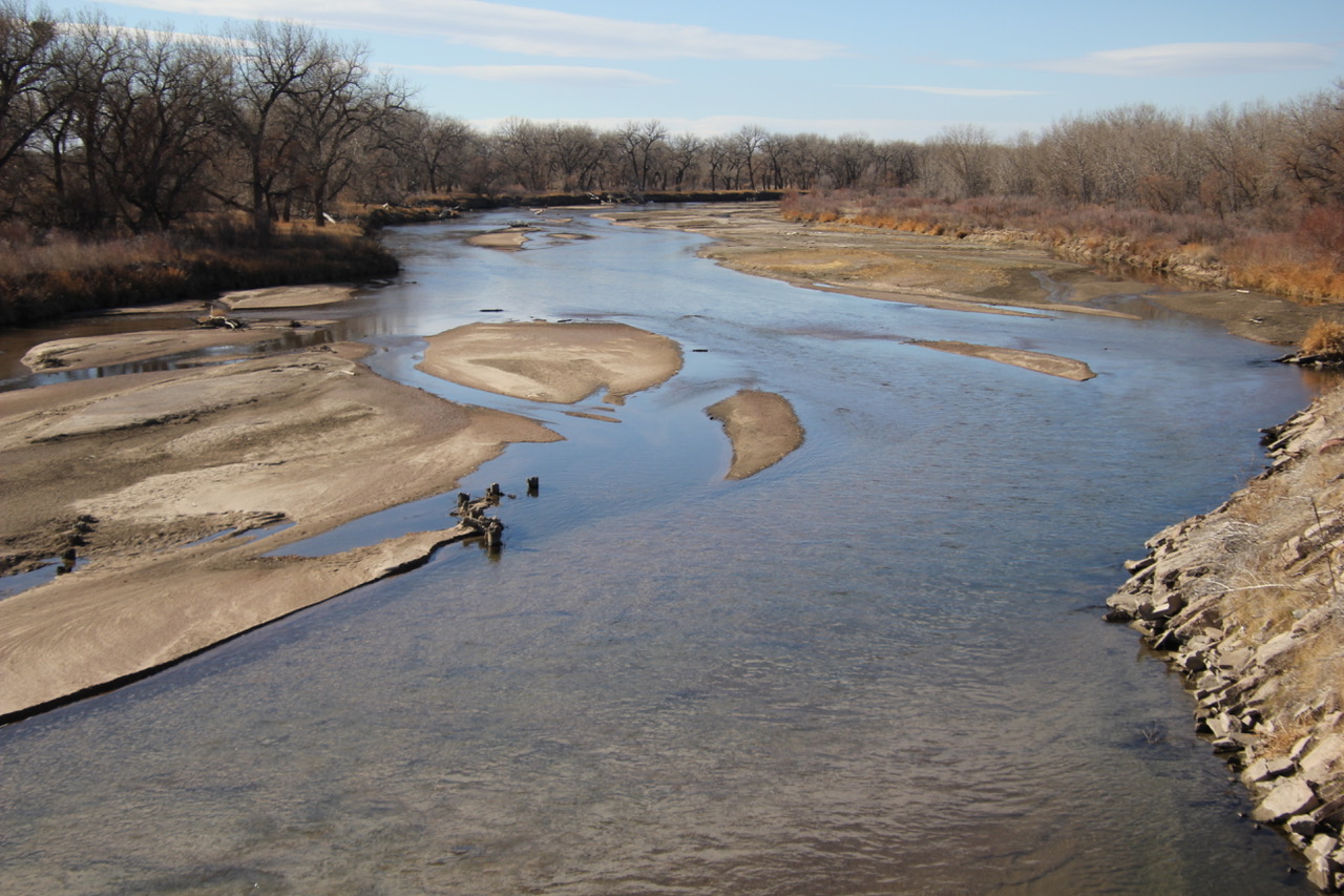
If you look at a map of southeastern Yuma County, Colorado, you’ll find a bumpy blue line labeled “South Fork Republican River.” But, for the majority of the year, this channel contains little to no visible water flow.
“So, the thing is, if we were to go upstream four or five miles, there’s flow,” Deb Daniel said while driving along a dusty road, adjacent to the riverbed in what used to be known as Bonny Lake State Park. She points to a stretch of riverbed covered with invasive Russian Olive trees. “There’s so much trees grown up in that area, and it’s so filled in with silt, that (the South Fork) completely disappears.”
The Republican River basin sustained Daniel’s family’s farm when she was growing up. In 2017, the six Colorado counties relying most on this river’s basin brought almost $2 billion in agriculture sales — just under a third of the state’s total $7.5 billion production value.
“There is such joy when I see water flowing,” Daniel said. For the last 20 years, she’s watched over the river as its conservation district manager. “And on the North Fork, it flows year-round.”
The Republican River basin. The North Fork, South Fork and Arikaree all flow through Yuma County before crossing state lines. Credit: USBR/DOI
That’s up in Northern Yuma county. These two forks (and the also-barely-flowing Arikaree River in central Yuma County) are tributaries that start in different parts of northeast Colorado and combine in Nebraska to feed the main body of the river…
Water still flows for most of the Republican’s 453-mile stretch. But the North Fork is going down…
‘A losing battle’
With North Fork flows decreasing and the South Fork and Arikaree barely running, the ecosystem suffers, Colorado risks major legal trouble with Kansas and Nebraska and people who farm these plains stand to lose their livelihoods.
Center pivot sprinklers in the Arikaree River basin to irrigate corn. Each sprinkler is supplied by deep wells drilled into the High Plains (Ogallala) aquifer.
The Republican River’s water levels drop partially because water in the ground surrounding it and beneath it is being used up, mostly to irrigate farms. And, in turn, part of the reason that groundwater isn’t as replenished is because of the river’s limited water.
It’s a dynamic [Joyce] Kettelson has long been aware of, weighing the water longevity for the community against her family’s economic security…
Severe drought conditions plagued portions of Yuma County for the majority of the last two years. Parts of the county have experienced moderate drought during almost half of the last two decades.
According to the U.S. Drought Monitor, severe drought conditions often reduce river flows and harm farming operations. Yuma is the only county that all three main tributaries of the Republican River run through…
Running out of options
Most of the irrigation shuttering has to happen near the South Fork in Yuma and Kit Carson counties. Despite the river conservation district and federal government offering to pay farmers who participate, just a third of the 10,000-acre goal has been met as of Jan. 6, 2022.
A booming market for irrigated crops, like corn and wheat, over the last two years made it hard to convince farmers to exchange those profits for the irrigation-shutoff payments.
Last month, the river conservation district board voted to more than double yearly water use fees so that they could also significantly increase the amount they offer to farmers who stop irrigating around the South Fork. Several board members of the groundwater districts Midcap manages also sit on the river district board and helped make that decision.
So now, someone farming 100 acres would have to pay $45,000 to irrigate for 15 years instead of the $21,750 they paid before the fee increase. If that farmer’s land is within a mile of the South Fork and they enter the program to totally retire the land for 15 years, they would now get paid more than $67,000 instead of $52,875.
“They’ve known that they’ve needed to retire them for eight to 10 years,” Midcap said. “But the actual process of getting the fee increased has taken at least nine months.”
Part of the reason for the hold-up, several local officials told KUNC, is that the conservation board members are often farmers and ranchers themselves. So they struggle to make decisions that could hurt them and their neighbors financially…
[Note] Midcap later made a point to say that he has hope because the county can sustain itself on the remaining groundwater for at least another century…
Midcap is confident that enough irrigated acres will be shut down to keep the state in compliance with the 2024 deadline. But there’s a second deadline: another 15,000 acres must shut down by 2029. He’s less confident about that…
“But we’re between a rock and a sword. There is no other option,” said Deb Daniel, Republican River Water Conservation District manager. “If we don’t get this done, the state of Kansas could virtually force our state engineer to shut off irrigated ag in northeast Colorado, and we can’t let that happen.”
Interest in irrigation-shutoff programs has already sharply increased since the district increased the payments it offers, she added…
The actions needed to fulfill the compact, protect the river and keep the agricultural economic backbone of these communities strong can intersect, she said, but often end up at odds. There are a lot of hard decisions to be made…
She’s inspired by the producers changing their crops to ones that use less water, and by those finding ways to farm without irrigation at all. She’s helping the conservation district, county government and Colorado Parks And Wildlife working on a $40 million plan to get water flowing through the South Fork around Bonny Reservoir again.
But, Daniel admits, the river will likely never return to its former glory. At this point, it’s all just mitigating losses.
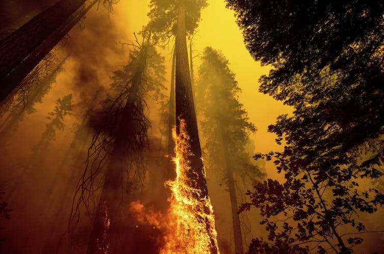
On September 4, 2021, the Joint Base Lewis-McChord Soldiers and the Bureau of Land Management-California’s Folsom Lake Veterans Hand Crew constructed a handline, cleared brush, and dealt with hot spots north of Lake Davis and Portola during the largest wildfire of 2021–California’s Dixie Fire. The western wildfires of 2021 were one of 20 separate billion-dollar disasters that struck the United States last year. (Joe Bradshaw/Bureau of Land Management)
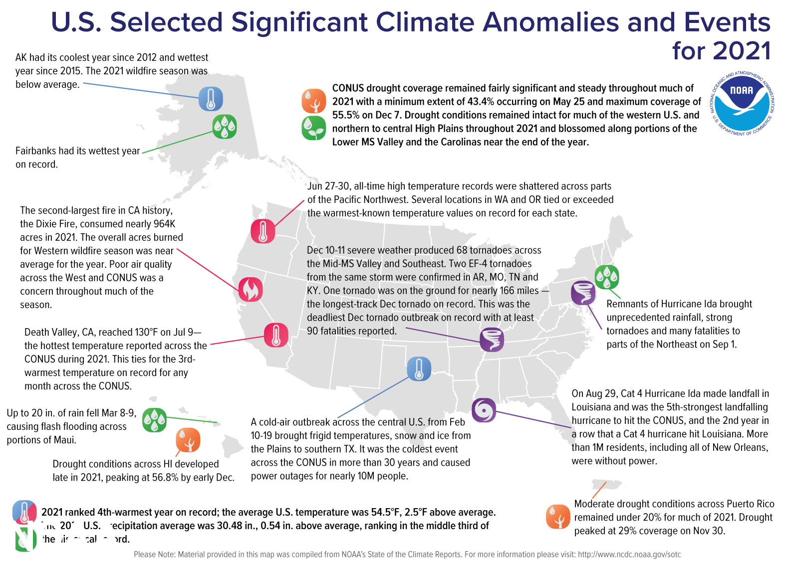
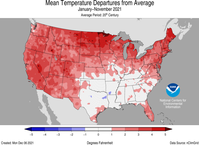
The year 2021 was marked by extremes across the U.S., including exceptional warmth, devastating severe weather and the second-highest number of billion-dollar weather and climate disasters on record.
The nation also saw an active wildfire year across the West as the north Atlantic Basin stayed busy with its third most-active Atlantic hurricane season on record, according to scientists from NOAA’s National Centers for Environmental Information.
Here’s a recap of the climate and extreme weather events across the U.S. in 2021:
Climate by the numbers
December 2021 | Full year 2021
The December contiguous U.S. temperature was 39.3 degrees F, 6.7 degrees above average, making it the warmest December on record and exceeding the previous warmest December in 2015.
Ten states — Alabama, Arkansas, Kansas, Louisiana, Mississippi, Missouri, Nebraska, New Mexico, Oklahoma and Texas — also had their warmest Decembers on record.
For 2021, the average contiguous U.S. temperature was 54.5 degrees F, 2.5 degrees above the 20th-century average and ranked as the fourth-warmest year in the 127-year period of record. The six warmest years on record have all occurred since 2012.
Maine and New Hampshire had their second-warmest year on record with 19 additional states across the Northeast, Great Lakes, Plains and West experiencing a top-five warmest year. Meanwhile, Alaska’s average annual temperature was 26.4 degrees F, 0.4 of a degree above the long-term average and the coldest year since 2012.
Precipitation across the contiguous U.S. totaled 30.48 inches (0.54 of an inch above average), which placed 2021 in the middle third of the climate record. Massachusetts had its ninth-wettest year on record, while Montana ranked ninth driest on record for 2021.
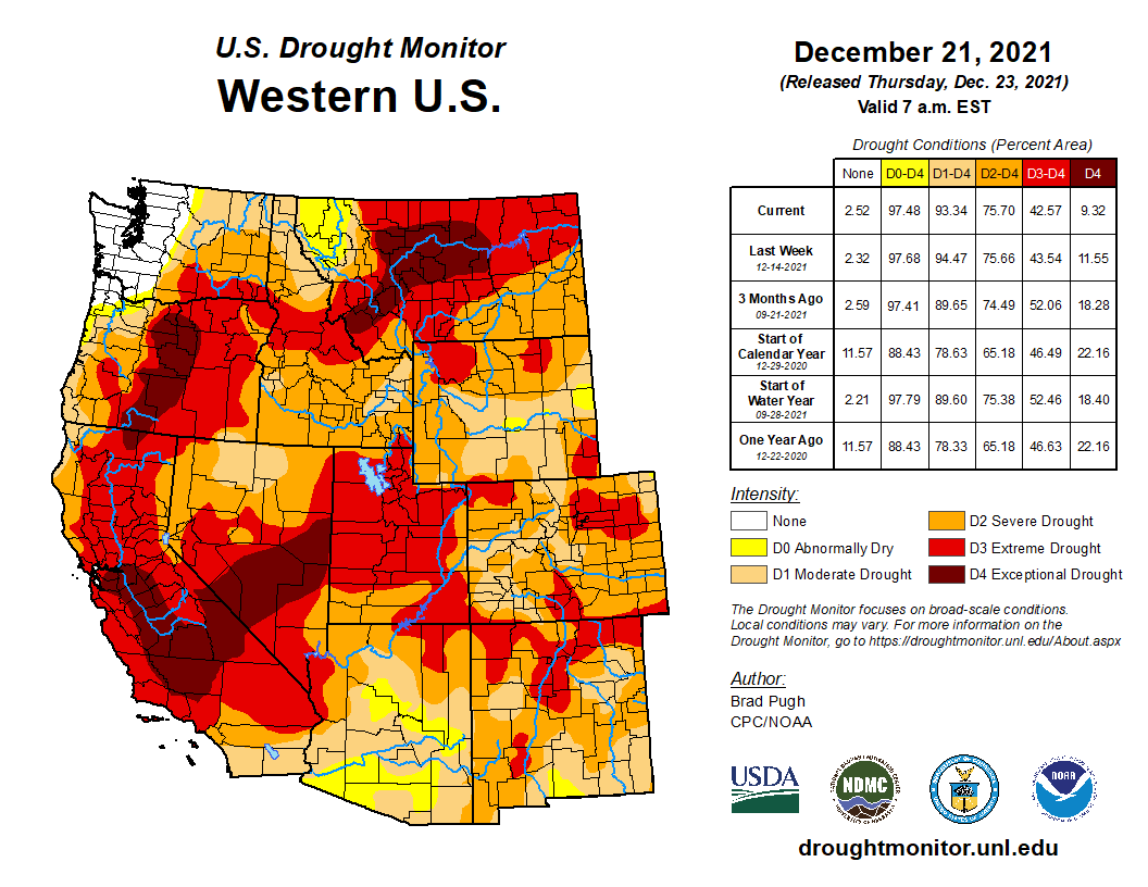
According to the U.S. Drought Monitor, drought coverage remained fairly significant and steady throughout much of 2021, with a minimum extent of 43.4% occurring on May 25 and maximum coverage of 55.5% on December 7.
A map of the United States plotted with significant climate events that occurred throughout 2021.
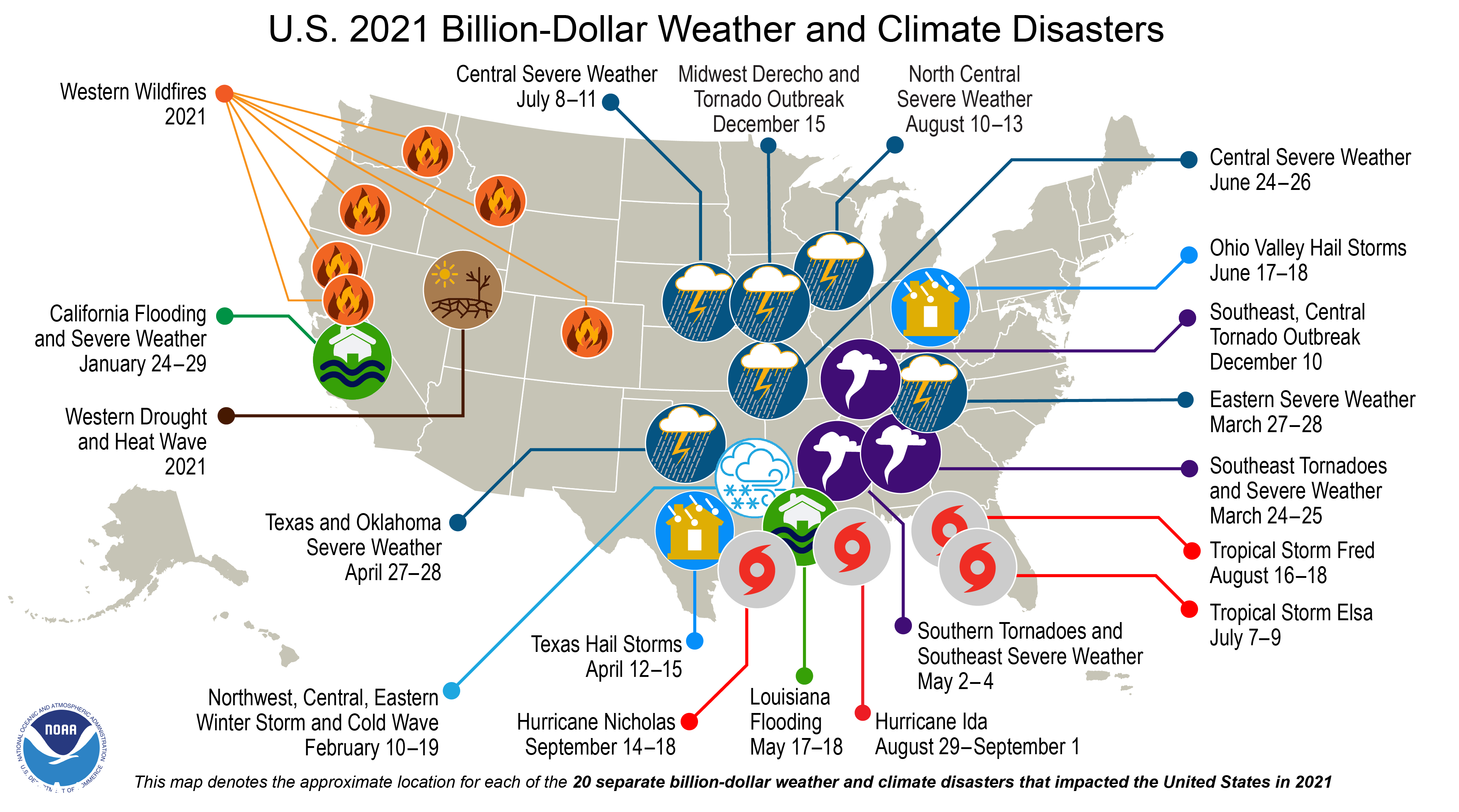
Billion-dollar disasters in 2021
Last year, the U.S. experienced 20 separate billion-dollar weather and climate disasters that killed at least 688 people — the most disaster-related fatalities for the contiguous U.S. since 2011 and more than double last year’s number of 262. The following 20 events, each exceeding $1 billion, put 2021 in second place for the highest number of disasters recorded in a calendar year, behind the record 22 separate billion-dollar events in 2020:
1 winter storm/cold wave event (focused across the deep south and Texas).
1 wildfire event (western wildfires across Arizona, California, Colorado, Idaho, Montana, Oregon and Washington).
1 drought and heat wave event (summer/fall across western U.S.).
2 flood events (in California and Louisiana).
3 tornado outbreaks (including the December tornado outbreaks).
4 tropical cyclones (Elsa, Fred, Ida and Nicholas).
8 severe weather events (across many parts of the country, including the December Midwest derecho).
Damages from these disasters totaled approximately $145 billion for all 20 events. This exceeds the total damage of $102 billion from the 22 events in 2020.
Map of the U.S. plotted with 20 separate billion dollar disasters that occurred in 2021. For more, go to https://www.ncdc.noaa.gov/billions/.
Hurricane Ida was the most costly event of 2021 at $75 billion and ranks among the top-five most costly hurricanes on record (since 1980) for the U.S. The combined cost of the four tropical systems was approximately $78.5 billion, more than 54% of the total U.S. billion-dollar disaster price tag in 2021.
The historic mid-February winter storm/cold wave was the costliest winter storm on record ($24 billion), more than double the previous record winter storm event — the Storm of the Century in March 1993.
The total cost over the last five years of these disasters (2017-2021) exceeds $742 billion — averaging $148 billion a year. These five-year and annual average costs both set record highs.
Other notable climate and weather events in 2021
The Atlantic hurricane season was busy: During 2021, 21 named storms formed in the North Atlantic Basin. This was the third most active Atlantic hurricane season on record. Category 4 Hurricane Sam was the most intense Atlantic hurricane of the season, while Category 4 Hurricane Ida was the strongest landfalling and most destructive hurricane of the season. This was the sixth year in a row with above-average tropical activity across the Atlantic Basin.
Numerous wildfires scorched the West: More than 7.1 million acres were burned across the western U.S. last year, which was 96% of the 10-year average. The second-largest fire in California history, the Dixie Fire, consumed nearly 964,000 acres in 2021. Smoke from several large fires created air quality and health concerns throughout much of the season.
An active tornado year: The tornado count for 2021 was above average across the contiguous U.S., with 1,376 tornadoes reported. By early January 2022, 193 tornadoes were confirmed in December alone — the greatest number of tornadoes for any December on record and nearly double the previous record of 97 in 2002.
The most notable events during the year were two outbreaks on March 17 and March 25 across the South, with a combined total of about 100 tornadoes, including an EF-4 tornado, an outbreak in Iowa on July 14, the December 10-11 Mid-Mississippi River Valley Tornado event that spawned two EF-4 tornadoes and the December 15 Midwest derecho event that produced more than 60 tornadoes across Nebraska and Iowa.
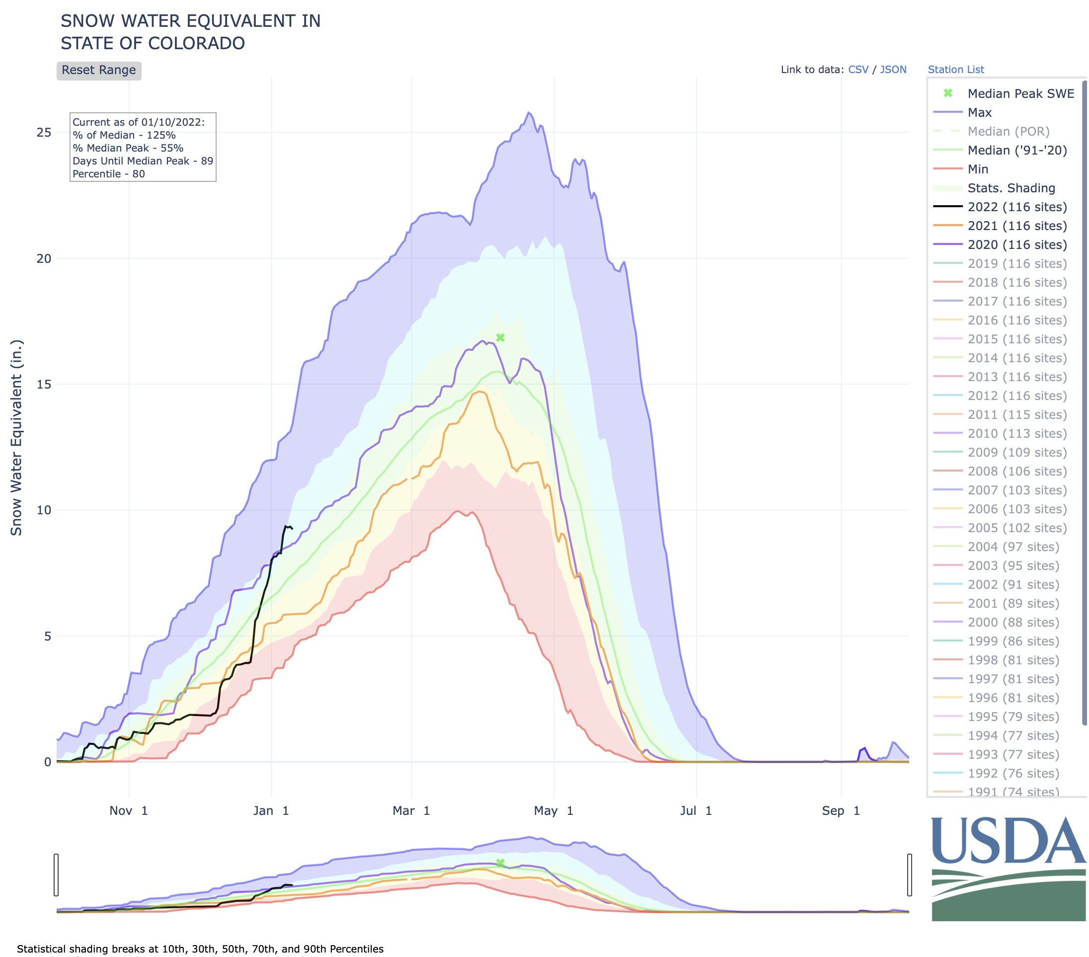
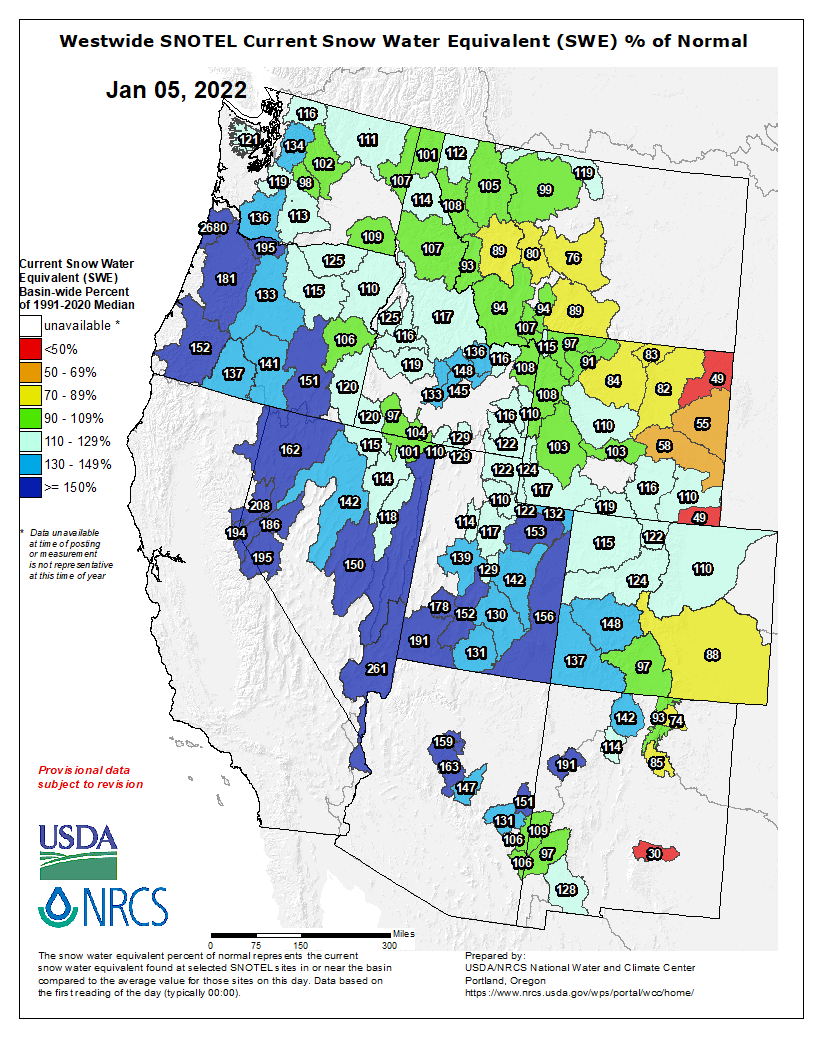
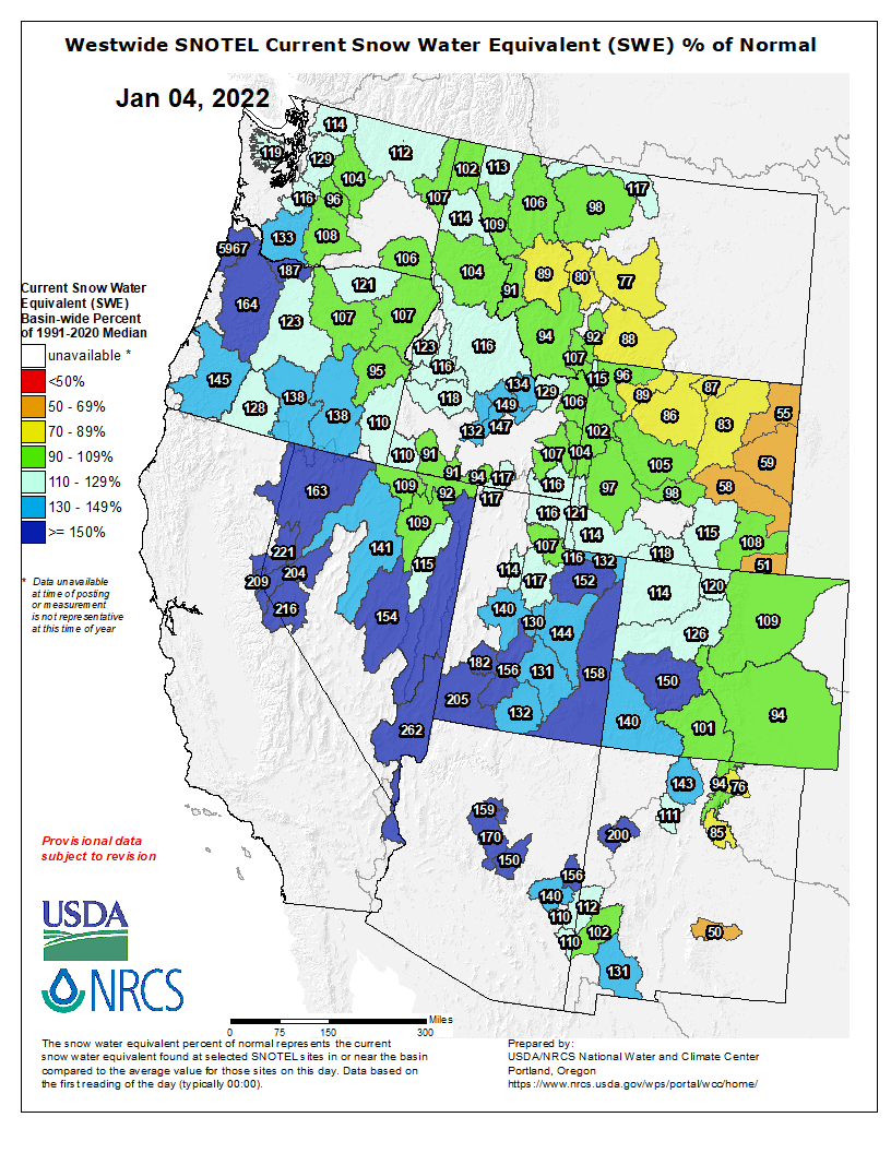
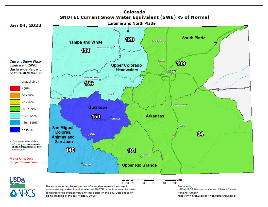
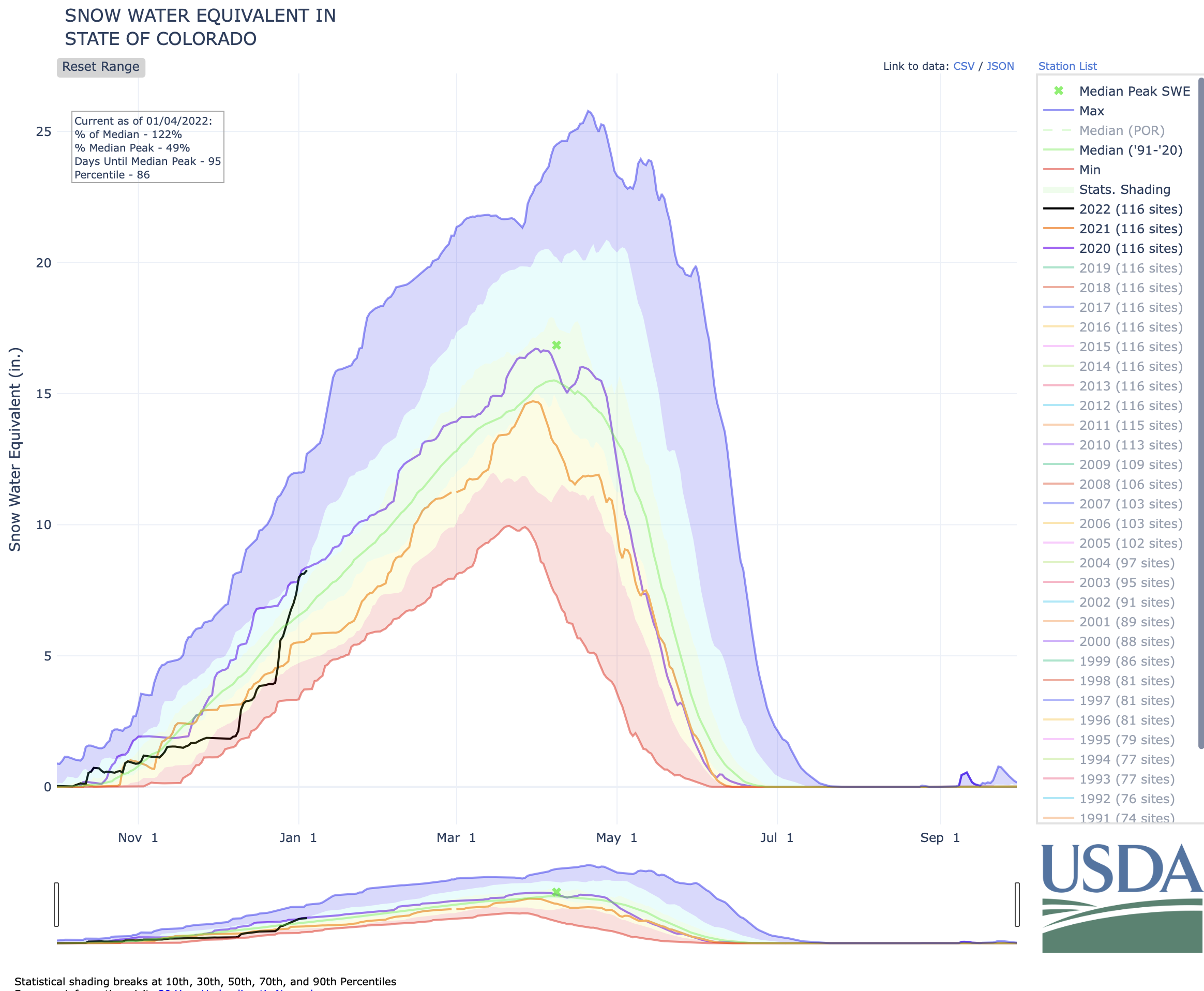
Colorado’s snowpack continues to break away from the 20-year to-date median, with 48 inches of snow falling in some parts of the state this week and more snow on the way.
Colorado’s current statewide snowpack is at 130 percent of the to-date median, as of January 7. This compares to the state being at 51 percent of the to-date median snowpack a month ago, on December 7.
A look at how radical this jump has been can be seen on the chart below, with the black line representing the snow water equivalent this year and the green line representing the 20-year median. The steep vertical climb of the black line shows how rapidly snow has been falling.
Let’s take a look a how each river basin varies by percent of to-date median snowpack…
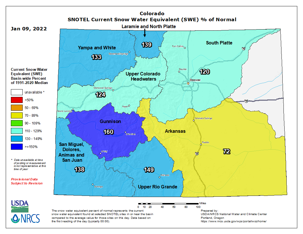
Colorado snowpack basin-filled map January 10, 2022 via the NRCS.
Arkansas River Basin: 98 percent
Colorado Headwaters River Basin: 132 percent
Gunnison River Basin: 148 percent
Laramie–North Platte River Basin: 145 percent
Upper Rio Grande River Basin: 97 percent
San Miguel–Dolores–Animas–San Juan River Basin: 135 percent
South Platte River Basin: 136 percent
Yampa–White–Little Snake River Basin: 131 percent
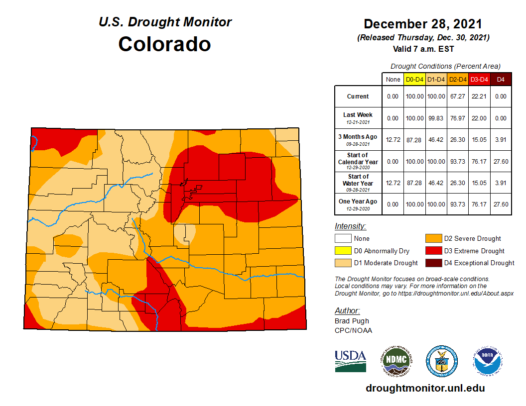
Colorado Drought Monitor map January 4, 2022.
Considering that 95 percent of the state was experiencing drought, as of January 4, we’ll take all the snow we can get.
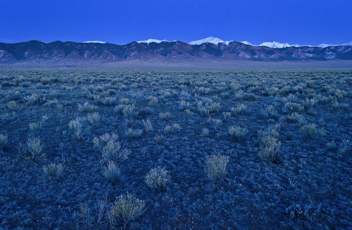
The country’s second largest potato producing region, is in its 18th year of drought in 2020. The San Luis Valley in Colorado is known for its agriculture yet only has 6-7 inches of rainfall per year. San Luis Valley via National Geographic
RWR’s proposal to Douglas County is, for an initial payment of $20 million, to build a pipeline that would bring 22,000 acre-feet of water from the San Luis Valley aquifer to the Front Range. If Douglas County agrees, the $20 million would come from ARPS stimulus money.
Struggling with water scarcity, changing climate, and aquifer depletion, San Luis Valley residents object to the proposal. A formidable group has organized around the belief that there is no water available to move outside the San Luis Valley.
Protect Our Water–San Luis Valley lists as members: 15 local water districts and entities; 22 cities and towns; 22 conservation and environmental groups; and two farm groups. On its website local governments in opposition to RWR’s proposal include the Rio Grande Water Conservation District and the Towns of Crestone and Saguache.
Despite their marketing assertions, RWR’s plan to export water from the San Luis Valley was not devised by locals nor will it benefit the entire valley.
RWR needs to find a customer like Douglas County to move its proposal forward. The plan relies on drawing water from the Upper Rio Grande Basin and exporting it to the Front Range. Without an identified end user for the exportation and sale of the water, RWR can’t file its plan in Colorado Water Court.
While the project has been in the works for some time, many questions remain unanswered.
RWR does not own municipal water rights, and RWR would need to buy wells and well rights before filing in court to convert irrigation water rights to municipal water rights.
Until recently, RWR executives asserted specifics about project locations, timetables, or costs were uncertain because they are focused on winning valley support and filing a legal case in Colorado’s water court, which could take three to five years to process. That case would help determine whether the San Luis Valley has enough water for RWR to legally export without hurting existing users.
In general, the proposal before Douglas County Commissioners reveals that RWR would build a wellfield northeast of Moffat. A pipeline would carry water north along state Highway 17, more than 1,000 feet up and over Poncha Pass to two access points along the South Platte River Basin, one at Antero Reservoir and another Elevenmile Reservoir, both in Park County.
In addition, a $50 million “community fund” would be developed under the RWR proposal to assist local communities with schools, broadband or food banks, senior services or job training. A separate pool of money, about $68 million, would pay farmers and ranchers who agree to sell their water rights, known in agriculture circles as “buy and dry.”
Those dollars will come from long-time private investors, according to Sean Duffy, a spokesman for RWR.
An agreement using stimulus money would give Douglas County access to needed water at less than half the typical rate of $40,000 to $50,000 per acre-foot, said RWR spokesman Sean Duffy…
Duffy also pointed out that both the water and economic status quo in the valley are not currently sustainable. Critics say the RWR project will only make the situation worse, while supporters argue it offers a more sustainable solution to the state’s water woes.
The San Luis Valley is described as one of the most arid regions in Colorado, receiving less than 9 inches of precipitation annually. In recent years snowfall on the Sangre de Cristos has been perceptibly less, resulting in reduced stream flows and reduced recharge of the two aquifers below the valley floor.
The shallow unconfined aquifer has been tapped with wells for crop irrigation for several generations and is over-appropriated. Below lies the confined aquifer which Renewable Water Resources believes holds a billion-acre foot of water.
That one-billion-acre foot estimate is highly disputed by local water managers, farmers and ranchers.
San Luis Valley Groundwater
Since 2012 many farms and ranches in the valley have already made self-imposed cuts in irrigation to try and prevent further depletion of the shallow aquifer. A number of subdistricts have been formed as local farmers’ only way of buying more time to solve depletions to the aquifer in their own way. Each subdistrict has until 2031 to replenish water to a predetermined level. Failure to meet those targets could result in the State Engineer’s office shutting down wells until the aquifer reaches that target through unimpeded recharge with no groundwater pumping.
RWR’s proposal is offering very similar benefits to those proposed by Stockman’s Water in 1998, a project that ultimately failed.
Stockman’s Water proposed to export at least 100,000 acrefeet annually, mitigating any water losses by offering, in exchange, 25,000 to 50,000 acre-feet of senior water rights.
Gary Boyce, the manager/ owner of Stockman’s Water, also promised a $3 million trust fund to be administered by Saguache County, and environmental benefits—more riparian and wetland habitat. Renewable Water Resources offers the potential opportunity to add over 3,000 acres to the Baca Wildlife Refuge located off of County Road T.
Cleave Simpson has met with the Douglas County Commissioners. Using federal American Rescue Plan Act funds for the RWR proposal is a twist he didn’t see coming.
“I think it’s unconscionable to use those federal dollars to diminish one community in support of another community,” he said. In addition to representing the San Luis Valley in the Colorado Senate, Simpson is the general manager of the Rio Grande Water Conservation District, which is leading the opposition to the RWR plan.
Simpson reminds us that there is a long history of legal fights over water export claims in the San Luis Valley. The Rio Grande Water Conservancy District already had money set aside to challenge the RWR proposal after the court awarded valley residents legal fees from a previous failed export case involving a developer in the 1970s, called American Water Development Incorporated.
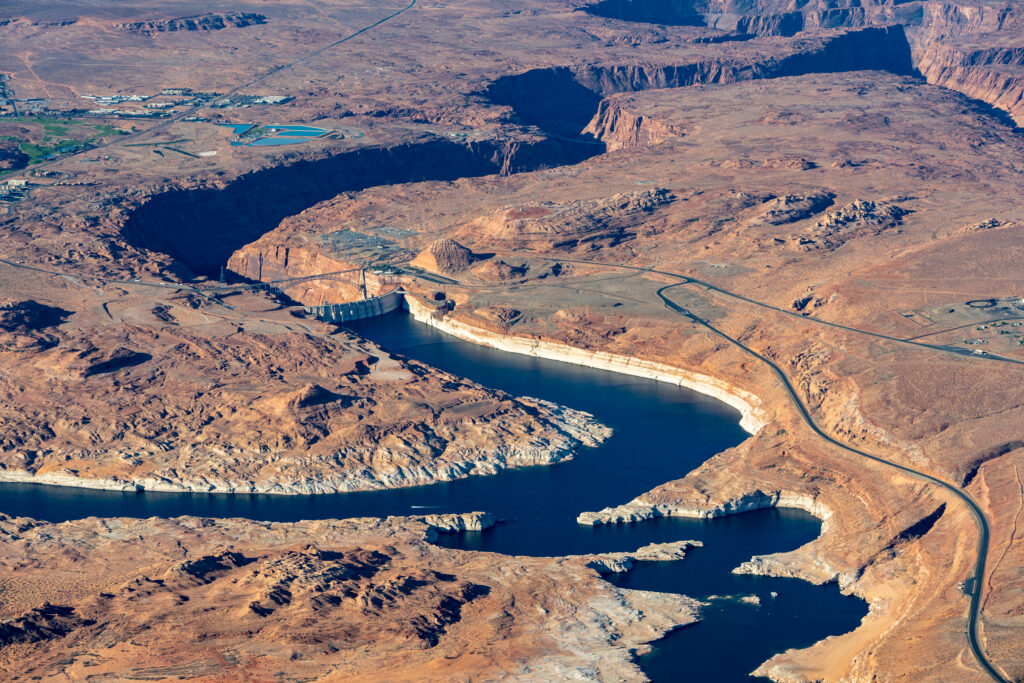
The U.S. Bureau of Reclamation announced Friday that it plans to adjust management protocols for the Colorado River in early 2022 to reduce monthly releases from Lake Powell in an effort to keep the reservoir from dropping further below 2021’s historic lows.
As of Thursday, the nation’s second-largest reservoir — part of a Colorado River system that provides drinking water to approximately 40 million people throughout the West — sat at an elevation of 3,536 feet. That’s 27% of the reservoir’s capacity, 164 feet below full and just 11 feet above the bureau’s target elevation of 3,525 feet, designed to give a 35-foot buffer before “dead pool.” Below 3,490 feet of elevation, Lake Powell dips into a zone where the generation of hydropower by water flowing through the Glen Canyon Dam becomes unreliable.
According to a bureau news release, the modified delivery schedule will not alter the total amount of water let through Glen Canyon Dam over the course of the year but will hold back a cumulative 350,000 acre-feet between January and April to help Lake Powell recover from lows that left many boat ramps unusable at the popular recreation site last summer.
Despite a wet October giving water managers hope that the region might make some progress towards recovery amidst a 22-year drought, this past November was the second-driest on record and inflows came up 1.5 million acre-feet short of the Bureau’s projections from the previous month. When adjusted December projections anticipated Lake Powell dropping below 3,525 feet as soon as this February, the agency convened partners from the basin states, Tribes, federal agencies, non-governmental organizations and water managers to devise a new management scheme…
Scientists, however, are not sure spring runoff will materialize. In the 22nd year of regional drought, the term “aridification” is gaining traction as the better way to describe what might be a long-term drying of the American West, influenced by climate change.
“We need to be extra vigilant and careful, because we do not know what lies ahead,” said Jack Schmidt, director of Utah State University’s Center for Colorado River Studies in response to Friday’s announcement. “Looking into the future, none of us can know precisely what’s going to happen this year. We have had times when we’ve looked great at the end of February, and then had an exceptionally dry March and the snowpack evaporated.”
Schmidt was the senior author of a white paper published by a group of hydrologists last February that analyzed the future of Colorado River flows under various climate change and use scenarios. Their findings predicted that, given drying trends and a growing western population, projected basin-wide rates of water consumption could result in Lake Mead or Lake Powell running dry as soon as 2050, halting hydropower operations and negatively impacting the Grand Canyon ecosystem.
[…]
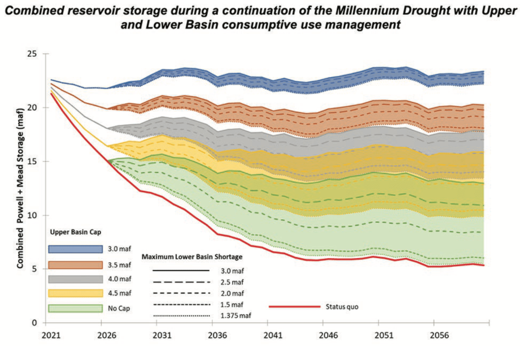
Figure ES-3. End-of-year combined Lake Powell + Lake Mead storage using hydrologic conditions sampled from the Millennium Drought (2000-2018) demonstrates the effects of a range of Upper Basin demand ‘caps’ along with a range of Lower Basin maximum shortages triggered when the combined storage falls below 15 maf. The status quo uses the 2007 UCRC Upper Basin schedule and elevation-based shortage triggers. Credit: The Center for Colorado River Studies
Wayne Pullan, regional director of the bureau’s Upper Colorado Basin, agreed [January 7, 2022] that there is uncertainty in the system…
In response to this, the agency plans to continue to monitor the basin’s hydrology and may make further adjustments to protect Lake Powell’s elevation. These could include sending additional water downstream to the reservoir from Colorado River Storage Project units at Flaming Gorge, Blue Mesa and Navajo reservoirs. Bureau officials will also continue to work with Upper Basin states on a Drought Response Operations Plan, due out in April 2022.
Schmidt, meanwhile, sees three shades of a silver lining to Friday’s doomsday-seeming announcement from the Bureau.
First, his team in February concluded that estimates of future consumptive use calculated by the Upper Colorado River Commission may be overinflated, giving the seven states that rely on this supply some additional wiggle room. If the western states learn to better live within their water means, their populations can grow without tanking the Colorado River system, they argue.
The second point, towards this end and also outlined in the February white paper, is that opportunities to stretch the supply further by improving water conservation efforts still abound. This is an argument often made by environmental groups critical of per capita water use rates in Utah’s Washington County which, by many measures, far exceed those in other similar desert communities…
Schmidt’s third note of positivity in reaction to Friday’s announcement from the Bureau is that the modified release schedule for Lake Powell actually better mirrors the natural flows of the Colorado River. Ecologists are often critical of the impact dams have on riparian environments. If we’re dealing with a situation of diminished overall flows, Schmidt says, it makes sense for artificial releases to be especially reduced in winter months when the river is lowest in its natural state.
Here’s the release from the Bureau of Reclamation (Elizabeth Smith):
The Bureau of Reclamation released a draft environmental assessment to supplement a final environmental impact statement (FEIS) completed in 2013 for proposed changes associated with construction and operation of the Arkansas Valley Conduit (AVC).
“Reclamation released an AVC Supplemental Information Report, in June 2021, that identified proposed changes in the AVC footprint, AVC participants, and a three-party contract with the Southeastern Colorado Water Conservancy District (Southeastern) and Pueblo Water,” said Reclamation Eastern Colorado Area Manager, Jeffrey Rieker. “This draft environmental assessment provides the supplemental analysis of the information in that report.”
Arkansas Valley Conduit map via the Southeastern Colorado Water Conservancy District (Chris Woodka) June 2021.
Reclamation would construct the AVC trunkline and Southeastern while AVC participants and others would construct AVC spur and delivery pipelines under the Proposed Action. The AVC project would utilize Pueblo Water’s existing system to treat and deliver AVC water from Pueblo Reservoir to a connection point east of the City of Pueblo along U.S. Highway 50, and eliminate 24.7 miles of pipeline construction around the city of Pueblo that was originally included the FEIS’s selected alternative.
The three-party contract will address AVC’s use of Pueblo Water’s water treatment plant and water delivery system, as well as Pueblo Water’s continued use of excess capacity storage in Pueblo Reservoir. The contract also incorporates the storage of additional water rights associated with the Bessemer Ditch and will replace an existing 25-year excess capacity contract that expires in 2025.
The environmental assessment has been prepared in compliance with the National Environmental Policy Act and is available for public review and comment at: https://www.usbr.gov/gp/ecao/avc/. The 2013 AVC FEIS, 2014 AVC Record of Decision, and 2021 AVC Supplemental Information Report can also be accessed from this webpage. Reclamation is requesting that any comments on the draft environmental assessment be submitted by January 30, 2022. Comments can be sent to tstroh@usbr.gov. For additional information, please contact Terence Stroh, Environmental Specialist, at 970-461-5469 or the above email address.
AVC is and authorized feature for the Fryingpan-Arkansas Project in Southeastern Colorado in Pueblo, Crowley, Otero, Bent, Prowers and Kiowa Counties. You can find more information on the Fryingpan-Arkansas Project at: https://www.usbr.gov/projects.
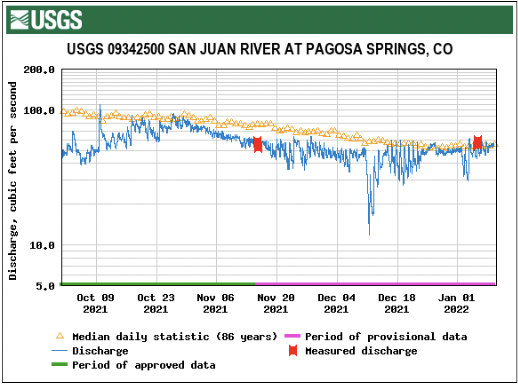
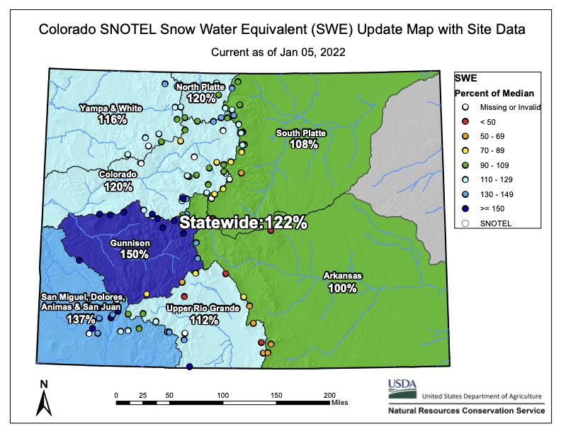
Less than a month ago, on Dec. 8, 2021, the snowpack level for the San Miguel, Dolores, Animas and San Juan river basins was at 31 percent of that date’s median, according to the U.S. Department of Agriculture (USDA) National Water and Climate Center’s snow pack report.
As of 11 a.m. on Jan. 5, the San Miguel, Dolores, Animas and San Juan river basins were at 136 per- cent of the Jan. 5 median.
According to the USDA, as of 11 a.m. on Wednesday, Jan. 5, the Wolf Creek summit, at 11,000 feet of elevation, had 22.6 inches in snow water equivalent.
That amount is 149 percent of that date’s median snow water equivalent…
River report
According to the U.S. Geological Survey (USGS), the San Juan River was flowing at a rate of 53.7 cfs in Pagosa Springs as of noon on Wednesday, Jan. 5. Based on 86 years of water records at this site, the lowest recorded flow rate for this date is 26 cfs, recorded in 1990. The highest recorded rate for this date was in 1987 at 116 cfs. The average flow rate for this date is 59 cfs.
An instantaneous reading was unavailable for the Piedra River near Arboles.
Colorado Drought Monitor map January 4, 2022.
Drought report
The National Integrated Drought Information System (NIDIS) was last updated on Dec. 28, 2021. The NIDIS website indicates 100 percent of Archuleta County is abnormally dry and also in a moderate drought. The NIDIS website also notes that 47.66 percent of the county is in a severe drought stage. Additionally, the NIDIS website notes that 10.33 percent of the county remains in an extreme drought. No portion of the county is in exceptional drought.
On Dec. 21, 2021, the Archuleta County Board of County Commissioners (BoCC) committed $10,000 through a letter of commitment to be used as part of the cash match for the Town of Pagosa Springs and the Upper San Juan Watershed Enhancement Partnership’s ( WEP) grant application for the south Yamaguchi Park project.
The funds will be taken from the county’s Conservation Trust Fund, which can only be used for outdoor recreation purposes.
The grant being applied for will be dispersed by the Colorado Water Conservation Board (CWCB) next March.
WEP representative Al Pfister first approached the BoCC in regard to the matching fund request on Dec. 7, 2021.
Pfister previously explained that the total cost of the project is just over $664,000, with more than $500,000 coming from the grant.
The WEP needs a 25 percent cash match, or just over $166,000, to be awarded the grant. Six other entities have been asked to com-mit funds including the Town of Pagosa Springs, San Juan Water Conservancy District, Trout Unlimited, Friends of the Upper San Juan, The Nature Conservancy and Weminuche Audubon.
County Attorney Todd Weaver noted that “it’s a community col- laborative effort.”
The letter of commitment sent to the CWCB reads, “This project is part of the Upper San Juan Basin Integrated Water Management Plan and would create various new and/or improved river access points and channel features for the San Juan River, thereby enhancing recreation options at various river flows, reducing access conflicts, create diverse aquatic habitat to support fisheries, and develop a more resilient river facing changing hydrology and temperatures in the future.”
Commissioner Warren Brown mentioned he felt it was a “worthwhile” project to support, noting it will likely have a positive impact on tourism in the community.
Commissioner Ronnie Maez mentioned the project will be a “huge improvement.”
Commissioner Alvin Schaaf noted it will serve as a benefit “to all of the community.”
The letter of commitment of funds was approved unanimously.
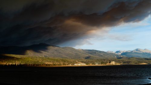
Smoke from the East Troublesome fire looms over Granby Reservoir. Photo credit: Evan Wise via Water for Colorado
Click here to access the paper (Dmitri a. Kalashnikov Jordan l. Schnell John t. Abatzoglou Daniel l. Swain and Deepti Singh). Here’s the abstract:
Wildfires and meteorological conditions influence the co-occurrence of multiple harmful air pollutants including fine particulate matter (PM2.5) and ground-level ozone. We examine the spatiotemporal characteristics of PM2.5/ozone co-occurrences and associated population exposure in the western United States (US). The frequency, spatial extent, and temporal persistence of extreme PM2.5/ozone co-occurrences have increased significantly between 2001 and 2020, increasing annual population exposure to multiple harmful air pollutants by ~25 million person-days/year. Using a clustering methodology to characterize daily weather patterns, we identify significant increases in atmospheric ridging patterns conducive to widespread PM2.5/ozone co-occurrences and population exposure. We further link the spatial extent of co-occurrence to the extent of extreme heat and wildfires. Our results suggest an increasing potential for co-occurring air pollution episodes in the western US with continued climate change.
Barring epic snowstorms during the next four months, reservoirs on the drought-strapped Colorado River will enter new territory in 2022, likely unable to fill such basic missions as generating hydropower.
In response, the reservoirs’ owner, the U.S. Bureau of Reclamation, is moving quickly to create work-arounds.
The Colorado River Basin serves seven states and Mexico. It is divided between the Upper Basin states of Colorado, New Mexico, Utah and Wyoming, and the Lower Basin consists of Arizona, California and Nevada.
“We simply must focus on short- and near-term operational challenges in both the Lower Basin and Upper Basins,” said Camille C. Touton, the recently sworn in commissioner of Reclamation.
Graphic credit: Chas Chamberlin
But it is the Upper Basin’s Lake Powell that is causing the most concern right now. “We face unprecedented operational challenges at Glen Canyon Dam in a matter of mere months, even weeks,” she said. “Depending on the hydrology, Powell could decline to fall below minimum power pool for long durations.”
The U.S. Department of Interior has made clear its intention to protect lake levels, to ensure protection of the “structural integrity of the infrastructure,” said Tanya Trujillo, the undersecretary for water and science at the agency.
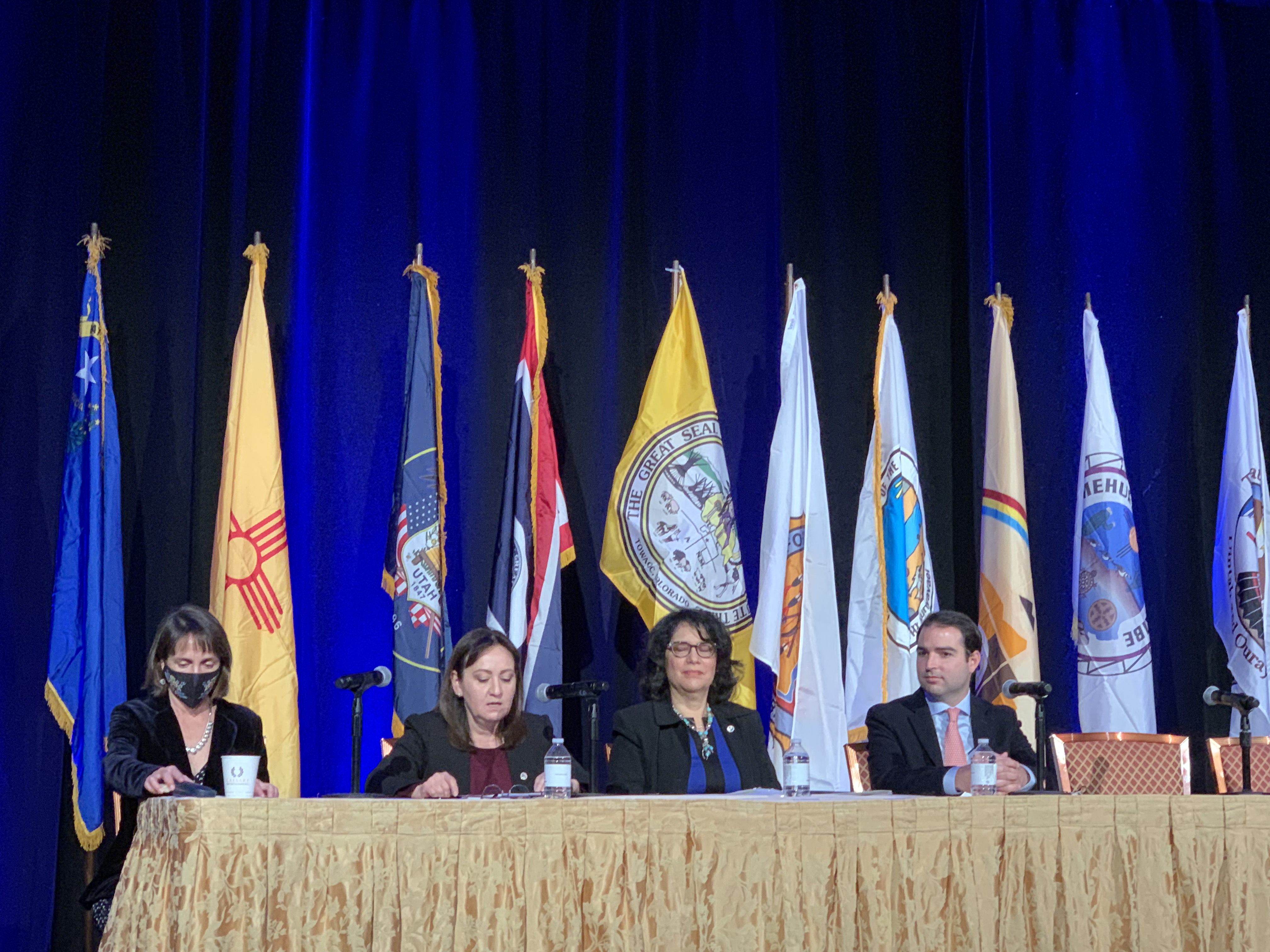
Tanya Trujillo panel with U.S. Commissioner Maria-Elena Giner & Commissioner Adriana Resendez discussing Mexico and U.S. management of the Colorado River at the 2021 Colorado River Water Users Association Annual Conference. Photo credit: IBWC
“We at Interior have a federal responsibility to protect the populations we serve,” she said in the final session of the Colorado River Water Users Association Conference in Las Vegas on Dec. 16. “That includes protecting the infrastructure. I have asked (the Bureau of) Reclamation to develop options for consideration in case we see these dry trends continuing.”
What those options might be isn’t clear yet.
Bart Miller, water program manager at Western Resource Advocates, said the water crisis is an opportunity to accelerate water conservations. “We have a real need to act in the next couple of years,” he said.
John Entsminger at the Colorado River Water Users Association Annual Conference December 15, 2021.
Comments in Las Vegas alluded to the sobering realities. “All hands on deck,” said John Entsminger, general manager of the Southern Nevada Water Authority.
Colorado and other basin states have tightened water use since 2002. As documented at Powell, however, the belt-tightening lags what is needed. The pace must be hastened. Exactly how is the question facing Colorado and other states.
Projections show a high risk of continued drying. The two big reservoirs, Mead and Powell, in January 2000 were at 95% of capacity with a combined storage of 47 million acre-feet. By April 2022, they are projected to be less than 30% full with a combined storage of 15 million acre-feet.
Both reservoirs reached historically low levels last summer, holding the least amount of water since they began filling in the 1930s and 1960s respectively. The inflow into Powell last spring and summer was the second lowest on record.
Elevation 3,525 feet is the line in the sandstone established by water managers at Glen Canyon. That will provide a 35-foot buffer above the level below which hydropower cannot be produced. Modeling by the Bureau of Reclamation in December showed a 47% chance that Powell could drop below the target level for ensuring continued safe hydropower generation as soon as 2023.
“Everything associated with Lake Powell is critical to operation of the whole basin,” said Patrick Tyrrell, Wyoming’s representative on the Upper Colorado River Commission.
“We’re not quite sure how the lake will operate if that water elevation approaches the top of the penstocks,” he said. It’s also not clear how water can be released from the reservoir at that lower level, sometimes called dead pool, he added.
Water levels at Powell had declined to within inches of 3,525 this year before the Bureau of Reclamation released water from upstream reservoirs in Colorado and Utah beginning last July.
Looking ahead, officials said aggressive conservation will be key and Las Vegas’ efforts are among those being watched closely. Still rapidly growing, now with 2.3 million residents, the Southern Nevada Water Authority, which serves the city and its suburbs, relies upon the Colorado River to provide 90% of its supplies in a valley that gets less than 4 inches of rainfall a year. Yet even as the population has grown 52% in this century, river consumption has declined 23%.
Las Vegas has achieved this feat by using both carrots and sticks. It may not be noticeable on the Strip because the Bellagio fountains still put on a show and the toilets still flush. In the new suburbs, though, you see almost no grass in front yards, and it’s limited in backyards.
Tightening in Vegas continues. Colby Pellegrino, deputy general manager for resources at Southern Nevada, reported at the conference proposals to trim water use at existing golf courses and ban water for new courses. Swimming pools will shrink in size. And a new Nevada law prohibits Colorado River water use on non-functional turf by 2027.
Water deliveries to Arizona, California and Nevada have declined 22% from 2002 and 2020. More cuts are coming. During the conference in Las Vegas, representatives of the three states signed an agreement known as the 500+ Plan, that requires them to cut 500,000 acre-feet in 2022 and 2023. The plan also requires the three states to pool a collective $100 million, to be matched by a grant from the federal government, for implementation of water efficiency and conservation.
Lake Powell Pipeline map via the Washington County Water Conservancy District, October 25, 2020.
What about the upper-basin states? They have never used their full legal entitlement to river water, and Utah, in particular, wants to build a pipeline from Powell to the rapidly growing St. George-Hurricane area.
In Colorado, agreement about the need for tempering demand has been coalescing. Miller, of Western Resource Advocates, points out that operational adjustments, such as the Upper Basin reservoir releases this year, rely upon existing water, and cloud-seeding to generate more snow cannot solve the problem.
That leaves conservation as the area for more fruitful work to match the rapidly changing climate in the Colorado River Basin.
Past agreements in the Colorado River Basin show a long gestation time that can then emerge into policy given certain political climates. The current situation on the Colorado River provides that opportunity, say John Fleck, of the University of New Mexico’s Department of Economics and Water Resources Program, and Anne Castle, of the Getches-Wilkinson Center at the University of Colorado-Boulder.
“State and federal water officials should seize this opening, cognizant of its likely limited duration, and cement new agreements that steer river operations in a more sustainable direction,” Fleck and Castle say in a recent article. “Well-timed and explicit federal direction may be necessary to catalyze the already ongoing discussions.”
Long-time Colorado journalist Allen Best publishes Big Pivots, an e-magazine that covers energy and other transitions in Colorado. He can be reached at allen@bigpivots.com and allen.best@comcast.net.
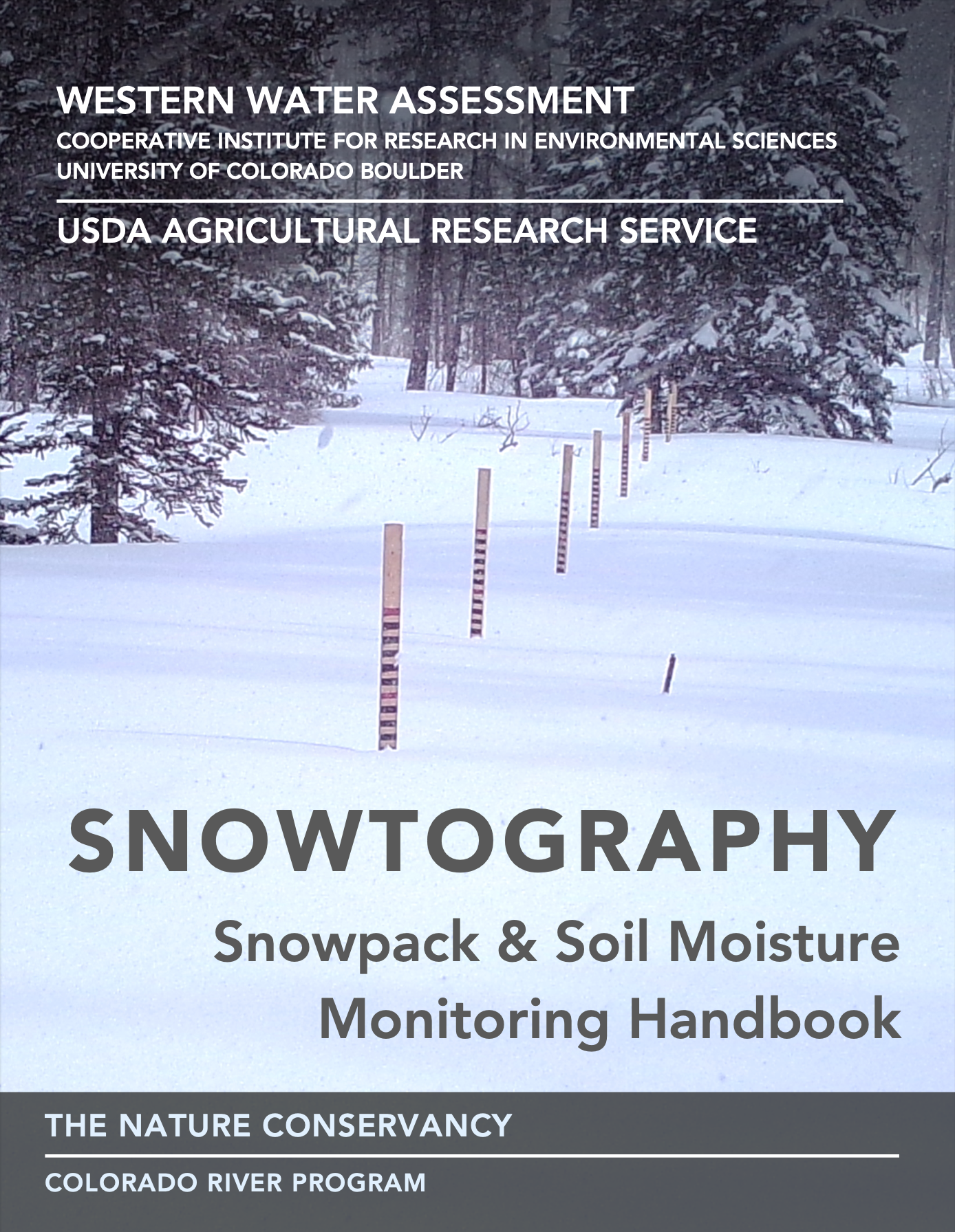
Western Water Assessment/Nature Conservancy/USDA Snowtography guide cover January 2022.
Click here to access the handbook. If you’re not a water provide it will be a primer into the business of water supply:
Western Water Assessment, in collaboration with The Nature Conservancy and the USDA-Agricultural Research Service, has produced a snowtography handbook to support resource managers, researchers, and practitioners working in forested headwater settings where the arrangement and density of trees, or the size and severity of disturbances, affect snowpack persistence and soil moisture availability.
The snowtography handbook guides readers through the process of establishing their own snowtography and soil moisture monitoring stations. It offers guidance on site selection, snowtography options, equipment requirements, and installation. The instructions are based on snow-forest research and hands-on experience at multiple sites in Arizona, and in the San Juan National Forest in southwestern Colorado.
Boat ramp at Page, Arizona, December 17, 2021. Photo credit: Allen Best/Big Pivots
Click here to read the article from National Public Radio (Nathan Rott) and for the photos and video. Here’s an excerpt:
Despite recent rain and record snowfall in California’s Sierra Nevada, the Western U.S. is experiencing one of its driest periods in a thousand years — a two-decade megadrought that scientists say is being amplified by human-caused climate change. The drought — or longer-term aridification, some researchers fear — is forcing water cutbacks in at least three states and is reviving old debates about how water should be distributed and used in the arid West.
At Lake Powell, the nation’s second-largest reservoir, record-low water levels are transforming the landscape, renewing a long-standing dispute over the land the reservoir drowned — a canyon labyrinth that novelist Edward Abbey once described as “a portion of earth’s original paradise.” For half a century, environmental groups and Colorado River enthusiasts have implored water managers to restore Glen Canyon by draining the reservoir….
The goal has always been viewed as a bit far-fetched. Lake Powell is one of the busiest tourist destinations in the country. A half-billion-dollar tourism industry has blossomed on its stored waters along the Utah-Arizona border.
But with water levels at record lows and dropping, hindering tourism and revealing long-hidden rock formations like the one behind Dombrowski’s boat, advocates for Glen Canyon see a unique opportunity to catalog what was lost and to correct, perhaps, what environmentalist David Brower called “America’s most regrettable environmental mistake.”
Human actions built the reservoir. Now human actions are causing it to shrink…
A critical “bank account” that’s overdrawn
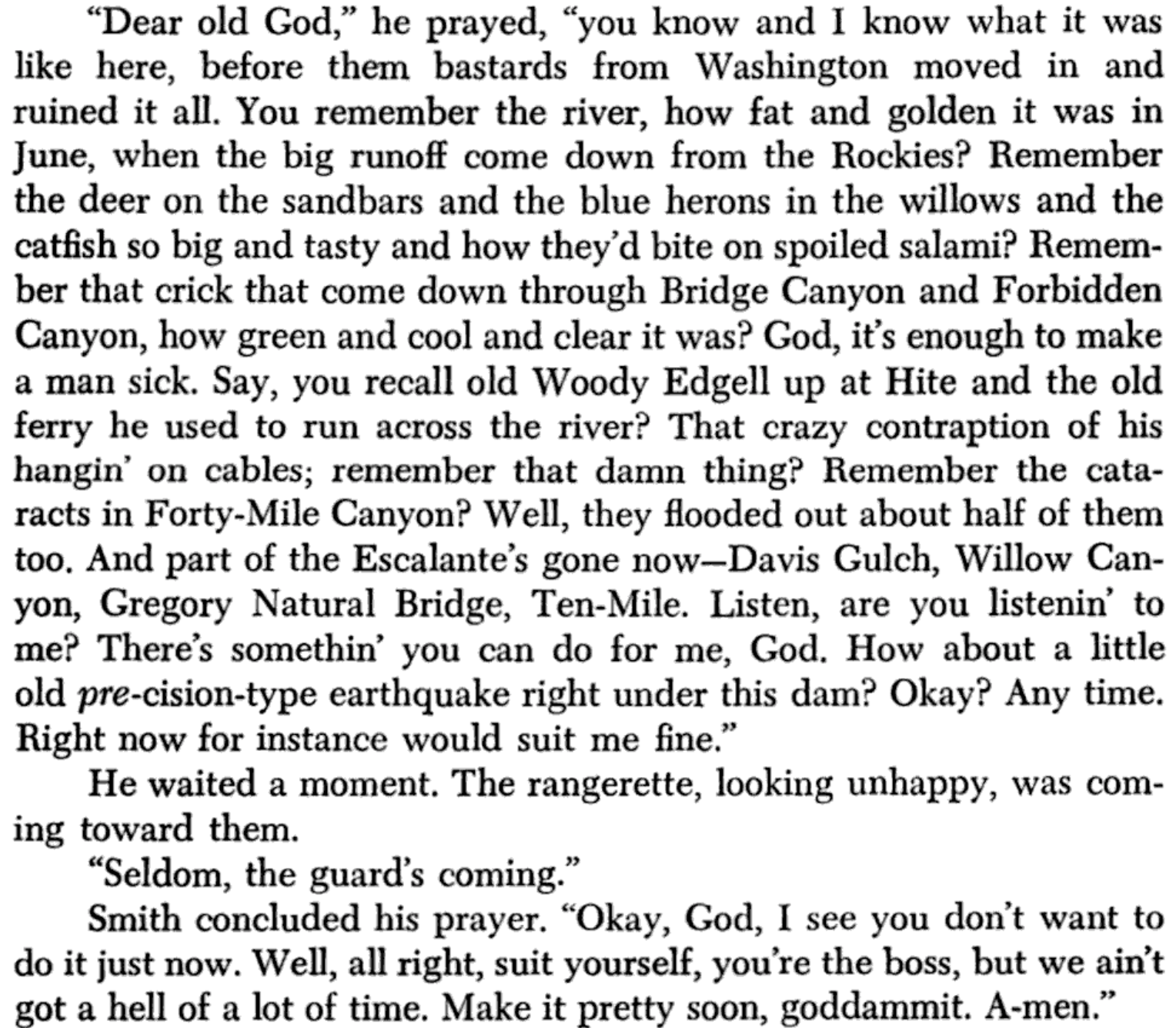
Seldom Seen’s prayer at about Glen Canyon Dam from The Monkey Wrench Gang — Edward Abbey
It would be hard to overstate the anger sparked by the creation of Lake Powell and the flooding of Glen Canyon. The plot of Abbey’s most famous fiction, The Monkey Wrench Gang, centered on a band of environmental extremists hellbent on destroying the concrete behemoth that pinched off the Colorado River near the Utah-Arizona border in 1963.
The Glen Canyon Dam, named for the canyon it drowned, was celebrated as one of the “engineering wonders of the world” by the Bureau of Reclamation. To Abbey, it was “an insult to God’s creation.”
Rock spires, arches, amphitheaters and ecosystems were gradually submerged. Stalled water crawled up slot canyons. Petroglyphs and pull-tab beer cans were covered over.
Ken Sleight the original Monkey Wrencher photo via Salon
“They ruined it all when they put the water in there,” says Ken Sleight, a river-runner friend of Abbey’s and an environmental preservationist.
The purpose of the dam was to generate electricity for a growing Southwest and to manage flows on the famously up-again, down-again Colorado River [in line with the “Law of the River“. Ranchers, farmers and a fast-growing Western U.S. needed a stable water supply. Glen Canyon Dam and Lake Powell, together with their downstream neighbors, Hoover Dam and Lake Mead, would provide that stability…
“In addition to its significant recreation value, Lake Powell functions as a vast ‘bank account’ of water that can be drawn on during dry years,” states the Bureau of Reclamation…
Hotter temperatures and milder winters have reduced flows on the Colorado River, shrinking nature’s annual deposit. Water demands, meanwhile, have remained steady or increased. “To sustain our water use, we have drained the bank account,” says Jack Schmidt, a watershed scientist at Utah State University.
Lake Powell near Page, AZ on December 13, 2021. Inflow into the Colorado River’s second largest reservoir was the second-lowest ever last year and current projections from the Bureau of Reclamation suggest this year could be similar. Water scarcity was a main topic of discussion at a gathering of water managers and experts in Las Vegas this week. CREDIT: HEATHER SACKETT/ASPEN JOURNALISM
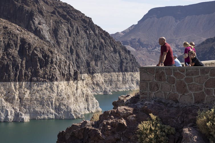
Today, Lake Powell and Lake Mead are at about one-third of their total capacity. A chalky bathtub ring stains the canyon walls of both, more than 100 feet overhead…
Recent snowstorms have improved the short-term picture, boosting snowpack levels across much of the West, but they haven’t solved the larger imbalance in the region’s water portfolio, which is forcing stakeholders up and down the Colorado River to adapt and think in innovative ways. California, Nevada and Arizona recently reached an agreement to take less water from the river in an effort to prop up Lake Mead…
A push to revive a storied canyon
In parts of Glen Canyon, the new normal is starting to look a lot like the old.
Slot canyons, grottoes, cliffs and spires — the kinds of natural features that draw millions to Grand Canyon and Arches National Park — are reemerging from the waters. Willows and cottonwoods are sprouting on muddy banks. Pottery shards dot shorelines.
“The last time this span was out, Neil Armstrong hadn’t walked on the moon yet,” the Glen Canyon Institute’s Balken says, steering a boat under one of the largest natural bridges in the world. Water reflects on its red belly like a kaleidoscope as Balken putters up the narrowing canyon ahead.
For the last 25 years, Balken’s nonprofit, the Glen Canyon Institute, has been one of the loudest advocates for America’s “lost national park.” It calls for restoring the canyon by lowering Lake Powell and for a broader rethinking of the values assigned to this stretch of desert.
“This place is so much more than a storage tank,” Balken says, walking up a sediment-laden slot canyon. “That’s what this [drought] is showing us. These places can recover.”
An hour’s walk up the canyon, the bathtub ring still stains the wall high overhead, and the floor is covered in shoulder-high vegetation. A narrow stream trickles down, beaver tracks pressed in the mud along its edge.
Biologists and other researchers have joined Balken on similar hikes to document the recovery and see how the canyon is recuperating. Invasive species like Egyptian saltcedar are flourishing alongside native plants. Sediment, deposited by the reservoir’s slack water, clogs canyon floors. But life is flourishing the farther away you get from the lake’s edge.
The Glen Canyon Institute wants that to continue. It’s pushing a policy called Fill Mead First, arguing that when the Western U.S. gets another big snow year, water managers should fill the bank account at Lake Mead before adding water to its upstream backup, Lake Powell…
“I just want to bring, like, every water manager and everybody that’s negotiating the future management of Lake Powell and Lake Mead, and I want them to come in and experience this,” Balken says. “And just know that when you’re talking about refilling Lake Powell reservoir, potentially, you’re talking about redrowning this place.”
Brad Udall: Here’s the latest version of my 4-Panel plot thru Water Year (Oct-Sep) of 2021 of the Colorado River big reservoirs, natural flows, precipitation, and temperature. Data (PRISM) goes back or 1906 (or 1935 for reservoirs.) This updates previous work with @GreatLakesPeck.
Schmidt, the watershed scientist at Utah State University, did a technical assessment of the Fill Mead First proposal in 2016. He found that its effects on water savings along the Colorado River would be negligible and that it would restore more natural fluidity in the Grand Canyon. But, he says, it doesn’t solve the underlying problem of the region’s water shortages.
“It doesn’t matter whether water is stored in Powell, in Mead, 50-50. It doesn’t matter for solving the problem of the imbalance of the checking account,” he says. “That problem can only be solved by reducing consumptive use.”
[…]
“It’s happening”
While water managers debate that change at increasingly urgent conferences, the conversation about Lake Powell’s future is already happening on its shrinking shores.
Lake Powell Marinas, a boat rental company on the reservoir, is advertising for people to come see the natural features revealed by the lower water levels. The mayor of Page, Ariz., a town built for and by Lake Powell, is talking publicly about a reenvisioned future. Houseboaters like Dombrowski are debating whether to sell or hold.
Lake Powell, upstream from Glen Canyon Dam. At the time of this photo in May, 2021, Lake Powell was 34% full. (Ted Wood/Water Desk)
Here’s the release from the Bureau of Reclamation:
The Bureau of Reclamation began monthly operational adjustments at Glen Canyon Dam on Jan. 1, taking initial steps to protect the reservoir’s target elevation of 3,525 feet. As of Jan. 5, Lake Powell’s water surface elevation measured 3,536 feet, just 11 feet above the target elevation. Without the changes to monthly water releases, the reservoir’s elevation was projected to steadily decline below the target elevation through the winter months. The adjusted releases are designed to help protect critical elevations at Lake Powell until spring runoff materializes.
The monthly volume of water released from Glen Canyon Dam is being adjusted to hold back 350 thousand acre-feet (kaf) of water in Lake Powell from January to April when inflow to the reservoir is low. The same amount of water (350 kaf) will then be released to Lake Mead between June and September after the spring runoff occurs. The annual volume of water released from Glen Canyon Dam is unchanged by these operational adjustments.
“Under the Drought Response Operations Agreement, making these monthly operational adjustments at Glen Canyon Dam is essential to protect Lake Powell from dropping to critically low elevation levels in the weeks and months ahead,” said Reclamation’s Upper Colorado Basin Regional Director Wayne Pullan. “Although the basin had substantial snowstorms in December, we don’t know what lies ahead and must do all we can now to protect Lake Powell’s elevation.”
The modified release pattern was put into action after Reclamation met with basin partners including the basin states, Tribes, federal agencies, non-governmental organizations and water managers to discuss the purpose and need to shift the delivery schedule of water.
Water year 2022 got off to a promising start in the Colorado River Basin with a wetter-than-normal October, but it was followed by the second-driest November on record and resulted in a loss of 1.5 million acre-feet of inflow for Lake Powell compared to the previous month’s projections. December projections showed the reservoir dropping below the target elevation of 3,525 feet as early as February 2022. As defined in the Drought Response Operations Agreement, the target elevation provides a sufficient buffer to allow for response actions to prevent Lake Powell from dropping below the minimum power pool elevation of 3,490 feet, the lowest elevation that Glen Canyon Dam can generate hydropower.
While the basin recently experienced substantial snowpack, critically low reservoir levels coupled with uncertainty about future snowpack and observed spring inflow necessitate action. The modified release pattern for Glen Canyon Dam is as follows:
Reclamation is closely monitoring the basin’s hydrology and will release updated projections later this month. The modified release pattern may be further adjusted, if needed, in response to changing hydrologic conditions. The operational adjustments are consistent with the dam’s Long-term Experimental and Management Plan Record of Decision (LTEMP ROD) and will not impact operating tiers or annual release volumes at Lake Powell or Lake Mead. Only the monthly volumes are being adjusted; the annual release volume of 7.48 million acre-feet for water year 2022 (October 1, 2021 – September 30, 2022) will remain the same.
If future projections indicate the monthly adjustments are insufficient to protect Lake Powell’s elevation, Reclamation will again consider additional water releases from the Colorado River Storage Project initial units of Flaming Gorge, Blue Mesa and Navajo reservoirs. Meanwhile, Reclamation and the Upper Basin states continue to work on a Drought Response Operations Plan and expect to have it completed in April 2022.
“The plans adopted in previous years, including the 2007 Interim Guidelines and the Drought Contingency and Binational Water Scarcity Contingency plans, along with voluntary actions, have helped sustain the Colorado River System through the current 22-year-long drought,” said Reclamation’s Lower Colorado Basin Regional Director Jaci Gould. “We’ll continue to work with our basin partners in the future in the same collaborative spirit we have demonstrated in the past.”
The recently enacted Bipartisan Infrastructure Law provides the resources to back up Reclamation’s commitment to collaboration, with historic investments in water and drought resilience. Reclamation is working with its partners in the West in the transparent implementation of this law to meet the need for long-term adaptation for drought and a changing climate. For more information on the Infrastructure Law and Reclamation’s implementation, please visit our website at http://usbr.gov/BIL.
From Metropolitan State University of Denver (Mark Cox):
Snow came really late to Colorado this year.
As December rolled around, skiers were left scratching their helmets at the dearth of available white stuff. And while many are hopeful that significant mountain snowfall forecast for this week will turn things around, it’s been a tough start to the season for Colorado’s ski resorts.
Four had to postpone their scheduled openings this season, and only a fraction of the state’s ski trails are ready for action. Compounding the problem, record-high temperatures seriously hobbled the resorts’ usual early season snowmaking operations (where water and pressurized air are used to create artificial snow).
“Snowmaking requires just the right cool temperatures,” explained Tom Bellinger, an Environmental Science professor at Metropolitan State University of Denver. “But it has been borderline warm in the mountains so far, and that has significantly hampered their efforts. All the ski companies can do now is hope for some big storms as winter progresses.”
Skiers wait to get on a lift at Winter Park Resort. Photo by Amanda Schwengel
Warming weather
However, the real worry is not just this season’s late snow but the larger trend it likely indicates. Decade over decade, Colorado is getting warmer. Denver, for example, shattered the modern record for its longest-ever snow-free stretch – 232 days – and saw its latest-ever first snowfall of the season Dec. 10 – all of three-tenths of an inch.
When viewed through the lens of the state’s growing climate crisis – Colorado has been hit hard by disappearing glaciers and rapidly diminishing water supplies in recent years – there’s a sense that this current spell could be just a prelude. And that’s bad news for everybody, not just skiers, Bellinger said.
“People should certainly be concerned about the prospect of compressed winters, which start later and end sooner, because the cold season provides the bulk of our annual water supply,” he said.
Shorter winters, he said, will mean a decline in the annual reserves of mountain snow that get us through the summer deficit season. “At this point,” he said, “it’s imperative that we all become much smarter about water use, both in terms of managing reservoir supplies and our own personal consumption.”
Photo credit: Colorado State University
Positive action
The Colorado ski industry is a curious thing: a mighty $4.8 billion enterprise that’s dependent on the weather, a random phenomenon that is growing increasingly unpredictable.
“Ski and mountain tourism enterprises are often based at higher elevations, where the impact of warming is occurring at a more rapid rate,” said Lincoln Davie, assistant professor of Outdoor Recreation in MSU Denver’s School of Hospitality. “They are like canaries, collectively sounding a dire warning to the rest of us.”
But key industry players do seem to be taking the crisis seriously. Aspen Snowmass, for example, has built a plant that converts captured methane to electricity and constructed a huge solar array, while also moving to an exclusively electric auto fleet.
Going even further, Vail Resorts generates 85% of its electricity from renewable sources and has committed to having a zero net operating footprint by the end of the decade. All across the industry, in fact, companies are taking major steps to mitigate the impact of climate change.
Lobbying for change
Perhaps just as important, the Colorado ski industry is also wielding its significant influence and financial muscle to take the climate fight to legislators.
Recognizing that no individual organization can solve a systemic crisis alone, ski companies and other tourism-industry players have joined powerful coalitions such as Protect Our Winters and the Outdoor Industry Association to lobby for decisive action.
“The outdoor industry has become a powerful force in addressing climate change,” said Davie. By working together, he said, they have depoliticized environmental issues and learned to speak with a common voice, which significantly broadens their reach.
“Notably, the Outdoor Industry Association was part of a group of major trade and union players that met this summer with the president and vice president to discuss the infrastructure bill,” Davie said. “It was a massive moment for the outdoor industry, representing decades of work – and that kind of access really counts.”
A snowboarder prepares to ride into Montezuma Bowl at Arapahoe Basin Ski Area. Photo by John Arnold
Ultimately, though, this barrage of positive action won’t count for much without broader societal change. Impressive as they are, the ski industry’s measures can feel like using a small cup to bail water from a fast-sinking boat.
“If the current trajectory continues,” Bellinger said, “Coloradans will have to get used to seeing fewer ski runs at major resorts in the future because snowmaking alone can’t hope to fill all the trails in the state.”
And that, he said, would inevitably lead to a negative spiral: fewer skiers allowed on the mountains, increased prices (snowmaking is labor-intensive and costly) and lower profits.
It’s a grim outlook. But in the absence of sweeping environmental legislation and wholesale changes in social behavior, basic logic and science indicate that this is where we are heading.
“Put simply, we are not moving far or fast enough to head off a climate crisis,” Davie warned. “The future of the ski industry needs to be one of collectivism, built around an authentic commitment to seriously addressing these issues. Without that, there isn’t much hope.”
Here’s the release from Colorado Parks & Wildlife (Jason Clay):
Colorado Parks and Wildlife is seeking applications for wetland and riparian restoration, enhancement and creation projects to support its Wetlands Program Strategic Plan.
Swim class on the San Juan River. Photo: Brent Gardner-Smith/Aspen Journalism
CPW will award up to approximately $1.25 million in funds from Great Outdoors Colorado (GOCO) and Colorado Waterfowl Stamps to projects in Colorado that support the Wetlands Program Strategic Plan’s two main goals:
Improve the distribution and abundance of ducks, and opportunities for public waterfowl hunting. Applications supporting this goal should seek to improve fall/winter habitat on property open for public hunting (or refuge areas within properties open for public hunting) or improve breeding habitat in important production areas (including North Park and the San Luis Valley in Colorado, and other areas contributing ducks to the fall flight in Colorado).
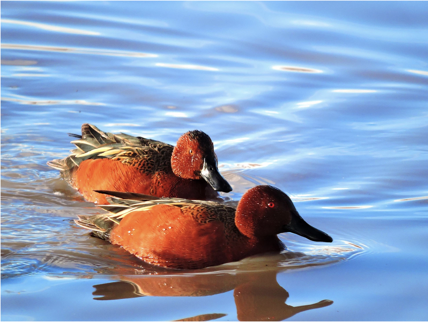
Cinnamon Teal by NPS Patrick Myers.
Improve the status of declining or at-risk species. Applications supporting this goal should seek to clearly address habitat needs of these species. See species list on the Wetlands Priority Species page.
The application deadline is Wednesday, Jan. 26. The Wetlands Funding Request for Applications (RFA) is available on our website, which can be accessed by clicking here.
American beaver, he was happily sitting back and munching on something. and munching, and munching. By Steve from washington, dc, usa – American Beaver, CC BY-SA 2.0, https://commons.wikimedia.org/w/index.php?curid=3963858
A new Tier 1 priority species this year is beavers. Beavers are a keystone species and ecosystem engineer that create and maintain healthy wetland and riparian habitats. Many mountain ponds, willow thickets and meadows are the works of beavers over time. These habitats aid in controlling floods, providing refugia during wildfires, improving water quality and preventing soil erosion.
Tier 1 species are the highest priority for project funding.
The Colorado Wetlands for Wildlife Program is a voluntary, collaborative and incentive-based program to restore, enhance and create wetlands and riparian areas in Colorado. Funds are allocated annually to the program and projects are recommended for funding by a CPW committee with final approval by the Director.
“Wetlands are so important,” said CPW Wetlands Program Coordinator Brian Sullivan. “They comprise less than two percent of Colorado’s landscape, but provide benefits to over 75 percent of the species in the state, including waterfowl and several declining species. Since the beginning of major settlement activities, Colorado has lost half of its wetlands.”
Since its inception in 1997, the Colorado Wetlands Program and its partners has preserved, restored, enhanced or created more than 220,000 acres of wetlands and adjacent habitat and more than 200 miles of streams. The partnership is responsible for more than $40 million in total funding devoted to wetland and riparian preservation in Colorado.
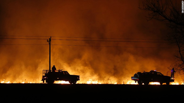
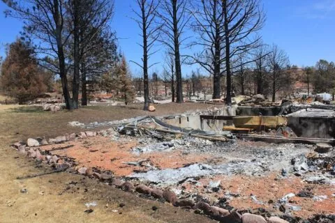
Marshall Fire December 30, 2021. Photo credit: Boulder County
FromColorado Public Radio (Michael Elizabeth Sakas):
Several factors are fueling the water problems in both communities. Firefighters used so much water trying to extinguish the Marshall and Middle Fork fires that pressure was lost in both water systems. Bacteria and other organisms can enter water lines that aren’t properly pressurized and contaminate water supplies.
The fires also carved a destructive path through Superior and Louisville that broke water mains and destroyed as many as 1,000 homes, damaging and exposing other pipes, leaving them open to other contaminants entering the water systems.
Greeley Water and Sewer customers can expect about 10% rate increases starting this month, as the department funds more than $200 million in investments over the next several years.
The Greeley Water and Sewer Board recently approved the new rates in a unanimous vote, according to a city news release. On average, residents can expect a utility rate increase of about $10 a month, or about 9.8%.
The increases take effect this month, but residents may not see the changes until their February utility bills.
The increases break down as follows, according to the release:
Water: An average increase of $4.16 per month will help cover the city’s participation in a new water storage reservoir to provide enough water for more than 4,500 new residents.
Sewer: An increase of $4.22 per month will cover the cost of state- and federally mandated sanitary sewer upgrades. The mandates reduce the amounts of nitrogen and phosphorous allowed in the city’s treated wastewater discharge to reduce algae growth.
Stormwater: An increase of $1.54 per month will help the city resolve downtown flooding issues. The city will upgrade its storm drainage to handle large rain events, such as the one in July that damaged businesses and homes.
In the release, Harold Evans, chairman of the water and sewer board, cited the regulatory changes and providing for the city’s rapidly growing population as drivers behind the rate increases.
Snowpack levels on the Western Slope continue to climb above normal for this time of the year and thanks to recent winter storms the Front Range is no longer terribly far behind.
That recent snowfall to the west even means that drought conditions are no longer as severe as they were in late December, according to the latest data from the National Drought Mitigation Center.
Climatologists expressed concern at lower snowpack levels earlier in the winter. Snowfall on the Western Slope feeds into the Colorado River, upon which tens of millions of people depend. And abnormally dry conditions to the east exacerbate wildfire risk, seen most recently in the devastating Marshall fire in Boulder County.
Over the last few weeks snowpack levels trended toward those above-average levels.
Colorado snowpack basin-filled map January 5, 2022 via the NRCS.
Data collected by the U.S. Department of Agriculture’s Natural Resources Conservation Service shows that as of Thursday snowpack around Gunnison and Ouray sits at 148% of normal levels. Snowpack around Durango also rose to 137% of normal levels.
Similarly levels around Aspen and Glenwood Springs are 124% of normal and the area around Steamboat Springs is at 115% of normal. Even the Front Range, where conditions were previously described as “bleak” is looking better. Snowpack from Denver to Fort Collins sits at 110% of normal. And from Colorado Springs to Pueblo levels are 88% of normal.
Colorado Drought Monitor map January 4, 2022.
With the improving snowpack, some Western Slope areas in Garfield, Gunnison, Mesa and Pitkin counties are now considered to be “abnormally dry,” an improvement over the moderate and severe drought conditions previously noted by the National Drought Mitigation Center.
Scott Hummer sent two photographs via email showing how conditions have improved at Stagecoach Reservoir from December to January. From his email, “Thought you’d be interested to see the view of conditions outside my kitchen window…storm last night…quite a change over the past month! Think Snow!”
Stagecoach Reservoir area December 7, 2021. Photo credit: Scott HummerStagecoach Reservoir area January 6, 2022. Photo credit: Scott Hummer
According to SNOTEL reports, most of western Colorado is experiencing above average snowpack with the upper Colorado River watershed, which includes Garfield County, clocking in at about 126% of typical snow water equivalent measurements, the U.S. Department of Agriculture reported…
Sunlight Mountain Resort, on the other hand, measures snow daily, and reported about 60 inches fell from Dec. 24 to Jan. 1.
“Some of the locals have said they haven’t seen a storm cycle like that in decades,” said Troy Hawks, the resort’s sales and marketing manager.
Fresh snow is great for business, and Hawks said the resort set another record for season pass sales this season. Additionally, the resort experienced a record high sales day during the holidays, which includes all sales at the resort — lift tickets, rentals and food sales, he said.
A South Platte River Water Update will be held in Brush on Wednesday [January 12, 2022]. The half-day program includes updates on the Master Irrigator Program, the Northern Integrated Supply Project, salinity in the South Platte and the Platte Valley Water Partnership project.
The update will be held at the Riverview Event Center, 19201 County Road 24, near Brush. It will begin at 8:50 a.m. and run until noon. Lunch will be served.
The Colorado Master Irrigator program offers farmers and farm managers advanced training on conservation- and efficiency-oriented irrigation management practices and tools. The program is the product of efforts led by several producers, district management representatives, and others interested in conserving groundwater in eastern Colorado. The program is modeled on the award-winning Master Irrigator program created and run since 2016 by the North Plains Groundwater Conservation District in the Texas panhandle.
Greg Peterson of the Colorado Ag Water Alliance and Roxy McCormick, Master Irrigator in the Republican River Basin, will present the information.
[Brad] Wind, general manager of the Northern Colorado Water Conservancy District, will provide an update on NISP. Construction has been under way for several month on the project, which will provide about 40,000 acre-feet of new, reliable water supply. The project consists of two reservoirs, Glade and Galeton, a forebay reservoir, three pump plants, pipelines to deliver water for exchange with two irrigation companies and for delivery to participants, and improvements to an existing canal to divert water off the Poudre River near the canyon mouth.
Grady O’Brien, CEO of Neirbo Hydrology, will present information on salinity in the lower reaches of the South Platte River. Salinity has been a growing problem as urban development and agricultural irrigation have added to the river’s saltiness. The water doesn’t taste salty – it contains only 0.12 percent salts compared with ocean water’s 3.5 percent – but the increasing salinity does have a negative impact on the soil. Salt in the soil suppresses the level of potassium, which is necessary for plants to take up nitrogen and create new plant material.
Old-fashioned flood irrigation used to leach the salts out of the soil, but more efficient irrigation methods don’t put enough water on the ground to do that. And, while the amount of salt in the river at Sterling seems miniscule, it is nearly twice the amount in the Denver area, just above Broomfield, and more than six time the salinity of the river above Denver.
Joe Frank, general manager of the Lower South Platte Water Conservancy District, will talk about the Platte Valley Water Partnership. It is a joint water supply project by the LSPWCD and the Parker Water and Sanitation District to use a new water right that the two entities are developing along the South Platte River near Sterling.
The project will use new and existing infrastructure to store and transport water for agricultural use in northeastern Colorado and municipal use along the Front Range. The partnership involves the phased development of the water right. The early phases would involve a pipeline from Prewitt Reservoir in Logan and Washington counties to Parker Reservoir, which supplies the City of Parker. Later developments would see a 4,000-acre-foot reservoir near Iliff on land owned by Parker, and a 72,000-acre-foot reservoir near Fremont Butte north of Akron. A pipeline, pump stations, and treatment facility will also be built as part of the project.
Anyone wanting to attend the update presentations can register by contacting Madeline Hagan, morganconservationdistrict@gmail.com (970) 427-3362 or Amber Beeson, centennialcd1@gmail.com (970) 571-5296.
‘How are we helping the landscape, how are we helping the community and what’s our long-term vision?’
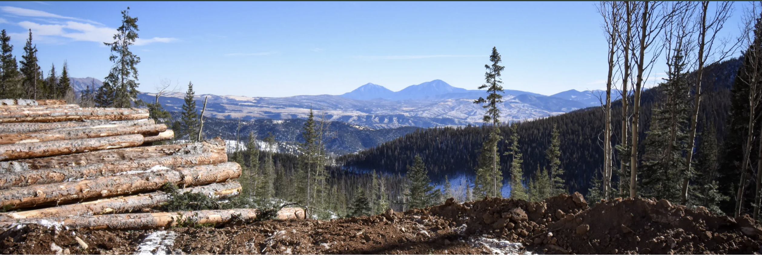
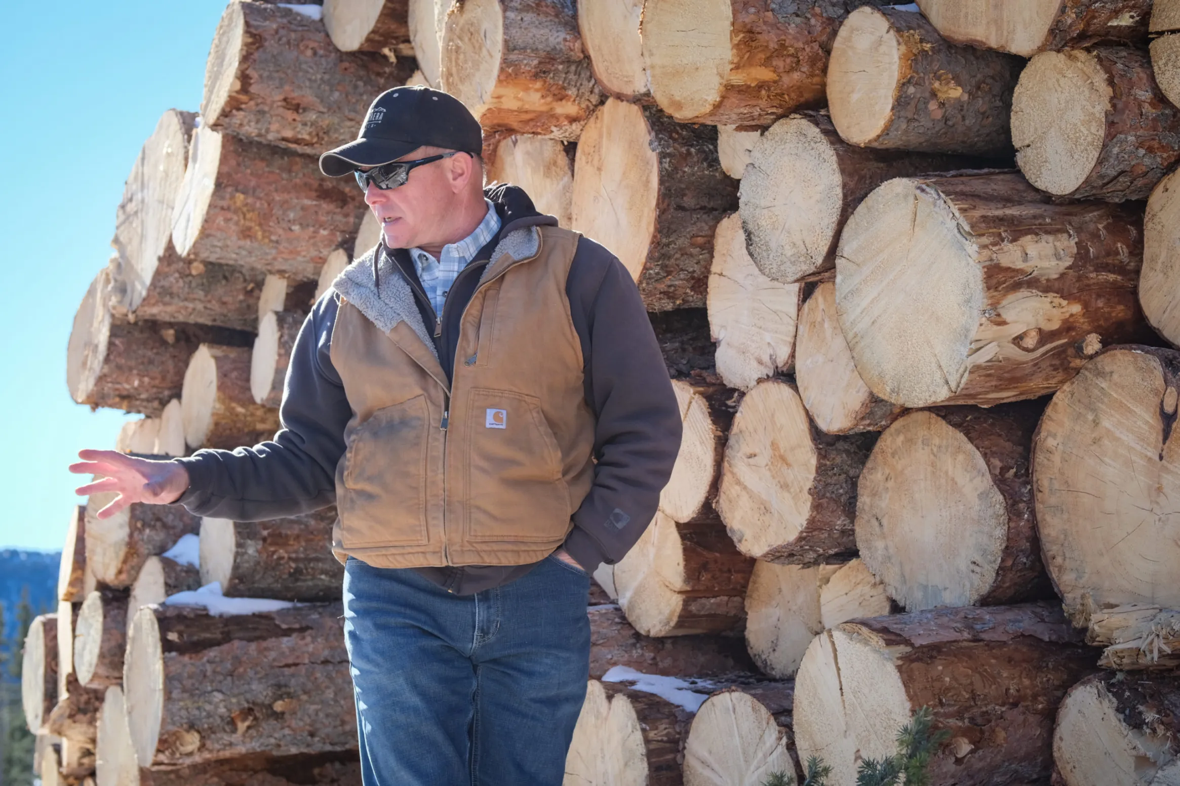
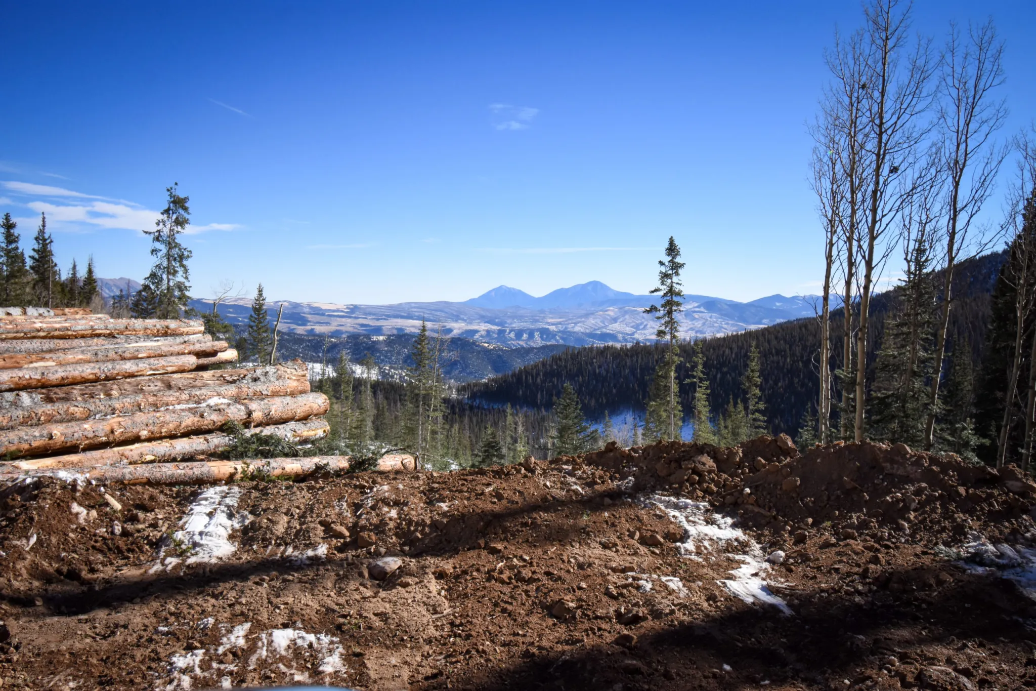
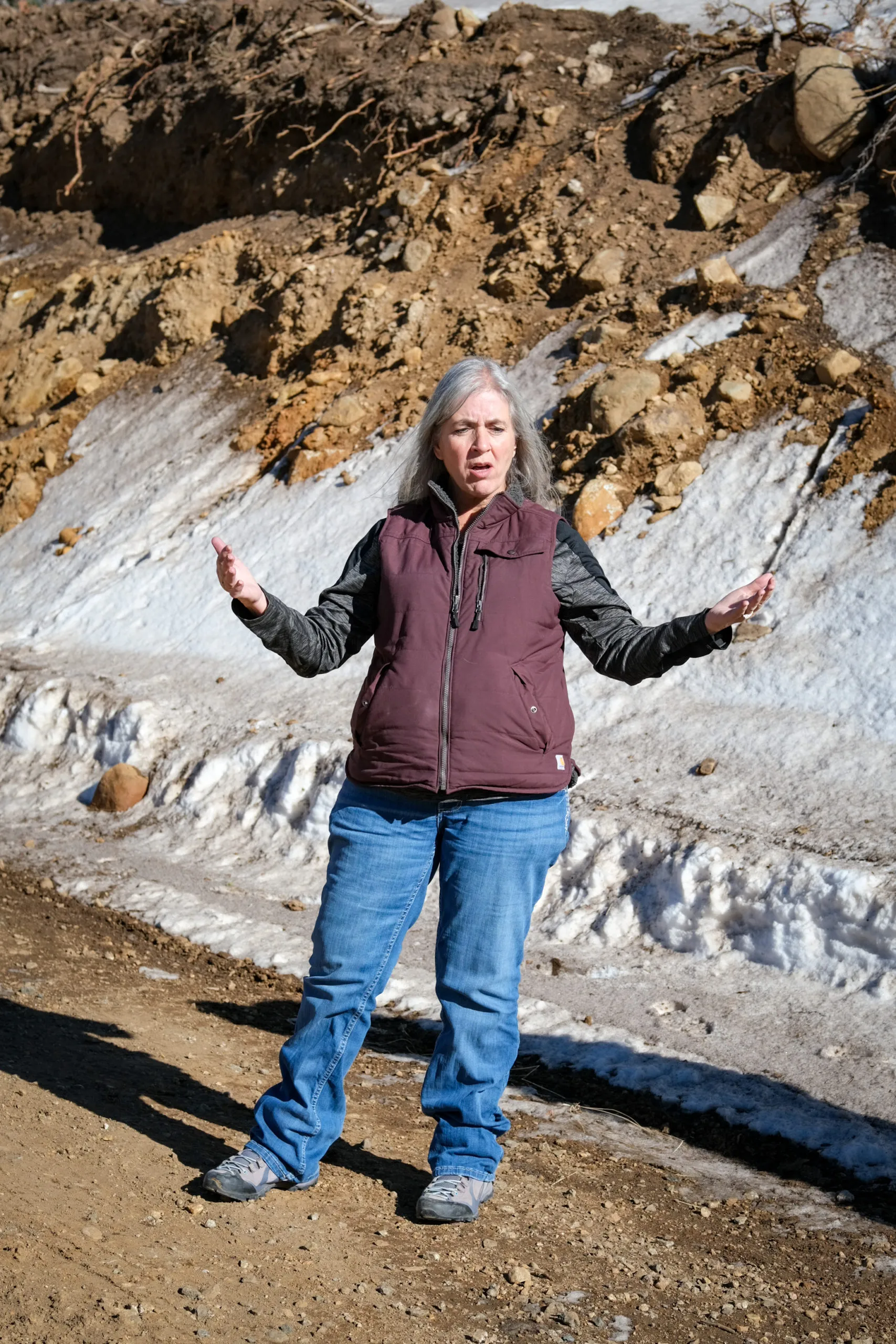
The mid-December day was balmy, normal for these times. James Fischer, forestry manager for the 172,000-acre Trinchera Ranch, was explaining and pointing out aspects of the Trinchera’s adaptive management forest plan as he gained elevation in the SUV, barely a trace of snow even in the higher reaches.
James Fischer. Photo credit: Ryan Michelle Scavo
“We’re trying to adapt and go ‘OK, what is it going to look like in the future?’ That’s hard,” he said, explaining how one of the largest conservation easements and pieces of property in Colorado is learning to adapt to the changing climate conditions.
“I mean, we’re basing it on models so you’re going ‘OK, it’s going to warm up. It’s going to dry out.’ How do we manage for that? I don’t know. As a profession, we’re trying different things right now, hoping they’re going to work. I mean, this is a long-term process. We’re only here for just a short period of time.”
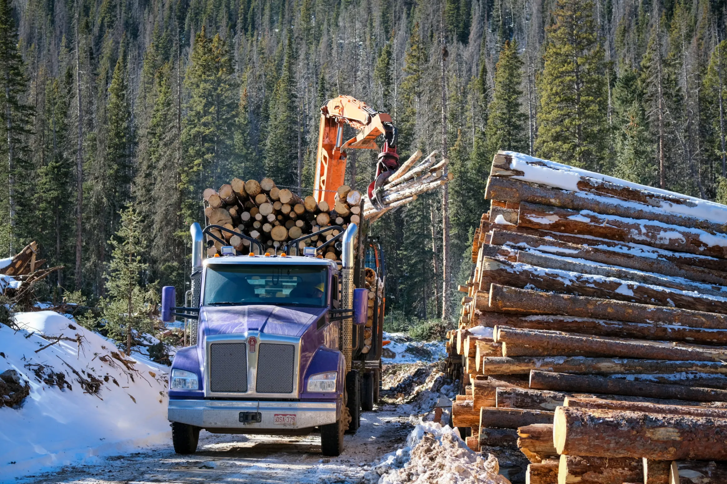
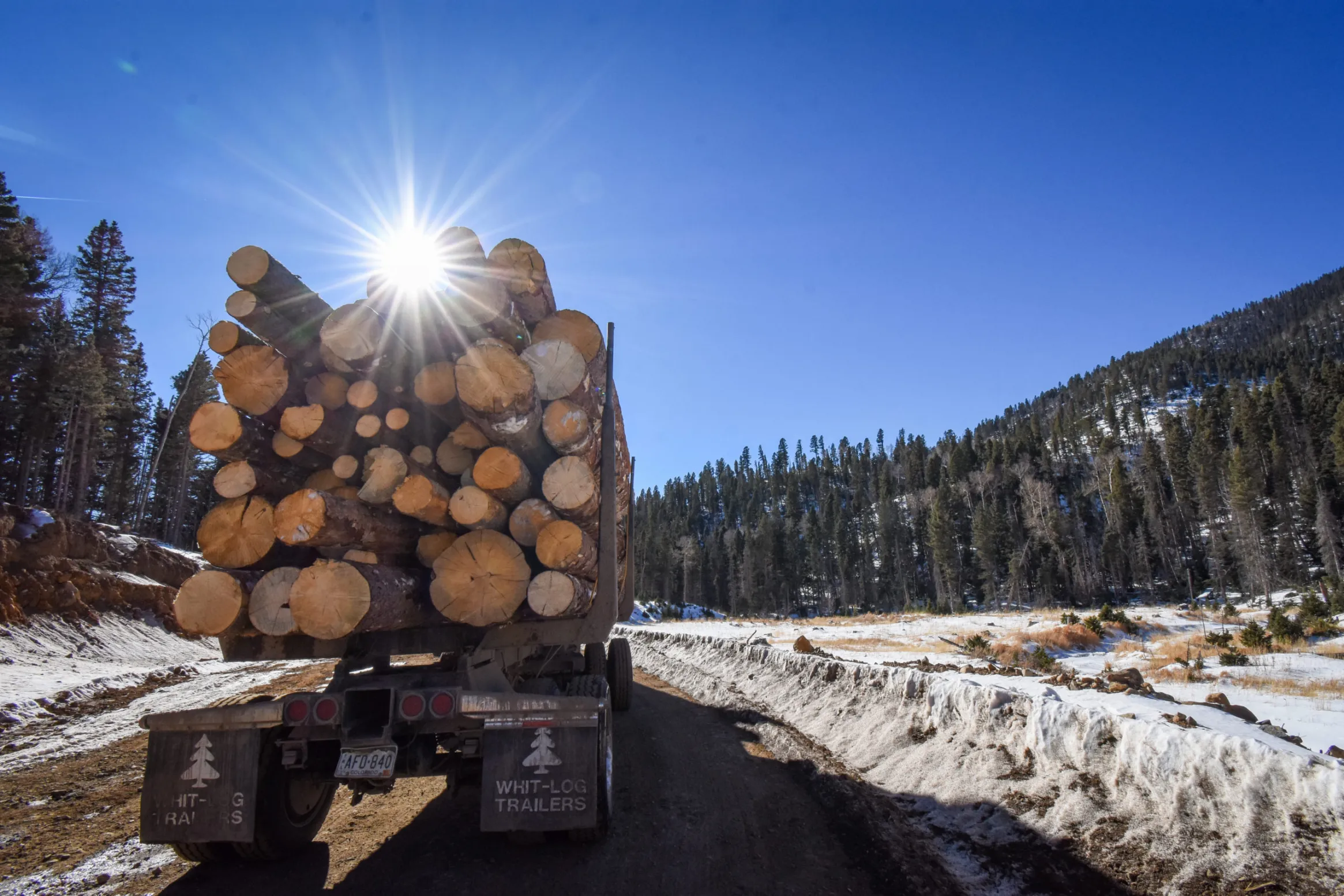
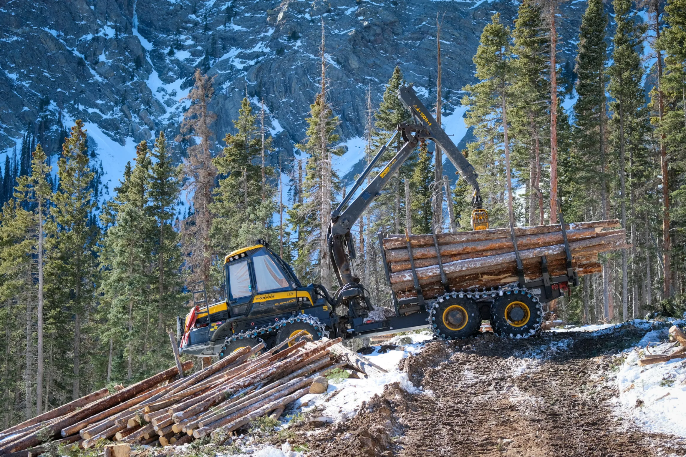
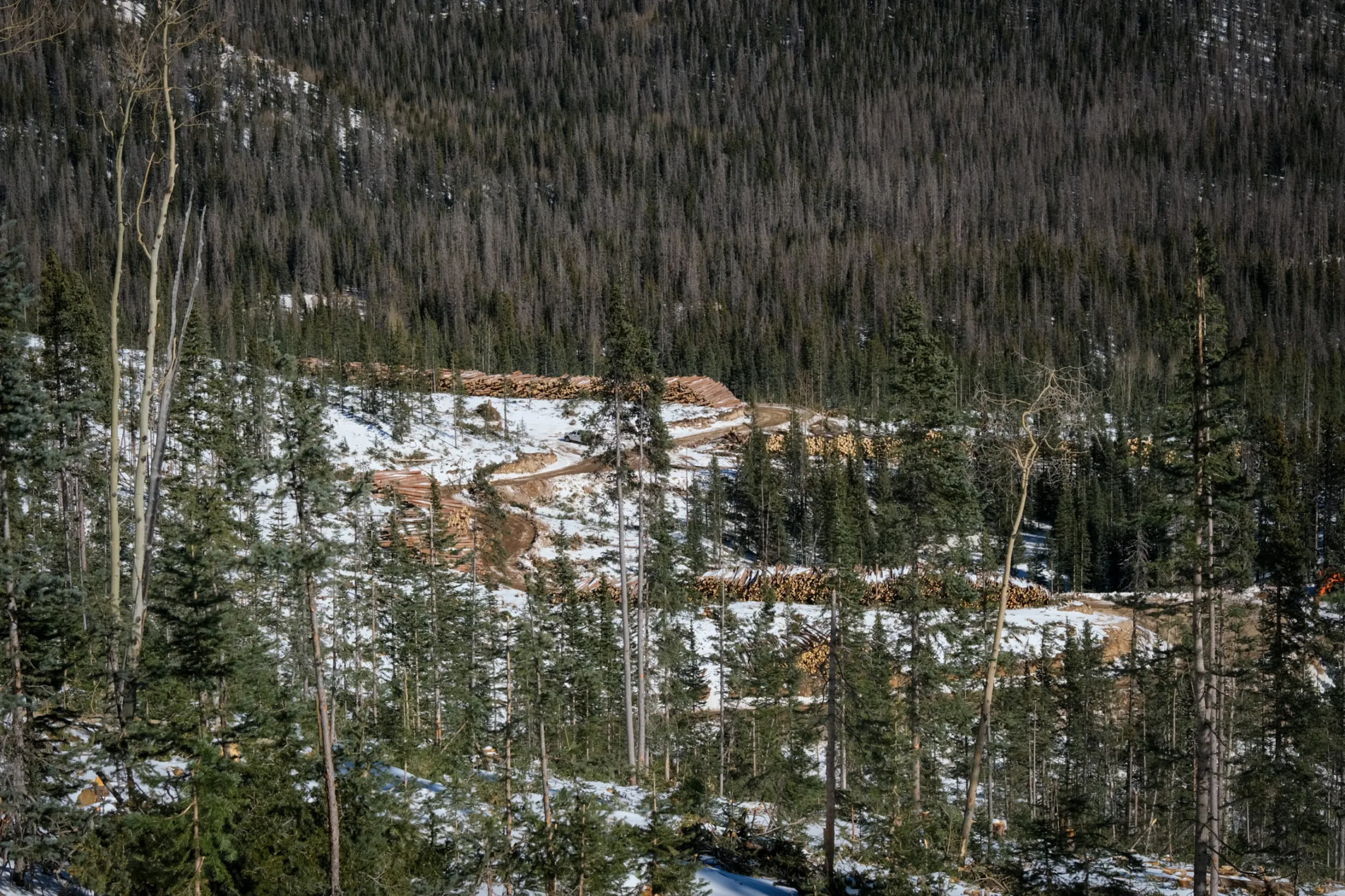
Spruces and mixed conifers 120 to 150 years old are thinned from the forest and hauled to the Blanca Forestry Products sawmill maybe 15 miles away – down the mountain to the Valley floor and on the outskirts of the town of Blanca.
Of Trinchera’s total acreage, 90,000 are timbered, said Fischer. “Then out of that, there’s 30,000 of spruce, 30,000 of mixed conifer and about 30,000, roughly, of aspen in there.” He can recite those numbers because the saw mill’s business model pushed him to update the Trinchera’s forest management plan and conduct a new inventory to give him precise numbers of what exists.
Of Trinchera’s total acreage, 90,000 are timbered: 30,000 of spruce, 30,000 of mixed conifer and about 30,000, roughly, of aspen. Photo credit: Ryan Michelle Scavo
The saw mill itself was a stroke of genius. Like the Trinchera Ranch, it is owned by conservation philanthropist Louis Bacon. Operated by Blanca Forestry Products, it came online in 2017 and produces 8.5 million to 9 million board feet of timber a year out of the Trinchera.
Judy Lopez. Photo credit: Ryan Michelle Scavo
“I think that evolution to get to the sawmill was really important because it helped not only the ranch understand, but it was an opportunity to work with the community and understand what fits those needs,” said Judy Lopez, conservation and sustainability manager for the Trinchera Ranch. “When we think about the sawmill, it’s just not a place for timber but it also created this pool of jobs for all local folks.”
“The same thing up here. As James continues to expand the logging operation, we’re seeing more and more folks in the area getting higher quality jobs and being able to do work here at home that’s meaningful. I think that is one of the key pieces of everything that goes on here and looking at it through that big, broad lens: how are we helping the landscape, how are we helping the community and what’s our long-term vision? Those are two really key pieces of that vision.”
Since July, crews have focused on an 8-mile stretch of the Trinchera Ranch. Operations are a mosaic across the different landscapes to help reduce fuels. Using some of the cleanest and most technologically-advanced equipment, logs are cut to the precise size for the saw mill.
“The big change is how we get this material out, the equipment that’s being used,” said Fischer. “There’s only two pieces of equipment doing all of this. One cuts and manufactures the logs out in the woods, the other piece goes behind, picks it up, brings it up here, puts it by the road or decks it.”
Decks of logs, guessing 25 feet high or higher, line the mountain roads over those eight miles. The cut timber is evidence of how the forest is actively managed. During the day, four semi-trucks will go back and forth to the saw mill, each hauling eight loads a day, 12 at best.
Trucks are loaded up. During the day, four semi-trucks will make the trips to the saw mill on the Valley floor, each hauling eight loads a day. Photo credit: Ryan Michelle ScavoLoaded truck heads down to the saw mill on the Valley floor. Photo credit: Ryan Michelle Scavo
It’s not only the proactive and adaptive nature of the forest management plan, but the importance of it. Protecting the Trinchera Watershed which feeds into the Rio Grande Basin is critical to the Valley’s ecosystem.
Aaron Swallow. Photo credit: Ryan Michelle Scavo
“Everything is tied holistically because we all realize in the West, water is our limited resource,” said Aaron Swallow, environmental manager for the Trinchera and Tercio Ranches. “What James is trying to do here is protect this watershed, again, from that high-severity fire that’ll just essentially nuke it out. Then we don’t have water, and we don’t have fisheries for a couple of years. That’s very scary.”
The dryness of the Valley and the scenario of a forest fire hit close to home for the Trinchera most recently in 2018, during the Spring Creek fire. Since then, the severe drought over the past two years causes a variety of concerns for Fischer as he surveys the forest around him.
“The problem is, come summer, if we don’t get moisture, then these trees . . . they’re stressed going into the winter, then spring comes and we get little moisture, they’re just going to get more stressed so then they’re more susceptible for those beetles to bore in and kill those trees,” said Fischer.
“What happens when these beetles fly, they’ll start boring into the closest tree they can get to and, if one of them is, say, stressed and can’t produce enough sap to pitch that beetle out, it gets in and then they send a pheromone out or release a pheromone for all of their buddies to go “Hey, I got in, come join the party,” and they go attack that tree.”
An overstocked forest means the trees are competing for limited nutrients, water and sunlight. “Throw drought in there, and that’s kind of the final nail in the coffin,” Fischer said.
Severe drought over the past two years is causing a variety of concerns, including wildfires and beetle infestation. Photo credit: Ryan Michelle Scavo
The Trinchera Ranch is part of a Sustainable Forestry Initiative, which is a certification program that examines the ranch’s harvesting practices. As the only certified forest in Colorado, Fischer’s forest management plan is scrutinized through on-site visits and data he provides on the inventory of the forest to road layouts.
“Our planning, our whole implementation, everything from start to finish, is gone over with a fine-tooth comb,” said Fischer. “They look at our forest management planner, our inventory, that all needs a check. Then, how are we doing with road layout? They look at that and ‘OK, you’re meeting it. Are you exceeding it? OK, you’re doing that.’”
The benefits are to the land itself and the protection of the natural environment of the San Luis Valley.
“I think it’s critical for the Sangre de Cristos and the wildlife corridors that are moving around here,” said Lopez. “Especially as we see dryings happening, we’re going to need places for animals to move, we need places for species to move. We need to have a place where there’s a protected area where all of these things can begin to happen. I think, in that way, what we’re doing is super important.”
Agile equipment gathers processed logs in the forest and takes them to the road and stacks them. Photo credit: Ryan Michelle ScavoTrucks are loaded up. During the day, four semi-trucks will make the trips to the saw mill on the Valley floor, each hauling eight loads a day. Photo credit: Ryan Michelle Scavo
Del Norte Riverfront Project. Photo credit: Rio Grande Basin Roundtable
From The Rio Grande Basin Roundtable via The Alamosa Citizen:
THE Rio Grande Basin Roundtable (RGBRT) began its water advocacy efforts in 2005 as a result of the Colorado Water for the 21st Century Act. This act created nine Roundtables across the state to represent the eight major river basins and the Denver metro area.
Rio Grande Basin Reservoir release. Photo credit: Rio Grande Basin Roundtable
Like all the state’s roundtables, the RGBRT is run by local stakeholders and is focused on local community values and water issues. Funding for roundtable project implementation comes from through the Colorado Water Conservation Board. With these state funds, each Roundtable can financially support local projects that further the goals laid out in the Colorado Water Plan and the respective Basin Implementation Plan.
Since its inception in 2005, the RGBRT has helped fund more than 50 projects, including Irrigation Infrastructure, Reservoir Improvements, River and Watershed Restoration, Conservation Easements, Water Education, Water Management and Water Research Projects. These projects addressed a variety of uses in every corner of the San Luis Valley.
This didn’t stop in 2021. Despite the pandemic, work continued – allowing five amazing projects to be completed. These projects demonstrate the power that can be garnered when groups come together and create projects that benefit many users, including irrigation, water administration, recreation, the environment, municipal needs and education. The projects and their purposes are listed below.
Del Norte Riverfront Project
The Del Norte Riverfront Project was a community-led effort to improve public access, create recreation infrastructure, and enhance aquatic and riparian habitat along the Rio Grande in Del Norte. The overall purpose of the project was to create connectivity between the communities and visitors of the SLV and the river that sustains it. The new Riverfront Park includes a whitewater playwave, boat ramp, fish habitat structures, pedestrian river access, parking area, an ADA accessible picnic shelter, and interpretive signage. The project has provided a significant positive benefit to the community of Del Norte and the San Luis Valley by creating a welcoming, safe space for community members, boaters, and anglers, while also improving river health. The Del Norte Riverfront Project was made possible through collaboration between the Rio Grande Headwaters Restoration Project (RGHRP), Town of Del Norte, Del Norte Trails Organization, Riverbend Engineering, Trout Unlimited, San Luis Valley Water Conservancy District, Colorado Parks and Wildlife (CPW), local businesses, and countless community members.
Rio Grande Cooperative Project
The Rio Grande Cooperative Project improved infrastructure and optimized management on the Rio Grande. Both Rio Grande and Beaver Creek Reservoirs were repaired to address seepage issues and improve outlet works. With upgraded infrastructure for the storage and release of water, stakeholders on these reservoirs came together to develop a management strategy that maximizes the benefits of timed reservoir releases, resulting in optimized flows that benefit aquatic habitat, irrigation supplies, augmentation demands, and Rio Grande Compact compliance. The project was a partnership between the San Luis Valley Irrigation District, CPW, and the Colorado Water Conservation Board.
Conejos Meadows Resilient Habitat Project
The Conejos Meadows Resilient Habitat project, which was identified in the Conejos River Stream Management Plan (SMP), enhanced habitat on 9,200 linear feet of the Conejos River below Platoro Reservoir, greatly improving connectivity and habitat complexity. During low flow time periods such as winter months and during droughts, the improved instream habitat provides a low flow channel to maximize available habitat and water delivery conveyance. Additionally, the project added rocks and large wood to existing deep pool habitat features in the area, providing increased winter and refuge habitat for the high value recreational fishery. The project is a partnership between Trout Unlimited, the Conejos Water Conservancy District (CWCD), CPW, the Rio Grande National Forest, and Riverbend Engineering. The project complements the Winter Flow Program led by Trout Unlimited and the CWCD, which is an effort to increase stream flows on this section of the Conejos River during the non-irrigation season.
Conejos River Partnership Project
The Conejos River Partnership Project (CRPP) was born out of the Conejos River Stream Management Plan (SMP) and has brought together the CWCD, RGHRP, CPW, Division of Water Resources, Bureau of Land Management, private landowners, and water users to address irrigation infrastructure and riparian and aquatic habitat degradation on the Conejos River. This multi-phased project helps meet aquatic habitat needs on the Conejos River through the rehabilitation of irrigation infrastructure, enhancement of aquatic habitat, and restoration of riparian and wetland habitats. The CRPP includes six sites along the Conejos River between Mogote and the confluence with the Rio Grande. In 2021, construction was completed at the Sabine Ditch to replace the diversion structure and headgate, revegetate and stabilize upstream streambanks, and reconnect the river with its floodplain. Construction will continue in 2022 at additional project sites.
Rio Grande Basin Conejos River Partnership Project Construction. Photo credit: Rio Grande Basin Roundtable
Alamosa River Water Delivery Improvement Project
The Alamosa River Water Delivery Improvement Project was a collaborative effort between the Terrace Irrigation Company and the Alamosa-La Jara Water Conservancy District. Many diversions along the Alamosa River are manually diverted with headgates that are out-of-date and deteriorated. This project resulted in the replacement of the headgate on the Main Canal, installation of automatic controllers on the Main and Creek Canal, and installation of satellite recording devices on 5 of the larger upstream diversion structures. As a result of this project, the Alamosa River will be administered more accurately for the benefit of all stakeholders involved, including the Alamosa River Keepers, Colorado Parks and Wildlife, Division of Water Resources, the Town of Jasper, Expo Inc., and other water users along the river.
The Rio Grande Basin Roundtable continues to work on collaborative and innovative solutions that will keep the Rio Grande Basin water here and working for our communities. We want to thank the Colorado Water Conservation Board and their incredibly dedicated staff, along with other project funders that include Foundations, Agencies, Organizations and contractors who all work passionately to help us create a sustainable water future. We wish you all a Happy New Year and invite you to join us at our monthly RGBRT meetings.
So this is what climate change looks like: operating on the margins, yet able to dramatically alter the story on center stage.
Warming temperatures played a monster role in creating the conditions that enabled the fire that burned nearly 1,000 houses as well as other buildings in Boulder County on Dec. 30.
“We are just numb. It happened so quickly,” Lafayette resident Peggy Williams reported in a Facebook post after being forced to flee. “We never thought our little towns would experience something like this.”
To understand what happened and why, it’s useful to examine the discrete elements. Some are entirely natural and nothing new. Taken together, though, they represent a new dynamic, unprecedented in Colorado.
“Certainly, climate change is never the only part of the story when it comes to wildfires. It’s part of the story but there’s always more to the story,” said Russ Schumacher, the Colorado state climatologist. “That being said, what we see in these fires and have seen in the last couple of years in Colorado, the changing climate is kind of making us expand our imaginations of what types of destructive wildfires are possible.”
A scattergram assembled by Schumacher showing weather and precipitation records from three Front Range locations tells the story of hot and dry over past decades. The Fort Collins record goes back longer, but records kept at Denver’s Central Park – the site of Denver’s airport prior to DIA — are more proximate to Boulder.
The year 2021, for the period between June 1 and Dec. 29, stands alone in its intense combination of warm and dry, even compared to other seven-month periods. Look at the warm and dry quadrant closely and you will see a pattern: disproportionate representation of 21st century years.
Again, it’s not just precipitation, not just warmth. It’s the combination.
Because of the warm temperatures and drought, vegetation became bone dry by year’s end. And that resulted in what one meteorologist suspects was near-record combustibility of the grasses in the open spaces.
High winds were another crucial ingredient. They rapidly pushed the flames eastward from origins of the fire near Marshall, on the outskirts of Boulder, through Superior and into Louisville while threatening Lafayette, Westminster, and Broomfield.
What’s new in all this?
Wind? Absolutely not. Boulder, Golden, and Denver were still new mining supply camps in the 1860s, when the newspapers of Colorado reported the “savage violence” of winds that tore off roofs and stopped trains. Papers issued by researchers from the National Center for Atmospheric Research and the National Oceanic and Atmospheric Administration in the 1970s and 1980s reported winds in excess of 100 mph, including one gust of 137 mph at the NCAR building in January 1982.
The winds of Dec. 30 were notably strong but not without precedent. They shattered the glass in cars and other vehicles, but wind storms in the past have flattened buildings in Boulder, Golden, and other towns even in recent years.
No particular study of the winds seems to have been conducted since the 1980s, but the perception is that they have actually become less frequent in recent decades, according to Schumacher.
One final ingredient, what meteorologist and science writer Bob Henson calls the “other elephant in the room,” is housing and other buildings adjoining open spaces in Superior and Louisville. Without it, this would have been a prairie fire.
Conditions for the fire began setting up in spring. Abundant May rains created a landscape lush and green. Then in June, it stopped raining across most of the Front Range and temperatures spiked.
In a tweet, Henson pointed to records for Sept. 1 through Dec. 30 for Denver.
Temperatures an average 52.2 degrees Fahrenheit, the second warmest in 150 years.
Precipitation of 0.47 inch, the least in 150 years.
Snowfall of just 0.3 inch, the least in 140 years.
“The warmer it gets, the harsher these droughts will be on the landscape,” Henson, whose books include “The Thinking Person’s Guide to Climate Change,” wrote in the tweet.
The climate writing was on the wall
Climate scientists in recent years have stressed how rising temperatures can create drought where none would otherwise exist. These are called hot droughts, and California has made them infamous.
That expression has also been used in the Colorado River Basin. There, increased evaporation and transpiration caused by rising temperatures has robbed average or near-average snowpacks, producing runoff into Lake Powell of 25% to 30% of average.
In Boulder County, precipitation was nowhere near normal. In its New Year’s Eve story, “How extreme climate conditions fueled unprecedented Colorado fire,” The Washington Post reported that Boulder averages over 30 inches of snow between September and December; this year it got 1.46 inches.
Graphic credit: Westwide Drought Tracker
This converted the green vegetation of May into the sort of tinder useful to getting the logs burning in the fireplace. The Washington Post story by staff writer and meteorologist Jason Samenow, assistant Colorado state climatologist Becky Bolinger, and meteorology student Jacob Feuerstein pointed to two indexes that document this flammability.
One, the Evaporative Demand Drought Index, or EDDI was at a record high in eastern Colorado during December. The index provides a snapshot of how “thirsty” the atmosphere is compared to normal that time of year.
“It can be a good wildfire risk predictor as it takes into account temperatures, sunlight and wind, in addition to humidity,” the authors wrote.
Another indicator, the Energy Release Component, was also dangerously high, reflecting the contribution of all live and dead fuels to potential fire intensity.
Boulder County had instituted fire restrictions on Nov. 30, prohibiting open fires, including charcoal barbecues and grills. The release said the restrictions were a response to the “increasing fire danger, lack of moisture, and the forecast for above seasonal temperatures without precipitation.” As of Dec. 30, eastern Boulder County was in a swath described by the Colorado Drought Monitor as “extreme,” the second driest category.
Then came the spark or fire – from a source or sources still undetermined as of Sunday evening — and the 6,200-acre conflagration.
Henson observes that the vast majority of the homes were built in the 1980s or later. Had this firestorm occurred 50 years ago, it might well have been largely a prairie fire. With the development, though, it became a different, more destructive fire.
Firefighters from across Kansas and Oklahoma battle a wildfire near Protection, Kan., Monday, March 6, 2017. (Bo Rader/The Wichita Eagle via AP)
‘Several things going wrong at the same time’
Massive fires have not been uncommon on the Great Plains. In March 2012, a fire near Yuma burned 24,000 acres. Other fires in recent years have swept across hundreds of thousands of acres in other Great Plains states.
“As white cells are to man, so fire is to prairie,” wrote William Least Heat-Moon in “PrairyErth,” his paean to Chase County, Kansas. In his assessment of the tallgrass prairie, however, he did not speak to the seasonality of prairie fires.
The latest major fire on the Great Plains occurred in mid-December. A fire driven by gusts of up to 100 mph resulted in deaths of two men and damages across 163,000 acres near the town of Paradise in north-central Kansas. As with the Boulder County fires, abnormally dry conditions were blamed along with the winds.
“It was definitely a perfect storm,” Shawna Hartman, a spokeswoman for the Kansas Forest Service, told The Associated Press. “These fires ran for 20-plus miles in an afternoon. It’s very, very reminiscent of what you would see in California.”
In the shortgrass prairie of Boulder County, Henson described a similar confluence of “several things going wrong at the same time, including the wind storm, the dryness, the warmth drying out the landscape further.”
The suburban nature of this fire also deserves attention. This wasn’t the foothills in what is commonly called the wildland-urban interface. It was the place of winding streets, many million-dollar homes and an economy strongly engaged in northern Colorado’s booming high-tech economy.
Residents forced to flee were still in shock two and three days later, trying to sort out the circumstances that had at least one (and likely many others) shopping for clean underwear and other necessities at Target in nearby towns, still unable to return home.
That shopper, after a night deprived of sleep and still unsure of whether her rented home was standing — it was, but a house four doors away had become rubble — shared a friend’s report from afar of having a new understanding of what it’s like to be a refugee.
The Wildland-Urban Interface is the Boulder County suburbs
Daniel Swain, a climate scientist at the University of California Los Angeles and a well-known blogger, pointed out in a tweet that the Boulder County fires demonstrate “just how far into the suburbs the … interface actually extends given sufficiently extreme drought and wind conditions.”
In a tweet, the University of Montana’s Phil Higuera, a professor of fire ecology, also suggested the fires will “help dispel the misconception that the wildland-urban interface (#WUI) is ‘just’ a bunch of vacation homes in dense forest.”
In 2012, the Waldo Canyon Fire on the edge of Colorado Springs destroyed 346 homes and killed 2 people. Photo/Allen Best
During the last decade, fires have made it into the suburbs and exurbs. In 2012, the Waldo Canyon Fire destroyed 346 homes and killed 2 people on the northwestern outskirts of Colorado Springs. The next year, the Black Forest Fire destroyed 511 homes north in a forested area north of Colorado Springs in what was – until the Boulder County fires – the most destructive of human property in Colorado history.
Different from those June fires in and near Colorado Springs, the Boulder County fires occurred in late December. This is a new game, at least in Front Range fires. It’s also part of a trend: an expansion of wildfire season. Like tornados in Southern states and the Midwest, the calendar for wildfires is less useful.
Consider the East Troublesome Fire. In the 20th century, mid-October brought hunting season and snow. In 2020, it produced a new fire even as other fires, including the Cameron Peak Fire west of Fort Collins, continued to grow. Then came a wind storm and, on Oct. 22-23, East Troublesome raced past Grand Lake and vaulted across the treeless Continental Divide, forcing the evacuation of Estes Park.
Now comes the state’s biggest fire in history — on the cusp of New Year’s Eve.
The fire will force us to “expand our imaginations,” said Schumacher. “Thinking about the most destructive fire ever happening in late December is not the sort of thing that we were probably planning on. Given what we have seen in the last couple of years, we as a collective Colorado community need to do some rethinking of what is possible, what we need to prepare for.”
[…]
This story benefitted from editing by the crew at Boulder Reporting Lab. Scattergrams and posts courtesy of Russ Schumacher.
Click on a thumbnail graphic to view a gallery of drought data from the US Drought Monitor.
US Drought Monitor map January 4, 2022.
High Plains Drought Monitor map January 4, 2022.
West Drought Monitor map January 4, 2022.
Colorado Drought Monitor map January 4, 2022.
Click here to go to the US Drought Monitor website. Here’s an excerpt:
This Week’s Drought Summary
In what has become a familiar pattern, heavy precipitation continued to improve drought and dryness across the northern half of the West Coast States, though it created its own set of significant impacts. Farther south, similar totals fell on a relatively small area in southwest California. Heavy precipitation – some falling as heavy snow – also covered areas from the Ohio Valley and Middle Atlantic States southward through the Tennessee Valley, the interior Southeast, and the Carolinas. Parts of the Rockies – primarily the higher elevations – also reported moderate to heavy precipitation. Meanwhile, only light precipitation fell on the Northeast, across much of the lower Midwest, and along most of the Gulf Coast and adjacent areas. Most of the Plains and upper Mississippi Valley reported little or no precipitation. The result was some significant areas of drought improvement across the Carolinas and interior Southeast, as well as parts of the West Coast States and Rockies. In contrast, unseasonably warm and dry weather for several weeks prompted fairly broad areas of deterioration along the immediate central Gulf Coast, the southwestern half of the lower Mississippi Valley, and the southern Plains…
It was a dry week east of the Rockies, and even across Colorado and Wyoming, moderate to heavy precipitation was limited to the higher elevations. This was sufficient to prompt some improvement in western Colorado and a small section in northwestern Wyoming. The eastern portions of D0 and D1 areas in North Dakota were also improved based on a re-assessment of reduced impacts from earlier precipitation. Meanwhile, southern Kansas saw some deterioration near Oklahoma, where the last 60 days brought very little precipitation. But given it is the coldest and climatologically driest time of year there, deterioration was limited to a patch in the southernmost reaches of Kansas where the weather has been somewhat warmer. Central Wyoming also saw worsening conditions where little or no precipitation fell during the last 60 days…
Colorado Drought Monitor one week change map ending January 4, 2022.
Heavy precipitation and a generous snowpack in mountainous areas led to more improvement here, based in part on monthly statistics for December. Improvement was brought into large swaths of the region, especially across central Montana, much of Idaho and Utah, western Nevada, and part of central and southern California. It was a wet week with 2 to locally 6 inches of precipitation reported from the Cascades westward to the Coast in the Pacific Northwest and adjacent parts of California, further reducing dryness and drought in areas where such conditions have already been removed. Some areas in California already received more precipitation in the last 3 months than they had in the prior 12 months…
Eastern Tennessee – as with adjacent parts of the Southeast Region – reported at least 3 inches of rain, with as much as 6 inches in isolated spots. Farther west, less-widespread 2 to 4 inch amounts extended across northern Arkansas and adjacent Oklahoma. As a result, improvement occurred in many esixting areas of D0, keeping most of the northern tier of this Region drought-free and limiting D0 to some areas near the Mississippi-Ohio Rivers confluence, and interior eastern Tennessee. In stark contrast, several weeks of unseasonably warm weather and aubnormal precipitation led to broad deteriorations across the southern half of the Region from Mississippi and Louisiana westward through significant portions of Texas. Over the last 2 months, precipitation totals were 4 to 8 inches below normal from eastern Teas through Louisiana into central Mississippi, leading to widespread D1 to and D2 across central Mississippi, northern Louisiana, and eastern Texas while D0 expanded southward to cover areas from central Louisiana and Mississippi all the way to the Gulf Coast. Farther west across central and western portions of Texas and Oklahoma, deterioration was not as widespread and there were some small scattered areas of improvement, However, most of central and western Texas, the Texas and Oklahoma Panhandles, and central Oklahoma recorded 25 percent of normal precipitation or less for the past 60 days…
Looking Ahead
January 5-9, 2022 could benefit some of the recently-expanded areas of dryness and drought near the Gulf Coast. 0.5 to 1.0 inch is forecast along the Coast from the western Florida Panhandle through most of southeastern Louisiana, with amounts potentially topping 1.5 inches farther west into the northeastern Texas Coast. Farther north, moderate to heavy precipitation – including some substantial snowfall – should reach from the Lower Mississippi Valley through the upper Southeast, the central and southern Appalachians, and (to a lesser extent) the Middle Atlantic States. Between 1.5 and 2.5 inches of precipitation will impact a swath extending from northeastern parts of the Lower Mississippi Valley eastward into the southern Appalachians. Moderate precipitation should extend as far north as the immediate Ohio Valley, as far east as the Middle Atlantic Coast, and as far southeast as non-coastal areas of the Carolinas and Georgia. Heavy precipitation and some heavy snows should continue to whittle away at dryness and drought in the Pacific Northwest, although it will probably bring a different set of problems. Areas west of the Washington Cascades will be most significantly impacted, with most locations recording several inches (liquid equivalent) of precipitation. Several areas extending from the Idaho Panhandle and adjacent areas southeastward into central Colorado will also see moderate precipitation, especially in the Idaho Panhandle (1.5 to locally 3.5 inches) and higher elevations in Wyoming and Colordao. Other parts of the 48-states will see much less precipitation. Light to moderate precipitation (generally 0.5 to 1.0 inch) is expected across the Northeast, with little or none falling along the Southeast Coast and most of Florida, the Plains, and the southwestern quarter of the Nation. Temperatures will remain well below normal from the Upper Midwest through most of Montana, averaging 9 to 15 deg. F below normal. Near-normal temperatures will cover the Northeast and Middle Atlantic States while unseasonable warmth prevails along the southern tier of the country and in the Four Corners Region.
The Climate Prediction Center’s 6-10 day outlook (valid Jan 10-15, 2022) favors subnormal precipitation across most of the 48-states, with odds favoring above-normal precipitation limited to a swath from the southern Rockies to the Lower Mississippi Valley. Meanwhile, above-normal temperatures are favored near the Gulf Coast (especially Florida), the Plains, most of the Rockies, and the immediate West Coast.
US Drought Monitor one week change map ending January 4, 2022.
Just for grins here’s a gallery of early January US Drought Monitor maps for the past few years.
As J.T. Shaver, a forester with the Colorado State Forest Service, strolls through the Hutchison Ranch, a legacy cattle farm in Salida, Colo., it’s what he doesn’t see that excites him most.
Last year, the trees here were so dense you couldn’t see more than 20 feet away. The 11,713-foot peak of Methodist Mountain was obscured by piñon-juniper trees. Now, the trunks are pleasantly spaced out, letting in beams of sunlight. The ground is scattered with wood chips and stumps, feeding a healthy new bed of grasses.
“This looks completely different than this time last year,” Shaver says. “I’m pleasantly surprised.”
The landscape’s evolution was the result of a weeks-long treatment organized by Shaver’s office to help this 5,800-person town prepare for wildfire. By thinning the dense thickets of trees, any fire that does reach the ranch shouldn’t burn hot and fast in the crown of the trees. Instead, it should run along the ground with less intensity, burning more naturally. “We’re mimicking the behavior of a wildfire that would have occurred prior to European settlement,” Shaver’s colleague, Josh Kuehn, explains.
Over the past decade, Chaffee County’s once sleepy population has steadily grown as people seek refuge from the busier Interstate 70 corridor. In 2017, county leaders convened a master planning process but were surprised to learn that residents’ No. 1 concern wasn’t small business sustainability or housing prices or even traffic. It was wildfire.
“We knew about the beetle kill epidemic and saw that our forests were in poor health,” says Kim Marquis, project and outreach coordinator for Envision Chaffee County. “The first step to growth planning was taking on our wildfire risk.”
At that point, Chaffee County had been spared from the intense fires ravaging the state in recent decades, although the 2019 Decker Fire would soon burn just two miles south of Salida. But residents had embraced the frightening reality that few places in Colorado are safe from fires. Climate change and the decades-long drought have been fueling bigger and more dangerous fires, leaving devastation up and down watersheds.
The county assembled stakeholders, including state foresters, federal officials, local landowners and farmers, to work proactively to improve forest health. Aurora Water also joined the talks, since a fire near Salida could potentially pollute the headwaters of the Arkansas River, one of Aurora’s primary water sources. The partners thoroughly mapped the area, highlighting the properties and forests most at risk if a fire did come through the Rio Grande and San Isabel National Forests.
While local landowners could take their own preventative measures like shoring up buildings and removing dead trees, the Colorado State Forest Service (CSFS) also received funding for a more holistic treatment. The Methodist Front Wildland Urban Interface Forest and Watershed Health Restoration Project, funded through a RESTORE Colorado Program grant, along with the U.S. Forest Service (USFS), Salida and Poncha Springs, and a county fund, will treat 478 acres of public and private land, masticating trees to thin out the crowns and encourage healthier vegetation. Eventually, with the participation of enough landowners, the fuel break will stretch five miles, creating a buffer between the forest and the ranches, townhomes and small farms in Salida.
How fires went from healthy to hazardous
Decker Fire October 2019. Photo credit: Greg Hobbs
The Decker Fire, which burned nearly 9,000 acres, came in an unusually calm year in the midst of a decade that has reshaped how Coloradans see fire. Since 2012, six megafires, defined by the National Interagency Fire Center as fires larger than 100,000 acres, have burned in Colorado.
Looking towards Boulder at the Marshall Fire December 30, 2021 From 53rd and Stuart in Adams County.
Last week, the Marshall Fire in Boulder County, though just a few thousand acres in size, became the state’s most destructive, burning nearly 1,000 homes in Superior, Louisville and parts of unincorporated Boulder County.
During 2020’s Pine Gulch Fire, north of Grand Junction, Colo., hotshot firefighters watch and wait for the fire to burn through brush and move to grass fields, where the flames become less intense, before they can hold it back. Photo by Kyle Miller/Wyoming Hotshots, USFS, via National Interagency Fire CenterA helicopter drops water on the Cameron Peak Fire near CSU’s Mountain Campus. Photo credit: Colorado State UniversityA view from the highway of the massive East Troublesome wildfire smoke cloud near Rocky Mountain National Park in Colorado on October 16, 2020. Photo credit: Inciweb
2020 saw the state’s three largest recorded fires to date—Cameron Peak, East Troublesome and Pine Gulch—and some 700,000 acres burned, more than 540,000 of which burned in those three fires alone. And the CSFS’s 2020 Forest Action Plan projects a 50% to 200% increase in the annual area burned in the state by 2050.
There’s no single factor making Rocky Mountain fires more intense. Bark beetle infestations swept through tens of millions of acres of forest in the West over the past two decades, leaving large stands of dead trees. A century of federal policy that squelched out all fires rather than letting them burn naturally led to a buildup of fuel stores in forests. Climate change is creating warmer and drier conditions, and an earlier snowmelt has extended the fire season.
Chuck Rhoades, a research biogeochemist at the USFS’s Rocky Mountain Research Station, says those “compound disturbances” have created a pattern of fires that are burning more intensely and in places and seasons that experts wouldn’t predict. Fires that once would have been a natural tool to clear dead fuel and encourage seeds to sprout are now a major threat to communities. Some, including Cameron Peak and East Troublesome, have ravaged high-elevation forests where fires used to be rare. A 2021 study in the Proceedings of the National Academy of Sciences found that high-elevation forests in the Rocky Mountain region are burning more than at any point in the past 2,000 years.
That, Rhoades says, means land managers and cities are seeing impacts outside the scope of anything they’ve prepared for—with ripple effects throughout the environment.
“We often think that where we were before will help us predict where we’re going,” he says. “But there are a lot of question marks out there. It forces a little humility in that we can’t understand what we’re going to get next.”
One known, however, is that the higher-intensity wildfires are putting more Coloradans at risk as the state’s population booms. In 2020, the CSFS estimated that half of the state’s population lived in Colorado’s 3.2 million-acre wildland-urban interface area, known as the WUI, where human development intermingles with fire-prone vegetation. By 2050, CSFS says that area could triple in size to encompass more than 9 million acres, or more than 13% of the state.
The risks are especially profound for watersheds. As more intense fires clear out thick older trees, shrubs and grasses grow back in their place. Without dense roots and pine needle cover, the forest floor that typically acts as a sponge for snowmelt and precipitation is turning fragile and rocky. Those are prime conditions for erosion and flooding, with streams and rivers accumulating water faster and earlier than usual. According to USFS research, the risk of flooding and debris flow is higher for at least 3-5 years post-fire, often longer, and those floods can be as much as three times more severe than they would be otherwise.
Ash and silt pollute the Cache la Poudre River after the High Park Fire September 2012
Runoff from burn scars can run black, laden with ash, debris, nutrients and heavy metals from burned soil and biomass. If those contaminants reach utilities’ water infrastructure, they can clog water filters or settle in reservoirs, possibly fostering algal blooms and taking up valuable reservoir space.
The 1996 Buffalo Creek Fire and the 2002 Hayman Fire, the largest in Colorado’s history until 2020, each burned along the Upper South Platte River, immediately upstream of Strontia Springs Reservoir, which accommodates about 80% of Denver Water’s raw water supply and 90% of Aurora’s supply. The fires exacerbated erosion in the watershed, leading to sediment-laden flows that dumped debris and contaminants in the reservoir. More than a decade later, the reservoir’s capacity to store water remains reduced, and water quality is still impacted from sediment flows, even after $27.7 million worth of dredging, removal and recovery work. Last year’s fires caused water utilities across the state to shift their operations to protect their source water.
It’s clear, then, that the risks of fires no longer stay in the forest. Partnerships have sprung up from Boulder to Durango to protect valuable watersheds and water infrastructure, forcing water district managers to become just as interested in what happens to the forest around headwaters as what goes into their customers’ pipes.
All hands on deck
In 2020, the Colorado State Forest Service released its updated Forest Action Plan, identifying some 2.5 million acres—roughly 10% of the state’s forests—as being “in urgent need of treatment.” The highest priority forests were in the Front Range’s Arapaho-Roosevelt and Pike-San Isabel forests and in the San Juan Forest around Durango. “We have to prioritize those areas where we’re going to get the most bang for the buck,” says Weston Toll, watershed program specialist for the CSFS. Still, he says, with so much of the state at risk, “we’re paddling against the current.”
The Forest Action Plan’s priority map reflected a range of factors, including where fuel had built up, how close fires could get to human development, and the impact on wildlife and water. But those areas didn’t all line up with valuable headwaters, despite some water managers’ arguments that any waterways must be protected. Nor does the map give much direction on how to square the widespread needs with limited resources.
Wildfire mitigation used to be defined by what some experts call “random acts of restoration,” individual projects on small plots of land depending on the owner’s interest and availability. A National Forest might have dead trees removed and fuel treated for insect infestation, but neighboring land might be left untreated, doing little for the overall region’s safety.
Now, the USFS and others are promoting a philosophy of shared stewardship, bringing together a variety of partners ranging from federal land managers, local water districts, utilities, logging companies, recreationists and private landowners to collaborate on responsible forest management.
Toll says the state may still be paddling against the current, but “it helps to have everyone paddling in the same direction, which wasn’t happening until five or 10 years ago.”
Watershed Assessment Vulnerability Evaluation (WAVE) volunteers work to install silt fencing immediately above Northern Water’s Willow Creek Reservoir. Photo by Emanuel Deleon, Colorado State University
‘Mutual benefits’
After the runoff from the Buffalo Creek and Hayman fires poured sediment into Strontia Springs Reservoir, officials at Denver Water realized they could be spending less money and having a bigger impact by focusing on preventing fires and flooding before the effects reached their infrastructure. The utility formed the From Forests to Faucets partnership with USFS, a multi-year effort to fund forest health projects to boost resilience in priority areas within Denver Water’s collection system. In 2017, the program was expanded to include state and local authorities to stretch Denver Water’s forest health work to non-federal lands.
Fuel breaks played an important role protecting homes during the Buffalo Fire on June 12, 2018, in Summit County. Photo credit: U.S. Forest Service.
Fuel breaks around the Dillon Reservoir watershed funded by the program are credited with protecting nearly 1,400 homes near Silverthorne during the 2018 Buffalo Fire, despite red-flag drought conditions.
“There was this exciting realization that there were a lot of mutual benefits in funding these projects,” says Madelene McDonald, watershed planner at Denver Water. “Forest restoration projects not only bolster source water protection, but also improve wildlife habitat, expand recreation access, and can protect communities in the wildland urban interface.”
But it is also incumbent on communities to do their own preparation. That can include building codes that require fire-resistant building material or defensible space requirements to clear fuel from some established perimeter around buildings. Colorado does not have a state wildfire code or model ordinance, despite recommendations from a 2014 task force, but communities like Boulder and Colorado Springs have regulations governing new homes in at-risk areas.
“There’s a big educational component, but seeing a disaster happening right in our faces prepares people,” says Marquis of Envision Chaffee County. “We’re asking people to join this honestly heroic story to protect the community.”
Money matters
Addressing all of the CSFS’ Forest Action Plan’s priority areas is estimated to cost $4.2 billion, money that state agencies and local partnerships just don’t have. USFS spent $1.8 billion in fire suppression, fighting and responding to wildfires nationally in fiscal year 2020, but just $431 million on treatments to reduce fuel buildup through its Hazardous Fuels program, according to national spokesperson Babete Anderson. According to National Interagency Fire Center data, other federal government programs spent $510 million on fire suppression in 2020. According to a Colorado Department of Public Safety report, Colorado’s 2020 fire season cost the state an estimated $38 million in suppression costs and required another $248 million in federal funds. Those state figures don’t include suppression costs footed by local agencies or the costs of property loss, infrastructure damage, watershed impacts, or economic losses. Nor do they account for other private, local, county or federal wildfire expenses.
The federal bipartisan infrastructure bill brings nearly $8 billion for wildfire risk reduction and forest restoration, including $90 million a year for the U.S. Department of Agriculture’s Landscape Restoration Partnership Initiative to support forest and grassland restoration secured by Colorado Sen. Michael Bennet.
Fire departments and forest managers can also cobble together money from grants from a variety of federal sources. In 2021, the Colorado legislature passed SB21-258, which authorized $25 million for wildfire mitigation, recovery and workforce development. In a statement, Colorado Department of Natural Resources director Dan Gibbs said the bill would “quickly move resources to on-the-ground projects and mitigation teams,” a step up from previous efforts that “have lacked the coordination, landscape-scale focus and robust state investment required to properly address the size and behavior of catastrophic wildfires.”
Even with those funding sources, it can be a challenge to prioritize spending in areas with the biggest benefit, or even address the widespread impacts of fires. Studies have shown that up-front mitigation saves costs on fire suppression, but even that is daunting when the needs are so vast.
Shaver, the Salida forester, says his community seems to understand that narrative and is on board with the cost of mitigation, knowing that the worst risk could be coming during any upcoming fire season.
“Sometimes there’s a feeling that you wish a fire would come through to validate the work,” Shaver says. “But a lot of people say they feel safer, and that in and of itself makes the work successful. Feeling safe is a win whether or not anything ever burns.”
Camille Stevens-Rumann, a forestry researcher at Colorado State University, graduate assistant Zoe Schapira, and field technician Zane Dickson-Hunt gather data in 2019 at the 2018 Spring Creek Fire burn scar, near La Veta, Colo. Here, aspen and scrub oak have sprouted but all pine trees and cones were destroyed in the fire. Photo by Mike Sweeney
The megafire era gripping the West isn’t just a threat to human development. Fires now burn so intensely that they literally reshape forests, shift tree species, and turn calm waterways into devastating mudflows.
A 2017 University of Colorado study analyzing 15 burn scars left from fires in Colorado and New Mexico found that as many as 80% of the plots did not contain new seedlings. In a 2020 follow-up study project under different climate change scenarios, the most severe scenario, where climate change continues unabated through 2050, showed as many as 95% of ponderosa pine and Douglas fir forests would not recover after a fire. In a “moderate” scenario where emissions decline after 2040, more than 80% of the forest would be replaced by scrubby grassland.
That, said study author Kyle Rodman, could have serious implications for waterways, due to the lack of established trees to stabilize soil and reduce the risk of flooding.
“Just because there aren’t trees doesn’t mean there’s no vegetation. Grasses and shrubs can hold back the soil, but it won’t be the same,” says Rodman, now a postdoctoral research assistant at the University of Wisconsin.
Nearly two decades later, the site of the 138,000-acre Hayman Fire, which burned in an area southwest of Denver in 2002, is still marred with patches of bare ground. That fire, according to a U.S. Forest Service (USFS) study, was so severe in areas that it consumed the canopy foliage as well as the seed bank for the forest’s ponderosa pines and Douglas firs, limiting regeneration. Overall, the study predicted “gradual return to preferred conditions” in the Hayman Fire area, though some of the worst-hit patches may see permanent vegetation changes.
Slopes above Cheesman Reservoir after the Hayman fire photo credit Denver Water.
In lower elevations, some of the heartier species, like the ponderosa pine and Douglas fir, are having trouble regrowing because of the increased heat and months-long drought. A 2018 study found that even seedlings of those species that were given supplemental water in burned areas had lower survival rates than expected because of the harsh natural conditions.
“When you’re planting a garden, those first few days are so critical. The plants need water to establish their roots and get healthy,” Rodman says. “Trees work a much longer timescale. Those first few years should be cool and wet and we just don’t have those conditions too often.”
Some tree species, like the high-elevation lodgepole pine, generally rely on fire because the heat helps them open and release seeds. But recent fires are burning so intensely that even lodgepole cones are consumed.
A 2020 study in BioScience found that burned forests are showing “major vegetation shifts” and recovering more slowly than expected. In some cases, heartier species might give way to drier shrub-dominated vegetation that can burn more easily. The study found that, generally, those post-fire “forested areas will have climate and fire regimes more suited to drier forest types and non-forest vegetation.”
That means that hearty forests used to adapting to natural changes are now facing conditions “outside the realm of the disturbances that some forests can handle,” says lead author Jonathan Coop, a professor of environment and sustainability at Western Colorado University.
“We have this paradigm that fire is a natural part of the forest and that forests will always recover,” Coop adds. “These days, we shouldn’t count on that.”
That vegetation shift is especially worrisome for waterways. Normally, forest floors soak in rain and snowmelt, releasing it to waterways slowly throughout the spring and summer. Burn-scarred watersheds, however, have faster runoff and a lower water yield because of the loss of natural material and because of hydrocarbons from smoke permeating the soil. A USFS analysis found that more than 50% of wildfire-scarred land area in Colorado showed increased erosion potential, mudslide threats, and sediment in streams for at least 3-5 years after a fire.
Those effects can last even longer depending on natural conditions, says USFS research engineer Pete Robichaud. The wild seasonal swings from climate change are challenging forests by dumping more precipitation on less stable ground.
The aftermath of July 2021 floods in Poudre Canyon, west of Fort Collins. (Credit: Colorado Parks and Wildlife)
“The drought cycle is bigger and the wet cycle is more intense,” Robichaud says. “The perfect storm is a high-severity fire followed by a high-intensity rainfall event.”
The harsh natural conditions, as well as widespread damage from bark beetles, has complicated typical recovery efforts. Some scientists say the rapid changes in forest conditions and fire characteristics make it hard to know what the best recovery strategy is. In some forests, for example, aspen trees that regenerate from low-ground structures rather than relying on seeds to sprout may dominate. Especially in low-elevation areas, shrubbier species like the Gambel oak may regrow faster in forests once driven by conifers.
While replanting is a natural step in recovery (USFS hosts six national nurseries that act as seed banks, although it has restrictions on where certain species can be planted), there are even concerns that the natural conditions should prompt a re-examination of how best to revitalize forests. Ultimately, Coop says, we should expect that forests may not look the same as they did in a pre-megafire era.
“I think this points to the need for all stakeholders and the public to start to think outside the box as far as how we evaluate the forests and ecosystems we depend on,” says Coop. “We might have to think about what ecosystems we are saving and under what circumstances we’ll have to let things go and let some changes unfold.”
A version of this article was first published in the Headwaters magazine Fall 2021 issue.
Jason Plautz is a journalist based in Denver specializing in environmental policy. His writing has appeared in High Country News, Reveal, HuffPost, National Journal, and Undark, among other outlets.
According to SNOTEL reports, most of western Colorado is experiencing above average snowpack with the upper Colorado River watershed, which includes Garfield County, clocking in at about 126% of typical snow water equivalent measurements, the U.S. Department of Agriculture reported…
Sunlight Mountain Resort…measures snow daily, and reported about 60 inches fell from Dec. 24 to Jan. 1.
About three inches of snow fell in Pueblo starting the night of New Year’s Eve and continuing throughout the next day, according to the National Weather Service Pueblo. While any amount of moisture is good for the prolonged drought conditions across the state, this amount of snow will likely not be enough to make any significant difference in the conditions on the southeastern plains. “In regard to the widespread drought across Southern Colorado it’s probably going to not have that much of an impact,” said NWS meteorologist Stephen Rodriguez.
“We need to see persistent [snow] and even more (amounts of snow across) Southeast Colorado.” Freezing temperatures during and immediately following the snowfall were quickly overtaken by climbing temperatures; Pueblo reached a high of 47 degrees on Jan. 3 and the forecast predicts a high of 62 degrees later this week. While this snowfall was the most Pueblo’s seen this winter, three inches of melted snow roughly amounts to about 18 inches of rain, leaving minimal moisture behind. “In terms of the southeast plains, this past snow event probably had minimal impact in regard to the drought,” Rodriguez said. Looking ahead, Rodriguez said the southeast plains have little-to-no precipitation in the forecast through at least mid-January.
Colorado snowpack basin-filled map January 4, 2021 via the NRCS.
Thanks to a widespread storm system that hit Colorado on New Year’s Eve, Colorado Springs has finally seen snow for the first time this season.
Measurable snow was recorded at the Colorado Springs Airport on Saturday night by the National Weather Service, absolutely smashing the city’s record for latest first snowfall of the snow season. The prior record was set on December 2nd in 2016, meaning that the December 31 ‘first snowfall’ this year pushed this date back 29 days…
As illustrated on the chart below, the state experienced its fastest jump in snow pack so far this season over the last few days. The current snow water equivalent is 121% of the to-date median statewide, according to the USDA.
Here’s the release from Colorado Parks & Wildlife (Travis Duncan):
Colorado Parks and Wildlife is celebrating its 125th anniversary in 2022 by telling the agency’s long history of wildlife conservation and outdoor recreation in a series of stories, videos, podcasts and community events over the coming 12 months.
Historical Photo: Colorado Game and Fish Department – Fish Planting Car No. 1
“This 125th anniversary is an opportunity to shine a spotlight on Colorado Parks and Wildlife’s mission of perpetuating the wildlife resources of the state and providing quality parks,” CPW Director Dan Prenzlow said. “Through a year of celebrating our past, present and future, we’ll show our dedication to educating and inspiring future generations to become stewards of our natural resources.”
The past
Using Colorado Outdoors Online, the CPW website, social media channels and traditional outlets, CPW will publish a series of stories describing the history of the past 125 years of state park and wildlife conservation in Colorado. We’ll highlight stories such as:
In the Gunnison River gorge, CPW Aquatic Biologist Eric Gardunio, holds a whirling-disease resistant rainbow trout. CPW is stocking fish resistant to the disease throughout the state. Photo credit: Colorado Parks and Wildlife
CPW’s terrestrial and aquatic biologists and researchers whose groundbreaking work has led the fight against chronic wasting disease in moose, elk and deer, combatted whirling disease in fish, expanded our understanding of the genetics of various species and helped the agency become a leader in balancing the carrying capacity of habitat with the various wildlife species competing on the landscape.
Greenback cutthroat trout photo credit: Colorado Parks and Wildlife.
CPW’s dedicated staff has helped restore the endangered black-footed ferret, bald eagles, lynx, Peregrine falcons, the Preble’s meadow jumping mouse, greenback cutthroat trout, boreal toads, Gunnison’s sage grouse, moose, Rio Grande and Colorado river cutthroat trout, and many other critical fish and wildlife species.
Came across an 1898 story in the St. Louis Post Dispatch about a 26-year-old woman, Annie Metcalf, a Missouri native, serving as a game warden in Colorado. She was the first woman to hold the title in Colorado and reportedly only the second nationwide. Credit: Colorado Parks & Wildlife
A profile of Annie Metcalf, Colorado’s first woman game warden. She was appointed a deputy game warden in 1898 in Routt County. She wasn’t afraid of mountain lions but she dreaded cows!
The story of her modern successors, starting with Susan Smith, the first woman appointed a District Wildlife Manager in Vail in February 1975.
A view of the boat ramp at Horseshoe Lake, Lathrop State Park, in Huerfano County, Colorado. The Spanish Peaks are in the background. By Jeffrey Beall – Own work, CC BY 4.0, https://commons.wikimedia.org/w/index.php?curid=61707075
The evolution of roadside parks and state recreation areas into our first state park, Lathrop near Walsenburg, on June 9, 1961, and our current roster of 43 state parks that offer world class outdoor recreation.
The present
CPW will be hosting events and receptions at state parks and offices around Colorado this year. Sign up for CPW’s eNewsletters and keep your eye on your inbox for events near you.
The future
CPW will soon be opening our 43rd state park at Sweetwater Lake, crafting a management plan for the restoration of gray wolves and introducing a Keep Colorado Wild Pass in 2023 that can be purchased during the Colorado vehicle registration or renewal process.
Photo credit: Colorado Parks & Wildlife
Photo credit: Colorado Parks & Wildlife
Stocking Greenback cutthroat trout September 22, 2021. Photos credit: Colorado Parks & Wildlife
A Colorado Parks and Wildlife officer heads out on patrol at Chatfield Reservoir. A $171 million redesign at the popular lake is now complete, providing more water storage for Front Range cities and farmers. Last week the Colorado Water Conservation Board approved a settlement that will pave the way for an environmental water plan to help offset the impacts of the new storage. Credit: Jerd Smith
Watson Lake fish ladder. Photo credit: Colorado Parks & Wildlife
Green Mountain Reservoir. Photo credit: Colorado Parks & Wildlife
The future site of Steamboat Lake is shown here in 1949. The barn pictured was owned by the Wheeler family, one of several families who ranched the land before it was bought by brothers John and Stanton Fetcher. John Fetcher proposed the construction of Steamboat Lake, which was built in 1967 and funded by the operators of Hayden power station and the Colorado Division of Parks and Outdoor Recreation. Photo via Bill Fetcher and Aspen Journalism
A busy highway can be a barrier for wildlife movement. This artist’s rendering shows an elk using the overpass to be built over U.S. 160 near Chimney Rock National Monument. The project will also include an underpass, since studies indicate that various species of wildlife prefer either above ground or underground routes to cross highways. Graphic credit: Colorado Parks & Wildlife
Image of wolf from a game camera, taken Oct 15, 2020, in Moffat County. Photo courtesy: Defenders of Wildlife via Colorado Parks and Wildlife
Connor Bevel, an Aquatic technician with Colorado Parks and Wildlife, holds one the 450 adult Colorado River Cutthroat trout released into the Hermosa Creek drainage October 9, 2020. Photo credit: Joe Lewandowski/Colorado Parks & Wildlife via The Durango Herald
The view from Music Pass in the Sand Creek drainage, where a multi-agency effort is unfolding to restore the Rio Grande cutthroat trout. (Provided by Colorado Parks and Wildlife)
Photo credit: Colorado Parks & Wildlife
A bear injured in a forest fire in June near Durango was released back into the wild on Monday. Images below show the bears feet when it was found and with bandages applied at CPW’s Frisco Creek facility. Photo credit: Colorado Parks and Wildlife
Cache la Poudre tributaries cutthroat stocking event August 2020. Photo credit: Jason Clay via Colorado Parks and Wildlife
Covid-Mask-wearing Black Bear. Credit: Colorado Parks & Wildlife
In-stream habitat improvements for brown trout on this section of the Conejos River in the San Luis Valley will occur thanks to this year’s Fishing is Fun grants. This is one of eight projects providing funds to improve angling opportunities in Colorado. Photo via Colorado Parks and Wildlife
Cherry Creek State Park. Vic Schendel Spring Summer 2017 via Colorado Parks & Wildlife
Full and permanent funding of the LWCF supports Colorado Parks and Wildlife’s mission to conserve wildlife and enhance outdoor recreational opportunities. Photo credit: Colorado Parks & Wildlife
A view of Fishers Peak from the property that will become Colorado’s next state park. Senate Bill 3 provides $1 million toward the park’s continuing development. Photo credit: Colorado Parks & Wildlife
Image from Grand County on June 6, 2020 provided courtesy of Jessica Freeman via Colorado Parks and Wildlife.
The sandhill cranes are back in the San Luis Valley (2020) on their spring migration. Photo credit: Colorado Parks & Wildlife
Mature Boreal toad. Photo credit: Colorado Parks & Wildlife.
Photo credit: Colorado Parks and Wildlife
Carrie Tucker, a CPW aquatic biologist, addresses about 40 volunteers who came to Cottonwood Creek to hike bags of rare Hayden Creek cutthroat trout to their new home. Josh Nehring, CPW senior aquatic biologist, reaches into a bag of rare Hayden Creek cutthroat trout as news media and volunteers watch to see him return the fish to the wild whitewater of Cottonwood Creek. All photos courtesy of Colorado Parks and Wildlife / Bill Vogrin
Justin Krall, a District Wildlife Manager for Colorado Parks and Wildlife based in Westcliffe, sits on his mule Speedy as Jenny follows carrying saddle tanks with about 2,000 rare Hayden Creek cutthroat trout. Photo credit: Colorado Parks and Wildlife / Bill Vogrin
Colorado Parks and Wildlife fish count Animas River August 2018: Photo credit: Joe Lewandnowski
ANS mitigation Navajo Lake June 6, 2018. Photo credit: Colorado Parks and Wildlife
Lake Avery. Photo credit: Colorado Parks and Wildlife
Great blue heron, Jackson Lake. Photo credit: Colorado Parks and Wildlife, December 2017.
Colorado Parks and Wildlife staffers prepare native Colorado River cutthroat trout for stocking north of Durango on July 27, 2017.
Roxborough State Park photo via Colorado Parks and Wildlife
Woods Lake photo credit Colorado Parks and Wildlife.
Sweetwater Lake, Garfield County, Colorado. Photo credit: Todd Winslow Pierce with permission
FromThe New York Times (David Marchese). Click through and read the whole article. Here’s an excerpt:
Such is the grimly politicized state of science these days that the descriptors typically used to explain who Katharine Hayhoe is — evangelical Christian; climate scientist — can register as somehow paradoxical. Despite that (or, indeed, because of it), Hayhoe, who is 49 and whose most recent book is “Saving Us: A Climate Scientist’s Case for Hope and Healing in a Divided World,” has become a sought-after voice for climate activism and a leading advocate for communicating across ideological, political and theological differences. “For many people now, hope is a bad word,” says Hayhoe, the chief scientist for the Nature Conservancy as well as a professor of political science at Texas Tech. “They think that hope is false hope; it is wishful thinking. But there are things to do — and we should be doing them.”
Where, if any, are there areas where you see a conflict between scientific consensus and your religious beliefs? The biggest struggle I have is that in the Bible, Jesus says to his disciples, “You should be recognized as my disciples by your love for others,” and today when you look at people who self-identify as Christians in the United States, love for others is not one of the top characteristics you see. Christianity is much more closely linked with political ideology and identity, with judgmentalism, partisanship, science denial, rejection of responsibility for the poorest and most vulnerable who we, as Christians, are to care for. You know, there was a really interesting recent article about the landscape of evangelicalism in the United States, and it said that about 10 years ago if you asked people, “Do you consider yourself to be evangelical?” and they said yes, and then you asked, “Do you go to church?” about 30 percent would say no. But nowadays something like 40 percent of people who self-identify as evangelicals don’t go to church. They go to the church of Facebook or Fox News or whatever media outlet they get their information from. So their statement of faith is written primarily by political ideology and only a distant second by theology…
You talk a lot about the importance of trying to communicate with people outside of our respective bubbles. You do that out of necessity because you’re doing the work you do while living in an conservative part of a conservative-leaning state. Where might cross-ideological conversations, particularly about climate change, happen for people who aren’t in a similar situation? So here’s the interesting thing: Your question contains a misconception. The misconception is that climate action isn’t occurring because of the people who aren’t on board with it. The reality is that more than 70 percent of people in the U.S. are already worried about climate change, and about 35 percent of those are really worried. So the biggest problem is not the people who aren’t on board; the biggest problem is the people who don’t know what to do. And if we don’t know what to do, we do nothing. Just start by doing something, anything, and then talk about it! Talk about how it matters to your family, your home, your city, the activity that you love. Connect the dots to your heart so you don’t see climate change as a separate bucket but rather as a hole in the bucket of every other thing that you already care about in your life. Talk about what positive, constructive actions look like that you can engage in individually, as a family, as an organization, a school, a place of work. Add your hand to that giant boulder. Get it rolling down the hill just a little faster. Even if we live in a progressive bubble, most of the people are not activated, and we activate them by using our voice…
How do you see rational thinking and emotionally driven behavior as working together — or not — in this context? That is something that I have thought about but nobody has ever asked me before. I think it’s Jonathan Haiti who says that we think that people use information to make up their minds but they don’t. People use what Haidt calls our moral judgment. We use moral judgment to make up our minds and then use our brains to find reasons that explain why we’re right. There’s no way to separate the emotional from the logical. We think it’s possible to convince people to act rationally in their best interests: Well, look at people who, as they are dying, are rejecting the fact that they have Covid. Look at people who are still rejecting simple things like taking a vaccine and wearing masks. We are primarily emotional, and emotions are engaged deeply with climate change because it brings up the most profound sense of loss: People on the right, for example, deeply fear losing their liberties because of climate solutions. So what we need to do is to show everyone how climate solutions are not only not incompatible with who they are but help more genuinely express who they are and what we care about; make us an even more-genuine advocate for national security, an even stronger supporter of the free market, an even more independent person or, in my case, a more genuine expression of my faith.
Sewage treatment plant. Photo credit: Colorado State University
Here’s the release from Colorado State University (Anne Manning):
Every day, hundreds of billions of gallons of a precious, dwindling natural resource, fresh water, is used for agricultural irrigation, energy extraction and more. The demand for novel sources of clean water, in the face of a growing population and a warming planet, is at crisis levels.
Colorado State University researchers have been given the green light on a research project that could rewrite the book on how spent water from agricultural fields or wastewater facilities are treated and reused, and how valuable commodities could be extracted from those waters. Their goal is to create new, sustainable uses for non-traditional water sources and to disrupt humanity’s reliance on traditional fresh water for crops and other needs.
The CSU team has received a $1.9 million grant from the U.S. Department of Energy’s National Alliance for Water Innovation, a $110 million, multi-institutional network of scientists focused on treatment and reuse technologies for outside-the-box water sources like municipal wastewater, seawater and agricultural drainage. Thomas Borch, professor in the Department of Soil and Crop Sciences with joint appointments in chemistry and civil engineering, is leading the awarded CSU research team and also serves on the leadership team of the national alliance.
Reducing demand for water
Borch and the team, which includes researchers from several institutions and an industry partner, will be focused for the next two years on developing and testing low-cost, environmentally benign materials that function as chemical sorbents, similar to sponges, for the precise removal and recovery of certain nutrients – mainly phosphate, ammonium and nitrate – from municipal and agricultural wastewaters. Their testbed will be a working wastewater treatment facility on the Hawaiian island of Maui operated by Washington-based water treatment solutions company WaterTectonics. WaterTectonics’ CEO, Jim Mothersbaugh, will serve as a key research partner in the project.
The benefits of a successful venture would be multi-faceted, the researchers say. Treatment and reuse of wastewater would reduce demand for fresh water across many sectors, including agriculture. The phosphates and other nutrients reclaimed from that water could become valuable, environmentally friendly fertilizers for agricultural fields. What’s more, their work could lead to an overall reduction in the levels of phosphates and nitrates typically left in wastewater and that end up in lakes and oceans. These nutrients feed harmful algae blooms, disrupting delicate ecosystems including fish and aquatic plants.
“The volumes of water we are talking about are just huge,” Borch said. “Agriculture alone is responsible for more than 42% of all fresh water withdrawals in the country. If you want to really make a different with respect to treatment and reuse of water, you will need to focus on either the agriculture or the power sectors.”
What is biochar?
The researchers’ starting sorbent materials of choice will be optimized and chemically tailored biochar and clay, which will be functionalized by the addition of metal oxides and biodegradable polymers. Biochar, commonly known as a soil additive, is a charcoal-like material created by burning carbon-rich biomass – usually wood, wheat straw, corn stalks or manure – in an oxygen-free environment. Its potential as a low-cost material for precision-separation of nutrients from water is being explored by multiple scientists, including the CSU team.
For this project, the team plans to use biosolids waste from the Maui treatment plant as their starting material for making their biochar sorbents. Other members of the research team from University of Cincinnati will work on optimizing clay as a sorbent material.
Jim Ippolito, CSU associate professor in the Department of Soil and Crop Sciences, will work on biochar synthesis and optimization. An expert in turning raw materials – including biosolids generated from sewage treatment facilities – into valuable, nutrient-rich products for agricultural land application, Ippolito will provide key expertise in both making the biochar and fine-tuning its sorbent properties.
“The main concept with our proposal is to determine a means by which we can selectively remove even greater amounts of phosphorus and nitrogen from this water,” Ippolito said. “It’s relatively difficult to remove both of these simultaneously from the water column. Our goal is to create novel materials to do the removal for us, yet capture these nutrients in such a way so they can be reused as a fertilizer source.”
The Maui plant has a pyrolysis unit under construction for the conversion of biosolids to biochar. Their intent is to use the manufactured biochar as a nutrient removal sponge for the wastewater. The nutrient-loaded biochar will then be used for agricultural applications in Maui, for which there is high demand. Conversion of municipal biosolids to biochar will reduce the cost of biosolids management while also assisting the facility’s sustainability goals and reducing its carbon footprint.
The CSU team will work with WaterTectonics and the local operator of the plant to make the biochar, characterize its chemical structure, and develop a sustainable solution for the recovery of nutrients from the plant’s waste.
“We are tapping directly into work that is ongoing, but will be responsible for development of advanced sorbent materials for selective removal of nutrients with WaterTectonics,” Borch said.
A critical focus of the project is scalability and economic viability, which is why the researchers are choosing simpler materials like clay and biochar, rather than more exotic, rare materials. “Exotic materials might work better as sorbents, but they would be prohibitively expensive and serve only as an academic exercise,” Borch said.
Other partners
Other partners on the grant are researchers at the National Renewable Energy Laboratory who will conduct environmental impact analysis and help the team compare varied materials with more traditional forms of wastewater treatment and reuse. The team also includes researchers from the Environmental Protection Agency and the University of Hawaii at Manoa.
To perform high-resolution molecular characterization of their unique biochars and clays, the team will also partner with scientists at the National High Magnetic Field Laboratory at Florida State University, the Lawrence Berkeley National Laboratory, and the Stanford Synchrotron Radiation Lightsource.
When the 40th annual Southern Rocky Mountain Ag Conference kicks off in 29 days, attendees will christen the new Ski-Hi Regional Complex east wing complete with its spacious conference rooms – and avoid having to shuttle around to other venues in Monte Vista to catch the full flavor of the three-day event.
It’s a dream come true for event organizers Kyler Browner and Marisa Fricke, who now can envision a growing regional conference with daily guest speakers, concurrent breakout sessions, a trade show, and cattle ranchers and crop producers together in one space networking, sharing best practices, and swapping stories.
“Having everyone in one campus, one spot, just makes the logistics so much better,” said Browner.
What attendees won’t see is the rush to finish. On Monday, Alcon Construction crews were busy building handrails, installing countertops, and pushing forward to complete the work before the conference’s opening day on Feb. 1 rolls around.
With the COVID pandemic at play, it’s been that way throughout for Alcon on this project, first racing to get the main entrance on the west end completed in time for last July’s 99th Annual Ski-Hi Stampede and now racing to finish the east end of the 54,473-square-foot building to welcome farmers and ranchers back to the all-important ag conference.
Alcon has done yeoman’s work, understanding the importance of the Ski-Hi Regional Complex as a Valley-wide events center and the critical task of completing it in time, first for the Ski-Hi Stampede, and now the second half of the building for the regional ag conference.
The regional ag conference, established initially by CSU-Extension in the San Luis Valley to help share its research and embed itself among the Valley ag and farming communities, is the first big business and social event of the year in the Valley. The Monte Vista Chamber of Commerce brings the trade show together, with the goal this year of 30 additional vendor booths from years past.
Browner has a schedule in mind on the sessions he’d like to catch: A panel with some of the top producers of meat goat; a grazing seminar with Jim Gerrish, author of “Management-Intensive Grazing: The Grassroots of Grass Farming;” a discussion with the Rocky Mountain Farmers Union on federal and state legislation affecting farmers and ranchers; and then on Feb. 3, the final day of the conference, a heavy discussion on a topic that is on the minds of everyone – water and the road forward.
“Whenever I talk to producers, I feel a lot of uncertainty,” said Browner on the mood of today’s Valley farmer. The rising cost of fertilizer and fuel, concerns about water and drought conditions, the difficulty in finding labor, all weigh heavily on the Valley’s ranchers and producers.
“We just think we need to solve our own problems ourselves, but this kind of conference gets you out of your little bubble and helps you reconnect with people and with a set of resources we have in the Valley.”
Alcon Construction will do its part and have the hall ready in time. When they step inside, attendees and participants to the 40th annual Southern Rocky Mountain Ag Conference will have a home that can serve their needs and bring them together like never before.
Since its formation more than 100 years ago, Denver Water has always planned ahead when investing in the system that today supplies clean, safe drinking water every day to a quarter of Colorado’s population.
And with a variety of changes — from regulations to weather patterns — expected in the future, the utility and its 1,000 employees are continuing the work needed to maintain, repair, protect and upgrade its 4,000 square miles of watershed and 3,000 miles of pipe, plus its dams, pump stations and underground storage tanks and more.
Denver Water delivers safe, clean water to 1.5 million people every day, 25% of Colorado’s population. Photo credit: Denver Water.
While the global COVID-19 pandemic has added another layer of complexity, Denver Water has worked to keep rate increases for customers as small as possible.
On Oct. 27, the Denver Board of Water Commissioners adopted new water rates that will effective Jan. 1, 2022, to help pay for critical upgrades and projects to keep this system operating efficiently. How that rate increase will affect individual customer bills will vary depending on where the customer lives in Denver Water’s service area and how much water they use.
For typical single-family residential customers who receive a bill from Denver Water, if they use 104,000 gallons of water in 2022 as they did in 2021, the new rates will increase their monthly bill by a range of about 47 cents to $1.34 depending on where they live.
“Denver Water’s mission is to ensure that we deliver safe, clean water to the people who rely on us every day,” said CEO/Manager Jim Lochhead. “Over the next 10 years, we are forecasting an estimated investment of $2.6 billion into our system to increase its resiliency, reliability and sustainability in the face of changes we are anticipating. From more frequent droughts and wildfires to additional regulations we expect we will be asked to meet — we will be prepared.”
A helicopter collects water from Dillon Reservoir during efforts to contain the Ptarmigan Fire near Silverthorne, Colorado, in late September. Photo credit: John Baker, safety specialist at Denver Water.
A customer’s monthly bill is comprised of a fixed charge, which helps ensure Denver Water has a more stable revenue stream to continue the necessary water system upgrades to ensure reliable water service, and a volume rate for the amount of water used.
The fixed monthly charge — which is tied to the size of the meter — is increasing by 74 cents in 2022 for most single-family residential customers to ensure Denver Water is recovering 20% of its needed revenue from fixed charges.
After the fixed monthly charge, Denver Water’s rate structure has three tiers based on the amount of water used.
“Even with such large efforts in our future, it’s our goal to have slow and steady rate increases with even, annual adjustments that allow our customers to plan ahead and avoid rate shocks,” said Fletcher Davis, rates manager for Denver Water.
To keep water affordable, the first tier, which covers essential indoor water use for bathing, cooking and flushing toilets, is charged at the lowest rate.
The amount of water in this first tier is determined for each customer by averaging their monthly water use as listed on bills dated January through March each year. This is called their average winter consumption.
Water use above the average winter consumption — typically used for outdoor watering — is charged at a higher price. Efficient outdoor water use is charged in the second tier (middle rate), followed by additional outdoor water use in the third tier (highest rate).
Meet customers who used Garden In A Box, a Resource Central program supported by Denver Water, to beautify their landscapes with water-wise plants.
The difference in volume rates for customers who live inside Denver compared to those who live in the suburbs is due to the Denver City Charter, which was changed in 1959 to allow permanent leases of water to suburban water districts based on two conditions: 1) there always would be an adequate supply for the citizens of Denver, and 2) suburban customers pay the full cost of service, plus an additional amount.
Denver Water encourages customers to be efficient with their water use.
Using less water means more water can be kept in the mountain reservoirs, rivers and streams that fish live in, and Coloradans enjoy. And using less water also can lower your monthly water bills, saving money.
“We are continuing our work maintaining and replacing water mains in the street, building a new state-of-the-art treatment plant and water quality laboratory, preparing for the needed expansion of Gross Reservoir and replacing old, customer-owned lead service lines to protect our customers from the risk of lead in drinking water,” Lochhead said.
“At the same time, we use the tools available to us to help pay for the necessary investment in our system and keep our rates as low as possible.”
In addition to rates paid by customers, Denver Water relies on bond sales, cash reserves, hydropower sales and the fees paid when new homes and buildings are connected to the system.
The utility does not make a profit or receive tax dollars. It reinvests money from customer water bills to maintain and upgrade the water system.
The key to shifting away from fossil fuels is for consumers to begin replacing their home appliances, heating systems, and cars with electric versions powered by clean electricity. The challenges are daunting, but the politics will change when the economic benefits are widely felt.
For too long, the climate solutions conversation has been dominated by the supply-side view of the energy system: What will replace coal plants? Will natural gas be a bridge fuel? Can hydrogen power industry? These are all important questions, but, crucially, they miss half the equation. We must bring the demand side of our energy system to the heart of our climate debate.
The demand side is where humans, households, and voters live. It is where we use machines on a daily basis, and where the choices about what kind of machines we use — whether powered by fossil fuels or electricity — make our climate actions and climate solutions personal. We don’t have a lot of choice on the supply side, but we have all of the choice on the demand side. For the most part, we decide what we drive, how we heat our water, what heats our homes, what cooks our food, what dries our laundry, and even what cuts our grass. This constitutes our “personal infrastructure,” and it is swapping out that infrastructure that will be a key driver of the global transition from fossil fuels to green energy.
According to an analysis by Rewiring America, a nonprofit think tank I co-founded that focuses on electrifying our lives, if we redraw our emissions map around the activities of our households, we see that about 42 percent stem from the decisions we make around our kitchen tables. It gets close to 65 percent if we include the offices, buildings, and vehicles that are connected to the commercial sector and the decisions we make from our office desks.
The supply-side climate challenge is a question of a relatively small number of giant machines, including coal mines, LNG terminals, pipelines, refineries, and natural gas- and coal-fired power plants, all of which are owned by corporations. The demand-side climate challenge involves a very large number of relatively small machines. In the United States, it’s our 280 million cars and trucks, our 70 million fossil-fueled furnaces, 60 million fossil-fueled water heaters, 20 million gas dryers, and 50 million gas stoves, ovens, and cooktops.
The traditional storyline for what we can do in our own lives has been an “efficiency-first” narrative that was born of the 1970s oil crisis. During that time, we needed to adjust to a reduction in foreign oil supplies, which led to more efficient cars with better gas mileage and more efficient appliances. That gave us efficiency as policy, such as federally mandated vehicle fuel standards, and led to Energy Star appliances.
But now we’re facing a completely different kind of energy crisis. To address global warming in time to keep the Earth livable, we need to get to zero emissions as soon as possible. It should be obvious that we can’t “efficiency” our way to zero and that we need to transform our way to no emissions. Starting on the demand side, this leads to a clear conclusion: We must electrify everything. And quickly. And we must supply all those new electric machines on the demand side with cleanly generated electricity on the supply side.
How quickly? At roughly the rate at which we replace these things. Cars often last around 20 years. Water heaters average 12 to 15 years; furnaces and home heating solutions, around 20; kitchen and laundry appliances, 10 to 15 years. The best climate outcome we can achieve is to upgrade all of these demand-side machines to higher performing electric machines at their next retirement. This needs to be in combination with increasing the electricity supply to power these machines, and to do so with clean renewables, while also retiring coal plants and other heavy emitters ahead of schedule.
An all-electric house. REWIRING AMERICA
I have been talking publicly about climate change and what solutions need to look like for nearly 20 years. It’s been a learning journey about how to tell a story that can motivate people in the face of what seems insurmountable. I worry that nihilism will soon grip us on this issue, unless we can paint a picture of what success looks like. And that picture needs to be simple, the actionable steps achievable. People want to see themselves in the solution, but not at the expense of sacrificing the things they love and the conveniences of modern life.
We still have a slim chance of keeping global warming under 2 degrees C (3.6 degrees F), without changing entirely the fabric of everyday living. It may not be everyone’s version of climate success, but it is possible to help avoid extreme warming with a substitution of the machines in our lives. To do so, we need to achieve a close to 100 percent adoption rate of the right technologies as we replace the fossil-fueled machines we use today.
Fortunately, technologies now exist for the majority of these things. Electric cars currently have sufficient range, and are close enough to cost-parity at the dealership, that we can imagine that transition. The cost per mile drops significantly, too. Air-source heat pumps have such high performance now that they beat traditional furnaces and boilers in many climates. The modern induction cooking experience is better than cooking with gas. It is not yet true in the U.S. that rooftop solar is the cheapest energy source, but it is true in Australia, and the difference has to do with regulations.
Solar modules themselves are incredibly cheap, around 30 cents a watt. Australia ran a certification and training program for building a workforce that also certified the installers as inspectors. This made the process of purchasing and installing solar in Australia simple and doable in a matter of days. The installed cost ends up being around $1 per watt. In the U.S., the process takes 60 days and includes complicated permitting and inspection requirements. The result is that the installed cost winds up being $3 per watt. We need to look around the world for the best practices and implement them everywhere; Norway’s rapid adoption of electric vehicles is another example.
If you could cover the average U.S. rooftop in solar at the Australian installed price, put two electric vehicles in your driveway as easily as you can in California or Norway, install the best Japanese heat pumps, and cook on the best German induction cooktops — and then back it all up with a household battery tied to a smart main panel connected to an enlightened grid that encourages consumers to self-generate power and to store and shift loads — we’d be a long way toward the success we need.
In the U.S., there are a billion of these machines that need to be replaced and installed across the nation’s 121 million households. This creates an enormous economic opportunity to manufacture all or most of these machines in America. And because the cost of all these things is falling further, and the performance is increasing with every passing year, by around 2025 people will be saving money by making these choices about the infrastructure of their daily lives.
New houses equipped with rooftop solar panels in northwest Sydney, Australia. HARLEY KINGSTON / ALAMY STOCK PHOTO
It isn’t the entire solution to climate change, but it is the solution to much of it, and it is a solution we can start deploying everywhere today. Yes, for a few more years we’ll need government subsidies and incentives, like those proposed by Senator Martin Heinrich (D-NM) in his Zero-Emission Homes Act that is currently included in President Biden’s “Build Back Better” plan being debated in Washington — and that needs to be fully funded. Heinrich’s bill, and a House companion, would offer point-of-sale rebates for heat-pump hot water heaters, heat pump HVAC systems, electric cooking appliances, and electric clothes dryers. The goal is to remove the upfront barrier for homeowners to replace a fossil-fueled appliance with a cleaner alternative.
In the long run, electrifying our lives will save everyone a lot of money on energy bills — up to $2,500 per household, according to Rewiring America’s Household Savings Report. But these clean energy appliances come with higher up-front costs to deliver the savings over time. That means we will need low-cost financing.
Low-interest “climate loans” would allow everyone to afford the up-front costs of these clean technologies. Diverse households have different financing needs so we need to pull every policy lever at the federal and state levels, as well as engage in public-private partnerships to enable this. If banks step in, the role of governments will be to make sure that all families can afford it. For many families it will be simple enough to make these investments alongside their household mortgage. For other families, federal policies already exist that enable people to pay as they go as part of their utility bill and own the upgraded appliances in the long run. These incentives and mechanisms need to be available when people purchase new electric appliances and machines.
Critics will argue that this will hit political hurdles. And it will. But if we remain constrained by what we think is politically possible, then we’ll never have a sufficiently ambitious climate agenda. We must change the politics, and the politics will only change and become bipartisan when the economic benefits are felt in every household. Rooftop solar is no longer political in Australia because families of all political stripes have felt the positive effect on cash flow of having cheaper electricity. It can’t be understated how important it is that the Ford F-150, a cultural icon and the most produced vehicle ever, is going electric. Once households red, blue, and purple are enjoying the lower cost of ownership of an electric F-150, the politics of this whole issue will change. Norwegians of all stripes support the rapid adoption of electric vehicles in that country, and it is no-longer a political issue. Politicians are still able to sell a story of fear of change and loss around this transition in 2021. Increasingly, that won’t be possible because the economics will shift.
This needed electrification will halve the total amount of energy required in the economy, but triple the amount of electricity that needs to be delivered. It is critical, obviously, that this electricity be cleanly generated. Ten percent to 30 percent can be generated locally on rooftops and over commercial buildings and parking lots. The rest will need to be produced by wind farms, utility-scale solar farms, and geothermal, hydroelectric, and nuclear facilities. All of those facilities will need to be connected by long-distance transmission lines.
Electric cars charging in Oslo, Norway.
Of course, none of this is simple, nor politically easy, but with each passing year the inevitability of this solution becomes more so and the cost competitiveness higher, and our motivations to fight climate will increase with each season of climate disruption. The only question is if our sense of urgency will grow fast enough to mitigate the climate disaster before it is too late. My optimism stems from the fact that the scale of the transition lowers the cost enough to make the transition an economic slam dunk, which will change the politics markedly.
The long-term economic benefits of household electrification are not only in energy savings, but in creating jobs. Mass electrification in the U.S. would create up to 25 million new jobs — across every ZIP code — as the national energy infrastructure is modernized, according to a Rewiring America analysis. Most of these jobs — installing solar panels and wind turbines, upgrading the grid, and replacing dirty heaters with clean ones — would necessarily be local. You can’t outsource clean energy. You can’t offshore the installation of an induction stovetop. Those jobs would have a multiplying effect, as the woman who gets a good job as a solar installer is going to spend money in her local community.
Meantime, we should stop pretending there are going to be other miracle technologies that will change the game. Most of the solution will be electrification. Hydrogen and nuclear are both electric technologies at the end of the day, too.
The electrify everything drive will need the type of focus that the U.S. had in World War II when the wartime production board prioritized Liberty ships, Liberator bombers, Jeeps, and munitios. This time around it will be batteries instead of bullets, wind turbines instead of aircraft, and electric vehicles instead of tanks.
Once we make the trade to clean energy, we’ll find that we’ll be able to enjoy all the comforts of home we’re used to — warmth and cooling, zippy cars, hot water, radiant heat — but with lower costs and cleaner air.
This is a critical moment, but it can also be a great one for the economy, our families, and the environment if we take smart action. We have one last chance to address climate change: Electrify everything.
The two-day New Year’s Eve storm, which was forecast to drop 8 to 16 inches on Summit County ski areas, under-delivered, with Loveland Ski Area getting 8 inches in 48 hours, Arapahoe Basin Ski Area picking up 7 inches, Breckenridge Ski Resort and Copper Mountain Resort each getting 6 inches, and Keystone Resort reporting 5 inches.
But anyone who skied first chair New Year’s Day knows the mountains skied deeper than the reports, and the snow totals since Christmas Eve are still pretty rosy, with more than 30 inches for almost all Summit County resorts.
Copper and Breckenridge each received 35 inches of snow — just 1 inch shy of 3 feet — during the 10-day holiday period. Loveland, which is on the other side of the Continental Divide from Summit County, picked up 34 inches. A-Basin tallied 31 inches in the same 10-day period, and Keystone got the least, with 26 inches.
Leading the way with a season total of 25 inches is Copper, but Loveland and Breckenridge aren’t far behind with 123 and 115 inches, respectively. A-Basin has totaled 85.25 inches, and Keystone has reported 80 inches this season…
All the fresh snow and wind have created considerable (3 out of 5) avalanche danger at all elevations in the Vail and Summit County zone, according to the Colorado Avalanche Information Center.
“Avalanche conditions are dangerous,” the center’s report states. “There is no clearer evidence than a very large, unsurvivable avalanche running (Sunday) morning in the East Vail area.”
That slide broke near the ground, 6-10 feet deep, on a wind-loaded slope near a ridgetop, but the avalanche forecast cautioned not to underestimate sheltered terrain.
Westwide SNOTEL basin-filled map January 4, 2022 via the NRCS.
Fly fishers on the San Juan River below the Navajo Dam.U.S. Bureau of Reclamation
From email from Reclamation (Susan Novak Behery):
In response to decreasing flows in the critical habitat reach, the Bureau of Reclamation has scheduled an increase in the release from Navajo Dam from 300 cubic feet per second (cfs) to 350 cfs for Tuesday, January 4th, at 4:00 AM.
Releases are made for the authorized purposes of the Navajo Unit, and to attempt to maintain a target base flow through the endangered fish critical habitat reach of the San Juan River (Farmington to Lake Powell). This release change is calculated as the minimum required to maintain the target baseflow.
The San Juan River Basin Recovery Implementation Program recommends a target base flow of between 500 cfs and 1,000 cfs through the critical habitat area. The target base flow is calculated as the weekly average of gaged flows throughout the critical habitat area from Farmington to Lake Powell. Note that due to low storage and forecast inflows in WY 2022, the minimum release of 250 cfs, as documented in the Navajo Record of Decision (2006), may be implemented this winter or spring as long as that release can satisfy the target baseflow.
FromCircle of Blue (Brett Walton). Click through to read the whole article and for the photographs:
Too much. Too little. Too polluted.
For years these compact phrases, mantra-like in their repetition, have come to define the world’s water problems.
Now add a fourth: too frequent.
If nothing else, the last 12 months of floods, fires, droughts, and other meteorological torments delivered an uncomfortable message. Extreme events are happening more often. And they are happening almost everywhere.
Communities rich and poor bore witness to horrific devastation in 2021…
The pain is instead distributed in other ways. Homes washed away. Dry wells. Persistent hunger after failed harvests and reliance on food aid. Rebuilding again and again like this is wearying. People on the Louisiana Gulf Coast and the Sahel, in central Africa, have come to see their homelands as places of danger. Some want to move. Their neighbors may already have.
Limiting the damage from a fevered planet was the goal of a U.N. climate summit in November. Negotiators made incremental progress in Glasgow, but the world’s carbon trajectory is still off course for keeping the global average temperature from rising more than 1.5 degrees Celsius above what it was two centuries ago.
Coming out of the summit, climate campaigners accused political leaders of another compact phrase — of being too timid. Low-carbon energy plans could be deployed quicker. More money could flow to poorer countries to aid adaptation to severe storms. Fossil fuel subsidies could be ratcheted down. Carbon-trapping forests and wetlands, which also filter water and calm floods, could be protected from plows and shovels.
Without a greater sense of urgency this decade, the hill to climb becomes much steeper. Future leaders don’t want to find themselves adding another phrase to the list: too late…
West Drought Monitor map December 28, 2021.
Severe Drought Challenges American West
Intense heat and meager precipitation produced tinderbox landscapes across the American West. Though no stranger to drought, the region buckled under extreme conditions. Seattle, known for mild, pleasant summers, witnessed three consecutive days of 100 degree F heat. The city had only three such days in the previous century. Hundreds of people died in the Pacific Northwest heat wave.
Water systems were at the center of the story. Lake Oroville, the second-largest reservoir in California, dropped to a record low, too depleted to generate hydropower. Wells across the region dried up, fish and birds perished, marinas closed, algae outbreaks intensified, and wildfires scorched forests and homes.
In a drying region, communities are trying to make do with less. Nevada lawmakers banned ornamental grass – the sort that fills median strips and surrounds shopping centers – in the Las Vegas area. Utah lawmakers sought to spend $50 million of the state’s pandemic relief funds on water meters for lawn irrigation. Meanwhile, a coalition of federal agencies, NGOs, and academic partners introduced OpenET, a satellite-based tool for monitoring irrigation water use.
Brad Udall: Here’s the latest version of my 4-Panel plot thru Water Year (Oct-Sep) of 2021 of the Colorado River big reservoirs, natural flows, precipitation, and temperature. Data (PRISM) goes back or 1906 (or 1935 for reservoirs.) This updates previous work with @GreatLakesPeck.
Colorado River Basin Reaches Pivotal Moment
This year the Colorado River basin’s unforgiving math — too many promises of water and too little actual water — began to hit home. Lakes Mead and Powell, the country’s largest reservoirs, fell to record lows. The federal government declared a first-ever Tier 1 shortage, which meant mandatory water cuts for Arizona and Nevada.
The events of 2021 are likely to be only a prelude for sterner tasks ahead. The basin is overallocated. The region is drying. Though residents are trying to use less water, they can’t live with none. It is up to all parties in the basin to ensure that the unforgiving math does not work out to an answer of zero water.
The Colorado River basin, said John Matthews, executive director of the Alliance for Global Water Adaptation, is a place “where we only have hard choices now.”
George Washington addresses the Continental Congress via Son of the South
U.S. Water Access and Affordability
The U.S. government took a major step toward revitalizing the nation’s water systems when President Biden signed the $1.2 trillion infrastructure package on November 15. That is in addition to hundreds of billions in the American Rescue Plan Act that state, local, and tribal governments can use for urgent system repairs.
The funding is needed. Water utilities around California’s Clear Lake faced extraordinarily high levels of cyanobacteria that are clogging their equipment. Small communities in Michigan wondered where the money would come from for repairing sewers and removing lead pipes. The $15 billion included in the infrastructure bill for lead pipe replacement could help towns like Benton Harbor, the latest Michigan community to struggle with dirty water.
At the same time, municipalities continue to sue chemical companies over PFAS contamination of groundwater and rivers. Utilities from Alabama to Vermont have settled lawsuits for tens of millions of dollars – money that will help pay the cost of water treatment, chemical cleanup, and connecting homes with polluted wells to municipal water…
Looking towards Boulder at the Marshall Fire December 30, 2021 From 53rd and Stuart in Adams County.
Disasters Disrupt Water
A deep freeze in Texas. Hurricane damage in Louisiana. Fires in California that shrouded the sky and lasted for months. Each hazard, in its own way, exposed the vulnerabilities of water systems to climate shocks. The Texas freeze, which extended into Louisiana and Mississippi, caused pipes to burst and left millions without water for several days. The water system in Jackson, the capital of Mississippi, was so deeply damaged from the event that it had a boil-water advisory in place for a month.
Academics refer to incidents like these as “compounding” disasters — when, for example, a power outage cripples a wastewater plant that then floods rivers and streets with untreated sewage. Or when heavy rains wash sediment and debris from a fire-scorched hillside into a reservoir, clogging a utility’s drinking water intake.
The pace of such multifaceted disasters is unlikely to slow. People continue to move into risky terrain while aging infrastructure and misguided land developments, like draining and paving flood-buffering wetlands, prove inadequate to the moment. A study based on satellite data revealed that the number of people living in floodplains grew by 58 million to 86 million between 2000 and 2015.
“We are creating risk even faster than we can mitigate it,” said Alessandra Jerolleman, an assistant professor of emergency management at Jacksonville State University. “Even if we didn’t have climate as a compounding factor.”
[…]
Dr. Crystal Tulley-Cordova speaking at the 2021 Colorado River Water Users Association Annual Conference
Indigenous Groups Seek Voice in Water Decisions
Indigenous groups across the continents put themselves at the front lines of environmental protection, often at great personal and community risk.
By protesting against the Line 3 oil pipeline project in Minnesota or opposing dams in the Mekong basin that could damage important fisheries and wetlands, activists opened themselves to the threat of retaliation. An Indigenous campaigner in Honduras who was protesting a hydropower dam on the Ulúa River was shot and killed outside his home. His death was the latest in a string of attacks in recent years against environmentalists in Latin America.
Even in academia, Indigenous voices still struggle to be heard. In climate research in Alaska, Native communities are seeking greater representation of their oral traditions and centuries-old knowledge…
A rancher digs a boot heel into the dry ground of the Little Bear Ranch near Steamboat Springs, Colo., during the Northwest Colorado Drought Tour on August 11, 2021. Credit: Dean Krakel, special to Fresh Water News.
Climate Change Brings Water Risks
In northern Kenya, cattle carcasses putrefy on sunbaked ground, casualties of the region’s unforgiving drought. In China’s Henan province, subway commuters were trapped underground this summer when flash floods inundated the rail tunnel. These scenes were repeated in New York City’s subways during Hurricane Ida, in September. In British Columbia, a convoy of moisture-rich storms encircled the region with landslides and floods, cutting off major road and rail corridors that will take months to repair.
More of these events are to be expected as the planet continues to warm, according to the U.N. climate change panel’s most recent report, which noted that a buildup of greenhouse gases is intensifying the water cycle. Big rains are more likely to swell into monster storms because a warmer atmosphere can hold more moisture. Higher heat will amplify droughts, as is the case in the Colorado River basin.
“We now have increased evidence that extreme events are becoming both more frequent and more severe,” said Matthew Barlow, a professor of climate science at the University of Massachusetts, Lowell.
These extreme events are an economic risk. Countries that rely on hydropower dams for a large portion of their electricity supply can face shortages when the rains fail. It happened this year in Brazil, where low reservoirs caused hydropower generation to plunge. Power companies turned instead to natural gas — but also displayed new interest in wind and solar.
They are environmental and public health risks, too. Witness the salmon suffocating in Northern California streams and the explosive growth of harmful algal blooms in lakes.
Weather and climate shifts can also lead to social unravelings. People leave home when they feel that their prospects are dim. World Bank research found that droughts are more likely to spur people to migrate than floods.
This BAMS special report presents assessments of how human-caused climate change may have affected the strength and likelihood of individual extreme events.
This BAMS special report presents assessments of how human-caused climate change may have affected the strength and likelihood of individual extreme events.
The tenth edition of the report, Explaining Extreme Events in 2020 from a Climate Perspective, presents 18 new peer-reviewed analyses of extreme weather from across the world during 2020. It features the research of 89 scientists from nine countries looking at both historical observations and model simulations to determine whether and by how much climate change may have influenced particular extreme events.
FromColorado Public Radio (Michael Elizabeth Sakas):
Farmers and ranchers in two different river basins in Colorado are facing rapidly approaching deadlines to reduce their water use. The reductions are necessary to maintain interstate river agreements preserve underground water supplies.
The state wants to pay farmers and ranchers to stop irrigating some of their acreages to help keep more water in the ground. Gov. Jared Polis’ budget proposal for next year includes $15 million of COVID relief funds to fund such a program.
These river basins have their own legal arrangements and are managed by different rules. State agriculture commissioner Kate Greenberg said the solution for both areas is fewer irrigated acres.
Greenberg said the northeastern region needs to stop irrigating 10,000 acres by the end of 2024 and a total of 25,000 acres by the end of 2029 to stay in compliance with the agreement. So far, only 3,000 acres have been retired, she said.
Farmers and ranchers in the San Luis Valley in southern Colorado also need to stop irrigating to preserve that region’s aquifer, said Kevin Rein is the director of the Colorado Division of Water Resources…
For both river basins, taking no action to reduce agricultural water use would mean “dire” consequences, said Kelly Romero-Heany, the assistant director for water at the Colorado Department of Natural Resources. In the San Luis Valley, thousands of well users could face water cuts if the river basins don’t meet their goals. Those cuts could include local water utilities.
Greenberg, the state agriculture commissioner, supports the funding outlined in Polis’s budget. But she doesn’t want the water cuts to hurt agricultural production.
Greenberg says some of that funding could also be used to teach, train and equip farmers and ranchers to use drought-resistant crops and other techniques to farm and raise livestock with less water.
Colorado’s agriculture industry saw COVID-19 in the rear-view mirror in 2021 and focused on securing a future for farmers and ranchers. As if low commodity prices and rising input costs weren’t enough, ag folks – especially in the livestock sector – saw themselves beset by even more challenges.
Colorado’s livestock industry staged a statewide celebration in March as thousands of Coloradans feasted on beef at an estimated 100 events across the state.
The events were held as a protest against Gov. Jared Polis’ proclamation recognizing the national MeatOut observance on March 21. MeatOut is a national movement to reduce or eliminate animal protein from Americans’ diet.
Sterling’s Meat-In event was conceived by Jason Santomaso, hosted by Sterling Livestock Commission Co. and the Santomaso family, and drew approximately 2,400 people to dine on all-beef hamburgers and bratwursts. They also bid on a wide range of items to raise funds for the Santas of Sterling Miracle Letter program. The event raised in the neighborhood of $130,000, some of which the Santas turned back to help a family in need.
At the time, Gov. Polis was already trying to mend fences after backlash from his MeatOut proclamation. On March 12 the Colorado Livestock Association was notified that Polis had signed a proclamation naming March 22 Colorado Livestock Proud Day.
The governor had another opportunity to support the livestock industry in Colorado, and didn’t hesitate to grab it. At the end of March, as if to nail down his credibility among stockmen, Polis issued a strongly-worded statement opposing the proposed Protect Animals from Unnecessary Suffering and Exploitation initiative, nicknamed PAUSE, saying it would destroy the state’s livestock industry and devastate Colorado’s economy.
Livestock producers claimed that, if passed, PAUSE would criminalize many widely accepted animal husbandry practices necessary for successful livestock production. The question, officially known as Initiative 16, passed muster with the state’s Title Board, but that decision was appealed by a coalition of agricultural organizations. In June, the Colorado Supreme Court unanimously struck down the initiative, saying it didn’t meet statutory requirements.
Landowners suffered another setback at the hands of the Colorado General Assembly when Colorado’s conservation easement fix bill failed get needed support.
Senate Bill 21-033, Sponsored by Sterling’s Sen. Jerry Sonnenberg, would have created a new state income tax credit for certain taxpayers who were denied state income tax credits for conservation easements donated between 2000 and 2013 if the IRS allowed a federal income tax deduction for the same donation.
The bill would have helped landowners who donated development rights on their properties by setting aside $149 million from the state treasury to pay for the conservation easement tax credits rejected by the Colorado Department of Revenue more than a decade ago.
Sonnenberg and his allies had shepherded the bill, seen by many as the last chance to correct a gross injustice, through six committee hearings and a Senate floor vote before it arrived in the House Appropriations Committee to be referred to the House floor for final vote. On the last day of the legislative session, however, Democrats on the committee killed the bill with a 7-4 party line vote…
Water continued to be an issue of contention in 2021 with two steps forward and one step backward. The forward steps were in the formation of a partnership between the Parker Water and Sanitation District and the Lower South Platte Water Conservancy District to develop a new water right in the lower South Platte. But a lawsuit filed against the LSPWCD, if successful, would probably end that partnership.
In September, LSPWCD and PW&SD issued a joint press release announcing the formation of the Platte Valley Water Partnership, a joint water supply project to use a new water right that the two entities own along the South Platte River near Sterling.
The project will make use of new and existing infrastructure to store and transport water for agricultural use in northeastern Colorado and municipal use along the Front Range. The partnership involves the phased development of the water right. The early phases would involve a pipeline from Prewitt Reservoir in Logan and Washington counties to Parker Reservoir, which supplies the City of Parker. Later developments would see a 4,000 acre-foot reservoir near Iliff on land owned by Parker, and a 72,000 acre-foot reservoir near Fremont Butte north of Akron. A pipeline, pump stations, and treatment facility will also be built as part of the project.
Two months later, however, a Colorado taxpayer group filed a class action lawsuit in the 13th Judicial District Court in Logan County to try to overturn a mill levy increase by the Lower South Platte Water Conservancy District. The increase was primarily to help pay the District’s share of the cost of developing a new water right and building infrastructure for the Platte Valley Water Partnership project.
The Public Trust Institute, a Colorado-based public interest law firm, and the National Taxpayers Union Foundation of Washington, D.C., filed the lawsuit on behalf of an ad hoc group of taxpayers in Logan, Morgan, Sedgwick and Washington counties. Jim Aranci of Crook, Charles Miller, Jack Darnell and William Lauck of Morgan County and Curtis Werner of Merino are listed as plaintiffs in the lawsuit. Besides the water district, the defendants include the county treasurers of the four counties, who collected the taxes and handed the funds over to the district.
The suit was filed, the plaintiffs said, because although LSPWCD voters relieved the district of the requirements of the so-called Taxpayer Bill of Rights, or TABOR, the district still promised to go to the public for a vote to raise taxes. They maintain that raising the district mill levy from 0.5 mill to 1 mill violates that promise.
The district argues that it was authorized to levy up to 1 mill when it was created in the 1960s, but had never done so because it wasn’t needed. Now that it’s needed, the district says, the 1964 statute forming the district supersedes TABOR and levying the full mill without a vote is legal.
The South Platte River Basin is shaded in yellow. Source: Tom Cech, One World One Water Center, Metropolitan State University of Denver.
Wildfires that swept through Sequoia National Forest in California in September 2021 were so severe they killed ancient trees that had adapted to survive fires. AP Photo/Noah Berger
Alongside a lingering global pandemic, the year 2021 was filled with climate disasters, some so intense they surprised even the scientists who study them.
The area around Boulder, Colorado, was so unusually dry on Dec. 30, 2021, that a powerful wind storm sent grass fires racing through neighborhoods in Superior and Louisville, burning hundreds of homes in a matter of hours. Officials said the winds were so strong, there was little firefighters could do but evacuate homes and businesses in the fires’ paths.
In the U.S. alone, damage from the biggest climate and weather disasters is expected to total well over US$100 billion in 2021. Many of these extreme weather events have been linked to human-caused climate change, and they offer a glimpse of what to expect in a rapidly warming world.
In the U.S., something in particular stood out: a sharp national precipitation divide, with one side of the country too wet, the other too dry.
As a climate scientist, I study the impact of global warming on precipitation and the water cycle. Here’s what happened with precipitation in the U.S. in 2021 and why we’re likely to see similar scenarios in the future.
The east-west weather divide
The eastern U.S. weathered storm after storm in 2021. Record rainfall in Tennessee triggered deadly flash flooding in August. The remnants of Hurricane Ida merged with another front days after the hurricane hit Louisiana and became so intense they set rainfall records and flooded subway stations and basement apartments in New York and Pennsylvania, with devastating consequences. Severe storms hit several states with deadly tornadoes in December.
This kind of east-west weather divide can be enhanced by La Niña, a periodical phenomenon fueled by Pacific Ocean temperatures that tends to leave the Southwest drier than normal and the North and much of the eastern half of the U.S. wetter.
But something else is going on: Global warming fuels both dryness and extreme rainfall.
Flash flooding swept away cars and damaged homes in Tennessee in August 2021. AP Photo/John Amis
3 impacts of global warming on rainfall
Three things in particular happen to precipitation when the planet warms.
1) Global warming increases evaporation, leading to more drying of land and plants and also more overall precipitation.
Higher temperature increases evaporation from Earth’s surface, drying out vegetation and soils, which can fuel wildfires. It also increases the atmosphere’s capacity to hold moisture at a rate of about 7% per degree Celsius that the planet warms. With more moisture evaporating, global precipitation is expected to increase, but this increase is not uniform.
2) Global warming leads to more intense precipitation.
With higher temperature, more moisture is needed to reach the condensation level to form precipitation. As a result, light precipitation will be less common. But with more moisture in the atmosphere, when storm systems do develop, the increased humidity leads to heavier rainfall events.
In addition, storm systems are fueled by latent heat – the energy released into the atmosphere when water vapor condenses to liquid water. Increased moisture in the atmosphere also enhances latent heat in storm systems, increasing their intensity.
The remnants of Hurricane Ida flooded subway stations in New York City in September 2021. David Dee Delgado/Getty Images
3) Global warming tends to make wet places wetter and dry places drier.
Precipitation is not distributed evenly over the planet because of the global atmosphere circulation pattern. This global circulation brings moisture to places where winds come together, such as the tropical regions where we find most of the world’s rainforests, and away from places where winds diverge, such as the midlatitudes where most world’s deserts are located.
Assuming no significant changes in global wind patterns, increases in evaporation and moisture will mean more moisture is transported from dry areas to wet areas and into the storm tracks at higher latitudes. Global warming could also potentially change the global circulation pattern, causing a shift in the world’s wet and dry regions.
A California farmer pulled out almond groves in June 2021 because of a lack of water to irrigate them. Robyn Beck/AFP via Getty Images
Mountains, moisture and the east-west divide
These dynamics are also affected by local conditions, such as the shape of the land, the types of plants on it and the presence of major water bodies.
The western U.S., with the exception of the West Coast, is dry in part because it lies in the rain shadow of mountains. The westerly wind from the Pacific Ocean is forced upward by the mountain ranges in the West. As it moves up, the air cools and precipitation forms on the windward side of the mountains. By the time the wind reaches the leeward side of the mountains, the moisture has already rained out. As the wind descends the mountains, the air warms up, further reducing the relative humidity.
Higher temperature in areas like these where the moisture supply is already limited means less humidity in the air, leading to less rain. Higher temperature and less precipitation would also reduce snow packs in the mountains and cause earlier melt in spring. All these changes are likely to increase aridity in the West.
The ‘bathtub ring’ around Lake Mead in July 2021 reflected record low water levels in the Colorado River reservoir, which fell below 35% capacity and triggered water use restrictions. Photo by David McNew/Getty Images
The eastern U.S., on the other hand, receives abundant moisture from the North Atlantic and the Gulf of Mexico carried by the easterly trade wind. With abundant moisture supply, increasing temperature means more moisture in the atmosphere, leading to more precipitation and stronger storms.
An ‘ambassador’ for the larger conservation mission AVLT’s protection of historic ranch anchors a unique habitat, speaks to future open space needs. Photo credit: Aspen Journalism
The next decade is seen as perhaps the most critical yet to determine how much of the remaining unprotected lands in the Roaring Fork watershed will be preserved to support biodiversity, open space and public access, in the face of increasing pressure from climate change and development.
At 141 acres, the acquisition in August of Coffman Ranch, located east of Carbondale off County Road 100, stands out for the kind of preservation effort that the environmental community hopes to see going forward, exemplary as it is of remaining intact lands and critical conservation values.
The property, sold at a discount by longtime ranchers Rex and JoAnn Coffman to Aspen Valley Land Trust for $6.5 million, has been a working ranch for more than 100 years. Although about 80 acres of the property consists of irrigated meadows used in the spring and fall to raise cattle by local rancher Bill Fales, much of the rest of the site is more wild in character, with 35 acres of wetlands. It includes three-quarters of a mile of Roaring Fork River frontage along what AVLT Philanthropy Director Jeff Davlyn described as the most uninterrupted, biodiverse riparian corridor between the river’s confluence with the Colorado and Aspen’s North Star Nature Preserve.
An ecological inventory conducted on AVLT’s behalf lays out a total of five vegetative communities and two wetland types identified on the ranch property, supporting a wide array of plant, animal and fish species. While evidence of the impact of grazing is evident, the riparian habitat is still found to be in “excellent condition,” according to a draft of the study.
“The uniqueness of the property is the spatial distribution and mosaic of productive habitat types based upon vegetation communities and the extensive edge habitat they create,” says an ecological assessment from Carbondale-based firm DHM. “The combination of riparian forests, shrublands, grasslands/pasture and wetlands provides a surprisingly high richness of wildlife (particularly avian species) for the size of the property.”
AVLT — which remains in the midst of a yearslong fundraising campaign to secure a total of $14 million to cover the purchase price and development of a management plan, as well as to fund ongoing improvements and operations — sees Coffman Ranch as an “ambassador” for a larger conservation and public-engagement mission, according to Suzanne Stephens, director of the nonprofit.
“It’s manifest of where we are needing and wanting to go. It’s a big step,” she said of the acquisition of the site, which is located roughly 1.5 miles east of downtown Carbondale and can be accessed via the Rio Grande Trail.
The irrigated pasture of Coffman Ranch, shown here in August, has extensive and senior water rights. That’s one of the reasons Pitkin County helped fund the purchase with $2 million in open space funds. CREDIT: CURTIS WACKERLE/ASPEN JOURNALISM
Bringing the public over the fence
Although habitat protection, open space and continued agricultural production are the key values driving the acquisition, public access for limited managed recreation and educational use are also important components.
How these values and uses play out will be subject to the prescriptions of the management plan, a process expected to take at least until mid-2023. A conservation easement held by Pitkin County guarantees some form of recreation access no later than 2025. While there is currently no public access to the site pending the development of the management plan, AVLT staff is arranging tours for those interested in taking a look. Land-trust officials have discussed the potential of establishing a recreational trail that could be open for hiking and nordic skiing, accessing the river and other portions of the property, but subject to seasonal closures. It is also expected that the parcel will be used as an outdoor classroom serving 26 schools located within 15 miles of Coffman Ranch.
A few snowstorms and cold wintry conditions do not erase the West-wide drought, meaning the chances of a wildfire are not eliminated.
The majority of Utah, according to the U.S. Drought Monitor, remains in extreme drought as of Thursday, and some portions of the state remain potentially ripe for wind-whipped wildfires…
The Marshall Fire that began Thursday moved so fast in the densely populated area that few people had time to grab any belongings and simply had to escape with their lives and pets…
Could a fire like Colorado’s ever happen in Utah?
While there is snow in the mountains and in some valleys across Utah, it does not mean that some portions of the state are not still at risk for wildfires, especially coming off record heat and dry conditions this summer…
There remains a low to moderate risk of wildfires in a huge swath of eastern Utah, creeping into a section of central Utah, according to a fire risk informational map put out by http://Utahfireinfo.gov…
Snow in the mountains and a potential wildfire on the range may seem at odds with each other, but climate scientists, hydrologists and others have warned repeatedly that it will take more than just one good winter to lift Utah and the rest of the West out of the drought because these incredibly drier-than-normal conditions have persisted for a couple of decades.
Looking towards Boulder at the Marshall Fire December 30, 2021 From 53rd and Stuart.
FromThe Denver Post (Conrad Swanson) via The Loveland Reporter-Herald:
Three people are missing and feared to have been killed by the Marshall fire, Boulder County’s sheriff said Saturday, contrary to officials’ earlier declarations that nobody was still unaccounted for in the wake of this week’s raging wildfire.
Currently, two people are missing in Superior and another is missing in the Marshall area, Sheriff Joe Pelle said at an afternoon news briefing. Each of their homes was lost to Thursday’s wind-driven wildfire, the sheriff said.
The search has been hampered by smoldering debris then snowfall, Pelle said…
Pelle also announced that preliminary tallies show 991 homes and businesses — 553 in Louisville, 332 in Superior and 106 in unincorporated Boulder County — were destroyed by the fire, and 127 more were damaged. The Boulder Office of Emergency Management has posted a full list at boulderoem.com.
The cause of the 6,000-acre wildfire, the most damaging in Colorado history, remains under investigation, Pelle said. Investigators have found no evidence pointing to downed power lines as the fire’s spark, as first had been suspected, the sheriff said.
Becky Bolinger and the team at the Colorado Climate Center have kept watch over the dry and warm conditions that have blanketed the Front Range since the summer, knowing that they provided the perfect recipe for a wildfire.
For them, it was a matter of when and where a fire would spark – not if one would happen, said Bolinger, the assistant state climatologist at the center at the Colorado State University.
Still, Bolinger and other scientists who spoke to The Denver Post, were surprised by the location of the wind-swept Marshall fire that rapidly spread through Boulder County on Thursday. Instead of mountain forests, the flames spread through suburban neighborhoods and forced tens of thousands of Coloradans from their homes as the state’s burgeoning population collided with climate change.
“I have thought it won’t be long before we start experiencing fires like California where flames chase people out of their neighborhoods,” Bolinger said. “I didn’t expect that would happen in December.”
High winds are common in Colorado and even brush fires are known to happen in Boulder in December, although they aren’t common. The Marshall fire, which spread over 6,000 acres in a matter of hours, is unique in its intensity and how it struck grassland — now filled with thousands of homes — that have been drying out for months, climate scientists said.
The grass grew tall — remnants of a wet spring — and began drying out in the summer amid a decades-long drought. Making matters worse, the period between June and December has been the warmest period on record and among one of the driest periods for the Denver metro area since the early 1960s, said Jennifer Balch, a fire scientist and director of the Earth Lab at CU Boulder.
The grass grew tall — remnants of a wet spring — and began drying out in the summer amid a decades-long drought. Making matters worse, the period between June and December has been the warmest period on record and among one of the driest periods for the Denver metro area since the early 1960s, said Jennifer Balch, a fire scientist and director of the Earth Lab at CU Boulder…
A warming climate laid the foundation for wildfires to happen year-round instead of just in the summer and that needs to be taken into consideration as more homes are built, the scientists said.
“Climate change is definitely a part of this story in that fire seasons are longer,” Balch said. “We don’t have a season any longer. We are now looking at year-long fires.”
[…]
The Marshall fire has also made scientists realize that the wildland-urban interface, where developments meet natural land, is larger than they knew, Balch said.
WHEN fire broke out in Boulder County late Thursday morning and quickly grew into a devastating climate event that triggered the evacuation of the communities of Superior, Louisville, and parts of Broomfield, the inter-connectivity of Xcel Energy’s mountain natural gas system became evident 225 miles away in the San Luis Valley.
With fire flashing through the area Thursday morning – initial local media reports monitoring emergency scanners began reporting fire around 10:24 a.m. – Xcel Energy soon realized its natural gas infrastructure that supports the neighboring mountain communities of Summit and Grand counties was being impacted, said spokesperson Michelle Aguayo.
That threat pushed Xcel to shut down the impacted natural gas infrastructure around the fires, which resulted in a loss of pressure on Xcel’s mountain natural gas system, she said.
“This part of the system helps provide pressure and gas supply to the natural gas system leading into the mountain communities,” she said.
Xcel’s next move was to institute controlled power outages, which included Alamosa, Rio Grande and Saguache counties, to help manage the residential and commercial use on its natural gas system and prevent the potential of a larger natural gas outage in its mountain system.
Alamosa Citizen reached out to Xcel through Aguayo to understand why those three San Luis Valley counties were included in the controlled outage, particularly given the distance from the fires.
Integrated pipeline system
“It has less to do with Alamosa, Rio Grande, Saguache being part of the ‘mountain communities’ and more with how the natural gas system is set up,” Aguayo said. “We operate a continuous, integrated pipeline system which runs throughout the mountains from approximately Boulder, southwest to Bayfield. The critical infrastructure which was impacted by the wildfire inhibited our ability to serve those mountain communities throughout the system, which include the San Luis Valley.”
Xcel issued public notice at 6:03 p.m. on Thursday that it was going to implement controlled outages in five counties – Summit, Grand, Lake, Eagle, Saguache, Rio Grande and Alamosa – that would continue over the next six to eight hours. By 10:13 p.m. Xcel sent a second public notice that it expected to end the controlled outages overnight into Friday, which it did.
“Not having these critical facilities available put customers and communities at risk of losing natural gas service, especially as more customers used their furnaces to heat their homes as the temperatures dropped after the sunset,” Aguayo said.
The controlled outages extending into the three San Luis Valley counties helped Xcel manage natural gas usage as furnaces in homes and businesses kicked on Thursday, drawing on Xcel’s natural gas system.
“The reason electric service had to be controlled is that within those furnaces is an electric fan. Without the fan operating the furnace does not begin to heat. Thus, using controlled electric outages helped us manage the use on the natural gas system and prevent the potential of a larger natural gas outage in the mountain system,” Aguayo said.
Historically dry conditions across Colorado’s Front Range set the stage for fire to grow quickly and intensely across Boulder County. The Front Range experienced its warmest, and among its driest, period on record from June 1 to Dec. 29, according to Russ Schumacher, director of the Colorado Climate Center and associate professor with the Department of Atmospheric Science at CSU.