Glen Canyon Dam from the east side. Photo credit: Allen Best/Big Pivots
Click the link to read the article on the Big Pivots website (Allen Best):
Drought and aridification have exposed relics of construction of Glen Canyon Dam but also weaknesses of the 1922 agreement governing allocations. Can this document be salvaged?
In late May, I stood on the lip of Glen Canyon Dam, peering over the concrete edge to study the receding waters of Lake Powell. The reservoir was 75% empty.
Below I saw what appeared to be railroad tracks in a bench along the canyon wall. Acting dam manager Gus Levy said they were remnants of a concrete batch plant created to construct the dam in the early 1960s. They had emerged in February, the first time in nearly 60 years they had been above water.
The 21st century drought, now long and still deepening, coupled with aridification, has exposed problems in the compact governing allocations among the seven states in the Colorado River Basin. One clause in the Colorado River Compact would seem to saddle headwater states with taking up all the slack for reduced flows caused by climate change.
Now comes an important voice counseling a new view. Bruce Babbitt, the two-time governor of Arizona and then secretary of the interior in the Clinton administration, says it’s time to revisit this obligation.
“While I once thought that these aridification scenarios were kind of abstract and way out in the future, I don’t think that anymore,” Babbitt said in an interview with the Los Angeles Times.
Remains from a batch plant used in construction of Glen Canyon Dam emerged from the receding waters of Lake Powell in February. Photos/Allen Best
“It’s absolutely urgent that we start thinking now, while there’s time, about how we adjust the compact, the regulations, the necessary reductions, in the most careful way so that we limit the damage, which can really be extreme.”
“Huge,” tweeted Eric Kuhn, former manager of the Glenwood Springs-based Colorado River District, after Babbitt’s remarks were published.
At the Getches-Wikinson Center at the law school in Boulder next week, a conference subtitled “Hard Conversations about Really Complex Issues” will take up just what will constitute the thoughtful approach that Babbitt advises. The river and its tributaries provide water for up to 40 million people and some of its most productive farms across seven states.
Delegates from the basin states who gathered in Santa Fe, New Mexico, in 1922 assumed the river would deliver roughly 20 million acre-feet annually. That was unjustifiably optimistic. Evidence already existed of climate swings. The 20th century mostly failed those expectations, and the 21st century has been even stingier, delivering 17% less.
Jeff Lukas, a climatologist based in Lafayette who will speak at the conference, warns that even less water should be expected in coming decades.
“If forced to pick numbers right now, I’d go with 7%-25% lower by midcentury and 13%-33% less by the 2080s,” Lukas said.
End of natural drought might improve water flows, he adds, but only so much. Multiple studies attribute roughly half of the declined flows to human-caused greenhouse gases.
“But you don’t need a dire view of the future to know that the compact’s hydrologic assumptions and subsequent allocations are unworkable going forward,” he says. “I think the last 22 years alone have demonstrated that pretty clearly.”
Since 2007, the basin states have been patching up the compact with new agreements. A new sense of cooperation and shared sacrifice has become evident. Still untouched is that heart-burning stipulation that Colorado and the three other upper-basin states “will not cause the flow of the river at Lees Ferry to be depleted about an average of 75 million acre-feet for any period of 10 consecutive years …”
Lees Ferry is located in Arizona, above the Grand Canyon. Upstream 15 miles is Glen Canyon Dam, which generates hydroelectric power consumed in Basalt and Edwards as well as many other towns and farms in Colorado. However, the reservoir allows upper basin states to reliably deliver water to the lower-basin states and Mexico.
Brad Udall of Colorado State University’s Water Institute says the compact must be reinterpreted, not renegotiated. He believes delegates from upper-basin states who helped draft the compact a century ago would never have agreed to a fixed obligation in a changed climate. To assume so now also violates common sense.
The 19th century thinking was rooted in winners and losers, he says. Today, the intertwined economies of Southwestern states need solutions that maximize certainty even if the volume of water declines.
“The only thing that makes sense to me is that the two basins share this fundamental risk of declining flows, and I think that is a key part of a 21st century reinterpretation of the compact.”
Runoff from last winter’s snowstorms, if once again below average, has likely once again inundated those tracks I saw at Glen Canyon in May. They won’t stay submerged. Colorado River forecasters expect Powell’s resumed decline later this year. By January, it will be 80% empty.
Governor Jared Polis signed Senate Bill 22-114 into law Wednesday, authorizing the designation of fire-suppression ponds that will be exempt from the Prior Appropriation System established by the Colorado Constitution. The law allows up to 30 acres of fire-suppression ponds per county and bars the Colorado Division of Water Resources from requiring the replacement of water lost to evaporation from those ponds.
Chaffee County Commissioner Greg Felt, a member of the Colorado Water Conservation Board, supported the legislation…
[Terry] Scanga said the new law allows “clear injury to water rights. Our legislators can’t just wave a wand and magically say stealing water is okay.” The Upper Ark District, he added, will protest if someone tries to get a fire-suppression pond exemption in the Upper Ark Basin as it would injure water rights that the District was established to protect.
Scanga said Chaffee County already has a better system in place, requiring new subdivisions to install cisterns that store water for firefighting. Cisterns don’t lose water to evaporation, and they have firefighting hookups. Also, ponds ice over during winter months; cisterns don’t.
Felt said he can see why the new law is “problematic from a pure water rights perspective” but noted the increasing importance of considering forest health issues, a perspective reflected in support for the new law by “the big players in the South Platte Basin” – Denver Water, the Northern Colorado Water Conservancy District and Aurora.
“A very small and well-prescribed amount of injury is perhaps acceptable in order to mitigate the risk of catastrophic wildfire,” Felt said, noting that, to be eligible for the new designation, ponds “have to have been in place for at least 50 years.”
EL NIÑO/SOUTHERN OSCILLATION (ENSO) DIAGNOSTIC DISCUSSION
issued by
CLIMATE PREDICTION CENTER/NCEP/NWS and the International Research Institute for Climate and Society
9 June 2022
ENSO Alert System Status: La Niña Advisory
Synopsis: Though La Niña is favored to continue through the end of the year, the odds for La Niña decrease into the Northern Hemisphere late summer (52% chance in July-September 2022) before slightly increasing through the Northern Hemisphere fall and early winter 2022 (58-59% chance).
During May, below-average sea surface temperatures (SSTs) continued across most of the central and eastern equatorial Pacific Ocean. However, negative SST anomalies weakened during the past month, as reflected by the Niño indices, which ranged from -0.6ºC to -0.9ºC during the past week. Subsurface temperatures anomalies (averaged between 180°-100°W and 0-300m depth) also weakened with values returning to near zero. Below-average subsurface temperatures persisted near the surface to at least ~75m depth from the central to the eastern equatorial Pacific Ocean, with above-average temperatures continuing at depth (~100 to 200m) in the western and central Pacific Ocean. Low-level easterly wind anomalies prevailed in the east-central equatorial Pacific, while upper level westerly wind anomalies continued over most of the equatorial Pacific. Convection was suppressed over the western and central Pacific and was weakly enhanced over parts of Indonesia. Overall, the coupled ocean-atmosphere system continues to reflect La Niña.
The most recent IRI/CPC plume average for the Niño-3.4 SST index forecasts La Niña to persist into the Northern Hemisphere winter 2022-23. This is now in greater agreement with the forecast consensus this month, which also predicts La Niña to continue into the winter. However, it is clear that recent observed oceanic and atmospheric anomalies have weakened and this is anticipated to continue through the summer. Uncertainty remains over whether La Niña may transition to ENSO-neutral during the summer, with forecasters predicting a 52% chance of La Niña and a 46% chance of ENSO-neutral during July-September 2022. After this season, the forecast is for renewed cooling, with La Niña favored during the fall and early winter. In summary, though La Niña is favored to continue through the end of the year, the odds for La Niña decrease into the Northern Hemisphere late summer (52% chance in July/September 2022) before slightly increasing through the Northern Hemisphere fall and early winter 2022 (58-59% chance; click CPC/IRI consensus forecast for the chances in each 3-month period).
A slow-moving cold front resulted in thunderstorms with heavy rainfall (locally more than 3 inches) across the central to southern Great Plains, lower Mississippi Valley, and the Ozarks Region from May 31 to June 2. As this front progressed eastward, locally heavy rain also fell across the Ohio Valley and Northeast. Mid-level low pressure, which has persisted over the northeastern Pacific through much of the spring, continued to enhance onshore flow and precipitation from the Pacific Northwest eastward to the northern Rockies. 7-day precipitation amounts from May 31 to June 6 exceeded 0.5 inches (locally 2 inches or more) over a broad spatial area of Oregon, Washington, Idaho, Montana, and northern Wyoming. After Hurricane Agatha made landfall on the southern coast of Mexico, its remnant low pressure system tracked northeast to the Yucatan Peninsula and reemerged over the southern Gulf of Mexico. This low pressure system, which became Tropical Storm Alex, brought more than 5 inches of rainfall to southern Florida and triggered flooding in Miami. Seasonal dryness prevailed across southern California and the Desert Southwest. 7-day temperatures, from May 31 to June 6, averaged above-normal across much of the eastern and southern tier of the U.S., while cooler-than-normal temperatures prevailed throughout the northern to central Great Plains and upper Mississippi Valley. Mostly dry weather was accompanied by above-normal temperatures across Alaska during late May into the beginning of June. Trade wind showers brought beneficial wetness to the Big Island of Hawaii. Short-term precipitation deficits continue to increase across Puerto Rico, following another drier-than-normal week…
Heavy rainfall (1.5 to 3 inches, locally more) this past week resulted in a 1-category improvement to southeastern and central Kansas. More than 1.5 inches of rainfall this past week, along with soil moisture and long-term SPIs, supported a change from exceptional (D4) to extreme (D3) drought in parts of southwestern Kansas and adjacent southeastern Colorado. Widespread beneficial rainfall, exceeding 1 inch, this past week prompted a 1-class improvement to much of eastern Colorado. Swaths of heavy rainfall (more than 1 inch) also led to improvements of various Dx categories across parts of Nebraska and South Dakota. Much above-normal precipitation during the past 30 to 90 days and soil moisture percentiles supported the elimination of moderate drought (D1) across much of west-central Wyoming…
Colorado Drought Monitor one week change map ending June 7, 2022.
The wet late spring continues to support improving conditions from the Pacific Northwest eastward to the Northern Rockies. Based on multiple indicators including springtime precipitation, soil moisture, and streamflow, a broad 1-class improvement was made to eastern Washington with improving conditions also supported for parts of Oregon. The recent precipitation was enough to shift the long-term SPEIs out of exceptional (D4) drought in much of Klamath and Lake Counties of Oregon. In western Idaho, severe drought (D2) was improved to moderate drought (D1) based in part on the hydrologic response in the Weiser Basin. Southwestern Montana had a 1-class improvement, following recent wetness, soil moisture recharge, and 60-day SPI. Precipitation amounts of 1 to 3 inches along with below-average temperatures resulted in a 1-category improvement to parts of north-central Montana. Despite the recent cool pattern, 90 to 180-day SPIs supported 1-category degradation to parts of northern Montana. Impacts in this worsening drought area include required supplemental feeding, very dry soils, and dry stock ponds. Based on 90-day SPI and hydrology considerations in the Sevier River basin, extreme (D3) to exceptional (D4) drought was expanded across parts of Utah. Widespread severe to exceptional drought persists throughout much of the Southwest, Great Basin, and California. Hydropower production concerns at reservoirs in California and Nevada continue due to low water levels…
Heavy rainfall (1.5 to 3 inches, locally more) resulted in a 1-category improvement to west-central OK and northwestern TX, setting up a tight west to east gradient in Dx categories. In areas such as Custer County in western Oklahoma, that locally received as much as 8 inches of rainfall during the past week, a 2-category improvement was justified. This heavy rainfall extended southward into southeastern New Mexico and western Texas where parts of the Permian Basin, Davis Mountains, and Big Bend received more than 2 inches at the beginning of June. Farther to the east across parts of central and eastern Texas, along with northwestern Louisiana, increasing short-term precipitation deficits (2 to 4 inches), above-normal temperatures, and higher evapotranspiration rates resulted in a 1-category degradation. This expansion of abnormal dryness (D0) was supported by 30 to 60-day SPEI and these areas stand out on the EDDI product for flash drought. Eastern Texas and northern Louisiana will have to be closely monitored in subsequent weeks as short-term drought could rapidly develop. Locally heavy rain (more than 1 inch) this past week resulted in a slight decrease in D0 for northeastern Louisiana. On June 6, heavy rainfall extended south of the Ohio River which led to a general decrease in the small areas of D0 in Tennessee…
Looking Ahead
A couple of low pressure systems and trailing cold fronts are forecast to bring widespread, heavy rainfall to the Northeast and Mid-Atlantic through June 11. Along a nearly stationary front, a swath of heavy rainfall is forecast to spread southeastward from the Ozarks Region to the northern Gulf Coast on June 9 and 10. The wet pattern is likely to continue from the Pacific Northwest eastward to the northern Rockies and northern Great Plains through June 13, as another low pressure system emerges from the northeastern Pacific. Meanwhile, a heat wave is forecast to expand from California and the Desert Southwest eastward to the south-central U.S. during mid-June.
The Climate Prediction Center’s 6-10 day outlook (valid June 14-18, 2022) depicts large probabilities (more than 70 percent) for above-normal temperatures across the southern Great Plains, lower Mississippi Valley, and Southeast. Below-normal temperatures are favored to persist across the Pacific Northwest. Below-normal precipitation is favored for the central to southern Great Plains, middle to lower Mississippi Valley, and much of the Corn Belt. Probabilities for above-normal precipitation are elevated across the Pacific Northwest along with parts of the Southwest.
US Drought Monitor one week change map ending June 7, 2022.
And just for grins here’s a gallery of early June US Drought Monitor maps for the past few years.
A cottonwood forest in Bosque del Apache National Wildlife Refuge. Credit: Matthew Schmader/Open Space Division
Click the link to read the blog post on the InkStain website (John Fleck):
Sometime last weekend (June 4-5, 2022), the Rio Grande south of Socorro, New Mexico, began drying. By this morning (Monday June 6) river managers reported 20+ miles of drying. The gage north of the 380 bridge at San Antonio dropped to zero today.
The Albuquerque Bernalillo County Water Utility Authority, which normally gets the largest share of our drinking water from the Rio Grande (supplemented with imported Colorado River water via the San Juan-Chama Project), will likely be shutting down its river diversions within the next week to ten days, switching entirely to groundwater through late summer or fall. Which means my tap will still run, and I’ll still be able to water my lush suburban oasis cactus.
Flows on the Rio Grande through Albuquerque right now are the lowest since 1977, which was a crazy bad water year here. Absent a good summer monsoon (which bailed us out last year), we’re expecting the Rio Grande to dry in the Albuquerque stretch this year. As I understand it, this would be the first time we have seen that since 1983, though historically it has happened with some frequency in the past.
But it’s never happened since I’ve been here. (I hope readers will forgive a post now and then as I bear witness to my river going dry.)
Folks who depend on surface water for irrigating their yards, horse pastures, and the like are likely to see dry ditches…
One of the things I’ll be watching this year is the health of our bosque, the cottonwood gallery forest that lines the river. The trees are phreatophytes, which means they stick their roots down into the water table to drink directly. Even as the river dries, they’re still able to tap into the shallow aquifer, and we’ve seen them do well in recent years even as the surface manifestation of the river dries. It’s almost like under a nature-drive doctrine of prior appropriation, the trees are the senior users on the system. They’ll continue to take their cut.
Rio Grande adjacent to Valle de Oro National Wildlife Refuge. Courtesy of Janelle Golden, U.S. Fish and Wildlife Service.
Click the link to read the article on the USGS website (Shaleene Chavarria and C. David Moeser):
The Rio Grande is a vital water source for the southwestern States of Colorado, New Mexico, and Texas and for northern Mexico. Because streamflow in the basin is highly altered, disentangling the impacts of climate change and changes in streamflow due to anthropogenic influences such as dams, diversions, and other forms of water use is difficult. Therefore, a model that simulates naturalized flow (defined as streamflow that would occur in the absence of anthropogenic modifications) was developed to determine to what degree changes in streamflow can be attributed to potential changes in future temperature and precipitation without quantifying future changes in anthropogenic influences.
In this study, the calibrated Upper Rio Grande Basin PRMS model (Moeser and others, 2021) was run with projected climate data (Dixon and others, 2020) to produce a set of streamflow projections through the year 2099 that represent potential future changes in Rio Grande streamflow due to changes in climate. The PRMS model was forced with projections of daily precipitation, minimum daily temperature, and maximum daily temperature from 27 datasets for 1981- 2099. These datasets include data generated from three general circulation models (GCM; Table 1) included in the Coupled Model Intercomparison Project phase 5 (CMIP5) suite of models, using three statistical downscaling methods for three RCP scenarios. To arrive at potential climate-induced impacts, simulated streamflow for the model historical period (1981–2015) was subtracted from three simulated future time periods (2022-47,2048-73, 2074-99), and an analysis of changes in [naturalized] streamflow volume and timing was conducted for the Rio Grande and its tributaries.
In general, downscaled climate projections show consistent increases in temperature across the Upper Rio Grande Basin. The average projected change in total precipitation during the monsoon and snowmelt seasons suggests that, in general, precipitation will decrease during both seasons across the Upper Rio Grande Basin. However, there is considerable spread between individual downscaled climate projections and time periods. With the changes in temperature and precipitation, simulated hydrographs of streamflow and cumulative streamflow volume for streamgages on the main stem Rio Grande and outflow streamgages in near-native subbasins show changes from the historical period (1981–2015) in the magnitude and timing of streamflow for all future time periods and RCP scenarios. In general, changes in streamflow timing at all Rio Grande main stem gages showed shifts in timing of peak flow toward earlier in the year, whereas changes in streamflow timing at gages in near-native subbasins varied by location in the basin. Changes in streamflow volume along the Rio Grande main stem showed a similar trend for all RCPs and time periods where streamflow volume increases at headwater gages (Del Norte and Stateline) and decreases at all other gages below the headwaters. The largest percent differences in streamflow volume between the historical period and the future time periods were not found in the main stem gages but rather in the gages in the near-native subbasins.
Projected change in cumulative streamflow volume for all Precipitation-Runoff Modeling System stream segments using the ensemble mean of general circulation models (GCMs) and downscaling scenarios for three future time periods based on the representative concentration pathways (RCPs) 2.6, 4.5, and 8.5.
Projected change in cumulative streamflow volume for all Precipitation-Runoff Modeling System stream segments using the ensemble mean of general circulation models (GCMs) and downscaling scenarios for three future time periods based on the representative concentration pathways (RCPs) 2.6, 4.5, and 8.5.
Projected change in cumulative streamflow volume for all Precipitation-Runoff Modeling System stream segments using the ensemble mean of general circulation models (GCMs) and downscaling scenarios for three future time periods based on the representative concentration pathways (RCPs) 2.6, 4.5, and 8.5.
Projected change in streamflow timing for all Precipitation-Runoff Modeling System stream segments for the snowmelt season using the ensemble mean of general circulation models (GCMs) and downscaling scenarios for three future time periods based on the representative concentration pathways (RCPs) 2.6, 4.5, and 8.5. Center of mass date is defined as the date in which 50 percent of the total yearly (or seasonal) volume of water has runoff.
Projected change in streamflow timing for all Precipitation-Runoff Modeling System stream segments for the snowmelt season using the ensemble mean of general circulation models (GCMs) and downscaling scenarios for three future time periods based on the representative concentration pathways (RCPs) 2.6, 4.5, and 8.5. Center of mass date is defined as the date in which 50 percent of the total yearly (or seasonal) volume of water has runoff.
Projected change in streamflow timing for all Precipitation-Runoff Modeling System stream segments for the snowmelt season using the ensemble mean of general circulation models (GCMs) and downscaling scenarios for three future time periods based on the representative concentration pathways (RCPs) 2.6, 4.5, and 8.5. Center of mass date is defined as the date in which 50 percent of the total yearly (or seasonal) volume of water has runoff.
The Silver City Hotshots conduct firing operations along Highway 518 west of Holman, New Mexico, on May 9, 2022, during the Hermits Peak Fire. The fire became New Mexico’s largest wildfire in state history in May 2022, scorching more than 315,000 acres. (Inciweb)
Click the link to read the report on the NOAA website:
Key Points:
The average temperature of the contiguous U.S. in May was 61.9°F, which is 1.7°F above average, ranking in the warmest third of the 128-year record. Temperatures across the Northwest and northern Rockies were below average, with much of the Southwest, Deep South and locations east of the Mississippi River above average. Triple-digit heat scorched portions of the South throughout the month, setting a number of temperature records across Texas.
May precipitation for the contiguous U.S. was 3.17 inches, 0.26 inch above average, ranking in the wettest third of the historical record. Precipitation was above average across portions of the Northwest, northern and central Plains, Upper Mississippi Valley, Ohio Valley, eastern Gulf of Mexico coast and the Appalachians. Precipitation was below average from California to Texas and across portions of the Northeast. California experienced its driest January-May on record.
As of May 31, the largest fire on record in New Mexico, the Hermits Peak Fire, had consumed more than 315,000 acres and was 50 percent contained. Across all 50 states, 1.9 million acres have burned from January 1 through June 2 — more than two times the average for this time of year.
Several severe weather events occurred across the U.S. during May, producing 196 preliminary tornado reports. This is 71 percent of the 1991-2010 average of 276 tornadoes for the month of May.
According to the May 31 U.S. Drought Monitor report, 49.3 percent of the contiguous U.S. was in drought. Severe to extreme drought remains widespread across the western half of the contiguous U.S.
A map of the United States plotted with significant climate events that occurred during May 2022. Please see the story below as well as the full climate report highlights at http://bit.ly/USClimate202205offsite link. (NOAA/NCEI)
Other Highlights:
Temperature
For May, a persistent trough of low pressure over the Pacific Northwest contributed to Washington state ranking eighth coldest on record while the downstream ridge brought unseasonable warmth to the Deep South, resulting in Texas ranking second warmest.
The meteorological spring (March-May) average temperature for the Lower 48 was 52.2°F, 1.3°F above average, ranking in the warmest third of the record. Temperatures were above average from California to the Deep South and, in general, from the Mississippi River to the East Coast. Temperatures were below average from the Pacific Northwest to the Upper Midwest. Rhode Island ranked fourth warmest while nine additional states across the Northeast, Southeast and Southern Tier ranked among their warmest 10 spring seasons on record.
Averaged over the first five months of the year, the contiguous U.S. temperature was 44.3°F, 1.0°F above the 20th-century average, ranking in the warmest third of the January-May record. Temperatures were above average from California to Texas and from the central Gulf Coast to New England. California ranked eighth warmest on record for this period. Temperatures were below average in parts of the Northwest and from the northern Plains to parts of the Midwest.
The Alaska statewide May temperature was 39.9°F, 2.1°F above the long-term average. This ranked among the warmest one-third of the 98-year period of record for the state. Temperatures were above average across much of southern mainland Alaska as well as the northern Panhandle and parts of the North Slope. Temperatures were near average across much of the rest of the state.
The Alaska spring temperature was 27.3°F, 3.3°F above the long-term average, ranking in the warmest third of the record for the state. Temperatures were above average across most of the state with the eastern Interior regions and parts of the Panhandle region near average for the season.
The year-to-date temperature for Alaska was 18.8°F, 3.0°F above the long-term average, ranking in the warmest third of the record for the state. Above-average temperatures were observed across most of the southern half of the state, as well as much of the West Coast.
Precipitation
A ridge of high pressure suppressed precipitation across the Southwest in May and resulted in Arizona ranking fifth driest for the month. Conversely, the Pacific Northwest received above average precipitation, and Washington ranked eighth wettest.
The U.S. spring precipitation total was 8.07 inches, 0.13 inch above average, ranking in the middle third of the March-May record. Precipitation was above average across parts of the Northwest, northern Plains, Great Lakes, central Plains, along portions of the central and eastern Gulf Coast and across parts of the Northeast for the season. Precipitation during March-May was below average from California to the High Plains and western Gulf Coast. North Dakota ranked fourth wettest while New Mexico ranked sixth driest for the spring season.
The January-May precipitation total for the contiguous U.S. was 11.48 inches, 0.91 inch below average, ranking in the driest third of the record. Precipitation was above average from the northern Plains to the Great Lakes and from the mid-Mississippi Valley to the Northeast. Precipitation was below average across much of the West and Deep South, as well as portions of the central Plains during the January-May period. California ranked driest on record while Nevada, Utah and Arizona ranked third driest for this five-month period. North Dakota ranked fourth wettest for January-May.
Integrated across the state, precipitation across Alaska ranked fourth driest for May. Precipitation was above average across parts of the North Slope and eastern interior regions, but was generally very dry across much of the state throughout the month.
For the spring season, precipitation ranked 12th driest across Alaska although wetter-than-average conditions were observed across the Southeast Interior division. Precipitation was below average across much of the remainder of the state.
Despite the dry May and Spring season across Alaska, precipitation averaged across the state for the January-May period ranked in the wettest third of the record and was generally above average across much of southeastern Alaska and near or below average for much of the rest of the state. Record precipitation received in early 2022 contributed to the Southeast Interior division ranking wettest on record for the January-May period.
Other Notable Weather
Severe storms formed across the central Plains on May 4, producing several tornadoes including an EF3 near Lockett, TX. A line of severe storms, also known as a derecho, barreled across the central Plains into the Upper Midwest on May 12, causing extensive damage from at least 13 tornadoes and straight-line winds. The Upper Midwest was again impacted by severe weather over Memorial Day weekend, where more than 20 tornadoes were reported, including an EF2 in Forada, MN, and an EF3 in Altamont, SD.
US Drought Monitor map May 31, 2022.
Drought
According to the May 31 U.S. Drought Monitor report, 49.3 percent of the contiguous U.S. was in drought, down about 4.5 percentage points from the beginning of May. Drought intensified and/or expanded across the Southwest, West and parts of the Northeast. Exceptional drought expanded in southern Nevada, southern California, and in areas of the South, primarily along the Texas-New Mexico border. Areas of the Pacific Northwest, northern Rocky Mountains and High Plains saw drought conditions improve over the month of May. Moderate drought was introduced to portions of south-central Alaska, drought expanded across Puerto Rico and the extent of drought across Hawaii lessened during May.
Black Canyon July 2020. Photo credit: Cari Bischoff
From email from Reclamation (Erik Knight):
Releases from the Aspinall Unit will be decreased from 1400 cfs to 1350 cfs on Thursday, June 9th. Releases are being decreased to save water in Blue Mesa Reservoir as the baseflow targets on the Gunnison River are being met. The forecasted April-July runoff volume for Blue Mesa Reservoir is 68% of average.
Flows in the lower Gunnison River are currently above the baseflow target of 900 cfs. River flows are expected to stay at levels above the baseflow target for the foreseeable future.
Pursuant to the Aspinall Unit Operations Record of Decision (ROD), the baseflow target in the lower Gunnison River, as measured at the Whitewater gage, is 900 cfs for June, July and August.
Currently, Gunnison Tunnel diversions are 1030 cfs and flows in the Gunnison River through the Black Canyon are around 380 cfs. After this release change Gunnison Tunnel diversions will still be around 1030 cfs and flows in the Gunnison River through the Black Canyon will be near 330 cfs. Current flow information is obtained from provisional data that may undergo revision subsequent to review.
Water supports the lives of birds and people every day and was a high, bi-partisan priority for Colorado lawmakers during the 2022 legislative session. The General Assembly wrapped up the 120-day session on May 11. Audubon and our partners were active in securing several wins for water, our most precious natural resource. Funding for water projects, watershed resilience, and capacity are through lines for these wins. Here are a few highlights.
Watershed Assessment Vulnerability Evaluation (WAVE) volunteers work to install silt fencing immediately above Northern Water’s Willow Creek Reservoir. Photo by Emanuel Deleon, Colorado State University
Wildfire Prevention Watershed Restoration Funding, HB22-1379 appropriates $20 million from the Economic Recovery and Relief Cash Fund for projects to protect watersheds and river resiliency from wildfire impacts. The funding breaks down as $2 million to the Wildfire Mitigation Capacity Development Fund, $3 million to the Healthy Forests and Vibrant Communities Fund, and $15 million to the Colorado Water Conservation Board to fund watershed restoration projects with a boost for capacity to assist in applying for natural resource management federal grants. The Audubon network activated and supported HB-1379 by submitting 2,468 supportive responses!
Water infrastructure as sidewalk art
Infrastructure Investment And Jobs Act Cash Fund, SB22-215 creates a new cash fund that allows the state or local governments to receive federal funds for certain categories of infrastructure projects allowed under the Infrastructure Investment and Jobs Act (IIJA). For Colorado to be competitive for this once-in-a-lifetime funding under IIJA, it is necessary to have funds available as nonfederal match. SB-215 requires the state treasurer to transfer $60 million to the fund. Among the winners, 25 percent of this fund will be used toward water, environmental, and resiliency programs. The money in this fund is appropriated by the general assembly and the governor. Audubon and our partners met with decision makers and applaud bill sponsors for the foresight in creating this fund.
Mrs. Gulch’s Blue gramma “Eyelash” patch August 28, 2021.
Turf Replacement Program, HB22-1151 creates a program to incentivize water-wise landscapes. Irrigation of outdoor landscaping accounts for nearly half of the water use within cities and towns and is mostly used for nonnative turf grass. Voluntary and incentivized replacement of nonessential irrigated grass turf with water-wise landscaping increases communities’ resilience regarding drought and climate change, reduces the sale of agricultural water rights to municipal demand, and helps protect river flows. The bill defines water-wise landscaping as a water- and plant-management practice that emphasizes using plants that need less water. To learn more about native plants that support birds and pollinators, visit Rockies’ Habitat Hero program. Audubon thanks Habitat Hero Ambassador Don Ireland for his influential testimony in support of this bill.
The 2015 Colorado Water Plan, on a shelf, at the CU law library. Photo: Brent Gardner-Smith/Aspen Journalism
Colorado Water Conservation Board Construction Fund Project, HB22-1316 appropriates $8.2 million from the Colorado Water Plan implementation cash fund to the Colorado Water Conservation Board for grant-making for projects that assist in implementing the Colorado Water Plan. Water Plan grants serve as the bridge for Coloradans to implement actions within the plan. The Plan contains actions that can improve river health and support clean, reliable drinking water for communities and flourishing economies. Without a strong plan and funding for implementation, Colorado’s birds, rivers, and people will face a problematic water future with unacceptable consequences.
Heron wading in the Colorado River. Photo credit: Brent Gardner-Smith
Thank you for your engagement during the 2022 Colorado legislative session! Great Blue Herons, Yellow Warblers, and American Dippers depend on you to support our healthy rivers, wetlands, and watersheds for all of us. Audubon will continue to work with lawmakers and partners to prioritize water security for people, birds, and the healthy freshwater ecosystems that we all depend upon.
Low snowpack and soaring temperatures made 2020 the third-driest year on record in Colorado. When similar conditions repeated in 2021, tribal farmers in southwest Colorado had to scramble, fallowing thousands of acres of land and laying off workers at the Ute Mountain Ute Tribe’s farm and ranch outside of Cortez.
“It made me very aware that our farm is in the desert. We have to look at it that way,” says Simon Martinez, general manager for the Ute Mountain Ute Tribe Farm and Ranch Enterprise and the Bow and Arrow Brand non-GMO cornmeal business. The 7,700-acre farm is located on the tribe’s 553,008-acre reservation in southwest Colorado, less than 20 miles from the Four Corners.
When Dolores River flows below McPhee Reservoir were reduced to just 10% of normal in 2021, the tribe was able to operate only eight center pivot sprinklers, compared to its usual capacity of 110 sprinklers. A single center pivot sprinkler system irrigates circles of crops ranging from 32 to 141 acres in area. Lack of water meant fallowed acres, leaving the tribe to use only 500 acres in 2021, compared to 4,500 acres of alfalfa alone grown in 2020.
Without irrigation water, the farm’s ability to grow its mainstay crops of alfalfa and corn was majorly reduced, and without crops to harvest, employment, too, was cut to 50%. Twenty farm workers lost their jobs.
This year the tribe is expecting slightly more water, 20% to 25% of its normal allocation, or roughly 6,000 acre-feet of water, according to Mike Preston, president of the Weenuch-u’ Development Corporation, which oversees the farm’s operations. But some 6,000 acres of its 7,700-acre farm remain fallowed, a situation that requires the tribe to spend millions of dollars to keep weeds in check.
There is also hope in rising wheat prices, which are expected to reach $11.16 a bushel by December, according to Wall Street Journal crop pricing data. Preston said the tribe hopes to plant a late wheat crop this year to capitalize on the world-wide wheat shortages triggered by the war in Ukraine.
Overall, the tribe’s farm and ranch enterprises operate for economic empowerment and employment. And operations are largely successful—before the drought, the farm had been productive and profitable since it began operating in the late 1980s.
For Bow and Arrow Brand, operations didn’t slow, even last year. The cornmeal operation was launched years ago in order to stretch the shelf life of the tribe’s corn. Fresh sweet corn can last about two weeks, but by creating cornmeal, the produce remains profitable for around 18 months. Even during the drought and pandemic, sales continue. Full staff employment has been maintained.
Sustaining everything has been a challenge, but Martinez is up for the challenge, as he must be, he says. “We’re going to do our best to keep employment.”
Some help and funding is available to make up for losses, such as drought impact funding. And Martinez is working to help the farm adapt. He’s spreading the limited amount of water as far as possible through work with the Natural Resources Conservation Service to upgrade sprinkler nozzle packages and continued consultations with agronomists on crop selection for increased drought tolerance. But those efforts can only go so far.
Martinez is hopeful that McPhee, the third-largest reservoir in Colorado, which serves the tribe, will see its water levels restored to meet tribal needs.
“We’re kind of teetering on the brink,” says Preston. The Dolores River watershed relies entirely on snowpack. But conditions aren’t looking great—100% of Montezuma county remains in severe or extreme drought, according to the National Drought Mitigation Center. Forecasts for the Dolores River Basin, as of June 1, project 45% to 60% of water supply availability this year, according to the Colorado River Basin Forecast Center.
What seems clear to many in the region is that desert-like conditions are likely to continue and that means the Ute Mountain Utes must shift their operating plans to accommodate drier conditions.
“We’ve got to adapt,” Martinez says.
An earlier version of this article appeared in the Spring 2022 edition of Headwaters magazine. Additional reporting was contributed by Fresh Water News Editor Jerd Smith.
Rachelle Todea is Diné and a citizen of the Navajo Nation. She is a freelance reporter based in Westminster, Colo., who reports on climate change and Indigenous peoples.
Known for its breathtaking scenery, the Dominguez-Escalante National Conservation Area is a fine example of the spectacular canyon country of Colorado’s Uncompahgre Plateau. Red-rock canyons and sandstone bluffs hold geological and paleontological resources spanning 600 million years, as well as many cultural and historic sites. The Ute Tribes today consider these pinyon-juniper–covered lands an important connection to their ancestral past. The Escalante, Cottonwood, Little Dominguez and Big Dominguez Creeks cascade through sandstone canyon walls that drain the eastern Uncompahgre Plateau. Unaweep Canyon on the northern boundary of the NCA contains globally significant geological resources. Nearly 30 miles (48 km) of the Gunnison River flow through the Dominguez-Escalante NCA, supporting fish, wildlife and recreational resources. The Old Spanish National Historic Trail, a 19th Century land trade route, also passes through it. A variety of wildlife call the area home, including desert bighorn sheep, mule deer, golden eagle, turkey, elk, mountain lion, black bear, and the collared lizard. There are 115 miles (185 km) of streams and rivers in the NCA, and there is habitat suitable for 52 protected species of animals and plants. By Bob Wick; Bureau of Land Management – Dominguez-Escalante NCA, Public Domain, https://commons.wikimedia.org/w/index.php?curid=42092807
The Bureau of Land Management is kicking off Great Outdoors Month by finalizing two land acquisitions in Colorado and Wyoming that will unlock over 40,000 acres of previously inaccessible public land.
In partnership with The Conservation Fund, a national nonprofit that supports the voluntary protection of public lands and waters, the Bureau of Land Management finalized two acquisitions through the Land and Water Conservation Fund: the 160-acre Escalante Creek Parcel within the Dominguez-Escalante National Conservation Area in Colorado, and 35,670 acres of private land southwest of Casper, Wyoming that will unlock access to 40,000 acres of existing BLM and State of Wyoming land.
“The BLM works hard to provide additional access to previously inaccessible public lands by working with partner organizations like The Conservation Fund and through the Land and Water Conservation Fund,” said BLM Director Tracy Stone-Manning. “We are so grateful for these partnerships that allow us to conserve and expand access to public lands for many generations to come.”
Marton Property Acquisition
The BLM Wyoming acquisition is the largest land purchase that the BLM has undertaken in Wyoming, creating a 118-square-mile contiguous block of public land and improving public access to the North Platte River.
The Conservation Fund worked closely with the Marton family to acquire the property, and recently transferred it to the BLM for permanent protection using funding from the Land and Water Conservation Fund. The Conservation Fund’s initial purchase was also supported by a grant from the Rocky Mountain Elk Foundation. Congress provided funding to acquire the ranch over several years, and BLM received $21 million from the Land and Water Conservation Fund in 2021 to purchase the ranch in its entirety.
Located east of Alcova Reservoir, the Marton property is bordered to the north by 8.8 miles of North Platte River frontage and extends south into Carbon County. Acquisition of the property will connect formerly inaccessible BLM and State lands and ensure the continued conservation of important wildlife habitat for Greater Sage-Grouse, raptors, and big game species. The property’s proximity to Casper and ease of access furthers the Department of the Interior’s commitment to ensuring equitable access to America’s lands and waters.
“This acquisition marks a big step forward for improving public access,” said BLM High Plains District Manager Kevin Christensen. “Through our lasting partnership with The Conservation Fund, we have a unique opportunity to conserve crucial wildlife habitat at a landscape scale and expand access to the river and public land for our local community and visitors.”
The inclusion of an additional 8.8 miles of public access to the North Platte River, a blue-ribbon trout fishery boasting more pounds per mile of fish than any other stream in Wyoming, provides growth opportunities for the tourism and recreation economy in Casper and Natrona County. In 2021, travelers spent $285.1 million in Natrona County, generating $16.3 million in state and local taxes.
The acquired lands will be managed initially the same as adjoining BLM-managed lands, with existing decisions in place that protect wildlife habitats and other resources while promoting recreation. The BLM will undertake a planning effort to develop management prescriptions specific to the area that take into account the purposes of the Land and Water Conservation Fund and the input of Tribes, partner agencies, and the public.
“Ensuring a conservation solution like this one requires not just an outstanding landscape, but outstanding private citizens and public servants to match it,” said Dan Schlager, Wyoming state director at The Conservation Fund. “Thanks to the truly exceptional land management and determination of the Marton family, and an unwavering problem-solving commitment from the BLM, this remarkable landscape will remain permanently conserved for the enjoyment of the entire Wyoming community.”
Dominguez-Escalante National Conservation Area
The Dominguez-Escalante National Conservation Area, located in canyon country of the Uncompahgre Plateau in Western Colorado, is part of the BLM’s National Conservation Lands system. It is designated as an Area of Critical Environmental Concern, Watchable Wildlife Area, and Special Recreation Management Area. The parcel being transferred includes about a half-mile of Escalante Creek, which is home to three sensitive fish species and provides a popular whitewater kayaking destination. The creek is also an important tributary to the nearby Gunnison River. The lands are used for recreation activities like camping, fishing, and kayaking and contain essential wildlife habitats for desert bighorn sheep and mule deer.
“This acquisition in Colorado allows the BLM to permanently protect and enhance the cultural, recreational, and wildlife resources in Escalante Canyon for the benefit and enjoyment of present and future generations,” said Collin Ewing, Dominguez-Escalante National Conservation Area Manager. “We appreciate our continued partnerships with The Conservation Fund and the local community that allows us to improve equitable access on our public land.”
The Conservation Fund worked with the former owners of the 160-acre Escalante Creek property to find a permanent conservation solution for their land that will secure public access, improve recreational opportunities, and preserve ecosystem benefits for the local communities.
“Increasing recreational access to the spectacular red-rock canyons in the Dominguez-Escalante National Conservation Area is a great addition to the public lands that belong to all of us,” said Kelly Ingebritson of The Conservation Fund’s Colorado office. “We appreciate the leadership of the BLM, Colorado’s Congressional delegation, the landowners, and local supporters to protect a strategic treasure on Escalante Creek and in the heart of the National Conservation Area.”
“We are proud to see this land protected for public access and future generations,” said Paul Felin, former landowner, and representative for the family who owned the parcel. “The property’s portion of Escalante Creek is a wonderful recreation area that our family and friends enjoyed visiting since the 1970s, which the public will now be able to experience going forward under the BLM’s ownership.”
The Bureau of Land Management has acquired a 160-acre private parcel of land along Escalante Creek southwest of Delta, in the Dominguez-Escalante National Conservation Area, using Land and Water Conservation Fund money. The land now in public hands includes about a half-mile of the creek. The acquisition occurred with the help of the nonprofit Conservation Fund, which worked with the property’s former owners to find a permanent conservation solution for the land to secure public access, improve recreational opportunities and preserve ecosystem benefits, the BLM said in a news release.
A Conservation Fund fact sheet on the acquisition indicates it’s being made possible with the help of $480,000 in federal fiscal year 2022 Land and Water Conservation Fund dollars. The fund derives its revenues from federal offshore oil and gas leasing. It receives $900 million a year in permanent funding because of a bill passed by Congress in 2020. The Conservation Fund fact sheet says the acquisition is intended to permanently protect what had been a private inholding within the National Conservation Area.
It is accessible by a county road and is southwest and upstream of the Escalante Potholes Recreation Site. The acquisition will provide new access for camping, fishing and other recreation in a creek corridor also popular for whitewater boating during spring runoff season. The property also provides important wildlife habitat for species such as mule deer and desert bighorn sheep, and protecting it helps protect three sensitive fish species in the creek.
La Niña continued to influence regional weather during May with cooler than average temperatures throughout most of the region and above average precipitation for northern Wyoming. June 1st SWE was much above normal in much of Wyoming, near normal in northern Colorado and east of the Continental Divide and generally below normal or completely melted in Utah. June 1st seasonal streamflow forecasts were below to much-below normal for the Upper Colorado River and Great Basins. While drought remains present in 92% of the region, drought conditions significantly improved in northern Wyoming, but worsened in Utah and southern Colorado.
May precipitation was generally below normal in the Intermountain West. The driest conditions were observed in southern Utah and southwest Colorado where many locations saw no measurable precipitation. May precipitation was above normal in northwestern Wyoming, central Wyoming and locations along the Continental Divide in Colorado. Due to mostly below normal May temperatures, many mid-to-high elevation locations saw significant snowfall.
Regional temperatures were near-to-below normal during May. In northern Utah, northwestern Colorado and western Wyoming, temperatures were 2-4 degrees below normal.
June 1st snow water equivalent (SWE) was generally above normal in the northern portion of the region and completely melted out or below normal in southwestern Colorado and southern Utah. Near normal June 1st SWE was observed in northern Colorado, northern Utah and southern Wyoming despite below average May 1st SWE in many of these locations. In much of Wyoming, June 1st SWE conditions ranged from 126% – 705% of normal. Improvements in June SWE conditions compared to May1st SWE conditions were due to below normal temperatures and areas of much above average precipitation.
June 1st seasonal streamflow forecasts are below to much-below normal in the Upper Colorado River and Great Basins. Seasonal runoff forecasts were highest, but still below normal, for the Upper Colorado, Upper Gunnison, and Upper Yampa River basins. Seasonal runoff forecasts are much-below normal for all other river basins. Many locations in Utah and western Colorado, where temperatures were near normal and precipitation was below normal, dust storms caused significant dust accumulation on snowpack and speeded melt. Inflow forecasts for all major regional reservoirs are much-below normal with Green Mountain (79% normal) and Blue Mesa (68%) Reservoirs faring best and Lake Powell, Flaming Gorge, McPhee and Navajo Reservoirs are forecasted to have less than 55% normal inflow volumes.
Drought conditions continue across 92% of the region. Overall, drought conditions improved in the northern portion of the region and deteriorated in the south. Cooler and wetter conditions led to a two-category improvement of drought conditions in northern Wyoming and a large decrease in the coverage of extreme (D3) drought. D3 drought developed in southwestern Wyoming during May. Drought conditions worsened in western Colorado with the emergence of D1 drought along the Colorado River and expansion of D2 and D3 drought. Drought was removed in portions of Larimer and Routt Counties in northern Colorado. In Utah, D3 drought emerged over large areas of the state, now covering 72% of its area.
West Drought Monitor map May 31, 2022.
La Niña conditions continued during May with eastern Pacific Ocean temperatures averaging 1ºC below normal. La Niña conditions are expected to persist at least through June and there is a greater than 50% probability of La Niña continuing through early winter. A typical La Niña weather pattern is forecasted to continue during June with a higher probability of wetter and cooler than normal conditions for northern Wyoming. The NOAA seasonal forecast for June-August predicts a 60-70% probability of above average temperatures for most of the region and an increased probability of below normal precipitation for Wyoming, most of Colorado and northern Utah. There is an increased probability of above average summer precipitation in southern Arizona, suggesting the possibility of a stronger than normal monsoon.
Click the link to read the article on the Ark Valley Voice website (Jan Wondra). Here’s an excerpt:
While Chaffee and Fremont counties have been released (temporarily) from fire restrictions, such is not the case in San Luis Valley. The entire San Luis Valley is under fire restrictions. The Saguache County Office of Emergency Management is urging residents to prepare for wildfire…
The three National Weather Service offices in Colorado issued 62 red-flag warnings in April — the most since record-keeping began in 2006. Snowpack levels were well below average with the San Luis Valley recording less than half of its normal levels, according to the USDA’s Natural Resources Conservation Center…
Drought is expected to persist well into the summer according to the National Integrated Drought Information System. Models from the National Weather Service’s Climate Prediction Center also suggest the coming months will be warmer and much drier than normal across Colorado. Above normal significant fire potential is expected to continue from June through September according to the National Interagency Fire Center.
Click here to access the paper on the Nature website (Bryam Orihuela-Pinto, Matthew H. England & Andréa S. Taschetto). Here’s the abstract:
Climate projections suggest a weakening or collapse of the Atlantic Meridional Overturning Circulation (AMOC) under global warming, with evidence that a slowdown is already underway. This could have significant ramifications for Atlantic Ocean heat transport, Arctic sea ice extent and regional North Atlantic climate. However, the potential for far-reaching effects, such as teleconnections to adjacent basins and into the Southern Hemisphere, remains unclear. Here, using a global climate model we show that AMOC collapse can accelerate the Pacific trade winds and Walker circulation by leaving an excess of heat in the tropical South Atlantic. This tropical warming drives anomalous atmospheric convection, resulting in enhanced subsidence over the east Pacific and a strengthened Walker circulation and trade winds. Further teleconnections include weakening of the Indian and South Atlantic subtropical highs and deepening of the Amundsen Sea Low. These findings have important implications for understanding the global climate response to ongoing greenhouse gas increases.
Click the link to read “A huge Atlantic ocean current is slowing down. If it collapses, La Niña could become the norm for Australia” on The Conversation website (Matthew England, Andréa S. Taschetto & Bryam Orihuela-Pinto):
Climate change is slowing down the conveyor belt of ocean currents that brings warm water from the tropics up to the North Atlantic. Our research, published today in Nature Climate Change, looks at the profound consequences to global climate if this Atlantic conveyor collapses entirely.
We found the collapse of this system – called the Atlantic meridional overturning circulation – would shift the Earth’s climate to a more La Niña-like state. This would mean more flooding rains over eastern Australia and worse droughts and bushfire seasons over southwest United States.
East-coast Australians know what unrelenting La Niña feels like. Climate change has loaded our atmosphere with moister air, while two summers of La Niña warmed the ocean north of Australia. Both contributed to some of the wettest conditions ever experienced, with record-breaking floods in New South Wales and Queensland.
Earth’s climate is dynamic, variable, and ever-changing. But our current trajectory of unabated greenhouse gas emissions is giving the whole system a giant kick that’ll have uncertain consequences – consequences that’ll rewrite our textbook description of the planet’s ocean circulation and its impact.
What is the Atlantic overturning meridional circulation?
The Atlantic overturning circulation comprises a massive flow of warm tropical water to the North Atlantic that helps keep European climate mild, while allowing the tropics a chance to lose excess heat. An equivalent overturning of Antarctic waters can be found in the Southern Hemisphere.
Climate records reaching back 120,000 years reveal the Atlantic overturning circulation has switched off, or dramatically slowed, during ice ages. It switches on and placates European climate during so-called “interglacial periods”, when the Earth’s climate is warmer.
Since human civilisation began around 5,000 years ago, the Atlantic overturning has been relatively stable. But over the past few decades a slowdown has been detected, and this has scientists worried.
The main components of the Atlantic meridional overturning circulation. The northward flowing upper branch (red arrow) transports warm salty waters to the North Atlantic, and forms the North Atlantic Deep Waters (NADW) at high latitudes. The southward flowing NADW lies above the Antarctic Bottom Water (AABW). Stefano Crivellari, University of São Paulo/Research Gate
Why the slowdown? One unambiguous consequence of global warming is the melting of polar ice caps in Greenland and Antarctica. When these icecaps melt they dump massive amounts of freshwater into the oceans, making water more buoyant and reducing the sinking of dense water at high latitudes.
Around Greenland alone, a massive 5 trillion tonnes of ice has melted in the past 20 years. That’s equivalent to 10,000 Sydney Harbours worth of freshwater. This melt rate is set to increase over the coming decades if global warming continues unabated.
A collapse of the North Atlantic and Antarctic overturning circulations would profoundly alter the anatomy of the world’s oceans. It would make them fresher at depth, deplete them of oxygen, and starve the upper ocean of the upwelling of nutrients provided when deep waters resurface from the ocean abyss. The implications for marine ecosystems would be profound.
With Greenland ice melt already well underway, scientists estimate the Atlantic overturning is at its weakest for at least the last millennium, with predictions of a future collapse on the cards in coming centuries if greenhouse gas emissions go unchecked.
The ramifications of a slowdown
In our study, we used a comprehensive global model to examine what Earth’s climate would look like under such a collapse. We switched the Atlantic overturning off by applying a massive meltwater anomaly to the North Atlantic, and then compared this to an equivalent run with no meltwater applied.
Our focus was to look beyond the well-known regional impacts around Europe and North America, and to check how Earth’s climate would change in remote locations, as far south as Antarctica.
An Atlantic overturning shutdown would be felt as far south as Antarctica. Shutterstock
The first thing the model simulations revealed was that without the Atlantic overturning, a massive pile up of heat builds up just south of the Equator.
This excess of tropical Atlantic heat pushes more warm moist air into the upper troposphere (around 10 kilometres into the atmosphere), causing dry air to descend over the east Pacific.
The descending air then strengthens trade winds, which pushes warm water towards the Indonesian seas. And this helps put the tropical Pacific into a La Niña-like state.
Australians may think of La Niña summers as cool and wet. But under the long-term warming trend of climate change, their worst impacts will be flooding rain, especially over the east.
We also show an Atlantic overturning shutdown would be felt as far south as Antarctica. Rising warm air over the West Pacific would trigger wind changes that propagate south to Antarctica. This would deepen the atmospheric low pressure system over the Amundsen Sea, which sits off west Antarctica.
This low pressure system is known to influence ice sheet and ice shelf melt, as well as ocean circulation and sea-ice extent as far west as the Ross Sea.
A new world order
At no time in Earth’s history, giant meteorites and super-volcanos aside, has our climate system been jolted by changes in atmospheric gas composition like what we are imposing today by our unabated burning of fossil fuels.
The oceans are the flywheel of Earth’s climate, slowing the pace of change by absorbing heat and carbon in vast quantities. But there is payback, with sea level rise, ice melt, and a significant slowdown of the Atlantic overturning circulation projected for this century.
Now we know this slowdown will not just affect the North Atlantic region, but as far away as Australia and Antarctica.
We can prevent these changes from happening by growing a new low-carbon economy. Doing so will change, for the second time in less than a century, the course of Earth’s climate history – this time for the better.
Flying over Antarctica, it’s hard to see what all the fuss is about. Like a gigantic wedding cake, the frosting of snow on top of the world’s largest ice sheet looks smooth and unblemished, beautiful and perfectly white. Little swirls of snow dunes cover the surface.
But as you approach the edge of the ice sheet, a sense of tremendous underlying power emerges. Cracks appear in the surface, sometimes organized like a washboard, and sometimes a complete chaos of spires and ridges, revealing the pale blue crystalline heart of the ice below.
As the plane flies lower, the scale of these breaks steadily grows. These are not just cracks, but canyons large enough to swallow a jetliner, or spires the size of monuments. Cliffs and tears, rips in the white blanket emerge, indicating a force that can toss city blocks of ice around like so many wrecked cars in a pileup. It’s a twisted, torn, wrenched landscape. A sense of movement also emerges, in a way that no ice-free part of the Earth can convey – the entire landscape is in motion, and seemingly not very happy about it.
Broken ice where Thwaites Glacier heads out to sea. Ted Scambos
Antarctica is a continent comprising several large islands, one of them the size of Australia, all buried under a 10,000-foot-thick layer of ice. The ice holds enough fresh water to raise sea level by nearly 200 feet.
Its glaciers have always been in motion, but beneath the ice, changes are taking place that are having profound effects on the future of the ice sheet – and on the future of coastal communities around the world.
Breaking, thinning, melting, collapsing
Antarctica is where I work. As a polar scientist I’ve visited most areas of the ice sheet in more than 20 trips to the continent, bringing sensors and weather stations, trekking across glaciers, or measuring the speed, thickness and structure of the ice.
Currently, I’m the U.S. coordinating scientist for a major international research effort on Antarctica’s riskiest glacier – more on that in a moment. I have gingerly crossed crevasses, trodden carefully on hard blue windswept ice, and driven for days over the most monotonous landscape you can imagine.
For most of the past few centuries, the ice sheet has been stable, as far as polar science can tell. Our ability to track how much ice flows out each year, and how much snow falls on top, extends back just a handful of decades, but what we see is an ice sheet that was nearly in balance as recently as the 1980s.
Early on, changes in the ice happened slowly. Icebergs would break away, but the ice was replaced by new outflow. Total snowfall had not changed much in centuries – this we knew from looking at ice cores – and in general the flow of ice and the elevation of the ice sheet seemed so constant that a main goal of early ice research in Antarctica was finding a place, any place, that had changed dramatically.
But now, as the surrounding air and ocean warm, areas of the Antarctic ice sheet that had been stable for thousands of years are breaking, thinning, melting, or in some cases collapsing in a heap. As these edges of the ice react, they send a powerful reminder: If even a small part of the ice sheet were to completely crumble into the sea, the impact for the world’s coasts would be severe.
Like many geoscientists, I think about how the Earth looks below the part that we can see. For Antarctica, that means thinking about the landscape below the ice. What does the buried continent look like – and how does that rocky basement shape the future of the ice in a warming world?
In East Antarctica, the part closer to Australia, the continent is rugged and furrowed, with several small mountain ranges. Some of these have alpine valleys, cut by the very first glaciers that formed on Antarctica 30 million years ago, when its climate resembled Alberta’s or Patagonia’s. Most of East Antarctica’s bedrock sits above sea level. This is where the city-size Conger ice shelf collapsed amid an unusually intense heat wave in March 2022.
Below the ice, recent studies have mapped Antarctica’s bedrock and show much of the west side is below sea level. Bedmap2; Fretwell 2013
In West Antarctica the bedrock is far different, with parts that are far deeper. This area was once the ocean bottom, a region where the continent was stretched and broken into smaller blocks with deep seabed between. Large islands made of volcanic mountain ranges are linked together by the thick blanket of ice. But the ice here is warmer, and moving faster.
The realization that the West Antarctic ice sheet was gone in the past is the cause of great concern in the global warming era.
Early stages of a large-scale retreat
Toward the coast of West Antarctica is a large area of ice called Thwaites Glacier. This is the widest glacier on earth, at 70 miles across, draining an area nearly as large as Idaho.
Satellite data tell us that it is in the early stages of a large-scale retreat. The height of the surface has been dropping by up to 3 feet each year. Huge cracks have formed at the coast, and many large icebergs have been set adrift. The glacier is flowing at over a mile per year, and this speed has nearly doubled in the past three decades.
Two decades of satellite data show the fastest ice loss in the vicinity of the Thwaites Glacier. NASA.From above, fractures are evident in the Thwaites Glacier. Ted Scambos
Some of the first measurements of the ice depth, using radio echo-sounding, showed that the center of West Antarctica had bedrock up to a mile and a half below sea level. The coastal area was shallower, with a few mountains and some higher ground; but a wide gap between the mountains lay near the coast. This is where Thwaites Glacier meets the sea.
This pattern, with deeper ice piled high near the center of an ice sheet, and shallower but still low bedrock near the coast, is a recipe for disaster – albeit a very slow-moving disaster.
Ice flows under its own weight – something we learned in high school earth science, but give it a thought now. With very tall and very deep ice near Antarctica’s center, a tremendous potential for faster flow exists. By being shallower near the edges, the flow is held back – grinding on the bedrock as it tries to leave, and having a shorter column of ice at the coast squeezing it outward.
An Antarctic glacier flows toward the sea. Erin Pettit How warmer water is undermining the glacier.
If the ice were to step back far enough, the retreating front would go from “thin” ice – still nearly 3,000 feet thick – to thicker ice toward the center of the continent. At the retreating edge, the ice would flow faster, because the ice is thicker now. By flowing faster, the glacier pulls down the ice behind it, allowing it to float, causing more retreat. This is what’s known as a positive feedback loop – retreat leading to thicker ice at the front of the glacier, making for faster flow, leading to more retreat.
Warming water: The assault from below
But how would this retreat begin? Until recently, Thwaites had not changed a lot since it was first mapped in the 1940s. Early on, scientists thought a retreat would be a result of warmer air and surface melting. But the cause of the changes at Thwaites seen in satellite data is not so easy to spot from the surface.
Beneath the ice, however, at the point where the ice sheet first lifts off the continent and begins to jut out over the ocean as a floating ice shelf, the cause of the retreat becomes evident. Here, ocean water well above the melting point is eroding the base of the ice, erasing it as an ice cube would disappear bobbing in a glass of water.
Warming water is reaching under the ice shelf and eroding it from below. Scambos et al 2017
Water that is capable of melting as much as 50 to 100 feet of ice every year meets the edge of the ice sheet here. This erosion lets the ice flow faster, pushing against the floating ice shelf.
The ice shelf is one of the restraining forces holding the ice sheet back. But pressure from the land ice is slowly breaking this ice plate. Like a board splintering under too much weight, it is developing huge cracks. When it gives way – and mapping of the fractures and speed of flow suggests this is just a few years away – it will be another step that allows the ice to flow faster, feeding the feedback loop.
Up to 10 feet of sea level rise
Looking back at the ice-covered continent from our camp this year, it is a sobering view. A huge glacier, flowing toward the coast, and stretching from horizon to horizon, rises up to the middle of the West Antarctic Ice Sheet. There is a palpable feeling that the ice is bearing down on the coast.
Ice is still ice – it doesn’t move that fast no matter what is driving it; but this giant area called West Antarctica could soon begin a multicentury decline that would add up to 10 feet to sea level. In the process, the rate of sea level rise would increase severalfold, posing large challenges for people with a stake in coastal cities. Which is pretty much all of us.
How water works: An important series by the Rio Grande Basin Roundtable
The Rio Grande Basin Roundtable does a great job of explaining how water works in the San Luis Valley and across Colorado with a running series of articles that are published monthly on AlamosaCitizen.com. The latest article looks at the Yampa River. Past articles have gone in depth on water augmentation in the San Luis Valley and work being done to improve snowpack and refined streamflow forecasting.
You can find all the articles here and watch for more each month. They are educational and beneficial in understanding the water puzzle of the Upper Rio Grande Basin and other critical river basins in the state.
Yampa River below North Side Ditch… 6-1-22 30 CFS & Dropping. Photo credit: Scott Hummer
Click the link to read the article on the Colorado Public Radio website (Michael Elizabeth Sakas). Here’s an excerpt:
The state has closed a heavily fished stretch of the Yampa River south of Steamboat Springs in an emergency move to protect the river’s health and fish from low streamflows. The mandatory closure, once rare, has become more common in recent years as decades of climate change-fueled drought continues to plague the West and the Colorado River Basin. The Yampa River feeds the Colorado River, which supplies water to 40 million people across the West. The fishing closure covers about a half-mile section of the Yampa River downstream of Stagecoach Reservoir. In 2021, the same stretch of the river was closed from late May until November. Colorado Parks and Wildlife aquatic biologist Billy Atkinson said the section has cool, clear water released from the lake that attracts a lot of fishing.
Atkinson said water releases from Stagecoach would drop to 15 percent of what’s normal for this time of year because of how little water is flowing into the reservoir. He said Stagecoach was down about 12 feet going into the winter of 2021, which he said is about three times lower than normal. Not enough snow collected in the Yampa River Basin to greatly improve streamflows or water supplies this year. Snowpack numbers climbed to above-average in early January but dropped and stayed below average through May. Recent snowstorms improved snowpack conditions, but Atkinson said years of intense drought has dried out the soil. As the snow melts, the soil takes much of the water before it reaches streams and reservoirs.
Lake Powell boat ramp at Page, Arizona, December 17, 2021. Photo credit: Allen Best/Big Pivots
Click the link to read the article on the GreenWire website (Jennifer Yachnin). Here’s an excerpt:
Despite its status as the cornerstone of the “Law of the River” — the various agreements that dictate how the water is managed between seven basin states and Mexico — some key provisions in the Colorado River Compact remain unsettled.
“There are a lot of unresolved questions and much more complexity then you frequently read in the newspaper about characterizations of the compact,” Anne Castle, a former Interior Department assistant secretary for water and science, explained in March at the University of Utah’s Wallace Stegner Center annual symposium…
But a new compact would require a time-consuming, potentially fraught, political process, featuring interstate negotiations and then state legislative and congressional approvals. That’s why as the Bureau of Reclamation looks to begin work on the Colorado River Basin’s post-2025 operating plan, some observers suggest now is the time to instead rethink how states interpret the compact’s existing language, and apply those new definitions going forward. Those tweaks could ensure the seven states share the burden of a smaller river equally, alleviating potentially significant cuts to water use in the upper basin states of Colorado, New Mexico, Utah and Wyoming…
Map credit: AGU
“You would think with a 100-year-old document that we would know what it meant,” Brad Udall, the senior water and climate research scientist at Colorado State University’s Colorado Water Institute, recently told E&E News…
One of the most significant unsettled points in the compact centers on whether the document includes a “delivery obligation” for the upper basin states to ensure a consistent amount of water flows to the trio of lower basin states.
“The conventional wisdom in the 20th century by legal scholars was it was a hard and fast delivery obligation,” Udall explained, and later added: “The upper basin has never agreed” with that interpretation.
Without a [reimagining] of that provision — one that doesn’t insist on a specific delivery each decade regardless of persistent drought or diminished precipitation — water managers have expressed concern the upper basin states would bear the brunt of climate change impacts, cutting water to users in their quartet of states to ensure downstream flows remain at potentially unsustainable levels.
As summer is typically a time of higher water use (and higher monthly bills), Denver Water wants to remind customers that making changes to indoor and outdoor water use can help save water and save money.
“The best way to save money on your water bill is to become more efficient at using water,” said Jeff Tejral, a former water efficiency manager at Denver Water.
Denver Water and the Environmental Protection Agency’s WaterSense program have several resources available to help save water and money.
From fixing leaks inside and outside to turning off the water when brushing your teeth, some of the following water-saving ideas are free or inexpensive and can be done quickly. Others, like revamping your landscape or replacing appliances, may require a more long-term approach.
A constantly dripping faucet won’t only drive you crazy but it will freak Mother Nature out, too. Even a small faucet leak can waste up to three gallons of water each day. Photo credit: Delta Faucet
Fixing leaks indoors
Across the U.S., Americans waste about 1 trillion gallons of water every year through water leaks and spend about 10% of their water bill on wasted water, according to the EPA.
“If you’ve got a leak, you are spending money on water that you’re not even using,” Tejral said. “Leaking toilets are often the biggest culprits for water waste. Some leaks are almost undetectable, while others are easy to spot.”
The biggest cause of toilet leaks are worn-out flappers. These are the rubber parts that seal off the tank from the bowl. Over time, the flappers decay and allow water to slowly leak into the bowl.
This toilet has a small, almost undetectable leak through its pink, circular flapper on the bottom of the tank. Some leaks can be detected by listening to hear if water is coming into the tank after it’s done filling. Photo credit: Denver Water.
Another common cause of leaks is a float arm that is not set properly, causing water to constantly flow down the overflow/refill tube.
The EPA reports that an average leaking toilet can waste about 200 gallons of water every day.
For Denver Water customers, a leak of 200 gallons per day can add around $415 per year on your water bill.
Listen to hear if the toilet continues to run after a flush. Or, drop dye tabs or a few drops of food coloring into the toilet tank. If there is a leak, color will show up in the bowl after a few minutes depending on the size of the leak. Just make sure to flush after the test to prevent stains.
Fixing flappers and float arms are relatively simple and inexpensive repairs. Replacement parts can be found at hardware and home improvement stores and there are many resources online to help guide you through the fix.
Placing a few drops of food coloring in a toilet’s tank will leak into the bowl if there is a leak in the flapper. Photo credit: Denver Water.
In addition to checking toilets for leaks, Tejral also suggests inspecting all water sources in your home, including faucets, showers, and water supply lines for dishwashers, washing machines, swamp coolers and ice machines.
Denver Water has tips for conducting a self-audit of your home’s plumbing on its website.
And remember, small leaks can add up over time. A leak of 10 drops per minute can waste 300 gallons of water per year.
Not only can these leaks again add to your water bill, they can damage your home.
Fixing leaks outdoors
Spring is a great time to inspect your irrigation system and outdoor hoses for leaks as you turn the system on in preparation for the summer irrigation season. Be sure to wait until it warms up to turn on the system, the last freeze in the metro area is typically around May 4, according to the National Weather Service.
Inspecting your sprinkler throughout the watering season is a good way to spot problems. Photo credit: Denver Water.
Outdoor water leaks can be found in sprinkler heads, pvc pipes, backflow preventers, irrigation system valves, sprinkler heads and drip systems. Not only do leaks raise your water bill, they lower the performance of your entire sprinkler system.
Let’s run the math on how leaks can hit you in the wallet.
Irrigation system experts say it’s not uncommon for a sprinkler zone to leak one gallon per minute. If you run that zone for 18 minutes, three times per week, that’s 216 wasted gallons of water per month and roughly an additional $1.22 on your Denver Water bill.
If there are similar leaks on multiple sprinkler zones in your yard, and those leaks continue all summer and over many years, that’s a lot of wasted water that adds onto your utility bill.
And if you use a manual sprinkler, remember to check your hose connections for leaks too.
Wet areas around sprinklers can be a sign of a leak in a supply line or connection underground. Photo credit: Denver Water.
Watering rules can save you money
The EPA reports that 50% of water put on lawns nationwide is lost due to wind, evaporation and runoff caused by inefficient irrigation methods.
“The summer watering rules are in effect from May 1 through Oct. 1. They can really help customers save money by encouraging them to water efficiently,” Tejral said. “We see a lot of inefficiencies with sprinkler systems and small problems that can add up.”
One basic rule is to water between 6 p.m. and 10 a.m. This avoids watering in the heat of the day when water can be lost to evaporation before it ever lands on the grass.
It is also best to avoid watering when it’s windy, so water doesn’t blow off your yard.
Also, check to make sure sprinklers are not aiming onto the street, driveway or sidewalk.
Homeowners should also check the weather forecast and look for rainy days when they can skip irrigating and let your lawn soak up Mother Nature’s rain.
Check to make sure your sprinklers aren’t accidentally watering the sidewalk or street. Photo credit: Denver Water.
Setting the control clock
The watering rules can help your lawn by providing guidelines for how long to run sprinkler zones based on various types of sprinklers. Denver Water recommends watering only two or three days per week.
Tejral reminds homeowners to check their irrigation system’s control clock throughout the watering season, avoiding the “set it and forget it” approach.
Common problems with control clocks include sprinklers going off in the middle of the day, zones not running for an appropriate length of time and run times that are not adjusted during the watering season as weather conditions change.
roperly programming your irrigation control system will improve the efficiency of your sprinklers and improve the health of your yard. Photo credit: Denver Water.
“Understanding your control system is one of the most important things you can do to make sure you are watering efficiently and not wasting water,” Tejral said.
Tejral also recommends setting controllers to “cycle and soak.”
This means splitting the total run time for each sprinkler zone in half. For example, instead of running each zone for 18 minutes all at once, run each zone for nine minutes and then wait a bit before running the same zone for another nine minutes.
“Cycle and soak practices give the ground more time to absorb water like a sponge,” Tejral said. “If the sponge is full, it can’t absorb any more water. The ground works the same way.”
When customers do not follow these guidelines, they often think using more water is the best way to get a greener yard. But that often adds to the bill and does not help the grass.
“Cycle and soak” is a watering technique used to break up sprinkler run times to give water time to soak into the ground. Photo credit: Denver Water.
Another tip is to monitor each sprinkler zone because some zones need less water than others.
For example, grass in a backyard that has several trees will need less water than grass in a front yard with no trees that is in the full sun all day.
The watering rules also provide guidance for adjusting sprinkler zone run times throughout the watering season. Less water is needed in May and September, when the weather is cooler, than in June, July and August, when the weather is warmer.
Avoid overwatering
A common mistake that leads to higher water bills is overwatering the yard when brown spots or dry areas appear.
“Often, homeowners see brown spots and immediately think they need to run their sprinklers longer, when in fact the brown spots could be due to a variety of problems,” Tejral said.
Sprinkler-related reasons for brown spots include heads that have sunk into the ground, broken heads, sprinklers that are not aimed properly, water pressure issues and poor coverage. Doing a visual inspection when the sprinklers are running is a good way to spot problems.
Some problems can be easily fixed.
Note the leak on the sprinkler after it’s hit by a lawnmower. Photo credit: Denver Water.
“Plastic sprinklers can crack in the winter and break easily in the summer if they’re hit by lawnmowers or stepped on, so it’s important to check them throughout the summer,” Tejral said.
A comprehensive approach to checking how much area your sprinklers are reaching is to do a catch can test.
This involves spreading cups across each sprinkler zone to see if water from the sprinklers is dispersing evenly and reaching target areas.
Tejral says if you are a customer with a water bill that is over $200 per month during the irrigation season or if you are considering installing or retrofitting your irrigation system, you may benefit from hiring a professional who has earned their Qualified Water Efficient Landscaper certification.
Landscape and irrigation professionals take part in Qualified Water Efficiency Landscape certification training at Castle Rock Water in February 2020. Photo credit: South Metro Water Supply Authority.
A list of certified landscape and irrigation experts can be found on the QWEL website. The experts provide a number of services including sprinkler system audits, water efficient irrigation system designs, water-saving landscape designs and installation. Services are provided for residential and commercial customers.
“A QWEL certified professional may cost money up front, but the savings will add up over time,” Tejral said. “A water efficient landscape will also hold up better in times of drought.”
WaterSense also provides links to qualified professionals.
Landscape change
Changing the kind of lawn and landscape you have in your yard also can reduce water use.
If you want a different look for your yard, consider different types of turf grass or other landscape changes.
Mrs. Gulch’s Blue gramma “Eyelash” patch August 28, 2021.
“Kentucky bluegrass requires more water,” Tejral said. “Homeowners who like the look of grass but are open to something different can look at buffalo grass, blue gramma and fescue.”
Tejral said it is a good idea to evaluate your outdoor living needs every year and determine if grass is the best fit.
Hardscapes, patios, vegetable gardens and shrubs may be more practical and require less water than grass.
The owners of this home in Denver created a diverse backyard with with a mixture of grass, shrubs and patio space. Photo credit: Denver Water.
Rebates
Denver Water offers rebates for customers interested in reducing water use indoors and out.
Rebates are available for some high-efficiency toilets, smart irrigation controllers and high-efficiency sprinkler heads. Be sure to check the Denver Water website for details about which models qualify for rebates.
High-efficiency rotary spray heads deliver water at a slower rate to give water more time to soak into the ground. They also provide a stream of water that is more likely to fall to the ground compared to a spray head that sends out a mist of water that can be swept away by the slightest wind.
High-efficiency sprinklers deliver water in streams and at a slower rate than fixed-spray head nozzles. Photo credit: Denver Water.
Replace old fixtures and appliances
While many water-saving fixes are free or relatively inexpensive to do, the EPA says the average family can save 13,000 gallons of water annually by investing a bit more to save money down the road.
When buying new appliances and fixtures, purchase products that carry an Energy Star or WaterSense label, an indication that the product uses less energy or water compared to products that don’t carry those labels.
This includes washing machines, dishwashers, showerheads, faucets, toilets, irrigation controllers, sprinkler parts and more.
Installing WaterSense fixtures reduces water consumption and saves money on water bills. Photo credit: Denver Water.
High-efficiency shower heads use about 1.75 gallons per minute compared to older ones that use 2.5 gallons per minute.
Replacing an older washing machine with an Energy Star model can save 30 gallons to 40 gallons per load.
Newer dishwashers can save 3,870 gallons of water annually.
Replacing faucet aerators is an easy way to save water at home. Photo credit: Denver Water.
Replacing faucet aerators is another way to save money and water.
New aerators for bathroom sinks dispense just half a gallon of water per minute compared to older ones that use around 1 gallon to 1.5 gallons per minute.
The TAVA Waters community in southeast Denver shows how advancements in technology allow water efficiency products to save money and water without loss of performance.
Crews from Ecosystems install 2,500 high-efficiency toilets at the Tava Waters community in Denver in 2017. Photo credit: Denver Water.
Other easy changes
There are other simple actions that don’t cost anything to do but will save money on your water bill.
These include taking shorter showers and turning off the water when brushing teeth.
Running dishwashers and washing machines when they are full is another way to save water.
You can also use a spray nozzle with a shut-off handle when washing the car or cleaning windows and patios.
Directing downspouts to landscapes is another way to help plants without increasing water consumption.
Even small amounts of extra rainwater add up over a season and can help keep trees and shrubs healthy. Just make sure the water drains toward the landscape and not toward the home’s foundation.
Aiming downspouts away from the house and onto landscapes is a good way to take advantage of rain and snowmelt. Photo credit: Denver Water.
Another free tip to improve your lawn’s health is to make sure you don’t mow the grass too low.
Lawn experts at Colorado State University’s Extension office recommend keeping your grass height at 2.5 to 3 inches to make it more resistant to heat, drought and insects.
And remember to cover up your pool or spa when not in use, this prevents water loss due to evaporation.
Billing
Denver Water encourages customers to review their monthly water bills. Unusually high bills could indicate a leak.
Customers should also watch their email for Denver Water’s summer watering efficiency reports.
The monthly report, sent June through October, shows if you are using water efficiently. If you want this report, make sure your Denver Water account is updated with your email or call Customer Care at 303-893-2444 to sign up.
Denver Water sends out water efficiency reports to customers during the summer watering season. Image credit: Denver Water.
Develop a plan
While there are a wide range of ideas, Tejral said it’s perfectly OK to start small, or to make a plan that takes on manageable changes that will help save water in your home and landscape.
The key to saving money, watering efficiently and having a healthy landscape is to develop a plan either by yourself or with a professional. Photo credit: Denver Water.
“Many of these ideas save small amounts of water, but when you combine them, it can add up and result in significant savings,” Tejral said. “The good news is that saving water at home not only helps lower water bills, it also creates healthier lawns while reducing the impact on rivers and streams in the mountains where we collect our water.”
For this story, the cost of water lost through leaks is based on $5.69 per 1,000 gallons, the average cost of water for Denver Water residential customers, both those inside and outside the city. The amount of money saved by changes suggested in this story are general amounts, as individual monthly bills include a range of factors that were not part of the calculations in this story.
Click the link to access the paper on the AGU website (Carl J. Talsma,Katrina E. Bennett,Velimir V. Vesselinov):
Abstract
Drought is a pressing issue for the Colorado River Basin (CRB) due to the social and economic value of water resources in the region and the significant uncertainty of future drought under climate change. Here, we use climate simulations from various Earth System Models (ESMs) to force the Variable Infiltration Capacity hydrologic model and project multiple drought indicators for the sub-watersheds within the CRB. We apply an unsupervised machine learning (ML) based on Non-Negative Matrix Factorization using K-means clustering (NMFk) to synthesize the simulated historical, future, and change in drought indicators. The unsupervised ML approach can identify sub-watersheds where key changes to drought indicator behavior occur, including shifts in snowpack, snowmelt timing, precipitation, and evapotranspiration. While changes in future precipitation vary across ESMs, the results indicate that the Upper CRB will experience increasing evaporative demand and surface-water scarcity, with some locations experiencing a shift from a radiation-limited to a water-limited evaporation regime in the summer. Large shifts in peak runoff are observed in snowmelt-dominant sub-watersheds, with complete disappearance of the snowmelt signal for some sub-watersheds. The work demonstrates the utility of the NMFk algorithm to efficiently identify behavioral changes of drought indicators across space and time and to quickly analyze and interpret hydro climate model results.
Key Points
Unsupervised machine learning automatically identifies key sub-watersheds with significant changes in their future drought indicators
In the Colorado River Basin mountains, distinct differences in future runoff seasonality and intensity changes are established
Significant uncertainty in drought behavior is observed among the applied climate models
Plain Language Summary
Our study applies a pattern recognition computer program to categorize regions with the Colorado River Basin (CRB), based on the modeled future behavior of several indicators important to drought. We use the results from models of climate and water to estimate how drought will change in the future. We then group the behavior of sub-watersheds based on identified similarities in their response to changes we observed. We show that areas of the Upper CRB could experience a large reduction in available water for evapotranspiration (for use by trees, e.g.,), and that future hydrologic conditions may more closely resemble those of the Southwest CRB regions today. We are also able to pinpoint which sub-watersheds should expect large losses in snowpack based on expected changes to spring runoff contribution to streamflow. The work is important in that it highlights a key tool that can be used for rapid assessment of vast amounts of climate and hydrology data in a region that may be critically impacted by future changes in extreme events, such as drought.
Click the link to read “Colorado will lose half its snow by 2080 and look more like Arizona, federal scientists conclude” on The Denver Post website (Bruce Finley). Here’s an excerpt:
“We see increased aridity moving forward”
Parts of Colorado, Wyoming and Utah are drying out due to climate-driven changes in stream flows, and these states will shift to become more like the most arid states of the Southwest, federal researchers found in a scientific study published this week.
The lead author of the study said Colorado will experience a 50% to 60% reduction in snow by 2080.
“We’re not saying Colorado is going to become a desert. But we see increased aridity moving forward,” said hydrologist Katrina Bennett at the federal government’s Los Alamos National Laboratory in New Mexico.
The researchers used an artificial intelligence “machine learning” system that allowed them to analyze massive amounts of data collected over 30 years including soil moisture, volumes of water in streams, evapotranspiration rates, temperature and precipitation across the varying landscapes within the Colorado River Basin. Tracking the West’s hydrology on such a scale previously would have taken years.
Read the label on your lawn fertilizer bag and help save your favorite lake or reservoir from those smelly, pea-green algae blooms that shut down summer watering spots for weeks at a time.
That’s the message from water quality officials and city water utilities this year as the summer lawn and recreation season gears up.
Algae blooms, long common in the Eastern United States, are becoming more frequent in Colorado lakes and reservoirs as a 20-year mega-drought reduces water levels, 90-plus degree days occur more often, raising water temperatures, and growing numbers of homeowners add phosphorous-laced lawn fertilizers to their grass.
Blue-green algae produces toxins that can harm people and pets, and can also create odors and tastes that degrade water quality.
The problem surfaced at Aurora’s Quincy Reservoir in 2020. Since then the city has taken the lead on trying new treatment methods, such as installing aeration devices that inject oxygen into the water. It has also spent millions on other treatments such as hydrogen peroxide and alum, which kill certain types of toxin-producing algae and, with alum, weigh the phosphorous down so that it falls to the bottom of the lake and becomes encased in silt and mud.
But the biggest issue, by far, says Sherry Scaggiari, an environmental services manager at Aurora Water, is the increasing amount of phosphorous that finds its way from lawns into stormwater, and then into streams and lakes.
“We are trying to get people to use less phosphorous on the grass. You need nitrates, but you don’t need phosphorous,” Scaggiari said.
At Barr Lake State Park near Brighton the problem has triggered several efforts to clean up Barr and Milton Reservoir, which are owned by a private irrigation company. Steve Lundt, a scientist who sits on the board of the Barr-Milton Watershed Association, has been monitoring the watershed for some 20 years.
Beach at Barr Lake, where agencies are working to remove toxic algae. May 31, 2022. Credit: Jerd Smith, Fresh Water News
“People always ask, ‘Why is there so much phosphorous in these reservoirs?’ Well, there are 2.5 million people living in the watershed. That is half the population of the state.”
Fixing Barr and Milton is a major undertaking. Treatments such as alum work best in water bodies, such as natural lakes, where water supplies aren’t released annually for irrigation. Much of the Barr-Milton system is used to irrigate farm lands on the Eastern Plains as well as to supply municipal drinking water. It drains and fills every eight months, roughly.
“We would be adding alum almost continuously,” Lundt said, an expensive process that also expands the park’s carbon footprint because the alum has to be mined.
Aurora, however, hopes it only needs to treat Quincy once every 10 years or so, according to Greg Baker, spokesperson for Aurora Water. But if phosphorous levels continue to rise, it may have to be done more frequently.
Lundt is also using a method known as bio-remediation to remove some 8,700 carp, or roughly half of the local carp population, from Barr Lake since 2014. The invasive species is known for stirring up the sediment, releasing phosphorous into the water and creating a situation ripe for algae growth.
This month the association plans to hold a fishing competition with a $2,000 prize for the angler who removes the most carp.
And Aurora and Barr-Milton are looking at extensive planting programs along waterways leading to their reservoirs that will use plants, such as cattails, that are effective at removing phosphorous from water.
Still, water officials say, the best tool, and perhaps most cost-effective, is to begin slashing the use of phosphorous-based lawn fertilizers.
The Barr-Milton Watershed Association has been leading a campaign, called the P-Free Lawn Fertilizer campaign, to encourage consumers to omit phosphorous from lawn care for several years. And Water ’22, a year-long campaign to educate Coloradans on water issues, is also highlighting the issue. [Water ’22 is being led by Water Education Colorado, which sponsors Fresh Water News].
Lundt said some 12 states have already outlawed phosphorous-enriched fertilizers’ use by homeowners unless they can prove their soils are short of phosphorous.
Major fertilizer makers, such as Scott, have removed phosphorous altogether.
“Fertilizer companies are on board, it’s a matter of just changing the culture of how we fertilize our lawns,” Lundt said.
Jerd Smith is editor of Fresh Water News. She can be reached at 720-398-6474, via email at jerd@wateredco.org or @jerd_smith.
Click the link to read the article on The New York Times website (Tim Wallace and Nadja Popovich). Here’s an excerpt:
The explosive, early start to this year’s Southwestern fire season reflects the convergence of long-term trends — a forest landscape overgrown after decades of aggressive fire suppression and parched by drought; springtime temperatures warmed by human-caused climate change — and more immediate dangers, like the relentless winds that have fanned the flames. It’s an ominous sign for the rest of the American West, where the fire season tends to start later, but where conditions are similarly primed to burn…
Propelled by strong winds, warm temperatures and low humidity, the combined fire moved quickly through dry, overgrown forests and grasslands. Fire crews fought to slow its advance, but the inferno’s fast pace and extreme behavior often hampered their containment efforts. On the gustiest days, which saw winds reach up to 80 miles per hour, firefighting planes and helicopters had to be grounded and crews were prevented from reaching the front lines.
Similar conditions have fueled wildfires across New Mexico. The Black fire in Gila National Forest exploded in mid-May to become the second largest blaze burning in the state. It has continued to grow, forcing nearby evacuations as recently as this weekend. Another large springtime wildfire near the village of Ruidoso in the south of the state, which has since been contained, destroyed or damaged more than 200 structures and left two people dead…
This spring, the risk factors aligned for an extreme fire season in New Mexico, said Park Williams, an associate professor at the University of California, Los Angeles, who studies long-term drought trends and the effects of climate change. Much of the state saw its driest or near-driest April on record. Springtime temperatures were above average, too. Those conditions, typical for the Southwest during a La Niña climate pattern, added to longer-term risks: forests left overcrowded and unhealthy by decades of aggressive fire suppression; a mega-drought that created a tinder-dry landscape; and the background warming caused by the burning of fossil fuels and other human activity. Add high winds to the mix and you have “the perfect recipe for extreme wildfire,” Dr. Williams said.
Click the link to read the article on the Deseret News website (Amy Joi O’Donoghue). Here’s an excerpt:
This is how bad it is getting: The Metropolitan Water District in California is a wholesale supplier of water with 26 member agencies representing 80 cities and communities. CBS News reported that the district’s water delivery network supplied just 5% of the water local areas had requested. It is also prepared to levy a fine of $2,000 per acre-foot of water to those areas that fail to meet the state’s water savings goal. An acre-foot is enough water to cover a piece of land roughly the size of a football field water one foot deep.
In May, the city of Mesa, Arizona, declared a water shortage, and officials there are instituting severe water restrictions at their own facilities. Salt Lake County is in a similar mode, shooting for water savings by asking parks and recreation leaders to cut back on water use as much as possible while still keeping ballfields and golf courses functional.
Lake Powell, just upstream from Glen Canyon Dam. At the time of this photo, in May 2021, Lake Powell was 34% full. (Ted Wood/The Water Desk)
Click the link to read the article on the Stateline website (Matt Vasilogambros):
Conservation should not feel like belt-tightening but like an opportunity, said Heather Cooley, director of research at the Pacific Institute, an Oakland-based think tank. She and her colleagues found in a recent study that California could reduce urban water use by more than 30% by making sustainability investments, tripling water reuse and recycling and recapturing rainwater.
The American West’s culture around water must become more realistic, she said. Climate change is making the region—already two decades into the worst megadrought in 1,200 years—hotter and drier. Adopting sustainable practices and investing in new infrastructure not only will save water, but also cut greenhouse gas emissions that worsen climate change, Cooley said.
“We can still wash our clothes. We can still have beautiful landscapes. We can still shower and flush the toilet,” she said. “We just need to do it efficiently.”
Throughout the West, grassy outdoor landscapes don’t match the native arid ecosystems, said Amanda Begley, associate project manager for the Water Equity Program at TreePeople, an environmental education program serving Southern California. Native plants and trees such as sage brush and oak use less water, cool neighborhoods and attract biodiversity, butterflies, birds and bees.
“Now that we’re up against a wall, we can’t really ignore the climate we’re in anymore,” she said. “Are lawns the best use of our drinking water? I think no.”
But replacing lawns costs money. Communities throughout California provide rebates to incentivize new native landscape investments, but many people can’t afford the upfront price tag, said Bruce Reznik, executive director of Los Angeles Waterkeeper, an environmental advocacy group. Direct-install programs can lift the financial burden for low-income households, he said.
“It’s doable,” he said. “It’s not going to be easy. It’s not going to be cheap. But it’s going to be doable.”
‘We Should All Do Our Part’
States and cities across the West have taken steps in recent years to account for drought, which has devastated the Colorado River and drastically lowered water levels at Lake Mead and Lake Powell.
Water regulators in southern Nevada are increasing rebates for homeowners and business owners to remove their grass, adding to a successful lawn-removal program in the region. Turf already is banned for new developments. Nevada lawmakers last year passed legislation that prohibits Colorado River water to be used on “non-functional” grass at commercial properties, apartment complexes and street medians. The law goes into effect by 2026.
Some cities in Colorado, Montana, New Mexico and Utah also have lawn watering restrictions in place. Colorado lawmakers this year passed a bill that pays residents to remove their ornamental lawns.
Cities generally are using less water than ever before, even with booming population growth, said Mark Squillace, a professor of natural resources law at the University of Colorado Law School. Tackling water shortages means changing the way states manage water, he said, especially for infrastructure projects that divert limited Colorado River water and for agriculture, which accounts for around 80% of water use in the West.
Drinking water sometimes is used to grow water-intensive crops such as alfalfa, he pointed out, most of which are exported to other countries. He finds this “insane.”
“We should all do our part, but we should recognize that we’re not going to solve our problems on the backs of our cities,” he said. “We should be more conscious about using water in our lives and in our homes. But at the end of the day, it’s not going to be enough.”
While statewide water restrictions may be inevitable, Squillace is hesitant to say they’ll solve water shortages. Solutions should be tailored for their communities, he said.
Licensed under a Creative Commons Attribution-Noncommercial-NoDerivatives 4.0 International License (CC-BY-NC-ND 4.0).
Story by: Stateline, an initiative of The Pew Charitable Trusts.
The East Troublesome Fire, the second-largest in state history, was human-caused, the U.S. Forest Service announced Friday. Investigators came to that conclusion based on evidence gathered from where the fire started. Considering the area and time of year the East Troublesome Fire began, the agency’s news release stated, a hunter or a backcountry camper may have caused it, potentially by accident.
The fire started about 15 miles northeast of Kremmling in the Arapaho National Forest on Oct. 14, 2020. It was fully contained Nov. 30, 2020, but not before it burned 193,812 acres and destroyed more than 360 homes as well as more than 200 other buildings. The Rocky Mountain Insurance Information Association estimated losses from the fire at about $543 million. The cost to fight the fire was $15.7 million, according to the National Interagency Coordination Center…
A burnt sign on Larimer County Road 103 near Chambers Lake. The fire started in the area near Cameron Peak, which it is named after. The fire burned over 200,000 acres during its three-month run. Photo courtesy of Kate Stahla via the University of Northern Colorado
The cause of the Cameron Peak Fire, the largest wildfire in state history, is believed to be human-caused but is still under investigation.
The Cameron Peak Fire burned 208,913 acres during a 112-day run that started Aug. 13, 2020, in the Roosevelt National Forest about a 65-mile drive northwest of Fort Collins. It destroyed 461 buildings, including 224 homes, and 17 business structures, and was the most expensive fire to fight in state history with a suppression cost of $133.3 million, according to the National Interagency Coordination Center.
The Roaring Fork River seen here on May 24 near the Catherine Store Bridge in Carbondale. Downstream at Glenwood Springs, the river peaked for the season on May 20, early and outside the window of what’s considered normal. CREDIT: HEATHER SACKETT/ASPEN JOURNALISM
Rivers in western Colorado have already peaked for the season, creating challenging conditions for reservoir managers and rafting companies.
Fueled by spring windstorms that deposited snow-devouring dust on the mountain snowpack, most streams saw their peak flows between May 19 and 21 for this year, according to data from the Colorado Basin River Forecast Center.
On May 19, the Crystal River near Avalanche Creek hit its high mark for the spring at about 1,870 cubic feet per second. On that day in the southwest part of the state, the San Miguel River at Placerville peaked at 823 cfs; and the Yampa River in Steamboat Springs hit its high mark of 2,915 cfs..
On May 20, the Roaring Fork River just above its confluence with the Colorado River in Glenwood Springs peaked at 4,450 cfs; the Eagle River at Dotsero peaked at about 4,950 cfs.
On May 21, just upstream of major agriculture diversions to the Grand Valley at a location known as Cameo, the Colorado River peaked at about 10,730 cfs. At the Utah state line, streamflows peaked at 16,130 cfs.
The peak streamflow volumes for these locations were within the range of what’s considered normal.
Although there may be a second, smaller peak in coming days as summer temperatures return, forecasters say most of the snow below 11,000 feet has already melted out, meaning not enough is left to fuel a bigger peak than the one that has already happened.
For several locations — the Roaring Fork at Glenwood, the Crystal, the San Miguel and the Colorado at Cameo — the peak came so early that it was outside the window of what’s considered normal. The rest of the locations — the Yampa, the Eagle and the Colorado at the Utah state line — were inside the normal range, although on the earlier side.
These conditions can be partly attributed to dust on snow, which causes the snowpack to melt earlier and faster.
“Dust on snow has played a pretty big role this year,” said Cody Moser, a senior hydrologist with the CBRFC. “It really allows the energy from the sun to get absorbed into the snowpack much more than if you have this white, clean snow surface.”
According to Jeff Derry, executive director of the Silverton-based Center for Snow and Avalanche Studies, a total of 11 dust events occurred in April and May. A total of six or seven occur during a normal year.
This spring has been unusually windy, which has kicked up dust from northern New Mexico and Arizona and deposited it on Colorado’s snow-capped peaks; the San Juans Mountains, in the southwestern part of the state, were the hardest hit. Each year, the center ranks the severity of the dust storms.
“A number of those were really nasty events,” Derry said. “This is the first time since 2013 that we have said it’s a severe dust year.”
The Crystal River just below Avalanche Creek on June 3. Streamflows near this location peaked on May 19 at 1,840 cfs according to data from the Colorado Basin River Forecast Center. CREDIT: HEATHER SACKETT/ASPEN JOURNALISM
Early runoff brings challenges
The early runoff is a challenge for Blazing Adventures, a rafting company based in Aspen and Snowmass that runs trips on the Roaring Fork River. According to owner Vince Nichols, they usually try to run the Roaring Fork through the Fourth of July before heading to other sections of the Arkansas and Colorado rivers that see higher flows later in the summer. This year, it will be closer to mid-June, he said.
“It’s certainly been a strange runoff this year,” Nichols said. “We came out of the ski season with some optimism, but when we mixed in those high winds and dust, it ran off a lot faster than we were anticipating.”
The early runoff could also have implications for reservoir managers, who may have to begin releasing water earlier in the summer to meet downstream calls. A call happens when a senior water right is not receiving its full amount of water and junior upstream water users must cut back in order to send water to the senior user downstream.
This may end up being the situation with Green Mountain Reservoir, which is on the Blue River, is operated by the U.S. Bureau of Reclamation and is affected by the call from the Shoshone hydropower plant in Glenwood Canyon. The call comes on most years in midsummer, but this year, it may be earlier.
“I may have to start making storage releases earlier,” said Victor Lee, an engineer with the Bureau of Reclamation. “That’s pretty typical of dry years, but with this early runoff, the call might come much earlier than what I expected.”
The same may happen at Ruedi Reservoir, on the Fryingpan River. Ruedi is also operated by the Bureau of Reclamation and is affected by the call at Cameo, which comes on most summers.
Although Ruedi had been forecast to fill by the skin of its teeth this year, Bureau of Reclamation hydrologist Tim Miller said he now thinks it will end up 1,000 to 6,000 acre-feet short. He said he will continue releasing the minimum required flow of 110 cfs until downstream calls come on and he has to release more stored water.
“I always like to point out that our snowpack is a natural reservoir and if that reservoir releases its water earlier than what’s normal, you can kind of imagine the disruptions and problems that occur,” Derry said. “It makes reservoir management a little bit more complicated if you have the water coming down earlier than what you expected.”
Aspen Journalism covers water and rivers in collaboration with The Aspen Times. This story ran in the June 4 edition of The Aspen Times.
Click the link to read the article on the High Country News website (Jonathan Thompson) [June 1, 2022]:
Conservation and wildlife corridors can help, but is it enough?
On April 7, Interior Secretary Deb Haaland announced that her department would “advance its work on wildlife corridors” by focusing on “conservation and restoration of wildlife corridors and habitat connectivity in a way that supports conservation outcomes.”
The federal initiative includes $2.5 million in grants for seven states and three tribal nations to fund 13 projects, from increasing climate-resilient habitat for big game on a New Mexico ranch owned by the Pueblo of Sandia, to doing post-fire restoration work in California. There’s also $250,000 to establish a conservation easement on the Twin Eagle Ranch in western Wyoming to avert potential residential development and protect the so-called Path of the Pronghorn, which runs through the area.
The Path of the Pronghorn is a 6,000-year-old, 150-mile-long migration corridor in northwest Wyoming that the iconic ungulates follow north every spring to higher grazing ground in the Tetons and then retrace southward in the fall. The Twin Eagle (née Carney) Ranch sits right in the middle of it, making its conservation a victory for the pronghorn.
Just two days prior to Haaland’s announcement, however, the corridor suffered a major blow when, as first reported by WyoFile, a federal judge cleared the way for Jonah Energy’s 3,500-well Normally Pressured Lance Field natural gas drilling project to advance on 140,000 acres of mostly public land — smack-dab in the Path of the Pronghorn. When the Bureau of Land Management OK’d the project in 2018, conservation groups sued, saying the agency didn’t properly consider impacts to the pronghorn and greater sage grouse. But on April 5, U.S. District Judge Scott Skavdahl rejected their challenge.
Now it appears that even as the pronghorn were guaranteed clear passage through the Twin Eagle Ranch, the groundwork was being laid for an industrialized obstacle course that they’ll have to navigate one day.
The entire back-and-forth epitomizes the good, bad and ugly state of wildlife in the West in the spring of 2022, as setbacks are followed by breakthroughs — and vice versa.
THE GOOD
Monarch butterfly on milkweed in Mrs. Gulch’s landscape July 17, 2021.
MONARCH MAKES A COMEBACK?: In spring 2021, it seemed as if the monarch butterfly was doomed. The Xerces Society, which conducts an annual California-centered count, documented a 99% decline in monarch populations since the 1980s, possibly caused by climate change, increased use of the herbicide glyphosate, industrialization and the residential development of farmland. So it was a bit of a welcome surprise this winter when California’s skies fluttered with orange and black wings: Xerces’ Thanksgiving count tallied 250,000 monarchs, compared to just 2,000 the previous year.
Two male specimen of the Devils Hole Pupfish (Cyprinodon diabolis) photographed in the Devil’s Hole, Nevada. This image originates from the National Digital Library of the United States Fish and Wildlife Service.
PUPFISH RETURN: Fish biologists were swigging the bubbly (figuratively) after counting a whopping 175 Devils Hole pupfish this spring. That may not sound like much, especially since it constitutes the species’ entire wild population. But it’s the most seen in 22 years at the tiny fish’s tiny habitat, which comprises the upper 80 feet of a water-filled cavern in a detached unit of Death Valley National Park in Nevada. Prior to the 1990s, the Devils Hole pupfish — one of the world’s rarest fishes — consistently numbered about 200, but the population plummeted to less than half that before this recent rebound.
THE BAD
WIND POWER VS. BIRDS: ESI Energy, a subsidiary of renewable energy giant NextEra, has killed at least 150 golden and bald eagles at its wind power facilities in eight states since 2012 without applying for an incidental take — or accidental killing — permit, according to federal prosecutors. The company was fined over $8 million and sentenced to five years’ probation after pleading guilty to nine of those killings in Wyoming and New Mexico. Meanwhile, the Los Angeles Water and Power Department has applied for a permit from the U.S. Fish and Wildlife Service to cover the incidental take of up to two free-flying California condors and two associated eggs or chicks over 30 years at its Pine Tree Wind Farm in the Tehachapi Mountains. The utility is breeding birds in captivity in hopes of replacing the slain vultures. The California condor is North America’s largest land bird, and though it has been brought back from the brink of extinction, it remains imperiled (See story).
GET THE LEAD OUT (OF THE EAGLES): The first study of population-level lead poisoning in bald and golden eagles was published this winter. The news was not good: Of the more than 1,200 eagles sampled, almost half showed evidence of repeated exposure to lead, most likely from ammunition fragments ingested after hunters dress game in the field. Bald eagles are not affected as much because their numbers are climbing at a rapid rate, researchers say. “In contrast, the golden eagle’s population is not as stable, and any additional mortality could tip it towards a decline,” said Brian Millsap, U.S. Fish and Wildlife Service national raptor coordinator and co-author of the study.
PAUCITY OF PINYON JAYS: Pinyon jays — social corvids often called camp robbers, owing to their tendency to snatch campers’ snacks — are critical components of the Southwest’s piñon-juniper woodlands: They harvest piñon nuts and bury them for later eating, leaving some of the buried seeds to germinate and grow into new piñon trees. Now the birds are disappearing at an alarming rate; over the last five decades, the population has declined by as much as 85%. Suspected culprits include thinning or clearing of piñon woodlands and climate change’s impact on habitat. In April, Defenders of Wildlife petitioned the Biden administration to protect the bird under the Endangered Species Act.
Image from Grand County on June 6, 2020 provided courtesy of Jessica Freeman via Colorado Parks and Wildlife.`
THE UGLY
WRANGLING OVER WOLVES: Following the colonial-settler invasion of the Western U.S., local and state governments, ranchers and individuals set out to exterminate the gray wolf. They nearly succeeded, virtually extirpating it from the Lower 48. But federal Endangered Species Act protections helped bring it back, enough to result in the lifting of federal protections in Idaho, Montana and Wyoming, in 2011. Now wolves are being hunted in the Northern Rockies as avidly as they were in the 1800s. In 2019, the Trump administration delisted gray wolves in the remaining states, potentially opening those sparser populations to the same treatment. But a federal judge reversed that decision earlier this year. Mexican wolves have remained protected, and in March, the U.S. Fish and Wildlife Service reported that the population grew by 5% last year, to reach a total of 196 animals.
Air samples from NOAA’s Mauna Loa observatory in Hawaii provide important data for climate scientists around the world. On Thursday, NOAA announced that analysis of data from their global sampling network showed that levels of the potent greenhouse gas methane recorded the largest annual increase ever observed in 2021, while carbon dioxide continued to increase at historically high rates. (NOAA)
Humans pumped 36 billion tons of the planet-warming gas into the atmosphere in 2021, more than in any previous year. It comes from burning oil, gas and coal.
The amount of planet-warming carbon dioxide in the atmosphere broke a record in May, continuing its relentless climb, scientists said Friday. It is now 50 percent higher than the preindustrial average, before humans began the widespread burning of oil, gas and coal in the late 19th century.
There is more carbon dioxide in the atmosphere now than at any time in at least 4 million years, National Oceanic and Atmospheric Administration officials said.
The concentration of the gas reached nearly 421 parts per million in May, the peak for the year, as power plants, vehicles, farms and other sources around the world continued to pump huge amounts of carbon dioxide into the atmosphere. Emissions totaled 36.3 billion tons in 2021, the highest level in history.
As the amount of carbon dioxide increases, the planet keeps warming, with effects like increased flooding, more extreme heat, drought and worsening wildfires that are already being experienced by millions of people worldwide. Average global temperatures are now about 1.1 degrees Celsius, or 2 degrees Fahrenheit, higher than in preindustrial times.
This graphic shows the increasing warming influence over time of CO2 and non-CO2 greenhouse gases, in CO2 equivalents, on the left axis. The corresponding increase in the AGGI is shown on the right axis. Credit: NOAA Global Monitoring Laboratory.
This year marks the 42nd Annual Conference on Natural Resources at Colorado Law. Over its rich history, the conference has addressed many different natural resource issues. In more recent years, the Center’s summer conference has explored the major issues in water law and policy in the West.
There is no debate – demands for water across the Colorado River Basin exceed the shrinking supply. Chronic drought, record heat, increasing winds and aridity, as well as rampant wildfires are diminishing the Basin’s overall health and resilience.The historically low levels in Lake Mead and Lake Powell have invited unprecedented federal action and raise the specter of a looming energy crisis. To ensure a sustainable future, these harsh realities will require inclusive collaborations and innovative actions. We look forward to bringing together a broad array of expertise and diverse perspectives from across the region to candidly discuss these complex challenges. Please add your voice as we examine potential options to advance sustainable water management, expand basin-wide conservation in every sector, and strengthen watershed resilience.
A kayaker runs the 6-foot drop of Slaughterhouse Falls on the Roaring Fork River in June 2021. River recreation and conservation groups are pushing a bill that aims to establish a recreational in-channel values reach designation, which would create a legal mechanism to lease water for river recreation. CREDIT: HEATHER SACKETT/ASPEN JOURNALISM
Colorado Water Conservation Board Seeking Water Success Stories
As part of the larger Colorado Water Plan update process, the Colorado Water Conservation Board has launched a new online portal for members of the public to submit their success stories on how they are building a stronger water future for Colorado. To learn more and submit a story, visit engagecwcb.org. The Colorado Water Plan draft is set for release for public comment on June 30.
Wetter weather patterns have tempered drought conditions in the upper Arkansas Basin and boosted snowpack, but the latest U.S. Drought Monitor report shows Extreme to Exceptional drought (D3-D4) across Baca, Bent and Prowers counties with Extreme drought extending into four adjoining lower-basin counties.
Colorado Drought Monitor map May 31, 2022.
Snowpack
As the National Resources Conservation Service (NRCS) map shows, Arkansas Basin snowpack was at 101% of median as of May 29. The Fremont Pass SNOTEL site is reporting 90% of median.
Reservoir Storage
May 29 reservoir data from the U.S. Bureau of Reclamation showed 205,838 acre-feet of water stored in Pueblo Reservoir and 63.7% full. Twin Lakes Reservoir is 76.8% full at 108,219 acre-feet. Turquoise Lake is currently 58.1% full with 75,227 acre-feet in storage. U.S. Army Corps of Engineers data show 30,014 acre-feet of water currently stored in John Martin Reservoir. In spite of low water levels, the Colorado Parks and Wildlife website shows the east boat ramp at John Martin State Park is still open.
River Flows
Arkansas River flows are 202 cfs near Leadville, 690 cfs at Granite, 1,380 cfs at Wellsville and 1,570 cfs at Cañon City. Below Pueblo Dam and near Avondale, flows are 1,090 cfs and 1,390 cfs, respectively. The Rocky Ford gauge is reporting 495 cfs. Below John Martin Reservoir flows are 610 cfs, and at Lamar, 58.8 cfs.
Voluntary Flow Management Program
Flow management targets to support recreational boating are slated to begin July 1 after spring runoff.
River Calls
Currently, the Arkansas Basin has 14 calling water rights, including four on the mainstem – the Fort Lyon Canal (1887 priority), the Hyde Ditch (1887), the X-Y Irrigating Ditch (1889) and the Arkansas River Compact for flows at the Colorado-Kansas state line. The most senior calling right is the Model Ditch with an 1865 priority date on the Purgatoire River. The 1866 Gonzales Ditch right continues to call for Apishapa River water. Other tributary calls include the RB Willis Ditch on Wahatoya Creek, a Cucharas River tributary, the Reservoir and the Pedro Gomez ditches on the Huerfano River and the Tremayne Ditch No.1 on Fourmile Creek. The most junior calling water right on Ark River tributaries is the Waggoner Ditch on Stout Creek with an 1880 priority date.
Paradox Valley Unit Facility in western Colo. Photo credit: Reclamation
Click the link to read the release on the Reclamation website (Justyn Liff and Becki Bryant):
The Bureau of Reclamation today [June 1, 2022] restarted operations of the Paradox Valley Unit (PVU), a crucial salinity control facility for the Colorado River system. For the next six months, the PVU will operate at a reduced capacity to gather data that will help guide future operational decisions.
Located in a remote area of western Colorado, along the Dolores River in Montrose County, the PVU removes an average of 95,000 tons of salt annually from the Dolores and Colorado rivers. It does this by extracting brine groundwater in the Paradox Valley and injecting it into a deep injection well, thereby preventing it from entering the Dolores River, which is a major tributary of the Colorado River. Saline concentrations of this naturally occurring brine groundwater have measured in excess of 250,000 milligrams per liter—about eight times saltier than seawater—and have contributed up to 200,000 tons of salt per year to the Colorado River system.
Prior to the restart, the Paradox injection well had been shut down since March 2019, when a 4.5 magnitude earthquake was recorded at the site. Though there was no damage to the well or surrounding area, injection was suspended to model injection formation pressure, monitor and analyze seismic activity, and to perform a seismic hazard analysis to ensure safe operation. Reclamation has determined that seismic activity at the site has significantly decreased and that resuming operations at a reduced rate under close watch is acceptable.
“The safety of our personnel and that of the community is our primary concern,” said Upper Colorado Regional Director Wayne Pullan. “After ceasing operations of the unit and thorough inspections, we want to ensure the community that we are ready to test the site by operating the unit at a reduced capacity for continued evaluation and assessment.”
The six-month-long operational test will consist of injecting brine groundwater into the 16,000-foot-deep well at a reduced rate of 115 gallons per minute, which is 67% of past operations. Modeling indicates that this reduced rate will have a negligible impact on seismicity and Reclamation will closely monitor the injection pressure and seismic response. If any unfavorable conditions develop, such as increased magnitudes in seismicity, operation will be suspended until it is deemed safe to continue.
“The injection test results will be used to evaluate well conditions and help Reclamation create a plan for potential future injection operations,” said Western Colorado Area Office Manager Ed Warner. “A seismic risk analysis will be completed in 2023 and an operations plan may be developed, based upon the injection test results.”
The PVU started operations in 1996 and provides substantial benefits, up to $23 million annually, including improved water quality, increased life of municipal and industrial infrastructure, and increased crop yields for all downstream water users in the Colorado River Basin.
The Colorado River Basin Salinity Control Forum meeting was held May 11, where the Basin states participated in discussion and coordination regarding PVU operations, seismic risk analysis, and post-EIS direction, to include the start of this six-month injection well test.
For more information about the PVU, visit our website.
Dolores River Canyon near Paradox
Click the link to read “Reclamation resumes salt-water injection at reduced level as it evaluates seismic threat” on the Grand Junction Daily Sentinel website (Dennis Webb). Here’s an excerpt:
The agency’s Paradox Valley Unit has been used for decades to help keep salt from reaching the Dolores River, and ultimately the Colorado River. Salinity in the Colorado River watershed harms water quality, impacts municipal and industrial infrastructure and impairs crop yields within the river basin. The Bureau of Reclamation facility extracts brine groundwater in the Paradox Valley and injects it into a 16,000-foot-deep well, keeping it from reaching the Dolores River, a tributary of the Colorado River.
The groundwater has been measured to be about eight times saltier than seawater, with saline concentrations exceeding 250,000 milligrams per liter, according to the Bureau of Reclamation. It estimates that its project has kept an average of about 95,000 tons of salt a year from reaching the rivers through operation of the injection well from 1996, when operations started, through 2019. This has resulted in up to $23 million in annual benefits by reducing river salinity and its impacts. The wastewater injection has a drawback, however, in that it induces seismic activity that has worsened over the years. In March 2019 a magnitude 4.5 associated with the facility was felt as far away as Grand Junction and Moab. It was the largest quake that has been linked to the injection well.
Following that quake, the Bureau of Reclamation suspended operations at the well for more than a year before briefly resuming them on a test basis. It also considered alternative salinity control measures in the Paradox Valley, including drilling and operating a new well at one of two new locations, using evaporation ponds, or building a plant to heat the brine to crystallize and remove the salt. But it ultimately decided against pursuing any of those due to concerns about things such as cost and potential aesthetic and wildlife impacts.
Click the link to read the article on The Denver Post website (Conrad Swanson). Here’s an excerpt:
That patch, east of Steamboat Springs, covers a portion of southwest Jackson County and a sliver of Larimer County’s western border, accounts for just 1% of the state’s area, Drought Monitor data indicates. But it’s a start. The rest of the state still ranges in between “abnormally dry” and an “exceptional drought,” but recent rain and snowfall this week began nibbling away at those massive swathes of dry land…
Snowpack conditions in northern Colorado improved this week after a bout of storms, according to data collected by the U.S. Department of Agriculture’s Natural Resources Conservation Service.
Scott Hummer sent the photos below via email yesterday.
Yampa River below North Side Ditch… 6-1-22 30 CFS & Dropping. Photo credit: Scott HummerYampa River below Oakton Ditch 6-1-22. Photo credit: Scott Hummer
Colorado’s land, water, wildlife and forests saw increased funding, programs and support that will save Coloradans money and protect our great outdoors as the Colorado Department of Natural Resources outlined its 2022 legislative successes and accomplishments.
“The 2022 legislative session saw new investments and resources for Colorado’s land, water, forests, and people,” said Dan Gibbs, Executive Director, Colorado Department of Natural Resources. “Working with our legislative champions and Governor Polis we were able to secure $60 million in federal stimulus funds to help farmers and ranchers in the drought stricken and groundwater resource constrained Republican River and Rio Grande River basins. We have new funding and resources for wildlife highway crossings, forest mitigation and watershed projects, new state parks, outdoor recreation, water projects and orphaned wells, and increased support for our backcountry search and rescue crews, among other accomplishments. We greatly appreciate the support of legislators, the Governor, local governments and many in the nonprofit community who championed more support for Colorado’s outdoors, water, forest and lands. These programs will help save Coloradans money as we build off our reduced state parks pass program through the Keep Colorado Wild pass and protect our natural resources. We look forward to moving quickly on these important policies and resources to benefit all Coloradans.”
Highlights Include:
Relief for Farmers and Ranchers in the Republican and Rio Grande Basins – SB22-028: Appropriates $60 million from the Economic Recovery and Relief Cash Fund to accelerate progress on meeting groundwater sustainability deadlines in the Rio Grande and Republican river basins in coordination with the Division of Water Resources, the Rio Grande Water Conservation District and the Republican River Water Conservation District.
Safe Crossings For Colorado Wildlife And Motorists – SB22-151: Creates the Colorado Wildlife Safe Passage Cash Fund to provide funding for projects that provide safe road crossings for connectivity of wildlife and reduce wildlife-vehicle collisions, and allocates $5 million to help the Colorado Department of Transportation leverage federal dollars to build more wildlife highway crossings in consultation with Colorado Parks and Wildlife. This will help drivers save money, make our roads safer and protect our iconic wildlife.
Investments in our Parks and Recreation to meet Demand for Coloradans Love of Outdoors and our State Parks – HB22-1329 : Appropriates $5.9 million and new staff for CPW to advance the goals of the Future Generations Act to improve wildlife populations, increase the number of fish stocked, maintain parks and wildlife areas and respond to the impacts of rapid population growth and increasing outdoor recreation. The bill also appropriated $860,000 for CPW’s Colorado Outdoor Regional Partnerships Program and $515,000 to work with partners to develop Colorado’s next state park at Sweetwater Lake.
New Support for Backcountry Search and Rescue Teams: SB22-168: Responds to the needs of nearly 2,800 backcountry search and rescue (BSAR) responders by providing $1 million to support BSAR volunteers, including providing mental health programs, and allows search and rescue volunteers (and their beneficiaries) to receive educational benefits if they are injured, or if they die while on a search and rescue incident.
Creating an Enterprise to Clean up Orphaned Oil and Gas Wells – SB22-198: creates the Orphan Wells Mitigation Enterprise Fund to clean up old oil and gas well sites, reducing pollution and providing cleaner air for Coloradans. The landmark bipartisan legislation creates an enterprise to collect mitigation fees to fund the plugging and reclamation of orphaned oil and gas wells.
Increase Colorado’s capacity to enhance watershed health and wildfire mitigation: HB22-1379: invests $20 million of American Rescue Plan Act funding in the Colorado State Forest Service’s Healthy Forest, Vibrant Communities fund to conduct wildfire mitigation work to protect watersheds, the Colorado Water Conservation Board to fund grants in the Watershed Restoration Grant Program, to the Department of Natural Resources to enhance its Colorado Strategic Wildfire Action Program, and in technical assistance and local-capacity to secure federal funding for projects that promote watershed and forest resilience.
Innovative Turf Replacement Initiative – HB22-1151: directs the Colorado Water Conservation board to provide $2 million for state matching funds for turf replacement programs to promote water-wise landscaping to protect our water.
Improve State Tree Nursery to Create more Climate Resiliency – HB22-1323: provides $5 million for improvements to the Colorado State Forest Service’s tree nursery to substantially increase its capacity to provide low-cost, native and climate-adapted trees; to build climate-resilient watersheds and forests; and to enhance carbon storage to meet the state’s climate mitigation goals.
Protecting and Investing in Colorado’s Wildlife – HB22-1329: includes an additional $1 million in general funds for CPW to support voter approved wolf reintroduction and management activities. Because of this support, funding for wolf reintroduction will not come from revenues from hunting or fishing license sales.
The Colorado River from Navajo Bridge below Lee’s Ferry and Glen Canyon Dam. The proposed Marble Canyon Dam would have been just downstream from here. Jonathan P. Thompson photo.
Reading and listening to accounts of running the Colorado River and its tributaries before the dams came can be heartbreaking because it reminds us of all that has been lost. Imagine what Tiyo, the Hopi boy who piloted a cottonwood raft from somewhere in Glen Canyon to the Sea of Cortez long, long ago, saw on his journey. Consider the experiences of John Wesley Powell, E.C. La Rue, Emery Goodridge, Bert Loper, and, albeit not on a boat, Everett Ruess. Those experiences cannot be duplicated, even in some modern form. Where once ran water wild and free, now are still and stagnant reservoirs held back by giant, concrete monoliths.
But sometimes when I read old papers about the Colorado River Basin, I become grateful, as well, knowing that it could have been a heck of a lot worse. Such is my experience recently as I’ve made my way through the 1946 Bureau of Reclamation report titled: The Colorado River: A Natural Menace Becomes a National Resource1.
The rather off-putting name, aside, the 300-page report is a fascinating read, chock full of information about population in the Basin, industries, and so forth. But it’s also a blueprint for plumbing the Colorado River system, from the headwaters to the Sea of Cortez, with diversions, dams, canals, hydropower plants, tunnels, and trans-basin exports. That’s the insane part.
As I read the report, instead of envisioning all that had been lost to development, I imagined what the West would look like had the water buffalos realized all of their dam dreams. It’s scary. Nary a mile of river would have remained unaltered. They had plans for dams in the Grand Canyon, in Glen Canyon, in Cataract Canyon; on the Green and the Yampa; in Echo Park and in the Goosenecks of the San Juan; and, perhaps most byzantine, the Animas-La Plata project (which I’ll get to in a moment). But first, a little sampling of potential projects:
The Glen Canyon Project: The proposal is similar to what was eventually realized. Notable quote from the report: “This lake would have unusual recreational opportunities.”
Dark Canyon Project: This dam would have been on the Colorado River a few miles above the current Hite bridge and the reservoir would have inundated all of Cataract Canyon and stretched to the edge of Moab and almost to Green River.
The Moab Project: A dam on the Colorado just upstream from Moab with a reservoir stretching all the way to the Dewey Bridge.
Dewey Project: A dam on the Colorado three miles downstream from its confluence with the Dolores River. The 8.2 million acre feet reservoir would have extended 55 miles up the Colorado and 20 miles up the Dolores and would have inundated Cisco. From the report:
“The town of Cisco, population 53, lies entirely within the reservoir site but if relocated on the reservoir shore line and on both a railroad and transcontinental highway, it should have ample opportunity to become a resort center.”
Echo Park Project: A dam on the Green River 3.5 miles below its confluence with the Yampa with a lake that would inundate Dinosaur National Monument. This is the reservoir David Brower and the Sierra Club—with help from the coal industry, which didn’t want more hydroelectric competition—were able to stop.
Bluff Project: A dam on the San Juan River just below Comb Wash. It would have put the town of Bluff under about 100 feet of water.
Goosenecks Project: A 500,000 acre foot reservoir with hydroelectric dam some 43 miles downstream from Bluff.
Slick Horn Canyon Project: Another San Juan River dam, probably just below Slick Horn Canyon.
This diagram showing some of the madness … er, proposed dams … is best viewed at http://LandDesk.org.
And now for the big doozy: The Animas-La Plata Project in Southwestern Colorado. Now, I know some of you will think, Here he goes, talking about the Animas River again. And, yeah, I get it. But as crazy as all of the aforementioned proposals are, this one was more complex and convoluted and involved than any of the others.
From 1946 “Menace” report, USBR. Credit: The Land Desk
The Animas-La Plata project was first conceived of in the early 1900s. It was intended to move water from Animas River to the “Dry Side” in the La Plata River watershed, about a dozen miles west of the Animas. The Dry Side has oodles of fertile, flat farmland, but not enough water to irrigate it; the Animas Basin has relatively reliable and abundant flows of water, but not a lot of farmable land. The A-LP would provide “supplemental water for 24,700 acres of insufficiently irrigated land in the La Plata River Basin and a full supply for 86,300 acres of new land in that basin and adjacent areas, including 25,500 acres under the Monument Rock project on the Navajo Indian Reservation.”
You might think this would be simple: Just tunnel through the divide between the two watersheds and send the water through. But that’s not nearly as fun as building nine reservoirs, miles of canals and tunnels and conduits, and a handful of hydropower plants. Here’s the rundown:
An aqueduct would be built near Silverton to catch water from Mineral Creek and Cement Creek and deliver it to the 54,000 acre feet Howardsville Reservoir on the Animas upstream from Silverton. From there, a pressure conduit would send water to a 12 megawatt power plant in Silverton.
A dam on the Animas at Whitehead Gulch, about four miles below Silverton. Silverton Reservoir would only be about three miles long (and would not inundate Silverton, but would flood the railroad tracks), as its main purpose is for hydropower production and to divert water through a tunnel to the Lime Creek drainage, where …
… another dam would be built, presumably just above the confluence with Cascade Creek. In addition to the water from Silverton Reservoir, the Lime Creek Reservoir would also get “unregulated inflows from Cascade Creek through a collection conduit and tunnel.” And, from Lime Creek another tunnel would lead back through the West Needles to a power plant on the Animas River w/ a static head of 1,155 feet and installed capacity of 40 megawatts. Wow.
The dam for the 140,000 acre feet Teft Reservoir would be on the Animas River somewhere below Tefft (the proper spelling) Spur (close to the Cascade Wye). Maybe it would be in the Rockwood Gorge, but I’m not sure. Water would back up into Cascade Creek and, most likely, would inundate Needleton. The railroad tracks would be underwater.
The main project canal—the one that takes water over to the La Plata—would begin at or just below Teft Dam and go along the west side of the Animas River, intercepting the flows of Hermosa, Junction, and Lightner Creeks, along with storage releases from …
… Hermosa Park Reservoir (25,000 acre feet) on Hermosa Creek. That would add an interesting twist to skiing the backside of Purgatory. Ice skating, anyone?
Whether the canal would skirt Durango, or would cross higher ground west of Durango is not clear. But somehow it would wend its way westward, and would “cross the Animas-La Plata Divide northeast of Fort Lewis College and extend across the La Plata River Valley to the Dry Side. It would continue southwest along the Mancos-La Plata Divide to the head of Salt Creek,” which in turn would serve the …
… Monument Rocks Reservoir (20,000 af) and project lands below it, located north of Shiprock.
Long Hollow Reservoir (14,000 af) would be “connected the La Plata River by inlet and outlet canals.” Another canal from Long Hollow would irrigate the McDermott-Farmington Glade area near Colorado-New Mexico state line. (Note: This is the only component of the 1946 plan that got built).
State Line Reservoir (32,000 af) would straddle the State Line on the La Plata River. A canal would lead from there to the southwest to …
… Meadows Reservoir (11,400 af).
The Land Desk’s rendering of the 1946 description of the proposed Animas-La Plata Project in Southwest Colorado. Legend: Pink Box=Dam; Blue Line=River/Creek; Green Line=Canal; Dotted Black-Orange Line=Tunnel.Lake Nighthorse and Durango March 2016 photo via Greg Hobbs.
The Animas-La Plata Project ultimately was built, but it looks nothing like this. It’s a single off-stream reservoir, Lake Nighthorse, filled with water pumped uphill from the Animas River. A small amount of water is piped westward, but it doesn’t make it to the Dry Side. In fact, the water—much of which belongs to the Ute Mountain Ute and Southern Ute Tribes—mostly is just sitting there, providing a nice place for Durangoans to cool off on hot summer days. There currently is no mechanism for delivering the water to the tribes. Long Hollow Reservoir was also constructed later, but separately from the A-LP.
Excerpt from the 1946 “Menace” report. Credit: The Land Desk
Most of the other projects on the water buffalo wishlist didn’t come to fruition, either, and Cisco, Utah, won’t be a lakeside resort town anytime soon.
The Land Desk is about to take the old Silver Bullet on the road to do some reporting. You know how we fund this stuff? With your subscriptions! We got no ads, no corporate sponsors, no fancy grants — just you (which is a lot). So, yeah, the Bullet is pretty darned fuel efficient, but still with gas prices these days? We sure could use your help. Thanks! — Subscribe
Ohio’s Cuyahoga River Water Trail passes through the national park. NPS / D.J. Reiser
Click the link to read the article on the Revelator website (Rona Kobell):
Some rivers and lakes wouldn’t be swimmable today without this critical law. But it could use a refresh to help meet our current challenges.
The Clean Water Act came to life the same year I did, kicking and screaming and full of promise. Now we’re both turning 50 — me and the law formally known as the Federal Water Pollution Control Act Amendments of 1972.
The half-century mark is a good time to take stock of one’s performance, and it’s fair to say that, like me, the Clean Water Act has some wrinkles and blemishes. As a longtime environmental journalist covering the Chesapeake Bay, I’ve seen the Act struggle as it reached middle age. At times, it hasn’t been all it could be, or all it should be.
It tackled the easy problems first, like factory pollution and sewage discharges, while putting off the harder lifts like agriculture and stormwater. And it’s become weak in the face of problems it doesn’t regulate, like manure runoff from small operations. It can seem, well, tired. As if it’s lost its fight, its verve, and it’s still following routines that don’t quite get the job done. We’re still wrangling over what waters fall under its jurisdiction, and what we define as a waterway. At 50, we should know what we are, right?
But I’ve seen major improvements that wouldn’t have happened without the law. So even if a blowout party is unwarranted (it’s still Covid times, after all), I think the Act is entitled to at least a nice glass of clean H20.
Fifty years after its passage, the Clean Water Act has restored fisheries in many rivers, lakes and estuaries. In Chicago, Pittsburgh, Chattanooga and Washington, D.C., residents can kayak on rivers that were once so fetid no one would dare go near them. Bostonians have taken clean water a step further; they can swim in the Charles. Musicians Randy Newman and Michael Stipe immortalized the burning smell of Cleveland’s Cuyahoga River in their songs; today, largely thanks to the Act, the river has a state scenic river designation and has become a centerpiece of Cleveland’s downtown.
Kayakers on the Cuyahoga River in downtown Cleveland, Ohio. Photo: Erik Drost (CC BY 2.0)
With its cousin, the Clean Air Act, regulators forced polluters to stop emitting nitrogen, phosphorus, mercury and other pollutants into the air. Steel production, coal mining, oil and gas drilling, nuclear power generation — all these industries were put on notice. If they polluted the water, they wouldn’t be in business long. The government and citizens could file suit under the Clean Water Act. Not wanting to face the negative publicity or the fines, many industries worked with regulators to clean themselves up.
The Clean Water Act doesn’t celebrate its 50-year-milestone alone. It had help. On June 14, 1972 — the day I was born — the administrator of the U.S. Environmental Protection Agency banned the use of the pesticide DDT, which was killing eagles and ospreys in massive numbers. That October, Congress passed the Marine Mammal Protection Act to safeguard ocean mammals from poaching and other threats.
Thanks to these efforts, Chesapeake Bay now has more nesting pairs of bald eagles than any other place on the U.S. East Coast. The nation’s bird soars at Conowingo Dam, a power-generating station on the Susquehanna River, and at Aberdeen Proving Ground, which was once on the nation’s list of most hazardous sites for its legacy of pollution from munitions testing. Crabbers ply the waters from Baltimore to Norfolk; oyster dredgers work steadily in the Tangier Sound.
No species could thrive without clean water — nor could the fishers whose livelihoods depend on it. Aquaculture, too, has taken a hold in the Chesapeake. The most important consideration for where to locate an oyster farm or hatchery? The water’s salinity, and its cleanliness.
A bald eagle works on a mid-day fish along a dock pile at Mill Creek in Hampton, Virginia. Photo: Aileen Devlin/Virginia Sea Grant (CC BY-ND 2.0)
I’ve long admired the fortitude of the bipartisan Congress that overrode President Richard Nixon’s veto and passed the law to forever protect the waters of the United States. It wasn’t the first law to do it — the Rivers and Harbors Act of 1899 made it illegal to discharge refuse of any kind into navigable waters, and it later required federal permits to put structures in the water. But the Clean Water Act expanded protections to all waterways.
Monumental as it was, though, now the Clean Water Act at 50 needs a bit of a refresh, since the pollution it’s meant to stop has changed. In the Chesapeake Bay, our problem today is largely not industrial smokestacks but rather the detritus of how we live our lives. The Act doesn’t regulate these “nonpoint sources,” as we call them: the pesticides coming off our lawns, the motor oil and mercury in our stormwater, the nitrogen and phosphorus from the manure that farmers apply to their fields. We’ve made huge strides in sewage treatment, in standards for nitrogen emissions that end up in our waterways from cars, and in regulations for large animal facilities. But we have yet to figure out how to regulate the pollution that doesn’t come out of a tailpipe or a smokestack.
Another area that needs improvement: EPA officials regularly pass most of the Act’s enforcement to states, and states chronically understaff inspection units. Earlier this year Maryland Environment Secretary Ben Grumbles promised the legislature he would ramp up efforts, but only after lawmakers reviewed reports of how much the situation had deteriorated. If enforcement is lousy in a blue state bordering Washington, D.C., imagine how it looks in other states. All of them need to look at the teeth in their laws.
Laws like the Clean Water Act are good at stopping bad things, but they’re not always up to date for allowing good things. And that’s what we need now, whether it’s large-scale wind turbines in our oceans or manmade islands to protect crucial habitat for shorebirds. We need to eliminate barriers to beneficial uses of natural material, such as living shorelines, and not make the process of farming oysters so onerous. We need developers to understand that filling a wetland and creating another is nothing like no-net-loss; it’s a capitulation of everything we hold dear. Water ecosystems take decades to evolve and grow; laws that protect them must take into account the importance of legacy plants that hold roots together and protect land and water.
Despite the wear and tear, the Clean Water Act is holding up. The women’s magazines keep telling us 50 is still young and vibrant. And I hope that’s true for this law. There’s a lot more to do.
Click the link to read the article on the Green Car Congress website (Michael Sivak). Here’s an excerpt:
This post examines the recent changes in the costs of powering gasoline, diesel, and electric vehicles. The expectation was that the cost of electricity had recently increased much less than the costs of gasoline and diesel. The reason is that, in the United States, oil is used to generate less than 1% of electricity. Therefore, the recent jump in oil prices (because of the war in Ukraine), should have only a relatively small indirect effect on the cost of electricity.
The raw data—the retail prices of regular gasoline, on-highway diesel, and residential electricity—came from the Energy Information Administration. The gasoline and diesel prices are already available through May 2022, while the electricity prices are currently available only through March 2022.
The table below shows all available average monthly prices for 2022. Also shown are the calculated changes for each month compared with the January prices.
Average monthly prices for 2022. Graphic credit: Michael Sivak
Large-scale improvements to drought conditions and abnormal dryness took place in the High Plains region this week, where widespread rain and mountain snow fell as several storm systems moved through the region. Extreme drought was removed from central Kansas and northeast Nebraska, where soil moisture improved and short- and long-term precipitation deficits lessened. Widespread improvements were also made in South Dakota, where precipitation deficits improved. Rain and mountain snow was also widespread in Colorado recently, leading to improving conditions in both the Rocky Mountains and high plains. Heavy precipitation amounts fell in northern Wyoming and southern Montana, leading to a large swath of improved conditions. Lingering long-term abnormal dryness in western North Dakota also continued to wane, while moderate drought was removed entirely from the west end of the state after precipitation this week. Despite the improving drought conditions, agricultural problems continued in the region. Winter wheat harvest potential in Kansas was reduced by over 25%, while conditions are too wet in parts of Montana and the Dakotas for planting spring wheat…
Colorado Drought Monitor one week change map ending May 31, 2022.
Localized heavy precipitation fell across maily the northern half of the West region this week, leading to a few areas of improvements. Drought areas in southwest and northeast Oregon, central Idaho, northern Nevada, and northern Utah saw some local improvements as drought indices responded to recent precipitation. As mentioned in the High Plains section, widespread improvements were made in southern Montana after heavy precipitation fell there, with localized amounts of 5 inches or more. Recent precipitation also allowed for some improvements in northeast Montana. Despite these improvements, widespread severe, extreme, and some exceptional drought continued across the West. Impacts from the widespread drought include reduced grazing for cattle in New Mexico due to wildfire closures in national forests and hydropower production concerns at reservoirs in Nevada and California due to very low water levels…
Widespread drought conditions continued in western portions of Oklahoma, Texas, southern Texas, and southern Louisiana this week, though some improvements were noted in Texas and Oklahoma. Recent heavy rainfall from far northern Oklahoma into parts of south-central Oklahoma and west-central and central Texas lessened precipitation deficits enough to allow for improved drought conditions. The ongoing drought area over western Oklahoma and the eastern Texas Panhandle is now long-term, reflecting the impact of recent rain events. Tuesday night’s thunderstorms in the Southern Plains was not accounted for on this week’s map, as it fell after the Tuesday morning cutoff. This will be considered for next week’s map. Despite recent rainfall, problems continued with winter wheat and cotton growth in the southern Great Plains. Finally, a small area of short-term drought in southeast Tennessee was removed after heavy rain this week…
Looking Ahead
Through the evening of Monday, June 6, the National Weather Service Weather Prediction Center is forecasting moderate precipitation amounts in parts of the Northwest, with some mountainous areas forecasted to see over an inch of precipitation. Dry conditions are expected to continue in the Southwest. Widespread rain exceeding one-half inch is expected to have fallen across northern Texas, including parts of the Panhandle, and much of Oklahoma. Elsewhere in the Great Plains, some precipitation is forecast to fall from southwest North Dakota southward, with amounts generally varying between 0.25 and 0.75 inches. Heavier amounts are possible along the Minnesota/Iowa border. In the eastern U.S., generally drier conditions are expected, though some parts of the Ohio Valley and Northeast and the Appalachians are expected to receive at least a half-inch of rain. Finally, a tropical disturbance is forecast to move across southern Florida, which may deliver rain amounts from 3 to 10 inches, especially across the southern half of the Florida Peninsula. For the latest on this system, please refer to forecasts from your local National Weather Service office and any advisories from the National Hurricane Center.
US Drought Monitor one week change map ending May 31, 2022
Click the link to view the graphic on the USGS website.
Climate change interacts with droughts in many ways. Some regions are experiencing warmer, drier conditions than they have in the past, leading to less rainfall (meteorological drought) or snowpack (snow drought). Over time, this can cause water sources like lakes, streams, and underground aquifers to dry up (hydrological drought). This, in turn, can lead to water shortages in human communities (socioeconomic drought) and agricultural systems (agricultural drought). It can also damage plant and animal communities in the region (ecological drought). Click the graphic for a larger view.
Upgrades made to the Santa Rita Water Reclamation Facility have improved water quality in the Animas River. Reduced nutrients and E. coli make the river safer for recreationists and limit impacts on aquatic life. (Courtesy of Mountain Studies Institute)
A study by Mountain Studies Institute, the city of Durango and the Colorado Department of Public Health and Environment released late last year has revealed that upgrades made to the Santa Rita Water Reclamation Facility from 2017 to 2020 have improved water quality in the Animas River. The improvements have decreased the nutrients and bacteria the reclamation facility discharges into the Animas River, creating a healthier ecosystem for aquatic life and making the river safer for recreation…
The improvements were extensive and included new headworks, which is where the wastewater enters the plant, secondary processing infrastructure and an ultraviolet disinfection system. They completely changed parts of the water treatment process at Santa Rita. From 2017 to 2020, the city, CDPHE and MSI conducted a study to quantify the water quality improvements in the Animas River from the facility’s upgrades as a part of CDPHE’s Measurable Results Program. They took water samples above and below Santa Rita, as well as at the point where the facility discharged treated water back into the river, and measured the concentrations of nutrients and E. coli.
The changes were significant.
The study found the upgrades reduced phosphorous by 93%, nitrogen by 59% and E. coli by 90% in the water the treatment plant releases into the Animas. Santa Rita’s May 2020 permit allowed for 100 mg/L of nitrogen in the water it released. After the improvements, it was releasing 7.16 mg/L. For E. coli, the facility’s permit allows 1,756 mpn/ml. With the new UV system, it now releases less than 10 mpn/ml, Elkins said. Mpn/ml stands for most probable number per milliliter and is a measurement of the concentration of bacteria in water.
“That should give you an idea of how well we’re doing,” Elkins said.
Following recommendations from the board that considers grant requests to the Pitkin County Healthy Rivers Program, county commissioners recently approved more than $100,000 to assist four local projects.
The projects were outlined in a county staff memorandum prepared for a Pitkin Board of County Commissioners work session last week:
● The Roaring Fork Conservancy in Basalt will receive $33,000 for its New Watershed PenPals Program, curriculum enhancement and creation, teacher training and program delivery at the conservancy’s river center and throughout the Roaring Fork Watershed.
“We are poised to unroll several new education projects, all aimed at broadening our reach. Revitalizing our education curriculum, increase teaching sites and expanding our programs will pump new life into environmental education, inspire educators to develop meaningful student projects, and increase general water fluency and interest across the Roaring Fork Watershed,” a letter from RFC Education Director Megan Dean to the river board says.
● The Red Mountain Ditch Co. will receive $48,000 for one year of a three-year conservation-irrigation initiative to pipe the remaining section of the 12-mile ditch and install technology to enable remote flow monitoring and head-gate control.
● The Ruedi Water and Power Authority will receive $12,750 to revitalize the Roaring Fork Watershed Collaborative, which was established in 2002 to bring counties and municipalities together “to think like a watershed,” the memo says. The collaborative has been dormant over the past few years.
The amount will help facilitate new meetings of the collaborative over the next two years. The funds will help “refresh and renew” the group, providing an opportunity for those interested in water resource and watershed health topics to regularly convene, learn, share, discuss, plan and collaborate on matters that impact water resources, according to the memo.
● Water Education Colorado/Watershed Assembly/Colorado Riparian Association will receive $7,500 to help fund the Sustaining Colorado Watersheds Conference, “the largest, most watershed-focused conference in Colorado,” the memo says. The event will be held on Oct. 11-13 at a resort in Avon.
Pitkin County commissioners’ approval is required on all individual grant requests recommended by the river board that represent an amount greater than $5,000. The river board has the authority to OK requests smaller than $5,000. Two such grants won approval at the board’s April 21 meeting:
● The Middle Colorado Watershed Council will receive $5,000 to support work with rain gauge monitoring and a soil moisture program in Glenwood Canyon to inform emergency notifications for motorists via the National Weather Service and the Colorado Department of Transportation. The project also involves data collection for long-term studies on post-fire mitigation.
“The river board thought this was a worthy collaboration as impacts to Glenwood Canyon affect a large region, with outsized impacts to Roaring Fork Watershed residents,” the memo states.
● Colorado Rocky Mountain School will receive $4,800. In a special meeting on May 5, the river board heard a presentation by ninth graders and their teacher in a request for funds to install four osprey nesting boxes and poles in collaboration with private landowners and the Roaring Fork Audubon Society.
The river board accepts applications in the spring and fall.
A Stripper header is a type of combine header which removes the grain from the plant, leaving the stem standing in the field. Stripper headers work by using rotating fingers which are able to catch and pull the grain from cereal plants, boasting increased work rates due to less material passing through the combine. They are available for most combines and are attached in a similar manner to a standard header. Photo credit:
In many areas of Kansas, prolonged drought has resulted in short wheat and thin stands. Harvesting wheat in these situations can be a challenge. Special attention needs to be given to cutting height, machine adjustments, and operator control. In short wheat, getting the heads into the combine with less straw will be a challenge. In some cases, the reel may not be able to effectively convey the wheat back from the cutter bar to the auger, nor hold it in place during cutting. Short cutting will also mean more contact potential with the ground and reduced levels of surface residue which will likely negatively impact cropping systems in water-limited environments.
In the case of material conveyance, stripper headers, air reels, and draper headers may be a great help.
Stripper headers
Stripper headers allow the grain to be harvested efficiently while leaving the maximum amount of standing residue in the field. Research has shown that this preservation of wheat residue can reduce evaporative losses of water after harvest, aid in the moisture retention of snow, and improve the yields of the next year’s crop.
To properly use a stripper header, note the following:
Operators need to be aware of the stripping rotor height and the relative position of the hood to the rotor. This position needs to be set correctly so that heads approach the rotor at the proper angle for stripping.
Keep the nose of the hood orientated so that the top of the wheat heads are even with, or slightly below, the forward point of the nose. This may require operating the header with the nose in a slightly lower-than-normal position relative to the rotor. However, it’s important to note that running a stripper header lower than necessary will result in increased power consumption and accelerated finger wear.
Combine ground speeds should be kept high (above 4 mph) to maintain collection efficiency and minimize header losses.
Several people have reported that adjusting header height with a stripper header is not as critical as it is with a conventional header, and that a stripper header could easily be run by non-experienced people (see step 1).
Continue to adjust stripping rotor speed throughout the day as conditions change. If rotor speeds are too high, that will result in detachment of the entire head and unnecessary increases power requirements. Rotor speeds that are too slow will result in unstripped grain remaining in the head. In general, rotor speeds will be less in thin short wheat than in better stands.
Air reels
Air reels will also aid in the material conveyance from the cutter bar to the auger in reel-type units when crops are light or thin. These units are made in several different types including finger air reels, non-reel, and units that fit over existing reels. Examples of manufacturers are Crary (West Fargo, ND) and AWS (Mitchell, Ontario Canada). Non-reeled units have the advantage of less eye strain from the continuously rotating header reel, but all units have collection efficiencies compared to conventional reels even in sparse or short crops. These units do not control the amount of wheat stubble left in the field and the operator still has to control the cutting height. In short wheat this may mean little to no field stubble will be left for next season’s moisture collection and for these reasons stripper headers may be better choice for certain areas of Kansas.
Draper headers and flex heads
Draper headers may help with the conveyance of material since they have a very short distance between the cutterbar the conveyance belt. The ability to tip the cutterbar completely back will aid in keeping harvested crop material moving across the cutter bar and onto the belt as well as ensuring some stubble remains standing on the soil surface. Cleats on the belt need to be in good to new condition to maximize conveyance of crop material away from the cutterbar. Set gauge wheels properly to maximize cutting height and leave standing residue.
Flex heads will also help deal with the lower cutting heights and potential ground strikes. In thin stands of wheat it is even more important that sickles and guards are in good condition as there is less crop material pushing into the cutting area, which would normally help ensure cutting by worn sickles and guards. On headers with finger reels, it is quite likely that the short cut wheat will pass in between the fingers rather than being swept backward. Producers may consider adding material over or behind the fingers to act more as a bat to sweep the cutterbar clean. Plastic/vinyl materials or repurposed round baler belting have been successfully used for this purpose.
If harvesting with a draper or flex header, maintain the cutting height as high as possible to preserve standing stubble. Typically, cutting wheat at two-thirds of its full height will result in losses of less than 0.5 percent as any missed heads contain light weight grain that will be lost as tailings during the harvesting process.
Conventional headers
For many farmers, new equipment may not be an economical choice and you may have to make do with a conventional head on your combine. In this case, adjust the reel to get the best movement of the heads from the cutter bar to the auger. Combining in slightly damp conditions may help prevent shatter and decrease losses. If wheat heads have flipped out of the header from the top of the auger, an extra “auger stripper bar” may necessary. A small strip of angle iron can be bolted slightly behind and below the auger to help with material conveyance. In thin wheat stands it is even more important that sickles and guards are in good condition as there is not as much crop material to push into the cutting area and ensure cutting by worn sickles and guards.
If harvesting with a conventional header, maintain the cutting height as high as possible to preserve standing stubble. Typically, cutting wheat at two-thirds of its full height will result in losses of less than 0.5 percent as any missed heads contain light weight grain that will be lost as tailings during the harvesting process.
Combine adjustments
In addition to material conveyance and cutting height, lower yields and uneven crop flow may also require performing combine adjustments to the concave/rotor cage clearance, cylinder/rotor speed, and fan speed. Follow the manufacturer’s recommendations. The leading cause of grain damage under almost any harvesting condition is overly fast cylinder or rotor speed. This will especially be evident in harvesting short wheat as there will be less material in the concave or rotor cage to thresh against, increasing the likelihood of grain damage if cylinder/rotor speed is too high.
On conventional machines it may be necessary to reduce concave clearance to attain good separation. On rotary combines it may be advantageous to maintain a typical clearance to provide a more normal threshing condition while using less threshing area. The use of blanking plates on the rotor cage may improve separation. Fan speeds may need to be reduced slightly in order to minimize grain losses. Once adjusted properly, try to keep material crop flow as constant as possible as most threshing and cleaning units work best under these constant flow conditions. As the amount of material passing through the combine decreases the response to various settings such as cylinder/rotor speed, concave/rotor cage clearance, and fan speed will be more sensitive than under more normal operating conditions.
Performing kill-stops during harvest will be especially critical in evaluating grain losses and identifying which stage of the harvesting process is the source. After performing a kill-stop the operator should look at shattered grain losses before the header, losses after the header and before the spread pattern of the combine, and losses in the tailings behind the combine. Losses can be quickly checked by looking at the number of seeds in the tailings and elsewhere around the combine.
Typically, 20 seeds per square foot is equal to 1 bushel per acre for a sampling area equal to the cutting width of the combine. For the tailings area, where the material is concentrated, multiply the 20 seeds per square foot by the header-to-tailings width ratio. For example, a combine with a 7-foot spreader width and 28-foot header would have a factor of 4 (28 divided by 7), and 80 seeds per square foot (20 x 4) would be the correct number for a bushel-per-acre loss. Also, a normal shoe length is typically one foot, so estimated measurements can be done with your foot. Individual field and header losses are determined by looking at areas before and under the combine. Actual combine threshing losses are determined by subtracting these numbers from the tailing loss.
Summary
Although this will be a rough wheat harvest for many farmers, some changes can be made to help maximize harvest efficiencies. If you have ever wanted to try an alternate header (stripper, flex-draper, etc.), this may be the year for you. For those not wanting to buy, renting may also be a viable option.
Producers in dryland production systems need to keep in mind that in very low-yielding wheat years, anything that can be done to preserve what little crop residue is present will have large impacts on evaporative losses and productivity of the next crop.
Lucas Haag, Northwest Area Crops and Soils Specialist
lhaag@ksu.edu
Ajay Sharda, Extension Biological and Agricultural Engineer
asharda@ksu.edu

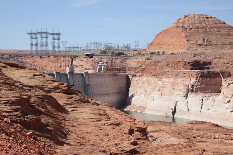


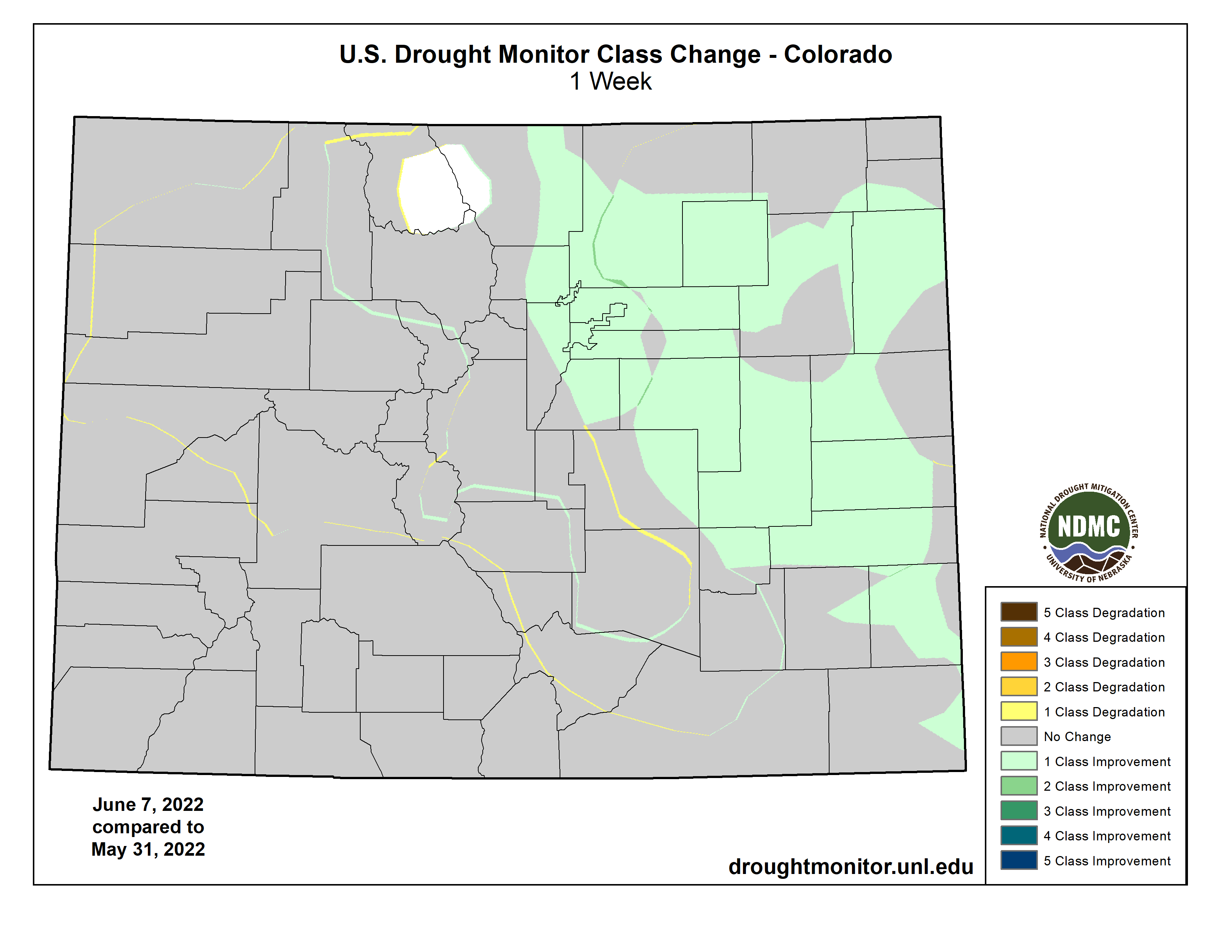
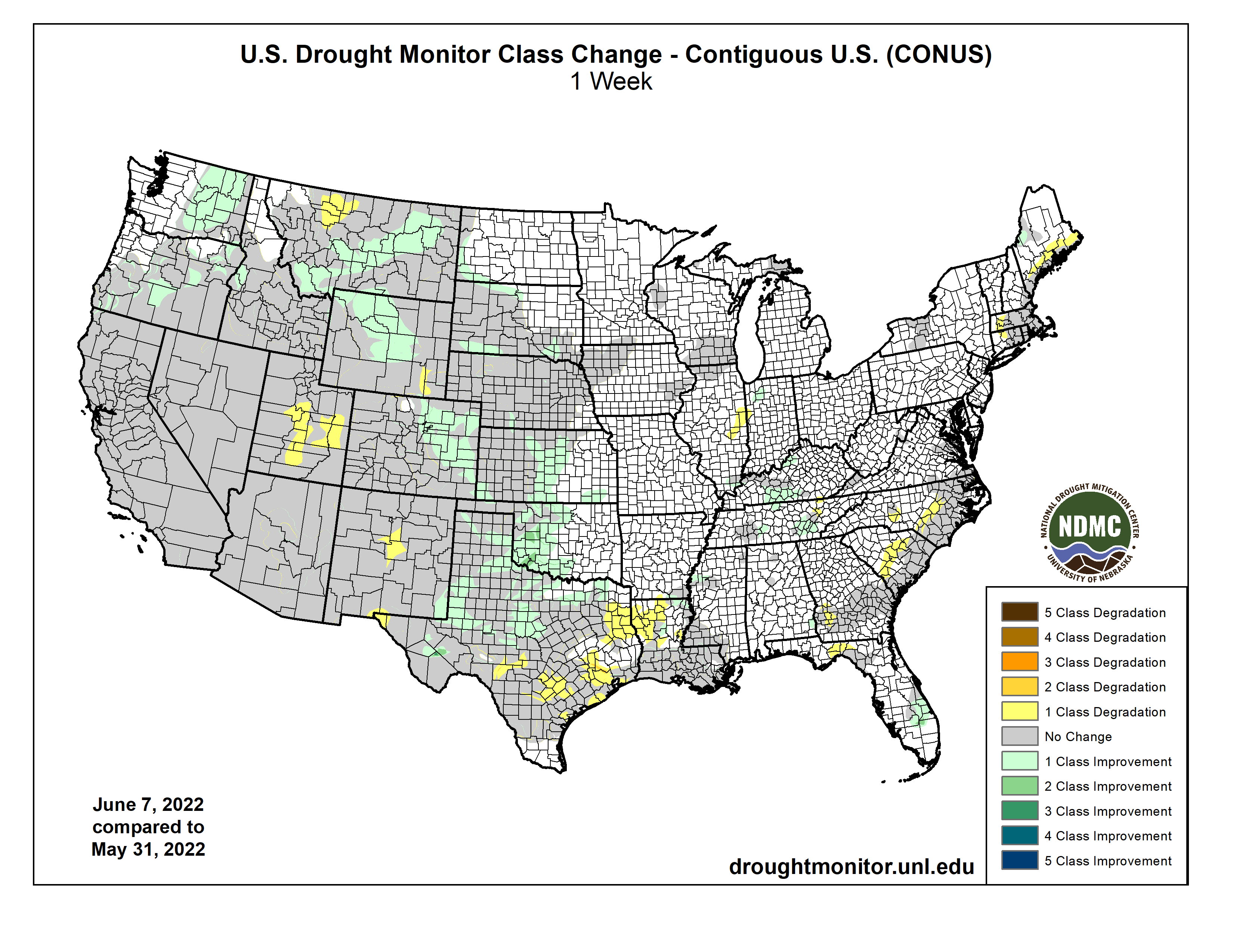

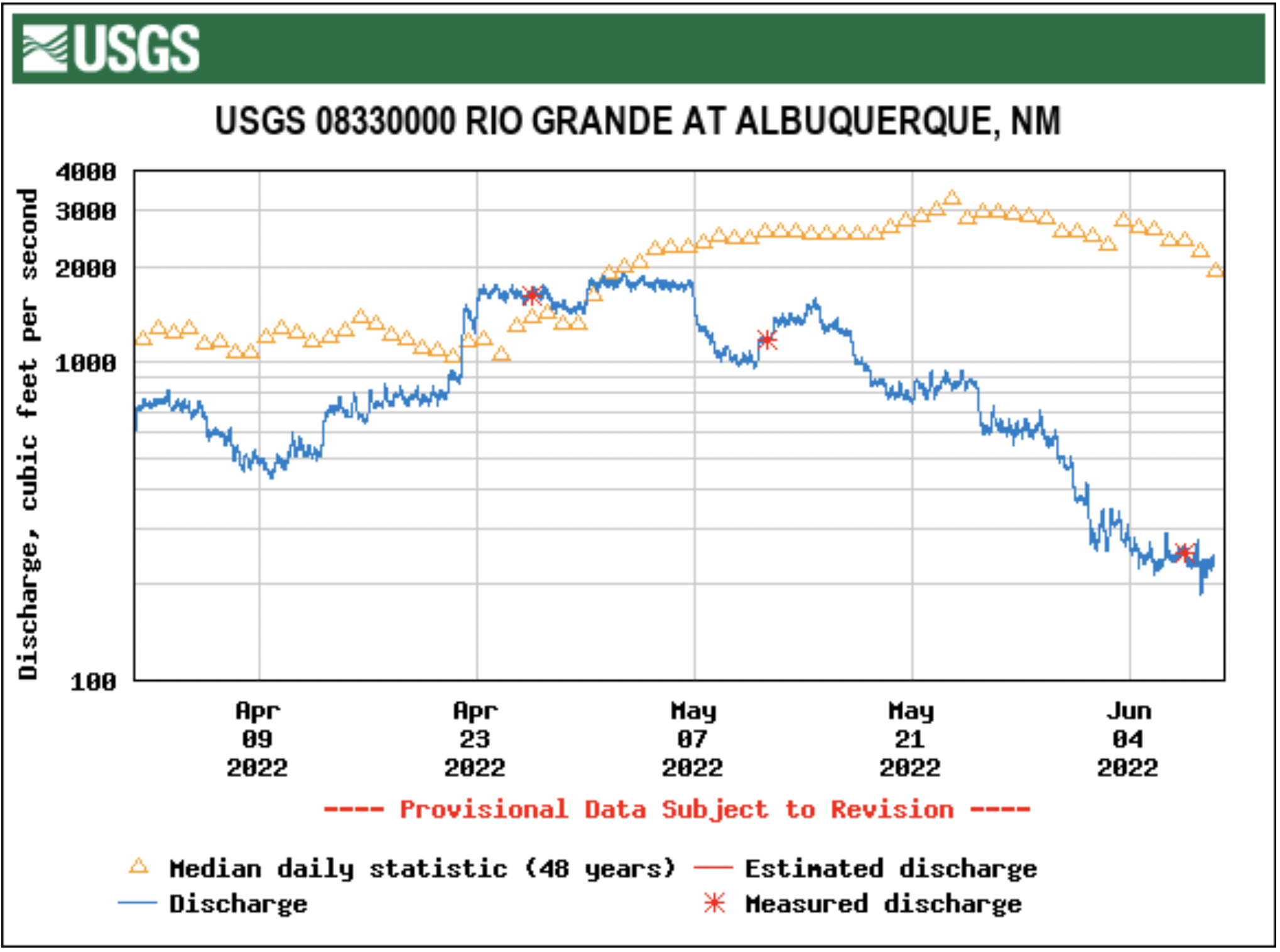
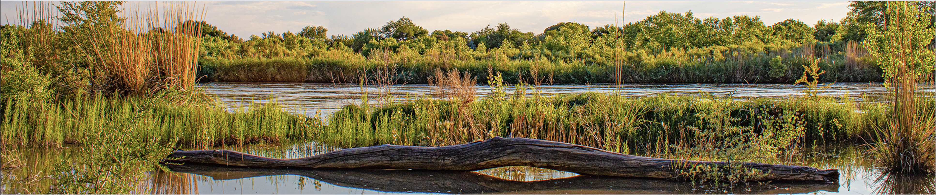


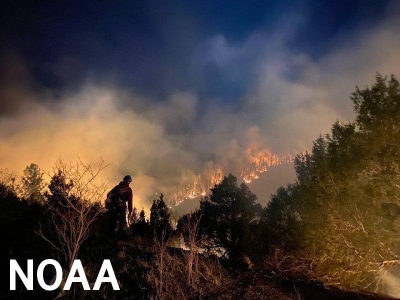
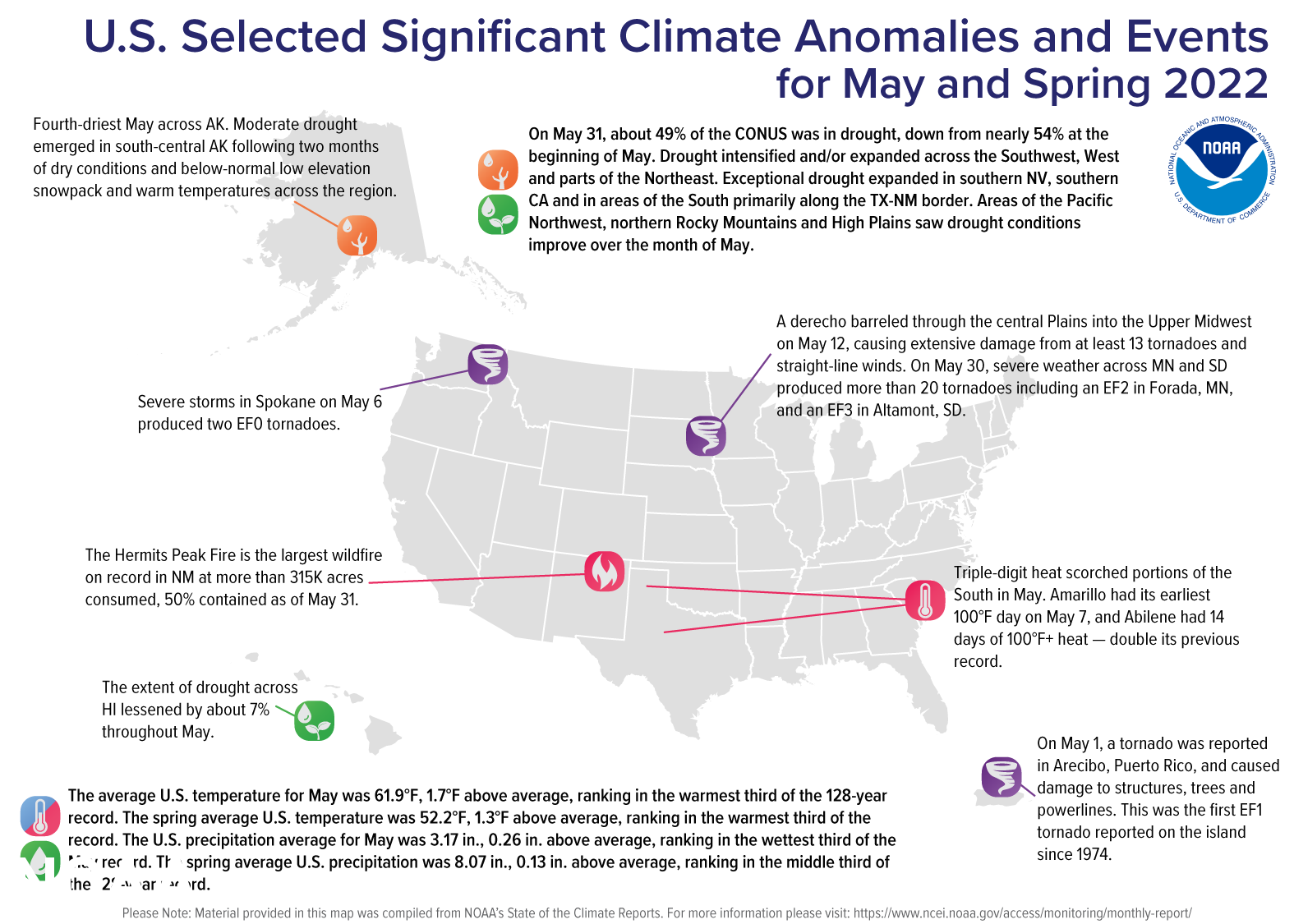
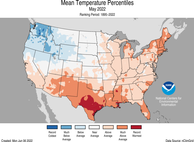
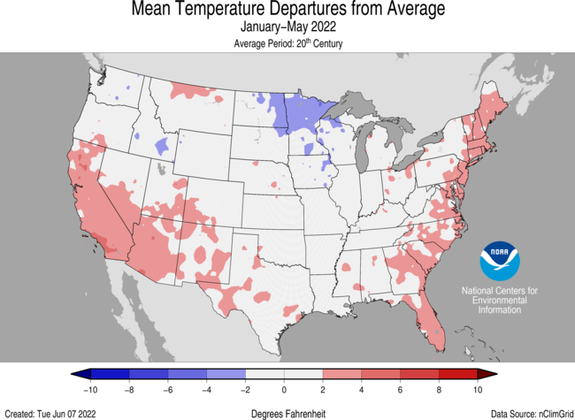
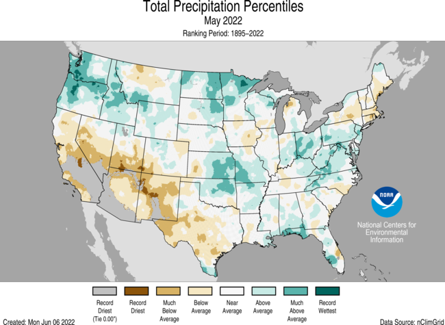

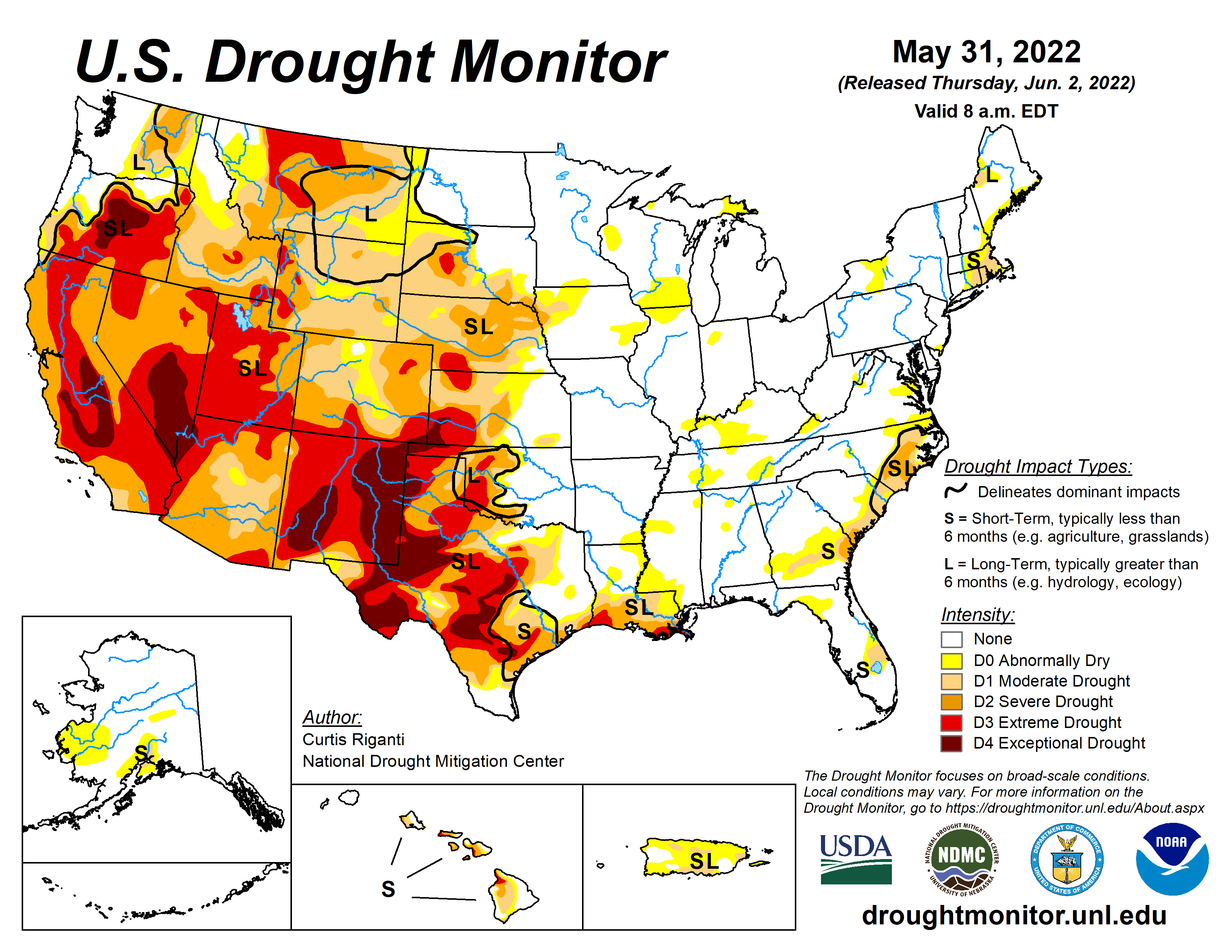

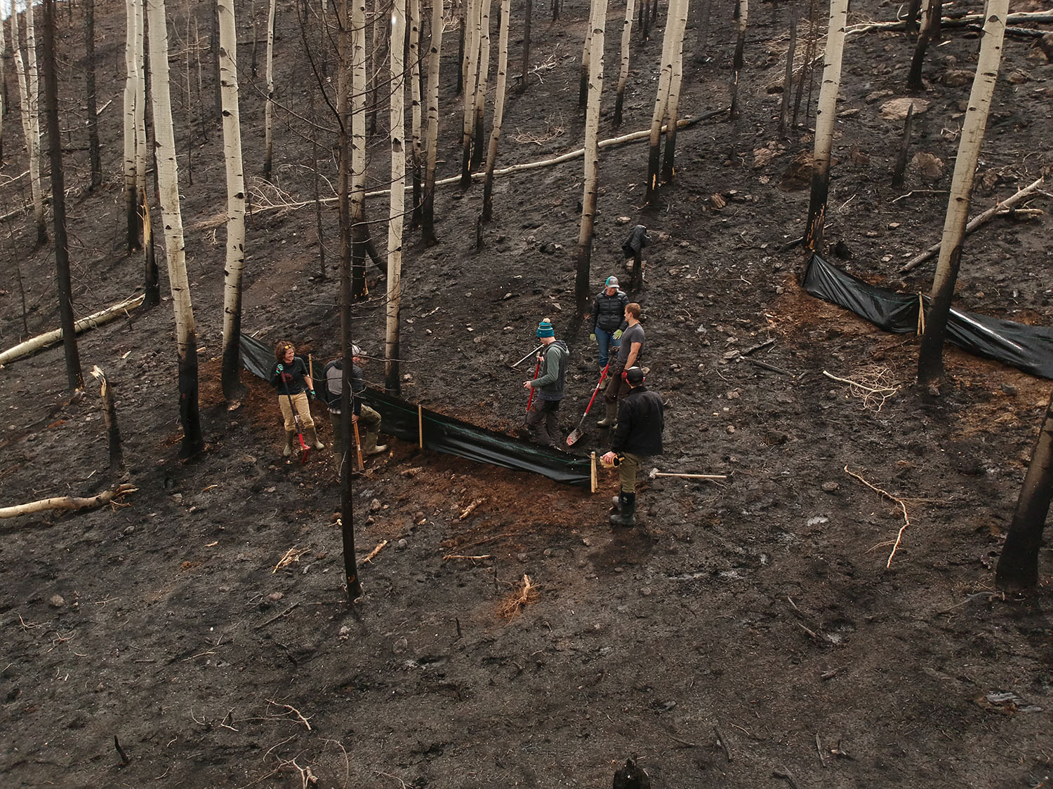


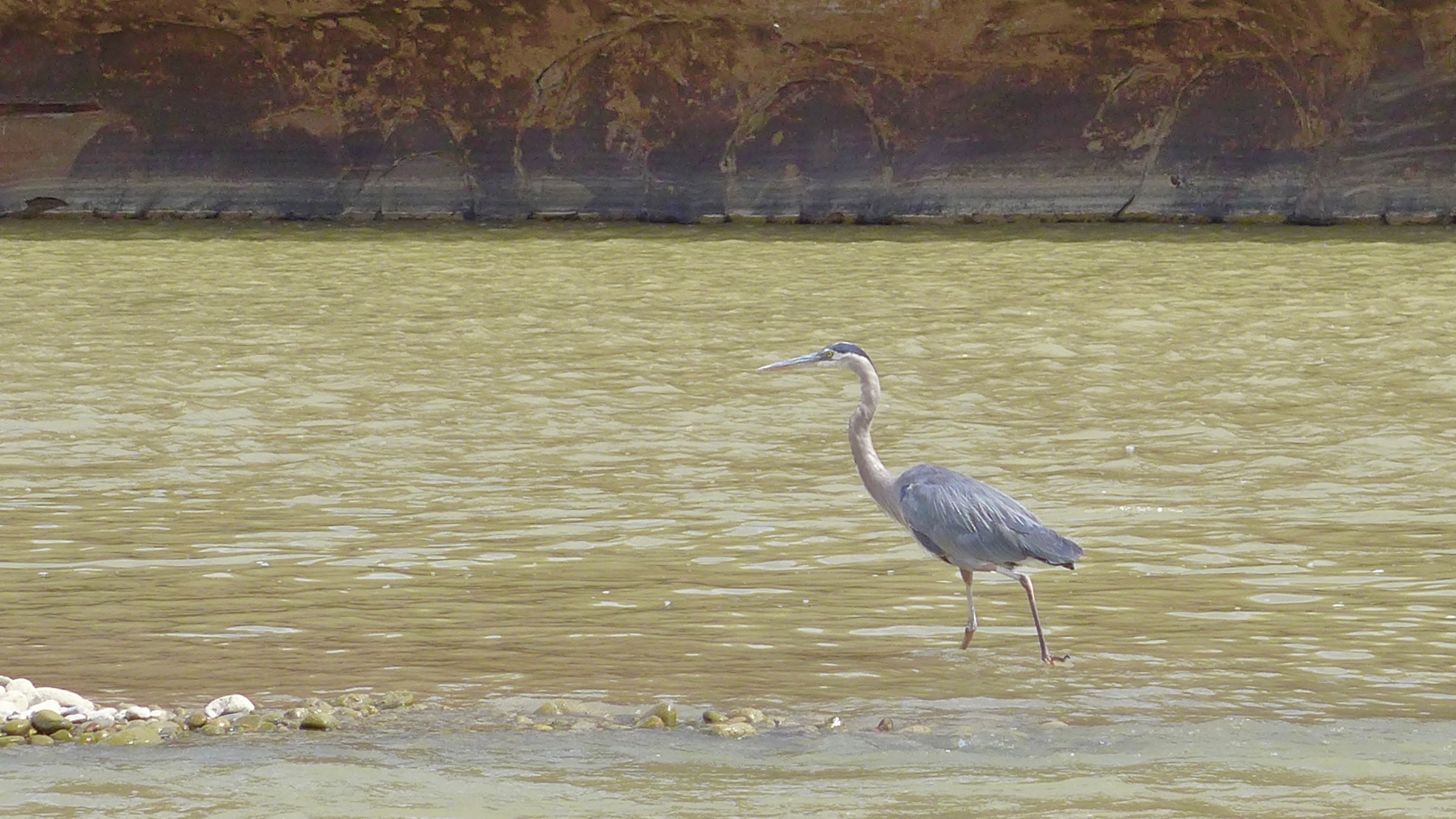


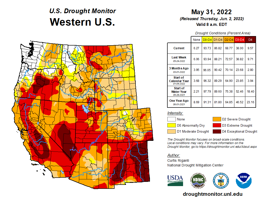


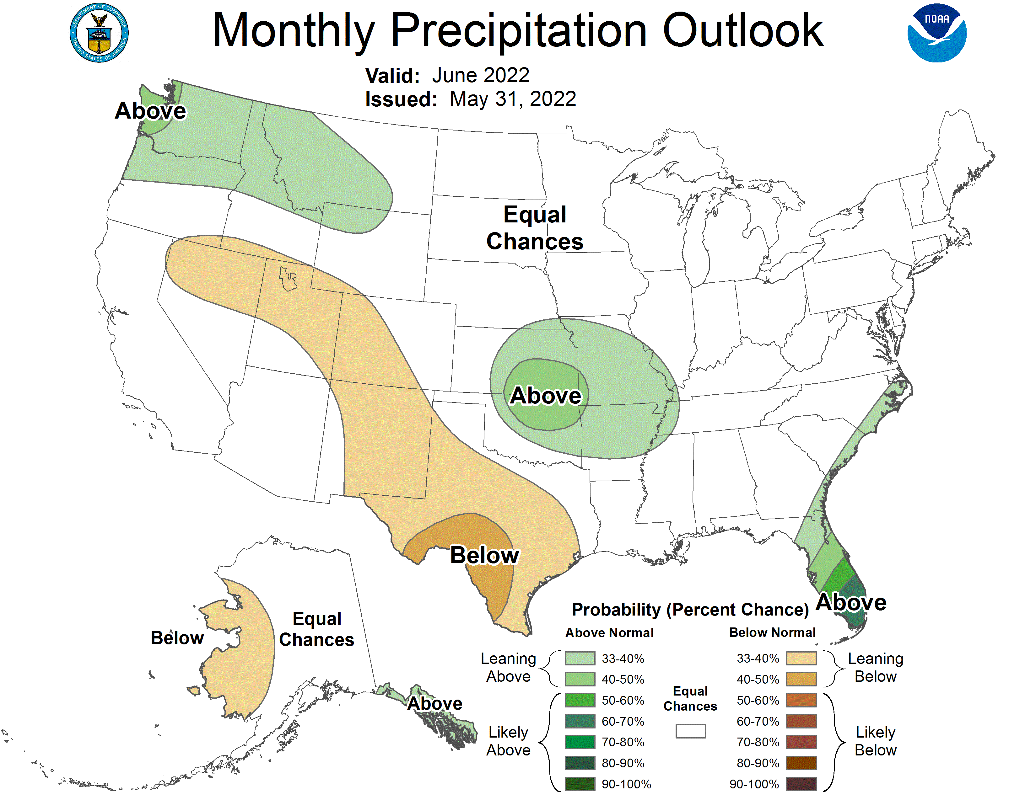
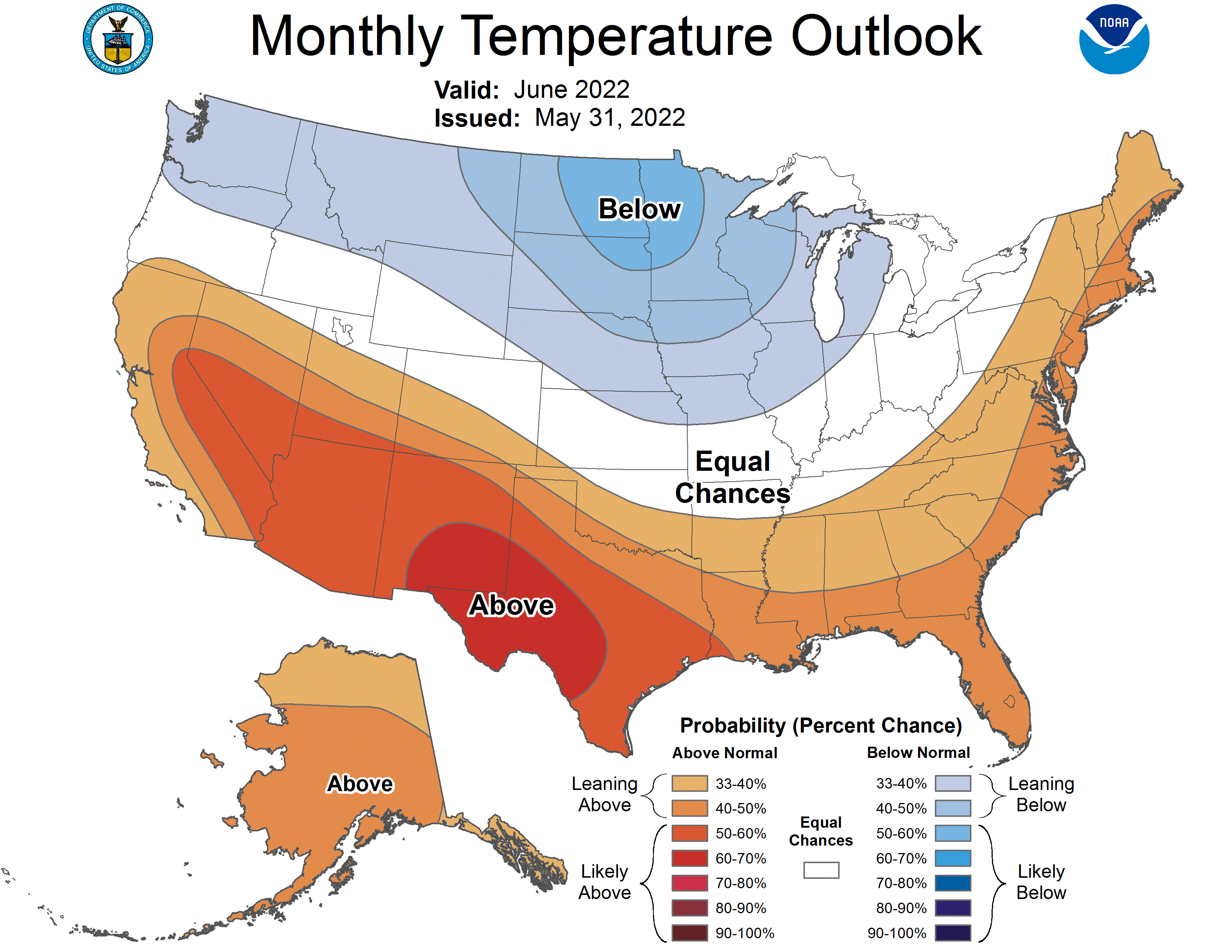
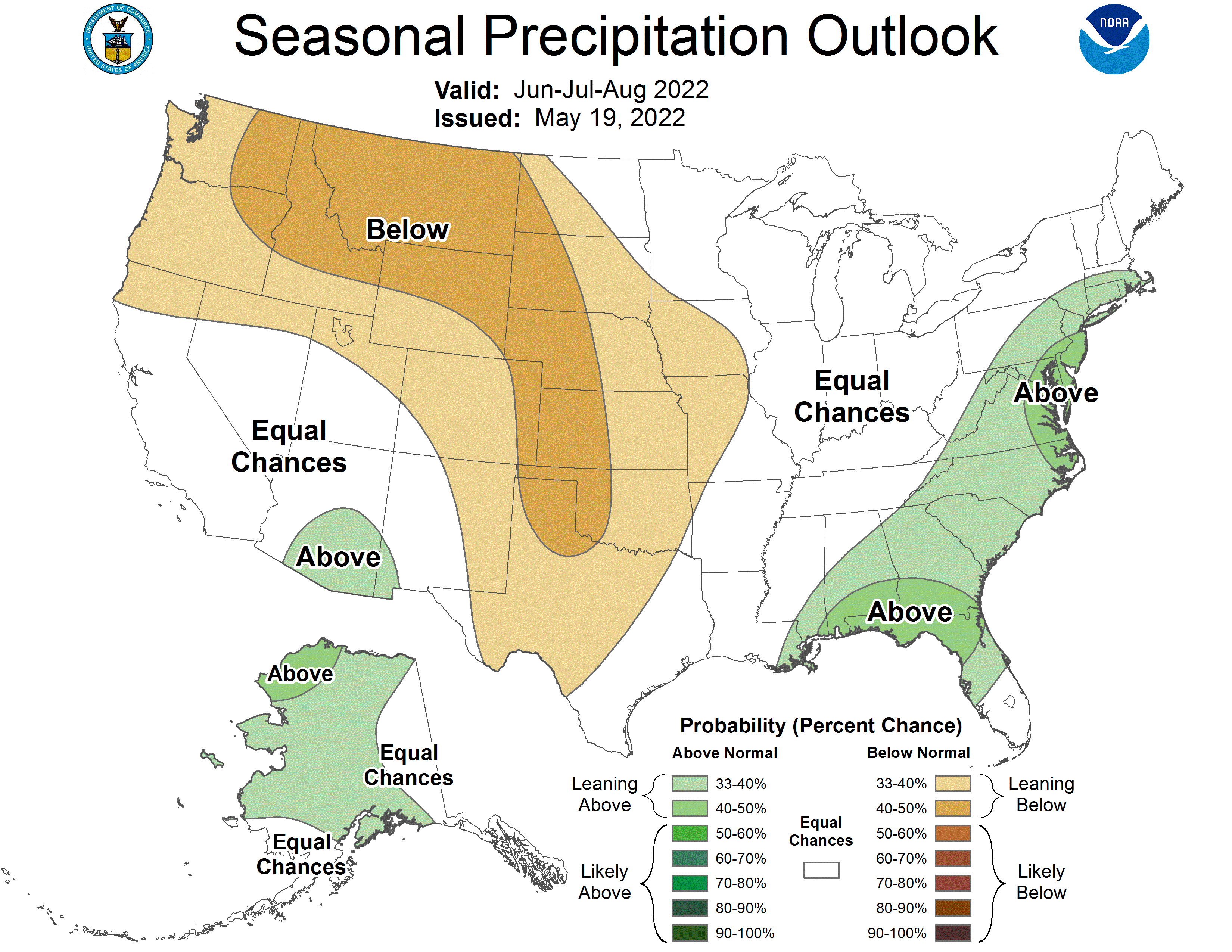
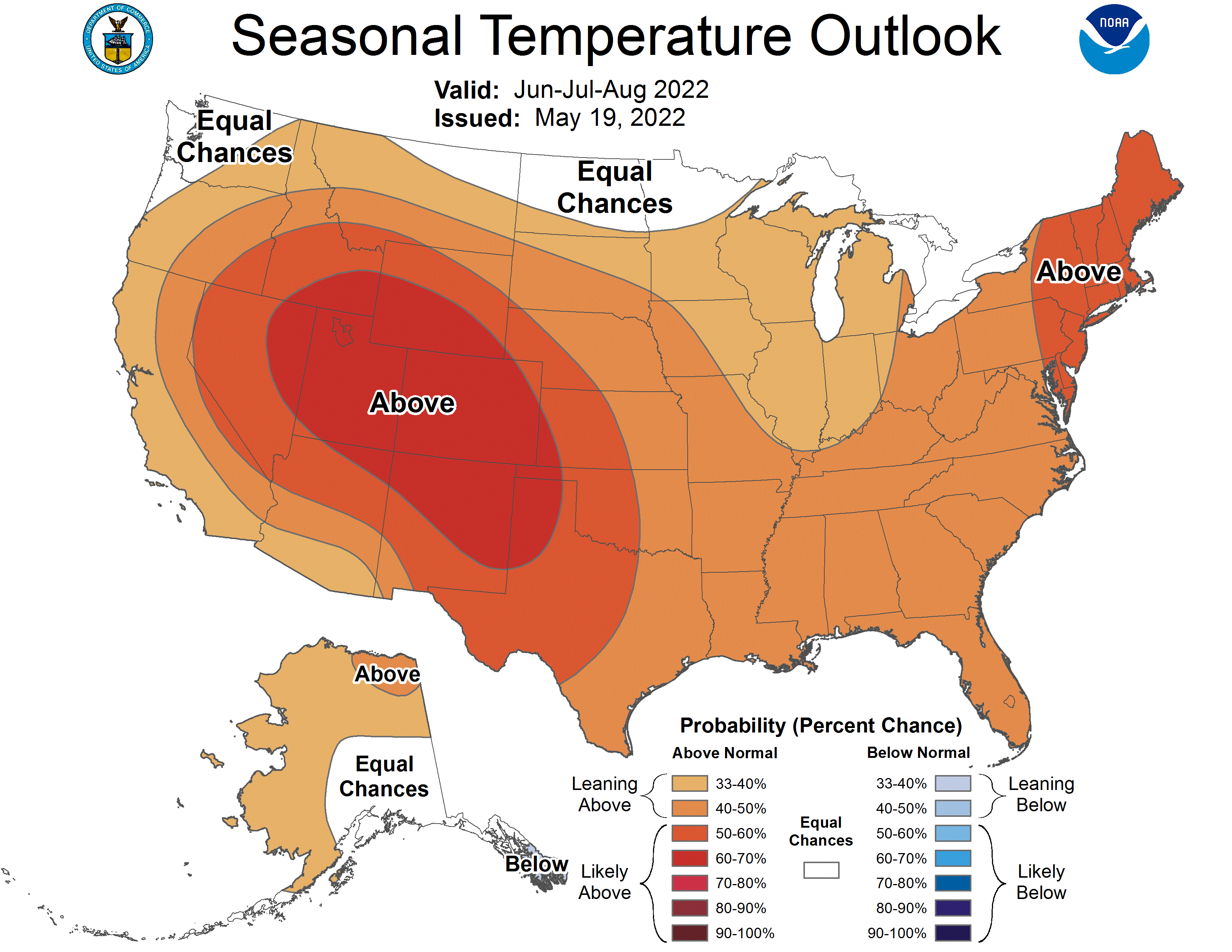
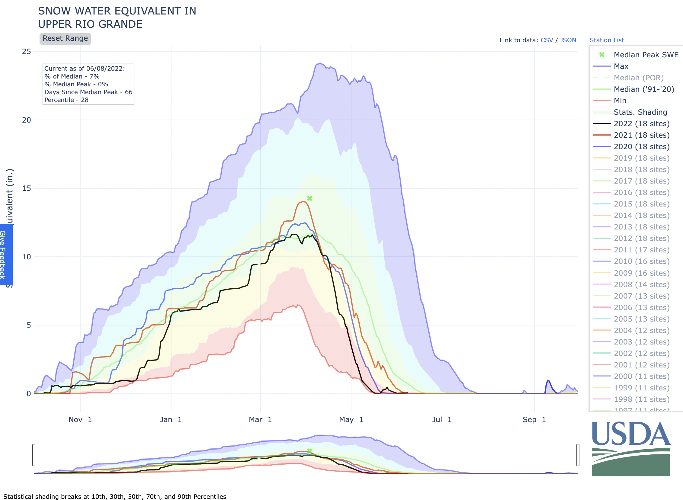
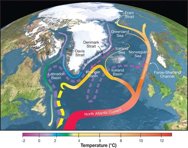
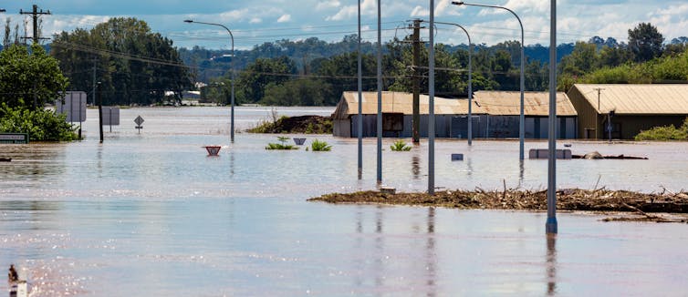
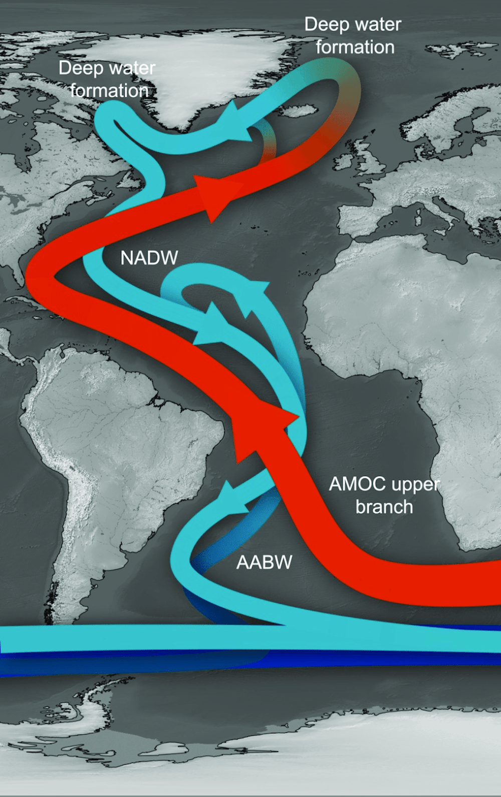

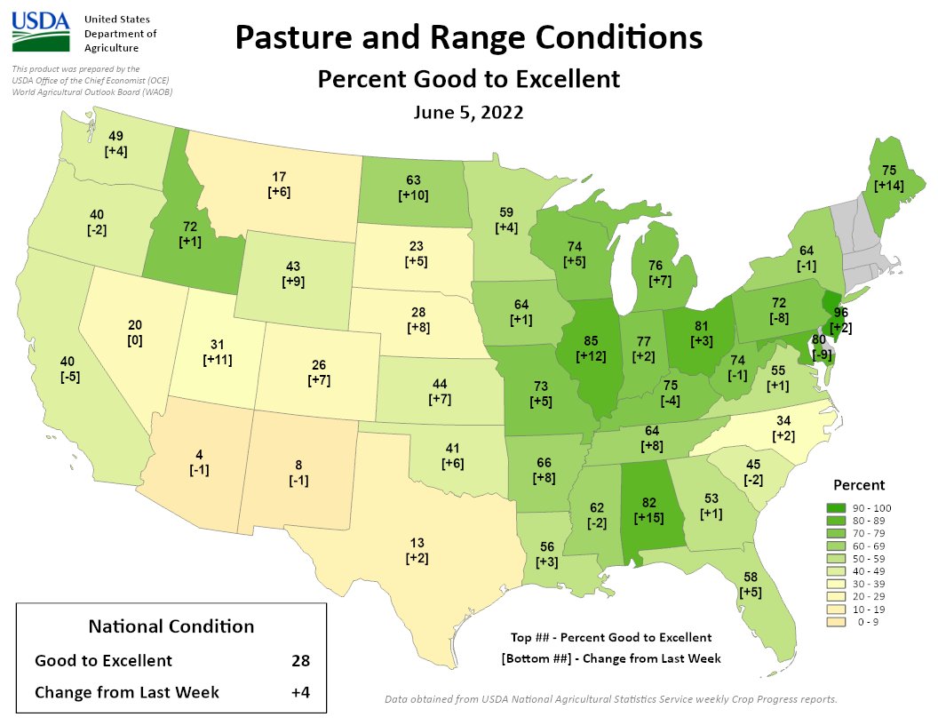
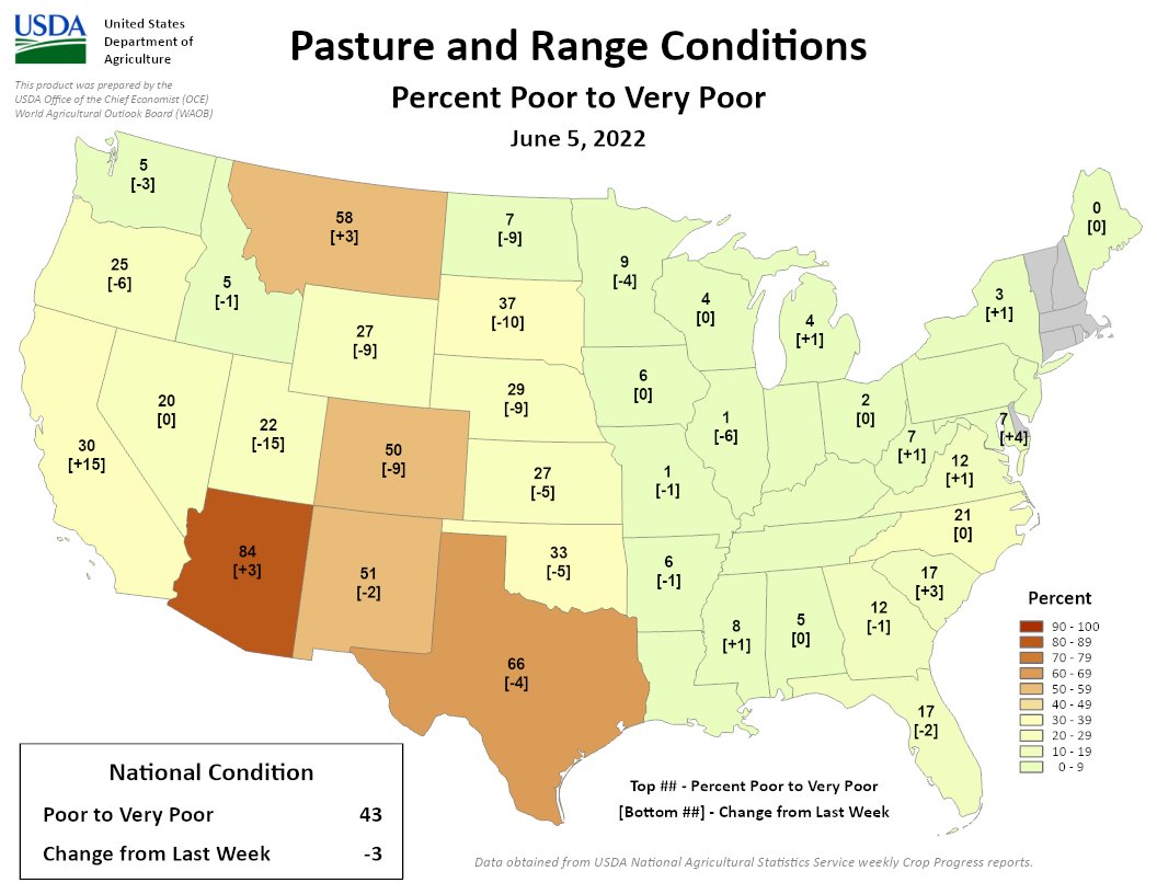


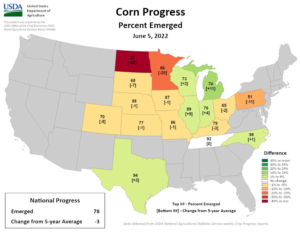

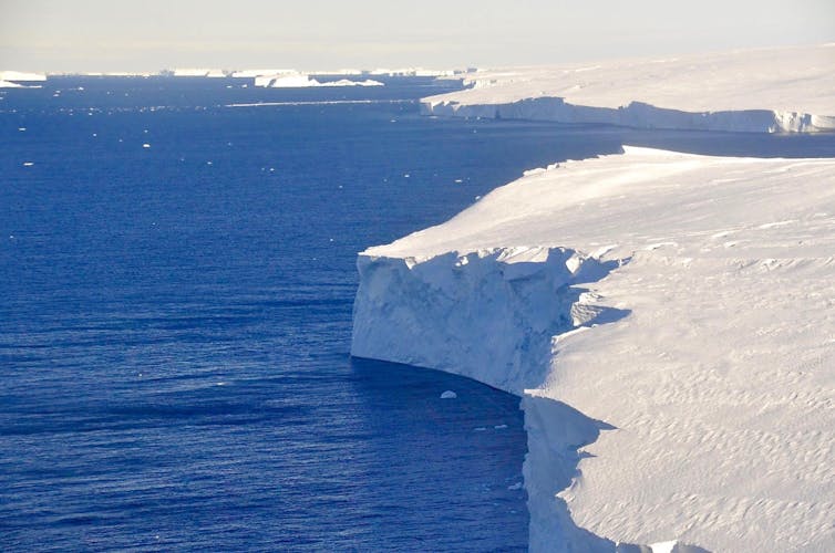

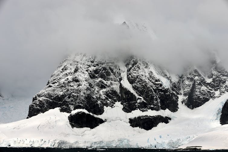
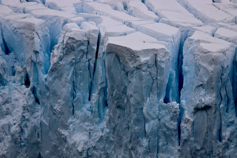

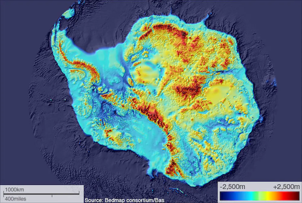
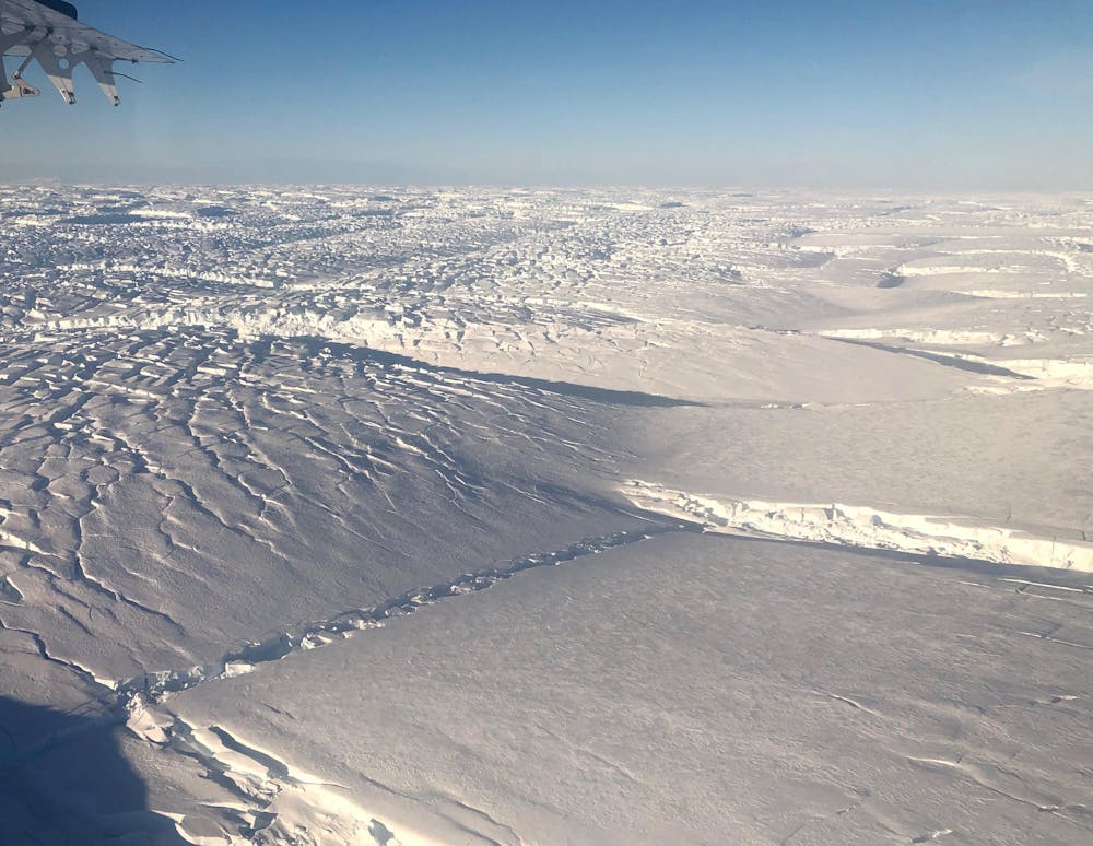
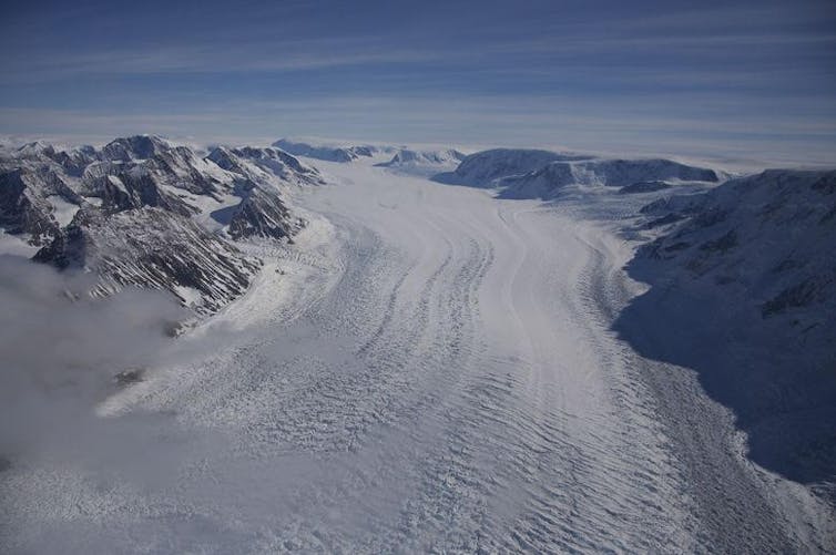

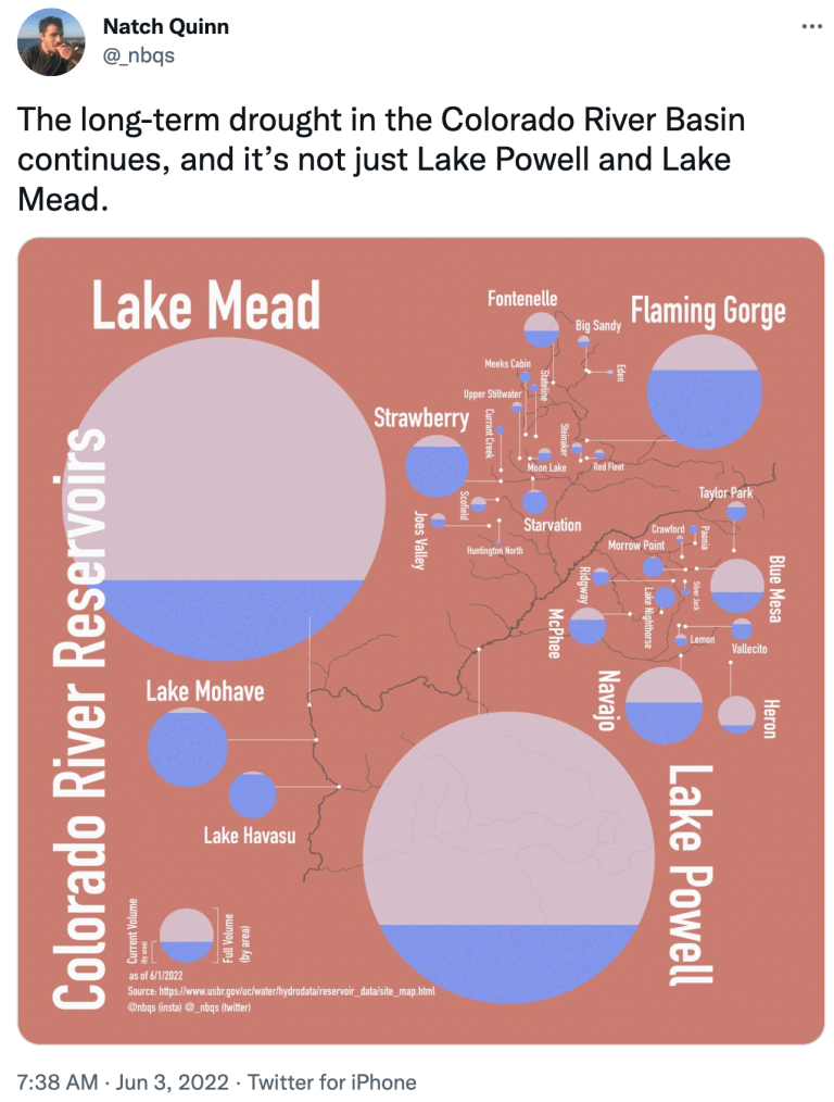
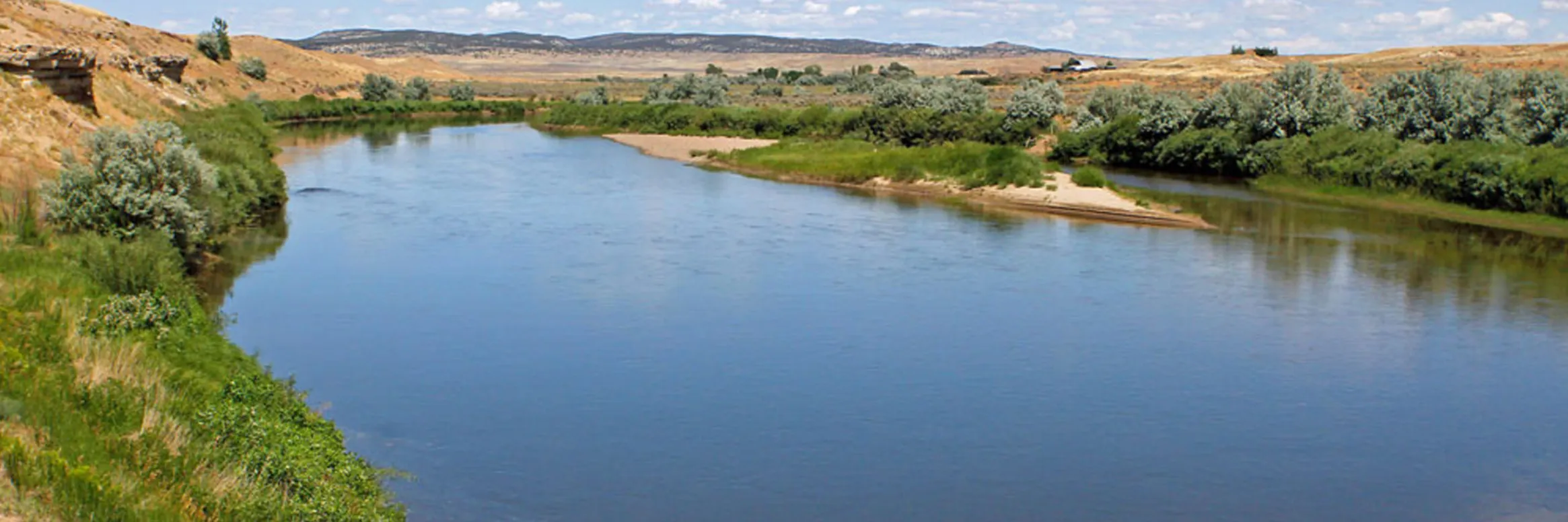
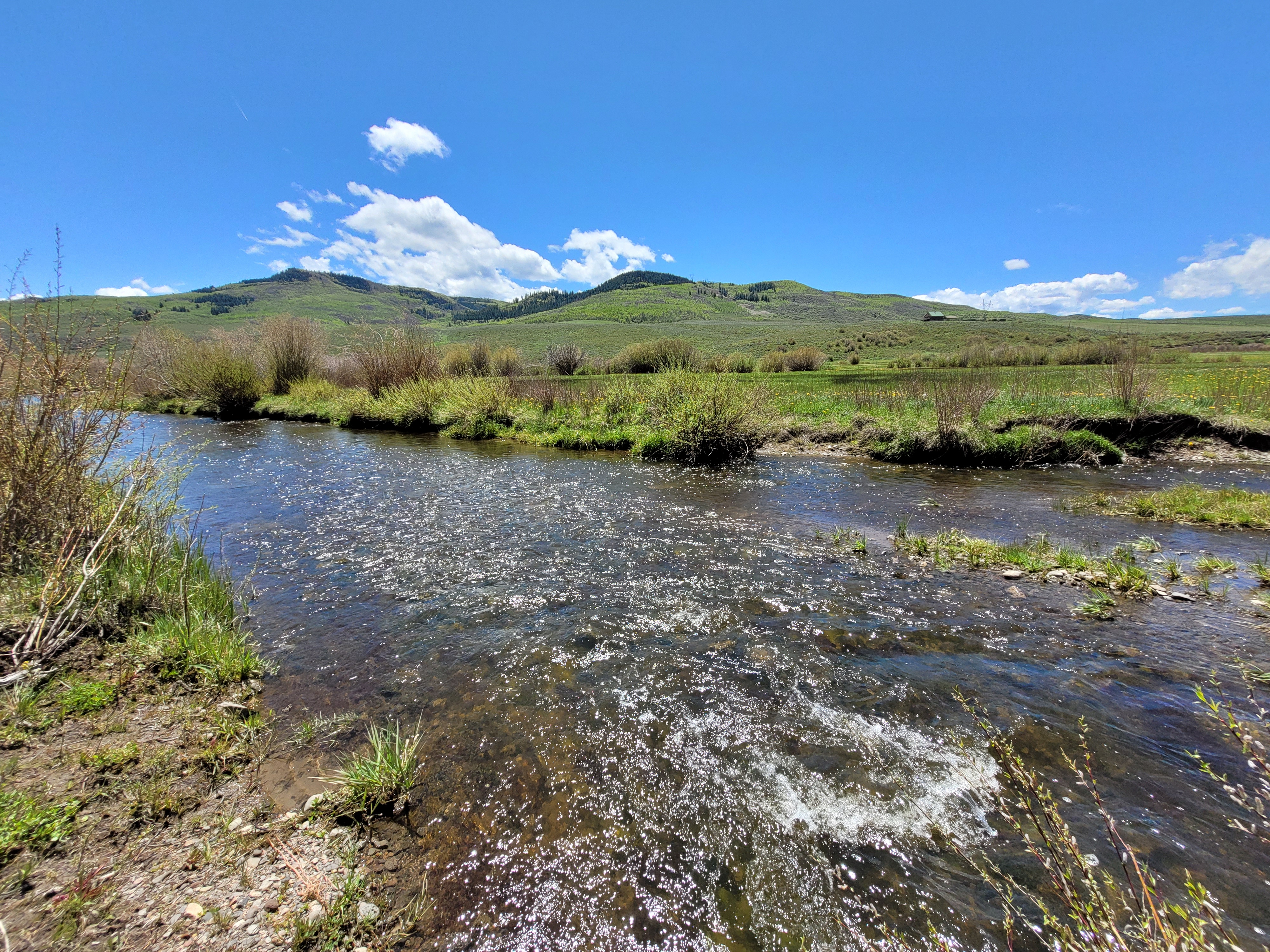

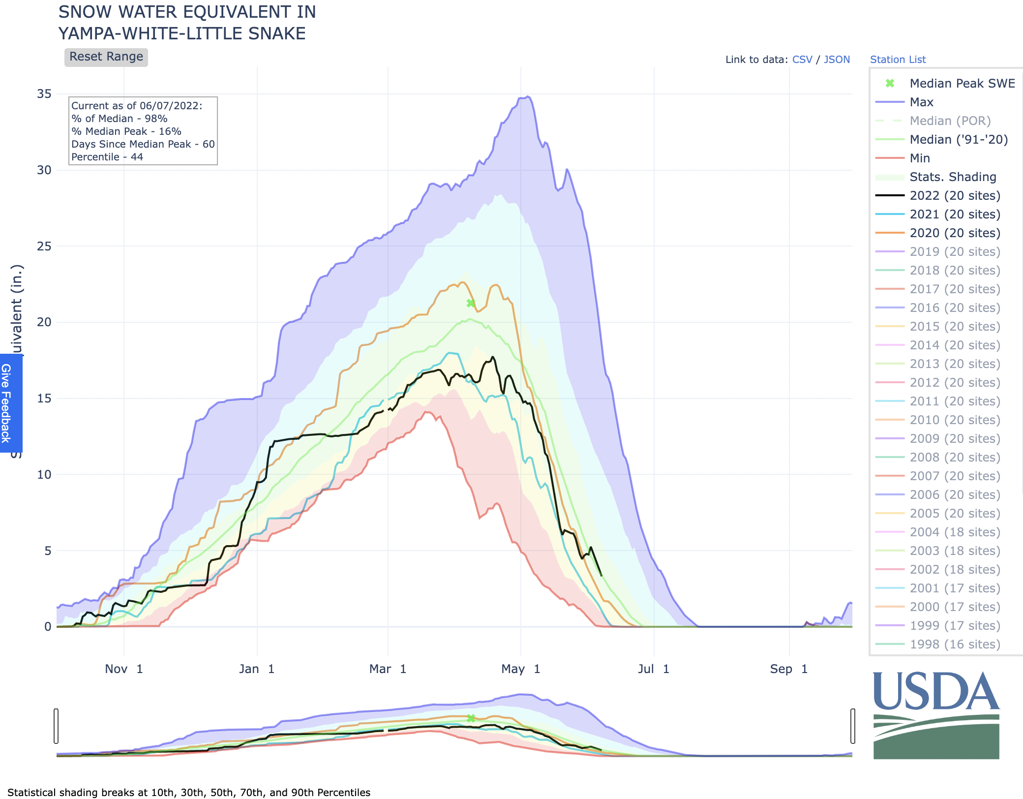


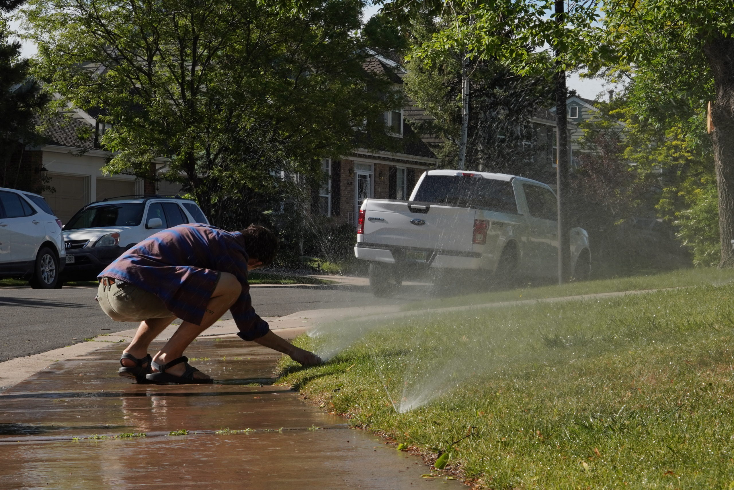
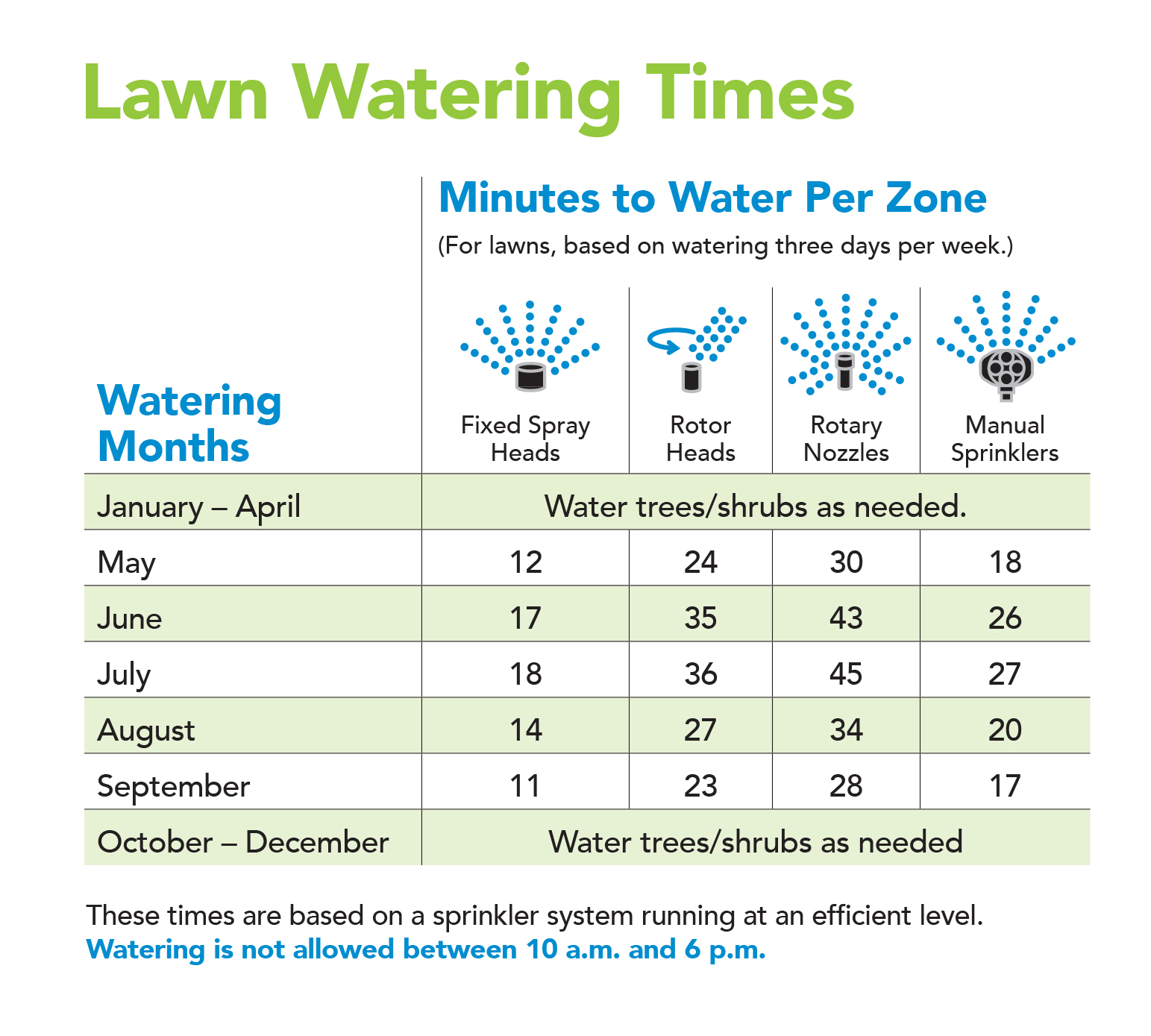
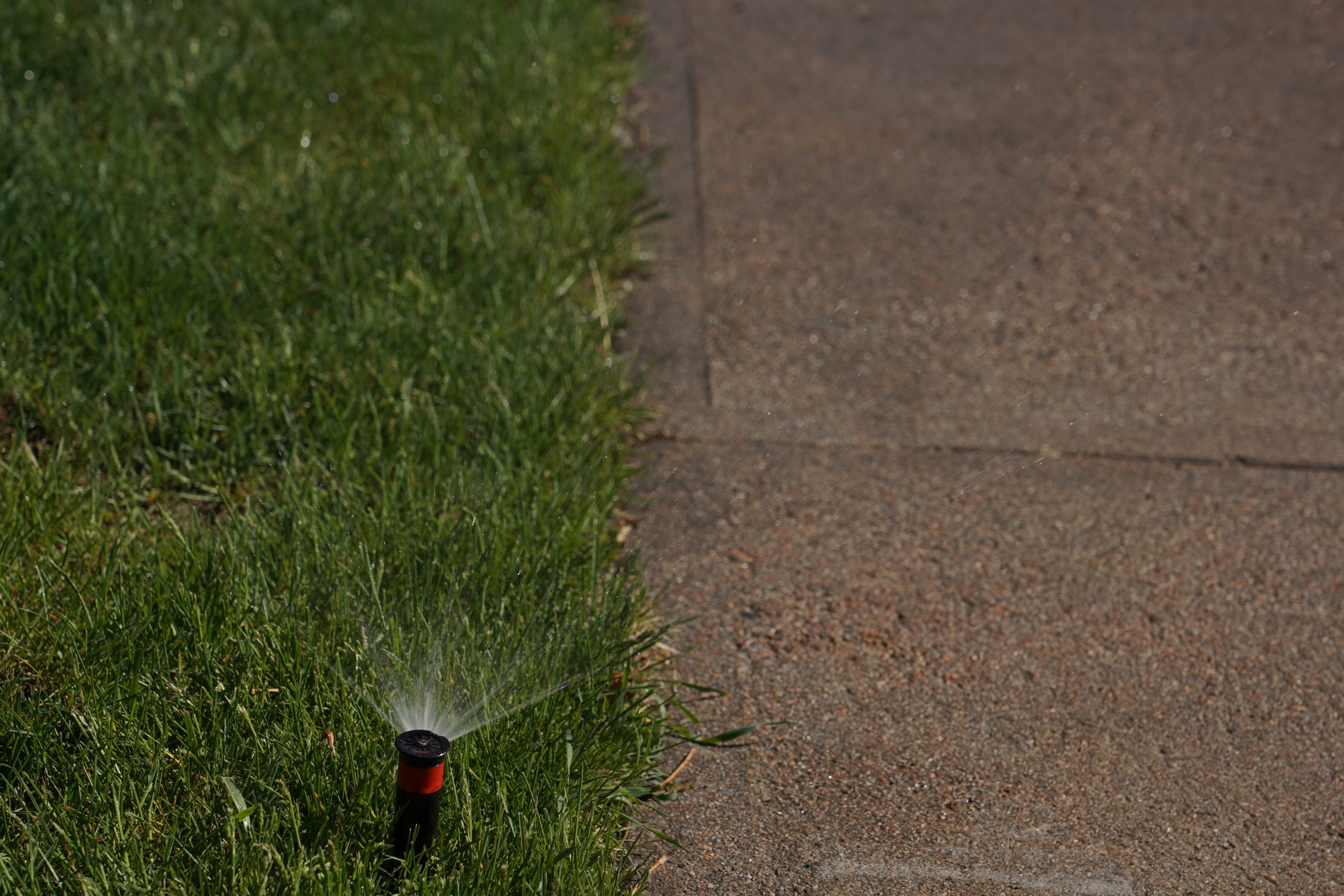


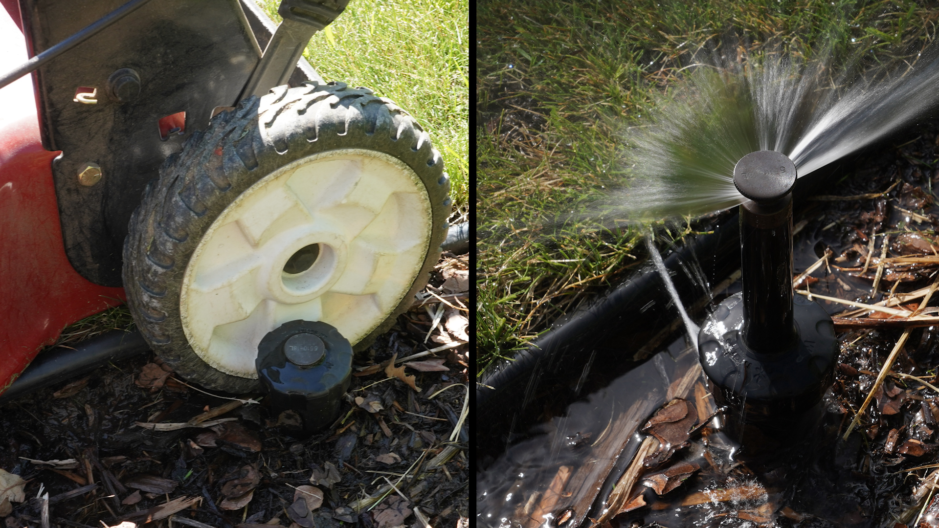


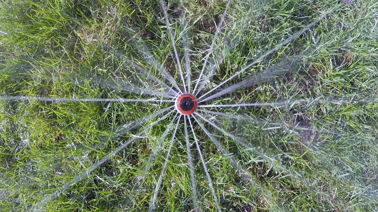
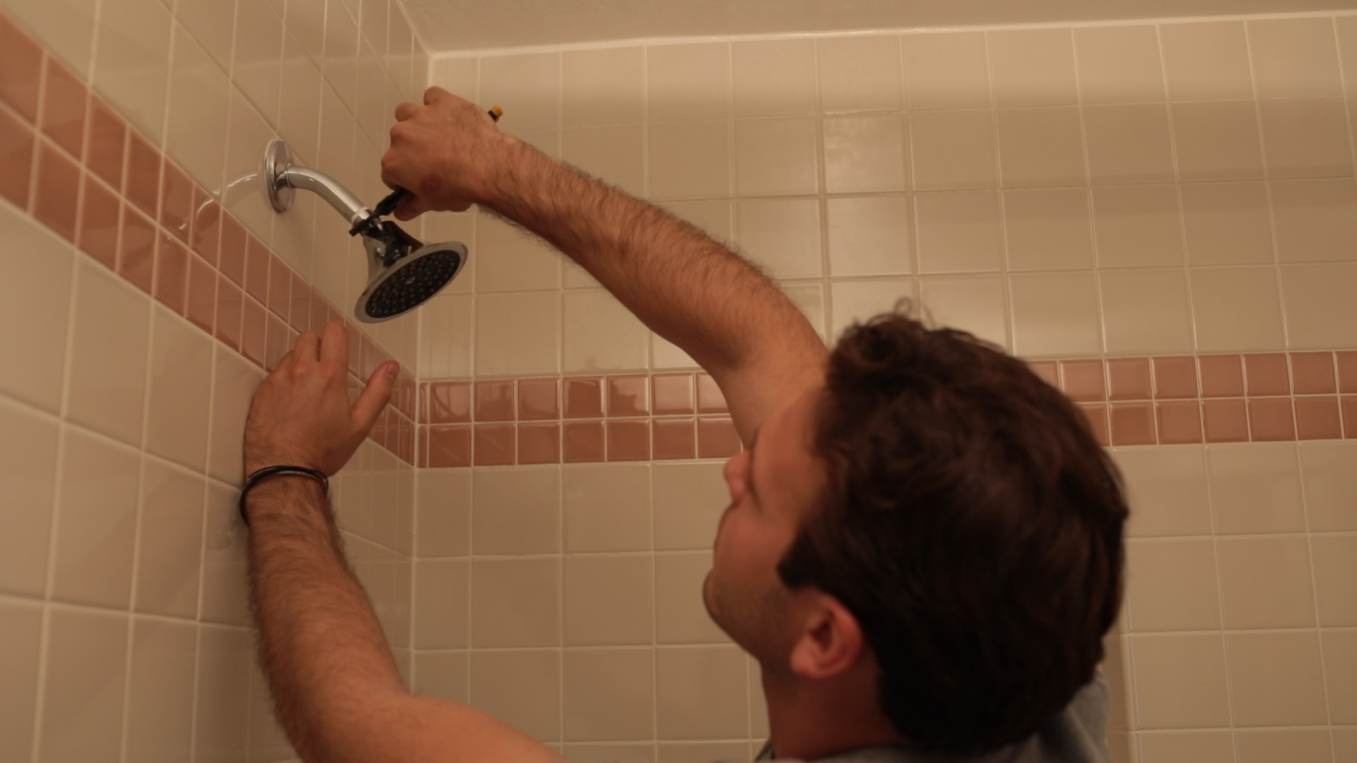


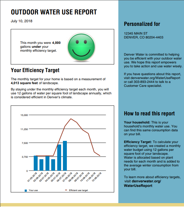
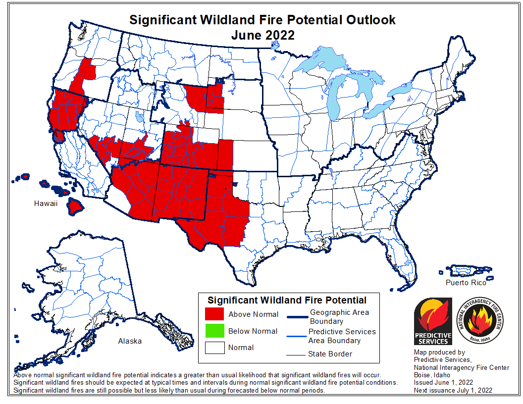


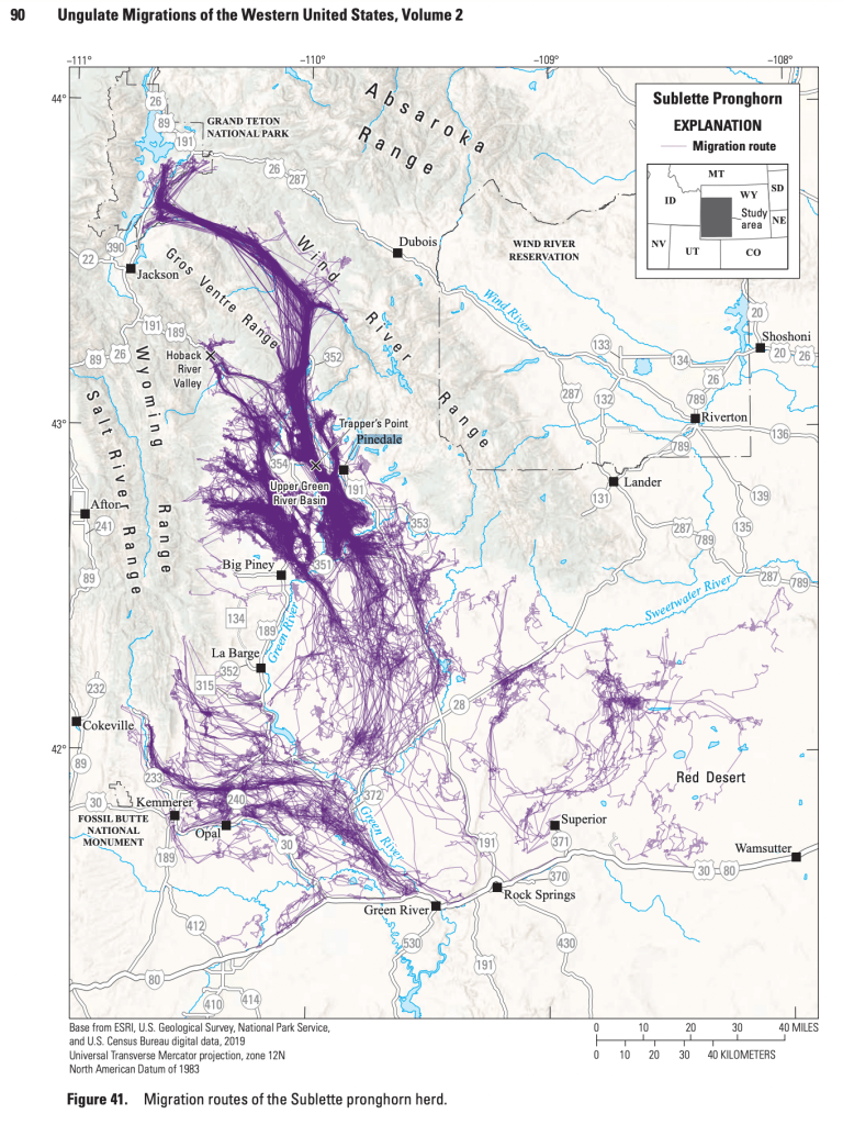
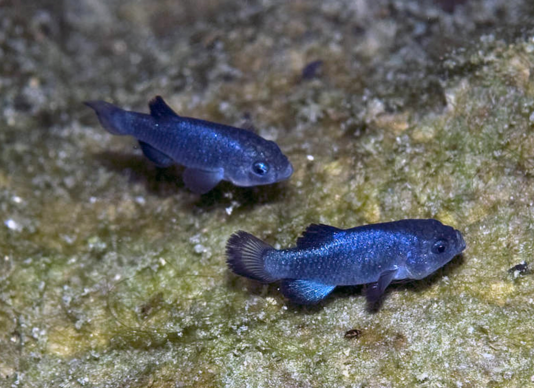


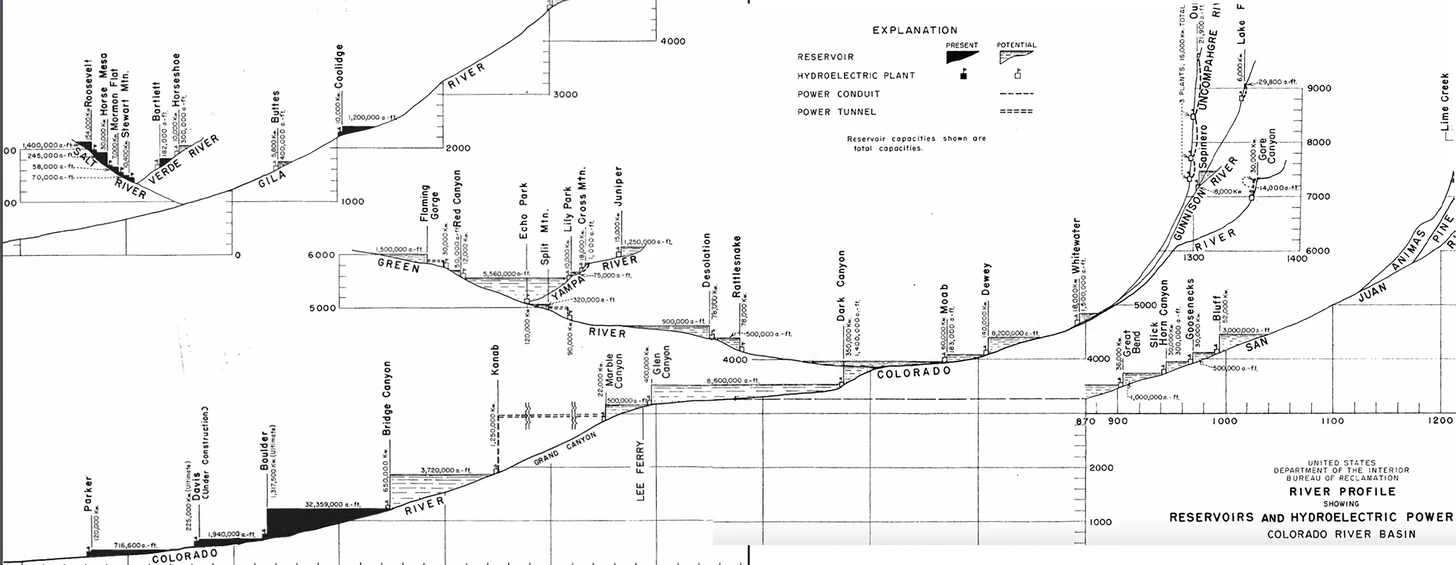

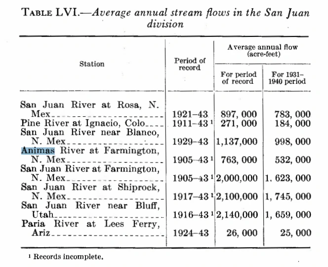


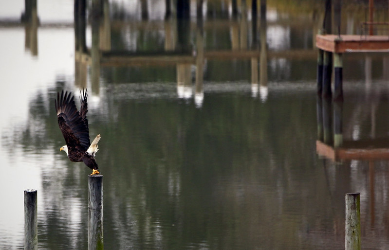


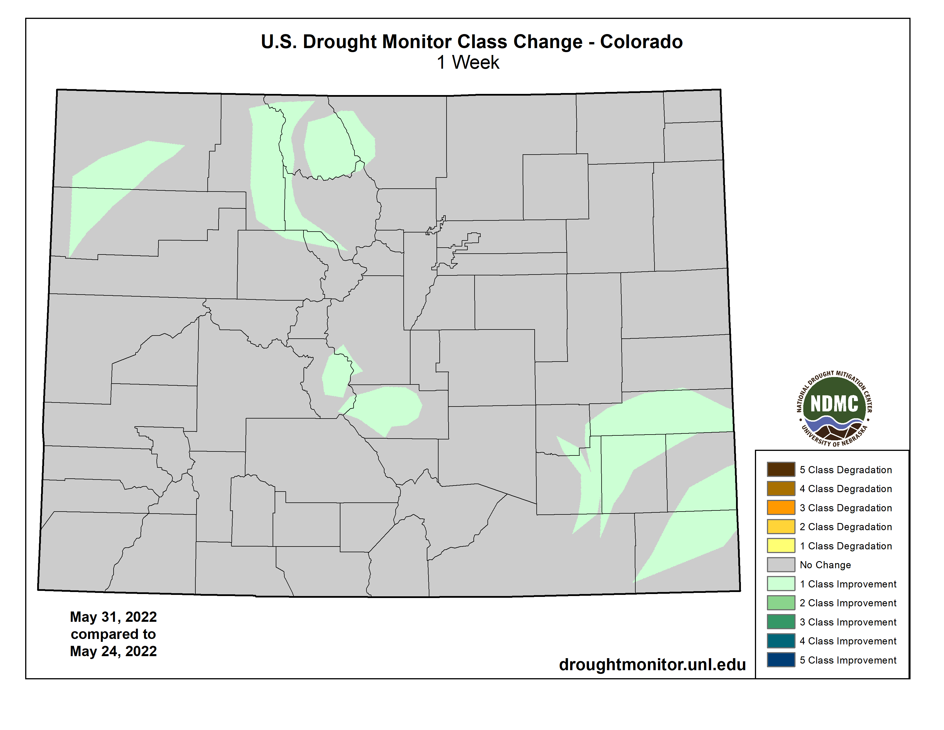
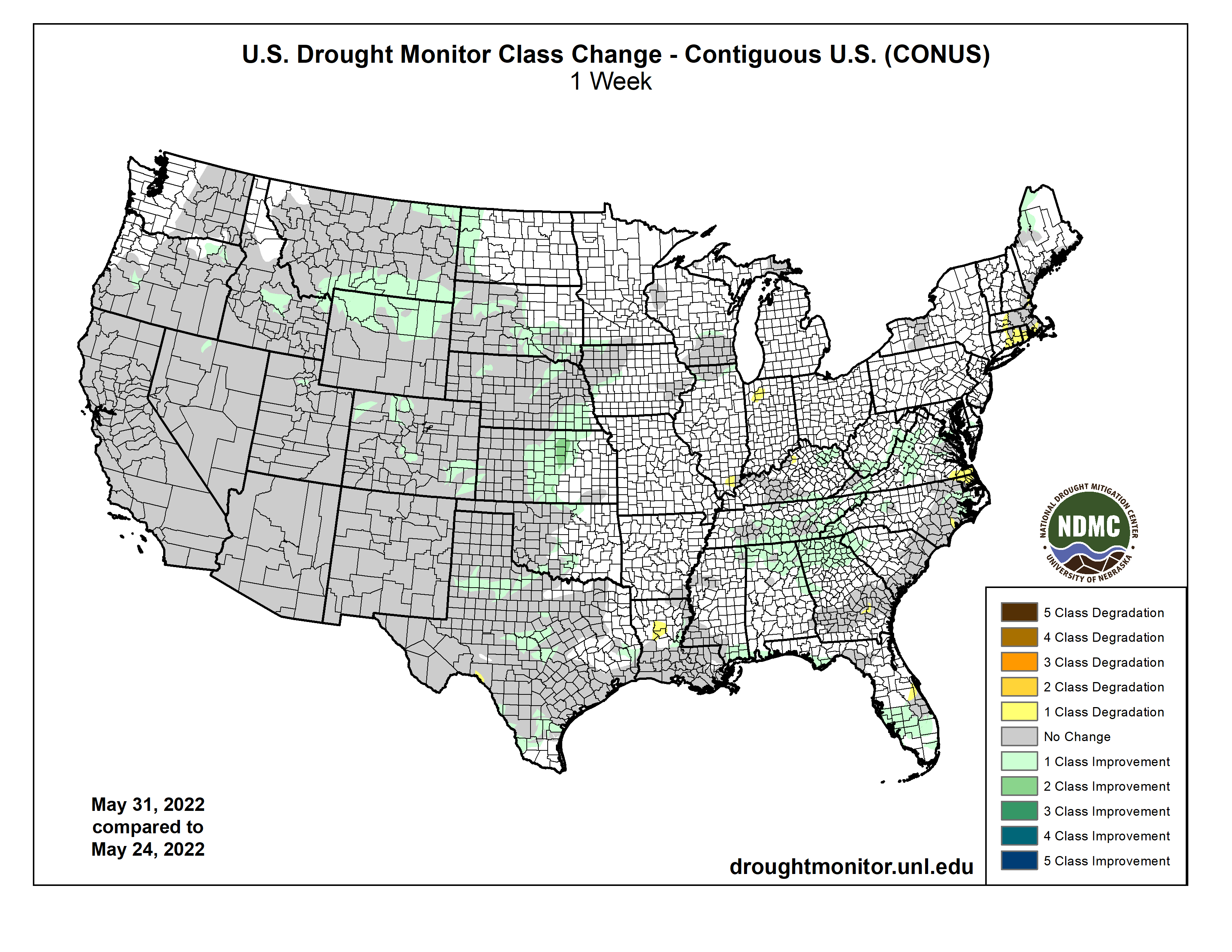


