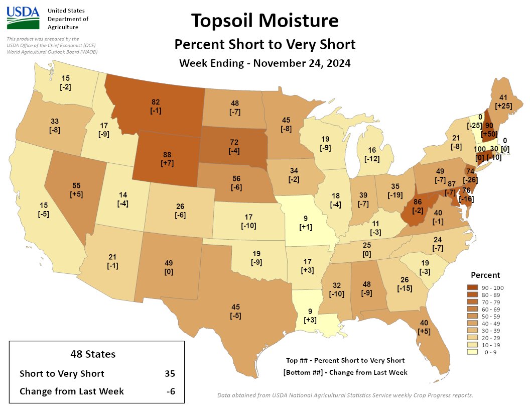
35% of the Lower 48 is short/very short, 6% less than last week. Soil moisture conditions improved in much of the U.S. this week. The exceptions? ME, NH, FL, AR, LA, WY, NV. Dry soils persist in the NE & Northern Rockies.

35% of the Lower 48 is short/very short, 6% less than last week. Soil moisture conditions improved in much of the U.S. this week. The exceptions? ME, NH, FL, AR, LA, WY, NV. Dry soils persist in the NE & Northern Rockies.
Click the link to read the article on the Summit Daily website (Robert Tann). Here’s an excerpt:
November 29, 2024
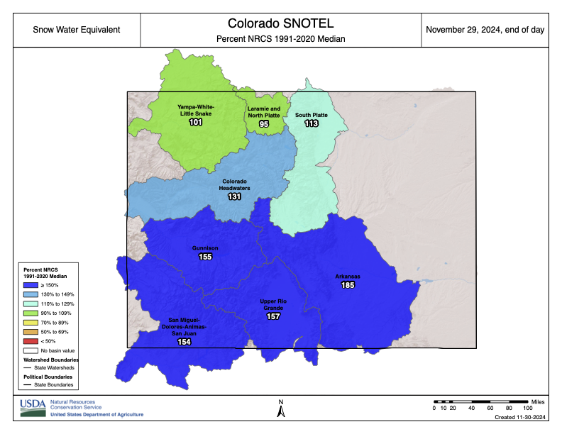
Snowpack levels in Colorado continue to outperform past years, with the latest surge driven by an intense series of winter storms that brought multiple feet of fresh snow across the High Country…Statewide snowpack levels reached 134% of the 30-year-median as of Friday, Nov. 29, according to data from the Natural Resources Conservation Service. It’s the highest level for this time of year in the past 10 years…River basins with the highest snowpack levels are concentrated in the southern half of the state, with snowpack in the Arkansas River Basin — which stretches from north of Colorado Springs to the New Mexico border — standing at nearly 200% of normal as of Friday. The central-mountain Colorado Headwaters River basin stood at 134% while the Yampa-White-Little Snake River Basin — which includes Steamboat Springs — stood at 103%. Snowpack levels typically peak in April, though the dates vary by basin…
Back-to-back storms late last week and through Wednesday have helped ski areas open acres of new terrain, with Copper Mountain becoming the first resort in Colorado to net 100 inches of snowfall this season.

Click the link to read the article on the Steamboat Pilot & Today website (Ali Longwell). Here’s an excerpt:
November 29, 2024
Last week, the governmental entity created to represent Western Slope water users submitted its 600-page application for $40 million from the Inflation Reduction Act, which allocated $4 billion toward drought mitigation efforts. The application falls under the Bureau of Reclamation’s Upper Colorado River Basin Environmental Drought Mitigation funding opportunity, also known as the Bucket 2E funding. The $40 million would go a long way toward the $98.5 million needed for the Colorado River District to purchase the water rights from Xcel Energy. So far, the district has raised around $56.9 million from the state legislature, its board and the various Western Slope municipalities and utilities it serves.
While the district’s request for federal dollars has received support from the majority of Colorado’s federal congressional delegation, the Inflation Reduction Act is likely to be targeted by Trump as he takes office in January. While the president-elect is unlikely to repeal the Inflation Reduction Act completely, he has promised to rescind any unspent funds under the act. The bureau is expected to award the Bucket 2E grants in the spring…Regardless of this uncertainty, Amy Moyer, the Colorado River District’s director of strategic partnerships, said the district “remains steadfast in its commitment to securing the Shoshone water rights and protecting the long-term health of the Colorado River.”
Click the link to read the article on the Sibley’s Rivers website (George Sibley):
Breaking news! The Lower Colorado River Basin is threatening the Upper Basin with a ‘Compact Call’ if it does not agree to share some major cuts in river use! Well, actually the news broke a week ago – and now there’s more news: just as I was wrapping this analysis of the ‘Call’ up yesterday, the Bureau put out for our consideration five options for river management up to and beyond the 2026 termination of the ‘Interim Guidelines.’
So we’ll interrupt our out-of-the-box exploration for management options for living with a desert river in an intelligent universe, and try to figure out what’s going on back in the surreal world of the ‘Compact box’ – looking at the ‘Call’ situation here, then get into the five management options in a couple weeks after the dust has settled.
The Lower Colorado River Basin has attempted to break the stalemate between the two Compact-designated Colorado River Basins, by telling the Upper Basin that, if they do not agree to share some major cuts when the river situation grows desperate again, then in that desperate time they will issue a ‘Compact call’ on the Upper Basin to deliver the whole 7.5 million acre-feet (maf) on average they claim the Compact obligates the Upper Basin to deliver regardless of the water situation upriver.
There has been no formal Upper Basin Commission response to that threat, but Colorado’s Commissioner, and director of the Colorado Water Conservation Board, Becky Mitchell, essentially called the bluff, and put the blame for Lower Basin problems back on the Lower Basin. The Upper Basin has argued that, if the situation becomes so desperate that the Lower Basin’ share cannot be delivered without draining Powell Reservoir, then the Upper Basin users will already be experiencing extreme shortages levied by nature.
This Hobson’s choice from the Lower Basin hinges on Article III(d) of the Colorado River Compact, which says, ‘The States of the Upper Division will not cause the flow of the river at Lee Ferry to be depleted below an aggregate of 75,000,000 acre-feet for any period of ten consecutive years.’ Does this mean, as Lower Basin states will argue, that the Upper Basin has a ‘delivery obligation’ of 75 maf over any ten-year period, regardless what is happening weatherwise in the Upper Basin? Or does it mean, as Upper Basin states are likely to argue, should argue, that if the flow to the Lower Basin were to fall below that 75 maf over a ten-year period due to circumstances other than human uses in the Upper Basin states (drought, dead pool in Powell Reservoir due to excessive releases, the atmosphere’s growing ‘evaporative demand,’ et cetera), causing ‘the flow to be depleted’ below the 75 maf minimum, then responsibility for the depletion does not fall on the water users in the Upper Basin, but on changing natural processes beyond human control. The Upper Basin could, maybe should, argue that this condition in the Compact is simply a reminder to Upper Basin users, to be careful in using their 7.5 maf half of the river (cue bitter laughter), to not infringe on the Lower Basin’s 7.5 maf half of the river.
And so far as the Compact goes, that reminder is all there is. Nowhere in the Compact is there any provision for a ‘Compact call,’ or any other procedure when or if the flow at Lee Ferry (the ‘Mason-Dixon line’ between the two Basins) were to fall below that 75 maf over ten years. A ‘call,’ the reader might remember, is an unneighborly procedure in the appropriations doctrine that remains the foundation of water law in all seven Colorado River Basin states: if downstream water users with senior rights are not able to get all of their appropriated water, they can place a ‘call’ on upstream users with junior rights, who have a legal obligation to let enough water go past their headgates to fill the seniors’ rights.

A seven-way division of the use of the river, however, proved to be nearly impossible. Each commissioner had come with the charge to protect their own state’s glorious future, to develop their vast acreage of potentially irrigable land, their mineral resources, et cetera. No factual studies existed to support the glorious visions. And when the water requirements for those visions were all added up, they would have required a river half again larger than even the overly optimistic flow numbers provided by the Bureau of Reclamation.
The Bureau hovered around the Compact meetings, eager to ‘make concrete’ the final purpose stated in that Compact preamble: ‘to secure the expeditious agricultural and industrial development of the Colorado River Basin, the storage of its waters, and the protection of life and property from floods.’ The Bureau wanted to build big dams on the Colorado River, and ‘expeditious agricultural and industrial development’ was the rational cloak the Bureau and the commissioners could throw on over the romantic urge to just take on the conquest of Fred Dellenbaugh’s ‘veritable dragon’ of a river.
Herbert Hoover, U.S. Secretary of Commerce and chair of the Compact Commission, and an engineer by training and romantic inclination, also wanted to build big dams. And when the commissioners grew frustrated at their failure to resolve an equitable seven-way split of the use of the river after several days of looking at magical numbers, he worked hard to keep them from just dropping the whole idea, reminding them that Congress would not approve funding for Colorado River projects until the seven states all felt satisfied that a share of the river would be there for them when they were ready to grow like California.
Still, he was unable to pull them together for a serious working meeting until November, nearly the end of the year they had given themselves to create their interstate compact. He was able to lure them with an idea he and Delph Carpenter, Colorado’s commissioner, had cooked up over the summer: instead of the currently impossible seven-way division based on vague visions, they would work out a two-way division, dividing the river into two Basins, the four tributary states mostly above the river’s canyon region as an Upper Basin, and the three states mostly below the canyons as a Lower Basin, and each Basin could have the use of half the river, to divide further among each Basin’s states at their leisure.
Holed up at the posh Bishops’ Lodge just north of Santa Fe, with 28 formal meetings in 11 days and who knows how many off-the-record breakfast and bar caucuses and drafting sessions, they came up with a Compact that no one loved, but six of the seven thought they could live with, to satisfy Congress that they were all on the same page.
The seventh state was Arizona. Arizona’s commissioner, W.S. Norviel saw from the start that this two-basin idea caged the thousand-pound gorilla, California, to the satisfaction of the four Upper States, but left his state in the cage with the gorilla. He signed off on the Compact – possibly so Hoover would let them go home – but his state legislature refused to ratify the Compact. And all the other six states only ratified it after months of persuasion that it was as good as they were going to get.
Congress, on the other hand, was sufficiently infected with the romance of conquest to be willing to ratify the Compact with only six of the seven states on board. The next step was the Boulder Canyon Project Act in 1928, clearing the way for the construction, begun under President Hoover, of Hoover Dam, Parker Dam, the Imperial Weir Dam and the All-American Canal – a massive project that was about the only thing happening in America in the Great Depression, and which was adopted by the Roosevelt administration as the model for the Public Works Program and several other New Deal programs to put America back to work on big visions.
But at the base of all that is the rushed and rickety Colorado River Compact, the ricketiness of which was acknowledged by most of the commissioners – and by Hoover himself, who in one of the later November compact meetings, summarized the emerging compact as ‘a temporary equitable division, reserving a certain portion of the flow of the river to the hands of those men who may come after us, possessed of a far greater fund of information; that they can make a further division of the river at such a time, and in the meantime we shall take such means at this moment to protect the rights of either basin as will assure the continued development of the river.’ (Italics added) If the legal and political infrastructure isn’t quite in place – never mind: go ahead and build the physical structure anyway.
We have the whole chain of laws, subsequent compacts, court decisions, interim guidelines and other fixes that have tried to shore up the Compact – the Law of the River – but nothing that really addresses the matter of the 7.5 maf promise to both basins that the river cannot support – and that the Lower Basin now seems to be considering, on the basis of that Article III(d) obfuscation, as an appropriated right that the gives them a kind of seniority over the Upper Basin.
Isn’t that what this ‘Compact Call’ threat is? Hasn’t the Lower Basin essentially tried to graft the Compact onto the appropriations doctrine in order to threaten the Upper Basin with a ‘Compact call,’ despite the expressed intent of the Compact to create an equitable division that would preclude post-Compact appropriation calls between states?
I’ll leave it there, hoping that someone with a greater fund of information can explain this to me. Watch the ‘Comments’ section here.
And then we’ll dig into the Bureau’s recommendations in a week or two. And forget, for the time being, trying to think outside the Compact box; it demands our attention, love it or not.

From email from Pete Kolbenschlag:
The West’s public lands are an iconic and a cherished asset that belong to all Americans. They are also deeply rooted in the practicality of place, in the agricultural and hardscrabble ways of the West’s rural towns and far-flung communities. Public lands have been established over decades, and are still enduring now, as a public asset.
Public lands are an especially American legacy, founded in an anti-nobility tradition as an investment in the nation and in our shared future. These lands are part of the character and history of those who live here, and few would easily give them up. Still, there is also another legacy that continues to this day that runs contrary to all that. Privatizing the public domain has been on the to-do list of robber-barons and others for over 100 years.
Public lands provide ecological services, like ensuring a good water supply, making our businesses, farms, communities and lives here possible. But few would say that the management of public lands has not been fraught with problems, resources often neglected, policy captured by industries and interests it is meant to regulate.
Too often those with a narrow and self-interested agenda hide behind the well-founded misgivings people have about how public lands are managed. Most recently it is the State of Utah as stalking horse, advancing a court challenge that seeks to undermine the very foundations of America’s public lands. According to an alert from Backcountry Hunters & Anglers: “The catch is simply this: the transfer of public lands from federal to state governments is the pathway to streamlined privatization. Despite the State’s adamant claims that it intends to “keep public lands in public hands,” the reality of the matter is that the bar for sale is significantly lower under State control than it is under the current federal management system, which has proven to be very effective at retaining lands in the public domain.”
Westerners who have been around awhile can often see these plays to take the public’s lands for what they are. Often wearing the familiar look of the rural West and pulling on a populist appeal, these ploys serve a specific and narrow set of interests. Many seasoned observers are not surprised to see these same deep-pocketed interests at it again, seeking to turn public lands to their own purposes.
At the start of the 20th Century many large livestock operations, absentee speculators, and fly-by-night operators intent on exploiting the West’s resources wanted the public’s lands turned over to their purposes and to benefit their needs. And those with this agenda have made significant progress at various times, so we know what is at risk. We also know which interests stand to gain the most from taking America’s public assets away: it’s not the public.
This time it’s dressed up in a novel legal argument engineered for the Supreme Court, which is a reason for real concern. But it’s not a new agenda. The motivations and monied-interests behind it are as old as the American West itself. When I first arrived in the West it was the “Wise Use Movement,” which was itself just the Sagebrush Rebellion repackaged. And while the agenda is not novel, the threat this time is significant. Many point to a Supreme Court that has recently favored corporate over community interests. Undemocratic forces that seek to monetize public resources for private gain have strong allies in powerful positions.
Public land agencies evolved from the needs of a growing nation and from on-going conflicts. National Forests were reserved, in the case of the North Fork Valley, to protect downstream- from upstream-agriculture because the headwaters were being poorly managed and overgrazed by sheepherders, impacting fruitgrowers in Paonia. Western range wars were also a thing at the turn of the previous century, and western Colorado saw its share. Public lands management began, in part, to ensure a more equal footing for use of the public’s shared parks, open spaces, and wildlife lands.
The Bureau of Land Management grew out of the grazing service, general land office and other Interior Department agencies. The land office had been administering the Homestead and similar acts, and when the “frontier was closed,” federal lands – which had been seized, secured and opened up with federal treasure (provided mostly by eastern taxpayers) – became a public asset to be managed for broader benefit. Grazing reform, mineral leasing laws, and other rudimentary land management practices were established to protect resources that the public relied on.

Elections matter and America has again chosen its leaders. Now our water, natural resources, and the right to have a liveable climate could all be in the balance, again. Luckily an antidote to the misappropriation of public wealth is also part of the western body politic. In western Colorado we will have a new Congressman and our national public lands will be managed with a different agenda.
Make sure that your government’s representatives and agencies, along with your family and friends, businesses you shop at and customers you serve, all know how important public lands are to you. These places are at the core of the West. Be ready to act. Speak up for your public lands now.
Pete Kolbenschlag is a long-time public lands activist and currently the director of the Colorado Farm & Food Alliance based in Paonia, Colorado.

Click the link to read the article on the Associated Press website (Tom Howarth). Here’s an excerpt:
As the American Southwest grapples with a historic water crisis, some advocacy groups, such as the Glen Canyon Institute (GCI), propose drastic measures like draining Lake Powell to address the diminishing flow of the Colorado River. However, Arizona’s top water official, Tom Buschatzke, has warned that this approach could exacerbate the problem rather than resolve it. Buschatzke, the director of the Arizona Department of Water Resources, outlined the risks of removing Lake Powell from the equation in the broader water management system. His argument underscores the importance of maintaining the reservoir as a buffer against the volatility of the Colorado River’s flow.
“Bigger reductions in the flow of the river that might attend to climate change are something that is being looked at,” Buschatzke told Newsweek. “But if you take Lake Powell out of the equation, the yield of the system is going to go down.”
[…]
“There will be wet years in which you won’t have storage to save the water,” he said. “So the overall yield over a longer-term average has to go down without Lake Powell. That means you have less usable water, and that might not be the outcome you’re trying to achieve.”
[…]

The proposal to drain Lake Powell also highlights a broader philosophical divide in water management: incremental fixes versus transformative changes. According to Buschatzke, large-scale reforms, while potentially impactful, are fraught with challenges…Groups like the GCI disagree with Buschatzke, arguing that bypassing Glen Canyon and adopting a “Fill Mead First” policy could not only help manage water in the system more effectively but also recreate the landscape lost when Glen Canyon Dam was first constructed in the 1960s. As the levels of the lake have receded in recent years, plants and animals have reclaimed in the shores in what’s been dubbed an “ecological rebirth.”

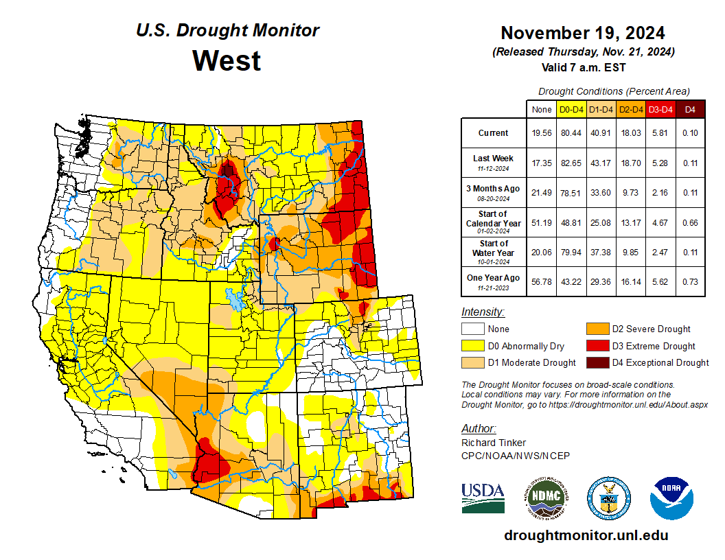
Click on a thumbnail graphic to view a gallery of drought data from the US Drought Monitor website.
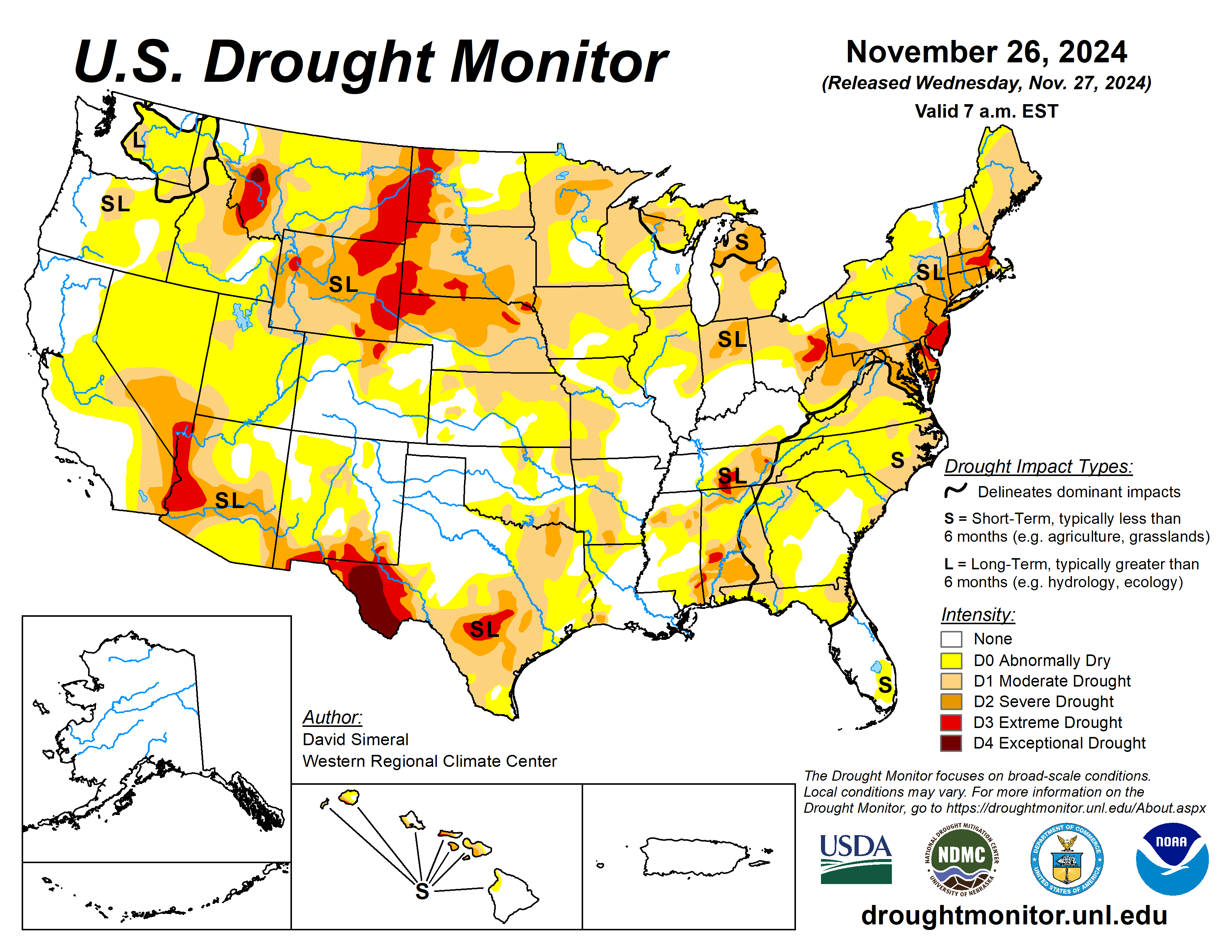


Click on the link to go to the US Drought Monitor website. Here’s an excerpt:
This Week’s Drought Summary
This U.S. Drought Monitor (USDM) week saw widespread improvement in drought-related conditions across areas of the Pacific Northwest and Northern California in response to a series of strong Pacific storms including a powerful atmospheric river that delivered significant rainfall accumulations to the lower elevation coastal areas and heavy mountain snow. In the coast ranges of Northern California, 7-day rainfall totals exceeded 25+ inches in some areas, according to preliminary data from the National Weather Service (NWS) California-Nevada River Forecast Center. The series of storms boosted mountain snowpacks above normal levels across the Cascades (Oregon, Washington), Blue Mountains (Oregon), Sawtooth Range (Idaho), and the northern and central Sierra. In the Desert Southwest, drought expanded and intensified on the map across areas of southern Nevada and Arizona in response to persistent dry conditions and record warm temperatures during the past 6-month period. In the Midwest, improving short-term conditions due to recent precipitation events across areas of the region led to widespread improvements in drought-affected areas. In the Northeast, light-to-moderate precipitation accumulations, including beneficial snowfall, led to a reduction of areas of drought coverage in Pennsylvania and West Virginia. In the Southeast, rainfall last week and overall improving conditions (soil moisture, streamflows) led to the removal of areas of drought on the map in Alabama, Georgia, and Florida.
In terms of reservoir storage in areas of the West, California’s reservoirs continue to be at or above historical averages for the date (November 25) with the state’s two largest reservoirs (Lake Shasta and Lake Oroville) at 111% and 105% of their averages, respectively. In the Southwest, Lake Powell is currently 37% full (59% of typical storage level for the date) and Lake Mead is 32% full (53% of average), with the total Lower Colorado system 42% full as of November 18 (compared to 43% full at the same time last year), according to the U.S. Bureau of Reclamation. In Arizona, the Salt River Project is reporting the Salt River system reservoirs 75% full, the Verde River system 57% full, and the total reservoir system 73% full (compared to 81% full a year ago). In New Mexico, the state’s largest reservoir along the Rio Grande is currently 7% full (17% of average). In the Pacific Northwest, Washington’s Franklin D. Roosevelt Lake is 90% full (103% of average for the date), Idaho’s American Falls Reservoir on the Snake River is 35% full (86% of average), and Hungry Horse Reservoir in northwestern Montana is 82% full (100% of average)…
High Plains
On this week’s map, only minor changes were made in the region including in eastern Nebraska and western North Dakota. For the week, precipitation across the region was generally light and primarily restricted to eastern portions of the Dakotas and Nebraska as well as western and northern portions of Kansas. However, some isolated moderate-to-heavy snowfall accumulations were observed in the Dakotas last week, including 14 inches reported at Lake Metigoshe State Park in northern North Dakota. In terms of average temperatures, cooler-than-normal temperatures (3 to 9 deg F below normal) were observed across the Dakotas, while the southern portion of the region experienced temperatures 1 to 5 deg F above normal in eastern Nebraska and Kansas…
West
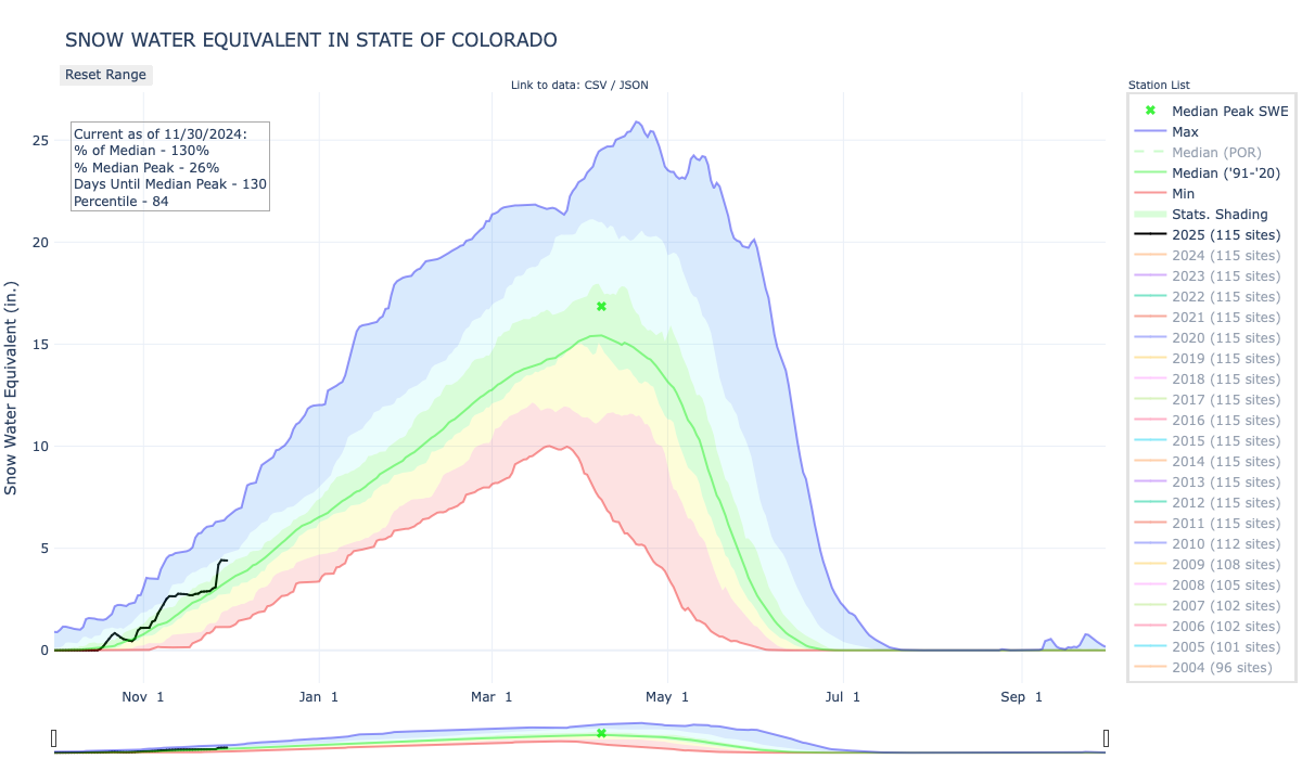
Out West, a series of powerful Pacific storms delivered heavy rain and mountain snow accumulations to the Pacific Northwest and Northern California. Impacts from the series of storms included damaging winds, major power outages, flash flooding, road closures, landslides, and debris flows. In the Coastal Range, an NWS observing station northwest of Santa Rosa, California reported a 7-day total of 24 inches of rain. Overall, the series of storms led to widespread removal of areas of drought on the map across the Pacific Northwest as well as areas experiencing short-term dryness across Northern California. Looking at the regional snowpack situation, the NRCS SNOTEL network is reporting (November 25) the following region-level (2-digit HUC) SWE levels: Pacific Northwest 179%, Missouri 78%, Upper Colorado 96%, Great Basin 125%, Lower Colorado 127%, Rio Grande 145%, Missouri 78%, Souris-Red-Rainy 128%, and Arkansas-White-Red 157%. In the Desert Southwest, areas of Extreme Drought (D3) expanded on the map this week in northwestern Arizona, extending northward into southern Nevada, in response to a combination of short and long-term precipitation deficits and record heat observed during the past 6-month period. Elsewhere in the region, the atmospheric river last week boosted snowpack conditions in Montana, helping to improve drought-affected areas in the northwestern part of the state…
South
Across the region, generally dry conditions prevailed this week, especially in the western portion of the region, with little or no precipitation observed across the western half of Texas and Oklahoma. However, light to moderate rainfall (2 to 4+ inches) was observed in isolated areas of southern Louisiana and Mississippi leading to minor improvements in drought-affected areas of southeastern Mississippi. For the week, average temperatures were near normal across the southern extent of the region while northern portions ranged from 3 to 6 degrees F above normal. On the map, deterioration occurred in isolated areas of Texas including the Trans Pecos, South Texas, and the southern Edwards Plateau, while improvements were made in the Panhandle and east Texas. Looking at reservoir conditions in Texas, Water for Texas (November 26) was reporting statewide reservoirs at 72% full, with many reservoirs in the eastern part of the state in good condition, while numerous reservoirs in the western portion of the state were experiencing continued below-normal levels…

Looking Ahead
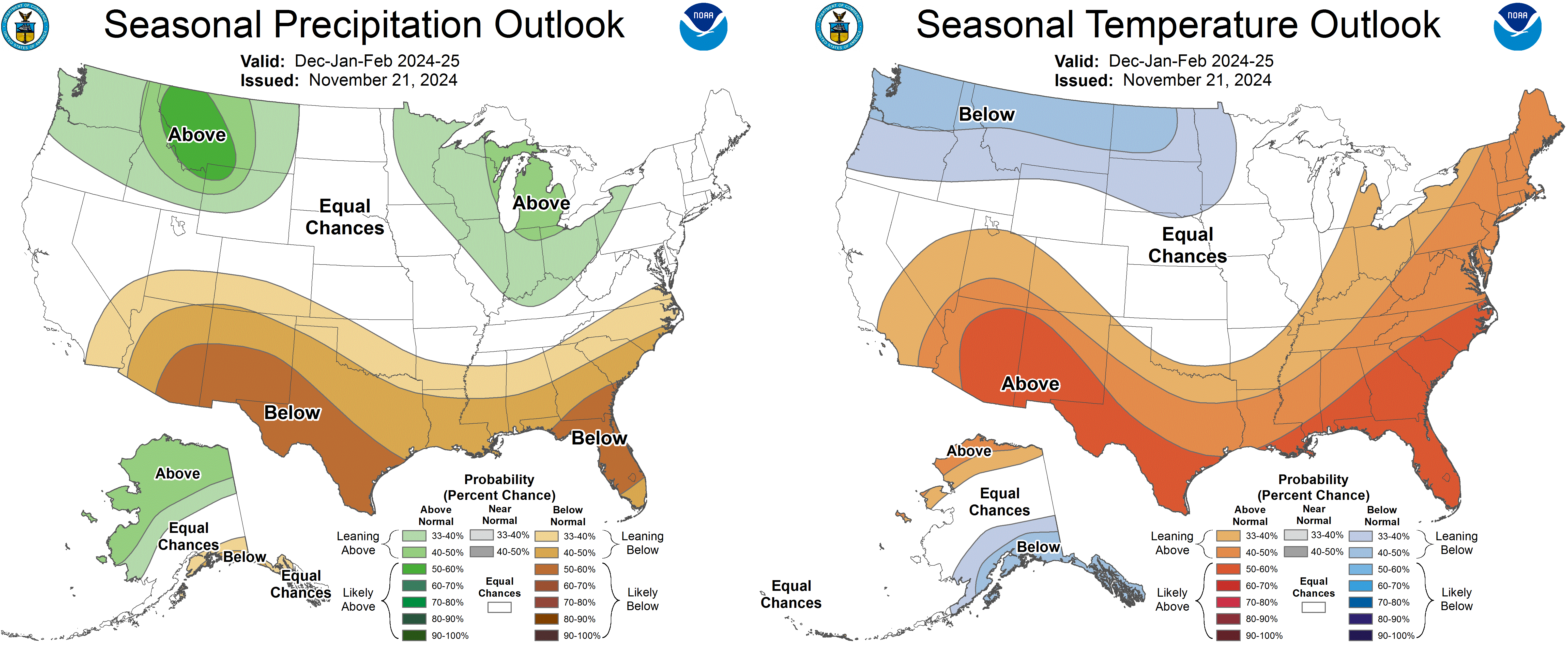
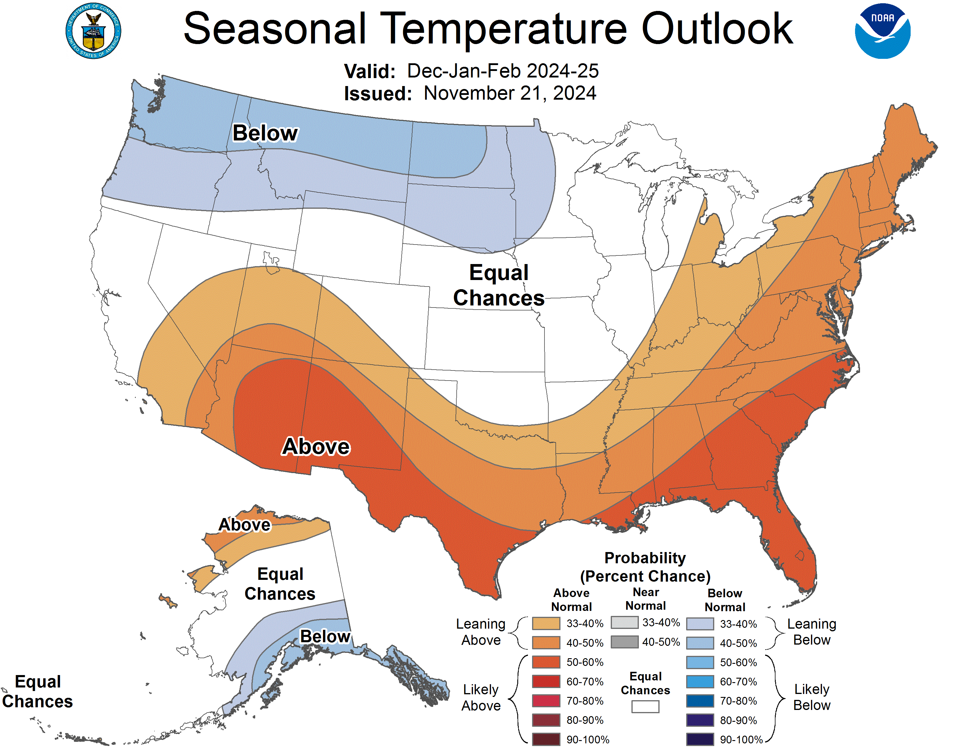
The NWS Weather Prediction Center (WPC) 7-Day Quantitative Precipitation Forecast (QPF) calls for light-to-moderate precipitation accumulations ranging from 1 to 2 inches (liquid) across areas of the Intermountain West including the Colorado Rockies and ranges in central and southern Utah. Lighter accumulations are expected in the southern Sierra, North Cascades, and areas of the northern Rockies. Along the Gulf Coast of Texas and Louisiana, light accumulations (<1 inch) are forecasted for the 7-day period. In the Upper Midwest and areas downwind of the Great Lakes in the Northeast, accumulations of <1 inch are expected. The Climate Prediction Center (CPC) 6-10-day Outlook calls for a moderate-to-high probability of above-normal temperatures across the West and near-normal temperatures across the Plains states. Conversely, below-normal temperatures are expected across the Eastern tier. In terms of precipitation, there is a low-to-moderate probability of above-normal precipitation across much of Texas and Louisiana as well as areas of the northern Plains. Elsewhere, below-normal precipitation is expected across much of the West, Central and Southern Plains, Southeast, Mid-Atlantic, and New England.


Click the link to read the article on the InkStain website (John Fleck):
November 15, 2024
I put up a slide for my University of New Mexico water resources graduate students during class yesterday afternoon with two pictures – the emerging canyons at the upper end of Lake Powell, and a smallmouth bass.
When Lake Powell gets low, we get a) the remarkable emergence of Cataract Canyon, and b) warm water invasive smallmouth bass sneaking through Glen Canyon Dam’s outlets, headed downstream to dine on the endangered humpback chub. My University of New Mexico colleagues and collaborators Benjamin Jones and Bob Berrens famously dubbed these “green-vs-green” tradeoffs:

Managing for one – keeping Lake Powell high to keep smallmouth bass out of the Grand Canyon – inevitably conflicts with the other – keeping Lake Powell low to protect the emerging environmental values of Cataract Canyon.
In a new white paper out today, my colleagues Jack Schmidt, Eric Kuhn, and I argue for the creation of a process to better incorporate and manage the multiplicity of values along the Cataract Canyon/Lake Powell/Glen Canyon/Grand Canyon/Lake Mead stretch of the Colorado River as we develop new post-2026 river operating guidelines. We recognize that keeping water flowing to taps and headgates across the Colorado River Basin is the primary motivation behind the new operating guidelines being developed by the Bureau of Reclamation. We argue that, as the community is writing those rules, we have an opportunity to incorporate a broader set of community values.
In particular, we argue that more creative water accounting methods would allow water to be either held upstream in Lake Powell for later delivery, or send downstream early to Lake Mead, in order to better take into account what Benjamin and Bob called the “multiple dimensions of societal value.”
The white paper elaborates on our formal proposal submitted in March to Reclamation as part of the agency’s Post-2026 decision process.


So when I got to the Hertz rental office yesterday they did not have a Polestar as I had reserved so the clerk said they would substitute similar vehicle, a Suburu Solterra. I thought, “Okay, that might be a nice ride.”
I motored east on I-70 thinking that I would do a first charge in Limon where I had charged my Leaf before because it showed up on a map from an app recommended by Hertz. When I arrived at the charging location the chargers were all offline. When I checked the ChargePoint app later the location didn’t show up which tells me that it has been closed.
It was a bummer but I had enough charge to get Flagler where I had also charged my Leaf there once before. When I connected I was immediately stunned by the charger telling me that it would take more than two hours to 100%. This can’t be right I thought, the charger (Electrify America) is capable of providing 350 KW of shared charge. I called Hertz and was told that the Solterra does not charge at Level 3. The only cars they have that charge at Level 3 are Teslas and Polestars.
I charged enough to get back home (3% charge when I arrived), hooked up to my Level 2 charger for an hour or so, then returned the car.
While charging at Flagler I called Avis to rent a Tesla. I picked up the car (Model 3) this morning and it crapped out just before Central Park Avenue on I-70. After being towed back to Avis I now have a different Tesla (Model Y) and am heading out again.

I’m heading out for Thanksgiving dinner with Hellchild and then to Las Vegas for the Colorado River Water Users Association Conference December 4-6, 2024. Posting my be intermittent. Hertz didn’t have a Polestar this morning so I’m in a Suburu Solterra.
Click the link to read the article on the Inside Climate News website (Wyatt Myskow):
November 21, 2024
The Biden administration on Wednesday released four alternatives to address the drought-stricken Colorado River’s water shortages, giving seven states, 30 tribes and the 40 million people who rely on the river a taste of how the vital waterway will be managed in the coming decades.
But the announcement offers little in the way of hard details, with a draft environmental impact statement analyzing the impacts of the Department of Interior’s proposed alternatives pushed back to next year. The states, meanwhile, remain divided over the path forward to deal with shortages on the river. Over the past year, the seven Colorado River Basin states—Arizona, California, Colorado, Nevada, New Mexico, Utah and Wyoming—along with tribes and the federal governments have been in negotiations over the “Post-2026 Operations” for the river that will dictate how to deal with water shortages. The river’s current drought guidelines, drafted in 2007, will expire at the end of 2026.
“We continue to support and encourage all partners as they work toward another consensus agreement that will both protect the long-term stability of the Colorado River Basin and meet the needs of all communities,” said Laura Daniel-Davis, the acting deputy secretary of the Department of Interior. “The alternatives we have put forth today establish a robust and fair framework for a Basin-wide agreement. As this process moves forward, the Biden-Harris administration has laid the foundation to ensure that these future guidelines and strategies can withstand any uncertainty ahead, and ultimately provide greater stability to the 40 million water users and the public throughout the Colorado River Basin.”
The river that enabled the Southwest’s rapid growth and vital agricultural production has seen its flows diminished roughly 20 percent over the past two decades by a megadrought. Climate change and years of overuse of the river’s resources have led the system’s massive reservoirs—lakes Mead and Powell—to fall to just a third of their capacities. That prompted steep cuts in allocations of the river’s water to Arizona, California and Nevada, and tense negotiations over its future. Further declines at the reservoirs could cause their respective dams to reach minimum power pool, where they can no longer generate electricity, or dead pool, when the water drops too low to flow through the concrete dams’ plumbing.
The Colorado River Basin is regulatorily split in two. The Upper Basin consists of Colorado, Wyoming, Utah and New Mexico. The Lower Basin is composed of Arizona, California and Nevada, which historically has used more of the river. Under the 1922 Colorado River Compact, which divided up the river’s resources and is the bedrock document for how it is governed, the Upper Basin is required to allow the Lower Basin states’ allocation of water to flow downstream before it can use its half of the river. If the Upper Basin fails to send the required amount of water, its own allocation could be cut.
Earlier this year, each basin submitted its own proposals for how it would manage the river’s water post-2026, but there was little agreement between their plans. The Upper Basin argued that, since it does not have large reservoirs and its users already have to make cuts anytime there is drought, it should be able to send less water downstream and the Lower Basin should bear responsibility for cutbacks. Under the Lower Basin’s proposal, all users would be forced to take cuts based on the total amount of water held in eight reservoirs across the entire system. Meanwhile, tribes have submitted their own proposals and comments, as have environmental groups.
The two basins remain deeply split, and though both sides are committed to coming to an agreement, it’s possible that the question of how Colorado River water will be divided and distributed between the basins will have to be settled in court, KUNC reported earlier this week. The Upper Basin representatives also maintain it has the right to take more water out of the river, given it does not use its full share, something that’s drawn the ire of its lower basin counterparts, environmental groups and water attorneys.
The Interior Department will analyze the four options presented Wednesday in an environmental assessment, with a final decision planned for 2026 on how to advance the process the Biden administration began and that President-elect Donald Trump’s administration will have to take over. One alternative is the federal government’s plan to “achieve robust protection of critical infrastructure,” like Hoover and Glen Canyon dams and the large amounts of hydropower they produce, along the river. Another combines that plan with comments from tribes and others. A third follows a proposal submitted by environmental groups, while the fourth combines the proposals of the states and tribes.
“Big picture: There’s still a lot of conflict about how Lake Powell will be managed,” said Kyle Roerink, the executive director of the Great Basin Water Network. A key difference between the alternatives is how water would be released from Lake Powell, the massive reservoir in the middle of the river system. He said the Upper Basin’s proposal would use it as a “piggy bank” to store water for them while the Lower Basin, which has priority rights to the water, wants to see it used to deliver what it is owed by the upstream states.
The states themselves say it will take time to fully analyze the proposals put forth by the Bureau of Reclamation, which oversees the river’s management, but neither side seems excited about the options, though they’ve admitted the need to continue working together.
“There are some really positive elements to these alternatives, but at the same time I am disappointed that Reclamation chose to create alternatives, rather than to model the Lower Basin states’ alternative in its entirety,” said Tom Buschatzke, the director of the Arizona Department of Water Resources, in a statement. “The Lower Basin’s alternative didn’t start at one extreme or the other, and it showed unequivocally that the Lower Basin was willing to take the first tranche of cuts.”
In a statement, Colorado River Commissioner Becky Mitchell said that “Colorado continues to stand firmly behind the Upper Division States’ Alternative, which performs best according to Reclamation’s own modeling and directly meets the purpose and need of this federal action.
“The Upper Division States Alternative is supply-driven and is designed to help rebuild storage at our nation’s two largest reservoirs,” she said. “The Alternative protects Lake Powell’s continued ability to release water downstream into the future to continue to meet our obligations and protect our significant rights and interests in the Colorado River.”
Roerink likened the Biden administration’s efforts to bring water users together as “herding cats” and said that Wednesday’s decision may help bring them back to the table to find a solution. But the divide between the two basins remains wide. “Change is scary,” he said.
This article originally appeared on Inside Climate News (hyperlink to the original story), a nonprofit, non-partisan news organization that covers climate, energy and the environment. Sign up for their newsletter here.

Click the link to read the release on the Audubon website (Jennifer Pitt):
November 20, 2024
The following is the oral testimony of Jennifer Pitt, Audubon’s Colorado River Program Director before a House Natural Resources Subcommittee on Water, Wildlife and Fisheries:
Chair Bentz, Ranking Member Huffman, and members of the Subcommittee, thank you for holding this hearing on proposed legislation addressing water management in the western United States. My name is Jennifer Pitt and I serve as the Colorado River Program Director for the National Audubon Society, with over 25 years of experience working on water issues in the Colorado River Basin. National Audubon Society is a leading national nonprofit organization representing more than 1.4 million members and supporters. Since 1905, we have been dedicated to the conservation of birds and the places they need, today and tomorrow, throughout the Americas using science, advocacy, education, and on-the-ground conservation. Audubon advocates for solutions in the Colorado River Basin that ensure adequate water supply for people and the environment.
Audubon supports H.R. 9515, the Lower Colorado River Multi-Species Conservation Program Amendment Act of 2024. The Program constructs habitats along the Colorado River below Hoover Dam, and that habitat is essential not only for the 27 species the program targets, but also for many of the 400 species of birds that rely on the Lower Colorado River, including Yellow-billed Cuckoos, Sandhill Cranes, and Yuma Ridgway’s Rails. Today, because the Program spending does not keep pace with the collection of funds from non-federal partners, about $70 million is held in non-interest-bearing accounts. If these funds were held in an interest-bearing account, the Program would have about $2 million in additional funds per year, and be more able to maintain program implementation in the face of increasing costs.
Audubon appreciates the inclusion of H.R. 9969 in this hearing. This bill directs Reclamation and the Western Area Power Administration, in consultation with the Glen Canyon Dam Adaptive Management Work Group, to enter into a memorandum of understanding to explore and address potential impacts of management and experimental actions to help control invasive fish passage in the face of drought and declining water levels. Rapidly changing conditions on the Colorado River warrant the experimental approach of adaptive management, with the Work Group bringing together varied interests to a consensus on how to protect downstream resources and strike a balance on river operations. Results of this collaboration include improved sediment flows that help maintain sandy beaches used by plants and animals that dwell in the floodplain, as well as by people traveling the canyon by boat.
The context for these bills is the current crisis on the Colorado River. Climate change continues to ravage the Colorado River Basin, which is now in its 25th year of drought. The forecast for this winter is for above-normal temperatures and below-normal snowpack, which could impact Colorado River water supply. With a 2026 deadline looming for the expiration of existing federal guidelines for operation of federal Colorado River infrastructure – with implications for water supply reliability for people and the river itself – human nature is creating unacceptable risks. Colorado River water managers are preparing for conflict to protect their share of an increasingly scarce water supply, rather than focusing on holistic solutions.
Earlier this year, Audubon joined with conservation partners in submitting to Reclamation our Cooperative Conservation Alternative for consideration in the post-2026 NEPA process for developing Colorado River Operating Guidelines. Cooperative Conservation is designed to improve water supply reliability, reduce the risk of catastrophic shortages to farmers and cities, create new flexible tools that can protect infrastructure, incentivize water conservation, help Tribes realize greater benefits from their water rights, and improve river health. We urge Reclamation and all Colorado River Basin parties to consider our approach as they proceed through the NEPA process.
From a bird’s eye view, the whole system matters. That needs to hold true for water users who must figure out how to share the Colorado River. The old adage applies: united we stand, divided we fall. The Colorado River community – in particular Upper Basin and Lower Basin interests – must stop thinking parochially and start thinking about how we survive drier times together.
I would like to thank Congress for funding water conservation programs, such as WaterSMART and the Cooperative Watershed Management Program, and the crucial funding in the Bipartisan Infrastructure Law and the Inflation Reduction Act, both of which include funding to improve the resilience of the Colorado River Basin. With this funding, and states working together, we have avoided a crisis, but we are still just one bad winter away from catastrophic shortages. To be effective, this funding needs to get out of federal coffers and into the hands of water users and water managers, to incentivize water conservation and efficiency, to improve the health of the forests and headwater streams that are the river’s source, and to stabilize the river itself – the natural infrastructure that supplies water to more than 40 million people. Congress will need to help in the future with additional funding to support continued resilience investments in the Colorado River Basin as warming continues.
Thank you very much for the opportunity to testify and I would be happy to answer your questions.

Click the link to read the article on the Writers on the Range website (Jennifer Rokala):
November 18, 2024
President Donald Trump’s first term was a disaster for America’s public lands. While the prospects for his second term are even more bleak, Westerners across the political spectrum—even those who voted for Trump—stand ready to oppose attempts to sell off America’s public lands to the highest bidder.
As for Trump’s pick for Interior Secretary, North Dakota Governor Doug Burgum: If Burgum tries to turn America’s public lands into an even bigger cash cow for the oil and gas industry, or tries to shrink America’s parks and national monuments, he’ll quickly discover he’s on the wrong side of history.
Public lands have strong bipartisan support in the West. The annual Conservation in the West Poll, last released by the Colorado College State of the Rockies Project in February 2024, found that nearly three-quarters of voters—including Republicans—want to protect clean water, air quality and wildlife habitats, while providing opportunities to visit and recreate on public lands.
That’s compared to just one-quarter of voters who prefer maximizing the use of public lands available for drilling and mining. According to the poll, which surveyed voters in Arizona, Colorado, Idaho, Montana, Nevada, New Mexico, Utah, and Wyoming—80 % of Westerners support the national goal of conserving 30 % of land and waters in America by the year 2030.
Bipartisan support for more conservation and balanced energy development has been a cornerstone of the poll’s findings since it began in 2011. Under the leadership of President Joe Biden and Interior Secretary Deb Haaland, the current administration has made progress over the past four years in bringing public land management in line with the preferences of Western voters. That includes better protecting the Grand Canyon, increasing accountability for oil and gas companies that operate on public land, and putting conservation—at last—on par with drilling and mining on public land.
The President-elect may find it hard to immediately block what Westerners want. After Trump took office in 2017 promising to transform public land management, his team was unprepared and used its power to benefit its own interests, ignoring the wishes of the American people.
Trump’s first Interior secretary, Ryan Zinke, misused his position to advance his dream of owning a microbrewery in Montana. Trump’s second Interior secretary, oil and gas industry lobbyist David Bernhardt, put his finger on the scale in the interest of a former client. Trump’s choice to run the Bureau of Land Management, William Perry Pendley, served illegally without being confirmed by Congress.
We worked hard to shed light on this corruption and defend public lands from Trump’s attacks. Still, Trump’s Interior department allowed oil and gas companies to lock up millions of acres for bargain basement prices.
In his second term, Donald Trump will attempt to shrink national monuments like Bears Ears in Utah and permit drilling and mining in inappropriate areas. The president-elect has already committed to undoing President Joe Biden’s energy and environmental policies.
Project 2025, the policy handbook written by former Trump officials, clearly lays out a plan to gut the Interior Department and remove environmental safeguards that ensure the health of our public lands.
Project 2025 would give extractive industries nearly unfettered access to public lands, severely restrict the power of the Endangered Species Act, open millions of acres of Alaska wilderness to drilling, mining and logging and roll back protections for spectacular landscapes like Bears Ears and Grand Staircase-Escalante national monuments. It would also remove protections for iconic Western species such as gray wolves and grizzly bears.
What can we do about this assault? The law and public opinion are on our side. Public land protections are stronger today than ever, thanks in large part to the grassroots efforts of Tribes, local community leaders and conservation organizations.
We know much of what’s in Trump’s public lands playbook, and we will fight back. We’ll continue to shine a light on corruption within the Trump administration and hold it accountable.
Our partners will work in Congress to stop bad policies and projects from going forward. We are ready to take action in the courts and in the streets. And we’re not waiting until Inauguration Day to start.
Jennifer Rokala is a contributor to Writers on the Range, writersontherange.org, an independent nonprofit dedicated to spurring lively conversation about Western issues. She is executive director of Center for Western Priorities, a nonpartisan public lands advocacy group.

Click the link to read the article on the Colorado Public Radio website (Ishan Thakore). Here’s an excerpt:
November 22, 2024
A $99 million plan to buy and permanently preserve some of the oldest water rights in Colorado is inching closer to securing all of its funding. But President-elect Donald Trump’s promise to gut climate spending could throw a wrench in the deal, despite its bipartisan support. The Colorado River District, which advocates on behalf of Western Slope water users, submitted a funding application today to the U.S. Bureau of Reclamation under a program for drought mitigation. The district is seeking $40 million from the federal agency to help purchase water rights from Xcel Energy, the state’s largest utility…
Since the agreement, around 25 Western Slope water providers, the river district and the state of Colorado have committed $56 million to purchase the water rights. The state’s water conservation board, much of Colorado’s congressional delegation, and a bipartisan group of state lawmakers support the plan. To make up the remaining funds, the river district is banking on money from the Inflation Reduction Act, the nation’s largest climate law, which was signed by Biden in 2022. Bureau of Reclamation records show the agency has $450 million remaining under the law to dole out to state, local and tribal governments in the upper Colorado River Basin for projects that offset the effects of drought and climate change…
That stream of federal funding for the Shoshone water deal has not yet been committed and could be in jeopardy, according to Martin Lockman, a law fellow at the Sabin Center for Climate Change Law. President-elect Trump said he would rescind any remaining funds from the inflation law when he returns to office. Project 2025, a conservative policy blueprint influential among the president-elect’s advisors, has called for repealing elements of the law.
Click the link to read the article on The Land Desk website (Jonathan P. Thompson):
November 22, 2024
🥵 Aridification Watch 🐫
The Bureau of Reclamation released a sort of teaser of its eagerly anticipated plan for dealing with the demand-supply imbalance on the Colorado River. And like most teasers, it gives very little insight into what to expect from the actual plan. It presents four alternative ways forward, but doesn’t say which one the agency is leaning towards. But they all are at least partially aimed at keeping Lake Powell’s surface level above the minimum power pool, so that water can continue to be released via the penstocks and hydroelectric turbines. This would put most of the burden for cuts on the Lower Basin states, which could experience up to a 3.5-million-acre-feet shortage some years. This doesn’t cut it for John Weisheit, Living Rivers’ Conservation Director, who noted:


But there may be even less water than previously anticipated in the Colorado River in the future, throwing even the best laid plans askew. That’s the finding of a recent study, in which researchers ran historic data and climate change forecasts through modeling programs, yielding hundreds of thousands of streamflow scenarios for the Colorado River and its tributaries originating on Colorado’s West Slope. They concluded that relying on the historic streamflow record risks underestimating the magnitude of future drought events. And these droughts could significantly reduce the amount of water flowing in Colorado River tributaries, throwing supply and demand further off balance.
Patrick Reed, the study’s principal author, said in a press release:

And if less water is going into Lake Powell, then its operators will release even less water from Glen Canyon Dam, meaning deeper shortages for the millions of folks downstream who rely on the river.
For now, however, things are looking alright for the Colorado River. Some good autumn storms built up the snowpack, which is now sitting right at about the median level for this time of year in the Upper Colorado River Basin.

Meanwhile, things are quite nice, snowpack-wise, down in the San Juan Mountains, where snow-water levels are higher than this date’s normal and significantly healthier than at this time in 2024 or 2023. And another storm is on its way.

Will the good times last? According to the latest seasonal climate outlook, probably not. Forecasters are expecting it to be drier and warmer than normal in the Southwest, though things could go either way in the northern portion of the Colorado River Basin. But then, it’s always best to take these long-term forecasts with a hefty grain of salt.

🏠 Random Real Estate Room 🤑
Where can you get, in 2024, 1.36 acres that includes an old post office, a 104-year-old cabin, a converted bus, and at least one RV for just $75,000? Cisco, Utah, that’s where. The property was immortalized by Sarah Gilman in her 2018 High Country News article “The Pioneer of Ruin,” a profile of the owner and Cisco’s sole resident Eileen Muza. Miranda Trimmier also wrote about Cisco and Muza for Places Journal in 2019, and a variety of other media attention followed about their effort to restore that piece of the “ghost town.” The property was listed in July for $275,000 — Muza’s partner apparently was not interested in living out there — but the price was dropped to $75,000 this month. It’s certainly one of the funkier properties on the market and probably the least expensive housing for sale in the greater Four Corners area. But the “housing” part isn’t official: Even though Muza lived there and it sports several dwellings, the property is listed as land, not a residence (so it won’t show up on searches for houses). But you’d better move quick if you’re interested: It showed up on the 2.9-million-follower @cheapoldhouses Instagram feed recently, so it could go fast. Heck, at that price, I even briefly considered it for the Land Desk/Lost Souls Press global HQ!
And just down the road, in that illustrious Cisco suburb known as Moab, about 100 people gathered to protest the proposed Kane Creek Development. The developers want to build nearly 600 housing units and associated infrastructure at a place called Kings Bottom on the banks of the Colorado River a couple miles downstream from Moab. It’s not going over so well with many locals. That’s just a crap ton of houses, it would all be vulnerable to flooding (meaning a good portion of the homes, and the contents of a planned sewage treatment plant, could end up floating in Lake Powell someday). I suppose the developers could move the whole operation up to Cisco.
In an alternate reality, in which the Bureau of Reclamation circa 1946 had its way, Cisco might be waterfront property right now. For more on that, check out this piece from the Land Desk archives (available to paid subscribers only):

Cisco Resort and other water buffalo oddities — Jonathan P. Thompson
June 1, 2022
Gratuitous Silver Bullet Shot


Click the link to read the release on the Reclamation website:
November 21, 2024
The Bureau of Reclamation has selected 36 projects to receive a total of $3.3 million in federal funding to enhance water efficiency across the Western United States. The funding, provided through the Small-Scale Water Efficiency Projects program, will support initiatives such as the installation of flow measurement or automation systems, canal lining to reduce seepage, and other similar projects that aim to improve water management on a smaller scale.
“As stewards of vital water resources, it is our responsibility to ensure that every drop is used efficiently,” said Bureau of Reclamation Chief Engineer David Raff. “These investments, while focused on smaller-scale projects, have a lasting impact on our ability to conserve water, protect ecosystems, and support the communities that depend on these critical resources.”
The Bureau of Reclamation is now accepting applications for the next Small-Scale Water Efficiency Projects program funding opportunity, with a deadline of January 14, 2025.
For more information on how to apply for funding, visit grants.gov. To learn more about the program and find details about projects in your area, visit the program’s website.
The projects selected are:
Arizona:
- Coldwater Canyon Water Company, Upgrade Manual Read Meters to Advanced Meter Reading Technology: Reclamation Funding: $91,786
- Global Water Resources, Turf Removal Incentive Program for Residential and Non-Residential Customers: Reclamation Funding: $50,000
- Joshua Valley Utility Company, Phase III: Upgrade 400 Meters to Advanced Reading Technology: Reclamation Funding: $100,000
- Sonora Environmental Research Institute, Inc, High-Efficiency Clothes Washer Replacement Program for Low-Income Households: Reclamation Funding: $47,500
California:
- City of Hercules, Enhancing Park Irrigation Efficiency with Cloud-Based Controllers: Reclamation Funding: $100,000
- Cucamonga Valley Water District, Water Savvy Parkway Transformation Program: Reclamation Funding: $100,000
- Desert Water Agency, Grass Removal Program: Reclamation Funding: $100,000
- Fresno Irrigation District, Meter Installation Program: Reclamation Funding: $100,000
- Jackson Valley Irrigation District, Propeller Meter Upgrades: Reclamation Funding: $100,000
- Pajaro Valley Water Management Agency, Remote Data Acquisition for High Production Groundwater Wells: Reclamation Funding: $97,878
- San Lorenzo Valley Water District, AMI Water Meter Replacement Project: Reclamation Funding: $100,000
- Upper San Gabriel Valley Municipal Water District, Water Use Efficiency Plant Voucher Project: Reclamation Funding: $100,000
Colorado:
- Community Agriculture Alliance Inc, Automate Headgates on the Bear River: Reclamation Funding: $100,000
- Town of Fraser, 2026 Water Meter Modernization and Replacement Project: Reclamation Funding: $100,000
- Town of Simla, Municipal Water Meter Upgrade for Water Efficiency: Reclamation Funding: $100,000
Idaho:
- A&B Irrigation District, Water Accounting Software Implementation and Project Upgrade: Reclamation Funding: $47,500
- Boise Project Board of Control, Automation of the Brooks Lateral: Reclamation Funding: $24,967
- Fremont Madison Irrigation District, Fremont-Madison Irrigation District Automation and SCADA Project Phase 4: Reclamation Funding: $100,000
- Jefferson Irrigation Company, Flow Measurement of Irrigation Canal Turnouts for Jefferson Irrigation Company, LTD: Reclamation Funding: $99,715
- Long Island Irrigation Company, Main Diversion Replacement: Reclamation Funding: $100,000
- Upper Wood River Water Users Association, Inc, Bypass Canal Lining Project: Reclamation Funding: $100,000
North Dakota:
- Agassiz Water Users District, Agassiz Water Users District 2024 Remote Read Water Meter Project: Reclamation Funding: $100,000
- City of Bottineau, City of Bottineau, Advanced Metering Infrastructure Project – Phase I: Reclamation Funding: $100,000
- City of Mandan, Mandan Advanced Metering Infrastructure System Update Project: Reclamation Funding: $100,000
- City of Watford City, Watford City Advanced Metering Infrastructure Project – Phase II: Reclamation Funding: $100,000
- Southeast Water Users District, Southeast Water Users District: Advanced Metering Infrastructure Improvements Phase II Project: Reclamation Funding: $100,000
Nevada:
- City of Boulder City, Boulder City Water Meter Upgrades: Reclamation Funding: $98,613
Oregon:
- Colton Water District, Automated Meter Reading: Reclamation Funding: $100,000
- Ochoco Irrigation District, Inc, J1 Lateral Pipe and Metering Project: Reclamation Funding: $36,574
South Dakota:
- Belle Fourche Irrigation District, Anderson Lateral Pipeline: Reclamation Funding: $83,406
Utah:
- Circleville Irrigation Company, Dalton Ditch Water Conservation Project – Phase 3: Reclamation Funding: $100,000
- Clinton City, Clinton City AMI Project Phase I: Reclamation Funding: $100,000
- Draper Irrigation Company, Culinary Smart-Metering Project: Reclamation Funding: $100,000
- Jensen Water Improvement District, Residential Meter Replacement and Upgrade Project: Reclamation Funding: $100,000
- Powder Mountain Water and Sewer Improvement District, System-Wide Radio Read Meter Project: Reclamation Funding: $100,000
Washington:
- Clallam County PUD No. 1, Small-Scale Advanced Metering Infrastructure Project: Reclamation Funding: $100,000
Reclamation provides cost share funding the Small-Scale Water Efficiency Projects to irrigation and water districts, Tribes, states and other entities with water or power delivery authority for small water efficiency improvements, prioritizing projects that have been identified through previous planning efforts.
Small-Scale Water Efficiency Projects are part of the WaterSMART Program. It aims to improve water conservation and sustainability, helping water resource managers make sound decisions about water use. The WaterSMART Program identifies strategies to ensure this generation, and future ones, will have enough clean water for drinking, economic activities, recreation and ecosystem health. To learn more, please visit www.usbr.gov/watersmart.

Click the link to read the article on the Water Education Colorado website (Jerd Smith):
November 21, 2024
Arapahoe County has enough water to meet its needs through 2050, according to a new study, but major steps will need to be taken to reduce future demand and protect the county’s groundwater supplies.
Arapahoe County Commissioner Jeff Baker, in a statement, said the study is a cautionary tale, showing that while existing supplies generate 141,000 acre-feet of water each year, future growth could strain those supplies.
“If they want to build, they need to make sure there is enough water to provide adequate water resources to people. This is not a green light to develop,” Baker said.
Arapahoe County is home to 656,000 people, who use 83,400 acre-feet of water a year. By 2050, those numbers are expected to soar, with population topping 900,000 and water demand increasing to as much as 116,000 acre-feet a year, according to the new report.

As with other counties, Arapahoe County does not deliver water, relying instead on 12 separate water districts and agencies to supply its communities, according to Anders Nelson, a spokesman for the county. Some of its supplies come from renewable surface water — primarily runoff from mountain snowpack — while the more rural parts of the county rely on groundwater.
The study outlines several steps that should be taken to protect the fast-growing community southeast of Denver from future water shortages. The county will require developers to document adequate water for new construction projects; implement county-wide water-efficient landscaping rules, and encourage regional partnerships and water sharing agreements.
More by Jerd SmithJerd Smith is editor of Fresh Water News. She can be reached at 720-398-6474, via email at jerd@wateredco.org or @jerd_smith.

Click the link to read the article on the AZCentral.com website (Arlyssa D. Becenti). Here’s an excerpt:
November 21, 2024
Hopi Chairman Timothy L. Nuvangyaoma breathed a sigh of relief on Tuesday as Arizona Gov. Katie Hobbs signed the Northeastern Arizona Indian Water Rights Settlement Act, a significant step that sends the measure on to Congress. It’s poised to become the largest Indian water rights settlement in history…
“This is a historic moment for the state of Arizona, tribal nations, and all parties to these agreements. They create a consequential and lasting impact by securing a sustainable water supply for tens of thousands of Arizonans and helping local economies thrive,” Hobbs said. “I’m proud to be a part of this solution that many Arizona families have fought to get for generations. It’s a testament to their strength and determination, as well as my commitment to collaborate with Arizona’s tribal nations and protect water supplies for all Arizonans.”

The settlement act resolves long-standing tribal water rights claims to the Colorado River, the Little Colorado River and groundwater sources in northeastern Arizona. The water infrastructure funded by the settlement will address the critical need for safe and reliable water supplies for members of three tribes — Navajo, Hopi and San Juan Southern Paiute — ensuring access to clean running water, a necessity all Arizonans deserve…Congress must ratify the settlement before it adjourns at the end of the year. If the measure fails to pass, supporters will have to reintroduce it when the new Congress convenes in January.

Click the link to read the article on the Alamosa Citizen website:
November 21, 2024
Alamosa is continuing to piece together its Rio Grande recreation puzzle. With support from the city of Alamosa to pull back the levee to make way for a beach, the Alamosa Riverfront Project is taking a different shape. Support from the city will aid in helping bring the project to completion.
During a city council meeting earlier in November, councilors recognized that the project aids in the city’s “Activating the Rio Grande Corridor,” a top priority for the Parks and Recreation Department.
As the river’s oxbow loops lazily trickle ever southward to the Gulf of Mexico, deciphering how to ensure people can access the river, how the river can maintain its natural biodiversity, and how to prevent thousands from losing their homes in a “100-year” flood make it a daunting and sharp puzzle.

The Alamosa Riverfront Project is looking to expand recreation access and improve river restoration from the State Avenue Bridge, upstream of Alamosa’s Cole Park, to the West Side Ditch, downstream of Cole Park. It’s a multi-million dollar project that, so far, has received overwhelming support from the community, according to project planners and members of the community who showed up at a series of summer community meetings.
You may be able to take the town from the river, but the river will continue to flow through town.
The project is looking to connect people back to the Rio Grande, not through adrenaline-pumping white water, but instead by leveraging its natural geographic limitations.
Brian Puccerella, San Luis Valley Great Outdoor’s outdoor recreation manager, has been involved in this project since about 2016. That’s when the conversation about expanding access to paddlers, maybe adding a play wave, and just expanding recreation generally started making the rounds.
The conversation was about “what was possible in our stretch of river in town,” Puccerella said. “We didn’t know the answer to that.”
An engineering study was funded in 2017 to look at what was possible.
“The conclusion,” he laughed, “was not much. It’s pretty flat and we don’t have a lot of flow. That doesn’t mean there isn’t going to be recreational improvement.”
The study equates Alamosa’s stretch of low-flowing river, less than one mile per foot downhill through town, to a “skinny lake.”
Puccerella explained that Alamosa’s portion of the river doesn’t have the flows or drops to ever get whitewater, even in a good year. A lot of the water that flows from the mountains into the river is diverted to different systems throughout the San Luis Valley. By the time the river reaches Alamosa, its flows are quite slow.
What we do have, he said, is flatwater.
That’s not a negative, though. “It creates opportunity for family-friendly recreation.”
Construction is still a ways out. Alamosans can expect construction to begin sometime around fall 2026. A lot of money still needs to be raised, and a lot can happen between now and then. What planners won’t have to worry about is the Army Corps of Engineers’ levee recertification.

BEACHFRONT PROPERTY
When construction is finished, the western levee, the side of the river adjacent to Cole Park, will be pulled back and a highly accessible riverfront beach will be added. Right now there’s a fairly steep, unfriendly drop to the water. In the future, there will be easy access for everyone.
The Rio Grande Headwaters Restoration Project is heading up the funding and providing the support to engineers throughout the project’s timeframe. During the summer, the group held two community feedback meetings to both inform and learn. From those meetings, project planners were able to adjust the plans.
Final plans will be revealed to the public in early 2025. These preliminary renderings can give us a hint, however.
“We’re doing this because this is what the community wanted,” said Cassandra McCuen, program manager for the Rio Grande Headwaters Restoration Project. She called the project “amazing and transformative.”
McCuen and Puccerella joined Outdoor Citizen podcast host Marty Jones to talk more about the project and provide updates. You can listen to that episode here, or wherever you get your podcasts.
From those community meetings, project planners were able to incorporate community feedback. Two of the most important pieces of feedback for engineers and designers: ensuring as much of the project is ADA accessible as possible, and making sure the river and beachfront are safe.
Access from Cole Park will be a priority, as it will serve as a kind of hub. The project calls for a few more boat ramps, adding to the two Alamosa currently has. These boat ramps won’t be for motorboats, but personal watercraft such as paddle boards, tubes, kayaks, and canoes.
Increasing recreational potential increases recreational safety. Currently, Puccerella and McCuen said, floating south of Cole Park isn’t advised. The West Side Ditch Diversion and the railroad bridge are a bit of a snag of willows, rusty metal, and splintered wood.
INSIDE THE LEVEE
“Inside the levee it’s more complicated,” McCuen said.
When it comes to changing the levee or potentially changing how water flows through town, you answer to the Army Corps of Engineers.
The Corps is responsible for ensuring that levees don’t fail during a proverbial “hundred-year flood.” Alamosa has a history of regular and devastating flooding. The levee system protects Alamosa proper and East Alamosa. Without a certified levee system, property owners are required to pay for flood insurance.
The recertification process is still many years out. The riverfront project is just a few years out. McCuen said the city has been an amazing partner in supporting the project.
With that in mind, project planners were able to meet with the Army Corps of Engineers and provide them with a full rundown of the project, plus the support of the city of Alamosa, and their proposal to pull the levee back.
McCuen said it was a real point of concern, because the project planners were unsure of how the Corps would react to the project’s proposal of pulling the levee back and the inner-levee restoration work.
McCuen said they were finally able to meet with the Army Corps in August. During that meeting, the Corps told the project planners they would be willing to work with them, “as long as you do not impact the flows through Alamosa negatively.”
Pulling the levee back to make way for a beach won’t impact flows in a noticeable way.
“Our project has worked seamlessly with the work that’s gone into levee recertification,” she said.

FISH PASSAGE
People are not only getting an upgrade, but so are the wildlife. This project is unique and special to Alamosa through both its recreation and restoration efforts. McCuen said the attempt is to improve the natural condition of the Rio Grande through town alongside increasing its recreational value. From the planning phase onward, restoration has been at the forefront of the project.
In-town restoration work can be complicated due to the levee recertification, but also due to the geographical limitations Puccerella mentioned. The river is extremely confined, McCuen explained.
Part of that confinement is because the Rio Grande is a very developed river. For example, diverting the Rio Grande’s flow before it reaches Alamosa creates that low flow prime for paddling and floating, but it also makes the water warm.
Warm water is bad for the Rio Grande’s fish. “Super-duper low flows make the area hot,” McCuen said. So one of the major aspects of the restoration portion is creating a safe, cool fish passage.
“We want fish to be able to flow upstream and downstream.”
The fish passage would simply be deeper channels that fish would use as aquatic highways. Also needed are fish refuges, or backwater habitats that exist along the river to serve as places where native fish can take refuge from non-native carp and pike.
Restoring the Rio Grande will take time and effort, but connecting the people back to the river is a start.
“We really wanted to create a project that spoke to the culture of Alamosa, spoke to the community, is something the community wanted, and I think we’re gonna get there because people took time out of their day to be involved in all this,” McCuen said.
Click on a thumbnail graphic to view a gallery of drought data from the US Drought Monitor website.


Click the link to go to the US Drought Monitor website. Here’s an excerpt:
This Week’s Drought Summary
The trend of the past few weeks toward generally increased precipitation across the Contiguous 48 states continued this week, with several sizeable swaths of heavy precipitation recorded, and broad coverage of near or above normal amounts. The heaviest amounts fell from the Cascades westward to the Pacific Ocean, in addition to southwestern Oregon and northwestern California. Amounts exceeded 3 inches through almost this entire region, with amounts of 5 inches to locally 1 foot observed in portions of the Cascades and immediate Pacific Coastline, especially where orographically enhanced. Several other large areas recorded at least an inch and locally up to 5 inches, including most of the northern Intermountain West, a swath from the southern High Plains through the central Great Plains and the middle and upper Mississippi Valley, much of the lower Mississippi Valley, the lower Ohio and Tennessee Valleys, the upper Southeast, much of the Virginia Tidewater and eastern North Carolina, and parts of the southern and central Appalachians. Numerous locations in the Lower Mississippi Valley and northwestern Alabama reported 3 to 5 inches of rain, as did a swath in north-central Kentucky and isolated spots in western Tennessee, northwestern Texas, eastern Oklahoma, southwestern Kansas, and western Iowa. The broad coverage of moderate to heavy precipitation prompted sizeable areas of improvement in this week’s Drought Monitor. The pattern of increased precipitation has yet to materialize in the Northeast, however, where record and near-record low precipitation amounts have been observed over the past few months, and continued dryness last week allowed conditions to continue to deteriorate. Little or no precipitation was also recorded across the southern reaches of South Carolina and Georgia, the Florida Peninsula, southern Texas, most of the central and northern Plains, and the southwestern quarter of the country, with patches of deterioration noted in these areas as well this week…
High Plains
Moderate to heavy precipitation was widespread across the southern and eastern reaches of the High Plains Region, and moderate amounts were observed in some of the higher elevations of Wyoming and central Colorado, and over northern North Dakota. Elsewhere, only a few tenths of an inch, at most, was measured. In the areas of heaviest precipitation (1.5 to approaching 3.0 inches), improvement was introduced. This included significant parts of Kansas, southeastern Colorado, eastern sections of Nebraska and South Dakota, and a relatively small area in southeastern North Dakota. The remainder of the region, under a regime of light to moderate precipitation at best, dryness and drought assessments were unchanged…
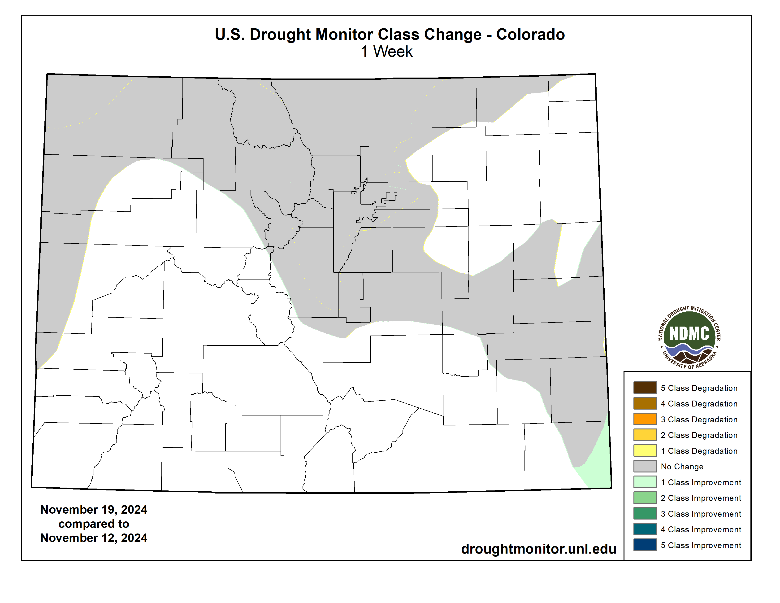
West
Heavy to excessive precipitation in northwestern California and the Northwest from the Cascades to the Pacific Coast induced widespread 1-category improvement in these areas. Totals exceeding 3 inches were almost ubiquitous, and amounts of 5 to locally 12 inches were common in the Cascades and near the immediate coast. This amounted to peeling back D0 and D1 to the west. In Oregon, streamflows have finally begun to respond to the increased precipitation. Other areas of improvement were introduced where there was spottier moderate to heavy rain in parts of eastern Oregon, northern Idaho, and westernmost Montana. Moderate to heavy precipitation (locally up to 3 inches) also doused southeastern New Mexico adjacent to the heavy rains in western Texas, with similar 1-category improvements introduced in areas with over 1.5 inches of precipitation. Elsewhere, only scattered light precipitation was reported, and dryness and drought were primarily unchanged. Some deterioration was noted in west-central Montana (to D1) while a significant swath of eastern Montana slid into extreme drought (D3)…
South
Like the Southeastern Region, the South Region experienced highly variable rainfall this past week, although more areas experienced significant rainfall and improved conditions than dryness and deterioration. The latter was confined to central and southern Texas where little or no rain fell, expanding D0 through much of Deep South Texas and prompting the introduction of D1 in a patch near the lower Rio Grande River. Farther north, moderate to heavy precipitation prevailed, especially across western Teas, much of Oklahoma, portions of Louisiana, Mississippi, and western Tennessee. A large part of these areas saw a 1-category improvement, nearly eliminating severe drought (D2) in western Arkansas, eastern Oklahoma, and adjacent Texas, and also decreasing D1 coverage substantially across the northern and eastern tiers of the Region…
Looking Ahead
During the next five days (November 21-25), moderate to heavy precipitation is expected in the western and northeastern quarters of the contiguous states, and along the immediate Canadian border. Lesser amounts, if any, are expected in and around the Plains and along most of the southern tier. The greatest amounts are forecast across northern California and the Sierra Nevada, where totals exceeding 5 inches are expected to be widespread, with the potential for as much as 15 inches at isolated spots in the higher elevations. Generally 1.5 to 3.0 inches are expected in the West from the Cascades to the Pacific Coast and in portions of the northern Intermountain West. Similar amounts are also forecast for most of New York State, northeastern Pennsylvania, and to a lesser extent New England, the Great Lakes, and southwestern California. Between 0.75 and 1.5 inches should fall in the remainder of the Northwest, the higher elevations of the central Rockies, southwestern California, much of the Great Lakes, Pennsylvania, Maryland and Delaware, and the rest of New England. In contrast, little or no precipitation is expected in the Plains from the central Dakotas southward, and along the southern tier of the country from southeastern California eastward through Georgia and most of the Carolinas. Very warm weather is expected in central and southern Texas, with temperatures expected to average 10 to 13 deg. F above normal. A larger area from eastern Arizona through the Lower Mississippi Valley is forecast to average 5 to 10 deg. F above normal. Meanwhile, unusually low temperatures averaging 10 to 17 deg. F below normal are anticipated from the central and western Dakotas through most of Montana. Temperatures may average up to 10 deg. F above normal from the Upper Mississippi Valley and central Plains westward through the Great Basin and northern Intermountain West. Near or slightly above normal temperatures are expected elsewhere.
The Climate Prediction Center’s 6-10 day outlook (valid November 26-30) favors above-normal precipitation in a swath from the Southwest and the Great Basin eastward through most of the Plains, and from Mississippi Valley eastward to the Atlantic Coast. Only the Northeast, Florida Peninsula, central and southern Texas, the Great Lakes, and the Far West are outside the area where above-normal precipitation is expected. Odds exceed 50 percent over the east-central Rockies and adjacent High Plains. Unusually dry weather is more likely in western Texas, the Northwest, parts of the Intermountain West, plus central and northern portions of the Rockies and Plains. Subnormal precipitation is also more likely across Hawaii, especially the northwestern islands. Meanwhile, the southern tier of the country from the Plains to the Atlantic Coast is expected to average warmer than normal, with odds topping 50 percent along and near the Gulf of Mexico Coast. Hawaii is also expected to average warmer than normal, especially the central and northwestern islands. Cold weather is favored across central and northern portions of the Rockies, Plains, and Mississippi Valley, plus some adjacent areas. Chances for significantly subnormal temperatures are 70 to 80+ percent from Montana east of the Rockies and most of the Dakotas.


Click the link to read the release on the Department of Interior website:
November 20, 2024
Investments from President Biden’s Investing in America agenda have staved off crisis in the Colorado River Basin
Alternatives released today lay out necessary steps towards consensus agreement for post-2026 operations
Since Day One of the Biden-Harris administration, the Department of the Interior has led critical discussions over how to bring the Colorado River back from the brink of crisis in the face of a 24-year drought. Having achieved overwhelming success in 2023 on interim operation plans to guide operations through 2026 with a historic consensus agreement, and following more than a year of collaboration with the states and Tribes who call the Colorado River Basin home, the Biden-Harris administration today released the next step in a responsible path to guide post-2026 operations for the Colorado River.
Today, the Department released five proposed alternatives that will be analyzed as part of the Post-2026 Operations for the Colorado River. These alternatives represent a wide range of actions that respond to a broad spectrum of hydrology for the Colorado River Basin and reflect elements from proposals submitted by Basin states, Tribes, cooperating agencies and non-governmental organizations, as well as ongoing conversations and collaborations with all Basin stakeholders. As Basin partners continue to work towards a consensus agreement, the range of alternatives provides the framework for a realistic and fair path to meet the goals and needs of the communities and users that rely on this important and diminishing water source. This range includes a “Basin Hybrid Alternative,” that is designed to reflect components from the proposals and concepts submitted by the Upper Division States, Lower Division States, and Tribal Nations to present elements that could provide a basis for coordinated operations and may facilitate greater agreement across the Basin. All five alternatives will be formally analyzed to ensure the long-term stability of the Colorado River Basin for all of the communities and habitats that rely on it.
“With historic investments from President Biden’s Investing in America agenda, the Department of the Interior has successfully fostered an unprecedented level of collaboration and partnerships with Colorado River Basin states and Tribes,” said Acting Deputy Secretary Laura Daniel-Davis. “We continue to support and encourage all partners as they work toward another consensus agreement that will both protect the long-term stability of the Colorado River Basin and meet the needs of all communities. The alternatives we have put forth today establish a robust and fair framework for a Basin-wide agreement. As this process moves forward, the Biden-Harris administration has laid the foundation to ensure that these future guidelines and strategies can withstand any uncertainty ahead, and ultimately provide greater stability to the 40 million water users and the public throughout the Colorado River Basin.”
“In the face of a climate change-fueled megadrought, communities and ecosystems in the Colorado River Basin need both near-term and long-term solutions to ensure the stability of this precious resource for generations to come,” said John Podesta, Senior Advisor to the President for International Climate Policy. “Over the past four years, thanks to the resources from President Biden’s Investing in America agenda and our Administration’s efforts to work with states and Tribes, the future of the Colorado River Basin is much brighter. The alternatives released today will help support ongoing efforts for all Basin partners to reach consensus on a sustainable path forward that will help ensure that Colorado River Basin communities are healthy and thriving, now and into the future.”
“As the West continues to face drought conditions, now is the time for more investment, innovation and collaboration for urgent and essential progress across the Colorado River Basin. The river is one of our nation’s most invaluable natural resources – providing clean water, hydropower and habitat for more than 40 million people, 30 Tribal Nations, and a wide diversity of species. When the Basin was on the brink of collapse, the Biden-Harris administration helped bring it back – thanks to historic investments from President Biden’s Investing in America agenda,” said White House National Climate Advisor Ali Zaidi. “Those efforts helped stabilize the Colorado River for the short-term – but now, we owe it to future generations to find long-term solutions that ensure the river’s continued stability. Harnessing the best-available science, the Administration today continues to lead the Basin to stability by offering a framework that will build a more sustainable and equitable future for communities across the West. We continue to encourage all Basin partners to find a consensus agreement that meets the needs of all the river’s users.”
Over the last three years, the Biden-Harris administration has led a comprehensive effort to make Western communities more resilient to climate change and address the ongoing megadrought across the region by harnessing the full resources of President Biden’s historic Investing in America agenda. As climate change has accelerated over the past two decades, the Colorado River Basin experienced the driest period in the region in over one thousand years. Together, the Inflation Reduction Act and Bipartisan Infrastructure Law provide the largest investment in climate resilience in our nation’s history, including $15.4 billion for western water across federal agencies to enhance the West’s resilience to drought and deliver unprecedented resources to protect the Colorado River System for all whose lives and livelihoods depend on it. This includes $5.35 billion for over 577 projects in the Colorado River Basin states alone.
In June 2023, the Department initiated the formal process to develop future operating guidelines and strategies to protect the stability and sustainability of the Colorado River for future generations. The release of the proposed alternatives sets the basin on a course that allows for timely development of final operating guidelines. This is a step that must be taken by August 2026 to inform future operations – the existing guidelines expire in December 2026. Today’s announcement comes as Bureau of Reclamation Commissioner Camille Calimlim Touton convenes the ninth Federal–Tribal–State forum, an unprecedented working group created under Secretary Haaland’s leadership to bring the seven Basin states and 30 Tribes together to regularly discuss the shape and substance of post-2026 operations.
“We have worked tirelessly over the past several years to bring Colorado River Basin stakeholders together for a transparent and inclusive post-2026 process that has fostered collaboration and compromise. Importantly, we have also put Tribal governments at the table for the first time in history,” said Commissioner Touton. “Today, we show our collective work. These alternatives represent a responsible range from which to build the best and most robust path forward for the Basin. I have confidence in our partners and the Reclamation team in continuing this work to meet the needs of the river for the future.”
Addressing the Short-Term Crisis
The lifeblood of the American West, the Colorado River Basin provides water for more than 40 million people and fuels hydropower resources in seven U.S. states. It is a crucial resource for 30 Tribal Nations and two states in Mexico, and it supports 5.5 million acres of agriculture and agricultural communities across the West, in addition to important ecosystems and endangered species. In 2021, historic drought along the river brought the communities it serves to a near crisis. This megadrought diminished the river’s largest reservoirs — Lake Mead and Lake Powell — to critically low elevations. Ravaged by the climate crisis, extreme drought, and unsustainable water use, this vital artery was drained to perilous lows, jeopardizing agriculture, urban areas, and ecosystems.
To provide decisive intervention and bold action, the Biden-Harris administration launched an all-of-government approach to address the short-term risk and set the stage for the development of long-term solutions to help avoid a similar crisis in the future. By collaborating with states, Tribes, federal partners and interested stakeholders – the Department paired innovative investments through President Biden’s Investing in America agenda with operational strategies to address water shortages and promote sustainable management. The consensus agreement for near-term operations, announced in 2023, stabilized the system in the short-term, as the Department embarked on the broader effort to address long-term conservation needs. Today, Lake Mead is replenished, up nearly 20 feet from two years ago, and Lake Powell has rebounded 50 feet. The lower Basin states and the Country of Mexico are on track to save 1.6 million acre-feet by the end of 2024, an unprecedented level of conservation for the Colorado River Basin.
President Biden’s Investing in America Agenda
President Biden’s Investing in America agenda represents the largest investment in climate resilience in the nation’s history and is providing much-needed resources to enhance Western communities’ resilience to drought and climate change. Reclamation is leveraging nearly $13 billion in critical investments across the west through the Bipartisan Infrastructure Law and Inflation Reduction Act.
These funds have helped the federal government secure a series of historic water conservation agreements across the Basin states, while investing in state-of-the-art upgrades to the West’s aging water infrastructure, including innovative projects that support water distribution structures, water storage capacity, advanced metering infrastructure, canal lining, farm efficiency improvements, recycling and desalinating water, and more. These investments have been essential in reducing water demand through voluntary water conservation incentives, while also investing in infrastructure upgrades and long-term strategies to maximize water resources.
Charting a Path Forward
The post-2026 process is a multi-year effort to identify a range of alternatives and ultimately determine operations for Lake Powell and Lake Mead and other water management actions in a future of persistent drought and increasing climate variability. These operations will be critical in defining water allocations for cities and agriculture, guiding future management, and guarding against the need for the kind of short-term fix the Biden-Harris administration successfully negotiated and completed earlier this year.
Guided by the lessons learned and best practices developed through the Department’s short-term effort and using the best-available science, Reclamation analyzed how future operational guidelines and strategies can be sufficiently robust and adaptive to withstand a broad range of hydrological conditions and ultimately provide greater stability to water users and the public throughout the Colorado River Basin.
In addition to public comment, virtual seminars, frequent meetings with the Basin states and the Federal-Tribal-State forum, Reclamation has conducted 30 nation-to-nation consultations and held 40 Tribal Information Exchanges to ensure ongoing dialogue and information sharing. To date, Department staff have visited and met with each Basin state Governor or designee and have visited more than half of the 30 Colorado River Tribes on their own land – a demonstration of the Administration’s commitment to meaningful nation-to-nation engagement.
Reclamation will now analyze these alternatives to develop a draft Environmental Impact Statement (EIS). Once published, the draft EIS will include a public comment period. This puts Reclamation on a path to publish a final EIS, which would then be followed by a Record of Decision in 2026.
While the post-2026 process will determine domestic operations, the Biden-Harris administration has collaborated with the Country of Mexico in recognition of their equities in the Basin. The International Boundary and Water Commission will continue to facilitate consultations between the United States and Mexico on Binational Cooperative Processes under the 1944 Water Treaty.

Click the link to read the “Post-2026 Colorado River Reservoir Operational Strategies for Lake Powell and Lake Mead: Narrative of National Environmental Policy Act Alternatives“
Approach to Alternative Development
- Features of all action alternatives will ensure a broad range of alternatives for analysis. Reclamation’s goal for the post-2026 process is to allow for the adoption of specific guidelines for the coordinated reservoir management of Lake Powell and Lake Mead through their full operating range and to provide for the sustainable management of the Colorado River system and its resources under a wide range of potential future system and hydrologic conditions.
- An operating plan must be in place by August 2026. We are sharing the five alternatives now as a voluntary step in the National Environmental Policy Act (NEPA) process to enhance transparency and create a framework for a realistic and fair path for Colorado River Basin states, Tribes, and non-governmental organizations to continue to work toward a consensus agreement that protects the stability and sustainability of the Colorado River System into the future.
- Releasing the alternatives in advance of publishing the draft Environmental Impact Statement (DEIS) affords the public and affected water users more information about the process and provides greater opportunities for collaboration, to ensure that we have a plan in place before the current guidelines expire.
Concepts Common to All Alternatives
- All alternatives will undergo a detailed analysis of impacts on the natural and human environment as necessary to develop a Draft EIS. The analysis will also compare the performance of alternatives over a common set of key hydrologic metrics including reservoir elevations, water use and reductions, and deviations from Glen Canyon objective releases, pursuant to the Long Range Operating Criteria (LROC).
- Releases from Lake Powell may be less than the specified release below elevation 3,490 ft due to Glen Canyon Dam infrastructure limitations.
- Additional Lower Basin shortages (and potential additional reductions in water deliveries to Mexico) may be necessary under future hydrologic scenarios where Lake Mead reaches dead pool.
- As in the 2001 and 2007 Guidelines, the Secretary retains all applicable authority to respond to exigent and emergency conditions.
- The determination of deliveries to Mexico is not a part of the proposed federal action. Any such determination would be made in accordance with the 1944 Treaty. Nevertheless, modeling assumptions with respect to the distribution of shortages for the Lower Division States include operationally aligned water delivery reductions to Mexico in order to analyze potential impacts to hydrologic and other environmental resources. Shortage amounts described are amounts of total shortage, including Mexico. Modeling assumptions that identify water deliveries to Mexico pursuant to the 1944 Treaty with Mexico would be developed after all necessary and appropriate discussions have been completed with the United States International Boundary and Water Commission in consultation with the Department of State.
Description of Alternatives
No Action
- The No Action does not meet the purpose of and need for the federal action, but it is included as a requirement of NEPA.
- Operations would revert to annual determinations announced through the Annual Operating Plan (AOP) process.
- Lake Powell release would be 8.23 maf unless a higher release is required for equalization or a lower release results from Glen Canyon Dam infrastructure limitations.
- Shortages to the Lower Basin would be based on priority and reach a maximum of 600 kaf.
- This would not represent a continuation of current operations but is generally based on the preexisting operating guidance that was in place before the adoption of the 2007 Interim Guidelines Record of Decision (ROD), and thus includes no specific activities above Lake Powell beyond existing authorities (e.g., to make emergency releases from Colorado River Storage Project (CRSP) Initial Units to protect infrastructure at Glen Canyon Dam).
- Existing Intentionally Created Surplus (ICS) would be delivered in accordance with existing agreements, but there would be no new delivery and storage mechanisms.
Alternative 1: Federal Authorities
- This alternative is designed to achieve robust protection of critical infrastructure within the Department and Reclamation’s current statutory authorities and absent new stakeholder agreements.
- Lake Powell releases would be determined based on Lake Powell elevations, unless equalization releases are required. Lake Powell releases would range from 9.5 to 5.0 maf. Releases could be less than 5.0 maf, and Lake Powell elevations could be increased by CRSP Initial Units, to protect infrastructure at Glen Canyon Dam.
- Lower Basin shortages of up to 3.5 maf would be distributed consistent with the priority system and would be triggered based on combined storage in Lake Powell and Lake Mead.
- Existing ICS (Intentionally Created Surplus) would be delivered in accordance with existing agreements, but there would be no new delivery and storage mechanisms.
- There would be explicit accounting of unused/undeveloped quantified Tribal water
Alternative 2: Federal Authorities Hybrid
- This alternative is designed based on proposals and concepts from Tribal Nations, federal agencies, and other stakeholders to achieve robust protection of critical infrastructure while benefiting key resources (e.g., natural, hydropower and recreation) through a new approach to distributing storage between Lake Powell and Lake Mead that enhances the reservoirs’ ability to support the Basin.
- Lake Powell releases would be determined based on a combination of Lake Powell and Lake Mead elevations, 10-year running-average hydrology, and Lower Basin deliveries. Lake Powell elevations could be increased by releases from CRSP Initial Units to protect infrastructure at Glen Canyon Dam.
- This alternative would include new delivery and storage mechanisms for Lake Powell and Lake Mead with federal and non-federal storage pools and maximum flexibilities for all users. The operations incorporate Basin-wide shared contributions to the sustainability of the system, including Upper Basin conservation that would be stored in Lake Powell and Lower Basin shortages starting at 1.5 maf, which exceeds average annual evaporative and system losses at and below Lake Mead, and reaching a maximum of 3.5 maf.
- Shortages would be triggered based on combined storage in Lake Powell and Lake Mead and distributed pro-rata.
- There would be explicit accounting of unused/undeveloped quantified Tribal water.
- Some elements of this alternative would require additional federal statutory authorities and stakeholder agreements.
Alternative 3: Cooperative Conservation
- This alternative is informed by a proposal submitted by a consortium of conservation organizations with the goal of stabilizing system storage, integrating stewardship and mitigation strategies of Lakes Powell and Mead, maintaining opportunities for binational cooperative measures, incentivizing water conservation, and designing flexible water management strategies.
- Lake Powell releases would range from 11.0 maf to 5.0 maf and would be determined by total Upper Basin system storage and recent hydrology. Releases would switch to “run-of-river” when Lake Powell is at 3,510 ft or lower. The operations incorporate Basin-wide shared contributions to sustain system integrity, including up to 4.0 maf of shortages in the Lower Basin triggered by combined seven-reservoir storage and recent hydrology, and voluntary water contributions from both basins.
- Some elements of this alternative would require additional federal authorities and stakeholder agreements.
Alternative 4: Basin Hybrid
- This alternative is designed to reflect components from the proposals and concepts submitted by the Upper Division States, Lower Division States, and Tribal Nations to present elements that could provide a basis for coordinated operations and may facilitate greater agreement across the Basin.
- Lake Powell releases would be determined primarily based on Lake Powell elevation with consideration in some scenarios of Lake Mead elevation. Releases would range from 12.0 to 5.0 maf. Lake Powell elevations could be increased by releases from CRSP Initial Units to protect infrastructure at Glen Canyon Dam.
- This alternative would include new delivery and storage mechanisms for Lake Powell and Lake Mead, including incentivizing conservation and managing/offsetting reductions, to afford the Tribal and non-Tribal entities the same ability to use these mechanisms. The operations incorporate Basin-wide shared contributions, including Upper Basin conservation that would be stored in Lake Powell and up to 2.1 maf of Lower Basin shortages triggered by combined seven reservoir storage.
- This alternative would analyze shortage distribution using two approaches: priority and pro-rata, both of which would be analyzed with and without shortages to Tribes.
- There would be explicit accounting of unused/undeveloped quantified Tribal water.
- Some elements of this alternative would require additional federal authorities and stakeholder
agreements.
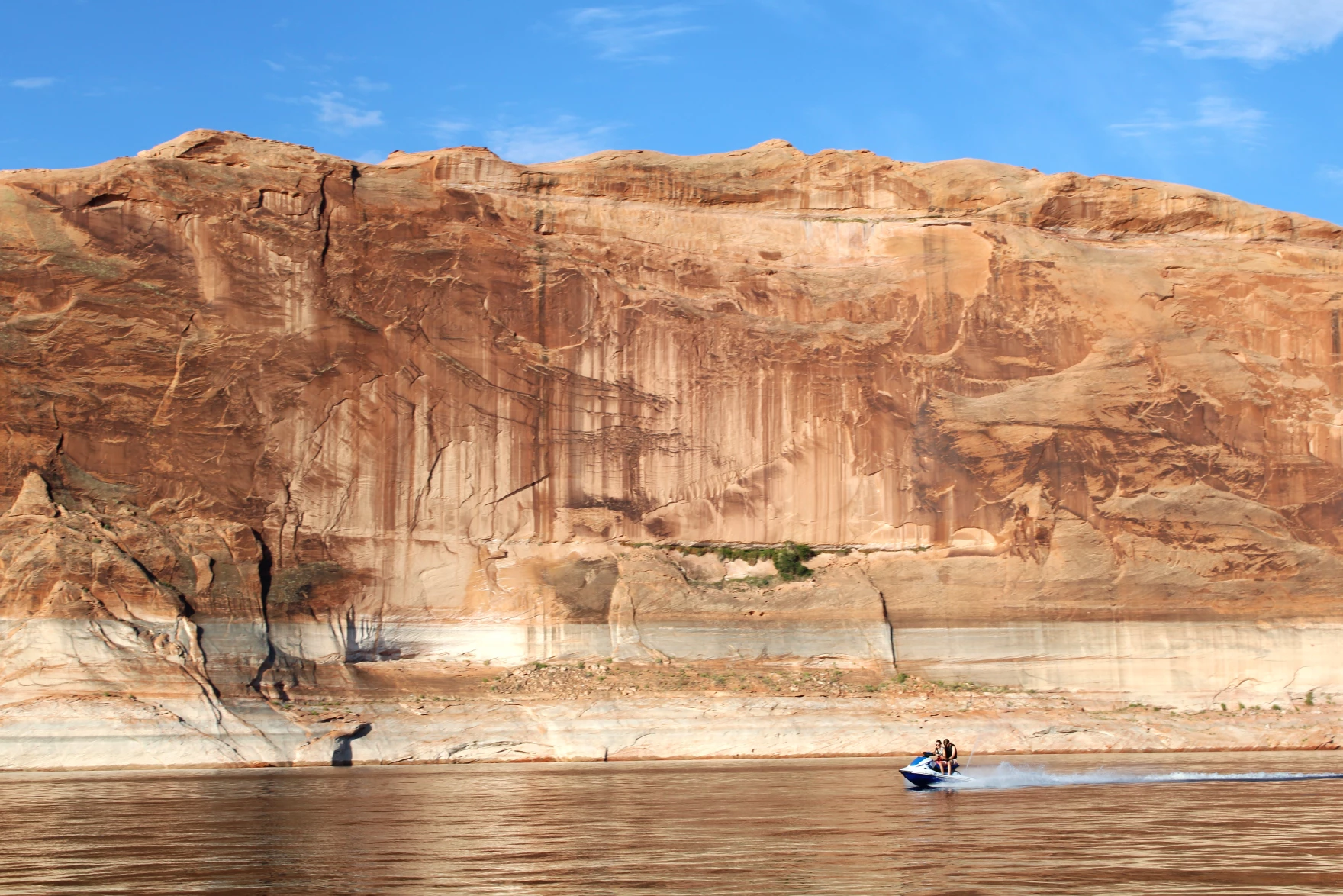
Click the link to read the article on the KUNC website (Alex Hager):
Federal water officials released a set of possible plans for managing the shrinking Colorado River in the future. They urged state negotiators to agree on a single plan, since the states are deeply divided about how to share the pain of cutbacks during dry times.
“We can either remain stuck at an impasse, or secure a future for future generations that promises the stability and sustainability of one of our greatest natural resources,” said Ali Zaidi, White House climate advisor.
The current rules for sharing Colorado River water expire in 2026, and the seven states that use it are on the hook to come up with a replacement before then. They’re split into two camps, and each submitted a separate proposal to the federal government in March. State negotiators say they want a collaborative solution, but they don’t appear any closer to agreement than they did in March and have publicly dug in their heels about their ideological differences.
In a call with reporters on Wednesday, multiple federal officials encouraged states to pick up the pace in those negotiations.
“To get to the other side here,” Zaidi said, “there’s going to be a requirement, an imperative on all of us, to find the common ground to move the process forward with urgency.”
Although federal agencies operate the dams and reservoirs that hold Colorado River water, they have historically implemented management plans drawn up by states.
But today, in an apparent attempt to nudge the states towards agreement, the Interior Department released four “alternatives” – each a different proposal for managing the river – and none of them are exactly in line with either of the competing state proposals.
“Now really is the time for the basin states and tribes to redouble their work toward a consensus alternative,” said Laura Daniel Davis, the acting deputy secretary of the interior. “The alternatives we’re announcing today show that path and I urge them to do so.”
The alternatives released by Interior are relatively light on details, but seem to include input from some of the 30 native tribes which use the river, and environmental groups which campaigned for more protections for wildlife and their habitats.
Kyle Roerink, director of the nonprofit Great Basin Water Network, said the alternatives don’t give any serious clues about a final plan for managing the river, but rather attempt to push forward the conversation among the states.
“It’s hard to make a broad and sweeping statement about it,” he said. “We’re waiting for the big picture. We’ve been thirsting for it for well over a year, but we’re dealing with a recipe that only lists a few of the ingredients and we can only make assumptions.”
By releasing alternatives, the Biden administration may be attempting to influence negotiations ahead of its departure from the White House. It’s unclear exactly how Donald Trump’s upcoming return to the presidency could shape talks about the Colorado River, but state leaders said they don’t expect the change to disrupt their process.
This story is part of ongoing coverage of the Colorado River, produced by KUNC in Colorado and supported by the Walton Family Foundation. KUNC is solely responsible for its editorial coverage.

Click the link to read the article on the Colorado State University website (Allison Sylte):
November 18, 2024
We can all agree that we literally can’t survive without water. The real controversy arises from how we should manage this precious resource.
Ultimately, it comes down to working together. That’s why the theme of the 2024 Water in the West Symposium was “Building Bridges: Collaborative Water Action.” The Nov. 14 event at the Colorado State University Spur campus in Denver brought together more than 150 stakeholders representing everything from the state and federal government to academia and tribal nations.
“We often overlook acres of common ground to focus on less significant differences,” CSU Chancellor Tony Frank said in his opening remarks. “I think with water and in conversations like this one … offer us a path toward unity.”
And during a day filled with panels discussing diverse topics, ranging from agriculture to state water planning and finance, one common theme rang through: progress through collaboration isn’t always easy, but it is possible.
Here are some of the key takeaways.
Teams should create spaces for listening and dissent
Keynote speaker Michaela Kerrissey, an assistant professor of management at the T.H. Chan School of Public Health, focuses much of her research on helping teams solve difficult problems.
“Part of it is about not getting stuck in the problem but figuring out what the solution is,” Kerrissey said.
Finding solutions to problems is a good common goal, and having this sense of purpose is a good anchor to a strong team, Kerrissey said. Another key? Creating a space where everyone feels empowered to speak up – including those who might disagree with the overall consensus.
“The idea behind this is that likely in all of our organizations and all of our teams, great ideas get left behind because the culture doesn’t come with a space to come forward, be heard, and be taken seriously,” she said.
Kerrissey was the first speaker of the day. Martin Carcasson, the founder and director of the CSU Center for Public Deliberation, was the last, and he too focused his remarks on how allowing for disagreement can ultimately lead to better results.
“For divergent thinking, we need to get beyond the usual suspects and status quo and hear all the voices,” he said.
That’s easier said than done. And in an at-times polarized world, his hope is that we create more spaces that allow this to happen.
“We have so many organizations that are designed to divide us, we need organizations that are designed to bring us together,” Carcasson said.
Solving grand problems requires empathy
Meagan Schipanski, an associate professor in the Department of Soil and Crop Sciences at CSU, said science is really good at defining problems. Solving them requires more of a human touch.
“As a biophysical scientist, I’ve become increasingly convinced that we need to lead with the humans, the stories, the contexts in all these situations,” she said.

She pointed to her efforts to engage with stakeholders working to preserve the Ogallala Aquifer, and the varying motivations and struggles of everyone involved.

Heather Dutton, the district manager for the San Luis Valley Water Conservation District, shared similar lessons from her efforts engaging with farmers and ranchers.
“We realized the environmental community and farmers have a lot in common – we rely on the river as one of the key economic drivers of our region, we rely on it for happiness,” she said. “The thread of realizing we all have so much in common has enabled us to have robust and collaborative projects to think about all the different uses and benefits.”

Manuel Heart, the chairman of the Ute Mountain Ute tribe in southwestern Colorado, also shared the importance of getting to know the people involved in different sides of a problem.
“I’m hoping to bring education to each of you, education about who we are as a native people, as a Ute Mountain tribe, and to have the respect to be able to speak freely and bring the challenges we face, and also gain trust and partnership,” he said. “You have to feel those feelings of not just one ethnic group, but other ethnic groups.
“You need that empathy to feel what is going on.”
Building strong relationships requires trust and a common goal
Nobody will be able to solve the water crisis alone. That’s why the Water in the West Symposium featured panelists representing everything from state-level water conservation groups to NGOs to private companies.
All of them shared stories about how they’ve worked together to solve problems in their region, and a common thread from all of these successes? Trust.

“I think that uncertainty leads to misinformation, and all the sudden it’s us against them, and you have disagreements between downstream water users versus upstream ones, and everything in between,” said John Ford, the water projects manager for agriculture at the Nature Conservancy Arizona. “When you can get people together and be really clear, you can mitigate some of the risk and distrust. That’s when collaborations happen.”
Russ Sands, the section chief for water supply planning at the Colorado Water Conservation Board, said it’s clear that something needs to be done – it’s just a matter of rallying people around that common goal.

“We know water has a massive impact on the hazards in this state … the cycle of drought, more things catching on fire … it has devastating consequences, and that really stacks up on our impact and need for action,” he said. “We need to move to a place where we’re talking and need to take care of each other and work together.”

There’s a lot of room for hope
Working together isn’t always easy, but it is possible – and that lesson applies to so much more than water.
“We really liked the idea of bringing people together to talk about collaboration, to showcase what’s happening on the ground,” said Jocelyn Hittle, the associate vice president for CSU Spur. “Deliberation is what makes our American democracy experiment very strong, and very alive, and very dynamic.”
Carcasson, who speaks to groups across Northern Colorado about how to have collaborative conversations, said he was encouraged by hearing panels throughout the day and realizing that there was already a strong dialogue surrounding Water in the West.
“It’s really heartening to see,” he said.

Click the link to read the article on the Colorado Water Trust website (Dana Hatfield):
November 12, 2024
As a representative for Colorado Water Trust, I often get asked if our purpose is to buy and dry up agricultural water rights and land. My response to that is Colorado Water Trust is a small but highly productive nonprofit organization with a seven-person team and a $1 million core budget. We are much too small to go around purchasing water rights. But what we can do is lease water and build relationships. Being able to consider the use of temporary solutions with our over fifty project partners every year makes our work possible and puts millions of gallons of water back in rivers today.
Also in response to that question, I provide an explanation of how the majority of our projects are temporary and voluntary solutions which aim to safeguard farmers and ranchers’ water rights and provide flexibility and economic incentive. We do sometimes have permanent projects that change water rights from irrigation to environmental flow when desired by the project partners, or permanent water sharing agreements with agriculture where we may use the water rights in the fall for environmental flow instead of irrigation. But, generally, our projects are temporary and always voluntary. I explain that we make the process of working with us an ongoing conversation and relationship – not a forever done deal. And hopefully, if I have managed to keep their attention and explain it well, they are pleased to hear about the customized and supportive approach that Colorado Water Trust takes to working with agriculture.
We have several temporary arrangements in partnership with agricultural producers today. A simple explanation of how these projects work is that they typically operate in any five years of a ten-year period after we sign an agreement (per Colorado legislation). Then in winter of each year, we follow the snow-pack to predict what the flow levels will likely be at the farm or ranch’s local stream. Depending on projections, we start our conversation early in the year to determine whether extra water will be needed in the stream and if the farmer or rancher would be open to foregoing using their water for part or all of the upcoming growing season. If so, we offer reimbursement for the water at fair market value. In some cases, we offer an additional incentive bonus for running the project and/or reimbursement for any crop loss due to halted irrigation. In either case, having this conversation early in the year allows the farmer or rancher to plan their year accordingly.
Throughout this process, Colorado Water Trust staff ensures that the water is protected in this new, temporary use against abandonment or a reduction in value through the state’s use-it-or-lose-it water administration policy. And to the extent possible, we also work to ensure that the water is protected against other diverters taking it out as it flows downstream. All of this results in us being able to restore water to their local river, often transforming a small drying stream into a cool flowing waterway. This can rescue and protect stranded fish and restore surrounding ecosystems. It’s a powerful, ongoing partnership.
Many water rights owners have been skeptical of the environmental community’s perceived intentions of buying and drying up agriculture and there, historically, has been a great deal of mistrust in these types of agreements for that reason. But, it is worth noting that in recent years, we have seen a major increase in interest in these kinds of projects. Folks we never thought would be interested in working with us when I started at Colorado Water Trust 7 ½ years ago have been reaching out to talk and ask questions this past year. It’s amazing. And to top that, we are turning these projects around much faster than ever before. Negotiations and relationship building used to take several years – our first project with agriculture back in the early 2000’s took a decade to implement. Now, at times, we can turn these around within months. I attribute this success to our increased visibility and growing reputation (people are just more comfortable working with us), our project partners touting our collective success in working together throughout their communities, and our Program Team’s expertise in customizing the right solutions for differing operations. This year, our temporary agricultural water sharing projects will restore roughly 850 million gallons of water to Colorado’s rivers and streams. These projects can dramatically help maintain a healthy ecosystem – it’s important work and can save critical habitat and a generation of fish.
“Colorado Water Trust is doing something that benefits rural communities while creating flexibility within the legal system. Instead of looking at our water rights as something we can only keep or sell, Colorado Water Trust is helping us see them as another tool to make the water system sustainable. With their help, senior water rights can support rivers during low flows and be consumed on the ranch at other times while putting some money away in the bank, too.”
– Marsha Daughenbaugh Rancher at Rocking C Bar Ranch in Steamboat Springs and Colorado Water Trust Board Member

All this to say – there is immense benefit to temporary agricultural water sharing projects. They foster an incredible amount of relationship building and help break down barriers between conservation and agriculture. This bridging of the divide between environmental nonprofits and farms and ranches cannot be underestimated. Of the water that gets diverted from Colorado’s rivers, eighty percent of it goes to farms and ranches. They are crucial partners in environmental restoration work. We also need agriculture to thrive in order to protect our local economies and access to local food, and because farmers and ranchers are some of the best stewards of our land and water because of the invaluable pulse that they keep on the health of our local ecosystems. We need each other.
Our temporary and voluntary solutions are significantly impactful. It may be difficult to understand why these solutions are important and lasting when they are not permanent. I encourage people to think outside the box and recognize the power of these kinds of temporary solutions. Not only do they prevent harmful buy and dry schemes by offering meaningful, collaborative, and flexible options to irrigators, but they are also the effective solutions that work within our current water law system. Our prior appropriation system can be complex, rigid, and difficult to navigate. But these temporary agreements between conservation and agriculture work within that system.
Consider these benefits to temporary water sharing projects with agriculture:
- Lasting, collaborative relationships forged between river restoration agencies and agriculture. These temporary arrangements allow water rights owners to test the waters of environmental partnerships before committing to something more long-term.
- Helping our local agricultural economies to endure through tumultuous climate changes and providing them the opportunity to do so in a way that can also benefit their local rivers.
- A perpetual opportunity to impact some of our smaller streams and rivers in rural areas that can be hard to gain access to but are just as important to our overall environmental health in Colorado.
- Preventing buy and dry of agriculture and the permanent acquisition of land and water by developers by supporting farms and ranches with flexible, voluntary, and economically beneficial solutions.
- Guiding future legislation by showcasing how effective temporary solutions can be to encourage permanent state policies that support these kinds of agreements and offer increased flexibility for all parties.
As is often said about Colorado Water Trust – we are a do-tank, not a think-tank. We get a lot done within our current water law system. We have restored well over 24 billion gallons of water to Colorado’s rivers and streams throughout the last 23 years. We have built up our reputation among the agricultural community and are getting projects on the ground faster than ever before in ways that benefit both our farms, ranches, AND our rivers. We believe strongly in the lasting impacts of these relationships and projects. Because, with the threat of climate change upon us and a decreasing water supply, there has never been a more important time to build permanent bridges for the benefit of our people and our environment.

Updated November 20, 2024 to include video of the lecture.
Ms. Mulroy’s lecture yesterday evening focused on increasing water supply in the Lower Basin (after setting the stage with the reality of a declining Colorado River due to climate change). One solution she offered was a pipeline from northwest Mexico to the Imperial Valley. The water would be used to replenish the Salton Sea and then be desalted for irrigation to lessen the diversion of water from the Colorado River in the Imperial Valley. The Imperial Irrigation District holds the largest water rights on the river and is an important source of food for the U.S. so her solution is an attempt to keep them in production and also cutting Lower Basin diversions.
She acknowledges the costs involved and the problem of disposing of the brine but is convinced that conservation, while very important, cannot solve the crisis of a declining supply in the basin. She has observed desalination in the Middle East where it is piped across the landscape to meet demands. This is the solution that Cape Town has embraced since nearly hitting “Day Zero” a few years ago during a particularly long and deep drought.
Augmentation of the Lower Basin water supply would benefit the entire basin, she maintains, taking pressure off the Upper Basin which already shoulders the burden of reduced water supplies during drought years.

Click the link to read the article on the Time Magazine website (Amy Bowers-Cordalis). Here’s an excerpt:
November 12, 2024
Time: What is the single most important action you think the public, or a specific company or government (other than your own), needs to take in the next year to advance the climate agenda?
Bowers-Cordalis: The most critical action in advancing the climate agenda is to work directly with Indigenous nations and peoples. Climate, biodiversity, and conservation are deeply intertwined; solutions to the climate crisis often lie in protecting biodiversity and embracing local, nature-based solutions. Indigenous territories hold 80% of the world’s remaining biodiversity because these lands, reserved for Indigenous use, have been shielded from development while allowing Indigenous stewardship practices to thrive. Indigenous peoples manage these resources with reverence, guided by traditional ecological knowledge passed down through generations and safeguarded by inherent tribal sovereignty.
Governments and corporations must move beyond the exploitation of Indigenous resources and conflict with Indigenous nations, and instead form partnerships that honor Indigenous legal rights, knowledge, and unique political status. This approach is strongly supported by tribal, U.S., and international law. Many tribes in the U.S. have sophisticated tribal law and court systems that codify ancient reciprocal relationships with nature and land management practices. U.S. treaties with tribes are the supreme law of the land, providing powerful legal tools to advance nature-based solutions to the climate crisis. Furthermore, the United Nations Declaration on the Rights of Indigenous Peoples (UNDRIP) affirms the indivisibility of human rights, sovereignty, natural resource stewardship, and planetary health. It underscores our responsibility to restore the environment for future generations and calls on governments to remedy past harms to both Indigenous peoples and the planet. To advance the arc of justice and healing, it is time for the United States and all countries to fully implement the UNDRIP, ensuring protection for Indigenous Peoples’ human rights and all of our responsibilities to future generations.
Klamath River dam removal, the largest river restoration project in U.S. history, is a prime example of the tremendous potential of supporting Indigenous-led, nature-based solutions. Indigenous grassroots activism and tribal leadership have driven history’s largest river restoration project. The $550 million agreement, made with one of the world’s largest power companies, resulted in the removal of four dams on the Klamath River. The agreement equally respects Indigenous rights, the rights of nature, business interests, and public needs. Removing the dams was less costly than upgrading them, resulting in lower power costs for consumers, restoring over 400 miles of spawning habitat, improving water quality, and reducing methane emissions. Importantly, it ensures that Indigenous peoples on the Klamath can continue their fishing way of life by restoring the lifeblood of our culture.
This type of collaboration shows that solutions honoring the rights of nature, Indigenous peoples, and business are not only possible but essential. Achieving this requires dismantling colonial systems that took lands and resources for profit, resulting in ecological destruction. By restoring balance through the mutual interests of Indigenous peoples, nature, and business, we can heal the planet.

Click the link to read the article on The Revelator website (Juliet Grable):
November 18, 2024
As the fish swim back to places they haven’t reached for more than a century, scientists will watch for signs of the watershed’s recovery.
The removal of four hydroelectric dams on the Klamath River in southern Oregon and Northern California has been recognized as the largest dam removal in U.S. history. More notably, it’s also the largest salmon-restoration project to date.
In late September I watched an excavator take large bites out of the cofferdam at Iron Gate, the most downstream of the dams.
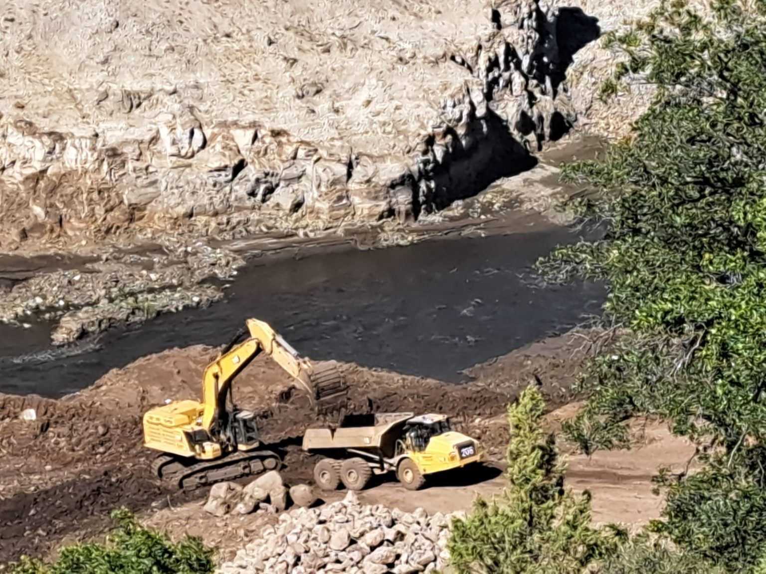
Just over two weeks later, a crew spotted a pair of salmon spawning in one of the tributaries above Iron Gate, where the fish had not previously been able to reach. On Oct. 16 biologists spied fall Chinook salmon at the mouth of a tributary in Oregon. This spot, 230 miles from the ocean, is above all four of the former dam sites.
The speed of the salmon’s return has astonished even the most seasoned biologists.
“Even though we’ve been anticipating the moment, it’s not until you see that first Chinook…I don’t know; I’m still in shock,” says Mark Hereford, project leader of the Klamath anadromous restoration program at Oregon Department of Fish and Wildlife, who found the fish in the Oregon tributary.

News of the salmon’s return prompted a flurry of texts and excited phone calls among fish advocates. Their return is especially poignant to members of the Klamath Tribes, whose ancestral lands include the upper Klamath Basin above the dam sites. With the construction of the dams, salmon, or c’iyaals, had been absent from the Upper Basin for over 100 years.
Now attention is shifting from the massive dam-removal project to the equally enormous task ahead: restoring the Klamath watershed. Biologists will look to the fish themselves for guidance.
All Hands on Deck
The Klamath River supports fall and spring Chinook, coho, and steelhead, along with other important species like Pacific lamprey. All are expected to benefit from dam removal.
Biologists are using every means possible to detect and track salmon as they explore their new habitat. The California Department of Fish and Wildlife has installed “video weirs” to capture images of salmon in key tributaries; the agency also has crews on the ground surveying spawning salmon. Also in California, the nonprofit Cal Trout has installed a sonar monitoring station just above the former Iron Gate dam. Cal Trout is also leading a project to sample fish using special nets near the Iron Gate dam site; these hands-on surveys will provide a week-by-week snapshot of fish in the river. The crew are fitting some of these fish with radio tags and passive integrated transponders, or PIT tags, so they can track them as they move upstream.
In the upper basin, ODFW is working with the Klamath Tribes, university researchers, and other partners to conduct spawning surveys and set up monitoring stations to detect tagged fish.
“It will help us answer the question: Are fish moving into the new habitat, and if so, what species?” says Hereford.
This intensive monitoring will continue for at least four years. Besides informing restoration, the efforts will also reveal how fish respond to some of the challenging conditions in the upper basin.
The Klamath River starts in Upper Klamath Lake in southern Oregon and passes through two small dams before crossing into California.
Most of the vast wetlands surrounding Upper Klamath Lake were converted into farmland over a century ago. The lake is naturally productive, thanks to volcanic soils high in phosphorus, but the removal of filtering wetlands and channelization of tributaries above the lake let in a flood of nutrients. The lake is frequently plagued with large algae blooms and poor water quality.
There’s ideal habitat in the tributaries above Upper Klamath Lake, but to reach it, cold water-loving salmon must navigate an expanse of warm, shallow, and at times oxygen-poor water. How will they fare?
To get a jump on this question, fisheries biologists have been releasing young hatchery-bred spring Chinook into tributaries above the lake.
What they’ve witnessed is encouraging, says Hereford, who is leading the project, now in its third year. They’ve detected fish everywhere they’ve set up monitoring stations. What’s more, fish are finding cold, spring-fed pockets in the lake.
“Some of them are able to find that cold water refuge and staying there the whole summer, which is great,” says Hereford. There’s abundant food in these cold pockets, which allows the fish to grow nice and big before they head downstream toward the ocean. Bigger fish generally survive better, says Hereford.
The young spring Chinook they release later this fall will actually have the chance to reach the ocean.
“This year will be really interesting because it’s the first time we’ve released fish into a free-flowing river,” says Hereford.
Young fish moving downstream and adults swimming upstream will still have to navigate two small dams that were not removed. Both have fish ladders, but the openings in the ladders are too small for large adult salmon to pass through. (This problem will be fixed: A feasibility study is already underway.)
Radio-tagged and PIT-tagged juveniles will tell biologists how they’re getting through the dams and inform future solutions to improve passage.
Long-Term Recovery
Large dams have contributed to steep declines in salmon runs across the West.
“When we have dams in place, we have a lot of constraints on salmon,” says Shari Witmore, fish biologist, West Coast Region at NOAA Fisheries. “Layer on climate change, water management, and diversions, and that further constrains their ability to respond to local conditions and access different types of habitat. Overall, it’s more of a struggle to have sustainable, diverse populations.”
As the pioneering fall Chinook demonstrate, they’re good at finding cold, spring-fed streams. Now that the dams are gone, they can access more of them.
“When you’re talking about a large and diverse system like the Klamath, the tributaries and the main stem all work together like a family,” says Michael Belchik, senior fisheries biologist at the Yurok Tribe. “Some of the tributaries are cold-water refuges when the main stem Klamath gets warm.”
The dams on the Klamath didn’t just physically block fish; they starved downstream reaches of the sediment and gravel they need to construct their nests, or redds. The reservoirs also acted like giant heat sinks, altering temperatures downstream. They harbored massive algae blooms that compromised water quality and submerged cold springs that are ideal spawning grounds.
Already Belchik has noted the return of cooler temperatures to the river, which bodes well for the fall run of Chinook.
“If we’re seeing a couple fish here or there in certain tributaries, we’re going to see a lot more in the upcoming years as the river recovers, the clarity returns, and the spawning gravels are revealed,” says Belchik.
Dam removal is just the beginning. As exciting as it is to see the return of salmon to their historic habitat on the Klamath River, it will take several fish generations for them to establish sustainable populations, says Witmore.
Other large dam-decommissioning projects have shown that fish often respond quickly to removal of physical barriers. After two dams were removed from the Elwha River in southwest Washington between 2011 and 2014, steelhead returned to habitat above the dam sites almost immediately. Chinook salmon have also rebounded, albeit more slowly. Last year the Lower Elwha Klallam Tribe was able to open a small subsistence and ceremonial coho salmon fishery — an important milestone in the recovery of these fish populations.
Restoring Habitat
Jenny Creek is one of the first tributaries to flow into the Klamath River above the Iron Gate dam. Before and after photos illustrate the dramatic effects of dam removal.
My “before” picture, from September of 2023, was taken from a bridge that passes over the creek right before it entered the Iron Gate reservoir. Fat and sluggish, the backed-up creek is painted with swirls of green algae. You can’t smell the anaerobic rot, but it’s not hard to imagine.

A year later, the water runs clear, dancing around boulders and past willows that have spontaneously sprouted along the banks.
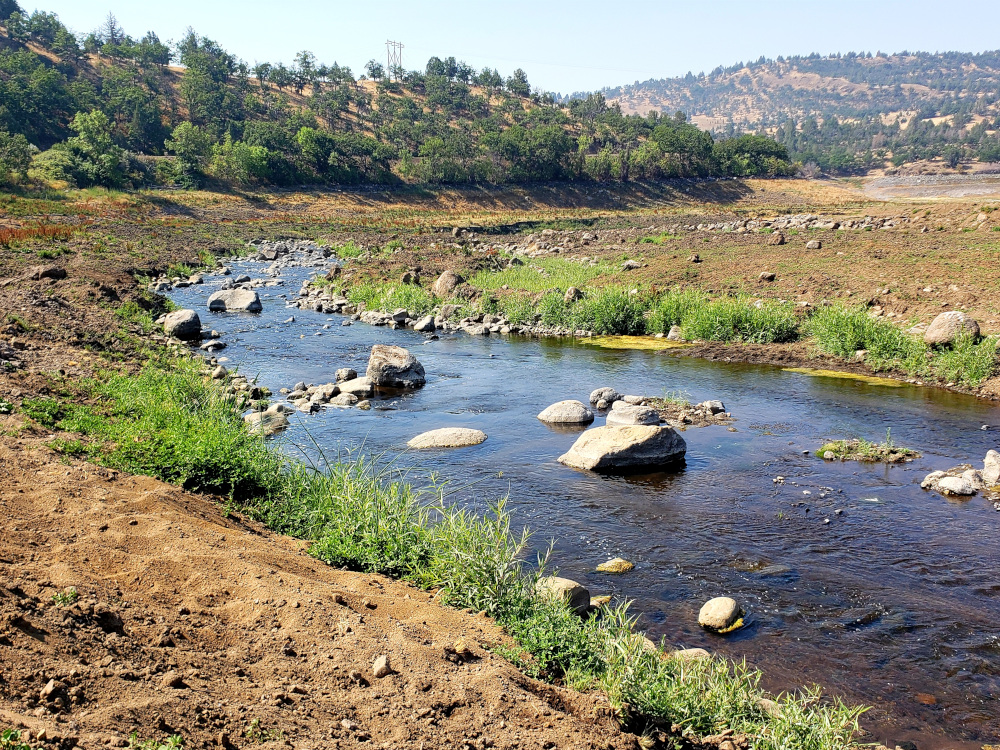
“If you look at Jenny Creek and the Klamath main stem itself in the Iron Gate reservoir footprint, you see thousands, tens of thousands of willows coming up,” says Belchik. “A whole riparian forest is being reborn even right now.”
This tributary is one of several targeted for restoration in this and the other reservoir footprints. Crews have already been sculpting floodplains and planting new vegetation on bare ground that was uncovered when the reservoirs were drained. They’re also placing whole trees, with their roots intact, across streams to help create pools and spawning habitat.
Restoration is taking place not just in the reservoir footprints but throughout the watershed. Even groups that have historically clashed over water are cooperating to get this work done. Just last month the Klamath Water Users Association and several Tribes announced they had agreed on 19 restoration projects throughout the basin.
The old tensions are still there: Water remains a scarce resource with too many demands on it. But there does seem to be a newfound understanding that we all benefit from a healthy Klamath watershed.
Meanwhile everything biologists and other scientists are learning on the Klamath will add to the body of knowledge around dam removal.
“What are the consequences? What happens to the fish afterward? What if there’s spawning areas below the dam? What happens with the sediment?” says Belchik. “We’re going to be able to answer these questions better and better as we move forward.”
A Triumphant Return
On Nov. 3 I took my husband Brint to see the Chinook spawning at one of the tributaries. By then biologists on spawning surveys had counted more than 100 fish on a single day in that stream alone.
We walked downstream. The creek is only calf-deep in places, but the 30-inch salmon were not easy to spot. We had to learn to see the dark, undulating torpedo shapes.
The landscape opened up as we neared the confluence with the Klamath. This part of the creek had been submerged under a reservoir less than a year ago. It was treeless, and the mud adjacent to the stream banks had dried and cracked into blocks.
As we walked we were joined by others curious to witness history — hunters who were camping nearby and families on a Sunday outing. Several kids tested their balance on the large logs that had been placed across the stream, looking for fish.
“Salmon!” a boy screamed, pointing. A startled Chinook breached with a splash, then darted downstream. The boy’s mom explained why it was important not to disturb the fish while they were hard at work making more salmon.

Brint and I grinned at each other. We too were screaming “salmon,” though silently: the simple thrill of seeing these big, beautiful fish amplified by the triumph of their homecoming.


Click the link to read the article on The Land Desk website (Jonathan P. Thompson):
November 15, 2024
On Wednesday morning I woke up in Holbrook and, before leaving, did a little tour around the high desert crossroads town, awed by the weirdness of it all. I don’t mean that in a bad way. Holbrook, with its Bucket of Blood Street, grinning plastic dinosaurs, and mid-century kitsch, is truly unique, the product of the interstate, railroad, and Route 66 running through the nearest community to Petrified Forest National Park.
I headed west, doing my best to avoid driving on I-40. This led me to no fewer than three dead ends, forcing me to backtrack. But it also took me down some cool, if defunct, segments of Route 66, and almost got me creamed by a big rig hauling coal ash from the Cholla power plant, which looms over the sere landscape. After touring Joseph City and Winslow, I veered away from the Little Colorado River and headed southward across the Navajo Nation, up to Hopi, past the wintering corn fields at Moenkopi, and through Tuba City before continuing south on Hwy. 89.

Whenever I’m in this part of Arizona, I try to get to Navajo Bridge (which is actually a pair of bridges), which spans Marble Canyon and the Colorado River downstream from Lees Ferry. One of the bridges was built in 1929, and is now for pedestrians, the other in 1993. They resemble the bridge that crosses the Colorado just below Glen Canyon Dam. I like to go out on the dam-bridge, too, but I also find it a bit frightening: the dam exudes an aura of, for lack of a better term, ominous violence. The Navajo Bridge, by contrast, is a place of serenity. You can stand out on it and, unimpeded by chain link fences, look straight down on the deep, murky green, slow-moving waters of the Colorado and do a bit of vertiginous meditation.
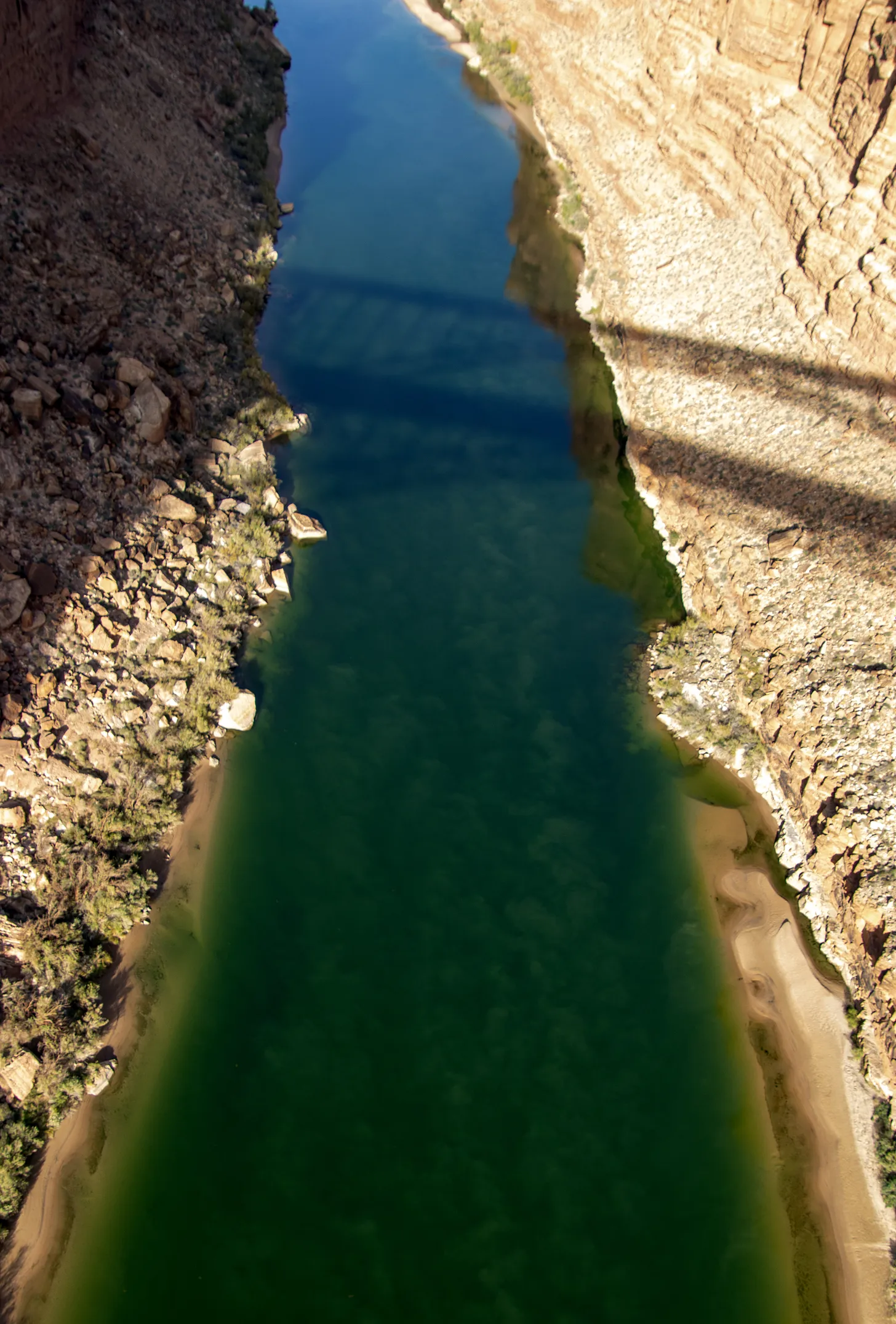
The light was crisp, almost harsh, on this visit, and the parking lot almost empty. I got out of the Silver Bullet, stretched, and ambled toward the bridge, noticing as I did a trio looking intently downriver through binoculars. It appeared as if they were studying the engineering of the automobile bridge, and I wondered if maybe it were cracking and getting ready to fail catastrophically. I readied my camera, just in case, and followed their gaze. That’s when I saw them: a trio of giant birds perched on the steel beams of the bridge, some 470 feet above the river, doing a bit of meditating of their own (or perhaps waiting for carrion to float by).

The magnificent creatures, their pink bald heads jutting out from brown-feathered bodies, are California condors, some perhaps the descendants of six birds released in the area in 1996, others that were introduced in later years. They are huge — sporting up to ten-foot wingspans — but live a fragile existence. After being driven nearly to extinction, federal wildlife officials began rearing California condors in captivity and reintroducing them throughout the West. Now there are more than 500 California condors in the wild, but humans continue to imperil them.

Perhaps the greatest threat is lead poisoning, which comes from ingesting carrion contaminated by lead ammunition. Lead ammunition is designed to shatter and fragment when it hits an animal, increasing its lethality. These fragments end up in the animal’s flesh and the guts, which hunters often discard in the field to be eaten by scavengers. This fall a condor in Zion died from lead poisoning, and wildlife officials say nearly every condor they test has some level of lead in its bloodstream.
Federal and state-level efforts to ban the use of lead ammunition for hunting have run into strong resistance from gun rights advocates, who claim (erroneously) that the initiatives are aimed at stopping all hunting. So some states, including Arizona and Utah, have implemented voluntary programs that incentivize hunters to use non-lead ammunition and dispose of gut piles in a scavenger-safe way. In 2019, California prohibited the use of lead ammo for hunting, but did not ban the sale of the ammunition.

I spent a good part of the afternoon mesmerized by the birds, hoping they would spot something dead and rotting and delicious so I could witness one in flight. It didn’t happen, but I consider myself fortunate nonetheless: As I was preparing to leave I looked straight down from my place on the bridge for one last glimpse at the mighty Colorado, all emerald green down below, and there, only about ten feet below me, sat a young condor, pink beak protruding from a fuzz of black feathers.
Click the link to read the article on the Colorado Climate Center website (Russ Schumacher):
November 18, 2024
The six months from May through October were the warmest on record across Colorado, and parts of the state had been quite dry over that time period; you can read more about those statistics in our October monthly summary. Then in early November, things turned around in a big way across southern and eastern Colorado, with a huge snowstorm from November 4-10 (or really, a couple storm systems that affected the state, one right after the other). There were some remarkable snow totals, with reports of up to 60 inches (5 feet) in the Sangre de Cristo Mountains, and widespread 24-36 inches on the southeastern plains.


This amount of snow, especially at the lower elevations of eastern Colorado, doesn’t happen very often. Here is a list of the top seven-day snowfall totals at stations in Colorado east of -104.5° longitude, which excludes mountain/foothills locations. There five snowstorms that show up on this list.

One that appears several times is the historic storm of early November 1946. That storm produced 50 inches of snow at Eads and 46 inches at Karval, easily the biggest low-elevation snowstorm in state records. You can find plenty of photos and stories about that storm; I enjoyed reading this one from Time Magazine, which gives a sort of poetic sense to a storm that disrupted many lives and industries.
But the second-highest total in this portion of the state was 46 inches that fell from November 4-10 of this year, on the northeast side of Trinidad. The November 2024 storm also had impressive totals of 41″ near Deer Trail, and 34″ near Simla. These really are huge snow totals for eastern Colorado. I think it’s fair to say that the November 2024 storm is only topped by November 1946 for low-elevation snowfall in eastern Colorado.
Other historic storms that show up on the list for eastern Colorado were in late December 2006 (two storms within a week of each other), and in 1980 in northeast Colorado. (If you allow Front Range/foothills locations, then other historic storms like December 1913 and March 2003 also appear on the list. See this presentation from 2005 by Nolan Doesken on “Colorado Classics” for a walk through snowstorm history.) Many people have memories of the October 1997 snowstorm, which was a major storm in southeast Colorado as well, but in terms of snow accumulation, it didn’t even make this list.
The November 1946 and 2024 storms had a lot in common
If we take a quick look at the November 1946 and 2024 storms, we see that they had a lot in common. First is the obvious — they happened at almost exactly the same time of year. But there were also a lot of similarities in the meteorology. Here are animations of the 500-hPa heights and vorticity for these two storms in the ERA5 reanalysis. For the non-meteorologists, this is a measure of the “spin” in the atmosphere. The maps highlight that in both events, a strong upper-level disturbance became cut off from the main flow and parked itself over Arizona and New Mexico for a couple days, before moving northeastward across eastern Colorado and into the Great Plains. This is the type of large-scale setup that favors long-duration precipitation over southern Colorado, while still being just cold enough to be snow rather than rain. The main difference between the two events appears to be that the 1946 storm sat in place for about an extra day compared to the 2024 storm.


Very wet snow
Although the snow was very disruptive to travel and agriculture (and pronghorns), it will also have longer-term positive effects on the drought situation in southeastern Colorado. This part of the state had an extremely dry spring, which got the growing season off to a bad start. Precipitation through the summer was closer to average, but it was a very hot summer such that drought and its impacts persisted through the early fall. But the November snowstorm brought widespread 2-5″ of precipitation (liquid equivalent in snow, and/or rain in spots that stayed slightly warmer.) These are huge precipitation amounts for this time of year on the plains. Most of southeastern Colorado has already guaranteed that the November through February period will have more precipitation than average (right image below). And the spots in the darker green on that map received in one week more than twice the average precipitation that would typically fall from November through February!

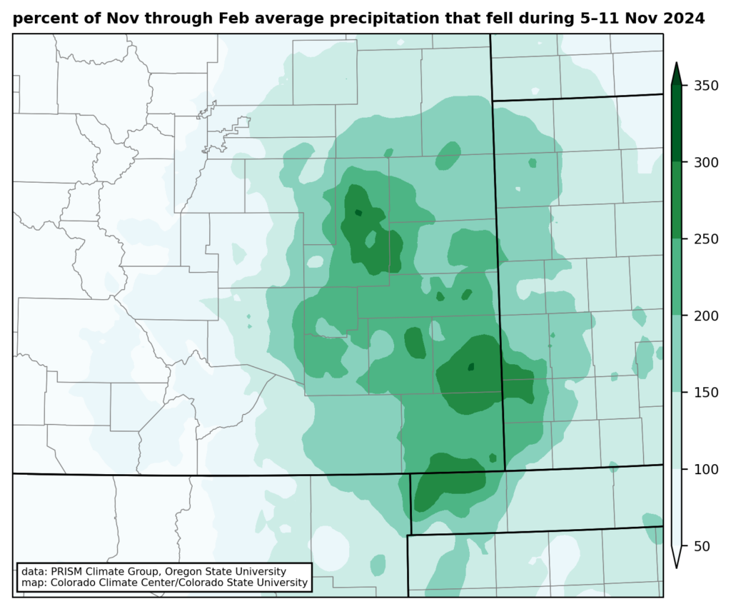
All of the precipitation led to widespread improvements on the US Drought Monitor, with parts of southeast Colorado seeing a two-category improvement, from D2 (severe drought) to D0 (abnormally dry; there are still precipitation deficits on long timescales in this region). In contrast, northern Colorado received much less precipitation from this storm, and improvements were more limited, with D2-D3 (severe-extreme) drought remaining in Larimer and Weld Counties.

What does this mean for the rest of the winter? Well, there was an analysis in the Washington Post this week that showed projections for winter (December-January-February) snowfall across the US, and it showed below-normal snowfall across the southern US, including southern Colorado. This projection is connected in part to the La Niña pattern that is emerging. Now, keep in mind that the Post analysis was specifically for the winter season, so the huge November storm is not included in the forecast period. But some locations exceeded their entire annual average snowfall total in this one storm! The stations on the map below were either within a few inches of (in green), or even more than (in purple) their average annual total. The dark purple dot is Karval, which averages 21″ of snow per year, and had 27″ in this storm. Stations at Rocky Ford and Kim also exceeded their annual average in this one storm. So, while technically a projection of below-average snowfall for the winter (Dec-Jan-Feb) could still come true, much of southeastern Colorado has already clinched a snowier-than-average cool season from this single major storm.
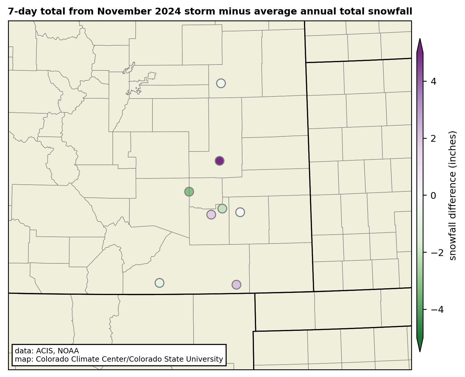
What about mountain snowpack?
This storm brought some very big amounts to the southern mountains, especially the Sangre de Cristos. On November 9, the SNOTEL stations in the Arkansas River basin exceeded their previous record high snow-water equivalent (SWE) for the date. It never hurts to get a good early start to the snowpack! But also keep in mind that the mountains get a lot of snow in even an average year. In other words, it really is very early. The Arkansas basin now has about 25% of its usual peak for the season—much higher than usual for mid-November, but there is still a *long* way to go. La Niña generally brings below-average snowpack to the southern mountains overall, so we will just need to wait and see.


Click the link to read the article on the Alamosa Citizen website:
November 15, 2024
“Not a great year,” is how Colorado Division of Water Resources Division 3 Engineer Craig Cotten summed up the flows on Rio Grande and Conejos River systems this water year which ended Nov. 1.
The Rio Grande had an estimated annual flow of 485,000 acre-feet or 78 percent of the long-term average, while the Conejos River had 238,000 acre-feet or 79 percent of the long-term average, according to figures Cotten presented this week to Rio Grande Basin Roundtable members.
Under the Rio Grande Compact with New Mexico and Texas, Colorado will be obligated to deliver an estimated 122,500 acre-feet from the Rio Grande and 67,800 acre-feet from Conejos River downstream into New Mexico and its storage at Elephant Butte Reservoir.
“We are delivering all the water we have in the system to the state line,” Cotten said, noting that with the water year now ended there is 100 percent curtailment on the Rio Grande and Conejos River systems.
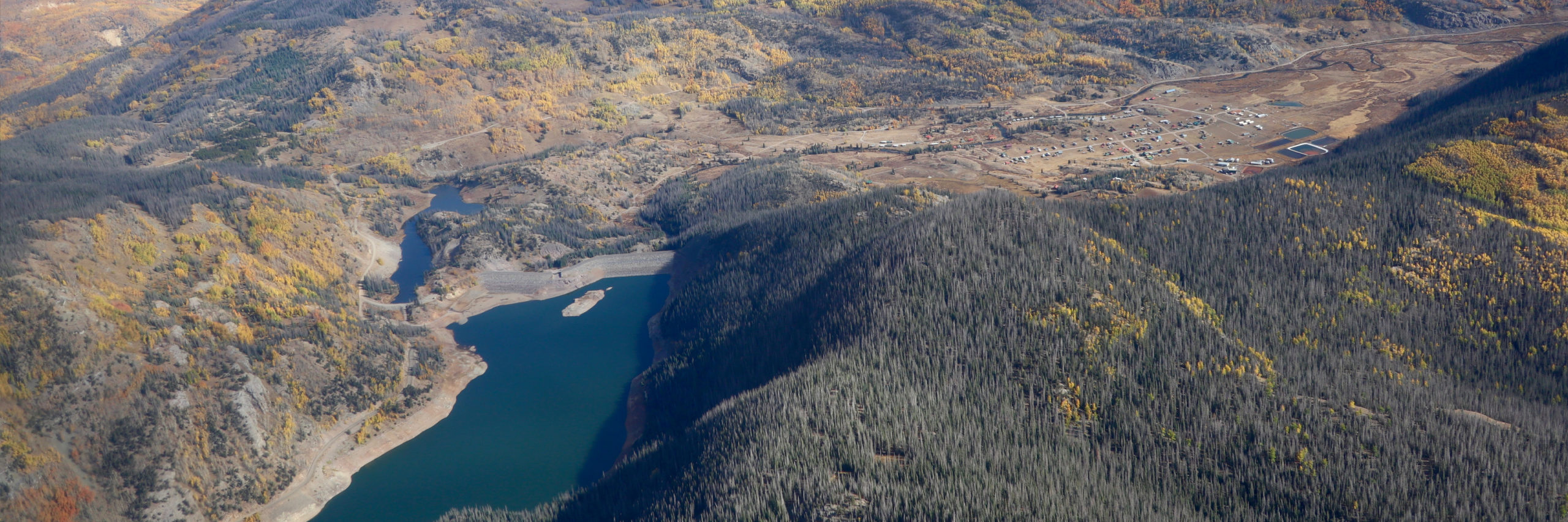
Getting into the fine details of the Rio Grande Compact, Cotten said Colorado is not storing any water from this year at Platoro Reservoir in Conejos County due to Article 7 of the compact. Platoro Reservoir is a post-compact storage reservoir which Colorado can’t utilize this year because storage of a usable water supply at Elephant Butte and Caballo Reservoir in New Mexico has potentially dropped below 400,000 acre-feet.
“Article 7 of the Compact is in effect and that restricts our ability to store in post-compact reservoirs. So we are not currently storing additional water in Platoro Reservoir,” he said.
The irrigation or water season in the Valley typically runs from April 1 to Nov. 1 and is primarily reliant on snow runoffs in the springtime from the surrounding San Juan and Sangre de Cristo ranges. The runoffs feed into the creeks and streams that come together to form the Rio Grande.
A lack of consistency in snowfalls over the past two decades and the warming of the southern end of Colorado compared to the state’s northern frontiers has San Luis Valley irrigators constantly working to figure out how to farm and ranch in a climate of aridification.
“The forecast is for the northern areas to get more snow than the southern areas,” Cotten said in looking at the outlook for 2024-25 winter.
The Colorado Climate Center, at the start of 2024, released a study showing how “the greatest warming has been observed over the Southwest and San Luis Valley climate regions.”

Click the link to read the article on the Water Education Foundation website (Trevor Birt, Fernando Castro-Alvarez, Dennis Davis, Clarence Fullard, Alexander Funk, Daniel Galindo, Marnie Kremer, Dylan Mohamed, Annalise Porter, Noe Santos, Cora Tso, Rachel von Gnechten):
November 14, 2024
The 2024 Colorado River Water Leaders cohort completed its seven-month program with policy recommendations involving ”augmentation” – projects that increase the availability and supply of water – as the Colorado River Basin grows hotter and drier.
The cohort of 12 up-and-coming leaders included engineers, lawyers, resource specialists and others working for public, private and non-governmental organizations from across the river’s basin. The cohort had full editorial control to choose its recommendations.
Their report provides a roadmap to promote a purposeful, continuing dialogue around the deployment of water augmentation projects, such as seawater and brackish desalination, water recycling and cloud seeding. The report outlines ways to reduce barriers to implementation through strategies that enable consensus around goals, information sharing and funding support.
The report recommends the formation of an inclusive Water Augmentation Community of Practice that would:
- Commit to continuous formal discussions on the future of augmentation in the Colorado River Basin.
- Create a system to identify and prioritize the most promising augmentation projects.
- Endorse a comprehensive, durable funding structure, supported by a wide group of contributors, to finance the launch of augmentation projects.

Click here to read the full report.
Cohort members presented their recommendations in September at the Water Education Foundation’s biennial Colorado River Symposium, an invitation-only event in Santa Fe, N.M., whose audience included key water managers, state and federal officials, tribal leaders and other interested groups throughout the Colorado River Basin.
Our biennial Colorado River Water Leaders program is modeled after our California Water Leaders program, which deepens the participants’ knowledge of water, enhances their leadership skills and prepares them to take an active, cooperative approach to decision-making on water issues. Leading experts and policymakers served as mentors to cohort members.
The next Colorado River Water Leaders cohort will be in 2026.


Click the link to read the article on the Aspen Journalism website (Heather Sackett):
November 15, 2024
An irrigation company in western Colorado says it is disappointed in an Upper Basin water conservation program, its impacts to the company’s operations and the local agricultural community.
Grand Valley Irrigation Company President Sean Norris, in a September letter to state officials, said that GVIC shareholders will no longer be allowed to participate in the System Conservation Pilot Program without advance approval from the board. This year, seven GVIC irrigators participated in the federally funded program, which Norris said violates GVIC policies and bylaws as well as injures other shareholders on the system.
“The board has even broader concerns with the SCPP,” the letter reads. “As the program grows, the agricultural economy in the Grand Valley will suffer adverse economic impacts.”
In 2023, the Upper Colorado River Commission rebooted the System Conservation Pilot Program, which was first tested from 2015 to 2018. Infused with $4 billion from the Inflation Reduction Act for Colorado River programs, SCPP pays water users in the Upper Basin states — Colorado, New Mexico, Utah and Wyoming — to leave their fields dry for the season or enact other conservation measures and let their water flow downstream. Over two years, the program has saved about 101,000 acre-feet of water at a cost of about $45 million.

The reason for Norris’ disappointment is because GVIC’s participation in the conservation program resulted in impacts to one of the biggest, oldest and most important water rights on the Western Slope: the Cameo call. This group of agricultural water rights is able to take up to 1,950 cubic feet per second from the Colorado River to irrigate the peach orchards, vineyards and hayfields of the Grand Valley.
When this senior water right isn’t receiving the full amount it is entitled to, it places a “call.” This means that upstream junior water users — some of them Front Range water providers that take water across the Continental Divide from the basin’s mountainous headwaters — must shut off so that Cameo can receive its full amount of water.

The Cameo call comes on most years late in the irrigation season: July through October. And its impacts can be felt far upstream. The Cameo call has the ability to command the flow of water throughout the headwaters of the Colorado River basin. For example, residents of Aspen and Pitkin County like to see Cameo come on because it means that more water is flowing down Lincoln Creek and the Roaring Fork River as the Twin Lakes Reservoir and Canal Co., which provides water to mainly to Pueblo and Colorado Springs, is forced to shut off its diversion at Grizzly Reservoir.
This year, however, officials at the Colorado Division of Water Resources reduced the amount of the Cameo call because of GVIC irrigators’ participation in the conservation program. State engineers said that since the irrigation company was not using its full amount to irrigate, it couldn’t call for the full amount and reduced the call by about 25 cfs. About 1,500 acres under GVIC were enrolled in SCPP in 2024, and engineers calculated that the call should be reduced by 1 cfs for every 64 acres.
The Cameo call this year was on from Sept. 3 to Oct. 23. According to state officials, without the 25 cfs reduction, Cameo would have come on two days earlier: Sept. 1.
Norris said that GVIC’s system of nearly 100 miles of canals that serve about 40,000 acres between Palisade and Mack needs all of its water to function properly and that reducing the call harms all of the company’s water users. The full diversion is needed to maintain water levels in the canals and provide the “push water” to reach the farthest downstream ditches.
“The decrease in GVIC’s call adversely affects all shareholders in the system and especially those shareholders who continue to farm and irrigate while SCPP participants collect government paychecks for doing nothing,” the letter reads.
Norris said GVIC management believed that the Cameo call would not be affected by GVIC shareholders’ participation in SCPP and that state officials had assured them that this would be the case.
“At the beginning of the program, we were told that our calls would not be affected by this participation,” he said. “Then, in the middle of the summer, we had this meeting, and we were informed that that was indeed not the case and that our call would be affected.”
But even if the GVIC staff and board members believed the call would not be affected, individual participants in SCPP were informed that the call would be cut back when they signed up for the program. State and UCRC officials had to approve verification plans for each of GVIC’s seven projects. The plans contained the following language: “The Colorado Division of Water Resources will reduce the amount of the Cameo call … based upon an average delivery of 1 cfs to 64 acres and the number of acres not being irrigated at the time of the call.”

River District warned of impacts
With its location near the state line, some of the biggest and most senior water rights on the Colorado River and huge expanses of irrigated farmland, the Grand Valley is an ideal location for an interstate water conservation program. But SCPP has also faced criticism about its high cost, the limited water savings, the difficulty in measuring and tracking conserved water, and the potential damage it could cause to local agricultural economies.
The Colorado River Water Conservation District, whose mission is to protect and develop water for the Western Slope, warned in a January comment letter to state officials that a call reduction could happen. River District officials pointed out that the water that GVIC doesn’t use, instead of flowing downstream, could be picked up by Front Range transmountain diverters.
The River District’s position has long been that these types of conservation programs need careful consideration and guidelines to avoid harming local communities and other water users. River District General Manager Andy Mueller spoke to Colorado Basin Roundtable members at the September meeting and explained that Front Range water providers such as Denver Water, Northern Water, Colorado Springs Utilities and Aurora Water could take that 25 cfs. That is the opposite of SCPP’s intent, which is to respond to drought and falling reservoir levels at Lake Powell and Lake Mead.
“The federal government, in its effort to put water in the system, has just unwittingly provided an exportation of water out of the river at its headwaters,” Mueller told the roundtable. “We shouldn’t be setting up a system like that. Just that plain and simple.”
State officials said no TMDs benefited from the reduction in the Cameo call this year because the upstream call at the Shoshone hydro plant in Glenwood Canyon had already turned off the TMDs on the mainstem of the Colorado River. A maintenance project on Grizzly Reservoir this year meant that Twin Lakes did not take the 25 cfs either. Jason Ullman, the top engineer with the Department of Water Resources, said a few upstream junior water users probably picked that water up.

The valley’s other large irrigation company, Grand Valley Water Users Association, did not have any shareholders participate in SCPP in either 2023 or 2024 because the board did not approve participation. But if irrigators from both GVWUA and GVIC had participated in SCPP in 2024, it could have resulted in an even bigger reduction of the Cameo call.
“If there was a much larger amount of acreage that would participate in a program, then that resulting call reduction would be larger,” Ullmann said.
Water managers don’t know yet whether SCPP will happen again in 2025 or beyond — federal authorization is pending in Congress. But Norris said that irrigators who want to participate in any future conservation programs like SCPP will have to get approval from the board to make sure the project is in compliance with GVIC’s bylaws. Because the bylaws include a prohibition on changes to water use that could prevent the company from being able to divert its full amount, it’s unlikely the board would approve future SCPP projects that would reduce the Cameo call.
Norris said he sees the 2024 SCPP as an experiment to gather data.
“A lot of the data is numbers and money-driven and acres watered,” he said. “But a lot of the data is the social impacts, the operational impacts that are harder to quantify. Having companies say they’re not going to participate because it unfairly impacts some of their users is a data point they hadn’t necessarily considered, but now they’ve got that in their experiment.”

Click the link to read the article on the InkStain.net website (Eric Kuhn, Rin Tara, and John Fleck):
November 5, 2024
The pending Northeastern Arizona Indian Water Rights Settlement Agreement settles Navajo Nation, Hopi Tribe, and San Juan Southern Paiute Tribe claims to the Upper Colorado River Basin in Arizona. To do so, Arizona’s 50,000 AF entitlement of Upper Colorado River Basin water will be allocated.
Although Arizona’s testimony during the ratification of the 1948 Upper Colorado River Basin Compact indicated that Arizona’s cut would be used for tribes, Arizona fashioned the deal to benefit the Central Arizona Project. Charles A. Carson, Arizona’s Upper Basin Compact Commissioner, originally requested 136,200 AF/yr for Arizona in the negotiation but ultimately accepted 50,000 AF/yr in the interest of sweetening the deal for the rest of the states to sign on to stream depletion theory as the means for measuring system use. Stream depletion theory, under Arizona’s interpretation of the 1922 Colorado River Compact allowed Arizona to consume two million acre-feet per year on the Gila River system, while only being charged for one million acre-feet of compact apportionment.
This theory, in combination with the Upper Basin relationships strengthened by Carson’s choice to accept only 50,000 AF/yr, is what Carson envisioned would be used to convince Congress Arizona had a sufficient legal water supply for the Central Arizona Project. The CAP project was approved in 1968 and completed in the 1990s, though tribal water in Arizona’s northeast corner was not quantified. Even after CAP was built, a portion of the power generated at Navajo Generating Station, which consumed a significant portion of that 50,000 AF/yr apportion, powered the pumps that transported CAP water from Lake Havasu to central Arizona.
Eight decades after Arizona acknowledged that the 50,000 AF of Upper Colorado River Basin water was destined for tribes, Congress is on the cusp of approving the settlement that would resolve some water rights for Navajo Nation, Hopi Tribe, and San Juan Southern Paiute Tribe. This settlement is critical and long overdue, especially considering Arizona’s acknowledgement of tribal entitlement in the 1940s.
The “backstory” behind Arizona’s 50,000 acre-feet of Upper Basin water.
At the recent Water Education Foundation Colorado River meeting in Santa Fe, we heard an update on the status of Congressional approval of the water rights settlement among Arizona the Navajo, San Juan Southern Paiute and Hopi nations. Among other things, the settlement divides up the use of the 50,000 acre-feet of water apportioned to Arizona by the 1948 Upper Colorado River Basin compact. How Arizona ended up with 50,000 acre-feet of Upper Basin water is a fascinating story. At first blush, it may seem somewhat arbitrary, but the reality is that it was based on a well-conceived and executed strategy by Arizona’s negotiators At the time, the deal was cut, Arizona’s negotiator made clear that the only likely users of the water would be Native American communities in northeast Arizona. The deal was not designed for their benefit, but rather for the ultimate benefit of Arizona’s quest to build the Central Arizona Project.
While Arizona’s motives may have focused entirely on cutting an interstate deal to enable construction of the CAP, the state’s leadership were frank in acknowledging that the only people who might put Arizona’s Upper Basin allotment to use where Native Americans.
“There is not much possibility of using water on that land except … on the Navajo Reservation,” Arizona’s Charles A. Carson told members of Congress during the 1949 Upper Basin Compact hearings.

The 1922 Colorado River Compact divides the basin into two sub-basins: the Upper Basin and the Lower Basin. The dividing point is Lee Ferry, located in Northern Arizona, a mile downstream of the confluence of the Colorado and Paria Rivers. Lands that drain into the Colorado River above Lee Ferry are in the Upper Basin, including about 7,000 square miles of lands in northeastern Arizona. Today all but a small portion of these lands are located on the Navajo reservation. Likewise, both Utah and New Mexico have lands that drain into the river below Lee Ferry. The Upper Gila River in New Mexico and Kanab Creek and the Virgin River in Utah are Lower Basin streams.
Although Arizona has lands in the Upper Basin, it is not a State of the Upper Division, a critically important distinction under the 1922 Compact. As a state with Upper Basin lands, Arizona in entitled to use some portion of the beneficial consumptive use apportioned to the Upper Basin under Article III(a) of the 1922 Compact, but since it is not a State of the Upper Division, it does not share in the joint obligations of the Upper Division States to provide certain flows at Lee Ferry under Articles III(c) and III(d). This is a nuance the negotiators of the 1948 Upper Basin Compact understood from the get-go (UCRBCC Official Record, 1st meeting, pages 25-26).
Arizona’s Upper Basin Compact Commissioner was Charles A. Carson. He was the state’s special counsel for Colorado River matters. Carson, an accomplished lawyer and skilled negotiator, began representing Arizona in the mid-1930s. By the 1940s, Arizona’s top water priority was obtaining Congressional approval of the Central Arizona Project (CAP). Carson negotiated the 1944 contract between Arizona and the United States for 2.8 million acre-feet of Hoover Dam water. He orchestrated his state legislature’s ratification of the Colorado River Compact a few weeks later. In 1945 he chaired the legal sub-committee of the Six-State Committee that successfully lobbied for Senate ratification of the 1944 Water Treaty with Mexico. During this time, he became a close associate and friend of Colorado’s Clifford Stone and Royce Tipton. Stone was Colorado’s Upper Basin Compact Commissioner, its first Executive Director of the Colorado Water Conservation Board, and the long-time chair of the Committee of Fourteen that advised the U.S. State Department on the treaty negotiation with Mexico. Tipton was a consulting engineer that worked for Colorado on four major interstate compacts. He was an engineering consultant to the State Department during the negotiations of the 1944 Treaty. With Stone’s blessing, Carson hired Tipton to help with Arizona’s efforts to advance the Congressional approval of the CAP.
Carson’s appointment as Arizona’s Upper Basin Compact Commissioner was likely welcomed by the negotiating teams from the other states. He was designated as Chair of the Commission’s Legal Committee, which would ultimately make numerous recommendations to the Commission on the language and structure of the Upper Basin Compact. Among the many important recommendations the legal committee made were the decisions to include the water requirements of the Upper Basin’s tribes within the apportionments made to each individual state (rejecting an option by New Mexico to consider the tribal needs as a “sixth state”) and the language of Article IV which prescribes how the UCRC will determine the timing and amount and distribute among each Upper Division State a curtailment (aka – “compact call”), if necessary to be in compliance with 1922 Compact.

Carson first spelled out what Arizona wanted from an Upper Basin Compact during the second meeting of the Upper Basin Compact Commission in September 1946, almost two full years before the other four (?) states put their cards on the table during the marathon seventh meeting in July 1948. Carson suggested Arizona be apportioned “all of the waters (on its Upper Basin lands) precipitated thereto, and in addition thereto, 1000 acre-feet from the Paria River” (Official Record, 2nd meeting, page 4). When the other states were finally ready to negotiate the allocations (Colorado had insisted that the Commission not address this core issue until the Engineering Committee had completed its report), Carson reiterated his request–Arizona wanted the right to use all the water that fell on its lands as precipitation plus an additional thousand acre-feet from the Paria River. Now that the Engineering Committee had completed its report, this number was now quantified–136,200 acre-feet (Official Record, 7th Meeting, page 69). According to the Engineering Committee, these 136,200 acre-feet represented 0.87% of the natural (virgin) flow at Lee Ferry (Official Record, 7th Meeting, page 22). This number may seem very high based on our recent experience, but it was the number the Commission had in front of it and in the 1940s the estimated natural flow of the river at Lee Ferry was about 16 million acre-feet per year.
The problem facing the Commission was that collectively the states had requested a total of 117% of the available water. Since Arizona had requested a fixed amount, the problem was with the four Upper Division States, but that did not prevent the other states from suggesting that Arizona consider taking less. Wyoming’s legal advisor Bill Wehrli asked Carson if Arizona would accept an apportionment of 49,200 acre-feet. Carson responded, “I am willing to do that in order to try to help make a compact.” Interestingly, Wehrli responded, “we would be willing to be a little more generous and give you one percent” (7th meeting, page 109). The 49,200 acre-feet referenced by Wehrli was taken from the 1947 comprehensive basin report prepared by the Bureau of Reclamation. The report included very little detailed backup information. Although no tribal members were consulted or invited to the negotiations, the Office of Indian Affairs (now the BIA) provided some input to the Commission on tribal needs. It suggested that present and future depletions from tribal use on Arizona’s Upper Basin lands would total about 25,000 acre-feet per year but cautioned that this estimate was preliminary (Official Record, 5th Meeting, pages 49-51).
When the dust settled, Carson accepted a fixed 50,000 acre-feet per year, only 37% of Arizona’s contribution to the flow of the river at Lee Ferry. The only other state that accepted an apportionment smaller than its contribution was Colorado. It produces 70% of the river’s flow at Lee Ferry but accepted a 51.75% apportionment (~72% of its contribution). In contrast, New Mexico which contributes only 1.6% of the river’s flow, got an apportionment of 11.25%. What made Arizona happy was the package deal that accompanied the agreement on the state apportionments. The three other Upper Division States accepted a proposal by Colorado and Arizona that apportionments be measured by the stream depletion theory. Under the stream depletion theory, the Upper Basin’s compact apportionment is measured as the net impact of man-made depletions on the natural flow of the Colorado River at Lee Ferry. The agreement on the stream depletion theory was made a part of Article VI of the Upper Basin Compact. Article VI is applicable to the Upper Basin only, but Upper Basin officials, including Stone and Tipton, would later testify before Congressional committees that it was their opinion that the Lower Basin’s 1922 Compact apportionment was supposed to be measured as the net impact of the Lower Basin’s man-made depletions on the natural flow of the Colorado River at the international boundary with Mexico.
Why was adoption of the stream depletion theory an important victory for Arizona? Simply put, under Arizona’s interpretation of the 1922 Compact at the time, using the stream depletion theory, Arizona’s could consume two million acre-feet per year on the Gila River system, but only be charged for one million acre-feet of compact apportionment. In its natural state, the Gila River loses an average of one million acre-feet per year as it flows from the Phoenix area to its confluence with the Colorado River at Yuma. Under the stream depletion theory, the net impact of consuming two million acre-feet per year of Gila system on the natural flow of the Colorado River was only a million acre-feet. If Arizona was going to be limited under the 1922 Compact to the use of about 3.8 million acre-feet (2.8 million under its Boulder Canyon Project Act allocation plus all one million acre-feet of III(b) water (less a small amount set aside for Utah and New Mexico), using the stream depletion theory freed up a million acre-feet that the CAP could pump from Lake Havasu to Central Arizona.
California, of course, had a different theory on how 1922 Compact apportionments were supposed to be measured. It advocated for the “diversions minus return flows” theory. Under this theory, all two million acre-feet of Arizona’s Gila River use would be charged to Arizona as compact apportionment. Under this method, the water available for the CAP would be a million acre-feet less, likely making the project economically unfeasible. For more details on the different theories and why Colorado believed the stream depletion theory benefited the Upper Basin, see Science Be Dammed chapter 12.
During the negotiations of the Upper Basin Compact, Wyoming had initially opposed using the stream depletion theory. Speaking for its delegation, Wehrli questioned the basic legal assumption that the 1922 Compact apportioned depletions, noting that California’s legal argument had merit. He concluded that stream depletion theory benefited the Lower Basin more than the Upper Basin and he stated, “Wyoming is desirous of staying completely out of the controversy between Arizona and California, Lower Basin States” (Official Record, 7th Meeting, pages 58-60). To reach a final compact agreement, Wyoming ultimately accepted the stream depletion theory, but unlike Colorado, it never championed it in Congressional testimony or court filings. Note, with perfect hindsight, Wehrli was mostly right, but also note that the question of how to measure apportionments under the 1922 Compact has never been resolved.
What Carson accomplished by accepting a small apportionment was to strengthen the close working relationship between his state and the four States of the Upper Division. It’s apparent that Carson believed that this relationship would help Arizona in its battle with California over the Congressional authorization of the CAP. In his compact report to the Governor, Carson writes that his engineers and the Indian Service believed that Arizona would never use more than about 30,000 acre-feet per year on its Upper Basin lands and therefore Arizona received 50,000 acre-feet as a measure of safety. He makes no mention of any input or consultation with the Navajo Nation, nor does he refer to the 49,200 acre-feet estimate made by the Bureau of Reclamation. Concerning Article VI and the stream depletion theory he writes, “[t]his of course is in complete accord with Arizona’s construction of the Colorado River Compact, and it is believed will be helpful to Arizona in opposing California’s arguments on the Gila River.” Carson concluded his report with “I believe it to be fair, just, and equitable to all of the States, and particularly valuable to Arizona in that it supports Arizona’s position in opposition to the arguments made by certain California interests” (Carson’s report is included in the record of the 1949 Congressional Hearings on the Upper Basin Compact, pages 128-139).
After a minor kerfuffle with California’s Congressional delegation which was settled by report language making it clear that by approving the Upper Basin Compact, Congress was not committing the United States to any interpretation of the 1922 Compact, it was approved by Congress and became effective on April 6, 1949.
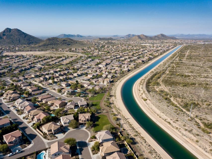
Was the Carson strategy to minimize its claims for Upper Basin water and enlist the Upper Division States as close allies in Arizona’s quest to build the CAP successful? The short answer is yes, the result was that the CAP was authorized in 1968 and has been fully operational for about three decades. The path that Arizona used to get there, however, differed from the one that he envisioned. Carson who died in 1951, believed that Arizona would use the stream depletion theory to convince Congress, or if that failed, the Supreme Court, that Arizona had a sufficient legal water supply under the 1922 Compact to build and operate the CAP. Indeed, in 1952 when Arizona filed suit against California, one of its claims for relief was that it asked the Supreme Court to find that the stream depletion theory was the proper method of measuring apportionments under the 1922 Compact.
In one of the first major turning points in the case, in 1954 California filed a joinder motion to bring the Upper Basin States into the case arguing that the compact issues that Arizona wanted the court to interpret such as how apportionments are measured, how the surplus is measured for Mexican Treaty purposes, and how mainstem reservoir evaporation is handled were basin wide issues that impacted all seven states. From today’s perspective, California’s logic seems obvious, but that was not the case in the 1950s. In a coordinated response, Arizona and the Upper Divisions States convinced Special Master George Haight that the case involved Lower Basin matters only. While the Upper Division States had independent reasons to stay out of the case, they were concerned that their participation in the case would delay Congressional approval of the Colorado River Storage Project, clearly had they decided that they needed to be in the case, the Special Master would most likely have let them in. Note, New Mexico and Utah were parties to the case as to their Lower Basin interests only.
Ultimately, Haight’s successor, Simon Rifkind determined that the 1922 Compact did not need to be interpreted to decide the case. Thus, the disputed compact issues raised by Arizona in 1952 remain unresolved. In 1963 the Supreme Court agreed, ruling that the 1928 Boulder Canyon Project Act allocated 2.8 million acre-feet per year of mainstem water to Arizona, but subject to water availability under the 1922 Compact. This gave Arizona sufficient water to gain Congressional approval of the CAP. Had Arizona not followed Carson’s advice and chosen a more adversarial approach to dealing with the Upper Basin States, it is unclear if the CAP would exist today.
Arizona’s 50,000 acre-feet apportionment was also used to support the CAP because a portion of the power generated by the Navajo Generating Station was used to power the pumps used by the CAP to move water from Lake Havasu to central Arizona. At its peak the coal-fired plant consumed over 28,000 acre-feet per year. The plant was shut down in 2019. Today, the average use of Arizona’s Upper Basin apportionment is about 11,000 acre-feet per year (U.S. Bureau of Reclamation, Upper Colorado River Basin Consumptive Uses and Losses Spreadsheet, 20240624 version. Note the consumptive use numbers on this spreadsheet are not necessarily the same as Arizona’s use under Article VI of the Upper Basin Compact).
Now nearly eight decades after the water needs of the Native Americans living in Arizona’s Upper Basin lands were subordinated to its interests in the authorization and construction of the CAP, Arizona, the Navajo Nation, the Hopi Tribe, the San Juan Southern Paiutes, the United States and others have reached a water rights settlement. The settlement divides Arizona’s 50,000 acre-feet of Upper Basin water into three ways: 44,700 acre-feet per year for the Navajo Nation, 2,300 acre-feet per year for the Hopi Tribe, and 3,000 acre-feet per year for the City of Page. Note, the settlement goes beyond just allocating Arizona’s Upper Basin water, it also addresses the Lower Basin Colorado River, groundwater, and the Little Colorado River (a Lower Basin stream).
We thus have finally reached the point where the water Carson told Congress was intended for use by Native Americans might actually be theirs to use.
At the Santa Fe meeting, there was general support and enthusiasm for Congressional approval (and funding) of the settlement. Tom Buschatzke, Director of AWDR missed the meeting because he was in Washington advocating support of legislation authorizing the settlement. The Salt River Project, IID, and CAP all support the settlement.
The settlement of tribal rights has always raised difficult issues for both basins. The rights of Navajo, Hopi, and Southern San Juan Paiute people to use the Colorado River for both consumptive and cultural purposes predate statehood of all four Upper Division States. Their rights are “pre-compact” rights and thus, under Article VIII, are not impaired by the 1922 Compact. The use of water by tribal sovereigns has never fit well into the state-centric water use rules established by the Euro-American settlers. When the Navajo Nation, a sovereign entity, signed its1868 Treaty with the United States, it was one community. Today, it is crisscrossed with boundary lines. It has land and water in three Upper Division States, in both the Upper and Lower Colorado River Basins, and in the Rio Grande as well.
Whatever the detailed issues are, it is now time to get past them and move the Basin toward unanimous support for approval and implementation of this important settlement.

Click the link to read the article on the High Country News website (Anna Marija Helt):
November 1, 2024
Old rope swings hang from even older cottonwoods along the Middle Rio Grande in Albuquerque, New Mexico. The riverside forest, known as the bosque, has long been a shady oasis in the arid valley. “It’s where everyone would go,” said Shelby Bazan, who describes herself as a “born and raised Burqueña,” or native of Albuquerque. Her father grew up along the river in the ’70s, and both her parents remember summers when the river was alive with water and people.
Myron Armijo, the governor of Santa Ana Pueblo, shares those memories. “The Rio Grande was our playground,” he said. “Once we got our chores done, then we would get out there and play, a lot of the time pretty much all day long.” Now, water diversions, development and climate change leave more sections of the river dry each year. “If you jump, you’re just going to hit the dirt,” said Bazan. Nobody has bothered to replace the old swings.
Over the past two decades, restoration efforts large and small have removed introduced plants such as tamarisk and Russian olive, which can form impenetrable thickets, replacing them with native cottonwoods, willows and shrubs that support wildlife and are significant to the people with the deepest roots in the valley. “It means a lot to us, both traditionally, culturally,” Armijo said of the bosque.
But as the region warms — average temperatures since 2000 have been 1.8 to 2 degrees Fahrenheit higher than they were over the previous century — and the once-high water table drops, those who love the bosque have been forced to reconsider what can be realistically restored.
OVER MILLENNIA, the bosque’s mosaic of plant communities was maintained by a high water table, seasonal flooding and a meandering river channel. “You’d have grassy meadows, wetlands and understory shrubs over here; young cottonwoods over there; older cottonwoods over here,” said ecologist Kim Eichhorst, director of the community-science-based Bosque Ecosystem Monitoring Program (BEMP).
By the 1990s, 150 years of water- and land-use decisions had destroyed or degraded much of this historic mosaic. “Channelization, levees to protect communities, impoundments to store water for irrigation purposes — that all changed the river,” said Glenn Harper, who’s worked for Santa Ana Pueblo for over 25 years and oversees its 142,000 acres of grassland, shrubland and woodland habitat.

Cottonwoods that germinated in the 1930s and 1940s are now separated from the river and nearing the end of their lifespan. Without the seasonal floods that distributed seeds and nutrient-rich sediment, there are few young cottonwoods to replace them. At the same time, drier, hotter conditions have encouraged introduced plants, not only tamarisk and Russian olive but Siberian elm, Ravenna grass and many others.
In response, many Middle Rio Grande communities — at Santa Ana and Sandia pueblos, in Albuquerque and elsewhere — began restoration efforts along the river to bring back the bosque. Though much of the initial work was spearheaded and funded by local communities, many of the projects now have government agency support. For example, Albuquerque’s industrialized South Valley is now home to Valle del Oro National Wildlife Refuge, thanks to a collaboration between the local community and the U.S. Fish and Wildlife Service. Though bosque restoration isn’t the refuge’s sole purpose, it is a part of its plans for the land.
When Santa Ana Pueblo embarked on its ambitious bosque restoration plan, said Armijo, the tamarisk and Russian olive thickets under the mature cottonwoods were so dense that getting through them on horseback was impossible. After the pueblo’s Bosque Restoration Division cleared about 1,500 acres, the bosque began to resemble the open cottonwood forest that pueblo elders remembered from their youth.
Since then, though, falling groundwater levels have stressed the aging cottonwoods, and many are dying or dead. “Climate change,” said Nathan Schroeder, Santa Ana Pueblo’s Restoration Division manager. “That’s where I feel like the deck keeps getting shuffled.” And because the roots of young trees can no longer reach the water table, the pueblo’s original plan for planting new cottonwoods among the old is no longer tenable.
AS CONVENTIONAL restoration approaches become less reliable, advocates are asking how to move forward. “What we really need is to recognize what the system can support,” said Eichhorst. Instead of trying to restore the bosque to what it was, she envisions a mix of dryland plants and smaller pockets of “wet-loving” plants, cottonwoods or otherwise, wherever water is sufficient.
At the pueblo, the Restoration Division may plant some native drought-tolerant shrubs where it had planned to grow cottonwoods. Farther downstream in Albuquerque, said geographer and herbalist Dara Saville, some of these species are showing up on their own: “Now that the bosque is largely dry … you see the creeping in of plants from the mesa, from the foothills, from these higher, drier areas.”
Saville, the founder of the nonprofit Yerba Mansa Project (YMP), doesn’t mind shrubs. “They’re key components of my concept of restoration, resiliency and ongoingness.” The bosque will continue, she said, but as it changes to adapt to new conditions, tenacious, shrubby plant species will likely become more common. And while shrubs can’t provide a shady refuge for people, they do offer food and shelter to wildlife, and some are sources of traditional foods and medicines. Along the Middle Rio Grande, project staff and volunteers have planted native species, such as yerba mansa, pale wolfberry, golden currant and willow baccharis, all of which have medicinal uses.
Bazan, who works as a BEMP educator, said nonnative trees are another option: “If we don’t have the cottonwoods, would you rather have an exotic bosque that has Siberian elm that still provides shade — or would you rather have a native bosque, but of shrubs and dry grassland areas?” Though Siberian elms are classified as “noxious weeds” in New Mexico, their tolerance for a lower water table and their ability to provide habitat for local species such as porcupine have led restorationists to consider leaving them in place in some areas.
While the restoration projects are ecologically and culturally important, there are many competing uses for the Rio Grande’s water, including irrigation and the demands of an expanding urban population. Although riverside vegetation also uses river water, a new bosque mosaic is expected to use less water than extensive thickets of nonnative trees and shrubs.
In the pueblo, however, the focus remains on native plants and wildlife. To support young cottonwoods and willows, the restoration division, in partnership with federal agencies, used excavators to lower sections of the riverbank and bring back some limited flooding. The bosque planted in this new floodplain over the past 15-plus years is luring endangered southwestern willow flycatchers, threatened western yellow-billed cuckoos and, according to this year’s survey, yellow warblers, Harper said.
No matter its makeup, restoring and maintaining a more resilient bosque ecosystem will require cooperation and long-term maintenance. “It never ends,” said Harper. Eichhorst is encouraged by the region’s shared love of the bosque. “It isn’t something that’s just an older generation, but it’s something that younger students are actively participating in,” she said. “It’s not hopeless.”
This story is part of High Country News’ Conservation Beyond Boundaries project, which is supported by the BAND Foundation. hcn.org/cbb
Click the link to read the article on the Big Pivots website (Allen Best):
November 14, 2024
New study says greenhouse gases, not natural drought, have been swinging a heavier bat in Western states since 2000
Yet another scientific study finds that rising heat has been playing an outsized role in the spreading and lengthening drought in the American West during the 21st century. The question remains how exactly we will act on this information.
The latest study was published in Science Advances under the title of “Anthropogenic warming has ushered in an era of temperature-dominated droughts in the western United States.”
“For generations, drought has been associated with drier than normal weather,”
said Veva Deheza, a study co-author and director of the National Oceanic and Atmospheric Administration’s National Integrated Drought Information System .
“This study further confirms we’ve entered a new paradigm where rising temperatures are leading to intense droughts with precipitation as a secondary factor.”
Previous studies had demonstrated the influence of precipitation and evaporative demand on drought. The researchers in this new study explicitly sought to disentangle the influences of natural variability from human causes, i.e. warming produced by the addition of greenhouse gases to the atmosphere.
They concluded that around the year 2000 that human-caused warming became the dominant factor in the severity of drought in the 11 Western states and also expanded areas affected by drought conditions.
They attributed 61% of the severity of the drought from 2022 to 2022 to high temperatures and only 31% to reduced precipitation.
“This study has uncovered that rising temperatures and the resulting high evaporative demand have surpassed precipitation deficit as the dominant drought driver around the year 2000 in the (Western United Sates),” wrote Rong Fu, a UCLA climate researcher, a lead author of the study.
“This change cannot be explained by natural climate variability and is mainly caused by warming due to anthropogenic forcing. This drought regime shift has led to increased drought severity and coverage since the turn of the 21st century, marking the beginning of a new era where (western United States) droughts are increasingly driven by evaporative demand rather than precipitation deficits.”
This study builds upon the work of Brad Udall of Colorado State University and other studies. Udall and Jonathon Overpeck, then of the University of Arizona, completed a study in 2017 that found a third to a half of the nearly 50% in reduced flows in the Colorado River from 2004 to 2014 could be attributed to warming. Their study was called “The twenty-first century Colorado River hot drought and implications for the future.”
That study helped spread the use of the word “aridification” for what is occurring. Unlike drought, it is not necessarily something that will end.
Flows in the Colorado River have declined 20%, a process often called aridification. The river and its tributaries provide water from Albuquerque to Denver to Cheyenne, as well as to most of southern California, plus most places between.
Udall last week told the Los Angeles Times that this new study came to the same conclusion of his and other studies.

“They found, just like all these other studies, that higher temperatures have been, and are going to be, a cause of more severe droughts as it warms in the 21st century,” he said. “That means that we need to plan for a hotter and drier future.”
Russ Schumacher, the Colorado climatologist, said temperatures can be expected to increase an average of between 1 and 4 degrees Fahrenheit unless emissions can be abated, creating a climate in Denver more akin to that now found in Albuquerque or El Paso and likely further reducing flows of the Colorado River that have averaged 12.5 million acre-feet this century to possibly 9.5 million acre-feet.

The seven-basin states that share the river are already struggling to come to grips with this existing hotter and drier reality than the compact that was struck a century ago and assumed more than 17.5 million-acre feet.
This, in turn, will force shifts in what crops we grow on farms as well as the choices made in urban landscaping.

Others areas in the 11 Western states don’t rely upon the Colorado River but have parallel problems. For example, portions of eastern Colorado overlie the Ogallala Aquifer, a body of water deposited up to two million years ago that is being drawn down rapidly. Most of the water goes to creating feedstock for livestock.
In his comments to the LA Times, Udall also expressed dismay at the policies that many expect Donald Trump will institute as president, rolling back efforts to hurry the energy transition.
“We know how to solve this problem,” Udall said. “Much of this will now be sidelined to pursue an anti-science agenda that will further enrich the gigantic companies that created this problem in the future place.”
Another way of understanding the study findings is that the higher temperatures caused primarily by burning fossil fuels have made ordinary droughts into exceptional droughts.
A release posted on the NOAA website explained that droughts-induced by natural fluctuations in rainfall still exist, but there’s more heat to suck moisture from bodies of water, plants, and soil.
“A warmer atmosphere can hold more water vapor before the air mass becomes saturated, and precipitation can form. This creates a cycle in which the warmer the planet gets, the more water can evaporate from the landscape and remain stored in the atmosphere longer before it returns to earth as rain or snow.”
Droughts can form even if precipitation patterns remain within a normal range as higher temperatures and evaporation remove water from soils. They can last longer, cover wider areas, and be even drier with every little bit that the planet warms.
To tease out the effects of higher temperatures on drought, the researchers have separated “natural” droughts due to changing weather patterns from droughts due to human caused climate change in the observational data over a 70-year period. Previous studies have used climate models to conclude that rising temperatures contribute to drought. But without observational data about real weather patterns, they could not pinpoint the role played by evaporative demand due to naturally varying weather patterns.


Click the link to read the article on the KJCT website (Ja’Ronn Alex). Here’s an excerpt:
November 14, 2024
Over 300 people attended Montrose County’s 6th Annual West Slope Water Summit…Water is a big part of the Western Slope’s identity. Montrose County held a water summit and invited everyone to drop by and hear speakers like Andy Mueller of the Colorado River District speak on the issues.
“We really want to make sure they understand where the situation is with the Colorado River, the things we have to do,” said Sue Hansen, Montrose County Commissioner of District 2.
Rest assured, our state representatives in Denver are looking to keep water on the Western Slope, on the Western Slope. “We are the biggest water rights holder, and we need to make sure that we can protect that as we go forward. Downstream is continuing to want more and more and more. There is no way any of us can continue to supply them with what they think they want,” commented Catlin.


From email from the CWCB:
November 15, 2024
The Colorado Water Conservation Board and the Colorado Division of Water Resources are excited to announce $7 million in funding for Colorado water users within the Upper Colorado River Basin in need of a device to measure their water diversions.
The Upper Colorado River Commission approved the $7 million for Colorado on October 28. The funding comes from the Commission’s federal Bipartisan Infrastructure Law (BIL) Spend Plan. In total, the BIL provides $8.3 billion to the Bureau of Reclamation for western water infrastructure.
The funding comes at a time when the Colorado Division of Water Resources is working on implementing new water measurement rules in the Colorado River, including Divisions 4, 5, 6 and 7. Rules for Division 6, which includes the Yampa, White, and Green River basins, were signed on January 16, 2024. DWR is currently in the rulemaking process for Division 7, which includes the San Juan and upper Dolores River Basins. Division 4 covers the Gunnison River basin, San Miguel River basin, lower Dolores River basin, and the Little Dolores River basin. Division 5 covers the mainstem of the Colorado River.
The new rules provide clarity on what an acceptable water measurement device is and where they are needed. While Colorado statute gives the State and Division Engineers authority to require water users to install measuring devices, it does not include specifics on what are considered acceptable measuring methods.
“Accurate measurement of diversions is critical to protect Colorado’s entitlement to water, including under the Colorado River Compact, and to ensure we are maximizing the beneficial use of the public’s water resource,” said Jason Ullmann, State Engineer. “We appreciate this funding from the UCRC to help Colorado water users with the costs of installing a measurement device.”
The Colorado Water Conservation Board will manage the $7 million program and will hire an engineering consultant to assist with the administration. Details about program eligibility and applications will be announced in 2025.
“This new program is a testament to CWCB’s mission to conserve, develop, protect, and manage Colorado’s water resources for both present and future generations,”said Lauren Ris, CWCB Director. “Colorado is a longstanding leader in water measurement and administration, and we aim to extend these benefits to as many West Slope users as possible, ensuring sustainable water management for years to come.”
CWCB expects to roll out a competitive application process that will allow water users in the Upper Colorado River Basin who are in need of measurement devices, such as flumes and weirs, to apply for funding over the next several years.


Click the link to read the article on the American Rivers website (Michael Fiebig):
September 18, 2024
A co-published blog by American Rivers and the Getches-Wilkinson Center at Colorado Law.
The Wild and Scenic Rivers Act of 1968 has been the preeminent tool to protect free-flowing rivers in the United States since it was passed more than 50 years ago. Under the Act, rivers with “outstandingly remarkable scenic, recreational, geologic, fish and wildlife, historic, cultural or other similar values,” as well as their immediate environments, are protected from dams and other potential harms. In spite of its success, the Act largely omits Tribes, failing to give Native Nations the authority to designate, manage, and co-manage Wild and Scenic rivers within their own boundaries and on ancestral lands. Correction of this omission is long overdue, both in terms of equity and the long-term benefit to rivers.
A current example of this omission was brought to our attention through conversations with Indigenous community members along the Little Colorado River (LCR) in Arizona. The LCR was threatened in recent years by a series of pumped-storage hydropower projects proposed on Navajo Nation lands by non-Indigenous developers, and against the will of the Navajo Nation, Hopi Tribe, Pueblo of Zuni, and others who find the LCR culturally important. Historically, under the Federal Power Act, proposed hydropower projects have been given a preliminary permit on tribal trust lands by the Federal Energy Regulatory Commission (FERC) against the will of the Tribe whose land the projects would be located on. Indigenous community advocates understandably wanted to know, “What can we do to permanently protect the Little Colorado River from these unwanted hydropower projects?”

Designating a river under the Wild and Scenic Rivers Act is a powerful defense against unwanted dams and diversions–it is the only designation that prevents new dams and diversions on designated rivers. The problem is that since Tribes were largely omitted from the 1968 Act, they were not given the power to designate or manage Wild and Scenic rivers, even on their own lands. That management power currently defaults to the National Park Service, even when a designated river is on tribal lands. To say that this is a disincentive for Tribes to utilize the Wild and Scenic Rivers Act to protect their rivers is an understatement.
And that’s not all. As the Table below shows, Tribes don’t even have some of the powers that have been given to states and private parties under the Act, such as the ability to petition the Secretary of Interior to give Wild and Scenic protections to state-protected rivers, or the ability to receive funding and technical assistance, which both private parties and states can. Co-management/co-stewardship agreements and cooperative agreements are also not explicitly authorized for Tribes in the Act, which is a potential disincentive for federal agencies to explore such agreements with willing, interested, and knowledgeable Tribes.

As sovereign nations, Tribes should at least have the power that states and NGOs have regarding river designations. Tribes should be able to manage Wild and Scenic Rivers on their lands, ask the Secretary of Interior to include rivers protected by Tribes under the Wild and Scenic Rivers Act, be formally authorized to engage in co-stewardship agreements with federal agencies, and have the ability to receive funding and technical assistance when managing rivers on their lands.
Correcting the omission of Tribes in the Wild and Scenic Rivers Act remains long overdue. We heard from both legal scholars and tribal communities that creating a well-researched, draft proposal—which you can download here—would be the best way to begin an informed conversation. This is in no way intended to be a finished product, but meant to engage Tribes, advocates, and legal thinkers in what might be possible, and in turn help us make that a reality.
We also realize that proposing to amend a bedrock natural resources law is no small undertaking, and not without some risks. The structure of the Wild and Scenic Rivers Act makes amending the Act easier and less risky than amending other similar laws. Currently, each new river designation is added to the National Wild and Scenic Rivers System through an amendment to the original Act, which means that a new Wild and Scenic designation by a Tribe that includes these proposed amendments would be all that would be necessary to implement them. Furthermore, the Concept Paper proposes extending existing authorities to Tribes through the addition of new sections in the Wild and Scenic Rivers Act, not changes to existing protections that have been settled law for over 50 years.
In this way, and with your help, we not only propose to retain the protections that the Wild and Scenic Rivers Act has afforded outstanding free-flowing rivers across the county for the last half century, but to expand the ability for Tribes to utilize those same protections to safeguard free-flowing rivers of cultural and ecological importance into the future. Now is the time to address the omission of Tribes in the Wild and Scenic Rivers Act and other bedrock natural resources laws. Doing so would be a measure of restorative justice, while also benefiting Tribes and all life which depends on rivers.
Please download and read the Concept Paper and Draft Model Legislation, and let us know what you think. We look forward to hearing from you.
Click HERE to download a PDF of the Concept Paper and Draft Model Legislation. Please send feedback, questions, and comments to info@tribalwildandscenic.org or through our website www.tribalwildandscenic.org.
The Wild and Scenic Rivers Act Amendments Project was founded in 2021 by American Rivers, the Grand Canyon Trust, and the Getches-Wilkinson Center in response to Indigenous advocates seeking a tool to protect culturally and ecologically important rivers on Tribal lands from FERC-licensed hydropower projects. More input from Tribes, river advocates, and legal scholars is being sought for the next phase of this project.
Click the link to read the briefing on the Western Water Assessment website:
November 13, 2024 – CO, UT, WY
October precipitation varied widely across the region, particularly in Colorado with southern Colorado seeing above normal conditions and northern Colorado generally seeing below normal conditions. October temperatures were above to much above normal throughout the region, with Utah experiencing its warmest October on record and Colorado and Wyoming their second warmest. Regional snow-water equivalent (SWE) was variable, with the majority of Utah and southern Colorado observing above normal SWE and northern Colorado and Wyoming observing below normal SWE. By the end of October, drought conditions expanded since September, now covering 53% of the region. ENSO-neutral conditions continued in October and there is a 53% chance of La Niña conditions developing by early winter. The NOAA seasonal outlook for November-January suggests an increased probability of below normal precipitation for much of Colorado and southern Utah and above normal temperatures for the whole region.
Regional precipitation was variable in October, ranging from above to below normal conditions in each state. Colorado experienced the widest variance of conditions, from as low as 5-25% of normal precipitation along the Front Range and in northeastern Colorado, to 200-300% of normal precipitation in southern Colorado. A small area in Las Animas County, Colorado experienced greater than 300% of normal precipitation. October precipitation was 5-25% of normal in southeastern Wyoming. October precipitation was in the bottom 10% of the period of record in northwestern and southeastern Wyoming as well as northern Colorado, while precipitation was in the top 10% of all years in southern Colorado.

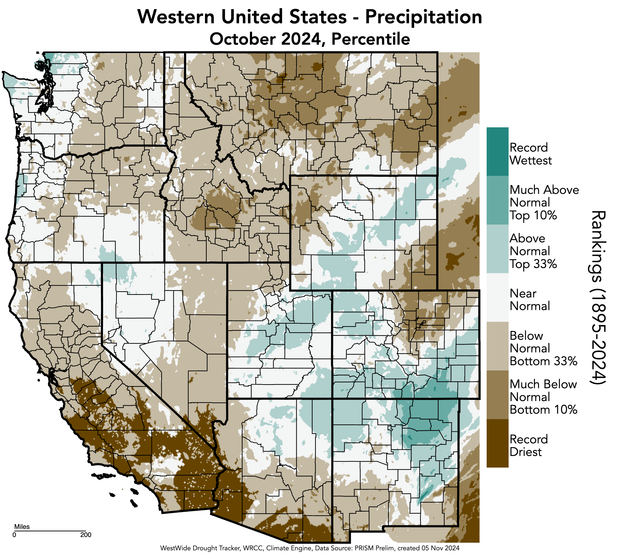
October temperatures were 4-8ºF above normal throughout the region. Pockets of 8-10°F above normal temperatures were observed in northern and eastern Utah, northern Colorado, and southern Wyoming. A few pockets of 2-4°F above normal temperatures occurred in each state, and one small pocket of near normal (0-2°F) temperatures occurred in Mineral County, Colorado. Large areas throughout the region experienced record-warm temperatures for October. Regionally, Utah experienced its warmest October on record, while Colorado and Wyoming had their second warmest. Additionally, many other states in the West experienced their warmest or second warmest Octobers on record, including Arizona, New Mexico, and Texas, and California and Montana, respectively.

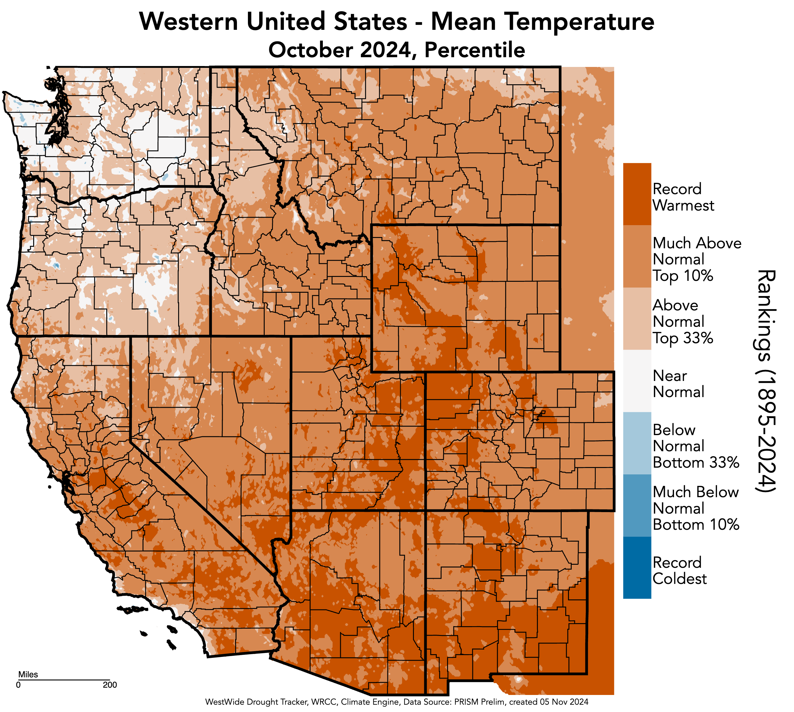
As of November 1, snow-water equivalent (SWE) was variable across the region. SWE was above normal for the majority of Utah, with much above normal conditions in the Upper Colorado-Dolores River (592%), Great Salt Lake (588%), and Jordan River Basins (204%). Much above normal SWE also was observed in southwestern Colorado and northeastern Wyoming basins. Below normal SWE was observed in the majority of Wyoming, with much below normal SWE in the Upper Yellowstone (41%) and Snake Headwaters Basins (41%). The South Platte Basin in Colorado also experienced much below normal SWE at 37% of normal. In Colorado, most SNOTEL sites reported 0-2″ of SWE with a high of 6” at Beartown near Telluride. In Utah, most SNOTEL sites reported 0-1″ of SWE with a high of 2.4” at Steel Creek Park in the Uinta Mountains. Lastly, in Wyoming, most SNOTEL sites reported 0-1″ of SWE with a high of 2.3” at Bald Mountain in the Bighorn Mountains.
Note: Current SWE as a percent of normal maps are often skewed at this time of year due to the very low average SWE this early in the season.

At the end of October, drought covered 53% of the region, up from 31% drought coverage in September. As of mid-October, drought conditions covered the entire state of Wyoming. Severe (D2) drought coverage more than doubled and extreme (D3) drought coverage tripled in Wyoming, and a small pocket of exceptional (D4) drought emerged in northeastern Wyoming. In Colorado, D1 drought coverage nearly doubled, D2 drought nearly tripled, and D3 drought emerged along the northern Front Range. Lastly, in Utah, D1 drought coverage doubled and D2 drought emerged in Washington County.
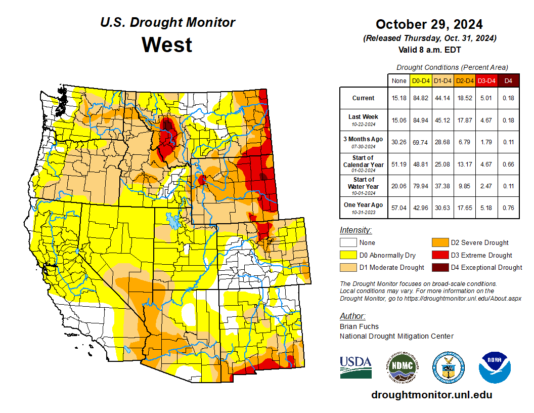

Regional streamflow conditions were near to below normal during October. Below normal streamflow conditions were observed in multiple river basins of each state with much below normal conditions in parts of the Gunnison, North Platte, South Platte, Republican, and Arkansas River Basins in Colorado; the Lower Green and Lower Colorado River Basins in Utah; and the Big Horn, Upper Green, and North Platte River Basins in Wyoming. Much above normal conditions were observed in the East Fork Sevier River Basin in Utah.


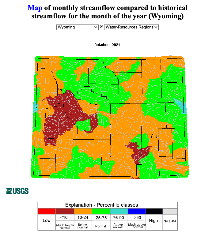
ENSO-neutral conditions continued during October with near to below average sea surface temperatures in the Pacific Ocean, which triggered a La Niña Watch from the NOAA Climate Prediction Center. There is a 53% chance of La Niña emerging by December and a 53% chance of it persisting through December-February. There is a 55% chance of ENSO-neutral conditions returning by January-March, according to the IRI Model-Based Probabilistic ENSO Forecast. Note, there is a discrepancy between the NOAA and IRI ENSO forecasts at this time. The NOAA seasonal outlook for November-January suggests an increased probability of below normal precipitation for southern Colorado and southeastern Utah, and above normal precipitation for northwestern Wyoming. There is an increased probability of above normal temperatures for the entire region, particularly in southern Colorado and southeastern Utah.

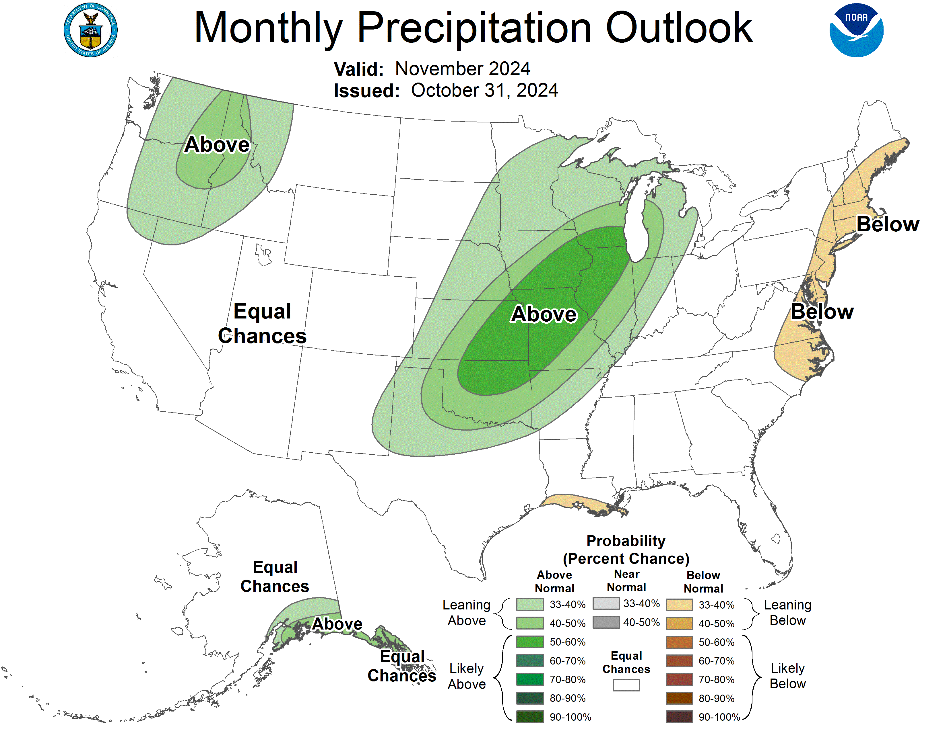

Significant climate event: Record October heat. Salt Lake City experienced its warmest October on record in 2024, with the first 16 days reaching 80°F or above. The average temperature for the month was 62.4°F, surpassing the previous record of 60.5°F set in 2015. Other Utah cities also saw record-breaking average temperatures: St. George at 69.9°F, Provo at 61°F, Fillmore at 60.7°F, Escalante at 60.6°F, Price at 58.6°F, Lehi at 57.9°F, Manti at 56.6°F, Park City at 52.9°F, and Alta at 47.1°F. Northern Colorado experienced very dry weather and significantly above normal temperatures as well, with only two days of measurable precipitation and 26 days of above normal temperatures. Colorado was on track to have its warmest October on record, but a cold front in the last two days caused the average monthly temperature to slip to the second warmest on record. In Denver, the mean October temperature was 59.1°F, which was 8.0°F above normal, making it the second warmest October on record. Precipitation was much below average at 0.11 inches, which is 0.88 inches below normal. No snow was observed, which is 3.9 inches below the average October snowfall.


Click the link to read the article on the Water Education Colorado website (Shannon Mullane):
November 14, 2024
Western states are mired in negotiations over future Colorado River cutbacks, but state officials agree on one point: A presidential changeover won’t derail the process.
Colorado River Basin officials have to stick to a tight, federally regulated timeline to replace water management rules that were created in 2007 and will expire in 2026. Negotiations over the new rules will overlap with leadership changes in Washington, D.C., when President-elect Donald Trump steps back into office. But new administrations have not disrupted basin negotiations in the past, and state officials don’t expect big issues this time around either.
“The deadline’s the deadline, regardless of who’s at Interior, who’s at Reclamation and frankly who’s representing the states,” said John Entsminger, Nevada’s top negotiator and general manager for the Southern Nevada Water Authority.
The 2007 rules were created in response to several years of drought — the beginning of a two-decade megadrought that elevated concerns about the future water supplies for 40 million people, including Coloradans from the Western Slope to the Front Range.
The Bureau of Reclamation is analyzing several alternatives for the new, post-2026 rules. Reclamation declined to comment on questions about the upcoming transition, saying it plans to keep working with basin stakeholders.
But replacing the 2007 guidelines comes with a strict timeline: Reclamation needs time to draft the new rules, hold public comment, handle revisions, comply with required waiting periods and more before 2026, said Anne Castle, who formerly oversaw water and science policy for the Department of the Interior.
“If you back up all those timelines, there’s not that much time left,” Castle, the federal representative on the Upper Colorado River Commission, said.
If the basin states want Reclamation to consider a seven-state agreement in its analysis, they have until spring 2025 to submit it, she said.
State negotiators, including Colorado River Commissioner Becky Mitchell of Colorado, said they are committed to continuing the negotiations.
“I don’t think there’s any doubt that if we come up with something that we — the seven states — can live with, that it would be satisfactory to Reclamation,” said Gene Shawcroft, Utah’s top negotiator and chair of Colorado River Authority of Utah. “The onus is still on us as states to come up with a solution.”
But the talks are at an impasse, said JB Hamby, California’s top negotiator. In recent years, federal involvement has helped push the states to consensus, and that involvement is vital going forward, he said.
However, over the next year, that federal involvement could be hampered by leadership transitions. Historically, presidents install new officials in top leadership positions, and it can take up to a year to install new leaders, like the Secretary of the Interior and Bureau of Reclamation commissioner.
“Whatever the background the next commissioner will have, no matter where in the West they may come from … it’s critical to have that direct federal involvement in that particular role as promptly as possible,” said Hamby, chairman and Colorado River commissioner for the Colorado River Board of California.
This isn’t the first time basin officials are debating weighty river issues during an administration change, several state negotiators said. Party politics don’t typically cause seismic shifts in Colorado River policy — the basin splits more along geographic lines or by type of water use.
For example, the transition from former President Barack Obama’s administration to the first Trump administration did not interrupt the basin’s negotiations over additional drought-response plans, which were finalized under Trump in 2019.
Tom Buschatske, who is the director of the Arizona Department of Water Resources and the state’s top negotiator, said he is not expecting delays this time either.
“I’m going to somewhat hang my hat on the fact that, over the last almost 25 years now, when you see past administrations change, we’ve not really seen that impacting the path forward, or the pinch points and deadlines, at least for the Colorado River,” Buschatzke said.

Click the link to read the discussion on the Climate Prediction Center website:
November 14, 2024
ENSO Alert System Status: La Niña Watch
Synopsis: La Niña is most likely to emerge in October-December 2024 (57% chance) and is expected to persist through January-March 2025.
Over the past month, ENSO-neutral continued, as evidenced by overall near-average sea surface temperatures (SSTs) observed across the central and eastern equatorial Pacific Ocean. Similar to last month, the latest weekly Niño indices ranged from +0.2°C (Niño-4) to -0.3°C (Niño-3.4. Below-average subsurface temperatures persisted across the east-central and eastern equatorial Pacific Ocean. For the monthly average, low-level wind anomalies were easterly over a small region of the east-central equatorial Pacific, and upper-level wind anomalies were near average. Convection was suppressed over the Date Line and was weakly enhanced over eastern Indonesia. The traditional and equatorial Southern Oscillation indices were positive. Collectively, the coupled ocean-atmosphere system reflected ENSO-neutral.
The IRI plume predicts a weak and a short duration La Niña, as indicated by the Niño-3.4 index values less than -0.5°C. The latest North American Multi-Model Ensemble (NMME) forecasts are cooler than the IRI plume and predict a weak La Niña. Due to this guidance and La Niña-like atmospheric circulation anomalies over the tropics, the team still favors onset of La Niña, but it is likely to remain weak and have shorter duration than other historical episodes. A weak La Niña would be less likely to result in conventional winter impacts, though predictable signals could still influence the forecast guidance (e.g., CPC’s seasonal outlooks). In summary, La Niña is most likely to emerge in October-December 2024 (57% chance) and is expected to persist through January-March 2025.
Click on a thumbnail graphic to view a gallery of drought data from the US Drought Monitor website:
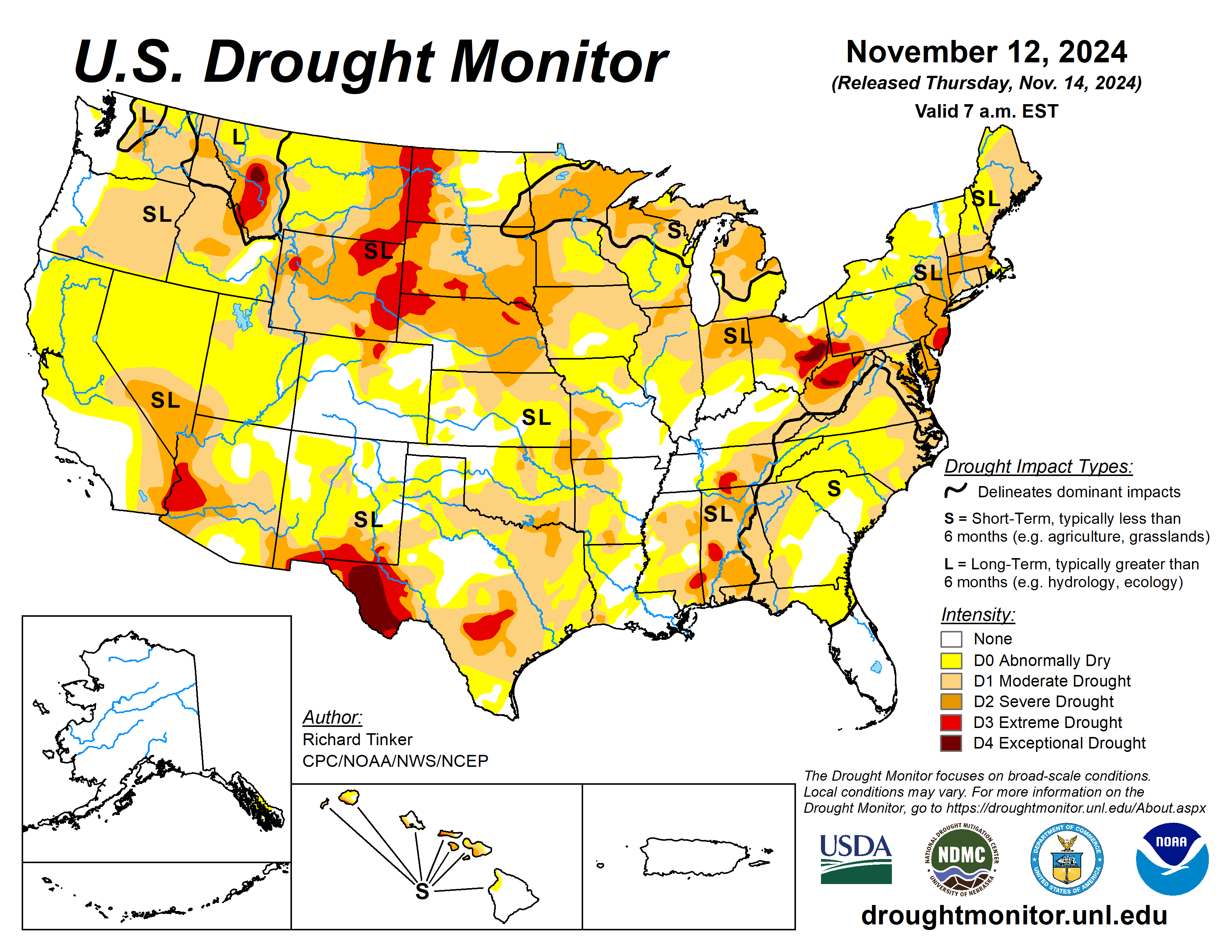


Click the link to go to the US Drought Monitor website. Here’s an excerpt:
This Week’s Drought Summary
Storm systems brought significant precipitation and drought relief to broad areas in the central Rockies, central and southern Plains, Lower and Middle Mississippi Valley, Lower and Middle Ohio Valley, and the South Atlantic Region. Meanwhile, subnormal precipitation and some unseasonable warmth led to deterioration in dryness and drought conditions in portions of the Southwest, southern and western Texas, the interior Southeast, the northeastern Gulf Coast, the central and southern Appalachians, the mid-Atlantic region, the Northeast. Excessive precipitation totals fell on some areas. From central South Carolina through much of southeastern Georgia, amounts of 4 inches to locally a foot of rain were reported. Similar totals fell on central Louisiana, a band through central and north-central Texas, small parts of the Lower Ohio Valley, and orographically-favored areas in the Northwest. In addition, a broad area covering the eastern half of Colorado and adjacent areas in New Mexico and the central High Plains recorded 2 to 4 inches of precipitation, much of which fell as snow in the middle and higher elevations. A few scattered sites reported 3 to 4.5 feet of snow, mainly in the higher elevations of Colorado…
High Plains
A potent 500-hPa low triggered widespread heavy precipitation over southern half of the Region, except along the eastern fringe, while amounts were limited to several tenths of an inch at most farther north. Between 2 and 4 inches of precipitation fell on a large swath covering the eastern half of Colorado, most of central and western Kansas, and adjacent Nebraska. In nearby areas, amounts ranging from a few tenths of an inch to a couple of inches were observed over the western half of Colorado amounts of 0.5 inch to approaching 2 inches in spots was observed across southeastern Wyoming, most other areas in Nebraska, and eastern Kansas. Moderate amounts fell on a swath across the central and southwestern Dakotas the remainder of this region reported little or no precipitation, as well as most of Wyoming. In some of the higher elevations of Colorado, this precipitation fell as heavy snow, with a few locations reporting snow piling up 3 to 4.5 feet deep (50 to 54 inches buried Fort Garland CO while 44 to 47 inches were reported near La Veta, Elbert, and Trinidad CO). All of this resulted in a large area of improvement depicted over southern and western Kansas, most of northern and eastern Colorado, part of southwestern Nebraska, and a few spots in eastern Wyoming. There were a few areas of 2-class improvement in southeastern Colorado, northwestern Kansas, and the fringes of south-central and southeastern Kansas. Elsewhere, due to relatively cool weather, the dry week didn’t engender much deterioration, with most of these locations remaining unchanged from last week. One exception was in a small patch of northeastern Nebraska and adjacent South Dakota, where a new patch of extreme drought (D3) was identified…
West
Heavy precipitation In northeastern New Mexico, with snow reported in some of the higher elevations, produced areas of improvement to dryness and drought. A few high spots in New Mexico reported near 3 feet of snow, including locations near Las Vegas NM and Folsom NM. The only other area of improvement in the West Region was in eastern Washington. Not much precipitation fell last week…
South
Like the Southeastern Region, the South Region experienced highly variable rainfall this past week. Heavy precipitation – in some areas for the second consecutive week – soaked a swath from Louisiana and eastern Texas northward through much of the Lower and Middle Mississippi Valley and the Tennessee Valley. A broad swath reaching as far west as central Arkansas recorded at least 1.5 inches in most places, with some areas recording much higher amounts (3 to 8 inches in part of western Tennessee, and over a foot in parts of central Louisiana). This resulted in reductions in dryness and drought severity across affected areas of the Lower Mississippi Valley and eastern Texas, with some 2-class improvements imposed in a small part of both southwestern Louisiana and an area straddling southwesternmost Mississippi and adjacent southeastern Louisiana. To the north, the heavy rains also removed abnormal dryness from across western Tennessee. Farther west, another area of heavy precipitation accompanied a frontal passage in a swath from central Texas into the central Red River (south) Valley, where totals reached 4 to 8 inches along the axis of heaviest amounts. To the north, heavy precipitation associated with a pair of potent upper-level low pressure systems dropped over 2 inches on a large part of central and western Oklahoma and much of the Texas Panhandle, with localized totals exceeding 4 inches in the eastern Texas Panhandle northward to the Oklahoma/Kansas border. There was also a patch of heavy rainfall to the east across portions of eastern Oklahoma, where isolated amounts peaked at around 3 inches. Dryness and drought affecting these areas were significantly eased, with a couple patches of 2-class improvements in north-central and northeastern Oklahoma. In stark contrast, little or no precipitation was observed from parts of southeastern Oklahoma southward through Deep South Texas, and across western Texas as well. Dryness and drought worsened in some of the areas, with the most widespread deterioration noted in western Texas. The broad area of exceptional drought (D4, the most intense category) expanded there to cover most or all of eastern Hudspeth, Culberson, western Reeves, Jeff Davis, Presidio, and Brewster Counties. Also, D3 (extreme drought) also expanded to cover most of the remainder of the Big Bend of Texas…
Looking Ahead
During the next five days (November 14-18), moderate to heavy precipitation is again expected from the Cascades westward to the Pacific Coast, with totals expected to exceed 5 inches expected in some of the higher elevations and orographically-favored sites. One or more inches are also anticipated in the Sierra Nevada, with several tenths of an inch possible along most of the California Coast down to the Mexican border. Parts of the northern Intermountain West are expected to receive over an inch of precipitation, with 2 to locally 4 inches forecast across the Idaho Panhandle. A low pressure system and trailing front should trigger another round of heavy precipitation in the central and southern Great Plains from central Texas northward into southeastern Nebraska and the Middle Mississippi Valley, with 1.5 to locally 4.0 inches anticipated from central and east-central Kansas southward through the Red River (south) Valley and adjacent northern Texas. At least an inch is also anticipated east of the Lower and Middle Mississippi River through the interior Southeast, Lower Ohio Valley, central and southern Appalachians, and the mid-Atlantic region. Over 2 inches may fall on parts of the central Appalachians and adjacent Piedmont. Meanwhile, moderate amounts should fall on the southern Rockies and adjacent High Plains and across the Great Lakes region and the northern Ohio Valley. In contrast, little or no precipitation is expected across much of the Northeast, Florida and the adjacent South Atlantic region, southern Texas, the northern Plains, the central and southern Rockies, and the Southwest.
The Climate Prediction Center’s 6-10 day outlook (valid November 19-23) features enhanced chances for both above-normal precipitation and temperatures across the Upper Midwest and across most areas east of the Mississippi River, with odds for significantly above-normal rainfall reaching 50 to near 70 percent on the Florida Peninsula. Wetter than normal weather is also slightly favored across Hawaii. Meanwhile, subnormal precipitation seems more likely across Texas and adjacent locations as well as the western Rockies, most of the Intermountain West, and the Sierra Nevada. Below normal temperatures are favored across the central and southern Plains and adjacent Mississippi Valley, the Rockies, and the Intermountain West. Southeastern Alaska should also average colder than normal while in Hawaii, neither extreme of temperature is favored.
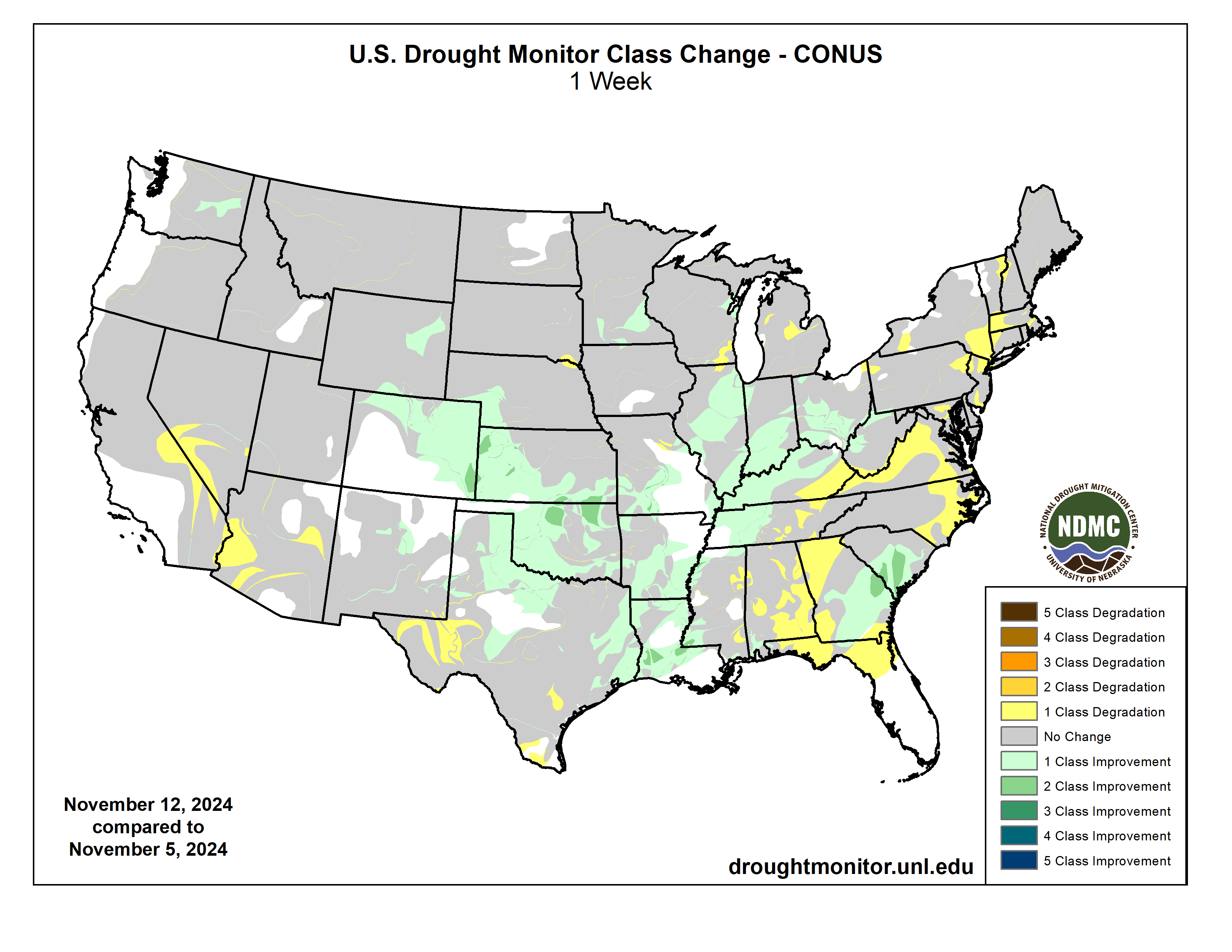
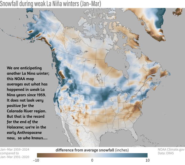
Click the link to read the article on the Sibley’s Rivers website (George Sibley):
November 12, 2024

Hunter Thompson put the term ‘fear and loathing’ into our cultural dialogue in the early 1970s: first in 1971 with ‘Fear and Loathing in Las Vegas,’ then with ‘Fear and Loathing on the Campaign Trail’ in 1973, a long rambling essay into America’s political character based on his coverage for Rolling Stone of the 1972 election of Richard Nixon over George McGovern.
‘Fear and loathing’ is a pretty accurate description of the campaign that Donald Trump ran: fear of a tidal wave of immigrants, mostly criminals; fear of a tidal wave of crime; fear of Promethian women unbound; fear of – well, fear of the future in general, along with a massive denial of things that most Americans apparently don’t want to think about, as discussed in my last post. That those tidal waves of fear were devoid of any factual reality, and the denials chin-deep in ignored factual realities – all that was immaterial; fear and anger work their dark magic best in darkness.
As for ‘loathing’: he and his minions worked hard, with considerable success, to make the gullible loath liberals, progressives, enviros, believers in the rule of law, people wanting to make their own decisions about their own bodies, anyone who still harbors the vision that we can save the planet from ourselves and that life can be made decent for everyone. He and his minions have said, will continue saying, things about people like me that are vicious fictions – I am the evil spawn of the devil just because I’d like to see more equity in our society, and have a commitment to the now-receding hope that we can pass a still-livable planet on to the next generations?
And he won with that campaign. The vote by a majority of my fellow Americans indicate that the Untied States (sic) is no longer going to even be trying to be Thompson’s ‘monument to all the best instincts of the human race this country might have been.’ Not now, anyways. Might we hope that we will recover our more positive vision after four more years with Trump and his dark xenophobic vision? There’s really nothing but hope, but like the guy in the lifeboat said, ‘Pull for the horizon, boys. It’s better than nothing.’
So – back to the river: ‘Let us gather by the river, the beautiful, the beautiful river….’
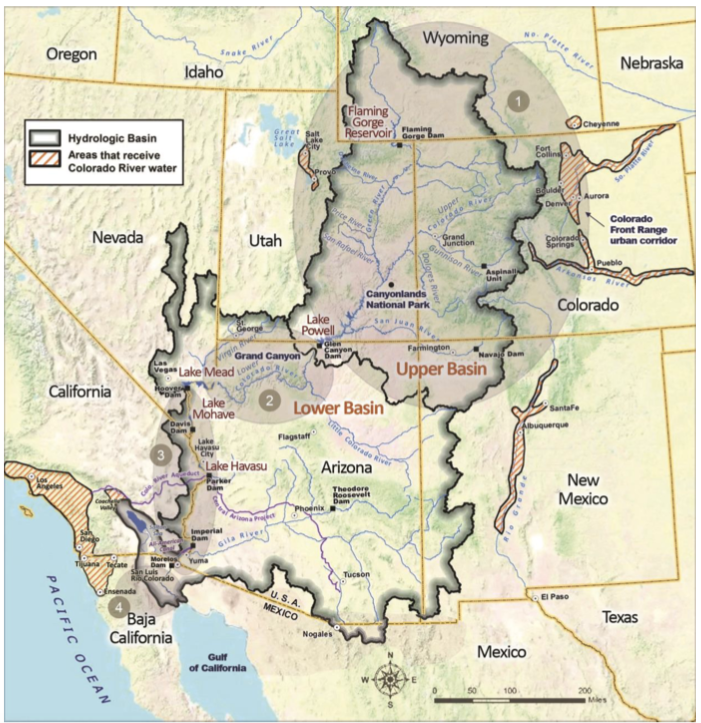
What were we doing when so rudely interrupted by the election? We were taking advantage of these ‘interim months’ in the Colorado River Basin to engage in a little thinking ‘outside the box’ about the Colorado River, while the seven basin states remain stalemated in the ‘Colorado River Compact Box.’ The Compact’s division into Upper and Lower Basins has devolved at this point to a situation that can legitimately be compared to the 1860 division of states into North and South with a downward spiral toward conflict and chaos. Only in the rich imagination of Paolo Bacigalupi does it descend to open uncivil warfare physically in the Colorado River region (read his worst-case book, The Water Knife, if you haven’t already). But the biggest action step recently in the stalemate was when Arizona’s state director of Water Resources, Tom Buschatzke, asked his governor and legislature to ‘set aside’ a million dollars in the event that going to court becomes unavoidable.
So in our ongoing ‘romance’ with the river, we could either hover and dither over that stalemate, like the rest of the media, trapped in the ‘Compact Box’ – or just take advantage of the ominous quiet to heist ourselves up on the edge of the box, to look over and out at possible alternative futures.
We’ve been exploring the anomaly of a river in a desert – a river created through natural atmospheric processes in a mountainous region of sufficient elevation to force precipitation onto land steep enough so that a large portion of the water created runs off its slopes rather than sinking in – a water-producing region. Whose produced water then runs off into desert lands, where the water produced in the highlands is gradually consumed by the same natural processes – evaporation, transpiration from riparian vegetation, and replenishment of low groundwater tables, and also by human cultures that learn how to use the river to grow things – mainly food crops and cities. The river is not significantly replenished for those losses by precipitation in the arid deserts, so it gradually diminishes, disappears on its way to sea level. The sun giveth the river, and the sun taketh the river away. The vaporized river water rides the wind, usually eastward in search of another condensing factor in the environment, to again become liquid precipitating on the increasingly thirsty earth as we relentlessly drive the planet’s temperature upward.
For cultures trying to live in desert lands with a heavy dependence on a river in the desert, there are two kind of obvious fundamental principles for using the river’s water: 1) first, collaborate on an equitable and efficient division of the use of the river’s water among all its desert consumers, and make that use contingent on the application of best practices in avoiding waste. And 2) take care of the water-producing region in order to maintain or achieve its optimal flows into the deserts. I’ll say that again: it is the responsibility of all the desert water users to take care of the water-producing region for their water, as well as being careful with the water that reaches their desert. Another principle the Colorado River Compact not only ignored, but made worse with the assumption that management of the Headwaters for the river would be up to high-desert users in the Upper Basin, and none of the Lower Basin’s business.
Despite the current disputatious stalemate between the seven states trying to share the river and their division into two camps of north states and south states (with the state boundaries themselves making no geographic or hydrological sense) – there are actually things going on internally within the states, mostly led by the huge metropolitan ‘city states,’ that work toward that first principle of collaboration on the best use of the river and its water. There are water-sharing agreements between desert cities and desert farmers; there are expensive efforts by the cities to maximize efficiency in the use of their current shares of the river, as well as the usual striving for larger shares. Considering that the division of the use of the waters is still bound by the foundational ‘first come first served’ appropriation doctrine, it is all the more remarkable that cooperation and efforts toward maximal and equitable efficiency are beginning to break out here and there, transcending strict appropriation law enforcement.
There is not, however, much conscious and coordinated attention among river users in the desert region for the water-producing region of the river in the desert – the 15 percent of the Basin lands (largely uninhabited) that produces 90 percent of their water. That’s what we’ve been trying to explore in some recent posts – beginning with the river’s ‘mystery’: the fact that of the estimated 170 million acre-feet (maf) of precipitation that falls over the Basin, roughly half of it in the water-producing region, only around 10 percent of that actually shows up in the river.
In a previous post we looked at some of the reasons why so much of the river’s water disappears from the river’s water-producing region – all attributable to sun and wind: sublimation (direct conversion of water from solid to vapor) diminishing the snowpack throughout the whole winter; evaporation as the snowpack melts and forms streams exposed to the desert sun; and transpiration through trees and other vegetation of groundwater that sinks into their root zone. Together these processes consume around three-fourths, at least two-thirds, of the water that falls on the Headwaters.
That is a Sibley guesstimate, by the way. We haven’t devised really accurate measures for any of these naatural processes (although there is currently serious scientific work toward better measures). The Western Water Assessment study I’ve been citing is somewhat stuck in the Compact Box, breaking most of its analysis down into Upper and Lower Basin data, which does not work for the ‘water-producing and water-consuming’ model, since most of the Upper Basin is part of the water-consuming desert region (ten inches or less annual precipitation). The WWA estimates the ‘runoff efficiency’ for the whole Upper Basin at 16 percent – an estimated 14.8 maf at the Lee Ferry version of the Mason-Dixon Line from an estimated 92 maf of precipitation – meaning that for every 6 acre-feet of precipitation, only one acre-foot makes it into the river for surface water users. (The WWA estimates Lower Basin runoff efficiency at three percent – one acre-foot dribbling into the river for every 33 acre-feet of precipitation – in areas with way less than 10 inches of annual precipitation.
While we’re talking numbers, the 14.8 maf at Lee Ferry is not an actual measure of water flowing past the division point, but an estimate of what the flow there would have been if there were no human water consumers upstream. There are of course hundreds of farmers and ranchers upstream as well as some substantial cities and lots of towns in the three major tributaries of the Colorado River mainstem: the Green, the Colorado-Gunnison confluence, and the San Juan. Towns and cities can estimate their consumption fairly accurately (especially the half a million acre-feet that go through tunnels to the Front Range metropolis. But more than 80 percent of Upper Basin consumptive use is agriculture, and the largest portion of that is hay production in mountain valleys not easily adapted to modern large scale irrigation technology (even if the small ranches could afford it). Flood irrigation is the default process; and how much water gets used in that makes the ag consumption figures a really rough guesstimate.

While we’re talking numbers, the 14.8 maf at Lee Ferry is not an actual measure of water flowing past the division point, but an estimate of what the flow there would have been if there were no human water consumers upstream. There are of course hundreds of farmers and ranchers upstream as well as some substantial cities and lots of towns in the three major tributaries of the Colorado River mainstem: the Green, the Colorado-Gunnison confluence, and the San Juan. Towns and cities can estimate their consumption fairly accurately (especially the half a million acre-feet that go through tunnels to the Front Range metropolis. But more than 80 percent of Upper Basin consumptive use is agriculture, and the largest portion of that is hay production in mountain valleys not easily adapted to modern large scale irrigation technology (even if the small ranches could afford it). Flood irrigation is the default process; and how much water gets used in that makes the ag consumption figures a really rough guesstimate.
The question for the water-consuming region then – aware as we ought to be, that we are losing in our changing climate 5-6 percent of our river’s water for every one degree F increase in average temperature – is whether there might be better management strategies for the Headwaters that would improve that ratio even just a little, to help compensate for coming losses…. And don’t be thinking that maybe what we need is less management, not more (more wilderness!). If we are going to keep adding more people to this planet, we are going to need better management everywhere – maybe not more, definitely not less, but certainly better.
We can say, with some confidence, that about the only part of the Headwaters where we have significant management options is the broad band of forests and grasslands ringing the Southern Rockies above the 8,000-foot elevation where most of the river region’s precipitation falls. These forests and grasslands occupy most of the water-producing region below the alpine tundra where the sun and wind rule uncontested, and above where the high deserts begin below the 8,000-foot elevation. Those forests – the subalpine spruce-fir forest and the montane pine forest (splashes of aspen everywhere in both) – are almost all public lands, designated National Forests, managed by the U.S. Forest Service.
The 1897 ‘Organic Act’ that turned existing ‘Forest Reserves’ into National Forests, and created the Forest Service to ‘improve and protect’ them, gave a broad overview of the National Forest mission:
‘No public forest reservation shall be established, except to improve and protect the forest within the reservation, or for the purpose of securing favorable conditions of water flows, and to furnish a continuous supply of timber for the use and necessities of citizens of the United States.’
The use of the conjunctions ‘or’ and ‘and’ there indicate that this law might have been written by a lawyer trying to hedge something by writing like a lawyer. Does the ‘or’ indicate a choice had to be made between the two ‘use’ clauses and ‘improving and protecting’ the reserved forest? And why the negative-sounding start: ‘No public forest reservation shall be established, except…’?
We need to remember that 1897 was Very Early Anthropocene (1850s-1950s): we were simultaneously trying to do two things. On the one hand, we were developing increasingly effective and efficient fossil-fueled methods for vacuuming up the resources of the continent and turning them into production infrastructure and consumer goods. The assault on the forests for timber to turn to lumber to feed the insatiable call for more houses got seriously industrialized with steam-powered sawmills and railroads to haul the forest products quickly in great volume.
But on the other hand, we were becoming ‘woke’ to the consequences of these resource-mining activities. The 19th century equivalent to Rachel Carson’s Silent Spring in 1962 was Man and Nature, published in 1864 by the early conservationist George Perkins Marsh. Marsh laid out in plain language the consequences of timber-mining and grass-mining, as well as the more conventional mining of other valued resources. Clogging and gullying of the rivers and streams were the worst consequences of these practices, choked with soil and debris washed off the denuded slopes – which also diminished the ability of the forests and grasslands to grow again. The farmable floodplains were devastated by larger and more violent spring floods.
It’s easy but not very accurate to say the one hand did not know what the other hand knew; but anyone dependent on the rivers for water knew the unpaid cost of all their houses and barns. It was, however, knowledge for them like the knowledge of the climate crisis is for us today: knowledge to be acknowledged only through the five-step process of accepting what we don’t want to accept: denial, anger, negotiation, depression and finally, acceptance.
This probably explains the negative beginning the Forest Service mission statement – ‘No public forest reservation shall be established’ – except when we think we have to. Goddam right! This the people’s land, not the government’s! Ours to put to beneficial use! But – yeah. We’ve got to do something about the mess running of the mountains into the rivers…. But can’t it wait till we’ve converted a little more of it into wealth?
Well, that’s a good place to stop for now. Denial and anger have a long history in American exceptionalism.
Next time – a closer look at the forests and water production.

Click the link to read the article on the Walton Family Foundation website (Jared Romero):
October 23, 2024
As a young girl growing up on the Southern Ute Indian Reservation, Lorelei Cloud learned the value of water in life lessons every week outside her uncle’s home.
“I lived with my grandparents in an old adobe home they had remodeled. We didn’t have any running water and so we always hauled water to our house,” says Cloud, Vice Chairman of the Southern Ute Indian Tribe in southwest Colorado.
“Every Sunday, my uncle would come and pick up my sister and me. We would fill up our water jugs from the garden hose outside his house and take it back to our house. That was our water for the week.”
On the occasions when her family’s supply didn’t last, Cloud’s grandmother would collect water from a nearby ditch and boil it for safe use – tiding them over until the next trip to her uncle’s.
Those early memories – of water scarcity, not abundance – have helped shape Cloud’s work today as a state leader in water conservation, and as a champion for Tribal voices in water decision-making in Colorado.
Native American Tribes hold some of the most senior water rights in the Colorado River Basin and have thousands of years of knowledge about water management.
But they have been historically excluded from decisions around allocations and management of the river and water resources. And on many Reservations, including the Southern Ute, access to clean, safe drinking water is still far from universal.
“When we pray, we always pray about water,” Cloud says of her Tribe’s traditions. “We pray it’s always going to be there to take care of our people.”

For Cloud, action follows prayer. In 2023, she was named to the Colorado Water Conservation Board, becoming its first Indigenous member. She also chairs the Indigenous Women’s Leadership Network, which aims to create a bigger platform for Indigenous women working on water and natural resource issues.
And she has served as chair of the Ten Tribes Partnership, a coalition of Tribes in the Upper and Lower Colorado River Basin seeking a greater voice for Indigenous communities in management of the river.
“Traditionally, as a people, we value water. We know that water is sacred. We also know that water is alive. It has a spirit just like all living things have a spirit,” Cloud says.
“We’ve never taken more than what we could use. What we couldn’t use, we always gave back. That belief in respecting nature is always at the center of my thought process and my decision-making.”
Bringing more voices to the table when making water management decisions leads to better solutions, Cloud says. That’s critically important in the Colorado River Basin, which provides water to 40 million people in seven states, even as climate change and drought are ushering in an uncertain water future.
“Being that first Indigenous person on the water conservation board, it really helped open my eyes on how other people make the decisions about water use within the state of Colorado,” Cloud says.
“I have a greater understanding and respect for all of the water users in Colorado because they are very conscious about how water is being used and how water is being allocated.”
In turn, Cloud says she hopes non-Tribal water users in Colorado are gaining a better understanding of the unique water challenges facing Indigenous people.
The Southern Ute Indian Tribe has its own water treatment facility. But dozens of families in more remote areas lack universal access to clean water. Water hauling services can cost hundreds of dollars.
“Tribal residents have to make the decisions if they can flush their toilets, if they have the water to wash their dishes, if they can take showers, on a daily basis,” she says. “Other people in the basin don’t have to make those decisions. They don’t consciously think about paying for the water before they use it.”
Cloud understands the significance of her status as the first Indigenous member of Colorado’s water board. Every meeting, every conversation she joins helps normalize Tribal involvement in water decision making.
“Bridging those gaps, highlighting inequities that exist – it’s all part of changing how the world views Tribes and Tribal water rights,” she says. “Having Tribes in all of those conversations is really, really important. We are the senior water right holders. We are the first inhabitants of this continent. We are the first conservationists.”
She believes Indigenous women bring a particularly unique, important – and overlooked – perspective to discussions in the future of water in the Colorado River Basin.
“Indigenous women are naturally in leadership roles in conservation, because we tap into the generational knowledge and intuition and experience that can help solve complex environmental challenges,” she says.
“Women have always been the caretakers. When they go out and gather water for their home, they need to know how much water is available. They need to know the quality of the water that’s available. So they understand the connection between water demand and water supply.”
Cloud cites her grandmother – Sunshine Cloud Smith – as the most influential and inspiring person in her own life. Cloud calls her grandmother “a rebel for her time” who lied about her age to leave the reservation to go to school at 16. She also joined the Army and later became a member of the Southern Ute Tribal Council and led Head Start programs to benefit Tribal children.
Cloud remembers her grandmother taking her to a bridge crossing the Pine River, on the Reservation, for water ceremonies.
“My grandmother was the glue in my family,” she says. “She would pray and make offerings to the spirit so that we would have rain for the season and have water. Since then, the Pine River has always been a place where I can go and pray and leave offerings for the spirits.”
Today, Cloud sees it as her “personal duty” to help elevate Indigenous women to leadership roles on water issues.
“I’m not a gatekeeper in my knowledge. I always want to share my knowledge with other women.”

Click the link to read the article on The Durango Herald website (Christian Burney). Here’s an excerpt:
November 13, 2024
The city of Durango’s approach to stormwater management is largely reactionary: When storm drains become clogged, crews reshuffle their priorities to clean the drains. Infrastructure around the city is failing, and after heavy rains, debris is often swept across streets, parking lots and into riverways. The Public Works Department is in desperate need of dedicated staff to implement a proper preventive maintenance program, Bob Lowry, interim Public Works director, said. Besides two street sweeper operators in its streets division, Public Works lacks any staff dedicated to preventive maintenance to stormwater infrastructure, he said. And it lacks a dedicated funding source for managing its stormwater system. He said the system consists of nearly 55 miles of pipe and 2,392 storm drainage inlets in curbs and gutters, in addition to natural drainage channels.
Residents have expressed concerns about sediment unloading into the Animas River after heavy rain and snow melt, which threatens ecology and wildlife, and flood-prone zones and failing stormwater infrastructure around town imperiling private and public property.
Last week, Lowry pitched City Council the idea of establishing a stakeholder committee tasked with identifying a suitable long-term funding source. Councilors will consider a resolution establishing such a group at their next meeting in November. In a presentation with photos of problem areas around town, he highlighted pipes clogged by debris, flood zones and erosion…
A dedicated stormwater maintenance fund would facilitate a crew of four additional staff and a supervisor, street sweeping, inspecting pipes and infrastructure with camera feeds, and inlet and pipe cleaning operations, he said…And, he hopes such a committee and the Durango Financial Advisory Board would conclude stormwater management fees that would be charged through residents’ and businesses’ utility accounts are the best funding option.
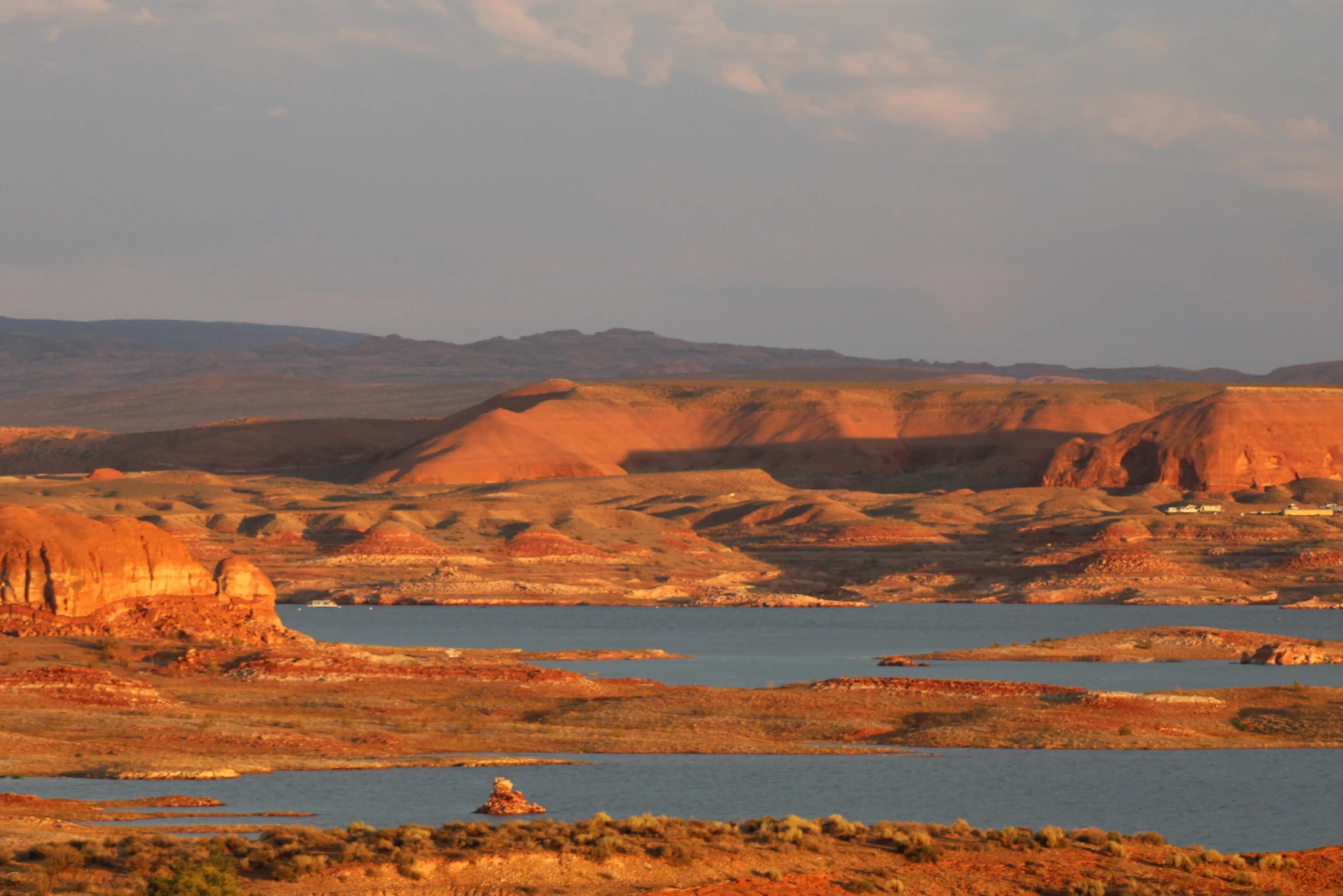
Click the link to read the article on the KUNC website (Alex Hager):
November 7, 2024
The people who will determine the future of the Colorado River said they do not anticipate major changes to their negotiation process as a result of former president Donald Trump’s return to the White House.
Multiple officials from states that use the Colorado River pointed to historical precedent and said that similar negotiations in the past were largely unaffected by turnover in presidential administrations. Historically, state leaders have written the particulars of river management rules, and the federal Bureau of Reclamation implements the states’ ideas.
“I think if you’re using history as your guide, the election probably doesn’t mean a whole lot,” said John Entsminger, Nevada’s top water negotiator. “We have seen both Democratic and Republican administrations over the last two and a half decades have pretty consistent Colorado River policy.”
The Colorado River is used by 40 million people from Wyoming to Mexico. Climate change is shrinking its supplies, and policymakers are trying to agree on ways to rein in demand. They are under pressure to come up with a new set of rules for sharing its water by 2026 when the current guidelines expire.
Those policymakers – a group of seven appointed officials from each of the states that use the Colorado River – are split into two factions. Those two groups released competing proposals for how to manage the river after 2026, and they do not appear close to an agreement.

The Biden Administration had urged those states to coalesce around one proposal before the presidential election to help ensure it could go through the necessary paperwork and be implemented smoothly, but state leaders failed to do that.
On the campaign trail, Trump suggested major shakeups to the federal government, suggesting that he would gut or dissolve some federal agencies entirely. Entsminger said he does not think those efforts will extend to the federal agencies that help manage water in the West.
“I expect there to be a Department of the Interior,” he said. “I expect there to be a Bureau of Reclamation because someone has to actually operate the dams on the Colorado River.”
However, the Trump Administration may not be in a hurry to appoint new heads of those agencies. Entsminger pointed to past administrations that have prioritized other agencies, and Interior Department leaders haven’t been appointed until eight or nine months after inauguration day.
“The basin states can’t afford to sit around and wait to hear who that’s going to be,” Entsminger said. “It’s incumbent upon the basin states to keep working towards a solution in the interim, until we know who the new administration’s representatives are going to be.”
Scientists and policymakers broadly agree that climate change is driving the two-decade megadrought that is shrinking the Colorado River, but Trump has denied that climate change even exists. His administration appears poised to expand fossil fuel extraction, which would accelerate climate change. Western water leaders don’t expect those attitudes to get in the way of finding ways to rein in water demand.
“I don’t think that the debate over climate change is going to change the view of the federal administration about the need to deal with a smaller river, or how we’re going to get there,” said Tom Buschatzke, Arizona’s top water negotiator. “I just don’t see it happening.”
Even if Colorado River management at the federal level is stable, discord between the states could make things tricky. Currently, the Upper Basin states of Colorado, Utah, Wyoming and New Mexico are in disagreement with their Lower Basin neighbors – California, Arizona and Nevada. The two camps have a rivalry going back more than a century, and it still divides them today.
Elizabeth Koebele, who researches water policy at the University of Nevada, Reno, said that creates a risky level of instability.
“I worry that when our house isn’t in order inside the [Colorado River] basin,” she said, “Then these bigger, national level, ‘big-P Political’ changes are more likely to impact policy making, or more likely to add more stress to policy making.”
Koebele said federal leaders have often helped spur action and agreement among states by giving them “ultimatums” and deadlines to submit water management plans. The federal water officials appointed by Trump, she said, will face a tall order if they want to do that this time around.
“The stakes are probably higher than ever,” Koebele said, “And the Upper Basin and Lower Basin are facing major conflicts about who’s responsible for doing something about this. So I’m maybe not as optimistic as the state [negotiators] are.”
State water negotiators in both basins said they plan to keep pressing forward, and seemed optimistic about agreement, even amid shifting politics at the national level.
“We’re committed to coming up with a solution,” said Gene Shawcroft, Utah’s top negotiator. “This is a seven state solution, not an administration solution, if you will. And so there’s no waffling in our commitment to come up with a solution.”
Shawcroft said he believes any plan agreed upon by all seven states would be accepted by a future Trump administration.
This story is part of ongoing coverage of the Colorado River, produced by KUNC and supported by the Walton Family Foundation. KUNC is solely responsible for its editorial coverage.