Romancing the River: Bluffing a Call, Calling the Bluff — George Sibley (SibleysRivers.com) #ColoradoRiver #COriver #aridification

Black Canyon of the Gunnison River. Photo credit: NPS

Click the link to read the article on the Sibley’s Rivers website (George Sibley):

Breaking news! The Lower Colorado River Basin is threatening the Upper Basin with a ‘Compact Call’ if it does not agree to share some major cuts in river use! Well, actually the news broke a week ago – and now there’s more news: just as I was wrapping this analysis of the ‘Call’ up yesterday, the Bureau put out for our consideration five options for river management up to and beyond the 2026 termination of the ‘Interim Guidelines.’

So we’ll interrupt our out-of-the-box exploration for management options for living with a desert river in an intelligent universe, and try to figure out what’s going on back in the surreal world of the ‘Compact box’ – looking at the ‘Call’ situation here, then get into the five management options in a couple weeks after the dust has settled.

The Lower Colorado River Basin has attempted to break the stalemate between the two Compact-designated Colorado River Basins, by telling the Upper Basin that, if they do not agree to share some major cuts when the river situation grows desperate again, then in that desperate time they will issue a ‘Compact call’ on the Upper Basin to deliver the whole 7.5 million acre-feet (maf) on average they claim the Compact obligates the Upper Basin to deliver regardless of the water situation upriver.

There has been no formal Upper Basin Commission response to that threat, but Colorado’s Commissioner, and director of the Colorado Water Conservation Board, Becky Mitchell, essentially called the bluff, and put the blame for Lower Basin problems back on the Lower Basin. The Upper Basin has argued that, if the situation becomes so desperate that the Lower Basin’ share cannot be delivered without draining Powell Reservoir, then the Upper Basin users will already be experiencing extreme shortages levied by nature.

This Hobson’s choice from the Lower Basin hinges on Article III(d) of the Colorado River Compact, which says, ‘The States of the Upper Division will not cause the flow of the river at Lee Ferry to be depleted below an aggregate of 75,000,000 acre-feet for any period of ten consecutive years.’ Does this mean, as Lower Basin states will argue, that the Upper Basin has a ‘delivery obligation’ of 75 maf over any ten-year period, regardless what is happening weatherwise in the Upper Basin? Or does it mean, as Upper Basin states are likely to argue, should argue, that if the flow to the Lower Basin were to fall below that 75 maf over a ten-year period due to circumstances other than human uses in the Upper Basin states (drought, dead pool in Powell Reservoir due to excessive releases, the atmosphere’s growing ‘evaporative demand,’ et cetera), causing ‘the flow to be depleted’ below the 75 maf minimum, then responsibility for the depletion does not fall on the water users in the Upper Basin, but on changing natural processes beyond human control. The Upper Basin could, maybe should, argue that this condition in the Compact is simply a reminder to Upper Basin users, to be careful in using their 7.5 maf half of the river (cue bitter laughter), to not infringe on the Lower Basin’s 7.5 maf half of the river.

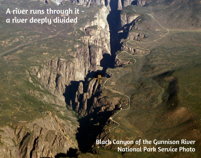
And so far as the Compact goes, that reminder is all there is. Nowhere in the Compact is there any provision for a ‘Compact call,’ or any other procedure when or if the flow at Lee Ferry (the ‘Mason-Dixon line’ between the two Basins) were to fall below that 75 maf over ten years. A ‘call,’ the reader might remember, is an unneighborly procedure in the appropriations doctrine that remains the foundation of water law in all seven Colorado River Basin states: if downstream water users with senior rights are not able to get all of their appropriated water, they can place a ‘call’ on upstream users with junior rights, who have a legal obligation to let enough water go past their headgates to fill the seniors’ rights.

Members of the Colorado River Commission, in Santa Fe in 1922, after signing the Colorado River Compact. From left, W. S. Norviel (Arizona), Delph E. Carpenter (Colorado), Herbert Hoover (Secretary of Commerce and Chairman of Commission), R. E. Caldwell (Utah), Clarence C. Stetson (Executive Secretary of Commission), Stephen B. Davis, Jr. (New Mexico), Frank C. Emerson (Wyoming), W. F. McClure (California), and James G. Scrugham (Nevada) CREDIT: COLORADO STATE UNIVERSITY WATER RESOURCES ARCHIVE via Aspen Journalism

A seven-way division of the use of the river, however, proved to be nearly impossible. Each commissioner had come with the charge to protect their own state’s glorious future, to develop their vast acreage of potentially irrigable land, their mineral resources, et cetera. No factual studies existed to support the glorious visions. And when the water requirements for those visions were all added up, they would have required a river half again larger than even the overly optimistic flow numbers provided by the Bureau of Reclamation.

The Bureau hovered around the Compact meetings, eager to ‘make concrete’ the final purpose stated in that Compact preamble: ‘to secure the expeditious agricultural and industrial development of the Colorado River Basin, the storage of its waters, and the protection of life and property from floods.’ The Bureau wanted to build big dams on the Colorado River, and ‘expeditious agricultural and industrial development’ was the rational cloak the Bureau and the commissioners could throw on over the romantic urge to just take on the conquest of Fred Dellenbaugh’s ‘veritable dragon’ of a river.

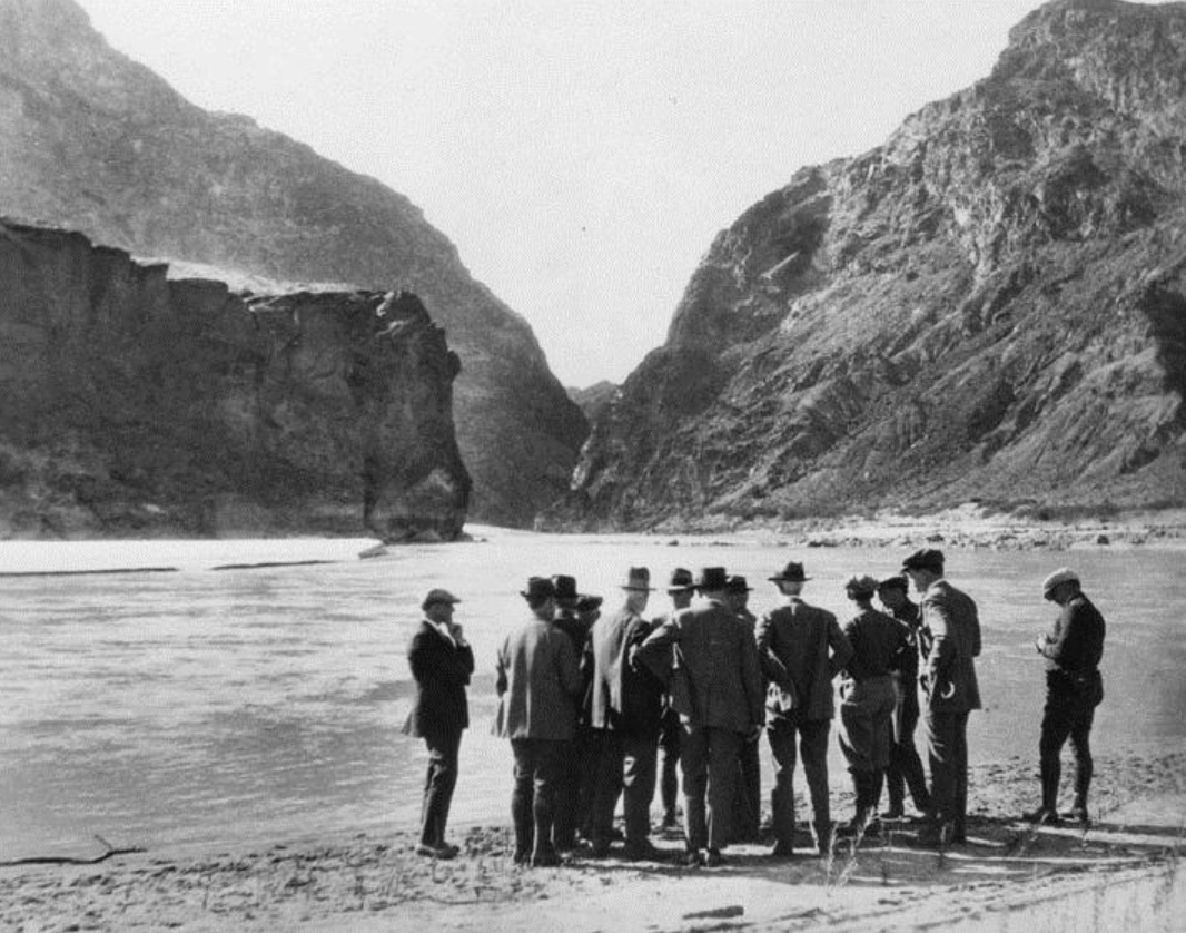
Herbert Hoover, U.S. Secretary of Commerce and chair of the Compact Commission, and an engineer by training and romantic inclination, also wanted to build big dams. And when the commissioners grew frustrated at  their failure to resolve an equitable seven-way split of the use of the river after several days of looking at magical numbers, he worked hard to keep them from just dropping the whole idea, reminding them that Congress would not approve funding for Colorado River projects until the seven states all felt satisfied that a share of the river would be there for them when they were ready to grow like California.

Still, he was unable to pull them together for a serious working meeting until November, nearly the end of the year they had given themselves to create their interstate compact. He was able to lure them with an idea he and Delph Carpenter, Colorado’s commissioner, had cooked up over the summer: instead of the currently impossible seven-way division based on vague visions, they would work out a two-way division, dividing the river into two Basins, the four tributary states mostly above the river’s canyon region as an Upper Basin, and the three states mostly below the canyons as a Lower Basin, and each Basin could have the use of half the river, to divide further among each Basin’s states at their leisure.

Holed up at the posh Bishops’ Lodge just north of Santa Fe, with 28 formal meetings in 11 days and who knows how many off-the-record breakfast and bar caucuses and drafting sessions, they came up with a Compact that no one loved, but six of the seven thought they could live with, to satisfy Congress that they were all on the same page.

The seventh state was Arizona. Arizona’s commissioner, W.S. Norviel saw from the start that this two-basin idea caged the thousand-pound gorilla, California, to the satisfaction of the four Upper States, but left his state in the cage with the gorilla. He signed off on the Compact – possibly so Hoover would let them go home – but his state legislature refused to ratify the Compact. And all the other six states only ratified it after months of persuasion that it was as good as they were going to get.

The Colorado River near Black Canyon before Hoover Dam. Photo via InkStain.

Congress, on the other hand, was sufficiently infected with the romance of conquest to be willing to ratify the Compact with only six of the seven states on board. The next step was the Boulder Canyon Project Act in 1928, clearing the way for the construction, begun under President Hoover, of Hoover Dam, Parker Dam, the Imperial Weir Dam and the All-American Canal – a massive project that was about the only thing happening in America in the Great Depression, and which was adopted by the Roosevelt administration as the model for the Public Works Program and several other New Deal programs to put America back to work on big visions.

But at the base of all that is the rushed and rickety Colorado River Compact, the ricketiness of which was acknowledged by most of the commissioners – and by Hoover himself, who in one of the later November compact meetings, summarized the emerging compact as ‘a temporary equitable division, reserving a certain portion of the flow of the river to the hands of those men who may come after us, possessed of a far greater fund of information; that they can make a further division of the river at such a time, and in the meantime we shall take such means at this moment to protect the rights of either basin as will assure the continued development of the river.’ (Italics added) If the legal and political infrastructure isn’t quite in place – never mind: go ahead and build the physical structure anyway.

We have the whole chain of laws, subsequent compacts, court decisions, interim guidelines and other fixes that have tried to shore up the Compact – the Law of the River – but nothing that really addresses the matter of the 7.5 maf promise to both basins that the river cannot support – and that the Lower Basin now seems to be considering, on the basis of that Article III(d) obfuscation, as an appropriated right that the gives them a kind of seniority over the Upper Basin.

Isn’t that what this ‘Compact Call’ threat is? Hasn’t the Lower Basin essentially tried to graft the Compact onto the appropriations doctrine in order to threaten the Upper Basin with a ‘Compact call,’ despite the expressed intent of the Compact to create an equitable division that would preclude post-Compact appropriation calls between states?

I’ll leave it there, hoping that someone with a greater fund of information can explain this to me. Watch the ‘Comments’ section here.

And then we’ll dig into the Bureau’s recommendations in a week or two. And forget, for the time being, trying to think outside the Compact box; it demands our attention, love it or not.

Colorado River “Beginnings”. Photo: Brent Gardner-Smith/Aspen Journalism

Public lands are an asset — Pete Kolbenschlag (Colorado Farm & Food Alliance @ColoFarmFood)

Coyote Gulch and Mrs. Gulch after the climb out of Coyote Gulch at Jacob Hambiln Arch (2000).

From email from Pete Kolbenschlag:

The West’s public lands are an iconic and a cherished asset that belong to all Americans. They are also deeply rooted in the practicality of place, in the agricultural and hardscrabble ways of the West’s rural towns and far-flung communities. Public lands have been established over decades, and are still enduring now, as a public asset. 

Public lands are an especially American legacy, founded in an anti-nobility tradition as an investment in the nation and in our shared future. These lands are part of the character and history of those who live here, and few would easily give them up. Still, there is also another legacy that continues to this day that runs contrary to all that. Privatizing the public domain has been on the to-do list of robber-barons and others for over 100 years. 

Photo credit: Greg Hobbs

Public lands provide ecological services, like ensuring a good water supply, making our businesses, farms, communities and lives here possible. But few would say that the management of public lands has not been fraught with problems, resources often neglected, policy captured by industries and interests it is meant to regulate. 

Too often those with a narrow and self-interested agenda hide behind the well-founded misgivings people have about how public lands are managed. Most recently it is the State of Utah as stalking horse, advancing a court challenge that seeks to undermine the very foundations of America’s public lands. According to an alert from Backcountry Hunters & Anglers: “The catch is simply this: the transfer of public lands from federal to state governments is the pathway to streamlined privatization. Despite the State’s adamant claims that it intends to “keep public lands in public hands,” the reality of the matter is that the bar for sale is significantly lower under State control than it is under the current federal management system, which has proven to be very effective at retaining lands in the public domain.” 

Westerners who have been around awhile can often see these plays to take the public’s lands for what they are. Often wearing the familiar look of the rural West and pulling on a populist appeal, these ploys serve a specific and narrow set of interests. Many seasoned observers are not surprised to see these same deep-pocketed interests at it again, seeking to turn public lands to their own purposes. 

At the start of the 20th Century many large livestock operations, absentee speculators, and fly-by-night operators intent on exploiting the West’s resources wanted the public’s lands turned over to their purposes and to benefit their needs. And those with this agenda have made significant progress at various times, so we know what is at risk. We also know which interests stand to gain the most from taking America’s public assets away: it’s not the public. 

Oil and gas infrastructure is seen on the Roan Plateau in far western Colorado. (Courtesy of EcoFlight)

This time it’s dressed up in a novel legal argument engineered for the Supreme Court, which is a reason for real concern. But it’s not a new agenda. The motivations and monied-interests behind it are as old as the American West itself. When I first arrived in the West it was the “Wise Use Movement,” which was itself just the Sagebrush Rebellion repackaged. And while the agenda is not novel, the threat this time is significant. Many point to a Supreme Court that has recently favored corporate over community interests. Undemocratic forces that seek to monetize public resources for private gain have strong allies in powerful positions. 

Public land agencies evolved from the needs of a growing nation and from on-going conflicts. National Forests were reserved, in the case of the North Fork Valley, to protect downstream- from upstream-agriculture because the headwaters were being poorly managed and overgrazed by sheepherders, impacting fruitgrowers in Paonia. Western range wars were also a thing at the turn of the previous century, and western Colorado saw its share. Public lands management began, in part, to ensure a more equal footing for use of the public’s shared parks, open spaces, and wildlife lands. 

The Bureau of Land Management grew out of the grazing service, general land office and other Interior Department agencies. The land office had been administering the Homestead and similar acts, and when the “frontier was closed,” federal lands – which had been seized, secured and opened up with federal treasure (provided mostly by eastern taxpayers) – became a public asset to be managed for broader benefit. Grazing reform, mineral leasing laws, and other rudimentary land management practices were established to protect resources that the public relied on. 

Pete Kolbenschlag, founding Director at Colorado Farm & Food Alliance

Elections matter and America has again chosen its leaders. Now our water, natural resources, and the right to have a liveable climate could all be in the balance, again. Luckily an antidote to the misappropriation of public wealth is also part of the western body politic. In western Colorado we will have a new Congressman and our national public lands will be managed with a different agenda. 

Make sure that your government’s representatives and agencies, along with your family and friends, businesses you shop at and customers you serve, all know how important public lands are to you. These places are at the core of the West. Be ready to act. Speak up for your public lands now.  

Pete Kolbenschlag is a long-time public lands activist and currently the director of the Colorado Farm & Food Alliance based in Paonia, Colorado.

Draining #LakePowell Won’t Solve Crisis — the Associated Press

“New plot using the nClimGrid data, which is a better source than PRISM for long-term trends. Of course, the combined reservoir contents increase from last year, but the increase is less than 2011 and looks puny compared to the ‘hole’ in the reservoirs. The blue Loess lines subtly change. Last year those lines ended pointing downwards. This year they end flat-ish. 2023 temps were still above the 20th century average, although close. Another interesting aspect is that the 20C Mean and 21C Mean lines on the individual plots really don’t change much. Finally, the 2023 Natural Flows are almost exactly equal to 2019. (17.678 maf vs 17.672 maf). For all the hoopla about how this was record-setting year, the fact is that this year was significantly less than 2011 (20.159 maf) and no different than 2019” — Brad Udall

Click the link to read the article on the Associated Press website (Tom Howarth). Here’s an excerpt:

As the American Southwest grapples with a historic water crisis, some advocacy groups, such as the Glen Canyon Institute (GCI), propose drastic measures like draining Lake Powell to address the diminishing flow of the Colorado River. However, Arizona’s top water official, Tom Buschatzke, has warned that this approach could exacerbate the problem rather than resolve it. Buschatzke, the director of the Arizona Department of Water Resources, outlined the risks of removing Lake Powell from the equation in the broader water management system. His argument underscores the importance of maintaining the reservoir as a buffer against the volatility of the Colorado River’s flow.

“Bigger reductions in the flow of the river that might attend to climate change are something that is being looked at,” Buschatzke told Newsweek. “But if you take Lake Powell out of the equation, the yield of the system is going to go down.”

[…]

“There will be wet years in which you won’t have storage to save the water,” he said. “So the overall yield over a longer-term average has to go down without Lake Powell. That means you have less usable water, and that might not be the outcome you’re trying to achieve.”

[…]

A bend in Glen Canyon of the Colorado River, Grand Canyon, c. 1898. By George Wharton James, 1858—1923 – http://digitallibrary.usc.edu/cdm/ref/collection/p15799coll65/id/17037, Public Domain, https://commons.wikimedia.org/w/index.php?curid=30894893

The proposal to drain Lake Powell also highlights a broader philosophical divide in water management: incremental fixes versus transformative changes. According to Buschatzke, large-scale reforms, while potentially impactful, are fraught with challenges…Groups like the GCI disagree with Buschatzke, arguing that bypassing Glen Canyon and adopting a “Fill Mead First” policy could not only help manage water in the system more effectively but also recreate the landscape lost when Glen Canyon Dam was first constructed in the 1960s. As the levels of the lake have receded in recent years, plants and animals have reclaimed in the shores in what’s been dubbed an “ecological rebirth.”