DENVER — Colorado Parks and Wildlife is seeking applications for wetland and riparian restoration, enhancement and creation projects to support the Wetlands for Wildlife Program.
This year, CPW will award over $1.1 million in funds from Great Outdoors Colorado (GOCO) and Colorado Waterfowl Stamps to projects in Colorado that support the Wetlands Program Strategic Plan’s two main goals:
Improve the distribution and abundance of ducks, and opportunities for public waterfowl hunting. Applications supporting this goal should seek to improve fall/winter habitat on property open for public hunting (or refuge areas within properties open for public hunting) or improve breeding habitat in important production areas (including North Park and the San Luis Valley in Colorado, and other areas contributing ducks to the fall flight in Colorado).
Improve the status of declining or at-risk species. Applications supporting this goal should seek to clearly address habitat needs of these species. See the identified threats, recommended conservation actions, and progress to date for these species in the Colorado State Wildlife Action Plan (SWAP) Conservation Dashboards.
Wetlands for Wildlife application guidance and instruction is available at: cpw.state.co.us/wetlands-wildlife-grants. The application deadline is Monday, Feb. 10.
About the program The Colorado Wetlands for Wildlife Program is a voluntary, collaborative and incentive-based program to restore, enhance and create wetlands and riparian areas in Colorado. Funds are allocated annually to the program and projects are recommended for funding by a CPW committee with final approval by the Director.
“Wetlands are so important,” said CPW Wetlands Program Coordinator Brian Sullivan. “They comprise less than two percent of Colorado’s landscape, but provide benefits to over 75 percent of the species in the state, including waterfowl and several declining species. Since the beginning of major settlement activities, Colorado has lost half of its wetlands.”
Since its inception in 1997, the Colorado Wetlands Program and its partners has preserved, restored, enhanced or created more than 220,000 acres of wetlands and adjacent habitat and more than 200 miles of streams. The partnership is responsible for more than $40 million in total funding devoted to wetland and riparian preservation in Colorado.
Swim class on the San Juan River. Photo: Brent Gardner-Smith/Aspen Journalism
Permafrost is thawing across Boreal and Arctic lands, causing old carbon stored in soil or sediment to be released to the atmosphere as CO2 or CH4. A lot of these emissions occur in winter because post-thaw soils can become too wet to freeze, like this thaw bog in northwestern Canada.
On Sunday, Dec. 29, the daytime high of 57 degrees in Alamosa established a new record for the date, making December 2024 one of the warmest Decembers this century. | Credit: The Citizen
A mild December caps a year of unusual weather for Alamosa and the greater San Luis Valley. Or maybe it’s just the new normal in a century of changing climates and chaotic weather patterns.
The month of December brought 10 different 50-degree weather days, and an average temperature of 45 degrees – or 10 degrees above what’s been historically normal, according to figures from the National Weather Service.
On Sunday, Dec. 29, the daytime high of 57 degrees in Alamosa established a new record for the date, making December 2024 one of the warmest Decembers this century.
The summer and late fall were strange as well this year. Between May and August, the Valley floor received 6.14 inches of rain, making it one of the wettest four-month periods on record this century.
For perspective, the San Luis Valley typically experiences 7 inches of total precipitation and around 30 inches of measurable snow each year. In 2024, Alamosa experienced 11.36 inches of precipitation and 37 inches of snow.
Those late spring and summer rains came off a record amount of total snow in March when 14.5 inches fell, way above the 4 inches of snow that is typical for the month. Indeed, 2024 was a strange, wet weather year.
Yet, the Upper Rio Grande Basin continues to struggle and local irrigators remain under state pressure to reduce their groundwater pumping and retire more fields. In August alarm bells went off for water managers when readings of the unconfined aquifer storage levels shockingly showed the critical aquifer near its lowest measurable point.
“You’re always under pressure and the sense of urgency is always there,” said Cleave Simpson of the stress farmers and ranchers in the San Luis Valley face to recover the ailing aquifers of the Rio Grande. He works as general manager for the Rio Grande Water Conservation District and represents the Valley and most of southwestern Colorado as a state senator.
In his role as state legislator, Simpson sponsored legislation that resulted in $30 million committed to pay Valley irrigators to retire more groundwater wells to reduce their groundwater pumping. Over the past dozen years, payments made to either temporarily or permanently fallow agricultural fields and reduce the amount of groundwater pumped in the Valley have totaled $100 million, according to figures Simpson cited on this episode of The Valley Pod.
The podcast episode with Simpson looks back on the century and how the new millennium, now 25 years in, has been dominated by the effects of climate change.
U.S. Drought Monitor July 23, 2002.
“From climate, in particular, 2002 was this critical moment in time for us. That’s when the whole paradigm shifted for the San Luis Valley and Colorado and really the western U.S.,” said Simpson. “That was the worst drought in our recorded history. The Rio Grande had never seen those kinds of diminished flows, ever, since we started recording it.
“It’s basically since 2002 till today, that’s 22 years of this drying, this no snow pack, this change in how runoff occurs, and the timing and the volumes.”
Simpson and others who closely follow the weather patterns of the San Luis Valley say it’s no longer drought but aridification settling into the soil that the Valley will wrestle with as the 21st century proceeds.
We’ll see now what 2025 has in store.
Rio Grande and Pecos River basins. Map credit: By Kmusser – Own work, Elevation data from SRTM, drainage basin from GTOPO [1], U.S. stream from the National Atlas [2], all other features from Vector Map., CC BY-SA 3.0, https://commons.wikimedia.org/w/index.php?curid=11218868
Click the link to read the article on The Denver Post website (Nick Coltrain). Here’s an excerpt:
December 23, 2024
Colorado state officials and the Union Pacific Railroad reached a tentative agreement on the future of the 100-year-old Moffat Tunnel — and, in the process, set the stage to expand passenger rail service in the mountains between Denver and Craig, officials announced Monday. Barring any major hiccups between now and the formal signing in May, the state will extend the 99-year lease allowing Union Pacific to use the tunnel for another 25 years. In exchange, the state will receive expanded access to Union Pacific’s railroad tracks for passenger trains from Denver to northern Colorado over that time frame. The final technical details still need to be finalized, but the state’s key negotiators were confident Monday that this agreement would set the stage for final approval. If all proceeds smoothly, regular daily passenger train service between Denver and Grand County — a portion of the full corridor — could begin in time for the start of the ski season in late 2026. For several years, Amtrak has run the revived Winter Park Express ski train along that route seasonally, but only around weekends — including from Thursdays through Mondays this season. The mountain rail expansion could eventually lead to up to three roundtrip services per day between Denver and Craig, with several stops, including Winter Park and Steamboat Springs, along the way…The deal announced Monday will also settle the use of the Moffat Tunnel, with the expiration of the 99-year lease just weeks away. The state owns the tunnel and leases the tracks that run through it to Union Pacific, which other train operators can then pay to use.
The 6.2-mile Moffat Tunnel is the only rail tunnel in the state that spans the Continental Divide. It connects Gilpin and Grand counties west of Denver. At more than 9,200 feet in elevation, it is the highest point in Amtrak’s national rail network, according to Sky-Hi News. The tunnel serves as a crucial rail connection between the Front Range and the Western Slope, as well as the grander American West.
Welcome to the Landline, a monthly newsletter from High Country News about land, water, wildlife, climate and conservation in the Western United States.Sign up to get it in your inbox. Screenshot from the High Country News website.
In mid-November, 10 days after 77 million of our fellow Americans chose Donald J. Trump to be their next president, I found myself at the old Navajo Bridge, which spans Marble Canyon and the Colorado River downstream from Lees Ferry in northern Arizona. I got out of my car, stretched and ambled toward the pedestrian bridge, which mirrors the newer one for automobiles.
As I reached the bridge, I noticed some onlookers looking intently downstream with binoculars. I followed their gaze to see a trio of giant, bald-headed, feathered creatures perched on the steel beams of the automobile bridge, looking a bit like the flying monkeys in the old Wizard of Oz film. They were California condors, maybe 10 in all, apparently waiting for an afternoon carrion snack to float by on the slow-moving emerald waters far below.
I wandered back and forth on the bridge for the next hour or so, stopping frequently to snap another photo, meditate vertiginously on the river and limestone cliffs or to gaze again in awe at the magnificent, uncanny creatures. Politics and the election results became irrelevant, at least for a moment, and it was with a newfound sense of serenity that I finally got back into the car and headed north.
Condors 6Y and 2A (I’m sure they have their own, more interesting names, but …) at the Navajo Bridge. According to condorspotter.com, 6Y is a male born in March 2019 at the Oregon Zoo. And 2A is a female hatched at the World Center for Birds of Prey in May 2021. Jonathan P. Thompson photo.
My mental calm was quickly shattered, however, as news trickled out about Trump’s Cabinet picks and plans. It is becoming increasingly clear that we are entering a perilous political era in which the federal government’s role is fundamentally altered. This includes a multi-pronged assault on our public lands and the rules, regulations, laws and agencies designed to protect them. Those condors on the Colorado River could be among the many victims.
Judging from the record of Trump’s first term, his campaign platform, his Cabinet picks so far and Project 2025, the right wing’s “presidential playbook,” it’s clear that he will once again attempt to dismantle the administrative state — and he’ll likely be better at it this time. The destruction will include gutting federal agencies, replacing experienced staffers with Trump loyalists and eviscerating protections for human health and the environment. The goal is to shrink the government, slash spending on safety nets and social programs to fund more tax cuts for the wealthy, and (of course) remove regulatory barriers standing in the way of ever-growing corporate profits. With the likes of Elon Musk buying his way into the administration, it promises to be a government of the billionaires, by the billionaires, and for the billionaires.
Trump actually summed up this ethos better than I ever could in a social media post, when he vowed to give anyone who invested at least $1 billion “in the United States of America … fully expedited approvals and permits, including, but in no way limited to, all Environmental approvals. GET READY TO ROCK!!!” He seemed to be responding to global mining corporation Rio Tinto, which is behind the proposed Resolution Copper Mine at Oak Flat in Arizona, urging the new administration to weaken environmental laws and expedite permitting for big mines.
During his first term, Trump made his hostility toward public lands clear as he reduced national monuments and rolled back regulations on fossil fuel extraction. This time, he promises a repeat performance, backed by a GOP-dominated Congress, a conservative-leaning Supreme Court and an army of professional ideologues who have been eagerly preparing for this moment for the last four years.
We can expect him to try to shrink or entirely rescind national monuments — particularly Bears Ears, Grand Staircase-Escalante and the Baaj Nwaavjo I’tah Kukveni-Ancestral Footprints of the Grand Canyon — potentially reopening hundreds of thousands of acres of uranium-rich lands to new mining claims during a time when the domestic uranium industry is experiencing a revival.
He will likely reward petroleum companies for donating generously to his campaign by implementing his “drill baby drill” policies. He’ll open up more public land to oil and gas leasing, including in the Alaskan Arctic, and rescind drilling bans on Thompson Divide in western Colorado and around Chaco Culture National Historical Park in New Mexico. He’ll roll back new EPA rules aimed at reducing greenhouse gas and mercury pollution from coal power plants.
If Trump’s hunger for “energy dominance” and corporate freedom don’t come for your public lands, the “Cult of Efficiency” probably will. Musk donated $277 million to Trump’s campaign. In return, he has been chosen to co-chair the so-called Department of Government Efficiency, or DOGE, where he has vowed to slash some $2 trillion in allegedly “wasteful” spending.
What this will actually mean remains unclear. But Trump’s suggestion that he may try to privatize the U.S. Postal Service because it’s not “profitable” and must be “subsidized” gives a good indication of what Musk’s quasi-department will be targeting. The USPS is designed to provide a public good, not a profit, and its priorities are fulfilling that mission, not maximizing efficiency. After all, how could delivering a letter to some remote rural backwater for some 50 cents ever be efficient?
And if the USPS is a problem, then what about public lands and the agencies that manage them? Sure, they provide ecological benefits, stewardship of and free access to millions of acres of stunning landscapes, wildlife habitat and so much more. And yet, they are “subsidized” to the tune of tens of billions of dollars each year, making them ripe for Musk’s chopping block. Utah, with the support of other conservative states, has offered to make Musk’s job easier with a lawsuit seeking to seize control of the “unappropriated” federal land in its midst. Because those states can’t afford to manage those lands at a loss, they would almost certainly sell them off to private interests.
And what about those condors? For years, industry and conservative politicians have tried to weaken the Endangered Species Act because it stood in the way of development and profits. Project 2025 calls for an escalation of these efforts, which now have more support in Congress — and from the efficiency cult.
The federal government has spent at least $35 million so far on the California condor program. It’s an effort that has so far paid off by helping to bring the species back from the brink of extinction; the wild population is up to almost 600 from an 1980s low of just 22 birds. Public goods such as species restoration simply don’t fit into narrow Musk’s profit-focused vision. And the condor remains fragile, threatened by lead poisoning, power lines, wind turbines and avian influenza, and it is not yet self-sustaining.
In the weeks since the election, I’ve seen a number of pundits, politicians and even advocates calling on land, water and air defenders to take a more conciliatory approach, to forge alliances with oil and gas companies, to abandon calls to “keep it in the ground,” to work with Republicans to speed up permitting reform in order to expedite renewable energy development, even if it does mean more fossil fuel development as well. Yet if ever there was a time not to give in, this is it. America’s public lands are under unprecedented attack from nearly every front. Now we need to be even more vigilant and fierce in our defense of it. [ed. emphasis mine]
Out on that bridge, something compelled me to hang my body a little too far over the rail so I could gaze straight through the empty space toward the river. My vertigo was overcome by the thrill of seeing, just below me on a steel girder, a juvenile condor, its pink beak jutting from a thatch of dark brown feathers. That, I thought, is certainly worth fighting for.
Condors perched on steel girders some 450 feet above the Colorado River. Jonathan P. Thompson photo.
The court agreed that the state’s energy policies violated Montanans’ constitutional right to a clean environment.
The Montana Supreme Court on Wednesday upheld a landmark victory for youth climate activists, affirming a decision by a lower court last year that the state’s energy policies violated their constitutional rights to a clean environment. Many of the 16 young people who brought the case, Held v. Montana, testified during the trial about the extreme weather they had witnessed in their home state, which is a major player in oil, gas and coal. They argued that a state law barring consideration of climate in setting energy policy was unconstitutional. The burning of fossil fuels produces the greenhouse gases that are dangerously warming the world. Rikki Held, 23, the named plaintiff in the case, was among those who testified. On Wednesday, she hailed the court’s decision. “This ruling is a victory not just for us, but for every young person whose future is threatened by climate change,” she said…
The plaintiffs were represented by lawyers from the nonprofits Our Children’s Trust and Western Environmental Law Center. Nate Bellinger, the activists’ lead counsel, said the decision showed that “the future of our children cannot be sacrificed for fossil fuel interests.”
[…]
Patrick Parenteau, professor of law emeritus and senior fellow for climate policy at the Environmental Law Center at Vermont Law and Graduate School, said that Montana was among a handful of states with environmental provisions in its constitution, and perhaps has the strongest of them. He said he expected to see similar lawsuits filed in other states now. Mr. Parenteau said the strong language in the opinion last year by Judge Kathy Seeley of Montana District Court had cleared the path for the decision to be upheld. Because the matter is squarely within the bounds of state law, he added, he did not see a pathway to appeal to the United States Supreme Court.
“It’s a landmark because it’s the first court in the U.S. to recognize a constitutional right to a stable climate,” he said. But it could run up against political realities, as the fossil fuel industry continues to receive strong support from state officials.
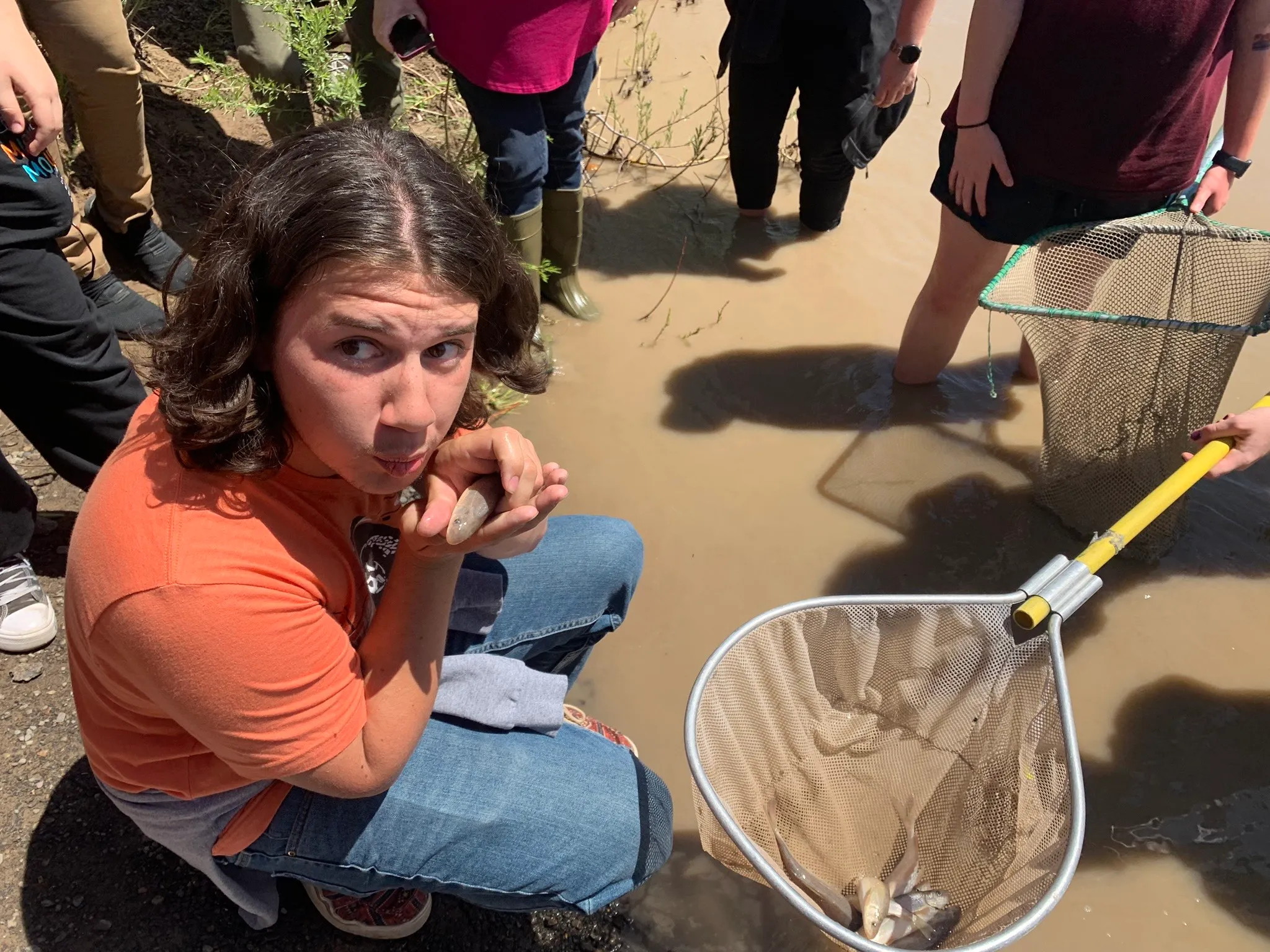
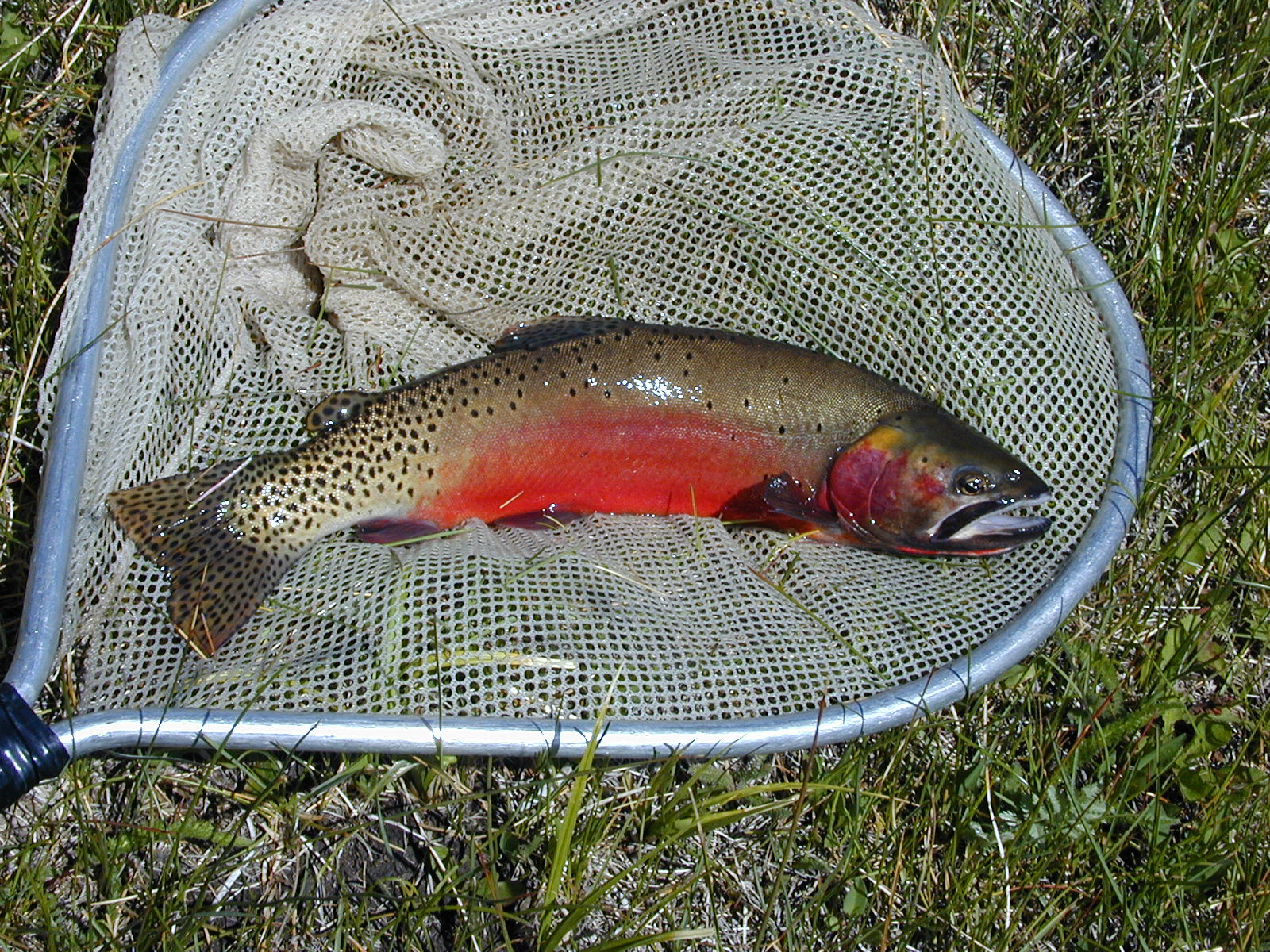
CPW biologists hopeful as genetically unique cutthroat trout rescued from 2016 wildfire are found to be reproducing in SE Region streams
COALDALE, Colo. – Eight years after wildfire and flashfloods threatened to wipe out a genetically unique cutthroat trout from tiny Hayden Creek, Colorado Parks and Wildlife biologists are finding hopeful signs that their efforts to save the fish are succeeding.
Recent surveys of creeks where CPW has reintroduced the unique trout found evidence they are surviving multiple years – a huge milestone in any wildlife restoration project. Even more important, CPW biologists are finding newly hatched Hayden Creek cutthroat (HCC), meaning they are naturally reproducing in some streams and thriving.
“This is very exciting news for these fish and for the agency, considering the odds they faced back in 2016,” said Paul Foutz, senior aquatic biologist for CPW’s Southeast Region.
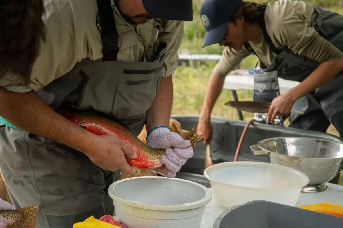
In July 2016, as a wildfire raged on Hayden Pass south of Coaldale, a small army of CPW aquatic biologists, hatchery staff, and U.S. Forest Service personnel donned fire-resistant suits, strapped on heavy electro-shocking backpacks, carried oxygen bottles, nets and water tanks and headed behind fire lines to pull off a daring rescue of a rare cutthroat trout from the south fork of Hayden Creek.
The dramatic effort was undertaken because massive wildfires like the Hayden Creek Fire, which charred 16,754 acres that summer, often produce ash and debris that wash into creeks and rivers, ruining water quality, choking off aquatic life and destroying habitat.
That day in 2016, CPW biologists found and removed 194 of the rare HCC trout, before the team returned to safety outside the fire zone. And their worst fears about the creek quickly came true when runoff from later rains overwhelmed Hayden Creek with a thick, black sludge that ultimately poured into the Arkansas River, damaging fish and habitat for miles in that waterway.
After the fire, surveys of Hayden Creek found no fish remained.
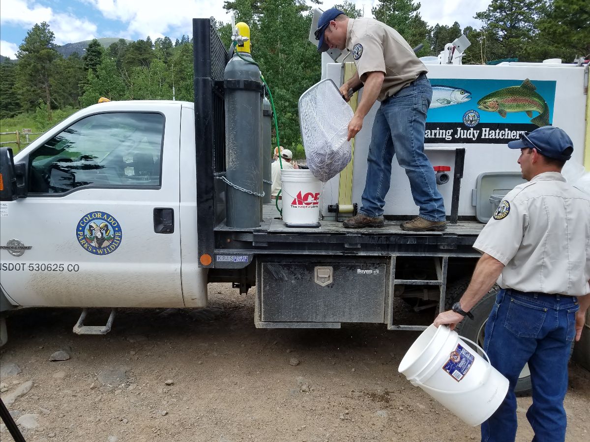
The only known survivors were 158 of the rare fish rescued by CPW staff and placed in an isolation unit at the Roaring Judy Hatchery near Gunnison. The other 36 had been released in nearby Newlin Creek, in the Wet Mountains about 10 miles southwest of Florence, in hopes they would survive in the wild.
Almost immediately, CPW aquatic biologists began the urgent task of finding new homes out on the landscape for the Hayden Creek cutthroat. The staff at Roaring Judy planned to keep the survivors as a brood stock and spawn new generations each spring. But they couldn’t all live in the hatchery.
So similar sized creeks within the Arkansas River drainage were scouted. Biologists wanted creeks that were comparable in size and habitat characteristics offering year-round flow and that were remote enough to protect the prized HCC trout from human interference.
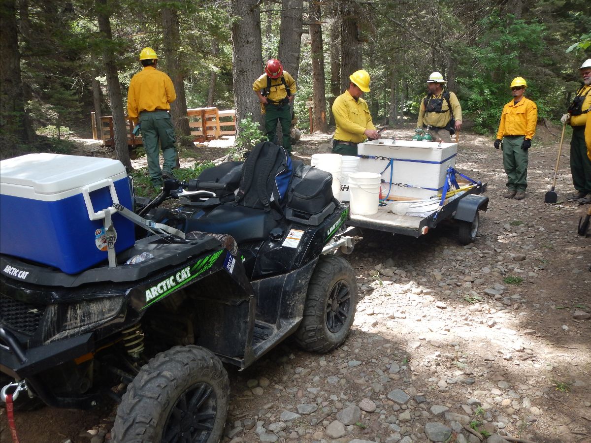
The first creek deemed suitable was Newlin, where 36 were released during the fire. In October 2017, a team of 20 aquatic biologists, other staff and volunteers from CPW and the U.S. Forest Service (USFS) fanned out across the five drainages that make up Newlin Creek, which twists and turns through thick brush and rock in the rugged foothills.
The biologists split into six teams and bushwhacked up and down six miles, give or take, of the remote upper reaches of Newlin Creek, following the creek’s main stem and four branches. They snaked along treacherous cliffs, through jumbles of huge boulders and under fallen trees between Locke and Stull mountains.
The teams hiked for hours as the sun turned the day into short-sleeve weather, taxing some of the crew clad in rubber wading outfits and lugging 30-pound electrofishing units on their backs.
Anywhere that trickles of water pooled enough to offer fish habitat, the CPW/USFS teams stopped and probed the pools with their electrofishing units in hopes of catching a few of the 36 fish that were released during the fire.
They repeated the process dozens of times as they thrashed through the brush, scrambled over rocks, under felled trees and past caves and piles of bones from predator kills. At the end of a 10-hour marathon fish survey, the results were clear: none of the 36 HCC trout had survived.
But that day of scouting convinced the CPW team that Newlin Creek could serve as the new home for HCC trout spawned at Roaring Judy.
Biologists began the painstaking task of reclaiming Newlin of any existing fish that might compete with the HCC trout. Only then could stocking begin.
The work climaxed Oct. 24, 2018, when 900 HCC trout, each about 2 inches long, were carried in bags by CPW staff up Newlin Creek and released.
The restoration effort eventually expanded to 13 other streams across the Arkansas Drainage. Spreading them across the region makes them less vulnerable to extinction due to an isolated catastrophic fire or flood event.
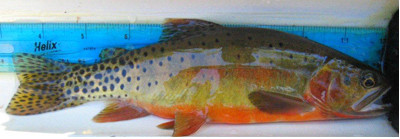
Since that first stocking in 2018, more than 8,000 HCC trout have been released in Newlin along a 1.5-mile stretch of water. After years of observing survival of the HCC trout in Newlin, CPW biologists documented evidence of natural reproduction in surveying the creek in 2024.
On July 20, 2016, a team of Colorado Parks and Wildlife aquatic biologists and staff assembled and enter an active fire zone during the Hayden Pass Wildlife to rescue genetically unique cutthroat trout from the south prong of Hayden Creek. Photo credit: Colorado Parks & Wildlife
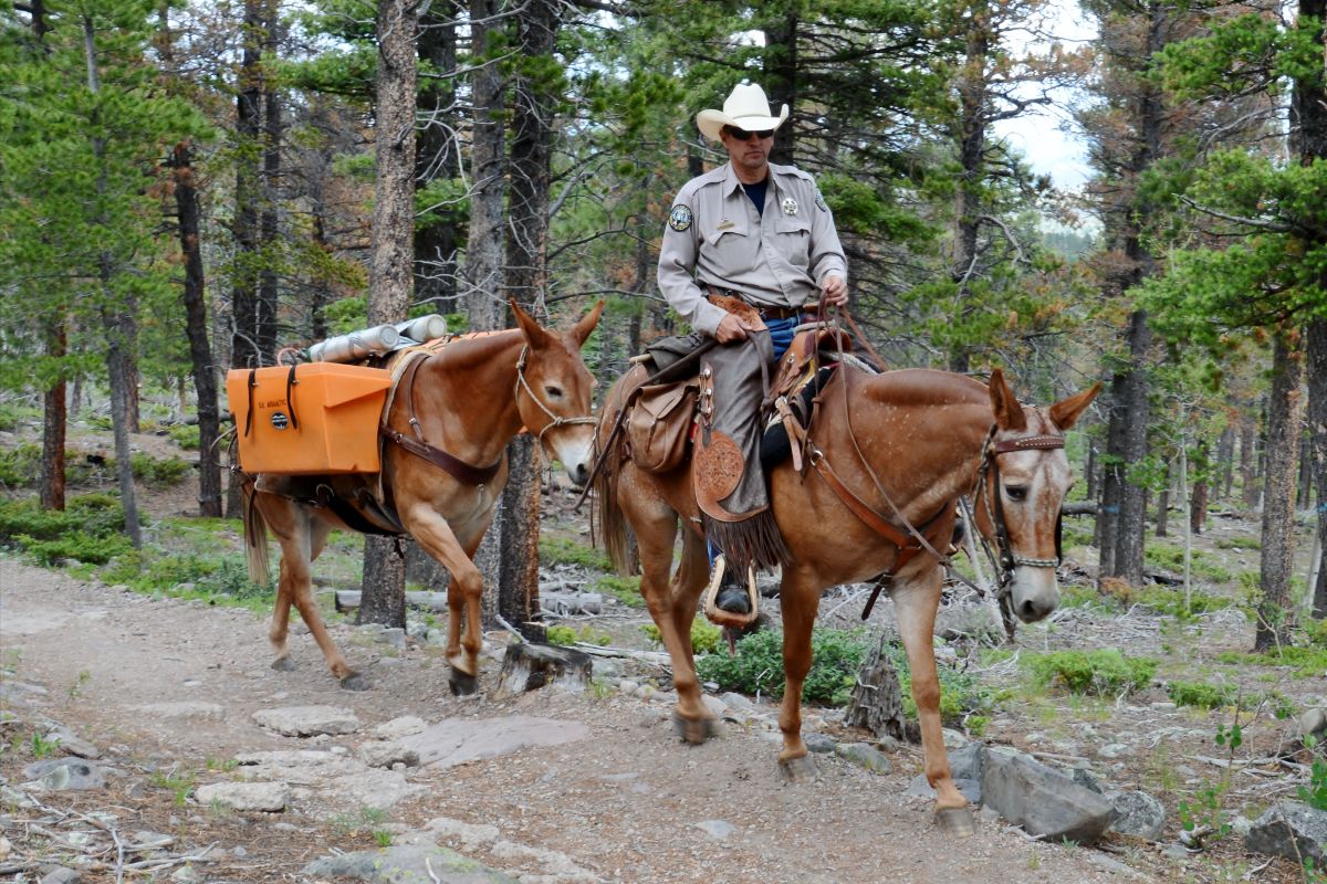
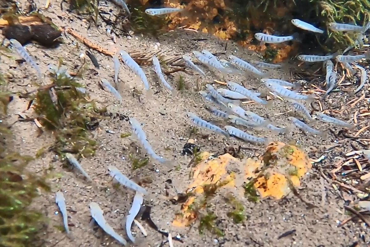
In October 2018, CPW began stocking Hayden Creek cutthroat fingerlings, spawned in the Roaring Judy Hatchery near Gunnison, into Newlin Creek. Hatchery staff delivered the fingerlings, which were separated into bags and hauled up the creek by CPW staff and released. Photo credit: Colorado Parks & WildlifeDuring a July 20, 2016, rescue effort, CPW aquatic biologists carried electrofishing backpacks, nets, oxygen tanks and coolers to haul out any of the rare cutthroat, now called Hayden Creek cutthroat, before ash and debris from the fire overwhelmed the drainage. Photo credit: Colorado Parks & WildlifeA CPW aquatic biologist displays a Hayden Creek cutthroat trout in a net during a July 20, 2016, rescue of fish during the Hayden Pass Wildfire. Photo credit: Colorado Parks & WildlifeIn October 2018, CPW began stocking Hayden Creek cutthroat fingerlings, spawned in the Roaring Judy Hatchery near Gunnison, into Newlin Creek. Hatchery staff delivered the fingerlings, which were separated into bags and hauled up the creek by CPW staff and released. Photo credit: Colorado Parks & WildlifeCPW Wildlife Officer Justin Krall leads his mule Jenny with panniers full of rare Hayden Creek cutthroat trout to be stocked into Cottonwood Creek in a 2019 stocking event. Photo credit: Colorado Parks & WildlifeHayden Creek cutthroat trout fingerlings swim in the current of Cottonwood Creek in this 2019 photo. Photo credit: Colorado Parks & Wildlife
Drops wastewater rate increase from 30 percent to 10 percent
At a Dec. 20 special meeting, the Pagosa Area Water and Sanitation District (PAWSD) Board of Directors approved the district’s 2025 budget…The 2025 budget includes $1,345,822 in revenues for the PAWSD general fund, primarily from property taxes, and $1,647,189 in expenditures, a 20 percent increase from 2024…The budget indicates that legal and professional spending, as well as spending on maintenance and computer support and upgrades, are anticipated to increase in 2025…
The general fund balance at the end of 2025 is projected to be $1,448,928, down 17 percent from the end of 2024…The PAWSD water enterprise fund is projected to receive $33,450,308 in revenues, including $5,609,336 in service charge revenue, $1 million in capital investment fee (CIF) and raw water acquisition fee revenue, and $25.2 million in loan proceeds, which will be used for the continued construction of the Snowball Water Treatment Plant expansion. Overall, revenues for the fund are projected to rise 5 percent from 2024. Expenditures for the fund are budgeted at $35,934,411, an 18 per-cent increase from 2024
Colorado Springs. Photo credit: Allen Best/Big Pivots
Click the link to read the article on the Big Pivots website (Allen Best):
December 19, 2024
Transmission line in southeast Colorado a cause for guarded optimism among utility leaders
Interstate highways have transformed Colorado and America altogether. People growing up in the 1950s rarely had fresh fruit or vegetables in winter. Now, broccoli beheaded yesterday in a field near Yuma, Ariz., can be on a store shelf in metro Denver within a day or two. Much of that journey will be on an interstate highway.
High-voltage transmission lines are our four-lane highways of electricity. They worked well enough when giant coal plants provided most of our electricity. Now, as Colorado and other states strive to replace fossil fuels with renewables, new connections must be built, to knit us together across broader areas.
A federal agency this week delivered cause for cautious optimism. The Department of Energy has picked three transmission corridors among 10 national candidates for advanced work. One of them, the Southwestern Grid Connector Corridor, would begin in southeast Colorado near Lamar, and work south into New Mexico and then somewhat west.
The 2021 Bipartisan Infrastructure Law authorized the secretary of energy to designate any geographic area as a national interest electric transmission corridor. The energy department has found that absence of transmission harms consumers. With more transmission, we can share low-cost renewable generation across broader areas. We need an electric grid larger than one weather system and covering more than one time zone.
The existing transmission network is akin to our highways of 50 to 60 years ago. We have transmission, but it’s as if Interstate 70 stopped at the state line. In fact, transmission lines do. Colorado is in the Western electrical grid of 10 states and some adjoining areas. This grid, however, is better understood as a collection of 34 different islands connected by narrow causeways.
“A cautious hurrah,” said Mark Gabriel, the CEO of United Power when I asked his reaction. The Brighton-based electrical cooperative supplies 113,000 members from the foothills to Weld County’s oil and gas fields, including many new industrial centers along I-76.
“Anything that promotes additional transmission is a good thing,” said Gabriel. “However, the challenge remains in actually getting something constructed in a reasonable period of time to make a difference.”
Gabriel pointed out that more than $40 billion in transmission projects have been announced. “Only a fraction are actually being built.”
Permitting has been the bane of many transmission projects. For example, it took 18 years before the TransWest Express Transmission project that will ferry wind-generated electricity from southern Wyoming to Utah and West Coast markets finally broke ground in 2023. It nicks the corner of northwest Colorado.
A bill being negotiated in Congress would ease federal permitting requirements to allow more rapid creation of transmission lines. Other provisions of the Energy Permitting Reform Act of 2024 would also benefit oil and gas extraction.
Tri-State Generation and Transmission, the wholesale provider for 17 of Colorado’s 22 electrical cooperatives, pointed to the need for streamlined permitting in its reaction to the transmission line in southeastern Colorado.
Transmission doesn’t come cheap. And just as interstate highways have their unsavory aspects — my companion and I can routinely hear I-70 roaring a mile away — transmission lines have their downsides. Who wants one in their backyard?
Baca County has Colorado’s best wind resource and it gets plenty of sunshine. Lacking has been transmission. Top photo transmission in Colroado Springs. Photo credit: Allen Best/Big Pivots
Some want to believe nuclear energy will solve all of our problems. The Pueblo City Council, while saying nice things about nuclear, intends to scrap a goal of 100% renewables by 2035. Maybe nuclear will be an answer, but recent projects have had eye-bulging costs. Natural gas has problems, too, as was evident in Winter Storm Uri of February 2021 when costs soared.
Chris Hansen, as a state legislator from Denver, sponsored key legislation to push transmission planning in Colorado. Now in Durango as CEO of La Plata Electric, he has started working on guiding his electrical cooperative to 97% emission-free electricity in the next decade. Transmission, he says, will be crucial.
Capacity of existing transmission lines can be expanded by reconductoring and other technology. But we altogether need to be better connected east and west, north and south.
One crucial question, says Hansen, is whether Denver-based Chris Wright, the choice of Donald Trump to be secretary of energy, will support continued transmission planning. His Colorado-based career has been in oil and gas. Wright sees renewables as a distant solution.
Southeastern Colorado brims with renewable energy potential. Baca County has Colorado’s best wind, according to a 2017 study by the National Renewable Energy Laboratory. It also has strong solar. That’s why corn grows so well there — assuming it has water. The water of the Ogallala Aquifer won’t last, but the solar and wind almost certainly will. What it lacks now is a farm-to-market transmission highway.
This story was originally published by The Land Desk and is republished here by permission.
On a mid-November evening I stood on a gravelly plain, shivering in the wind as clouds dangled their wispy fingers of snow onto Cedar Mesa to the north of me. The long sunset finally fizzled into darkness and I watched for the one-day-past-full moon to rise over the Valley of the Gods. But the dark horizon never yielded the anticipated orb. Instead, I was treated to evanescent shards of orangish light escaping through cracks in the clouds.
I was in southeastern Utah on a nearly flat expanse of scrub-covered limestone some 1,200 feet above the winding and silty San Juan River. I was also just barely inside the boundaries of Bears Ears National Monument. At least for now. But the national monument protections on my little dispersed campsite, along with a good portion of the landscape I looked out upon, will likely go away shortly after President-elect Donald Trump takes office next year.
Last week the New York Timesreported that Trump will again shrink Bears Ears and Grand Staircase-Escalante National Monuments back to the diminished boundaries he established in 2017. The 1.36-million-acre Bears Ears — which President Joe Biden restored in 2021 — will become a 200,000 acre national monument divided into two discrete units. Left out will be Valley of the Gods, Cedar Mesa, the Goosenecks of the San Juan, the White Canyon and Dark Canyon regions, and portions of Butler and Cottonwood Washes.
Raplee Ridge in Bears Ears National Monument.
Photo credit: Jonathan P. Thompson
The act is likely illegal, since the Antiquities Act only gives presidents the power to establish national monuments, not shrink or eliminate them. And it will revive lawsuits still pending since Trump’s previous shrinkage. But while the legal challenges wend their ways through the courts, Trump’s shrinkage will take hold (barring a court injunction). The draft management plan that federal officials and tribal representatives have worked on for years will be rendered obsolete before it’s even approved, and about 1.2 million acres of public land will be re-opened to new mining claims and oil and gas and coal leasing.
There are the conservation consequences to think of, which I’ll get to, but more importantly is the symbolic significance. Bears Ears was originally proposed and conceived of and pushed by five sovereign tribal nations — with the backing of another two dozen tribes — who were looking to protect lands that had been stolen from them and put into the “public domain.” Representatives from those tribes had a hand in crafting the new management plan, which uniquely incorporates Indigenous knowledge into decision-making.
By overturning the national monument, Trump is thumbing his noses at those same tribal nations, essentially telling them that their efforts and ties to this land are meaningless. As I stood out there dissolving into the darkness, a question arose: Why? Why the hell would a Manhattan real estate developer and reality show personality, who probably had never set foot on the West’s public lands, make such a cruel and thoughtless gesture? What was he hoping to achieve?
I’ve posited potential motives for the initial shrinkage. Trump wanted to curry favor with the powerful Sen. Orrin Hatch, of Utah, so he could gut Obamacare and get tax cuts for the wealthy through Congress. He wanted to help out his friends in the uranium mining and oil and gas industries. He wanted to repay Utah voters for abandoning their principles and voting for him.
Snow virgas over Cedar Mesa. Photo credit: Jonathan P. Thompson
But the oil and gas industry isn’t exactly champing at the bit to drill in the Bears Ears area. There are many other more accessible and profitable places to chase hydrocarbons. And in 2017 the domestic uranium mining industry was virtually nonexistent, and its 200 or so employees hardly made for a significant voting bloc. Mark Chalmers and Curtis Moore, the CEO and VP of Energy Fuels, probably the most viable uranium mining and milling company out there, didn’t even donate to any of Trump’s presidential campaigns.
It really seems that Trump diminished Bears Ears and Grand Staircase-Escalante National Monuments for no other reason than to dismantle the environmental legacies of his rivals and predecessors, former Presidents Bill Clinton and Barack Obama. And given his cabinet picks so far, Trump is planning on more of the same in his second term. He “governs” out of greed and self-interest, first, followed closely by spite — aimed at liberals, his political rivals, and Republicans who don’t show enough fealty to him.
The expected shrinkage won’t have an immediate impact on the landscape where the protections are lifted, which will simply revert back to federal land managed under the multiple-use mandate. Come Jan. 20, there will not be a battalion of drilling rigs marching upon the weird formations of Valley of the Gods or mines opening up in White Canyon’s cliffs.
Yet there will be longer term consequences. All of the debate and back and forth over the national monument has attracted more visitors to the general area, and that has brought more impacts. Taking away national monument status from most of those lands will not reduce visitation, but it will take away resources for and opportunities to manage their impacts. The Trump-era management plan, which was hardly a plan at all and replaced the tribal commission with a bunch of monument opponents, will remain in place, rendering what’s left of the national monument almost meaningless.
After Trump’s first shrinkage, speculators and would-be mining firms staked a handful of claims in lands that had been taken out of Bears Ears national monument. That was when the uranium industry was moribund. Now, higher prices, a renewed interest in nuclear power, and a ban on enriched reactor fuel from Russia has given the industry new life. While uranium production remains minimal, exploration has kicked up significantly, including in lands just outside the Bears Ears boundary. This time around we’re likely to see not only mining claims being staked soon after the shrinkage in places like White Canyon and Cottonwood Creek, but also exploratory drilling. Even if companies don’t have any short-term interest in mining in the area, the drilling can help them establish the claims’ validity, thereby increasing the likelihood that the right to mine those parcels would be locked in if a future administration or the courts were to restore Bears Ears.
Just as night became complete, the moon emerged from behind the clouds and cast a pale light over everything. At the same time, I saw my friends’ truck’s headlights bouncing up the road, so I trudged through the cold to guide them to the campsite. We laughed and talked and played music. One was still reeling from the shock of the presidential election’s outcome, the other, who works with rural communities across the West, had seen Trump’s victory as almost inevitable.
Eventually, I snuggled up in my sleeping bag in my little tent and emerged more than ten hours later, just as the moon was getting ready to set and the sun prepared to rise over the corner of the Carrizo Mountains along the New Mexico-Arizona border. The landscape around me slowly revealed itself as if awakening from slumber. Later, under the almost harsh blue sky, my friends and I made our way almost aimlessly across the scrub-covered plain, trying to avoid the Russian thistle that had proliferated after more than a century of cattle grazing and following the erratic cow paths when we encountered them.
At one point we heard the report of what sounded like a semi-automatic firearm being shot in the distance. It wasn’t a hunter, I’m sure of that. More likely a recreational shooter looking to waste some ammo before the proposed shooting ban goes into effect — though now it’s not likely to. Maybe they were targeting cans, or petroglyphs, or a desert-varnish-covered boulder or grazing cattle. I involuntarily flinched at each bang.
Sunset in Bears Ears National Monument. Photo credit: Jonathan P. Thompson
I walked with gratitude for the beauty all around and the freedom to wander through it. I walked with sadness, too, and anger at those who would try to reduce this place, this living landscape, to a pawn in their petty and vindictive game, and who would try to open it back up to corporations looking to wring every last particle of profit from it. But I also found hope in the knowledge that powerful tribal nations, land protectors and nonprofits will continue their fight to protect this land and challenge the spiteful attempts to diminish this place.
We came to the edge of the San Juan River gorge and dropped into it, following a path forged by gold prospectors back during the “Bluff Excitement” of the early 1890s, when folks thought they could get rich by scouring the San Juan River’s banks for flakes of gold. The gold rush fizzled before it got started, but the trail endures. After reaching its terminus, we stopped our banter and sat quietly and listened to the silty waters gurgle by slowly and watched a red tail hawk frolic reassuringly in the updrafts far above. The future is uncertain, but this much I know: Beauty will persist regardless of who occupies the White House.
In the heart of Northern Minnesota lies a place that inspired the powerful film Saving Silence. Join POW Creative Alliance Captain, Emily Tidwell as she returns to the Boundary Waters Canoe Area, reflecting on how this wild landscape saved her life. ‘Saving Silence’ dives deep into mental health, the critical importance of public lands, and the unsettling presence of microplastics in some of the world’s most remote places. Emily reconnects with Arctic explorer Lonnie Dupre and Clare Shirley, owner of Sawbill Canoe Outfitters, to discuss why protecting this pristine wilderness is more crucial than ever. Thank you to Fat Tire and Visit County Cook for making this possible! Written and produced by Emily Tidwell. Cinematography and editing by Beau Larson. Additional cinematography Spencer Duclos. Audio Design Keith White. Color Design by Jonny Siroteck and Logan Pehota.
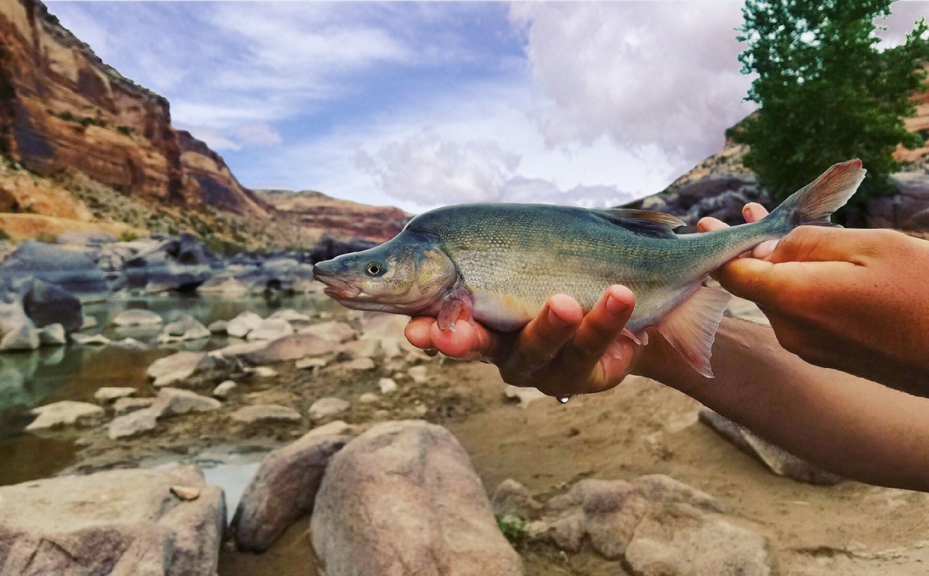
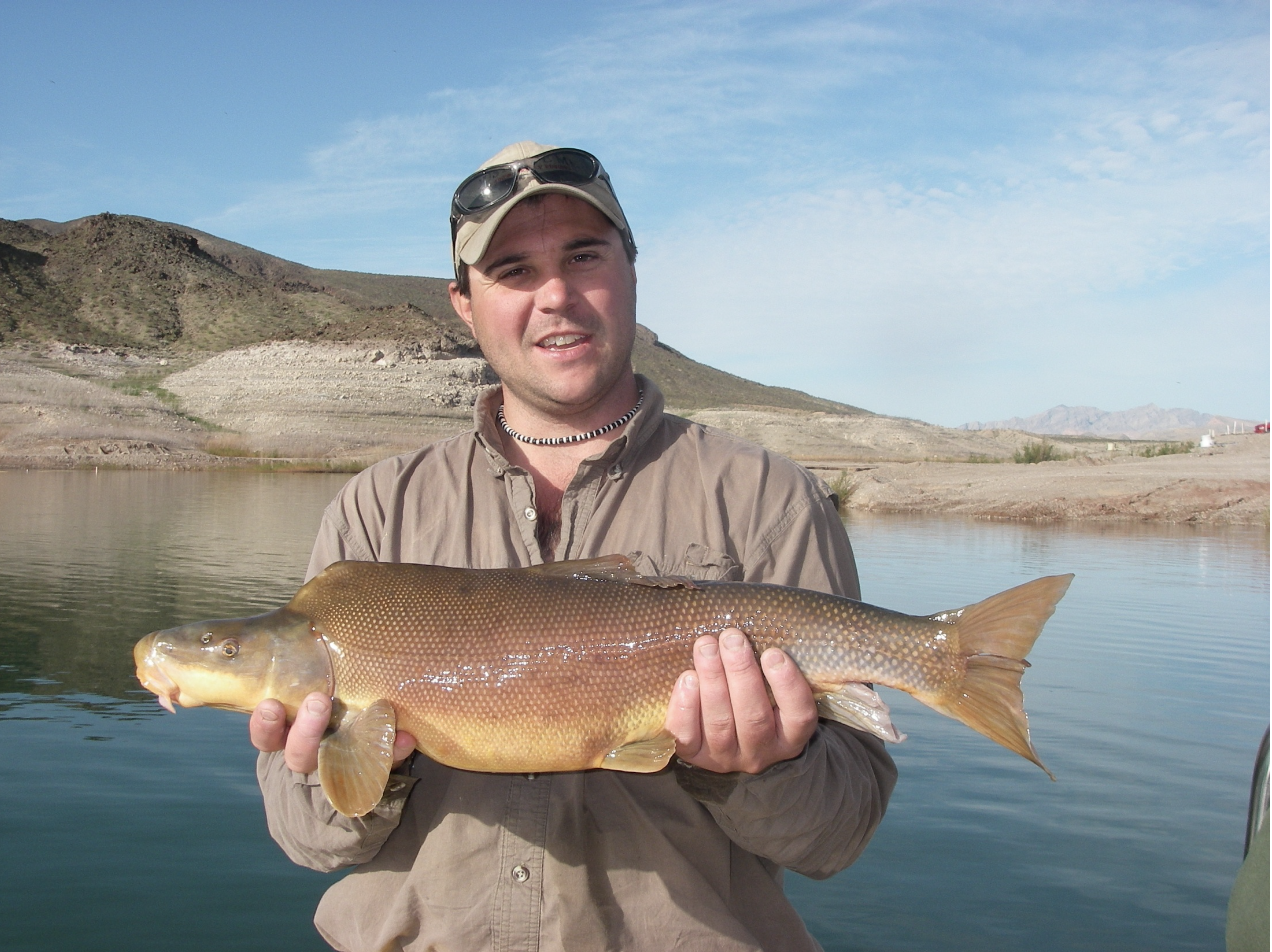
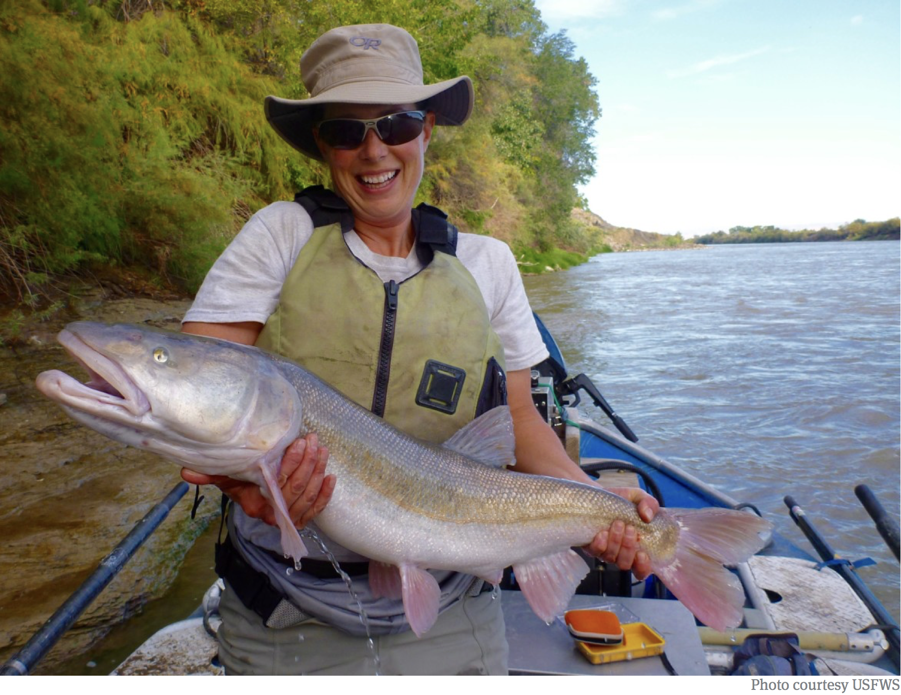
The threatened Humpback Chub is one of four fish species that programs in Colorado and other Western states have been working to recover for nearly three decades. U.S. Fish and Wildlife Service/ Courtesy Photo
For nearly three decades, Colorado and other Western states have been working to recover several species of endangered fish in the Colorado and San Juan river basins. Congress last week approved a bill that will renew the program’s federal funding for seven more years. The bill was included in the 2025 National Defense Authorization Act, which is heading to President Joe Biden’s desk. Sens. John Hickenlooper, D-Colo., and Mitt Romney, R-Utah, sponsored the fish recovery program’s reauthorization act. Rep. Lauren Boebert, R-Colo., sponsored the bill in the House.
“Local communities, Tribes, water users, and Congress — we’re all in to protect our native fish and rivers,” Hickenlooper stated in a news release. “These programs are tried and true. Our extension will help continue them to save our fish and make our rivers healthier.”
Federal authorization for the two fish recovery programs — the Upper Colorado River Endangered Fish Recovery in Colorado, Utah and Wyoming as well as the San Juan Recovery Implementation Program in Colorado and New Mexico — expired this September. The reauthorization act, however, will extend the programs through 2031, authorizing the U.S. Bureau of Reclamation to contribute up to $92 million in the next seven years. The bill also adds up to $50 million for capital projects that support infrastructure improvements to recover the threatened and endangered species…The annual operating costs for the programs were historically funded by Colorado River Storage Project hydropower revenues, which have diminished over time due to drought, declining reservoir storage, increased costs and more, according to a September Colorado Water Conservation board memo. This has required the federal and state appropriations and contributions to increase to cover costs, it adds. The fish recovery programs also rely on in-kind contributions and funding from other partners. Both programs have sought to recover populations of four species — the humpback chub, razorback sucker, Colorado pikeminnow and bonytail fish — in these basins. When the Upper Colorado and San Juan programs were established in 1988 and 1992, all four species faced extinction, but they have seen some success.
The Gold King Mine’s level 7 adit and waste rock dump, boarding house, and other associated structures, circa 1906. Via the Land Desk
Click the link to read the article on the Land Desk website (Jonathan P. Thompson):
December 13, 2024
⛏️Mining Monitor ⛏️
The News: After decades of trying, Congress finally passed a “good samaritan” mine remediation bill that could help nonprofits and other non-governmental organizations clean up abandoned mining sites.
The Context: In 1994, the state of Colorado, with the help of Bill Simon and other volunteers, launched the Animas River Stakeholders Group to study and address abandoned mines in the upper Animas River watershed. It would be a collaborative approach — without heavy-handed regulations or the dreaded Superfund designation. “We figured we could empower the people in the community to do the job without top-down management,” Simon told me back in 2016. “Giving the power to the people develops stewardship for the resource, and that’s particularly useful in this day and age.”
Their task was a monumental one: The US Geological Survey has catalogued some 5,400 mine shafts, adits, tunnels, and prospects in the upper Animas watershed. Nearly 400 of them were found to have some impact on water quality, about 60 of which were major polluters, contributing about 90% of the mining-related heavy metal loading in streams. Dozens of abandoned mine adits collectively oozed more than 436,000 pounds of aluminum, cadmium, copper, iron, and zinc into the watershed each year, with waste rock and tailings piles contributing another 80,000 pounds annually.1
The upper Animas isn’t unusual in this respect. A 2020 Government Accountability Office report estimated that there are more than 500,000 abandoned mining-related sites and features across the Western United States. While most of those are hardly noticeable and have little effect on the environment, at least 100,000 of them were found to pose physical or environmental hazards.
Those hazards range from open mine shafts (that can swallow up an unsuspecting human or animal), to contaminated tailings or waste rock piles, to the big one: mine adits discharging heavy metal-laden acid mine drainage into streams. Federal and state programs exist to address some of these hazards. But the sheer number of problematic sites, and the fact that many are on private lands, makes it impossible for these agencies to remediate every abandoned mining site.
So, for the last few decades, nonprofits and collaborative working groups like the Animas River Stakeholders have taken up some of the slack. With funding from federal and state grants and mining companies, the Stakeholders removed and capped mine waste dumps, diverted runoff around dumps (and in some cases around mines), used passive water treatment methods on acidic streams, and revegetated mining-impacted areas.
This image was taken during the peak outflow from the Gold King Mine spill at 10:57 a.m. Aug. 5, 2015. The waste-rock dump can be seen eroding on the right. Federal investigators placed blame for the blowout squarely on engineering errors made by the Environmental Protection Agency’s-contracted company in a 132-page report released Thursday [October 22, 2015]
But the most pernicious polluters — the draining adits — were off limits. The volunteer groups couldn’t touch them, because to do so would require a water discharge permit under the Clean Water Act, and that would make the Stakeholders liable for any water that continues to drain from the mine, and if anything went wrong. In other words, if some volunteers were trying to remediate the drainage from a mine, and it blew out Gold King-style, the volunteers would be responsible for the damage it inflicted — which could run into the hundreds of millions of dollars.
For the last 25 years, the Animas River Stakeholders2, Trout Unlimited, other advocacy groups, and Western lawmakers have pushed for “good samaritan” legislation that would allow third parties to address draining mines without taking on all of the liability. Despite bipartisan support, however, the bills struggled and ultimately perished.
That’s in part due to concerns that bad actors might use the exemptions to shirk liability for mining a historic site. Or that industry-friendly EPA administrators might consider mining companies to be good samaritans. And back in 2015 Earthworks pointed out that good samaritan legislation wouldn’t address the big problem: A lack of funding to pay the estimated $50 billion cleanup bill. So if a volunteer group did trigger a Gold King-like disaster, the taxpayers would likely end up footing the bill.
But last year, Sen. Martin Heinrich, a New Mexico Democrat, and 39 co-sponsors from both parties introduced the Good Samaritan Remediation of Abandoned Hardrock Mines Act, tightened up to alleviate most concerns. It passed the Senate in July of this year, and was sent to the House, where it also received support from Republicans and Democrats alike.
Assuming President Biden signs it into law, the new act will open the door to more cleanups — but in a limited way. To begin with, the bill only authorizes 15 pilot projects nationwide, which will be determined via an application process. The proponents will receive special good samaritan cleanup permits and must follow a rigorous set of criteria. No mining activities will be allowed to occur in concert with a good samaritan cleanup. However, reprocessing of historic waste rock or tailings may be allowed, but only in sites on federal land, and only if all of the proceeds are used to defray remediation costs or are added to a good samaritan fund established by the act.
Rep. Frank Pallone, a New Jersey Democrat, opposed the bill nonetheless, saying it compromises federal environmental law and “opens the floodgates for bad actors to take advantage of Superfund liability shields and loopholes.” He added that it would give the incoming Trump administration “unilateral power to decide which entities are good samaritans and which are not.”
This isn’t, however, a blanket loophole, it only applies to 15 projects — at least for now. While that limits the damage that could be done by bad actors abusing the liability shields, it also limits the benefits: Fifteen projects isn’t going to go very far in addressing the 100,000 or so hazardous mine sites. The Animas River watershed may not benefit at all, since the 48 sites in the Bonita Peak Mining District Superfund site are not eligible for good samaritan remediation.
Still, the law will open the door for a handful of projects that could improve water quality in some watersheds. The challenge now is figuring out how to address draining mines in an economically feasible fashion. Simply plugging, or bulkheading, the mine adits often isn’t effective, because the contaminated water ends up coming out somewhere else. And treating the draining water is an expensive, and never-ending, process.
The good news is that some funding was made available via the Infrastructure and Inflation Reduction laws passed during the last four years, and just this week the Biden administration gave mining cleanup a boost this week by offering states $3.7 million in grants to inventory, assess, and remediate abandoned hardrock mines.
The bad news is that the legislation that’s really needed — genuine and substantial mining law reform — probably is on hold for at least the next four years.
Prior to mining, snowmelt and rain seep into natural cracks and fractures, eventually emerging as a freshwater spring (usually). Graphic credit: Jonathan Thompson
***
In other mining news, the Biden administration this week halted new mining claims and mineral leasing for the next two years on 165,000 acres in the upper Pecos River watershed west of Santa Fe, New Mexico. The “segregation,” as the action is called, is designed to allow the Interior Department to determine whether to ban mining and drilling in the area for the next 20 years.
Included within the acreage are more than 200 active mining claims held by Comexico LLC, a subsidiary of Australia-based New World Resources. For the past several years, Comexico has been working its way through the permitting process to do exploratory drilling at what it calls its Tererro mining project. It has met with stiff resistance from locals and regional advocacy groups, partly because mining has a dark history in the Pecos River watershed. In 1991, a big spring runoff washed contaminated mine and mill waste from a long-defunct mine into the upper Pecos River, killing as many as 100,000 trout. That prompted a multi-year cleanup of various mining sites.
But the withdrawal won’t stop the project outright, because it doesn’t affect existing, active, valid claims. Yet it can keep the company from staking more claims and may make it harder to develop the existing ones (especially if they haven’t established validity).
What was a bit more of a surprise to me is how it broke down into categories.
📸 (Not Quite) Parting Shot 🎞️
The old Buick at Cow Canyon Trading Post and Cafe in Bluff, Utah, my favorite place to stop and get caffeinated and breakfast burrito’d in Canyon Country. Jonathan P. Thompson photo.
1 These figures did not include the recently closed Sunnyside Mine/American Tunnel or the Gold King, since both were permitted mines at the time, meaning they weren’t abandoned.
2 The ARSG disbanded after much of the watershed was designated a Superfund site.
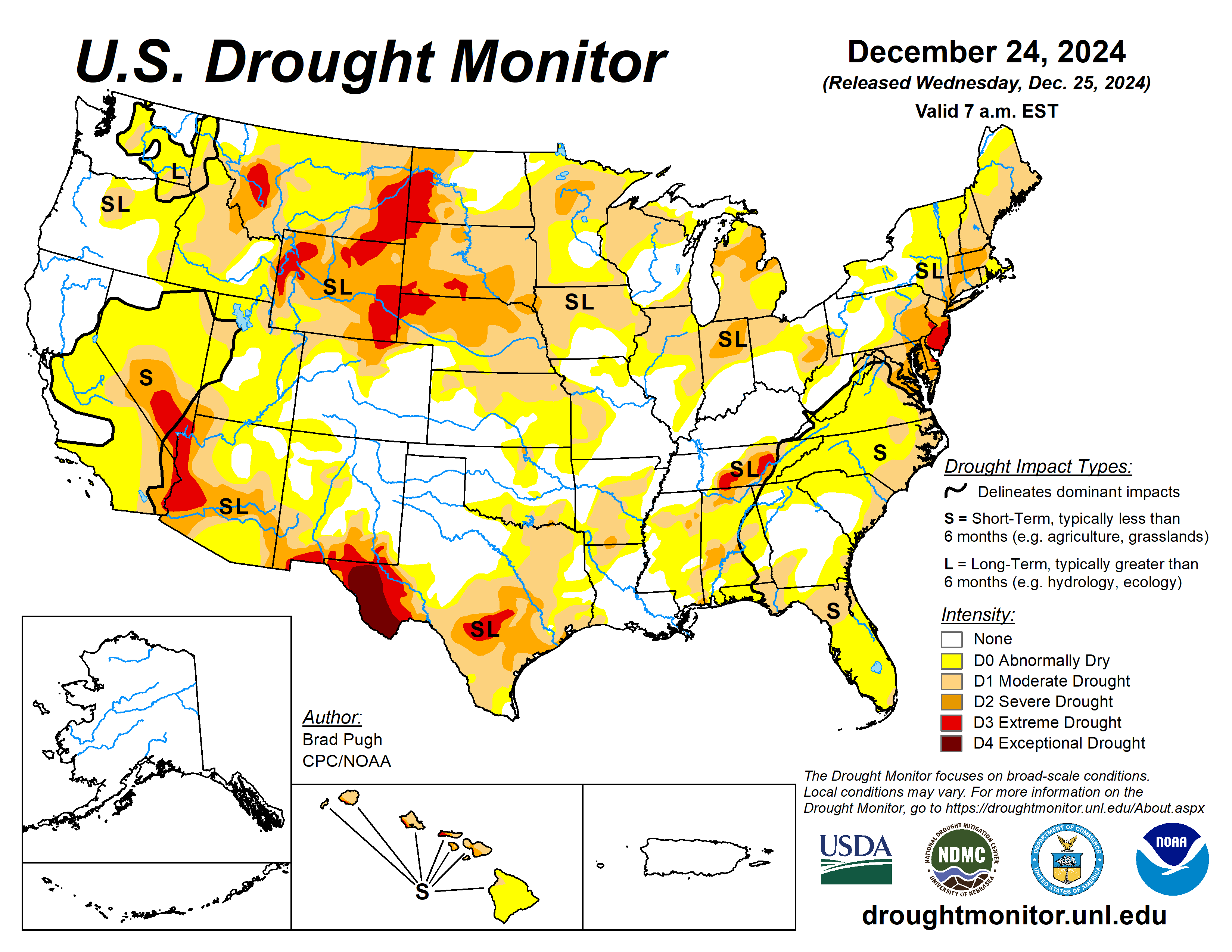
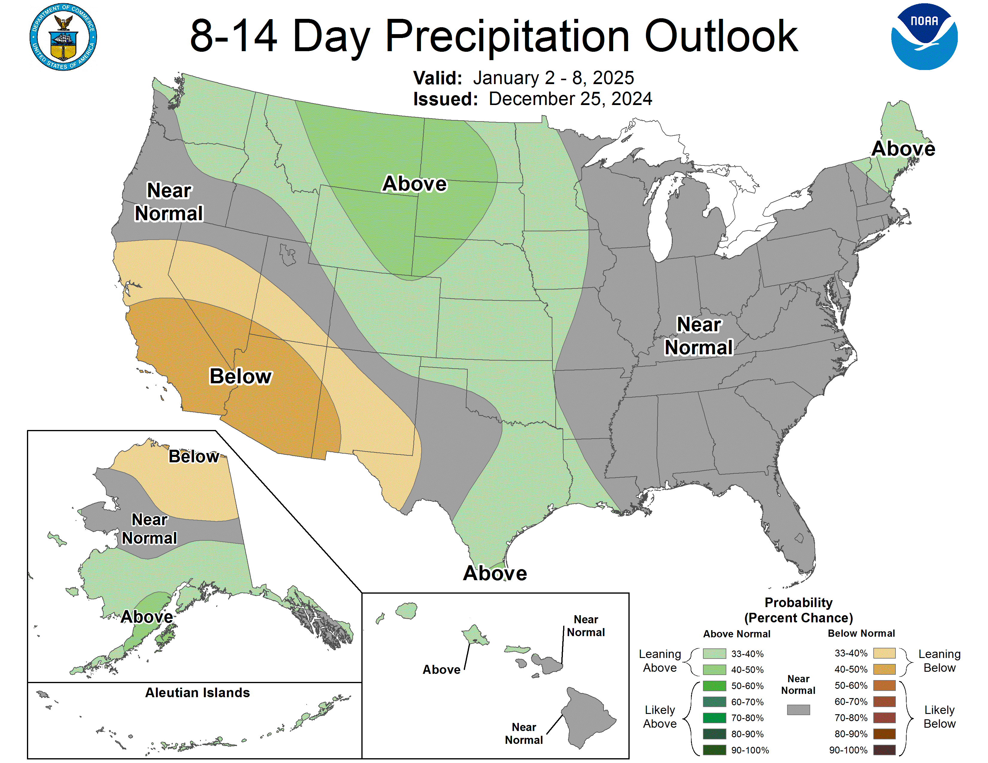
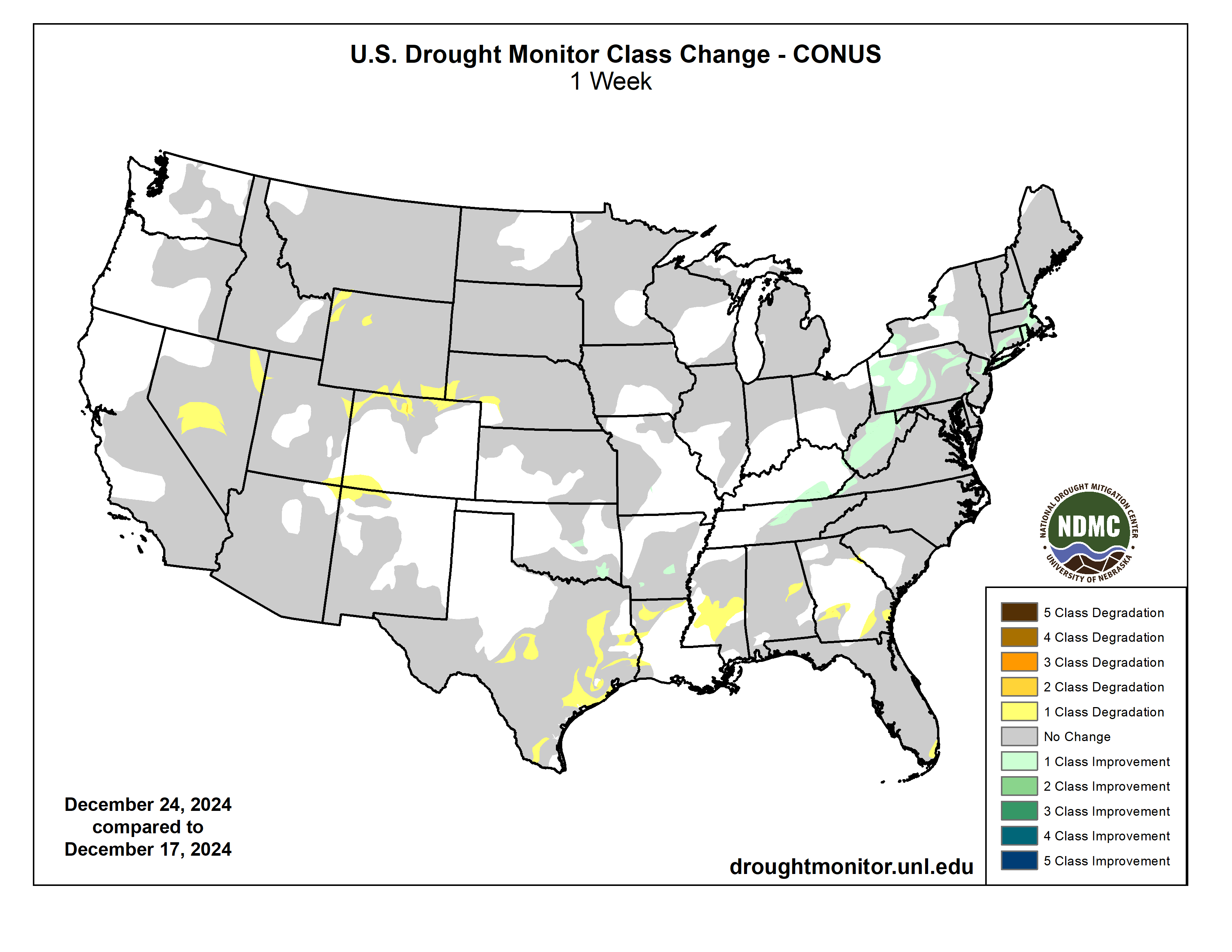
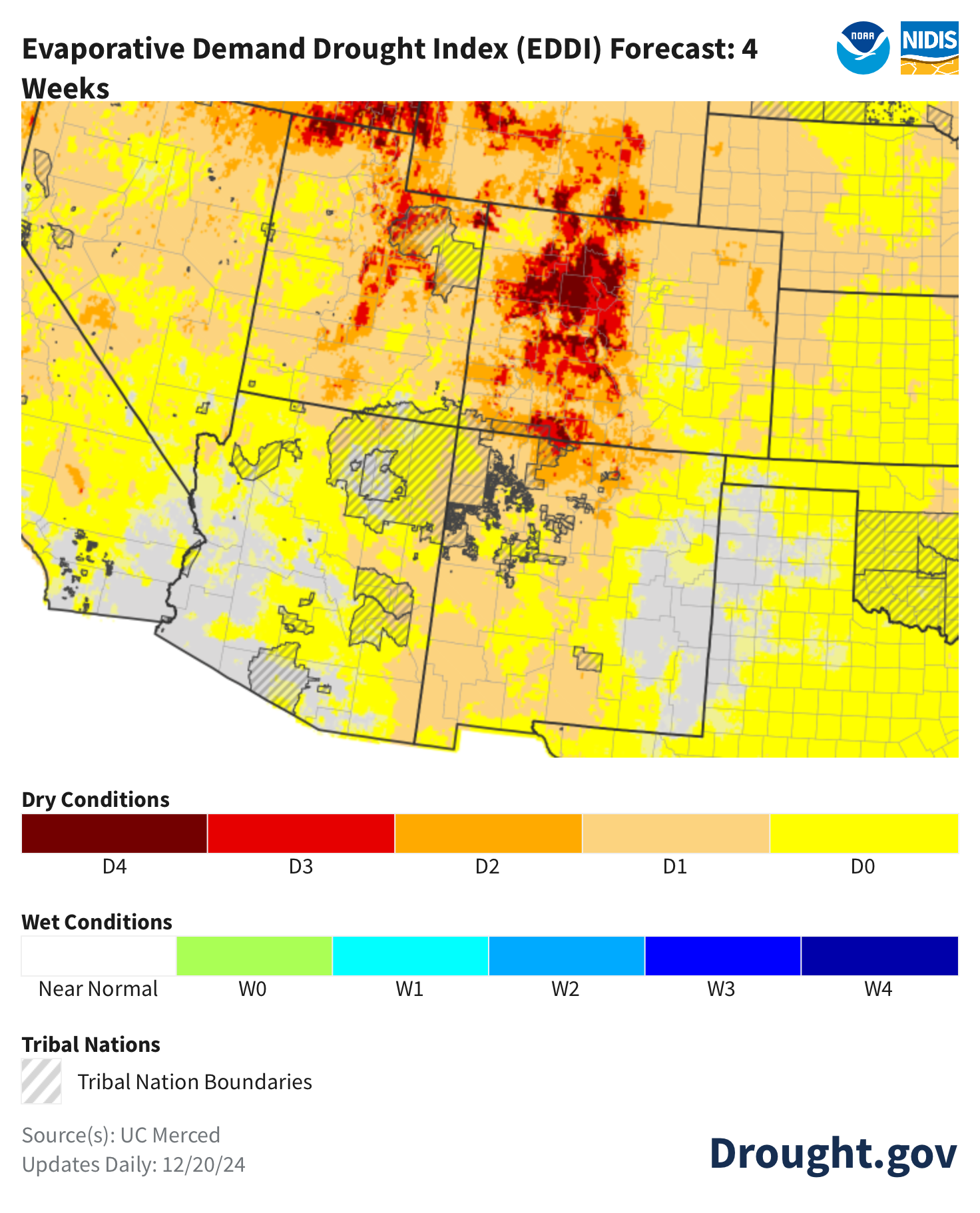
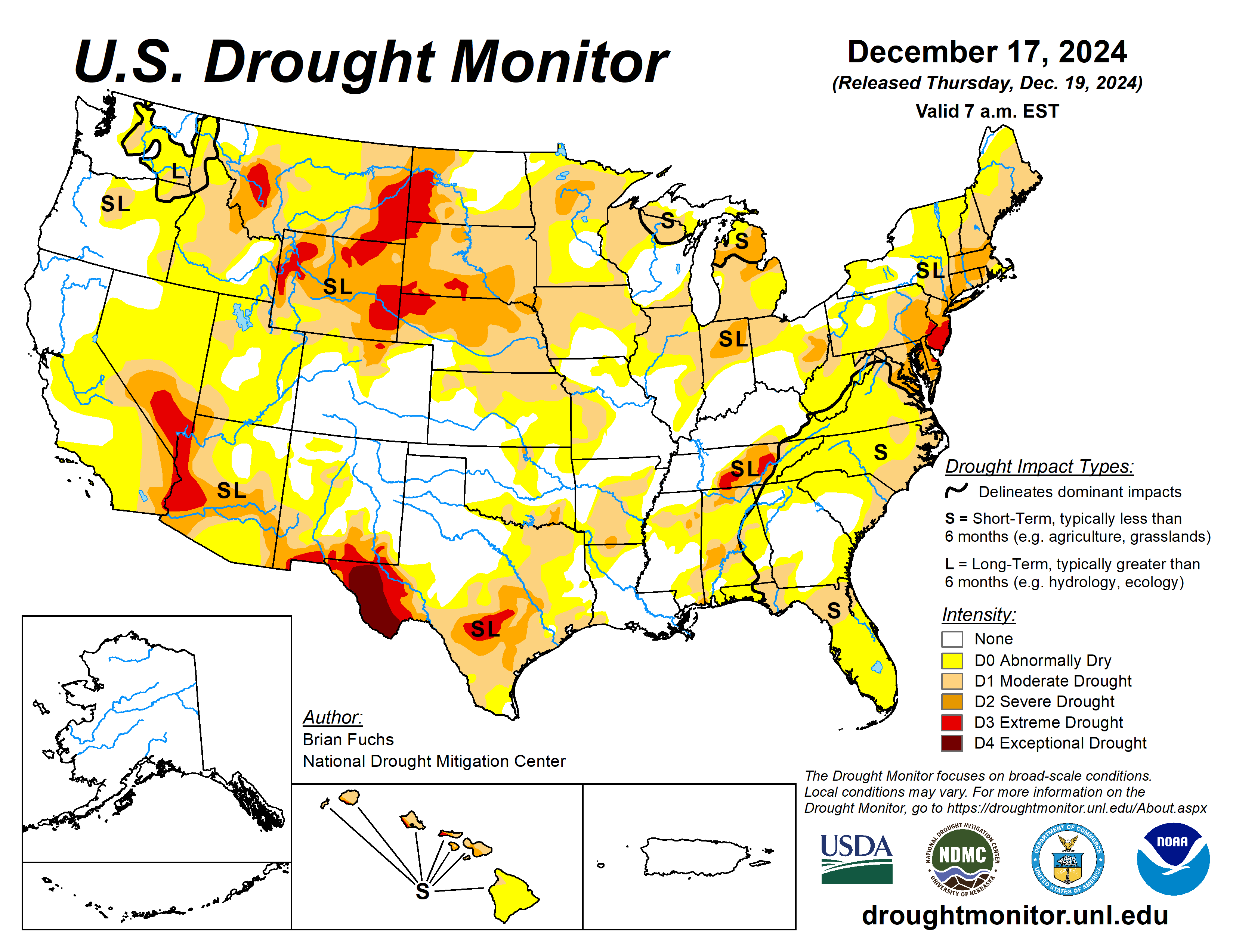
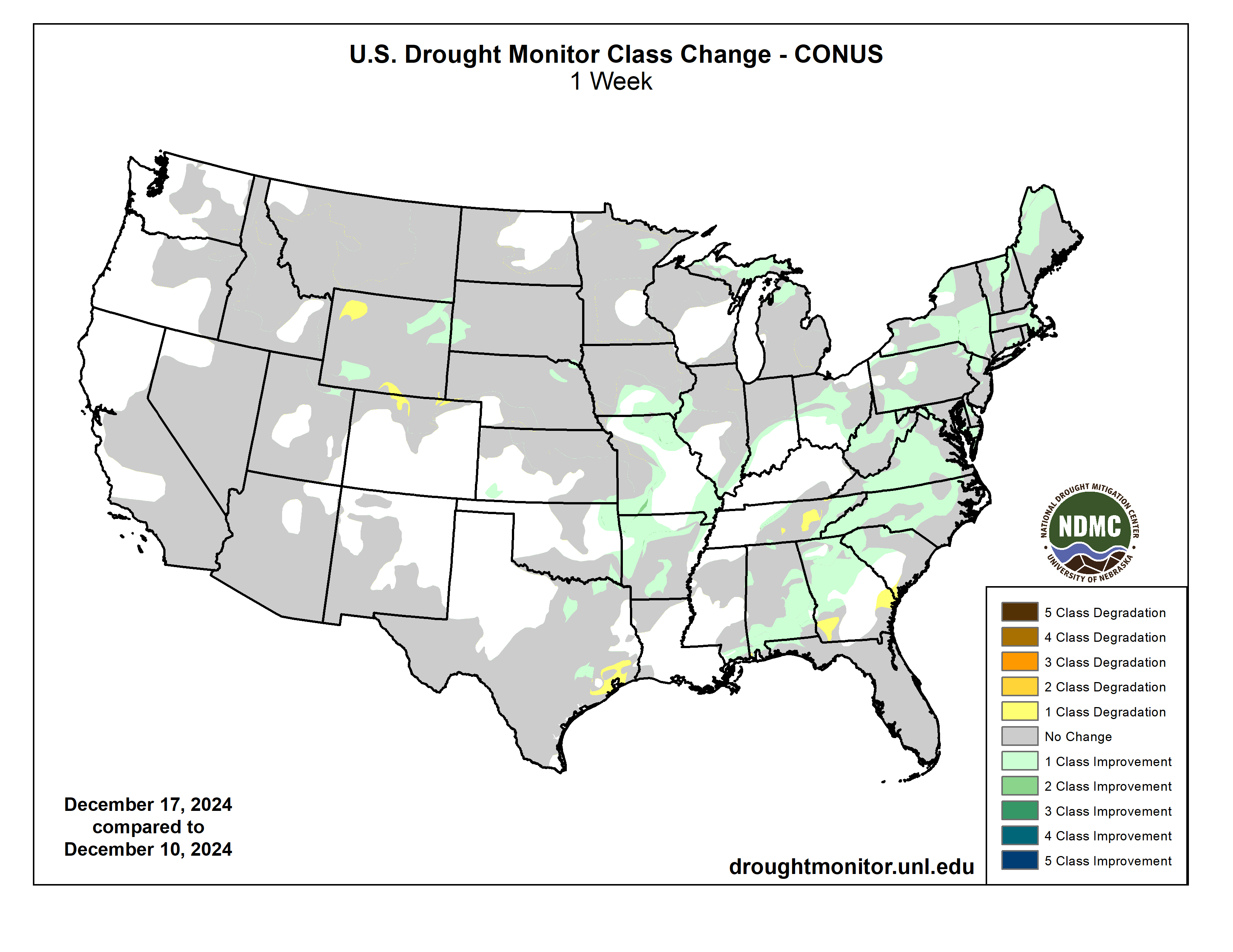
A swath of precipitation (0.5 to 1.5 inches) this past week led to small improvements from parts of Oklahoma and Arkansas northeastward to the Central Appalachians. Since the major drought that affected the Central Appalachians and Upper Ohio Valley peaked in late September, drought has steadily improved across these areas the past two months. Near to above-normal precipitation during the past 30 days supported drought improvement across parts of the Northeast. Farther to the south across the Southeast, Lower Mississippi Valley, and Texas, 30 to 60-day precipitation deficits continue to increase with expanding and intensifying drought during mid to late December. December is typically a drier time of year for the Upper Midwest and Northern to Central Great Plains where little to no weekly drought change was warranted. Since the beginning of October, precipitation has generally averaged below normal across the Central Rockies, Great Basin, Southwest, and southern California. From December 17-23, enhanced onshore flow resulted in wetter-than-normal conditions across coastal northwestern California and much of the Pacific Northwest. 7-day temperatures, ending on December 23, averaged above normal throughout the West and Central to Southern Great Plains with colder-than-normal temperatures limited to the Great Lakes and Northeast…
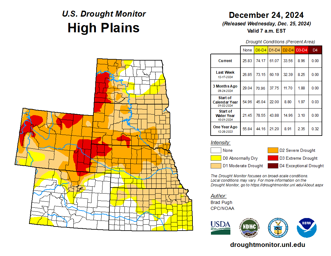
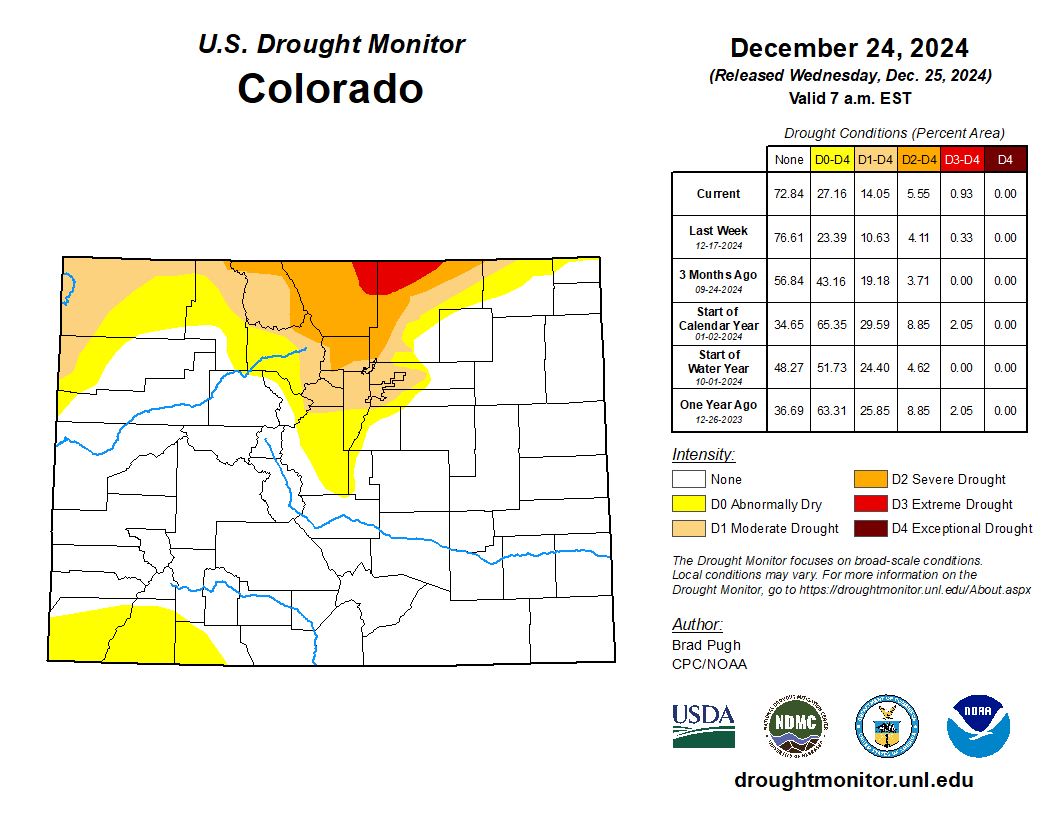
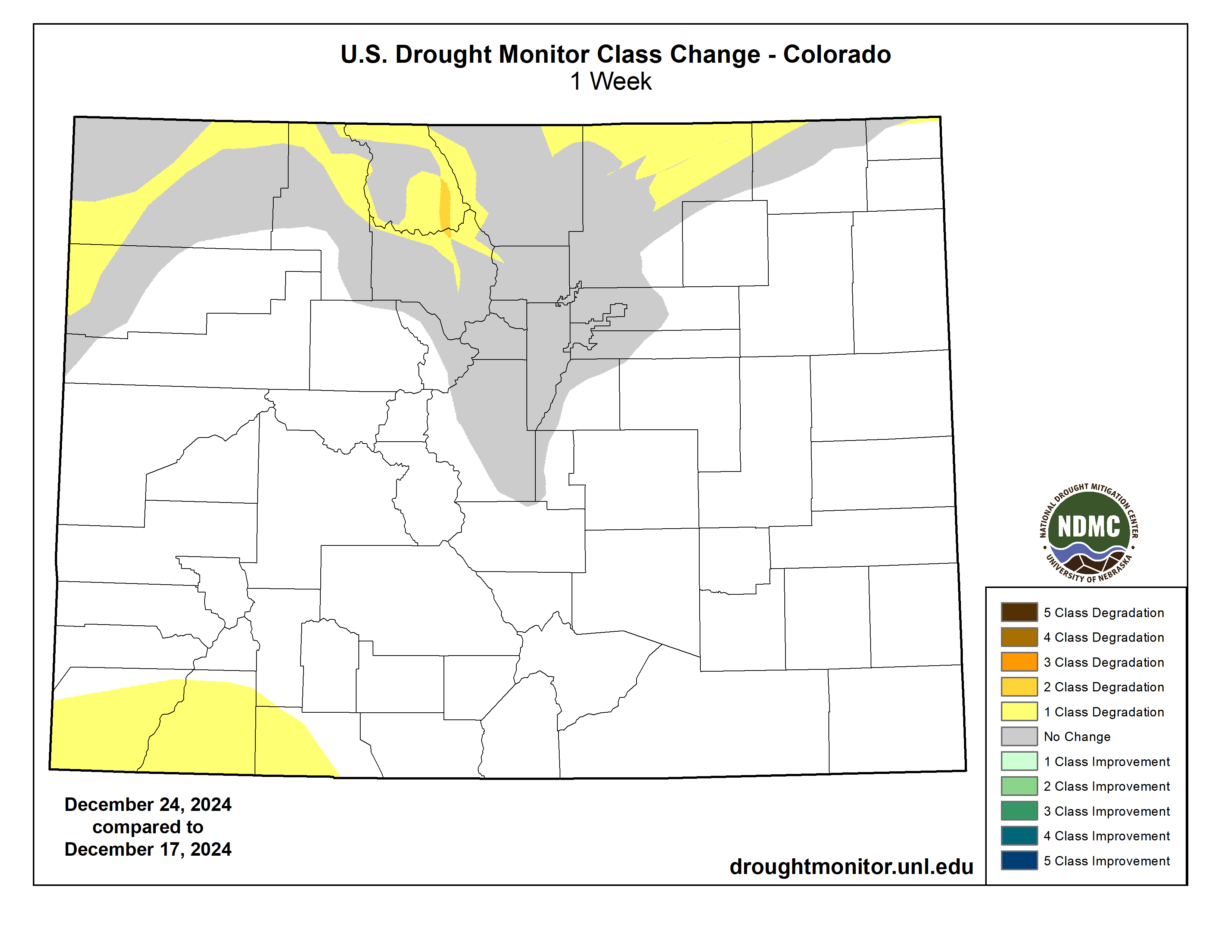
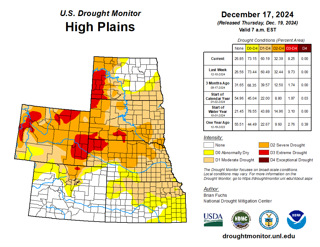
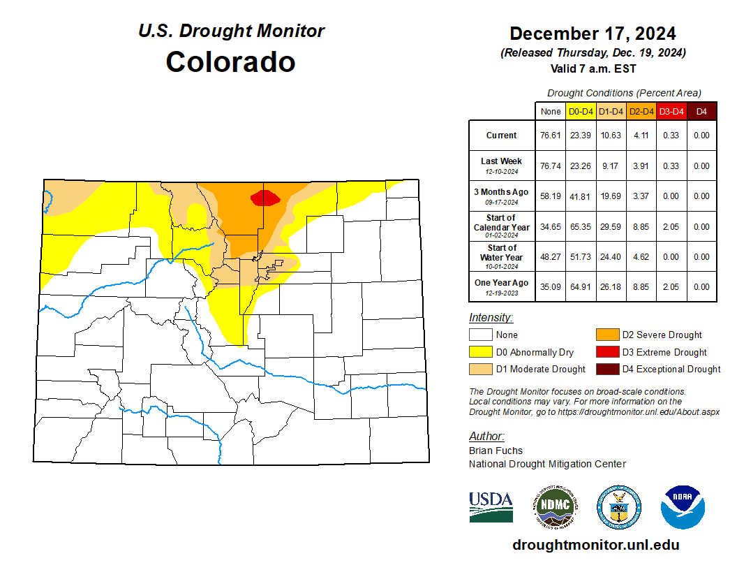
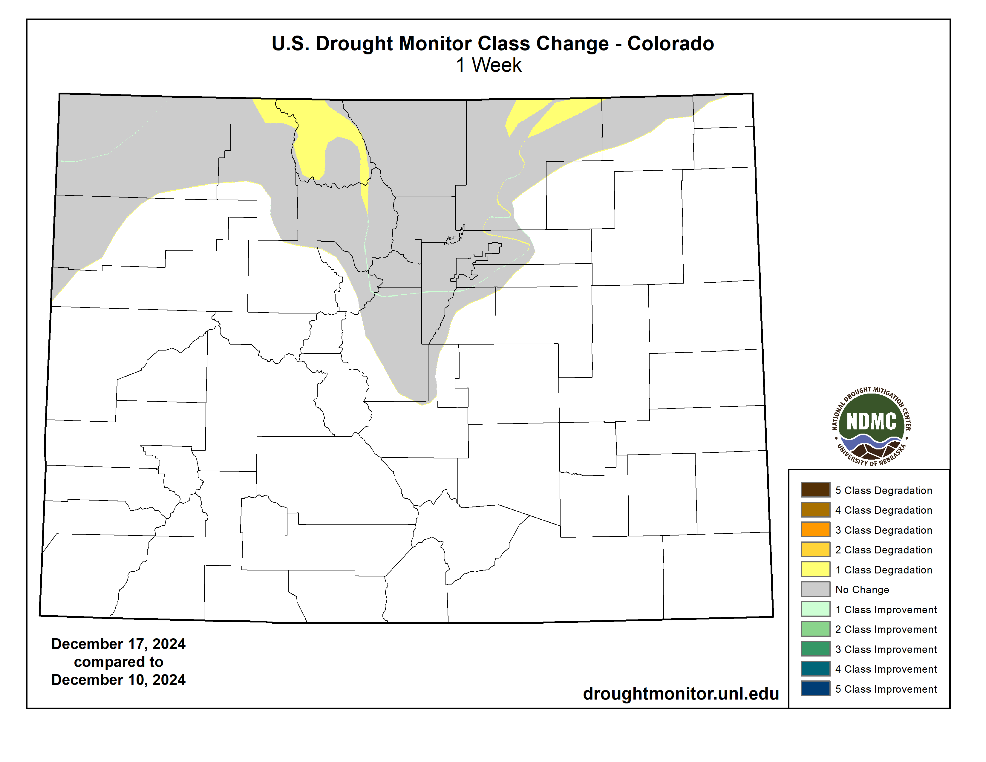
Based on SPIs at various time scales, low snowpack, and the NDMC short-term blend, a 1-category degradation was made to northern Colorado along with southern and northwestern Wyoming. Snow water equivalent amounts are below the 5th percentile where extreme drought (D3) was expanded in Wyoming. These same indicators justified an expansion of abnormal dryness (D0) across southwestern Colorado. Severe drought (D2) was expanded across western Nebraska due to soil moisture percentiles falling below the 10th percentile and support from the 90 to 120-day SPI…
Colorado Drought Monitor one week change map ending December 24, 2024.
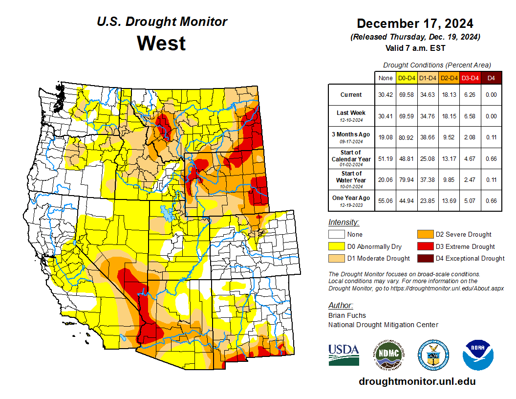
Based on increasing water year to date (WYTD: October 1-December 23) precipitation deficits, a 1-category degradation was warranted for central Nevada. For this same reason, moderate drought (D1) was added to portions of northeastern Nevada. Elsewhere, no other changes were made. WYTD precipitation was at or above-normal for much of the Pacific Northwest and northern California and below-normal for the remainder of the West region. As of December 23, snow water equivalent (SWE) was below-normal across the Northern Rockies of Montana and Wasatch Mountains of Utah. SWE was near average for the Sierra Nevada Mountains and highly variable throughout the Cascades…
Based on increasing short-term precipitation deficits and 30 to 90-day SPIs, abnormal dryness (D0) and moderate drought (D1) were expanded across northern Louisiana and portions of south-central Mississippi. These same indicators along with the NDMC short-term blend supported the expansion of D1 to severe drought (D2) across portions of eastern and southern Texas. Around one inch of precipitation supported a 1-category improvement across portions of Arkansas and central to southeastern Oklahoma. Recent precipitation also led to improvement across northern Tennessee to be consistent with bordering areas of southeastern Kentucky…
Looking Ahead
During late December, multiple low pressure systems will bring heavy precipitation (rain and high-elevation snow) to the Pacific Northwest and northern California. On December 27, widespread rain with locally heavy amounts (more than 2 inches) is forecast for eastern Oklahoma, eastern Texas, and Arkansas. A slow-moving low pressure system and trailing front are forecast to bring varying precipitation amounts (0.5 to 1.5 inches) to the Ohio and Tennessee Valleys, Mid-Atlantic, and Northeast.
The Climate Prediction Center’s 6-10 day outlook (valid December 30, 2024-January 3, 2025) favors above-normal temperatures across the East, Southern Great Plains, and Southwest. Near normal temperatures are favored for the Northern Great Plains, Northern Rockies, and Pacific Northwest as above-normal temperatures are forecast to moderate during this 5-day period. A pattern change is forecast during the first week of the New Year with a transition towards near or below-normal temperatures for much of the lower 48 states. Elevated above-normal precipitation probabilities are forecast for the Pacific Northwest, Great Plains, Midwest, and Northeast. Below-normal precipitation is more likely for the southern two-thirds of California and the Southwest.
US Drought Monitor one week change map ending December 24, 2024.
Click the link to read the article on The Montrose Press website (Katharynn Heidelberg). Here’s an excerpt:
December 7, 2024
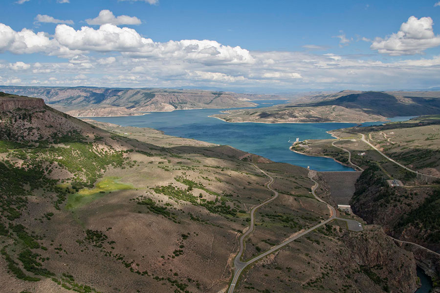
Hydropower infrastructure at Blue Mesa Reservoir will see some urgent updates, with the help of money coming through the Interior Department’s Aging Infrastructure Account. The account received more than $3 billion through the Bipartisan Infrastructure Law. As part of an $849 million disbursement announced by the Interior on Dec. 3, more than $32.03 million will go to replace butterfly valves at the Blue Mesa power plant and to refurbish two ring follower gates at the dam there. This funding will pay for planning, final design and implementation.
“The infrastructure at Blue Mesa dates to the facility’s original construction, with most installations made in 1963,” a Bureau of Reclamation official said via email, in response to questions. “Given a typical service life of 50 years, much of the equipment has exceeded this threshold and requires either refurbishment or replacement. Currently, funding is allocated to priority projects that address these urgent needs.”
The government further is providing $1.3 million to pave the public access road to the power plant and $650,000 to replace the electrical “bus” that transmits power from generator to transformer at the plant…According to Bureau of Reclamation information, Blue Mesa’s power plant is composed of two 30,000-kilowatt generators, driven by 41.55-horsepower turbines; each turbine operates at a maximum head of 360 feet. The plant’s generating capacity is 86,000 kilowatts…The Department of the Interior in its announcement said the money is an investment through President Joe Biden’s Investing in America agenda, and aimed at revitalizing aging water delivery systems. The funding is gong to 77 projects overall, in several Western states, including 14 in the Colorado River Basin, totaling $118.3 million.
A new statewide survey shows that 23 Colorado cities have aging lead water delivery pipes, roughly 20,000 of them, that could potentially taint drinking water.
Under federal rules, those cities must identify all contaminated pipes and replace them by 2037, according to the Colorado Department of Public Health and Environment.
But the initial survey, completed in October, also found that 170,000 additional water lines still need to be examined. Cities that have untested water delivery pipes are notifying customers of the risk and have through November of next year to finish the identification process, according to Seth Clayton, executive director of Pueblo Water.
“It took a significant effort to get the initial inventory completed,” Clayton said, “and then we sent out 22,000 letters to customers saying their service line type is unknown and could be lead. That sparks a bit of panic because of the misinformation out there. But call volumes and our customer service time is starting to decrease.”
The City of Lafayette banned lead pipes in 1959, according to Melanie Asquith, the city’s principal utility engineer. As part of the new survey, it has identified just one partial pipe that contains lead. Still, the city is notifying 770 customers who have unknown line types and plans to begin testing them early next year.
The communities on the list are: Sterling, Denver Water, Manitou Springs, Steamboat Springs, Georgetown, Grand Junction, Golden, Ft. Morgan, Englewood, Loveland, Aurora, Yampa, Flager, Lafayette, Limon, Bristol Water and Sanitation District, Pueblo Water, Eckley, Parkville Water District, Silver Plume, Greeley, Morgan County Quality Water District, Lost Valley Ranch Corp.
Lead water lines were commonly used up until the 1980s, when they were banned by the EPA. Though water entering the pipes may be clean, erosion of the aging lines causes lead to seep into the water. No levels of lead are considered safe for children and can cause serious health problems in adults, according to the Colorado Department of Public Health and Environment.
Even before the new mandate to replace all lead lines, the EPA ordered cities such as Denver to begin replacement programs because some lead had been detected in water delivered to homes, violating federal standards at the time. Denver Water has removed 30,000 lines, with another 30,000 to go, according to agency spokesman Todd Hartman.
Other cities that have never had lead levels that exceed federal standards began replacing lead lines years ago as part of routine maintenance and leak repair programs, according to Mark Ritterbush, Grand Junction’s water services manager.
“We’ve been chipping away at it over time because we knew the EPA was going to do this. There’ve been rumblings for at least a decade,” Ritterbush said.
Still, he said, the city has spent $1 million to comply with the lead pipe rules and meet the survey deadline. “We had a good foundation. But because we’re on the clock, it’s a lot to handle.”
Mrs. Gulch would have turned 70 today. Her family joked that she was their Christmas present back in 1954. I miss her and in particular I miss her sense of humor and wise counsel. Here’s a story from the first days of our 50 year marriage when we moved into my VW bus for the summer.
Mrs. Gulch Yellowstone National Park 1973.
Sense of humor
We camped for a few days at the Great Sand Dunes and then headed over to Monarch Pass to the Gunnison Valley. After we dropped into the valley Mrs. Gulch asked about lunch and decided she could create something, while moving towards Gunnison, with a can of tuna in oil that we had in the food box. The dilemma at hand was what to do with the oil. She slides the passenger window open and uses the lid to release the oil onto the highway.
Mrs. Gulch Great Sand Dunes June 1973.
In a little while I notice a car behind us, with it’s windshield wipers going, lights flashing, and horn honking. The driver had his head out the window which I figured out later probably served two purposes, my cussing out, and the ability to see the road. I concentrated on looking straight ahead not giving away the fact that I saw them behind me and overcame the urge to pull over to see what they wanted.
After a short while the driver moved his car into position for revenge. He pulled alongside and a little ahead of the bus while his passenger was shaking a can of pop preparing the contents for launch. When she popped the top the soda blew back into her window instead of coating the bus. They then took off west down US-50.
We couldn’t stop laughing, great belly laughs, howls of laughter, embarrassed red-faced laughter, guilty laughs for the trouble we had caused, and relieved laughter that they had sped away. This went on for a good long time and every time we looked at each other another round would break out.
After gassing up on the edge of Gunnison we were moving west down the main drag through town and saw them at a car wash. Of course this spawned another wave of guilty laughter. It would’ve been hard to deny culpability with tuna oil caked with road dust all along the side of our vehicle.
Mrs. Gulch
Wise counsel
Mrs. Gulch’s wise counsel that afternoon was to keep heading west up into the National Forest and find a place to camp — maybe for a couple of days.
Coyote Gulch’s VW Bus South Park 1973. Photo credit: Mrs. Gulch
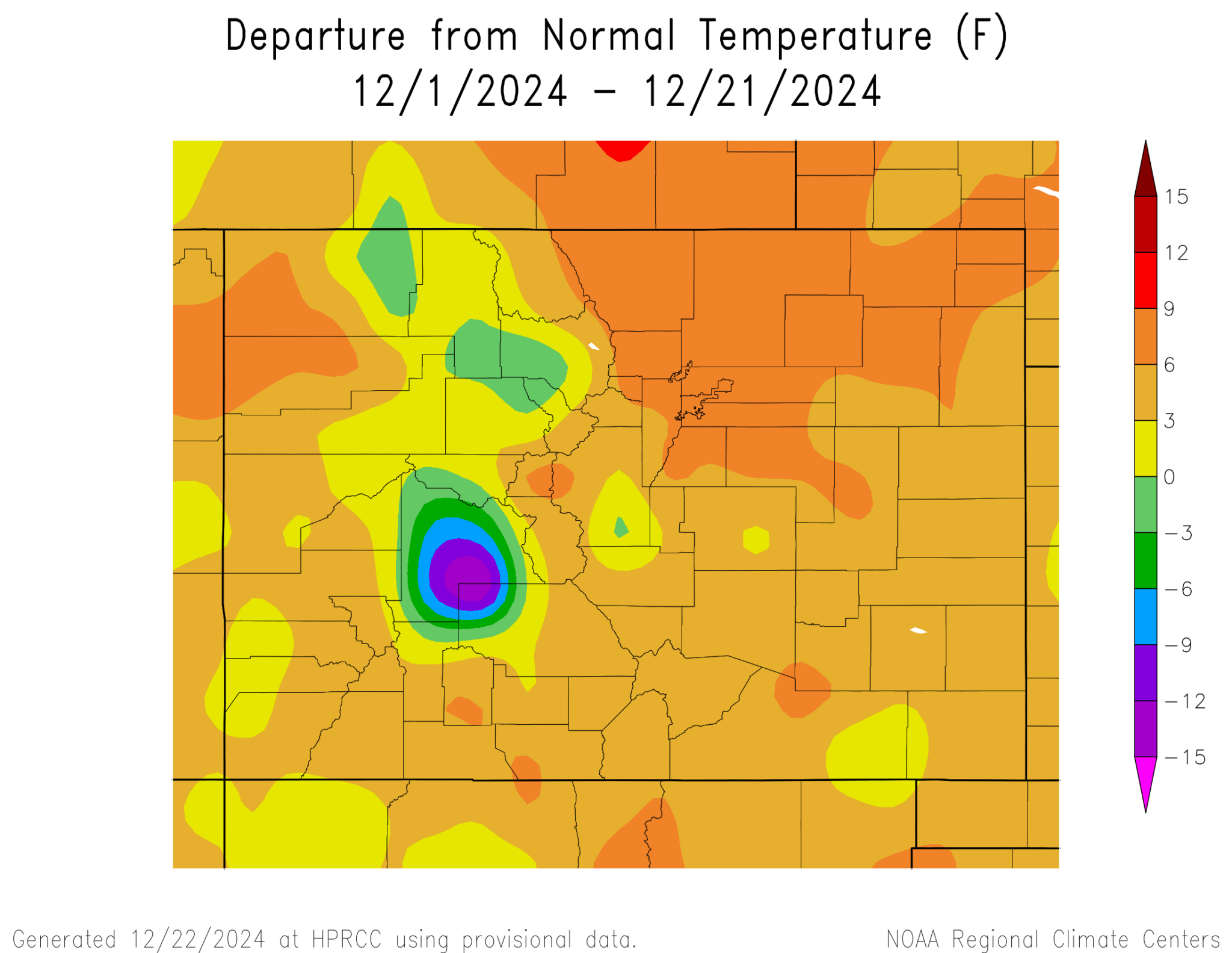
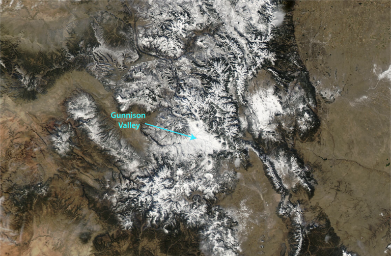
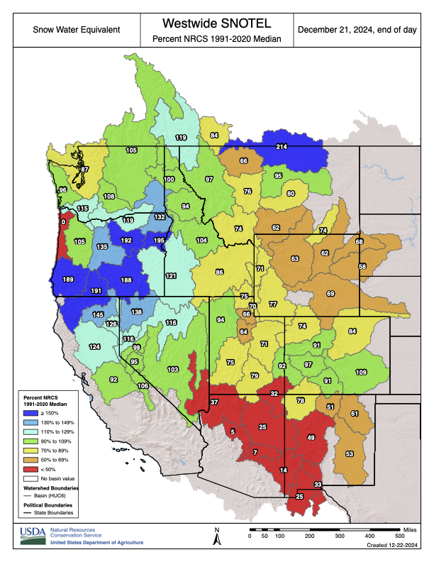
Across Colorado, this December has been much warmer than average, a bookend to what will end up as one of the warmest years on record statewide. Except there’s one spot where December hasn’t been warm at all — very much the opposite.
On any climate map of Colorado for December 2024, Gunnison sticks out like a sore thumb. For example, here are the high temperatures from CoAgMET on Friday, December 20. Really warm for late December, including some record highs along the Front Range. But then there’s Gunnison with a high of just 22°F.
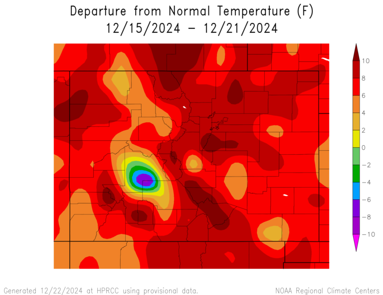
And here’s the departure from the average temperature for December through the 21st. Most of the state is 3-9°F warmer than average…and then there’s the bulls-eye of purple around Gunnison. For the week of December 15-21 it’s even more stark: almost the entire state in a deep red of warmth, with Gunnison again in a cold purple. Typically when we see maps like these, we get suspicious about problems with the data or a faulty thermometer, but this isn’t an error. Gunnison has truly been an anomaly in the state’s weather and climate this month.
Departure from normal temperature: December 1-21. Credit: High Plains Regional Climate Center
Departure from normal temperature December 15-21. Credit: High Plains Regional Climate Center
Here are a few more remarkable stats. From December 1-20, the climate station outside Gunnison has been 13 degrees colder than average. The highest temperature reported so far in December has been 26°F; there’s never before been a December without a high above freezing. (The average high at Gunnison this time of year is in the upper 20s.) And there were 15 straight nights with low temperatures below -10°F, including record lows of -26 on November 30 and -23 on December 1.
Two key factors are causing the remarkable cold, compared to the warmth the rest of the state has seen in December. The first is geography. Gunnison sits in a valley, surrounded by mountains on all sides. Northeast of town, the Taylor and East Rivers come together to form the Gunnison River, and the confluence with Tomichi Creek is just to the west. Cold air is known to pool in high mountain valleys like this, and the cold can be very persistent.
MODIS satellite image on December 20, 2024, showing the snow cover in the Gunnison Valley. From MODIS Today at the University of Wisconsin
If there’s a bunch of snow on the ground, these valley cold pools can become especially stubborn, and that’s exactly what’s happened this month. The storm just before Thanksgiving dropped over a foot of snow in the valley, and over 2 feet in the nearby mountains, among the highest totals from this storm. And even though the larger-scale air masses have been warm through December, the snow has remained in the valley (clearly visible in the satellite image above) and the air hasn’t warmed up. When there’s deep snow cover, it reflects sunlight and keeps the days cool, and also favors cold nights by insulating the air from the warmer land underneath. This creates a feedback loop where it stays cold, which means the snow doesn’t melt, which means it stays cold.
What’s especially unusual is that this has all happened without getting additional snowfall: Gunnison has reported only 0.5″ of snow in December. The mountain snowpack has flatlined through December, and up the hill at Crested Butte they’ve even had several days above freezing. But it’s still snowy and cold in the Gunnison Valley, and will stay that way for the foreseeable future. What looks more likely is that the rest of the state will start to cool down to something resembling winter in early January, so Gunnison won’t look like such an outlier.
Click the link to read the article on the Big Pivots website (Patricia J. Rettig):
December 2, 2024
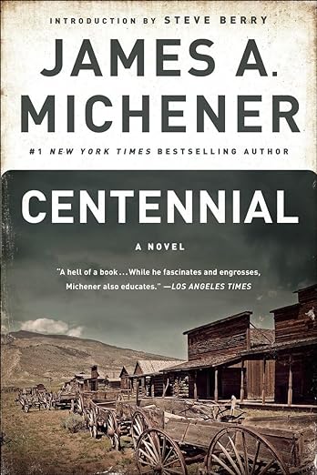
Imagine a best-selling, 900-page novel using “a sad, bewildered nothing of a river” as its centerpiece, connecting the earth’s geologic origin and dinosaur age to 1970s rural Colorado.
Now imagine that novel becoming a touchstone for its times, yet still relevant today, as our nation approaches its 250th anniversary. The book is James A. Michener’s Centennial, an unlikely novel published a half-century ago. By creating a microcosm of the country, he explained America to itself in anticipation of the 1976 bicentennial.
That the Pulitzer-prize winning Michener chose as his landscape the West—and the little-known South Platte River on Colorado’s northeastern plains—is surprising only in that this was his first epic novel related to the U.S. mainland.
But ever since he briefly lived in Greeley, Colorado, in the late 1930s before his writing career began, the winding South Platte River stuck with him. As a young college professor, Michener recognized the wealth of stories resulting from the hardships of people surviving in an arid area.
After Michener’s service on a national bicentennial committee left him frustrated, he decided to return to the Centennial State, Colorado, which gained statehood in 1876. He hoped to tell a tale of the American experience, and in the opening chapter a character states, “If we can make the Platte comprehensible to Americans, we can inspire them with the meaning of this continent.”
Forgoing stereotypical Western stories of railroad builders and farmers’ daughters, Michener fictionalized selected histories of settlement and created relatable characters.
South Platte at 52 bridge image by Laura Perry, courtesy USGS.
Native Americans, French trappers, Mennonite settlers, farmers of German-Russian descent, English ranchers, Mexican and Japanese laborers—all depended on the South Platte River and its tributaries in the dry, inhospitable land. They also had to depend on each other.
By starting with the land’s formation, Michener depicts every character as an immigrant. He estimates human arrival in the region at about 12,000 years ago, and those Indigenous peoples and their descendants remain present throughout the story. As more people arrived and society evolved, everyone built lives in relationship with the river.
For many, the river provided a pathway to the West. For a few, it revealed golden nuggets, though the real wealth was the water itself.
Yet what Michener presents as progress gradually becomes recognized as unsustainable. The memorable Potato Brumbaugh has not only the innovative idea of irrigating crops but also the radical concept of digging a tunnel under the Rocky Mountains to import water from west of the Continental Divide. When this source is not enough, groundwater pumping increases, with dire consequences.
Such innovation—water-related and otherwise—is important to understand today, but also significant is knowing the history of how communities got built. Michener also shows the conflicts that arose with each wave of newcomers bringing their own ideas about how to live.
He also demonstrates changing attitudes, including acceptance of racial differences and increasing dismay over environmental destruction. His story concludes in the early 1970s, referencing Watergate, international conflict and immigration. Characters face inflationary times and polluted air and water. They know they need to solve the coming water shortages.
Not much is different today.
The key difference is that as Michener’s characters decry the environmental damage caused by their ancestors and neighbors, they also recognize they need to know their history and honor their longstanding connections to the land and water.
This is what modern humanity has forgotten. Through the innovations of pipes, plumbing and chemical treatments, we have relegated our rivers to the background, as if they were merely an unending supply of water at our command. We have lost our connections to natural resources, to history, to each other.
Patricia Rettig, Associate Professor, Libraries, Colorado State University, March 29, 2022
As we now prepare for our 250th anniversary, Centennial, both the novel and the groundbreaking 26-hour television miniseries airing from 1978 to 1980, reminds us of the country’s strengths.
Nearly 900 pages in, a character skips a Colorado-Nebraska college football game to survey the South Platte by plane. As he nears the Nebraska state line, he says, “No one in Colorado will believe it, but this river is more exciting than football.”
Imagine if more people, in all states, felt the same way. Patricia J. Rettig is a contributor to Writers on the Range, writersontherange.org, an independent nonprofit dedicated to spurring lively conversation about the West. She is the archivist for the Water Resources Archive at the Colorado State University Libraries
The South Platte River Basin is shaded in yellow. Source: Tom Cech, One World One Water Center, Metropolitan State University of Denver.
Republican River in Colorado January 2023 near the Nebraska border. Photo credit: Allen Best/Big Pivots
Click the link to read the article on the Big Pivots website (Allen Best):
December 23, 2024
10,000 acres in the basin have now been retired from irrigation. But Colorado must remove 15,000 more acres before 2030.
Colorado has achieved a milestone, retiring 10,000 acres from irrigation in the Republican River Basin of northeastern Colorado.
But a much larger, more difficult challenge lies ahead. The state must retire 25,000 acres before 2030 in order to comply with the compact with Nebraska and Kansas governing water in the basin.
The Colorado Division of Water Resources announced on Dec. 20 that Nebraska and Kansas agreed that Colorado has taken the necessary actions to retire the minimum 10,000 acres based on executed contracts and aerial data collected in the summer of 2024.
The compact between the three states was ratified in 1942. Then came the widespread adoption of high-capacity wells followed by center-pivot sprinklers that permitted exploitation of the Ogallala and other aquifers. The aquifers feed into various forks of the Republic River.
Flows in the river subsequently declined. Kansas and Nebraska complained, rolling out the legal sabers. That resulted in formation of the Republican River Water Conservation District in 2004 to address the over-drafting of the aquifer. A resolution between Colorado and its neighbors in 2016 gave Colorado a specific target. It must figure out how to eliminate irrigation from 25,000 acres in the South Fork of the Republican River by the end of 2029.
Wells in the Republican River Basin in Colorado.
Dick Wolfe, then the state water engineer, was asked in September of 2016 how this would be accomplished. He paused a moment, then pretended to have a scissors in his hands, as if a barber, saying “Bit here, a bit there.” And that is what has been happening.
Irrigators in the district contribute to the district on a per-acre basis. The money is used to induce irrigators to end their diversions via the wells.
State legislators in 2023 allocated $30 million to supplement the district’s self-generated funds to sweeten the pot. The Colorado Water Conservation Board earlier this year added another $6 million.
The map below shows the location of wells in the district. It mostly lies between Interstates 70 and 76.
Some parts of the aquifer, mostly in the southern parts, ceased to have sufficient water for pumping. At a meeting this year in Wray, directors of the conservation district were told that even in the better areas along the North Fork of the River, in the Yuma and Wray areas, water levels have been dropping a foot and a half a year.
There is some agreement among directors that stepped-up action must be taken in order to meet the 2029 deadline for retirement. They will take up that discussion at a February meeting.
Click the link to read the post on the InkStain website (John Fleck):
December 21. 2024
I was talking to Eric Kuhn Thursday (write a book together – bonded for life) who pointed out that the Colorado Basin River Forecast Center has started running its models for 2025 runoff. They don’t look good.
It’s way too early to think of this as a “forecast.” But they provide a feel for where we’re at now: Do we have a good head start? Are we already behind? The error bars are still huge, with a lot of upside potential, but we are alreadybehind – 1.4 million acre feet below median for Lake Powell inflow.
The current climate forecast headlights, which can at least dimly illuminate the next month for us, don’t look good. The US Drought Monitor folks publish an experimental forecast tool called the Evaporative Demand Drought Index (EDDI).
EDDI uses the federal Climate Forecast System model, an operational model to help gauge conditions over the coming months. CFS is then coupled with tools to estimate evaporative demand – not simply how much snow we’re going to get, but how rain and snow interact with temperature and atmospheric moisture, all of which play roles in the system that sends water from the snowpack in the Rockies to headgates and kitchen taps across the West.
EDDI says that over the next month, we should expect the CBRFC’s runoff forecast to go down, not up. We’re falling behind.
Why this matters
The obvious reason this matters is its direct relationship with this year’s water management. Will Powell and Mead go up or down? What does that mean for near term water supply?
But we’re also all playing multiple games of four-dimensional chess trying to anticipate how the near term runoff scenarios influence long term negotiations over Post-26 river management. One of my little projects right now is to step back from my normative angst (where “normative angst” == John’s super pissed off about the negotiators’ abject failure) to think about the deeper negotiation theory stuff going on.
Here’s a look Westwide.
Westwide SNOTEL basin filled map December 21, 2024 via the NRCS.
The Interior Department on Friday finalized its updated Western Solar Plan, potentially opening 31.7 million acres of federal public lands in the West to industrial solar energy development, including some 3.8 million acres in Wyoming.
The decision comes just weeks before President-elect Donald Trump takes office, and just hours before a potential federal government shutdown.
The Wyoming acreage considered suitable for solar energy represents about 20% of land overseen by the Bureau of Land Management in the state, according to the BLM. Suitable areas in Wyoming exclude sage grouse core areas and avoid ungulate migration corridors and unindustrialized areas, according to federal officials.
The plan updates an effort initiated in 2012, when the federal government under then-President Barack Obama envisioned industrial-scale solar would be concentrated in very high solar potential areas of the southwest. The updated version, however — part of President Joe Biden’s goals to expand renewable energy development to address climate change — expanded the study area to include several more western states, including Wyoming.
This planning map depicts Bureau of Land Management managed areas in Wyoming that may be suitable and unsuitable for industrial-scale solar energy development. (U.S. Bureau of Land Management)
Both the Interior and BLM have insisted that although the plan identifies 31.7 million acres as suitable for development, only about 700,000 acres across the West are “anticipated” to be developed.
“The larger available area allows for greater flexibility in considering solar proposals,” according to the Interior, which stressed that each solar project will be analyzed individually and include opportunities for public input.
“With an updated Western Solar Plan, created with extensive input from the public, the Department will ensure the responsible development of solar energy across the West for decades to come,” outgoing Interior Secretary Deb Haaland said in a prepared statement.
Initial reactions
Conservation groups expressed tentative support for the finalized plan hours after the decision was published Friday in the Federal Register.
“The Western Solar Plan will play a crucial role in securing our country’s energy independence and security over the coming decade,” Natural Resources Defense Council Senior Policy Advocate Josh Axelrod said in a prepared statement. “This is a rare piece of policy that can drive job growth, boost rural economies and ensure conservation of fragile environmental resources.”
The updated Western Solar Plan “represents a compromise that will allow Wyoming to continue to innovate and grow its energy economy while protecting our important conservation resources on BLM-managed public lands,” The Nature Conservancy said in a prepared statement.
he conservancy published a study of the Western Solar Plan revision effort in 2023. “There’s an abundance of low-impact spots for the development of solar energy in Wyoming — more than enough to meet market demand,” TNC’s Wyoming Energy Program Director Justin Loyka told WyoFile at the time.
But whether federal officials fully embraced input from conservation groups and others wasn’t clear during first-blush readings of the final plan on Friday.
“The plan is just really haphazard,” San José State University Professor of Environmental Studies Dustin Mulvaney told WyoFile. “To me, it’s a recipe for more litigation and more lawsuits and more people getting upset just because of the free-for-all-nature of it.”
This map, provided by The Nature Conservancy, depicts areas where the group, during the Bureau of Land Management’s planning process, noted potential impacts to big game migration corridors and crucial winter habitat. The agency largely addressed those concerns in its final plan, according to The Nature Conservancy. (The Nature Conservancy)
It was unclear, Mulvaney said, whether federal officials fully integrated many innovative strategies tested to avoid negative impacts in sensitive landscapes.
Although Interior officials attempted to correct course — learning from mistakes in past sitings of solar energy development in the southwest — the agency strayed into new, dangerous territory when it expanded its solar energy scope to other western states, according to Mulvaney.
For example, one criteria it used to essentially disqualify public lands from being off limits to solar development was the presence of invasive plant species such as cheatgrass. Not only does that overlook other landscape values like wildlife habitat connectivity, such invasive plant species typically spread by following other forms of development like wind farms.
“Because of the presence of cheatgrass, it opens up a lot of those landscapes to solar development,” Mulvaney said. “It’s not thinking about questions about, like, ‘Where might we be interrupting migration corridors and [genetic connections]?’ All these things are connected.”
Click the link to read the article on the NOAA website (Amy Butler and Laura Ciasto):
December 19, 2024
When we launched this blog last winter, the atmosphere came through for us with not one, but two breakdowns of the stratospheric polar vortex. That was very considerate of it, given that many winters pass without even a single one. With all the excitement that occurs when the stratospheric polar vortex is disrupted during a sudden stratospheric warming, our readers might wonder whether there is any way to predict weeks or even months ahead of time the likelihood that one (or more!) will occur this upcoming winter.
As we discussed last year, there are certain ingredients that need to come together to drive a sudden stratospheric warming. These can be boiled down to two main factors:
persistent weather patterns in the lower atmosphere (troposphere) that can amplify large-scale atmospheric waves vertically into the stratosphere; and
ideal wind conditions in the stratosphere that steer the arriving waves and encourage them to break near the polar vortex, which rapidly slows the polar stratospheric winds.
The exact details of these factors are often not predictable beyond 7-10 days [footnote 1], but that doesn’t mean we can’t say anything about the likelihood of a polar vortex disruption and sudden warming happening in a given season. That’s because there are ocean and atmospheric climate patterns or oscillations that are potentially predictable weeks or months ahead of time, and these predictable climate patterns can influence the ingredients for a sudden stratospheric warming listed above. In other words, while we can’t predict the exact timing of a sudden warming months ahead of time, we might be able to give the odds (make a “probabilistic forecast”) that one is likely (or not) to occur at some point during the winter, based on how we think these other climate patterns will affect our sudden stratospheric warming recipe.
Playing the odds: things that increase or decrease the chances of polar vortex disruptions & sudden stratospheric warmings
We know that El Niño-Southern Oscillation (ENSO) drives “teleconnections” – predictable patterns of high and low pressure that extend from the tropics into the mid-latitudes. These highs and lows represent large-scale atmospheric waves, which can be used to predict remote weather impacts. As Amy wrote about in a guest post on the ENSO blog a few years ago, these ENSO-related atmospheric waves can help to amplify–or dampen–normal high and low pressure patterns in the mid-latitudes, and that interaction affects whether these waves get big enough to travel into the stratosphere. On average, El Niño teleconnections tend to amplify more waves into the stratosphere, and those waves weaken wintertime polar vortex winds on average compared to La Niña (see the image below, left side). There’s a ~30% increase in sudden stratospheric warmings during El Niño winters [footnote 2; Polvani et al. 2017].
Changing the amount of atmospheric waves coming up from the troposphere is one way to change the likelihood of a polar vortex disruption/sudden warming. Another way is to change where the waves break once they get to the stratosphere. If they’re forced to break near the pole, a disruption and sudden warming of the polar vortex becomes more likely. If they’re forced to break farther south, the polar vortex is more likely to remain undisturbed. So what determines where they break?
Remember that large atmospheric waves can only travel in winds that blow from the west. That’s the direction the stratospheric winds blow in most of the polar to middle latitudes during winter, allowing waves to travel freely there. But farther south, the Quasi-biennial Oscillation (or QBO) comes into play.
(left) When the Quasi-biennial Oscillation (QBO) is from the west, winter (Dec-Jan) polar stratospheric winds are stronger than average (purple), making sudden stratospheric warming less likely. (right) When the QBO is from the east, the polar vortex is weaker than average (green). The panels above the globes show difference from average east-west winds at altitudes from 100 to 10 hPA across each latitude band from the equator (zero) to the North Pole (90). The dashed line indicates the altitude/pressure level used to define the QBO. Positive values mean westerly winds at a given latitude and altitude were stronger than average; negative values mean weaker-than-average westerlies (or stronger-than-average easterlies). Data is from the ERA5 reanalysis, and the anomalies are defined relative to the 1991-2020 average. NOAA Climate.gov image, adapted from analysis by Amy Butler.
The QBO describes an approximately 2-year (or, “quasi-biennial”) cycle of alternating easterly (from the east) and westerly (from the west) winds in the tropical stratosphere. This flip-flop of tropical winds can either allow waves in the stratosphere to keep traveling into the subtropical regions (if the QBO winds are blowing from the west) or force them to break closer to the pole (if the QBO winds are blowing from the east). [footnote 3]
This is one explanation for why we see weaker polar vortex winds and increased chances of sudden warmings during “easterly QBO” and stronger polar vortex winds and reduced chances of sudden warmings during “westerly QBO”.
Reading tea leaves for the polar vortex in winter 2024-25
So far we’ve talked about the relationships between the polar vortex and the QBO and ENSO separately, but both phenomena are often occurring at the same time [footnote 4]. If we combine these statistical connections, it can help us predict whether a sudden stratospheric warming (SSW) [footnote 5] might be more or less likely to occur this winter.
If we sort past winters by their ENSO and QBO status, what we find is that the state of ENSO and QBO in early winter can be used to give some indication of the overall seasonal strength of the polar vortex and the likelihood of a SSW. That’s what you can see in the image below.
The dots in each quadrant of this graph show the strength of the polar vortex in past winters (December-February), based on the phase of the Quasi-biennial Oscillation (QBO) (vertical axis: positive values indicate westerly winds, negative values indicate easterly winds) and tropical sea surface temperatures in the Nino 3.4 region (horizontal axis: positive values indicate El Niño-like conditions, and negative values indicate La Niña-like conditions). The strongest polar vortex years (dark purple dots) cluster in the upper left quadrant of the graph, meaning winters with westerly QBO and La Nina. The weakest polar vortex years (dark green dots) occur in easterly QBO winters. Winters with at least one polar vortex disruption/sudden stratospheric warming (SSW) are marked with a black outline (and years with two have two circles). The red dot indicates where winter 2025 would rank based on November 2024 values only. NOAA Climate.gov image, adapted from original by Amy Butler.
For example, most of the dark purple dots indicating a very strong polar vortex year occur in the upper left quadrant of the image, which are winters with La Niña and westerly QBO conditions. And unsurprisingly, these are also the conditions with the lowest occurrence of SSWs (46% of winters with these conditions have had a SSW). On the other hand, the winters with the highest occurrence of SSWs occur during easterly QBO winters in general (the bottom half of the plot), but during La Niña conditions in particular (the lower left quadrant). This is somewhat surprising, since if we just consider ENSO conditions, La Niña is actually associated with stronger polar vortex winds over a season. This may mean there could be some interactions that occur between ENSO and the QBO that promote SSWs in unexpected ways, or non-linear interactions of ENSO with the polar vortex [footnote 2].
What does this tell about this upcoming winter? Using November 2024 values for the QBO and ENSO, the winter of 2024-2025 looks likely to fall into westerly QBO and La Niña conditions (upper left quadrant). This would suggest that chances for a SSW are somewhat reduced compared to average, and conditions may even be primed for a strong polar vortex. Nonetheless, sudden warmings have occurred in these conditions before (12 times!)- which again re-emphasizes that these sorts of statistics can only tell us probabilities. Even though there’s a 55% chance an SSW won’t happen, there’s still a 45% that a SSW could occur. In other words, don’t bet the farm on this year’s odds for a SSW.
What does the crystal ball say?
So what do the most recent forecasts tell us? Over the last two weeks, polar vortex winds have been extremely strong, with extended range forecasts showing little chance of a slowdown through at least the beginning of January. As for what our quick statistical analysis might tell us if it were a Magic 8 ball, to the question if stronger-than-average polar vortex winds will continue: “Signs point to yes” [footnote 6].
Fig 3. Observed and forecasted (NOAA GEFSv12) wind speed in the polar stratosphere compared to the natural range of variability (faint blue shading). For the GEFSv12 forecast issued on 18 December 2024, the winds at 60 degrees North (the mean location of the polar vortex) are forecast to remain stronger than normal for at least the next 2 weeks (bold red line). By mid-January, the forecasted strength of the polar stratospheric winds becomes very uncertain (light red lines). NOAA Climate.gov image, adapted from original by Laura Ciasto.
Footnotes
If we want to predict the exact timing and details of if and how a sudden stratospheric warming will evolve, it’s likely to be about as successful as a 7-10 day weather forecast- because the ingredients that drive these disruptions are related to and affected by weather patterns that are only predictable that far ahead of time. However, note that once a sudden warming occurs, it has potentially predictable impacts on surface climate for weeks to months afterwards.
The two phases of ENSO, El Niño and La Niña, have roughly opposite-signed high and low pressure teleconnections. For example, over the North Pacific, El Niño teleconnections are typically associated with a deepening of the Aleutian Low, while La Niña teleconnections weaken this low pressure region. This might make you think that the two phases of ENSO should also induce opposite-signed responses in the occurrence of sudden warmings. However, in the ~65 year observational record, sudden warmings occur more often in both El Niño and La Niña winters compared to ENSO-neutral conditions (Butler and Polvani 2011). So, what’s going on? It’s possible that La Niña teleconnections may be able to amplify atmospheric waves in a different way than El Niño (i.e., not over the North Pacific, but in one of the other regions of high/low pressure). Alternatively, it’s possible that 65 years isn’t actually enough to get an accurate measure of this relationship, and so the observed increase in sudden warmings during La Niña is just random luck. When long climate model simulations are performed, in general they see fewer sudden warmings during La Niña than El Niño (Polvani et al 2017). However, these models might also not capture ENSO teleconnections and their effect on the stratosphere correctly.
In a future blog post, we will go into more detail about the QBO and why it occurs, and how it affects the polar vortex. The explanation presented here is the most common one and was described by Holton and Tan (1980). But it’s not clear that this fully explains the connection between the tropical and polar stratospheric winds (Garfinkel et al 2012).
There are also many other persistent climate patterns that have been used to look for these statistical connections and guide seasonal forecasts of the polar vortex and sudden stratospheric warmings, including the Madden-Julian Oscillation, Arctic sea ice, Eurasian snow cover, North Pacific sea surface temperatures, or winds in the upper stratosphere.
After intense negotiation, our editor agreed to allow us to introduce the acronym SSW mid-way through the post, on the assumption that by this point, readers would be as tired of reading it spelled out as we were.
This Magic 8 ball response is likely too confident, but we couldn’t find a Magic 8 ball response that said “More likely yes than no but not by much”.
The QBO index uses daily zonal winds measured from radiosondes (balloons) at three tropical stations: Canton Island, Gan/Maledive Islands, and Singapore. Since 1975, the data is only based on measurements from Singapore. The data was compiled by the Freie Universitat Berlin. However since this data stopped updating in 2021, here we supplement from 2021-2024 using Singapore station data from the NASA QBO website.
References
Butler, A. H., and L. M. Polvani (2011), El Niño, La Niña, and stratospheric sudden warmings: A reevaluation in light of the observational record, Geophys. Res. Lett., 38, L13807, doi:10.1029/2011GL048084.
Garfinkel, C. I., T. A. Shaw, D. L. Hartmann, and D. W. Waugh, 2012: Does the Holton–Tan Mechanism Explain How the Quasi-Biennial Oscillation Modulates the Arctic Polar Vortex?. J. Atmos. Sci., 69, 1713–1733, https://doi.org/10.1175/JAS-D-11-0209.1.
Polvani, L. M., L. Sun, A. H. Butler, J. H. Richter, and C. Deser, 2017: Distinguishing Stratospheric Sudden Warmings from ENSO as Key Drivers of Wintertime Climate Variability over the North Atlantic and Eurasia. J. Climate, 30, 1959–1969, https://doi.org/10.1175/JCLI-D-16-0277.1.
Colorado has officially reached the milestone of retiring more than 10,000 acres of farmland from irrigation in the southern Republican River basin. These efforts are necessary to stay in compliance with the Republican River Compact with Kansas and Nebraska.
Depleted groundwater in the Republican River Basin has impacted how much surface water flows east. To remedy this, the Republican River Compact Administration (“RRCA”) adopted a resolution in 2016 to retire 10,000 acres in this part of the basin by 2024.
An additional 15,000 acres need to be retired by December 31, 2029. Colorado is already well on its way to meeting this second milestone, with nearly 7,000 additional acres under contract for retirement.
“Agriculture is the economic driver for the northeastern counties of Colorado. This is a difficult situation for the producers,” said Jason Ullmann, State Engineer with the Colorado Division of Water Resources. “I know this work hasn’t been easy, and more must be done. I applaud the Republican River Water Conservation District for their major efforts to reach this deadline.”
Colorado provided Kansas and Nebraska with the executed contracts and aerial data collected in the summer of 2024. Kansas and Nebraska agreed that Colorado has taken the necessary actions to retire at least 10,000 acres.
“By working together with the State of Colorado, the Republican River Water Conservation District continues to make great strides in complying with the ongoing requirements imposed by the 2016 Republican River Compact Administration Resolution,” said Deb Daniel, general manager of the Republican River Water Conservation District. “The RRWCD continues, with financial support from Colorado, to provide funding to compensate well owners who are willing to voluntarily retire a portion of their irrigated acres to ensure that Colorado and the Republican Basin achieve and maintain compliance with the compact.”
Earlier this year, the Colorado Water Conservation Board approved $6 million to be included in the proposed 2025 CWCB projects bill to support efforts to retire additional acres in the Republican River basin. In 2022, the Colorado state legislature unanimously approved $30 million in the pursuit of retiring the required irrigated acres. The CWCB administers those funds, which were awarded through Senate Bill 22-028.
A whistleblower and watchdog advocacy group used an EPA database of locations that may have handled PFAS materials or products to map the potential impact of PFAS throughout Colorado. They found about 21,000 Colorado locations in the EPA listings, which were uncovered through a freedom of information lawsuit. Locations are listed by industry category. (Source: Public Employees for Environmental Responsibility analysis of EPA database)
Organic halides are highly useful compounds in chemical synthesis, where the halide serves as a versatile functional group for elimination, substitution, and cross-coupling reactions with transition metals or photocatalysis1-3. However, the activation of carbon-fluorine bonds, the most commercially abundant organohalide and found in PFAS, or “forever chemicals”, are much rarer. Current approaches based on photoredox chemistry for activation of small molecule carbon-fluorine (C–F) bonds are limited by the substrates and transition-metal catalysts needed4. A general method for the direct activation of organofluorines would have significant value in organic and environmental chemistry. Here, we report an organic photoredox catalyst system that can efficiently reduce C–F bonds to generate carbon-centered radicals, which can then be intercepted for hydrodefluorination (swapping F for H) and cross-coupling reactions. This system enables the general use of organofluorines as synthons under mild reaction conditions. We extend this method to the defluorination of polyfluoroalkyl substances (PFAS) and fluorinated polymers, a critical challenge in the breakdown of persistent and environmentally damaging forever chemicals.
Students from Palisade High School kissed good-bye to hatchery-raised juvenile razorback suckers before releasing them into the Colorado River May 2023. The fish are listed as endangered under the Endangered Species Act, but populations have recovered enough that U.S. Fish and Wildlife Service has proposed to downlist them to threatened. CREDIT: HEATHER SACKETT/ASPEN JOURNALISM
Endangered fish recovery programs in Colorado and three other Western states were given renewed access to federal funds thanks to a bill passed Wednesday by Congress.
Lawmakers gave the go-ahead to the U.S. Bureau of Reclamation to spend tax dollars on the programs with just days left in a lame-duck session, which adjourns Friday. The news was welcomed in Colorado, where the programs help protect four threatened and endangered species in the Colorado River and San Juan River basins.
“Local communities, Tribes, water users, and Congress — we’re all in to protect our native fish and rivers,” U.S. Sen. John Hickenlooper, a Colorado Democrat who sponsored the Senate bill, said in a news release. “These programs are tried and true. Our extension will help continue them to save our fish and make our rivers healthier.”
Lawmakers voted to reauthorize the federal funding for seven years for two programs: the Upper Colorado River Endangered Fish Recovery Program — which operates in Colorado, Utah and Wyoming — and the San Juan River Basin Recovery Implementation Program — which spans Colorado and New Mexico. The total funding amount is yet to be determined. The federal government allocated about $16.6 million, total, for the two programs between October 2023 and September 2024.
The recovery program bill was included in the annual National Defense Authorization Act, which sets national security policy and recommended spending levels for the Department of Defense. The act still awaited President Joe Biden’s signature as of Wednesday.
Rep. Lauren Boebert, a Republican who currently represents the 3rd Congressional District in western Colorado, sponsored the bill in the House of Representatives to reauthorize funding for the programs.
Through the programs, a wide network of federal, local and state agencies work together to try to stabilize and rebuild the populations of certain endangered species, including the razorback suckers, Colorado pikeminnow and bonytail. A fourth species, the humpback chub, has recovered enough that it was downgraded to threatened from endangered.
The fish species have lost vital habitat along the Colorado River and its tributaries, in part because of human uses, like developing former wetland areas, damming rivers, or diverting the flow of water to farms and cities. Dry years, lower flows and higher temperatures have led to warmer water, offering prime habitat for nonnative predator fish, which eat and compete with the threatened and endangered species.
Farmers, reservoir operators, city water managers, and conservationists across Colorado coordinate their water management plans to try to improve conditions for the species.
These plans also help ensure that Colorado River water continues to flow through western Colorado — instead of being used elsewhere — supporting agriculture and communities along the way.
Even students are involved in the effort. Every year, Palisade High School students help the Upper Colorado River program raise razorback suckers until they are old and large enough to be released into the river upstream from Grand Junction. The school released its thousandth sucker in May.
Students from Palisade High School transfer baby razorback suckers from a tank into the Colorado River. The students raised the endangered fish in a hatchery as part of the Upper Colorado River Endangered Fish Recovery Program. CREDIT: HEATHER SACKETT/ASPEN JOURNALISM
Pat Steele, a science teacher at the high school who helped found the program, said it is awesome to see lawmakers from both parties work together.
“That’s exactly what our lawmakers should be doing,” he said. “Working together and showing that example of bipartisanship, and showing our young people that this is how you get things done.”
For program managers, the move offers greater clarity going forward.
There was never a question that the programs would fold, but Reclamation is a major source of funding, said Michelle Garrison, a water resources specialist for the Colorado Water Conservation Board, one of the top water agencies in Colorado, and a representative of Colorado water users in the recovery efforts.
Without the legislation, the flow of funding could have been disrupted, potentially requiring cutbacks or making it harder to hire seasonal staff and order equipment, she said.
“Knowing it’s good to go really helps the planning process,” she said. It allows the network of partners to identify and prioritize what they need to focus on in coming years. “When you’re comfortable that you’re doing the best you can for the species, that gives you more certainty that you’re going to make sufficient progress.”
Ron Rogers biologist with Bio-West Inc., holds a large razorback sucker captured in Lake Mead near the Colorado River inflow area
A Colorado pikeminnow taken from the Colorado River near Grand Junction, and in the arms of Danielle Tremblay, a Colorado Parks and Wildlife employee. Pikeminnows have been tracked swimming upstream for great distances to spawn in the 15-mile stretch of river between Palisade and Grand Junction. An apex predator in the Colorado, pikeminnows used to be found up to six feet long and weighing 100 pounds. Photo credit: Lori Martin, Colorado Parks and Wildlife via Aspen JournalismWild bonytail chub
Click the link to read the release on the UN website (Fragkiska Megaloudi, Gloria Pallares, Terry Collins):
December 9, 2024
Aridity: The ‘existential crisis’ redefining life on Earth
Five billion people could be affected by 2100
Even as dramatic water-related disasters such as floods and storms intensified in some parts of the world, more than three-quarters of Earth’s land became permanently drier in recent decades, UN scientists warned today in a stark new analysis.
Some 77.6% of Earth’s land experienced drier conditions during the three decades leading up to 2020 compared to the previous 30-year period, according to the landmark report from the UN Convention to Combat Desertification (UNCCD).
Over the same period, drylands expanded by about 4.3 million km2 – an area nearly a third larger than India, the world’s 7th largest country – and now cover 40.6% of all land on Earth (excluding Antarctica).
In recent decades some 7.6% of global lands – an area larger than Canada – were pushed across aridity thresholds (i.e. from non-drylands to drylands, or from less arid dryland classes to more arid classes).
Most of these areas have transitioned from humid landscapes to drylands, with dire implications for agriculture, ecosystems, and the people living there.
And the research warns that, if the world fails to curb greenhouse gas emissions, another 3% of the world’s humid areas will become drylands by the end of this century.
In high greenhouse gas emissions scenarios, expanding drylands are forecast across the Midwestern United States, central Mexico, northern Venezuela, north-eastern Brazil, south-eastern Argentina, the entire Mediterranean Region, the Black Sea coast, large parts of southern Africa, and southern Australia.
The report, The Global Threat of Drying Lands: Regional and global aridity trends and future projections, was launched at the 16th conference of UNCCD’s nearly 200 Parties in Riyadh, Saudi Arabia (COP16), the largest UN land conference to date, and the first UNCCD COP to be held in the Middle East, a region profoundly affected by impacts from aridity.
“This analysis finally dispels an uncertainty that has long surrounded global drying trends,” says Ibrahim Thiaw, UNCCD Executive Secretary. “For the first time, the aridity crisis has been documented with scientific clarity, revealing an existential threat affecting billions around the globe.”
“Unlike droughts—temporary periods of low rainfall—aridity represents a permanent, unrelenting transformation,” he adds. “Droughts end. When an area’s climate becomes drier, however, the ability to return to previous conditions is lost. The drier climates now affecting vast lands across the globe will not return to how they were and this change is redefining life on Earth.”
The report by UNCCD Science-Policy Interface (SPI) — the UN body for assessing the science of land degradation and drought — points to human-caused climate change as the primary driver of this shift. Greenhouse gas emissions from electricity generation, transport, industry and land use changes warm the planet and other human activities warm the planet and affect rainfall, evaporation and plant life, creating the conditions that increase aridity.
Global aridity index (AI) data track these conditions and reveal widespread change over the decades.
For the first time, the aridity crisis has been documented with scientific clarity, revealing an existential threat affecting billions around the globe. The report points to human-caused climate change as the primary driver of this shift. Greenhouse gas emissions from electricity generation, transport, industry and land use changes warm the planet and other human activities warm the planet and affect rainfall, evaporation and plant life, creating the conditions that increase aridity. Credit: UN
Aridification hotspots
Areas particularly hard-hit by the drying trend include almost all of Europe (95.9% of its land), parts of the western United States, Brazil, parts of Asia (notably eastern Asia), and central Africa.
Parts of the Western United States and Brazil: Significant drying trends, with water scarcity and wildfires becoming perennial hazards.
Mediterranean and Southern Europe: Once considered agricultural breadbaskets, these areas face a stark future as semi-arid conditions expand.
Central Africa and parts of Asia: Biologically megadiverse areas are experiencing ecosystem degradation and desertification, endangering countless species.
By contrast, less than a quarter of the planet’s land (22.4%) experienced wetter conditions, with areas in the central United States, Angola’s Atlantic coast, and parts of Southeast Asia showing some gains in moisture.
The overarching trend, however, is clear: drylands are expanding, pushing ecosystems and societies to suffer from aridity’s life-threatening impacts.
The report names South Sudan and Tanzania as nations with the largest percentage of land transitioning to drylands, and China as the country experiencing the largest total area shifting from non-drylands into drylands.
For the 2.3 billion people – well over 25% of the world’s population – living in the expanding drylands, this new normal requires lasting, adaptive solutions. Aridity-related land degradation, known as desertification, represents a dire threat to human well-being and ecological stability.
And as the planet continues to warm, report projections in the worst-case scenario suggest up to 5 billion people could live in drylands by the century’s end, grappling with depleted soils, dwindling water resources, and the diminishment or collapse of once-thriving ecosystems.
Forced migration is one of aridity’s most visible consequences. As land becomes uninhabitable, families and entire communities facing water scarcity and agricultural collapse often have no choice but to abandon their homes, leading to social and political challenges worldwide. From the Middle East to Africa and South Asia, millions are already on the move—a trend set to intensify in coming decades.
Map of Africa. Credit: Geology.comq
Aridity’s devastating impact
The effects of rising aridity are cascading and multifaceted, touching nearly every aspect of life and society, the report says.
It warns that one fifth of all land could experience abrupt ecosystem transformations from rising aridity by the end of the century, causing dramatic shifts (such as forests becoming grasslands and other changes) and leading to extinctions among many of the world’s plants, animals and other life.
Aridity is considered the world’s largest single driver behind the degradation of agricultural systems, affecting 40% of Earth’s arable lands
Rising aridity has been blamed for a 12% decline in gross domestic product (GDP) recorded for African countries between 1990–2015
More than two thirds of all land on the planet (excluding Greenland and Antarctica) is projected to store less water by the end of the century, if greenhouse gas emissions continue to rise even modestly
Aridity is considered one of the world’s five most important causes of land degradation (along with land erosion, salinization, organic carbon loss and vegetation degradation)
Rising aridity in the Middle East has been linked to the region’s more frequent and larger sand and dust storms
Increasing aridity is expected to play a role in larger and more intense wildfires in the climate-altered future—not least because of its impacts on tree deaths in semi-arid forests and the consequent growing availability of dry biomass for burning
Rising aridity’s impacts on poverty, water scarcity, land degradation and insufficient food production have been linked to increasing rates of sickness and death globally —especially among children and women
Rising aridity and drought play a key role in increasing human migration around the world—particularly in the hyper-arid and arid areas of southern Europe, the Middle East and North Africa and southern Asia.
Report marks a turning point
For years, documenting the rise of aridity proved a challenge, the report states. Its long-term nature and the intricate interplay of factors such as rainfall, evaporation, and plant transpiration made analysis difficult. Early studies produced conflicting results, often muddied by scientific caution.
The new report marks a turning point, leveraging advanced climate models and standardized methodologies to deliver a definitive assessment of global drying trends, confirming the inexorable rise of aridity, while providing critical insights into its underlying drivers and potential future trajectory.
Recommendations
The report offers a comprehensive roadmap for tackling aridity, emphasizing both mitigation and adaptation. Among its recommendations:
Strengthen aridity monitoring Integrate aridity metrics into existing drought monitoring systems. This approach would enable early detection of changes and help guide interventions before conditions worsen. Platforms like the new Aridity Visual Information Tool provide policymakers and researchers with valuable data, allowing for early warnings and timely interventions. Standardized assessments can enhance global cooperation and inform local adaptation strategies.
Improve land use practices Incentivizing sustainable land use systems can mitigate the impacts of rising aridity, particularly in vulnerable regions. Innovative, holistic, sustainable approaches to land management are the focus of another new UNCCD SPI report, Sustainable Land Use Systems: The path to collectively achieving Land Degradation Neutrality, available at https://bit.ly/3ZwkLZ3. It considers how land-use at one location affect others elsewhere, makes resilience to climate change or other shocks a priority, and encourages participation and buy-in by Indigenous and local communities as well as all levels of government. Projects like the Great Green Wall—a land restoration initiative spanning Africa—demonstrate the potential for large-scale, holistic efforts to combat aridity and restore ecosystems, while creating jobs and stabilizing economies.
Invest in water efficiency Technologies such as rainwater harvesting, drip irrigation, and wastewater recycling offer practical solutions for managing scarce water resources in dry regions.
Build resilience in vulnerable communities Local knowledge, capacity building, social justice and holistic thinking are vital to resilience. Sustainable land use systems encourage decision makers to apply responsible governance, protect human rights (including secure land access) and ensure accountability and transparency. Capacity-building programmes, financial support, education programmes, climate information services and community-driven initiatives empower those most affected by aridity to adapt to changing conditions. Farmers switching to drought-resistant crops or pastoralists adopting more arid-tolerant livestock exemplify incremental adaptation.
Develop international frameworks and cooperation The UNCCD’s Land Degradation Neutrality framework provides a model for aligning national policies with international goals, ensuring a unified response to the crisis. National Adaptation Plans must incorporate aridity alongside drought planning to create cohesive strategies that address water and land management challenges. Cross-sectoral collaboration at the global level, facilitated by frameworks like the UNCCD, is essential for scaling solutions.
Comments
“For decades, the world’s scientists have signalled that our growing greenhouse gas emissions are behind global warming. Now, for the first time, a UN scientific body is warning that burning fossil fuels is causing permanent drying across much of the world, too—with potentially catastrophic impacts affecting access to water that could push people and nature even closer to disastrous tipping points. As large tracts of the world’s land become more arid, the consequences of inaction grow increasingly dire and adaptation is no longer optional—it is imperative.” – UNCCD Chief Scientist Barron Orr
“Without concerted efforts, billions face a future marked by hunger, displacement, and economic decline. Yet, by embracing innovative solutions and fostering global solidarity, humanity can rise to meet this challenge. The question is not whether we have the tools to respond—it is whether we have the will to act.” – Nichole Barger, Chair, UNCCD Science-Policy Interface
“The report’s clarity is a wake-up call for policymakers: tackling aridity demands more than just science—it requires a diversity of perspectives and knowledge systems. By weaving Indigenous and local knowledge with cutting-edge data, we can craft stronger, smarter strategies to slow aridity’s advance, mitigate its impacts and thrive in a drying world.” – Sergio Vicente-Serrano, co-lead author of the report and an aridity expert with Spain’s Pyrenean Institute of Ecology
“This report underscores the critical need to address aridity as a defining global challenge of our time. By uniting diverse expertise and leveraging breakthrough technologies, we are not just measuring change—we are crafting a roadmap for resilience. Tackling aridity demands a collaborative vision that integrates innovation, adaptive solutions, and a commitment to securing a sustainable future for all.” – Narcisa Pricope, co-lead author, professor of geosciences and associate vice president for research at Mississippi State University, USA.
“The timeliness of this report cannot be overstated. Rising aridity will reshape the global landscape, challenging traditional ways of life and forcing societies to reimagine their relationship with land and water. As with climate change and biodiversity loss, addressing aridity requires coordinated international action and an unwavering commitment to sustainable development.” – Andrea Toreti, co-lead author and senior scientist, European Commission’s Joint Research Centre
By the Numbers:
Key global trends / projections
77.6%: Proportion of Earth’s land that experienced drier climates from 1990–2020 compared to the previous 30 years.
40.6%: Global land mass (excluding Antarctica) classified as drylands, up from 37.5% over the last 30 years.
4.3 million km²: Humid lands transformed into drylands in the last three decades, an area one-third larger than India
40%: Global arable land affected by aridity—the leading driver of agricultural degradation.
30.9%: Global population living in drylands in 2020, up from 22.5% in 1990
2.3 billion: People living in drylands in 2020, a doubling from 1990, projected to more than double again by 2100 under a worst-case climate change scenario.
1.35 billion: Dryland inhabitants in Asia—more than half the global total.
620 million: Dryland inhabitants in Africa—nearly half of the continent’s population.
9.1%: Portion of Earth’s land classified as hyperarid, including the Atacama (Chile), Sahara (Africa), Namib (Africa), and Gobi (China/Mongolia) deserts.
23%: Increase in global land at “moderate” to “very high” desertification risk by 2100 under the worst-case emissions scenario
+8% at “very high” risk
+5% at “high” risk
+10% at “moderate” risk
Environmental degradation
5: Key drivers of land degradation: Rising aridity, land erosion, salinization, organic carbon loss, and vegetation degradation
20%: Global land at risk of abrupt ecosystem transformations by 2100 due to rising aridity
55%: Species (mammals, reptiles, fish, amphibians, and birds) at risk of habitat loss from aridity. Hotspots: (Arid regions): West Africa, Western Australia, Iberian Peninsula; (Humid regions): Southern Mexico, northern Amazon rainforest
Economics
12%: African GDP decline attributed to aridity, 1990–2015
16% / 6.7%: Projected GDP losses in Africa / Asia by 2079 under a moderate emissions scenario
20M tons maize, 21M tons wheat, 19M tons rice: Expected losses in global crop yields by 2040 due to expanding aridity
50%: Projected drop in maize yields in Kenya by 2050 under a high emissions scenario
Los Cedros, the iconic cloud forest reserve in Ecuador’s Western Andes, which is under concession for copper and gold mining to Canadian company Cornerstone and Australian BHP. Photo credit: The Rainforest Project
Water
90%: Rainfall in drylands that evaporates back into the atmosphere, leaving 10% for plant growth
67%: Global land expected to store less water by 2100, even under moderate emission scenarios
75%: Decline in water availability in the Middle East and North Africa since the 1950s
40%: Predicted Andean runoff decline by 2100 under a high emissions scenario, threatening water supplies in South America
Just above the horizon here, a haboob (dust storm) can be seen heading north.
This was shot at what remains of the Salton Sea Naval Test Station. Photo credit: slworking2/Flickr
Health
55%: Increase in severe child stunting in sub-Saharan Africa under a medium emissions scenario due to combined effects of aridity and climate warming
Up to 12.5%: Estimated rise in mortality risks during sand and dust storms in China, 2013–2018
57% / 38%: Increases in fine and coarse atmospheric dust levels, respectively, in the southwestern U.S. by 2100 under worst case climate scenarios
220%: Projected increase in premature deaths due to airborne dust in the southwestern United States by 2100 under the high-emissions scenario
160%: Expected rise in hospitalizations linked to airborne dust in the same region
The General Sherman sequoia tree is wrapped in fire-resistant foil to protect it from the KNP Complex fire. (National Park Service)
Wildfires and forests
74%: Expected increase in wildfire-burned areas in California by 2100 under high emission scenarios
40: Additional annual high fire danger days in Greece by 2100 compared to late 20th century levels
Notes to editors:
Aridity versus drought
Highly arid regions are places in which a persistent, long-term climatic condition lacks available moisture to support most forms of life and atmospheric evaporative demand significantly exceeds rainfall.
Drought, on the other hand, is an anomalous, shorter-term period of water shortage affecting ecosystems and people and often attributed to low precipitation, high temperatures, low air humidity and/or anomalies in wind.
While drought is part of natural climate variability and can occur in almost any climatic regime, aridity is a stable condition for which changes occur over extremely long-time scales under significant forcing.
Over the last week, precipitation was greatest in portions of the Southeast and coastal areas of northern California. Widespread precipitation was recorded from Arkansas into the Midwest and along much of the eastern seaboard from the Mid-Atlantic up into New England. Much of the Plains, Southwest, and Rocky Mountains were quite dry during this period as well as much of the Florida peninsula. Temperatures were cooler than normal over the northern Plains and much of the Midwest with departures of 5-10 degrees below normal. Above normal temperatures were recorded over the northern Rocky Mountains, the southern Plains and into the South, where departures were 5-10 degrees above normal. Most other locations observed temperatures near normal…
It was a dry week for most of the region with only areas of southeastern Nebraska, northeastern Kansas, northern North Dakota and the Plains of eastern Wyoming and Montana showing any above-normal precipitation. Temperatures were cooler than normal over the Dakotas with departures of 3-6 degrees below normal while most of the rest of the region was 3-6 degrees above normal for the week. Abnormally dry conditions improved over southwest and southeast Kansas while severe drought improved in northeast Wyoming and into western South Dakota. The extreme drought in northeast Nebraska was reassessed and removed as the convergence of the indicators at extreme drought levels no longer existed, even with some long-term signals still showing some dryness in the extreme levels…
Colorado Drought Monitor one week change map ending December 17, 2024.
Most of the southern and southwest portions of the region were dry for the week. After an early start to the snow season, many areas have seen it drop off considerably and are below normal for this time of year. The wettest areas were in northern California into the Great Basin and southern Idaho and Montana. Temperatures were mainly 3-6 degrees above normal over the region with only those areas recording the most rains being below normal for the week. Even with the precipitation in areas, changes to the drought status in the region were minimal this week. Moderate drought improved in northern Utah and southwest Wyoming. Extreme drought expanded in northwest Wyoming while northern Colorado had abnormally dry and moderate drought expand slightly…
Temperatures were warmer than normal over most of the region with departures of 5-10 degrees above normal for the week. The wettest areas were in eastern Oklahoma, Arkansas and northern Mississippi, where most recorded 150-200% of normal precipitation for the week. Moderate drought and abnormally dry conditions improved over much of northern, western, and central Arkansas and in far eastern Oklahoma. Moderate drought improved over extreme southeast Mississippi and in far eastern Tennessee. Portions of eastern Tennessee continued to be dry and a new pocket of extreme drought was added. Exceptional drought was removed from south central Tennessee and some improvements to moderate drought and abnormally dry conditions were made in central Tennessee. Moderate drought expanded in east Texas while severe drought contracted in north Texas and portions of east Texas…
Looking Ahead
Over the next 5-7 days, it is anticipated that the best chances for precipitation will be over the Pacific Northwest, Midwest, and the eastern third of the United States. Much of the central and southern Plains, Southwest, and Rocky Mountains will expect little to no precipitation. Temperatures during this period will be above normal over the western half of the country with the greatest departures expected over the Southwest where it could be 10-13 degrees above normal. The coolest temperatures will be along the East Coast where departures of 7-10 degrees below normal can be anticipated from North Carolina up to New York.
The 6-10 day outlooks show that the probability of warmer-than-normal temperatures covers almost the entire country outside of the East Coast from North Carolina to Massachusetts where probabilities lean to near normal conditions. The highest probabilities of above-normal temperatures will be in the northern Plains and upper Midwest. The greatest chances of above-normal precipitation will be in the Pacific Northwest and portions of the South. The best chances of below-normal precipitation are in the Southwest and northern New England.
US Drought Monitor one week change map ending December 17, 2024.
Fig. 1. Contributions of P′ and PET′ to the WUS drought. (A) Drought severity time series of 12-month moving cumulative P′−PET′, P′, and −PET′ during 1948–2022 averaged over the WUS (with cosine latitude weighting); the thin lines represent 12-month cumulative values, while the thick lines are their 20-year moving average; the yellow-shaded area represents drought periods identified when average P′−PET′ falls below its 30th percentile value for the 1948–1999 climatological period (marked by the gray dashed horizontal line); the vertical dotted line separates 1948–1999 (P1) and 2000–2022 (P2). We multiply PET′ by −1 for direct comparison with P′. (B) Time series of drought coverage and contributions from P′ and −PET′; thin lines represent total areas within the WUS (11 contiguous US states, 3.12 × 10⁶ km2 in total) that are in drought condition (local P′−PET′ below the 30th percentile value for any grid point; black) and those where PET′ (red line) or P′ (blue line) alone was strong enough to cause drought (Materials and Methods); thick lines are their 20-year moving average. (C) Map of averaged PET′ contribution to drought severity, i.e., −PET′/(P′−PET′), during drought periods in P1; the thick black line marks the boundary of the WUS region. (D) Same as (C), but for drought periods in P2. (E) Change of PET′ contribution from P1 to P2, i.e., the difference between (D) and (C); gray dotted areas indicate insignificant change (P ≥ 0.05; P values are adjusted using the false discovery rate (FDR) criterion of αFDR < 0.05).
Historically, meteorological drought in the western United States (WUS) has been driven primarily by precipitation deficits. However, our observational analysis shows that, since around 2000, rising surface temperature and the resulting high evaporative demand have contributed more to drought severity (62%) and coverage (66%) over the WUS than precipitation deficit. This increase in evaporative demand during droughts, mostly attributable to anthropogenic warming according to analyses of both observations and climate model simulations, is the main cause of the increased drought severity and coverage. The unprecedented 2020–2022 WUS drought exemplifies this shift in drought drivers, with high evaporative demand accounting for 61% of its severity, compared to 39% from precipitation deficit. Climate model simulations corroborate this shift and project that, under the fossil-fueled development scenario (SSP5-8.5), droughts like the 2020–2022 event will transition from a one-in-more-than-a-thousand-year event in the pre-2022 period to a 1-in-60-year event by the mid-21st century and to a 1-in-6-year event by the late-21st century.
Udall/Overpeck 4-panel Figure Colorado River temperature/precipitation/natural flows with trend. Lake Mead and Lake Powell storage. Updated through Water Year 2024. Credit: Brad Udall
As observed by the Gravity Recovery and Climate Experiment (GRACE) and GRACE Follow On (GRACE-FO) missions, global terrestrial water storage (TWS), excluding ice sheets and glaciers, declined rapidly between May 2014 and March 2016. By 2023, it had not yet recovered, with the upper end of its range remaining 1 cm equivalent height of water below the upper end of the earlier range. Beginning with a record-setting drought in northeastern South America, a series of droughts on five continents helped to prevent global TWS from rebounding. While back-to-back El Niño events are largely responsible for the South American drought and others in the 2014–2016 timeframe, the possibility exists that global warming has contributed to a net drying of the land since then, through enhanced evapotranspiration and increasing frequency and intensity of drought. Corollary to the decline in global TWS since 2015 has been a rise in barystatic sea level (i.e., global mean ocean mass). However, we find no evidence that it is anything other than a coincidence that, also in 2015, two estimates of barystatic sea level change, one from GRACE/FO and the other from a combination of satellite altimetry and Argo float ocean temperature measurements, began to diverge. Herein, we discuss both the mechanisms that account for the abrupt decline in terrestrial water storage and the possible explanations for the divergence of the barystatic sea level change estimates.
Article Highlights
Global terrestrial water storage, excluding glaciers and ice sheets, declined abruptly between May 2014 and March 2016, with a corollary increase in sea level
A series of droughts, possibly linked to global warming, has since helped to prevent global terrestrial water storage from recovering
Also around 2015, two independent estimates of barystatic sea level began to diverge, but we find no evidence of a connection with the terrestrial water storage decline
Illustration of the NASA’s Gravity Recovery and Climate Experiment Follow-On (GRACE-FO) spacecraft, which will track changes in the distribution of Earth’s mass, providing insights into climate, Earth system processes and the impacts of some human activities. GRACE-FO is a partnership between NASA and the German Research Centre for Geosciences.
Credits: NASA/JPL-Caltech
Update December 19, 2024: The Limon facitlity listed below was offline on November 26, 2024 and it does not show up today on ChargePoint. It looks like Deer Trail and Burlington for Corridor fast-charging.You can also charge in Flagler.
December 16, 2024
Gov. Polis joined officials from the Colorado Energy Office and the Colorado Department of Transportation to celebrate the completion of the EV Fast Charging Corridors Program, which was launched in 2018. The state spent more than $10 million on the grant program, which aimed to increase Colorado’s electric vehicle fast-charging infrastructure. Additional funds totaling over $2 million were provided by private investors and local governments. The Energy Office partnered with charging station company ChargePoint to install a total of 33 high-speed charging stations around the state…To date, there Colorado has more than 1,100 fast-charging stations and 4,400 Level 2 ports. Electric vehicles made up over a quarter of new car sales in Colorado in the third quarter of 2024, according to a study by the nonprofit organization Northeast States for Coordinated Air Use Management.
These fast-charging stations are located along six major transportation routes, including interstates and state and U.S. Highways, enabling Coloradans to drive anywhere in the state in an electric vehicle. All 33 sites are now open.
Western Slope
Craig: Kum & Go, 700 E. Victory Way, Craig, CO 81625
Dinosaur: Welcome Center, 101 Stegosaurus Fwy, Dinosaur, CO 81610
Durango:
City Parking, 250 W 8th St, Durango, CO 81301
Purgatory Ski Resort, 1 Skier Pl, Durango, CO 81301
Granby: Kum & Go, 308 W. Agate Avenue, Granby, CO 80446
Gunnison: 202 E Tomichi Ave, Gunnison, CO 81230
Montrose: City Parking Lot, 533 N. 1st Street, Montrose, CO 81401
Ouray: 1230 Main Street, Ouray, CO 81427
Pagosa Springs: Centennial Park, San Juan River Walk, Pagosa Springs, CO 81147
Rifle: Kum & Go, 705 Taugenbaugh Blvd, Rifle, CO 81650
Steamboat Springs: Kum & Go, 80 Anglers Drive, Steamboat Springs, CO 80477
Vail: Lionshead Parking, 395 S Frontage Rd W, Vail, CO 81657
Eastern Plains
Burlington: 122 Lincoln St, Burlington, CO 80807
La Junta: Village Inn, 5 Walmart Way, La Junta, CO 81050
Lamar: Welcome Center, 109 E Beech St, Lamar, CO 81052
Limon: 250 E Main St, Limon, CO 80828
Sterling: 130 N 4th St, Sterling, CO 80751
Front Range
Aurora: 7-Eleven, 14490 E Colfax Ave, Aurora, CO 80011
Boulder: 1500 Pearl St., Boulder, CO
Brighton: 7-Eleven, 15200 E 120th Ave., Brighton, CO 80603
Canon City: 403 Royal Gorge Blvd, Canon City, CO 81212
Conifer: 27181 Main Street, Conifer, CO, 80433
Dacono: Kum & Go, 127 Laura Way, Dacono, CO 80514
Estes Park: Visitor Center, 500 Big Thompson Ave, Estes Park, CO 80517
Fairplay: Town Hall, 901 9th St, Fairplay, CO 80440
Although the relationship between conservatism and solar energy has historically been contentious, some conservatives, like Weld County Commissioner Lori Saine (R-Dacono), see solar power as a key part of a “free-market” energy economy — as well as a step on the path to energy independence.
In early December, the American Legislative Exchange Council (ALEC), an organization of state legislators that espouses free market principles and federalism, unanimously passed “The Resolution in Support of Farming and Energy Production” at its States & Nation Policy Summit in Washington, D.C. Introduced by Saine, the resolution advocates for the permitting of community solar and agrivoltaics projects on farmland. Proponents of the measure hope it will spur consumer choice and energy options to help family farmers and increase domestic energy production.
Agrivoltiacs, or agrisolar, is the practice of using the same land you use for traditional agricultural practices for the production of solar energy.
“American farmers and ranchers deserve to have choices about how they produce energy on their farmlands,” Saine said in support of the resolution. “Small-scale community solar and agrivoltaics can play an important part in our national energy future, providing opportunities for farmers and keeping farmland in production. We have seen firsthand in Colorado the positive impact these types of projects have in preserving our agricultural communities and I urge conservatives around the nation to embrace it.”
China connected the world’s largest floating solar power plant in central Anhui province to its power grid in early June 2017. The solar farm will generate electricity for 15,000 homes. Photo via Science.HowStuffWorks.com
Weld County has already seen a push for improved solar capabilities. A project funded through the federal Department of Energy moved forward earlier in the year with plans in Fort Lupton to replace a diesel-powered generator that powers a water purification plant with a solar-powered one.
Saine admits that she is somewhat of an unlikely ally for the burgeoning solar industry, especially considering she received several zero scores from environmentalist groups when she was in the state Legislature. Saine said in an interview that she thinks some of the conservative opposition to solar and other forms of renewable energy was coming from partisanship.
“My own journey on this began in 2021 when I had farmers approach me as a commissioner to tell me they needed more fairness when it comes to this type of energy production on farmland,” Saine said. “I did face pushback from some of my constituents; the two main things I was hearing in opposition were, ‘Oh, this is just going to be giving money to Joe Biden,’ and that some people just thought that solar panels were ugly.”
Saine, who ran unsuccessfully for Congress in 2022, worked to find a way to bridge that gap between the solar advocates and skeptics in her rural community. She sees solar as a way to meet the needs of Weld County.
“This is really exciting as a burgeoning industry, just five years ago solar panels were effective at about 15%, now they’re about 25%. We have really seen massive leaps in technology over the past few years, and we’re excited that Weld County can be a national leader on this front,” said Saine.
The measure provides what advocates call an “actionable path forward” for counties and localities considering the adoption of community solar and agrivoltaics. According to the resolution, “Solar facilities on unproductive or nonproductive farm ground can provide passive income for farmers to weather adverse events or uncertainty,” and “Solar production and agrivoltaics can also help young farmers afford to buy land for farming production.”
Larry Ward, the president and CEO of Conservatives for a Clean Energy Future, was optimistic about the prospects of community solar being embraced by the conservative movement.
“Conservative policymakers across the country are embracing community solar as an opportunity to prioritize economic development and increase consumer choice,” Ward said. “We are hopeful that this ALEC resolution will encourage more conservative lawmakers to explore how community solar can promote energy freedom and prosperity in their counties.”
As it currently stands, 19 states and D.C. have policies in place that allow for third-party community solar development. Multiple state legislatures are advancing bills to enable these new programs, including Republican-sponsored legislation in states like Wisconsin, Iowa, Ohio, Missouri, Georgia, and Pennsylvania.
Research from the Conservative Energy Network has found that 60% of Republicans and 65% of Independents support community solar. For conservatives, the growing support for community solar has to do with more competition and freedom in the energy market than for anything related to climate. Support typically comes for economic reasons. Conservative states are currently the largest producers of wind energy and often lie in what is called by those in the energy industry as the “wind belt” in the Midwest. Conservatives in these states have seen a sizable return on investment in wind power, for both the state and local landowners, and have provided rural communities and agricultural centers with a reliable source of energy.
“Conservatives should hold on to free market values. Nothing in this resolution prescribes who should operate the companies or how one gets financial incentives. Just energy choice,” Saine concludes. “Conservatives should hold on to free market values even when it isn’t popular, because principles don’t change.”
Solar installation in the San Luis Valley. Photo credit: Western Resource Advocates
he site where Ute Water plans to build Owens Creek Reservoir at 8,200 feet on the Grand Mesa was snow covered by mid-November. The Western Slope’s largest domestic water supplier has conditional water rights for the 7,000-acre-foot reservoir. Credit: William Woody
Click the link to read the article on the Aspen Journalism website (Heather Sackett) Be sure to click through for the great graphic showing conditional water rights volumes and locations:
Updated December 18, 2024 to include William Woody’s photographs (Used with permission).
December 12, 2024
Cities, conservancy districts, energy companies own rights for 2.6 million acre-feet of additional water storage on the Western Slope.
Nearly two hours east of Grand Junction on a remote dirt road on the Grand Mesa is a nondescript, shallow, sage-brush-covered valley where two creeks meet.
The site, at 8,200 feet in elevation, is home to a wooden corral where ranchers with grazing permits gather their livestock and to the Owens Creek Trailhead where hikers set out for nearby Porter Mountain.
It’s also the spot where the largest domestic water provider on Colorado’s Western Slope plans to someday build a reservoir. The proposed Owens Creek Reservoir is modest in size, at about 7,000 acre-feet. It would help Ute Water Conservancy District satisfy the needs of its 90,000 customers into the future.
“Our job as a water provider is never done,” said Greg Williams, assistant manager at Ute Water. “You can develop one and you move onto your next project and go through that same process.”
Ute Water Assistant Manager Greg Williams, left, stands at the site of the proposed Owens Creek Reservoir on the Grand Mesa. Cities across the state have conditional water rights that save their place in line while they work to develop projects. Photo credit: William Woody
In most cases, water in Colorado must be put to beneficial use to keep a right to use it on the books. The cornerstone of Colorado water law is the system of prior appropriation, where the oldest water rights get first use of rivers. And hoarding water rights without using them amounts to speculation, which is illegal. But a Colorado water law feature known as a conditional water right allows water-rights holders to skirt this requirement and hold their place in line. The conditional water rights for the proposed Owens Reservoir date to 1972, although work to build this particular reservoir appears limited to preliminary studies and work on other related components of Ute Water’s system.
Ute Water, along with many other cities, conservancy districts and oil and gas companies across the Western Slope, are hanging on to water rights that are in some cases a half-century old without using them. Conditional water rights allow a would-be water user to reserve their priority date based on when they applied for the right, while they work toward eventually using the water. The result is millions of acre-feet worth of conditional water rights on paper that have been languishing for decades without being developed. Some of these rights are tied to large reservoir projects.
An analysis by Aspen Journalism found that across Colorado’s Western Slope, cities, conservancy districts, fossil fuel companies and private entities hold conditional water rights that would store about 2.6 million additional acre-feet from the Colorado River and its tributaries in not-yet-built reservoirs each bigger than 5,000 acre-feet. This is a staggering amount of water storage and more than the entire state of Colorado currently uses from the Colorado River basin, which is about 2.1 million acre-feet a year.
Most of this water would be stored in not-yet-built reservoirs, each bigger than 5,000 acre-feet. In some cases, the water would be stored in already-existing reservoirs, using conditional rights that would allow the reservoir to be refilled or enlarged.
Ute Water has plenty of company among the state’s conditional water rights holders. The Glenwood Springs-based Colorado River Water Conservancy District has rights from 1972 for the 66,000-acre-foot Wolcott Reservoir on Ute Creek in Eagle County; Mountain Coal Company says it wants to build the 75,000-acre-foot Snowshoe Reservoir on Anthracite Creek near Kebler Pass with rights from 1969; and Denver Water has plans for the 350,000-acre-foot Eagle-Colorado Reservoir on Alkali Creek in Eagle County using water rights from 2007. These are just a few examples of the 94 conditional water rights for new and existing reservoirs of 5,000 acre-feet or more planned for western Colorado identified by Aspen Journalism.
In a way, this planned water development represents the hopes and dreams for the future growth of the Colorado River’s Upper Basin states — Colorado, Wyoming, Utah and New Mexico. The 1922 Colorado River Compact promised 7.5 million acre-feet to the Upper Basin, which so far has never come close to using its half. The state of Colorado has the right to use 51.75% of the Upper Basin’s allocation.
But some experts say these proposed reservoirs are unrealistic wishes of the past, a vestige of the mid-20thcentury frenzy of dam building across the West that is mismatched for 21st century conditions. They say if this scale of future development comes to pass, it would upend the system of water rights, as well as harm the environment. They say the water court system that keeps these phantom reservoirs alive is being abused and should be reformed. In the era of historic drought, climate change and crashing reservoir levels, where users already see shortages in dry years, some say this amount of water for new development simply does not exist.
The Colorado River flows past a golf course near Parachute. Cities, conservancy districts, energy companies and private entities have conditional water rights for 2.6 million acre-feet of water to be stored across the Western Slope. Photo credit: William Woody
The Upper Basin’s dreams of water development also highlight a central tension at the heart of the current disagreement between the Upper Basin and the Lower Basin states of California, Arizona and Nevada. The two sides have not been able to reach an agreement about how the river’s two largest storage buckets, Lake Powell and Lake Mead, should be operated in the future and how cuts should be shared in drought years. Negotiations are currently at an impasse.
Over the past 100 years, the Lower Basin has fully developed its share of the river and then some. The Upper Basin has not, but it believes it is still entitled to, despite the contradictory nature of both committing to conservation while holding on to plans for new future uses.
“It’s especially a problem when we’re trying to find more water to reduce the amount of depletion on the Colorado River,” said Mark Squillace, a natural resources law professor at the University of Colorado Boulder. “If all these water rights were developed, it would be a disaster. I think everybody understands that.”
Holding on to conditional rights
The Colorado River meanders through the Grand Valley, where it turns peach orchards and alfalfa fields green. Ute Water, the largest domestic water provider on the Western Slope, plans to build additional reservoirs to serve its Grand Valley customers.
Photo credit: William Woody
Entities can’t just hang on to conditional water rights in perpetuity. To maintain a conditional right, an applicant must every six years file what’s known as a diligence application with the state’s water court, proving that they still have a need for the water, that they have taken substantial steps toward putting the water to use and that they “can and will” eventually use the water. They must essentially prove they are not speculating and hoarding water rights they won’t soon use.
A cottage industry has sprung up around these diligence filings. Engineering firms produce studies that show a conditional water rights holder has worked to develop the water right. Attorneys file diligence applications with the water court and then see them through the sometimes yearslong process to get it renewed for another six years.
Aspen Journalism’s analysis looked at only the biggest proposed reservoirs on the Western Slope, but every year, hundreds of diligence applications are filed statewide for smaller amounts of water.
And the bar for proving diligence is low.
“It’s only limited by the imagination of the lawyer who’s filing the application about what you can claim for diligence,” said Aaron Clay, a longtime water attorney and water court referee in the Gunnison River basin, who teaches community courses about the basics of water law across the Western Slope.
The standard for reasonable diligence is much lower now than it was decades ago, Clay said, because state officials want at least some of these reservoirs to be built. The thinking is practical and political: Building more reservoirs makes it easier to control the timing and amount of water Colorado lets flow downstream.
Water court judges are hesitant to abandon these conditional water rights, even if they have been languishing without being used for decades partly because in Colorado water is treated as a fully vested property right, where the state may have to compensate water rights holders if they take it away from them. And owners of these rights believe they are valuable and are reluctant to let them go. The status quo is maintained because there’s no incentive for anyone to scrub these unused water rights from the books. [ed. emphasis mine]
Some entities, such as Ute Water, have conditional water rights for several reservoirs, pipelines, pumping stations and other components of an integrated system. Applicants are not usually required to file separate diligence applications for each of the system’s components. For example, in Ute Water’s most recent diligence filing for Owens Reservoir, the conservancy district filed a combined application for 14 different components of an integrated system. The application, filed in August and still pending in Division 5 of water court, claims that work on one feature of the system constitutes reasonable diligence on all the features of the system.
Municipal water providers such as Ute Water are given special deference under Colorado water law through something called the Great and Growing Cities Doctrine. [ed. emphasis mine]
Ute Water Assistant Manager Greg Williams shows a map where the domestic water provider plans to build Buzzard Creek Reservoir and Owens Creek Reservoir. Cities, conservancy districts, energy companies and private citizens have 94 conditional water rights for use in new and existing reservoirs on the Western Slope.
Photo credit: William Woody
“The standard for diligence for a municipality is even lower,” Clay said. “We’re going to give them a little leniency with diligence by saying if you can still show us you’re going to need that water 30, 40, 50 years from now and you’re doing something toward it — studying it, working on the environmental issues or whatever — that’s going to be enough diligence to get you by for another six years.”
Owens Reservoir is just one of several Ute Water plans to develop. Williams said they are currently working to enlarge Monument Reservoir No. 1 and will then explore building Buzzard Creek Reservoir, Willow Creek Reservoir and Big Park Reservoir, all on the Grand Mesa.
“It remains to be seen the timing of when those reservoirs would be developed,” Williams said. “But our intent would be to continue developing each one of those sources.”
Squillace said that although he understands cities may need more leeway when it comes to long-term water planning, there is a lot of abuse of the conditional water rights system. The state water courts should be tougher on denying claims of diligence and stop granting extensions to water rights that haven’t been developed despite having had decades to do so, he said.
“You’re not supposed to sit on them for 20, 30, 40 years before you develop them,” he said. “It’s the failure of the state water courts to take diligence requirements seriously. They just apparently seem to give out these extensions of water rights without a whole lot of showing that there’s actually any kind of diligent work toward developing the water. I think it’s a huge problem.”
Uncertainty hangs over decades-old proposed reservoirs
Smaller proposed reservoir sites are scattered across Grand Mesa in western Colorado, and are underpinned by decades-old conditional water rights.
Photo credit: William Woody
One way in which these conditional water rights could present a problem is the uncertainty they create for the state’s other water users, especially those who have put their water to use in the past 60 or so years.
Andrew Teegarden is a fellow at the Getches-Wilkinson Center for Natural Resources, Energy and the Environment at the University of Colorado School of Law. The University of Denver Water Law Review plans next fall to publish his paper “Uncertain Future: How Conditional Water Rights Have Created Unintended Consequences in Colorado.” When the owners of conditional water rights with older priority dates finally begin diverting water that they have not used for decades, they may cut off junior water users who began using water between the conditional right’s older date and the present day. Teegarden calls this “line-jumping,” and if all these proposed reservoirs were developed, it could upend the entire priority system. [ed. emphasis mine]
The solution, he said, is for Colorado to stop treating conditional rights as property rights. Lawmakers could also reform diligence standards and impose a strict time limit, such as 50 years, for applicants to put their water to beneficial use. Otherwise, these conditional rights should be abandoned.
“Clearly, the history and precedent surrounding conditional rights were well-intentioned on giving users within the system flexibility to implement large-scale projects and the security to hold their place in priority,” the paper reads. “These rights, though, come with unintended consequences and it is vital that reforms be implemented before people begin seeing their water rights curtailed or diminished.”
If these proposed dams are built, they could also have a negative impact on the environment. Western Resource Advocates and several other nonprofit and government organizations within Colorado work to improve riparian habitats and keep water flowing in rivers for the benefit of fish and ecosystems. Many of the groups’ projects try to mitigate the effects of cities and agriculture taking too much water out of rivers.
John Cyran, senior attorney with WRA’s Healthy Rivers Program, said this 2.6 million acre-feet of proposed reservoirs is a time bomb.
“Given that so many streams are already in stressed positions, it’s a big problem for the environment,” Cyran said. “We’re trying to look at the river as it is now and figure out how we can make it healthier. If a bunch of new claims come on the river, that work will be for nothing.”
Cyran brings up another potential issue with conditional water rights: They are able to be bought, sold, changed and transferred to another owner, another location or another type of use. In October, the Middle Park Water Conservancy District transferred conditional rights for a 20,000 acre-foot reservoir on Troublesome Creek near Kremmling to a private ranch for just $10. Some worry that this Western Slope water could be sold to the Front Range. And WRA is opposing another instance in the White River basin where an oil and gas company wants to transfer its storage rights to a new location.
“The idea is supposed to be a conditional right saves your place in line,” Cyran said. “There should be restrictions on water users trying to change those rights to some new purpose while retaining their senior priority. If you can’t use it for what you intended, it goes back to the river. You don’t get to use it for something else, and you don’t get to sell it to somebody to use for something else.”
Future water development tensions persist on Colorado River
But perhaps the biggest issue with 2.6 million acre-feet worth of new water storage may be the effect on, and implications for, the Colorado River basin as a whole. Water managers from each of the seven basin states are in the midst of hammering out a deal that would decide how Lake Powell and Lake Mead are operated and how cuts are shared among the seven states beyond 2026.
The Colorado River flows along I-70 in De Beque Canyon just east of the Grand Valley. Water users hold rights to store an additional 2.6 million acre-feet from the Colorado River and its tributaries in proposed reservoirs on the Western Slope.
Photo credit: William Woody
Colorado officials have been rolling out new talking points, which include that the Upper Basin already uses about 30% less water in dry years because the water simply isn’t there, so the Lower Basin should take a corresponding proportionate cut of 30%.
At a time when water managers are debating how to share cuts in a hotter, drier future and where some water users are already suffering shortages, why is this large scope of water development in western Colorado still planned?
JB Hamby, chair of the Colorado River Board of California and the state’s lead negotiator in Colorado River talks, who also serves on the board of the Imperial Irrigation District, which is the biggest water user on the Colorado River, laughed when Aspen Journalism told him that Colorado has plans to develop 2.6 million acre-feet worth of new reservoirs on the Western Slope.
“That’s crazy,” he said.
Hamby said building 20th century-style infrastructure to develop more water in the Upper Basin does not make sense. He said all water users in the basin should be working together to find ways to collectively reduce their use. That includes navigating differing interpretations of the Colorado River Compact without involving the U.S. Supreme Court.
“That’s our best step forward, not pretending like it’s 1965, which it is not,” Hamby said.
Hamby was getting at something that is a major sticking point between the Upper and Lower basins: two different interpretations of an aspect of the 1922 Colorado River Compact.
The agreement assumed there was 16 million acre-feet of available water each year, with 7.5 million acre-feet each allocated to the Upper and Lower basins. The goal was to reserve an equal portion of the river’s flows for the Upper Basin to prevent rapidly growing California from taking all the water. Giving half to the Upper Basin ensured that the states could slowly grow into their full allocation.
A century later, the Upper Basin still has not done that and currently uses about 4.3 million acre-feet a year. Experts have pointed out that 16 million acre-feet was an overestimate of how much water was available to begin with, and after two decades of being wracked by drought and climate change, that amount of water surely no longer exists in the Colorado River basin system. The foundation of the Colorado River Compact was flawed.
Upper Basin water managers cling not only to what was promised to them 100 years ago but to the belief that as long as they don’t use more than the 7.5 million acre-feet allocated to them, they will not be in violation of the compact. However, some Lower Basin advocates believe that regardless of the Upper Basin’s use, the upstream states could be subject to a compact call if they don’t deliver 7.5 million acre-feet a year. Because river flows have diminished over the past 20-plus years, additional use in the Upper Basin could exacerbate shortages and trigger litigation from the Lower Basin in the form of a compact call, which could force cuts on the Upper Basin. Legal uncertainties about how a compact call could unfold complicates the dynamic and heightens animosity between the two basins.
Amy Ostdiek, chief of the interstate, federal and water information section of the Colorado Water Conservation Board, said an additional 2.6 million acre-feet of reservoir storage won’t increase the risk of a compact call.
“We have the right to the beneficial use of 7.5 million acre-feet a year and in the Upper Basin, Colorado gets 51.75% of the available supply,” she said. “I do not see these projects as putting us in danger of going over that number.”
According to Jason Ullmann, Colorado’s head engineer at the Department of Water Resources, 2.6 million additional acre-feet of water exists in some years and could be developed, especially since most of that would be captured as spring runoff. The way reservoirs typically work is by storing snowmelt in the spring and releasing it as needed later in the year. But any new reservoir would be at the mercy of the particular and variable hydrologic conditions of any given year and may not always fill.
“Typically, storage buckets, the larger ones in particular, they may not accomplish a full fill every year,” Ullmann said. “It may not be a [2.6 million acre-foot] draw on the river every year. It’s just a water right for that amount of storage.”
Hamby said the Upper Basin point of view is one of the past and out of alignment with the hydrology of the river, which has been declining over the past two decades and is expected to continue to decline.
“The idea of developing new infrastructure to put more water to use does not make sense in this century,” he said. “And while there may be feelings of promises from 1922, this is 2024.”
What if it was all a dream?
One reason these proposed reservoirs don’t seem to worry many water managers is because nobody believes they will ever all be built. Although these projects represent the desires of the Upper Basin, this scale of development may be just a pipe dream.
Eric Kuhn, a Colorado River expert, author and former general manager of the Colorado River District, doubts that many of these reservoirs will be built, but not because the water isn’t there or because of the permitting hurdles, environmental impacts or expense of construction. Rather, Kuhn says there’s no longer a need for many of these storage buckets.
Oil and gas wells line the Colorado River along a rural stretch of western Colorado. Energy companies hold conditional water rights across the region, many linked to the potential future development of oil shale.
Photo credit: William Woody
Some of these conditional rights, especially in the Yampa-White-Green River basin, are associated with oil shale development, which has become less economically feasible in recent years. There are no new large-scale federally subsidized irrigation projects on the horizon. And as more agricultural land is converted to residential developments across the West, water use goes down.
Cities such as Aurora and Las Vegas have implemented aggressive conservation programs and have proved they can grow without using a lot more water. As the Upper Basin continues to urbanize, it may never grow into its 7.5 million-acre-foot allocation. The only reservoirs that will realistically be built, Kuhn said, will be small (1,000 acre-feet or less) and on a creek where there’s municipal demand.
“Maybe you need additional storage for streams that don’t have enough storage today, but that’s a tiny, minute amount,” he said. “Conditional water rights are a product of 50, 60, 70, 80 years ago, when they had a purpose. I don’t even see that they have a purpose anymore. They also represent a whole bunch of projects that, if they had been economically feasible, would have been built a long time ago.”
Although many entities continue to hang on to conditional water rights that they are unlikely to develop, some are starting to take a more clear-eyed approach, recognizing that some of these phantom reservoirs are dreams of the past and letting them go.
The River District has abandoned conditional reservoir rights on the Crystal River and other places; in January, a company with ties to oil shale development abandoned rights for a reservoir on Thompson Creek south of Carbondale; Colorado Springs recently gave up water rights for reservoirs in Summit County; and in October, the town of Breckenridge let go of water rights for two reservoirs on the Swan River but kept rights for a third: Swan River Reservoir No. 4.
James Phelps, director of public works for the town of Breckenridge, said they didn’t file the diligence claims this time for Swan River Reservoirs Nos. 1 and 2, which had water rights dating to 1981, because the town doesn’t need to develop that much reservoir capacity. Other factors in the town’s decision to not keep the reservoirs alive were the huge financial costs; the fact that housing developments encroached on the reservoir sites; and disturbance to the ecosystem in a place where residents place a high value on the environment.
“It was determined that if there was a need for the water in the future, whatever that need may be, we wouldn’t need to develop all three of those,” Phelps said. “We know that developing reservoirs is not an easy thing to do.”
Despite Colorado water courts’ tendency to rubber-stamp most diligence applications to keep alive decades-old unused water rights, there is at least one recent example of legal pushback on a reservoir enlargement project.
In October, a federal judge ruled that Denver Water’s Gross Reservoir expansion violated the Clean Water Act because it didn’t take into consideration the potential for a Colorado River Compact call and the declining hydrology of the basin. Although it’s unclear if this ruling would set a precedent for any other dam and reservoir project in Colorado, it signals a growing understanding of the risks that new water development could pose to the entire Colorado River system.
“The Colorado River Compact rests on a politically unpalatable truth — the Compact promised the basin states water that simply does not exist,” a footnote in the ruling reads. “The Court emphasizes this context for good reason: The cracked foundation of the Colorado River’s management system all but demands skepticism over any proposal that will affect the hydrology of the Colorado River basin.”
This story was produced by Aspen Journalism, in partnership with The Water Desk at the University of Colorado Center for Environmental Journalism.
Ute Mountain Ute Chairman Manuel Heart, Navajo Nation President Buu Nygren, and Gov. Stephen Roe Lewis of the Gila River Indian Community during a “Soverign-to-Soverign Nation” panel at the Colorado River Water Users Association conference. (Photo: Jeniffer Solis/Nevada Current)
Since 2021, a handful of Colorado River Basin tribes have significantly boosted water supply in Lake Mead through voluntary contributions, helping stabilize a crucial reservoir that 25 million people rely on.
The consequences of a two-decade drought in the west and a shrinking river have given tribes leverage in negotiations over how the river’s water is managed, and persuaded the federal government to pay tribes to conserve water while funding millions in additional infrastructure.
More conservation arrangements with tribes were reached last week, after tribes met with the Bureau of Reclamation during the annual Colorado River Water Users Association conference to extend water-saving agreements that will conserve another 43,000 acre feet of water in Lake Mead, or enough water to serve about 14,000 households for a year.
The San Carlos Apache Tribe in southeastern Arizona agreed to leave 30,000 acre feet in Lake Mead in exchange for $12 million from the federal government. The Fort Yuma Quechan Indian Tribe along the Arizona-California border also signed an agreement to conserve 13,000 acre feet of Lake Mead water for $5.2 million.
Those investments build on other historic water-saving agreements with Colorado River Basin tribes in recent years designed to boost water levels in Lake Mead.
Last year, the Gila River Indian Community in Arizona received $50 million from the Inflation Reduction Act in exchange for agreeing to leave 125,000 acre feet of water in Lake Mead, adding about two feet of water to the reservoir. The Gila River Indian Community committed to similar water savings this year and in 2025 for an additional $100 million in funding, conserving enough water to supply half a million homes.
In September, the Gila River Indian Community also received $107 million from the Inflation Reduction Act for three separate water conservation infrastructure projects, after agreeing to leave an additional 73,000 acre-feet of water in Lake Mead over the next decade.
During the annual Colorado River Water Users Association conference last week, the Bureau of Reclamation also announced an agreement with the Colorado River Indian Tribes to fund a $5 million study on constructing a new reservoir that could save up to 35,000 acre feet for the tribe, and help them develop their water rights.
Additionally, the Bureau of Reclamation announced $21.5 million in funding from the Inflation Reduction Act last week to help the White Mountain Apache Tribe in Arizona plan and design a rural water delivery system.
The Biden administration committed more than $6 billion to support water infrastructure in Tribal communities between the Bipartisan Infrastructure Law and Inflation Reduction Act, but any future funding will likely depend on what President-elect Donald Trump chooses to do with unspent funds.
During the campaign Trump said he would claw back unspent IRA funding.
Looking to the lame duck
Tribal communities also hope Congress passes and the president signs into law substantial federal water project legislation before the new Congress is sworn in and Trump is inaugurated.
The $5 billion Northeastern Arizona Indian Water Rights Settlement Act that would secure water rights for the Navajo Nation, Hopi Tribe and San Juan Southern Paiute Tribe.
The federal legislation authorizes $5 billion to acquire, build, and maintain essential water development and delivery projects, including a $1.75 billion distribution pipeline. The three tribes would also be guaranteed access to over 56,000 acre-feet of Colorado River water and specific groundwater rights protections.
Navajo Nation President Buu Nygren emphasized the urgency of the Northeastern Arizona Indian Water Rights Settlement. Nygren said he hopes basin states will support and advocate for the settlement, which could boost its chances of passing before a new administration takes the White House next month.
However, some Colorado River Basin states have expressed concerns about the settlement and its impact on water use and future management, a fact Nygren acknowledged.
“I was hoping to come in today that we have some consensus, but there’s one underlying issue that we’re trying to resolve,” Nygren said.
Confluence of the Little Colorado River and Colorado River; Credit: EcoFlight
During a press event last week, New Mexico’s representative on Colorado River matters, Estevan Lopez, said the Upper Basin states are concerned the settlement would allow tribes to lease water from the Upper Basin to the Lower Basin.
“When you move water across the basin boundary, that has always required a seven state consensus,” Lopez said.
“We feel it’s imperative that we need to have an actual consensus among the states if that’s going to move forward,” Lopez said.
Lower Basin states — Nevada, Arizona, and California — and Upper Basin states — Colorado, New Mexico, Utah, and Wyoming — have been at odds for months over how to manage the river after current management rules expire in 2026.
Tribal leaders noted that water settlement bills have historically been passed during lame duck congressional sessions, meaning that if it does not pass now, the legislation will have to effectively restart the process anew in the next Congress.
Nygren said he is still hopeful Congress can pass the water settlement bill during the lame duck session, as either a stand-alone bill or as part of a larger package, and urged the seven basin states to support the settlement.
“We’ve got a Congress that’s willing, that’s excited. All we gotta do is come to consensus, and then we put it in Congress’s hands. It would be a great celebration to see President Biden sign off on that within the next couple of weeks,” Nygren said.
Gov. Stephen Roe Lewis of the Gila River Indian Community echoed Nygren’s optimism.
“I remain ever hopeful that we will be celebrating the first anniversary of the Northern Arizona settlement next year,” he said
Lewis added he is not pessimistic about the Trump administration if the settlement fails to come together before Biden steps down, noting that the Drought Contingency Plan in 2019, which stabilized the Colorado River through voluntary reductions and increased conservation, was authorized when Trump was president in 2019.
“I remain hopeful that [the Trump administration] will help us finish this journey that we’re on for those new guidelines. I’m also not worried about Congress stepping up and providing the new authority and funding that we may need to implement the kinds of ideas that we see are necessary,” Lewis said.
Click the link to read the article on the ENSO Blog (Emily Becker):
December 12, 2024
There’s a 59% chance that weak La Niña conditions will develop shortly. This is very similar to last month’s estimate, just applied to November–January. It’s true; if you read last month’s post, you can pretty much carry that information over to this month. However, we have lots of fun sciency details to talk about this month, so stick around!
The office holiday party
La Niña, the cool phase of the El Niño/Southern Oscillation (ENSO), is a coupled ocean-atmosphere pattern in the tropical Pacific Ocean. To qualify as La Niña conditions, we need to see (1) surface water in the tropical Pacific that is at least 0.5 °C (just shy of 1˚F) cooler than the long-term average (long-term=1991–2020) and (2) evidence of changes in the Walker circulation, the atmospheric circulation over the tropical Pacific. This evidence includes stronger upper-level and near-surface winds (the trade winds), more rain than average over Indonesia, and less rain over the central Pacific.
Cocktails with your old friends
Speaking of the tropical ocean and atmosphere—where are they now? Our key monitoring index, the temperature of the surface water in the Niño-3.4 region, is still running just a little cooler than the long-term average. According to our most reliable long-term dataset, ERSSTv5, the November index was -0.2 °C. While below average, this does not exceed the La Niña threshold of -0.5 °C.
It’s important to have both the ocean and the atmosphere showing changes, because there are feedbacks between them (this is the “coupled” part) that help La Niña grow and stick around for several months. When La Niña (or El Niño, can’t forget him) are present, they change global atmospheric circulation in known ways, allowing us a window into potential seasonal temperature and rain/snow patterns.
November 2024 sea surface temperature compared to the 1985-1993 average (details on climatology from Coral Reef Watch). The box indicates the location of the Niño-3.4 ENSO-monitoring region in the tropical Pacific. The surface of the east-central tropical Pacific is slightly below average temperature, but much of the global ocean remains warmer than average. NOAA Climate.gov image from Data Snapshots.
Global ocean temperatures have been running way above average for more than a year now, and as you can see from the map above, November was no exception. [emphasis mine]
Meanwhile, looking up, we see an atmosphere that is showing signs of a Niña-ish pattern. In November, the trade winds were stronger than average, upper-level winds were also stronger, and the tropical Pacific was much less rainy than average. I’ll have more details on this in a few paragraphs.
Dance club
Let’s look at that Niño-3.4 sea surface temperature compared to all the La Niña events since 1950. As you can see below, the Niño-3.4 Index decreased sharply after the peak of last winter’s El Niño, but kind of stalled out in the spring and has been solidly in ENSO-neutral territory for months now.
How sea surface temperatures in the Niño-3.4 region of the tropical Pacific changed over the course of all La Niña events since 1950 (gray lines) and 2024 (black line). This shows the traditional calculation for Niño-3.4, the monthly temperature compared to the most recent 30-year average (1991–2020 for the 2024 line). By this measure, the La Niña threshold has not been crossed, and ENSO is still neutral. Climate.gov graph, based on data from Michelle L’Heureux from CPC using ERSSTv5.
However, that lit-up global ocean we see in the map above may be getting up in ENSO’s grill. Over the past few months, we’ve talked about the Relative Niño-3.4 Index, which compares the Niño-3.4 region to the rest of the tropical oceans. When you take the traditional Niño-3.4 and subtract the tropical average ocean surface temperature, you find a Relative Niño-3.4 Index that dips past the La Niña threshold (see footnote for additional details on Relative Niño-3.4 calculations). In short, the traditional Niño-3.4 says no La Niña yet; the relative index would say we’re already there.
How sea surface temperatures in the Niño-3.4 region of the tropical Pacific changed over the course of all La Niña events since 1950 (gray lines) and 2024 (black line), based on the relative Niño-3.4 calculation. Here, the monthly temperature is compared to the most recent 30-year average, but then the tropical average ocean surface temperature is subtracted, to account for global ocean warmth. By this measure, the La Niña threshold of 0.5 °C has been crossed. The relative Niño-3.4 index is not our official metric, though, and it needs more research. Climate.gov graph, based on data from Michelle L’Heureux.
With that in mind, Michelle investigated some measurements of the atmospheric component of La Niña. Specifically, she graphed the Equatorial Southern Oscillation and the amount of clouds in the central tropical Pacific. The Equatorial Southern Oscillation compares the surface pressure in the eastern equatorial Pacific to the western. When it’s positive, that means the western pressure is weaker than average and the eastern pressure is stronger than average, indicative of a stronger Walker circulation—La Niña’s signature.
Clouds are estimated with satellite observations of outgoing longwave radiation, or “OLR” for short. Very cold surfaces, like the top of a deep thunderstorm cloud, emit less OLR than a warmer surface, like a cloud-free ocean. Therefore, more OLR generally means fewer clouds. Fewer clouds in the central tropical Pacific is also a La Niña signature move.
We don’t use these monthly atmospheric indexes for declaring ENSO events, because they are much more variable (they jump, jump around) than the ocean index. You can see this in how zig-zaggy the lines are in the below graphs compared to the above. They are very useful for understanding how conditions are evolving, though.
Two ways of looking at the atmospheric conditions in the tropical Pacific: the Equatorial Southern Oscillation (left) and cloudiness in the central Pacific (right). The colored lines show 2024, while the gray lines are every La Niña on record. Both measurements provide evidence that the Walker circulation is stronger than average, a La Niña atmospheric signature. Climate.gov graph, based on data from Michelle L’Heureux.
When Michelle graphed these two atmospheric indexes, she found that they both looked pretty darn La Niña-y. (In these graphs, higher numbers are more like La Niña). In fact, the OLR from November 2024 ranks higher than any previous La Niña! However, these numbers do change a lot from month to month because of other subseasonal patterns like the Madden-Julian Oscillation (which was active), so it could bounce back down into the mosh pit next month.
Afterparty
So what do we take home from all this? The atmosphere looks like La Niña, and has for a while, but the ocean doesn’t, at least by our traditional sea surface temperature measures. Forecasters still think it’s likely that the traditional Niño-3.4 Index will cross the threshold soon, in part helped along by the strong trade winds, which cool the surface and keep warm water piled up in the far western Pacific.
Out of the three climate possibilities—La Niña, El Niño, and neutral—forecasts say that La Niña conditions are the most likely for the November–January season (blue bar over the NDJ label, 59% chance). NOAA Climate Prediction Center image.
But even if we do declare a La Niña Advisory soon, it will very likely be a weak event at most. Check out Nat’s recent post for the implications of a weak La Niña on North American winter forecasts.
This is very much a developing story—you’re reading about scientific development and discovery in real time. Our official ENSO metrics may not describe ENSO quite as well in the context of the much-above-average global ocean temperatures we’ve seen over the past year, but we don’t know yet if the relative Niño-3.4 Index is going to consistently describe ENSO better into the future. We need more research to better understand what is happening.
What we do know is that the ENSO Blog is going to keep you up to date and make sure you’re never late to the party!
Footnote
After you subtract the tropical average (20°S–20°N) sea surface temperature anomalies, the difference has lower variance than the original SST anomalies. This is why the computation of relative Niño-3.4 also has a variance adjustment where you multiply by a scaling factor (ratio of the standard deviation of the SST anomaly with the standard deviation of the difference index). If you want to see how this really works, here is some github code to compute relative ONI using observations. In the relative SST map above, the standard deviation of SST anomaly at each grid box is used instead of the standard deviation of the Niño-3.4 index.
he Rio Grande cutthroat trout, icon of Southern Colorado and New Mexico, after years of fighting for survival with the help of countless human hours, will not find itself on the endangered species list. The U.S. Fish and Wildlife Service recently announced the trout is not in danger of extinction or likely to become so in the foreseeable future, after two and half decades of review and conservation work.
After completing a final review, the Service concluded that the Rio Grande Cutthroat trout’s current status in the mostly remote water ways of Colorado and New Mexico doesn’t meet the definition of a threatened or endangered species, and won’t be listed under the Endangered Species Act.
“CPW staff have worked tirelessly for decades to ensure Rio Grande cutthroat trout continue to persist,” said Matt Nicholl, Colorado Parks and Wildlife’s assistant director of aquatic wildlife. “The responsibility of successfully managing this species deeply aligns with our mission, and we are thankful for the continued support and collaboration with all of the partners who have made this announcement possible.”
Photo credit: Colorado Parks & Wildlife
Over the course of the past three decades, biologists from Colorado have added 94 populations of pure Rio Grande cutthroats to 239 miles of stream, through chemical reclamations and habitat and connectivity enhancements related to these species.
The Rio Grande cutthroat trout is one of 14 subspecies of cutthroat trout. It lives in mostly remote, mountainous streams in New Mexico and southern Colorado. The fish is a colorful red, orange and yellow, peppered with dark spots.
Cutthroat trout historic range via Western Trout
Rio Grande cutthroat trout can be found in high-elevation streams and lakes of the Rio Grande, Canadian and Pecos River drainages in Colorado and New Mexico, making it the southern-most cutthroat trout. Currently, the fish only occupies 12 percent of its historic habitat in about 800 miles of streams. Biologists estimate that 127 conservation populations now exist in the two states, and 57 of those populations are considered to be secure.
“The Rio Grande cutthroat trout has been New Mexico’s state fish since 1955,” said Amy Lueders, the Service’s southwest regional director. “This fish is extremely important for recreational angling in New Mexico and Colorado and management efforts have focused on population restoration, habitat improvement and research. We are thankful to the Rio Grande Cutthroat Trout Conservation Team because their continued work, along with efforts by other partners, will support the health of both the subspecies and its habitat into the future.”
To complete its life cycle, the cutthroat trout needs a network of slow and fast streams with clear, cold, and highly oxygenated water and highly biodiverse streambeds.
Since 2003, Colorado Parks and Wildlife and multiple partners, including federal agencies, states, tribes, municipalities, non-government organizations and private landowners, have worked to conserve the species and implement long-term management actions to ensure its persistence and survival.
A series of collaborative frameworks of this group was updated in 2013 and again in 2023 with a conservation agreement and conservation strategy that aimed for long-term conservation.
“This decision is in response to all of our hard work between all of our partners,” said CPW aquatic biologist Estevan Vigil. “The whole Rio Grande Cutthroat Conservation Team, this is a win for all of us and shows we’re working hard to conserve the species without making that federal protection necessary and that we are making gains for the species. The decision to not list the Rio Grande cutthroat doesn’t mean we can stop. It just means we are on the right track.”
The past, present and future threats to the Rio Grande cutthroat trout have been monitored and evaluated closely. The primary factor impacting the survival of the subspecies is the presence of nonnative species of trout, including rainbow trout, brook trout and brown trout. The conservation populations of Rio Grande cutthroat trout, or populations with less than 10 percent genetic introgression from nonnative trout, occupy approximately 12 percent of the species’ historical range. Additional threats include habitat loss, reduced habitat connectivity and whirling disease.
Those other fish will outcompete, prey upon and hybridize with Rio Grande cutthroats. As a result, pure populations of Rio Grande cutthroat trout are restricted primarily to headwater streams to avoid an overbearing mix of disease and genetics.
View the U.S. Fish and Wildlife Service’s findings here.
Credit: Colorado Parks & Wildlife
The trout has had a specialized team focusing on its survival throughout the restoration effort. The Rio Grande Cutthroat Trout Conservation Team is made up of state agencies in New Mexico and Colorado, as well as federal agencies, tribes, and non-government organizations.
In the past 10 years, the conservation team has conducted 13 population restorations by removing nonnative trout and reintroducing Rio Grande cutthroat trout.
The Rio Grande Cutthroat Trout Conservation Team meets in January each year to coordinate rangewide goals and objectives. Vigil said the team serves to provide checks and balances to each other to make sure holistic goals are met.
“Following that meeting, we all go back to the areas we manage and divide and conquer all summer to meet the goals set of conserving this species,” Vigil said. “Through this shared commitment to collaborate and take actions, the future for this native species is bright throughout the Rio Grande Basin.”
The conservation team has conducted 13 reclamation projects to restore the fish to its native streams in the past decade, and additional projects in Colorado will soon lead to further conservation populations.
Recognizing declines, CPW began conservation efforts for this species in the early 1980s. Work included genetic testing, invasive species removal, habitat protection and enhancement, and broodstock development.
In Colorado, Rio Grande cutthroats are spawned in the wild by CPW biologists and eggs are raised at the Monte Vista Hatchery. Since 2020, CPW has stocked 24 waters with Rio Grande cutthroats raised at the hatchery.
A new conservation population of Rio Grande cutthroat trout was designated in 2023 when a survey revealed multiple age classes of the species following a successful 2015 restoration project on the Roaring Fork drainage upstream of Goose Creek in the Weminuche Wilderness.
Recent reclamation projects also have been conducted on the North Fork and South Fork of Trinchera Creek, Sand Creek, and Rito Hondo Reservoir, but those populations won’t count as conservation populations until future surveys reveal multiple age classes of Rio Grande cutthroats.
“We are continuing to reclaim waters for native cutthroat trout by removing non-native fish and restocking with natives,” Vigil said. “We have a lot of projects and some in the process of being rebuilt. We know we are making good progress on the conservation of the species, and this is confirmation we are doing our jobs correctly and making progress.”
Over the past two years, species experts from CPW have served on the Technical Advisory Team to support USFWS in developing a Species Status Assessment. This included thorough input on early drafts of the assessment and enhancing scientific accuracy and defensibility of this document to support the final decision.
“CPW biologists played a significant role in the writing of this strategy, which details specific conservation actions and collaborative approaches that will reduce and/or eliminate threats to the long-term viability of the species,” said CPW senior aquatic biologist Jim White. “Following this announcement from the USFWS, we look forward to continued partnership with the conservation team as we continue to advance conservation goals for these unique species.”
Rio Grande cutthroat trout via Colorado Parks and Wildlife
Kevin Terry, a project coordinator for Colorado Trout Unlimited, holds up a Rio Grande cutthroat trout at Upper Sand Creek Lake.Workers administer the plant-based chemical compound rotenone at Upper Sand Creek Lake in the Sangre de Cristo range. The chemical kills all fish in the waterway so that Rio Grande cutthroat trout, a native species, had be restored to the habitat. (Provided by Colorado Fish and Wildlife)The Rio Grande cutthroat trout has dwindled in its native habitat. A multi-agency effort to restore it still can inspire anger and concern. (Provided by Colorado Fish and Wildlife)A Rio Grande cutthroat trout is pictured in 2014. Photo courtesy of U.S. Fish & Wildlife ServicePhoto credit: Colorado Parks & Wildlife
100 years of average September-October-November temperature anomalies over land areas through 2024… Data from NOAAGlobalTemp v6.0.0: http://www.ncei.noaa.gov/products/lan…
Click the link to read the article on the NOAA website:
December 11, 2024
A patchwork of green circles dot the landscape across the High Plains of the United States, their green grid created by sprinklers irrigating with well water pumped from the Ogallala Aquifer. Relying heavily on the Ogallala Aquifer, farmers and livestock growers in this semi-arid region produce nearly one-fifth of the wheat, corn, cotton and cattle produced in the United States as of 2011.
The importance of the Ogallala Aquifer and the communities it supports cannot be overstated. Irrigation of crops significantly boosts productivity and supports the socioeconomic lifeblood of this region. Agricultural sales from the Ogallala Aquifer region contribute billions of dollars to local economies and national gross domestic product.
However, the Ogallala Aquifer is in trouble. Groundwater measurements in the Ogallala Aquifer show ongoing declines in aquifer water quality and quantity. The shared water resource can be managed sustainably, but this will require cooperation by water users within the region and support from those outside of the region who also benefit from it.
The Summit brought together more than 230 crop and livestock growers, scientists and technical experts, water managers, governments (local, state, and federal), and other partners to work to address water management challenges within the region. Summit opening remarks were delivered by Kansas Governor Laura Kelly and U.S. Senator for Kansas Jerry Moran.
“Without water there is no agriculture, and without agriculture there are no rural communities in the High Plains,” said Kansas Senator Jerry Moran. “The future of the High Plains region depends on leadership to preserve water.”
This third Summit built on successes of past Summits led in 2021 and 2018 by the Irrigation Innovation Consortium. Key takeaways from the Summit were summarized in the recently published 2024 Ogallala Aquifer Summit Summary Report. The Summit program was split among four sessions, each devoted to some aspect of the theme, “Building Trust, Mobilizing Collaboration.”
Session 1: Applying Science and Data for Regional Agricultural Sustainability
The opening session focused on the science of the hydrology and climatology of the region with the goal of building trust and collaboration between scientists, who are working to understand the dynamics of the Aquifer, and business leaders and decision-makers, who are implementing the knowledge being produced. Presenters highlighted the value seasonal climate predictions provide to manage risks to the community, as well as tools to support decisions to withdraw groundwater.
Session 2: Harnessing the Power of Peer Networks
The next session focused on harnessing the power of peer networks to bring people together to share successes and lessons learned. This included a presentation about the successes of the Master Irrigators program in some states, and successes in individual regions and farms when solutions are implemented.
Session 3: Mobilizing Supply Chain Partners
The second day opened with a focus on the nationwide and global risk presented by Ogallala water challenges. Water scarcity in this region impacts local, national, and global economies, and even national security, because, as one panelist pointed out, “food security is national security.” Producers underscored the need to recognize the economic value of water in approaches to address these risks.
Subsequent discussions focused on mobilizing supply chain partners to support agricultural sustainability within the region. Sustainable water use in the Ogallala not only impacts local farmers within the region, but major corporations from across the country and the world who rely on Ogallala water. Customers at grocery stores across the country buy bread or beef that was grown from Ogallala water. Northern Texas alone produces 20% of U.S. cotton using water that is drawn from the Ogallala Aquifer. This cotton is being worn as t-shirts or blue jeans by millions of people around the world. Corporations who rely heavily on production in the High Plains regions are invited to be part of the ongoing conversation about sustainable use, hence the importance of mobilizing supply chain partners.
Session 4: Building the Future We Want: Thinking and Acting Intergenerationally
The final session focused on building intergenerational collaboration. Thinking and acting intergenerationally is about making sure there is a future for the next generation in the region. Participants discussed their desire for flexible and voluntary tools to manage the aquifer and a need for more educational opportunities to create future leaders and a skilled workforce for the next generation’s water.
The conference ended with a capstone session that asked Summit participants, “What do you hope to be true in three years?” This 90-minute conversation helped articulate the potential next-steps to arrive at real progress in the region. Participants hoped to return to the next Summit having made strides in communicating and collaborating further, developing and implementing new tools, and broadening educational and research opportunities in the region.
The Brooklyn Mine, northwest of Silverton, is among the worst polluters in the Animas River watershed. An innovative restoration project successfully planted 900 trees on a mine waste rock pile to help repair the landscape./ Courtesy of U.S. Forest Service
The U.S. House on Tuesday approved the Good Samaritan Remediation of Abandoned Hardrock Mines Act, via voice vote. The bill passed the Senate in July and now goes to President Joe Biden’s desk. The bill sets up a pilot program under the Environmental Protection Agency to allow “good Samaritans” to clean up and improve water quality around abandoned hard rock mine sites without being subject to liability for pre-existing pollution…
Colorado Sens. John Hickenlooper and Michael Bennet are original co-sponsors of the Senate bill, while Colorado Reps. Brittany Pettersen, Joe Neguse, Lauren Boebert, Jason Crow and Yadira Caraveo co-sponsored the House version. Hickenlooper said the bill is important for all Mountain West states because current liability rules make clean up work too risky.
“If someone, a good Samaritan, comes along and wants to help try to fix [an old mine leaking pollution] and they’ve got a great idea … they can’t do it because the moment they touch anything to do with that pollution, they own it. In other words, they can be sued.” Hickenlooper said. “This is all about trying to let people clean up the mess that people made a century ago without being liable for it.”
[…]
It’s estimated there are as many as 140,000 abandoned hardrock mines in the U.S., with about 23,000 in Colorado. The legislation sets up 15 pilot projects over seven years. Ty Churchwell, mining coordinator for Trout Unlimited, said passage of this bill is “a big, big deal.” The non-profit is one of only a few that do this kind of work, with much of it done by state mine remediation agencies.
At the Colorado River Water Users Association conference last week in Las Vegas, Nevada, representatives from the 25th Navajo Nation Council, the Navajo Nation Department of Justice, the Office of the President and Vice President, and the speaker’s office outlined the significant water challenges facing Navajo communities and the opportunities presented by ongoing water rights settlement agreements. Crystal Tulley-Cordova, a hydrologist with the Navajo Nation Department of Water Resources, stated at the conference that the tribe is committed to safeguarding water resources across its 27,000-square-mile Navajo Nation, which spans Arizona, Utah, and New Mexico…Tulley-Cordova explained that the Navajo Nation has historically relied on groundwater, which can take thousands of years to recharge…
Three key water rights settlement acts are critical to the Navajo Nation’s water future, Tulley-Cordova stated. The Northeastern Arizona Indian Water Rights Settlement Act of 2024, the Navajo Gallup Water Supply Act of 2023, and the Navajo Nation Rio San José Stream System Water Rights Settlement Act of 2024 provide opportunities to secure water rights and avoid costly litigation…
The CRWUA’s 2024 report highlighted significant developments and challenges in water management, particularly emphasizing the efforts of the Ten Tribes Partnership. The partnership, established in 1992, includes tribes with federally recognized water rights in the Colorado River Basin, such as the Navajo Nation, the Ute Indian Tribe, and the Southern Ute Indian Tribe, which collectively hold rights to approximately 20% of the river’s mainstream flow…The Navajo Nation was a focal point of the report, with updates on key infrastructure projects such as the Navajo-Gallup Water Supply Project. The initiative, supported by federal legislation, will deliver reliable drinking water to underserved Navajo communities by 2029. Recent advancements include the awarding of a $267 million contract for the San Juan Lateral Water Treatment Plant, one of the project’s cornerstone facilities. The report also highlighted innovative collaborations, such as the Jicarilla Apache Nation’s efforts to use its settlement water rights creatively. By leasing water to the state of New Mexico, the tribe supported endangered species preservation while funding essential water delivery projects. These collaborative approaches demonstrate how tribal water rights can address both ecological and human needs.
Colorado River “Beginnings”. Photo: Brent Gardner-Smith/Aspen Journalism
Click the link to read the article on The Salt Lake Tribune website (Brandon Gebhart, Estevan López, Becky Mitchell and Gene Shawcroft). Here’s an excerpt:
December 6, 2024
As representatives of the Upper Basin states of Colorado, New Mexico, Utah and Wyoming, we are committed to a fair, common sense, data-driven approach that balances the needs of all stakeholders. Our approach is to adapt Colorado River operations and uses to the annual available water supply using the best available science and tools while we continue to meet our responsibilities and commitments to our communities, our states and the Basin. We are planning for and will manage the river we have, not the river we want…More than 90% of the river comes from the annual snowpack, which occurs almost entirely in the Upper Basin. Warming temperatures are making river flows increasingly volatile and uncertain and have intensified since the Colorado River Compact was signed in 1922. Getting the next set of Colorado River operating rules right demands that we manage uses within the river we have.
Udall/Overpeck 4-panel Figure Colorado River temperature/precipitation/natural flows with trend. Lake Mead and Lake Powell storage. Updated through Water Year 2024. Credit: Brad Udall
Annual hydrologic variability forces the Upper Basin states to manage uses within the means of the river, which hinders our ability to develop our full compact apportionment. Each year, water managers across the Upper Basin shut off water users when flows are low, adapting uses to the available supply. This is painful to individual Upper Basin water users but is necessary to continue to manage our uses consistent with actual hydrology and the rights and obligations under the 1922 Compact.
As part of the negotiations to establish post-2026 operating rules, we have offered an Upper Division States Alternative, a common-sense, data-driven solution to the Colorado River’s challenges. Our proposal benefits the entire basin by aligning uses and operations with actual water supply and includes voluntary conservation in the Upper Basin. Reclamation has released a description of potential Colorado River water management alternatives to guide development of the post-2026 Colorado River operating rules. We believe the Upper Basin Alternative is within the range of options outlined by Reclamation…Climate change is already here in the Colorado River Basin. Adapting to actual hydrologic conditions, which the Upper Basin does every year out of necessity, can provide a model for equitable and sustainable river use across the entire system. With the current guidelines expiring in 2026, our shared responsibility must be to prioritize the Colorado River’s future by aligning water use with the available supply. It’s time to live within the means of the river we have.
Sessions at this year’s conference, themed “Piecing the Puzzles Together,” were designed to help fit together the various competing interests among Colorado River water users, including tribal, municipal, agricultural, conservation and environmental concerns, said Gene Shawcroft, president of the Colorado River Water Users Association. Climate change and explosive growth in the region have introduced new variability and instability that was not affecting the river when the 1922 Colorado River Compact was signed and require discussions to craft a solution…Water stakeholders across the basin have a responsibility to solve the puzzle for the people of the American West, Shawcroft said. There is also a responsibility to manage the river in an efficient way to ensure its future…
The 1922 Colorado River Compact is still enforced, but the operating guidelines are being negotiated, said Jennifer Pitt, the Colorado River program director at the National Audubon Society. The long-term guidelines, referred to as Post-2026 Operations, will revisit the 2007 Interim Guidelines and other operating agreements that expire in 2026, including drought contingency plans and Minute 323, which allows Mexico to continue to store water in Lake Mead, according to the association’s 2023 report.
Udall/Overpeck 4-panel Figure Colorado River temperature/precipitation/natural flows with trend. Lake Mead and Lake Powell storage. Updated through Water Year 2024. Credit: Brad Udall
Click the link to read the article on the AZCentral website (Brandon Loomis). Here’s an excerpt:
December 6, 2024
State water officials lobbed pointed criticisms at each other on Thursday during successive programs at the Colorado River Water Users Association conference. J.B. Hamby, California’s lead river negotiator, said his state and Arizona won’t keep reducing what they take from the river simply to watch upstream states increase their diversions “and building pipelines to more golf courses.” Brandon Gebhart of Wyoming responded by calling such positions “saber-rattling,” “distractions” and “bullshit.”
[…]
After listening to the back-and-forth on Thursday, a former Interior secretary and Arizona governor said the talks may require a high-level mediator appointed by the White House. That’s what it took to get the states to agree to their initial water-sharing compact in 1922, Bruce Babbitt told The Arizona Republic, and it would help now…Officials from Arizona have begun discussing the option of triggering a “compact call” if that happens, referring to language in the compact that they believe should cause the Interior Department’s Bureau of Reclamation to enforce the compact on behalf of the Lower Basin. Central Arizona Project board members began the week by passing a resolution calling on federal officials to analyze the option of such a compact call…The Rocky Mountain states upstream from Lees Ferry say they already take their share of cuts in low-snow years. Instead of reducing releases from the big reservoirs that the Lower Basin uses, the Upper Basin has to cut back according to what’s flowing down headwater streams. Those reductions average more than a million acre-feet a year, according the New Mexico’s [Estevan Lopez]. The upper states have never approached using their full half, New Mexico compact Commissioner Estevan Lopez said, and aridification has force reductions from a high point of 5.1 million acre-feet.
“It’s highly likely that we in total won’t be able to develop much more than that based on hydrology,” he said.
The future of managing water in the West remains uncertain following the presidential election. But a handful of Colorado River Basin tribes are celebrating a series of new water infrastructure investments from the outgoing Biden administration. Inside a cramped room at a Las Vegas resort, leaders from five federally recognized Southwestern tribes came together during the annual Colorado River Water Users Association conference…
The San Carlos Apache Tribe and Fort Yuma Quechan Indian Tribe, which straddles the Arizona-California border, met with the Bureau of Reclamation to extend water-saving agreements during a signing ceremony on Wednesday. San Carlos has agreed to not withdraw 30,000 acre feet from Lake Mead in exchange for $12 million from the federal government, while Fort Yuma Quechan will collect $5.2 million to leave 13,000 acre feet alone. Colorado River Indian Tribes Chairwoman Amelia Flores signed a letter of intent to fund a $5 million planning study to construct a new reservoir for its main canal through Reclamation’s Native American Affairs Technical Assistance Program, which provides support to develop, manage and protect their water resources…Additionally, the Ute Mountain Ute Tribe, which spans the Four Corners states of Utah, Colorado and New Mexico, signed a repayment contract for the Animas-La Plata Project that has been ongoing for 14 years. It’ll also allocate the tribe 38,000 acre feet of storage in Lake Nighthorse, a reservoir near Durango, Colorado…Lastly, the White Mountain Apache Tribe has been awarded $21.5 million from the Inflation Reduction Act to help plan and design a rural water system to divert, store and distribute water from the White River for some 15,000 residents across the Fort Apache Reservation in eastern Arizona.
Prior to mining, snowmelt and rain seep into natural cracks and fractures, eventually emerging as a freshwater spring (usually). Graphic credit: Jonathan Thompson
Click the link to read the article on the KUNC website (Rachel Cohen). Here’s an excerpt:
December 12, 2024
More than 140,000 abandoned hardrock mines scatter federal lands in the Western U.S. Their cleanup could be getting easier, thanks to a bill that cleared its final hurdle in Congress this week…Finally, this week, the U.S. House of Representatives passed a bipartisan bill called the Good Samaritan Remediation of Abandoned Hardrock Mines Act, which the Senate had already passed this summer. It creates a pilot program under the Environmental Protection Agency that allows nonprofits, governments or landowners to clean up old mines without taking on the risk…
“Historically, the fear of litigation and liability that might trail a would-be ‘good Samaritan’ has kept us from doing a lot of that clean-up work,” said Chris Wood, the president and CEO of Trout Unlimited, which works to remediate mine tailings to improve water quality. Wood said the organization faces obstacles to do as much cleanup as it would like because of the liability concerns. He’s been working to remove these hurdles for two decades.
Bureau of Reclamation commissioner Camille Calimlim Touton (left) smiles at JB Hamby of the Imperial Irrigation District at a conference in Las Vegas on December 4, 2024. The federal government has sent hundreds of millions of dollars to the Southern California farming district to incentivize farmers to use less water. Photo credit: Alex Hager/KUNC
Click the link to read the article on the KUNC website (Alex Hager):
December 14, 2024
Where the farm fields meet the desert in Southern California’s Imperial Valley, farmer John Hawk looks out over a sea of green.
“It really is an emerald gem that we have,” he said. “With the water, we can do miracles.”
The Imperial Irrigation District uses more water from the Colorado River than any other single entity – farm district, city, or otherwise – from Wyoming to Mexico. As climate change shrinks the river’s supplies, its biggest users are facing increasing pressure to cut back on their demand.
“Do we need to conserve? Absolutely,” Hawk told KUNC in 2023. “We need to conserve, but we need to be paid for the conservation.”
Last year, the federal government took Imperial’s farmers up on that suggestion. Over the course of three years, it agreed to send more than $500 million to the district to use less water and leave it in Lake Mead, the nation’s largest reservoir. That money comes from the Biden Administration’s Inflation Reduction Act.
Water leaders in the West and Washington D.C. alike have lauded the effort as a pivotal way to boost the reservoir, which has dropped to all-time low levels in recent years. Similar spending has saved water on farms and tribal land across the region. It has also made city utilities more efficient. But now, on the cusp of Donald Trump’s return to the White House, those who use the river’s water are worried that funding could disappear.
“All these programs cost money,” said Gina Dockstader, a fourth-generation farmer who sits on the Imperial Irrigation District board of directors. “All this investment, all this infrastructure costs money, and without these additional funds, these farmers can’t afford to put it in by themselves.”
John Hawk, a farmer in California’s Imperial Valley, walks across an irrigation canal on June 20, 2023. “We need to conserve, but we need to be paid for the conservation,” he said. Photo credit: Alex Hager/KUNC
The federal government needs to keep water in Lake Mead and the nation’s second-largest reservoir, Lake Powell. Without conservation, water levels could drop low enough to cause the shutoff of massive hydropower generators. Even lower water levels could make it impossible to send water from big reservoirs to the Colorado River on the other side of the dams that hold them back.
When the Biden Administration set aside $4 billion of the Inflation Reduction Act for Colorado River work, it lifted some weight off the shoulders of anxious water managers, who could use it to incentivize water conservation and stave off catastrophe at those reservoirs.
Those measures also bought time for negotiators working on new, long-term rules for sharing the river’s water. Nevada’s top water negotiator, John Entsminger, called the federal spending a “once-in-a-generation windfall.”
On the campaign trail, then-candidate Donald Trump said he would claw back unspent funds from the Inflation Reduction Act. That could jeopardize the expensive programs that have brought a wave of temporary peace and certainty for the Colorado River basin.
“It would be really disappointing if that went away,” said Hannah Holm with the conservation group American Rivers. “People are pretty pessimistic.”
American Rivers receives funding from the Walton Family Foundation, which also supports KUNC’s Colorado River coverage.
Holm said the need for water conservation, and funding to make it possible, will only get more important in the future. Climate change is expected to keep shrinking the amount of water in the river and necessitate more cutbacks to the region’s water use.
“If that funding doesn’t materialize,” she said, “We just won’t be as able to adapt as well to the conditions we already have, let alone the conditions that are coming our way.”
The Biden Administration’s infrastructure funding reached a wide variety of water-related projects. Holm cited forest restoration work that helps decrease the likelihood of forest fires, which can add dirt, ash, and harmful debris to rivers that supply drinking water.
A pipe carries treated wastewater out of a water recycling demonstration facility in Carson, California on May 26, 2022. Cities are modernizing their water treatment systems to make them more efficient, often with the help of federal funding. Alex Hager: KUNC
City facilities that treat water for drinking were also on the long list of entities that received federal funding under the Biden Administration.
In the Los Angeles area, for example, the Metropolitan Water District of Southern California is spending massive amounts of money on equipment that will help steel its network against future water shortages. That agency is spending more than $3 billion on a water recycling facility, where it will safely turn sewage back into drinking water instead of cleaning it to a lower standard and releasing it into the ocean.
“In the long run, it’s going to be vital for us,” said Deven Upadhyay, Metropolitan’s interim general manager. “In the short run, it looks to be pretty expensive compared to the other resources we have. So the federal dollars really do help.”
Meanwhile, as farms and cities tighten the screws on their water use, the negotiators shaping the big-picture future of the Colorado River are stuck at an impasse. The seven states that use its water are split into two camps, divided by deep ideological differences about who should cut back on their water use going forward.
State water officials are projecting optimism that Trump’s second term will not shake up their talks, citing a historical precedent of stability within federal water agencies that is mostly unaffected by turnover in the White House.
Holm said the future they are negotiating, though, will look different if there is less federal money to ease the pain of water reductions.
“In order to be able to make less water do more,” she said, “We need to be able to manage it a lot more precisely. That takes investment in science, in infrastructure, in monitoring, in figuring out different ways of moving water around. And none of that happens by itself.”
This story is part of ongoing coverage of the Colorado River, produced by KUNC in Colorado and supported by the Walton Family Foundation. KUNC is solely responsible for its editorial coverage.
Map of the Colorado River drainage basin, created using USGS data. By Shannon1 Creative Commons Attribution-Share Alike 4.0
One of the hopeful notes coming out of the recent Colorado River discussions is the way the operation of Glen Canyon Dam in a more flexible way, to accommodate a broader range of values, is back on the table. The USBR alternatives released ahead of this week’s Colorado River Water Users Association, while requiring some tea leaf divination because of their brevity, seem to leave the door open for this discussion.
Jack Schmidt and I have a new white paper offering some assistance, based on our understanding of the legal and regulatory structure around Grand Canyon National Park and Glen Canyon National Recreation Area. The idea behind what we’re arguing isn’t to wag a regulatory finger and say, “The law requires us to do X.” Rather, we’re saying, “The law enables us to do X,” where for “X” we argue for the consideration of a wider range of social, cultural, and environmental values as we make decisions about how to divide the water up between Lake Mead and Lake Powell.
The Land Desk is taking a break from its regularly scheduled programming to set something straight. It has come to our attention that one or more of our readers don’t realize that under the Biden administration the United States has become the planet’s leading oil and gas producing powerhouse. Well, it has, mostly on the strength of a drilling frenzy on public, private, and state land in the Permian Basin of New Mexico and Texas.
For those who pay attention, this shouldn’t come as a surprise. But apparently it is news to those who have been duped by President-elect Trump’s claims that his “drill, baby, drill” agenda will bring an end to Biden’s alleged “war on energy” and make America energy-dominant again. There is no war on energy, and under the Biden administration the U.S. has been more “energy dominant” than ever before. In fact, it is the globe’s leading producer (and consumer) of petroleum and natural gas.
The United States’ crude oil and petroleum production surpassed both Saudi Arabia’s and Russia’s in 2013, during the Obama administration, and has continued climbing ever since. Now the U.S. produces more crude oil than any nation in history. This is largely due to advances in drilling technology opening up new sources of hydrocarbons, but is also driven by global oil prices. Source: U.S. Energy Information Administration.
This is not something to celebrate, or for the outgoing administration to take pride in — all that oil and gas gets burned, adding more greenhouse gases to the atmosphere and exacerbating the climate crisis. It’s just the facts, which include:
U.S. oilfields are producing more crude oil and natural gas than ever before, and production continues to increase steadily, particularly from the Permian Basin.
13.4 million barrels per day: Crude oil production from U.S. oil fields in August 2024. In August 2008 it was 5 million barrels per day.
The U.S. is the globe’s leading producer of crude oil, extracting as much crude oil and other petroleum liquids as Saudi Arabia and Russia combined.
21.91 million barrels/day; 11.13 million b/d; 10.75 million b/d: U.S.; Saudi Arabia; and Russia crude oil and other petroleum liquid production in 2023. They are the world’s top three producers.
The U.S. is even more methane-dominant, producing 25% of the globe’s natural gas.
Natural gas production and consumption for various regions. Source: Statistical Review of World Energy.
The U.S. is exporting more liquefied natural gas, crude oil, and petroleum products than ever before, becoming one of the world’s leading exporters of hydrocarbons.
The United States exports nearly as much LNG, or liquefied natural gas, as all Middle Eastern producers combined. Source: Statistical Review of World Energy.
The U.S. is a net exporter of crude oil and other petroleum products, making it more “energy independent” than it has been since the early 1900s — if you fall for that sort of thing.
While the U.S. continues to import millions of barrels of crude oil each day, it exports substantially more petroleum products as a whole, making it a net exporter to the tune of over 5 million barrels per day. Source: Energy Information Administration.
The U.S. also continues to import large volumes of crude oil, because oil is a global commodity and many of the nation’s refineries are equipped to handle “sour” crude from the Middle East.
Oil and gas corporations have enjoyed tremendous profits during the Biden administration.
ExxonMobil pulled in $13.2 billion in operating profit during the third quarter of this year. Source: Tradingeconomics.com
Whether this is because of or in spite of or totally unrelated to the Biden administration’s policies is open to debate. Biden revived or implemented a handful of new regulations on oil and gas drilling during his term, some of which have only just begun to take effect. And the Bureau of Land Management offered less acreage for federal oil and gas leasing than previous administrations. But the agency also handed out about as many drilling permits, on average, as the Obama and Trump administrations.
That the oil and gas industry was able to reap such bounty regardless is partially due to the fact that, intentionally or not, Biden’s policies were crafted to allow drilling to continue at a rapid pace while still giving the taxpayers a better return and protecting more fragile areas. This included designating (intentionally or not) the Permian Basin as a de facto oil and gas sacrifice zone. A huge majority of the drilling permits issued under Biden were for federal land on the New Mexico side of the Permian Basin, and the Environmental Protection Agency delayed its response to rising pollution in the area, allowing drilling to go on unfettered. Nearly all of the domestic crude oil and natural gas production growth of the last several years has come from the Permian Basin.
The Biden administration issued around the same number of drilling permits, on average, as the Obama and first Trump administrations. But it handed out far more permits in New Mexico’s Permian Basin than ever before. Source: BLM.
The incoming Trump administration has announced plans to roll back Biden-era environmental protections and expedite oil and gas drilling permitting and leasing on federal lands shortly after taking office. This will almost certainly include opening up more acreage in Wyoming, Utah, and Alaska to leasing. And they’ll try to issue more drilling permits in those places, too.
But even if companies lease more land or pull more permits in Wyoming, they won’t necessarily put them to use— most oil and gas leasing is speculative, anyway, meant to build up a corporation’s land-holdings to entice more investment. And petroleum firms currently are sitting on thousands of unused federal drilling permits. These days the industry has shown little interest in developing areas outside of the Permian Basin, and the Biden administration has more or less let it run rampant down there, leading to the current state of U.S. energy dominance.
Oil and gas production from the Permian Basin will continue to increase for the foreseeable future regardless of who is in the White House. But you shouldn’t expect Trump’s “drill, baby, drill” agenda to further increase drilling or oil and gas production — or to lead to lower gasoline prices. In fact, Trump’s threatened tariffs on Canada will actually increase gas prices in some parts of the U.S., because we get quite a bit of crude oil from them. Besides, his policies are not really aimed at bolstering production or bringing down your prices. They are intended to cut costs for petroleum corporations, thereby increasing their profits, which are already ridiculously high. And it will come at the expense of human health and the environment. [ed. emphasis mine]
⛏️Mining Monitor ⛏️
Drilling material near Slick Rock, Colorado. Jonathan P. Thompson photo.
My email box has been hopping with press releases from various lithium and uranium mining companies tooting their horn about their latest acquisition or exploratory drilling campaign in the Four Corners Country, which tends to get my hackles up. And yet, among the noise is still very little news about actual mining. I have to admit I’m a bit surprised by the lack of ore production, given all of the hype over the last few years.
I did visit one of the more contentious exploratory drilling projects just outside Slick Rock, Colorado. They weren’t drilling when I was there, but a flatbed trailer loaded down with drilling material was on hand, right next to the radioactive-symbol signs warning folks of the presence of a uranium mill tailings repository. Anfield, one of the bigger companies operating in the area, is behind that project.
Anyway, here’s a sampling of the hype — and a bit of whatever the opposite of hype is:
Thor Energy says it has begun drilling at its Wedding Bell Project, which sits right near the San Miguel-Montrose county line in the Uravan Mineral Belt in western Colorado. The area has seen heavy prospecting (and a bunch of road-building) in the past.
Pegasus Resources says it has secured drilling permits — contingent upon posting a reclamation bond — for its Energy Sands and Jupiter claims along the San Rafael Swell, west of Green River, Utah, and just north of I-70 where it intersects the Swell. They’re planning on drilling 48 exploratory wells on 50’x50’ pads.
C2C Metals acquired five groups of uranium mining claims in the Uravan Mineral Belt, including the Eula Belle and Mum-Whitney claims in Montrose County and the Norther, Spud Patch, and Dulaney extension in San Miguel County. The claims cover a total of about 5,400 acres.
American Battery Materials says it has received the “necessary agency approvals” — pending the posting of a financial bond — to reenter an old oil and gas well in the Lisbon Valley of southeastern Utah to search for lithium.
And then there’s the anti-hype: Even as all of these projects appear to be ramping up the exploratory phase, one of the few companies that’s actually producing lithium is shutting down. That’s right. U.S. Magnesium, which extracts lithium and magnesium and other materials from Great Salt Lake brine, is idling its operations and laying off 186 employees, according to KUER. They cite “deteriorating market conditions for lithium carbonate.” That is, the price for the stuff isn’t high enough to make mining it profitable.
I guess this sort of thing was inevitable? The Family Farm Alliance is now offering “Make Alfalfa Great Again” hats. It makes me wonder what that would mean, exactly? Maybe they want to genetically engineer it to use less water? Hmmm…
EVs and plug-in hybrids were 25.3% of all new-car sales in third quarter of this year. What might slow the momentum? Credit: Allen Best/Big Pivots
Click the link to read the article on the Big Pivots website (Allen Best):
December 5, 2024
Colorado earlier this year surpassed California in the sales of electric vehicles and plug-in hybrids.
From July through September, 25.3% of all new cars sold in Colorado were EVs or plug-in hybrids. That’s a 5.4% increase from the April-June time period. California, the perennial leader in EV sales, recorded 24.3% increase during the same period.
In Colorado, 82% were full electric vehicles and 18% were plug-in hybrid electric vehicles.
Spurred by the most lucrative incentives in the nation, Colorado has been on a roll in EV sales throughout 2024.
“Colorado’s nation-leading progress in electric vehicle adoption is a key part of our ambitious efforts to achieve net-zero emissions in Colorado by 2050,” said Will Toor, executive director of the Colorado Energy Office.
“Between investments in charging infrastructure and generous incentives to bring down purchase and lease costs, our commitment to making electric vehicles an affordable and reliable option for Coloradans is paying off.”
Travis Madsen, the transportation program manager for the Southwest Energy Efficiency Project, concurred with that assessment. “Things are heading in the right direction” he said.
Next year, Colorado will offer somewhat smaller incentives and whether the federal incentives will remain intact is an open question. “We will be tasked with keeping the momentum going,” said Madsen.
Carrots aplenty line the path to the sales lot. All Coloradans can get a $5,000 state tax credit for purchasing or leasing those new EVs (battery electric and plug-in hybrid electric) with manufacturer’s suggested retail prices under $80,000. An additional $2,500 can be applied against purchase of EVs with suggested retail prices of under $35,000.
The $5,000 state tax credit is available through the end of this year. It drops to $3,500 starting in January 2025.
Income-qualified Coloradans exchanging an eligible old or high-emitting vehicle can also take advantage of a $6,000 rebate through the Vehicle Exchange Colorado program for a new EV purchase or lease and a $4,000 rebate for a used EV purchase or lease.
Madsen pointed out that the income-qualified EV rebate program offered through Xcel Energy was a great success, although all available funds have now been reserved. The program had a budget of $6 million, and somewhere around 1,200 customers claimed financial help for purchase of new or used EVs. “The $6 million budget went pretty fast,” he said.
In addition, Coloradans may be eligible for a $7,500 federal tax credit for the purchase or lease of certain EV models that meet specific manufacturing requirements. A $4,000 federal tax credit is available for used EV purchases and leases.
Might those federal tax credits be curbed? The national press has chewed over the possibility that Republicans under Trump, who has been heavily influenced by Elon Musk, may try to reduce or eliminate the tax breaks for EV buyers.
Madsen said he would not be surprised if the incoming administration changes the tax credit for individual vehicle purchases or leases, but is more optimistic that the commercial EV tax credit that was made available through the Inflation Reduction Act of 2022 will prove more durable. That tax credit has helped dealers offer better deals on EV leases even for models that do not qualify for the individual credit.
Republicans hold a slim five-vote majority over Democrats in the House of Representatives, 220 to 215. Battery factories and other components of EV manufacturing can be found in quite a few congressional districts represented by Republicans. Madsen speculates that some Republicans may vote against efforts to slow the momentum of EV adoption, because the credit is providing economic benefits in a diverse array of locations across the country.
Meanwhile, car manufacturers continue with plans to roll out new models such as the Chevy Equinox EV. Madsen sees no fundamental changes. “If federal support declines, they might manufacture fewer vehicles,” he said. “Those kinds of changes are possible.”
Also at issue has been the confidence level for charging. Colorado, in some cases working with the federal government, now has more than 5,500 publicly available charging ports. Another $5 million has been awarded by the state to install an additional 576 ports via the Charge Ahead Colorado program.
First road charge for Coyote Gulch’s Leaf in Granby May 19, 2023. Note the Colorado Energy Office’s logo below the connectors on the unused charger.