The condors of Marble Canyon: Images from a serendipitous encounter — Jonathan P. Thompson(LandDesk.org)

Condor X8, a female hatched in 2018, sits on a Navajo Bridge beam. Jonathan P. Thompson photo.

Click the link to read the article on The Land Desk website (Jonathan P. Thompson):

November 15, 2024

On Wednesday morning I woke up in Holbrook and, before leaving, did a little tour around the high desert crossroads town, awed by the weirdness of it all. I don’t mean that in a bad way. Holbrook, with its Bucket of Blood Street, grinning plastic dinosaurs, and mid-century kitsch, is truly unique, the product of the interstate, railroad, and Route 66 running through the nearest community to Petrified Forest National Park.

I headed west, doing my best to avoid driving on I-40. This led me to no fewer than three dead ends, forcing me to backtrack. But it also took me down some cool, if defunct, segments of Route 66, and almost got me creamed by a big rig hauling coal ash from the Cholla power plant, which looms over the sere landscape. After touring Joseph City and Winslow, I veered away from the Little Colorado River and headed southward across the Navajo Nation, up to Hopi, past the wintering corn fields at Moenkopi, and through Tuba City before continuing south on Hwy. 89.

The historic Navajo Bridge, now for pedestrians only, was built in 1929 and replaced by the larger bridge in the 1990s. Jonathan P. Thompson photo.

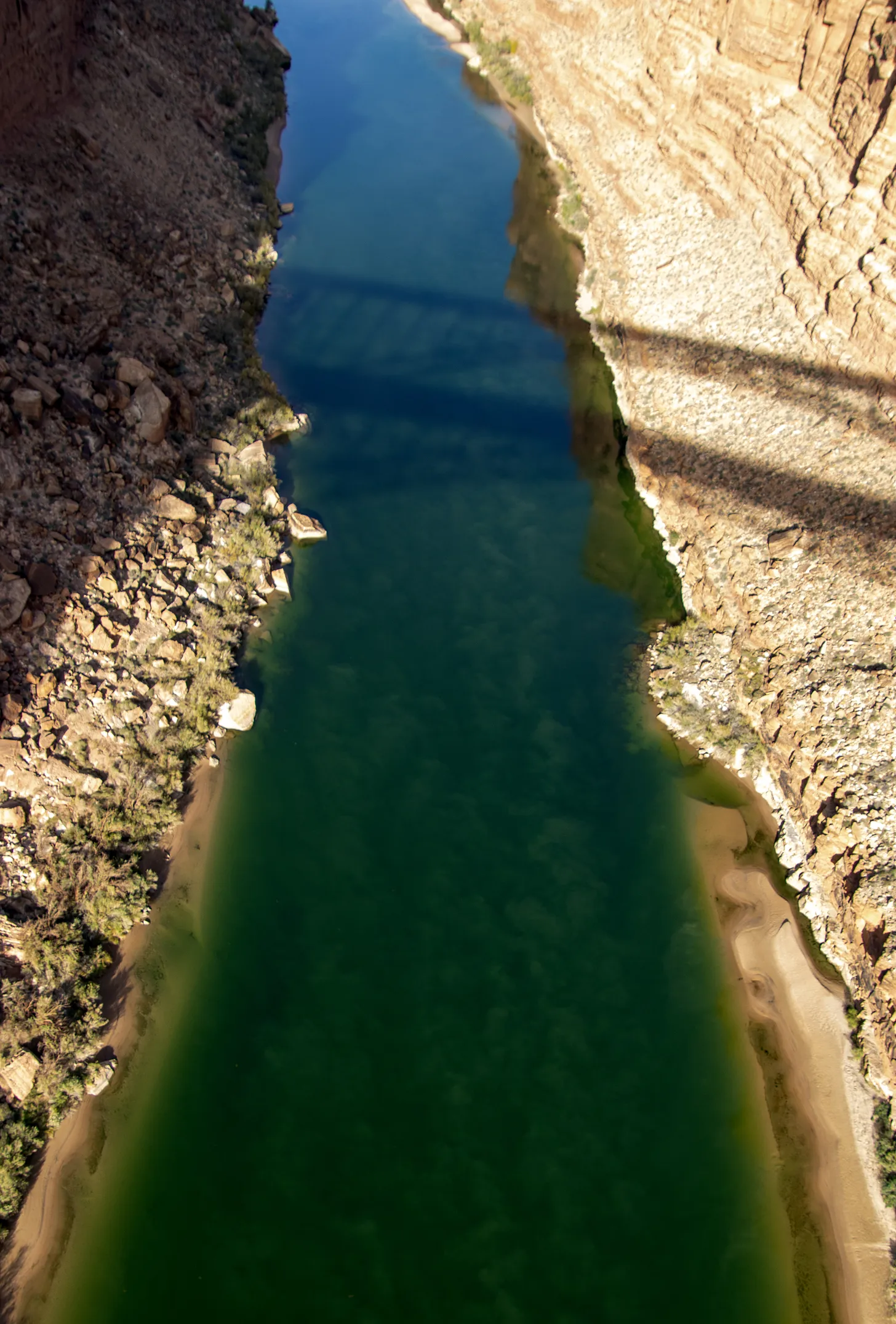
Whenever I’m in this part of Arizona, I try to get to Navajo Bridge (which is actually a pair of bridges), which spans Marble Canyon and the Colorado River downstream from Lees Ferry. One of the bridges was built in 1929, and is now for pedestrians, the other in 1993. They resemble the bridge that crosses the Colorado just below Glen Canyon Dam. I like to go out on the dam-bridge, too, but I also find it a bit frightening: the dam exudes an aura of, for lack of a better term, ominous violence. The Navajo Bridge, by contrast, is a place of serenity. You can stand out on it and, unimpeded by chain link fences, look straight down on the deep, murky green, slow-moving waters of the Colorado and do a bit of vertiginous meditation.

The Colorado River from the Navajo Bridge. Jonathan P. Thompson photo.

The light was crisp, almost harsh, on this visit, and the parking lot almost empty. I got out of the Silver Bullet, stretched, and ambled toward the bridge, noticing as I did a trio looking intently downriver through binoculars. It appeared as if they were studying the engineering of the automobile bridge, and I wondered if maybe it were cracking and getting ready to fail catastrophically. I readied my camera, just in case, and followed their gaze. That’s when I saw them: a trio of giant birds perched on the steel beams of the bridge, some 470 feet above the river, doing a bit of meditating of their own (or perhaps waiting for carrion to float by).

Condors perched on steel girders some 450 feet above the Colorado River. Jonathan P. Thompson photo.

The magnificent creatures, their pink bald heads jutting out from brown-feathered bodies, are California condors, some perhaps the descendants of six birds released in the area in 1996, others that were introduced in later years. They are huge — sporting up to ten-foot wingspans — but live a fragile existence. After being driven nearly to extinction, federal wildlife officials began rearing California condors in captivity and reintroducing them throughout the West. Now there are more than 500 California condors in the wild, but humans continue to imperil them.

Condors 6Y and 2A (I’m sure they have their own, more interesting names, but …) at the Navajo Bridge. According to condorspotter.com, 6Y is a male born in March 2019 at the Oregon Zoo. And 2A is a female hatched at the World Center for Birds of Prey in May 2021. Jonathan P. Thompson photo.

Perhaps the greatest threat is lead poisoning, which comes from ingesting carrion contaminated by lead ammunition. Lead ammunition is designed to shatter and fragment when it hits an animal, increasing its lethality. These fragments end up in the animal’s flesh and the guts, which hunters often discard in the field to be eaten by scavengers. This fall a condor in Zion died from lead poisoning, and wildlife officials say nearly every condor they test has some level of lead in its bloodstream.

Federal and state-level efforts to ban the use of lead ammunition for hunting have run into strong resistance from gun rights advocates, who claim (erroneously) that the initiatives are aimed at stopping all hunting. So some states, including Arizona and Utah, have implemented voluntary programs that incentivize hunters to use non-lead ammunition and dispose of gut piles in a scavenger-safe way. In 2019, California prohibited the use of lead ammo for hunting, but did not ban the sale of the ammunition.

A young condor on the pedestrian bridge. Jonathan P. Thompson photo.

I spent a good part of the afternoon mesmerized by the birds, hoping they would spot something dead and rotting and delicious so I could witness one in flight. It didn’t happen, but I consider myself fortunate nonetheless: As I was preparing to leave I looked straight down from my place on the bridge for one last glimpse at the mighty Colorado, all emerald green down below, and there, only about ten feet below me, sat a young condor, pink beak protruding from a fuzz of black feathers.

A whopper of a snowstorm — Russ Schumacher (#Colorado Climate Center) @rschumacher.cloud #snowpack

Click the link to read the article on the Colorado Climate Center website (Russ Schumacher):

November 18, 2024

The six months from May through October were the warmest on record across Colorado, and parts of the state had been quite dry over that time period; you can read more about those statistics in our October monthly summary. Then in early November, things turned around in a big way across southern and eastern Colorado, with a huge snowstorm from November 4-10 (or really, a couple storm systems that affected the state, one right after the other). There were some remarkable snow totals, with reports of up to 60 inches (5 feet) in the Sangre de Cristo Mountains, and widespread 24-36 inches on the southeastern plains.

Preliminary snowfall totals from the 5-9 November 2024 snowstorms in Colorado and New Mexico, from NOAA’s Weather Prediction Center.
VIsible satellite image on Sunday morning, November 10, 2024. From the NWS Pueblo summary at https://www.weather.gov/pub/November2024WinterStorm

This amount of snow, especially at the lower elevations of eastern Colorado, doesn’t happen very often. Here is a list of the top seven-day snowfall totals at stations in Colorado east of -104.5° longitude, which excludes mountain/foothills locations. There five snowstorms that show up on this list.

Listing of the top 15 seven-day snowfall totals (inches) at stations in Colorado located east of -104.5° longitude. This excludes stations in the mountains and foothills. Data obtained from ACIS.

One that appears several times is the historic storm of early November 1946. That storm produced 50 inches of snow at Eads and 46 inches at Karval, easily the biggest low-elevation snowstorm in state records. You can find plenty of photos and stories about that storm; I enjoyed reading this one from Time Magazine, which gives a sort of poetic sense to a storm that disrupted many lives and industries.

But the second-highest total in this portion of the state was 46 inches that fell from November 4-10 of this year, on the northeast side of Trinidad. The November 2024 storm also had impressive totals of 41″ near Deer Trail, and 34″ near Simla. These really are huge snow totals for eastern Colorado. I think it’s fair to say that the November 2024 storm is only topped by November 1946 for low-elevation snowfall in eastern Colorado.

Other historic storms that show up on the list for eastern Colorado were in late December 2006 (two storms within a week of each other), and in 1980 in northeast Colorado. (If you allow Front Range/foothills locations, then other historic storms like December 1913 and March 2003 also appear on the list. See this presentation from 2005 by Nolan Doesken on “Colorado Classics” for a walk through snowstorm history.) Many people have memories of the October 1997 snowstorm, which was a major storm in southeast Colorado as well, but in terms of snow accumulation, it didn’t even make this list.

The November 1946 and 2024 storms had a lot in common

If we take a quick look at the November 1946 and 2024 storms, we see that they had a lot in common. First is the obvious — they happened at almost exactly the same time of year. But there were also a lot of similarities in the meteorology. Here are animations of the 500-hPa heights and vorticity for these two storms in the ERA5 reanalysis. For the non-meteorologists, this is a measure of the “spin” in the atmosphere. The maps highlight that in both events, a strong upper-level disturbance became cut off from the main flow and parked itself over Arizona and New Mexico for a couple days, before moving northeastward across eastern Colorado and into the Great Plains. This is the type of large-scale setup that favors long-duration precipitation over southern Colorado, while still being just cold enough to be snow rather than rain. The main difference between the two events appears to be that the 1946 storm sat in place for about an extra day compared to the 2024 storm.

Geopotential height, vorticity, and winds at 500 hPa for he November 1946 snowstorm. Data from ERA5, obtained from the Copernicus Climate Data Store (https://doi.org/10.24381/cds.bd0915c6)
Geopotential height, vorticity, and winds at 500 hPa for Data from ERA5, obtained from the November 2024 snowstorm. Copernicus Climate Data Store (https://doi.org/10.24381/cds.bd0915c6)

Very wet snow

Although the snow was very disruptive to travel and agriculture (and pronghorns), it will also have longer-term positive effects on the drought situation in southeastern Colorado. This part of the state had an extremely dry spring, which got the growing season off to a bad start. Precipitation through the summer was closer to average, but it was a very hot summer such that drought and its impacts persisted through the early fall. But the November snowstorm brought widespread 2-5″ of precipitation (liquid equivalent in snow, and/or rain in spots that stayed slightly warmer.) These are huge precipitation amounts for this time of year on the plains. Most of southeastern Colorado has already guaranteed that the November through February period will have more precipitation than average (right image below). And the spots in the darker green on that map received in one week more than twice the average precipitation that would typically fall from November through February!

Precipitation for November 1-14, 2024, from the PRISM dataset and CoCoRaHS observers. Data source: PRISM Climate Group, CoCoRaHS
Percent of the average November through February precipitation that fell during the week from November 5-11, 2024. Data source: PRISM Climate Group, CoCoRaHS

All of the precipitation led to widespread improvements on the US Drought Monitor, with parts of southeast Colorado seeing a two-category improvement, from D2 (severe drought) to D0 (abnormally dry; there are still precipitation deficits on long timescales in this region). In contrast, northern Colorado received much less precipitation from this storm, and improvements were more limited, with D2-D3 (severe-extreme) drought remaining in Larimer and Weld Counties.

Colorado Drought Monitor one week change map ending November 12, 2024.

What does this mean for the rest of the winter? Well, there was an analysis in the Washington Post this week that showed projections for winter (December-January-February) snowfall across the US, and it showed below-normal snowfall across the southern US, including southern Colorado. This projection is connected in part to the La Niña pattern that is emerging. Now, keep in mind that the Post analysis was specifically for the winter season, so the huge November storm is not included in the forecast period. But some locations exceeded their entire annual average snowfall total in this one storm! The stations on the map below were either within a few inches of (in green), or even more than (in purple) their average annual total. The dark purple dot is Karval, which averages 21″ of snow per year, and had 27″ in this storm. Stations at Rocky Ford and Kim also exceeded their annual average in this one storm. So, while technically a projection of below-average snowfall for the winter (Dec-Jan-Feb) could still come true, much of southeastern Colorado has already clinched a snowier-than-average cool season from this single major storm.

Comparison of the 7-day total snowfall from the November 2024 snowstorm to the annual average snowfall (in inches). Stations within a few inches of their annual total are shown in green, those that exceeded their annual average in this one storm are in purple. Data source: ACIS and NOAA/NCEI 1991-2020 normals.

What about mountain snowpack?

This storm brought some very big amounts to the southern mountains, especially the Sangre de Cristos. On November 9, the SNOTEL stations in the Arkansas River basin exceeded their previous record high snow-water equivalent (SWE) for the date. It never hurts to get a good early start to the snowpack! But also keep in mind that the mountains get a lot of snow in even an average year. In other words, it really is very early. The Arkansas basin now has about 25% of its usual peak for the season—much higher than usual for mid-November, but there is still a *long* way to go. La Niña generally brings below-average snowpack to the southern mountains overall, so we will just need to wait and see.

Here are the typical outcomes from both El Niño and La Niña for the US. Note each El Niño and La Niña can present differently, these are just the average impacts. Graphic credit: NWS Salt Lake City office

Water year ends with below-average river flows: Warmer weather, lack of consistent snowfall continue to pose challenges — @AlamosaCitizen #RioGrande

Sunrise March 10, 2023 Alamosa Colorado with the Rio Grande in the foreground. Photo credit: Chris Lopez/Alamosa Citizen

Click the link to read the article on the Alamosa Citizen website:

November 15, 2024

“Not a great year,” is how Colorado Division of Water Resources Division 3 Engineer Craig Cotten summed up the flows on Rio Grande and Conejos River systems this water year which ended Nov. 1.

The Rio Grande had an estimated annual flow of 485,000 acre-feet or 78 percent of the long-term average, while the Conejos River had 238,000 acre-feet or 79 percent of the long-term average, according to figures Cotten presented this week to Rio Grande Basin Roundtable members.

Under the Rio Grande Compact with New Mexico and Texas, Colorado will be obligated to deliver an estimated 122,500 acre-feet from the Rio Grande and 67,800 acre-feet from Conejos River downstream into New Mexico and its storage at Elephant Butte Reservoir.

“We are delivering all the water we have in the system to the state line,” Cotten said, noting that with the water year now ended there is 100 percent curtailment on the Rio Grande and Conejos River systems.

Platoro Reservoir. Photo credit: Rio de la Vista

Getting into the fine details of the Rio Grande Compact, Cotten said Colorado is not storing any water from this year at Platoro Reservoir in Conejos County due to Article 7 of the compact. Platoro Reservoir is a post-compact storage reservoir which Colorado can’t utilize this year because storage of a usable water supply at Elephant Butte and Caballo Reservoir in New Mexico has potentially dropped below 400,000 acre-feet.

“Article 7 of the Compact is in effect and that restricts our ability to store in post-compact reservoirs. So we are not currently storing additional water in Platoro Reservoir,” he said.

The irrigation or water season in the Valley typically runs from April 1 to Nov. 1 and is primarily reliant on snow runoffs in the springtime from the surrounding San Juan and Sangre de Cristo ranges. The runoffs feed into the creeks and streams that come together to form the Rio Grande.

A lack of consistency in snowfalls over the past two decades and the warming of the southern end of Colorado compared to the state’s northern frontiers has San Luis Valley irrigators constantly working to figure out how to farm and ranch in a climate of aridification.

“The forecast is for the northern areas to get more snow than the southern areas,” Cotten said in looking at the outlook for 2024-25 winter.

The Colorado Climate Center, at the start of 2024, released a study showing how “the greatest warming has been observed over the Southwest and San Luis Valley climate regions.”

Conejos River near Antonito August 2019. Photo credit: Allen Best