November 6, 2024
Donald J. Trump will once again be president of the United States.
The Associated Press called the race for Trump early Wednesday morning, ending one of the costliest and most turbulent campaign cycles in the nation’s history. The results promise to upend U.S. climate policy: In addition to returning a climate denier to the White House, voters also gave Republicans control of the Senate, laying the groundwork for attacks on everything from electric vehicles to clean energy funding and bolstering support for the fossil fuel industry.
“We have more liquid gold than any country in the world,” Trump said during his victory speech, referring to domestic oil and gas potential. The CEO of the American Petroleum Institute issued a statement saying that “energy was on the ballot, and voters sent a clear signal that they want choices, not mandates.”
The election results rattled climate policy experts and environmental advocates. The president-elect has called climate change “a hoax” and during his most recent campaign vowed to expand fossil fuel production, roll back environmental regulations, and eliminate federal support for clean energy. He has also said he would scuttle the Inflation Reduction Act, or IRA, which is the largest investment in climate action in U.S. history and a landmark legislative win for the Biden administration. Such steps would add billions of tons of additional greenhouse gases to the atmosphere and hasten the looming impacts of climate change.
“This is a dark day,” Ben Jealous, the executive director of the Sierra Club, said in a statement. “Donald Trump was a disaster for climate progress during his first term, and everything he’s said and done since suggests he’s eager to do even more damage this time.”
During his first stint in office, Trump withdrew from the Paris Agreement, the 2015 international climate accord that guides the actions of more than 195 countries; rolled back 100-plus environmental rules; and opened the Arctic National Wildlife Refuge to drilling. While President Joe Biden reversed many of those actions and made fighting climate change a centerpiece of his presidency, Trump has pledged to undo those efforts during his second term, with potentially enormous implications — climate analysts at Carbon Brief predicted that another four years of Trump would lead to the nation emitting an additional 4 billion metric tons of carbon dioxide than it would under his opponent. That’s on par with the combined annual emissions of the European Union and Japan.
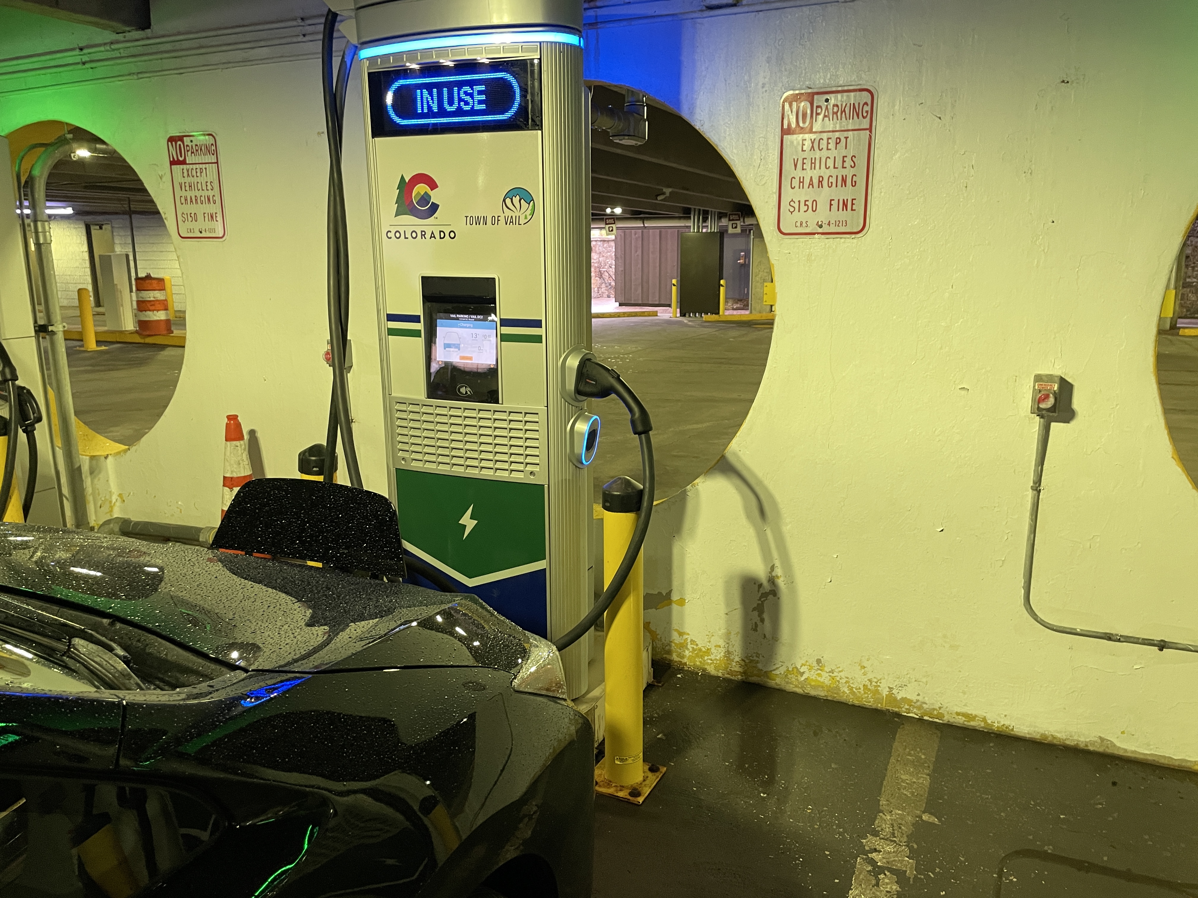
One of President-elect Trump’s primary targets will be rolling back the IRA, which is poised to direct more than a trillion dollars into climate-friendly initiatives. Two years into that decade-long effort, money is flowing into myriad initiatives, ranging from building out the nation’s electric vehicle charging network to helping people go solar and weatherize their homes. In 2023 alone, some 3.4 million Americans claimed more $8 billion in tax credits the law provides for home energy improvements. But Trump could stymie, freeze, or even eliminate much of the law.
“We will rescind all unspent funds,” Trump assured the audience in a September speech at the Economic Club of New York. Last month, he said it would be “an honor” to “immediately terminate” a law he called the “Green New Scam.”
Such a move would, however, require congressional support. While many House races remain too close to call, Republicans have taken control of the Senate. That said, any attempt to roll back the IRA may prove unpopular, because as much as $165 billion in the funding it provides is flowing to Republican districts.
Still, Trump can take unilateral steps to slow spending, and use federal regulatory powers to further hamper the rollout process. As Axios noted, “If Trump wants to shut off the IRA spigot, he’ll likely find ways to do it.” Looking beyond that seminal climate law, Trump has plenty of other levers he can also pull that will adversely affect the environment — efforts that will be easier with a conservative Supreme Court that has already undermined federal climate action.
Trump has also thrown his support behind expanded fossil fuel production. He has long pushed for the country to “drill, baby, drill” and, in April, offered industry executives tax and regulatory favors in exchange for $1 billion in campaign support. Though that astronomical sum never materialized, The New York Times found that oil and gas interests donated an estimated $75 million to Trump’s campaign, the Republican National Committee, and affiliated committees. Fossil fuels were already booming under Biden, with domestic oil production higher than ever before, and Vice President Kamala Harris said she would continue producing them if she won. But Trump could give the industry a considerable boost by, for instance, reopening more of the Arctic to drilling.
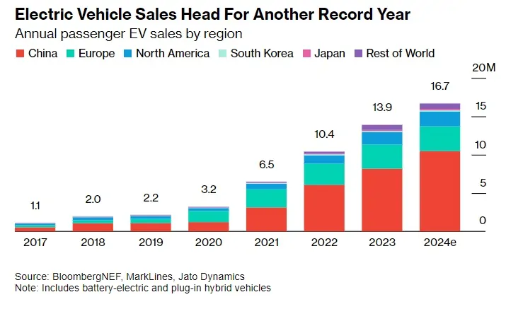
Any climate chaos that Trump sows is sure to extend beyond the United States. The president-elect could attempt to once again abandon the Paris Agreement, undermining global efforts to address the crisis. His threat to use tariffs to protect U.S. companies and restore American manufacturing could upend energy markets. The vast majority of solar panels and electric vehicle batteries, for example, are made overseas and the prices of those imports, as well as other clean-energy technology, could soar. U.S. liquefied natural gas producers worry that retaliatory tariffs could hamper their business.
The Trump administration could also take quieter steps to shape climate policy, from further divorcing federal research functions from their rulemaking capacities to guiding how the Centers for Disease Control and Prevention studies and responds to health concerns.
Trump is all but sure to wreak havoc on federal agencies central to understanding, and combating, climate change. During his first term, his administration gutted funding for research, appointed climate skeptics and industry insiders, and eliminated several scientific advisory committees. It also censored scientific data on government websites and tried to undermine the findings of the National Climate Assessment, the government’s scientific report on the risks and impacts of climate change to the country. Project 2025, the sweeping blueprint developed by conservative groups and former Trump administration officials, advances a similar strategy, deprioritizing climate science and perhaps restructuring or eliminating federal agencies that advance it.
“The nation and world can expect the incoming Trump administration to take a wrecking ball to global climate diplomacy,” Rachel Cleetus, the policy director and lead economist for the Climate and Energy Program at the Union for Concerned Scientists, said in a statement. “The science on climate change is unforgiving, with every year of delay locking in more costs and more irreversible changes, and everyday people paying the steepest price.”
The president-elect’s supporters seem eager to begin their work.
Mandy Gunasekara, a former chief of staff of the Environmental Protection Agency during Trump’s first term, told CNN before the election that this second administration would be far more prepared to enact its agenda, and would act quickly. One likely early target will be Biden-era tailpipe emissions rules that Trump has derided as an electric vehicle “mandate.”
During his first term, Trump similarly tried to weaken Obama-era emissions regulations. But the auto industry made the point moot when it sidestepped the federal government and made a deal with states directly, a move that’s indicative of the approach that environmentalists might take during his second term. Even before the election, climate advocates had begun preparing for the possibility of a second Trump presidency and the nation’s abandoning the global diplomatic stage on this issue. Bloomberg reported that officials and former diplomats have been convening secret conversations, crisis simulations, and “political war-gaming” aimed at maximizing climate progress under Trump — an effort that will surely start when COP29 kicks off next week in Baku, Azerbaijan.
“The result from this election will be seen as a major blow to global climate action,” Christiana Figueres, the United Nations climate chief from 2010 to 2016, said in a statement. “[But] there is an antidote to doom and despair. It’s action on the ground, and it’s happening in all corners of the Earth.”