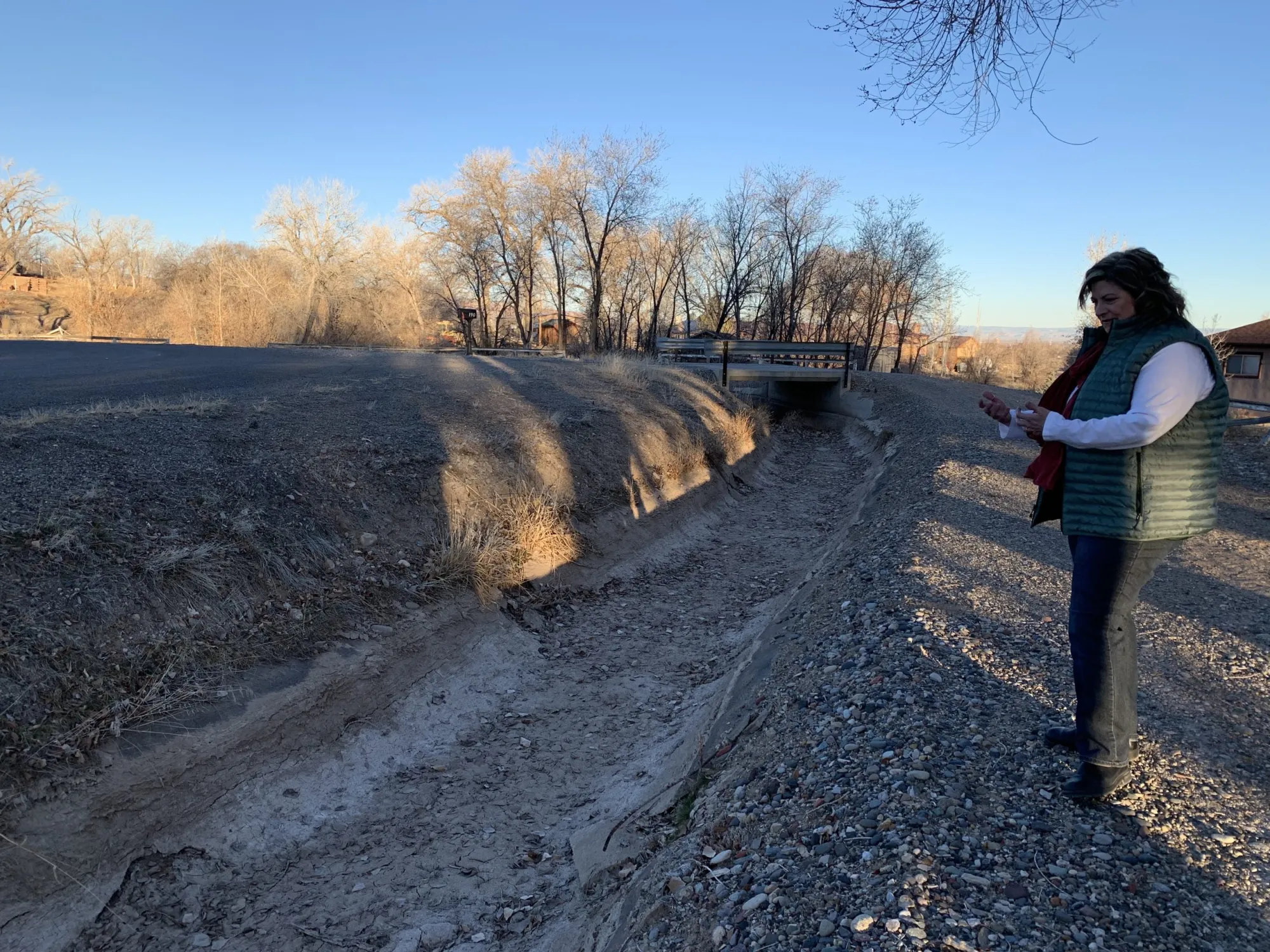
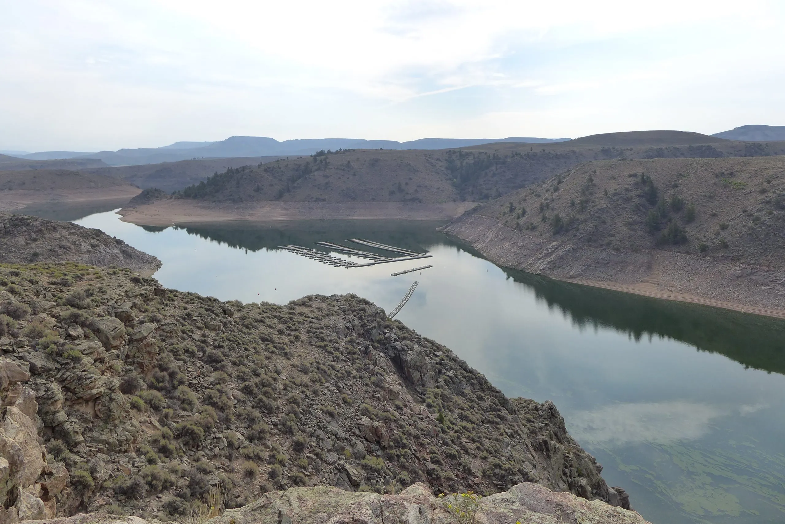
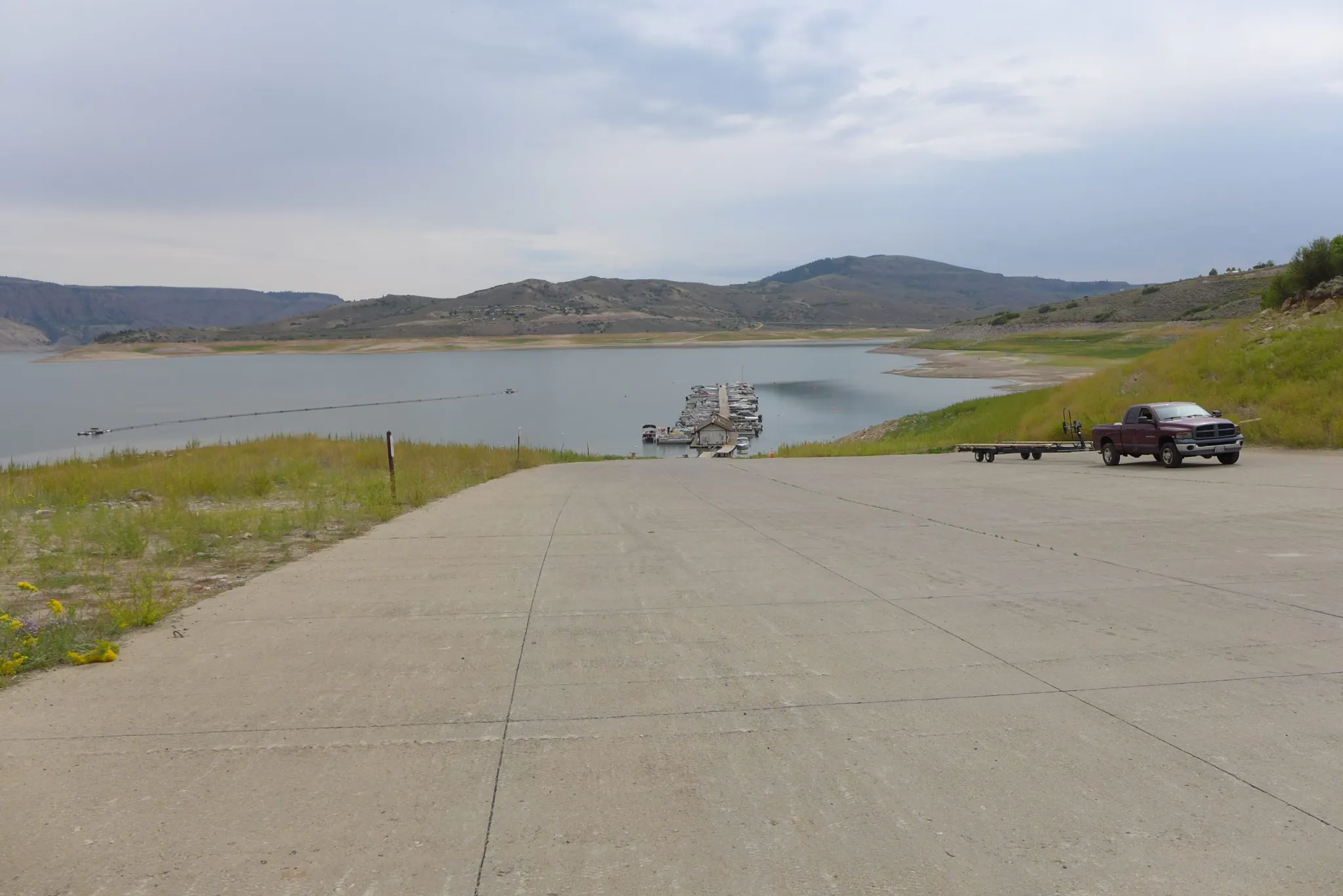
The fickle “children of the Pacific Ocean,” El Niño and La Niña, have again dealt the Gunnison River Basin a bad hand. A weak La Niña winter sent the storm-bearing jet streams over the northwestern United States and southern Canada, leaving the Southwest, and southern half of Colorado, relatively dry for 2025, according to Bob Hurford, Colorado’s Division 4 (Gunnison Basin) Engineer. Hurford visited Gunnison on April 17 for an annual “State of the River” program, along with Andy Mueller, general manager of the Colorado River Water Conservation District, known as the “River District,” the program’s sponsor. Sonja Chavez, manager of the Upper Gunnison River Water Conservancy District, and Jesse Kruthaupt, Gunnison agent for Trout Unlimited’s Colorado Restoration Program spoke on the state of the Upper Gunnison River.
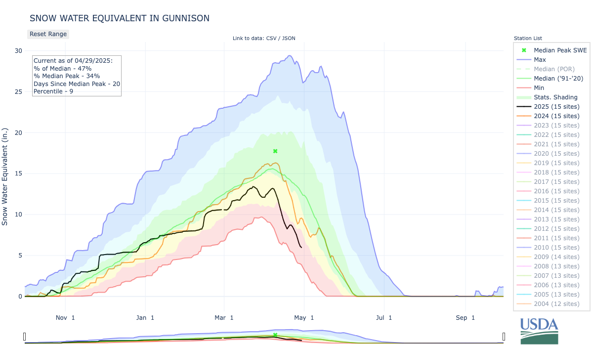
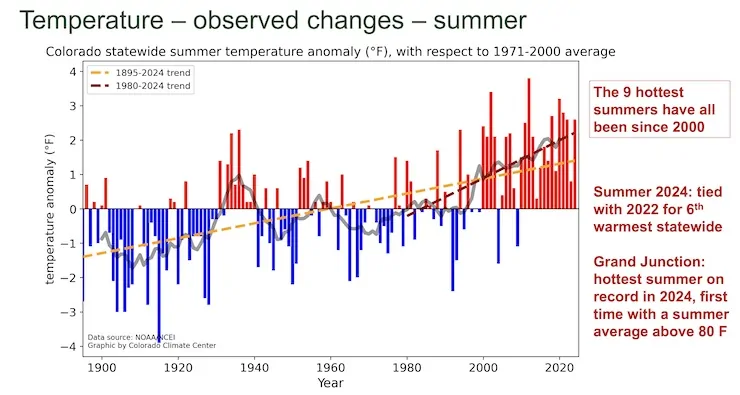
Hurford led with a discussion of what is unfolding locally in water year 2025 (Oct. 1, 2024 through Sept. 30, 2025). The Upper Gunnison Basin’s April 1 snowpack (usually at or near the maximum depth for the winter) contains only 59% of the 30-year average water content. It is projected at this point to yield through July about 540,000 acre-feet of runoff or less for the river — probably not enough to fill Blue Mesa Reservoir after downstream water rights are filled. An acre-foot of water is the amount it would take to cover the playing area of a football field to the depth of one foot. As the changing climate warms the planet, March is becoming the “new April.” This year’s snowpack peaked in mid-March. With the big melt usually beginning sooner nowadays, spring-like weather is causing trees and other plants to also begin “drinking” sooner…Increasing evaporation and plant transpiration also come with the changing climate. According to Mueller, for every additional degree Fahrenheit in the ambient temperatures, another 3-5% of water on the surface and in plants disappears as water vapor. These are changes to be anticipated for as long as we continue to warm the planet’s climate. Hurford concluded his presentation with a chart indicating that the decade beginning with 2020 is on track at this point to be the driest decade on record, including the droughts of the 1930s and 2000s.
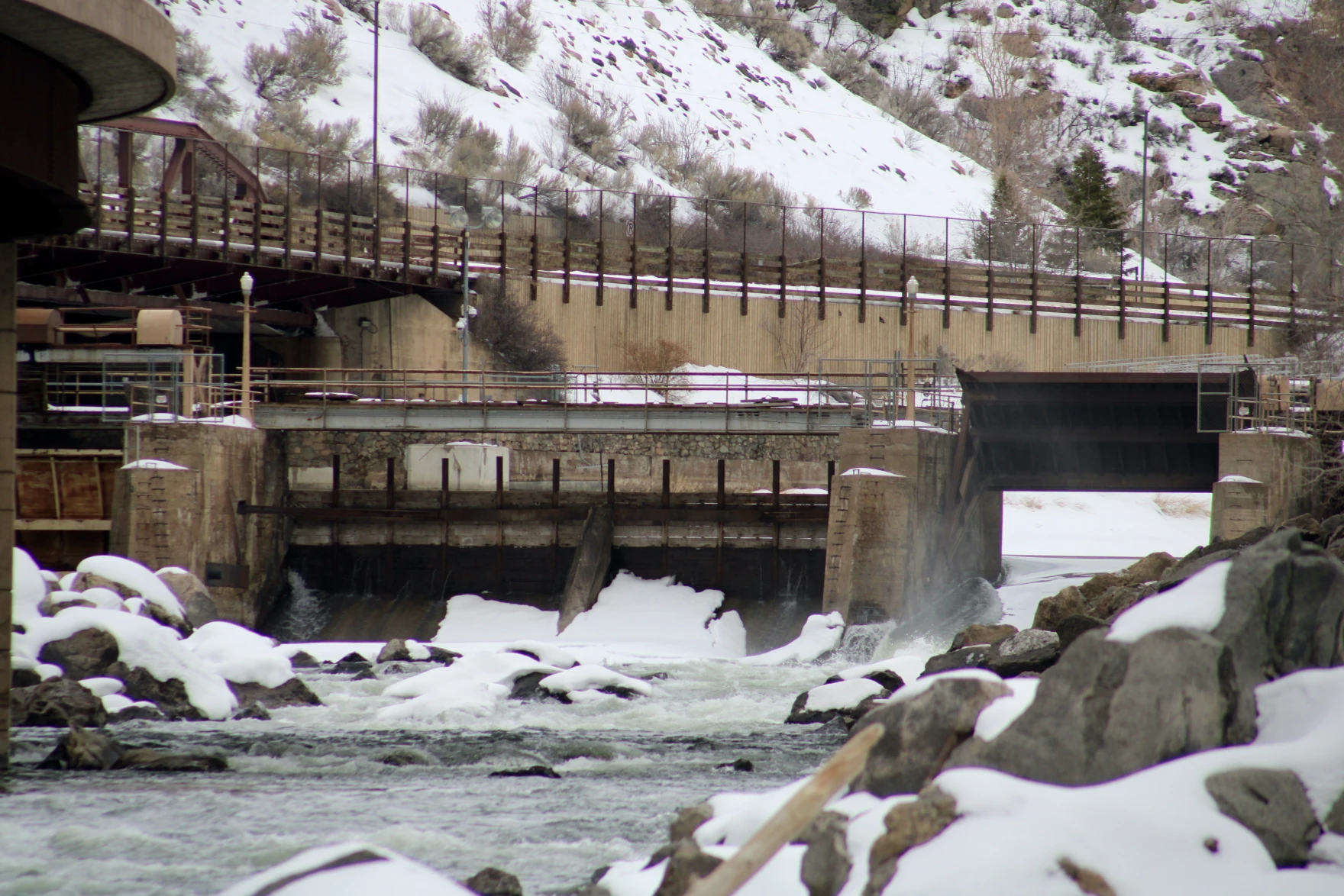
The Shoshone hydro plant in Glenwood Canyon. The River District has made a deal with Xcel Energy to buy the water rights associated with the plant to keep water flowing on the Western Slope. Credit: Heather Sackett/Aspen Journalism
Pitkin County on Wednesday joined 29 other Western Slope counties, cities and towns, irrigation districts and water providers in financially backing a plan to buy a critical Colorado River water right.
Pitkin County commissioners unanimously approved a resolution supporting the Shoshone Permanency Project and pledging $1 million toward the campaign to keep the water rights associated with the Shoshone hydropower plant in Glenwood Canyon on the Western Slope. Pitkin County’s Healthy Rivers Board recommended the $1 million contribution from its fund at its regular meeting April 17.
The Colorado River Water Conservation District plans to purchase the water rights from Xcel Energy for nearly $100 million. The water rights are some of the biggest and oldest non-consumptive water rights on the mainstem of the Colorado River, and ensure water keeps flowing west to the benefit of downstream cities, farms, recreation and the environment.
“From our perspective we view this as an opportunity to really create and enhance a partnership that should be incredibly functional in the future,” River District General Manager Andy Mueller told commissioners on Wednesday. “We’re committed to working with you to keep the upper Roaring Fork healthy and figuring out creating solutions to bring water into the watershed at the right times of year.”
About 40% of the headwaters of the Roaring Fork River is diverted across the Continental Divide for use in the Arkansas River basin. It’s long been Pitkin County’s goal to mitigate the effects this has on the health of the Roaring Fork.
In exchange for support of the Shoshone project, Pitkin County will be able to use some water from Grizzly Reservoir, owned by the city of Aspen and the River District, to boost flows in the upper Roaring Fork River.
“One of the most productive things to come out of this, in addition to the benefits you’ve already discussed with the Shoshone project itself … is going to be that the River District has agreed that Pitkin County can now have a voice in working with Aspen and the River District on that Grizzly water,” said Jennifer DiLalla, an attorney with Moses, Wittemyer, Harrison and Woodruff. DiLalla is the county’s outside counsel who works on water issues. “That is one of the only sources of water available upstream of you. It’s not going to be there all that often, but when it is, it’s a really great benefit for the upper Fork.”
The $1 million pledge may help the county and the River District repair their rocky relationship after years of being at odds over certain water issues. Pitkin County didn’t initially support the Shoshone campaign because of the complex interaction of the water rights with another big set of downstream irrigation water rights in the Grand Valley known as the Cameo call.
“We’ve come a long way because it used to be not too long ago that we were just going to oppose this, period,” said Pitkin County Commissioner and River District representative Francie Jacober. “I would say that we are on the road to a new era of cooperation with the River District.”
Pitkin County’s concern was that with Shoshone under new ownership — and the proposed addition of an instream flow use for the water along with hydropower — the call for the water through Glenwood Canyon might delay or reduce the need for the Cameo call. Aspenites like to see the Cameo call come on because it forces the Twin Lakes diversion to shut off, which means more water flowing down the Roaring Fork, typically during a time of year in late summer and early fall when streamflows are running low and river health is suffering.
North Star Nature Preserve on the Roaring Fork River just upstream of Aspen experienced high water in June of 2023. Pitkin County is supporting the River District’s campaign to buy the Shoshone water rights in exchange for help boosting flows in the upper Roaring Fork. Credit: Heather Sackett/Aspen Journalism
Some of the mistrust between the two local governments can be traced to water rights owned by the River District that would have kept alive huge reservoirs on the Crystal River near Redstone. The district eventually abandoned those rights, but not without first being challenged in water court by Pitkin County. Pitkin County also opposed the widely supported River District 2020 tax increase — ballot measure 7a — which funds water projects across the district’s 15-county area.
To secure the Shoshone water rights — which comprise a 1902 right for 1,250 cubic feet per second and another from 1929 for 158 cfs — the River District must add an instream flow use to the water rights in addition to their current use for hydropower. That requires working with the Colorado Water Conservation Board, which is the only entity in the state allowed to hold instream flow rights which preserve the environment, as well as getting a new water court decree to allow the change in use.
Despite the support and $1 million pledge, Pitkin County still may oppose the change case in water court. The county hired Golden-based engineering firm Martin and Wood Water Consultants to do an analysis of the Shoshone and Cameo call interaction to see if the Roaring Fork could be harmed. According to Tara Meininger, an engineer with Martin and Wood, there could potentially be an annual impact of 26 acre-feet on average to the upper Roaring Fork.
But a final report is still not complete, said Pitkin County Attorney Richard Neiley, which is why the county reserved the right to oppose the River District in water court.
“It’s an important goal to make sure that change does not result in injury to the Roaring Fork forever,” Neiley said. “We haven’t given anything away with respect to being able to argue or oppose the change case on that basis.”
With Pitkin County’s $1 million contribution, the River District has now raised $57 million from local and regional partners. In addition, the project was awarded $40 million in the final days of the Biden administration, but that funding has since been frozen, though River District officials are hopeful that the federal funding will still be realized.
The River District plans to present an agreement on the instream flow water rights to the Colorado Water Conservation Board at its regular meeting in May.
“We’re about to enter into a process with the Colorado Water Conservation Board where your support will be essential to a successful experience there and then on into water court,” Mueller told commissioners. “So we just want to say thank you very much.”
Colorado transmountain diversions via the State Engineer’s office
Lake Powell at Wahweap Marina as seen in December 2021. Dwindling streamflows and falling reservoir levels have made it more likely that what some experts call a Colorado River Compact “tripwire” will be hit in 2027. Credit: Heather Sackett/Aspen Journalism
Time is ticking for states that share the shrinking Colorado River to negotiate a new set of governing rules. One major sticking point, which has the potential to thrust the parties into a protracted legal battle, hinges on differing interpretations of a few sentences in a century-old agreement.
In a recent letter, the river’s Lower Basin states – California, Nevada and Arizona – asked federal officials to analyze the effects of a hypothetical legal concept known as a “compact call.”
The problem? The 1922 Colorado River Compact says nothing about a compact call. And although the phrase often looms like a threat over Colorado River discussions, there is no agreed-upon definition of the term, what would trigger a compact call nor how one would play out. In fact, the Upper Basin states – Colorado, New Mexico, Utah and Wyoming – don’t believe the laws governing the river even contemplate it.
The February letter comes as water managers from all seven Colorado River Basin states are in the midst of deciding how Lake Powell and Lake Mead will be operated and cuts will be shared after 2026 when the current guidelines expire. In March 2024, each basin submitted competing proposals to the U.S. Bureau of Reclamation. In January, federal officials with the outgoing Biden administration released their analysis of five different potential ways forward and did not include either basin’s proposal, but a “basin hybrid” that incorporated elements from both.
In essence, the Lower Basin states have identified a potential opening with the Trump administration, and asked new leaders at the Interior Department to adopt the Lower Basin’s view on some of the most contentious and disagreed-about parts of Colorado River management.
“I believe that under the law, the compact requires delivery of 7.5 million acre-feet of water on a 10-year rolling average, plus one-half of the Mexico Treaty obligation to the Lower Basin,” said Tom Buschatzke, director of Arizona’s Department of Water Resources. “So we want to see Reclamation, as our request indicated, incorporate that outcome into the modeling for any alternative to look at. That includes how reductions in the Upper Basin states might have to occur.”
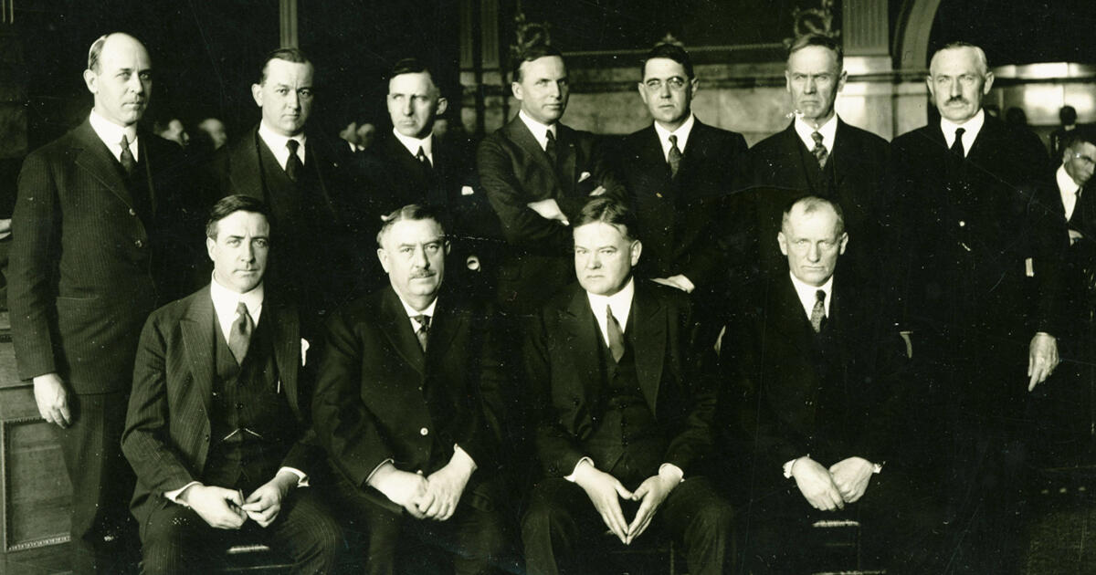
Members of the Colorado River Commission, in Santa Fe in 1922, after signing the Colorado River Compact. From left, W. S. Norviel (Arizona), Delph E. Carpenter (Colorado), Herbert Hoover (Secretary of Commerce and Chairman of Commission), R. E. Caldwell (Utah), Clarence C. Stetson (Executive Secretary of Commission), Stephen B. Davis, Jr. (New Mexico), Frank C. Emerson (Wyoming), W. F. McClure (California), and James G. Scrugham (Nevada)
CREDIT: COLORADO STATE UNIVERSITY WATER RESOURCES ARCHIVE via Aspen Journalism
Over a century ago, the compact split the river’s water evenly, with half (7.5 million acre-feet a year) going to the Upper Basin and half to the Lower Basin. Another 1.5 million acre-feet a year was later allocated to Mexico.
The crux of the dispute comes from how the Upper Basin states and the Lower Basin states each interpret a key phrase in the compact: “The States of the Upper Division will not cause the flow of the river at Lee Ferry to be depleted below an aggregate of 75,000,000 acre-feet for any period of ten consecutive years…”
To the Upper Basin states, “will not cause” means that their use won’t be the reason the Lower Basin doesn’t get its allocation. They see it as a “non-depletion” obligation.
According to Colorado officials, they’re not delivering water downstream, but rather they’re not causing the flows to be depleted.
“What this means is that if the flows were to drop below 75 million acre-feet over a ten-year period, there would be an inquiry into what caused that to occur,” Michael Elizabeth Sakas, Colorado River communications specialist with the Colorado Water Conservation Board said in a written response to questions from Aspen Journalism.
On the other hand, the Lower Basin states say they’re owed the water, with the Upper Basin states required to send the 75 million acre-feet over 10 years, plus half of the Mexico Treaty obligation (which works out to 82.5 million acre-feet every 10 years) downstream to the Lower Basin.
Compact “tripwire” threatens to complicate
Colorado River expert Eric Kuhn says that the latest report from the U.S. Bureau of Reclamation is a major caution sign for the basin. An anemic snowpack this past winter could be setting the basin on the road to a compact call (as defined by the Lower Basin). The most recent federal forecast predicts that in 2027, the 10-year cumulative flow at Lee Ferry could drop below 82.5 million acre-feet, a threshold Kuhn calls the first “tripwire” for a compact call.
“If flows were to go below 82.5 million, then that’s the first time, in theory, the lower division states could point to the Upper Basin and say, ‘You’re not complying with your compact obligations,’” Kuhn said. “This is not going to sneak up on us. I think most of the modeling shows that it’s almost inevitable we will drop below 82.5 in the next three or four years.”
But Upper Basin officials disagree. In their interpretation, this tripwire doesn’t exist. A compact call is a concept recognized only by the Lower Basin.
They also point out that calls for water apply to situations where there is a senior rights holder and a junior rights holder. Under the prior appropriation system, the oldest water rights get first use of the river, and senior rights can force junior rights to stop using water so seniors can get the full amount they are entitled to. But Upper Basin officials say there is no priority between the two basins; they are on equal standing. [ed. emphasis mine]
That may be true, but the three Lower Basin states are also home to the basin’s biggest water users and cities, with more political power than the sparsely populated Upper Basin states.
Navajo Bridge spans the Colorado River downstream from Lake Powell near Lee Ferry, the dividing line between the upper and lower basin. Some federal forecasts predict that in 2027, the flow at Lee Ferry could drop below a critical threshold that some experts call a “compact tripwire.”
River headed for “wildly uncharted territory”
So what would happen if and when the river shrinks enough to trigger the first compact tripwire?
In practice, a compact call could mean the Lower Basin states would sue the federal government to get them to send more water downstream from Lake Powell. (The U.S. Bureau of Reclamation is responsible for making releases from Lake Powell and Lake Mead.) The Lower Basin states could also demand that the Upper Basin states implement cuts to get more water into Lake Powell. But the Upper Basin states will almost certainly argue they are in compliance with the compact and don’t need to make cuts. The Supreme Court could then decide whether the Upper Basin states are in compliance with the compact.
“It’s wildly uncharted territory,” said Chuck Cullom, the executive director of the Upper Colorado River Commision. “It’s not a straightforward path to say: ‘We need you to release more water out of Glen Canyon Dam and curtail uses.’”
Udall/Overpeck 4-panel Figure Colorado River temperature/precipitation/natural flows with trend. Lake Mead and Lake Powell storage. Updated through Water Year 2024. Credit: Brad Udall
The Upper Basin’s argument hinges on what is causing the flows at Lee Ferry to drop. The four states say it’s not their fault, because they only use between 3.5 and 4.5 million acre-feet a year, far less than their allocation of 7.5 million acre-feet. The culprit, they say, is climate change, which according to scientists has contributed to a 20% decline in flows from the 20th century average. They have also shown that every 1 degree Celsius of warming results in a 9% reduction in flows.
With a fixed number for how the river is shared, and a slowly dwindling amount of water available, the Upper Basin has been bearing the brunt of the effects of climate change, a phenomenon that Kuhn calls the “Upper Basin squeeze.” But the climate change argument could open a can of worms.
“There are numerous other water compacts between states,” Kuhn said. “Are we reopening every one of those? It could mean that other states do not have to comply with their compact obligations.That would be a precedent decision that would affect every compact in the western United States.”
How would cuts work?
Water users on Colorado’s Western Slope are eager to know how cuts could play out and over the past few years they have asked state officials repeatedly for more clarity on this issue. One reason is because most of the big transmountain diversions that take water from the mountainous headwaters of the Colorado to Front Range cities date to after the 1922 compact, meaning they would likely be cut first. But as the population centers and economic engines of the state, it’s unlikely a plan to cut water use would include turning off the taps to Denver.
In a crisis situation where cuts are mandatory, the strict prior appropriation system would probably not hold.
“They’re going to have to make hard decisions, and they are going to primarily meet the human health and safety needs of people first,” Kuhn said. “It’s an open secret that the priority system works under normal conditions; it doesn’t work in emergencies.”
Western Slope water users also want to know the state’s plan for cuts, because some areas may be more at risk of forced cutbacks than others. The Yampa/White/Green River basin in the northwest corner of the state, for example, developed later than other places, with lots of more junior water rights. Would they be first on the chopping block?
“We believe that regardless of where things stand on the river, clarity can’t hurt water users,” said Peter Fleming, general counsel with the Colorado River Water Conservation District. “In the long run, clarity will help people to plan better.”
But state officials have been reluctant to provide clarity about how cuts could be implemented, saying now is not the time to plan for it and that the Upper Basin states have always been in compliance with the compact.
“Colorado is not at risk of any compact curtailment scenario in the near future,” Sakas said in a written response to Aspen Journalism. “For the last 20 years, the Upper Basin has been using half of what we are allowed to use under the 1922 Compact while our downstream neighbors use significantly more than their apportionment.”
Figuring out who would be the first to take cuts and tracking that water to the state line would not be an easy task, said Colorado River expert Jennifer Gimbel. Gimbel is the senior water policy scholar at the Colorado State University Water Center and is the former director of the Colorado Water Conservation Board.
“It would be a tremendous headache and a huge undertaking,” she said. “But I don’t know if that means we shouldn’t be doing it.”
The Colorado Division of Water Resources, in a first step, has been developing measurement rules and requiring measurement devices for water users across the Western Slope. According to state officials, the goal of this effort is to accurately measure diversions so that if necessary, Colorado sends downstream only the water that is required to maintain compact compliance and not a drop more.
From left, J.B. Hamby, chair of the Colorado River Board of California, Tom Buschatzke, Arizona Department of Water Resources; Becky Mitchell, Colorado representative to the Upper Colorado River Commission at the Colorado River Water Users Association Conference in 2023. Water managers from all seven Colorado River Basin states are in the midst of deciding how Lake Powell and Lake Mead will be operated and cuts will be shared after 2026Credit: Tom Yulsman/Water Desk, University of Colorado, Boulder
Trying to stay out of court
One thing most water managers agree on is that finding a seven-state consensus is better than the potentially protracted litigation possible under some kind of compact call scenario. Some are hoping for the best but preparing for the worst. The Arizona Department of Water Resources requested about $1 million last year for Colorado River litigation from the state budget. Buschatzke said the Upper Basin states might fare worse under a compact call than they would by adopting the Lower Basin proposal.
“Because there are a lot of moving parts, litigation — a compact call — is a possibility,” he said. “It’s not a possibility I want to see occur. But I’ll have to do what I have to do to protect the state of Arizona.”
If the states can come up with new guidelines that fairly share the river, the threat of a compact call, which has long hung over Colorado River management discussions, could evaporate like water from the surface of Lake Mead. Cullom said that in 2007 when the seven states implemented the soon-to-expire guidelines that are currently in place, they agreed that if the two basins made good on their commitments outlined in those guidelines, they would set aside the issue of compact compliance — at least until after 2026.
“If they can figure out a way to live within the means of the river in such a manner that both the Upper Basin and Lower Basin agree, hopefully addressing a compact call again won’t be needed because it’s been addressed,” Gimbel said.
This story was produced by Aspen Journalism, in partnership with The Water Desk at the University of Colorado’s Center for Environmental Journalism.
Map of the Colorado River drainage basin, created using USGS data. By Shannon1 Creative Commons Attribution-Share Alike 4.0
This historical photo shows the penstocks of the Shoshone power plant above the Colorado River. A coalition led by the Colorado River District is seeking to purchase the water rights associated with the plant. Credit: Library of Congress photo
Western Slope water leaders hope bipartisan support can thaw $40 million in frozen federal money aimed at securing some of the Colorado River’s oldest water rights. The Colorado River District is spearheading an effort to purchase senior rights from Xcel Energy used at the Shoshone hydroelectric plant in Glenwood Canyon. The water allocated by the rights passes through the facility and back into the river, making them “nonconsumptive” rights, but by purchasing them for $99 million Western Slope leaders hope to ensure that water can continue to flow downstream and avoid the possibility it could be rerouted to Front Range users. The effort to buy the rights raised more than $50 million between the state of Colorado, the River District and more than two dozen entities on the Western Slope. In January, the federal government announced $40 million worth of support to the project. Just days later, the Trump administration took over, and that money was put on hold.
“I think that has been frozen,” Republican Congressman Jeff Hurd, who represents Colorado’s 3rd Congressional District, said in response to a question about the grant during a tele-town hall event on March 11. “Just know that we are working hard behind the scenes to see what we can do to make sure that that funding is allocated and completed.”
Andy Mueller, general manager for the Colorado River District, said the group anticipated delays in the funding from the start on account of the changing administrations. But, because the group has been working on pooling the money in advance, they’re not being left high-and-dry by the funding freeze just yet.
“We’re one of the fortunate grantees, if you will, in that situation. I know there are a lot of grantees who were actually engaged in digging dirt and had hired staff in anticipation of grants,” Mueller said. He noted the deal is still pending a water court change case, giving the Shoshone purchase deal extra runway to haggle over the federal contribution.
At the March 4 Grand County Board of Commissioners meeting, the Colorado River District shared good news: the dam’s settling was no longer cause for alarm. At the meeting, river district staff presented its 2024 Comprehensive Dam Safety Evaluation, which showed the likelihood of Ritschard Dam’s failure is “within industry-accepted tolerable risk guidelines.” This means that although there’s always a risk of failure for any dam, there is no need to rehabilitate or repair the dam. Andy Mueller, the river district’s general manager, told commissioners that the district has partnered with “experts from around the world” to complete the evaluation and is confident in its results…
A view of the upstream side of the dam that forms Wolford Reservoir, on Muddy Creek, a tributary of the Colorado River, above Kremmling. A recent dam safety evaluation found that the dam is at greater risk of cracking and internal erosion than previously thought.
CREDIT: BRENT GARDNER-SMITH / ASPEN JOURNALISM
The Ritschard Dam is owned and operated by the Colorado River District. D.H. Blattner and Sons of Minnesota constructed the 122-foot-tall dam between 1993 and 1995. It is composed of a clay core, covered by rockfill with a sand filter. According to the river district, the clay core provides a barrier that prevents water from passing through the dam. If the settling were to cause cracks in the core, water could enter and eventually lead to the dam’s failure if nothing was done. Since construction, the dam has shifted down 2.6 feet. The top of the dam has also moved sideways about 8 inches. This is possibly due to poor rockfill compaction. However, the district hasn’t pinned down an exact reason for the settling. Hunter Causey, the district’s director of asset management and chief engineer, told commissioners that he and other staff members “have been keeping a really close eye” on the dam. Contractors have added additional feet to the top of the dam because of the settling. After using monitoring devices to study the dam every day, the river district conducted comprehensive safety evaluations in 2016 and 2020. The 2020 evaluation found that risk had increased…the settling has abated in recent years, although it is expected to continue at a slower pace.
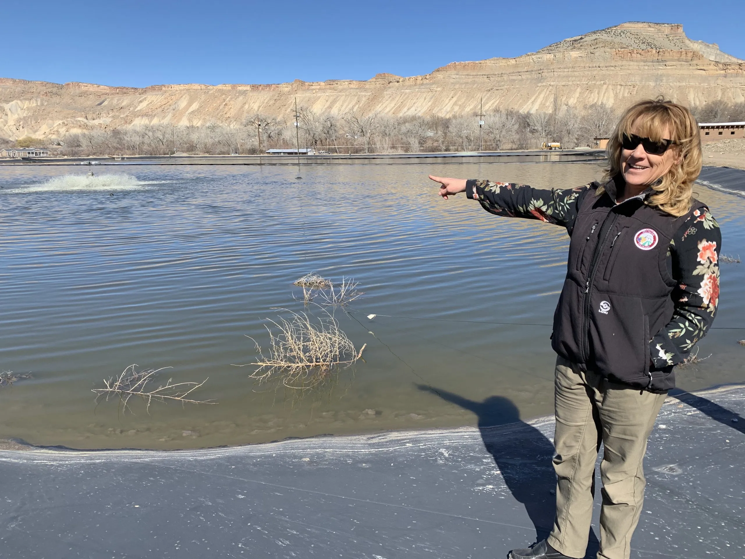
Palisade Town Manager Janet Hawkinson points out the aerators in the town’s wastewater lagoons. The Town plans to pipe its wastewater to Clifton’s treatment plant and reclaim the nine-acre area as wetlands using a $3 million federal grant — funding which has now been paused by the Trump administration. Credit: HEATHER SACKETT/Aspen Journalism
In the Grand Valley south of Highway 50, Orchard Mesa Canal No. 1 winds through 18 miles of rural agricultural farmland and residential backyards.
In January, the Orchard Mesa Irrigation District was promised $10.5 million from the U.S. Bureau of Reclamation to pipe the open canal — which has crumbling chunks of concrete and rebar poking out along its sides — and install more-efficient valves instead of headgates. In addition to delivering water more easily to the 6,700 users in the district, a goal of the project is to improve the irrigation system’s efficiency so more water could be left for endangered fish in a critical 15-mile stretch of the Colorado River.
But the future of the project is uncertain because about $151 million in funding for projects aimed at conservation and drought resilience on the Western Slope has been frozen by the Trump administration.
“We are on hold ourselves because we don’t have the revenue to move forward,” said Jackie Fisher, manager of the Orchard Mesa Irrigation District.
On Jan. 17, during the final days of the Biden administration, the U.S. Bureau of Reclamation announced it had awarded $388 million in funding through the Inflation Reduction Act for projects throughout the Colorado River’s Upper Basin (Colorado, New Mexico, Utah and Wyoming). The money was allocated through what the bureau called “Bucket 2, Environmental Drought Mitigation,” or B2E, which is earmarked for projects that provide environmental benefits and address issues caused by drought.
But just three days later, the Trump administration issued an executive order, “Unleashing American Energy,” which said “all agencies shall immediately pause the disbursement of funds appropriated through the Inflation Reduction Act of 2022.”
Water managers say they are waiting on information from the bureau and have not heard anything about the status of funding since the Jan. 17 announcement. Most are operating under the assumption funding is still paused and, with it, their projects. The Trump administration has yet to appoint a new Bureau of Reclamation commissioner.
“Officially, from Reclamation we have not heard a thing,” said Steve Wolff, general manager of the Durango-based Southwestern Water Conservation District, which was awarded $26 million for drought mitigation. “We’re very happy we were successful, but now we are in a no-man’s land.”
Officials from the bureau did not respond to questions from Aspen Journalism about the status of the funding.
Seventeen of the 42 Upper Basin projects are in western Colorado and include things such as almost $3 million for dam removal and wetlands restoration at Fruita Reservoir; $1.9 million for studying the effectiveness of beaver dam analogs in the headwaters of the Roaring Fork River; and $4.6 million for drought resiliency on conserved lands. The funding pause also affects six tribal water projects in the Upper Basin, including $16 million for the Southern Ute Indian Tribe for drought mitigation on the Pine River.
Abby Burk, a senior manager with Audubon Rockies’ Western Rivers Program, said everyone awarded the funding is in limbo now. Burk is involved with two of the projects awarded B2E money in the Grand Valley: the Fruita Reservoir dam removal and restoration, and a project in Palisade that would convert wastewater lagoons into wetlands.
“We’ve got some great projects that are just hanging in the air waiting for a decision,” Burk said. “We in the environmental community are trying to support our project partners; we are just at a momentary loss. There’s just quite a bit of uncertainty.”
Manager of the Orchard Mesa Irrigation District Jackie Fisher points out the crumbling concrete in the lining of the district’s canal No. 1. OMID was awarded a $10.5 million federal grant for infrastructure upgrades, but that funding has been paused by the Trump administration. Credit: HEATHER SACKETT/Aspen Journalism
The uncertainty surrounding B2E funding comes at a crucial time for the Colorado River basin, which has been plagued by drought and dwindling streamflows due to climate change for more than the past two decades. Representatives from the seven Colorado River basin states (California, Arizona and Nevada, which comprise the Lower Basin) are in the midst of tense negotiations about how the nation’s two largest reservoirs — Lake Powell and Lake Mead — will be operated and how water-supply shortages will be shared in the future.
Some water managers said that without this once-in-a-lifetime federal funding they were promised, many of these projects probably won’t happen. Southwestern Water Conservation District was awarded the grant, but the district plans to distribute the money to smaller local entities for a variety of projects, including invasive plant control through the Mancos Conservation District; to the Ute Mountain Ute Tribe for erosion control and restoration; and to Mountain Studies Institute for restoration of fens.
“For these projects to happen, we absolutely need this funding,” Wolff said. “I certainly hope it does shake loose.”
The $10.5 million awarded to the Orchard Mesa Irrigation District would cover the entire cost of the canal piping project, and without federal money, the district would struggle to pay for it, Fisher said.
“We already run on a shoestring budget, so a $10.5 million project is nearly impossible,” Fisher said. “We’re pinching pennies all the way around.”
The Glenwood Springs-based Colorado River Water Conservation District is the recipient of the biggest B2E award in Colorado: $40 million toward the purchase of the Shoshone water rights. The River District is in the midst of a campaign to buy the water rights associated with Xcel Energy’s hydropower plant in Glenwood Canyon for $99 million. These water rights are some of the oldest nonconsumptive rights on the Western Slope and help keep water flowing to downstream ecosystems, cities, agricultural and recreational water users.
In a prepared statement, the River District’s general manager, Andy Mueller, struck a slightly more optimistic tone.
“While the timing of federal funding to secure the Shoshone water rights remains uncertain, the River District is encouraged by key appointments within the Department of the Interior,” Mueller said. “We are prepared to work closely with the next Bureau of Reclamation commissioner to advance this critical effort and other essential water projects that protect agriculture and the communities that rely on it — both in Colorado and across the basin.”
The Colorado River District’s State of the River meetings are a spring tradition in Western Colorado, bringing communities together to discuss the most pressing water issues facing our region. These free public events provide valuable insights into river forecasts, local water projects, and key challenges impacting West Slope water users.
Eleven meetings are planned across the Western Slope; see the list below. These events offer an opportunity to hear directly from water experts and better understand the factors shaping the future of our rivers. A complimentary light dinner will be provided, and all events include a Q&A session to address your questions and concerns.
While each program is tailored to reflect local water priorities, key topics at all events will include:
River flow forecasts
Updates on the Colorado River system
Local water projects and priorities
Current challenges facing Western Colorado water users
Shoshone Water Rights Preservation Project updates
If there are specific local issues or projects you would like to see highlighted, please include that information in your registration.
Registration is required, but attendance and dinner are free. We encourage all community members—whether deeply involved in water issues or just beginning to engage—to join us and participate in this important conversation.
Secure your spot today and be part of shaping the future of water in Western Colorado.
Click each event below to register!
Agendas will be posted for each meeting once they are finalized.
Three of Colorado’s top water experts hammered home the idea that Colorado’s water situation id precarious, at best, and almost always on the brink of crisis. The day-long Voices of Rural Colorado symposium in Denver was the setting for an hour-long discussion of Colorado water. Attendees heard from, and interacted with, Rebecca Mitchell, former executive director of the Colorado Water Conservation Board and now Colorado’s representative on the Upper Colorado River Commission; Zane Kessler, director of government relations for the Colorado River District; and Jim Yahn, Logan County Commissioner and manager of the North Sterling Irrigation District. One of the points that was repeatedly made during the discussion was that the Colorado River is Colorado’s River. Besides watering most of the Western Slope of Colorado, the river is tapped for more than a half-million acre feet of water to the Front Range and eastern plains. Nearly half of that, about 200,000 acre feet per year, is fed directly into the Big Thompson River at Estes Park, primarily for irrigation in the South Platte River Basin. The remaining 330,000 acre feet is diverted to cities on the Front Range like Denver, Colorado Springs and Pueblo. That water ends up in the South Platte and Arkansas River basins…
Yahn told the attendees that continued drought in the Colorado River Basin will have an impact on the South Platte Valley, which is why projects like the Chimney Hollow Reservoir, nearing completion next to Carter Lake west of Berthoud, are important…Mitchell said that the crisis on the Colorado is easily seen in the water levels of the two largest reservoirs on the river, Lake Mead on the Nevada-Arizona state line near Las Vegas, and Lake Powell, halfway between Salt Lake City and Phoenix on the Utah-Arizona state line.
GLENWOOD SPRINGS, Colorado — The Colorado River District’s Board of Directors held its first quarterly meeting of the year on Jan. 21-22 and approved $480,000 in Community Funding Partnership grants to support water projects across the Western Slope. A highlight in this round of funding is a $300,000 grant to the Colorado Mesa University’s Ruth Powell Hutchins Water Center to support the Center’s growth over the next three years, including hiring an executive director and establishing a long-term growth strategy for the organization. The River District funding award will be matched by $ 300,000 from Colorado Mesa University.
The grant and partnership with CMU will strengthen the Water Center’s ability to serve as a West Slope hub for water policy and academic education, fostering leadership and innovation in water resource management. The funding will also support strategic planning and program expansion, positioning the West Slope as a central source of research, collaboration, and leadership in Colorado’s River.
“Supporting the CMU Water Center is an investment in the expertise and leadership needed to secure Western Colorado’s water future,” said Colorado River District General Manager Andy Mueller. “CMU has long been a trusted leader in West Slope education and data-informed research. This partnership empowers local knowledge and innovation and will create future generations of water leaders in the Colorado River.”
“At CMU, we take pride in being a voice for Western Colorado, and we see the Water Center as central to that mission,” said Colorado Mesa University President John Marshall. “With this investment from the Colorado River District—matched by CMU—we are establishing a strong, foundational hub for water research and policy rooted in Western Slope expertise, helping students and professionals drive solutions for our region’s water future.”
In addition to the CMU Water Center grant, the Board approved $180,000 in Community Funding Partnership grants for critical water projects across the Western Slope. An $80,000 grant will support the Terror Ditch Pipeline Project in Delta County, piping just over a mile of ditches to reduce water loss and mitigate infrastructure collapse risks, benefiting over 500 acres of agricultural land in the Gunnison Basin. Another $100,000 grant will fund the Upper Yampa Watershed and Stagecoach Reservoir Water Quality Model Project in Routt County, which will develop decision-making tools to address harmful algal blooms and improve water quality in the Upper Yampa River Basin.
The Community Funding Partnership, launched in 2021, is designed to support the development of multi-benefit water projects across Western Colorado. To date, the program has funded over 130 projects and leveraged nearly $100 million in funding for projects that benefit agriculture, infrastructure, healthy rivers, watershed health and water quality, and conservation and efficiency.
For more information on the Colorado River District’s Community Funding Partnership and how to apply for future funding opportunities, visit www.ColoradoRiverDistrict.org.
Lee Ferry, the dividing line between the upper and lower basin states of the Colorado River Basin. Photo credit: Allen Best
Click the link to read the article on the Big Pivots website (Allen Best):
January 28, 2025
It’s part of a theme. Does Colorado need to start planning for potential Colorado River curtailments?
Snow in southwestern Colorado has been scarce this winter. Archuleta County recently had a grass fire. A store manager at Terry’s Ace Hardware in Pagosa Springs tells me half as many snowblowers have been sold this winter despite new state rebates knocking 30% off the price of electric models.
Near Durango, snowplows normally used at a subdivision located at 8,000 feet remain unused. At Chapman Hill, the in-town ski area, all snow remains artificial, and it’s not enough to cover all the slopes. A little natural snow would help, but none is in the forecast.
Snow may yet arrive. Examining data collected on Wolf Creek Pass since 1936, the Pagosa Sun’s Josh Kurz found several winters that procrastinated until February. Even when snow arrived, though, the winter-end totals were far below average.
All this suggests another subpar runoff in the San Juan and Animas rivers. They contribute to Lake Powell, one of two big water bank accounts on the Colorado River. When I visited the reservoir in May 2022, water levels were dropping rapidly. The manager of Glen Canyon Dam pointed to a ledge below us that had been underwater since the mid-1960s. It had emerged only a few weeks before my visit.
That ledge at Powell was covered again after an above-average runoff in 2023. The reservoir has recovered to 35% of capacity.
A ledge that had been used in the construction of Glen Canyon Dam emerged in spring 2022 after about 50 years of being underwater. Photo May 2022/Allen Best
Will reservoir levels stay that high? Probably not, and that is a significant problem. Delegates who wrangled the Colorado River Compact in a lodge near Santa Fe in 1922 understood drought, at least somewhat. They did not contemplate the global warming now underway.
In apportioning the river flows, they also assumed an average 17.5 million acre-feet at Lee Ferry, the dividing line between the upper and lower basins. It’s a few miles downstream from Glen Canyon Dam and upstream from the Grand Canyon. Even during the 20th century the river was rarely that generous. This century it has become stingy, with average annual flows of 12.5 million acre-feet. Some worry that continued warming during coming decades may further cause declines to 9.5 million acre-feet.
Udall/Overpeck 4-panel Figure Colorado River temperature/precipitation/natural flows with trend. Lake Mead and Lake Powell storage. Updated through Water Year 2024. Credit: Brad Udall
Colorado State University’s Brad Udall and other scientists contend half of declining flows should be understood as resulting from warming temperatures. A 2024 study predicts droughts with the severity that formerly occurred once in 1,000 years will by mid-century become 1-in-60 year events.
How will the seven basin states share this diminished river? Viewpoints differ so dramatically that delegates from the upper- and lower-basin states loathed sharing space during an annual meeting in Las Vegas as had been their custom. Legal saber-rattling abounds. A critical issue is an ambiguous clause in the compact about releases of water downstream to Arizona and hence Nevada and California.
Colorado transmountain diversions via the State Engineer’s office
Might Colorado need to curtail its diversions from the Colorado River? That would be painful. Roughly half the water for cities along the Front Range, where 88% of Coloradans live, comes from the Colorado River and its tributaries. Transmountain diversions augment agriculture water in the South Platte and Arkansas River valleys. The vast majority of those water rights were adjudicated after the compact of 1922 and hence would be vulnerable to curtailment. Many water districts on the Western Slope also have water rights junior to the compact.
In Grand Junction last September, Andy Mueller, the general manager of the Colorado River Water Conservation District, the primary water policy agency for 15 of Western Slope counties, made the case that Colorado should plan for compact curtailments — just in case. The district had earlier sent a letter to Jason Ullmann, the state water engineer, asking him to please get moving with compact curtailment rules.
Eric Kuhn, Mueller’s predecessor at the district, who is now semi-retired, made the case for compact curtailment planning in the Spring 2024 issue of Colorado Environmental Law Review. Kuhn’s piece runs 15,000 words, all of them necessary to sort through the tangled complexities. Central is the compact clause that specifies the upper basin states must not cause the flow at Lee Ferry, just below today’s Glen Canyon Dam, to be depleted below an aggregate of 75 million acre-feet on a rolling 10-years basis.
That threshold has not yet been met — yet. Kuhn describes a “recipe for disaster” if it is. He foresees those with agriculture rights on the Western Slope being called upon to surrender rights. He and Mueller argue for precautionary planning. That planning “could be contentious,” Kuhn concedes, but the “advantages of being prepared for the consequences of a compact curtailment outweigh the concern.”
Last October, after Mueller’s remarks in Grand Junction, I solicited statements from Colorado state government. The Polis administration said it would be premature to plan compact curtailment. The two largest single transmountain diverters of Colorado River Water, Denver Water and Northern Water, concurred.
Front Range cities, including Berthoud, above, are highly reliant upon water imported from the Colorado River and its tributaries. December 2023 photo/Allen Best
Recently, I talked with Jim Lochhead. For 25 years he represented Colorado and its water users in interstate Colorado River matters. He ran the state’s Department of Natural Resources for four years in the 1990s and, ending in 2023, wrapped up 13 years as chief executive of Denver Water. Lochhead, who stressed that he spoke only for himself, similarly sees compact curtailment planning as premature.
“It just doesn’t make sense to go through that political brain damage until we really have to,” he said. “Hopefully we won’t have to, because (the upper and lower basins) will come up with a solution.”
Lochhead does believe that a negotiated solution remains possible, despite the surly words of recent years…
“We need to figure out ways to negotiate an essentially shared sacrifice for how we’re going to manage the system, so it can be sustainable into the future,” he said. This, he says, will take cooperation that so far has been absent, at least in public, and it will also take money.
Instead, we’ll have to slog along. The runoff in the Colorado River currently is predicted to be 81% of average. It fits with a theme. Unlike the children of Lake Wobegone, most runoffs in the 21st century have been below average.
Map of the Colorado River drainage basin, created using USGS data. By Shannon1 Creative Commons Attribution-Share Alike 4.0
The Shoshone hydro plant in Glenwood Canyon. The River District has made a deal with Xcel Energy to buy the water rights associated with the plant to keep water flowing on the Western Slope. Credit: Heather Sackett/Aspen Journalism
The century-old water rights of the Shoshone Power Plant are essential to maintaining the flow and vitality of Colorado’s namesake river. The Colorado River District, alongside a diverse coalition of supporters, is working tirelessly to safeguard this critical resource, ensuring its benefits endure for ecosystems, communities, and future generations across Colorado’s Western Slope. Learn more at keepshoshoneflowing.org Learn more about the Colorado River District at ColoradoRiverDistrict.org
View of Shoshone Hydroelectric Plant construction in Glenwood Canyon (Garfield County) Colorado; shows the Colorado River, the dam, sheds, a footbridge, and the workmen’s camp. Creator: McClure, Louis Charles, 1867-1957. Credit: Denver Public Library Digital Collections
Click the link to read the article on the Steamboat Pilot & Today website (Ali Longwell). Here’s an excerpt:
November 29, 2024
Last week, the governmental entity created to represent Western Slope water users submitted its 600-page application for $40 million from the Inflation Reduction Act, which allocated $4 billion toward drought mitigation efforts. The application falls under the Bureau of Reclamation’s Upper Colorado River Basin Environmental Drought Mitigation funding opportunity, also known as the Bucket 2E funding. The $40 million would go a long way toward the $98.5 million needed for the Colorado River District to purchase the water rights from Xcel Energy. So far, the district has raised around $56.9 million from the state legislature, its board and the various Western Slope municipalities and utilities it serves.
While the district’s request for federal dollars has received support from the majority of Colorado’s federal congressional delegation, the Inflation Reduction Act is likely to be targeted by Trump as he takes office in January. While the president-elect is unlikely to repeal the Inflation Reduction Act completely, he has promised to rescind any unspent funds under the act. The bureau is expected to award the Bucket 2E grants in the spring…Regardless of this uncertainty, Amy Moyer, the Colorado River District’s director of strategic partnerships, said the district “remains steadfast in its commitment to securing the Shoshone water rights and protecting the long-term health of the Colorado River.”
Water runs down a spillway at the Shoshone hydro plant in Glenwood Canyon. Rockfalls, fires and mudslides in recent years have caused frequent shutdowns of plant operations. Credit: Heather Sackett/Aspen Journalism
A $99 million plan to buy and permanently preserve some of the oldest water rights in Colorado is inching closer to securing all of its funding. But President-elect Donald Trump’s promise to gut climate spending could throw a wrench in the deal, despite its bipartisan support. The Colorado River District, which advocates on behalf of Western Slope water users, submitted a funding application today to the U.S. Bureau of Reclamation under a program for drought mitigation. The district is seeking $40 million from the federal agency to help purchase water rights from Xcel Energy, the state’s largest utility…
Since the agreement, around 25 Western Slope water providers, the river district and the state of Colorado have committed $56 million to purchase the water rights. The state’s water conservation board, much of Colorado’s congressional delegation, and a bipartisan group of state lawmakers support the plan. To make up the remaining funds, the river district is banking on money from the Inflation Reduction Act, the nation’s largest climate law, which was signed by Biden in 2022. Bureau of Reclamation records show the agency has $450 million remaining under the law to dole out to state, local and tribal governments in the upper Colorado River Basin for projects that offset the effects of drought and climate change…
That stream of federal funding for the Shoshone water deal has not yet been committed and could be in jeopardy, according to Martin Lockman, a law fellow at the Sabin Center for Climate Change Law. President-elect Trump said he would rescind any remaining funds from the inflation law when he returns to office. Project 2025, a conservative policy blueprint influential among the president-elect’s advisors, has called for repealing elements of the law.
The Grand Valley Irrigation Company Canal is one of the canals that brings water to agricultural lands in the Grand Junction area. About 1,500 acres of GVIC farmland were enrolled in the System Conservation Pilot Program in 2024, which water managers say negatively impacted the Cameo call. Credit: Brent Gardner-Smith/Aspen Journalism
An irrigation company in western Colorado says it is disappointed in an Upper Basin water conservation program, its impacts to the company’s operations and the local agricultural community.
Grand Valley Irrigation Company President Sean Norris, in a September letter to state officials, said that GVIC shareholders will no longer be allowed to participate in the System Conservation Pilot Program without advance approval from the board. This year, seven GVIC irrigators participated in the federally funded program, which Norris said violates GVIC policies and bylaws as well as injures other shareholders on the system.
“The board has even broader concerns with the SCPP,” the letter reads. “As the program grows, the agricultural economy in the Grand Valley will suffer adverse economic impacts.”
In 2023, the Upper Colorado River Commission rebooted the System Conservation Pilot Program, which was first tested from 2015 to 2018. Infused with $4 billion from the Inflation Reduction Act for Colorado River programs, SCPP pays water users in the Upper Basin states — Colorado, New Mexico, Utah and Wyoming — to leave their fields dry for the season or enact other conservation measures and let their water flow downstream. Over two years, the program has saved about 101,000 acre-feet of water at a cost of about $45 million.
Graphic credit: Laurine Lassalle/Aspen Journalism
The reason for Norris’ disappointment is because GVIC’s participation in the conservation program resulted in impacts to one of the biggest, oldest and most important water rights on the Western Slope: the Cameo call. This group of agricultural water rights is able to take up to 1,950 cubic feet per second from the Colorado River to irrigate the peach orchards, vineyards and hayfields of the Grand Valley.
When this senior water right isn’t receiving the full amount it is entitled to, it places a “call.” This means that upstream junior water users — some of them Front Range water providers that take water across the Continental Divide from the basin’s mountainous headwaters — must shut off so that Cameo can receive its full amount of water.
Flows in the main stem of the Roaring Fork River on Tuesday, June 14, 2016 below the diversion dam on the upper Roaring Fork. CREDIT: BRENT GARDNER-SMITH/ASPEN JOURNALISM
The Cameo call comes on most years late in the irrigation season: July through October. And its impacts can be felt far upstream. The Cameo call has the ability to command the flow of water throughout the headwaters of the Colorado River basin. For example, residents of Aspen and Pitkin County like to see Cameo come on because it means that more water is flowing down Lincoln Creek and the Roaring Fork River as the Twin Lakes Reservoir and Canal Co., which provides water to mainly to Pueblo and Colorado Springs, is forced to shut off its diversion at Grizzly Reservoir.
This year, however, officials at the Colorado Division of Water Resources reduced the amount of the Cameo call because of GVIC irrigators’ participation in the conservation program. State engineers said that since the irrigation company was not using its full amount to irrigate, it couldn’t call for the full amount and reduced the call by about 25 cfs. About 1,500 acres under GVIC were enrolled in SCPP in 2024, and engineers calculated that the call should be reduced by 1 cfs for every 64 acres.
The Cameo call this year was on from Sept. 3 to Oct. 23. According to state officials, without the 25 cfs reduction, Cameo would have come on two days earlier: Sept. 1.
Norris said that GVIC’s system of nearly 100 miles of canals that serve about 40,000 acres between Palisade and Mack needs all of its water to function properly and that reducing the call harms all of the company’s water users. The full diversion is needed to maintain water levels in the canals and provide the “push water” to reach the farthest downstream ditches.
“The decrease in GVIC’s call adversely affects all shareholders in the system and especially those shareholders who continue to farm and irrigate while SCPP participants collect government paychecks for doing nothing,” the letter reads.
Norris said GVIC management believed that the Cameo call would not be affected by GVIC shareholders’ participation in SCPP and that state officials had assured them that this would be the case.
“At the beginning of the program, we were told that our calls would not be affected by this participation,” he said. “Then, in the middle of the summer, we had this meeting, and we were informed that that was indeed not the case and that our call would be affected.”
But even if the GVIC staff and board members believed the call would not be affected, individual participants in SCPP were informed that the call would be cut back when they signed up for the program. State and UCRC officials had to approve verification plans for each of GVIC’s seven projects. The plans contained the following language: “The Colorado Division of Water Resources will reduce the amount of the Cameo call … based upon an average delivery of 1 cfs to 64 acres and the number of acres not being irrigated at the time of the call.”
The headgates of the Grand Valley Irrigation Company Canal pull water from the Colorado River. GVIC’s water rights are part of an important group of rights known as the Cameo call, which have the ability to command the flow of the river far upstream. Credit: HEATHER SACKETT/Aspen Journalism
River District warned of impacts
With its location near the state line, some of the biggest and most senior water rights on the Colorado River and huge expanses of irrigated farmland, the Grand Valley is an ideal location for an interstate water conservation program. But SCPP has also faced criticism about its high cost, the limited water savings, the difficulty in measuring and tracking conserved water, and the potential damage it could cause to local agricultural economies.
The Colorado River Water Conservation District, whose mission is to protect and develop water for the Western Slope, warned in a January comment letter to state officials that a call reduction could happen. River District officials pointed out that the water that GVIC doesn’t use, instead of flowing downstream, could be picked up by Front Range transmountain diverters.
The River District’s position has long been that these types of conservation programs need careful consideration and guidelines to avoid harming local communities and other water users. River District General Manager Andy Mueller spoke to Colorado Basin Roundtable members at the September meeting and explained that Front Range water providers such as Denver Water, Northern Water, Colorado Springs Utilities and Aurora Water could take that 25 cfs. That is the opposite of SCPP’s intent, which is to respond to drought and falling reservoir levels at Lake Powell and Lake Mead.
“The federal government, in its effort to put water in the system, has just unwittingly provided an exportation of water out of the river at its headwaters,” Mueller told the roundtable. “We shouldn’t be setting up a system like that. Just that plain and simple.”
State officials said no TMDs benefited from the reduction in the Cameo call this year because the upstream call at the Shoshone hydro plant in Glenwood Canyon had already turned off the TMDs on the mainstem of the Colorado River. A maintenance project on Grizzly Reservoir this year meant that Twin Lakes did not take the 25 cfs either. Jason Ullman, the top engineer with the Department of Water Resources, said a few upstream junior water users probably picked that water up.
The Grand River Diversion Dam, also known as the “Roller Dam”, was built in 1913 to divert water from the Colorado River to the Government Highline Canal, which farmers use to irrigate their lands in the Grand Valley for the Grand Valley Water Users Association. Photo credit: Bethany Blitz/Aspen Journalism
The valley’s other large irrigation company, Grand Valley Water Users Association, did not have any shareholders participate in SCPP in either 2023 or 2024 because the board did not approve participation. But if irrigators from both GVWUA and GVIC had participated in SCPP in 2024, it could have resulted in an even bigger reduction of the Cameo call.
“If there was a much larger amount of acreage that would participate in a program, then that resulting call reduction would be larger,” Ullmann said.
Water managers don’t know yet whether SCPP will happen again in 2025 or beyond — federal authorization is pending in Congress. But Norris said that irrigators who want to participate in any future conservation programs like SCPP will have to get approval from the board to make sure the project is in compliance with GVIC’s bylaws. Because the bylaws include a prohibition on changes to water use that could prevent the company from being able to divert its full amount, it’s unlikely the board would approve future SCPP projects that would reduce the Cameo call.
Norris said he sees the 2024 SCPP as an experiment to gather data.
“A lot of the data is numbers and money-driven and acres watered,” he said. “But a lot of the data is the social impacts, the operational impacts that are harder to quantify. Having companies say they’re not going to participate because it unfairly impacts some of their users is a data point they hadn’t necessarily considered, but now they’ve got that in their experiment.”
This photo shows the newly-installed headgate stem wall at the Sheriff Reservoir dam in Routt County. The town is moving forward with repairs to the dam’s spillway after the Colorado Division of Water Resources placed restrictions on the 68-year-old structure in 2021.
Town of Oak Creek/Courtesy photo
On Tuesday, Oct. 15, the Colorado River District Board of Directors unanimously approved $366,655 in funding from the Community Funding Partnership program to support two critical water infrastructure and restoration projects. The Sheriff Reservoir Dam Rehabilitation Project and the Gunnison River Basin Drought Resiliency and Restoration Project aim to increase water security for agriculture, protect local drinking water supplies, and enhance environmental health on Colorado’s western slope. Including these recent approvals, the Community Funding Partnership has awarded a total of $3.3 million to 26 West Slope water projects in 2024.
“These projects are a perfect example of our mission in action—protecting critical drinking water supplies while also improving infrastructure and supporting productive agriculture,” said Melissa Wills, Community Funding Partnership program manager at the Colorado River District. “By investing in these efforts, we are also leveraging significant federal and state funds and delivering long-term benefits to communities throughout the region.”
The Sheriff Reservoir Dam Rehabilitation Construction Project, spanning Routt and Rio Blanco counties, aims to restore the dam’s safety and functionality, protect downstream communities, secure water supplies for the Town of Oak [Creek], and improve flows in both Trout Creek and Oak Creek. Additionally, the Gunnison River Basin Drought Resiliency and Restoration Project will enhance irrigation efficiency and restore riparian habitats along Kiser, Tomichi, and Cochetopa creeks. Led by Trout Unlimited, this effort will work to reconnect floodplains, reduce streambank erosion, lower water temperatures, and boost late-season stream flows in Delta, Gunnison, and Saguache Counties.
Since its establishment in 2021, the Colorado River District’s Community Funding Partnership has funded over 125 projects and leveraged more than $95 million in federal funding to benefit local communities across the West Slope. The program, supported by voters through ballot measure 7A in November 2020, focuses on five key areas: productive agriculture, infrastructure, healthy rivers, watershed health and water quality, and conservation and efficiency. By serving as a catalyst for securing matching funds from state, federal, and private sources, the program continues to play a vital role in advancing multi-purpose water projects in the region.
The two projects approved by the board on October 15th are listed below. Detailed project descriptions and staff recommendations are available in the public meeting packet HERE.
Sheriff Reservoir Dam Rehabilitation Construction Project
Applicant: Town of Oak Creek
Total Approved: up to $232,155.00
Location: Routt and Rio Blanco Counties
Gunnison River Basin Drought Resiliency and Restoration Project
Applicant: Trout Unlimited
Total Approved: $134,500
Location: Gunnison, Delta, and Saguache Counties
For more information on the Colorado River District and the Community Funding Partnership program, visit coloradoriverdistrict.org.
The twin turbines of Xcel Energy’s Shoshone hydroelectric power plant in Glenwood Canyon can generate 15 megawatts. The plant was down for about a year and a half, according to the Colorado Division of Water Resources. Credit: Heather Sackett/Aspen Journalism
The Shoshone Hydropower Plant in Glenwood Canyon was not operating for nearly all of 2023 and more than half of 2024, adding urgency to a campaign seeking to secure the plant’s water rights for the Western Slope.
According to records from the Colorado Division of Water Resources, the Shoshone Hydropower Plant was not operating from Feb. 28, 2023 until Aug. 8, 2024. According to Michelle Aguayo, a spokesperson from Xcel Energy, the company that owns the plant, there was a rockfall which forced an outage as well as maintenance which impacted operations during that time period.
The Grizzly Creek Fire burning along the Colorado River on August 14, 2020. By White River National ForestU.S. Forest Service – Public Domain
In 2024 the plant has been down for 221 days; in 2023 for 307 days; in 2022 for 91 days and in 2021 for 143 days. Water Resources Division 5 Engineer James Heath said he began tracking Shoshone outages in 2021 when they began to happen more frequently, starting with the post-Grizzly Creek fire mudslides in Glenwood Canyon.
“It was all these extended outages and just being able to have some sort of record of what was going on,” Heath said. “I kept getting questions from the parties on how many days we were operating ShOP and what the priorities were on those different days.”
The recent extended outages of the plant increase the urgency of the effort by the Colorado River Water Conservation District to acquire Shoshone’s water rights, which are some of the oldest and most powerful non-consumptive rights on the main stem of the Colorado River. If the plant were to shut down permanently, it would threaten the Western Slope’s water supply. The water rights could be at risk of being abandoned or acquired by a Front Range entity.
At a tour of the Shoshone plant in October, hosted by the Water for Colorado Coalition, River District Director of Strategic Partnerships Amy Moyer explained why the Shoshone water rights are important for improving water security and climate resilience on the Western Slope.
“As we’re sitting here in the iconic Glenwood Canyon. … It is a beautiful place, but we have an active highway, a railroad, a hydro power plant, all nestled in this tiny canyon that has experienced its fair share of natural hazards and risks over the years,” Moyer said. “When we’re looking at the level of risk, that is why we are looking for permanent protections for these water rights, and why we have a willing partner in Xcel Energy realizing that they had an incredible asset that was meaningful to Colorado’s Western Slope and the Colorado River itself.”
Water runs down a spillway at the Shoshone hydro plant in Glenwood Canyon. Rockfalls, fires and mudslides in recent years have caused frequent shutdowns of plant operations. Credit: Heather Sackett/Aspen Journalism
According to the terms of ShOP, when it is on during the summer, the plant can call 1,250 cfs. In the wintertime, that number falls to 900 cfs. The agreement is in place for 40 years (with 32 remaining), a relatively short period in water planning, after which it could be renegotiated. And ShOP doesn’t have the stronger, more permanent backing of a water court decree.
“ShOP came about as a band aid to kind of maintain the river flow and the river regime when the plant was out,” said Brendon Langenhuizen, River District director of technical advocacy. “ShOP wasn’t meant to be for year after year after year of the plant being down.”
The Shoshone hydro plant in Glenwood Canyon. The River District has made a deal with Xcel Energy to buy the water rights associated with the plant to keep water flowing on the Western Slope. Credit: Heather Sackett/Aspen Journalism
The River District’s campaign to acquire the Shoshone water rights has been gaining momentum over the last year, with about $55 million in committed funding so far from entities across the Western Slope, the River District and the state of Colorado. The River District plans to apply for $40 million in funding from the U.S. Bureau Reclamation’s B2E funding. This money from the Inflation Reduction Act is earmarked for environmental drought mitigation.
The River District’s plan is to add an instream flow use to the water rights in addition to their current use for hydropower. That requires working with the Colorado Water Conservation Board, which is the only entity in the state allowed to hold instream flow rights which preserve the environment, as well as getting a new water court decree to allow the change in use.
That way, when the Shoshone plant is offline, the instream flow right would be activated to continue pulling water downstream, making ShOP obsolete and solidifying a critical water right for the Western Slope.
Xcel would lease the water right for hydropower from the River District for as long as the plant is in operation.
“New plot using the nClimGrid data, which is a better source than PRISM for long-term trends. Of course, the combined reservoir contents increase from last year, but the increase is less than 2011 and looks puny compared to the ‘hole’ in the reservoirs. The blue Loess lines subtly change. Last year those lines ended pointing downwards. This year they end flat-ish. 2023 temps were still above the 20th century average, although close. Another interesting aspect is that the 20C Mean and 21C Mean lines on the individual plots really don’t change much. Finally, the 2023 Natural Flows are almost exactly equal to 2019. (17.678 maf vs 17.672 maf). For all the hoopla about how this was record-setting year, the fact is that this year was significantly less than 2011 (20.159 maf) and no different than 2019” — Brad Udall
“Colorado’s Western Slope is truly at an epicenter of increased temperatures and decreased streamflows that are exacerbating temperature issues, creating water quality issues,” Moyer said. “So it’s imperative that we look for these legacy level, permanent solutions to build resiliency in our basin.”
Lake Powell has been about a quarter-full. The snowpack looks strong now, but it’s anybody’s guess whether there will be enough runoff come April and May to substantially augment the reservoir. May 2022 photo/Allen Best
Click the link to read the article on the Big Pivots website (Allen Best):
October 24, 2024
Colorado River Basin states have scaled back their demands on the river. But agreement about solutions proportionate to the challenge remains distant as the 2025 deadline nears.
The story so far: Andy Mueller, the manager of the Colorado River District, the lead water policy body for 15 counties on the Western Slope of Colorado, used his organization’s annual seminar this year to call for the state to begin planning for potential curtailments of diversions. The river has delivered far less water in the 21st century than was assumed by delegates of the seven basin states when they drew up the Colorado River Compact in 1922. Might higher flows resume? Very unlikely, given what we know about climate change. See Part Iof the series and Part II.
“Having a state plan for compact curtailment has been on the table for what seems like forever, likely 2005 to 2007,” said Ken Neubecker. Now semi-retired, he has been carefully watching Colorado River affairs for several decades and has represented several organizations at different times.
Why hasn’t Colorado moved forward with this planning? When I called him to glean his insights, Neubecker shared that he believes it’s because such planning encounters a legal and political minefield.
“It’s not as simple as pre-1922 rights are protected and post-1922 rights are going to be subject to curtailment based on the existing prior appropriation system.”
Denver Water’s Moffat Tunnel diversion from the Fraser River to Boulder Creek. Most of water diverted to Colorado’s Front Range cities from Western Slope rivers and creeks have legal rights junior to the Colorado River compact. Photo/Allen Best
Front Range municipal water providers and many of Colorado’s agriculture diversions are post-1922 compact. And so are some agricultural rights on the Western Slope.
“I think everybody thinks that well, we’re on the slow-moving train and the cliff is getting closer but it’s not close enough – and there are other things that we can do to slow the train down.”
Taylor Hawes, Colorado River Program director for the Nature Conservancy via Water Education Colorado.
Taylor Hawes, who has been monitoring Colorado River affairs for 27 years, now on behalf of The Nature Conservancy, suspects that Colorado doesn’t want to show its legal hand or even admit the potential need to curtail water use in Colorado. She contends that planning will ultimately provide far more value.
“The first rule you learn in working with water is that users want certainty. Planning is something we do in every aspect of our lives, and planning is typically considered smart. It need not be scary,” she told Big Pivots. “We have all learned to plan for the worst and hope for the best.”
Colorado can start by creating a task force or some other extension of the state engineer’s office to begin exploring the mechanisms and pathways that will deliver the certainty.
“We don’t have to have all the answers now,” Hawes said. “And just because you start the process for exploring the mechanism to administer compact compliance rules doesn’t mean you implement them. It will give people an understanding of what to expect, how the state is thinking about it.”
Rio Grande near Monte Vista. Meeting Colorado’s commitments that are specified in the compact governing the Rio Grande requires constant juggling of diversions. Photo/Allen Best
Compacts have forced Colorado to curtail diversions in three other river basins: the Arkansas, Republican and Rio Grande. The Rio Grande offers a graphic example of curtailment of water use as necessary to meet compact obligations on a week-by-week basis.
The Republican River case is a more drawn-out process with a longer timeline and a 2030 deadline. In both places, farmers are being paid to remove their land from irrigation. The Colorado General Assembly this year awarded $30 million each to the two basins to bolster funding for compensation.
A study commissioned by the Nature Conservancy that involved interviews with water managers and others in those river basins had this takeaway message: “the longer (that) actions are delayed to address compact compliance, the less ability local water users have to tailor compliance-related measures to local conditions and needs and reduce their adverse impacts.”
In the Arkansas Basin, Colorado had to pay $30 million and water available to irrigators was reduced by one third.
“That’s the first lesson in how not to do compact compliance: do not wait to be sued because (then you lose) the flexibility to do stuff the right way,” said one unidentified water manager along the Arkansas River.
Neubecker points to another basin, the South Platte. Even in 1967, Colorado legislation recognized a connection between water drawn from wells along the river and flows within the river. The 2002 drought forced the issue, causing Hal Simpson, then the state engineer, to curtail well pumping, creating much anguish.
Ken Neubecker via LinkedIn
Creating a curtailment plan won’t be easy, Neubecker warns. “It could easily take 10 years. ’Look how long it took to create the Colorado Water Plan. It took a couple years and then we had an update five years later. And that was easy compared to this.”
All available evidence suggests the Colorado River Basin states are nowhere near agreement.
In August, Tom Wilmoth provided a perspective from Arizona in a guest opinion published by The Hill under the title of “Time is running out to solve the Colorado River crisis.” As an attorney he has worked for both the Arizona water agency and the Bureau of Reclamation before helping form a law firm in 2008.
“It has taken 24 years for the problem to crystalize, but less than 24 months remain to develop a solution,” he wrote. “Yet there appears to be little urgency in today’s discussion among the Colorado River Basin’s key players.”
Wilmoth said ”Deferring hard conversations today increases the risk of litigation later.” He, like all others, sees a reasonable chance it would end up before the Supreme Court – with the risk of the justices appointing a special master to adjudicate the conflict. “Its recent tendency has been to appoint individuals lacking in subject matter expertise, a troubling prospect given the complex issues at play.”
The area around Yuma, Ariz., and California’s Imperial Valley provide roughly 95% of the vegetables available at grocery stores in the United States during winter months. February 2017 photo/Allen Best
Monitoring the conversations from Southwest Colorado, Rod Proffitt sees Mueller trying to prepare people in the River District for the challenges ahead.
“I think he has tried to scare people. He is trying to get them prepared to make some sacrifices, and limiting growth is a sacrifice.”
A semi-retired water attorney, Proffitt is also a director of Big Pivots, a 501-c-3 non-profit.
Make no mistake, says Proffitt, more cuts in use must be made – and they need to be shared, both in the lower basin and in the upper basin. What those cuts need to be, he isn’t sure. Nor do they necessarily need to be the same.
For example, he can imagine cuts that are triggered by lowering reservoir levels. At a certain point, lower basins must reduce their use by X amount and upper basin states by Y amount.
The federal government has mostly offered carrots to the states to reduce consumption, a recognition of the river’s average 12.4 million acre-feet flows, far short of the flows assumed by the compact. It also has sticks, particularly regarding lower-basin use, but has mostly avoided using its authority. Instead, the lower-basin has reduced use voluntarily, if aided by the federal subsidies.
The Inflation Reduction Act and the Bipartisan Infrastructure Act, have yielded a river of money for projects in the West that broadly seek to improve resiliency in the face of drought and climate change. The seeds have been planted in many places. For example, a recent round of funding produced up to $233 million for the Gila River Indian Community in Arizona for water conservation efforts.
The federal government has also offered incentives to reduce consumption in the upper basin. The System Conservation Pilot Program ran from 2015 to 2018. The 2024 program was funded with $30 million through the Inflation Reduction Act and had hopes for conserving about 66,400 acre-feet.
The federal government, through the Bureau of Reclamation, has clear authority to declared water shortages in the lower basin. It has warned that three million acre-feet less water must be used. The lower-basin argues that the upper basin should share in some of this burden.
Grand Junction has a maze of irrigation canals but the municipal water utility gets water from a creek that flows from the Grand Mesa. Some diversions in Colordo are pre-compact, but many others occurred after 1922. This is a scene from Grand Junction. Photo/Allen Best
Should the federal government get out the stick?
“Nobody wants to apply vinegar this close to the November election,” said James Eklund when we talked in late September about the stalemate on the river.
Eklund has had a long association with the Colorado River. His own family homesteaded on the Western Slope near Colbran in the 1880s and the ranch is still in the family. He lives in Denver, though, and was an assistant attorney in the state attorney general’s office in 2009, when I wrote my first story. He later directed the Colorado Water Conservation Board, the lead agency for state policy.
For the last few years Eklund has been on his own, more or less, a water attorney now working for Sherman and Howard, a leading Denver firm, while trying to represent clients with diverse agriculture water rights.
“Litigation is a failure,” he said when I asked him about Mueller’s remarks in Grand Junction. He contends the upper basin must come to the table with more ideas about how to solve the structural imbalance between supplies and demands than it has so far. And this, he said, will involves some pain.
Creating compact curtailment will involve rule-making, though, and that will take time and effort. Echoing Denver Water’s position, he says it will divert Colorado from the more important and immediate work of helping negotiate solutions.
Eklund suspects an ulterior motive of the River District: to get the state to play its cards on what curtailment could look like so that it can begin jockeying for position.
On the other hand, he believes cutbacks should be premised on two bedrock principles: voluntary and compensated. But Eklund also says that if the situation becomes desperate enough, water will continue to find its way to cities. “The Front Range is not going to bend its knee to alfalfa plants. It’s not going to do it.”
And then, Colorado’s Constitution allows municipalities to take water. It requires compensation.
The Bureau of Reclamation has said the same thing in the lower basin. Las Vegas and other cities will not be allowed to dry up.
The Bureau of Reclamation has said that Las Vegas and other cities will not be cut off from water in the Colordo River. . Photo/Allen Best
But what if compact curtailment means making the hard decision about who doesn’t get water and does not get compensated – people like the farmers near Fort Morgan who, in 2002, had to cease pumping water?
Neubecker characterizes the position of Colorado as one of conflict avoidance. Look at where it got Neville Chamberlain, the British prime minster, in his negotiations with Hitler.
What Colorado must do is prepare for the worst-case scenario. “It’s a doomsday plan,” Neubecker says of compact curtailment. “Make the plan, involve all the people who are going to be effected by the plan, and put it on the shelf – but not too far back on the shelf, just in case you need it”
For now, water levels in the two big reservoirs are holding more or less steady.
Another winter like 2002 could trigger renewed clanging of alarm bells.
John Fleck at Morelos Dam, at start of pulse flow, used 4/4/14 as my new twitter avatar
In New Mexico, Fleck, the author, who also monitors Colorado River matters at his Inkstain blog, rejects the metaphor of the Titanic or the idea that conflict is inevitable. In 2002, California was still using 5.1 million acre-feet from the Colorado River, both for agriculture and to supply the metropolitan areas of Southern California. This was well above the state’s apportionment of 4.4 million acre-feet. “The rhetoric was that it will be a disaster to California’s economy” to return to the allocated flows.
California eventually did cut back and it has done just fine. “Everybody would prefer not to do the adaptation, but they have done it just fine. We see that over and over again in community responses to drought in the Western United States,” he said.
Lake Powell currently has filled to 40% of capacity, a marked improvement from February 2023, when the reservoir had fallen to 22% of capacity. Mead is at 36% of capacity. The situation is not as tense as it was two years ago. That could change in the blink of another hot, dry runoff like that in 2002.
Figure 2. Graph showing reservoir storage between 1 January 2023 and 15 October 2024, highlighting the amount of reservoir recovery during each snowmelt season and the amount of reservoir drawdown during intervening periods. Credit: Jack Schmidt/Center for Colorado River Studies
Roaring Fork River September 2022. Photo credit: Allen Best
Click the link to read the article on the Big Pivots website (Allen Best):
October 22, 2024
Our story so far: Andy Mueller used the Colroado River District seminar this year to call for Colorado to begin planning for potential curtailment of the Colorado River. The state engineer, who is legally responsible for such planning, it it occurs, pushed back, saying first things first. For Part I, go here.
Andy Mueller, general manager of the Colorado River District, has used the district’s annual seminar in Grand Junction in years past to warn of a worsening situation in the Colorado River Basin. Two years ago, for example, he warned that flows were already well below the 20th century averages. Might those flows of 13.5 to 14 million acre feet further decline to 9.5 million acre-feet in decades ahead?
Even relatively healthy snowfalls don’t necessarily produce robust volumes of runoff. For example, snow during the winter of 2023-24 was good but runoff just 84% of average.
“A new different” is how Dave Kanzer, the River District’s director for science and interstate matters, described the runoff numbers. [ed. emphasis mine]
“We are just kind of treading water, and where we are next year could be similar to where we are this year — unless something changes,” he added during the district’s seminar in Grand Junction. “There’s a lot of uncertainty.”
Warming temperatures most likely will produce continued declines in river flows. That was a key takeaway of the presentation by Russ Schumacher, the state climatologist. He’s a careful scientist, clear to differentiate what is known from that which is not. Much of what he said was not particularly new. Some of the conclusions he offered were little changed from those of a decade ago – but with one key difference. Another decade of data has been compiled to support those conclusions.
Seven of Colorado’s nine warmest years have occurred since 2012. The rise can be seen most clearly in summer and fall records. This past summer was part of that trend. It was the sixth hottest summer in Colorado’s recorded history going back to the late 1800s.
Some places were hotter than others, though. In Grand Junction, gages at Walker Airfield recorded the hottest June-August period ever, an average of more than 80 degrees. That’s the average temperature 24/7, day and night.
Precipitation? No clear trend has emerged. Levels vary greatly from year to year.
Graphic credit: Russ Schumacher/Colorado Climate Center
Integration of temperature and precipitation records tell a more complex and concerning story. Rising temperatures have produced earlier runoff. The warmth also exacerbates evapotranspiration, which is also called evaporative demand. The warmer it is, the more surface air draws water from the plants and dries out the soils.
The most powerful way of explaining all this was in two sequences of slides, one of which is reproduced here.
“The timing shift, even if the peak doesn’t change all that much – the timing is quite important,” said Schumacher. Colorado River flows at Dotsero, near Glenwood Canyon, have already declined 25% during late summer.
Schumacher and other scientists describe predictions with various degrees of confidence. There is, he said, high confidence of a future warming atmosphere that to an even greater degree reduces runoff no matter how much snow falls in winter. We can be sure of temperatures rising between one and four degrees F by mid-century, he said.
Unless Colorado gets far more snow and rain, the ColoradoRiver will decline further. [ed. emphasis mine]
Future warming depends upon how rapidly greenhouse gas emissions rise globally. In mid-October, they were at 418 parts per million high on the slopes of Hawaii’s Mauna Loa. They were 315 when the first measurements were taken there in 1958 and roughly 280 at the start of the industrial era.
Graphic credit: Russ Schumacher/Colorado Climate Center
And that returns us to the Colorado River Compact, the foundation for deciding who gets what and where in the basin — and who doesn’t.
In 1922, when the Colorado River Compact was drawn up at a lodge near Santa Fe, the Colorado River had been producing uncommonly robust flows. In their 2019 book, “Science Be Dammed,” Fleck and Eric Kuhn, the former general manager of the River District, explained that ample evidence even in 1922 existed of drier times just decades before. Later evidence documented lesser flows in the centuries and millennia before.
Not only were flows in the Colorado River during the 20th century much less than was assumed by the compact, the document failed altogether to acknowledge water rights for Ute, Navajo and 28 other Native America tribes in the basin who were to get water as would be necessary to sustain agricultural ways of life. Just how much had not been determined, although it’s now estimated at 20% of the river’s total flow. Some claims still have not been adjudicated.
Mueller called it a “flawed document” produced by a “flawed process” that had “faulty hydrological assumptions” and did not include “major groups of people who reside in and own water rights in this basin.”
A March 31, 1922 photo of the Colorado River Commission. Standing left to right: Delph E. Carpenter (Colorado), James G. Scrugham (Nevada), R. E. Caldwell (Utah), Frank C. Emerson (Wyoming), Stephen B. Davis, Jr. (New Mexico), W. F. McClure (California) and W. S. Norviel (Arizona). Seated: Gov. Emmet D. Boyle (Nevada), Gov. Oliver H. Shoup (Colorado), Herbert Hoover (federal representative and chair) and Gov. Merritt C. Mecham (New Mexico). The governors were not members of the Commission. Photo: Colorado State University Library
For its time, though, the compact was a grand bargain. Colorado’s Delph Carpenter was a key negotiator. He had realized that if diversions from the Colorado River were determined by the doctrine of prior appropriation, the bedrock for water law in Colorado and most other states, the upper-basin states would lose out because they would develop the Colorado River more slowly. Instead, the compact created an equitable apportionment, essentially a 50-50 split of the water between upper and lower-basin states.
It was the foundation for what is now called the Law of the River, by which is meant the many laws, court decrees and agreements concerning both surpluses and droughts.
Dams were built, diversion structures constructed – including, because of a law of Congress in 1968, the Central Arizona Project (which also resulted in dams on the Animas and Dolores rivers in Western Colorado). That 1968 legislation, the Colorado River Basin Project Act, recognized that the river would be short by as much as two million acre-feet, said Mueller.
And then the agreements of the 21st century have tried to acknowledge lesser flows. But they have also deferred the really hard questions. The harder questions, as Mueller suggested, may yet provoke the states to get out their legal swords.
Central to the dispute is how much water should the upper basin states be releasing from Lake Powell? This is the key clause in the compact: “The States of the Upper Division will not cause the flow of the river at Lee Ferry to be depleted below an aggregate of 75,000,000 acre-feet for any period of ten consecutive years …”
Lee Ferry, located in Arizona but a few miles downstream from Glen Canyon Dam, is the formal dividing point between the upper-basin states and lower-basin states in the Colorado River. It is also the put-in location for boaters rafting or kayaking the Grand Canyon. Photo/Allen Best
Flows from Colorado and other upper-division states have been about 86 million acre-feet over the last 10 years.
Lower-basin states say no, that’s not enough. They argue that the upper basin states need to accept cuts, too.
For now, there is no dispute that the upper basin states are meeting that obligation. But what if a string of years like those of 2002-2004 return? And what if the case ends up before the Supreme Court and that court ultimately rules against the upper basin?
This sets up the potential – Mueller characterized it as a certainty – for conflict, a court case that will have to go before the U.S. Supreme Court.
“I don’t believe we’re violating the compact today, and I don’t think we’re going to be violating the compact necessarily if the river drops, if our delivery below Glen Canyon drops,” he said. “What I can tell you is we’re going to have litigation.”
In May 2022, a couple paused at once had been the bottom of the boat put-in ramp in Antelope Canyon to lok down on the receding waters of Lake Powell. The reservoir at that point was 22% full. Photo/Allen Best
Colorado, Mueller asserted, must put together rules for how it will handle shortages if the state must curtail it diversions in order to allow water to flow downstream. He called it a painful process but warned that the “future is not far away.”
The River District position is that the burden within Colorado cannot fall entirely on the Western Slope and its ag users. Programs designed to reduce compensation have been focused solely on the Western Slope and agriculture, says Lindsay DeFrates, deputy director of public relations.
“If we are looking to reduce water long term, we can’t put it on the backs of West Slope users,” she says. “It has to be a shared burden.”
Journalists insist that it’s Western Slope. People in the water community invariably say “West Slope.”
Next: Colorado River Basin states have scaled back their demands on the river. But But agreement about solutions proportionate to the challenge remain distant as deadline near.
Colorado transmountain diversions via the State Engineer’s office
Colorado River headwaters-marker. Photo credit: Allen Best/Big Pivots
Click the link to read the article on the Big Pivots website (Allen Best):
October 20, 2024
Andy Mueller, the general manager of the Colorado River District, delivered a strong message at the organization’s annual seminar in September. It was time, he declared, for Colorado to plan for potential curtailment of Colorado River diversions as necessary to comply with the compact governing the river among the seven basin states.
Colorado transmountain diversions via the State Engineer’s office
Compact curtailment, sometimes described as a compact call, means that those with water rights junior to or filed since the Colorado River Compact of 1922 would be vulnerable to having no water. That could potentially include most of Colorado’s Front Range cities, which get roughly half of their water from the Colorado River and its tributaries. It could also include some towns and cities on the Western Slope and even some farmers and ranchers on the Western Slope as well as some ag users reliant upon transmountain diversions.
The precise trigger for such a call, reduced flows to lower-basin states, is open to argument. An ambiguous clause in the compact could be hotly debated, and likely will be, if river flows continue to decline. Mueller spoke of legal saber rattling by lower basin states.
This is not entirely a new subject. Colorado has been talking about the potential for compact curtailment for about 20 years but has not pursued it. The state government disputes the immediate need. What almost everyone can agree upon, however, is that it will be foolish to assume that the near-average or better river flows of the last two years will prevail.
Reservoir levels in the basin have been sagging for most of the 21st century. Most dramatic was the runoff in 2002 when the river yielded only 3.8 million acre-feet. Delegates of the seven basin states who had gathered near Santa Fe in 1922 to apportion the river assumed average flows of at least five times that much.
“New plot using the nClimGrid data, which is a better source than PRISM for long-term trends. Of course, the combined reservoir contents increase from last year, but the increase is less than 2011 and looks puny compared to the ‘hole’ in the reservoirs. The blue Loess lines subtly change. Last year those lines ended pointing downwards. This year they end flat-ish. 2023 temps were still above the 20th century average, although close. Another interesting aspect is that the 20C Mean and 21C Mean lines on the individual plots really don’t change much. Finally, the 2023 Natural Flows are almost exactly equal to 2019. (17.678 maf vs 17.672 maf). For all the hoopla about how this was record-setting year, the fact is that this year was significantly less than 2011 (20.159 maf) and no different than 2019” — Brad Udall
Flows in 2003 and 2004 were only marginally better. Slowly, there was acceptance of extended drought unknown in the 20th century. In 2017, a study by Brad Udall and Jonathon Overpeck identified warming temperatures as just as important as drought in explaining the declines. They called it aridification.
By May 2022, the situation looked grim at Powell, the reservoir that the upper basin uses to fulfill its commitment to lower basin states as specified by the compact to the lower-basin states. Water levels had receded so much that tracks laid into the canyon wall to construct Glen Canyon Dam emerged. They had been underwater since the reservoir began filling in the mid-1960s.
It might have worsened. Modeling evaluated the risk of Powell having too little water to generate electricity by the next year. Some talked about potential for the reservoir to have too little water to pass any downstream, what is called dead storage.
Snow fell in prodigious quantities in the winter of 2022-2023 in Steamboat Springs and some other locations along the headwaters of the Colorado River and its tributaries, temporarily averting crisis on the Colorado River. Photo/Allen Best
Instead of further decline, snow fell in prodigious quantities during the next winter of 2022-2023 across parts of Colorado, which is responsible for 55% of total flows in the river, as well as in Wyoming and other upstream locations. Stock fences were entirely buried in some places of the Yampa Valley.
The runoff that resulted was the third-best in the Colorado River in the 21st century. Five more consecutive runoffs of the same magnitude would fill Powell and all the other reservoirs in the Colorado River Basin, according to Utah State University’s Jack Schmidt.
What if, instead of epochal snows in the Rockies, pitiful runoffs parallel to those of 2002 to 2004 return?
“Let’s hope for the best and plan for the worst,” Mueller said at the seminar in Grand Junction held by the River District. The Glenwood Springs-based district — its official title is the Colorado River Water Conservation District — was created in 1938 to represent the interests of 15 of the 20 counties on the Colorado River drainage.
Several people who heard Mueller’s remarks applauded them. Colorado, they say, should not wait until the very last minute before devising a strategy. Curtailing water use will be a very difficult and lengthy process. Better to get on it now.
But there is also another level to the discussion, one of moral and ethical questions, according to one long-time Colorado Rive observer
“How do we, as a community of two nations, seven states and Mexico, and 30 sovereigns (Native American tribes) — how do we come together to recognize that this is a shared resource, and climate change is changing the resource. We need to understand how to collaboratively share the resource in a way that will be necessary to live in a climate-altered world,” says John Fleck, an Albuquerque-based author of several books, including “Water is for Fighting Over: And Other Myths about Water in the West.”
Colorado and other upper basin states, he observes, are saying it’s not their problem because they have met their commitments.
”That is morally wrong to me,” he said in an interview. As a practical matter, it’s also “seems really dumb” because in the political and legal system the upper basin states are unlikely to win that argument in a drier 21st century. “That just ain’t gonna work.”
The Colorado River Compact of 1922 apportions waters between the upper and lower basins. Lee Ferry, just a few miles below Glen Canyon, along the Utah-Arizona border, divides the two. Water from the river is also exported outside the basin to agricultureal areas of eastern Colorado and cities of the Front Range as well as southern California, Albuquerque and other places. Map credit: AGU
The 1922 compact apportioned 7.5 million acre-feet for the upper basin states – Colorado as well as New Mexico, Utah and Wyoming — and 7.5 million acre-feet for the three lower basin states of Arizona, California and Nevada. The compact assumed deliveries to Mexico would be required by a future compact, and they also realized significant evaporation. Altogether, they assumed more than 20 million acre-feet flows in the river. That has rarely happened.
The debated clause is called the “non-depletion obligation.” It says the upper basin states must allow river flows of 75 million acre-feet over a rolling 10-year average at Lee Ferry. Lee Ferry is in Arizona, just below Glen Canyon and a few miles above the Grand Canyon.
Colorado’s position is two-fold. It argues that the lower basin overuse remains the primary problem coupled with climate change. And Colorado and its siblings in the upper basin didn’t create either.
“We take the position that we are not the cause of trending lower flows over the past 20 years,” said Jason Ullman, the state water engineer in a statement from the Colorado Department of Water Resources in response to a query by Big Pivots. “Climate change and aridification impact snowpack and soil moisture, which in turn reduce flows into the Colorado.”
Colorado and other upper-basin states altogether use between 3.5 and 4.5 million acre-feet annually compared to roughly 10 million acre-feet by the lower-basin states.
Denver Water, which provides water for the city and many of its suburbs, warns that compact curtailment planning might distract Colorado from negotiations with other states. Photo/Allen Best
“This is why Colorado believes that the responsibility to bring the river back into balance primarily lies with the lower basin and the need to bring uses within their compact apportionment with a plan to use less during times of shortage,” Ullman said.
Mueller, in his remarks at Grand Junction, didn’t disagree with that stance. But he insisted that Colorado needs to prepare a backup plan if the state must releases more water downstream, forcing the curtailment of its diversions.
“I think the best thing our state can do is, while continuing to make a very good case that we’re not the cause of this and that climate change is causing it, we need to be prepared in the event it occurs,” said Mueller
River District directors had recently asked Ullmann to “please get moving with compact curtailment rules,” he said.
The state needs to come up with the “right funds, have the right personnel, and get moving with our compact curtailment rules,” said Mueller.
This, he added, should not be seen as a sign of weakness by Colorado in the interstate negotiations, but rather as a sign “that we’re smart, that we’re helping our water users and our communities plan for the future.”
Colorado and other basin states are in the midst of negotiating new guidelines that govern operation of the two big reservoirs, Mead and Powell. The first set of guidelines were adopted by the states and the Bureau of Reclamation in 2007.
The regulations were abetted by the drought contingency plan, which brought cuts in water use to the lower basin and new water management tools to the upper basin.
The 2007 guidelines expire at the end of 2026. The states must come up with a new agreement that recognizes the shifted realities by the end of 2025.
Lake Powell was at 22% of capacity in May 2022 when this photograph was taken, revealing a ledge near the dam that had been used to construct Glen Canyon Dam. Photo/Allen Best
Lake Powell was at 22% of capacity in May 2022 a few weeks prior, a track used in that construction emerged from the receding waters, the first time it had been above water since Powell filled in the 1960s. Photo/Allen Best
State government does not absolutely reject the need for compact compliance rules, but the statement attributed to Ullman cites these negotiations.
“It would be imprudent to undertake any rule-making for compact compliance without knowing the terms of any seven-state consensus regarding operating guidelines that includes releases from Powell. Therefore, it is the position of the state engineer that undertaking compact compliance rule-making now would be premature.”
That sounds like no. But there’s more.
The state engineer has the exclusive authority to make and enforce regulations that enable Colorado to meet its compact commitments.
“Colorado recognizes that the first critical step in being able to administer to the compact, if necessary, is the ability to accurately measure diversions,” said Ullman in the written statement. “The state engineer is pursuing measurement rules for diversions to establish accuracy standards and better define where measurement is necessary. The goals of this effort include increasing the consistency of water right measurement so that Colorado sends only what is required to maintain compact compliance and not more.”
How much Colorado might have to curtail would depend upon findings of the Upper Colorado River Commission, which is governed by a 1948 compact.
The state engineer has adopted rules for one of the four water divisions on the Western Slope, and work is progressing in a second district. The engineer plans to also adopt measurement rules in the other two districts.
What do the big Front Range diverters with post-compact water rights have to say?
Denver Water falls in line behind the state position. It has major diversions from the Colorado River tributaries in Grand and Summit counties.
“We recognize interest from some in rules for compact administration, but it’s very important that this effort be undertaken at the right time, with thoughtful collaboration among water interests statewide. We know that the State Engineer laid out a potential process a few years ago, with the first step being a focus on measurement rules. If and when it becomes necessary to take further action, we trust the State Engineer to so do. In the meantime, we think it’s critical that states, including Colorado, should keep their focus on the post-2026 guidelines being negotiated now, and not be distracted during a process of the greatest importance to Colorado’s future.”
Northern Water, operator of the Colorado Big-Thompson diversions from the Colorado River headwaters in Grand County, says it will defer to the state. “Northern Water looks to the State of Colorado as the leader on matters related to interstate water agreements,” said public information officer Jeff Stahla.
Andy Mueller, general manager of the Colorado River District, speaks at the district’s annual water seminar on Friday, Sept. 20 at Colorado Mesa University in Grand Junction. Colorado River District/Courtesy photo
Water availability on Colorado’s Western Slope is under increasing pressure and uncertainty from climate change, population growth, and ongoing negotiations.
“We’re seeing a shrinking resource, and one trend that is likely to continue to accelerate whether we have more precipitation or not … is the warming temperatures are going to drive less water available for human use,” said Andy Mueller, general manager of the Colorado River District. “The question is: Can we as a society come together and plan for that? We haven’t done a great job of doing that so far, but perhaps we can.”
He posed this question to a room full of water managers, agricultural producers, and elected officials in Grand Junction on Friday, Sept. 20, for the Colorado River District’s annual water seminar. This year’s seminar encouraged attendees to “meet the moment” and to find clarity, solutions, and opportunities amid water insecurity in the West. As the event kicked off, attendees were asked to share the biggest challenge facing water management in their community. Words like “drought,” “scarcity,” “lack,” “quantity,” “politics,” “knowledge,” “climate change,” and “agreement” dominated the responses from attendees…
With these negotiations underway in the basin, conflict is likely unless stakeholders begin working together, planning, and learning from past mistakes and challenges…This collaboration includes bringing more voices to the table, particularly those left out of historic water negotiations. Lorelai Cloud, vice chairman of the Southern Ute Indian Tribal Council and director for the Colorado Water Conservation Board, said the 30 Native American tribes in the Colorado River Basin are 100 years behind on the conversations after being left out of the initial compact negotiations and many of the subsequent discussions.
“New plot using the nClimGrid data, which is a better source than PRISM for long-term trends. Of course, the combined reservoir contents increase from last year, but the increase is less than 2011 and looks puny compared to the ‘hole’ in the reservoirs. The blue Loess lines subtly change. Last year those lines ended pointing downwards. This year they end flat-ish. 2023 temps were still above the 20th century average, although close. Another interesting aspect is that the 20C Mean and 21C Mean lines on the individual plots really don’t change much. Finally, the 2023 Natural Flows are almost exactly equal to 2019. (17.678 maf vs 17.672 maf). For all the hoopla about how this was record-setting year, the fact is that this year was significantly less than 2011 (20.159 maf) and no different than 2019” — Brad Udall
View of Shoshone Hydroelectric Plant construction in Glenwood Canyon (Garfield County) Colorado; shows the Colorado River, the dam, sheds, a footbridge, and the workmen’s camp. Creator: McClure, Louis Charles, 1867-1957. Credit: Denver Public Library Digital Collections
The 2024 Annual Water Seminar was hosted by the Colorado River District at Colorado Mesa University. The event featured many big names in the community including John Marshall, Andy Mueller, David Payne, Merrit Linke, Bart Miller, Cleave Simpson, and many more…Their goal was to highlight the challenges the Western Slope faces now and will face in the future. These challenges pertain to the ever-present climate change crisis and bureaucracy…
According to Andy Mueller, the general manager of the Colorado River Water Conservation District, one of those bureaucratic obstacles is an agreement that was signed in the 1920s. This limits our entitlement to around 55% of the flow of the Colorado River. Another issue he tells us is communities in the Lower Basin—areas in California and Arizona—are keen on securing water. And with a growing population on the Front Range, Mueller says there is a heightened emphasis on securing the Shoshone Water Rights. “We are concerned that if we do not lock in the Shoshone Water Rights, we will see more water leave the Colorado River Basin, and there will be less water for the population and environment on the Western Slope.”
The Shoshone Water Plant is expected to have a $99 million price tag and is slated to increase the amount of available water to farmers and consumers. So far, we are told $56 million has been raised.
“New plot using the nClimGrid data, which is a better source than PRISM for long-term trends. Of course, the combined reservoir contents increase from last year, but the increase is less than 2011 and looks puny compared to the ‘hole’ in the reservoirs. The blue Loess lines subtly change. Last year those lines ended pointing downwards. This year they end flat-ish. 2023 temps were still above the 20th century average, although close. Another interesting aspect is that the 20C Mean and 21C Mean lines on the individual plots really don’t change much. Finally, the 2023 Natural Flows are almost exactly equal to 2019. (17.678 maf vs 17.672 maf). For all the hoopla about how this was record-setting year, the fact is that this year was significantly less than 2011 (20.159 maf) and no different than 2019” — Brad Udall
Click the link to read “Climatologist: Warming of state almost certain to continue” on the Grand Junction Daily Sentinel website. Here’s an excerpt:
September 21, 2024
On the heels of Grand Junction’s hottest summer on record, Colorado’s state climatologist advised Friday that the state’s warming trend over recent decades is all but certain to continue in coming ones. Russ Schumacher, also director of the Colorado Climate Center at Colorado State University, said at an event at Colorado Mesa University that temperatures in Colorado and globally have been warming and the projection is for continued warming in the future, “and there is very high confidence in that.”
Colorado statewide annual temperature anomaly (F) with respect to the 1901-2000 average. Graphic credit: Becky Bolinger/Colorado Climate Center
There’s less certainty about what the future holds for precipitation levels in the future in the state, other than that they will continue to be highly variable. But increasing temperatures will have water-related impacts even if precipitation patterns don’t change much, he said during the Colorado River District’s annual water seminar. He said seven of Colorado’s nine warmest years on record, averaged across the state, have occurred since 2012 and the warming trend has been particularly notable in the summer and fall. This year’s climatological summer, from June through August, tied for the sixth-warmest on record in the state, and the nine hottest summers all have been since 2000, he said. The average summer temperature at the Grand Junction Regional Airport this year was the hottest on record, he said…lows in the Colorado River have been declining since 2000. Annual flows at Lees Ferry below Lake Powell averaged 15 million acre feet during the 20th century but have averaged about 12.5 million acre feet since 2000, which has had some very dry years, he said…
The Colorado Climate Center addressed the impacts of climate change in the state in a report it issued in January. It projects that by 2050, under a medium-low carbon emissions scenario, Colorado statewide annual temperatures will warm between 2.5 to 5.5 degrees Fahrenheit compared to a 1971-2000 baseline, and 1 to 4 degrees compared to today.
Shumacher said that although there’s less certainty how climate change will affect precipitation in the state, warmer temperatures along with wind and low humidity result in increased evaporative demand, with dry air pulling moisture from trees, soils, crops and surface waters. That means there are times even when precipitation levels are higher that the water doesn’t go as far. Higher evaporative demand also increases the odds of drought happening and makes droughts more intense…At the Colorado River at Dotsero, peak flows already are declining and there has been about a 25% decline in flows in July and August, he said. Climate projections for the river at Dotsero show increased streamflows in the spring as runoff happens earlier due to earlier snowmelt, but then big declines in flows in July and August, “which is when you really need (water), especially if you don’t have storage,” Schumacher said. The changing climate also is expected to result in a continued trend of more and bigger wildfires, and possibly cause more extreme precipitation and flooding, among other hazards. But Schumacher said it’s important to remember that what is projected to happen in the Colorado Climate Center report isn’t all locked in, as it is a trajectory based on where things are headed now in terms of carbon emissions and the climate policies currently in place.
The Colorado River flows through the Shoshone diversion structure on Jan. 29, 2024. Northern Water, which supplies cities and farms on the Front Range, is asking for more data about how much water will stay on the Western Slope after the Colorado River District purchases rights to the water that flows through Shoshone. Photo credit: Alex Hager/KUNC
Click the link to read the article on the KUNC website (Alex Hager):
September 11, 2024
This story is part of ongoing coverage of the Colorado River, produced by KUNC and supported by the Walton Family Foundation. KUNC is solely responsible for its editorial coverage.
A Front Range water distributor is pushing back on a planned transfer of rights to water from the Colorado River. It has led to a disagreement between two major water agencies — a minor flare-up of longstanding tensions between Eastern Colorado and Western Colorado, which have anxiously monitored each others’ water usage for decades.
Northern Water, which serves cities and farms from Fort Collins to Broomfield, is asking for more data about the future of the Shoshone water right. Meanwhile, the Colorado River District, a powerful taxpayer-funded agency founded to keep water flowing to the cities and farms of Western Colorado, says Northern Water may be attempting to stymie its purchase of the water rights.
In early 2024, The Colorado River District announced it would spend nearly $100 million to buy rights to the water that flows through the Shoshone power plant, near Glenwood Springs. Shoshone’s water right is one of the oldest and biggest in the state, giving it preemptive power over many other rights in Colorado.
Shoshone Falls hydroelectric generation station via USGenWeb
Even in dry times, when water shortages hit other parts of the state, the Shoshone power plant can send water through its turbines. And when that water exits the turbines and re-enters the Colorado River, it keeps flowing for a variety of users downstream.
Since that announcement, the river district has rallied more than $15 million from Western Colorado cities and counties that could stand to benefit from the water right changing hands. Those governments are dishing out taxpayer money in hopes of helping make sure that water stays flowing to their region, even if demand for water goes up in other parts of the state.
The river district plans to leave Shoshone’s water flowing through the Colorado River. It’s an effort to help settle Western Colorado’s long-held anxieties over competition with the water needs of the Front Range, where fast-growing cities and suburbs around Denver need more water to keep pace with development.
The water right is classified as “non-consumptive,” meaning every drop that enters the power plant is returned to the river. The river district wants to ensure the water that flows into the hydroelectric plant also flows downstream to farmers, fish and homes. The agency plans to buy rights to Shoshone’s water and lease it back to the power company, Xcel Energy, as long as Xcel wants to keep producing hydropower.
Almost all of the $98.5 million for the river district’s purchase of Shoshone’s water will come from public funds. In addition to money from its own coffers and Western Colorado governments, the river district also plans to apply for federal funding to pay for its purchase of Shoshone’s water. It is planning to seek $40 million from the Inflation Reduction Act.
Despite decades-long tensions between water users on the Western Slope and the Front Range, leaders on the East side of the mountains have stayed mostly quiet about the Shoshone transfer.
Bicycling the Colorado National Monument, Grand Valley in the distance via Colorado.com
Northern Water’s recent statements about Shoshone perhaps mark the most notable public pushback to the pending deal. The agency supplies water to Front Range cities such as Loveland and Greeley, as well as farms along the South Platte River all the way to the Nebraska border.
The agency outlined its concerns in a letter to elected representatives, including Colorado Senators Michael Bennet and John Hickenlooper and congresspeople Joe Neguse, Lauren Boebert, Yadira Caraveo and Greg Lopez.
In short, Northern said it supports the concept of the transfer, but wants an independent study of how much water the Colorado River District plans to send down the river each year.
“We want to make sure that we’re all going into this with the same data to make sure that everyone’s interests are being addressed,” said Jeff Stahla, Northern Water spokesman.
Northern posits that the Western Slope could pull more water than the amount that has been historically used by Shoshone – enough to increase strain on upstream reservoirs that also supply the Front Range.
The River District calls that claim a “gross mischaracterization” of its plans.
“Their points ignore the stated intent of the effort and are counter to the stated values,” said Matthew Aboussie, a spokesman for the River District, “And they 100% know that.”
The River District published its own letter about the matter. The agency’s director said Northern Water’s efforts “were received as intentional obstacles intended to threaten the viability of the Shoshone Permanency Project,” and said Northern’s calls for more data collection could require a time-intensive study of the project and tie it up in litigation for up to a decade.
“We are not looking to change the historic flows,” Aboussie said. “So the intention is to protect the status quo.”
The River District is currently compiling data about the history and future of the Shoshone water right and plans to present it in Colorado’s water court, which is part of the state’s normal process to approve the transfer or sale of water rights.
View of Shoshone Hydroelectric Plant construction in Glenwood Canyon (Garfield County) Colorado; shows the Colorado River, the dam, sheds, a footbridge, and the workmen’s camp. Creator: McClure, Louis Charles, 1867-1957. Credit: Denver Public Library Digital Collections
Western Colorado financial support for purchasing major Colorado River water rights is broadening beyond local governments and water entities thanks to commitments made in recent days by the boards of Colorado Mesa University and Grand Valley Power. CMU’s board on Friday unanimously agreed to commit up to $500,000 toward the effort to purchase the water rights for the Shoshone hydroelectric power plant in Glenwood Canyon for $99 million, and Grand Valley Power’s board recently pledged $100,000…
“We’ve been of course following like everyone else the importance of the Shoshone right and this regional community effort to try and protect western Colorado,” CMU President John Marshall said Friday in an interview. “It just seemed like the obvious thing for the regional comprehensive university here to be in that conversation.”
He said he’s pleased to see the CMU board take the initiative to contribute to the purchase. Thanks to state and CMU funds, the college this summer began a three-year project to upgrade its geothermal-geoexchange plant that it uses for heating and cooling on campus. Already the system saves CMU about $1.6 million a year, and the latest upgrade will result in an additional $260,000 a year in forgone energy costs, Marshall said. He said CMU’s intention is to contribute a total of up to $500,000 over two years resulting from those forgone energy costs to the water rights purchase. Marshall said he thinks every entity that is committing funds to the effort is doing it for the same reason, which is the long-term health of the river…
Grand Valley Power is a not-for-profit electric cooperative serving 19,000 meters in and around Mesa County. Reached for comment Friday afternoon on its $100,000 commitment, Grand Valley Power CEO Tom Walch said in a prepared statement, “Grand Valley Power serves a rural consumer base, a large segment of which relies on agriculture. GVP’s contribution will come from unclaimed patronage capital and won’t affect the electric cooperative’s rates. What the contribution will affect is the rights of our members to feel secure about the future of sustainable water on the Western Slope. Our board recognizes the immense value these water rights hold for our region.”
Receding waters at Lone Rock in Lake Powell illustrate the impacts of megadrought. Hydroelectric generation will be endangered if the lake continues to shrink. Credit: Colorado State University
Colorado River officials in four states, including Colorado, are negotiating a new agreement with the federal government to conserve water and get credit to protect against possible cutbacks in the future.
Water conservation is a big issue in the Colorado River Basin, where prolonged drought, a changing climate, and overuse have strained the water supply for 40 million people. Currently, water conserved on a farm simply reenters streams and can be used by anyone downstream. The negotiations aim to set up a program to track, count and store that water so it can benefit the four Upper Basin states — Colorado, New Mexico, Utah and Wyoming.
Coloradans have asked for a conservation credit program, and this is a way of addressing that feedback, said Commissioner Becky Mitchell, Colorado’s representative on the Upper Colorado River Commission.
“One of the things that I heard primarily was that we need to be getting credit for the work that we are doing, and we need to be getting credit for it now,” Mitchell said Monday during the commission’s meeting.
Farmers, ranchers and other water users are already being paid to cut back their use of Colorado River water. Last year, taxpayers paid farmers and ranchers $16 million to cut their water use through the System Conservation Pilot Program.
The program led to water savings, but it did not require tracking and storing the water. Theoretically, water conserved in the Upper Basin could simply flow downstream to be used on farms, ranches and cities in the Lower Basin, according to critics of the program.
After years of debating and studying possible water credit programs, the commission ramped up its efforts to set up a program in July.
The commission hasn’t explicitly defined how credits will be used yet beyond saying they will benefit Upper Basin states. One possible use is to save up the credits and use them to fulfill the Upper Basin’s interstate water sharing obligations if river conditions worsen drastically and trigger mandatory cuts in the Upper Basin.
Commissioners and officials from the U.S. Bureau of Reclamation, which manages the basin’s vital storage reservoirs, aim to draft a conservation-for-credit agreement by the end of September.
It will identify general criteria for projects that could potentially conserve water for credit, like where conservation is taking place, who can participate, how the program would be regulated and how they plan to calculate conserved water.
If the commissioners approve the draft agreement, they will also have the option to move forward with accepting project proposals. The goal is to have applications in by October and to launch conservation projects in 2025, said Chuck Cullom, the commission’s executive director.
Establishing a conservation-for-credit program won’t be simple.
Building a long-term program to track and store conserved water raises questions about equity, funding, economic impacts and whether the idea is feasible at all.
The devil is in the details, said Andy Mueller, general manager of the Colorado River Water Conservation District, a public water planning and policy agency that spans over half the Western Slope (which is part of the Colorado River Basin).
Andy Mueller, the general manager of the Colorado River District, speaking at the district’s annual seminar on the Colorado RIver, on Sept. 14, 2018 in Grand Junction. Muller expressed concerns about how the state of Colorado might deal with falling water levels in Lake Powell and Lake Mead. Photo credit: Brent Gardner-Smith/Aspen Journalism
He wants to make sure a future program will not disproportionately impact one region, like the Western Slope. Farmers and ranchers in western Colorado have made nearly all of the water cuts through the conservation pilot program, even though communities across the state use Colorado River water.
“It’s a complex accounting world, and it takes time,” he said Monday after tuning into the virtual commission meeting along with about 100 other participants. “We do think they’re moving in the right direction.”
The potential program also has to coordinate with a set of high-stakes negotiations among all seven Colorado River states to decide the rules for storing, releasing and cutting back on water in the river’s main reservoirs, like Lake Powell and Lake Mead. These new rules won’t go into effect until after 2026.
Any credits gained before the end of 2026 will be counted but won’t be able to be used by the Upper Basin until after that process is complete, Cullom said.
The Upper Basin promised to conserve water in a proposal outlining how the four states envision future Colorado River management. Setting up a new conservation program shows the entire basin that the Upper Basin is taking action to cut back on water use, the state commissioners said.
Yampa River downtown with low flows. Photo credit: Colorado Water Trust
From email from the Colorado Water Trust (Blake Mamich, Katie Weeman and Holly Kirkpatrick):
(August 2, 2024) – On July 29, Colorado Water Trust (the Water Trust) began boosting flows in the Upper Yampa River with the initial order of 1,000 acre-feet of water (326 million gallons) at a rate of up 10 cfs for instream flow use by the Colorado Water Conservation Board (CWCB). This weekend the flow rate of the releases will increase to up to 45 cfs. The Water Trust is able to release this water out of Stagecoach Reservoir thanks to a ten-year, Temporary Lease for Instream Flow Use Water Delivery Agreement (ISF Lease) with the CWCB and has the contractual opportunity to purchase up to 5,000 acre-feet of water in 2024 if and when the Upper Yampa River needs additional flow. This project, in partnership with the Upper Yampa Water Conservancy District (UYWCD), the CWCB, and the City of Steamboat Springs (City) aims to support a healthy Yampa River, the fish and wildlife that depend on it, as well as the municipal, industrial, agricultural, and recreational uses on the river.
Why this project is needed: Nearly every year, no matter the snowpack and monsoon conditions, the Upper Yampa River’s flows start to dip below healthy levels in the summer and/or fall. These low flows and high temperature conditions on the river create unhealthy environments for fish species and can force the City to institute recreational closures on the Upper Yampa which closes the river to all human interaction and harms local businesses conducting tubing and fly-fishing activities.
How the partnerships work: This is a truly collaborative cross-industry effort between local, state, and federal agencies. Since 2012, Colorado Water Trust has led the effort to contract for water out of Stagecoach Reservoir to purchase and lease water to restore the Upper Yampa if and when the river experienced low flows. Because stored water must be released for a beneficial use, the mechanisms for releasing water to protect the health of the river are complex. Throughout the years, this project has become increasingly collaborative, resulting in a flexible ten-year contract with UYWCD and culminating in the second execution and operation of a ten-year ISF Lease with the CWCB. In the summer and fall, Colorado Water Trust coordinates and leads weekly meetings to report on implementation, discuss input and observations, and address questions from the community. Attendees include representatives from the CWCB, the City, Colorado River Water Conservation District, Friends of the Yampa, Yampa River Fund, the Upper Colorado Endangered Fish Recovery Program, Routt County, UYWCD, and Tri-State Generation and Transmission and local business representatives. During the coordination meetings, attendees provide real-time and on-the-ground observations, critical standards and thresholds are discussed, and pivotal questions are raised and deliberated. Once it is determined that the Upper Yampa needs boosted flows, Colorado Water Trust goes to work in executing our existing ten-year water supply contract with UYWCD and fundraising for the cost of the water.
How the funding works: It is a different compilation every year, but in 2024 we have major support from the CWCB’s Instream Flow program, as well as support from the Yampa River Fund, an anonymous donor in Steamboat Springs, and the Colorado River Water Conservation District.
What’s the impact: Since 2012, Colorado Water Trust has restored nearly 21,000 acre-feet of water to the Upper Yampa (5.88 billion gallons). We anticipate 2024 may be our biggest year yet. We aim to purchase and release up to 5,000 (1.6 billion gallons) of water from Stagecoach Reservoir to the Upper Yampa when it needs boosted flows. This can lower temperatures and protect fish and can hold off recreational closures for the benefit of the local economies and people tied to the river.
Yampa River downtown. Photo credit: Colorado Water Trust
According to a report titled Evaluating the Economic Contribution of Boatable Opportunities on the Yampa River written by Hattie Johnson with American Whitewater and Rachel Bash with Lynker Technologies, “In the example shown here, the extra 30 days of flows over 85 cfs in Steamboat Springs provide the region with about $500,000 of economic contribution.” This is a conservative estimate for Colorado Water Trust’s 2022 purchases and releases on the Yampa River. It is based on reports from rafting and fishing participants and was intended to be a tool that could easily be updated when more data is collected.
How the Upper Yampa is fairing this year: After a relatively cool spring, hot temperatures and dry conditions are taking their toll. Stream temperatures are rising and flows are dropping quickly. This was not unexpected as mid to late July is often when the river starts to need added flows.
QUOTE FROM COLORADO WATER TRUST
”It’s becoming apparent that in almost any year, wet, dry or average, the Upper Yampa River can benefit from additional flow in the late summer and fall months. That’s why it was an easy decision to make this year an operational year for the Instream Flow Lease with the CWCB. This lease was signed in 2022 and the legislation hat allowed it was adopted in 2020, so it’s exciting to use this contemporary tool for streamflow restoration for the first time.” Blake Mamich, Colorado Water Trust.
QUOTE FROM UYWCD
“Recent years have proven that our river system is changing in response to new climate realities,” said Andy Rossi, General Manager for the Upper Yampa Water Conservancy District. “Our partnership with the Colorado Water Trust and the use of CWCB’s Instream Flow Lease will be critical to protecting our river ecosystems and the communities that depend on them for years to come.”
QUOTE FROM CWCB
“The Colorado Water Conservation Board is proud to support continued partnership with the Colorado Water Trust,” said Lauren Ris, CWCB Director. “This important Instream Flow agreement on the Upper Yampa means we are not only addressing immediate ecological needs but also investing in the long-term health and resilience of the river for future generations.”
Stagecoarch Reservoir outflow June 23, 2019. Photo credit: Scott Hummer
View of Shoshone Hydroelectric Plant construction in Glenwood Canyon (Garfield County) Colorado; shows the Colorado River, the dam, sheds, a footbridge, and the workmen’s camp. Creator: McClure, Louis Charles, 1867-1957. Credit: Denver Public Library Digital Collections
The San Miguel Board of County Commissioners (BOCC) voted on Wednesday, July 24, to sign onto the Western District (Colorado Counties) letter to preserve Shoshone water rights. The letter, addressed to Colorado Senators Michael Bennet and John Hickenlooper, is in support of the Colorado River Water Conservation District’s aim to acquire and permanently protect the Shoshone water rights. The Shoshone Power Plant, off Interstate 70 near Glenwood Springs, possesses the oldest senior water rights directly on the Colorado River in Colorado. The plant generates 15 megawatts of electricity. This flow from Shoshone is critical in helping avoid low water levels further down the river…
The Colorado River Water Conservation District has spent more than 20 years fighting to permanently preserve the Shoshone water flow along with a coalition of western Colorado governments and water entities.
At the end of 2023, the Colorado River Water Conservation District and Xcel Energy formalized an agreement for the district to buy water rights for the Shoshone Power Plant from Xcel if the group was able to secure $99 million in funding. The agreement is part of a decades-long effort to help establish stable water flows below the power plant and to the Utah border…With the agreement, Colorado River Water Conservation District will own the water rights and lease them back to Xcel to create hydroelectric power…Colorado River Water Conservation District is also working to ensure that Shoshone’s water stays in the river and is not diverted even when the power plant is not generating hydropower. The district is in negotiations with the Colorado Water Conservation Board. Even after reaching an agreement between the district, the board and Xcel Energy, the case will still have to go through court to legally update the water rights.
Shoshone Falls hydroelectric generation station via USGenWeb
Click the link to read the article on the Sky-Hi News website (Elliot Wenzler). Here’s an excerpt:
May 30, 2024
A major deal to secure flows along the Colorado River in perpetuity is gaining momentum after Gov. Jared Polis signed a bill appropriating $20 million to the water right acquisition Wednesday in Silverthorne.
“I’m not being hyperbolic when I say it’s a once in a lifetime opportunity,” said Zane Kessler with the river district. “This has been a priority for our predecessor’s predecessors on the Western Slope.”
[…]
With the $20 million from the state, another $20 million from the river district and about $11 million from several other entities across the Western Slope, the sale is halfway to being fully funded. The district hopes to receive the rest of the funding from the federal government by the 2027 deadline to secure enough money…The funding was part of the annual water projects bill, which lawmakers pass each year to dedicate funding to various projects throughout the state. This year, about $56 million total was set aside. That’s higher than in years past because of an increase in revenue gained from sports betting. The state will ask voters to let them grow that funding further in November.
A Western Slope fundraising effort to buy the historic Shoshone hydroelectric plant water rights is now more than half of the way toward succeeding thanks to a $2 million contribution by the City of Glenwood Springs, just downstream of the Glenwood Canyon facility. Glenwood’s City Council unanimously approved the funding Thursday. The city’s recreation-based economy relies in part on reliable Colorado River flows through the canyon, which the plant’s water rights help assure by virtue of their seniority. The fundraising effort, led by the Colorado River District, now has raised more than $50 million toward the $99 million effort to purchase the water rights from Xcel Energy…
The river district and Xcel signed a purchase agreement for the water rights in December. The Shoshone rights include a 1902 right to flows of 1,250 cubic feet per second, and a second right to 158 cfs that was appropriated in 1929. The rights prevent upstream water diversions involving junior rights, including to Front Range cities, when there otherwise wouldn’t be high enough flows in the river to meet the power plant’s needs…
The release said that in 2022, the Colorado River Outfitters Association estimated that commercial river rafting through Glenwood Canyon created an economic impact of $23.5 million. Private boating and fishing are popular in the canyon too, as well as downstream of it.
The river district continues to pursue more funding from Western Slope sources, and plans to seek whatever remaining funding is needed, up to $49 million, from federal Inflation Reduction Act funding through the Bureau of Reclamation. Moyer said the river district expects the criteria for the Inflation Reduction Act funding opportunity to come out this summer.
View the complete public packet including all staff memos by clicking HERE (.pdf)
It has been a busy few months in the interstate and federal arena on the Colorado River. Last fall, Commissioner of the Bureau of Reclamation (BOR) requested that the seven basin states present a consensus-based proposal to the Bureau of Reclamation containing the states’ collective desire for future operational guidelines for Lakes Powell and Mead.
The Commissioner had requested that this consensus modeling proposal be submitted no later than March 11, 2024. Unfortunately, the seven states were unable to reach a consensus. In fact, the Lower Division States stopped showing up to meetings with the Upper Division States back in mid-January, making it very hard to reach a seven-state consensus. The Upper Division States and the Lower Division States submitted modeling proposals the week before the March 11 deadline.
Those proposals can be found HERE (Upper Division) and HERE (Lower Division) respectively.
“These proposals are pretty far apart in a lot of ways,” said Dave “DK” Kanzer, Dir. of Science and Interstate Matters for the River District. “But they all include some significant reductions in the Lower Basin.”
The Upper Division States propose operating Lake Powell based how full Lakes Mead Powell is October 1st. In their proposal, reductions in the Lower Basin use are dependent on an October 1 Combined Storage Trigger for Lakes Powell and Mead.[1]
The Upper Division States also discuss “parallel activities” within the Upper Basin which are not part of the federal action or alternatives recommended to be modeled as part of the Post-2026 NEPA process but which may complement the proposal in the future. These include:
Releases from Flaming Gorge, Navajo, and Aspinall Unit; and
Pursuing a voluntary, temporary, and compensated conserved consumptive use program.
Lower Division States Proposal
The Lower Basin proposes a “total system contents method” which bases reductions on volumes of water contained within seven Upper and Lower basin reservoirs[2] rather than on Lake Mead and Lake Powell elevations.
The Lower Basin proposal acknowledges what it refers to as the “structural deficit” and commits to reducing Lower Basin water use by up to 1.5 million acre-feet each year when system storage dips below 58% with optional reductions before that.
However, when combined system storage dips below 38%, the Lower Basin proposal asks that additional cuts be split evenly between the Upper and Lower Basins.
The Lower Basin proposal’s release criteria for Lake Powell are based on reservoir contents in the Upper Basin (Flaming Gorge, Navajo, Blue Mesa, and Lake Powell).
So what does that mean?
The Upper Basin proposal charts a reasonable path forward for the basin. It acknowledges the hydrologic realities of the river as well as the long-standing impacts to communities and industries who have already dealt with decades of involuntary reductions by living within what the river provides each year.
“Living within the hydrology is something we do here in the Upper Basin every year,” said Andy Mueller, Colorado River District General Manager. “Water users like those in the Uncompahgre Valley Water Users Association have to take a guess at how much water his water users are going to be able to have each year. And until perhaps last year, no one in the Lower Basin has ever been faced with that decision.”
On the other hand, the Lower Basin proposal would unfairly burden the Upper Basin when storage volumes are low by forcing reductions in use in the Upper Basin that are equivalent to reductions in the Lower Basin – even though the Lower Basin’s consumptive use far exceeds use in the Upper Basin by millions of acre-feet. It does not recognize the imperative to live within the hydrologic realities. This approach continues to use failed and outdated math and is unrealistic about the future of the river under the impacts of climate change.
Other Proposals
More recently, at least three other proposals of note were submitted to the Bureau of Reclamation for consideration:
A group of 20 of Colorado River basin tribes submitted a set of guiding principles to Reclamation that strongly suggests policy changes to address (HERE) the historical lack of Indigenous voices in the discussion and decision-making processes regarding Colorado River issues and calls for equitable representation.
Seven environmental organizations submitted a proposal (HERE) to Reclamation that outlines new flexible operational rules based upon reservoir storage thresholds and climatic conditions. Furthermore, they propose specific stewardship targets related to Grand Canyon flows, endangered fish recovery, and the Colorado River Delta. To support these targets, they propose creating an environmental water bank via purchase and/or conservation actions that would be operated independently from the abovementioned operational thresholds to meet environmental goals.
A group of independent water professionals that includes Professors Jack Schmidt and John Fleck along with CRD’s former General Manager, Eric Kuhn, submitted a proposal (HERE) to Reclamation that suggests a new flexible accounting concept be implemented that would allow storage credits to be created and transferred without impacting Colorado River compact accounting. It also suggests creating a new authority under an expanded Glen Canyon Dam adaptive management program and Federal Advisory Committee to enable more operational flexibility to meet multiple objectives beyond water supply objectives.
[1] The Trigger is calculated using Lake Powell and Lake Mead’s Storage volume (live storage below flood control elevations) by subtracting a threshold volume from the total live storage. The threshold volume for Lake Powell is 4.2 MAF. The threshold volume for Lake Mead is 4.5 MAF. The threshold volume for the two reservoirs combined is 8.7 MAF.
[2] For purposes of this Lower Basin Alternative, “total system contents” is the total volume of water in live storage within Flaming Gorge Reservoir, Blue Mesa Reservoir, Navajo Reservoir, Lake Powell, Lake Mead, Lake Mojave, and Lake Havasu.
Shoshone Hydroelectric plant. Photo credit: The Colorado River District
Click the link to read the article on the Summit Daily website (Robert Tann). Here’s an excerpt:
April 9, 2024
During a Tuesday, April 9, Summit Board of County Commissioners meeting, river district General Manager Andy Mueller told officials that his organization’s efforts to acquire water rights along a segment of the Colorado River “is vital to the health of all of our rivers in the Western Slope.”
Western Slope communities aren’t the only beneficiaries of the current system, with the [Shoshone Hydroelectric] plant’s water rights strengthening flows in Grand, Summit and Eagle counties, providing security to areas that depend on the Colorado River for a host of economic and environmental reasons. If the current water rights were not in place, the main beneficiaries would be Denver Water and other trans-mountain diverters which would experience increased yield through their respective collection systems, according to the river district…
In order to keep the same volume of downstream flow under new ownership, the river district will need to secure a water right for an instream flow, which can only be operated by the Colorado Water Conservation Board. The river district is currently in talks with the board to create a contract to do just that. But the crux of the river district’s deal is the water right’s $99-million price tag.
“The idea that we would allow this archaic little water right to disappear and watch it get siphoned off to benefit someone else’s future is really hard to take if you live and thrive here in Western Colorado.” — Colorado River District General Manager Andy Mueller
The city of Grand Junction became the latest entity to contribute to an effort to preserve a senior water right on the Colorado River Wednesday after City Council voted unanimously to pledge $1 million to the cause. The water right is from the Shoshone power plant in Glenwood Canyon, and provides 1,250 cubic feet per second under the senior right, and 158 cubic feet per second under the junior water right.
“It’s one of the oldest, largest rights on the Colorado River within our state,” said Colorado River District General Manager Andy Mueller said at Wednesday’s meeting. “It’s very unique in that it’s a non-consumptive water right built and first decreed in 1902 to generate hydroelectic power.”
In December, Xcel Energy and the river district agreed on a sale of the water rights for $99 million…Mueller said communities have relied on this water right for recreation, agriculture and development.
From email from the Middle Colorado Watershed Council:
March 29, 2024
In February 2024, the final piece of funding needed for the construction of the Roan Creek Fish Barrier and Infrastructure Project was secured through Partnership Funding from the Colorado River District. The $41,000 award followed the announcement last November of a Bureau of Reclamation WaterSMART award for $746,412. Early funding was secured from CPW for construction materials, and a match was supplied through Colorado Basin Roundtables Water Supply Reserve Funds.
The project works with partners to provide native fish protection while upgrading irrigation infrastructure. Natural barriers like waterfalls or artificial constructed barriers protect unique and important populations of native fish species. The upper portion of Roan Creek contains a unique native fish assemblage comprised of Colorado cutthroat trout, bluehead sucker, Paiute sculpin, and speckled dace.
A fish barrier will effectively eliminates the upstream movement of non-native fish to protect these species. During the barrier construction, irrigation infrastructure upgrades and ditch lining will allow efficient delivery of water for agriculture purposes.
The project was developed through collaborative efforts of the Bureau of Land Management (BLM), Colorado Parks & Wildlife (CPW), MCWC, Garfield County, the land owner, and the water rights holder. Wright Water Engineers and GEI Consultantswere hired to complete the 90% design needed to pursue funding for construction.
The river ecosystem will be getting a health check up this year as part of the Grand Valley River Initiative, a planning effort for the river corridor being coordinated by One Riverfront, RiversEdge West and the Hutchins Water Center at Colorado Mesa University. RiversEdge West Executive Director Rusty Lloyd said Lotic Hydrological was recently selected to perform a riparian and floodplain assessment this year, which will help establish a baseline of the river ecosystem.
“This would really identify areas of restoration and conservation that would support native riparian vegetation, versus maybe areas where recreation or development might happen,” Lloyd said. “That riparian and floodplain assessment is really supposed to get at where are our good quality ecosystem values and habitat along our river in the valley. That assessment will feed into the decision making processes, hopefully.”
Lloyd said the state of the river has been changing in recent years with more recreation and development along the river. He said the initiative is intended to help local planners and policy makers as they make decisions about the future of the river corridor. OV Consulting has also been selected to coordinate communications with local municipalities and stakeholders about how to plan for the future of the river, Lloyd said. He said what that looks like could vary from a framework local governments could use to a signed agreement on planning around the river between local governments.
The Rifle City Council listened to a funding request from a Colorado River District representative during their Wednesday regular session.
“We are asking that the City of Rifle consider a funding request for $100,000,” Amy Moyer said, Director of Strategic Partnerships for the Colorado River District…
The City Council authorized staff to sign a letter committing $100,000 to the purchase of the Shoshone Water Rights. This would be in the budget for 2025.
“I just want everyone to realize how historic this Shoshone Water Rights Purchase is and how it can totally save the western slope in case something ever happened to Xcel or that power plant. So I’m glad they came in and I’m glad we’re partnering with them,” Councilor Clint Hostettler said in their closing comments for the meeting.
The Shoshone hydro plant in Glenwood Canyon, captured here in June 2018, uses water diverted from the Colorado River to make power, and it controls a key water right on the Western Slope and that right is in the process of being acquired by the Colorado River Water Conservation District. Photo credit: Brent Gardner-Smith/Aspen Journalism
In their board meetings this month, the Clifton Water District and Grand Valley Water Users Association kicked in $250,000 and $100,000, respectively, toward the Colorado River District’s proposed purchase of the rights. The Orchard Mesa Irrigation District and Grand Valley Irrigation Co. have also informally agreed to financially support the effort and are awaiting final action in upcoming board meetings, according to a new release from the river district…
Clifton Water serves nearly 13,000 domestic taps. On the Western Slope De Beque, Silt, Parachute, Battlement Mesa and Rifle also rely on the river as their primary supply of drinking water. Grand Valley Water Users Association delivers irrigation water to more than 22,000 acres within its boundaries and more than 42,000 acres in the Grand Valley…
The river district also hopes to secure about half of the money for the purchase from the U.S. Bureau of Reclamation in the form of Inflation Reduction Act funds. Sealing the deal also is contingent on negotiating an instream flow agreement between the Xcel, the river district and the Colorado Water Conservation Board, and Xcel receiving approval from the state Public Utilities Commission for the dispersal of profits from the sale.
With a unanimous decision during a regular board meeting on February 14th, Ute Water’s Board of Directors pledged a financial contribution of two million dollars to the Colorado River District in securing the Shoshone water rights. The largest domestic water provider between Denver, Colorado, and Salt Lake City, Utah, is committing funding for the historic and monumental acquisition of the state’s largest and most senior non-consumptive water right on the Colorado River. This landmark purchase aims to finalize the Shoshone permanence efforts that Ute Water has been committed to for over 20 years.
Summary: View of a packtrain used for President Theodore Roosevelt’s hunting party in Glenwood Canyon (Garfield County), Colorado. The Colorado River is nearby.. Date: 1905. Buckwalter, Harry H.. Photo credit: Denver Public Library Digital Collections
What are the Shoshone water rights?
The senior Shoshone water right was established in 1902, before the Shoshone Hydroelectric Facility was constructed in the Glenwood Canyon east of Glenwood Springs, Colorado. The rights have commanded supreme control over the Colorado River for over a century to ensure the hydroelectric plant’s “first in time, first in right” allocation to run water through the power-generating turbines and back into the river below. The Colorado River water that exits the Xcel Energy-owned facility after power generation flows downstream has contributed to the life force of the Grand Valley for generations.
On December 19th, 2023, Xcel Energy signed a momentous Purchase Sale Agreement (PSA) with the Colorado River District, which will transfer the senior water rights to the multi-county conservation organization for 98.5 million dollars. The sale will provide a permanent solution to an agreement made in 2016–the Shoshone Outage Protocol (SHOP), a standing acknowledgment between major water users across the state to operate the Shoshone Call, thereby sending historic flows westerly even when the hydroelectric facility is not in operation. The facility does not have any plans to close to date, but isolated outages related to the age of infrastructure and a host of natural disasters that the Glenwood Canyon has inflicted, from rockslides to wildfires, have tested the SHOP agreement.
According to the Colorado Division of Water Resources, water rights can be abandoned or dissolved when not put to beneficial use. When called, rights as influential as Shoshone can command as much as 86,000 acre-feet of westerly flow in a dry year.
With the Shoshone water rights purchase, the Colorado River District, in collaboration with the Colorado Water Conservation Board, aim to arrange an instream flow agreement to secure the historic flows to the Western Slope.
Photo: 1950 “Public Service Dam” (Shoshone Dam) in Colorado River near Glenwood Springs Colorado.
Why are the Shoshone Water Rights important to Ute Water and its 90,000 customers?
With strategically redundant infrastructure and source waters, Ute Water can overcome the difficulties of dry years by activating secondary water sources from Ruedi Reservoir and the Colorado River to supplement primary Plateau Creek water sources. Additional flows in the Colorado River from the Shoshone call improve water quality characteristics, such as the dilution of salinity levels. Irrigation entities also rely on Colorado River flows that fill canals and allow for robust and bountiful agriculture. Continued flows from Shoshone aid in maintaining the natural heritage of four endangered and threatened fish species that utilize the 15-mile reach (Bonytail, Colorado Pikeminnow, Humpback Chub, and Razorback Sucker), and persist alongside continued water security and sustainability for the Grand Valley community.
On a statewide level, maintaining higher recreational flows fuels the river recreation economy in Colorado, where the Colorado River basin on the Western Slope contributes around four billion dollars annually to the state’s GDP, according to the Colorado River District. The flows from Shoshone that reach Lake Powell also contribute to Colorado River interstate compact compliance.
How will the purchase be funded?
The Colorado River District presented the plan and progress for funding the Shoshone permanency effort during Ute Water’s regular board meeting on February 14th. Colorado River District General Manager Andy Mueller outlined two major milestones that have gotten the project’s funding off the ground.
On December 19th, 2023, in conjunction with signing the PSA with Xcel Energy, the Colorado River District’s 15-county board unanimously approved a 20-million-dollar contribution.
Then on January 29th, during the regular Colorado Water Conservation Board meeting, a hearing took place regarding Shoshone water rights funding. Ute Water staff testified in support of the Shoshone permanency effort at the hearing, and the Colorado Water Conservation Board unanimously backed the effort with an additional 20 million dollars in state funds through the Non-Reimbursable Investment Grant.
Moving forward, the Colorado River District hopes to leverage at least ten million dollars committed by various water users and providers of the Western Slope who will continue to benefit from the flows of Shoshone. Once local funds are secured alongside Ute Water’s two-million-dollar contribution, the Colorado River District plans to request the remaining balance of 49 million dollars from the Bureau of Reclamation’s Inflation Reduction Act funding sources, which is slated to support drought mitigation funding projects like these efforts on Shoshone permanency.
What’s next?
More information about the effort can be found through the Shoshone Water Right Preservation Coalition and Campaign, of which Ute Water is a member, at keepshoshoneflowing.org. The Colorado River District plans to meet the four closing conditions of the PSA by December 31st, 2027. These closing conditions are as follows:
Negotiation of an instream flow agreement with the Colorado Water Conservation Board
A change of water rights decree through the water court process
Secure Funding
Approval by the Colorado Public Utilities Commission
Once these conditions are met and the acquisition is completed, Ute Water, the Grand Valley, and the Western Slope at large will realize the water security and sustainability benefits of Shoshone permanency.
Ute Water is proud to stand with our Western Slope community in preserving the lifeblood of our region – the Colorado River. Shoshone permanency has been generations in the making, and it will provide Western Slope water resources and prosperity for generations to come.
This historical photo shows the penstocks of the Shoshone power plant above the Colorado River. A coalition led by the Colorado River District is seeking to purchase the water rights associated with the plant. Credit: Library of Congress photo
Click the link to read the article on The Denver Post website (Elise Schmelzer). Here’s an excerpt:
February 26, 2024
A small hydroelectric power plant on the banks of the Colorado River has inspired a unique coalition in a state where water scarcity and politics often pit environmentalists, growers and recreationists against each other. Yet those groups recently set aside their competing interests in western Colorado, banding together to safeguard the water rights tied to the squat brown building tucked just off Interstate 70 in Glenwood Canyon. It still generates power, but its true value has been in the water that flows through it — which just might be the key to the river’s future…
Peter Fleming, the general counsel for the district, said of the interests along the river, from agricultural producers to the recreation industry: “Uniformly, across the board, they are in support of protecting the Shoshone flows. It’s pretty unique. People don’t always see eye to eye on water issues.”
[…]
Environmental protection plans exist based on the assumption that the water will be in the river. If the plant’s right were to disappear, those plans likely would need to be rewritten. The flows also keep water temperatures down for endangered fish and keep salinity low in drinking water for towns on the river…For agricultural producers in the Grand Valley, the water is crucial for growing Palisade peaches, wine grapes, wheat, corn, hay and alfalfa, said Tina Bergonzini, the general manager of the Grand Valley Water Users Association…The consistent flows provided by the Shoshone right also are critical for the $4 billion recreation industry centered on the Colorado River on the Western Slope, according to the river district.
A regional effort to purchase major Colorado River water rights in Glenwood Canyon gained major Western Slope support this week when the Ute Water Conservancy District pitched in $2 million toward the cause. The Mesa County entity’s board unanimously approved the contribution on Wednesday. An effort being led by the Colorado River District is seeking to buy water rights associated with the Shoshone hydroelectric power plant in Glenwood Canyon from Xcel Energy for $98.5 million, plus $500,000 to cover Xcel’s transaction costs. The rights include a right to flows of 1,250 cubic feet per second that dates back to 1902, along with a second, 158-cfs right that was appropriated in 1929…
The purchase is intended to ensure the flows continue even if the plant ever closes, through reaching an agreement with the state and pursuing a water court decree that would change the rights so they are not just for hydropower production but are instream flow rights would also ensure the flows continue.
The river district has committed $20 million itself for the purchase, and the Colorado Water Conservation Board recently supported pitching in $20 million in state funds, contingent on approval by the state legislature. The river district also has said it hopes to secure $49 million in federal funding and $10 million from West Slope governments and water entities.
Last post, I laid out some reasons why the water mavens now engaged in mapping out Colorado River management strategies beyond 2026 – the year ‘interim’ management strategies expire – should consider laying the Colorado River Compact to rest, archiving it along with most of the chain of subsequent compacts, rules and guidelines, legislated acts, minuted treaties and interim patches and props known as the ‘Law of the River,’ and start over with a new compact that actually reflects contemporary river realities.
One of those reasons was the fact that the Compact had failed from the start in its primary goal: to provide for an ‘equitable division and apportionment of the use of the waters’ that was not driven by the prior appropriation doctrine, which was leading the seven states into an appropriation ‘horse race’ in which California was already lapping the other six states.
Over the past years we have heard again and again, in speech and in print, that the Colorado River Compact is the ‘foundation of the Law of the River.’ That is just not true. The foundational law of all the law governing use of the river is the doctrine of prior appropriation, which all seven of the compact states had adopted from the time they were territories, as a vehicle for the reasonably orderly distribution of essential water among water users in the arid and semi-arid lands. [ed emphasis mine]
That is what we’re going to look into today – the doctrine of prior appropriation that is the foundation on which the formal and informal management of the river is built. (Fools tiptoe in where mavens fear to tread.)
The appropriation doctrine for the use of water in arid regions evolved literally everywhere at once in the arid West, a grassroots ‘common law’ that was only formalized, not created, when states wrote it into their laws and constitutions. ‘Common law’ refers to the ‘justice’ that people agree upon in resolving problems among themselves before there are local governments with sheriffs and judges to apply justice for them.
An appropriator of water could be anyone from an individual to a whole ditch company organized in a number of ways. An appropriation of water was created by just digging a ditch from a stream to put some water to use, and if you were smart posting a dated notice near it and starting a ditch journal at home. But no one needed to be asked for permission, and evidence of actual use amounted to proof of appropriation. ‘The right to divert the unappropriated waters of any natural stream to beneficial uses shall never be denied,’ the Colorado Constitution says.
But as more people came to use the streams, priority of appropriation became an issue that had to be resolved between parties wanting to use the same water in the pre-law period. That was probably resolved reasonably amicably in many cases; but for the rugged American individualist yeomen invented by Thomas Jefferson and John Locke, it could get tense, even violent; and the common rule arrived at among the unruled, when neither side would yield, was that the first user had the better claim, and got his water first, with the subsequent users in ranked priority for what was left. Once county and state offices were set up, land and water appropriation claims could be officially filed, with law enforcement to back them, which made it all easier, but still it occasionally resulted in open competitive conflict, in a nation of rugged individualists.
Appropriation law has developed a reputation today of being terribly complex, but it is all founded on that simple default premise, easily understood even by children on the playground: first come, first served. Although it should be acknowledged that the appropriation and privatization of water from the commons is not a universally accepted ‘God-given’ practice.
It should also be noted that a sociopolitical philosophy underlay appropriation law as it first evolved in the arid lands. The ‘agrarians’ – farmers and would-be farmers in counterrevolutionary retreat from the dominant Industrial Revolution back in the states – wanted to protect themselves from the speculators scouring the continent for investment opportunities for private capital. So their law insisted that no one could appropriate more water than he or she could put directly to use (or show ‘due diligence’ in installing the works to put the water to use). This prevented speculators from appropriating whole streams, to profit from selling or leasing to would-be farmers.
The emerging law also said that no riparian users could keep subsequent appropriators from access to the stream, even if it meant letting a junior user run a ditch through their fields. While appropriation was oriented toward the individual, this condition encouraged collaboration among users on a stream: the first user’s ‘mother ditch’ could be enlarged to carry water to other farms rather than cutting through the first users’ fields. My great grandfather James Short and his brother Frank started a floodplain ditch in the valley of the North Fork of the Gunnison River that, by the time they filed for a water right in 1889, had 21 farmers using the enlarged ‘Short Ditch,’ all named in the decree.
The Short brothers did not create a formal ‘ditch company’ for their often-enlarged ditch, but when it came to settling the mesas and benches above the floodplains, requiring long expensive upstream conveyance ditches, ditch companies were almost necessary, formally registered companies with a large appropriation shared out among the funding members once the system was completed. Entrepreneurs also somehow skirted the speculation issue, purchasing dry uplands at a low price and running a long conveyance ditch to it in order to resell it as irrigated land. Incorporated and unincorporated communities appropriated water for domestic and industrial purposes – the City of Gunnison went from a sagebrush flat to a ‘Tree City’ designation, thanks to a municipal ditch system along its streets.
For those interested in the agrarian roots of the prior appropriations doctrine, an excellent book on the subject is The Colorado Doctrine: Water Rights, Corporations, and Distributive Justice on the American Frontier by legal scholar David Schorr. It is all very straightforward, if not all as simple as the basic premise.
Complexity began to enter the system as users on the streams increased, and all local streams conflued with other streams, all with water users with rights in priority too; seniority in one watershed was not necessarily seniority in the downstream confluence with several watersheds.
State Engineer’s Office Division boundaries. Division 1 in Greeley: South Platte, Laramie & Republican River Basins. Division 2 in Pueblo: Arkansas River Basin. Division 3 in Alamosa: Rio Grande River Basin. Division 4 in Montrose: Gunnison & San Miguel River Basins, & portions of the Dolores River. Division 5 in Glenwood Springs: Colorado River Basin (excluding the Gunnison River Basin). Division 6 in Steamboat Springs: Yampa, White and North Platte River Basins. Division 7 in Durango: San Juan River Basin and portions of the Dolores River.
Hierarchies of state engineer and water commissioners had to compile all of that inter-watershed information and organize it by priority for entire river basins – eight major basins in Colorado alone. This was a formidable task in the pre-computer era; now we can look up water rights in minutes.Other complexities emerged, however, that began to change prior appropriation law – essentially a grafting of the urban-industrial mainstream game plans onto its agrarian roots. This complexity would have been precluded, or at least deferred, by a second simple rule proposed by the explorer-scientist Major John Wesley Powell. In his famously ignored 1877 ‘Report on the Lands of the Arid Regions’ – actually a detailed plan for an agrarian West – Powell proposed that, since the land was essentially worthless without the water, the right to use the water should ‘inher’ in the title for the land – land and water bound together as a single property.
John Wesley Powell’s recommendation for political boundaries in the west by watershed
His recommendation was ignored everywhere. Instead, land titles and water rights evolved as separate ‘properties.’ The right to just use a quantity of water became a property that could be bought and sold, like a piece of land or an automobile, separate from the land it nourished. And the sold water right kept its place in priority with the new owner; seniority went along with the purchase of the right to use the water.This freeing of water rights from their original purpose, alone, made the appropriations laws a powerful engine for the growth of great cities. Growing cities, with their concentrated wealth, could grow well beyond the limits of their own local water supply by buying water rights from users many miles distant and bringing the water to the city.
Laramie and Poudre Tunnel inlet October 3, 2010.
But an incident in two small tributaries of the South Platte River in Colorado’s Front Range led to further complexity – or opportunity, as the western city builders would have seen it. A little water was taken across a ridge from one watershed into another on Colorado’s Front Range. This was contested in water court by users from the basin of origin because they said it limited the future development of their watershed. The court, however, found that insufficient reason to deny this small ‘transbasin diversion.’
But given that foot in the door, the door was pushed open for much larger transbasin diversions – transmountain diversions, even through the Continental Divide, with no legal responsibility on the diverter to compensate the basin of origin for water appropriated or purchased, and the resulting loss of a piece of its future (sine agua nada).
These ‘complexities’ showed up in one form or another in the appropriation laws throughout the arid West. California, as usual, was first to really exploit it, bringing questionably acquired water a hundred miles from the Sierras to the Los Angeles Basin in the first decade of the 20th century. Transmountain diversions have been the cause of most of Colorado’s so-called ‘water wars,’ with the urban-industrial metropolis east of the Continental Divide now taking half a million acre-feet annually from the West Slope’s Colorado River headwaters.
Colorado transmountain diversions via the State Engineer’s office
The ‘great and growing cities’ of the eastern plains also managed to undermine, or at least muddy, the appropriation doctrine’s fundamental anti-speculation mandate, to only appropriate as much water as you could put directly to use. In the 1930s Denver leased and lined the pilot bore for the Moffat Tunnel, to move water through the Divide from the Fraser River on the West Slope. In 1937 the city filed for a Fraser water right that was almost twice as much water as they could put to use, planning to lease the rest to East Slope agricultural users until the growing city needed it.
The leaders of the newly created Colorado River Water Conservation District, protecting the West Slope’s water, challenged that additional water as speculation. The district water court judge agreed with them, and reduced the city’s claim accordingly. But Denver appealed the decision to the Colorado Supreme Court – which reversed the district judge’s finding, determining that ‘it is not speculation but the highest prudence on the part of the city to obtain appropriations of water that will satisfy the needs resulting from a normal increase in population within a reasonable period of time.’
Map credit: AGU
The courts have gone back and forth for decades now, trying to pin down what constitutes ‘prudent’ acquisition of water to meet ‘a normal increase in population within a reasonable period of time.’ But the sprawling urban growth throughout the Southwest since World War II has essentially made distinctions between ’normal growth’ and ‘speculation’ meaningless. And most of that growth has depended on water brought in from distant places – some acquired from farmers, for whom water rights constitute a good retirement package.
The mythographers of money like to say that ‘in the West water flows uphill toward money,’ implying an effortless magnetism for money. The truth is that large quantities of money come out from the concentrated wealth of the cities to suck up – at a considerable but affordable cost – the water (as well as other raw resources) to feed the cities’ growth.
One can argue – I might even – that the anti-capitalist appropriations law as conceived by the agrarian ‘counterrevolutionaries’ was at best a holding action that could not forever hold off the juggernaut of the Industrial Revolution rolling across the continent. One can also point out that, despite all this, the farmers still own the rights to 70-80 percent of Colorado River water. But that is mostly just because the urban-industrial juggernaut hasn’t needed more of it, yet; and in any case most of the agriculture in the Colorado River region is pretty thoroughly industrialized agribusiness. (Only in the headwaters tributaries does one still find a hereditary agrarian ‘agri culture’ – and it is feeling besieged.)
Those major ‘complexifications’ of the original simple idea of prior appropriation law probably barely scratch the surface of the ever more complex evolution of the prior appropriation doctrine, an evolution that goes on despite – or maybe because of – the fact that there is really no more water to appropriate from the exhausted commons.
There is, however, one more complexification that needs to be considered, to really understand where things are today in the Colorado River region, and that is the Colorado River Compact itself, and the rationale behind it that failed in trying to go around the appropriation doctrine rather than going through it.
But I’ve gone on long enough on this post; that will be for next time – with some thoughts on how we could maybe sketch out a compact that might work to address some of the challenges we face, now and beyond 2026, that the current Compact can’t resolve. Stay tuned.
Colorado River “Beginnings”. Photo: Brent Gardner-Smith/Aspen Journalism
Shoshone Falls hydroelectric generation station via USGenWeb
Click the link to read the article on the KUNC website (Alex Hager). here’s an excerpt:
February 9, 2024
The purchase [of the Shoshone Power Plant non-consumptive use hydropower rights] represents the culmination of a decades-long effort to keep Shoshone’s water on the west side of Colorado’s mountains, settling the region’s long-held anxieties over competition with the water needs of the Front Range, where fast-growing cities and suburbs around Denver need more water to keep pace with development. Even though the Shoshone water rights carry an eight-figure price tag, the new owners will leave the river virtually unchanged. The river district will buy access to Shoshone’s water from the plant operator, Xcel Energy, and lease it back as long as Xcel wants to keep producing hydropower. The water right is considered “non-consumptive,” meaning every drop that enters the power plant is returned to the river. The river district wants to keep it that way as long as they can and ensure the water that flows into the hydroelectric plant also flows downstream to farmers, fish and homes.
The river district is rallying the $98.5 million sum from local, state and federal agencies. The district has secured $40 million already, with deals in the works for the remainder. It’s rare for a big-money water deal to find this kind of broad approval from a diverse group of water users. But the acquisition is seen as pivotal for a wide swath of Colorado, and has been co-signed by farmers, environmental groups and local governments…Shoshone’s water right is one of the oldest and biggest in the state, giving it preemptive power over many other rights in Colorado. Even in dry times, when cities and farms in other parts of the state feel the sting of water shortages, the Shoshone Hydroelectric Plant can send water through its turbines. And when that water exits the turbines and re-enters the Colorado River, it keeps flowing for myriad users downstream…
The hydro plant itself produces relatively little energy. Its 15 megawatt capacity is only a small fraction of Xcel Energy’s total Colorado output of 13,100 megawatts. Shoshone’s capacity is enough to serve about 15,000 customers, which is less than a quarter of the population of Garfield County, where the plant is located. But the power plant has held legal access to water from the Colorado River since 1902, and can claim seniority over the vast majority of other water owners in the state. That kind of seniority means power and certainty for whoever owns it. And that has raised the hackles of Western Colorado water users, who worry that water users in other parts of Colorado might be interested in buying Shoshone’s water right…The Colorado River District’s plans to buy Shoshone’s water have rallied widespread support, largely because of the transfer’s widespread benefits. Perhaps no constituency will benefit from the move as much as the one that lives in the river itself…Standing on the banks of the Colorado River in Grand Junction, [Dale] Ryden looked out over a murky, meandering stretch of water. It’s part of the “15 mile reach,” a critical section of the river about 80 miles west of the Shoshone plant. The reach is filled partly by water exiting Shoshone’s turbines. Ryden explained that this section of river is home to a variety of species, some of which are endangered, and some which are found nowhere else on earth besides the upper portions of the Colorado River. Those species – with funky names like the flannelmouth sucker and the humpback chub – rely on this stretch of river for virtually every aspect of life.
This map shows the 15-mile reach of the Colorado River near Grand Junction, home to four species of endangered fish. Map credit: CWCB
Montgomery Reservoir, a source of water for Colorado Springs Utilities, can hold about 5,700 acre-feet of water. As the result of an agreement with West Slope opposers, Colorado Springs will be allowed to enlarge the reservoir to hold an additional 8,100 acre-feet without West Slope opposition. CREDIT: COLORADO SPRINGS UTILITIES
Colorado Springs has agreed to give up water rights tied to reservoirs in the Blue River basin in exchange for the ability to expand Montgomery Reservoir on the east side of the Continental Divide without opposition from Western Slope entities.
Colorado Springs Utilities had been fighting in water court since 2015 to hang on to conditional water rights originally decreed in 1952 and tied to three proposed reservoirs: Lower Blue Reservoir, on Monte Cristo Creek; Spruce Lake Reservoir, on Spruce Creek; and Mayflower Reservoir, which would also have been built on Spruce Creek. Lower Blue Reservoir was decreed for a 50-foot-tall dam and 1,006 acre-feet of water; Spruce Lake Reservoir was decreed for an 80- to 90-foot-tall dam and 1,542 acre-feet; and Mayflower Reservoir, was decreed for a 75- to 85-foot-tall dam and 618 acre-feet.
After negotiations with eight opposers, including the Colorado River Water Conservation District, Summit County and the town of Breckenridge, the parties are set to approve an agreement that would cancel the conditional water rights for Spruce Lake and Mayflower reservoirs. A third potential reservoir, Lower Blue, would keep its 70-year-old rights, but Colorado Springs would transfer the majority of the water stored to Breckenridge and Summit County, and would share the costs of building that reservoir, which would be owned and operated by Breckenridge and Summit County.
In exchange, the Western Slope parties will not oppose Colorado Springs’ plan to enlarge Montgomery Reservoir to hold an additional 8,100 acre-feet of water for a total capacity of about 13,800 acre-feet. That project is expected to enter the permitting phase in 2025. After the permitting and construction of the Montgomery Reservoir expansion, the conditional water rights for Spruce Lake and Mayflower reservoirs would be officially abandoned and the water rights for Lower Blue Reservoir transferred to Summit County and Breckenridge.
“These conditional rights we’re relinquishing in the agreement are for future reservoirs that would be difficult to permit and build for us,” Jennifer Jordan, senior public affairs specialist at Colorado Springs Utilities (CSU), said in an interview with Aspen Journalism. “And we can gain in average years that same yield and perhaps a little bit more by getting the Montgomery Dam enlargement completed.”
A 2015 evaluation of the conditional water rights and proposed reservoirs by Wilson Water Group found several potential environmental and permitting stumbling blocks, including the presence of endangered species and challenging high-Alpine road construction.
CSU also agreed to a volumetric limit of the amount it will be allowed to take through the Hoosier Tunnel after the Montgomery Reservoir expansion: 13,000 acre-feet per year over a 15-year rolling average. CSU currently takes about 8,500 acre-feet per year through the tunnel.
Montgomery Reservoir is part of CSU’s Continental Hoosier System, which takes water from the headwaters of the Blue River between Breckenridge and Alma to Colorado Springs via the Hoosier Tunnel, Montgomery Reservoir and Blue River Pipeline. It is the city’s oldest transmountain diversion project.
Each year, transmountain diversions take about 500,000 acre-feet from the Colorado River basin to the Front Range. Colorado Springs is a large water user that draws from this vast network of tunnels and conveyance systems that move water from the mountainous headwaters on the west side of the Continental Divide to the east side, where the state’s biggest cities are located. Colorado Springs’ largest source of Western Slope water is its Twin Lakes system, which draws from the headwaters of the Roaring Fork River above Aspen.
Proposed reservoirs on the Blue River
Map: Laurine Lassalle – Aspen Journalism Source: Colorado Springs Utilities Created with Datawrapper
CSU to support Shoshone
The Glenwood Springs-based River District was created in 1937 to combat these types of diversions and keep water on the Western Slope. It was one of the entities that opposed CSU’s conditional water rights in its nearly nine-year water court battle, which kicked off when the water provider filed a diligence application. That is the process in which a conditional water-right holder must demonstrate to the water court that it can and will eventually develop the water right, and that in the previous six years, it has done its diligence in seeing a project through.
On Jan. 16, the River District board approved the settlement agreement, which includes a commitment from Colorado Springs that the utility will support the River District’s efforts at securing the Shoshone water right.
The River District is working to purchase water rights from Xcel Energy associated with the Shoshone hydropower plant in Glenwood Canyon. The water rights date to 1902 and are nonconsumptive, meaning the water would stay in the river and flow downstream to the benefit of the environment, endangered fish and other water users on the Western Slope. The Colorado Water Conservation Board approved $20 million toward the $98.5 million purchase last week.
“The settlement provides additional local water supplies to the Blue River Valley and a commitment of support from Colorado Springs Utilities for the Shoshone Water Right Preservation effort, which provides substantial benefits to the health of the entire Colorado River, including important water security, economic and environmental benefits to the West Slope,” River District General Manager Andy Mueller said in a prepared statement. “In addition, the West Slope will benefit from clearly specified limits on the total amount of water Colorado Springs can divert through its Continental-Hoosier transmountain diversion tunnel.”
The agreement was also good news for Breckenridge, which will split the 600 acre-feet of water from Colorado Springs in a future Lower Blue Reservoir equally with Summit County. The reservoir was originally decreed for 1,006 acre-feet, but the agreement now limits the reservoir capacity to 600 acre-feet. Colorado Springs will retain the remaining amount, about 400 acre-feet, which can be stored in Montgomery Reservoir.
Breckenridge Mayor Pro Tem Kelly Owens said Breckenridge will be able to use the stored water in late summer, when flows in the Blue River are at their lowest.
“The way we see it is that we’ve now protected those waters, the snowmelt, and keeping it in the Blue River basin,” Owens said.
According to the agreement, Colorado Springs would pay 50% of the construction costs of a future Lower Blue Reservoir, and Breckenridge and Summit County would each pay 25%.
Colorado Springs City Council is expected to approve the agreement at its Feb. 13 meeting.
This story ran in the Feb. 5 edition of the Summit Daily.
Elk Creek Marina at Blue Mesa Reservoir on the Gunnison River was temporarily closed so the docks could be moved out into deeper water in 2021 after federal officials made emergency releases from the reservoir to prop up a declining Lake Powell. A state drought task force did not make recommendations regarding an interstate conservation program. CREDIT: HEATHER SACKETT/ASPEN JOURNALISM
Programs that would pay water users to conserve and send that water downstream for the benefit of the Colorado River system remain too controversial for Colorado water managers to agree on.
A statewide task force has failed to make recommendations to lawmakers about the primary issue they were supposed to tackle: how to address drought in the Colorado River basin and respond to a downstream call through water conservation programs.
Senate Bill 295 created the 17-member Colorado River Drought Task Force this year, with representatives from Western Slope water users, Front Range water providers, local governments, the state Department of Natural Resources, environmental groups and tribal leaders. The group met 10 times between July and December at locations across the state and remotely.
According to SB 295, the purpose of the task force was to provide recommendations for state legislation “to develop programs that address drought in the Colorado River basin and interstate commitments related to the Colorado River and its tributaries through the implementation of demand reduction projects and the voluntary and compensated conservation of the waters of the Colorado River and its tributaries.”
But a draft recommendation about what a conservation program should look like lost on a 9-7 vote, meaning task force members did not advance it as a recommendation to legislators. A narrative about the issue was still included in the report.
“I was personally disappointed that some of the larger topics that are out there in the water world or brought up at the task force did not get support from the task force,” said state Sen. Dylan Roberts, a Democrat who represents District 8 and was a sponsor of SB 295. “They either didn’t have time or shied away from those conversations about longer-term solutions.”
The losing recommendation contained many of the state’s same long-discussed themes surrounding demand management: Any potential program should be temporary, voluntary and compensated, should avoid disproportionate impacts to any one region, and must not injure other nonparticipating water rights holders; and Western Slope conservation districts should be involved with projects within their boundaries.
Task force members could not agree on whether the timing was right for such a program, with some saying it’s “premature.” The “no” votes came from those representing Front Range water providers, the Department of Natural Resources, the Department of Agriculture, the Southwestern Water Conservation District and Colorado’s two tribes, the Ute Mountain Ute Tribe and Southern Ute Indian Tribe.
“I think there is a lot of institutional pressure that keeps us tethered to the status quo in water policy in Colorado,” said Roberts, who represents Clear Creek, Eagle, Garfield, Gilpin, Grand, Jackson, Moffat, Rio Blanco, Routt and Summit counties. “We owe it to Coloradans and the people in the West to grapple with the reality of what faces us in the decades ahead. … There’s no time like the present to prepare for a bad situation.”
The lack of recommendations about conservation programs highlights the complicated nature of water in Colorado and the difficulty of achieving consensus among competing interests. A 2021 work group that had been created to tackle speculation also failed to make recommendations to lawmakers.
Water managers say any program designed to conserve water to send downstream to help boost the Colorado River system will likely involve mostly Western Slope agriculture. Members of a state drought task force could not agree on whether the timing was right for a conservation program, with some saying such a program is “premature.” CREDIT: BRENT GARDNER-SMITH/ASPEN JOURNALILSM
Conservation controversy continues
Demand management, water banking, system conservation, a strategic water reserve — the names and details are different, but the basic concept is the same: paying water users to use less on a temporary and voluntary basis. They have been controversial in Colorado, with skeptics saying these types of programs could strip rural agricultural communities of their water.
The Colorado Water Conservation Board undertook its own demand management feasibility investigation in 2019 with eight work groups devoted to exploring different aspects of a potential program. The CWCB shelved the investigation last year without implementing a program.
Some have argued that implementing a state conservation program now would weaken or constrain Colorado’s negotiating position among the six other Colorado River basin states as they hammer out new reservoir operating guidelines. The concern is that implementing a program now would remove the focus from where some say it belongs — that the crisis is driven by overuse in the lower basin. Some task force members said they simply didn’t have enough time to thoroughly discuss conserved consumptive use (CCU) programs.
“Unfortunately, the task force spent very little time discussing this recommendation,” Southwestern Water Conservation District General Manager Steve Wolff wrote in the report. “If we had, we may have been able to develop language that we all could have agreed to and moved a recommendation forward. As written, there are aspects that could not be supported by Southwestern.”
Alexandra Davis, Aurora Water’s deputy director of water resources, served on the task force and voted “no” on the recommendation on conservation programs.
“It’s been contentious,” Davis said. “The CWCB has had a difficult time coming to some sort of idea of what kind of program would benefit the state as a whole and to create sideboards for something that we haven’t been able to agree on yet just seemed premature.”
The Glenwood Springs-based Colorado River Water Conservation District, which recognizes that any CCU program is likely to heavily involve water users within its 15-county Western Slope area, has taken the lead on demand management and system conservation discussions and has commissioned its own studies on the topic in recent years. River District General Manager Andy Mueller wrote the minority report on the task force’s failed recommendation.
“Unfortunately, the task force was unable to provide clear guidance to the members of the General Assembly with respect to how our state should be prepared to move forward should the pressure to participate in an interstate conserved consumptive use program increase in the future,” Mueller wrote. “We respectfully disagree that the CCU proposal is premature, and that this conversation should wait until a specific program is implemented.”
Although the River District does not necessarily endorse a CCU program, officials have repeatedly said they should be prepared with guidelines that protect water users if the state decides to go forward with one and that the River District should be involved to ensure a measure of local control.
“If there are programs that are designed incorrectly, …you will destroy the future of our communities,” Mueller said at the Dec. 7 task force meeting in Denver. “We have seen an interstate water conservation program roll out without any approval by our state legislature or our government and we could see another one come out. … The West Slope will be the target of that produced water.”
Mueller was referring to the Upper Colorado River Commission’s System Conservation Program, which pays water users in the upper basin states — Colorado, New Mexico, Wyoming, Utah — to conserve. The program was rolled out in 2022 without evaluation or approval by the River District.
The Lake Fork Marina boat ramp at Blue Mesa Reservoir on the Gunnison River closed early for the season in 2021 after U.S. Bureau of Reclamation officials made emergency releases from the reservoir to prop up a declining Powell. Members of a statewide drought task force could not agree to advance a recommendation regarding conservation programs to help aid the Colorado River system. CREDIT: HEATHER SACKETT/ASPEN JOURNALISM
12 recommendations
The task force still came up with eight recommendations to legislators, most of which are expansions of or increased funding for existing programs: Continue funding of a technical assistance grant program; increase funding for aging water-related infrastructure; prioritize forest health and wildfire-ready watersheds; expand a temporary loan program to include storage rights; expand agricultural water rights protections beyond divisions 1 and 2 (the South Platte and Arkansas river basins); continue state funding of measurement tools; remove invasive species; and increase funding for municipal turf removal.
A sub-task force on tribal matters made four recommendations: fund a study of a potential pilot program to compensate tribes to not develop their water; have state officials write a letter requesting the U.S. Congress fully fund the Indian Irrigation Fund; waive a requirement for matching funds for state grant programs; and provide cultural protection of instream flows.
Task force Chair Kathy Chandler-Henry — a nonvoting member of the group, the president of the River District board and an Eagle County commissioner — said the time constraints were challenging. Coming up with recommendations in just five months for a field that normally moves at a snail’s pace was hard.
“I think the work that was done in that concentrated period of time is going to bear fruit in ways we don’t know about yet,” she said. “I think that, in itself, is the real value of the task force.”
From left, Hollie Velasquez Horvath, regional vice president for state affairs and community relations for Xcel, Kathy Chandler-Henry, president of the Colorado River Water Conservation District and Eagle County commissioner and Andy Mueller, general manager of the River District, at the kickoff event Tuesday for the Shoshone Water Right Preservation Campaign in Glenwood Springs. The River District has inked a nearly-$100-million deal to acquire the water rights tied to the Shoshone hydropower plant in Glenwood Canyon. CREDIT: HEATHER SACKETT/ASPEN JOURNALISM
Water managers, state and county elected officials and representatives from environmental and recreation organizations all gathered in Glenwood Springs on Tuesday to mark a historic deal intended to keep water in the Colorado River.
The Glenwood Springs-based Colorado River Water Conservation District has inked a nearly $100 million deal with Xcel Energy to buy one of the oldest and biggest non-consumptive water rights on the main stem of the Colorado River, a first step in ensuring the water continues flowing west.
“How does history feel?” Marc Catlin, vice president of the River District and state Representative from District 58, asked the audience. “Feels pretty good today, doesn’t it?”
At a packed meeting at the Hotel Colorado, River District President and Eagle County Commissioner Kathy Chandler-Henry signed a purchase and sale agreement with Xcel Energy for water rights associated with the Shoshone hydropower plant in Glenwood Canyon. The River District and other partners will pay $98.5 million for two water rights: a 1902 right for 1,250 cubic feet per second and another from 1929 for 158 cfs.
River District board members on Tuesday approved the purchase and sale agreement with Public Service Company of Colorado, a subsidiary of Xcel Energy, and approved spending $20 million from River District’s Community Funding Partnership grant program toward the deal.
The move represents the culmination of years of work on the part of the River District to secure the rights.
“Over the past few decades, 19 western Colorado entities have been working together tirelessly to find a permanent way to preserve these flows, which served as the backbone of western Colorado’s economy and environment,” River District General Manager Andy Mueller said.
Shoshone Falls hydroelectric generation station via USGenWeb
When the Shoshone plant is operating, it draws 1,408 cfs of water downstream, which adds up to about 1 million acre-feet each year, according to the River District. Upstream junior water rights holders, some of which are Front Range diverters that take water from the headwaters across the Continental Divide, must leave enough water in the river for Shoshone to receive its full amount. It also means that the water is available for other downstream users on the Western Slope, including for endangered fish in the critical 15-mile reach of the Colorado River in the Grand Valley.
In recent years, the Shoshone plant has been down often for maintenance and has been damaged or made inaccessible by ice jams, wildfires, rockfall and mudslides in the disaster-prone canyon. A 2016 agreement known as the Shoshone Outage Protocol (SHOP) allows the plant to continue calling for water even when it’s not operable. But SHOP is not permanent, which made Western Slope water managers uneasy. They worried that if Xcel sold or stopped operating the plant permanently, that water would no longer continue flowing downstream or another entity would seek to purchase the water rights.
According to Hollie Velasquez Horvath, regional vice president for state affairs and community relations for Xcel, the River District approached the utility four times about purchasing the rights.
“While we have no plans to not operate the Shoshone plant, we also understand the critical risk if there is ever a point in which that plant does not operate for our customers,” Horvath said. “This deal is important to our customers and I know our communities on the Western Slope.”
Xcel will continue to lease the hydropower rights from the River District for as long as the plant is in operation. The reach where the instream flow rights tied to the deal would be used would run about 2.4 miles from the point of diversion at the Shoshone Dam at the Hanging Lake Tunnel to the outfall of the powerplant penstocks.
Commissioners through whose counties the Colorado River and its tributaries flow — Grand, Summit, Eagle, Garfield, Mesa — each got a few minutes at the podium.
“Grand County is the most heavily diverted … in the state and this is a big deal for us,” said Merrit Linke, commissioner from Grand County, much of whose headwaters are taken eastward to the Front Range. “From tourism to ag and everything in between, Grand County relies on the Colorado and its tributaries. Just to name a few: Williams Fork, Willow Creek, the Fraser, the Muddy, the Blue. For all of those tributaries of the Colorado that flow west, thank you.”
The penstocks and main building at the Shoshone hydropower plant, which is owned by Xcel Energy and uses water diverted from the Colorado River to produce electricity. The plant has often not been operable in recent years because of ice jams, rockslides and wildfires. CREDIT: BRENT GARDNER-SMITH/ASPEN JOURNALISM
Funding needed
According to the purchase and sale agreement, the River District must pay $1 million by Jan. 1, but that is just the start. Closing the deal is contingent on four more conditions that must be fulfilled by the end of 2027: negotiation of an instream flow agreement with the Colorado Water Conservation Board, (the only entity allowed to hold instream flow rights); a change of water right decree that would allow the rights to be used for instream flow in addition to hydropower; approval of the deal by the Colorado Public Utilities Commission; and securing the remaining funding.
The River District has asked the CWCB to contribute $20 million; $10 million is expected to come from the Western Slope coalition, a group including the River District and 18 other local governments and water entities, and the remaining $49 million from the U.S. Bureau of Reclamation through the Inflation Reduction Act that made available $4 billion in funding for drought mitigation.
At Tuesday’s event, which also served as the kick-off for the Shoshone Water Right Preservation Campaign, elected officials vowed to raise their share of the money.
“Garfield County is committed to this project, not only in heart and soul, but in money,” said Garfield County Commissioner John Martin. “We’re going to raise as much as possible and we’re challenging each one of you. … Don’t give me $100, don’t give me $1,000, don’t just give me $1 million.”
State Sen. Dylan Roberts, a Democrat from District 8, which includes Clear Creek, Eagle, Garfield, Gilpin, Grand, Jackson, Moffat, Rio Blanco, Routt and Summit counties, committed to working to secure the funding from the CWCB.
“I applaud you on your excellent work and express my solemn and steadfast commitment to make sure that the state of Colorado does its part in making sure that we can preserve the Shoshone water rights forever,” Roberts said.
Mueller told Aspen Journalism in an earlier interview that securing the Shoshone water rights has been a goal of the River District since the organization’s inception in 1937. He said the deal is a permanent solution to keep water in the river, whose flows have been diminished by drought and climate change.
“While $99 million seems like a lot, in terms of its value to the river and in the communities that depend on it, it’s worth vastly more than that,” he said.
This historical photo shows the penstocks of the Shoshone power plant above the Colorado River. A coalition led by the Colorado River District is seeking to purchase the water rights associated with the plant. Credit: Library of Congress photo
Colorado transmountain diversions via the State Engineer’s office
Click the link to read the article on the Aspen Daily News website (Austin Corona). Here’s an excerpt:
As competition grows for Colorado’s limited water resources, Front Range cities are disproportionately vulnerable to interstate water cuts on the beleaguered Colorado River, according to a recently updated study. The study found that 96% of Front Range water use from the Colorado River is subject to possible cuts under an interstate agreement. Updated this year by Hydros Consulting, the study was conducted on behalf of the Colorado River Water Conservation District. It is part of a seven-year effort to analyze the potential impacts of water cuts under the Colorado River Compact in Colorado…
While the vast majority of Front Range water use is theoretically subject to compact curtailment, only 30% of Western Slope water use — consumptive use, not diversions — shares the same vulnerability. In addition, the Front Range accounts for 48% of the state’s curtailable Colorado River water use, despite only making up 23% of the state’s overall use of the river. The majority of Front Range water rights on the Colorado River are vulnerable to curtailment because they are newer than the Colorado River Compact, which was signed in 1922. In Colorado water law, water rights receive priority during shortages according to their age, meaning the compact trumps any water rights newer than it…
The study found that under current hydrologic trends and reservoir operations, Colorado’s growing water demand is not likely to trigger this situation. [ed. emphasis mine] A sustained period of severe drought, however, could make it happen. In the last 20 years, the Colorado River’s average flow dropped to 11 million acre-feet for a period of seven years (the longer-term norm has been 13 million). Study facilitators say that if that seven-year stretch were to become the new normal, river flows would drop below the lower basin’s entitlement, even if Colorado’s water demand stays flat. If Colorado’s water demand follows future growth projections, it would likely speed up that process, potentially decreasing annual flows by an additional half-million acre-feet. Even without a natural drop in river flows, rising Colorado water demand could cause other interstate issues on the river outside of the Colorado River Compact. Under Colorado water demand projections for 2050, created by the Upper Colorado River Commission, the upper basin could fail to meet its obligation of sending an additional .75 million acre-feet downstream to Mexico.
“New plot using the nClimGrid data, which is a better source than PRISM for long-term trends. Of course, the combined reservoir contents increase from last year, but the increase is less than 2011 and looks puny compared to the ‘hole’ in the reservoirs. The blue Loess lines subtly change. Last year those lines ended pointing downwards. This year they end flat-ish. 2023 temps were still above the 20th century average, although close. Another interesting aspect is that the 20C Mean and 21C Mean lines on the individual plots really don’t change much. Finally, the 2023 Natural Flows are almost exactly equal to 2019. (17.678 maf vs 17.672 maf). For all the hoopla about how this was record-setting year, the fact is that this year was significantly less than 2011 (20.159 maf) and no different than 2019” — Brad Udall
November 7, 2023: In what’s been described as “the largest aquatic habitat connectivity project ever undertaken in state history,” crews successfully tested the new Colorado River Connectivity Channel (CRCC) at the end of October. The new channel around Windy Gap Reservoir hydrologically and ecologically now reconnects two segments of the Colorado River for the first time in approximately 40 years.
Northern Water staff were joined by Grand County officials, Windy Gap Project Participant Representatives, Colorado Parks and Wildlife representatives and others to watch the first flows go through the long-awaited channel. This new video captures the historic day and includes comments from the project participants and stakeholders who were present to witness the occasion.
While water is now running through the new channel, there is still construction work to be done. Crews will continue putting the finishing touches on the project’s new dam embankment, diversion structure and other elements before winter weather brings activity to a stop in the upcoming weeks. Construction is expected to resume
next spring and wrap up later in 2024. Vegetation establishment along the channel will continue into 2025 and 2026, before the area is anticipated to open for public recreation in 2027.
The new channel will enable fish and other wildlife to move freely upstream and downstream around what is now a smaller Windy Gap Reservoir. Meanwhile, the reservoir will continue providing a diversion point on the Colorado River for the Windy Gap Project during the high flows of spring and early summer.
The CRCC is part of a package of environmental measures, valued at $90 million, associated with construction of Chimney Hollow Reservoir, which is ultimately where Windy Gap Project water will be stored once reservoir construction is completed.
Colorado Attorney General Phil Weiser this week expressed reservations about the Colorado River District’s proposal to acquire major senior water rights associated with the Shoshone hydroelectric power plant in Glenwood Canyon, voicing discomfort with the idea of a proposed instream flow right not being owned by the state. Speaking at a Colorado Water Conservation Board meeting, Weiser told river district General Counsel Peter Fleming that the ordinary structure in Colorado is for the state, through the state board, to own instream flow rights…
The proposal is for the river district to lease the acquired water rights back to Xcel for operation of the plant. The river district proposes that it and the CWCB would apply to state water court to get an alternate beneficial purpose of an instream flow added to the Shoshone water rights, to ensure the ability to keep the water in the river when it isn’t used for power generation, such as when the power plant is undergoing repairs. Although water entities already have agreed to generally keep water flowing as if the plant is in operation even when it is shut down, the river district and partners are seeking to protect those historic flows permanently, including in the case of the plant closing…
Fleming said the river district’s position is that the river district would assign the state the right to use the water rights for instream flows. He said that effectively the state would hold the right to use the water for instream purposes, but the only caveat is that Xcel wants to use the water for hydropower as long as the plant is operating, and the river district as the owner of the water rights would lease to Xcel the right to use the water…
Fleming said that although the CWCB ordinarily owns instream flow rights, state law also lets water users loan water to the CWCB for instream flows on a temporary basis, and other types of agreements also are in place. He said state law contemplates the state board using any means of acquiring the right to use instream flows, whether it be via loans, donations, acquisitions or obtaining “any sub-interest in the water right.”
[…]
Said Weiser, “What I don’t understand is why you’re talking at all about owning a title for something that’s use is in perpetuity and ordinarily managed by the state. That is not quite making sense to me as something that is outside of the way we tend to operate.” Weiser said the river district’s goal of getting to a status quo that’s sustainable for the Western Slope “seems to be accomplished by an instream flow right that is owned by the state and this body (the CWCB).”
The Colorado River in McInnis Canyons National Conservation Area, near Grand Junction, Colorado, on April 26, 2019. Photo by Mitch Tobin/The Water Desk
Negotiations are underway in Colorado to purchase one of the oldest, largest water rights on the Colorado River within state lines, expanding that water’s legal use to include environmental benefits, and creating one of the most significant opportunities in the state to protect streamflows for fish, habitat and wildlife.
Led by the Glenwood Springs-based Colorado River District, the proposed $98.5 million deal would allow a coalition of West Slope entities to purchase from Xcel Energy the most senior water right on that segment of the river and lease it back to Xcel’s Shoshone Hydropower Plant eight miles east of Glenwood Springs.
“It feels like the biggest investment we could make for water security for this side of the mountain,” said Kathy Chandler-Henry, chair of the river district board and an Eagle County Commissioner. She was referring to the Western Slope of the Continental Divide.
“I know it’s a big price tag, but in the future it will feel like a bargain,” she said.
That’s true in part because the volume of water is so large. According to Colorado River District documents, the water right generates anywhere from 41,000 to 86,000 acre-feet of water in a dry year. An acre-foot equals nearly 326,000 gallons. For comparison, Cheesman Reservoir, a Denver Water reservoir 50 miles southwest of the metro area, holds 79,000 acre-feet.
Shoshone Hydroelectric Plant back in the days before I-70 via Aspen Journalism
West Slope water interests have been trying for decades to find a way to purchase or at least control the Shoshone plant water right because it provides an important buffer for the river itself and for West Slope water users, Chandler-Henry said. If another electric company or water utility won control of the water right, West Slope interests worried that the water would not be managed in their interests.
Willing partner?
But Xcel has never agreed to a sale of the water right and as recently as 2018 has said it wasn’t interested in changing the status quo.
Xcel declined to comment on this proposed purchase, but Andy Mueller, general manager of the Colorado River District, said a draft agreement with the utility is in place and that Xcel is ready to support the change, in part to help protect the crisis-ridden Colorado River system.
“Xcel has shown a renewed interest in the health and viability of the Colorado River,” Mueller said via email.
In Colorado, water rights are tied to a particular stream segment and are regulated, or administered, based on the date they were first legally established. The Shoshone water right has a 1902 date.
Under the terms of the current proposal from the River District and its West Slope partners, which include 17 local governments and water entities, Xcel would continue to use the water to drive the turbines in the hydropower plant. When the plant isn’t operating, if it’s temporarily shut down for repairs for instance, the water would remain in the river, protected from upstream diverters by its 1902 water right.
Denver Water is one of those upstream diverters and, in years past, when the power plant wasn’t operating, has been able to use water it would otherwise need to leave in the river to flow downstream to fulfill the plant’s more senior water right. Whether the utility will back the purchase isn’t clear. Denver Water declined to comment, saying it was waiting to learn more about the proposal.
In or out of the stream?
In the water arena, a water right can have one of several designated rights to use, including agricultural, industrial, municipal and, just since the 1970s, instream or environmental.
Water rights are also classified based on whether they take water out of the stream for the intended use, termed a consumptive use, or whether they protect water from diversion so it can continue flowing in the stream for a prescribed benefit, which is referred to as a nonconsumptive use. Most uses fall in the consumptive use category. But the Shoshone water right, because the water returns to the stream once it passes through the hydropower plant, is nonconsumptive, as are environmental and recreational flow water rights, which keep water in the stream for the benefit of fish, wildlife, habitat and recreation.
“The whole state benefits from having a good, strong environment. And because this is the most senior nonconsumptive water right on the Colorado River, its ecological and environmental benefits are huge, especially with drought and climate change,” Chandler-Henry said.
The river district has agreed to contribute $20 million to the $98.5 million purchase, and is asking the Colorado Water Conservation Board (CWCB) for an additional $20 million grant. Another $10 million would be contributed by 17 governments and water agencies. The river district is seeking another $48 million from the U.S. Bureau of Reclamation under the Bipartisan Infrastructure Law, which has $4 billion set aside for drought resiliency in the Colorado River Basin, according to the grant proposal submitted to the CWCB.
Andy Mueller, the general manager of the Colorado River District, speaking at the district’s annual seminar on the Colorado RIver, on Sept. 14, 2018 in Grand Junction. Muller expressed concerns about how the state of Colorado might deal with falling water levels in Lake Powell and Lake Mead. Photo credit: Brent Gardner-Smith/Aspen Journalism
The negotiations are likely to take months, Mueller said, and will require approvals from the CWCB and potentially state legislators, as well as the Bureau of Reclamation and eventually a state water court, which will have to approve the expansion of legal uses from industrial to both industrial and environmental.
Another benefit of the Shoshone Water right is that its bountiful flows help support the Upper Colorado River Endangered Fish Recovery Program, a federal initiative that works to protect four endangered fish species on the river. Water utilities are obligated to help support the program as well and can face harsh penalties if there isn’t enough water in the stream to support the fish.
“Importantly, upstream and downstream water users all benefit from Shoshone’s contributions to the Upper Colorado Endangered Fish Recovery Program,” Mueller said.
A unifying effect
Environmental groups such as American Rivers see the proposed purchase as a major opportunity to help stabilize the Colorado River within state lines and across its seven-state basin.
Matt Rice is southwest regional director for American Rivers. “I see this as a real opportunity to do a really big transformative thing for the river and the state, and an opportunity to unify the state around the river. A big thing like this has a way of bringing people together,” he said.
Chuck Ogilby is a long-time river advocate and former member of the Colorado (River) Basin Roundtable, a public group that represents local water users reliant on the Colorado River mainstem within Colorado and that helps decide how state funding is spent within the basin.
“It’s the best news the Western Slope could ever have,” Ogilby said. “All we can do now is cross our fingers and hope the West Slope gets those water rights.”
New plot using the nClimGrid data, which is a better source than PRISM for long-term trends. Of course, the combined reservoir contents increase from last year, but the increase is less than 2011 and looks puny compared to the ‘hole’ in the reservoirs. The blue Loess lines subtly change. Last year those lines ended pointing downwards. This year they end flat-ish. 2023 temps were still above the 20th century average, although close. Another interesting aspect is that the 20C Mean and 21C Mean lines on the individual plots really don’t change much. Finally, the 2023 Natural Flows are almost exactly equal to 2019. (17.678 maf vs 17.672 maf). For all the hoopla about how this was record-setting year, the fact is that this year was significantly less than 2011 (20.159 maf) and no different than 2019.
This hayfield near Rifle is irrigated with water from a tributary of the Colorado River. West Slope water managers say they are being left out of the process to review and approve applications of a water conservation program. CREDIT: HEATHER SACKETT/ASPEN JOURNALISM
The newly appointed director of the state water board visited the Colorado River Water Conservation District in Glenwood Springs [October 18, 2023], and their conversation focused on a topic that has long been a concern for the district: temporary, voluntary and compensated water conservation programs.
Lauren Ris, who took over as director of the Colorado Water Conservation Board in August, replaces former CWCB director Becky Mitchell, who is turning her full attention to her position as the Colorado representative to the Upper Colorado River Commission and negotiating on behalf of the state on how to operate the Colorado River system. Ris, a water policy expert, had been deputy director of CWCB since 2017.
At the River District’s quarterly meeting, held Wednesday, Ris talked with board members about two water conservation programs, both of which have long been contentious and critical issues for the district. In 2018, the CWCB adopted a policy statement about demand management that said it would aim to avoid disproportionate negative economic or environmental impacts to any single sub-basin or region in Colorado. Ris assured the River District that was still the case.
“I don’t think anything has changed about our board’s position on that,” Ris said. “That has been our mantra all along.”
At the heart of a demand-management program would be paying Western Slope irrigators on a temporary and voluntary basis to use less water in an effort to boost Lake Powell’s levels, which have fallen to historic lows as a result of overuse, drought and climate change. The participation of Western Slope agriculture is key to creating a workable program, but the River District has said propping up the Colorado River system cannot come solely at the expense of its constituents; impacts must be spread equitably across the state.
The mission of the River District, which is based in Glenwood Springs and spans 15 counties in western Colorado, is to lead in the protection, conservation, use and development of Western Slope water. Paying water users to irrigate less has long been controversial on the Western Slope, with fears that these temporary and voluntary programs could lead to a permanent “buy and dry” situation that would negatively impact rural farming and ranching communities. With roughly 86% of the state’s water use in agriculture, irrigators often say they “have a target on their back” when it comes to finding places to cut water use.
In 2019, the state of Colorado undertook a two-year investigation into the feasibility of a demand-management program, convening nine workgroups, but the investigation has been tabled, and so far, the state has not created a program. The River District also conducted its own parallel study of demand management.
“I think it’s still a question out there whether it makes sense for the state at this time with what we have available to us right now and the information we have, given everything that’s going on at the federal level, if it makes sense to pursue that,” Ris said.
New director of the Colorado Water Conservation Board Lauren Ris and board president Greg Felt spoke to the Colorado River Water Conservation District board at its quarterly meeting in Glenwood Springs on Oct. 18. Board members had questions and concerns about two water conservation programs that could impact the West Slope.
CREDIT: HEATHER SACKETT/ASPEN JOURNALISM
System conservation
Although a state demand-management program may not be on the immediate horizon, another upper basin water conservation program — which is conceptually similar — will take place for a second year, in 2024: system conservation. Administered by the Upper Colorado River Commission and funded by the federal Inflation Reduction Act, system conservation pays water users in Colorado, Wyoming, Utah and New Mexico to cut their water use, typically by drying up fields, for one season.
The River District had sought to have a say in the project approval process, going so far as developing its own criteria for projects within its boundaries. But in March, water managers said that the UCRC had sole authority over the program and that the River District could not be involved in approving 2023 projects after all.
A recent study makes the case for River District involvement and points out what many already know: Water users in the Colorado River basin have a preference for local approaches to water conservation and do not trust formal programs run by state or federal officials — such as the UCRC. But despite this evidence, there probably won’t be an oversight role for the River District in system conservation again in 2024.
“Is there a role for the conservation districts to help them in that process of looking at applications?,” River District board president and Eagle County representative Kathy Chandler-Henry asked Ris. “We feel like we’re one level closer to the users on the ground and able to support that process.”
Ris replied that system conservation is being run by UCRC and that even the CWCB’s role is fairly limited.
Greg Felt, CWCB chair and representative from the Arkansas River basin, accompanied Ris at the River District meeting. The CWCB will consider whether to approve system conservation again for 2024 at its November meeting. He said he does not like the idea of paying people not to farm, but the 2024 program will have a narrower scope that explores demand-management concepts and supports innovation and local drought resiliency on a longer-term basis.
“What we were presented with was an additional layer, which was to prioritize projects that either helped enhance drought resiliency or conservation,” Felt said. “All of a sudden, I saw a value there that I hadn’t seen before. … I can get behind this because I think it will really help agriculture.”
Ris said that, going forward, the process would have more transparency, echoing a promise made by Mitchell.
For the 2023 program, the UCRC released few details about the individual projects. Payment amounts, the exact location of projects, names of participating ditches and information about water rights, including priority dates and decreed amounts of water, were redacted in the publicly available contracts between irrigators and the UCRC.
“We’re committed to making some changes based on the feedback that we heard,” Ris said. “We are planning on making as much information as possible available to interested parties. … We will still redact personal identifying information but are going to try and go light on the black pen.”
River District General Manager Andy Mueller said transparency for SCP 2024 was imperative, but he also pushed for a process to protect the district’s water users.
“I know (demand management and system conservation) are two different programs, but they may potentially have the same effect inside of our state, and that is reducing consumptive use and potential injury,” Mueller said. “We’d love to work with you to continue to improve both protections on injury and how we address proportionality. We think those are really important to our water users. This board has voiced great concern.”
Ris said the CWCB shares that concern and that the two agencies should continue to talk about it as they go forward.
Fraser River at gage below Winter Park ski area. Photo credit: Colorado Water Trust
Here’s the release from the Colorado Water Trust (Tony LaGreca and Mike Holmes):
Granby, Co., (Sept 18, 2023) – On September 18, 2023, the Grand County Irrigated Land Company (GCILC) started releasing water from Meadow Creek Reservoir to boost instream flows in the Upper Fraser River. Releases from the reservoir will be picked up by the Moffat Collection system and in exchange Denver Water will reduce diversions at the Jim Creek collection point. This will boost flows in the Upper Fraser River through the Town of Winter Park and on downstream. This project is part of a one-year agreement between GCILC and Colorado Water Trust (the Water Trust). Both parties hope it can be the first year of a longer-term solution to low flows of the Fraser River.
The added flow from the project, estimated at 3 cfs (cubic feet per second), is intended to support river health during times of low flow. The Water Trust analysis shows that flows in the reach of the Fraser River from Crooked Creek to the Town of Winter Park are regularly below the 8 cfs necessary to preserve the natural environment; and that low flows are most common in September.
To implement this project GCILC and the Water Trust obtained approval for a Water Conservation Program from the Colorado River District. This program allows GCILC to release the stored water for an environmental benefit without impacting the use records associated with those storage rights. GCILC worked with the Learning By Doing group to decide which stream reach would benefit from the project and with Denver Water to move the water through the Moffat collection system to the Upper Fraser.
“Historically the Upper Fraser River near Winter Park has seen low flows, particularly in August and September when resident trout are starting their fall spawning migration. Boosting flows at this time can help those fish have successful spawning runs and keep this valuable recreational fishery healthy. We are fortunate to have an excellent partner in GCILC and we look forward to working with them long into the future to keep the Fraser River flowing strong,” Tony LaGreca, Project Manager, Colorado Water Trust.
“By partnering with the Water Trust, GCILC hopes the releases of water from Meadow Creek Reservoir will, in a small way, help to mitigate the impacts to the watershed from the trans mountain diversions, and beconsistent with the Colorado River Cooperative Agreement,” Mike Holmes, Grand County Irrigated Land Company.
Under state statute, Water Conservation Programs can operate in 5 years out of a 10-year period. This is the first year of operation for this project. The parties plan on evaluating the success of this first year of operation before applying for future years of operation.
This is a true, broad collaboration between a local irrigation company (GCILC), a statewide Colorado nonprofit (The Water Trust), and international and national companies providing the funding to help make it all possible (The Coca-Cola Company and Swire Coca-Cola). Thanks to the financial support of the two companies, the Water Trust will reimburse the GCILC for the environmental flow releases.
ABOUT COLORADO WATER TRUST: Colorado Water Trust is a private, nonprofit organization that restores water to Colorado’s rivers by developing and implementing voluntary, water sharing agreements. Since 2001, the Water Trust has restored nearly 21 billion gallons of water to 600 miles of Colorado’s rivers and streams.
ABOUT THE COCA-COLA COMPANY: The Coca-Cola Company (NYSE: KO) is a total beverage company with products sold in more than 200 countries and territories. Our company’s purpose is to refresh the world and make a difference. We sell multiple billion-dollar brands across several beverage categories worldwide. Our portfolio of sparkling soft drink brands includes Coca-Cola, Sprite and Fanta. Our water, sports, coffee and tea brands include Dasani, Smartwater, vitaminwater, Topo Chico, BODYARMOR, Powerade, Costa, Georgia, Gold Peak and Ayataka. Our juice, value-added dairy and plant-based beverage brands include Minute Maid, Simply, Innocent, Del Valle, Fairlife and AdeS. We’re constantly transforming our portfolio, from reducing sugar in our drinks to bringing innovative new products to market. We seek to positively impact people’s lives, communities and the planet through water replenishment, packaging recycling, sustainable sourcing practices and carbon emissions reductions across our value chain. Together with our bottling partners, we employ more than 700,000 people, helping bring economic opportunity to local communities worldwide. Learn more at http://www.coca- colacompany.com and follow us on Instagram, Facebook and LinkedIn.
ABOUT SWIRE COCA-COLA: With revenues of $3 billion, Swire Coca-Cola, produces, sells and distributes Coca-Cola and other beverages in 13 states across the American West. The company’s territory includes parts of Arizona, California, Colorado, Idaho, Kansas, Nebraska, Nevada, New Mexico, Oregon, South Dakota, Utah, Washington, and Wyoming. Employing more than 7,200 associates the company’s headquarters is in Draper, Utah.
Meadow Creek Reservoir. Photo credit: Colorado Water Trust
Across Colorado, this water year was a gift. It delivered unexpected bounties of a healthy snowpack, a cool, wet spring and early summer, and reservoirs which filled and spilled. Water managers at local, state, and federal levels exhaled a collective breath.
Yet this year was likely only a temporary reprieve. Aridification of the American Southwest remains our long-term reality, and new water management strategies and solutions must reflect that. The decisions we make today need to be able to weather both storm and drought – durable solutions for a hotter, drier future instead of reactive stopgap measures to the crisis we collectively face.
As water leaders and as water users, we must proactively plan for the success of future generations and the hotter, drier landscape in which they’ll live throughout the Colorado River Basin. Durable solutions hold space for the uncertainty ahead and the fast-growing communities dependent on a rapidly diminishing water source.
The Colorado River District is thrilled to announce its highly anticipated Annual Water Seminar, where experts, stakeholders, and community members will come together to explore the pressing issue of securing durable solutions for the Colorado River.
Percent of normal U.S. precipitation over the past 30 days (December 25, 2022, through January 23, 2023) after a series of weather events known as atmospheric rivers, fueled by tropical moisture, flooded the U.S. West with rain and snow. Places where precipitation was less than 100 percent of the 1991-2020 average are brown; places where precipitation was 300 percent or more than average are blue-green. NOAA Climate.gov image, based on analysis and data provided by the Climate Mapper website.