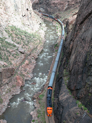
Tom Lawson runs through Cottonwood Rapid Sunday during the Downriver Classic, a 26-mile whitewater race from Coors Boat Ramp in Salida to Cotopaxi. Lawson placed third in the men’s classic with a time of 2 hours, 17 minutes, 3 seconds. FromThe Mountain Mail (Nick Jurney):
Andy Corra, Durango, captured his milestone 10th FIBArk Downriver Classic Sunday after making the 26-mile run from Salida to Cotopaxi in 2 hours, 9 minutes, 18 seconds.
“It doesn’t get any easier,” Corra said after winning his fourth consecutive FIBArk Downriver Race and 10th overall. His first victory came in 1985, 2 years after his first time participating in the historic competition.
Corra said some of the challenges in this year’s race included an upstream wind and cold water, though the flows near 3,000 cubic feet per second were an advantage to boats.
“It was windy, which was pretty cold and brutal on the hands,” Corra said. “But the water and flow were really good, up on the high side of medium levels.”
Corra’s 10th win came on Father’s Day, and he said he may look to pass the torch on to his 11-year-old son, Wiley, in the coming years.
“He said he was going to try and win as many as he can so I couldn’t catch him,” Wiley said with a smile after the race.
Second place in the downriver was captured by Jeff Parker, Concord, Mass., finishing in 2:16:28. Parker said he won the race in 1998, and his runner-up finish Sunday was his best finish since then.
“This was my 25th race, and I think it will be my last,” Parker said. “I want to go out with a second-place finish.”
Tim Lawson finished third in the downriver with a time of 2:17:03, while multi-sport competitor Natalie Anderson was the first female finisher at 2:30:06.
Team Blaze was the first team of rafters to come across the downriver finish line in Cotopaxi, finishing in 2:58:35.
“We had great water and great rafters,” said team captain Mark Mattson after paddling in his 30th race. “I like the high water; we don’t have to battle the rocks as much.”
Other members of Team Blaze included Matthew Petty, Joshua Mentzer, Tom Rice, Chadd Drott, Logan Myers and Jeff Flora.
The oldest participant in the downriver was Lynn Koester of Woodland Park, who said he is turning 77 today, while the youngest was Andy’s Corra’s son Wiley, who participated in the novice 10-mile downriver.
FIBArk board member Tom Barry said an issue with the spreadsheets used to tally results prevented race officials from getting full results and times put together by press time Sunday.
The Business After Hours Kickoff to the 66th FIBArk Whitewater Festival featured crashes of lightning, a scattering of hail and more than $1,000 raised at the event Wednesday at Salida SteamPlant. The annual kickoff, hosted by the Vaqueros of Heart of the Rockies Chamber of Commerce, was moved inside the SteamPlant because of the inclement weather.
“Welcome to the kickoff of the oldest whitewater rafting festival,” Salida Mayor Jim Dickson said to lead off the event.
After Dickson’s introduction, 2014 FIBArk Commodore Greg Felt welcomed people to the event and thanked them on behalf of the city for attending. “Thank you and welcome,” he said. “I hope you all have an unbelievable weekend.”
Following Felt’s speech, FIBArk Board President Christopher Kolomitz began an auction for a painting created for FIBArk by local artist Carl Ortman, depicting the “kayak wall” downtown.
Charlie Forster, CEO of Collegiate Peaks Bank, bought the painting to add to the bank’s art display.
“The painting really represents Salida, and the color and the quality make it a great piece,” he said. “Knowing that it will help out FIBArk is one reason (I bought it); the other is because this year’s commodore is Greg Felt. He’s a great guy.”
The money raised will go into the FIBArk general fund, Kolomitz said. Some of the money in the fund will go to the FIBArk youth paddling program, he said.
Along with local business people and guests, a visitor from South Korea took part in the festivities. Yun Ho Ra from Gunsan was riding his bike from Los Angeles to New York when he stopped in town. He said he would like to stay in Salida for a couple days to enjoy the festivities before he continues his travels.
The food, pulled pork sandwiches and baked beans, was prepared and served by the Vaqueros, and beer was provided by Eddyline Brewing, sponsor for the whitewater festival.
The first pour of Eddyline beer at the festival will be at 4 p.m. today in Riverside Park, said Kolomitz.
Missouri River Basin
Here’s the release from the United States Geological Survey:
A recent study conducted by scientists from the U.S. Geological Survey and published in the Journal of Geophysical Research – Biogeosciences found that a combination of climate and human activities (diversion and reservoirs) controls the movement of carbon in two large western river basins, the Colorado and the Missouri Rivers.
Rivers move large amounts of carbon downstream to the oceans. Developing a better understanding of the factors that control the transport of carbon in rivers is an important component of global carbon cycling research.
The study is a product of the USGS John Wesley Powell Center for Analysis and Synthesis and the USGS Land Carbon program.
Different downstream patterns were found between the two river systems. The amount of carbon steadily increased down the Missouri River from headwaters to its confluence with the Mississippi River, but decreased in the lower Colorado River. The differences were attributed to less precipitation, greater evaporation, and the diversion of water for human activities on the Colorado River.
For upstream/headwater sites on both rivers, carbon fluxes varied along with seasonal precipitation and temperature changes. There was also greater variability in the amount of carbon at upstream sites, likely because of seasonal inputs of organic material to the rivers. Reservoirs disrupted the connection between the watershed and the river, causing carbon amounts downstream of dams to be less variable in time and less responsive to seasonal temperature and precipitation changes.
The study presents estimates of changes in the amount of carbon moving down the Colorado and Missouri Rivers and provides new insights into aquatic carbon cycling in arid and semi-arid regions of the central and western U.S, where freshwater carbon cycling studies have been less common. This work is part of an ongoing effort to directly address the importance of freshwater ecosystems in the context of the broader carbon cycle. In the future, changing hydrology and warming temperatures will increase the importance of reservoirs in carbon cycling, and may lead to an increase in Greenhouse Gas Emissions that contribute to global warming, but may also increase the amount of carbon buried in sediments.
By this point, most of you have heard that it looks like El Niño is coming, and maybe you’re wondering why you should care. After all, why should it matter if the tropical Pacific Ocean becomes warmer than average? That’s thousands of miles away from the continental United States. Well, it turns out that El Niño often results in changes in the patterns of precipitation and temperature across many parts of the globe, including North America (Ropelewski and Halpert 1987, Halpert and Ropelewski 1992).
Many folks probably remember the heavy rainfall, flooding, and landslides that occurred in California in 1982/83 and again in 1997/98. As the region suffers through a devastating drought, it could be something of a relief if we knew for certain that El Niño would bring similar soaking rains. But those two events were the 2 strongest El Niños in the past 60 years, and we’ve seen many other El Niño years where California didn’t experience those types of devastating impacts. So assuming El Niño develops, what can we expect across the United States and when can we expect it?
By examining seasonal climate conditions in previous El Niño years, scientists have identified a set of typical impacts associated with the phenomenon (Figure 1). “Associated with” doesn’t mean that all of these impacts happen during every El Niño episode. However, they happen more often during El Niño than you’d expect by chance, and many of them have occurred during many El Niño events.
Figure 1. Average location of the Pacific and Polar Jet Streams and typical temperature and precipitation impacts during the winter over North America. Map by Fiona Martin for NOAA Climate.gov.
In general, El Niño-related temperature and precipitation impacts across the United States occur during the cold half of the year (October through March). The most reliable of these signals (the one that has been observed most frequently) is wetter-than-average conditions along the Gulf Coast from Texas to Florida during this 6-month period. This relationship has occurred during more than 80% of the El Niño events in the past 100 years.
In Southern California and U.S. Southwest, strength matters
Over California and the Southwest, the relationship between El Niño and above-average precipitation is weaker, and it depends significantly on the strength of the El Niño. The stronger the episode (i.e., the larger the sea surface temperature departures across the central equatorial Pacific are), the more reliable the signal in this region has been.
For instance, during the two strongest events in the past 60 years (1982/83 and 1997/98), much-above-median rainfall amounts fell across the entire state of California. Median or above-median precipitation was recorded over the entire state during strong episodes in both 1957/58 and 1972/73 (Figure 2). However, strong events in 1991/92 and 2009/10 only provided small surpluses in the southern part of the state, while precipitation during 1965/66 was generally average to below-average across the state.
Figure 2. DIfference from average (1981-2010) winter precipitation (December-February) in each U.S. climate division during strong (dark gray bar), moderate (medium gray), and weak (light gray) El Niño events since 1950. Years are ranked based on the maximum seasonal ONI index value observed. During strong El Niño events, the Gulf Coast and Southeast are consistently wetter than average. Maps by NOAA Climate.gov, based on NCDC climate division data provided by the Physical Sciences Division at NOAA ESRL.
For weak and moderate strength episodes (Figure 2), the relationship is even weaker, with approximately one-third of the events featuring above-average precipitation, one-third near-average precipitation, and one-third below-average precipitation.
Elsewhere over the United States, El Niño impacts are associated with drier conditions in the Ohio Valley, and there is a less-reliable dry signal in the Pacific Northwest and the northern Rockies. Hawaii also often experiences lower-than-average rainfall totals from the late fall through early spring period.
The climate impacts linked to El Niño help forecasters make skillful seasonal outlooks. While not guaranteed, the changes in temperature and precipitation across the United States are fairly reliable and often provide enough lead time for emergency managers, businesses, government officials, and the public to properly prepare and make smart decisions to save lives and protect livelihoods.
Definitions Weak El Niño: Episode when the peak Oceanic Niño Index (ONI) is greater than or equal to 0.5°C and less than or equal to 0.9°C.
Moderate El Niño: Episode when the peak Oceanic Niño Index (ONI) is greater than or equal to 1.0°C and less than or equal to 1.4°C.
Strong El Niño: Episode when the peak Oceanic Niño Index (ONI) is greater than or equal to 1.5°C.
The Arkansas Basin Roundtable, formed in 2005, consists of about 40 active, voting members today. Each county has two representatives, plus conservancy and conservation districts as well as 10 at-large members from the fields of agriculture, recreation and environment, and industry and small municipal water providers. With the purpose or legislative charge of the Rountable to “propose projects and methods to meet the needs of the Arkansas Basin.” By executive order Colorado’s Water Plan draft is due to the governor Dec. 10, 2014, allowing for a final decision to be made by December 2015.
The Roundtable has been working on solutions, ideas and projects to include in the State Water Plan. Some identified include increased storage, imported water (transfer mountain diversions), aquifer storage, recharge ponds, conservation (to reduce municipal demand), lease/fallow, and conservation easements with municipal component. As the Arkansas Basin Roundtable has been working closely with Colorado Parks and Wildlife, they seem to have the same goals in mind. It is Colorado Parks and Wildlife’s goal is to be able to develop relationships and be a partner with other water users as there are things that can be accomplished better together. More importantly, however, is that the Roundtable is asking for “YOUR” suggestions and input.
“Where is the water going to come from if we do build more water storage?” “What plans do we have to stop municipality raids?” were a couple of the concerns brought forth by the citizens of Fowler, as well as that Fowler does have a gap including a water shortage, although not defined in the previous plan. Again, as the Colorado Water Plan is “our” plan, the Arkansas Basin Implementation Plan needs your input. They are asking you to contact your local representatives, visit http://www.coloradowaterplan.com, cowaterplan@state.co.us, http://www.dola.colorado.gov.lgis, and to complete an input form obtained from these websites.
Montezuma County has bowed out of a complex water dispute on Canyons of the Ancients National Monument, but negotiated stipulations on water use for Yellow Jacket Creek.
In 2009, the monument purchased an inholding – the 4,500-acre Wallace Ranch – for $3.3 million. The property came with a conditional water right of 5.25 cubic feet per second from the intermittent desert stream.
The county, along with Southwest Colorado Landowners Association and Water Rights Montezuma, opposed a routine water-court procedure by the BLM regarding the due diligence on eventual use of the water rights.
“When the BLM acquires conditional water rights, they file for a six-year diligence period, an internal process that gives us time to determine how the water will potentially be used,” said Roy Smith, a BLM water specialist…
The county has been critical of the monument buying private inholdings, fearing it will diminish historic ranching opportunities in that area.
Commissioner Keenan Ertel argued that Article 1, Section 8, of the U.S. Constitution requires the state legislature to approve federal purchase of private property. Permission was not granted by the state, and BLM officials do not believe it is necessary.
The BLM filed a request for summary judgment on the case May 30, which asks the Durango water court judge Greg Lyman to rule in favor of the BLM because the objectors’ legal dispute is presented in the wrong court venue. The decision is pending, and if denied would trigger a trial.
The BLM argues due-diligence procedures have narrow parameters in water court and that those specific facts are not disputed in the case. Special Assistant U.S. Attorney Kristen Guerriero states claims of objectors are irrelevant in water court.
“Specifically, opposers assert Constitutional claims alleging that the United States does not have authority to purchase property own water rights in any state,” writes Kristen Guerrieo, Special Assistant U.S. Attorney. “These are not claims that challenge the validity of BLM’s diligence activities, but rather reflect Opposers’ desire to utilize the Water Court proceeding to advance other objectives.”
Montezuma County officials want water use out of Yellow Jacket creek to be decided on sooner than within the 6-year period requested by the BLM.
“They need to have a plan on what they will do with that water,” said commissioner Ertel.
Montezuma County attorney John Baxter told the commissioners the stipulation agreement drops them as official objectors in the BLM request for the six year diligence period on the Yellow Jacket water rights. But they will still have a say on how the water should be used when the BLM seeks absolute status of those water rights.
“Whether we win or not, they still have to go through us when they perfect the rights,” he said. “The BLM wants to kick the can down the road,” on deciding how to use the water.
The stipulation agreement states that when Yellow Jacket water rights are converted from conditional to absolute they can only be used for public recreation, BLM housing facilities, fire suppression, irrigation use, and livestock use. It further stipulates the water cannot be used to grow crops, that what is not used be available for downstream users, and that the BLM does not file applications to convert the water to instream flow uses or for uses on other properties.
Remaining objectors in the case, Southwest Colorado Landowners Association and Water Rights Montezuma, have until June 24 to respond to the request for summary judgement filed by the BLM.
A trial was scheduled to begin Thursday in state water court in Glenwood Springs. “That trial now will not happen,” Ely said.
Pitkin County has worked for about 10 years to establish the ability to use water rights for recreational purposes connected to the special project. The county wants to establish a kayak park on the Roaring Fork River just downstream from Fishermen’s Park, which is a stone’s throw from the Upper Basalt Bypass Bridge on Highway 82.
The county faced opposition from what Ely said he considers “the usual suspects” on water-rights issues. One of the parties opposing the county’s plan was the Twin Lakes Reservoir and Canal Co., which diverts from the headwaters of the Roaring Fork River.
Ely said various parties involved on both sides of the court battle stipulated a settlement rather than proceed with the trial and an uncertain outcome. It was a model of give-and-take, he said.
“Everybody left the table being hungry,” Ely said.
The agreement allows Pitkin County to call for water for the kayak park between April 15 and Labor Day. Differing water levels would be called at different times. The most water would be tapped for the park during spring runoff. The amount would be lower before and after prime runoff…
“It’s been about 10 years since this dialog first started,” Ely said during a ceremony Thursday at Fishermen’s Park attended by about 25 people, including Colorado Gov. John Hickenlooper…
Hickenlooper congratulated Pitkin County and Basalt for their river work. He noted that investments made in river features by towns such as Buena Vista and Salida have paid big dividends.
Lake Nighthorse via the USBR
Here’s the release from Reclamation (Justyn Hock)
Reclamation will hold a public meeting on Wednesday, June 18, 2014 from 5 pm to 7 pm on recreation at Lake Nighthorse, part of the Animas-La Plata Project. The meeting will be at the Durango Community Recreation Center, 2700 Main Avenue, in the Eolus and Sunlight Meeting Rooms. Reclamation will provide a brief presentation, and the public will be able to ask questions and look at maps and plans about recreation at Lake Nighthorse.
Currently, Reclamation is working with all Animas-La Plata Project partners and stakeholders to reach consensus regarding development and management of recreation at Lake Nighthorse. We believe we are nearing an agreement to integrate recreation into the project, while ensuring compatibility with the primary purposes of the project for municipal and industrial water supply.
We are conducting regular meetings with partners and stakeholders to discuss and resolve a broad range of issues concerning water quality, environmental protection, and tribal trust responsibilities of the United States government. Many issues have been resolved and Reclamation continues to work on remaining issues, including working closely with Association members to ensure protection of cultural resources and annexation of project lands by the city of Durango for administration of recreation and law enforcement purposes.
Click here to go to the Western Water Assessment climate dashboard. Here’s an excerpt:
Highlights
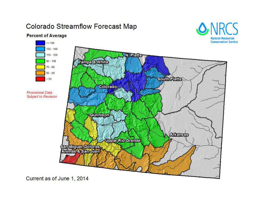
May was wetter than average across most of Colorado, adding to the above-average snowpacks in many basins. Drier than average conditions were experienced in most of Wyoming and northern Utah.
The spring runoff, in line with previous forecasts, has been above average to much above average in nearly all of Wyoming, and in northern, central, and southeastern Colorado. Below to much-below-average runoff has been observed in southwestern and south-central Colorado, southwestern Utah, and most of the eastern Great Basin.
Many gages in Colorado and Wyoming have seen record-high or near-record-high daily flows in the past three weeks, with minor to moderate flooding in some areas.
With the above-average spring runoff in the northern two-thirds of the region, reservoirs are regaining storage depleted by the last two years of dry conditions.
Atmospheric and oceanic conditions are still pointing to the very likely emergence of an El Niño event by fall. Sea-surface temperatures have continued to warm in the equatorial Pacific…
May Precipitation and Temperatures, and Current Drought
May was wetter than average across Colorado (except the southeastern quarter), southern Utah, and far southeastern Wyoming Western US Seasonal Precipitation. The month was drier than average in northern Utah and nearly all of Wyoming, though only relatively small areas saw less than 50% of average precipitation.
May temperatures Western US Seasonal Precipitation were up 3°F to cooler than average in most of Colorado, eastern Utah, and eastern Wyoming, and up to 4°F warmer than the monthly average, in the remainder of Wyoming and Utah.
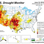
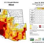
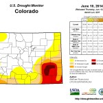
The latest US Drought Monitor US Drought Monitor, representing conditions as of June 10, shows slightly less drought for the region compared to early May. Drought conditions improved in eastern and southwestern Colorado, while worsening in a smaller area of south-central Colorado. The proportion of the region in D2 or worse drought: Utah unchanged at 22%, Colorado at 17%, down from 19%, and Wyoming unchanged at zero.
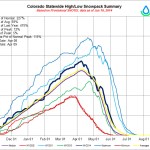
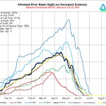
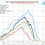
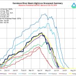
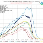
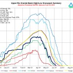
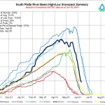
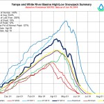
Current Snowpack
Early June is typically well past the peak accumulation at even the highest-elevation SNOTEL sites, and many sites have normally melted out by this date. Thus, the numerical percent-of-median-SWE values on the Current Basin Snowpack Map Western US Seasonal Precipitation should be treated with caution. That said, the prevalence of dark blue colors (>150% of median) on the map in Colorado, Wyoming, and far northern Utah does indicate an unusually large and persistent late-season snowpack in those basins. The basins in southwestern Colorado and southern Utah that were lagging behind seasonal normals throughout the spring have completely melted out and are not shown on the map.
According to the Colorado Dust-on-Snow Program (CODOS), no more dust events have occurred since May 13, leaving the seasonal total at eight events. The latest CODOS update noted that consolidated dust layers from events D3–D8 were exposed at the snow surface during field surveys done from June 2–4 at CODOS sites at Grand Mesa, Hoosier Pass, Loveland Pass (Grizzly Peak), Berthoud Pass, Willow Creek Pass, Rabbit Ears Pass, and McClure Pass, as well as Independence Pass. With the exposed dust, snow-surface albedo (reflectivity) is unusually low, and melt rates will be above-average through the remainder of the season, leading to a steeper-than-average declining limb of the annual hydrograph.
Here’s an in-depth look at Climate Change and the current affects on water supply in the Colorado River Basin, from The Las Vegas Desert Sun (Story by Ian James / Photos by Richard Lui). Here’s an excerpt:
The biggest reservoir in the United States is dropping 1 foot each week. Lake Mead’s rapidly sinking water level is set to reach an all-time low in July, driven down by a 14-year drought that scientists say is one of the most severe to hit the Colorado River in more than 1,200 years.
The water behind Hoover Dam supplies vast areas of farmland and about 25 million people in three states, and this critical reservoir stands just 40 percent full.
Droughts and even decades-long mega-droughts have long been part of the natural cycle of the Colorado River, but that ebb and flow is now occurring alongside global warming, which scientists say is influencing the weather and putting new pressures on water supplies that are already over-tapped and declining.
In many ways, climate change is starting to compound the problems of a water system in the Southwest that is fundamentally out of balance:
• The Colorado River would naturally flow through its delta to the Sea of Cortez. But so much water is taken from the river that it seldom reaches the sea, and federal officials say water use has begun to surpass the available supply, drawing down the river’s reservoirs.
• Beneath desert cities and towns, in places from Palm Desert to Borrego Springs, groundwater levels have been dropping as more water is pumped from wells than flows back into aquifers.
• Scientists aren’t sure to what degree climate change is influencing the natural cycle of droughts in the West, but they say it’s clear that hotter temperatures worsen droughts, meaning that future dry spells will become more intense, more frequent and longer-lasting. And the current drought is taking an economic toll on agriculture in California’s Central Valley, with UC Davis researchers estimating losses this year at $1.7 billion.
• Already, scientists say hotter temperatures across the West have led to less mountain snowpack and earlier melting of snow in the spring. More of the snow and rain that does fall is evaporating due to warmer temperatures, and that diminishes the flows of water into the Colorado River that sustain cities and farms across the Southwest.
A celebration of the return of water to the Delta [Click on the image to view Peter McBride’s slideshow]
Here’s great photo roundup of the Minute 319 pulse flow that re-connected the Colorado River with the Sea of Cortez, from Peter McBride, that is running in Outside Magazine. Click through to view the photos.
Thompson Creek via the Summit County Citizens Voice
From the Colorado Water Quality Control Commission via the Glenwood Springs Post Independent:
The state Water Quality Control Commission this week approved a special “Outstanding Waters” designation for several branches of Thompson Creek and its tributaries in the upper Thompson Creek watershed, west of Carbondale.
Trout Unlimited and the Roaring Fork Conservancy said in a news release that the designation will ensure that the watershed’s water quality is protected in perpetuity.
The Water Quality Control Commission’s decision means that anyone seeking approval for development or discharge permits in the watershed must demonstrate that the proposed activity does not degrade the creeks’ baseline water quality.
“This is a huge conservation win that ensures there will be no degradation of these pristine waters,” said Aaron Kindle, Colorado Field Coordinator for Trout Unlimited. “The designation will safeguard the streams, wetlands and tributaries of a nationally significant watershed, and the genetically pure populations of cutthroat trout found there.”
To qualify for the designation, a stream must exhibit high standards on 12 different water quality parameters, including ammonia, dissolved oxygen, e. coli, nitrate, pH and various metals.
The protections will be applied to North Thompson, Middle Thompson and the South Branch of Middle Thompson Creek, as well as several tributaries, including Park Creek, a stronghold for a rare subspecies of cutthroat trout. The vast majority of the designated creeks are on Forest Service lands.
FromThe Grand Junction Daily Sentinel (Dennis Webb):
A state commission has provided new watershed protections in the Thompson Divide area, where numerous entities are trying to stop oil and gas development.
However, such development apparently will be compatible with the “Outstanding Waters” designation by the state Water Quality Control Commission Tuesday.
Trout Unlimited and the Roaring Fork Conservancy had sought the designation. It applies to the north, middle and south branches of Middle Thompson Creek, and tributaries including Park Creek, home to a rare subspecies of cutthroat trout. The protections cover some 130 miles of waterways.
Stream segments qualifying for the designation must exhibit high standards based on water quality parameters such as ammonia, dissolved oxygen, nitrate, pH and various metals. Any entity discharging into a designated segment must show it won’t degrade existing water quality.
Interests including the Thompson Divide Coalition have been trying to prevent drilling on more than 200,000 acres west of Carbondale. Much of that acreage is leased, but certain leases are currently in suspension pending a Bureau of Land Management review.
Trisha Oeth, administrator for the Water Quality Control Commission, said Trout Unlimited testified that it reached out to energy companies holding leases in the areas and none opposed the designation.
“Trout Unlimited indicated the companies felt the designation would not impact their activities and that the designation would be compatible with their operations and plans,” she said.
The commission decided the sensitivity of cutthroat trout and diminishing extent of their habitat made the additional protection necessary.
David Ludlam, executive director of the West Slope Colorado Oil and Gas Association, called the designation “a clever maneuver that doesn’t concern us too much.”
“As modest drilling begins in the Thompson Divide, this important designation is in alignment with what our member companies already do to protect water and wildlife resources. We have shown a tremendous ability to safely produce natural gas in other sensitive western Colorado watersheds and will do so in the Thompson Divide, too.”
In a news release, Aaron Kindle, Colorado field coordinator for Trout Unlimited, called the designation “a huge conservation win that ensures there will be no degradation of these pristine waters.
“The designation will safeguard the streams, wetlands and tributaries of a nationally significant watershed, and the genetically pure populations of cutthroat trout found there,” Kindle was quoted as saying.
To win approval the stream has to meet several high quality standards and, the designation prohibits certain pollutants from being discharged into the water. Aaron Kindle is with Colorado Trout Unlimited, which fought for the designation. He says it protects fish.
“Cutthroat trout have been dwindled down to about 10 percent of their native range, so the populations that do exist are pretty critical and those creeks up there are really critical for cutthroat trout.”
The protected creek runs through an area where energy companies would like to drill for natural gas. The gas leases are currently at a stand-still while the Bureau of Land Management does a review. Kindle says Trout Unlimited had discussions with the oil and gas companies and he says they neither supported nor disapproved of the new designation.
Years ago, University of New Mexico emeritus biologist Loren Potter took me for a walk around the neighborhood for a newspaper story, pointing out the strangeness of the artificial ecosystem we’ve built. We bring trees that can’t make it on 10 inches a year, then don’t always water them as much as they need. The result was, even then, an urban forest under stress.
As I wrote in the Journal last week, Albuquerque has cut its water use to 134 gallons per person per day. A big part of that involves a reduction in outdoor watering. A result of that is evident on my morning walks – a lot more stressed trees.
Building farms and cities in the desert, moving the water to do it, then responding to the scarcity problems that result, is complicated.
FromThe Grand Junction Daily Sentinel (Gary Harmon):
Cooler temperatures and passing storms clouded the moment, but the peak of the runoff to and through the Grand Valley has passed. The Colorado River hit its high-water mark of 38,000 cubic feet per second at the Utah state line on June 3, the U.S. Bureau of Reclamation said.
That was just after the peak flow on the Colorado River above its confluence with the Gunnison River reached the peak of 26,100 cfs and before the Gunnison River peaked at Whitewater on June 7 with flows of 12,850 cfs, the Grand Junction office of the bureau said.
Cubic feet per second is a measurement of moving water.
The bureau had worked to stagger the highest flows of the Colorado and Gunnison rivers during what was anticipated to be a high-water year to reduce the effects of runoff through the Grand Valley while also providing scouring flows for the rivers for endangered species. Cooler-than-normal days and some passing storms made it difficult until Tuesday to rule out a resumption of high flows, the bureau said.
“This has been a later year for runoff and peaks,” bureau spokeswoman Justyn Hock said. “The cool weather and storms are causing a bit of fluctuation.” Crystal dam spilling May 2009
The bureau, meanwhile, has stopped the spill from Morrow Point Dam, but is planning to continue spilling water from Crystal Dam, the lowest dam on the Aspinall unit of reservoirs.
FromThe Grand Junction Daily Sentinel (Dennis Webb):
Water is spilling from all four gates at Morrow Point Dam on the Gunnison River above Montrose — the first time all the gates have been open since 1984. Morrow Point sits upstream from Crystal Dam, which on Thursday was spilling 5,500 cubic feet of water per second into the Black Canyon of the Gunnison below, bringing the flow to about 9,500 cfs in the canyon. That pushed flows to 13,000 cfs or more through Delta, the U.S. Bureau of Reclamation said.
The year 1984 was a major one for floods, requiring that all four gates atop Morrow Point Dam open up, said spokeswoman Justyn Hock. The last time that two gates were open for runoff was in 1995, Hock said.
High waters this year aren’t the only factor in opening all four gates on Morrow Point, Hock said. Officials want to put more water into Crystal Reservoir, the lowest impoundment on the Aspinall Unit, so flows mimicking spring runoff can be released to the benefit of endangered species of fish in the Gunnison and Colorado rivers downstream.
“We’ll probably be seeing more spills in the future” because of the need to scour out the Gunnison and improve its habitability for endangered and other species, as required by new rules governing management of the unit, Hock said.
The North Fork of the Gunnison River, meanwhile, was showing signs of retreating from its spring highs, Hock said, clearing out more room for mainstem Gunnison water.
Water will continue to spill from all four gates through the weekend, and the view can be seen from the Cimarron parking on U.S. Highway 50 east of Montrose.
How much longer the spill will continue, however, isn’t clear, Hock said.
FromThe Grand Junction Daily Sentinel (Gary Harmon):
Federal officials are releasing more water into the Gunnison River with an eye to benefit endangered fish while also ensuring that downstream areas aren’t inundated.
“We’re going out twice a day checking out the interstate and Connected Lakes” to be certain that the spring runoff doesn’t threaten Interstate 70 west of Fruita or residents and businesses closer to Grand Junction, said Erik Knight, hydrologist for the Grand Junction office of the U.S. Bureau of Reclamation.
Officials now expect the Colorado River at Cameo to peak about 26,000 cubic feet per second.
Those flows, combined with flows of about 12,000 cfs from the Gunnison River, could push the river below the confluence to approach 40,000 cubic feet per second at the Utah state line, Knight said.
That’s about the level of the river when it last inundated the interstate west of Fruita.
That’s exactly what the bureau wants to avoid, as it tries to stagger the highest flows in the Colorado and the Gunnison.
The road “should be dry, except maybe for the bike path,” Knight said.
Bureau officials also are watching the water levels near Skipper’s Island in the Colorado west of Fruita to get a better sense of how spring flows affect neighboring lands, Knight said.
“We’re getting an idea of what the flows mean” to neighboring properties as the levels rise, Knight said.
Bureau officials are also trying to release enough water to benefit endangered fish in the Gunnison, particularly the Colorado pikeminnow and razorback sucker.
Sediment has collected in the Gunnison riverbed in recent years and officials are hoping that higher flows will scour it out, resulting in better habitat for those and other aquatic species, bureau spokeswoman Justyn Hock said.
Greeley officials have reopened 6th Avenue, 83rd Avenue and the Poudre Ponds off of 35th Avenue following spring flooding along the Poudre River.
The river at Greeley fell below its 8-foot floodstage Monday evening, after several days of seeing its banks overflow, causing road closures and some damage to local businesses.
While the river level — at 7.4 feet Tuesday — has fallen, it isn’t expected to drop any farther, according to the National Weather Service forecast, and is predicted to be near floodstage again this weekend.
The Poudre Ponds are open to fishing and non-motorized boating, according to Greeley officials.
Tesla Model S battery FromBloomberg News via the The Denver Post (Susan Decker, Alan Ohnsman and Mark Clothier):
Elon Musk wants to apply the contrarian style that made him millions of dollars from PayPal and billions from rocket ships and electric cars, and revolutionize the litigious world of patents.
Tesla Motors Inc. became a rarity among automakers when Musk on Thursday pledged that inventions on his electric cars and batteries will be free for anyone to use “in good faith.”
The move may speed the adoption of technology that Musk needs to make his fledging line of cars more than a luxury niche.
Patents are a trade-off that give companies the right to block others from using a specific technology in exchange for making the idea public so others can analyze and build on it.
The alternatives are to keep the technology a trade secret or, as in the case of the Linux computing system, make the information available to everyone. Tesla is adopting a third way — continue to patent, but let the public use it at will.
“The more people that use the technology, the more valuable the market,” said Zorina Khan, an economics professor at Bowdoin College in Brunswick, Maine, and author of “The Democratization of Invention.”
Meanwhile, the US Supreme Court struck a blow against the foul patent trolls:
Highlands Ranch-based RainCommander and Boulder-based Rachio both make sprinkler timers that customers can manage from apps on their smartphones or computers.
Each startup pushed to get to market this spring, seeing a big potential in selling convenience and efficient water use. Existing timers are notoriously laborious for people to set up and adjust, creating a big chance for a company making a sprinkler adjustment as simple as updating a calendar on your iPhone.
“It’s a natural idea, and 10 years from now everybody — or almost everybody — will be controlling sprinklers this way. Hopefully with RainCommander,” said Mike Shupe, co-founder and chief technology officer of RainCommander.
People might not automatically think of needing a $250 sprinkler timer and a sprinkler app on their phone. But both RainCommander and Rachio say they’re finding a receptive audience.
Shupe and his sister-in-law, Deb Shupe, started RainCommander after Deb Shupe went looking for a sprinkler timer remotely controlled from a computer or smartphone and couldn’t find any on the market.
RainCommander publicly debuted in March and has 150 systems installed and another 78 ordered through a recent Kickstarter crowd-funding campaign, Mike Shupe said.
RainCommander is targeting homeowners and property management and landscaping businesses that have to adjust dozens if not hundreds of residential and commercial lawn sprinkler systems. It’s in talks to get a presence in big-box stores, too.
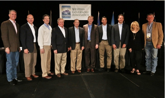
Photo of the Governors at the Annual Meeting via the Western Governors Association Click here to go to the website:
2014 Annual Meeting: June 9-11, The Broadmoor, Colorado Springs
Ten Western Governors attended WGA’s 2014 Annual Meeting. WGA Chairman and Colorado Gov. John Hickenlooper and Vice Chairman and Nevada Gov. Brian Sandoval welcomed Arizona’s Jan Brewer, Idaho’s Butch Otter, Kansas’s Sam Brownback, Montana’s Steve Bullock, North Dakota’s Jack Dalrymple, South Dakota’s Dennis Daugaard, Utah’s Gary Herbert and Wyoming’s Matt Mead.
Check out a slideshow of photos featuring Governors, special guests and Annual Meeting events.
Day 1
June 9, 2014: Opening day was historic for Western Governors, as they participated in a live video-teleconference with President Barack Obama to discuss the wildfire season and efforts to improve forest management, including an end to the practice of “fire borrowing.” The conversation represented the first time the Western Governors have had an in-person conversation with any president during a WGA meeting.
The day began with members of the Western States Tourism Policy Council, Interior Secretary Sally Jewell and other federal agency heads today signing a memorandum of understanding aimed at promoting federal-state dialogue and cooperation on western states tourism and public lands issues. Governor John Hickenlooper spoke and was joined at the ceremony by governors Matt Mead of Wyoming, Gary Herbert of Utah and Butch Otter of Idaho.
The afternoon session included a keynote by Secretary Jewell, followed by a roundtable on “Preparing for and Responding to Drought and Flooding,” moderated by South Dakota Gov. Dennis Daugaard. Guests on the panel included Jo-Ellen Darcy, Assistant Secretary of the Army (Civil Works), Department of Defense, and Robert Bonnie, Under Secretary, Department of Agriculture.
The afternoon session concluded the signing of an MOU by WGA Chairman Hickenlooper and Dr. Kathryn Sullivan, NOAA Administrator, to continue a collaboration on drought, flooding, and wildfire preparedness. The official business of the day concluded with the governors conducting a press conference attended by the Colorado Springs Gazette, Associated Press, E&E News and Washington Post.
June 10, 2014: Western Governors met with the chief of the Environmental Protection Agency to discuss the recently proposed regulations on carbon emissions from existing coal plants during the second day of the 2014 WGA Annual Meeting in Colorado Springs.
While several Governors take issue with the rule, EPA Administrator Gina McCarthy later characterized the discussions in a press conference as “collegial.”
McCarthy went on to say that the regulations aren’t “the end-all be-all” and that she hopes it changes companies’ strategies on energy development.
June 11, 2014: Western Governors elected Nevada Gov. Brian Sandoval Chairman of the Western Governors’ Association (WGA) and Oregon Gov. John Kitzhaber was elected as Vice-Gov SandovalChairman on the final day of the Annual Meeting.
After the announcement, the Nevada governor delivered remarks on his initiative for the coming year: the Western Governors Drought Forum. Gov. Sandoval said, in part, the goal of the forum “is to bring our states together to combat drought, and to recommit WGA to play a leading role in that fight.” Read more about the Drought Forum.
The Western Governors also announced six new policy resolutions on a variety of issues that range from Species of Concern and Candidate Species to Regional Wildfire Fighting Resources.
The Environmental Protection Agency and Army Corps of Engineers extended the comment period for new rules on Waters of the United States under the federal Clean Water Act. The federal agencies added an additional 90 days in extending the deadline for comments to Oct. 20.
The move came after urging by political and water interests, including Colorado Sens. Mark Udall and Michael Bennet, both Democrats.
The rules, published in the Federal Register on April 25, are an attempt to resolve federal jurisdiction issues after conflicting U.S. Supreme Court opinions on that authority.
Water users, particularly in the West, fear that the new rules would affect mostly dry washes and wetlands along with streams that have been traditionally regulated.
Steamboat Springs — Residents of the Yampa Valley, where the meadows are lush and snow still lingers on the peaks, easily could conclude that this is a year of water abundance. But in terms of the water produced by the entire Colorado River Basin, the summer of 2014 won’t be outstanding.
Eric Kuhn, of the Colorado River Water Conservation District, told an audience of about 50 state legislators, water managers and educators at the Sheraton Steamboat Thursday the abundance of snowmelt in the upper Colorado, Yampa and Green rivers early this summer isn’t indicative of the entire Colorado Basin.
“We have wet years, we have dry years but the bottom line for Lake Powell this year is that it’s going to be right about average,” Kuhn said…
“Currently, Lake Mead (below the Grand Canyon) and Lake Powell (just above the Grand Canyon) are 42 percent full,” Kuhn said. “Does that make us nervous? Yeah that makes us very nervous.”[…]
Water storage in Flaming Gorge Reservoir on the Green River just upstream from its Colorado stretch is expected to be 140 percent of average, and Blue Mesa Reservoir on the Gunnison River is expected to be 126 percent of average, Kuhn told his audience. But 25-mile-long Navajo Reservoir, straddling the Colorado and New Mexico state line and capturing flows from the San Juan River, will be just about 67 percent of average. It’s the southernmost reaches of the upper basin that are below par.
Kuhn and his audience had gathered in Steamboat Springs Thursday to begin a tour of the Yampa River Basin sponsored by the nonprofit Colorado Foundation for Water Education. CFWE program manager Kristin Maharg told the gathering that the purpose of the tour is to explore the compatibility of consumptive water uses (agriculture and power plants) and non-consumptive uses (recreation and habitat conservation) along the length of the Yampa in Routt and Moffat counties.
“The Yampa is no longer a valley too far, and we want to look at some of the demands this basin is facing,” Maharg said. “This is a very cooperative basin in terms of resource management and conservation.”
Thursday’s audience included more than a half dozen state legislators, members of their technical support staff, including an economist and an attorney who work on water bills, a Pitkin County commissioner and an Eagle County water district official, as well as college educators from Colorado State University, the University of Colorado Denver and Colorado Mesa University.
If there is some good news for the Colorado Basin and the people who depend on Lake Powell this summer, it’s that the abundance in the Green River basin will give the reservoir a boost this summer. Flaming Gorge Reservoir, about 30 miles upstream from the point where the Green makes a dog leg into Colorado on the way to its confluence with the Yampa, is currently releasing large amounts of water. That’s being done to mimic the spring floods that occurred before the dam was built in order to support the ecosystem that evolved around those floods. When the river is restored to its baseline sumer flow, it will be at double the flows seen in the last few years, or about 1,600 cubic feet per second. The net result of those additional flows should boost Lake Powell to 50 percent full by the end of July, Kuhn confirmed.
The Natural Resources Conservation Service in Denver predicted Monday that the total volume of flows in the Yampa in Steamboat Springs in June and July will be 118 percent of average, and maybe more if precipitation is abundant. And flows in the Elk, one of the Yampa’s biggest tributaries, could be at 145 percent of average during the heart of the summer.
The streamflow projections issued by the NRCS shouldn’t be interpreted as meaning the flows in the Yampa consistently will be at 118 percent of average, Mage Hultstrand cautioned. She is the assistant snow survey supervisor with the NRCS in Denver. Hultstrand explained that the streamflow projection anticipates the total volume of water that will flow under the Fifth Street Bridge from June through July.
“It’s based on current (snowpack) conditions and weather patterns in the area the past few months,” Hultstrand said.
The weather in terms of temperature and precipitation will have much to say about streamflow from week to week.
The Yampa at Steamboat peaked for the season May 30 at 4,850 cubic feet per second, Brenda Alcorn, senior hydrologist with the Colorado Basin River Forecast Center in Salt Lake City, Utah, said Wednesday. The Elk peaked at 6,300 cfs also on May 30. The Yampa came close to going higher June 2, but fell just short, Alcorn said. Flows in the Yampa were in decline this week, but the snowpack still has a kick in it; the Forecast Center expects the Yampa to rally Thursday and Friday, jumping from Wednesday morning’s flow of 2,300 cfs to perhaps 3,400 cfs by Friday. The median flow for June 11 is 2010 cfs. Temperatures are expected to reach the mid-70s under clear skies Thursday and Friday.
The streamflow projection issued by the NRCS really is intended to inform reservoir managers and help them understand how full their reservoirs will be and how much water they can release.
It’s safe to say the upper Yampa will be carrying more water than average for much of the next seven or eight weeks, but the streamflow forecast doesn’t guarantee there will be above average water in the river for irrigating hay fields or providing thrills for tubers during the last week in July, for example, Hultstrand said.
The Arkansas Basin Roundtable is compiling a reservoir of ideas that could go into making the Colorado Water Plan. The main difficulty will be putting them all to beneficial use: First in the Arkansas River basin’s implementation plan, then translating those into the state plan — all under conditions that still appear to be changing.
“It does appear to be a flood,” quipped Alan Hamel, who represents the basin on the Colorado Water Conservation Board.
Last month, Gov. John Hickenlooper signed legislation (SB115) that instructs the CWCB to have hearings in each basin and for the draft plan to be presented to the Legislature’s interim committee on water resources.
Meanwhile, the roundtable has received 60 written comments, some with multiple suggestions, on what needs to be in its basin implementation plan. The group has no organized way of incorporating comments into the volumes of information already compiled. There has been little time for point-by-point discussions.
The CWCB will review basin plans in July.
And the state plan being developed is in a different format than the basin plan.
“How do we integrate all this?” asked Reed Dils, a retired Buena Vista outfitter and former CWCB member.
“The timeline was a tough, tight timeline even before the legislation,” Hamel added.
Hickenlooper ordered the CWCB to produce a draft plan by December. For the past few months, the roundtable has expanded its meeting time and talked extensively about its own basin plan, the product of nine years of meetings. Some of that time has been devoted to providing new members background on past actions of the roundtable.
“Dozens of people have presented information to us,” said Bud Elliott of Leadville, one of the original roundtable members. “The public has been well represented.”
Gary Barber, who chaired the roundtable for several years and is now under contract to help write the basin plan, said some findings of the roundtable have stalled.
“I tell you, five years later, we’re still beating our heads over rotational fallowing, based on the experience of Fowler,” he said at one point.
A deal by Super Ditch to supply water to Fowler under a state pilot program this year fell through when farmers pulled out. It’s the third year the group has tried, but failed, to demonstrate a new method for agricultural transfers that leaves ownership in the hands of farmers.
Big water and a bountiful batch of boating events will mark the Royal Gorge Whitewater Festival as it boasts a blue-collar celebration for the “Average Joe” boater. Planners are touting plenty of “Boats, bands and beer,” for the sixth annual celebration June 20-21. Festivities are held at Centennial Park, known to locals as Duck Park, at Fourth and Griffin streets. With 20 events, a roaring Arkansas River and an increase in vendors, the festival will be the biggest to date.
“There are plenty of events for professional and expert level paddlers, but there are not a lot of events for the Average Joe weekend paddler, so we are creating our own niche,” said Kyle Horne, an event organizer. “It is something you can come in and compete in, have a good time and enjoy without competing with the big dogs.”
The pinnacle event will be the Build Your Own Boat Race slated for 5:15 p.m. June 21, but that is just one of the thrilling boating events which include stand up paddling, a duckie (inflatable kayak) dash, a kayak big air event, a Hyside Raft competition and even an inner tube race. Equipment from stand-up paddle boats and inner tubes to safety gear will be supplied to those who need it thanks to donations from local rafting companies, Horne said.
The only serious event for professional boaters and experienced long-distance paddlers, is the 6:15 p.m. June 20 kayak and raft race from Parkdale to Canon City. River flows which have been fluctuating between 4,500 and 3,400 cubic feet per second recently, will have to be at 4,000 cfs or less in order for the race to run, Horne said.
The event also features a fly casting competition for anglers, running races, a Whitewater Adventure Race featuring a run, obstacles and a muddy “slip and slide” finish as well as bicycling events for participants of all ages.
A 4:30 p.m. June 21, Rotary Rubber Duck Fundraiser hosted by Canon City and Florence Rotary Clubs will feature hundreds of little bathtub-sized rubber ducks racing along the river for a chance to win their “owners” prizes. In addition, a Kids’ Fun Zone and a trampoline jump will be set up at the park.
For those who would prefer to sit in the shade and relax, there will be live bands on two stages such as Pueblo’s Atomic Fireballs, local favorite The Highside Command, as well as James and the Devil, Wrestle with Jimmy and others. In addition, a wide variety of food and craft vendors will be set up at the park.
The festival was formed to help establish a Whitewater Park in Canon City and with the help of the Canon City Recreation District, the Whitewater Kayak and Recreation Park committee and the Fremont Community Foundation, the park became a reality in 2009 and is the center of the festival’s boating events. Fremont Adventure Recreation joined as a fourth partner and has added several entertaining competitions.
A fundraising live auction is slated for 8:15 p.m. June 21 and will include items such as a stand-up paddle boat from Jackson Kayak, a wooden canoe made by inmates working in Colorado Correctional Industries, a fly fishing package from Royal Gorge Anglers, and more. All funds raised during the festival go back into the community.
“A hundred percent of proceeds go toward community projects such as expansion and improvements to the whitewater park, recreation district programing, charitable projects and recreation projects,” Horne said.
Click here to go to the National Climatic Data Center for all the news. Here’s an excerpt:
Major climate events NOAA is closely monitoring:
Persisting and intensifying drought in parts of the West and the Central and Southern Plains: Long- and short-term dryness will continue to increase wildfire risk and impact water resources and agriculture. More information is available from the U.S. Drought Monitor.
Probability of El Niño increases later this year: According to NOAA’s Climate Prediction Center, there is a 70 percent chance of El Niño conditions developing this summer, increasing to an 80 percent chance by autumn and winter. El Niño conditions could have significant impacts on temperature and precipitation patterns across the United States. More information is available from the Climate Prediction Center.
The North Atlantic hurricane season began on June 1: According to NOAA’s Climate Prediction Center, the 2014 North Atlantic hurricane season is forecasted to be near-normal or below-normal in terms of the number of tropical storms, hurricanes, and major hurricanes. The last North Atlantic hurricane season with a below-average number of named storms was in 2009. More information is available from the Climate Prediction Center and NOAA’s National Hurricane Center.
Climate Highlights — May
The May contiguous U.S. average temperature was 61.2°F, 1.0°F above the 20th century average, tying as the 32nd warmest May on record.
A large portion of the central U.S. had temperatures near the 20th century average, while above-average temperatures were observed along the West Coast and the East Coast. California tied its ninth warmest May on record, with a statewide temperature 3.9°F above average. This marked the seventh consecutive month with above-average temperatures for California. No other state had May temperatures that ranked among the 10 warmest or coldest on record.
The May national precipitation total of 2.76 inches was 0.15 inch below the 20th century average, ranking near the middle of all Mays in the 120-year period of record.
Below-average and above-average precipitation totals were scattered across the country. Above-average precipitation was observed across the Northeast and in Texas, where it provided minor and short-term drought relief. Below-average precipitation was observed in the Southwest, Northern Rockies, Central Plains, and parts of the Midwest. Kansas had its sixth driest May on record, with 2.02 inches of precipitation, 1.83 inches below average.
According to the June 3 U.S. Drought Monitor report, 37.3 percent of the contiguous U.S. was in drought, down about 1.1 percent compared to the end of April. Both improvement and degradation of drought conditions occurred on the regional scale. Beneficial rain improved drought conditions across parts of Texas, Nebraska, and Iowa. In Texas, despite the short-term precipitation relief, extreme and exceptional drought coverage in the state is five times greater than at the start of the calendar year. Drought conditions worsened in parts of Kansas and Oklahoma. The long- and short-term dry conditions across the Southern Plains and the West helped fuel several large wildfires that threatened homes during May.
May precipitation totals were mixed across Hawaii. Locations on the Big Island were drier than average, which caused an expansion of abnormally dry conditions, according to the U.S. Drought Monitor. Locations on Oahu, Kona, and Maui had their wettest May on record, while the Honolulu airport had its wettest May since 1978.
During May, there were slightly more record warm daily highs and lows (3275) as record cold daily highs and lows (2937).
Based on NOAA’s Residential Energy Demand Temperature Index (REDTI), the contiguous U.S. temperature-related energy demand during May was 74 percent below average and the 11th lowest in the 1895-2014 period of record. The above-average temperatures across the densely populated Northeast region contributed to the below average REDTI during May.
Climate Highlights — spring (March – May)
The average temperature for the contiguous U.S. during spring was 51.1°F, 0.2°F above the 20th century average, ranking near the middle among all springs in the 120-year period of record.
Above-average spring temperatures were observed from the Rockies, westward. The California statewide average temperature tied with 2013 as the fifth warmest spring on record with a seasonal temperature 4.1°F above the 20th century average. Each season since the winter of 2012/13 has been warmer than average in California.
Below-average temperatures were interspersed with near-average temperatures across the eastern two-thirds of the Lower 48. No state had spring temperatures that ranked among the 10 coldest, although Louisiana and Wisconsin both had their 11th coldest spring on record, with temperatures 2.1°F and 3.2°F below average, respectively.
The spring national precipitation total was 8.01 inches, which was slightly above the 20th century average.
Below-average precipitation was observed from the Southern Rockies into parts of the Midwest, with the driest conditions across the Central and Southern Plains. Kansas had its third driest spring on record and driest since 1966, with 4.08 inches of precipitation, barely half the average. Oklahoma had its ninth driest spring and driest since 2005, with 6.42 inches of precipitation, 4.31 inches below average.
Above-average precipitation fell across the Pacific Northwest, the Upper Midwest, and along much of the East Coast and Gulf Coast. Washington state had its fourth wettest spring with 13.88 inches of precipitation, 4.65 inches above the 20th century average.
Alaska had its eighth warmest spring on record, with a seasonal temperature 3.1°F above the 1971-2000 average. The spring heat in Alaska peaked in May, which was the state’s sixth warmest in the 1918-2014 record. Many locations across the state, including Anchorage, King Salmon, and Kodiak, had their warmest May on record. Alaska also had its 25th driest spring on record, with a precipitation total 14.7 percent below the 1971-2000 average. The combination of a warm and dry spring contributed to the state having its smallest May snow cover extent in the 48-year period of record.
The U.S. Climate Extremes Index (USCEI) for spring was near average. On the national-scale, the spatial extent of one-day precipitation extremes ranked as the third highest spring value on record at 60 percent above average. On the regional scale, the elements that track the spatial extent of cold daily highs and lows were elevated across the central U.S., one-day precipitation extremes were record and near-record high in the East, while the spatial extent of drought was record high in the West. The USCEI is an index that tracks extremes (falling in the upper or lower 10 percent of the record) in temperature, precipitation and drought across the contiguous U.S.
Based on REDTI, the contiguous U.S. temperature-related energy demand during spring was 6 percent above average and the 56th highest in the 1895-2014 period of record.
Click here to go to the US Drought Monitor website. Here’s an excerpt:
Summary
The previous 7 days featured an active weather pattern from the Central Great Plains to the Northeast. During the middle of last week, a low-pressure system moved from the Midwest to New England. After that, a slow moving low-pressure system moved across the southern Great Plains to the Tennessee Valley, spreading copious amounts of rain across much of the Great Plains, Midwest, and Southeast. Dry conditions persisted across the western portion of the contiguous 48 states. Strong trades persisted across Hawaii and Puerto Rico, bringing rains to northern and eastern facing slopes. A tranquil pattern persisted across most of Alaska, except the Alaska Panhandle…
Southern Great Plains, Central and Southern High Plains
Rainfall (2-3+ inches) fell across much of east Texas, prompting the removal of dry conditions from some portions of east Texas. Rainfall near the Texas coast was more limited in scope, so minor reductions in D0 (Abnormally Dry) and D1 (Moderate Drought) conditions were pursued near Wharton County. Beneficial rains (0.9 – 2.7 inches) fell across much the Texas and Oklahoma panhandles. The rains prompted the contraction of D4 (exceptional drought) across northern Oklahoma and the Texas panhandle, while D3 (extreme drought) was trimmed from the Oklahoma panhandle and southeastern Colorado. Subsoil conditions across Oklahoma and Texas are still quite dry with 71 and 59 percent of the reports indicating Very Short or Short of Moisture conditions, respectively.
As with the Texas Panhandle, some beneficial rains (0.8 – 2.5 inches) fell across eastern New Mexico. D3 (extreme drought) was subsequently trimmed back from in and around Quay and Harding Counties.
Huerfano County in Colorado has been dry as of late, and as part of a reassessment, D0 was reinstated. According to the Colorado Climate Center, recent rains have been beneficial for eastern Colorado, although reports are indicating that more rains are necessary to stem the tide of negative impacts due to the dry conditions. The heavier rains (0.7 – 3.0 inches) farther north in Colorado and Kansas, resulted in a nearly 1-category improvement in Colorado and near Hamilton County in Kansas…
The Midwest and Central Great Plains
Widespread rains from Minnesota to Kansas prompted the removal or reduction of drought across much of the Midwest and Central Great Plains. D1 was removed from most of Pipestone and Nobles Counties in Minnesota as rains up to 3.2 inches fell.
Across Iowa, some rains fell throughout the week, which helped alleviate drought conditions for much of the state. The remaining drought conditions are tied to longer term soil moisture deficits, linked to a dry second half of 2013. Page, Washington, and Calhoun Counties reported 12-month precipitation totals at about the 7th, 10th, and 5th percentile, respectively.
The moderate to heavy rains (0.6 – 5.1 inches) that fell across much of Nebraska resulted in drought reduction. Deeper profiles into the soil are still showing dryness, so the reduction was tempered by the long-term conditions, although the Extreme Drought (D3) was removed from central Nebraska as those areas received enough rains to recharge soil moisture down to 2-3 feet, according to calculations by the Nebraska State Climatologist.
Abnormally dry conditions were removed from Illinois and Missouri as well. Rains there were more widespread but slightly less intense (1.5 – 4.9 inches), resulting in recharges of soil moisture and increased runoff. The discharge of the La Moine River went from 30cfs to 3,000 cfs in a couple of days and is now above median since June 4 at Collmar, IL. The surrounding subsoils are still dry. According to NASS, the rains greatly improved the topsoil but did not make much difference to subsoil moisture in western Illinois. The percentages of subsoil in very short (23%) to short (46%) is a slight improvement from the week before, with field tiles not running yet, according to reports out of the Illinois State Climatologist’s office. In Missouri, COOP stations and the University of Missouri Agricultural sit at Novelty reported rainfall amounts of nearly 5 inches, with widespread 2-4 inches for the week across Central Missouri, prompting the removal of D0.
A 1-category improvement was implemented for most of eastern Kansas due to the widespread rains, with the rains missing much of western Kansas. Long-term subsoil moisture deficits continue to plague that state as well, so D3 (Extreme drought conditions were retained across western and southern Kansas with NASS reporting an 18 percentage point drop in topsoil reported as Short or Very Short of moisture, but 66 percent of subsoil reports indicating Short or Very Short conditions…
The southern Rockies, Intermountain West, and West Coast
According to the Colorado Climate Center and the NIDIS Upper Colorado River Regional Drought Early Warning System have been warm and dry for the past week over south and central Utah. This time of year is typically a dry period for the region, and May was a both cool and wet month. No changes were made to the Upper Colorado River Basin area or the rest of Utah.
Persistent dry conditions prompted the expansion of drought conditions across Idaho. Thirty-day SPI as of June 10 is showing dryness expanding, so D0 was expanded to where SPI3 and 30-day SPI show dry conditions, but tempered where SPI3 and 90-day percent of normal precipitation show wet conditions that were present in the winter and spring.
Drought conditions were expanded in Arizona as SPI3 and SPI6 values showed conditions drier than what was previously depicted. Fuel moisture values are low and fire danger is high for much of Arizona, outside of the major metropolitan areas, and that is where drought depiction was increased. Water Year-to-Date (less than 50% of average) and 1-year precipitation totals support the expansion as well…
Looking Ahead
Heavy rains are likely across the Great Plains from Oklahoma to Minnesota (5.1 inches is the maximum forecast value over Iowa). Widespread rains are also forecast over the Southeast and Florida. Little to no precipitation is forecast from Arizona and Utah to the West Coast.
The ensuing 5 days (June 17 -21, 2014) features enhanced chances for above-normal rainfall from the Mississippi Valley to the East Coast, except Florida. The odds also favor surplus rainfall over northwestern Alaska. Odds for below-median rains are increased across much of the west, west of the Continental Divide and across portions of southern Texas.
Governor John Hickenlooper is drawing backlash for vetoing a bill that conservationists say would have prompted farmers to update their irrigation systems and kept more water in Colorado’s Western Slope streams without asking anyone to forfeit water rights. Hickenlooper said that the final version of the bill, SB 23, lacked sufficient support from agricultural and water groups. Conservationists say Hickenlooper’s veto amounts to a “failure to lead.”
“This legislation was the result of thousands of hours of coalition work over several years,” said Sara Lu of the Clean Water Fund. “The governor had expressed support for the bill, at least through his staff, and then seemingly out of nowhere he turned around and vetoed it.”
This week, the Clean Water Fund has launched a “failure to lead,” campaign against Hickenlooper. The campaign includes massive ad buys at the Colorado Springs Gazette and the Aurora Daily Sentinel and will see banners proclaiming the governor’s “failure to lead” flown over a Rockies game at Coors field and the Western Governors Association Conference at the Broadmoor hotel. The group is also launching an online, social media-driven campaign, from the site http://failuretolead.org/ […]
The Colorado Farm Bureau applauded Hickenlooper’s decision to veto the bill in favor of launching a pilot program and continuing negotiations next year. They said the bill was just too big a shift in a century of Colorado water law for farmers to feel secure in their rights.
Sponsors of the bill emphasized that a farmer’s participation in the program would have been entirely optional. The measure was simply intended to allow farmers water-right wiggle room to better line drainage ditches, or install more efficient sprinklers, without experiencing a legal ratchet effect on their water rights, where if you use less water one season, you must use less forever.
“This was a major initiative to promote wise water use and it was a win-win for Western Slope agricultural users and the environment,” sponsor KC Becker of Boulder said in a release expressing her disappointment and confusion after the veto.
Pretty much everyone agrees the “use-it-or-lose-it” aspect of Colorado water law is a rigid and outdated principle that needs adjusting, but they don’t all agree SB 23 was the solution.
“It’s a great idea, no doubt about it,” said Jim Pokrandt of the Colorado River District, which opposed the bill. “Our board’s concern was that not all the unintended consequences were figured out. Basically, water court would still be involved and that’s expensive.”
Pokrandt worried what would happen if someone downstream wanted to use the extra water, or what kind of issues a farmer wanting to return to higher usage after a few seasons might face.
Hickenlooper shared this concern, saying in his veto letter, “important questions remain about how best to expand the state’s in-stream flow program without creating injury or cost to downstream users, principally in agriculture.”
Hickenlooper asked the Colorado Department of Natural Resources and the Colorado Water Conservation Board to team up with lawmakers to make a pilot program in anticipation of tackling the issue next session.
The decision about what to do with Senate Bill 23 wasn’t easy, Colorado Gov. John Hickenlooper wrote. “It was a close call.”
But, ultimately, those sentiments were delivered in a veto letter, and the bill that provided incentives for Western Slope water efficiency measures will have to be reworked and revisited in another legislative session.
The veto sparked immediate blowback from conservation organizations that criticized Hickenlooper’s actions as incompatible with his rhetoric on water issues in the state…
While it’s true the bill enjoyed the backing of multiple water organizations and the governor’s own administration testified in its support, Hickenlooper’s veto letter pointed out that the message was not unanimous.
“Our membership was somewhat split on this,” said Doug Kemper, executive director of the Colorado Water Congress, after the veto.
While the Colorado Water Congress worked with legislators for months and eventually supported the bill, the Colorado River Water District, which represents Western Slope counties, saw its opposition specifically cited in Hickenlooper’s veto letter.
Agricultural interests were similarly divided. The Colorado Cattlemen’s Association supported the bill while the Colorado Farm Bureau opposed it.
Senate Bill 23 was intended to provide a process for water rights holders in certain divisions to implement agricultural efficiency measures without putting their rights at risk of abandonment. The efficiency savings would have been transferred to the Colorado Water Conservation Board for an instream use, while giving the original rights holders the option to get that water back in the future.
The Colorado River Water District praised the veto in a news release and stated that the approach taken by Senate Bill 23 was “too costly and likely ineffective.”
In his letter, Hickenlooper directed the Colorado Department of Natural Resources and Colorado Water Conservation Board to work with legislators on a pilot concept ahead of the next session.
Todd Hartman, a spokesman for the Department of Natural Resources, said it’s too early in the process to talk about what a pilot program might look like, but an approach will be developed in the coming months…
Colorado River Water District spokesman Chris Treese said the conversation about agricultural efficiency and instream flows will continue and that the organization plans to be involved in the pilot program discussion.
“Since we took a stand, we certainly want to be on forefront,” said Jim Pokrandt, of the Colorado River Water District.
Rep. KC Becker, D-Boulder, the House sponsor of Senate Bill 23, said any pilot program would require its own legislation in the next session.
“Of course, many ranchers, water districts, county governments, and others supported the bill as is,” Becker wrote in an email. “But if it takes a pilot to get it done, then that’s fine with me.”
The Colorado Water Congress will discuss the legislation in the upcoming weeks, Kemper said, and another year allows more time to get stakeholders on the same page.
“I don’t think it was an urgency, especially with weather this year,” he said, referencing the above-average snowpack in many basins…
“The only way anything good happens is through near unanimous consensus,” Pokrandt said.
An environmental group has launched an aerial attack on Gov. John Hickenlooper for his veto of a water-efficiency bill by flying a “Failure to Lead” banner at public events, including a gathering of Western governors.
The director of Clean Water Fund — a group concerned with America’s water, global warming and a new-energy economy — says it’s coincidental that the “Failure to Lead” mantra echoes attacks leveled at the Democrat governor by the Republican candidates trying to unseat him in November.
Sara Lu, state director of the nonprofit group, said the issue has nothing to do with being a Republican or a Democrat.
“In his 2014 State of the State address, Gov. Hickenlooper said that any ‘conversation about water needed to start with conservation,’ ” she said. “Senate Bill 23 was his opportunity to show real leadership on water. His willingness to support the undoing of years of work by a significant coalition of Coloradans in order to maintain the status quo is a huge failure to lead on water, and we’re going to hold him accountable.”
“Failure to sign is not the same as failure to lead,” governor’s spokesman Eric Brown countered. “R ead the veto message. The governor is taking this on as an administration priority so we can lead the collaborative process that fell apart.”
A “#FailureToLead SB23” banner was flown Saturday over the Rockies-Dodgers game at Coors Field and over the Capitol Hill People’s Fair at Civic Center, and Monday over The Broadmoor in Colorado Springs, where the Western Governors’ Association is meeting. It’s unclear whether the public understood that the banner referred to Hickenlooper or Senate Bill 23.
The measure provided incentives to Western Slope owners of water rights to make water-conservation improvements — such as using more-efficient sprinklers — and to leave the water-efficiency savings in the stream.
It was crafted over several years with the input and support of a diverse group of Colorado water stakeholders, including rural Coloradans, the Colorado Cattlemen’s Association, Denver Water, the Colorado Water Congress and conservation groups. The administration testified in favor of the bill.
“Despite these efforts, there was a breakdown in consensus toward the end of the legislative session that divided the water community and, in our view, would make implementation of the policy more difficult,” Hickenlooper wrote in his veto message.
Water once made the Baca Ranch the center of a firestorm that united the entire San Luis Valley. Now that resource plays a central role in offering a home to wildlife as part of the Baca National Wildlife Refuge.
When Congress created the refuge along with Great Sand Dunes National Park in 2000, it did so with the intention of preventing the water export schemes that were hatched by the ranch’s previous owners. That legislation also ordered the U.S. Fish and Wildlife Service to manage water on the property roughly the same way it had been for over a century.
Historically, the property was watered by the six streams that Cristo Mountains and by artesian wells that tap the confined aquifer. While the artesian wells no longer contribute much to the refuge, wet years still can see as much as 12,000 acres of wet meadows. Refuge Manager Ron Garcia said those meadows have been a boon to wildlife.
“That’s kind of our prime habitat for nesting birds,” he said.
Managing the ranch’s irrigation system, which at one point included over 100 miles of canals, was no easy task. Garcia and his staff got a big hand from Eddie Clayton, who’d worked for over three decades on the property as a ranch hand before dying at the beginning of last year.
Researchers continue to track how birds use the meadows, recording the cover type where nests are found, their proximity to water and whether the area is used for forage.
While Garcia and his staff have had to learn the ins and outs of irrigation on the ranch, they’ve also had to find a way to deal with large numbers of elk. A herd of between 4,000 and 6,000 elk roam the eastern side of the San Luis Valley. Garcia said surveys have found as many as 3,000 animals on the refuge during winter months. The elk concentrate along the streams running through the refuge, making a meal of willows and cottonwood shoots. Their browsing was such a problem that the refuge invited a researcher from Yellowstone National Park.
“He looked at all the riparian areas and told us at the rate of browse that’s happening out there, your riparian areas will be gone in a few years,” Garcia said. Since then, one strategy that’s worked is fencing out elk from streams.
“So far, they’ve been very effective,” Garcia said.
Those riparian areas are important, partly because they provide habitat for the endangered southwestern willow flycatcher, which makes its summer home in the valley.
To date, the refuge remains closed to the public at large, although every summer staff offers a series of tours to the public.
The wildlife service is working on a draft management plan that’s expected to be up for public comment within the next two months.
Once finalized, that plan will determine the amount of public access and management strategies for the Baca, along with refuges near Alamosa and Monte Vista.
Colorado’s senators are crying “whoa!” and its major water providers “no” on a proposed rule by federal agencies to manage all watersheds under the Clean Water Act. In March, the Environmental Protection Agency and U.S. Army Corps of Engineers proposed rules that attempt to resolve conflicting rulings on the Clean Water Act by the U.S. Supreme Court. The 370-page rules connect every part of a watershed, from mostly dry arroyos and wetlands to large streams and rivers, to be included under the definition of “waters of the United States.” It establishes a “nexus” of waters, rather than simply a connection to navigable waterways.
Last week, Sens. Mark Udall and Michael Bennet, both Colorado Democrats, sent a letter to EPA Chief Gina McCarthy and Assistant Secretary of the Army Jo-Ellen Darcy urging them to extend the public comment period for the rule.
“We have heard from many Coloradans who are concerned about unintentional consequences arising from the proposed rule, especially due to Colorado’s unique relationship with its water resources,” the senators wrote.
“Colorado landowners and water users need certainty and commonsense interpretation concerning federal jurisdiction under the CWA in order to maintain current operations and plan for future growth.”
On Wednesday, Mark Pifher, a Colorado Springs Utilities executive and member of the Colorado Water Quality Control Commission, testified before the water resources subcommittee of the U.S. House that the proposed rule adds regulations that would hamstring Colorado water projects.
Pifher oversaw the construction of the $600 million Prairie Waters Project, which allows Aurora and other Denverarea water providers to recycle return flows. He is the permit manager for Southern Delivery System, a $900 million project by Colorado Springs and its partners to reuse water in the Arkansas River basin.
Pifher claimed the new rules would have added costs to Prairie Waters by including mostly dry streams under federal jurisdiction, and pointed to additional costs added by regulation for SDS.
The rules, as written, also would have adverse impacts for agriculture, Pifher said.
“Unfortunately, the waters of the U.S. rule, as currently proposed, could serve to impose additional regulatory burdens on local communities and economies without any concomitant environmental benefits,” Pifher testified.
“Western municipalities and irrigated agriculture are prepared to work with the federal agencies and Congress in the crafting of a rule that adds clarity and certainty to the CWA and its implementing regulations, yet respects local needs.”
More Environmental Protection Agency coverage here.
Proposed reallocation pool — Graphic/USACE FromThe Greeley Tribune editorial staff:
It’s been a long time coming, but we’re glad to see the U.S. Army Corps of Engineers give its blessing to a proposal to expand Chatfield Reservoir south of Denver.
The Chatfield Reallocation Project, as it’s officially called, would cost $184 million and raise the lake by 12 feet. There are a dozen participants in the project, including the Central Colorado Water Conservancy District in Greeley.
Without the approval of the Army Corps, the project wouldn’t move forward. But the Corps last week officially signed off on the plans, including its wildlife-mitigation efforts and other efforts to minimize the impacts of the project.
“It’s a major milestone,” said Randy Knutson, president of Central Colorado’s board of directors. “There’s still a lot of work to be done, but we at least have the needed approval now to do that work.”
One might wonder why Greeley-area farmers would be interested in a reservoir expansion project south of Denver. The reasons are complicated, but in essence the new Chatfield water will allow some groundwater wells in this part of the state to begin pumping again.
Central Colorado oversees two subdistricts providing augmentation water to farmers in the LaSalle and Gilcrest areas and other parts of south Weld.
For someone to legally pump water out of the ground in Colorado, most wells must have an approved augmentation plan to make up for depletions to the aquifer. But because of increasing water prices, some in the ag community — many in the Central Colorado’s boundaries — have struggled to find affordable water they can use for augmentation.
For example, the price of a unit of Colorado-Big Thompson Project water has more than doubled to over $20,000 per unit since January 2013.
Thousands of groundwater wells in the area have been curtailed or shut down in recent years, and the Chatfield project will help get some of those wells pumping. Through some water exchanges and trades, Chatfield will provide an additional 4,274 acre-feet of water annually to some of Central Colorado’s water users.
It’s not easy to get Army Corps approval for water storage projects. That’s a “big deal,” as Knutson says, to help irrigate thousands of acres in Weld County that have been dried up in recent years.
Water officials estimate it will be 2017 before the new Chatfield water can be used in northern Colorado, but nonetheless we join many farmers and Central Colorado water users in celebrating the news.
Here’s the release from the Corps of Engineers (Gwyn Jarrett/Eileen Williamson):
The Assistant Secretary of the Army for Civil Works, Jo-Ellen Darcy, approved the Chatfield Reservoir, Colorado, Storage Reallocation Project in a Record of Decision sent to the Omaha District on May 29.
In the accompanying memo, Darcy said, “The proposed reallocation project alternative is technically sound, environmentally acceptable and economically justified.”
The Omaha District released the final Feasibility Report and Environmental Impact Statement (FR/EIS) in July 2013, regarding the request from the Colorado Department of Natural Resources to evaluate using Chatfield Reservoir as a solution for meeting future Front Range water needs while balancing the health of Colorado’s rivers and streams.
Gwyn Jarrett, project manager said, “The Corps has worked with the Department of Natural Resources’ Water Conservation Board in Colorado, 15 water use districts, multiple interested stakeholders and non-governmental organizations, including environmental groups, through a highly collaborative process, which helped lead to the approval of this complex, comprehensive project.”
The feasibility report and environmental impact statement aligns with the guidelines of the National Environmental Policy Act, to ensure public input plays a major role in the decision making process and that impacts to wildlife, vegetation, ecosystems, water and air quality, flood control, cultural resources and other factors are properly mitigated.
The U.S. Army Corps of Engineers Director of Civil Works, Steven L. Stockton, requested approval of the FR/EIS earlier this year. In his request, Stockton included an addendum to the report, which provides an update to project costs for Fiscal Year 2014, as well as a summary of public and agency comments on the Final FR/EIS, completed biological opinions related to the South Platte River and the Preble’s Meadow Jumping Mouse, and the finalized Fish and Wildlife Coordination Act Report.
On learning of the Record of Decision, Jarrett said, “The Corps worked with many outstanding agency and organization representatives on this project to assist the State of Colorado in meeting a portion of its growing water demand.”
The project will allocate 20,600 acre feet of storage in Chatfield Reservoir for municipal and industrial water supply and other purposes including agriculture, environmental restoration, and recreation and fishery habitat protection and enhancement.
By reallocating storage from the exclusive flood control pool into a joint conservation/flood control pool, the conservation pool level at Chatfield will increase by 12 feet, and provide an average of 8,539 acre feet of water per year for municipal and industrial use at less cost than other water supply alternatives.
Implementation of the pool rise and use of the reallocated storage will occur incrementally as recreational and environmental mitigation projects are completed. The reservoir operations plan will also be modified to reflect the changes.
In addition to water supply benefits, the FR/EIS states that flood control capabilities at Chatfield and within the Tri-Lakes system will not be affected. The pool raise and more frequent fluctuations in pool elevations will require significant modifications to relocate and replace existing recreation facilities, resources and project roads with new facilities and roads.
The plan includes expansive environmental mitigation to replace or compensate for habitat on Chatfield project lands inundated by the pool raise, including wetlands, bird habitat and habitat (including designated critical habitat) of the federally threatened Preble’s meadow jumping mouse. The selected plan includes up to five years of monitoring the environmental mitigation features and adaptive management to ensure mitigation success.
Associated costs including the updated cost of storage, water supply infrastructure, recreation area modifications and environmental mitigation will be funded at no cost to the Federal government.
From email from the Colorado Water Conservation Board (Rob Viehl):
The next Water Availability Task Force meeting will be held on Wednesday, June 18, 2014 from 9:30a-11:15a at the Colorado Parks & Wildlife Headquarters, 6060 Broadway, Denver in the Bighorn Room.
Statewide Basin High/Low graph June 10, 2014 via the NRCS
Arkansas River Basin High/Low graph June 10, 2014 via the NRCS
Upper Colorado River Basin High/Low graph June 10. 2014 via the NRCS
Gunnison River Basin High/Low graph June 10, 2014 via the NRCS
Laramie and North Platte Basin High/Low graph June 10, 2014 via the NRCS
Upper Rio Grande River Basin High/Low graph June 10, 2014
San Miguel, Dolores, Animas, and San Juan Basin High/Low graph June 10, 2014
South Platte River Basin High/Low graph June 10, 2014 via the NRCS
Yampa and White Basin High/Low graph June 10, 2014 via the NRCS
From the Estes Park Trail-Gazette (David Persons):
The cooler weather last weekend in the high country is slowing down the annual spring runoff into a more manageable, downward trending flow along the Big Thompson River, say federal water officials.
But, that doesn’t mean there won’t be times when the water level in the Big Thompson River – especially at night – rises a little.
“As we move into the rest of the week, visitors to and residents of the canyon will continue to see nightly flows rise with snow runoff, enhanced some by rain runoff, just as they have seen for the past week,” said Kara Lamb, the Public Information Officer for the U.S. Bureau of Reclamation’s Eastern Colorado Area Office in Loveland.
The slower runoff flow, however, is causing some changes about how the Bureau of Reclamation manages the runoff.
Lamb said water that had been diverted to the canal that feeds Horsetooth Reservoir has filled the reservoir. Its water level elevation has been fluctuating within the top foot of its storage capacity between 5,429 and 5,430 feet. With it back up near 5,430, the Bureau of Reclamation has stopped sending water to Horsetooth and increased the return of Big Thompson River water to the canyon at the canyon mouth using the concrete chute. By 5 p.m. Monday evening, the chute was running around 300 cubic feet per second, Lamb said.
Another change involves water from the Western Slope. Over the past few weeks during the high peak of the runoff, the Bureau of Reclamation stopped bringing water from the Western Slope by way of the Alva B. Adams Tunnel. Plans are now to restart that process.
“The drop in snowmelt runoff inflows will allow us to begin bringing some Colorado-Big Thompson Project West Slope water over again using the Alva B. Adams Tunnel,” Lamb said. “We anticipate the tunnel coming on mid-week and importing somewhere between 200-250 cfs.
“Once the tunnel comes back on, we will also turn the pump to Carter Lake back on, probably on Wednesday of this week.”
Lamb said Carter Lake’s water level elevation dropped slightly during runoff operations. It currently is around 95 percent full. Now that Horsetooth is basically full, Carter will receive the C-BT water until it is full.
Pinewood Reservoir, between Lake Estes and Carter Lake, is seeing a more typical start to its summer season, Lamb added.
From Greenland’s ice sheets to Himalayan glaciers and the snowpacks of western North America, layers of dust and soot are darkening the color of glaciers and snowpacks, causing them to absorb more solar heat and melt more quickly, and earlier in spring.
This trend toward darker snow from soot and dirt has been observed for years. Sources vary from dust blowing off deserts and snow-free Arctic land, to soot from power plants, forest fires, and wood-burning stoves. But now soot and dust are taking a greater toll, according to a report released this week, causing Greenland’s ice sheets to darken—and melt—at a faster rate in spring than before 2009.
This matters because Greenland is mostly covered in ice, and meltwater from thawing continental glaciers like those found in Greenland and Antarctica flows into the ocean, causing seas to rise. Greenland, the world’s largest island, holds enough ice that if it all melted seas would rise—likely over centuries—up to 20 feet.
This darkening of Greenland ice by soot and dirt will probably cause seas to rise faster toward the end of this century than previously forecast.
From email from Reclamation (Kara Lamb):
Things have been steady at Ruedi regarding runoff. We are anticipating a fairly straightforward week. Unless there is a significant weather event, we do not plan on making any changes at Ruedi until Friday. If the current conditions remain, we plan to reduce our release from the dam by about 100 cfs on Friday .
Ruedi Reservoir is still filling.
Current releases are about 350 cfs–the Rocky Fork is contributing another 50 cfs.
If the plan stays in place, by Friday night, the Ruedi Dam gage will be reading closer to 300 cfs. About 250 cfs of that will be released from Ruedi. The rest will be from Rocky Fork.
From email from Reclamation (Erik Knight):
Releases from the Aspinall Unit are being reduced over a 2 day period which began yesterday afternoon. The spills at Blue Mesa and Morrow Pt dams will end this afternoon, June 11. This will reduce the spill at Crystal and should have the effect of decreasing flows in the Gunnison River through the Black Canyon to the 6,000-6,500 cfs range. Currently we expect this level of release to be sufficient to sustain over 8,070 cfs at the Whitewater gage.
Pulse flow tongue upstream of San Luis Rio Colorado. Photo credit: National Geographic
Landsat view of Colorado River pulse flow in Mexico April 2014
Photo via the National Geographic
Colorado River pulse flow (Minute 319) reaches the Sea of Cortez for the first time since 1998 on May 15, 2014 via the Sonoran Institute
FromOutside (Rowan Jacobsen). Click through and read the whole article. Here’s an excerpt:
Honestly, nobody knew if it would make it to the sea. Nobody knew what would happen. Nothing like this had ever been tried before. And while scores of scientists from all over the world had descended on the delta to measure the effects on salinity, hydrology, biology, and every other factor they could think of, we were here to take the river’s pulse in an entirely different way. We were going to float it. Dead for decades, would it now feel like a glorified irrigation canal? Or, somewhere in the middle of it all, away from the cameras and piezometers, might we still summon the spirit of the Colorado? Forget the science; we were here for a séance.
Just below the dam, at least, the river truly looked reborn. All but one of Morelos’s 20 gates were wide open, and so much water was pouring down the channel that a lake had formed around the structure. Before a handful of perplexed onlookers, our ragged flotilla of river rats carried a couple of dented aluminum canoes and two inflatable paddleboards to the shores of the instant lake. The water would be sinking into the dry sand over every mile, but for now it was all systems go…
I tried to reconcile what I saw with Aldo Leopold’s description of the Colorado River delta in A Sand County Almanac, a towering text of the conservation movement. In 1922, Leopold and his brother paddled up the mouth of the river from the Gulf of California, camping along its braided channels and “deep emerald” waters. Leopold fell hard for the place. “The river was nowhere and everywhere,” he wrote, “for he could not decide which of a hundred green lagoons offered the most pleasant and least speedy path to the Gulf. So he traveled them all, and so did we. He divided and rejoined, he twisted and turned, he meandered in awesome jungles, he all but ran in circles, he dallied with lovely groves, he got lost and was glad of it, and so were we.”
The river Leopold found was a “milk-and-honey wilderness” filled with game “too abundant to hunt,” which Leopold chalked up to the innumerable seedpods hanging in every mesquite tree. “At each bend we saw egrets standing in the pools ahead, each white statue matched by its white reflection. Fleets of cormorants drove their black prows in quest of skittering mullets; avocets, willets, and yellow-legs dozed one-legged on the bars; mallards, widgeons, and teal sprang skyward in alarm.… When a troop of egrets settled on a far green willow, they looked like a premature snowstorm.”
There are few birds here now. Few walls of mesquite and willow. A classic case of unforeseen consequences. The delta gets about two inches of rain per year. It makes Kuwait look like a rainforest. But thanks to its great benefactor, it used to be the ecological jewel of the Southwest. Fed by snowmelt from the Rockies, the Colorado would leap out of its banks each spring to green the delta countryside for miles around. At two million acres, the Colorado River delta was half the size of the Mississippi River’s lower delta and, because it was an oasis in a vast desert, probably even more vital.
Of the hundreds of thousands of acres of riparian forests that once flourished on the lower Colorado, less than 2,000 acres of native willow and cottonwood remain. The rest has turned largely to tamarisk, a mangy, invasive shrub that is one of the only plants that can survive the salty sands of the modern delta. In jeopardy is the entire Pacific Flyway, that billion-bird artery stretching from Alaska to Patagonia, whose travelers must now make the 400-mile death-flap over the Sonoran Desert without food or respite.
Even today, few Americans grasp that the same river that carved Canyonlands and filled Lake Mead also kept Baja and Sonora alive. Back in the era of massive dam building, farmers and city planners were only too happy to see the wild Colorado transformed into a domesticated delivery system. Denver, Las Vegas, Phoenix, Tucson, Albuquerque, Los Angeles, San Diego, Mexicali, and many more municipalities drink the Colorado every day…
On March 23, I’d stood with a crowd of 200 on the bank below Morelos Dam, gazing at the concrete monolith and waiting for the first gate to open. Beside me, Jennifer Pitt, the director of the Environmental Defense Fund’s Colorado River Project, and Peter Culp, a Phoenix attorney and the go-to lawyer for Colorado River water issues, held their breath. “We’ve been waiting a long time for this,” Pitt said. It was way back in 1998 when Pitt, who was already at EDF, and Culp, then a law student volunteering for the Sonoran Institute, first came up with a plan for how new water-sharing agreements could free up some flow for the delta.
For years the idea went nowhere. Mexico and the U.S. were battling over Mexico’s water supply, and by 2006 litigation was the preferred mode of communication. It took an earthquake to shake everyone into action. On Easter Sunday 2010, a 7.2-magnitude temblor destroyed much of Mexico’s canal system. The U.S. agreed to store some of Mexico’s water in Lake Mead on an emergency basis until Mexico could use it, and relations began to thaw. In November 2012, Minute 319, the latest amendment to the 1944 Water Treaty between the two countries, was signed. It allows Mexico, which has no large reservoirs of its own, to store future surplus water in Lake Mead in exchange for agreeing to share the burden of any future shortages. The U.S. agreed to invest in improvements to Mexico’s irrigation network, and part of the water saved from that was devoted to delta restoration. Mexico’s National Farmers Confederation objected to what it saw as a water grab by the U.S., and California’s Imperial Irrigation District and Los Angeles squabbled over each other’s role in the agreement, but their voices were drowned out by the deal’s environmental component, which made it a crowd-pleaser in both countries. As Pitt put it, “How could you not fix this problem? It’s so obvious. And it gets people on an emotional level. It’s just not right. Especially at the bottom of something as grand as the Colorado River.”
And with that, Gate 11 creaked open, a frothing mass of whitewater spilled out of the dam, and everybody went wild. Jennifer and Peter raised their fists in the air. Cameras clicked. Two drones whirred overhead. A sheet of water rushed over the marsh, simmering with escaping air bubbles, and licked our feet. Champagne corks popped. Jennifer doused Osvel. Osvel doused Francisco Zamora, director of the Sonoran Institute, who cried, “¡Hay agua!” And we all watched as a tendril nosed its way down the channel, hesitated in a pool, seemingly uncertain, then appeared to make up its mind as it spilled over the lip and ran downstream. If the water could make it 50 miles, it would reach the Laguna Grande restoration site, where tens of thousands of seedlings had been planted by Pronatura and the Sonoran Institute.
That was so easy, I said to Peter Culp. Just open the gates and let the water flow. Should happen every year. But Culp wondered if it would ever happen again. As part of Minute 319, EDF, the Sonoran Institute, and Pronatura had agreed to provide a 52,000-acre-foot base flow, to be delivered over five years, to keep the new trees alive. They were scrambling to purchase water rights from Mexican farmers, and they’d teamed up with the Nature Conservancy, the Redford Center, and the National Fish and Wildlife Foundation in a Raise the River campaign to find the $10 million needed to do it. Even Will Ferrell and Kelly Slater lent a hand, shooting a mock PSA with Robert Redford in which they proposed that instead of raising the river, we should move the ocean.
But in 2017, the agreement must be renegotiated, and there is no guarantee that it will include water for the environment at all. With the Southwest projected to add another 20 million people in the next two decades and climate-change models predicting a 10 percent decline in the Colorado’s flow, finding extra water is getting harder. Frankly, the fact that it happened here in 2014 felt like a minor miracle. Right up until the moment when the first dam gate opened, I’d half expected black helicopters to swoop in and claim this precious resource for the city-state of Los Angeles…
Was the grand experiment worth it? To Sam, that depends on what happens next. “One pulse does not a living system make, but it does remind us that it is alive,” he wrote. Knowing that, do we let the river go back to its slumber, or do we raise it again? Annually? Permanently? Having seen the limitrophe wet and dry, having watched the dam open and close, I now understand more than ever that, at some level, it is simply a choice we get to make, and I have to believe that for anyone, Mexican or American, who got a taste of the delta in the spring of 2014, it’s an easy call. We’d found the bucking, ecstatic Colorado of old, right where we’d left it, romping through its old playgrounds like an oversize kid. For a few electric miles, it was in its element, and so were we. It tumbled into a hundred green lagoons, traveling them all, and so did we. It divided and rejoined, twisted and turned, meandered in awesome jungles, got lost and was glad of it, and so were we. It turned down long-forgotten paths, trying to find a graceful way forward, and so did we.
Is Nevada’s past the future for other Western states? The Western Governors’ Association pondered that fate at its conference Tuesday at The Broadmoor.
Since 2002, in the midst of the worst drought in modern times in the Colorado River basin, Las Vegas has reduced its water use by 33 percent while increasing its population by 25 percent. The drop in usage has been caused by active conservation, the economy and a program that pays property owners to rip up sod in Nevada’s largest city.
But Las Vegas has not rested, spending $817 million to drill a supply tunnel into the deepest part of Lake Mead and banking a five-year supply of water in underground storage.
“It’s as scary looking back as it is looking ahead,” said John Entsminger, general manager of the Southern Nevada Water Authority, describing the 15-year drought in the Colorado River basin. “Other states will have to look at similar projects.”
Entsminger said it will be important for other states to do more with less water as Nevada has done. The seven states that depend on the Colorado River represent a trilliondollar economy that, if those states alone were a nation, would be the fifth largest in the world.
States must find a way to serve growing populations while providing water for agriculture and industry, he said.
“One of the things we need to get away from is the false divide of water for sectors of the economy,” Entsminger said.
The other states represented at the convention are at different points on the same path, sharing the common themes of conservation, more storage and finding new ways to capture more water.
While storage in Lake Mead has increased by 1 million acre-feet in the past 10 years, the chance is increasing for new shortfalls in the next three years, said Assistant Secretary of the Interior Mike Connor.
“It’s not going to get us out of this drought situation any time soon,” Connor said.
Colorado, blessed with abundant snowpack, feels pressure from neighboring states, said James Eklund, executive director of the Colorado Water Conservation Board.
“Our snowpack is our greatest reservoir,” said Eklund, who has been charged by Gov. John Hickenlooper to come up with a state water plan through an ongoing grass-roots effort. “But we only consume one-third of our water, while two-thirds heads to 18 other states.”
Colorado’s water plan is drifting toward the more-with-less position, with heavy emphasis on conservation.
“We have to find how to meet demand with a less reliable water supply,” Eklund said.
More from the Chieftain:
Western governors are divided about the role of the federal government in water projects.
Some wanted to push permits for new storage projects through more quickly, while others saw the need for better data about the impacts of projects.
“What it means is the difference between getting a project done and not getting it done,” said Wyoming Gov. Matt Mead, arguing for streamlining the permit process.
But C.L. “Butch” Otter of Idaho told how a winter water storage program in his state depleted the Snake River aquifer over time.
“Water is a state issue and there will be strong pushback from any state with more federal involvement,” added Kansas Gov. Sam Brownback.
On the other hand, Montana Gov. Steve Bullock said more climate data is needed: “We’re going to need more data, not less, as we move forward.”
One of the problems with federal approval has been conflicting environmental laws passed by Congress, said Assistant Secretary of the Interior Mike Connor.
From the Associated Press via the Stamford Advocate:
Ten western governors met Tuesday with Gina McCarthy, the Environmental Protection Agency administrator, to talk about cleaner power plant rules proposed by the Obama administration — including cuts in greenhouse gas emissions from coal. A sampling of what some governors have to say about it:
ARIZONA: GOP Gov. Jan Brewer objects to the EPA plan and believes the agency has overstepped its authority, her spokesman has said. Arizona state lawmakers passed a law in 2010 that bars new state rules or regional agreements to reduce greenhouse gases unless the Legislature approves. It’s unclear how the EPA proposal will play out in Arizona.
COLORADO: Democratic Gov. John Hickenlooper said it was “refreshing” that McCarthy has been looking for input from governors on the EPA proposal. He noted that Colorado is moving to diversify its energy portfolio into an “all-of-the-above” approach. On climate change, he said, “I do think that climate change is being caused by mankind’s activity.”
KANSAS: Republican Gov. Sam Brownback was blunt in his assessment when the rules were announced. “This is more of the Obama administration’s war against middle America,” he said. Kansas relies on coal-fired plants for about 63 percent of the state’s electricity.
MONTANA: Democratic Gov. Steve Bullock said he believes coal is an important energy source for Montana (a coal producer) and the country. However, Bullock said: “In Montana, whether you’re a farmer, whether you’re a fisherman … you know that the climate is changing and we need to do something about it.”
NEVADA: Republican Gov. Brian Sandoval praised McCarthy for communicating with him before and after the rules were announced. While Sandoval said his administration is still reviewing the plan, he noted that Nevada already is decreasing its reliance on coal, citing legislation he signed that will close a couple of coal plants and replace them with renewable energy sources. “We felt like we were ahead of the curve on this,” he said.
SOUTH DAKOTA: GOP Gov. Dennis Daugaard has said he is concerned that the rules will raise energy prices — a worry other governors share. Daugaard wants a clearer understanding of how involved the federal government will be in formulating state plans to reduce emissions.
WYOMING: Republican Gov. Matt Mead says he is skeptical about man-made climate change. [ed. emphasis mine] He’s reserved judgment on the EPA plan until his coal-producing state has studied it. Mead has said he will “fight for coal” if the regulations aren’t reasonable.
Ten Western governors are meeting this week in Colorado Springs to discuss issues including the drought and the environment.
Colorado Gov. John Hickenlooper and Nevada Gov. Brian Sandoval are hosting the meeting at The Broadmoor hotel, which starts Monday.
Environmental Protection Agency Gina McCarthy is scheduled to speak to the governors on Tuesday, a week after announcing big cuts in pollution produced by the country’s power plants.
The other governors attending are Jan Brewer of Arizona, Butch Otter of Idaho, Sam Brownback of Kansas, Steve Bullock of Montana, Jack Dalrymple of North Dakota, Dennis Daugaard of South Dakota, Gary Herbert of Utah and Matt Mead from Wyoming.
President Barack Obama signed into law a bill that approves $12.3 billion in infrastructure projects and aims to boost U.S. ports and waterways.
The measure passed by wide margins in both the House and Senate, and has been applauded by a number of organizations, particularly agriculture groups.
“Our locks and dams transport our cargoes today, but were built in the 1920s and 1930s to accommodate far smaller loads and far less river traffic,” National Corn Growers Association President Martin Barbre said in a news release. “For farmers in particular, this is crucial, as more than 60 percent of the nation’s grain exports are transported by barge.”
Plume of subtropical moisture streaming into Colorado September 2013 via Weather5280
West Fork Fire June 20, 2013 photo the Pike Hot Shots Wildfire Today
Here’s the release from the Western Governors Association:
The opening day of the 2014 Annual Meeting was historic for Western Governors, as they participated in a live video-teleconference with President Barack Obama to discuss the wildfire season and efforts to improve forest management, including an end to the practice of “fire borrowing.”
While it was a continuation of the Governors’ discussion with the President on wildfires, following a White House meeting in February, it represented the first time the Western Governors have had an in-person conversation with any president during a WGA meeting.
At a press conference that concluded Day One of the meeting at The Broadmoor in Colorado Springs, all of the governors characterized the conversation as positive and said they supported legislation in the House and Senate that would end the practice of taking money that would be used for fire mitigation to use for fire suppression.
The day began with members of the Western States Tourism Policy Council, Interior Secretary Sally Jewell and other federal agency heads today signing a memorandum of understanding aimed at promoting federal-state dialogue and cooperation on western states tourism and public lands issues. Governor John Hickenlooper spoke and was joined at the ceremony by governors Matt Mead of Wyoming, Gary Herbert of Utah and Butch Otter of Idaho.
The afternoon session included a keynote by Secretary Jewell, followed by a roundtable on “Preparing for and Responding to Drought and Flooding,” moderated by South Dakota Gov. Dennis Daugaard. Guests on the panel included Jo-Ellen Darcy, Assistant Secretary of the Army (Civil Works), Department of Defense, and Robert Bonnie, Under Secretary, Department of Agriculture.
The afternoon session concluded the signing of an MOU by WGA Chairman Hickenlooper and Dr. Kathryn Sullivan, NOAA Administrator, to continue a collaboration on drought, flooding, and wildfire preparedness (Read more and download the MOU.)
The official business of the day concluded with the governors conducting a press conference attended by the Colorado Springs Gazette, Associated Press, E&E News and Washington Post.
Colorado Gov. John Hickenlooper, WGA Chairman, and Nevada Gov. Brian Sandoval, Vice Chairman, are hosting eight fellow governors at the 2014 Annual Meeting, including Arizona’s Jan Brewer, Idaho’s Butch Otter, Kansas’s Sam Brownback, Montana’s Steve Bullock, , North Dakota’s Jack Dalrymple, South Dakota’s Dennis Daugaard, Utah’s Gary Herbert and Wyoming’s Matt Mead.
As is fairly typical during the springtime in Colorado, May weather patterns brought a taste of nearly every season to our great state. A large snow storm over Mother’s Day weekend produced significant accumulation in every major river basin and stalled the rapid melt that had begun early in the month due to warm temperatures. Colorado also received significant precipitation in the form of rain during May, in fact for the first time this water year, all basins reported above normal monthly precipitation totals. During the last week of May, temperatures across the state exceeded historical averages for multiple days in a row. In the northern and central mountains, which had significant amounts of snow remaining, the high temperatures accelerated snowmelt. This coupled with heavy rainfall, led to high water levels on many rivers and flooding in some areas. With above average streamflows projected for June and July in the northern and central part of the state, water managers in these regions will have ample opportunities to fill their reservoirs this season. In the southern part of the state storage volumes remain low and with most of the snow already gone hopes are pinned on a good monsoon season.
Snowpack
The statewide snowpack totals this season were a welcome change from the last couple of years. This season began with fairly normal snow accumulation up until early February when a series of large storm systems began to hit the state. The storm systems generally favored the northern and central mountains and for the most part missed the mountains in the Southwest, the Upper Rio Grande and the southern tributaries of the Arkansas. The storm patterns continued until the first week of April when most of the basins in the state reached their peak snow accumulation and melt ensued. April was quite dry across the state and it looked like winter may be over when the entire state received significant snow over Mother’s Day weekend. This storm added to the already large snowpack’s in the northern and central mountains but most importantly, boosted the snowpack’s in the southern river basins and helped to delay the rapid melt that had begun in those regions. As of June 1 the statewide snowpack was 197 percent of the median and around 25 percent of the seasonal snowpack remained on the ground.
Precipitation
For the first month this water year all the major river basins in Colorado reported above average mountain precipitation. Statewide precipitation for May was 135 percent of average; the Arkansas basin reported the lowest percentage at 115 percent of average and the South Platte basin had the highest percentage at 155 percent. As of June 1, water year-to-date precipitation totals across the major river basins were near to above normal. The Upper Rio Grande had the lowest percentage at 84 percent of average for the water year. The South Platte had the highest percentage at 124 percent of average. Year-to-date precipitation for the state was 105 percent of average on June 1.
Reservoir Storage
During May Colorado added 419,400 acre-feet of water to its reservoirs. The end of May readings put total storage at 95 percent of average and 62 percent of capacity. Of course storage varies significantly between the major river basins. The South Platte basin has the highest storage totals; with 1,041,600 acre-feet of water, basin wide storage is at 113 percent of average and 94 percent of capacity. The Gunnison basin is not far behind with storage volumes that are 108 percent of average and 80 percent of capacity. The Arkansas basin is storing the lowest volume of water as a percent of average. The basin has 351,100 acre-feet of water stored which is 56 percent of average and 21 percent of capacity. Current reservoir storage mimics the trends in snowpack and spring runoff seen this season across the state. The southern basins have much less water stored than the northern basins. It is important to note that all basins have significantly improved their reservoir storage since last year at this time. Storage in the Upper Rio Grande for example is at just 63 percent of average currently, but this is a great improvement over the 37 percent of average volumes they had last year.
Streamflow
One of the main variables that can influence streamflow forecasts drastically in the spring is how much rain an area receives. For the most part, the streamflow forecasts for Colorado issued on June 1 were very similar to those issued on May 1; the exceptions were forecasts for the South Platte, Colorado and the Yampa and White river basins. These regions received significant amounts of rain throughout May which caused the current forecasts to increase considerably from those issued last month. The South Platte forecasts were the most affected by this; the region was hammered with thunderstorm activity and heavy rains throughout the month. The forecasts for the Cache la Poudre at Canyon Mouth west of Fort Collins, CO saw the most drastic increase this month. April to July forecasts jumped from 122 percent of average predicted on May 1 to 167 percent of average on June 1. June to July forecasts for this gage call for flows at 150 percent of average. In the Colorado basin the forecast for April to July flows into Wolford Mountain Reservoir jumped 31 percentage points this month. The current June to July forecast calls for flows to be at 163 percent of average. Forecasts in the remaining basins did not change much from those issued last month. The Upper Rio Grande still has some of the lowest forecasted flows for the remainder of the summer. The southern tributaries of the Arkansas basin are also forecast to see flows that are well below normal for the rest of this runoff season.
Water initiatives that could have a significant impact on the San Luis Valley are still awaiting Colorado Supreme Court decisions before moving forward to the November ballot box. Still awaiting the higher court’s direction are two initiatives Initiatives 89 and 103 that advocate the Public Trust Doctrine, which would present a radical change from the current water administration throughout the state.
Another ballot initiative, Initiative 75, has already passed through the higher court and now has the green light to collect signatures to place it on the 2014 ballot. Although not directly related to water issues, Initiative 75, the Right to Local Self-Government , could affect water developments and investments. It drew a court challenge from the business community.
The ballot title states: “An amendment to the Colorado constitution concerning a right to local self-government , and, in connection therewith, declaring that the people have an inherent right to local self-government in counties and municipalities , including the power to enact laws to establish and protect fundamental rights of individuals, communities, and nature and the power to define or eliminate the rights and powers of corporations or business entities to prevent them from interfering with those fundamental rights; and declaring that such local laws are not subject to preemption by any federal, state, or international laws.”
Initiative 75 was just one of more than 100 separate initiatives proposed or re-proposed this year. Eleven have been cleared so far to begin the signature-gathering process , and another 34 are still pending before the Colorado Supreme Court.
Those include Initiatives 89 and 103.
The Colorado Water Stewardship Project challenged the title-setting process for Initiatives 89 (Local Government Regulation of Environment ) and 103 (Public Trust Resources), arguing that the proposed initiatives did not meet the requirement of a single title.
These initiatives promote the Public Trust Doctrine. Since the 1800’s Colorado has operated under the Doctrine of Prior Appropriation, rather than the Public Trust Doctrine, so passage of these amendments could radically change the way water is administered in the state. Public Trust Doctrine holds that natural resources such as water are common property, while the Doctrine of Prior Appropriation operates under the principle that the first to put the water to use has priority over subsequent water users on that stream.
Colorado Supreme Court Justice Gregory Hobbs has described The Public Trust Initiative as dropping “what amounts to a nuclear bomb on Colorado water rights and land rights.”
Initiative 89’s ballot title is: “Shall there be an amendment to the Colorado constitution concerning a public right to Colorado’s environment, and, in connection therewith, declaring that Colorado’s environment is the common property of all Coloradans; specifying that the environ- ment includes clean air, pure water, and natural and scenic values and that state and local governments are trustees of this resource; requiring state and local governments to conserve the environment; and declaring that if state or local laws conflict the more restrictive law or regulation governs?”
Initiative 103’s ballot titles is: “Shall there be an amendment to the Colorado constitution concerning public ownership of natural and environmental resources, and, in connection therewith , creating a public trust in those resources, which include clean air, clean water, and the preservation of the environment and natural resources; requiring the state, as trustee, to conserve and maintain public trust resources by using the best science available to protect them against any substantial impairment, regardless of any prior federal, state, or local approval; seeking natural resource damages from anyone who substantially impairs them, and using damages obtained to remediate the impairment; allowing Colorado citizens to file enforcement actions in court; requiring anyone who is proposing an action or policy that might substantially impair public trust resources to prove that the action or policy is not harmful; and criminalizing the manipulation of data, reports, or scientific information in an attempt to use public trust resources for private profit?”
The Colorado Water Stewardship Project is supporting legal actions before the Colorado Supreme Court regarding these initiatives, and the higher court is expected to rule on these appeals before July.
In the meantime The Colorado Water Stewardship Project is continuing to bring awareness to these initiatives and what they could mean to the water community throughout the state.
About 70 groups ranging from municipal utilities and the Colorado Association of Commerce and Industry to conservation and conservancy districts have approved resolutions opposing the Public Trust Doctrine.
San Luis Valley entities that have passed resolutions include: San Luis Valley Irrigation District, Rio Grande Headwaters Land Trust and the Commonwealth Irrigation Company.
If the Colorado Supreme Court confirms the contested ballot titles and their proponents receive the green light to proceed with acquiring signatures, they would have to collect 86,105 valid registered voters’ signatures to get these initiatives on the ballot this fall. The deadline to collect those signatures and turn them in to the Secretary of State’s office would be August 4.
More 2014 Colorado November election coverage <a href="
This year the FIBArk Whitewater Festival will induct Salida natives Teddy and Dannie Makris into the FIBArk Hall of Fame.
“It’s an honor” for him and his brother to be inducted into the FIBArk Hall of Fame, Dannie Makris, who now lives in Woodland Park, said May 28. Teddy Makris died in 2004 in Pueblo.
Dannie Makris said he is “thrilled and tickled” to be inducted into the FIBArk Hall of Fame, “and I am sure my brother would be too.”
Dannie Makris said he started kayaking in 1958 when he got his first boat. Growing up in Salida, he had watched the downriver race every year since it started. Watching the race each year, “I always wanted to boat,” he said.
The two brothers would practice together in the Arkansas River near the F Street bridge, and the first part of the river they ran together was Cottonwood Rapid. Makris said he remembers on the first run down Cottonwood, his brother turned over and told him to “paddle like hell” and that he would meet him at the end.
The brothers were selected for the Hall of Fame because of their “exceptional athletic accomplishments, contributions toward the advancement of FIBArk and for their pioneering spirit within the kayaking community,” FIBArk Board President Christopher Kolomitz said.
The FIBArk Hall of Fame recognizes individuals who have made significant contributions to FIBArk and whitewater paddling.
In 1963 Dannie became the FIBArk downriver champion and the national slalom champ, Kolomitz said. That same year Teddy placed third in the downriver race. In summer 1963, both Teddy and Dannie represented the U.S. at the world championship events in Spittal, Austria. The U.S. team placed seventh.
Dannie won the national whitewater championships in 1961 on the Colorado River and in 1962 on the Feather River in California. He placed first in the FIBArk slalom, earning a national title in 1965, Kolomitz said. That same year he took third in the FIBArk downriver race behind two foreign boaters. In 1967 he was FIBArk commodore, and in 1969 Dannie won the FIBArk sportsmanship award, which was given by the past commodores’ club to a boater who contributes most to boating and good sportsmanship.
Back when he and his brother competed in the races, the European kayakers were talented and increased the level of competition because the countries “would send their best (boaters),” Makris said. In the races back then, 30,000 people would crowd the sides of the Arkansas River to watch the downriver race. Salida would empty out as people moved down river to watch the race.
The railroad also used to run a train following the race, so the passengers could watch. Makris said he and his brother could usually tell how well they were doing in the race by watching the train, “because the train would follow the leaders.”
Since the ’60s, both FIBArk and kayaking have changed, Makris said. Now much of the FIBArk festivities stay in Salida instead of spilling down the sides of the river. He said he misses the international racers the event would bring, and how big the parade was. FIBArk had good times in Salida in the ’60s with people coming from around the state, country and world to watch and race, he said.
Makris said he will visit Salida for this year’s FIBArk, now sponsored by Eddyline Brewing, and looks forward to seeing people in the area and watching the races.
Colorado River pulse flow (Minute 319) reaches the Sea of Cortez for the first time since 1998 on May 15, 2014 via the Sonoran Institute
Photo via the National Geographic
Landsat view of Colorado River pulse flow in Mexico April 2014
Pulse flow tongue upstream of San Luis Rio Colorado. Photo credit: National Geographic
From the Sonoran Institute (click through for photos of the pulse flow):
After eight weeks of water surging across the US – Mexico border, the historic connection between the Colorado River and the Upper Gulf of California officially occurred on Thursday May 15, 2014. This is the first time the river has connected with the sea in at least 15 years. This has not regularly occurred for more than a half-century!
The photos below document the historic connection. Please note that all photos are copyrighted by the Sonoran Institute, with aerial support from our partner LightHawk. If you are interested in using the photos, please contact the Sonoran Institute.
Flooding along the Cache La Poudre River damaged nearly two dozen homes and businesses in Greeley last week, and according to officials at the Northern Colorado Water Conservancy District, the Poudre River does not have any dams or reservoirs specifically for flood control. But there is an effort underway to change that.
The Poudre River is full of melted snow — so much so right now that levels are well above average in Larimer and Weld counties, spilling over banks, and flooding homes and businesses.
“We could fill a reservoir in a year like this,” Brian Werner with the Northern Colorado’s Water Conservancy District said.
He points out farmers’ irrigation dams inside the Poudre Canyon, but says water cannot be diverted to those to prevent flooding. He says there is no reservoir along the river because the idea was unpopular in the past.
“I think the general public is more aware when they see these flows and saying, ‘Boy, couldn’t we just store a little bit of that?’ Which is what this proposal does,” Werner said.
Northern Water wants to build two reservoirs off stream that could store water during high flow times. Planners estimate the project would cost $500 million, including $40 million to re-route Highway 287 to make room for Glade Reservoir, and build a smaller one north of Greeley…
But the federal approval process is moving slowly.
“We’ve been working on this in some form for over 20 years, taking some of the flood flows here on the Poudre and storing it,” Werner said.
They do expect to get some news on the status of studies being conducted on the project by the end of this year. It’s unlikely building would start before 2018.
From the Fort Collins Coloradoan (Ryan Maye Handy):
Several of the reservoirs that feed Northern Colorado are full, or approaching overfull, said Brian Werner, a spokesman for the Northern Colorado Water Conservancy District, which helps manage the reservoirs. Carter Lake, southwest of Loveland, is full, and Lake Granby near Rocky Mountain National Park is about to overflow, Werner added.
“We wouldn’t have guessed that in a million years a year ago,” Werner said Tuesday. Only a month ago, it was fifty-fifty if the reservoir would spill. “Now it looks like it will spill.”
Horsetooth is just 2 feet shy of being full, the highest the reservoir has been in late May and early June in the past six years.
The reservoir can hold enough to submerge 156,735 football fields in a foot of water. As of June 3, Horsetooth was holding 154,480 acre-feet of water, putting it around 98.5 percent full, said Zach Allen, a spokesman for Northern Water.
But what happens if Horsetooth does get full? The answer, Werner said, is basically “nothing.”
“We can control all the inflows to Horsetooth,” he said. Flatiron Reservoir and the Big Thompson River feed Horsetooth, and Northern Water controls all the outflows and inflows to the reservoir; Horsetooth’s water level can’t get higher than Northern Water wants it to, Werner said…
Lake Granby, on the other hand, is fed with snowmelt straight from the mountains. It’s levels are uncontrollable, and it could spill over any day now, Werner said.
“You can’t control what nature is going to do” with Granby, he added…
Northern Water for years has pursued an expansion of its water storage capacity to take advantage of plentiful water years. The Northern Integrated Supply Project would build a reservoir larger than Horsetooth northwest of Fort Collins. The proposal has drawn opposition from environmental groups and is in a yearslong federal review of its potential environmental impacts expected to be released late this year…
Much of Northern Colorado’s snowpack, around 200 percent of normal levels after an early May snow, has yet to melt, which brings the potential for much more water to come down from the mountains in the coming weeks.
From email from Reclamation (Kara Lamb):
We have seen the water level at Green Mountain Reservoir rise to the spillway gates as snow melt runoff inflows continue to come into the reservoir. As a result, we were able to increase the release from the dam to the Lower Blue River by 300 cfs today [June 9], using the spillway.
We are now releasing 1800 cfs to the Lower Blue.
From email from Reclamation (Kara Lamb):
The weekend went pretty smoothly for runoff here on the east slope of the Colorado-Big Thompson Project. Thunderstorms boosted runoff to the Big Thompson River slightly with inflow into Lake Estes peaking early this morning around 721 cfs. But this is still a downward trend.
As a result, outflow through Olympus Dam to the Big Thompson Canyon dropped today down to about 125 cfs. As we move into the rest of the week, visitors to and residents of the canyon will continue to see nightly flows rise with snow runoff, enhanced some by rain runoff, just as they have seen for the past week.
Deliveries to the canal that feeds Horsetooth Reservoir have brought Horsetooth back up to full. Its water level elevation has been fluctuating within the top foot of its storage between 5429 and 5430 feet. With it back up near 5430, we have curtailed the canal to Horsetooth and increased the return of Big Thompson River water to the canyon at the canyon mouth using the concrete chute. By 5 p.m. this evening the chute should be running around 300 cfs.
The drop off in snowmelt runoff inflows will allow us to begin bringing some Colorado-Big Thompson Project West Slope water over again using the Alva B. Adams Tunnel. We anticipate the tunnel coming on mid-week and importing somewhere between 200-250 cfs.
Once the tunnel comes back on, we will also turn the pump to Carter Lake back on, probably on Wednesday of this week. Carter’s water level elevation dropped slightly during runoff operations. It is around 95% full. Now that Horsetooth is basically full, Carter will receive the C-BT water. Turning the pump back on to Carter means residents around and visitors to the reservoir will see it fill for a second time this season.
Pinewood Reservoir, between Lake Estes and Carter Lake, is seeing a more typical start to its summer season. It continues to draft and refill with power generation as it usually does this time of year. This is also true for Flatiron Reservoir, just below Carter Lake and the Flatiron Powerplant. Both are expected to continue operating this way through June.
That is the plan we anticipate the East Slope of the C-BT to follow the rest of this week, June 9-13. We will post information if there is a major change; but as it stands now, I do not plan on sending an update again until next Monday. The state’s gage page is always available for those wishing to continue watching the water on a daily basis.
Word on the street this spring was that Blue Mesa Reservoir would be bursting at its banks this summer. Predictions were based on official and unofficial reports of above-normal river flows. However, a 2012 Environmental Impact Statement (EIS) has changed how local dams are operated in wet years, in deference to endangered fish species downstream. This new operational protocol will preclude the reservoir from filling this year.
“The reservoir is now only scheduled to reach a maximum storage of around 80 percent capacity in 2014,” said Upper Gunnison River District manager Frank Kugel. The U.S. Bureau of Reclamation (BOR) began blasting water through Blue Mesa Dam last week, with simultaneous releases happening at Morrow Point and Crystal Reservoirs, a trifecta of water storage and management that makes up what’s known as the Aspinall Unit.
The Record of Decision (ROD) states, “The EIS modifies the operations of the Aspinall Unit to provide sufficient releases of water at times, quantities, and duration necessary to avoid jeopardy to endangered fish species and adverse modification of their designated critical habitat while maintaining and continuing to meet authorized purposes of the Aspinall Unit.”
Given this new norm of operations adapted by the bureau during wet years, will Blue Mesa ever fill again?
“That’s a valid question, since the reservoir often does not fill in dry years due to lack of supply, and now with the Aspinall EIS, it will have trouble filling in wet years,” said Kugel.
“We all signed onto this because we agreed it’s important to save these fish,” said Colorado Fish and Wildlife Aquatic Species coordinator Harry Crocket.
According to the BOR’s website, an update written by hydraulic engineer Paul Davidson, unregulated inflow to Blue Mesa is 126 percent of normal this year, April through July. That’s 850,000 acre-feet of water entering the lake during the runoff months. “This sets the senior Black Canyon Water Right call for a one-day spring peak flow of 6,400 cfs, the Aspinall 2012 ROD target at a 10-day peak flow of 14,350 cfs… Reclamation plans to operate the Aspinall Unit to meet both the water right and ROD recommendations,” said Davidson.
The Colorado pike minnow, bonytail chub, humpback chub and razorback sucker are the fish that stand to benefit. The big flows are expected to improve the fishes’ critical habitat, at a time when the fish will be looking to spawn. Water will inundate otherwise shallow or dry riverbank areas, creating calm, sheltered spots for hatchlings, and heavy flows will wash the larvae into those areas.
The Gunnison River, said Crocket, was “mostly omitted” from the EIS as critical habitat. However, he said, “Historically, it was home to at least a couple of these species.”
“It’s a highly migratory fish,” Crocket said of the Colorado pike minnow. “It’s adapted to this big river system.”
It’s a system irrefutably changed by humans. Critical habitat for the Colorado pike minnow includes 1,123.6 miles of river, to include stretches of the Green, Yampa and White rivers, from Rifle to Glen Canyon, and the Yampa River to its confluence with the Colorado River.
“They [US Fish and Wildlife] did designate critical habitat [from the mouth of the Gunnison] to the Uncompahgre confluence [at Delta],” Crocket said.
The Colorado pike minnow called the Gunnison River home through the 1960s. “After that,” said Crocket, “it blinked out. It’s not been possible for it to be re-colonized.” A new fish passage at the Redlands structure, two miles upriver from the Gunnison-Colorado River confluence at Grand Junction, allows fish to make their way around the barrier and upstream, marking the first time in more than 100 years for those downstream fish to gain passage to the Gunnison.
Meanwhile, upstream, a form of collateral damage resulting from the big water releases at Blue Mesa worries Fish and Wildlife personnel. The number of fish sucked into and blown out through the dam is staggering. The technical term for this is entrainment.
“Bigger water years mean more water through the dam, and more fish entrained,” said Gunnison area Colorado Fish and Wildlife aquatic biologist Dan Brauch. “Certainly, loss of kokanee with those releases is a concern.”
Water levels and snowpack are 121 percent of normal, with as much as 40 percent yet to melt at some higher elevation areas, according to Snotel data…
Snow water equivalent at the Fremont Pass Snotel site, the headwaters of the Eagle River, had 15.1 inches of snow water equivalent on Friday morning still to melt and run into the river. It hit 17 inches on March 18 and kept piling up until May 17 when it peaked at 25.6 inches. It usually doesn’t melt out until June 18, Johnson said.
Streamflow on the Eagle River in Avon may have peaked on May 30, when the daily mean discharge was 4,110 cubic feet per second, which was 249 percent of median for that date. Thursday’s daily mean discharge was 3,650 cfs, 197 percent of normal for Wednesday.
Gore Creek in Lionshead may have peaked June 4.
“Having 20 to 40 percent of the total snowpack remaining in higher elevations in the Colorado Basin is good overall. It should help sustain streamflows through the month,” [Diane Johnson] said…
Copper Mountain still has 4.1 inches of snow water equivalent. That would normally be melted out by now, Johnson said…
Reservoir storage in the state is running 95 percent of normal and 62 percent of capacity. That, however, depends on where you are.
Colorado Water Plan website screen shot November 1, 2013
From the Glenwood Springs Post Independent (John Stroud):
The daunting task for members of the Colorado River Roundtable to reach some consensus in developing recommendations as part of a statewide water plan took a couple of key steps forward Monday.
The roundtable, made up of water users including municipalities, counties, conservation districts, ranchers and other representatives from a six-county area within the Colorado River Basin, decided at a meeting Monday to adopt a “high conservation standard” as part of its Basin Implementation Plan.
That means water conservation, both on the Western Slope and on the Front Range, to where a significant portion of the Colorado Basin’s water is being diverted, should be the primary emphasis in meeting the state’s water needs into the future, said Jim Pokrandt of the Colorado River District, who chairs the roundtable.
“Even if another transmountain diversion is possible, we’re saying that it has to be the last tool out of the box [to meet future water demands],” Pokrandt said. “And there are a lot of questions around whether it is possible.”[…]
Pitkin County Commissioner Rachel Richards also suggested that, if additional water storage to serve Front Range needs is necessary, more storage projects should be built on the Eastern Slope.
“Especially in years like this, they should be capturing some of these floodwaters and store it when they have that ability,” she said.
If additional Western Slope projects are built, they should be for Western Slope needs first, other members of the roundtable said.
Much of the debate around Gov. John Hickenlooper’s directive to develop a state water plan has centered on the potential need for new Front Range water diversions from the Western Slope to accommodate growth demands over the next 40 to 50 years.
Front Range water planners say those diversions will likely be needed regardless of successful conservation efforts, and that the water plan should contain assurances for new water projects in addition to ones already on the drawing board.
Also Monday, initial approval was given to the draft Colorado Basin Implementation Plan (BIP) being prepared for the roundtable’s consideration by a team of water planning consultants from SGM.
Monday was the deadline for the first round of comments on the basin plan, which is to be presented to the Colorado Water Conservation Board by mid-July to weigh alongside recommendations from other parts of the state.
“We still have a lot of work to do in the next 30 days to get all of your comments into the document,” said Louis Meyer, president and CEO of SGM, who is heading up the BIP project. “We realize there are a lot of holes and a lot of editing to be done before this is ready.”
The draft action plan covers six key themes, including specifics on how to:
• Cultivate healthy streams, rivers, lakes and riparian areas.
• Implement smart growth strategies while emphasizing local control.
• Assure dependable administration of water resources.
• Sustain agriculture.
• Secure safe drinking water.
• Encourage basinwide conservation.
Meyer gave a summary of the comments received by the Monday deadline, which will be incorporated into the basin plan.
Many of the comments followed the “not one more drop” mantra against new trans-mountain diversions. Although the basin plan does not use those specific words, it does emphasize the belief that there is not sufficient water left in the Colorado Basin to develop for Front Range needs without causing serious harm on the Western Slope and for downstream water users, Meyer said.
Other comments centered around coming up with better definitions for what constitutes a “healthy river” and “smart growth,” he said.
There’s also disagreement about whether the state water plan should guide local land-use decisions at all, including feedback from the Garfield County commissioners after a presentation of the BIP during their Monday meeting in Parachute, Meyer said…
Meyer said the commissioners also expressed support for improving the permitting process for water projects, protecting agricultural interests and protecting the Shoshone water right on the Colorado River.
Here’s the release from the Western Governors Association:
The Western Governors’ Association (WGA) and the National Oceanic and Atmospheric Administration (NOAA) signed a Memorandum of Understanding today (June 9, 2014) in Colorado Springs that renews and strengthens collaboration on drought and flood preparedness.
The purpose of the new MOU is to improve the development, coordination and dissemination of drought and extreme weather data, information and analysis in support of resource management decisions in Western states.
The agreement was signed in a ceremony during the opening day of the 2014 WGA Annual Meeting in Colorado Springs by NOAA Administrator Dr. Kathryn Sullivan and WGA Chairman and Colorado Gov. John Hickenlooper.
“The droughts and wildfires across our nation’s western states directly, or indirectly, affect us all,” said Dr. Sullivan. “NOAA is working, along with our partners like the WGA and governors, to ensure that people have the environmental intelligence they need to be prepared to tackle threats from drought and wildfires. From weather and water forecasts to climate analyses and predictions, demand for NOAA’s data is greater than ever, as western businesses and citizens plan for what is likely to be a very dry summer.”
The parties will work to ensure that collection and sharing of crucial drought, flooding and extreme weather-related data and information are improved and sustained. This may include soil moisture monitoring in the Missouri River Basin and snowpack monitoring in the Mountain West and coastal watersheds.
“I never met anyone who ran for Governor because he or she wanted to be the state’s chief emergency services manager,” said Jim Ogsbury, WGA Executive Director. “But that is one of the roles that Governors perform. In renewing this Memorandum of Understanding with NOAA, Western Governors are working to ensure that they have the data and analysis they need for an informed response to drought, flooding, and wildfire.”
The partnership will also support the Western Governors’ Drought Forum, an initiative of incoming WGA Chair Gov. Brian Sandoval.
For additional information or to arrange an interview, contact: Joe Rassenfoss, Communications Director, Western Governors’ Association; 720-897-4555 or joe@westgov.org
Read the complete MOU.
The WGA Annual Meeting continues through Wednesday, June 11, at The Broadmoor in Colorado Springs. Follow the meeting by visiting the Western Governors’ Association (@WestGov) website.
Wildfires are bigger, droughts are more severe and floods are catastrophic. States usually are at a loss to predict when or where those events will happen and can only mop up after the disasters.
On Monday, the Western Governors Association signed an agreement with the National Oceanic and Atmospheric Administration designed to give more certainty in forecasting nasty weather.
“We get the benefit of the finest scientific minds out there about what kind of weather we’ll have for the season,” said Colorado Gov. John Hickenlooper, chairman of the WGA.
A three-day conference at The Broadmoor is looking at weather, water and wildfire, along with oil and gas development — issues common to the Western states.
The agreement with NOAA will improve the regional analysis of data by combining the global expertise of the federal weather agency with onthe- ground observations at the state level. It will look at ways to improve lesser understood indicators like soil moisture and snowpack measurement.
“The fire season is 60-80 days longer,” Interior Secretary Sally Jewell told the governors of 10 states who attended the meeting. “We’re getting smarter about it, but we have to work closely with state, local and federal agencies.”
Interior announced Monday it is providing nearly $20 million in grants to look at ways to improve water efficiency at its projects throughout the West.
Federal agencies have learned much from floods and droughts in the last five years, added Jo-Ellen Darcy, assistant secretary of the Army for Civil Works, which includes the Army Corps of Engineers. In some states, reservoir releases controlled by the Corps can be timed to help alleviate impacts of severe weather.
NOAA Administrator Kathryn Sullivan said there is the possibility for more floods and drought-related fires this summer. She said improved observation can reduce states’ exposure.
The federal Agriculture Department also is cooperating in the effort.
“One of the things we found out in the 2012 drought was the importance of good conservation practices,” said Robert Bonnie, Agriculture undersecretary.
A partnership has been renewed to combat extreme weather conditions in the Western U.S.
Colorado has been through flood, wildfire, and drought, all of which cost the state millions.
The Western Governors’ Association (WGA) and the National Oceanic Atmospheric Administration (NOAA) signed a memorandum of understanding. It’s agreement to help the Western states in times of emergency. The agreement was renewed for five years
Roger Pulwarty works for the NOAA. He said the organization can help Colorado by providing data.
“We are working with the different offices the Colorado Water Conservation Board, the Natural Resources Department on how best to use the climate information and weather information and making sure to reduce risk and highlight investments at ski areas and other recreational places that can be sustained,” he said.
“We can dispatch those resources, those people, those assets and firefighting equipment assets to states like Colorado in the case of a fire and (when there is) need of them,” South Dakota Gov. Dennis Daugaard said.
Ten Western governors are meeting this week in Colorado Springs to discuss issues including the drought and the environment.
Colorado Gov. John Hickenlooper and Nevada Gov. Brian Sandoval are hosting the meeting at The Broadmoor hotel, which starts Monday.
Environmental Protection Agency Gina McCarthy is scheduled to speak to the governors on Tuesday, a week after announcing big cuts in pollution produced by the country’s power plants.
The other governors attending are Jan Brewer of Arizona, Butch Otter of Idaho, Sam Brownback of Kansas, Steve Bullock of Montana, Jack Dalrymple of North Dakota, Dennis Daugaard of South Dakota, Gary Herbert of Utah and Matt Mead from Wyoming.
Released in May, a federal scientific report called the National Climate Assessment concludes that the harms of global warming will become more and more disruptive across the nation throughout this century and beyond. The report emphasizes how warming and its all-too wild weather are changing daily lives, even using the phrase “climate disruption” as another way of saying global warming.
Colorado and the rest of the southwest region are described in the report as having increased heat, drought and insect outbreaks all linked to climate change and resulting in increased wildfires. The report also found the region has declining water supplies, reduced agricultural yields, health impacts in cities due to heat, and flooding and erosion in coastal areas.
The report finds that temperatures in the decade between 2001-2010 were the warmest on record, with an average temperature almost two degrees Fahrenheit warmer than historic averages. It also predicted that if global emissions continue to rise, average temperatures in the southwest region could rise by as much as 9.5 degrees by sometime between 2070-2099.
If emissions are “substantially reduced,” the report reduced temperature increase during the same time frame by 3.5 to 5.5 degrees.
“Summertime heat waves are projected to become longer and hotter, whereas the trend of decreasing wintertime cold air outbreaks is projected to continue,” the report says.
Because the southwest has the highest percentage of population living in cities, the report says the heat may cause repercussions for public health. The authors suggest that as high temperatures or heat waves are magnified by the urban heat island effect, the energy system will become stressed and thereby increase the possibility of brownouts or power outages. Without adequate cooling, populations will be subjected to the heat and face increase chance of illness or death.
By the end of the century, the report projects Colorado’s average snowfall will be reduced to 74 percent of what it was in the 30 years preceding 2000. Additionally, the report predicts the snow will melt earlier because of a layer of dust and soot resulting from agriculture and development.
Warmer winters and dryer conditions due to climate change are referenced in the report as causes of exacerbated bark beetle outbreaks leading to dead trees and wildfire danger. Other factors cited as increasing wildfire danger include non-native grasses and the federal policy of fighting fires, which allowed fuels to accumulate.
The report recommends prescribed burning, mechanical thinning and retention of large trees.
“These adaptation measures also reduce emissions of the gases that cause climate change because long-term storage of carbon in large trees can outweigh short-term emissions from prescribed burning,” the report says.
The Colorado Springs City Council is looking at competing proposals to deal with stormwater control. The action is important to Pueblo because of agreements related to Pueblo County’s 1041 permit for Southern Delivery System and the need to reduce flooding on Fountain Creek. Pueblo County officials have asked Colorado Springs to show how stormwater control will be funded since council abolished the city’s stormwater enterprise in 2009.
A study in February by CH2MHill found 282 projects totaling $687 million in Colorado Springs, and 268 projects totaling $102 million in areas out side of Colorado Springs in the Fountain Creek watershed. Of the total, 54 projects totalling $192 million are considered critical for public health and safety.
Council Monday heard proposals to form the Pikes Peak Regional Drainage Authority by a stormwater task force that has been meeting for two years and a counterproposal by Mayor Steve Bach and city staff that would roll stormwater funding into other capital projects.
The proposal for the regional authority would create an intergovernmental agreement among El Paso County, Colorado Springs, Manitou Springs, Fountain, Green Mountain Falls, Monument and Palmer Lake. The task force intends to introduce a ballot initiative forming the authority for the November general election ballot. Stormwater charges of $9 per month for homeowners could raise about $50 million annually for stormwater projects throughout the Fountain Creek watershed.
Bach’s proposal is to include Colorado Springs stormwater needs alongside other capital needs for technology, parks, public safety and public works. A report presented to council Monday by chief of staff Steve Cox concluded: “Stormwater is only part of the broader capital problem.”
It proposes funding $25.5 million annually for five years to catch up with stormwater needs through either refinancing bonds or imposing a sales tax of either three-quarters or one-cent sales tax.

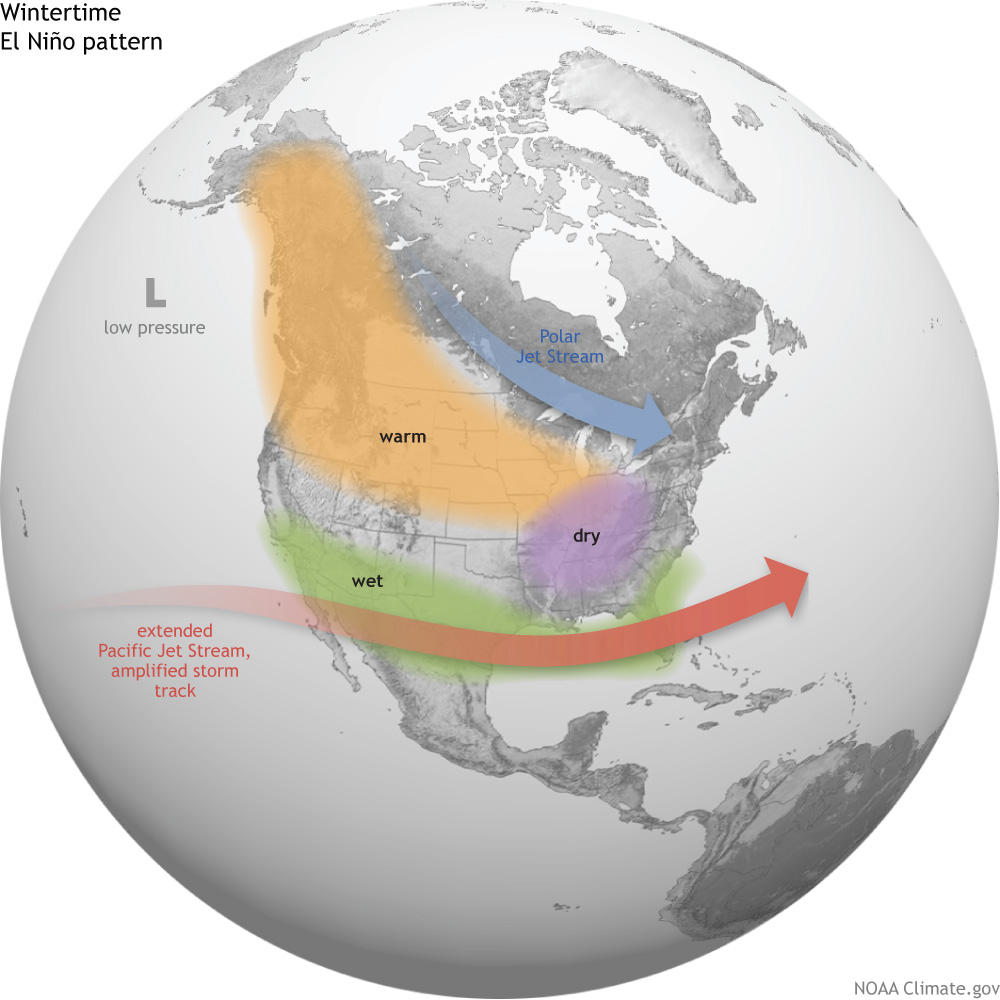
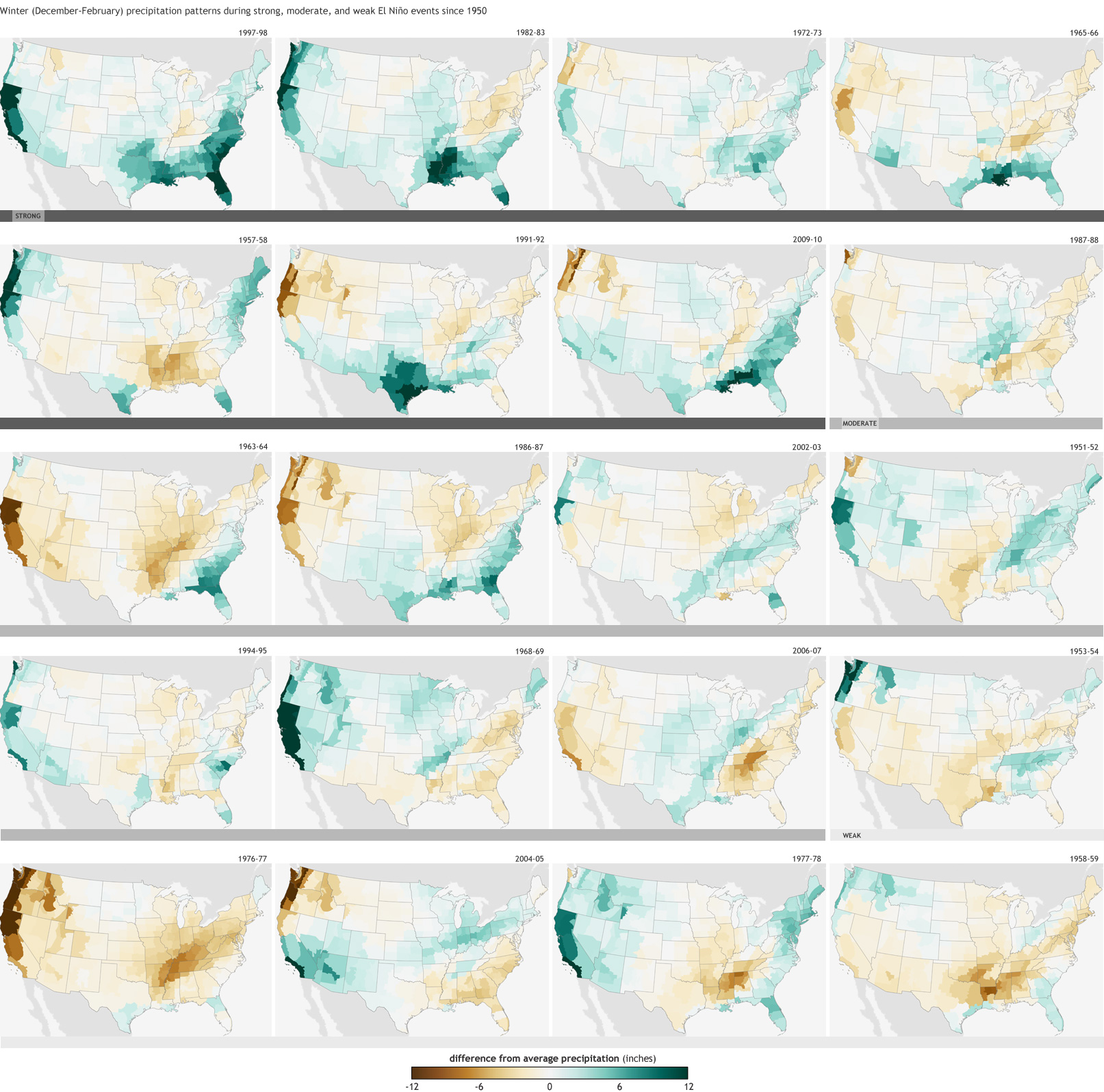


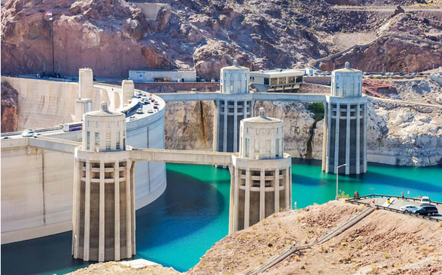
![A celebration of the return of water to the Delta [Click on the image to view Peter McBride's slideshow]](http://coyotegulch.blog/wp-content/uploads/2014/06/folksatsanluisriominute319fiestaapril2014.jpg?w=450)