CWCB: June 2014 Drought update, June MTD precipitation = 33% #COdrought


Click here to read the update from the Colorado Water Conservation Board:

May was wet and cool across most of the state resulting in improvements to drought conditions throughout eastern Colorado. However, June, to-date, has seen just 33% of average precipitation; with portions of southern Colorado also seeing above average temperatures. Warm and dry conditions, such as these, can counteract gains from precipitation quickly. Reservoir storage remains high in the north but below average in the southern half of the state. Southeastern Colorado continues to struggle with blowing dust due to high winds and dry soil moisture. The hope that a strong El Nino event would bring significant moisture to the plains has largely dissipated with stagnant ENSO conditions. Water providers in attendance indicated that storage levels are strong, with many reservoirs near or at capacity (and some spilling), and they are not imposing watering restrictions beyond normal operating procedures.

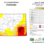
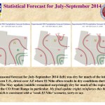
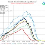
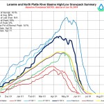
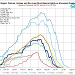
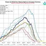
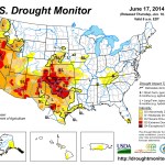
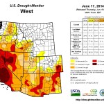
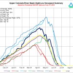
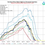
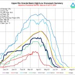
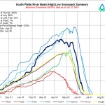
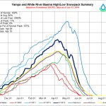
  • Currently, 49% of the state is in some level of drought classification according to the US drought monitor. 23% of that is characterized as “abnormally dry” or D0, while an additional 9% is experiencing D1, moderate drought conditions. 8% is classified as severe, 7% as extreme and 2% of the state remains in exceptional drought (D4). These conditions are slightly improved over last month.
  • Current streamflow forecasts statewide range from greater than 150% of average in the South Platte to below 50% of average in parts of the southwest. The northern portion of the state has forecasts that are near to above normal, while the southern portion of the state has forecasts below normal.
  • Snowpack statewide is at 197% of median. All basins are experiencing normal seasonal decline, but significant amounts of snow remain. By this time of year many basins have reached melt-out, making those with snow still on the ground appear greater than conditions actually reflect. As of June 17, the basins in the northern portion of the state are all above the median while the southwest, Rio Grande and Upper Arkansas are below the median.
  • Reservoir Storage statewide is at 95% of average at the end of May 2014, slightly higher than last month. The lowest reservoir storage statewide is in the Arkansas & Upper Rio Grande basins, with 56% and 63% of average storage, respectively. The Yampa/White and the South Platte have the highest storage level at 114% and 113% of average.
  • The Surface Water Supply Index (SWSI) for the state, which takes into account both reservoir storage and streamflow forecasts, is near normal across much of the state, with an “abundant” index in the northern basins of the South Platte, North Platte, and Colorado. The lowest values in the state are in the Southwest and Rio Grande Basins and indicate moderate drought.
  • El-Nino conditions have begun, but are not yet firmly established and appear to have stalled resulting in a weak event for the time being. The stronger an El Nino event is the more likely we are to see a wetter growing season. Long term forecasts indicate dry conditions along the Colorado Front Range and eastern plains through September, which is consistent with a weak El Nino scenario. Western Colorado can hope for a near normal monsoon season.
  • The short term forecast anticipates near normal rainfall at best throughout the state over the next 14 days. June in Colorado is typically driest in the mountains and on the western slope.
  • From the Associated Press via The Pueblo Chieftain:

    State officials say about half of Colorado remains in some level of drought.

    The Department of Natural Resources said Monday that more than 15 percent of the state is in a severe to exceptional drought. The hardest-hit area is in southeastern Colorado, while less extreme drought conditions are spread across the southern and eastern parts of the state.

    About a quarter of the state is classified as abnormally dry and 10 percent is in a moderate drought.

    Conditions vary widely, with the South Platte River in northeastern Colorado forecast to run 150 percent or higher of average because of heavy mountain snow last winter. Rivers in the southwest are predicted to be below 50 percent of average.

    Statewide, June precipitation has been 33 percent of average.

    USGS video: Hydroelectric survey of the Grand Canyon, 1923 #ColoradoRiver

    Colorado State University to study water quality impacts of beetle kill — the Fort Collins Coloradoan

    mountainpinebeetles

    From the Fort Collins Coloradoan (Ryan Maye Handy):

    Scientists from Colorado State University and Colorado School of Mines have begun a five-year study of the impacts beetle kill forests have on water quality in Northern Colorado.

    The study, funded by a $3 million grant from the National Science Foundation Water Sustainment and Climate Program, will look at the South Platte and Colorado River basins.

    Scientists from both universities will use computer models and field and lab experiments to assess changes to water quality and availability following the mountain pine beetle outbreak. Although the outbreak is on the down-swing, it has killed millions of acres of trees in Colorado and across the Rocky Mountain West.

    The Poudre River drains into the South Platte River Basin, where Fort Collins sits.

    More Cach la Poudre River watershed coverage here.

    Didymo outbreaks due to changing water chemistry in a warming world?

    Didymo algae
    Didymo algae

    From The Crested Butte News (Seth Mensing):

    For seven years he has sought the cause of widespread blooms of an algae known as didymo, or rock snot. Now longtime Rocky Mountain Biological Laboratory researcher and Dartmouth College professor Brad Taylor finally has his culprit. And the invasive outbreaks might have an origin closer to home than once believed, taking the unaware angler off the hook and placing the blame for the suffocating algae blooms on bigger environmental changes, according to a paper Taylor published in the journal BioScience.

    Taylor reports the algae Didymosphenia geminata was likely always present in even our most pristine streams and rivers, turning from an insignificant diatom into an asphyxiating blanket of goop as a result of changing water chemistry and a changing climate.

    Taylor started looking into the occurrence of large and unprecedented didymo blooms while at RMBL in the summer of 2007, a year after the blooms were first documented.

    “The work at RMBL figured prominently in the BioScience paper,” Taylor says. Didymo cells are in many rivers around Crested Butte and Gunnison and have been for more than 50 years, based on the research at the RMBL.

    According to Taylor, didymo blooms have been observed in the Taylor River, West Brush Creek, Cement Creek, East River, Oh-Be-Joyful below and above the wilderness area and Coal Creek, as well as some unnamed creeks and more. But such large blooms are a new phenomenon, Taylor says. And for reasons still being researched, the didymo cells in Poverty, Slate, Rustlers, East Fork Crystal, and some other rivers don’t bloom in the way didymo has come to be known.

    In his research plan on the RMBL website, Taylor says the second of two rounds of research, started in 2012, set out to answer four questions related to the didymo outbreaks.
    First, he hoped to answer the question of whether or not timing and magnitude of runoff correlated with didymo outbreaks. He wondered if the outbreaks could be related to the presence of beaver dams or occurred more in lake-fed streams. What he found was an affirmative answer to his final question about the relationship between an outbreak and phosphorus levels in the water. Instead of the algae blooming in response to an abundance of nutrients in the water, didymo was extending its reach to gather what few nutrients were left.

    Taylor doesn’t see any direct connection between low levels of phosphorous in the water and the abandoned mines in the area, since didymo occurs naturally in almost all streams, and blooms are being documented around the world. However, he said, the mats of didymo are trapping heavy metals that would otherwise flow freely downstream.

    And while that might sound like a good thing, the heavy-metal-laden didymo will eventually flow downstream, Taylor says, potentially depositing the heavy metals en masse.

    More Gunnison River Basin coverage here.

    Southern Delivery System update: $359 million spent so far, >44 miles of pipe in the ground

    Southern Delivery System route map -- Graphic / Reclamation
    Southern Delivery System route map — Graphic / Reclamation

    From The Pueblo Chieftain (Chris Woodka):

    Tunneling under Fountain Creek is proving more difficult than expected for the Southern Delivery System. Some pipeline near Pueblo Dam has been laid in solid rock. And the temporary irrigation system to provide water for native vegetation over the pipeline scar through Pueblo County contains 50 miles of pipe (main line and laterals) and 15,000 sprinkler heads. Those were some of the highlights of a progress report by Mark Pifher, SDS permit manager, to the Lower Arkansas Valley Water Conservancy District Wednesday.

    “The tunneling project was more difficult than we thought,” Pifher said. The work was being done just over the El Paso County line from the west side of Interstate 25, with a tunnel-boring machine 85 feet below ground.

    Because of the difficulty, a second borer from the east side one mile away is being used.

    “They had better meet in the middle,” Pifher joked.

    More than 44 miles of the 50 miles of 66-inchdiameter pipeline from Pueblo Dam to Colorado Springs has been installed; a treatment plant and three pump stations are under construction; and a Fountain Creek improvement project has nearly been completed, he said. All of the pipeline in Pueblo County has been installed, and revegetation has begun on 323 acres that were disturbed in Pueblo West and on Walker Ranches. The irrigation system is so large that it has to run in round-the-clock cycles seven days a week, Pifher noted.

    “It’s apparently the largest sprinkler system in the state,” he said.

    Another 484 acres has been planted with native seed in El Paso County.

    As of March, $359 million has been spent on SDS, with $209 million going to El Paso County firms, $65 million to Pueblo County companies, $900,000 to Fremont County contractors and $84 million to businesses in other parts of Colorado.

    More Southern Delivery System coverage here.

    Colorado: Forest Service comment letter shows breadth and depth of impacts from Denver Water’s diversion plan

    EPA webinar — When Green Goes Bad: Understanding Cyanobacteria, Nutrients & Lakes

    Conservationists raft trip part of the Yampa Awareness Project

    Yampa/White/Green river basins via the Colorado Geological Survey
    Yampa/White/Green river basins via the Colorado Geological Survey

    From Steamboat Today (Eugene Buchanan):

    For the fourth time, local nonprofit Friends of the Yampa (FOY) hosted a group of more than 20 national conservationists, water policy stakeholders and other river advocates for a four-day raft trip through Yampa Canyon and Dinosaur National Monument as part of its Yampa River Awareness Project (YRAP).

    After taking a fly-over of the Yampa Valley and Yampa Canyon the day before to see the waterway from the air, attendees packed dry bags and river gear to float the 71-mile stretch of river from Deerlodge Park west of Maybell to the Split Mountain Boat Ramp in Utah.

    Included on the trip were representatives from such conservation organizations as American Rivers and Western Resource Advocates, scientists from the Nature Conservancy and stakeholders from Conservation Colorado, The Wilderness Society, Colorado Water Trust, the Upper Yampa Water Conservancy District, the National Young Farmers’ Coalition, the Yampa River System Legacy Project and the Colorado River Water Conservation District. Local participants included former Routt County commissioner Ben Beall and former City Council president Ken Brenner.

    Hosted by river outfitter O.A.R.S, the think-tank trip included campfire panel discussions on everything from preserving the Yampa’s flows and integrity of its bio-diversity to the river’s PBO (Programmatic Biological Opinion), flow management plans and much more. Pow-wow sessions were held each morning and evening at camp, as well as at key ecological sites along the river.

    “One of Friends of the Yampa’s goals is to protect the free-flowing nature of the Yampa,” said FOY Board President Soren Jespersen. “You can’t protect something if you don’t have engaged constituents. This year our focus was bringing people who work in river advocacy and water policy programs. There’s an increasing threat that Front Range water interests are looking to the Yampa to solve their perceived water gaps.”

    Included on the trip was 14-year Dinosaur National Monument botanist Tamara Naumann, who estimates she’s been down the river nearly 100 times. For her, the biggest threat isn’t protecting the river’s flows or trans-basin diversions, but “people not caring.”

    “We need to figure out how to manage it into the next half-century,” she said. “There are many obligations that need to be met, and Colorado has an obligation to send water downstream. But while people’s objectives can be different, the end result can benefit everyone.”

    Two other participants, former Adrift Adventures owner Pat Tierney and renowned photographer John Fielder, attended as part of their plans to produce a coffee table book entitled “The Yampa River: Wild and Free Flowing,” to be released in 2015. As part of their efforts before the trip through Dinosaur, they floated and photographed the river from Steamboat to Maybell.

    “It’s a great story, and we’re excited to tell it,” said Tierney, adding that this year marked his 37th straight year running the canyon. “It will have great photographs and bring many of the river’s issues to light.”[…]

    “We need to build more relationships with farmers and ranchers in the region and show them that our interests are aligned,” said Kate Greenberg of the National Young Farmer’s Coalition. “We’re not going to solve the problem in a week, but this is a great start.”

    Take-homes included the need to get recreational and agricultural interests better aligned at both the local and Water Basin Roundtable level; creating an informal management plan for the Yampa’s resource values; and spreading the word on its unique bio-diversity.

    “The science aspect of the endangered species that thrive in a free-flowing river environment is important,” said FOY board member and recreational representative for the Yampa/White/Green Basin Roundtable Kent Vertrees, touting such endangered fish in the river as the Colorado pikeminnow. “You need it to back up water policy.”

    In the end, after crashing through the dinosaur-sized waves of Split Mountain Canyon at a whopping 20,000 cfs, every participant left with a better understanding of what needs to be done to preserve such a treasure. And many participants stayed on — and were joined by nearly 50 other out-of-town river advocates — to attend the ensuing three-day seminar in Steamboat and tour the upper Yampa Basin as part of a program put together by Nicole Seltzer of the Colorado Foundation for Water Education.

    More Yampa River Basin coverage here.

    Montezuma County stipulates out of BLM Yellow Jacket Creek diligence case

    Yellow Jacket Canyon via Four Corners Hikes
    Yellow Jacket Canyon via Four Corners Hikes

    From the Cortez Journal (Jim Mimiaga):

    Montezuma County has bowed out of a complex water dispute on Canyons of the Ancients National Monument, but negotiated stipulations on water use for Yellow Jacket Creek.

    In 2009, the monument purchased an inholding – the 4,500-acre Wallace Ranch – for $3.3 million. The property came with a conditional water right of 5.25 cubic feet per second from the intermittent desert stream.

    The county, along with Southwest Colorado Landowners Association and Water Rights Montezuma, opposed a routine water-court procedure by the BLM regarding the due diligence on eventual use of the water rights…

    The county has been critical of the monument buying private inholdings, fearing it will diminish historic ranching opportunities in that area.

    Commissioner Keenan Ertel argued that Article 1, Section 8, of the U.S. Constitution requires the state legislature to approve federal purchase of private property. Permission was not granted by the state, and BLM officials do not believe it is necessary.

    The BLM filed a request for summary judgment on the case May 30, which asks the Durango water court judge Greg Lyman to rule in favor of the BLM because the objectors’ legal dispute is presented in the wrong court venue. The decision is pending, and if denied would trigger a trial.

    The BLM argues due-diligence procedures have narrow parameters in water court and that those specific facts are not disputed in the case. Special Assistant U.S. Attorney Kristen Guerriero states claims of objectors are irrelevant in water court.

    “Specifically, opposers assert Constitutional claims alleging that the United States does not have authority to purchase property own water rights in any state,” writes Kristen Guerrieo, Special Assistant U.S. Attorney. “These are not claims that challenge the validity of BLM’s diligence activities, but rather reflect Opposers’ desire to utilize the Water Court proceeding to advance other objectives.”[…]

    Montezuma County attorney John Baxter told the commissioners the stipulation agreement drops them as official objectors in the BLM request for the six year diligence period on the Yellow Jacket water rights. But they will still have a say on how the water should be used when the BLM seeks absolute status of those water rights.

    “Whether we win or not, they still have to go through us when they perfect the rights,” he said. “The BLM wants to kick the can down the road,” on deciding how to use the water.

    The stipulation agreement states that when Yellow Jacket water rights are converted from conditional to absolute they can only be used for public recreation, BLM housing facilities, fire suppression, irrigation use, and livestock use. It further stipulates the water cannot be used to grow crops, that what is not used be available for downstream users, and that the BLM does not file applications to convert the water to instream flow uses or for uses on other properties.

    Remaining objectors in the case, Southwest Colorado Landowners Association and Water Rights Montezuma, have until June 24 to respond to the request for summary judgement filed by the BLM.

    More water law coverage here.

    Monte Vista is implementing a source water protection plan

    Monte Vista historic district via Wikipedia
    Monte Vista historic district via Wikipedia

    From The Monte Vista Journal (John McEvoy):

    Dylan Eiler, a specialist from Colorado Rural Water Association (CRWA) wowed the Monte Vista City Council with his June 5 presentation on the free Source Water Assessment and Protection (SWAP) program available to the city of Monte Vista.

    CRWA is a nonprofit organization that provides technical assistance and training to Colorado’s public water and wastewater treatment systems, according to their brochure.

    Not only is the program free, Eiler’s services in helping submit the $5,000 grant proposal that will pay for the program, as well as his expertise in the development and implementation of a source water protection plan is free also.

    The grant is a one-to-one matching grant, which means the city would have to match every dollar with either money or in-kind time. The city may meet the in-kind funds by tabulating time spent at stakeholder meetings by professional and non-professional people present, as well as any time lawyers or engineers contribute to the local program.

    The Colorado Department of Health and Environment (CDPHE) created Colorado’s SWAP program and source water assessment reports to help with the development and implementation of individual source water protection plans in 2004.

    “If area stakeholders know the source of their water, they will get involved,” said Eiler. “Identifying customers and involving citizens is the most effective way of creating advocates for protecting water sources.”

    More Rio Grande River Basin coverage here.

    Latest USFS permit does not compel ski areas to convey water rights to the US government

    Trail map for Powderhorn Ski Area via liftopia
    Trail map for Powderhorn Ski Area via liftopia

    From The Grand Junction Daily Sentinel (Gary Harmon):

    A U.S. Forest Service rule aimed at assuring that ski areas don’t sell off their water rights was welcomed by Colorado’s two senators and panned by the office for the representative whose district includes several resorts.

    The Forest Service on Friday is to unveil a rule to replace one that was rejected by a federal judge who ordered the agency to start the proposal anew.

    Under the proposed new rule, ski areas operating on Forest Service land would have to assure the Forest Service that the ski area would have sufficient water rights to provide for snowmaking and other essential operations even if the ski resort is sold.

    The rule would not require ski areas to transfer water rights to the Forest Service. That provision in the previous rule caused the National Ski Areas Association to take the Forest Service to court, where it won a ruling that sent the agency back to the drawing board.

    “This proposal balances the interests of the public, the ski areas and our natural resources by ensuring the necessary water is provided for winter recreation through our special-use permit process,” U.S. Forest Service Chief Tom Tidwell said in a statement about the rule, which is to be published in the Federal Register on Friday. “This proposed change will provide assurances to the public that they will continue to enjoy winter recreation at ski areas on national forests.”

    The Friday notice will start a 60-day public-comment period on the proposed rule.

    U.S. Sens. Michael Bennet and Mark Udall, both Colorado Democrats, said in separate state
ments that they welcomed the proposed new rule and looked forward to reviewing it.

    Udall called it “another step toward protecting our national forests and recreational opportunities on public lands.” while Bennet called for a consensus bill “based on today’s proposal that provides certainty and clarity on this issue for Colorado’s water community.”

    The House already has passed a bill by U.S. Rep. Scott Tipton, R-Colo., aimed at preventing the Forest Service and other federal agencies from demanding water rights in exchange for permits on federal lands.

    Tipton’s office had yet to see the proposed new rule, a spokesman said, noting that if it affects only the Forest Service, it falls short of protecting all users, including ranchers and municipalities that use federal lands and watersheds.

    The previous rule was first used in 2012 when the new owners of Powderhorn Ski Resort, now Powderhorn Mountain Resort, were required to turn over water rights in order to obtain a permit to operate on the Grand Mesa National Forest, prompting the suit by the National Ski Areas Association.

    From the Examiner (Charles Pekow):

    The 1982 Forest Manuel requires that USFS obtain water rights for making snow and operating facilities. Concessionaires can request rights on behalf of USFS. In 2004, the policy was amended to allow concessionaires and USFS to obtain the rights jointly. But the 2004 policy has let to considerable confusion, as water was obtained from different sources from in and out of federal property and transported in different ways, USFS found. So it amended the clause in 2011 to address different types of water rights.

    The 2011 directive distinguished between rights for water diverted from and used on local forest service land in the ski permit area, rights for water coming from USFS property outside the permit area, and water from outside sources. USFS amended the clause further in 2012. But the National Ski Areas Association (NSAA) sued in federal court. NSAA charged that USFS did not allow for public comment before changing the procedures, in violation of several federal statutes. U.S. District Court in Colorado agreed and vacated the 2011 and 2012 changes.

    So USFS is proposing new procedures and taking public comments. It conducted four open houses and sought comments last year too. It is reproposing the ideas based on what it learned.

    More water law coverage here.

    Fort Collins hosts tours of Poudre River

    From the Fort Collins Coloradoan (Ryan Maye Handy):

    Fort Collins Utilities will lead a guided tour of the Poudre River watershed this July and August, when residents can learn about the city’s water resources and quality control for their drinking water.

    Utilities will charter a bus to Cameron Pass, along Colorado Highway 14. While on the tour, residents will learn about Fort Collins’ watershed and water supply history, and take a short walking tour and stop at Gateway Natural Area. The tour starts at 8 a.m. and will leave from the Utilities service center at 700 Wood St. Utilities will provide lunch; the tour will end in Fort Collins at about 5 p.m.

    The tour will also address the effects of fire and floods on the watershed.

    The tour is free and open only to adults age 18 and up. The first tour will be on July 16, and the second on Aug. 9. Residents can register at http://www.fcgov.com/watershed, (970) 221-6700 or utilities@fcgov.com.

    Republican gubernatorial candidates all making water storage a top priority — The Greeley Tribune

    Northern Integrated Supply Project preferred alternative
    Northern Integrated Supply Project preferred alternative

    From The Greeley Tribune (Eric Brown):

    A top priority for all four Republican gubernatorial candidates struck a chord with the audience at a forum this week. All of the candidates talked early and often about developing more water-storage infrastructure for Colorado, doing so during a gubernatorial candidate question-and-answer forum Tuesday at the Protein Producer Summit, where livestock and water experts had already spent much of the day discussing water shortages for agriculture and the need for more water storage.

    “It seems to be something no one else has the courage to talk about,” said Republican candidate Bob Beauprez, a bison rancher and former U.S. Congressman, noting that, to his knowledge, Gov. John Hickenlooper has spoken only of expanding current water storage by about 10 percent.

    Referring to 10 percent increases in storage and Colorado’s population having doubled since the 1970s, and being expected to double again before 2050, Beauprez said, “We can’t keep going there, unless you want to keep drying up agriculture.”

    Beauprez also spoke about making better use of Colorado’s aquifers for underground water storage, while fellow Republican candidate Scott Gessler — Colorado’s current Secretary of State — also stressed the need for a two-pronged approach that also includes water conservation measures.

    All four Republican candidates made different points during the forum on other topics — for example, Gessler said he wants changes to Colorado’s constitution to require approval on a ballot in two consecutive elections before being approved, while former Colorado Senate minority leader Mike Kopp said, if elected, he’ll initiate a two-year study of regulations in Colorado, and will work to reduce regulatory costs by 25 percent for businesses.

    But when it came to water storage, all four Republicans stood in unison. This week’s three-day Protein Producer Summit was hosted by various Colorado livestock groups.

    Hickenlooper, currently leading a delegation in Mexico, joined the gubernatorial candidate forum Tuesday via video.

    In his answer to the water-shortfall question, he didn’t refer specifically to water storage.

    He listed conservation as the leading way to start addressing water shortages in Colorado, and otherwise talked about the Colorado Water Plan, which he initiated last year in hopes of letting local water officials and various users from across the state develop a statewide, long-term plan.

    In Colorado, those looking to build reservoir storage have run into pushback, largely from environmental groups, and have battled long federal permitting processes.

    For example, the Northern Integrated Supply Project, if approved, would build two new reservoirs — one near Fort Collins and another near Ault — and would provide 40,000 acre feet water per year to 15 municipalities and water districts in northern Colorado. But the endeavor — expected to cost about $500 million, if built — has been in the federal permitting stages for several years, and it’s still unclear how soon it will come, if it does.

    The project hasn’t been supported, or denounced, by Hickenlooper, but all four gubernatorial candidates — Beauprez, Gessler, Kopp and former U.S. Congressman Tom Tancredo — stressed that such projects would have their support, if elected, and are much needed.

    Colorado’s municipal and industrial water supply gap by 2050 could be as much as 630,000 acre-feet annually and, by that same year, the state could see as many as 700,000 acres of irrigated farmland dry up, with cities continuing to buy more water from ag users, according to the Statewide Water Supply Initiative report, released in 2010.

    That same report estimates the South Platte River basin alone, which covers Weld County and much of northeast Colorado, could face a municipal and industrial water supply gap of as much as 190,000 acre feet by 2050, and see as many as 267,000 acres of irrigated farmground dry up.

    The stakes are particularly high for the agriculture industry, which uses about 85 percent of the state’s water.

    Protecting Water and Property Rights Act of 2014 introduced to set aside EPA’s proposed “Waters of the US” clarification


    From The Greeley Tribune:

    A group of 30 Republican U.S. Senators on Thursday introduced legislation to stop the U.S. EPA and Army Corps of Engineers from finalizing the proposed Waters of the U.S. rule, currently under public comment, according to reports.

    The Senators’ “Protecting Water and Property Rights Act of 2014” aims to stop the U.S. EPA and Army Corps of Engineers from finalizing the proposed Waters of the U.S. rule — a rule they say would ignore limits established by Congress regarding regulation of bodies of water in the United States if finalized.

    The prosed rule, officially announced on March 25, dictates what waters fall under the definition of waters of the U.S., providing EPA and Corps jurisdiction to enforce regulations outlined in the Clean Water Act.

    “The Obama EPA is trying every scheme they can think of to take control of all water in the United States,” said Protecting Water and Property Rights Act of 2014 author Sen. John Barrasso, R-Wyo, said in a press statement. “This time, their unprecedented federal water grab is in the form of a rule that will hurt family farms, ranches, and small businesses by imposing outrageous permitting fees and compliance costs.”

    Barrasso, as well as famers, suggest that if the rule goes forward, it will restrict local land and water use decisions, and could extend to intermittent streams and ditches, requiring additional permitting for farming and ranching activities.

    From The Pueblo Chieftain (Chris Woodka):

    A Forest Service directive has the potential to add groundwater resources to proposed federal rules on surface water under the Clean Water Act, U.S. Rep. Scott Tipton, R-Colo., said Thursday. During a congressional hearing, Tipton questioned Undersecretary of Agriculture Robert Bonnie on the proposed groundwater directive. The directive would expand forest service control to include groundwater, as well as streams that feed it, Tipton said.

    Bonnie said Tipton is misinterpreting the rule.

    “The Forest Service is putting out a directive that will clarify and provide some consistency across the way we address groundwater as part of resource management plans, projects and other things,” Bonnie said. “The purpose of that directive is to provide greater consistency across the Forest Service. It doesn’t provide any new authorities to regulate groundwater.”

    Tipton disagreed.

    “My interpretation of it is that a farmer or rancher could divert legally out of a stream to fill a stock pond or irrigate a field, and will be in violation,” Tipton replied.

    Water users in Colorado already are nervous about increased scrutiny by the Environmental Protection Agency and Army Corps of Engineers under proposed rules that regulate nearly every waterway as waters of the United States.

    Those rules have been proposed to clarify federal authority after conflicting Supreme Court decisions.

    For instance, on Thursday the Southeastern Colorado Water Conservancy District spent time discussing potential impacts. Colorado Water Quality Control board member Mark Pifher testified to Congress last week that the rules would add regulatory expense to water projects. Sens. Michael Bennet and Mark Udall, both Democrats, helped expand the comment period for the rules.

    Meanwhile, Tipton has been critical of the Forest Service on other occasions, objecting to contract for ski areas that take water rights. The waters of the U.S. rule is another example of how the federal government is overreaching, he said.

    “I don’t know what’s not going to be applicable to the ‘waters of the U.S.’ This is the biggest water grab in American history coming out of the EPA,” Tipton said.

    More Environmental Protection Agency coverage here.

    Oil spill near Windsor ~7,500 gallons

    South Platte River Basin via Wikipedia
    South Platte River Basin via Wikipedia

    From The Greeley Tribune:

    About 178 barrels of crude oil, or roughly 7,500 gallons, has spilled east-southeast of Windsor and is affecting the Poudre River, state officials said Friday.

    The operator, Noble Energy, discovered the spill Friday and reported it to the Colorado Department of Natural Resources, said Todd Hartman, the department’s communications director.

    Noble reported a storage tank affected by spring flood waters released its contents. The release appears to be due to floodwaters undercutting a bank, causing the tank to drop downward and damaging a valve, allowing oil to escape from a broken valve. The well associated with the tank is shut in, and a second tank nearby appears unaffected.

    Standing water with some hydrocarbons remains in one low-lying area near the tank, Hartman said.

    Vegetation is stained for about one-quarter mile downstream of the site.

    Noble had environmental response personnel on site Friday afternoon.

    A vacuum truck was removing standing water and response personnel were sampling soils.

    The oil storage tank sits next to a field east of Weld County Road 23, on the north side of the Poudre River. The tank sits about 200 feet from the river, up a hill. A lot of flood damage was visible in the area, with washed out and eroded river banks and debris still in the water.

    Hartman said water quality staff from the Colorado Department of Public Health and Environment also were at the spill site Friday but have not discovered any impact on drinking water.

    More water pollution coverage here.

    FIBArk good for business

    Hooligan Race 2009
    Hooligan Race 2009

    From The Mountain Mail (Allison Dyer Bluemel):

    While downtown business owners saw increased foot traffic during FIBArk and said the festival went well overall, FIBArk board members said attendance was relatively steady and see room for improvements for next year. Festival attendance increased for Friday night’s music and throughout the weekend at the carnival, FIBArk Board President Christopher Kolomitz said.

    “Part of the increased traffic (Friday) was due to the draw of The (Infamous) Stringdusters’ performance and great weather,” he said.

    The popularity of the carnival was partly due to sales of more than 500 presale tickets before the festival and the vendor’s knowledge of the space available to him this year, which enabled him to feature two new rides, Kolomitz said.

    Locals and parents seemed to really appreciate being able to get the carnival tickets ahead of time, said Lori Roberts, Heart of the Rockies Chamber of Commerce executive director.
    She said festival programs were distributed earlier than usual, which enabled the chamber to convince visitors who came to town early to stay through the festival and extend their time in town.

    “I think it’s important that we send people downtown,” Roberts said.

    Additionally, Chaffee County’s information line, operated by the chamber, began to get heavy call volumes about 3 weeks before FIBArk from visitors looking for suggestions on what to do in the area, Roberts said.

    Kolomitz said exact attendance numbers are hard to compare to previous years because FIBArk is a free, nonticketed event, but “all 4 days were jam-packed with something for everyone.”
    FIBArk volunteers kept track of the number of competition participants throughout the weekend, which showed participation in land events increased while the freestyle river events decreased from previous years, Kolomitz said.

    Though Kolomitz said no one event stood out from the rest, he was particularly impressed with Andy Corra’s 10th win of the Downriver Classic Sunday.

    “It’s really a testament to his strength, athleticism and commitment to the sport. We’re really proud he came this year,” he said.

    While most events were a success, Kolomotiz said the board and volunteers recognized that some elements of the festival could be improved upon.

    “We had some issues with the timing of river events,” he said, “They were not as smooth as we would have liked.”

    Next year, the board hopes to develop a better system for recording the race times and results in order to get the competitors their awards more efficiently, particularly for the downriver races, he said.

    “The board member who put the results together for the Downriver has been receiving undeserved ridicule. It’s important to remember that we’re all volunteers here,” Kolomitz said.

    The festival also saw a slight increase in the number of food and retail vendors, both in the park and on the Coors Boat Ramp. This year, the board decided to separate the whitewater sports booths from the others and place them closer to the boat ramp, he said.

    “Overall, the music lineup was great, the vendors were tasteful, and the people at the parade seemed safe,” Roberts said.

    Community members and attendees can fill out a 10-question survey to give feedback to the FIBArk board about the quality of events, music, vendors and carnival during the festival at surveymonkey.com/s/FIBArk.

    Downtown retail business owners said they saw heavy traffic during FIBArk and immediately following the festival. Ruby Blues owner Michael Almeida said the store saw about a 20-percent increase in sales compared to last year. Businesses that sold merchandise catering to vacationing tourists, such as Salida Mountain Sports, Fat-Tees T-Shirt Shop and the F Street Five & Dime, saw foot traffic increase as well during the festival.

    “A lot of people came in to buy things they forgot for vacation or just can’t live without,” Salida Mountain Sports employee Jen Walters said.

    Colorado-specific T-shirts and anything with the Colorado flag were also big sellers, said Fat-Tees owner Duke Sheppard, who had a record-setting FIBArk this year.

    However, Su Casa Furniture, Accents & Gifts co-owner Jim Balaun said business picked up following FIBArk since the store is more popular with locals and homeowners.

    Downtown restaurant owners also reported increased traffic during the festival.

    For Shallots, Saturday evening and Sunday brunch were particularly busy. However, the town seemed abnormally empty on Friday, co-owner Amy Potts said.

    Despite the draw of music in the park, Currents co-owner Chris Tracy said the bands Current booked throughout the weekend drew in a full house of about half locals and half tourists.

    “Overall, the feel from the community was that things were up and things were going well,” Kolomitz said.

    More whitewater coverage here.

    Climate Change: “…it is hard to tell a positive story around ski resorts” — Eliot Whittington

    Copper Mountain snowmaking via ColoradoSki.com
    Copper Mountain snowmaking via ColoradoSki.com

    From Reuters (Alister Doyle):

    A few areas of the world might benefit from a shift in tourism, such as Alaska or northern Europe. And elsewhere, seasons may shift.

    The report said the Costa Brava region of Spain’s Mediterranean coast, for instance, was trying to draw tourists outside the summer months, responding to a lack of water and high temperatures during the high season.

    The study also said there was some evidence of people traveling to new destinations at risk of vanishing in a warming world, such as glaciers, the Arctic, Antarctica or coral atolls.

    “However, the opportunities presented by such ‘last-chance’ tourism will, by definition, be short-lived,” the report said.

    It also said that an increase of 1 meter (3 feet) in sea level rise this century – the upper bound of scenarios by the U.N. panel – would damage up to 60 percent of resort properties in the Caribbean and swamp many airports and ports.

    “Every part of the industry needs to … think about what more can be done to adapt to climate change, as well as how to continue the process of reducing the impact of their operations on the environment,” Stephen Farrant, director of the International Tourism Partnership, said in a statement attached to the report.

    Travel accounts for about 75 percent of tourism’s greenhouse gas emissions. More efficient planes, vehicles and greener fuels could help curb emissions, it said.

    Long Hollow Dam construction complete

    Long Hollow Reservoir location map via The Durango Herald
    Long Hollow Reservoir location map via The Durango Herald

    From The Durango Herald (Dale Rodebaugh):

    A ceremonial load of dirt was dumped Thursday to mark the end of construction of the Long Hollow Dam.

    The brief topping-out observation was attended by members of the Ute Mountain Ute Tribe, which helped fund construction, and Brice Lee from La Plata Water Conservancy District, which sponsored the project.

    The reservoir behind the dam will store 5,300 acre-feet of water from Long Hollow Creek and Government Draw to support area irrigators and help Colorado meet its obligation to share La Plata River water with New Mexico…

    The dam is 151 feet high with a span of 800 feet. A central clay core is supported upstream and downstream by tons of sand, rocks and dirt.

    Aaron Chubbuck, Weeminuche project manager, said the dump trucks used during construction covered the equivalent of 10 trips around the world at the equator (about 250,000 miles).

    Finishing touches remain. Sensors will be placed on the face of the dam to record possible movement or leakage, and electrical and hydraulic lines will be installed to operate the intake gate and valves on the downstream side.

    The “borrow areas” from where construction materials were taken will have to be revegetated.

    More La Plata River watershed coverage here.

    Moffat Firming Project support absent at Boulder BOCC hearing — Sky-Hi Daily News #ColoradoRiver

    Denver Water's collection system via the USACE EIS
    Denver Water’s collection system via the USACE EIS

    From the Sky-Hi Daily News (Hank Shell):

    “There were numerous data issues raised that might be worth flagging,” said Elise Jones, Boulder County commissioner. “Everything from the use of median versus average in the statistics to whether or not the cost estimates are accurate. There were numerous other examples but that seemed to be a theme.”[…]

    At the beginning of the meeting, Boulder County Commissioners’ staff voiced concerns about the project’s Final Environmental Impact Statement.

    The 12,000-page Final Environmental Impact Statement is meant to reveal possible environmental impacts of the project.

    “There wasn’t a robust discussion of the need and purpose of the project,” said Michelle Krezek, the commissioners’ staff deputy. “Specifically, there wasn’t any analysis of water conservation measures that could be taken or other smaller projects that could be undertaken instead of this large project. So it was hard to determine whether this was the right alternative.”

    Other concerns included the absence of the Environmental Protection Agency from the process and the effect that expansion of the reservoir would have on Boulder County infrastructure.

    Though most of the discussion focused on the project’s impacts in Boulder County, Grand County arose multiple times during the discussion, from both Grand and Boulder county residents. Boulder County commissioners said that they would take into account testimony about the effects of the project on the Western Slope.

    “We would want to draw the Corps’ attention to those substantive comments even though they were outside Boulder County,” Jones said.

    More than 20 people spoke during the hearing, but only one speaker, Denver Water Planning Director David Little, was in favor of the project, though he did not present an argument to counter previous assertions.

    “The passion that the people in the audience have shown and some of the information that they’ve brought forward is important for you to consider in augmenting your comments to the corps,” said Little.

    The Boulder County Commissioners will now submit their new comments to the Army Corps of Engineers.

    More Moffat Collection System Project coverage here and here.

    Runoff/snowpack news

    Click on a thumbnail graphic to view a gallery of snowpack data from the Natural Resources Conservation Service.

    Southeastern Colorado Water Conservancy District board meeting recap

    Arkansas Valley Conduit Comanche North route via Reclamation
    Arkansas Valley Conduit Comanche North route via Reclamation

    From The Pueblo Chieftain (Chris Woodka):

    New wrinkles in the federal budget process have improved chances for funding of the Arkansas Valley Conduit.

    Appropriations bills in the U.S. House and Senate have increased funding for the Bureau of Reclamation, with emphasis on capital projects that are in the design phase.

    While that does not provide an increase for the conduit’s $500,000 funding level next year, it could mean a shift in funding to the conduit by Reclamation, lobbyist Christine Arbogast told the Southeastern Colorado Water Conservancy District Thursday.

    “We have incredible support from those in Congress who represent the area to be served by the conduit,” Arbogast told the board. “They are fighting for the funding of it. Clearly, it is unprecedented, the levels they are going to for this.”

    She was referring to U.S. Sens. Michael Bennet and Mark Udall, both Democrats, and U.S. Reps. Cory Gardner and Scott Tipton, both Republicans.

    For instance, during meetings in Washington, D.C., last week, the senators met with top Department of Interior and Office of Management and Budget officials to make the case for more funding for the conduit.

    The $400 million Arkansas Valley Conduit would have a main line of 130 miles from Pueblo Dam to Lamar, serving 50,000 people in 40 communities.

    Federal money for the project would be repaid through Fryingpan-Arkansas Project excess storage contracts and user fees.

    More Arkansas Valley Conduit coverage here.

    Lower Arkansas Valley Water Conservancy District board meeting recap

    Orr Manufacturing Vertical Impact Sprinkler circa 1928 via the Irrigation Museum
    Orr Manufacturing Vertical Impact Sprinkler circa 1928 via the Irrigation Museum

    From The Pueblo Chieftain (Chris Woodka):

    More than 28,000 acres of Arkansas Valley farm ground — roughly a tenth of all irrigated land — is being covered by group plans that guard against increased consumptive use from surface irrigation improvements.

    The state pushed consumptive use rules for irrigation through Division 2 Water Court in 2010. The rules are meant to protect Colorado in its 1949 Arkansas River Compact with Kansas.

    Rule 10 allows groups to file plans in order to save on legal, engineering and administrative costs.

    The Lower Arkansas Valley Water Conservancy District is administering two Rule 10 plans this year.

    One covers farms on the Fort Lyon, which represents 18,000 acres. About 12,000 of those acres are under sprinklers, while the remainder are flood irrigated.

    The second plan covers 10,000 acres not on the Fort Lyon Canal, with two-thirds of that under sprinklers and 105 acres using drip irrigation.

    “About two-thirds of the farm are in the Fort Lyon plan. The goal is eventually to have them in their own group plan that would be self-sustaining,” said the district’s engineer Jack Goble during a presentation at Wednesday’s board meeting.

    This year’s Lower Ark plans cover 235 improvements on 92 farms that should require almost 1,900 acre-feet of replacement water. The amount owed is determined by a mathematical model devised by the Colorado Division of Water Resources that determines how much water would have been used before and after improvements.

    “It’s a guess of what we’ll owe,” Goble said. “The model is almost like a parallel universe.”

    The more water used in irrigation increases the amount owed to replace depletions in the river.

    “The more water that comes through the ditch, the more is owed,” Goble said.

    Goble walked the board through the complicated model, which takes irrigation flows, precipitation, seepage and runoff into account.

    The Lower Ark district is in the second year of a study on pond leakage, which so far is showing that more water is escaping than accounted for in the state’s model. Data from the study in some cases has been applied to specific ponds.

    More Ark Valley Consumptive Use Rules coverage here and here.

    Weekly Climate, Water and Drought Assessment of the Upper #ColoradoRiver Basin

    Upper Colorado River Basin Precipitation June 1 thru June 15, 2014 via the Colorado Climate Center
    Upper Colorado River Basin Precipitation June 1 thru June 15, 2014 via the Colorado Climate Center

    Click here to read the current assessment. Click here to go to the NIDIS website hosted by the Colorado Climate Center.

    Friends of Barr Lake fundraiser “Concert on the Prairie” Saturday

    2014 Jun 21 11 x 17 poster 05-01-14 (2)
    From email from Amy Conklin:

    Just wanted to remind you about the concert on the prairie this Saturday June 21st from 7-9pm. This is a fundraiser for Friends of Barr Lake. There will be great music, dancing and FREE WINGS from Buffalo Wild Wings. Tickets are only $10.00!(This includes park entry.)

    Colorado Springs: North Douglas Creek detention designed to keep stormwater out of neighborhoods

    pikespeak

    From The Colorado Springs Gazette (Matt Steiner):

    Tim Mitros, the stormwater manager for the City of Colorado Springs, showed off the latest flood mitigation project Wednesday, unveiling a large sediment detention basin along North Douglas Creek that should keep tons of water, mud and bigger debris from invading residential areas.

    The basin will hold about 25,000 cubic yards of sediment and can be cleaned out after each torrential storm, Mitros said. The new pond replaces a series of five smaller basins that filled quickly in early September 2013 after torrential rains pounded the Waldo Canyon fire burn scar and the rest of the Front Range from El Paso County to the Wyoming border.

    “It was supposed to be a 10-year fix,” Mitros said, noting that the city was surprised at how quickly the smaller basins filled and knew it had to come up with a Plan-B.

    Now when water and debris come raging down North Douglas Creek the large pond should stop most of the flow. And an “alluvial fan” below the basin will likely slow the water and spread out the rest of the torrent before it reaches the city’s storm sewers, Mitros said.

    Mitros and Flying W Ranch Foundation executive director Aaron Winter are relieved that the project has been completed before the 2014 monsoon season and potential heavy thunderstorms hit the burn scar. Storms in early July, mid-August and September of 2013 threatened North Douglas Creek and left Manitou Springs cleaning up after flash floods poured over U.S. Highway 24, out of Williams Canyon, destroyed multiple homes and flooded businesses along Manitou Avenue.

    “There is a lot of debris that is staging in the upper parts of North Douglas Creek,” Mitros said. “We expect in larger storms that the debris will start to flush out.”

    According to the city official, an estimated 60,000 to 100,000 cubic yards of mud and debris are sitting along the creek less than a mile above the new detention basin. He said it took just about 60,000 cubic yards to fill the five smaller ponds.

    Winter said the work that the city has done, as well as other projects by volunteers with the Coalition for the Upper South Platte, have helped reassure the foundation that its neighbors to the east will be protected.

    “Knowing that this basin is in place to protect the homes downstream is a big weight off our shoulders,” he said.

    More stormwater coverage here.

    The Lower Ark questions distribution of Fountain Creek funds

    Fountain Creek Watershed
    Fountain Creek Watershed

    From The Pueblo Chieftain (Chris Woodka):

    Money targeted for Fountain Creek projects to benefit Pueblo County is being spent in El Paso County out of compliance with an intergovernmental agreement, the Lower Arkansas Water Conservancy District charged Wednesday. The Lower Ark board instructed its attorney to send letters to the Fountain Creek Watershed Flood Control and Greenway District threatening legal action, and to agencies where the money has been used for matching funds.

    The money was contributed to the district under an IGA that includes the Lower Ark district and Colorado Springs Utilities. The IGA says a steering committee of representatives from all three groups will meet to advise the Fountain Creek board how to spend the money.

    The money came from the Lower Ark district and Utilities with the understanding that there would be a balance of projects in El Paso and Pueblo counties. Since Utilities’ share is being deducted from its payment under Pueblo County’s 1041 permit for Southern Delivery System, all of the projects should benefit Pueblo County, said Lower Ark General Manager Jay Winner.

    “We fought for that money and it is to be used in Pueblo County,” said Anthony Nunez, a former Pueblo County commissioner who sits on the Lower Ark board. “It always seems Pueblo comes out on the short end with El Paso County. . . . It’s blatantly illegal what they’re doing.”

    Some of the money has gone for grants to build trails or to fire-damaged areas in El Paso County, projects which Winner claims have no benefit to Pueblo County.

    The steering committee has not met for more than a year, but the Fountain Creek district has designated $98,000 in matching funds for five grant requests since then, and at its May meeting redirected $25,000 from a grant that was denied to a dam study that is poised to move forward.

    That’s illegal, because the IGA requires steering committee approval, Winner said.

    The board voted to have attorney Peter Nichols write to the Fountain Creek district and the agencies, which awarded grants based on what it considers misappropriated matching funds.

    “We’re the only policing agency for this malfunction,” added Reeves Brown, another Pueblo County member of the Lower Ark board.

    Mark Pifher, permit manager for SDS, was at the meeting and argued that the dam study grant now being considered would entirely benefit Pueblo. He also made the point that Pueblo representatives sit on the Fountain Creek board that approved the grants.

    Winner said that doesn’t matter because the IGA specifically instructs the district to move any expenditures through the steering committee first.

    “I think Colorado Springs Utilities should be as outraged about this as we are,” Winner told Pifher. “I question whether the district is just a vehicle for Colorado Springs to avoid paying the $50 million it owes to Pueblo County.”

    More Fountain Creek coverage here.

    Colorado: Not much love for proposed new water diversions

    US Drought Monitor: Drier-than-normal conditions will prevail from northern California into the Four Corners #COdrought

    Click on a thumbnail graphic to view a gallery of drought data from the US Drought Monitor.

    Click here to go to the website. Here’s an excerpt:

    Summary

    During the drought-monitoring period, widespread, locally heavy downpours brought drought relief to the Midwest, central Plains, and southern Florida, while drought conditions prevailed or intensified from California into the central and southern Rockies…

    Central Plains

    Conditions remained largely unchanged on the central High Plains during the monitoring period, as hot weather (readings as high as 100°F) offset the light to moderate showers (0.1 to 1 inch) which dotted western portions of the region. Farther east, however, locally heavy downpours – with totals averaging 1 to nearly 4 inches – resulted in reduction of Severe (D2) and Extreme (D3) Drought in central and southern Kansas. In improved areas, precipitation over the past 30 days has averaged 150 to 240 percent of normal. The improved conditions are noted in the June 15, USDA-NASS crop condition report for Kansas: winter wheat, which is beyond benefiting from rainfall, was rated 63 percent poor to very poor, while corn was only 9 percent poor to very poor (and 50 percent good to excellent)…

    Southern Plains and Texas

    Despite temperatures in the 90s, rainfall during the week was sufficient to warrant some modest reductions in drought from northern and central Oklahoma southward into central Texas, while hot, mostly dry conditions in western and northeastern portions of Texas led to small increases in drought intensity. Showers and thunderstorms dropped 1 to locally more than 2 inches of rain across much of central and northeastern Oklahoma, which – while not nearly enough to warrant widespread drought reduction or removal – were enough to improve pastures and summer crop prospects. In Texas, similar amounts of rainfall were reported from Lubbock southeast toward Waco and southward into Austin and San Antonio. Consequently, reductions in drought intensity were made in areas where the heaviest rain fell, although long-term impacts continue (i.e. reservoir storage and ground water supplies) despite recent 60-day surpluses. Rain largely bypassed the Dallas-Fort Worth metro area, where 90-day rainfall averaged 35 to 55 percent of normal at the end of the period; Severe (D2) to Extreme (D3) drought was increased to reflect the deteriorating conditions. Likewise, temperatures approaching or exceeding 100°F (locally as high as 108°F) in Texas’ Trans-Pecos region coupled with 6-month deficits approaching or exceeding 3 inches (locally less than 20 percent of normal) led to increases in Moderate Drought (D1) in western-most portions of the state…

    Western U.S.

    Unsettled conditions in the north contrasted with ongoing or intensifying drought elsewhere. The lingering benefits of February and early-March precipitation continued to diminish across California and the Southwest as unseasonable warmth and dryness increased water demands and further depleted already-meager snowpacks.

    In northern portions of the region, a slow-moving Pacific storm triggered increasingly heavy rain and mountain snow from the Cascades into the northern Rockies, the latter of which was hit with heavy snow at elevations as low as 6,500 feet. In the Northwest’s Moderate (D1) to Severe (D2) Drought areas, however, rain was mostly light (less than half an inch) and insufficient to warrant any reductions in drought intensity and coverage. To further illustrate the drought’s impacts, the USDA-NASS reported Washington’s winter wheat as 26 percent poor to very poor as of June 15, with only 30 percent rated good to excellent.

    Farther south, a disappointing water year drew to a close, most likely locking portions of the region into a third consecutive year of drought. In northern and central California, Exceptional Drought (D4) was increased to account for the updated (and mostly final) 2013-14 Water Year precipitation totals; from northern portions of the Coastal Range to Mt. Shasta, precipitation since October 1 totaled 30 to 50 percent of normal (deficits of 16 to 32 inches). The corresponding Standardized Precipitation Indices (SPI), which helps quantify precipitation in terms of drought and historical probability, are well into the D4 category. Feedback from local experts as well as updated precipitation data covering the past 2 to 3 years indicated that D4 expansion was warranted across north-central portions of the San Joaquin Valley and environs as well as from Pyramid Lake in western Nevada northwestward into California; water-year precipitation in both of these areas near or less than half of normal (locally less than 40 percent of normal) . Assessments of the situation in California over the ensuing weeks may warrant additional increases in drought coverage and intensity.

    In the central Rockies and Four Corners, changes to this week’s drought depiction were confined to northern and eastern portions of the region. In south-central Wyoming, Abnormal Dryness (D0) was expanded to reflect 180-day precipitation less than 35 percent of normal. In southeastern Colorado, similar precipitation shortfalls and resultant soil moisture deficits led to a small expansion between Pueblo and the New Mexico border…

    Looking Ahead
    Hot, humid conditions along with scattered afternoon and evening showers and thunderstorms will persist from the central and southern Plains to the Atlantic Coast, while dry weather prevails from California into the Southwest. The best chance for moderate to heavy rain appears to be from northern Texas northward into the Great Lakes, with additional heavy downpours possible in some of the already-flooded areas of the western Corn Belt. Farther south, seasonal showers will persist in Florida, while spotty showers in the interior Southeast may afford localized relief from developing dryness. Out west, rain and mountain snow will diminish in northern portions of the region, while dry, cooler-than-normal weather lingers for much of the period from California into the Four Corners. The NWS 6- to 10-day outlook for June 24-28 calls for above-normal rainfall in the Northwest and from the southern Plains to the central Atlantic Coast. Conversely, drier-than-normal conditions will prevail from northern California into the Four Corners and from the northern Plains into the Upper Midwest. Temperatures are expected to average above normal across much of the contiguous U.S., with cooler-than-normal weather confined to east-central Plains.

    Boulder County Commissioners’ hearing about Moffat Collection System Project now online #ColoradoRiver

    Denver Water's collection system via the USACE EIS
    Denver Water’s collection system via the USACE EIS

    From the Boulder Daily Camera (Charlie Brennan):

    To listen to Monday’s Boulder County commissioners public hearing on Gross Reservoir (Requires installation of Silverlight).

    The Environmental Protection Agency has added its voice to those with critical comments on the U.S. Army Corps of Engineers’ analysis of the potential impact of a Gross Reservoir expansion.

    “This letter and enclosed detailed comments reinforce the primary concern as stated in the EPA’s draft EIS letter that the Project would adversely impact water quality and aquatic resources in an already degraded system,” the EPA’s letter stated, referring to criticisms it initially raised when the analysis was in draft form.

    The letter, from the EPA’s office of Ecosystems Protection and Remediation, asserts that the Army Corps’ analysis describes all mitigation measures “as conceptual, and does not include mitigation commitments for some Project impacts that are significant to regulatory requirements” of the Clean Water Act.

    The official 45-day public comment period for the finalized environmental impact statement for what is formally known as the Moffat Collection System Project closed on June 9, and the EPA’s letter carries that date.

    The project manager for the proposed expansion has said, however, that the Army Corps would continue to take “meaningful” and “substantive” comments on the analysis until the agency makes a decision on the project, likely by April 2015…

    The EPA in its letter also states that it hopes its comments will stimulate further discussions with the Army Corps, the Colorado Department of Public Health and Environment, and Denver Water to ensure that its concerns are addressed prior to issuance of a project permit, so that the project is compliant with the Clean Water Act and “protective of waters of the U.S.”

    U.S. Sen. Michael Bennet, D-Colo., had implored the Army Corps on June 5 to extend its public comment period. And, the same day, the Boulder County Commissioners unanimously approved a letter detailing their objections to the adequacy and accuracy of the Army Corps’ analysis of the project, also saying the 45-day window for public comment should be extended.

    On Monday, the commissioners held three hours of public comment on the project, which will be distilled and used to contribute to a follow-up letter the commissioners will be sending to the Army Corps.

    “We had a full room, and I would say it was very well attended, and that people came in with quite a bit of research, science and data,” said commissioners’ spokesperson Barbara Halpin.

    More Moffat Collection System Project coverage here and here.

    Clear Creek Courant series [Part 1] about the past, present and future of Clear Creek

    Graphic via the Clear Creek Watershed Foundation
    Graphic via the Clear Creek Watershed Foundation

    Check out Ian Neligh’s retrospective about Clear Creek and the heydays of mining and logging (The Clear Creek Courant). Click through and read the whole thing. Here’s an excerpt:

    Editor’s note:This is the first installment of a three-part series examining the past, present and future of Clear Creek…

    Gold

    There’s a monument in Idaho Springs hidden away in the parking lot of the former middle school. The giant boulder pays tribute to George Jackson, an adventurer and fortune hunter, who discovered gold in Clear Creek 155 years ago.

    According to Don Allan, vice president of the Idaho Springs Historical Society, Jackson’s curiosity to follow the creek west into the mountains with only a couple of dogs by his side led to the country’s second largest gold rush.

    Like a row of dominoes, Jackson’s discovery led to an onslaught of pioneers and ultimately in 1876 to the formation of a state.

    “(Jackson) decided to go over and take a look down at the crick, and his curiosity brought him here to the confluence of Chicago Creek and Clear Creek,” Allan said. “When I talk with people about our community and how we got here, it was because of one man’s very good curiosity and a piece of gold.”

    Jackson discovered gold in January, and by June, more than 400 people had settled in the area.

    Natural hot springs drew more people into the area. Allan said in the Idaho Springs museum’s photography collection, there’s a photo of more than 50 employees standing in front of the hot springs.

    “Once the stream was panned out, they panned all the gold out of the crick. Then they had to dig and make mining mills,” Allan said. “And this crick was integral to the milling of all the gold and silver in this area.”

    The creek was used to support the mining industry such as the Mixel Dam in Idaho Springs, which was formed to help power mining mills and to create electricity. In 1864, silver was discovered to be the main mining mineral in Georgetown, and by 1877, the railroad reached Idaho Springs.

    According to “A History of Clear Creek County,” the area at one point had 48 different towns with names such as Red Elephant, Freeland and Hill City. It is estimated that several thousand mines crisscrossed the mountains around Clear Creek as people sought their fortunes first along its banks and then in its mountains.

    Those unlucky in gold sometimes found their way into the county’s second largest industry: logging. Early photos of the surrounding hillsides show them stripped of trees. But in time, the mining and logging industry waned, the frenzy slowed and the towns disappeared until there were only four municipalities left: Idaho Springs, Georgetown, Empire and Silver Plume. By World War II, the county’s mining industry has come almost to a complete halt.

    But the stream once called Cannonball Creek, Vasquez Fork and lastly Clear Creek remained.

    More Clear Creek watershed coverage here.

    Runoff/snowpack news: Colorado is mostly melted-out #ColoradoRiver

    From the Associated Press via the Casper Star Tribune:

    Strong spring runoff from heavy mountain snow is filling reservoirs in the upper reaches of the Colorado River drainage in western Wyoming.

    Rangelands in western Wyoming are unusually dry, but the Green River is flowing high and fast.

    Hydrologist Jim Fahey with the National Oceanic and Atmospheric Administration predicted more healthy runoff in the weeks ahead thanks to lingering mountain snow.

    Fahey said Fontenelle Reservoir is 67 percent full and could get to 90 percent full by the end of this summer. Flaming Gorge Reservoir is 86 percent full, up from 75 percent in January.

    Fahey said flows in the Green River could boost low water levels in Lake Powell and Lake Mead, but not by more than 1 or 2 percent.

    From email from Reclamation (Erik Knight):

    Right now Morrow Point dam is currently releasing ~6,500 cfs. This combined with Cimarron River flows has continued the spill at Crystal with flows in the Gunnison River through the Black Canyon fluctuating around 6,500 cfs. Flows in the Gunnison River at the Whitewater gage are still above the half bankfull target of 8,070 cfs. However, flows at Whitewater have been declining over the past few days coinciding with the drop in flows from the North Fork of the Gunnison River.

    Attempts to meet the half bankfull flow target of 8,070 cfs will continue with releases from the Aspinall Unit combined with tributary flow. Flows in the North Fork of the Gunnison River and other tributaries are quickly declining towards summertime baseflow levels.

    From email from Reclamation (Kara Lamb):

    I was out of the office for a few days and in that time, we saw inflows to Green Mountain Reservoir drop off a little bit. We stopped sending water over the spillway and reduced releases.

    Two more changes were made today at Green Mountain Dam, further curtailing releases. As a result, we are now releasing 1000 cfs to the Lower Blue River.

    From the Estes Park Trail Gazette (David Persons):

    It appears that the spring runoff along the Big Thompson River system has peaked and is subject to only brief surges, like the one last weekend, as the remaining snowpack in the mountains melts off…

    Kara Lamb, the public information officer for the U.S. Bureau of Reclamation’s Eastern Colorado Office in Loveland, said that the way the spring runoff has occurred this year has been about as good as hoped for.

    “Yeah, I would say we have been pleased so far,” Lamb said Monday afternoon. “Everyone had some apprehension going into this with the snowpack being so high and the river having rechanneled because of the flood…

    Currently, Lamb said the bureau is continuing to divert between 350-550 cfs in the Olympus Tunnel in addition to what is being released at Olympus Dam. That water had been going to Horsetooth Reservoir. However, Horsetooth is about six inches from capacity so most of that water is now being sent to Carter Lake with the rest (about 100 cfs) going back into the Big Thompson River at the mouth of the canyon.

    Lamb said the water going into Carter Lake raised the lake’s level by about a foot since last Friday.

    Broomfield’s rate payers won’t see increase in 2015 despite Northern Water’s bump for C-BT deliveries

    Southern Water Supply Project
    Southern Water Supply Project

    From the Broomfield Enterprise (Megan Quinn):

    David Allen, director of Broomfield Public Works, said the rate increase likely will not affect residents in 2015. Broomfield is in the midst of creating its 2015 budget and aims to adjust the water budget to cover the expenses. Broomfield’s finance department will have a better picture of what the water budget might look like sometime in the fall, Allen said. The $39,000 increase “is pretty minor” considering the overall water-related budget is around $16 million, he said.

    Broomfield typically pays around $16 million a year for water and water-related operations, such as treatment, maintenance, administration and utility billing, he said.

    That amount also includes paying for water from Broomfield’s other two water sources: Denver Water and the Windy Gap project.

    More infrastructure coverage here.

    2014 Colorado legislation SB14-195 funds phreatophyte study in the South Platte Basin #COleg

    From The Greeley Tribune (Eric Brown):

    Many farmers and others applauded the recent signing of a bill aimed at addressing a major water issue in the region — vegetation along the rivers, which consumes about 40 percent as much water as all cities in northern Colorado combined, studies show.

    Signed into law this month, Senate Bill 195, co-sponsored by Scott Renfroe, R-Eaton, allows the Colorado Water Conservancy Board to use funds for a two-year-plus study on the South Platte River watershed where it was impacted by the 2013 flood. The study will attempt to determine the relationship between high groundwater and increases in non-beneficial water consumption of phreatophytes — particularly non-native tamarisk, salt cedars, Russian olives and other such plants along rivers. The bill also calls for developing a cost analysis for the removal of the unwanted phreatophytes in the South Platte Basin. The final report is expected to be presented to the General Assembly by Dec. 31, 2016.

    “The amount of plants along the river … and the amount of water we lose because of them … just gets worse and worse every year for us,” said Frank Eckhardt, a LaSalle-area farmer and member of the South Platte Roundtable — a group made up of water officials and experts in the region who convene monthly to discuss ways of solving the region’s future water gaps.

    Eckhardt is also chairman of the board for the Western Mutual and Farmers Independent irrigation companies, which, combined, deliver water to about 15,000 acres of farmland in the LaSalle/Gilcrest areas.

    Eckhardt said his ditch companies removed some vegetation along their ditches and saw improvements in those water supplies.

    The bill talks of the CWCB working with Colorado State University and the Colorado Department of Agriculture on its study, and also notes funding for the study and report could come from unused dollars in an existing $1 million state fund.

    “Rather than spend $1 million to study the problem, there’s a lot of us who’d rather see that $1 million go toward more quickly removing some of those plants,” Eckhardt added. “Still, this was a good step.”

    A broader study of the South Platte basin, conducted last year by the Colorado Water Institute, showed that phreatophytes continue to increase, resulting in large quantities of non-beneficial consumptive water use — perhaps as much as 250,000 acre feet per year, or 80 billion gallons. According to 2010 Statewide Water Supply Initiative study, all of the South Platte Basin’s municipalities used a little over 600,000 acre feet. That being the case, approval of the study comes as welcome news to many water users and water officials in the ag-intense South Platte River Basin, which includes all or portions of eight of the state’s top-10 ag-producing counties, in addition to many of the fastest growing cities in Colorado.

    Many South Platte water users see invasive phreatophytes — deep-rooted plants that obtain water from permanent ground supplies or from the water table — as a major problem and potential threat to agriculture.

    In all years, and especially in years like 2012 — one in which rainfall was at a record low, some farmers’ irrigation ditches were running dry and cities were having to watch their supplies closely — many agree some of that water could be going to a more beneficial use than quenching the thirst of vegetation along banks in the South Platte basin.

    The Senate Bill 195 study won’t solve the problem, many acknowledge, but it represents another step in the right direction — although some still have questions about the bill.

    “There’s still a lot of explanation needed regarding how the dollars will be spent, among other issues,” said Bob Streeter, a South Platte Roundtable member, and head of the roundtable’s phreatophyte committee. “We’re looking forward to having some of that explained to us.”

    While Streeter acknowledges that phreatophytes are an issue, he, like others, questions how much water users would actually benefit in the long run if that vegetation was eradicated.

    Streeter and others agree some kind of vegetation would be needed in place of the removed phreatophytes because root systems are necessary for keeping the river’s banks from eroding, and vegetation would be needed to provide habitats for wildlife in those areas and flood control.

    The study isn’t the first step aimed at the phreatophytes issue. Most recently, the Colorado Youth Corps Association and Colorado Water Conservation Board, a division of the Department of Natural Resources, is funding invasive plant species mitigation projects throughout Colorado in an effort to preserve and protect the state’s water resources. Five projects in 2014 — funded through a $50,000 grant from the CWCB — will be conducted by Colorado Youth Conservation Association-accredited youth corps in conjunction with local project sponsors in four counties throughout the state.

    The projects are designed to control a variety of invasive phreatophyte plants. The Weld County Youth Conservation Corps, for example, will receive $15,000 to remove invasive vegetation from riverbanks and sandbars of the South Platte River.

    The CWCB, local governments and organizations also have put together other efforts to limit the amount of vegetation that now lines the banks across the state — some of which are plants that couldn’t be found along the river a century ago.

    With more thorough studies required and millions of dollars needed to help reduce the number of phreatophytes along rivers, no one is expecting immediate action that would significantly help address the looming water gap.

    However, despite the uncertainties, recent years — like 2012 — serve as a reminder that water shortages are likely to be an issue down the road as the population grows in northern Colorado, and all possible solutions need to be thrown on the table to avoid the expected water-supply gap.

    The Statewide Water Supply Initiative study estimates the South Platte River Basin alone could face a municipal and industrial water-supply gap of between 36,000 and 190,000 acre feet by 2050.

    More invasive specie coverage here.

    Breakthrough provides picture of underground water — Phys.org

    Groundwater movement via the USGS
    Groundwater movement via the USGS

    From Phys.org (Rob Jordan):

    Superman isn’t the only one who can see through solid surfaces. In a development that could revolutionize the management of precious groundwater around the world, Stanford researchers have pioneered the use of satellites to accurately measure levels of water stored hundreds of feet below ground. Their findings were published recently in Water Resources Research…

    Study co-author Rosemary Knight, a professor of geophysics and senior fellow, by courtesy, at the Stanford Woods Institute for the Environment, compared groundwater use to a mismanaged bank account: “It’s like me saying I’m going to retire and live off my savings without knowing how much is in the account.”

    Lead author Jessica Reeves, a postdoctoral scholar in geophysics, extended Knight’s analogy to the connection among farmers who depend on the same groundwater source. “Imagine your account was connected to someone else’s account, and they were withdrawing from it without your knowing.”

    Until now, the only way a water manager could gather data about the state of water tables in a watershed was to drill monitoring wells. The process is time and resource intensive, especially for confined aquifers, which are deep reservoirs separated from the ground surface by multiple layers of impermeable clay. Even with monitoring wells, good data is not guaranteed. Much of the data available from monitoring wells across the American West is old and of varying quality and scientific usefulness. Compounding the problem, not all well data is openly shared.

    To solve these challenges, Reeves, Knight, Stanford Woods Institute-affiliated geophysics and electrical engineering Professor Howard Zebker, Stanford civil and environmental engineering Professor Peter Kitanidis and Willem Schreüder of Principia Mathematica Inc. looked to the sky.

    The basic concept: Satellites that use electromagnetic waves to monitor changes in the elevation of Earth’s surface to within a millimeter could be mined for clues about groundwater. The technology, Interferometric Synthetic Aperture Radar (InSAR), had previously been used primarily to collect data on volcanoes, earthquakes and landslides.

    More groundwater coverage here.

    Water Values podcast: How can we resolve water conflicts?

    The Resurrection Mining Co. files change of use on Twin Lakes shares to augment depletions at the Yak Tunnel treatment plant

    Yak Tunnel via the EPA
    Yak Tunnel via the EPA

    From The Pueblo Chieftain (Chris Woodka):

    The Resurrection Mining Co. has filed its plan in water court to permanently replace flows to the Arkansas River water from its Yak Tunnel reclamation plant.

    According to a court filing in May, the company plans to dedicate 10 shares of Twin Lakes water to flow down Lake Creek to replace the water it is capturing and cleaning at the Yak Tunnel plant and surge pond about 1 mile southeast of Leadville.

    The water court application formalizes an arrangement that has been in place since Resurrection took over operation of the Yak Tunnel from ASARCO after a bankruptcy filing in 2005.

    ASARCO began operating the Yak Tunnel plant in 1989 following federal court decisions that required mining companies to intercept and treat drainage from mine tunnels. Twin Lakes shares were leased until the company bought its own shares in 1994.

    Depletions amounted to 3-7.7 acre-feet (1 million- 2.5 million gallons) annually from 2006-13. Replacement for those flows were replaced under a substitute water supply plan, an agreement administered by the state Division of Water Resources.

    The tunnel, like others in the area, originally was drilled to dewater mines and increase productivity. However, the drainage includes heavy metals that diminish water quality and endanger wildlife. The surge pond captures water that escapes from tunnels and allows the water treatment plan The court filing assures that an operating plan is in place, regardless of how much water is needed in any given year to replace depletion.

    More water pollution coverage here.

    The Pueblo Board of Water Works okays water for marijuana operations within the city limits

    Pueblo photo via Sangres.com
    Pueblo photo via Sangres.com

    From The Pueblo Chieftain (Chris Woodka):

    Water for marijuana operations within Pueblo city limits will be available as long as the feds remain lukewarm on enforcement, but the Pueblo Board of Water Works wants more time to think about supplying other Pueblo County operations. The board Tuesday approved a resolution to provide water from its non-federal sources to growers within city limits, provided that federal laws do not become more restrictive. The choice to make water available within city limits was unanimous, even though some board members are not fans of legal marijuana.

    “Colorado and the city have legalized it, so it makes it tough for us to say, ‘No, you won’t have access to water,’ ” said board member Nick Gradisar.

    Gradisar explained that federal enforcement under the current administration is deferential to Colorado and Washington laws on recreational marijuana, although the Department of Justice could crack down on marijuana operations if certain priorities such as organized crime involvement or weapons are violated.

    The rest of the board joined him with varying levels of enthusiasm.

    Jim Gardner supported the resolution wholeheartedly, comparing society’s attitudes toward marijuana with the prohibition of alcohol in the 1900s.

    “These are things that are going to happen in our culture,” Gardner said.

    Tom Autobee said the state has not done enough to regulate marijuana, and the city needs to treat marijuana like liquor licenses, taking neighborhood concerns into consideration. He supported the resolution “with reservations.” “This is a social experiment and I would ask people to use marijuana responsibly,” Autobee said.

    Kevin McCarthy said the will of voters comes first, but was also uncertain about marijuana use in general.

    “While I am uneasy about where this is going, there are sufficient protections in this ordinance,” McCarthy said.

    Board President Mike Cafasso also had misgivings about marijuana, but saw the need to support city and state laws.

    “This is not an easy decision for me,” Cafasso said. “I’m not a fan. I don’t believe it’s good for Colorado; it’s not good for our county; and it’s certainly not good for Pueblo,” Cafasso said.

    A second ordinance that would allow the Pueblo water board to sell 800 acre-feet (260 million gallons) of raw water annually at top dollar (about $500,000 at 2014 rates) was tabled. That water most likely would be used for well augmentation. The water board has received about three serious inquiries about such water, according to Executive Director Terry Book. Initially, the board defeated the ordinance on a 3-2 vote.

    Gardner and Gradisar voted for it, while the other three members wanted to table it, pointing out that there is no obligation under the city charter to make water available for marijuana.

    “We have to be careful about making a judgment about who we will sell water to,” Gradisar said, pointing out that some would argue against selling water to coal-fired power plants.

    “This is going to be an economic boon to Pueblo County.”

    Cafasso convinced the others that it should not be a dead issue, but that staff needed to talk to other water providers to determine how the issue is being handled. So the board voted 5-0 to reconsider a similar resolution in 60 days.

    “Let’s make sure before we parachute off the cliff we know where we are going to land,” McCarthy said.

    More Arkansas River Basin coverage here.

    Pueblo West Utilities Board members and staff are trying to make sense of SDS MOU with Colorado Springs

    Pueblo West
    Pueblo West

    From The Pueblo Chieftain (Chris Woodka):

    Pueblo West is pondering whether it even needs to turn on Southern Delivery System early after the metro district board waded through the process that led up to a controversial memorandum of understanding that would allow that to happen. The MOU apparently represents years of complex negotiations between Colorado Springs attorneys.

    Three board members, Chairman Lew Quigley, Mark Carmel and Judy Leonard, voted on May 27 to talk about the MOU in open session, rather than behind closed doors.

    But at Tuesday’s metro board meeting — devoted solely to water issues — board members and staff wrangled over what the document means and how it should be drafted.

    The MOU could pave the way for Pueblo West to begin using a new 36-inch pipeline from the north outlet on Pueblo Dam ahead of schedule. It’s needed because Pueblo West is reaching the limits of its current delivery line, and to provide redundancy if anything should happen to its sole supply source, said Manager Jack Johnston. Johnston said the MOU was merely conceptual, and the argued that details of it needed to be explained in executive session.

    “This is really our bus to drive,” Johnston said.

    Carmel countered that a more open discussion in public among Pueblo West, Colorado Springs needed.

    Pueblo County commissioners and attorneys objected to details of the agreement which required Pueblo West to obtain approval of 1041 permit conditions, saying Colorado Springs is attempting to bully the metro district.

    “This was presented to me as an ultimatum. … I suspect this new board will go back to the drawing board to give you a new direction,” Carmel said. He wanted to delay action until a full board could act — board member Jerry Martin was not at Tuesday’s meeting.

    Quigley objected to discussing the agreement in executive said that a meeting behind closed doors was needed to explain how the agreement related to several other lawsuits in order to protect Pueblo West’s legal position.

    Board member Barbara Bernard favored discussing such an agreement in executive session if necessary.

    “Yes, I want to know how we got to this point,” she said. “I need as much counsel as we can have.”

    From The Pueblo Chieftain (Chris Woodka):

    Colorado Springs Utilities was trying to make sure the clock wouldn’t start ticking if Pueblo West got water early under a controversial agreement.

    That’s how Mark Pifher, permit manager for Southern Delivery System, explained the situation Wednesday to the Lower Arkansas Valley Water Conservancy District during his update on SDS progress.

    The agreement was to have been discussed in executive session on May 27 by the Pueblo West Metropolitan District, but newly elected board member Mark Carmel objected to talking about it behind closed doors, claiming the agreement would hold Pueblo West “hostage.”

    The issue escalated when Pueblo County commissioners and attorneys claimed Colorado Springs was using bully tactics to pressure Pueblo West into gaining county approval of 1041 permit conditions from the county.

    “Pueblo West wanted delivery of the water as soon as possible,” Pifher said. “The concern we had was that if the water is delivered to Pueblo West, will all the other conditions be expedited?”

    Among those conditions is the beginning of $50 million payments to the Fountain Creek District and other Fountain Creek issues. Utilities and the Lower Ark have been in negotiations over Fountain Creek issues for the past nine years.

    “What we’re asking is that Pueblo West go to the commissioners so those other conditions will not be triggered,” Pifher said.

    The agreement also contained a provision that would require Pueblo West to stop using the new pipeline if Colorado Springs did not meet SDS conditions.

    On Tuesday, the Pueblo West board discussed the agreement with Manager Jack Johnston and attorney Harley Gifford.

    Carmel and board President Lew Quigley wanted an open discussion of the agreement. Johnston said it had been negotiated over several years by staff and attorneys. Gifford said it is tied to other legal issues that need to be discussed in executive session.

    The 36-inch water line from the north outlet is nearly complete and would provide redundancy for the existing 24-inch line Pueblo West has connected to the south outlet. The new line would provide up to 18 million gallons per day in addition to the 12-million-gallon capacity of the existing line.

    More Southern Delivery System coverage here and here.

    EPA: Want to learn more about the Waters of the US proposal? Watch this webcast.

    Regional stormwater task force hits a snag — The Colorado Springs Gazette

    Flooding in Colorado Springs June 6, 2012
    Flooding in Colorado Springs June 6, 2012

    From The Colorado Springs Gazette (Monica Mendoza):

    Members of a regional stormwater task force have been hopeful that the towns of Monument, Palmer Lake, Manitou Springs, Green Mountain Falls and Fountain would join El Paso County and Colorado Springs to form a regional stormwater authority that would collect fees and plan for stormwater projects together, but the Town of Monument is not sold on the idea, its mayor said Monday.

    “The biggest objection I have is we do not care for adding another layer of bureaucracy on top of everything we do,” said Mayor Rafael Dominguez. “We have a water fund, as part of a mill levy, and some of that money goes to stormwater.”

    Monument, north of Colorado Springs, has a population of about 5,700. Dominguez estimates stormwater needs are about $10 million. Those projects could get lost in the hundreds of millions of dollars in projects needed throughout the Fountain Creek Watershed, a 927-square mile area bordered by the Palmer Divide to the north, Pikes Peak to the west and a minor divide 20 miles east of Colorado Springs.

    “One of the biggest things that stood out in this plan is that an emergency in another municipality will become an emergency in Monument,” he said. “We don’t want to get bogged down with other problems – Manitou Springs, God bless them, they got issues.”

    Palmer Lake also might bow out of a regional stormwater effort, while Fountain and Manitou Springs officials say they still must review the plan and intergovernmental agreements before signing off…

    Task force leaders say if voters approve a stormwater fee in November, the estimated $50 million collected annually would be in addition to what cities and the county already spend on stormwater projects. Each entity would get what it put in over a five-year rolling average, organizers have said.

    Green Mountain Falls and Palmer Lake mayors could not be reached Monday for comment.

    Manitou Springs already has a stormwater enterprise fee and collects about $280,000 a year, said Mayor Marc Snyder. He wants to ensure that if Manitou Springs joins a regional group that his town, where flooding was disastrous last year, would receive at least what it already spends…

    Fountain does not collect a stormwater fee, said Mayor Gabriel Ortega. The town had discussed creating a stormwater enterprise fee but first wanted to wait for the regional task force plan…

    Munger said a stormwater authority could be formed with fewer than the original seven entities. The intergovernmental agreements would allow any of the neighboring towns to join any time, he said.

    More stormwater coverage here.

    Happy Birthday to the US Bureau of Reclamation

    President Theodore Roosevelt
    President Theodore Roosevelt

    Click here to read a short history of Reclamation:

    Inadequate precipitation in the American West required settlers to use irrigation for agriculture. At first, settlers simply diverted water from streams, but in many areas demand outstripped supply. As demand for water increased, settlers wanted to store “wasted” runoff from rains and snow for later use, thus maximizing use by making more water available in drier seasons. At that time, private and state-sponsored storage and irrigation ventures were pursued but often failed because of lack of money and/or lack of engineering skill.

    Pressure mounted for the Federal Government to undertake storage and irrigation projects. Congress had already invested in America’s infrastructure through subsidies to roads, river navigation, harbors, canals, and railroads. Westerners wanted the Federal Government also to invest in irrigation projects in the West. The irrigation movement demonstrated its strength when pro-irrigation planks found their way into both Democratic and Republican platforms in 1900. Eastern and Midwestern opposition in the Congress quieted when Westerners filibustered and killed a bill containing rivers and harbors projects favored by opponents of Western irrigation. Congress passed the Reclamation Act of June17, 1902. The Act required that water users repay construction costs from which they received benefits.

    In the jargon of that day, irrigation projects were known as “reclamation”projects. The concept was that irrigation would “reclaim” arid lands for human use. In addition, “homemaking” was a key argument for supporters of reclamation. Irrigation’s supporters believed reclamation programs would encourage Western settlement, making homes for Americans on family farms. President Theodore Roosevelt supported the reclamation movement because of his personal experience in the West, and because he believed in homemaking.

    In July of 1902, in accordance with the Reclamation Act, Secretary of the InteriorEthan Allen Hitchcock established the United States Reclamation Service within the U. S.Geological Survey (USGS). The new Reclamation Service studied potential water development projects in each western state with Federal lands — revenue from sale of Federal lands was the initial source of the program’s funding. Because Texas had no Federal lands, it did not become a Reclamation state until 1906 when Congress passed a special Act including it in the provisions of the Reclamation Act.

    From 1902 to 1907, Reclamation began about 30 projects in Western states. Then, in 1907, the Secretary of the Interior separated the Reclamation Service from the USGS and created an independent bureau within the Department of the Interior. In the early years, many projects encountered problems: lands/soils included in projects were unsuitable for irrigation; land speculation sometimes resulted in poor settlement patterns; proposed repayment schedules could not be met by irrigators who had high land preparation and facilities construction costs; settlers were inexperienced in irrigation farming; waterlogging of irrigable lands required expensive drainage projects; and projects were built in areas which could only grow low-value crops. In 1923 the agency was renamed the “Bureau of Reclamation.” Then, in the face of increasing settler unrest and financial problems for the reclamation program, in1924 the “Fact Finder’s Report” spotlighted the issues. The Fact Finders Act in late 1924 sought to resolve some of the financial and other problems.

    In 1928 Congress authorized the Boulder Canyon (Hoover Dam) Project, and large appropriations began, for the first time, to flow to Reclamation from the general funds of the United States. The authorization came only after a hard fought debate about the pros and cons of public power versus private power.

    The heyday of Reclamation construction of water facilities occurred during the Depression and the thirty-five years after World War II. The last major authorization for construction projects occurred in the late 1960s while a parallel evolution and development of the American environmental movement began to result in strong opposition to water development projects. Even the 1976 failure of Teton Dam as it filled for the first time, did not diminish Reclamation’s strong international reputation in water development circles. However, this first and only failure of a major Reclamation dam did shake the bureau which subsequently strengthened its dam safety program to avoid similar problems in the future. However, the failure of Teton Dam, the environmental movement, and the announcement of the President Jimmy Carter’s “hit list” on water projects profoundly affected the direction of Reclamation’s programs and activities in the United States.

    Reclamation operates about 180 projects in the 17 Western States. The total Reclamation investment for completed project facilities in September of 1992 was about$11.0 billion. Reclamation projects provide agricultural, household, and industrial water to about one-third of the population of the American West. About 5 percent of the land area of the West is irrigated, and Reclamation provides water to about one-fifth of that acreage (in1992, some 9,120,000 acres). Reclamation is a major American generator of electricity. In1993 Reclamation had 56 power plants on-line and generated 34.7 billion kilowatt hours of electricity.

    Between 1988 and 1994, Reclamation underwent major reorganization as construction on projects authorized in the 1960s and earlier drew to an end. Reclamation wrote that “The arid West essentially has been reclaimed. The major rivers have been harnessed and facilities are in place or are being completed to meet the most pressing current water demands and those of the immediate future.” Emphasis in Reclamation programs shifted from construction to operation and maintenance of existing facilities.

    Reclamation’s redefined official mission is to “manage, develop, and protect water and related resources in an environmentally and economically sound manner in the interest of the American public.” In redirecting its programs and responsibilities, Reclamation substantially reduced its staff levels and budgets but remains a significant Federal agency in the West.

    More Bureau of Reclamation coverage here.

    The San Juan Watershed Group launches website #ColoradoRiver

    San Juan River from Wolf Creek Pass
    San Juan River from Wolf Creek Pass

    From The Durango Herald (Dale Rodebaugh):

    The San Juan Watershed Group, composed of public agencies and community members interested in the health of the San Juan, Animas and La Plata rivers, has launched a website.

    The organization educates the public about water-quality goals, finds matching funds for farmers who change practices so as to not pollute the rivers and coordinates research for a basin-wide watershed plan.

    Most of the group’s work involves the San Juan River from Navajo Dam through Farmington to the border of the Navajo Nation, the Animas River from Durango to Farmington and the La Plata River downstream of the Colorado border.

    The new website is part of the website of the San Juan Soil and Water Conservation District, headquartered in Aztec. It can be found at http://www.sanjuanswcd.com or directly at http://www.sanjuanswcd.com/watershed .

    For further information about the organization, send an email to sanjuanwatershedgroup@gmail.com

    More San Juan River Basin coverage here. More La Plata River watershed coverage here. More Animas River watershed coverage here.

    CU Law: Colorado River Governance Initiative #ColoradoRiver

    Colorado River Basin including out of basin demands -- Graphic/USBR
    Colorado River Basin including out of basin demands — Graphic/USBR

    Click here to read the announcement:

    The Getches-Wilkinson Center for Natural Resources, Energy, and the Environment (GWC) is excited to announce the release of two new studies prepared by the GWC’s Colorado River Governance Initiative:

    Restoring Sacred Waters: A Guide to Protecting Tribal Non-Consumptive Water Uses in the Colorado River Basin is a detailed review of strategies available to tribes seeking to protect non-consumptive uses of their federal reserved rights. It surveys potential legal and political hurdles that tribes may encounter when applying their rights to instream flows and offers practical strategies derived from case studies the advice of tribal officials on how to surmount these hurdles. Strategies outside of the application of Indian federal reserved rights are also explored, including how federal environmental laws and conservation easements have been used to create additional flows in reservation streams.

    Click here for Restoring Sacred Waters

    Research Needs in the Colorado River Basin is a synthesis of ideas gained from interviews and reports assessing the state of research post Basin Study, identifying those areas where additional progress is most needed to aid the policy discussions. Embedded in this effort is an assessment of the role that the academic community can play going forward in addressing any shortcomings.

    Click here for Research Needs in the Colorado River Basin

    All reports of the Colorado River Governance Initiative can be found at the Colorado River Information Portal:
    http://www.waterpolicy.info/projects/CRIP/index.html

    For more information on Restoring Sacred Waters,
    Please contact:
    Julie Nania at Julie.Nania@Colorado.edu or
    Julia Guarino at Julia.Guarino@Colorado.edu

    For more information on Research Needs in the Colorado River Basin, please follow up with Doug Kenney at Douglas.Kenney@Colorado.edu.

    More Colorado River Basin coverage here.

    Climate Central: Check out 6 climate stories we think are worth a click

    New director of the CIRES-affiliated Western Water Assessment: Lisa Dilling

    lisadillingviacires

    From CIRES:

    Lisa Dilling, assistant professor of Environmental Studies at the University of Colorado Boulder, is the new director of the Western Water Assessment (WWA), an applied research program that addresses societal vulnerabilities related to climate, particularly in the area of water resources.

    WWA is part of the Cooperative Institute for Research in Environmental Sciences (CIRES) at CU-Boulder, and is funded primarily by NOAA’s Regional Integrated Sciences and Assessments Program.

    Dilling is also a CIRES Fellow and a member of CIRES’ Center for Science and Technology Policy Research at CU-Boulder. Her research focuses on decision making, the use of information and science policies related to climate change, adaptation, geoengineering and carbon management. Her current projects examine drought in urban water systems, water governance and climate change, municipal adaptation to hazards, decision making in public lands management, and knowledge for adaptation in Tanzania. Dilling has authored numerous articles and is a co-editor of the book Creating a Climate for Change: Communicating climate change and facilitating social change from Cambridge University Press.

    WWA is based in Boulder but works across the Intermountain West in Colorado, Utah, and Wyoming. Its mission is to identify and characterize regional vulnerabilities to and impacts of climate variability and change, and to develop information, products, and processes to assist decision makers throughout the Intermountain West. For example, WWA staff are producing a Climate Change in Colorado report for the state of Colorado; helped author the National Climate Assessment released this spring; and are conducting work to understand how emergency managers and others use (or do not use) NOAA streamflow forecasts.

    Kristen Averyt, WWA’s previous director, will now focus on her position as Associate Director for Science at CIRES, and she will continue to conduct research and lead projects for the WWA.

    Runoff/snowpack news

    coloradoriverbelowglenwoodsprings05092014

    From the Glenwood Springs Post Independent (Hannah Holm):

    The high water frothing through the Grand Valley this spring is a sharp contrast to conditions in June last year, when there was barely enough water to float a boat on the Colorado River between Palisade and the confluence with the Gunnison.

    The high water has brought hazardous floating conditions — be careful out there — and submerged some sections of the Colorado Riverfront Trail, but it has also brought smiles to the faces of kayakers, irrigators, and the folks in charge of efforts to recover four species of endangered fish that reside in these waters. And downstream, Lake Powell is rising at the rate of one foot per day, easing worries that the reservoir could soon drop below the level necessary to generate electricity at Glen Canyon Dam.

    The Colorado River at the gauge near Cameo in DeBeque Canyon crested at over 25,000 cubic feet per second (cfs) on June 2-3, and was still running well above average on June 10 at 16,400 cfs. It’s not advisable to brave these flows and associated floating debris on an air mattress, but with a proper boat, life jacket and an experienced guide, great adventures can be had.

    When the Cameo gauge surpasses 20,000 cfs, the “Big Sur” wave forms at the old Orchard Mesa Irrigation District diversion in the canyon, providing a legendary, if temporary, playground for kayakers and surfers. The last time the wave formed was in 2011, and the last time before that was rumored to be in 1997. It’s gone now, but if the warm “El Niño” currents in the Pacific Ocean bring us another wet winter it could be back next year.

    The high peak flows were partly a result of an unusually generous snowpack in the upper reaches of the Colorado Basin and partly a result of coordinated reservoir releases to improve habitat for endangered fish. These fish need to have the floodplain inundated periodically to create good spawning habitat.

    The Gunnison River at Whitewater, just upstream from Grand Junction, peaked at 12,900 cfs on June 6. The higher than average peak flows were largely due to higher than usual releases out of Blue Mesa and the other two dams in the Aspinall Unit. The Bureau of Reclamation delayed the high releases to avoid the flooding that could occur if both the Colorado and Gunnison rivers crested in Grand Junction at the same time.

    During peak releases from the Aspinall unit, all four gates on the Morrow Point dam, the middle dam in the trio, were opened for the first time since the record flood year of 1984. The high releases were made under a 2012 modification to the unit’s operating rules that increases release requirements in wet years to benefit endangered fish habitat.

    The peak flow at Whitewater was a bit below the 14,350 cfs target, but the Bureau of Reclamation will still try to attain the related goal of maintaining flows at Whitewater above 8,070 cfs for 40 consecutive days. Flows first hit this target on May 30. Gunnison River flows at Whitewater were still at 10,900 cfs on June 10.

    While we play in our rivers and local irrigators enjoy a respite from worries about shortages, the Southwest as a whole remains in a precarious water position. Downstream, almost the entire Colorado River Basin remains in moderate to extreme drought.

    From email from Reclamation (Kara Lamb):

    I hope everyone had a good weekend. The warm weather and the rain combined for a spike in Big Thompson River runoff flows on Saturday. It looks like the inflow down the Big Thompson River into Lake Estes got up to about 962 cfs early Saturday morning. Outflow through Olympus Dam to the canyon bumped up some on Saturday and Sunday–the average outflow to the canyon on Sunday was 316 cfs. But, today, the river has slowed down.

    Outflow through Olympus Dam to the canyon is now about 119 cfs.

    If you check the gage, you might notice the small diamond shapes that indicate the 84-year average flow for this time of year. The 316 cfs we hit over the weekend matched that average. We’ve now dropped back down again. I think the reason for the drop is we saw the peak of runoff on the Big Thompson River come a little early this year, over the weekend of May 31-June 1. That weekend, inflows to Lake Estes peaked at 1580 cfs and outflow to the canyon got up to 1000 cfs for an hour or two. We’ve pretty much seen a steady decline since then.

    We are still returning about 90 cfs of river water to the Big Thompson River using the concrete chute at the canyon mouth.

    We’re anticipating the outflow from Olympus to the canyon to stay in the 120 cfs range and the canyon mouth chute to stay around 90 cfs through most of this week; so, not a lot of change.

    What is changing is that as the river drops down, we’ll start bringing more water over from the West Slope via the Alva B. Adams Tunnel. Water imported through the tunnel is Colorado-Big Thompson Project water. It is used to generate hydro-electric power at both Marys and the Estes powerplants in Estes Park, then is recollected at Olympus Dam and sent through Olympus Tunnel to the rest of the project. C-BT water will generate power at Pole Hill and Flatiron powerplants and also be pumped up to Carter Lake.

    Carter Lake is filling for the second time this season. It has gained a foot in elevation since Friday and is now 96% full.

    Pinewood Reservoir, between Lake Estes and Carter Lake, continues to operate typically for this time of year. It fluctuates with power generation, between 70-85% full.

    From email from Reclamation (Kara Lamb):

    Just a quick note to let you know where the Fryingpan-Arkansas Project stands.

    Ruedi Reservoir is currently releasing about 205 cfs. The Ruedi Dam gage is reading around 237 cfs because another 30 or so cfs is from the Rocky Fork. The reservoir is about 94% full and still rising. We will try to stay near this release rate until the reservoir is full. Ruedi is anticipated to fill before the end of the month, probably a little sooner.

    Releases from Sugarloaf Dam at Turquoise Reservoir to Lake Fork Creek were cut back today by 25 cfs. The current release is now about 104 cfs, 80 cfs of that being native runoff flow. Turquoise’s water level elevation has come up considerably in the last two weeks. It is now almost 70% full, not quite, but almost.

    Runoff down Lake Creek to Twin Lakes has also decreased. The release from the dam to Lake Creek and the Arkansas River is currently around 663 cfs. Twin is almost 80% full.

    Meanwhile, Pueblo Reservoir has maintained a total storage content of about 60% for most of runoff, having hit its highest water level elevation for the season back in May. Please keep in mind that 60% of full at Pueblo is still a decent water level elevation because part of what is not filled in the reservoir is the flood control pool. It’s good for the flood control pool to be empty!

    As of today, we’ve moved roughly 70% of the the Fry-Ark’s forecasted imports from the West Slope into Turquoise Reservoir via the Boustead Tunnel.