
From WyoFile (Angus M. Thuermer Jr.):
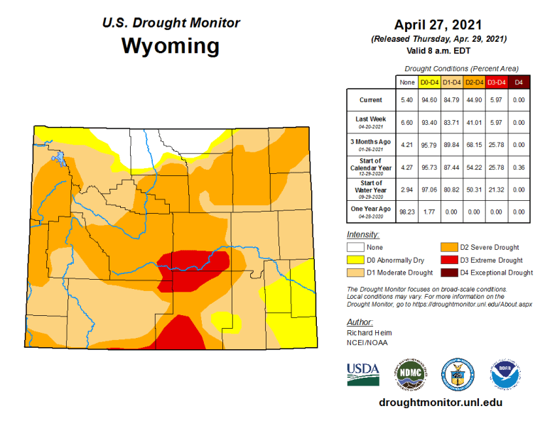
Ninety-five percent of Wyoming is abnormally dry or worse, according to a nationwide drought monitor map released Thursday.
The pervasive dryness may have significant near-term impacts on grazing and irrigation, and could result in down-stream calls on Wyoming water as early as next year, experts say.
The current conditions statewide mark a seismic shift from a year ago when only 2% of the state registered abnormally dry or drier, according to the National Drought Mitigation Center at the University of Nebraska-Lincoln.
The driest areas — classified as “extreme drought” and covering 6% of Wyoming — span parts of Carbon and Natrona counties, plus small areas in Sweetwater and Fremont counties. There, a poor snowpack will produce runoff “inadequate for ranching and farming,” the center says.
Only parts of Sheridan, Johnson, Big Horn and Park counties are at or above normal moisture levels.
The monitor map, updated monthly, shows “exceptional” D4 drought — the driest condition on the center’s scale — in parts of Utah and Colorado and other areas of the southwest, but not Wyoming.
Western residents are already feeling the effects. Early season wildfires in the Black Hills of South Dakota caused Gov. Kristi Noem to declare a state of emergency there through June 1. Southwestern water scarcity along the Colorado River may curtail water use in other states but shouldn’t affect Wyoming this year, said Steve Wolff, head of the State Engineer’s Office Interstate Streams Division…
Snowpack vs runoff
This week remote monitors measured the water content of the snowpack statewide at 89% of median, according to Fahey’s weekly report. The Powder and Tongue rivers in the northeast had the highest readings at 129% and 124% of normal respectively. The Upper Bear River Basin in western Wyoming measured lowest at 57% of median…
“Even though the snowpack is almost 100%, runoff [could be] 50%, give or take,” Wolff said. “A lot of that water is just going to soak into the ground.”
[…]
The drought map shows that about 40% of Wyoming suffers from moderate, D1, drought, a level in which hay and forage yield is low, fire danger is elevated, fewer wildflowers bloom and less irrigation water is available.
“Severe, D2, drought” affects another 39% of Wyoming, stressing trees and reducing water pressure in some wells. In D2 drought, pastures are poor, overgrazing occurs and producers begin to sell cattle, according to the center.
See-saw changes in recent weeks saw areas west of the Continental Divide dry out. “Much of that area, especially in Teton County, was the one part of the state that had been doing quite well in terms of the drought map,” said Tony Bergantino, acting director at the Water Resources Data System in the Wyoming State Climate Office.
But last week severe drought, D3, moved into Teton County for the first time since 2016, he wrote in an email. That severe drought also grew to cover a large area of Lincoln County.