hen the state of Colorado created the Groundwater Compact Compliance Fund with $30 million earmarked for recovering the aquifers of the Upper Rio Grande Basin, there was an intention to steer a good portion of the money toward irrigators working in Subdistrict 1 of the Rio Grande Water Conservation District.
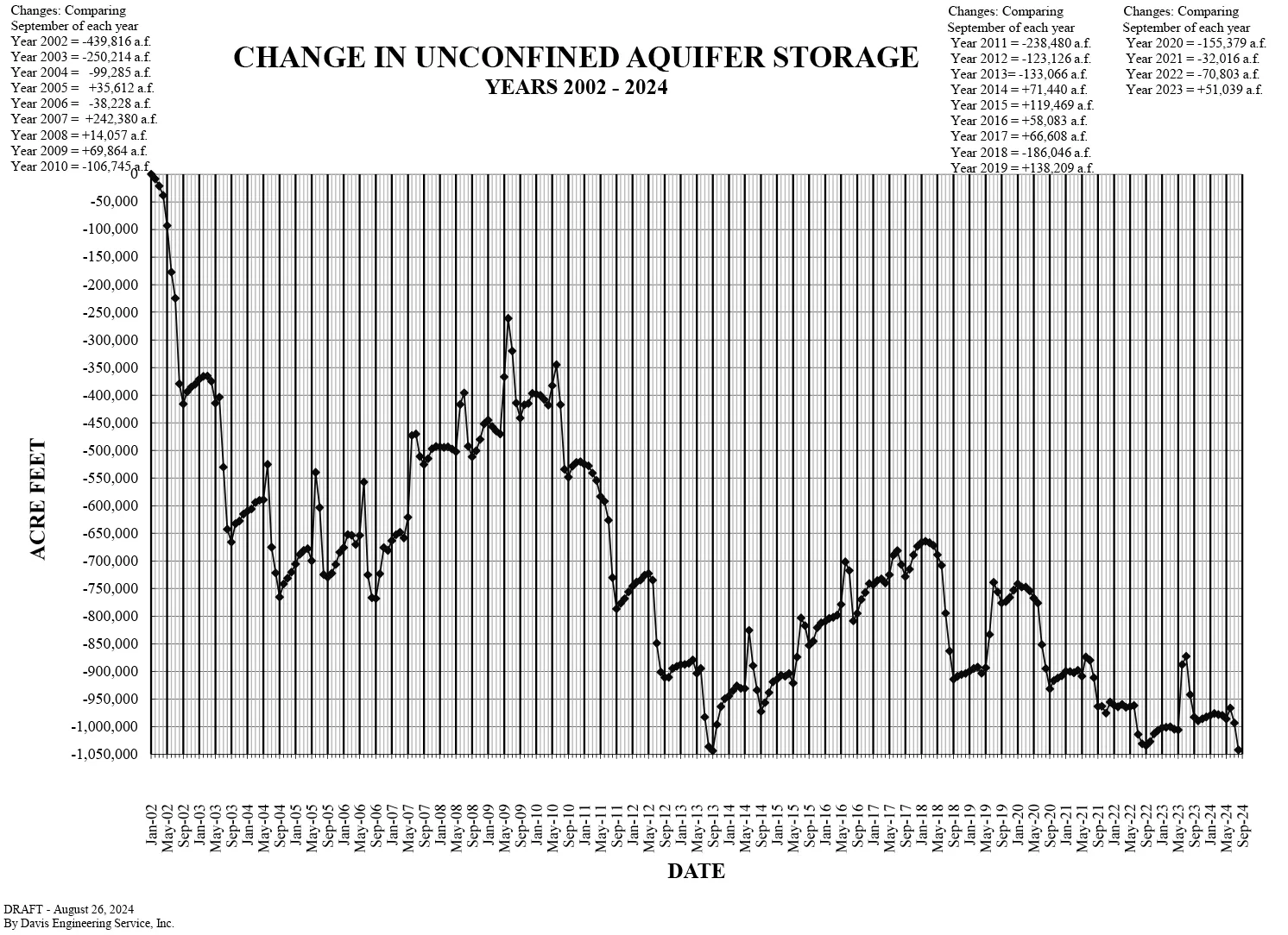
Whether the strategy will work is under question. Last month’s reading of the unconfined aquifer storage levels shockingly showed it at its lowest point, despite millions in tax dollars that have been spent to retire groundwater wells.
San Luis Valley Groundwater
The motivation behind Senate Bill 22-028 was to use state tax dollars to continue to dry out farming fields located in the most productive area of the San Luis Valley because that’s where the depleted unconfined aquifer of the Upper Rio Grande Basin runs through. For the past two decades the state Division of Water Resources has been working with Rio Grande Water Conservation District and the farmers and ranchers who operate in Subdistrict 1 to reduce the amount of groundwater they pump each growing season to help recover the struggling aquifer.
The 2022 state senate bill would bring new money into the effort. Of the $30 million allocated from Groundwater Compact Compliance Fund to the Upper Rio Grande Basin, nearly $14 million has been directed to retire 44 more groundwater wells in Subdistrict 1, with more money likely to come to further the strategy.
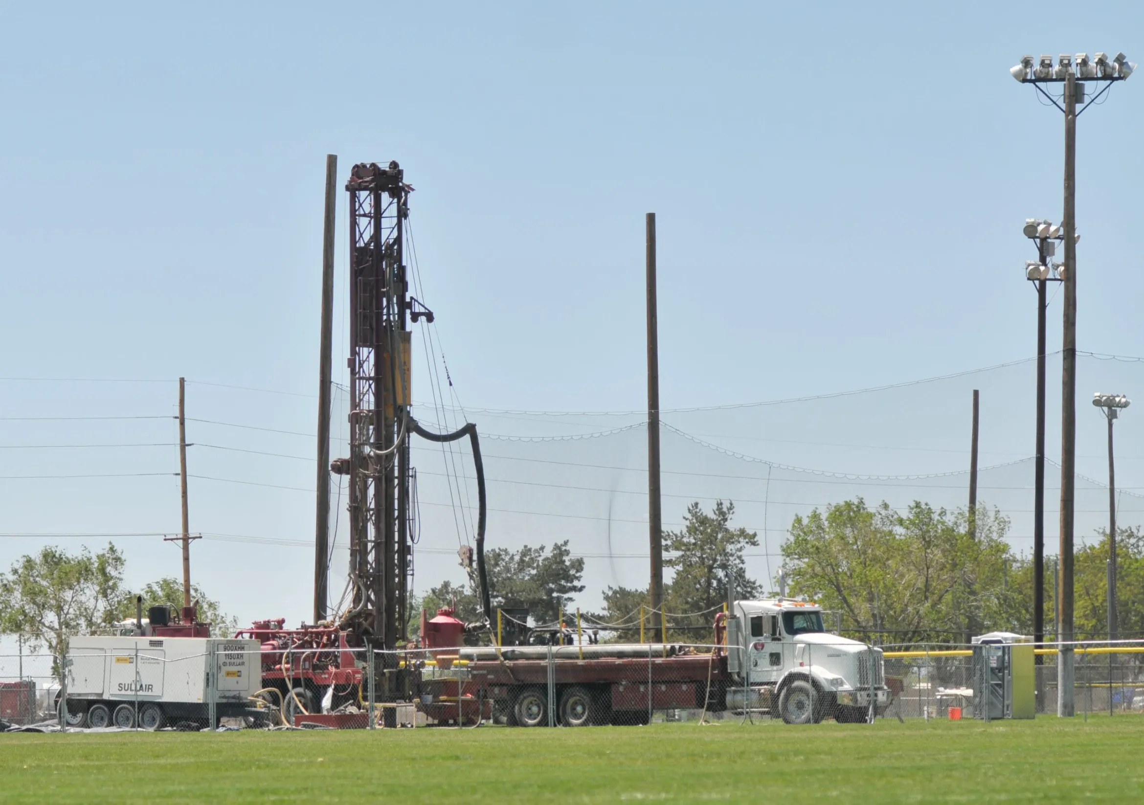
The state monitors the amount of groundwater pumped with flow meters tied to center pivot sprinklers which water the fields. The meter reading will tell the farm operator how many acre-feet of water they’ve used during the irrigation season, and each fall figures from those flow meters are reported to the state.
The assumption has been that by reducing the amount of groundwater pumped from the unconfined aquifer, the aquifer would recharge over time. Over the past decade, it appeared the strategy had validity with the aquifer at times showing a bounce back.
Then came the reading from this August which showed the unconfined aquifer storage near its lowest level, and state and local water managers found themselves scratching their heads in disbelief and frustration.
“It is disappointing to see that the aquifer has dropped lower this year. We had hoped to see an increase in aquifer levels, but another lower-than-average river flow year meant that less water was available to recharge the aquifers,” said Craig Cotten, the state division water engineer in the San Luis Valley.
The continued decline in unconfined aquifer levels is the reason the state engineer this year approved a new Groundwater Management Plan that is included in the Subdistrict 1 Fourth Amended Plan of Water Management. The plan was more than a year in the making and still needs approval from the state water court to go into effect. That won’t happen at the earliest until sometime in 2026.
Meanwhile, the clock is ticking.
“It is very concerning, especially given that Subdistrict #1, under its current plan, has just seven more years in which to recover the unconfined aquifer to a sustainable level. If the aquifer has not recovered by then, and if the subdistrict is still operating under its current Groundwater Management Plan, then the State Engineer will have no choice but to curtail all of the non-exempt wells in this area,” Cotten said.
There are several “ifs” in that scenario, all of which should get addressed when the state water court takes up the new Groundwater Management Plan for Subdistrict 1. But again, that’s not until 2026, and the clock, as Cotten mentions, is ticking.
Amber Pacheco, deputy general manager for the Rio Grande Water Conservation District, said there are 3,614 wells included in the Subdistrict 1 annual replacement plan. The idea that the state would come in and shut those down because farmers couldn’t recover the unconfined aquifer to a sustainable level is the constant worry Subdistrict 1 farm operators work under.
“There is no specific timeline in which the Subdistrict will meet its objective to reach a Sustainable Water Supply by reaching an Unconfined Aquifer Storage Level between 200,000 and 400,000 acre-feet below that storage level that was calculated to exist on January 1, 1976, but it may be 20 years or less depending on the hydrologic conditions following the period the new plan is implemented,” Pacheco said.
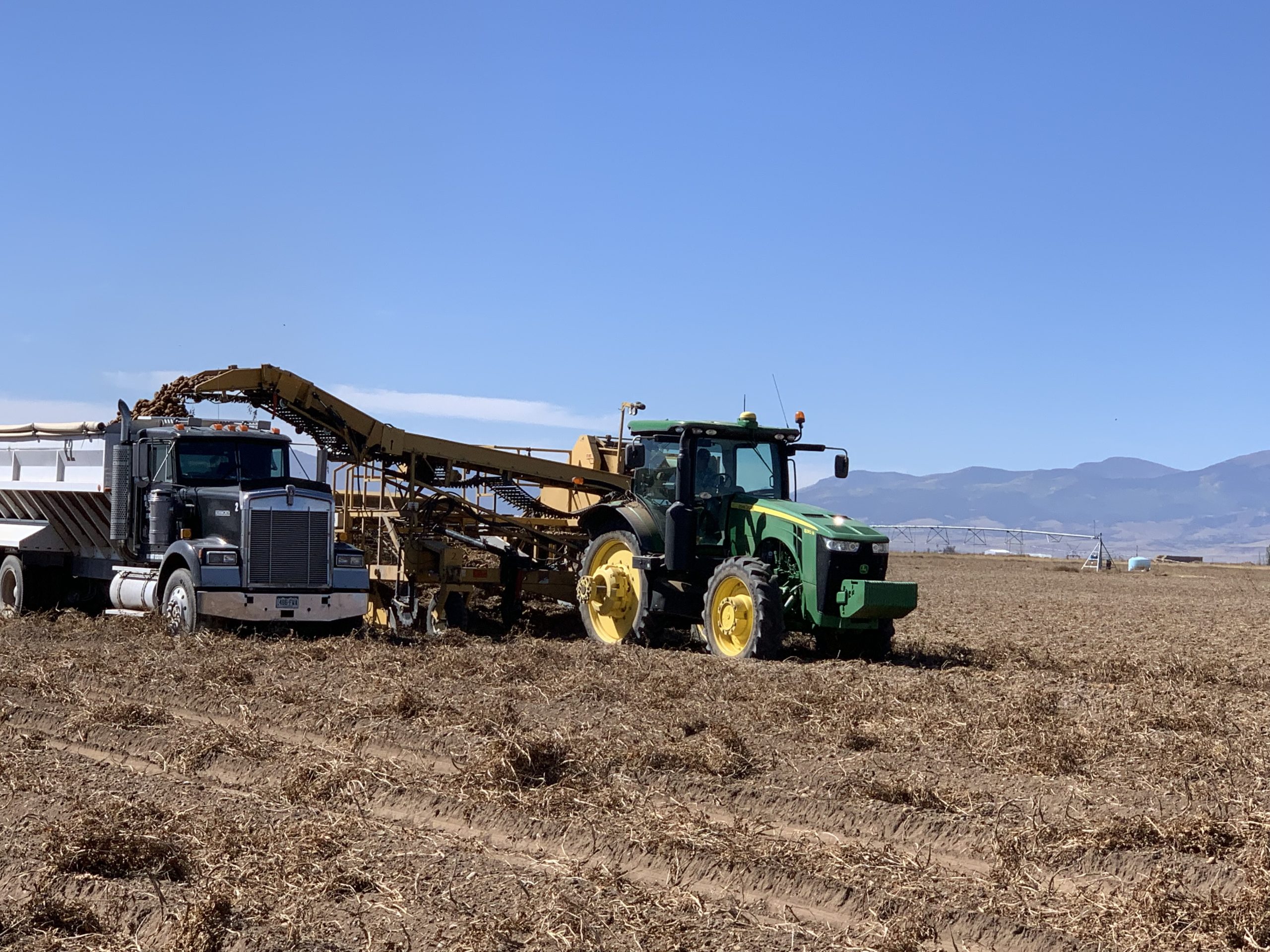
Take a drive down County Rd E or any of the other country roads that cross through Rio Grande and Alamosa counties and you’ll notice the Valley’s potato harvest in full swing. Take a bit closer look, and in the midst of the harvested fields is a growing amount of agricultural acreage once productive that is now intentionally dried out to save on the groundwater below.
The last days of the potato harvest. Photo credit: The Alamaosa Citizen
With the unconfined aquifer showing little to no bounce back after years of attempted recovery, the expectation is that the western and northern ends of the San Luis Valley will see more dry fields in the growing seasons to come. The money spent through the state’s Groundwater Compact Compliance Fund to retire more groundwater wells will begin to show up in the 2025, 2026 planting seasons and beyond.
As Cotten said, Subdistrict 1 is “one of the most productive irrigated farming areas in the state.”
Farming with a struggling aquifer is making it less so.
Milkweed, sweet peas, and a plethora of other flora billow from Farmer’s Ditch in the North Fork Valley of western Colorado. Jonathan P. Thompson photo.
Note to readers: Sorry this piece is late. I injured my hand in a way that makes typing a bit difficult and that has slowed me down a bit. And to non-paid subscribers: Sorry for the paywall and all, but we gotta pay the bills — and give the paid folks their premium content! If you’re interested, consider knocking down that paywall and accessing all the archives by becoming a paid subscriber!
This spring, I had the pleasure to sit on a panel on water in the West with Paolo Bacigalupi and Heather Hansman, two writers I’ve long admired. During the question & answer period, a local woman lamented the fact that some ditches were being piped or lined with concrete, because it would dry out the wetlands and ecosystems that had come to rely on the leaky laterals and ditches. And she was angry because the point, as she understood it, was to save water only to send it downstream to California. Her beloved valley, it seemed, was being dried out to fill up LA pools, which just seems wrong.
Jonathan P. Thompson, Paolo Bacigalupi, and Heather Hansman on a writer’s panel in Paonia in April, 2024.
I’ve thought about this a lot in the months since, because I think it gets down to the big, conceptual tug-of-war that’s happening around the Colorado River. There’s one battle between the different users of the river’s water. And then there’s another in which the values different communities hold are clashing with the “law of the river” and the overwhelming math that is driving the need to make massive changes.
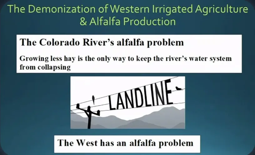
The following meditation on this clash was catalyzed by a slide a friend sent me from a Family Farm Alliance presentation at the Colorado Water Congress’s summer meeting. It accused me — via a piece I wrote for High Country News — of “demonizing” alfalfa.
Well, Family Farm Alliance, this is my response to you:
VALUES
The woman at the panel was referring to the North Fork Valley in western Colorado, a place with an extensive network of open canals, laterals, and ditches that irrigate peach, apple, and pear orchards, small vineyards, organic farms, and alfalfa fields. A handful of center-pivot sprinkler systems reveal themselves in the geometric perfection of their dependent fields, but most of the farms rely on older methods to bring water to the crops, namely by flooding the field or directing water down dirt rows where they soak into the plants’ roots.
Most of the canals and ditches are unlined and uncovered, and have been that way since they were built over a century ago. Many of them leak, some prolifically, their fugitive water blanketing the beige-gray earth with grass and nourishing cottonwoods, feral apricot and plum trees, sunflowers, willows, cosmos, reeds, sweet peas, milkweed, and cattails — along with a host of fauna that depend on those plants.
The intentional and accidental irrigation combine to form an irregular, pastoral patchwork of relative lushness amid the arid landscape of the kind that can be found in northern New Mexico, where a network of acequias irrigate long, rock-lined fields, or McElmo Canyon, where voluptuous pink sandstone rises up from a sea of emerald alfalfa. These places, where the cultivated and feral and wild collide, evoke the Provence of Jean Giono’s novels.
These are artificial landscapes, colonial ones, even, created by damming rivers and diverting their waters away from the fish and aquatic life in the streams and throwing off the natural balance of things. They rely heavily on inefficiencies in the system, from leaky laterals and ditches to flood-irrigation runoff. But they are, to my eye, lovely nonetheless, and contrast favorably with the more efficient farming areas, where high-tech irrigation systems deliver every drop of water to the linearly planted crops in laser-leveled fields.
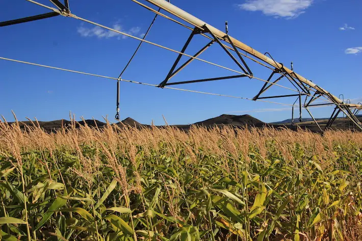
Agricultural productivity has grown 20% in the 21st century. Organic corn in Colorado’s North Fork Valley. Photo credit: Allen Best
And yet, because of math and water laws and compacts and the need to devote every drop of the shrinking Colorado River to “beneficial uses,” the character of these landscapes is likely doomed. It won’t happen next month or even next year, but over time. Nor will the lands be dried up altogether: In places like the North Fork the ditches — at least the ones with senior water rights — will continue to deliver water to the fields.
But more and more, those old leaky ditches will be upgraded, lined with concrete or other impermeable materials, or even put into pipes so that all of the water goes to those who hold the rights to that water, not to evaporation or the accidental ecosystems that have sprung up along the ditches’ banks. The farmers, too, may be forced or incentivized to become more efficient, replacing the flood irrigation with sprinklers or drip lines. Some will be paid to not irrigate at all. Most of the open ditches like the ones my cousins and I held stick-boat races in on my grandparents’ Animas Valley farm will be gone, along with the runoff of the kind that spilled from their corn and alfalfa fields to fill the cattail- and willow-tangled slough down below.
It is this loss that the woman in Paonia is mourning. It is heartbreaking. And it’s something I think about every time I write about the Colorado River and the looming crisis it and the communities and industries that rely on it face in the not-so-distant future.
If the crisis could only be solved — and the needed cuts in consumption made — based on our values alone, things would certainly be a lot easier. There would likely be fairly wide agreement that we should fallow the golf courses and drain the swimming pools before drying up the leaky-ditch wetlands and leaving the red-winged blackbird homeless. Farmers might join me in calling for tearing out thirsty turf lawns from Denver to San Diego, implementing progressive water rates to stem gluttony, and putting hard limits on household water use — if it meant keeping the sprinklers flowing to food crops, including alfalfa and other forage. After all, I value cheese and ice cream and green-chile burgers over the Sultan of Brunei or Miriam Adelson, who guzzled 12 million and 10 million gallons of water, respectively, last year to keep their Las Vegas estates green.
Ah, and yes, if all of this could be solved by prioritizing cuts based on values, alone, the Family Farm Alliance would have no reason to accuse me of “demonizing” alfalfa and other livestock forage crops (though I imagine the golf groupies would get me for vilifying them). But, alas, it’s just not that simple. Why? Because even the most lofty values are trumped by the cold, hard math.
MATH
The pertinent numbers in the equation include:
16.5 million acre-feet: Total human-related consumptive use of Colorado River water in 2020. This means all of the water that was withdrawn from the river and not put back into it, including reservoir evaporation. It does not include the 2.8 million acre-feet consumed via riparian and wetland evapotranspiration, nor does it include the 1.7 million acre-feet of water use from the Gila River, a tributary to the Colorado.
14.5 million acre-feet: The Colorado River’s median “natural flow” at the Lee Ferry stream gage, which is the official dividing line between the Upper Basin and Lower Basin, from 1906 through 2023. This is used as a measure of how much water is in the Colorado River, since downstream tributaries are relatively insignificant.
12.4 million acre-feet: The Colorado River’s average natural flow at Lee Ferry from 2000 through 2023.
This leaves us a few options for the big math problem that needs solving:
The optimistic equation (assumes the last 20 years was an anomaly and the river will go back to its old-normal flow soon, i.e. the median for 1906-2023):
14.5 million – 16.5 million = 2 million acre-feet deficit
The new-normal equation (assumes the next few decades will look like the most recent couple of decades — which is to say a megadrought) :
12.4 million – 16.5 million = 4.1 million acre-feet deficit
The pessimistic (realistic?) equation (assumes human-caused climate change will continue to deplete the river):
10.4 million – 16.5 million = 6.1 million acre-feet deficit
Estimated natural flow of the Colorado River at Lee’s Ferry (the dividing line between the Upper Basin and the Lower Basin). The natural flow is basically the total amount of water the river delivers each year, or the volume that would pass by Lee’s Ferry if there were no upstream diversions. Source: USBR.
Which is to say … we’re screwed no matter how you juggle the numbers! Sorry, that’s not very solution-oriented is it? No matter how you cut it, though, the Colorado River budget is running a massive deficit and has been for a while. That’s why Lake Powell, the Upper Basin’s savings account, has been shrinking and now is less than 40% full — even after a couple of decent winters. A couple of consecutive new-normal winters could bring the reservoir down below minimum power pool, shutting down the hydropower turbines and potentially setting the scene for a mega plumbing disaster.
While it’s highly unlikely that the Colorado River’s flows will increase enough to fill Lakes Powell and Mead to capacity anytime soon, it’s not impossible. During the extraordinarily wet and snowy four years between 1983 and 1986, nearly 80 million acre-feet of water ran into Lake Powell — which should be enough to fill both reservoirs and still deliver adequate flows downstream. If it happens, great! It would be foolish and potentially catastrophic to bet on a repeat, however.
That means the users of the river must erase the deficit by cutting anywhere from 2 million to 6 million acre-feet of consumption annually. The big question, and one that the basins and their member states have been debating, is: Where will those cuts come from? I’m not going to get into the many layers of these negotiations here, as that’s not the purpose of this essay, which is a bit of a thought experiment. Suffice it to say it’s complicated, and made more so by glaring errors and injustices committed when the Colorado River Compact was originally crafted.
Let’s say we’re going to make these cuts based on values. Obviously everyone has different values, so we’ll just go with those expressed at the Q&A session I lead this piece with, which can be summed up as prioritizing rural farmland, food crops, and the artificial wetlands that can be found in the North Fork Valley over urban lawns, golf courses, and billionaires’ estates.
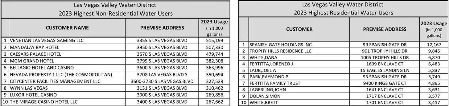
Where better to begin than Las Vegas? Let’s pull up some water user data and, holy cow! Look at those numbers. The Vegas resorts and the rich sure know how to use water:
The Venetian and Mandalay Bay resorts each use more than 500 million gallons of water per year. Meanwhile the top residential water users are mostly billionaires: 99 Spanish Gate Dr. — which goes through 12 million gallons per year — was owned by the Sultan of Brunei until tech-giant Jeff Berns purchased the 37,500 sf mansion for $25 million. Other top water gluttons include Miriam Adelson — a top Trump donor — and UFC CEO Dana White. The average Las Vegas household uses about 120,000 gallons per year, though newer, more efficient homes use far less.
When folks start throwing $25 million around for an unfinished house is when you know it’s time for a wealth tax. And when they use 100 times as much water as the average home, it’s also time for a new, progressive water rate structure, that incentivizes conservation and punishes gluttony. Las Vegas already has something like this, but the rates in the upper tiers are too low to be meaningful; they need to be so high that this kind of profligacy will sting even a billionaire’s pocketbook. Hell, better yet, why not just fallow these properties and xeriscape them?
When the numbers are added up, you’ve got:
227,243,000 gallons Top 100 Las Vegas residential water users’ combined consumption in 2023.
3,774,780,000 gallons Top 10 Las Vegas non-residential water users’ combined consumption in 2023.
Wow, so by shutting down just these folks, we could save 4 billion gallons of water, or … 12,275 acre-feet? Oh, that’s not as much as it seemed.
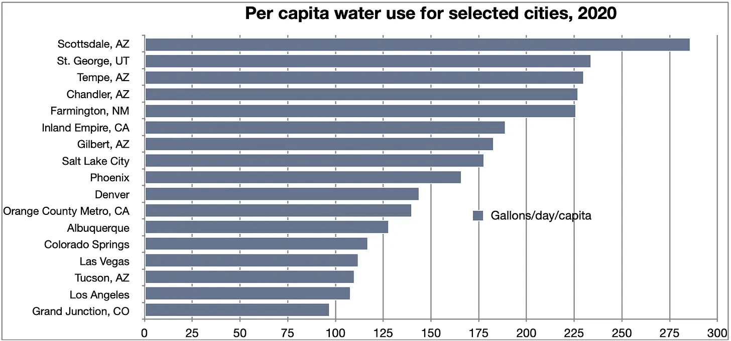
So how about we go to other cities and tear out turf, mandate low-flow appliances, ban lawn watering and swimming pools. I mean, if you could get Scottsdale and St. George residents to cut back to Tucson or Los Angeles per capita water levels, you’d make some more huge cuts.
If Scottsdale’s per-capita consumption were cut to Tucson’s levels it would save about 42 million gallons per year.
You could save millions of gallons through that effort, which is great. The problem is, this problem requires bigger thinking — you’ve got to make multiple cuts in the tens of billions of gallons range for it to make a significant difference. Once again, math, the ultimate buzz killer, raises its ugly head. See, as noble as all of these efforts might be, there just isn’t enough overall water use in the urban sector to come up with all the necessary cuts. You could drain the pools, dry up the lawns, seal up the Bellaggio fountains — hell, even shut off the massive pumps that convey water from Lake Mead to the Las Vegas metro area altogether — and you would still need to come up with at least another 1.6 million acre-feet of cuts. Entirely cutting off all of the Basin’s cities and industrial applications wouldn’t even get you to 4 million acre-feet of cuts. But boy, it sure would be interesting to watch — from afar.
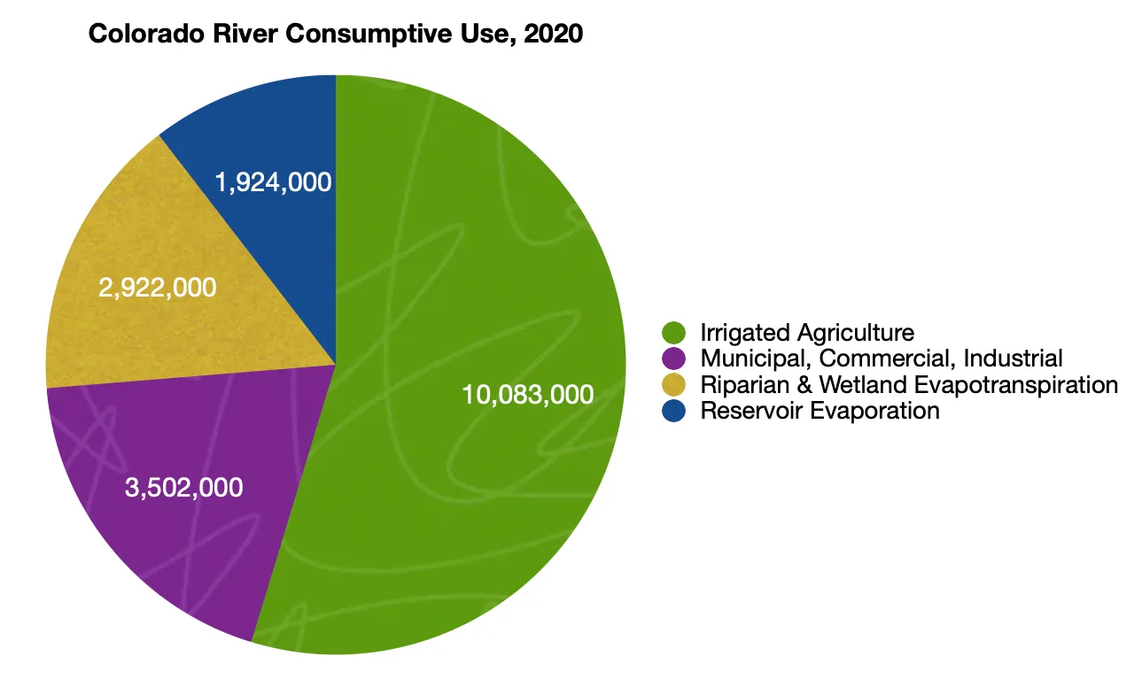
To conclude Part I, some charts that drive the point home:
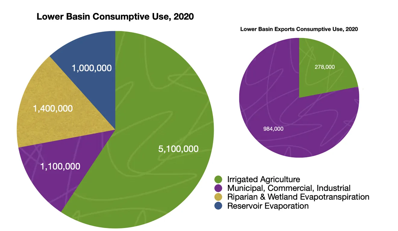
Irrigated agriculture gulps up about 10.1 million acre-feet per year, accounting for about 52% of the total consumptive use on the Colorado River. Meanwhile the municipal, commercial, industrial sector only uses 3.5 million acre-feet, meaning if you cut off all of the water to every Southwestern city, you still might have a water deficit in the Colorado River Basin. Source: New water accounting reveals why the Colorado River no longer reaches the sea, by Brian Richter et al
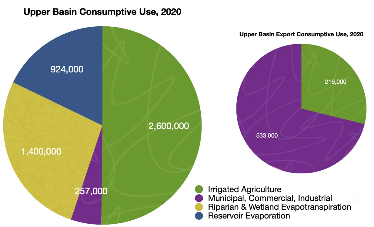
The chart on the left shows consumptive use within the Colorado River watershed only, where irrigated agriculture uses about 50% of the water. By contrast, Colorado River water sent over the Continental Divide to Colorado’s Front Range and New Mexico’s Rio Grande watershed is mostly used by cities, with about one-third going to agriculture.
About 59% of the non-exported Lower Basin consumptive use goes to irrigated agriculture. Exports follow the same pattern as in the Upper Basin, with most of the water going to urban use.
SOURCES: New water accounting reveals why the Colorado River no longer reaches the sea, by Brian Richter et al.; Decoupling Urban Water Use from Population Growth in the Colorado River Basin, by Brian Richter; Bureau of Reclamation, Las Vegas Valley Water District, Southern Nevada Water Authority, Zillow.
The Soldier Canyon Dam is located on the east shore of Horsetooth Reservoir, 3.5 miles west of Fort Collins, Colorado. The zoned earthfill dam has an outlet works consisting of a concrete conduit through the base of the dam, controlled by two 72-inch hollow-jet valves. The foundation is limey shales and sandstones overlain with silty, sandy clay. Photo credit Reclamation.
Nearly 150,000 residents will have greater access to safe drinking water without high costs for decades to come, after an approval by the Colorado Department of Public Health and Environment (CDPHE). This authorization will increase capacity at the Soldier Canyon Water Treatment Plant from 60 to 68 million gallons per day (MGD).
“The approval from CDPHE is a big win and a huge savings in dollars for the Tri-Districts all operating from the Soldier Canyon Water Treatment Authority’s Plant,” says Eric Reckentine, General Manager of North Weld County Water District.
The re-rating by the CDPHE which increases capacity from 60 to 68 million gallons per day (MGD), was successfully accomplished by the collective work of the three water districts operating out of Northern Colorado – North Weld County Water District (NWCWD), East Larimer County Water District (ELCO), and the Fort Collins-Loveland Water District (FCLWD).
“The expansion ensures that we can continue to provide water supplies to match our customers’ future growth needs and provide added resilience to our water supply systems,” states Mark Kempton, P.E, CWP, General Manager of Soldier Canyon Water Treatment Authority. “The Authority achieved the 8 MGD expansion using the Plant’s existing facilities, resulting in no construction and minimal costs. This efficiency has allowed us to keep our water rates low for our customers while continuing to provide a reliable, safe, and affordable drinking water supply to the Tri-Districts.”
The CDPHE expansion will provide water and larger capacity many years into the future for the tremendous development and population growth that Northern Colorado towns are experiencing.
“We continue to see projections for additional growth in the northern Colorado region and expanding water treatment capacity is a fundamental building block to sustain that growth. This treatment capacity increase represents the most cost-effective expansion in Soldier Canyon’s history and ensures all three partners can continue delivering high-quality drinking water well into the future,” explains Chris Pletcher, P.E., General Manager of Fort Collins – Loveland Water District.
“Like much of Northern Colorado, we anticipate continued growth within the East Larimer County Water District (ELCO) service area, and this addition of water treatment capacity will aid in meeting that new demand,” states Mike Scheid, General Manager of ELCO.
“I am very proud of the work of the other water districts and the staff and board of North Weld County Water District for helping to make accomplishments like this happen – it further stands by our commitment that we follow-through on what we promise for our customers,” says Reckentine. “This collaborative undertaking between the districts ensures we have secured the highest quality treated water for our Northern Colorado customers today, tomorrow, and into the future.”
ABOUT THE SOLDIER CANYON WATER TREATMENT AUTHORITY:
The Soldier Canyon Water Treatment Authority (SCWTA) owns and operates the Soldier Canyon Filter Plant, which is a 68 million gallon per day (MGD) conventional water treatment plant located in Fort Collins, CO. Since 1961, the Authority has provided high quality, reliable, safe, and affordable drinking water to over 145,000 people living in three water districts and adjacent communities in the Northern Colorado region. The three water districts (Tri-Districts) are:
The U.S. Air Force has a plan for cleaning up a decades-old jet fuel spill from a base near Albuquerque.
However, the local water authority said last week that the plan is inadequate, in part because it scales back current remediation efforts and doesn’t mention how the Air Force will address sudden issues.
In 1999, officials discovered a fuel leak, assumed to be more than 24 million gallons, in the jet fuel loading facility at Kirtland Air Force. The leak could be twice the size of the infamous Exxon Valdez oil spill of 1989, according to the Global Atlas of Environmental Justice.
It’s unclear when the leak – the largest underground toxic spill in U.S. history – first occurred, but it had been spilling fuel into the ground for decades by the time it was discovered, according to Kelsey Bicknell, environmental manager at the Albuquerque Bernalillo County Water Utility Authority.
An Air Force report says existing measures have prevented further migration of the fuel contaminants and that officials are regularly taking groundwater samples to ensure that drinking water remains safe both on and off-base.
Bicknell said there are concerns with the way the Air Force plans to go forward, including a lack of forward-looking analysis and the absence of a “trigger action plan” that identifies possible changes and prescribes a response to those changes.
She told the water authority’s Technical Customer Advisory Committee that the fuel soaked its way through almost 500 feet of soil, and ultimately reached the water table, where rock wouldn’t permit it to drop further. Then, she said, it began to pool underground.
Bicknell said the fuel not only contaminated the groundwater but also released volatile vapor into the nearby atmosphere.
She said the Air Force used a vapor extraction system to clean up more than a half-million gallons of fuel.
“This was a really successful system,” Bicknell said, adding that the program was shuttered after about a decade.
Bicknell said the Air Force is now using a groundwater pump-and-treat system that targets the dissolved fuel components that have moved away from the source of the leak and area. There are also four extraction wells, brought online between 2015 and 2018; they draw out and treat groundwater.
Bicknell said the Air Force has announced plans to turn off two of the wells. But that was done without input from the water authority and without including the agency in decision-making.
Air Force representatives did not immediately respond to phone and email requests for comment.
Bicknell said the goal now is to try to get the Air Force to reverse its decision before the wells are shut down. State and federal regulators have jurisdiction over the cleanup plan, she said, but the water authority cannot veto what the Air Force wants to do.
“Ultimately, we’re the water carrier, the ones that are impacted,” Bicknell said. “If the Air Force messes up, it is our source water that’s impacted, and it’s us that lose out on access to a supply source, so including us in the room and in project discussions and decision-making is something that is paramount.”