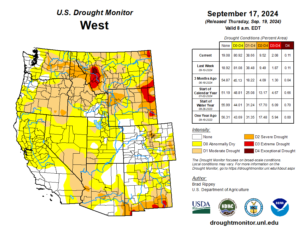
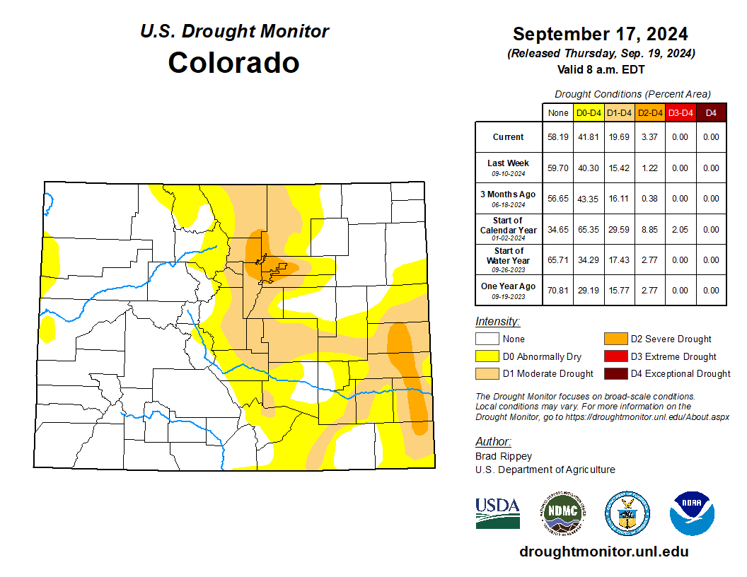
#Drought news September 19, 2024: On September 15, 2024 rangeland and pastures were rated 40 to 70% very poor to poor in eight Western States—all but #California, #Utah, and #Colorado

Click on a thumbnail graphic to view a gallery of drought data from the US Drought Monitor website.
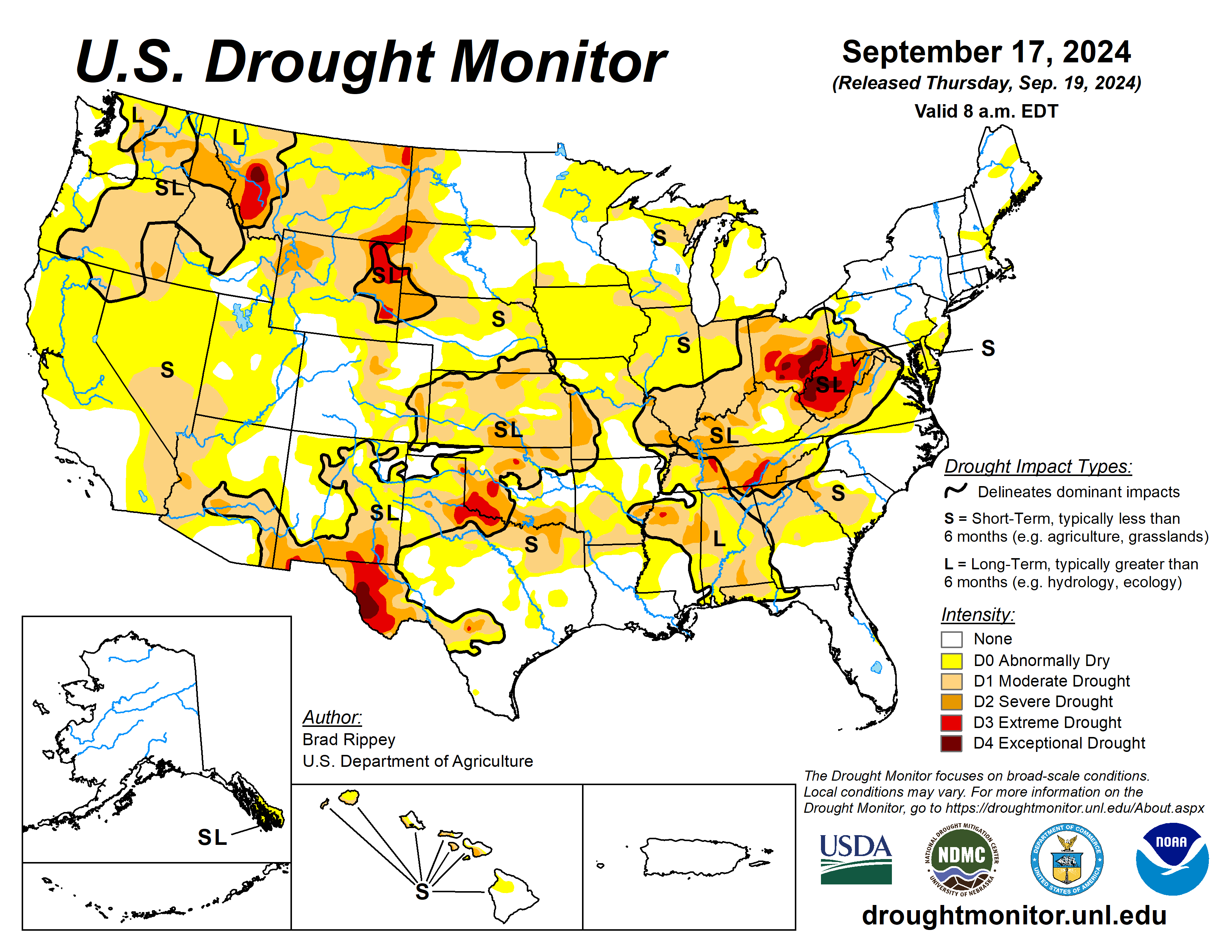
Click the link to go to the US Drought Monitor website. Here’s an excerpt:

This Week’s Drought Summary

On September 11, Francine became the third and strongest hurricane of the season to strike the U.S. Gulf Coast, following Beryl (in Texas) in early July and Debby (in Florida) in early August. Francine briefly achieved sustained winds near 100 mph while making landfall around 5 pm CDT in Louisiana’s Terrebonne Parish. Hurricane-force wind gusts (74 mph or higher) spread as far inland as New Orleans, where a gust to 78 mph was clocked at Louis Armstrong International Airport. Meanwhile in the Mississippi Delta, antecedent dryness minimized flooding, although rainfall topped 4 inches in many locations and localized wind gusts briefly topped 50 mph. As the former hurricane drifted farther inland, days of locally heavy showers led to pockets of flash flooding, extending as far east as Alabama and the Florida Panhandle. Less than a week later, on September 16, Potential Tropical Storm Eight moved ashore in northeastern South Carolina and delivered flooding rainfall (locally a foot or more) across southeastern North Carolina. By the morning of September 17, the end of this drought-monitoring period, much of North Carolina and portions of neighboring states had received significant rain. The remainder of the country largely experienced dry weather, leaving widespread soil moisture shortages across the Plains and Midwest—a classic late-summer and early-autumn flash drought. In the western U.S., a cooling trend was accompanied some rain and high-elevation snow, heaviest across the northern Rockies and environs. As the long-running Western heat wave subsided, late-season warmth replaced previously cool conditions across the Plains, Midwest, and Northeast. Nationally, nearly one-half (46%) of the rangeland and pastures were rated in very poor to poor condition on September 15, according to the U.S. Department of Agriculture, up from an early-summer minimum of 19%…

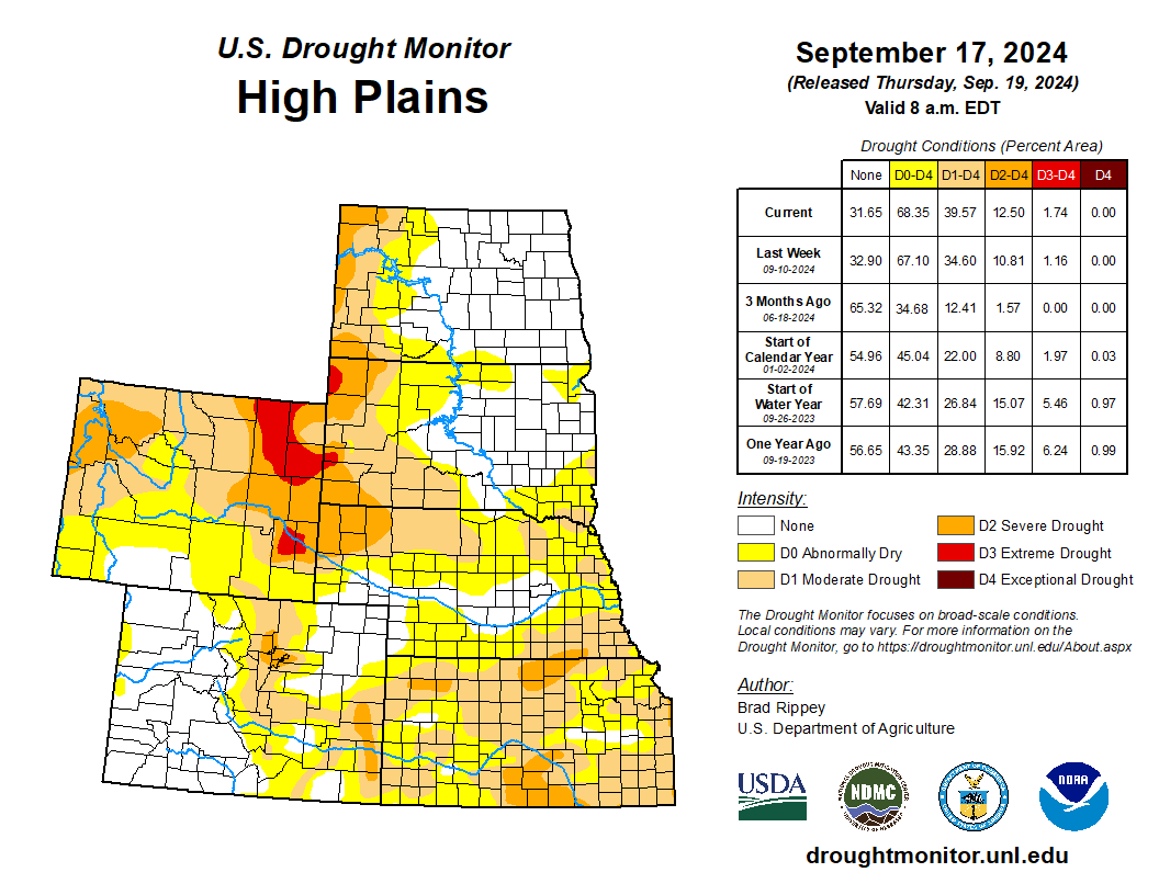
High Plains

Warm, mostly dry weather led to general expansion of abnormal dryness (D0) and various drought categories. Across the six-state region, topsoil moisture rated very short to short on September 15 ranged from 30% in North Dakota to 80% in Wyoming. In fact, values were above 50% in all states, except North Dakota. Some of the worst conditions—extreme drought (D3)—existed across northeastern Wyoming and southeastern Montana, an area still recovering from last month’s Remington and House Draw Fires, which collectively burned across more than 370,000 acres of vegetation, including rangeland. Wyoming led the region on September 15 with 70% of its rangeland and pastures rated very poor to poor, followed by Nebraska at 45% and South Dakota at 42%…
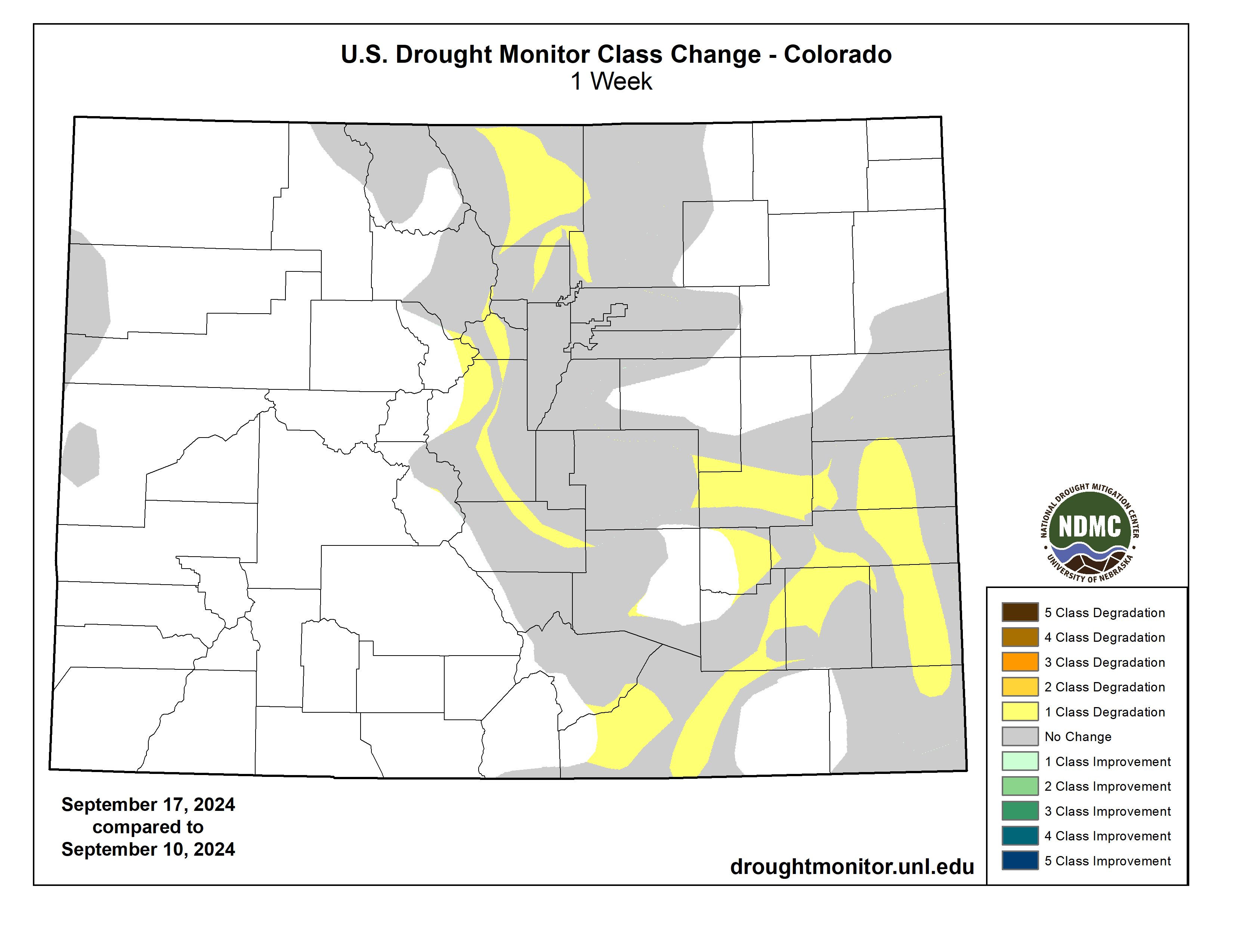
Colorado Drought Monitor one week change map ending September 17, 2024.

West

Despite widespread precipitation in the northern Rockies and environs, only slight drought improvement was introduced, as concerns related to poor vegetation health and water-supply shortages were ongoing. In one piece of good news, however, a summer-long Western heat wave effectively ended. On September 17, the maximum temperature of 93°F in Phoenix, Arizona, halted a record-setting, 113-day streak (May 27 – September 16) with afternoon readings of 100°F or greater. Given the turn toward cooler weather and the gradual increase in cool-season precipitation, the wildfire threat has diminished in some areas. In southern California, however, the Airport, Bridge, and Line Fires collectively burned more than 115,000 acres of vegetation earlier this month. On September 15, topsoil moisture in agricultural regions ranged from 54 to 80% very short to short in eight of eleven Western States—all but California, Arizona, and Utah. Similarly, rangeland and pastures were rated 40 to 70% very poor to poor in eight Western States—all but California, Utah, and Colorado…

South

Hurricane Francine delivered heavy rain across much of Mississippi, as well as parts of Arkansas, Louisiana, and Tennessee. On September 11, daily-record totals included 7.33 inches in New Orleans, Louisiana, and 4.14 inches in Gulfport, Mississippi. For New Orleans, it was the second-wettest September day on record, behind only 7.52 inches on September 25, 2002. On September 12, Apalachicola, Florida, received a daily-record sum of 6.29 inches, helping to boost the 3-day (September 11-13) total to 12.77 inches. Elsewhere on the 12th, daily-record totals reached 4.22 inches in Memphis, Tennessee; 3.95 inches in Jonesboro, Arkansas; and 3.05 inches in Tupelo, Mississippi. By September 13, rain loosely associated with the remnants of Francine spread as far east as Georgia, where Columbus collected a daily-record total of 3.22 inches. In Alabama, daily-record amounts for September 14 totaled 4.72 inches in Muscle Shoals and 3.63 inches in Birmingham. A separate area of heavy rain, prior to Francine’s arrival, soaked a small geographic area in southeastern Oklahoma, northeastern Texas, and southwestern Arkansas. However, areas outside the range of these downpours largely experienced worsening drought conditions. On September 15, Oklahoma led the region with topsoil moisture rated 61% very short to short, followed by Texas at 54%. Meanwhile, Texas led the region with rangeland and pastures rated 48% very poor to poor, followed by Oklahoma at 35%. On that date, Texas led the country with 36% of its cotton rated very poor to poor, well above the national value of 26%. Several patches of extreme drought (D3) continued to affect key agricultural regions of both Oklahoma and Texas. In Texas’ northern panhandle, record-setting highs for September 13 included 102°F in Borger and 101°F in Amarillo. For Amarillo, it was the latest triple-digit reading on record, supplanting 101°F on September 11, 1910. Both Borger (101°F) and Amarillo (100°F) logged triple-digit, daily-record highs again on September 14. Meanwhile, Texas led the region with rangeland and pastures rated 48% very poor to poor, followed by Oklahoma at 35%. On that date, Texas led the country with 36% of its cotton rated very poor to poor, well above the national value of 26%. Several patches of extreme drought (D3) continued to affect key agricultural regions of both Oklahoma and Texas. In Texas’ northern panhandle, record-setting highs for September 13 included 102°F in Borger and 101°F in Amarillo. For Amarillo, it was the latest triple-digit reading on record, supplanting 101°F on September 11, 1910. Both Borger (101°F) and Amarillo (100°F) logged triple-digit, daily-record highs again on September 14…

Looking Ahead

During the next 5 days, active weather across the nation’s mid-section could lead to significant precipitation in from the central sections of the Rockies and Plains into the upper Midwest. While rain could slow agricultural fieldwork, including harvest activities, rangeland, pastures, and recently planted winter wheat will benefit from a boost in topsoil moisture. In contrast, generally dry weather will prevail across the remainder of the country, excluding the Atlantic Coast States. However, the western Caribbean Sea will need to be monitored for tropical cyclone development, with possible future implications for the eastern U.S.

The NWS 6- to 10-day outlook for September 24-28 calls for of near- or above-normal temperatures nationwide, with the West, North, and southern Texas having the greatest likelihood of experiencing warmer-than-normal weather. Meanwhile, near- or below-normal precipitation across the western and north-central U.S., as well as northern New England, should contrast with wetter-than-normal conditions from the central and southern Plains to the Atlantic Coast, extending as far north as the Ohio Valley and southern New England.
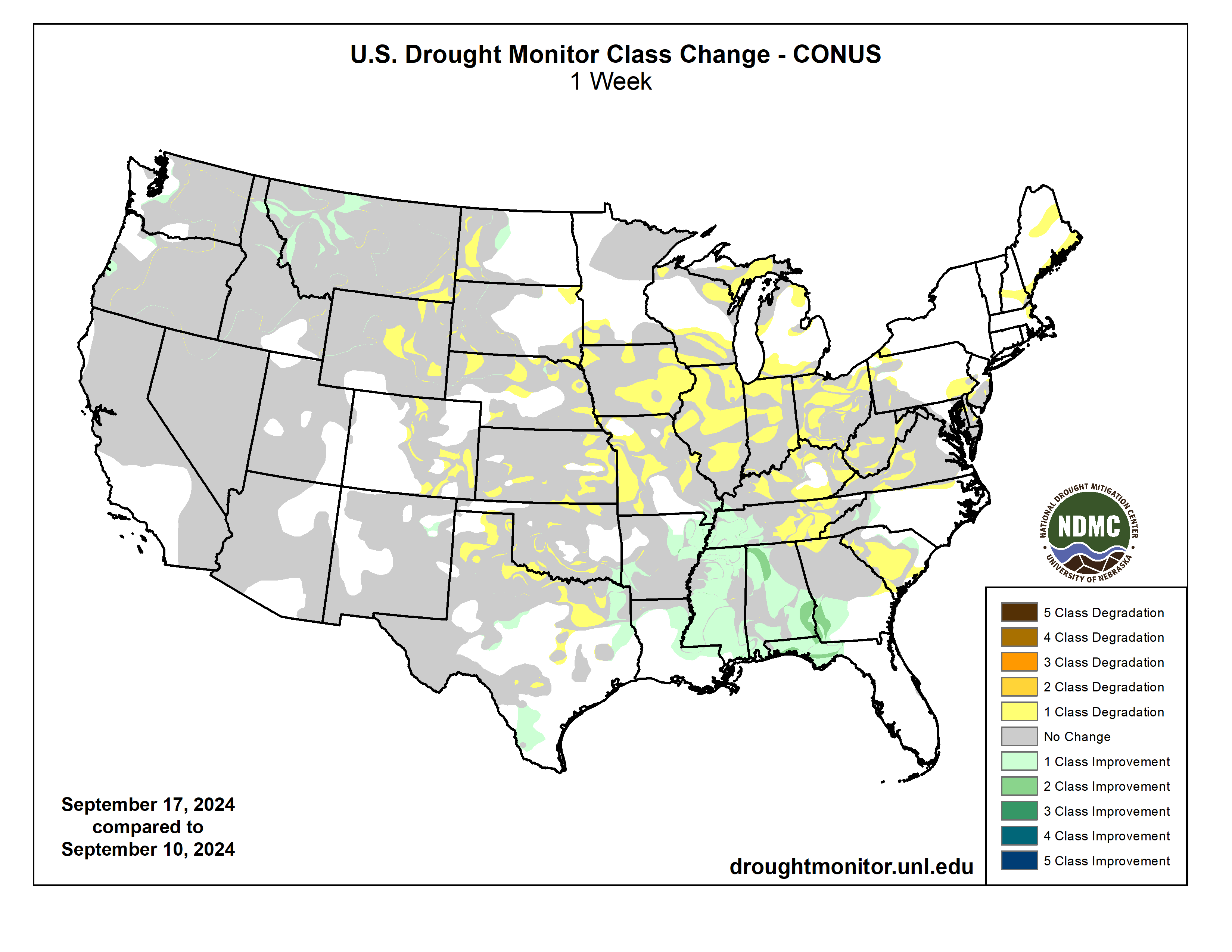
US Drought Monitor one week change map ending September 17, 2024.

How a California county got #PFAS out of its drinking water — National Public Radio

On April 16, 2024, the Yorba Linda Water District (YLWD/District) Board of Directors rededicated its state-of-the art PFAS Water Treatment Plant in honor of former YLWD Board President Dr. J. Wayne Miller. The J. Wayne Miller, Ph.D. Water Treatment Plant – capable of treating up to 25 million gallons of water per day – provides clean drinking water for the 80,000 customers the Yorba Linda Water District serves. Credit: Yorba Linda Water District

Click the link to read the article on the National Public Radio website (Pien Huang). Here’s an excerpt:

September 12, 2024

…in the past few years, Yorba Linda has picked up another distinction: It’s home toĀ the nation’s largestĀ per- and polyfluoroalkyl (PFAS) water treatment plant of its kind, according to the city.

ā€œThis December will be [three] years we’ve been running, and we’re the largest PFAS treatment plant using resin,ā€ saysĀ J. Wayne Miller, former board president at the Yorba Linda Water District, for whom the plant is named.

The Yorba Linda PFAS treatment plant took over a long, narrow strip of the water district’s parking lot, not quite the length of a football field. A series of giant tanks sit atop a concrete platform. ā€œHonestly, they look like large propane cylinders,ā€ says Todd Colvin, chief water system operator for the district. Each tank looms about 10 feet tall and can hold around 4,500 gallons. There are 22 of them, arranged in a double row, painted pristine ivory white. The tanks are packed half-full with a kind of resin – special polymer beads – that pull PFAS out of the water. Every gallon of water pumped from the district’s wells now passes through a few of these tanks for treatment, before going to the homes and businesses of 80,000 people.

The Yorba Linda Water District built the largest PFAS water treatment plant of its kind because it had a big PFAS problem. In February 2020, the water district had to take all of its wells offline because they were drawing groundwater contaminated with PFAS…But where is all this PFAS coming from? In Orange County, one of the primary culprits appears to be the Santa Ana River Almost a hundred miles long, the Santa Ana River flows through mountains and canyons, the cities and suburbs of San Bernardino and Riverside. Along the way, it picks up PFAS. ā€œWe find it in some of just the natural runoff that goes into the river during the winter, during storms,ā€ saysĀ Jason Dadakis, executive director of water quality and technical resources at the Orange County Water District. ā€We also detect some PFAS coming out of the sewage treatment plants upstream.ā€ There’s also the legacy of factories and military bases in the area.

#Aspen proposes second turbine for Ruedi hydro plant: Increased fish flows make power production inefficient — @AspenJournalism #FryingPanRiver #RoaringForkRiver #ActOnClimate

Utilities Engineer for the City of Aspen Phil Overeynder at the hydroelectric plant at Ruedi Reservoir. Releases from the reservoir in recent years have been too high in the summer and too low in the winter for Aspen to make hydropower efficiently. Credit: Heather Sackett/Aspen Journalism

Click the link to read the article on the Aspen Journalism website (Heather Sackett):

September 18, 2024

The city of Aspen wants to add a second turbine and generator unit to its hydroelectric plant at the base of Ruedi Dam, which officials say will allow for more power generation during times of high and low flows. 

Officials say an additional turbine, which is estimated to cost about $4.6 million, will restore the plant’s power production capacity to its originally intended 5 megawatts and allow the city to maintain its renewable energy goals. Since 2012, increased releases from Ruedi to benefit downstream endangered fish have meant that late summer and early fall flows are too high for the existing turbine to operate efficiently. 

Adding another turbine requires amending Aspen’s license for the Ruedi facility with the Federal Energy Regulatory Commission. According to the city’s draft FERC application for an amendment posted on the Aspen Community Voice website, which officials say they plan on filing by the end of the month, the timing and amount of water released from Ruedi Reservoir has changed since the hydro project began operating in 1986. Power production has diminished in recent years to just 68% of what was originally intended.

Hydroelectric Dam

ā€œAfter 40 years of reservoir and hydroelectric operations, it is now clear that achieving power output (maximum capacity and energy values) that approximates the original level authorized under the license will require additional generation equipment,ā€ the application reads.

The City of Aspen has a hydroelectric power plant at the base of Ruedi Reservoir, which helps them meet renewable energy goals. Aspen officials want to add a second turbine to make power more efficiently. Credit: Heather Sackett/Aspen Journalism

The facility is most efficient at flows between 100 and 225 cfs. But summer and fall flows are often higher than this range and winter flows often lower. Aspen has no control over how much water is released from the reservoir, which is managed by the U.S. Bureau of Reclamation.

According to the city’s application, gross energy production has declined from an average of 18.5 million kilowatt hours annually from 1986 to 2004 to 15 million kWh over the last decade. 

ā€œThe equipment is kind of mismatched for what’s going on with those releases,ā€ said Phil Overeynder, utilities engineer for the city of Aspen. ā€œSo we’re losing all of that energy above 225 cfs. If we have an additional turbine, we’ll be able to hit the sweet spot for the releases and generate the full amount of energy when it’s available.ā€

Also, an error in the design of the powerplant introduces air into the water column, reducing the efficiency of the turbine. Because of this flawed design, the hydro plant can’t efficiently make power above about 225 cfs. The city looked at options to fix this problem, Overeynder said, including raising the floor of the building, but the least expensive solution is adding another turbine.

A new turbine would be rated for 1.2 megawatts of production and the original turbine would be downgraded to a 3.8 megawatt capacity, for a total of 5 megawatts — the same as the plant’s current rating, but split between two turbines. During periods of higher releases, about 230 cfs would be routed through the existing turbine and 70 cfs would be routed through the new turbine for about 92% efficiency.

The project would also upgrade the hydro plant so it can be operated remotely, and would let the city continue making hydropower with one turbine if the other one is down for maintenance. The total project cost including the new turbine would be around $8.6 million, according to Overeynder.

ā€œThe proposed second turbine at Ruedi, together with other planned actions, will enable Aspen to restore the balanced power supply, which will maintain grid reliability and resiliency while continuing to provide 100% renewable energy,ā€ the application reads.

Ruedi Reservoir on the Fryingpan River is operated by the U.S. Bureau of Reclamation. Releases for the Colorado River Endangered Fish Recovery Program have boosted late summer and fall river flows in recent years. Credit: Heather Sackett/Aspen Journalism

Fish flow

Releases out of Ruedi have changed since the hydro plant began operating, with the reservoir now one of the most important sources of water for the Colorado River Endangered Fish Recovery Program. The program, designed to get water into a chronically de-watered section of the Colorado River near Grand Junction known as the 15-mile reach, has about 15,000 acre-feet of water available most years in Ruedi. Entities that own water in Ruedi such as Garfield County, Caerus Energy, Grand Junction area water provider Ute Water and the Colorado River Water Conservation District have also in recent years leased their water to the recovery program to boost flows beyond the dedicated 15,000 acre-foot pool. 

All of the recovery program’s releases are made in July through October, when streamflows naturally are reduced, but irrigation demands in the Grand Valley leave diminished river levels for endangered fish. According to numbers provided by recovery program staff, the Ruedi fish water releases increased from an average of 18,586 acre-feet in the time period from 1998 to 2012, to 20,460 acre-feet in the time period of 2013-2023. 

ā€œRuedi is an essential piece of our ability to manage water for the endangered fish,ā€ said Juile Stahli, director of the Upper Colorado Endangered Fish Recovery Program. ā€œRuedi has become really critical in helping us affect the ecology downstream.ā€

According to Tim Miller, a hydrologist with the U.S. Bureau of Reclamation who manages Ruedi, the current reservoir release pattern — higher flows in the late summer and lower flows in the winter — began after 2012 when the water in the reservoir was fully contracted. The owners of this contracted water (like those mentioned above) release it when they need it, and many lease it to the recovery program. Because more contract water is released from Ruedi, Miller said he has to make up that loss to the reservoir by releasing less water over the winter, resulting in low winter flows. 

ā€œI can tell you with absolute certainty that since Ruedi has been fully contracted we have released more water for fish augmentation than we did since the program started,ā€ Miller said. ā€œBecause we’ve released more contract water, given an average fill, it’s going to take more water to fill the reservoir the next year. So my releases during the winter were lower to recover that.ā€

According to data from USBR, the average flow out of the reservoir from July to October before the endangered fish recovery program started from 1980 to 1997 was 180 cfs. The average release after the program began in 1998 has been 204 cfs. The number of days releases have exceeded 225 cfs has also been trending upward since the recovery program began.

Aspen’s 100% renewable energy goals

Aspen first achieved its goal of 100% renewable energy in 2015, when a project that retrofit the Ridgway Reservoir dam in the Uncompahgre River basin to generate hydroelectric power came online. The city of Aspen was integral in launching the project, funding a feasibility study in the early 2000s and signing a 10-year contract in 2012 to purchase about 10 million kwh a year from Ridgway once it became available. Ridgway now accounts for about one-seventh of Aspen’s total power portfolio, according to Overeynder. In an effort to continue meeting its 100% renewable goal, the city is also looking to continue and potentially expand its hydroelectric power generation capacity on Maroon Creek. 

Aspen has begun the process of relicensing the project with FERC, which is smaller than the Ruedi project and has a capacity of 450 kilowatts. Aspen is also proposing to add additional units on Maroon Creek for a total of 500 kw. 

Hydropower, including energy Aspen buys from projects at Ridgway Reservoir and Western Area Power Administration, is supposed to make up about 45% of the city’s energy portfolio. But that percentage has dropped with the declining power production at Ruedi in recent years. The city also buys wind and solar power to achieve 100% renewable energy.

ā€œIf we do this (project at Ruedi) plus what we did already at Ridgway and are proposing to do at Maroon Creek, we will get back up to that 45%,ā€ said Justin Forman, Aspen’s Utilities Director. ā€œFor us, every megawatt counts and if it’s something local like this, we’re super proud of it and it certainly fits into the values that we have.ā€

The FERC relicensing process will take several years, with sign-offs also needed from the Colorado Department of Public Health and Environment, the U.S. Army Corps of Engineers and Pitkin County. Overeynder expects the new turbine to be operating sometime in 2027.

The city of Aspen supports Aspen Journalism with a community nonprofit grant. Aspen Journalism is solely responsible for its editorial content.

Map of the Roaring Fork River drainage basin in western Colorado, USA. Made using USGS data. By Shannon1 – Own work, CC BY-SA 4.0, https://commons.wikimedia.org/w/index.php?curid=69290878

Mt. Emmons land exchange finalized — @AlamosaCitizen

Northern slope aspects below Mt. Emmons summit Credit: US Forest Service

Click the link to read the article on the Alamosa Citizen website:

September 13, 2024

The U.S. Forest Service has finalized a land exchange with Mt. Emmons Mining Company located in Gunnison and Saguache counties.

Under the agreement, finalized on Aug. 29, the Forest Service exchanged 539 acres of federal land located adjacent to the Keystone Mine for 625 acres of land owned by Mt. Emmons Mining Company located within the Grand Mesa, Uncompahgre and Gunnison National Forests and Rio Grande National Forest. 

Iron Fen. Photo credit from report “A Preliminary Evaluation of Seasonal Water Levels Necessary to Sustain Mount Emmons Fen: Grand Mesa, Uncompahgre and Gunnison National Forests,” David J. Cooper, Ph.D, December 2003.

The land exchange allows the Forest Service to improve wildlife habitat and recreation opportunities by reducing private inholdings and creating more contiguous public land. The parcels acquired by the Forest Service include riparian and wet meadow habitats, which are vital to various bird and aquatic species.

Additional benefits of the land exchange include an established Conservation Easement and Mineral Extinguishment Agreement, prohibiting mining and allowing for non-motorized recreation in the future. It allows Mt. Emmons Mining Company to address mining remediation efforts, including water quality and facilitated the transfer of ownership and administration of the Kebler Winter Trailhead to Gunnison County.

ā€œWe are pleased to see this momentous exchange finalized,ā€ said Dayle Funka, Gunnison district ranger. ā€œThis project was truly a collaborative effort with local non-profits, private landowners and local and federal governments working to benefit future generations. We encountered obstacles throughout the process but found ways to move forward in the spirit of collaboration. As a result of many people’s dedication and perseverance, this land exchange will enhance public access and enable future non-motorized recreational opportunities. I commend the Mt. Emmons Mining Company for their commitment to mining remediation efforts and water quality, while honoring the values of the community.ā€

Read the final agreement: FINAL_Mt-Emmons_LEX-MPR_02-02-2024_Signed.NS.06.28.2024

For more information on the project, visit the Mt. Emmons Land Exchange project websiteĀ https://www.fs.usda.gov/project/?project=61798Ā or view theĀ Mt. Emmons Land Exchange story mapĀ online where you can examine the parcels and read a brief, informative description of this intricate and valuable lands project.

Map of the Gunnison River drainage basin in Colorado, USA. Made using public domain USGS data. By Shannon1 – Own work, CC BY-SA 4.0, https://commons.wikimedia.org/w/index.php?curid=69257550