Click the link to read the article on the Land Desk website (Jonathan P. Thompson):
September 6, 2024
🌵 Public Lands 🌲
The Bureau of Land Management released the final environmental impact statement and management plan for Grand Staircase-Escalante National Monument last month and I’ve been making my way through it (it’s a voluminous document, to put it mildly). A few things have really struck me:
- Crafting a management plan for a 1.8-million-acre landscape that includes deserts, canyons, forests, riparian areas, and much more is a monumental undertaking. There are so many factors to consider, such a diversity of ecosystems to steward, and many competing interests to account for. This one is impressive for its thoroughness and for all of the science and information it contains about the current state of the land.
- As is almost always the case with these sorts of things, the preferred alternative is a compromise, offering a lower level of protection than the more purely preservation-oriented alternative. Nonetheless it strives for conservation and is leaps and bounds stronger than the existing Trump-era plan, which will remain in effect if the new plan is not implemented. I took a look at the draft plan and the “preferred” alternative C a year ago, which was the second-most restrictive of the lot. After receiving a boatload of input, the BLM went with a new approach — Alternative E — which is a modified version of Alt. C, and is more restrictive in some cases, less in others.
- The preferred alternative would: “Establish a management approach in collaboration with Tribal Nations that ensures continued Tribal Nation stewardship of GSENM resources.”
- The plan’s light-handed approach to livestock graving provides yet more evidence that national monument designations pose virtually no threat to ranching, public lands grazing, and the “way of life” they foster. So next time a Utah politician or wannabe sagebrush rebel whines about how the BLM or the Biden administration or national monuments are destroying ranching, show them this plan — and remind them they’re still paying just $1.35 per month for a cow and its calf to roam around public land and chomp up about 1,000 pounds of the taxpayers’ forage.
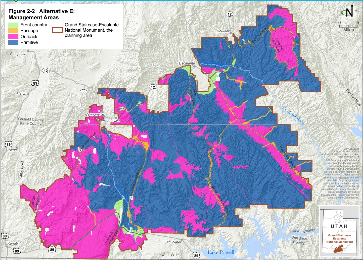
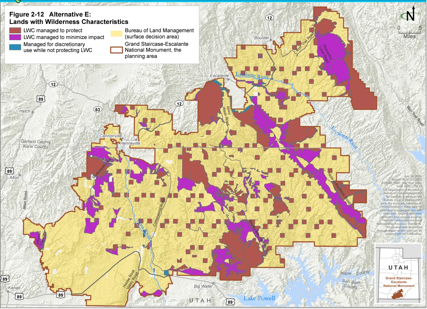
Now for some of the key elements of the plan (with maps from the preferred Alternative E):
- The monument has four management areas: Front Country, Passage, Outback, and Primitive.
- The monument includes 559,600 acres of lands with wilderness characteristics (i.e. lack of roads or development, “untrammeled,” etc.), but that aren’t designated wilderness areas. Alternative E would manage 329,400 acres of those lands for the protection of those characteristics, making them de facto wilderness areas; 224,100 acres would be managed to “minimize impacts”; and 6,100 acres would be managed for other compatible uses. That’s compared to the status quo, which allows for other uses on all of those lands.
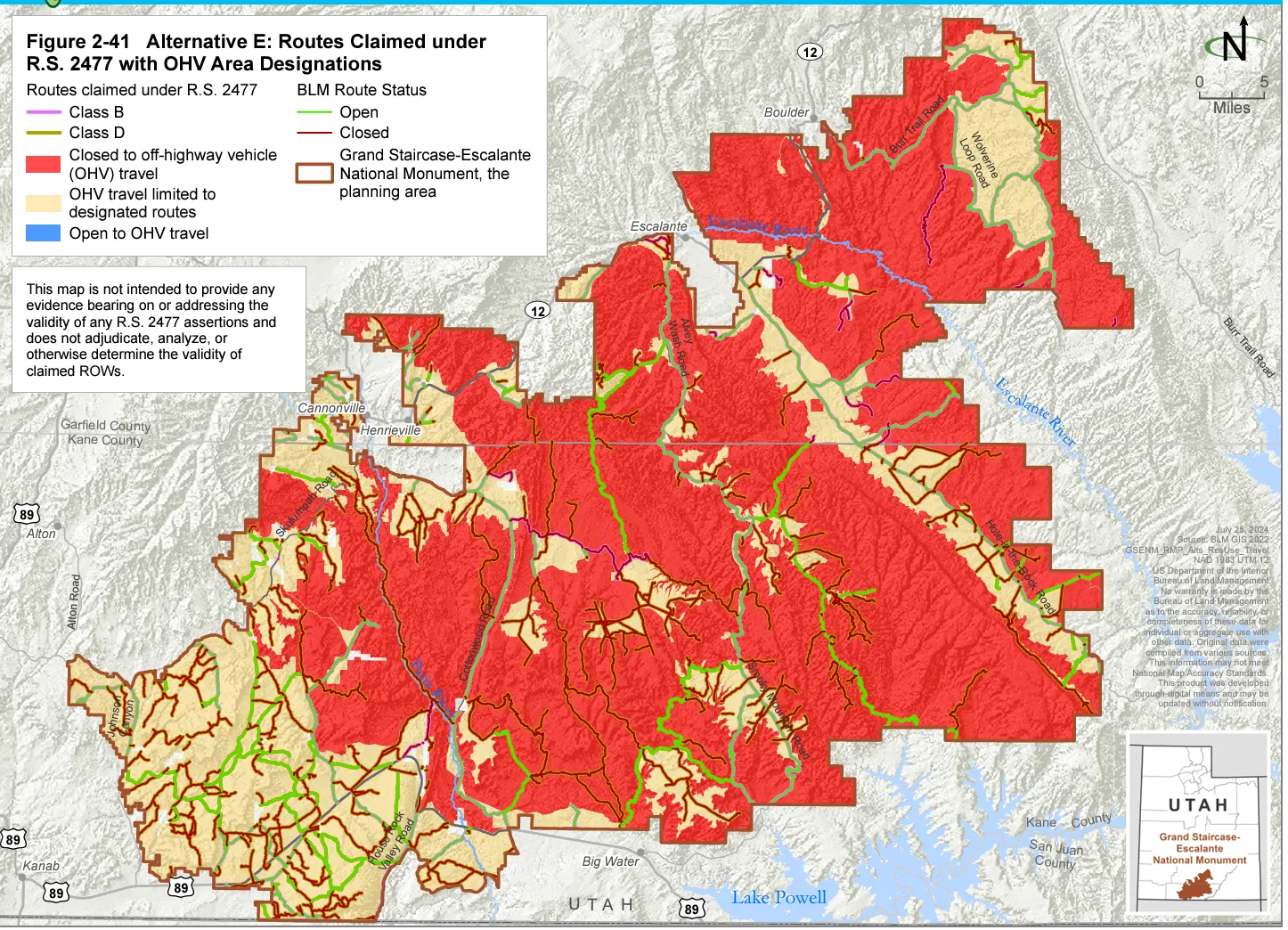
- Hundreds of miles of roads, from paved highways to dirt two-tracks, are webbed throughout the national monument. Most have been claimed by the county as RS-2477 routes (which, if upheld by courts, would give the county control over them), and most remain open to motorized travel. Currently about 1,500 acres of the monument are completely closed to OHV travel, and OHV use is limited to designated routes on 1.86 million acres. Under the new plan, 1.25 million acres would be closed to OHVs, with OHVs still allowed only on designated routes on about 620,000 acres.
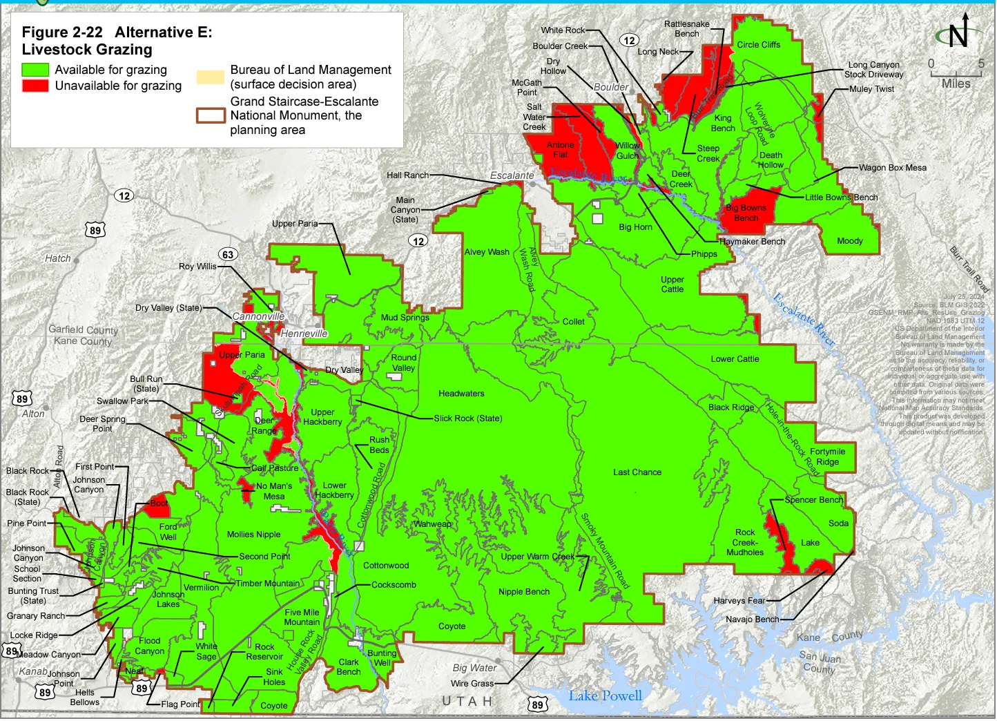
- Currently, about 2.1 million acres in the national monument planning area (which extends beyond the boundaries) are available to grazing, un-permitted allotments can be reinstated, and suspended Animal Unit Months, or AUMs, can be reactivated. The new plan would put just 128,300 acres off-limits to grazing — a deep compromise, given that Alternative D would have halted grazing on 1.2 million acres — and will allow cattle, but not sheep and goats, to chomp their way across 1.7 million acres.
- There are currently 76 grazing allotments in the monument, 14 of which are partially or completely unavailable to grazing, and 10 of which are vacant and available but are not currently permitted. The existing plan allows those to be re-permitted; the new plan would not.
- There are currently 105,452 animal unit months (a cow-calf pair grazing for one month), or AUMs, available in the planning area (76,207 active and 29,245 suspended). The 2020 plan directed the agency to reinstate the suspended AUMs, but it has not done so yet. Of the 76,207 active AUMs, operators only used (or were billed for) about 42,377 AUMs on average between 1996-2020. That suggests it’s the livestock operators themselves, not the land managers or monument protections, that are limiting grazing. There likely will still be a lot of bovines munching on native grasses and trampling the fragile cryptobiotic soils for years to come.
- The new plan would allocate 104,980 AUMs. But, when people voluntarily relinquish a grazing permit or lease, the number of allocated AUMs would automatically decrease by that same amount, which theoretically would phase out grazing over time.
- The agency estimates the cattle will emit a total of 4,584 metric tons of methane annually under the preferred plan.
And you know those folks screaming and yelling that national monuments will destroy local “heritage” and livelihoods and all of that? Some are well-intentioned but misinformed. Others are intentionally spewing disinformation in order to advance an ideological, sometimes corporate-driven, agenda. The Center for Western Priorities calls the latter the National Monuments Disinformation Brigade, and they just issued a report on these folks. Give it a read. Regular Land Desk readers will see some familiar names.

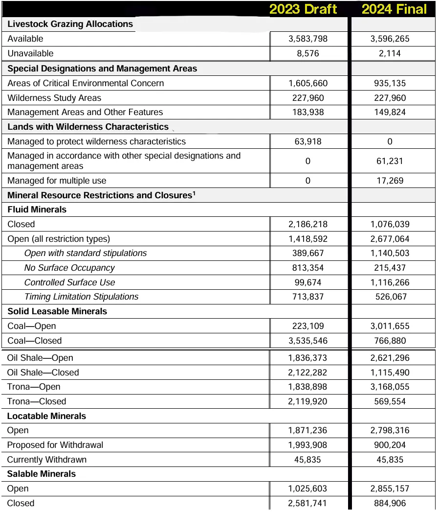
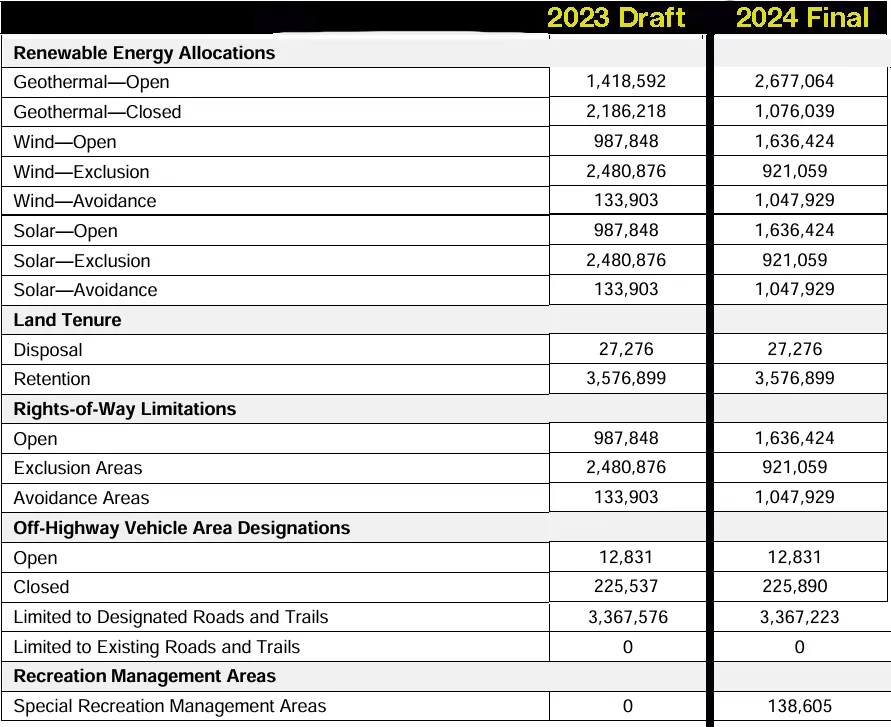
Speaking of land management plans and giving the livestock industry everything it wants, the BLM’s Rock Springs field office also recently released its final resource management plan for about 3.6 million acres of public land in the southern part of the state, including the Red Desert. The draft plan was unexpectedly strong on the conservation side of things, and I held it up as proof that the BLM was shedding its Bureau of Livestock and Mining label (okay, maybe not the livestock part).
A lot of Wyoming right-wingers weren’t so pleased with it, though, with one wing-nut claiming it would affect more people than “the Civil War, Pearl Harbor, and 9/11 combined.” Except there aren’t even that many people in all of Wyoming!
Anyway, rather than sticking to its guns, the BLM went back to the drawing board and did what federal agencies often do, compromised (and bent over backwards to please the noisy minority — and industry). The new plan, in my opinion, overcorrects and leaves 99.95% of the area open to grazing; designates areas of critical environmental concern on some 700,000 fewer acres than the draft plan; opens far more land to coal and trona mining, oil and gas drilling, oil shale extraction, and new mining claims. The new proposed plan also opens up more land than the draft to wind, solar, and geothermal development.
I chopped up the BLM’s chart and pasted it back together to allow for a quick comparison between last year’s draft proposal, and this year’s final preferred alternative plan.
⛈️ Wacky Weather Watch⚡️
Welp, Phoenix went and did it again by setting all sorts of records for armageddon-like heat. For example, it is now on the 107th consecutive day on which maximum temperatures reached 100° F or higher; the previous record was 76 days in a row back in 1993. The mercury has reached 110° on 55 days, matching the record set … last year. The average monthly temperature has exceeded the 1990-2020 normal during six of the last eight months, and this climatological summer (June-August) was the hottest on record. All of that’s crazy, disturbing, and scary — yet not all that surprising, given that we’re clearly in the grips of human-caused climate warming. What is surprising is that when some kind-hearted Phoenician put a cooler full of bottled water in his driveway to offer free relief to passersby, his homeowners association went after him for violating some obscure rule. HOAs, hmmmph!
🦫 Wildlife Watch 🦅
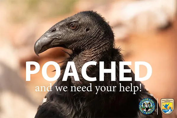
Someone shot a critically endangered California condor this spring near McPhee Reservoir in southwestern Colorado and wildlife officials want your help finding the shooter. Thanks to a tracking device, the dead condor was found and recovered in March within 24 hours of being shot between the small community of Lewis and the reservoir. It is illegal to kill the majestic birds. Folks with information are asked to call Colorado Operation Game Thief (OGT) Hotline: 1-877-COLO-OGT (1-877-265-6648); email game.thief@state.co.us; or report it online at Submit a Tip.
***
Sad news from Silverton, too: A mama bear died after a sheriff’s deputy shot it with a beanbag — that was supposed to be nonfatal — in an attempt to shoo the bruin away from people (who were gathered around gawking at her and her two cubs). The Durango Herald reports the San Juan County Sheriff’s department is looking into allegations that someone harassed one of the cubs.
😀 Good News Corner 😎
And, finally, some kind of cool news: The Ute Mountain Ute Tribe’s farm in southwestern Colorado has finished integrating a hydropower system into its irrigation network that will harness excess water pressure from pivot-sprinkler pipes. It’s not a huge system, but it demonstrates one way to generate clean energy with minimal impact. Now let’s hope there continues to be enough water running through those pipes.
Also: The U.S. EPA awarded the Hopi Tribe in Arizona $20 million to bring solar power to about 900 off-grid homes. It was all part of a massive clean energy and climate funding package to tribal nations, which included nearly $5 million to the Southern Ute Tribe to reduce greenhouse gas emissions from oil and gas facilities.