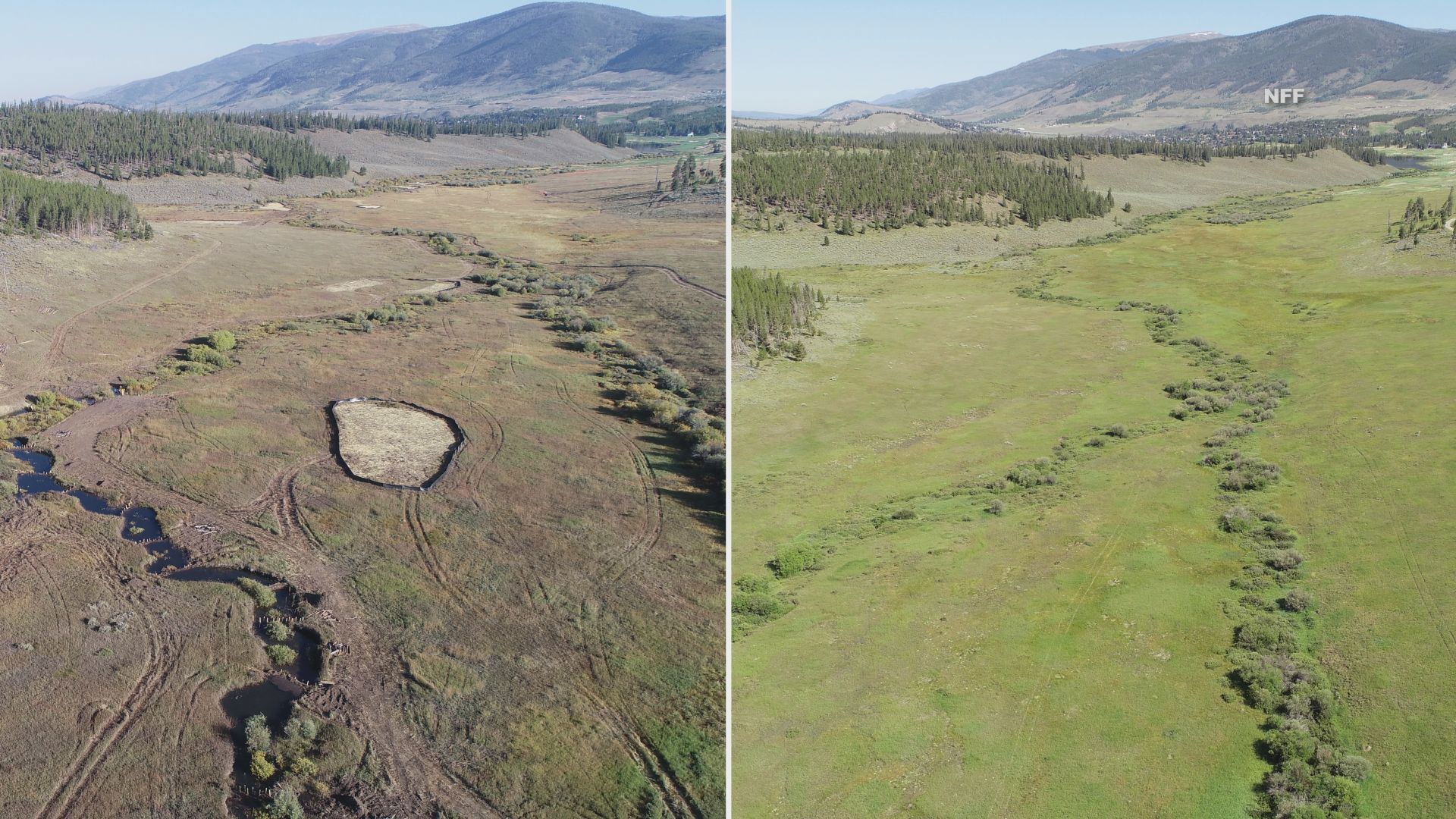
Before and after photos show a drastic change to the landscape. Credit: National Forest Foundation
Click the link to read the article on the 9News.com website (Brianna Clark). Here’s an excerpt:
September 17, 2024
Wetlands play a major role in keeping our water clean. Yet, according to the National Forest Foundation, the U.S. has lost more than half of them in the lower 48 states because of infrastructure development and agricultural practices. The Soda Creek Restoration Project hopes to undo some of that loss in Colorado…The project is part of a larger effort to restore 40 acres of wetlands in the White River National Forest, reestablishing nearly 30 acres while rehabilitating another 12.5 acres. The NFF started the project last month and all the work is being done by hand with the help of volunteers. One of several things they’re doing is creating dams to slow down the water allowing it to spread out over the valley. NFF Colorado River Watershed Program Coordinator Adde Sharp said the historic wetland in Summit County was converted into a cabbage farm more than a hundred years ago, causing the area to dry up and the landscape to change. Sharp said turning the area back into a wetland is a big deal because Soda Creek is upstream of Dillon Reservoir, which provides drinking water to the Denver area.
“Wetlands dramatically improve water quality because they’re like sponges or filters that are filtering out sediment and different contaminants in the water, heavy metals, etc.,” said Sharp. “If you live downstream of a wetland- and we all do, there are wetlands upstream of all of us- this is really improving your water quality.”
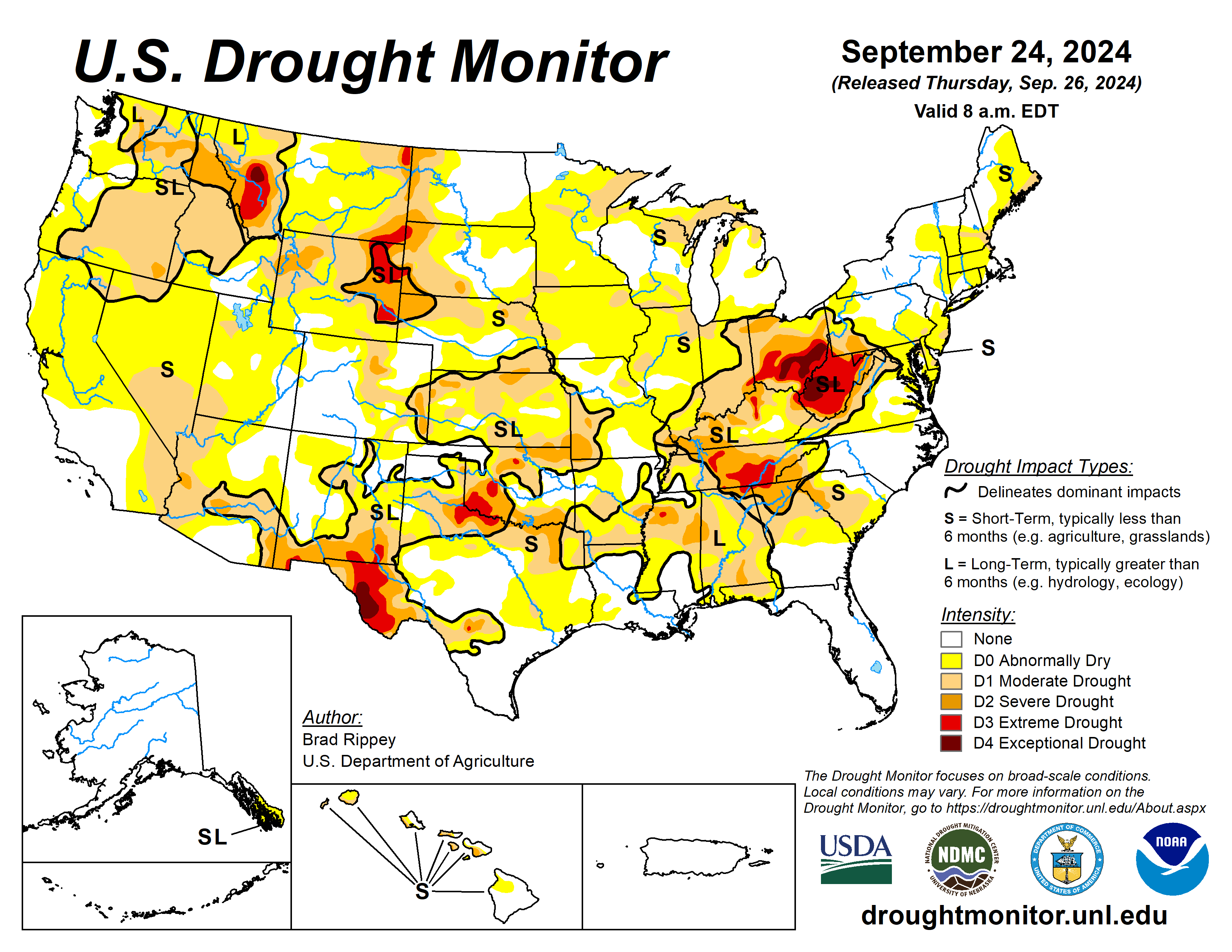
Following the previous drought-monitoring period’s extensive rainfall associated with Hurricane Francine and Potential Tropical Cyclone Eight, drought-easing precipitation developed farther west, across portions of the central and southern Plains and the middle Mississippi Valley. Another area of significant precipitation fell across the northern High Plains and environs, including parts of Montana. However, large sections of the country remained dry, with worsening drought conditions. Some of the most notable increases in the coverage of dryness and drought occurred in the upper Midwest and the Northeast, as well as parts of the western Gulf Coast region and the interior Southeast. Nationally, nearly one-half (45%) of the rangeland and pastures were rated in very poor to poor condition on September 22, according to the U.S. Department of Agriculture, up from an early-summer minimum of 19%…
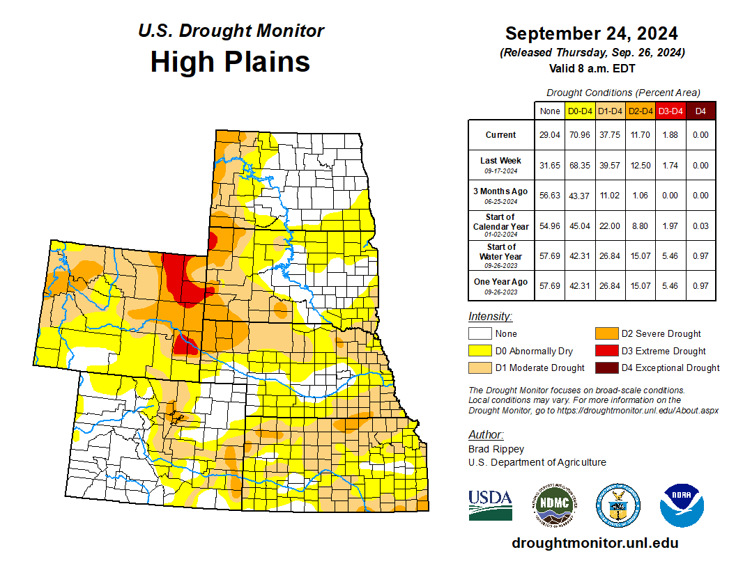
Aside from Kansas, where rainfall provided widespread drought relief, most of the High Plains experienced unchanged or worsening drought conditions. On September 22, topsoil moisture rated very short to short ranged from 29% in North Dakota to 84% in Wyoming, with values also above 50% in Colorado, Kansas, and Nebraska. Wyoming led the region on that date with 68% of its rangeland and pastures rated very poor to poor, followed by South Dakota at 44%…
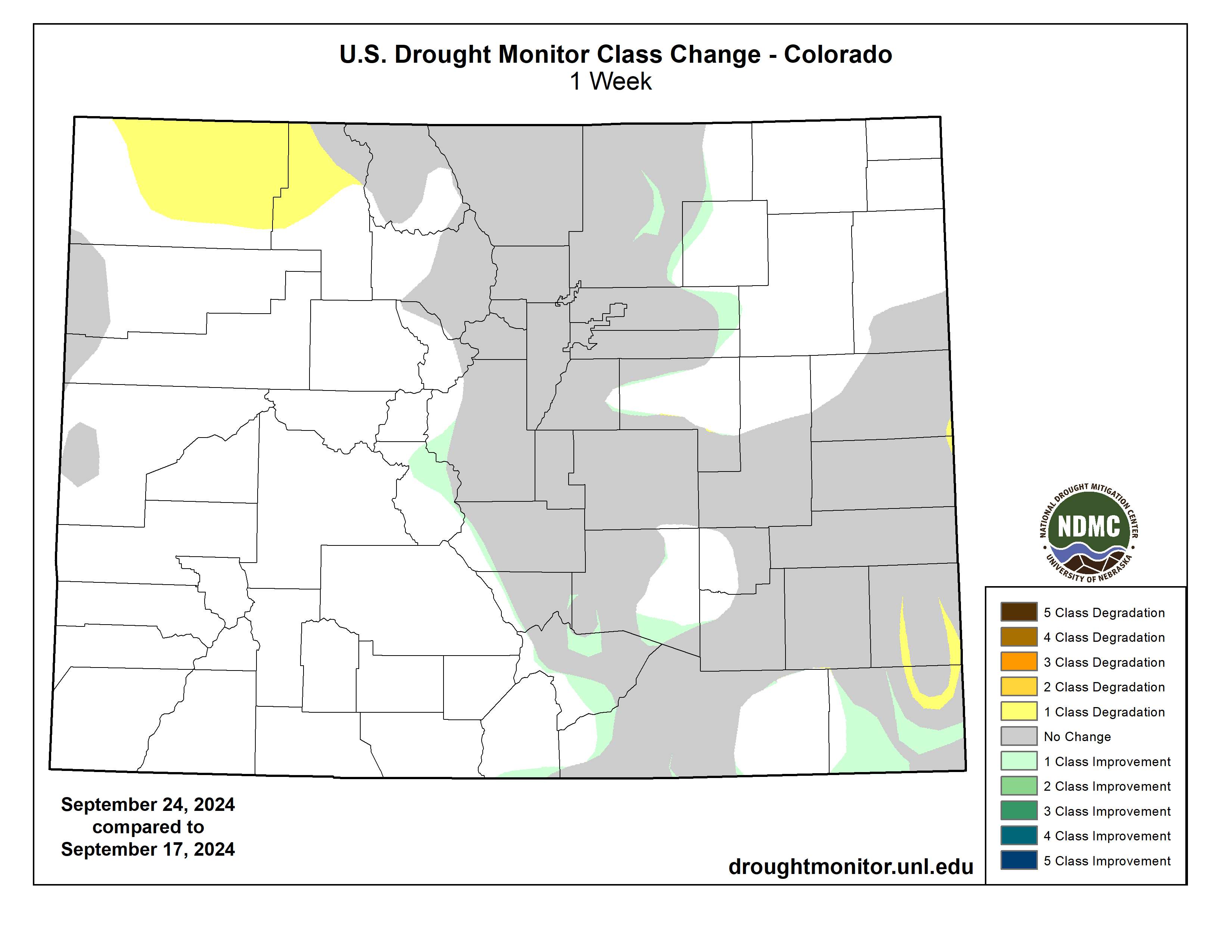
Colorado Drought Monitor one week change map ending September 24, 2024.
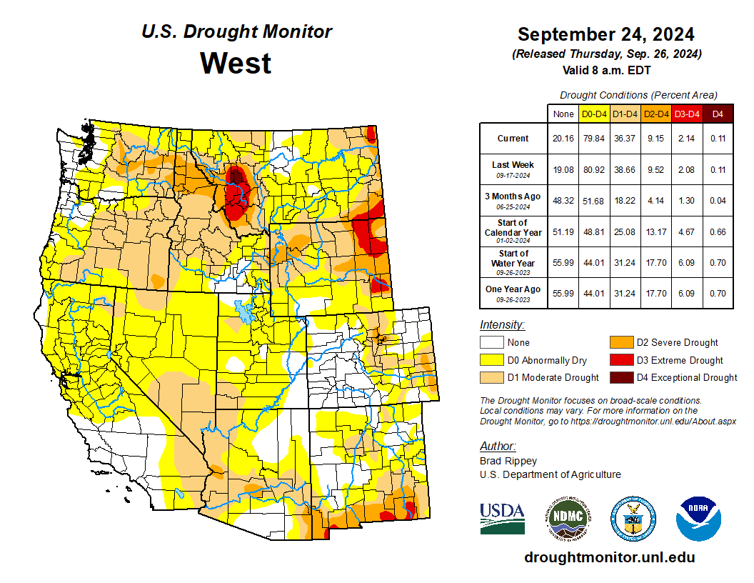
There were only minor changes in the Western drought depiction, aside from improvement due to heavy precipitation in parts of Montana. Dry conditions remained a concern in many areas, with statewide topsoil moisture rated very short to short on September 22 as high as 84% in Montana and 74% in Oregon. Northwestern rangeland and pastures remained largely in terrible shape, following a hot, dry summer, and by September 22 were rated more than 60% very poor to poor in Montana, Oregon, Washington, and Wyoming. Dry conditions also favored winter wheat seeding, with Washington leading the nation on September 22 with 54% of its intended acreage planted…
The South remained an odd mix of drought improvement and deterioration. Tennessee and Texas were notable for seeing large drought changes in both directions, with Tennessee noting drought deterioration in central and eastern areas and improvement in the west. Similarly, Texas saw improvement in some northern and central areas, along with a large expansion of abnormal dryness (D0) in the east-central part of the state. Oklahoma led the region on September 22 with statewide topsoil moisture rated 57% very short to short, followed by Texas and Tennessee both at 49%. Meanwhile, at least one-half of the rangeland and pastures were rated in very poor to poor condition in Tennessee (53%) and Texas (50%). Texas also led the U.S. with 48% of its cotton rated in very poor to poor condition on that date, well above the national value of 33%…
Looking Ahead
Hurricane Helene is forecast to strike Florida’s Big Bend late Thursday, with an intensity and pre-landfall path similar to that observed with Category 3 Hurricane Idalia, on August 30, 2023. Less than 2 months ago, Category 1 Hurricane Debby also moved ashore in the same general area of Florida. With Helene, a potentially catastrophic storm surge may occur along and to the east of where the eye crosses the Gulf Coast, with notable surge-related impacts also expected along the west coast of Florida’s peninsula. In addition, a significant inland push of hurricane-force winds (74 mph or greater) is expected across north-central Florida and southwestern Georgia, with likely impacts on timber and crops such as cotton and pecans. Damaging winds could reach higher elevations of the southern Appalachians. After punching inland, Helene should veer northwestward and decelerate due to interaction with a disturbance over the lower Mississippi Valley, heightening the risk of Southeastern flooding. Storm-total rainfall could broadly reach 6 to 12 inches, with locally higher amounts. During the next 5 days, much of the remainder of the country will experience warm, dry weather, ideal for summer crop maturation and harvesting, as well as winter wheat planting. However, lack of soil moisture for the establishment of winter grains and cover crops will remain a concern in drought-affected areas.
The NWS 6- to 10-day outlook for October 1 – 5 calls for near- or above-normal temperatures nationwide, with the Southwest having the greatest likelihood of experiencing warm weather. Meanwhile, near- or below-normal precipitation across much of the country should contrast with wetter-than-normal weather a few areas, including western Washington, peninsular Florida, and much of the Northeast.
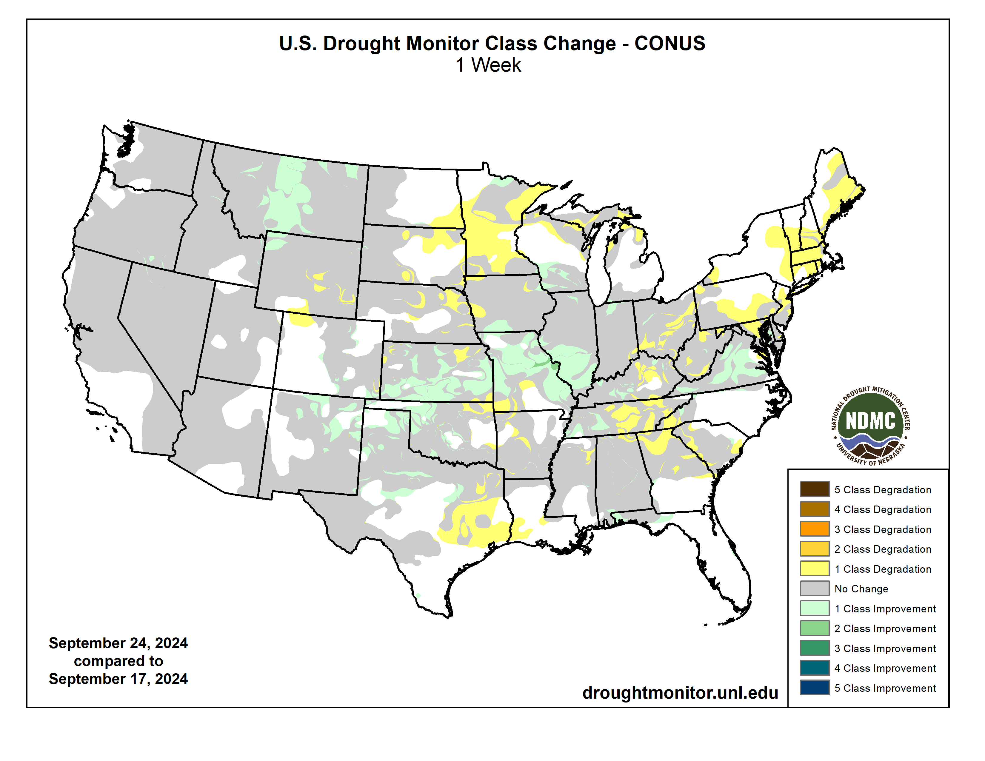
US Drought Monitor one week change map ending September 24, 2024.
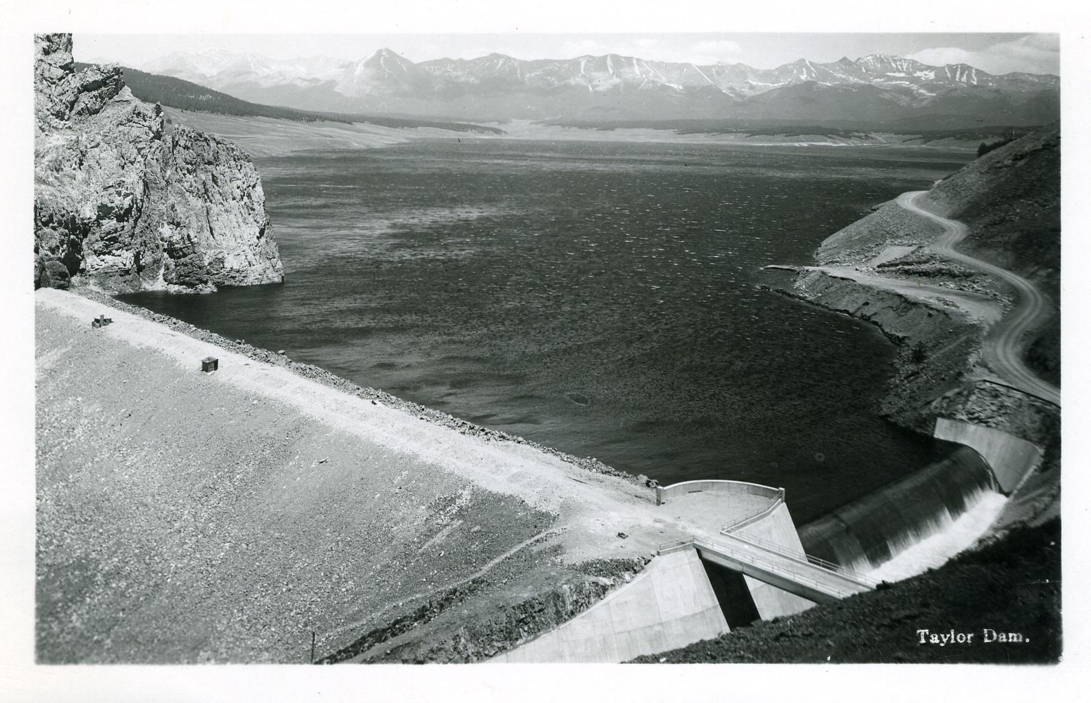
Local electric cooperative Gunnison County Electric Association (GCEA) has a new way of generating energy for the Gunnison Valley with the recent completion of its Taylor River Hydropower construction project. GCEA and the Uncompahgre Valley Water Users Association (UVWUA) commemorated the completion of the plant’s construction phase last week with a ribbon cutting ceremony, and plan to begin commercial power production around September 20. The $3.6 million project located at the Taylor Park Dam is a partnership between GCEA and the UVWUA. The new 500-kilowatt (kW) hydroelectric turbine and generator at the site will operate at or near full capacity 24 hours a day, year round, to produce an average of 3.8 million kilowatt-hours (kWh) annually. That amount of generation compares to some 2,500 kW (2.5 megawatt) fixed tilt-solar arrays and, according to GCEA strategy execution specialist Matt Feier, will provide clean electricity to approximately 500 local homes and businesses in Gunnison County…Construction on the project began in May 2023, but the hydroelectric vision has been in the works far longer…
GCEA provides the electric infrastructure and UVWUA manages the water flowing through the dam. The plant connects to the existing dam penstock and GCEA’s single-phase distribution line. Feier explained the process: “The new facility draws approximately 65 cubic feet per second of water out of the eastern penstock within the existing valve house. This water is piped to our Frances turbine within the newly constructed metal building at the base of the dam. The turbine spins, which in turn spins the generator and generates an electric current. This energy flows into GCEA’s existing distribution system and down to GCEA’s Alkali substation (located near Jack’s Cabin Cutoff) where it is distributed within GCEA’s service territory. After turning the turbine, the water flows back into the same spilling basin as the Taylor Dam’s main outflow,” he said. “This hydro generator will be a ‘run of the river’ facility and will not affect river flows within the Taylor River.” Feier said the Taylor River Hydro project is a welcome addition to GCEA’s current clean energy portfolio, and it will bump up GCEA’s local renewable energy generation. “This new hydroelectric facility will get us to approximately 3% local generation and we are working to gain the other 2%+ from local solar array developments,” he said.
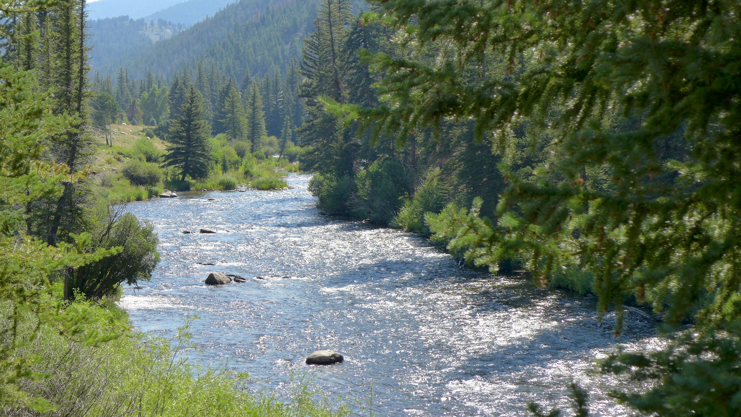
The Taylor River, jewel of the Gunnison River basin. Photo: Brent Gardner-Smith/Aspen Journalism
View of Shoshone Hydroelectric Plant construction in Glenwood Canyon (Garfield County) Colorado; shows the Colorado River, the dam, sheds, a footbridge, and the workmen’s camp. Creator: McClure, Louis Charles, 1867-1957. Credit: Denver Public Library Digital Collections
The 2024 Annual Water Seminar was hosted by the Colorado River District at Colorado Mesa University. The event featured many big names in the community including John Marshall, Andy Mueller, David Payne, Merrit Linke, Bart Miller, Cleave Simpson, and many more…Their goal was to highlight the challenges the Western Slope faces now and will face in the future. These challenges pertain to the ever-present climate change crisis and bureaucracy…
According to Andy Mueller, the general manager of the Colorado River Water Conservation District, one of those bureaucratic obstacles is an agreement that was signed in the 1920s. This limits our entitlement to around 55% of the flow of the Colorado River. Another issue he tells us is communities in the Lower Basin—areas in California and Arizona—are keen on securing water. And with a growing population on the Front Range, Mueller says there is a heightened emphasis on securing the Shoshone Water Rights. “We are concerned that if we do not lock in the Shoshone Water Rights, we will see more water leave the Colorado River Basin, and there will be less water for the population and environment on the Western Slope.”
The Shoshone Water Plant is expected to have a $99 million price tag and is slated to increase the amount of available water to farmers and consumers. So far, we are told $56 million has been raised.
“New plot using the nClimGrid data, which is a better source than PRISM for long-term trends. Of course, the combined reservoir contents increase from last year, but the increase is less than 2011 and looks puny compared to the ‘hole’ in the reservoirs. The blue Loess lines subtly change. Last year those lines ended pointing downwards. This year they end flat-ish. 2023 temps were still above the 20th century average, although close. Another interesting aspect is that the 20C Mean and 21C Mean lines on the individual plots really don’t change much. Finally, the 2023 Natural Flows are almost exactly equal to 2019. (17.678 maf vs 17.672 maf). For all the hoopla about how this was record-setting year, the fact is that this year was significantly less than 2011 (20.159 maf) and no different than 2019” — Brad Udall
Click the link to read “Climatologist: Warming of state almost certain to continue” on the Grand Junction Daily Sentinel website. Here’s an excerpt:
September 21, 2024
On the heels of Grand Junction’s hottest summer on record, Colorado’s state climatologist advised Friday that the state’s warming trend over recent decades is all but certain to continue in coming ones. Russ Schumacher, also director of the Colorado Climate Center at Colorado State University, said at an event at Colorado Mesa University that temperatures in Colorado and globally have been warming and the projection is for continued warming in the future, “and there is very high confidence in that.”
Colorado statewide annual temperature anomaly (F) with respect to the 1901-2000 average. Graphic credit: Becky Bolinger/Colorado Climate Center
There’s less certainty about what the future holds for precipitation levels in the future in the state, other than that they will continue to be highly variable. But increasing temperatures will have water-related impacts even if precipitation patterns don’t change much, he said during the Colorado River District’s annual water seminar. He said seven of Colorado’s nine warmest years on record, averaged across the state, have occurred since 2012 and the warming trend has been particularly notable in the summer and fall. This year’s climatological summer, from June through August, tied for the sixth-warmest on record in the state, and the nine hottest summers all have been since 2000, he said. The average summer temperature at the Grand Junction Regional Airport this year was the hottest on record, he said…lows in the Colorado River have been declining since 2000. Annual flows at Lees Ferry below Lake Powell averaged 15 million acre feet during the 20th century but have averaged about 12.5 million acre feet since 2000, which has had some very dry years, he said…
The Colorado Climate Center addressed the impacts of climate change in the state in a report it issued in January. It projects that by 2050, under a medium-low carbon emissions scenario, Colorado statewide annual temperatures will warm between 2.5 to 5.5 degrees Fahrenheit compared to a 1971-2000 baseline, and 1 to 4 degrees compared to today.
Shumacher said that although there’s less certainty how climate change will affect precipitation in the state, warmer temperatures along with wind and low humidity result in increased evaporative demand, with dry air pulling moisture from trees, soils, crops and surface waters. That means there are times even when precipitation levels are higher that the water doesn’t go as far. Higher evaporative demand also increases the odds of drought happening and makes droughts more intense…At the Colorado River at Dotsero, peak flows already are declining and there has been about a 25% decline in flows in July and August, he said. Climate projections for the river at Dotsero show increased streamflows in the spring as runoff happens earlier due to earlier snowmelt, but then big declines in flows in July and August, “which is when you really need (water), especially if you don’t have storage,” Schumacher said. The changing climate also is expected to result in a continued trend of more and bigger wildfires, and possibly cause more extreme precipitation and flooding, among other hazards. But Schumacher said it’s important to remember that what is projected to happen in the Colorado Climate Center report isn’t all locked in, as it is a trajectory based on where things are headed now in terms of carbon emissions and the climate policies currently in place.