The stacks go down, the energy transition moves forward: Plus: Wacky Weather Watch — Jonathan P. Thompson (www.landdesk.org) #ActOnClimate

The San Juan Generating Station in mid-June of 2022 The two middle units (#2 and #3) were shut down in 2017 to help the plant comply with air pollution limits. Unit #1 shut down mid-June 2022 and #4 was shut down on September 30, 2022. Jonathan P. Thompson photo.

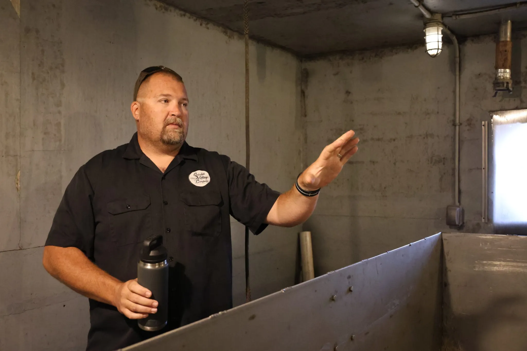
Click the link to read the article (and to view the cool video from EcoFlight.com) on The Land Desk website (Jonathan P. Thompson):

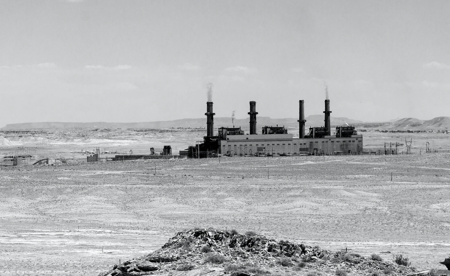
After five decades of spewing sulfur dioxide, ash, mercury, arsenic, carbon dioxide, and other pollutants into the northwestern New Mexico air, the four stacks of the San Juan Generating Station were brought down in spectacular fashion this past weekend. Sadly, I missed it in real life, but even the videos leave me feeling a bit giddy, as the controlled demolition heralds a new, cleaner, hopefully more just era in the Four Corners. 

It’s symbolic, of course: The real action happened in September 2022, when the last of the plant’s four units burned through the final ton of coal and the turbine [quit] turning for good. But what a symbol it is, for the region and for me, personally: The power plant, and, to an even larger degree, it’s older, bigger sister plant, Four Corners, have loomed over my existence ever since I was very young. 

Four Corners was constructed in 1964, and was the flagship of a massive effort by a consortium of utilities called WEST, or Western Energy Supply and Transmission Associates. They hoped to construct six massive coal-fired power plants and accompanying mines across the Colorado Plateau, which would then ship power hundreds of miles to rapidly growing Los Angeles, San Diego, Las Vegas, Phoenix, and Albuquerque across high-voltage lines. 

Not only did the growing supply of cheap power — and air-conditioning and water pumping — help the population of the Southwest’s cities soar, but the marketing caused the average American’s electricity consumption to grow four-fold between 1946 and 1968. “We are, in short, on an energy binge,” Harvey Mudd, Director of the Santa Fe-based Central Clearing House told the congressional committee in 1971, “which, like all binges, can only end in disaster.”

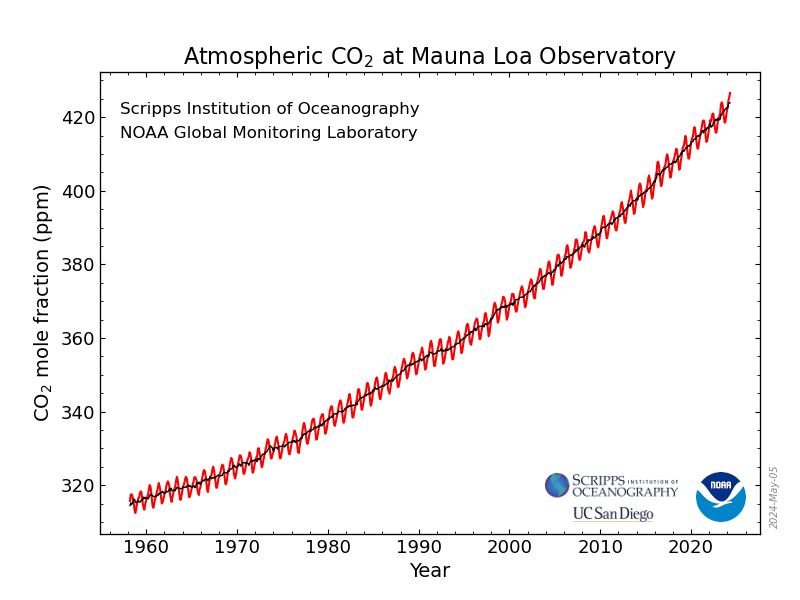
Mudd’s warning may even be more timely in 2024, as we embark on a new electricity binge to power the proliferation of energy-hungry AI-processing and cryptocurrency-mining data centers

Four Corners Power Plant was the first of the six to go online, sprouting on the edge of the Navajo Nation, atop the Fruitland formation, about 15 miles from Farmington. The relatively sparse population, along with the dearth of environmental regulations, allowed the mine and plant largely to be built under the radar. But once it started churning out juice, and pollution — to the tune of over 400 tons of particulate matter per day, along with sulfur dioxide, nitrogen oxides, and mercury — no one could miss the behemoth. The facility, along with the smog its pollutants gave way to, became a smoke-spewing symbol of energy colonialism, landscape-scale industrialization, and humans’ ability to spoil the environment. 

It helped give rise to a regional environmental movement, made up of elected officials, concerned residents, and advocates, which protested the pollution and implored a congressional committee in 1971 to block further power plant construction

But the impassioned rhetoric fell on deaf ears. After Four Corners came Mojave, Navajo Generating Station near Lake Powell, Huntington in Utah, and San Juan Generating Station, just across the river from Four Corners. They all had better pollution control systems than Four Corners did initially, but together they still kicked out thousands of tons of pollutants along with tens of millions of tons of planet-warming carbon dioxide each year, leaving the Four Corners Region to appear as if it had once again been inundated by a vast sea, only instead of water it was comprised of smog. Only the largest of all those slated to be built, the 5,000-megawatt Kaipairowitz plant, which would have sat on the western shore of Lake Powell eating up coal from land that was later included in Grand Staircase-Escalante National Monument, was not constructed.

I was born in the midst of the Big Buildup in 1970, and not long after I became conscious of the world around me I learned that the haze in the air that blotted out the once-expansive views of my homeland was not natural. And I learned that the main culprit were the new coal-burning power plants that loomed over the sere landscape. It was probably my first understanding of environmental destruction. 

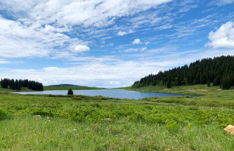
A decade and some years later, on a mid-summer’s eve, when I was in my late teens or early 20s, I drove my 1967 AMC Rambler station wagon west from my dad’s house in Cortez, over undulating gravel roads past hay fields, with their perfectly cubical hay bales lined up in a row, casting long shadows across the bright green, monsoon-moistened, freshly cut field. I was headed to The Point, atop the McElmo Dome, out beyond the last bean and hay fields. It was a nice place to camp because of its proximity to Cortez, but more importantly because of the views. You could see all the way to Monument Valley and Navajo Mountain — if the air was clear, which was rare. 

I didn’t like the smog, but I also didn’t really know anything different, since the smog was there before I was, and never really abated, given that the power plants churned round-the-clock, every day of the year. I had resigned myself to it; call it normalized degradation.

Navajo Mountain March 2023. Jonathan P. Thompson photo.

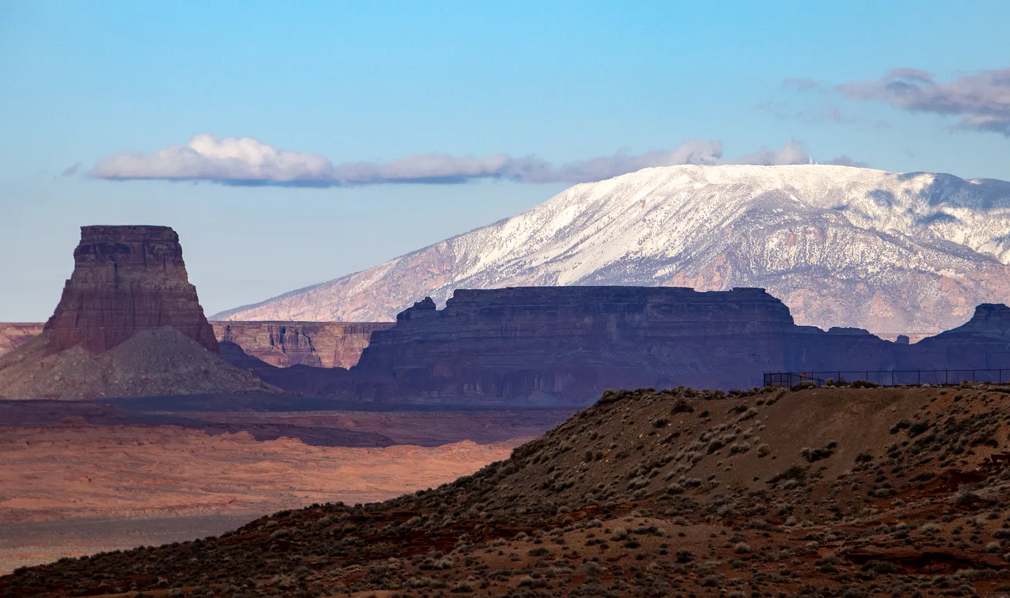
After watching the smog-enhanced sunset, punctuated by distant lightning strikes, I lay out my sleeping bag on the sandstone rim and covered it with a tarp and fell asleep. Deep in the night I was woken by lightning and thunder and huge raindrops pelting the tarp. I snuggled up underneath and let it lull me back asleep. When I awoke before sunrise I was startled by the clarity of the air. I not only could see the landforms of Monument Valley and the dark curve of Navajo Mountain, but I could see fissures in the sandstone and canyons on the mountainside. It was truly glorious to watch the sunlight spread across the landscape like that. 

But my revery soon was interrupted. A yellowish-gray amoeba, coming from the south, oozed its way up the canyons toward me. It was no mystery. It was smog, rushing in from the Four Corners and San Juan plants to replace the stuff that had been washed out by the night’s heavy rains. A sadness and anger rose up in me then, and I think it’s lingered ever since, motivating much of what I do.

So it was with a sense of satisfaction that I watched the video of the smokestacks falling into a cloud of their own demise. 

This graph shows the full record of monthly mean carbon dioxide measured at Mauna Loa Observatory, Hawaii. The carbon dioxide data on Mauna Loa constitute the longest record of direct measurements of CO2 in the atmosphere. They were started by C. David Keeling of the Scripps Institution of Oceanography in March of 1958 at the NOAA Weather Station on Mauna Loa volcano. NOAA started its own CO2 measurements in May of 1974, and they have run in parallel with those made by Scripps since. (Image credit: NOAA Global Monitoring Laboratory)

Notes from the energy transition — Jonathan P. Thompson

April 19, 2024

Photo credit: Jonathan P. Thompson/Land Desk

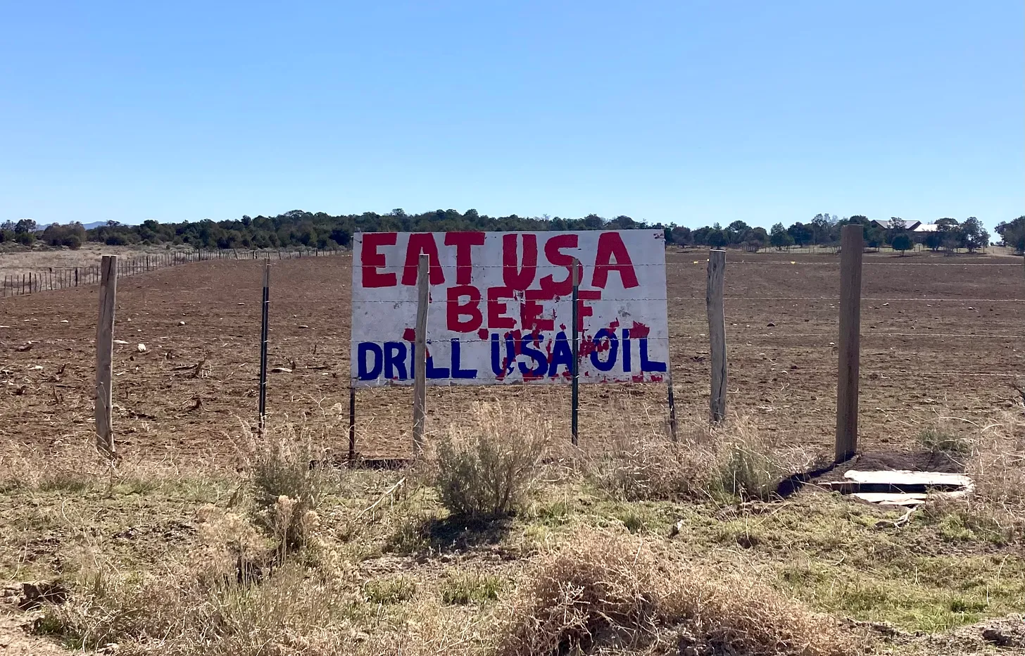
“EAT USA BEEF DRILL USA OIL.” So said the sign, in red and blue lettering against a white background, along a La Plata County road I took on a little trip down to northwestern New Mexico last week. It must have had some effect on me. Because after taking a run through the coalbed methane fields, I headed straight to Blake’s Lotaburger in Aztec and parto…

Read full story

⛈️ Wacky Weather Watch⚡️

Weather is weird. Always has been. But the last few weeks have been especially wacky in the West, as massive wildfires and resulting smoke meet up with record-breaking high temperatures, monsoonal deluges, and the resulting landslides and flash floods. 

We’ve covered the high temps here, so let’s look at the moisture, which should bring relief, but actually wreaks destruction. 

  • For the third time this summer, the monsoon mobbed Moab as a series of thunderstorms pounded the area and triggered flash flooding in and around the town. The National Weather Service showed rainfall amounts ranging from .76 inches at the Arches National Park HQ, to .95 inches at Canyonlands, to 1.01 inches at La Sal — all falling in a very short period of time. Mill Creek, which is normally a clear, gurgling brook that flows through the south side of downtown, turned into a raging, chocolate-milk-colored, debris-tossing monster — peaking out at 6,810 cubic feet per second, according to the USGS streamgage. And this one put the “flash” back into “flash flood”: On the morning of Aug. 23, the stream was a mere trickle at .36 cfs; by 8 p.m. that night it had ballooned up to 900 cfs; and it hit its 6,810 cfs high point at 8:30 p.m. before rapidly subsiding.
The streamflow gage reading for Mill Creek below its The streamflow gage reading for Mill Creek below its confluence with confluence with Pack Creek in Moab. Notice how fast it rose and subsided. Source: USGS.
  • Havasu Falls in the Grand Canyon — known for its luminous blue waters — swelled up so quickly after intense rainfall that it overwhelmed the stream gage: The readings simply disappear during the highest flows. But the torrent, which killed one hiker and forced the helicopter evacuation of more than 100 others, was recorded in other forms and it looks like it was a whopper. The Havasupai tribal council has closed their lands to tourists indefinitely in the flood’s aftermath. Good view of how the falls went from captivating to terrifying in a matter of minutes.
  • The dry winter in the Northern Rockies is coming home to roost in the form of big wildfires in northern Wyoming and southern Montana, including: 
    • Flat Rock and Constitution Fires: Together they have charred nearly 80,000 acres near the massive coal mines and in the coalbed methane fields near Gillette, Wyoming.
    • House Draw Fire has burned across about 175,000 acres east and south of Buffalo, Wyoming.
    • The Remington Fire has scorched nearly 200,000 acres straddling the Wyoming-Montana border east of Sheridan.
    • The Fish Creek Fire in Teton County is around 11,000 acres.

And, in Alaska, unusually intense rainfall triggered a landslide/debris flow on a slope in Ketchikan, killing one person, injuring three more, and destroying homes and infrastructure. 

It can be tempting to attribute all of this wackiness to climate change — some media outlets are even blaming it for a freak yacht-sinking off of Sicily — it’s not prudent and probably not accurate to do so. Neither the rainfall, nor the floods that resulted, are unprecedented (okay, it’s hard to know with Havasu Falls since the gage failed at the moment of truth). USGS data show that peak streamflows on Mill Creek in Moab, for example, are trending downward over time.

But it is fair to say that as the planet warms, we can expect weather to get wackier and more extreme. What we’re seeing now may just be a mild prelude to what’s yet to come.

#PagosaSprings seeks grant funding to expand #SanJuanRiver access — The Pagosa Springs Sun

Pagosa Springs. Photo credit: Colorado.com

Click the link to read the article on the Pagosa Springs Sun website (Derek Kutzer). Here’s an excerpt:

August 29, 2024

On Aug. 22, the Pagosa Springs Town Council approved a resolution authorizing the town to apply for grant funding from the Great Out- doors Colorado (GOCO) Community Impact Grant Program and the fed- eral Land and Water Conservation Fund (LWCF). If awarded, the grant funding would go toward the purchase of 3.63 acres of property adjacent to the San Juan River near the junction of U.S. 160 and U.S. 84.

An agenda brief on the matter states that the funding would support the first phase of the East Gateway River Park Project, which would include purchasing the land, an environmental assessment, site improvement design, cleanup, boat ramp installation and parking im- provements. An executive summary plan, drafted by the town, states, “Future project phases will include con- structing additional amenities such as restrooms, a handicap-accessible fishing pier, shade structures, paved parking, and a riverwalk trailhead.”

‘Just made it work’: Rye fields take root in heritage farm: Family behind Colorado Malting Company finds world-wide market for its craft malt — @AlamosaCitizen #SanLuisValley #RioGrande

Credit: Owen Woods

Click the link to read the article on the Alamosa Citizen website (Chris Lopez):

August 17, 2024

Spend any time around Jason and Josh Cody and their dad, Wayne, and you’ll quickly appreciate the farming ingenuity that has gone into turning the Colorado Malting Company on County Road 12 into one of America’s leading malt providers for craft beers and spirits.

There is a lot to say about the success of Colorado Malting Company and how the Codys were at the forefront of turning their 300 acres of barley, wheat, and rye fields into malt and how they found markets for their value-added ag products in big cities, small towns, and the world around. You can hear Jason Cody tell the story in this episode of The Valley Pod.

Credit: Owen Woods

It’s a company that can brag about being the first in the United States of America, as Jason likes to say, to craft malt and sell to craft spirits and beer makers. The San Luis Valley Straight Rye Whiskey made by Laws Whiskey House or many of the original New Belgium Beers are testament to that.

The Codys can also say they were founding members of the Craft Maltsters Guild, which now includes hundreds of malt houses around the country and up to 300 members. At one point in its early days, Colorado Malting Company had 187 craft breweries on a waiting list to buy its malt, and Jason and Josh are treated as royalty on their many trips outside the San Luis Valley, including some abroad, to preach the gospel of craft malting and how they figured out a different system to malt with fewer steps from their farm outside of Alamosa.

Credit: Owen Woods
Credit: Owen Woods

But to focus solely on the success and upcoming expansion of Colorado Malting Company would be a disservice to the brilliance of Wayne Cody and his sons and how each has lent his own expertise to the success of the family business, and the hard labor that’s gone into all.

It’s a story that has its roots in the Valley’s dairy industry and the Cody family operating one of those dairy farms up until 1995, when they sold the cows and got out of the business. The story picks up in 2007 when Wayne Cody came into the family house and presented a contract to his mom to sell the farm. Her response: she had $60,000 in savings and could they continue to grow their grain crops and try another year?

“That was the beginning of the malting company,” Jason Cody said. “So then the image to consider is me out in that old dairy barn tearing all that stuff out and pulling it out into the driveway and saying, look, there’s an opportunity.” 

Credit: Owen Woods

The opportunity was figuring out how to make malt to sell into the growing craft brewing industry that was blowing up in big cities around the time Grandma Cody refused to sign the selling papers. So the Codys took the stainless steel dairy tanks and converted them to make finished barley malt.

“Just made it work,” is how Wayne Cody describes the farm conversion from dairy to malting. “You just go,” he said, standing in another building on the farm that the Codys converted into their malt storage warehouse. 

Wayne Cody suffered a traumatic brain injury in a four-wheeler accident in 2012, and it was a few years after that son Josh relocated with his family to Alamosa. At the time Josh Cody was a professor at Concordia University in Wisconsin. He now serves as the creative director of both the Colorado Malting Company brand and the brand of the Colorado Farm Brewery, which the Codys own and operate alongside the malting company.

Credit: Owen Woods

Josh is also the family brewmaster, responsible for the craft beers on tap at the Colorado Farm Brewery. His latest is a craft rye beer that is light and crisp and flavorful.

The rye grain has come into its own as an ingredient in craft beers and spirits, and the need to grow more rye is what led Jason Cody to the Rio Grande Basin Roundtable this summer. 

The Rio Grande Basin Roundtable is a quasi-government entity that works on water management issues and water-related projects. One of its board members, Heather Dutton, is one of the brains behind the Rye Resurgence Project, which promotes San Luis Valley-grown rye as one of the Valley’s best sustainable crops for the simple fact rye uses less water to grow and the uniqueness in flavor the grain takes when grown at the Valley’s high altitude.

Credit: Owen Woods

“The San Luis Valley has a variety of rye that has been here among the farming community since we think probably the Dutch settlers,” said Jason Cody. “There’s no name for this variety of rye. It’s just if you go to buy the seed, they call it ‘VNS rye’, which is ‘Variety Not Stated.’

“What we found out, and it was all through trial and error and experimentation, was when we grew VNS rye in soil types we have out here, which are much more clay, much higher calcium soil, that the flavors that we were getting in the distillate off of those ryes were different than the flavors that you’d get with other varieties and other soil types.”

To meet demand for its rye malts, the Colorado Malting Company will need to grow and harvest 1,700 tons; it currently uses 500 tons of rye. It is that expansion and explanation to area farmers that prompted the Rio Grande Basin Roundtable to approve awarding $111,500 to help with expansion of Colorado Malting Company.

Credit: Owen Woods
Credit: Owen Woods

It was a unique ask of the Rio Grande Basin Roundtable from a private farmer to grow a private business, but one most members of the organization thought was important in its effort to get farmers to grow fewer water-intensive crops and to back an operation that literally is putting San Luis Valley rye on the map.

“You can taste it most prominently in San Luis Valley rye whiskey, which is because it’s a hundred percent almost our rye and there’s a specific flavor that we’ve all learned and look for in that rye whiskey now. It wasn’t on purpose, it was just something we discovered,” Jason Cody said.

The company’s expansion will result in three new buildings on the Cody farm, one to serve as the new malthouse with three automated drum maltings, another as a new warehouse, and a third to serve as a place to clean the grains.

Credit: Owen Woods
Credit: Owen Woods

Speciality smoked malts, including smoked barley for single malt scotch, is the newest twist and the new malthouse will help the Colorado Malting Company meet that demand.

“Everything will change,” said Jason Cody, his dad and brother standing nearby in the existing warehouse which the Codys figure will be converted into a shop to “repair and build things” once the new malthouse with the automated equipment is built.

“When Jason and I were boys we played street hockey in here,” said Josh Cody. “My grandfather used it to hold equipment, my dad and grandfather. They parked the combines and tractors and everything in here in the winter,” said Josh Cody.

Credit: Owen Woods

“It was filled with Coors barley once,” Wayne Cody said.

The day is getting on and the Colorado Farm Brewery will open for another Friday night in a few hours. The Codys head inside the brewery to sample Josh’s new rye beer and to plan more for the coming expansion of their Colorado Malting Company.

Recent Upper #ColoradoRiver Streamflow Declines Driven by Loss of Spring Precipitation — AGU Geophysical Research Letters #COriver #aridification

(a) Map of UCRB with the selected headwater basin locations and UCRB outlet at Lee’s Ferry (red star). (b) April 1 SWE snow course measurements (1964–2022) in Black Gore Creek basin and area-normalized annual streamflow (USGS gage ID 09066000) in mm for baseline (blue) and Millennium drought (red) years. Using the best fit line, resultant streamflow estimates from 500 mm SWE are displayed in blue (baseline) and red (Millennium drought) boxes. (c)10-year rolling average of normalized anomalies for UCRB naturalized streamflow as estimated at Lee’s Ferry (dark blue line) and UCRB precipitation from PRISM (light blue line).

Click the link to access the research letter on the AGU website (Daniel HoganJessica D. Lundquist):

Abstract

Colorado River streamflow has decreased 19% since 2000. Spring (March-April-May) weather strongly influences Upper Colorado River streamflow because it controls not only water input but also when snow melts and how much energy is available for evaporation when soils are wettest. Since 2000, spring precipitation decreased by 14% on average across 26 unregulated headwater basins, but this decrease did not fully account for the reduced streamflow. In drier springs, increases in energy from reduced cloud cover, and lowered surface albedo from earlier snow disappearance, coincided with potential evapotranspiration (PET) increases of up to 10%. Combining spring precipitation decreases with PET increases accounted for 67% of the variance in post-2000 streamflow deficits. Streamflow deficits were most substantial in lower elevation basins (<2,950 m), where snowmelt occurred earliest, and precipitation declines were largest. Refining seasonal spring precipitation forecasts is imperative for future water availability predictions in this snow-dominated water resource region.

Key Points

  • Significant decreases in spring precipitation have been observed since 2000 in headwater basins of the Upper Colorado
  • Drier springs have corresponded with greater spring potential evapotranspiration (PET)
  • Spring precipitation decreases and PET increases explain much of the variability in observed streamflow deficits in these headwater basins

Plain Language Summary

With over 40 million people dependent on the Colorado River, the 19% drop in streamflow since 2000 has been worrying, especially because its cause is not well understood. To explain this drop, we focused on changes to spring weather in snow-dominated basins, which contribute over 80% of the river’s water. We found spring precipitation decreases since 2000 not only reduced streamflow but also correlated with higher temperatures and evaporation rates and less cloudiness. These impacts combined to intensify streamflow declines in basins with earlier snowmelt. The importance of spring precipitation to Colorado River streamflow underscores the need to improve seasonal precipitation forecasts. Such improvements would enhance water availability predictions for the one billion people worldwide reliant on snow for water resources.

Meadow Creek Lake to be drained this fall for dam work — USFS

Meadow Creek Lake August 27, 2024. Photo credit: Garfield County

Click the link to read the release on the White River National Forest website:

Aug. 27, 2024

As part of upcoming work at the popular Meadow Creek Lake north of Rifle, the existing unpaved boat ramp will be closed Sept. 3-4 while Colorado Parks and Wildlife constructs a cement boat ramp.

This new ramp will not be available this season, but boaters will still be able to access the unpaved ramp for small craft launching for the remainder of the season after Sept. 4.

The lake will be drawn down beginning this fall so Colorado Parks and Wildlife can complete important upgrades to the existing dam in 2025. It will remain unfilled at least through the 2025 season and some closures are anticipated.

Earlier this month, CPW announced an emergency public fish salvage at Meadow Creek Lake. All bag and possession limits for the reservoir have been removed. Anglers can keep all the fish they catch using the lawful angling methods currently allowed at the lake.

Once the dam work is completed and the lake is refilled, CPW will restock it.