
Click the link to read the article on The Crested Butte News website (Katherine Nettles). Here’s an excerpt:
October 21, 2026
For the second year in a row, fall precipitation has come in heavy following an extremely dry summer season. In a county work session update on October 13, Upper Gunnison River Water Conservancy District (UGRWCD) senior water program manager Beverly Richards described how the wet month of September helped close out the water year with a boost of moisture to streams and soils ahead of winter. However, warm temperatures have worked against the moisture boost, and reservoir storage and overall drought conditions remain a long-term concern for water experts along the Colorado and Gunnison River Basins. Richards said September precipitation in most of Gunnison County was about 110-190% of average, and other areas of the state saw similar conditions. It was the 9th wettest in 30 years and tied with 1940 for fifth wettest in a longer historical record.
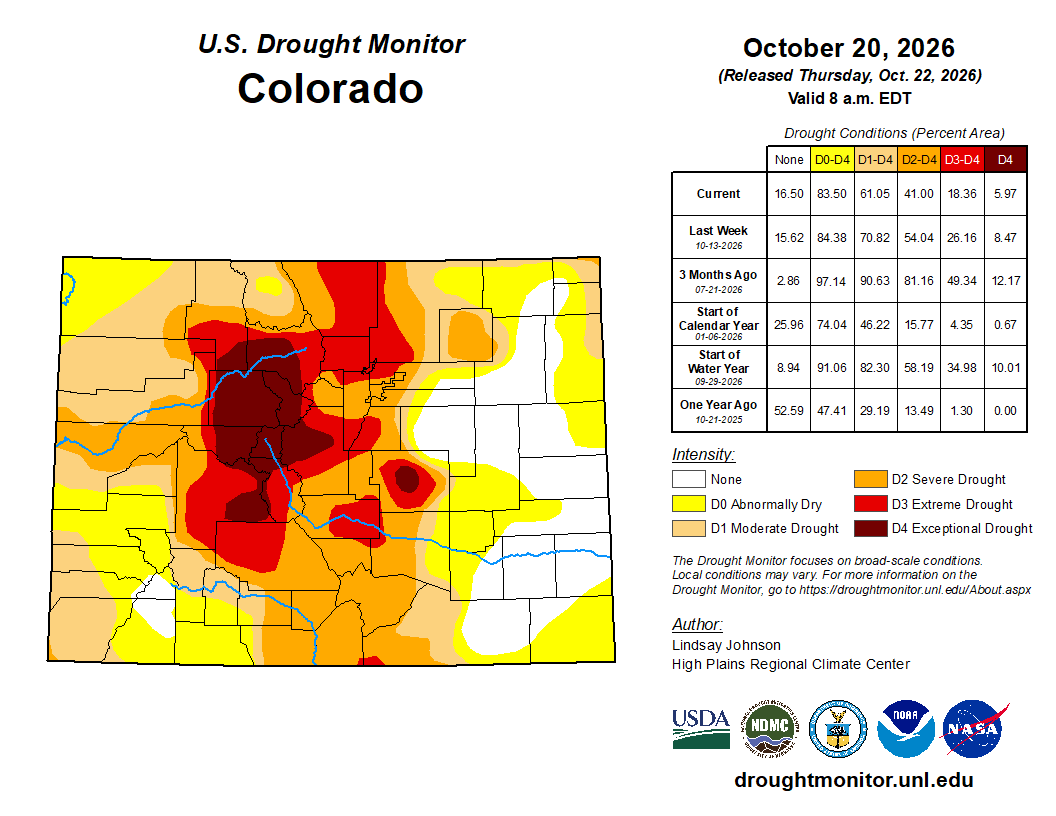
Unfortunately, despite that recent rainfall and even some snow, 100% of Gunnison County remains in severe to exceptional drought. “Areas to the south like Hinsdale and Sawatch County have seen some improvement in drought conditions due to the precipitation that occurred in September,” said Richards. While those southern areas saw one class of drought condition/soil moisture improvement, Gunnison County overall had one class of drought condition degradation. Richards reported that some southern areas received between three and six inches of rain during the early October precipitation events. The Upper Gunnison Basin was at 17% of the median amount of precipitation for the end of water year 2026 (which ended September 30) and temperature conditions for September were very warm—the second warmest in 132 years of record for the state. Richards said that was also 5.5 degrees warmer than the 20th century average…Temperatures in early October ranged from four to six degrees above normal based on the period of record…
Stream flows have been variable across the basin, including huge increases in flow at the Lake Fork, Slate and Taylor rivers around September 29. Richards said this helped make up for the low flows in August. The Slate River flow increased 129% in seven hours, and the Taylor increased by 153% in 16 hours. “So that precipitation event really helped stream flows quite a bit,” said Richards. Reservoir storage is at 47% of average for the entire basin and 33% of average for the upper basin (which includes Taylor and Blue Mesa reservoirs). Blue Mesa ended the water year at 143, 497-acre feet, which was 52% of the end of year levels in 2002, the next lowest year. Richards said Blue Mesa elevation has since declined another 1,030-acre feet and is 17% full. The current elevation of 7,413 feet is about 20 feet above the minimum power pool and 106 feet below the full pool. “We received communication on September 28 from the Bureau of Reclamation (BOR) that they were anticipating it may fall below power pool in April 2027 if conditions continue to decline,” reported Richards. “It’s in really dire condition.”
