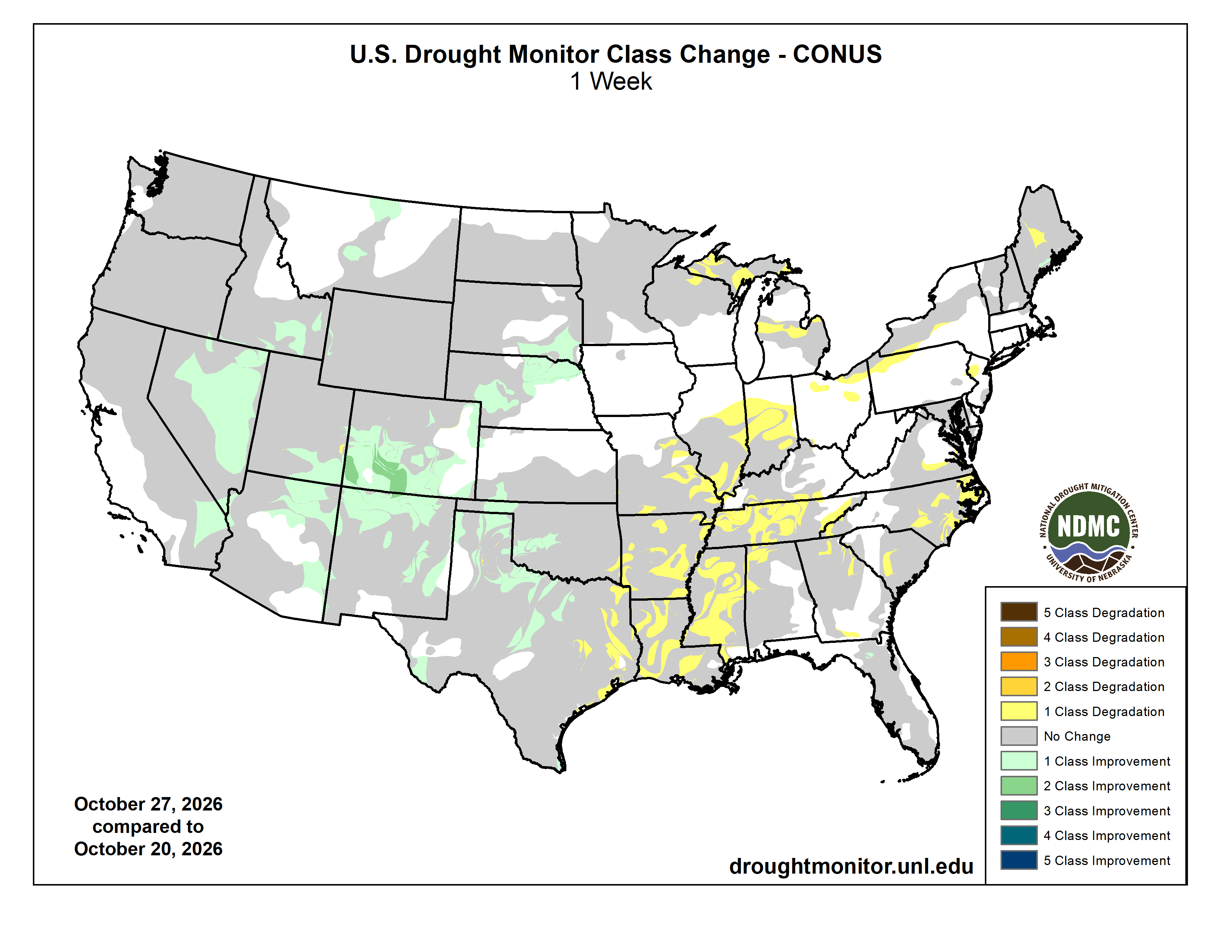
Click on a thumbnail graphic to view a gallery of drought data from the US Drought Monitor website.

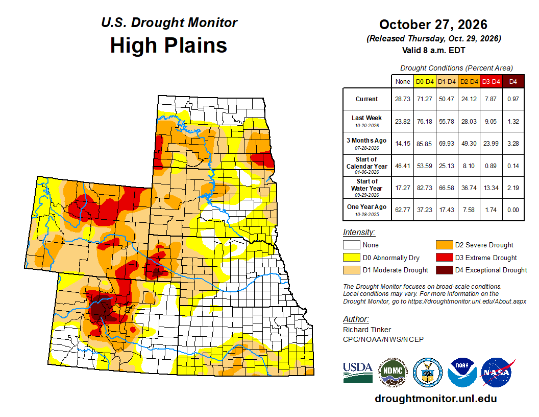
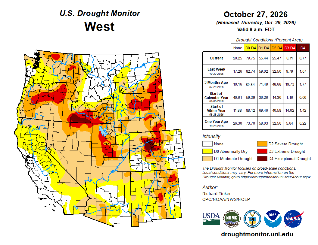
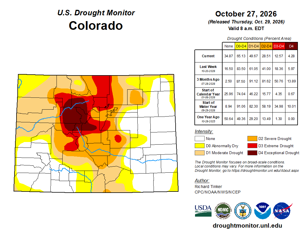
Click the link to go to the US Drought Monitor website. Here’s an excerpt:
This Week’s Drought Summary
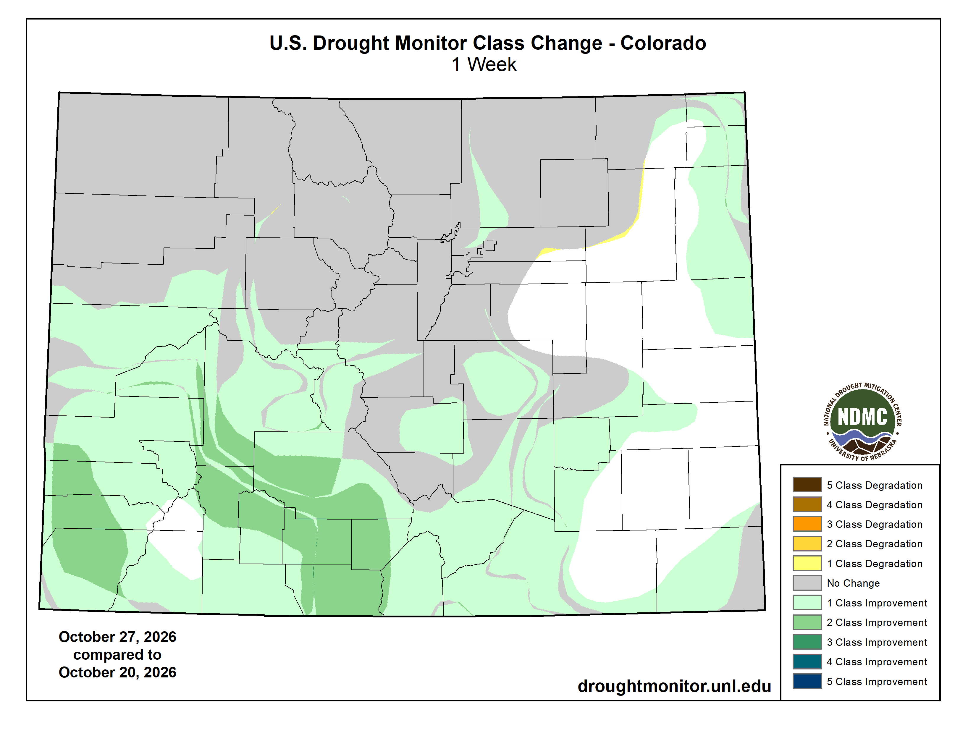
Most of the eastern half of the 48 Contiguous States received little or no rain last week. The only exceptions were across the eastern tier of the Florida Peninsula (over 2 inches in some areas), the Upper Mississippi Valley and northern Great Lakes Region (a few tenths to nearly an inch), and parts of coastal southeastern Texas (a few tenths to a little over an inch). Seasonably cool weather accompanied the fair weather across the northern half of the region, limiting drought intensification there. Warmer weather farther south led to broader areas of deterioration from the southern half of the Mississippi Valley eastward through the lower Mid-Atlantic. Farther west, moderate to heavy precipitation fell from the northern Great Plains to the southern High Plains and westward to the Pacific Coast. Some lower elevation locations, parts of the lower Colorado Valley, and parts of the northern Rockies recorded only light amounts to a few tenths of an inch, but amounts of at least 0.5 inch were observed elsewhere. The largest amounts (over 2 inches) fell on central and southeastern sections of the Four Corners Region, the higher elevations of southern California, the Pacific Northwest from the Cascades westward to the coast, and scattered locations across the higher elevations from western Montana southward through portions of Idaho, northern Utah, and far western Wyoming. Between 4 and 8 inches were observed in some areas near the Colorado/New Mexico border. This continued a pattern of heavy precipitation across much of the Four Corners Region, and significant further improvements were introduced in a large part of this area, with some 2-category improvements introduced across the wettest parts of southern Colorado…
High Plains
Excessive precipitation and areas of flooding were reported across much of central and southern Colorado last week, with at least moderate amounts (over 0.5 inch) common from the western half of Kansas northward through most of Nebraska and South Dakota. Moderate amounts also fell on western Wyoming in association with a pulse of tropical moisture that impacted much of the West. One-category improvements were widespread across the southern half as well as northeastern Colorado, along with central through northeastern Nebraska and southeastern South Dakota. In portions of south-central and southwestern Colorado where several inches of precipitation were observed, there were a few fairly broad areas where 2-category improvements were introduced. Elsewhere, dryness and drought did not change significantly enough to support improvements…
West
Light to moderate precipitation was widespread across almost the entire West Region last week, with locally excessive amounts (2 to locally 5 inches) reported in much of northern and eastern New Mexico, central Arizona, southeastern California, the Pacific Northwest from the Cascades to the coast, and southwestern California. Moisture surged northward out of the Four Corners Region at times, bringing widespread moderate to locally heavy precipitation for much of Utah, Idaho, and western Montana. The driest areas last week were in Washington and Oregon east of the Cascades, southeastern Montana, and the Desert Southwest, where up to a few tenths of an inch fell. The continued pattern of robust precipitation through most of the West Region led to continued improvement to dryness and drought. The most widespread improvement was noted across New Mexico (where localized flooding was reported), central and northern Arizona, and a large part of Nevada due to the wet pattern observed the past few weeks. Improvements were also noted in parts of the lower Colorado Valley, southern Utah, southern Idaho, and portions of central and western Montana. Long-term moisture deficits continue to impact a large part of the region despite the recent uptick in precipitation, so there was not much complete drought removal…
South
Over the past 2 to 4 weeks, different parts of the South Region have trended in markedly different directions. Heavy precipitation has been observed at times across western parts of the South Region, more specifically the central and western sections of Texas and Oklahoma. Areas of additional rainfall during this past week led to further improvements in conditions, some areas near the West Region free of dryness and drought. In contrast, rainfall has been much more sparse farther east, and another week of abnormally dry and warm weather led to broadscale deterioration across the Lower Mississippi Valley, Tennessee, and some of the eastern fringes of Oklahoma and Texas. D3 to D4 conditions now dominate a large part of this region across central and western Tennessee, Arkansas, Louisiana, and some adjacent areas, including northern and west-central Mississippi. Over the past 4 months, most locations across Arkansas, Louisiana, Mississippi, and southwestern Tennessee have recorded 8 to 16 inches less precipitation than normal, or generally less than half of normal…

Looking Ahead
During the next 5 days (through Nov 2), areas of heavy precipitation (1.5 to locally near 4.0 inches) are expected across central Arizona, the higher elevations of the central Rockies (including parts of Colorado that were inundated this past week), much of the High Plains of Texas, and part of the central Gulf Coast. Moderate amounts (0.5 to locally approaching 2.0 inches) are forecast for most of the higher elevations in the Rockies, a swath from the southern High Plains into the northern Great Plains, and most of the central and eastern Gulf Coast States. A few tenths of an inch with isolated higher amounts are expected across the rest of the U.S., with little precipitation anticipated along the central West Coast, southeastern Texas, the Mid-Atlantic, the Northeast, and the adjacent Great Lakes Region. Daily maximum temperatures are forecast to average 4 to 8 deg. F below normal across the central and western Four Corners, the Great Basin, and much of the Desert Southwest. Meanwhile, most locations from the northern and eastern Great Plains through the Great Lakes Region and across the Mississippi, Ohio, and Tennessee Valleys are expecting warmer than normal conditions, with daily highs averaging 5 to 13 deg. F above normal. The largest anomalies are anticipated across the southern Great Lakes Region.
During Nov 3-7, above-normal precipitation is at least marginally favored over most of the Contiguous U.S., Alaska, and the Big Island of Hawaii. The northern tiers of both Alaska and the western U.S. are the only exceptions, with drier than normal conditions expected from much of Montana through Washington and adjacent Oregon. Meanwhile, above-normal temperatures are also expected to dominate the country, with only parts of the western Hawaiian Islands and the Four Corners Region expected to average closer to normal temperatures.