#Colorado Corn Spring Forum Webinar, March 24, 2021

Corn sprouting. Photo credit: Colorado Corn

Click here for all the inside skinny.

Join us on March 24, 2021 for an afternoon Spring Forum Webinar to discuss what’s new in the corn world! We will be hearing from a great panel of speakers on global and local markets, have a pesticide update, see a presentation on corn marketing and finish up with updates on research projects the CCAC has invested in.

Schedule:
12:00-1:15pm: Welcome and Panel Discussion on global and local markets with Reece Cannady, Manager of Global Trade for the U.S. Grains Council; Nick Leiding, Senior Merchandiser for West Plains LLC; Joe Schuele, Vice President of Communications for the U.S. Meat Export Federation and Chris Allen, Vice President of Dairy Marketing and Economic Analysis, Dairy Farmers of America
1:15-1:30pm: Annual Review with Jeremy Fix, President, CCAC and Nicholas Colglazier, Executive Director, CCAC
1:30-2:00pm: Pesticide Update with Lanny Huston, Certified Crop Adviser
2:00-2:15pm: Break
2:15-3:15pm: Corn Marketing with Dr. Brent Young, Agricultural Business Management Economist with Colorado State University Extension
3:15-4:15pm: Research Project Reports with Reza Kashavarz, Ph.D. and Chad Godsey, Ph.D.

BONUS: If you attend the full webinar on March 24 and are a corn producer in Colorado, you can attend a Pesticide Applicator Workshop with Mountain West PEST on March 25 for free! This is a live online core credit training via Zoom Webinars.

To learn more about our speakers and their topics CCAC webinar, please visit https://coloradocorn.com/event/spring-forum-2021/ or you can register here.

E-mail media@coloradocorn.com for more information.

2020 Report on the Health of #Colorado’s Forests — @CSFS_Outreach

2020 Report on the Health of Colorado’s Forests cover

Click here to read the report:

The Colorado State Forest Service (CSFS) published its annual forest health report today, highlighting the current conditions of forests across Colorado and how the agency is improving the health of the state’s forests in the wake of historic wildfires.

After a devastating wildfire season, the report highlights the growing need to increase forest management across the state.

It also takes a regional look at forest health, offering statistics, insect and disease trends, and successes in forest management specific to four quadrants of the state.

As always, the report also offers a statewide outlook on trends in insect and disease activity in Colorado’s forests, as well as a look at the carbon storage problem in our state’s forests.

“Last year reminded us how important our forests are, as Coloradans escaped to forested areas in their communities and wildlands for tranquility, peace and a place to recreate and exercise,” said Mike Lester, state forester and director of the CSFS.

“Colorado’s forests are experiencing many challenges, from longer fire seasons to ongoing drought to more people living in the wildland-urban interface. In this report, we take a look at what is needed to protect the many benefits our forests provide in the face of these challenges – and what the Colorado State Forest Service is doing to address them.”

The 2020 Report on the Health of Colorado’s Forests focuses on “Protecting Our Future After a Historic Wildfire Year.” Key takeaways from the report include:

Living with Wildfire
The forest management needed to reduce wildfire risk to residents, lands, water supplies and economies is not happening fast enough. Colorado is primed to face the same types of uncharacteristic wildfires as last year unless an increase in the pace and scale of forest management is made a statewide priority, work is done more quickly and the buildup of beetle-killed and living fuels is addressed across the landscape in areas that can be accessed.

Carbon and Climate
Despite encompassing over 24 million acres, Colorado’s forests emit more carbon than they store. Our state is one of the five worst Lower 48 states in forest carbon emissions by some estimates. Colorado is contributing to a global problem, partly because our trees are not as healthy as they could be. Colorado’s forests need to be healthy in order to store carbon and mitigate climate change.

Insects and Disease
The spruce beetle remains the most damaging forest pest in Colorado. The report details the state’s top forest insects and diseases – and how bark beetles may affect wildfire behavior. The report also contains a map of where forests affected by spruce and mountain pine beetles overlap with the burn perimeters of last year’s wildfires.

FRWRM Grants
The Forest Restoration and Wildfire Risk Mitigation Grant Program continues to be a critical source of funding to address forest health issues on a local level. The report offers an example of how a state grant helped a community in Colorado Springs successfully mitigate its wildfire risk prior to the Bear Creek Fire in November.

Regional Project Highlights
Northeast Area

The CSFS is working to keep in check a hyperactive invasive species that is pushing out native vegetation, degrading wildlife habitat and draining water at Jackson Lake State Park and the nearby Andrick Ponds and Jackson Lake state wildlife areas. The CSFS is removing about half of the Russian olives that line picnic areas, campsites and hunting spots.

Southeast Area
Last year at Lake Pueblo State Park – one of the most popular state parks in Colorado with annual visitors exceeding 2.4 million – CSFS foresters assessed 191 trees over 200 acres of land to help keep park visitors safer. They focused on trees along trails and in campground areas, tagging those that posed safety concerns for mitigation by Colorado Parks & Wildlife.

Southwest Area
While time seemed to slow down for many last year with stay-at-home orders due to COVID-19, foresters in Gunnison County were in a rush to contain an outbreak of another kind ̶ the mountain pine beetle in the Taylor Canyon area. Had the beetle continued to increase populations at a rapid pace within lodgepole pine tree stands in this area, the risk of a catastrophic wildfire in the forest would greatly increase.

Northwest Area
In the southeast corner of Jackson County, the CSFS is improving the forest landscape at Owl Mountain while at the same time bolstering revenue for the timber industry. Despite a declining wood products industry in the state, the CSFS is helping sustain this local economy in northwest Colorado through a 376-acre project that is creating jobs for loggers and timber mills and generating revenue for state and federal agencies through a timber sale.

Each year, the forest health report provides information to the Colorado General Assembly and residents of Colorado about the health and condition of forests across the state. Information for the report is derived from an annual aerial forest health survey by the CSFS and U.S. Forest Service, Rocky Mountain Region, as well as field inspections, CSFS contacts with forest landowners and special surveys.

Copies of the 2020 report are available at all CSFS field offices. A PDF of the report and interactive maps of insect and disease activity are available at https://csfs.colostate.edu/forest-management/forest-health-report/.

Western states chart diverging paths as water shortages loom — The Associated Press #ColoradoRiver #COriver #aridification

In a photo from 2020, a distinct line around the rocky shore shows how much the water level has decreased in Nevada’s Lake Mead. Photo credit: Roberto (Bear) Guerra/High Country News

From The Associated Press (Sophia Eppolito and Felicia Fonseca):

As persistent drought and climate change threaten the Colorado River, several states that rely on the water acknowledge they likely won’t get what they were promised a century ago.

But not Utah.

Republican lawmakers approved an entity that could push for more of Utah’s share of water as seven Western states prepare to negotiate how to sustain a river serving 40 million people. Critics say the legislation, which the governor still must sign, could strengthen Utah’s effort to complete a billion-dollar pipeline from a dwindling reservoir that’s a key indicator of the river’s health.

Other states have had similar entities for decades, but Utah’s timing raised questions about its commitment to conservation and finding a more equitable way of surviving with less.

“There’s a massive disconnect all centered around climate change,” said Zach Frankel, executive director of the Utah Rivers Council, which opposed the legislation. “The other six basin states know the Colorado River is dropping, and they know they have to decrease their usage, while Utah is running around in this fantasy.”

[…]

The six members of the Colorado River Authority of Utah would oversee the state’s negotiations on the drought plan and other rules that expire in 2026. Opponents worry parts of the legislation would allow the authority to avoid scrutiny by keeping some documents secret and permitting closed meetings.

House Speaker Brad Wilson said Utah will pursue conservation, but that alone won’t meet the needs of one of the nation’s fastest-growing states. Utah is entitled to the water under longstanding agreements among the states…

Proposed Lake Powell Pipeline project map via the Washington County Water Conservation District (Utah) as of November 30, 2020.

The bill comes six months after the other states rebuked Utah’s plan to build an underground pipeline that would transport billions of gallons of water 140 miles (225 kilometers) from Lake Powell to a region near St. George, Utah, close to the Arizona border. Other states, such as Colorado and Wyoming, also are pursuing projects to shore up their water supply.

Water experts worry Utah, which experienced its driest year ever in 2020, is banking on water that might not be available and could further deplete Lake Powell. Utah is one of the…upper basin states that get their share of water based on percentages of what’s available but historically haven’t used it all. The lower basin states — Arizona, California and Nevada — get specific amounts that are subject to cuts.

Utah plans to tap 400,000 acre-feet of water on top of the 1 million acre-feet it typically uses.

Colorado River Basin. Graphic credit: Western Water Assessment

Phase I River Improvements Complete — City of #Montrose #UncompahgreRiver

Here’s the release from The City of Montrose:

The City of Montrose is pleased to announce that Phase I of the Uncompahgre River Improvements Project near North 9th Street is complete and open to the public. The project was completed under budget, ahead of schedule, and injury-free.

Construction of the Uncompahgre River Improvements Project started last fall and included the stabilization of riverbanks, restoration of a more natural stream system, improvement of aquatic and riparian habitats, and improvement of river access and fishing opportunities for the public. The project was made possible through a partnership with the Montrose Urban Renewal Authority and with the assistance of $784,000 in grants received from the Colorado Water Conservation Board and Colorado Parks and Wildlife.

“We are excited to bring this new recreational and fishing asset online for our residents,” City Engineer Scott Murphy said. “We feel that it will be a great complement to the recently-completed GOCO Connect Trail and it further expands our collection of great outdoor amenities right here in town.”

Uncompahgre River improvements via the City of Montrose.

The city would like to express a special thank you to the design and construction team Ecological Resource Consultants and Naranjo Civil Constructors for a job well done, Mayfly Outdoors for their 41-acre land donation within the project area, and to the volunteer river advisory committee who helped to guide the project through its planning phases.

The public is welcome to attend a virtual ribbon-cutting ceremony celebrating the project scheduled for Thursday, April 22, at 1 p.m. The live ceremony can be viewed online at the City of Montrose’s Facebook page.

Watch a video of the project:

Any questions regarding the project may be directed to City Engineer Scott Murphy at 970.901.1792.

#Colorado proposes a new paradigm for #YampaRiver — @AspenJournalism #GreenRiver #ColoradoRiver #COriver #aridification

An angler in the Yampa River in Steamboat Springs in early March 2020. Designating part of the Yampa River as over-appropriated would require some water users with wells to have an augmentation plan.
CREDIT: ALLEN BEST/ASPEN JOURNALISM

From Aspen Journalism (Allen Best):

Colorado water officials are considering whether to designate the increasingly stressed Yampa River from Steamboat Springs downstream to near its entrance into Dinosaur National Monument as over-appropriated.

If approved by the state water engineer, the designation would require augmentation plans for larger-volume wells along the river from Steamboat to Lilly Park, where the Little Snake River flows into the Yampa.

Augmentation plans document how the water used will be replaced to satisfy senior water rights. Such water is typically delivered from upstream reservoirs, both large and small.

The proposal comes amid growing evidence that the Yampa River can no longer deliver water to all users all the time as they wish. There have been two “calls” on the river in the past three years, limiting diversions of users with later — or junior — diversion decrees until those of older or more senior decrees are satisfied.

The changed hydrology of the river can best be understood at the gauging station along U.S. Highway 40 near Maybell. There, according to Division 6 Engineer Erin Light, annual flows a century ago of 1.5 million acre-feet annually have declined to 1.1 million acre-feet annually. The gauge during one year in the past decade recorded only 500,000 acre-feet.

Light is proposing the over-appropriation designation. When the comment period will begin and how long it will extend has not been determined.

“An existing water right is not going to be injured by this over-appropriation designation,” Light said on a video conference meeting Monday evening with more than 100 viewers. “They would be protected.”

Colorado law considers all groundwater to be tributary to the stream system unless proven otherwise. As Light recently explained to the Yampa/White/Green Basin Roundtable, when a stream system is over-appropriated, drawing water from a well can deplete the stream during times when the water in the stream is insufficient to satisfy all decreed water rights.

The Yampa River famously long had sufficient flows such that it lacked the close supervision of many of the state’s rivers, including all of those on the east slope.

“If you look at the South Platte, the Rio Grande and the Arkansas, these are basins where the surface water was over-appropriated 100-plus years ago,” said Kevin Rein, the state engineer. He will be making the decision whether to approve Light’s recommendation.

Only a few of Colorado’s rivers, mostly on the flanks of the San Juan Mountains, remain free of restrictions that require augmentation plans for wells along rivers as are now proposed for the Yampa.

Regulation of large-capacity wells began in Colorado during the 1960s. The laws were adopted in response to conflicts in the South Platte River Valley between farmers diverting water directly from the river and those drilling wells. State legislators clarified the legal rights of each. The key breakthrough was acceptance that groundwater was, in many cases, part of the same water system as the surface flows.

In the Yampa River valley, this designation would primarily impact new residential wells located on lots less than 35 acres and wells used for purposes other than domestic uses.

Permits for new wells located on lots of less than 35 acres in existing subdivisions may be issued for in-house use. If the well serves additional purposes, such as for livestock watering or a pond that intercepts groundwater on a lot less than 35 acres, then an augmentation plan must be in place before a well permit will be issued.

Well permits may be issued for as many as three single-family dwellings, irrigation of as much as 1 acre of lawn and garden, and for watering of domestic animals, on lots greater than 35 acres.

Based on her experience after designations of the Elk River and the Yampa River upstream of Steamboat Springs in the past decade, Light expects to see no major impacts.

“I have just not seen a tremendous impact on people because of this designation,” she said.

Stagecoach Reservoir, near Oak Creek, has several thousand acre-feet of its 36,000 acre-feet of storage capacity available for augmentation. YamColo, a smaller reservoir located on the Bear River, upstream from Yampa, has lesser quantities available. Both are administered by the Upper Yampa Water Conservancy District, whose boundary goes to but does not include Craig.

How much augmentation water will be needed from upstream reservoirs will depend upon the use, explained Holly Kirkpatrick, external affairs manager for the district. Does the well provide for livestock water, for example, and if so how many animals?

The conservancy district has enough water in the two reservoirs, especially Stagecoach, to provide for all needs, at least in the near term.

“Individual augmentation plans are of very small magnitude,” said Andy Rossi, general manager. “We might be talking about less than one acre-foot up to three acre-feet” (annually), he said of augmentation plans for new wells.

Traditional agriculture water users would normally seek storage rights in the reservoirs for larger volumes.

The gaging station in the Yampa River near Maybell has documented declined flows in the last century that have led to a state proposal to designate the river as over-appropriated. The designation, if approved, will affect permits for some new wells in the basin.
CREDIT: ALLEN BEST/ASPEN JOURNALISM

New paradigm

It will still be possible to file for new water rights in the Yampa subject to Colorado’s first-in-time, first-in-right pecking order. But the proposal signals a new paradigm for the full Yampa River Basin.

“It should be a clear indicator to those individuals establishing a new appropriation that water may not be available all of the time every year to meet their water needs,” Light said.

One of the key water rights in determining water use upstream are those at Lilly Park.

Twice in the past three years those rights have triggered “calls” on the Yampa River upstream, causing Light, as the water engineer, to require more junior users upstream to end their diversions. That same call could have been made in 2002, but the owner of the water rights at Lilly Park recently confided to Light that he didn’t want to cause the problems upstream in that notoriously dry year.

Enlargement of Elkhead Reservoir, near Hayden, has also allowed more water to be delivered downstream, forestalling the need for the designation of over-appropriation.

The Yampa River upstream of Steamboat Springs and many of its tributaries were previously designated as over-appropriated after a water decree for a recreational in-channel diversion for the kayak park in Steamboat Springs was granted in 2006.

For Steamboat Springs, one consequence was the need to create an augmentation plan for the wells along the Yampa River supplying its water treatment plant. The water from Stagecoach will be needed only if the river downstream is on call, meaning that Steamboat’s water diversions must be curtailed to meet needs of senior users.

Will the over-appropriation designation downstream of Steamboat impact the city’s water supplies?

“No, not that I’m aware of,” said Kelley Romero-Heaney, the city’s water resources manager.

The designation of over-appropriation “just means there’s more accountability” to ensure that new diversions don’t injure existing water users and water-right holders, Romero-Heaney said.

The state also designated the Elk River, north of Steamboat, as over-appropriated Jan. 1, 2011, just a few months after the first call. Water is available from Steamboat Lake for augmentation.

Small reservoirs have also been constructed to deliver augmentation water in the Elk River basin. Small augmentation reservoirs may be needed for new development downstream from Craig, such as for new rural subdivisions.

Light, in recommending the over-appropriation designation, identified no single trigger.

There were the two calls, critical low-flows in other years, and the increasing importance of juggling reservoir releases. She said the most important signal of a new era came in 2018, when the first call was placed on the river.

“I think you could make a good case of climate change and different ecological conditions,” said Rossi. Snowfall remains highly variable, but runoff has consistently arrived earlier followed by more intense heat and, perhaps, a later arrival of winter.

Soil moisture may also be a factor. If soils are dry going into winter, they’ll soak up more of the runoff.

“Start the season with dry soils, and that is the first bucket that needs to be filled when the snow starts melting,” Becky Bolinger, the assistant state climatologist for Colorado, explained last week in The Washington Post.

These changes were evident in 2020. Winter snows were healthy and the snow water equivalent, or the amount of water in the snow once it has melted, was 116% of median. Then came spring, early and warm. By June, the snow-water equivalent of the remaining snowpack had dropped to 69%.

Then came summer, hot and mostly absent rain. August broke records for both the hottest and driest summer month on the 130-year record. This combination of heat and lack of precipitation actually made 2020 worse than the other notorious drought years of recent memory: 2002, 2012 and 2018, according to Romero-Heaney

Designation of over-appropriation, however, would not forecast the climate in the Yampa Valley, cautioned Rein.

“It just recognizes what has been happening recently,” he said.

Climate change has started playing a significant role in declining river flows and falling reservoir levels in the Colorado River basin. These declines have led to concerns in Colorado during the last 20 years that requirements of the compact governing the Colorado River and its tributaries in the seven basin states could force curtailment of water use within Colorado.

From his perspective in Denver, Rein sees the proposed designation on the Yampa being neutral. All groundwater is already considered tributary to the river and hence should have no additional impact on compact compliance matters.

Aspen Journalism covers water and rivers in collaboration with the Steamboat Pilot & Today and other Swift Communications newspapers. This story ran in the March 10 edition of the Steamboat Pilot & Today.

Senate Confirms @POTUS’s Pick to Lead @EPA — The New York Times

Portrait of Michael S. Regan 16th administrator of the Environmental Protection Agency. By White House – https://www.whitehouse.gov/wp-content/uploads/2021/01/Michael_Regan.jpg, Public Domain, https://commons.wikimedia.org/w/index.php?curid=99054948

From The New York Times (Lisa Friedman):

The Senate on Wednesday confirmed Michael S. Regan, the former top environmental regulator for North Carolina, to lead the Environmental Protection Agency and drive some of the Biden administration’s biggest climate and regulatory policies.

As administrator, Mr. Regan, who began his career at the E.P.A. and worked in environmental and renewable energy advocacy before becoming secretary of North Carolina’s Department of Environmental Quality, will be tasked to rebuild an agency that lost thousands of employees under the Trump administration. Political appointees under Donald J. Trump spent the past four years unwinding dozens of clean air and water protections, while rolling back all of the Obama administration’s major climate rules.

Central to Mr. Regan’s mission will be putting forward aggressive new regulations to meet President Biden’s pledge of eliminating fossil fuel emissions from the electric power sector by 2035, significantly reducing emissions from automobiles and preparing the United States to emit no net carbon pollution by the middle of the century. Several proposed regulations are already being prepared, administration officials have said.

His nomination was approved by a vote of 66-34, with all Democrats and 16 Republicans voting in favor..

Mr. Regan will be the first Black man to serve as E.P.A. administrator. At 44, he will also be one of Mr. Biden’s youngest cabinet secretaries and will have to navigate a crowded field of older, more seasoned Washington veterans already installed in key environmental positions — particularly Gina McCarthy, who formerly held Mr. Regan’s job and is the head of a new White House climate policy office…

But most of the opposition centered on Democratic policy. Senator Mitch McConnell of Kentucky, the Republican leader, called Mr. Biden’s agenda a “left-wing war on American energy.”

“Mr. Regan has plenty of experience,” Senator McConnell said. “The problem is what he’s poised to do with it.”

In his testimony before the Senate last month Mr. Regan assured lawmakers that when it comes to E.P.A. policies, “I will be leading and making those decisions, and I will be accepting accountability for those decisions.”

Mr. Regan has a reputation as a consensus-builder who works well with lawmakers from both parties. North Carolina’s two Republican senators, Thom Tillis and Richard Burr voted to support his nomination. Even Senate Republicans who voted against him had kind words.

Photo credit from report “A Preliminary Evaluation of Seasonal Water Levels Necessary to Sustain Mount Emmons Fen: Grand Mesa, Uncompahgre and Gunnison National Forests,” David J. Cooper, Ph.D, December 2003.

#Drought news (March 11, 2021): One class improvement in a sliver of Costilla County otherwise no change in depiction for #Colorado

Click on a thumbnail graphic to view a gallery of drought data from the US Drought Monitor.

Click here to go to the US Drought Monitor website. Here’s an excerpt:

This Week’s Drought Summary

During the current period, most of the country was dry. There was some precipitation along the Gulf Coast and into the Southeast, with the greatest amounts over southern Georgia. Some storms impacted the Pacific Northwest as well, with coastal areas recording the most precipitation, especially on the coastal regions of far northwest California, southwest Oregon, and northwest Washington. Some scattered showers were recorded over the central Plains and New England, but generally these were not associated with significant precipitation. Temperatures were warmer than normal over much of the northern Plains and into the central Plains and Midwest with temperatures greater than 15 degrees above normal in the Dakotas. This took care of any remaining snows through the region and started the spring thaw on soils. Cooler than normal temperatures were recorded over much of the East and into the South where temperatures were 3-6 degrees below normal for the week. Cooler than normal conditions dominated much of New England with temperatures 9-12 degrees below normal…

High Plains

Dry conditions dominated the region, outside of some showers that impacted eastern Colorado and western Kansas. Warmer than normal conditions were widespread, with the Dakotas into Nebraska recording temperatures that were 15-20 degrees above normal for the week. The Army Corps of Engineers are considering conservation measures on the Missouri River basin if dry conditions continue. The 2021 calendar year runoff in the basin is anticipated at 21.8 MAF, or 84% of average. This eliminated most remaining snow in the region and began the spring thaw of soils. Due to ongoing dryness in the Dakotas, severe drought was pushed eastward this week and moderate drought was expanded to the east as well into western Minnesota. Livestock producers in the Dakotas are already separating out their animals in anticipation of needing to sell some off due to drought in the region. Another aspect of a winter with very little snow is that fire danger has rapidly increased in North Dakota. The local National Weather Service offices have started making their fire weather products more than a month early in response to the drought conditions. So far, 33 fires have burned more than 20,000 acres in North Dakota. In Kansas, abnormally dry and moderate drought conditions were pushed to the east in response to the most recent dryness in the region and above-normal temperatures…

West

Much of the region was dry this week with only areas of western Montana, northern California, southwest Oregon, and northwest Washington recording above-normal precipitation. Coastal areas were generally below normal for temperatures and most of the rest of the West was 3-6 degrees above normal. Water conservation measures are already beginning, with the Klamath County commissioners declaring a drought on the Klamath Basin as inflows into Upper Klamath Lake were some of the lowest in decades. As current snow data came in for December through February, some improvements were made in those areas with good seasonal snow accumulations and where the other indicators supported it. In Montana, moderate drought was improved in the southwest and south central portions of the state while severe drought was pushed farther to the west in the eastern portion of the state. Wyoming had improvements to moderate, severe, and extreme drought over the northern portions of the state. The Taos region of New Mexico also had improvements to the extreme and exceptional drought based upon the good snows in the Sangre de Cristo Mountains. Severe drought was pushed farther west along the California and Nevada border. North central Nevada also had some improvement to the extreme drought over the region based on the current water year data while portions of the severe drought in northeast Oregon also were improved based upon the current water year…

South

Temperatures were mixed in the region. Most of Texas and Oklahoma saw temperatures up to 3-6 degrees above normal while most of east Texas, southern Arkansas, Louisiana, and Mississippi were 3-6 degrees below normal. Dry conditions dominated the region with only portions of northern Oklahoma seeing any above-normal precipitation. Hay prices remained firm in the region with low hay stocks, due to drought, and producers needing to feed more during the recent cold snap in February. During this period, drought expanded and intensified over most of Texas and western Oklahoma where a mix of both short- and long-term issues are still embedded. A new area of exceptional drought was introduced over south Texas. In Louisiana, Arkansas, and Mississippi, abnormally dry conditions were expanded based on the short-term dryness in portions of those states missing out on recent rains. Abnormally dry conditions were also expanded over much of eastern Oklahoma and east Texas as the area continues to dry out…

Looking Ahead

Over the next 5-7 days, it is anticipated that precipitation totals will be greatest over the central Plains and Midwest, with the most precipitation expected over portions of Kansas and Missouri. An active pattern is anticipated, with the Southwest and California expected to see some good precipitation over the next several days. The Southeast is expected to stay dry again.

The 6-10 day outlooks show the greatest chances of below-normal temperature are for almost all areas west of the Mississippi River, with the highest probabilities over the High Plains. The best chances for above-normal temperatures are along the eastern seaboard and in the upper Midwest, Florida and northern Alaska. A change in patterns may be underway, with the best chances of above-normal precipitation over the Southeast and eastern United States. There is an above-normal chance of below-normal precipitation over the Southwest and northern Plains.

US Drought Monitor one week change map ending March 9, 2021.

How Big Oil Misled The Public Into Believing Plastic Would Be Recycled — National Public Radio

Top 10 sources of plastic pollution in our oceans.

From National Public Radio (Laura Sullivan):

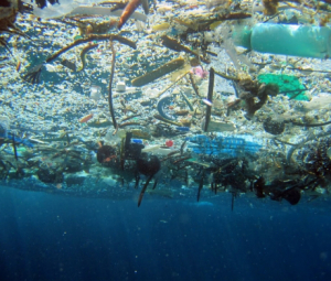
Laura Leebrick, a manager at Rogue Disposal & Recycling in southern Oregon, is standing on the end of its landfill watching an avalanche of plastic trash pour out of a semitrailer: containers, bags, packaging, strawberry containers, yogurt cups.

None of this plastic will be turned into new plastic things. All of it is buried.

“To me that felt like it was a betrayal of the public trust,” she said. “I had been lying to people … unwittingly.”

Rogue, like most recycling companies, had been sending plastic trash to China, but when China shut its doors two years ago, Leebrick scoured the U.S. for buyers. She could find only someone who wanted white milk jugs. She sends the soda bottles to the state.

But when Leebrick tried to tell people the truth about burying all the other plastic, she says people didn’t want to hear it.

“I remember the first meeting where I actually told a city council that it was costing more to recycle than it was to dispose of the same material as garbage,” she says, “and it was like heresy had been spoken in the room: You’re lying. This is gold. We take the time to clean it, take the labels off, separate it and put it here. It’s gold. This is valuable.”

But it’s not valuable, and it never has been. And what’s more, the makers of plastic — the nation’s largest oil and gas companies — have known this all along, even as they spent millions of dollars telling the American public the opposite.

NPR and PBS Frontline spent months digging into internal industry documents and interviewing top former officials. We found that the industry sold the public on an idea it knew wouldn’t work — that the majority of plastic could be, and would be, recycled — all while making billions of dollars selling the world new plastic.

The industry’s awareness that recycling wouldn’t keep plastic out of landfills and the environment dates to the program’s earliest days, we found. “There is serious doubt that [recycling plastic] can ever be made viable on an economic basis,” one industry insider wrote in a 1974 speech.

Yet the industry spent millions telling people to recycle, because, as one former top industry insider told NPR, selling recycling sold plastic, even if it wasn’t true…

Here’s the basic problem: All used plastic can be turned into new things, but picking it up, sorting it out and melting it down is expensive. Plastic also degrades each time it is reused, meaning it can’t be reused more than once or twice.

On the other hand, new plastic is cheap. It’s made from oil and gas, and it’s almost always less expensive and of better quality to just start fresh.

All of these problems have existed for decades, no matter what new recycling technology or expensive machinery has been developed. In all that time, less than 10 percent of plastic has ever been recycled. But the public has known little about these difficulties.

It could be because that’s not what they were told.

Starting in the 1990s, the public saw an increasing number of commercials and messaging about recycling plastic…

These commercials carried a distinct message: Plastic is special, and the consumer should recycle it…

It may have sounded like an environmentalist’s message, but the ads were paid for by the plastics industry, made up of companies like Exxon, Chevron, Dow, DuPont and their lobbying and trade organizations in Washington.

Industry companies spent tens of millions of dollars on these ads and ran them for years, promoting the benefits of a product that, for the most part, was buried, was burned or, in some cases, wound up in the ocean.

Documents show industry officials knew this reality about recycling plastic as far back as the 1970s.

Many of the industry’s old documents are housed in libraries, such as the one on the grounds of the first DuPont family home in Delaware. Others are with universities, where former industry leaders sent their records.

At Syracuse University, there are boxes of files from a former industry consultant. And inside one of them is a report written in April 1973 by scientists tasked with forecasting possible issues for top industry executives.

Recycling plastic, it told the executives, was unlikely to happen on a broad scale…

And there are more documents, echoing decades of this knowledge, including one analysis from a top official at the industry’s most powerful trade group. “The costs of separating plastics … are high,” he tells colleagues, before noting that the cost of using oil to make plastic is so low that recycling plastic waste “can’t yet be justified economically.”

Larry Thomas, the former president of the Society of the Plastics Industry, worked side by side with top oil and plastics executives.

He’s retired now, on the coast of Florida where he likes to bike, and feels conflicted about the time he worked with the plastics industry…

Thomas took over back in the late 1980s, and back then, plastic was in a crisis. There was too much plastic trash. The public was getting upset…

So began the plastics industry’s $50 million-a-year ad campaign promoting the benefits of plastic.

“Presenting the possibilities of plastic!” one iconic ad blared, showing kids in bike helmets and plastic bags floating in the air.

“This advertising was motivated first and foremost by legislation and other initiatives that were being introduced in state legislatures and sometimes in Congress,” Freeman says, “to ban or curb the use of plastics because of its performance in the waste stream.”

At the same time, the industry launched a number of feel-good projects, telling the public to recycle plastic. It funded sorting machines, recycling centers, nonprofits, even expensive benches outside grocery stores made out of plastic bags.

Few of these projects actually turned much plastic into new things.

NPR tracked down almost a dozen projects the industry publicized starting in 1989. All of them shuttered or failed by the mid-1990s. Mobil’s Massachusetts recycling facility lasted three years, for example. Amoco’s project to recycle plastic in New York schools lasted two. Dow and Huntsman’s highly publicized plan to recycle plastic in national parks made it to seven out of 419 parks before the companies cut funding.

None of them was able to get past the economics: Making new plastic out of oil is cheaper and easier than making it out of plastic trash.

Both Freeman and Thomas, the head of the lobbying group, say the executives all knew that…

The industry created a special group called the Council for Solid Waste Solutions and brought a man from DuPont, Ron Liesemer, over to run it.

Liesemer’s job was to at least try to make recycling work — because there was some hope, he said, however unlikely, that maybe if they could get recycling started, somehow the economics of it all would work itself out.

“I had no staff, but I had money,” Liesemer says. “Millions of dollars.”

Liesemer took those millions out to Minnesota and other places to start local plastic recycling programs.

But then he ran into the same problem all the industry documents found. Recycling plastic wasn’t making economic sense: There were too many different kinds of plastic, hundreds of them, and they can’t be melted down together. They have to be sorted out…

Industry documents from this time show that just a couple of years earlier, starting in 1989, oil and plastics executives began a quiet campaign to lobby almost 40 states to mandate that the symbol appear on all plastic — even if there was no way to economically recycle it. Some environmentalists also supported the symbol, thinking it would help separate plastic.

Smith said what it did was make all plastic look recyclable.

“The consumers were confused,” Smith says. “It totally undermined our credibility, undermined what we knew was the truth in our community, not the truth from a lobbying group out of D.C.”

But the lobbying group in D.C. knew the truth in Smith’s community too. A report given to top officials at the Society of the Plastics Industry in 1993 told them about the problems.

“The code is being misused,” it says bluntly. “Companies are using it as a ‘green’ marketing tool.”

The code is creating “unrealistic expectations” about how much plastic can actually be recycled, it told them.

Smith and his colleagues launched a national protest, started a working group and fought the industry for years to get the symbol removed or changed. They lost…

In response, industry officials told NPR that the code was only ever meant to help recycling facilities sort plastic and was not intended to create any confusion.

Without question, plastic has been critical to the country’s success. It’s cheap and durable, and it’s a chemical marvel.

It’s also hugely profitable. The oil industry makes more than $400 billion a year making plastic, and as demand for oil for cars and trucks declines, the industry is telling shareholders that future profits will increasingly come from plastic.

And if there was a sign of this future, it’s a brand-new chemical plant that rises from the flat skyline outside Sweeny, Texas. It’s so new that it’s still shiny, and inside the facility, the concrete is free from stains…

Larry Thomas, Lew Freeman and Ron Liesemer, former industry executives, helped oil companies out of the first plastic crisis by getting people to believe something the industry knew then wasn’t true: That most plastic could be and would be recycled.

Russell says this time will be different.

“It didn’t get recycled because the system wasn’t up to par,” he says. “We hadn’t invested in the ability to sort it and there hadn’t been market signals that companies were willing to buy it, and both of those things exist today.”

But plastic today is harder to sort than ever: There are more kinds of plastic, it’s cheaper to make plastic out of oil than plastic trash and there is exponentially more of it than 30 years ago.

And during those 30 years, oil and plastic companies made billions of dollars in profit as the public consumed ever more quantities of plastic.

Russell doesn’t dispute that.

“And during that time, our members have invested in developing the technologies that have brought us where we are today,” he says. “We are going to be able to make all of our new plastic out of existing municipal solid waste in plastic.”

[…]

Analysts now expect plastic production to triple by 2050.

#Colorado lawmakers, governor unveil $700M state economic stimulus plan. Here’s where the money will go — The Colorado Sun

Rich Meisinger Jr., business manager for the International Brotherhood of Electrical Workers, explains an aspect of the coal economy to Gov. Jared Polis in March 2020. Photo credit: Allen Best

From The Colorado Sun (Jesse Paul):

Top Democratic and Republican state lawmakers on Wednesday joined Gov. Jared Polis to unveil the broad strokes of a roughly $700 million state economic stimulus plan, most of which is set to go to “shovel-ready” infrastructure projects, including repairs to the Eisenhower-Johnson Memorial Tunnels and Interstate 70 bridges

The shovel-ready projects will total $170 million, or about a quarter of all the spending. Hundreds of millions more is set to be spent on other, longer term infrastructure projects, like expanding broadband access and revitalizing main streets in Colorado cities and towns.

The remainder of the spending includes initiatives to invest in rural Colorado, support the recovery of small businesses, workforce training and development, affordable housing development and mental health. There’s also money for child care and support for schools and students…

The announcement comes as President Joe Biden is expected to sign a $1.9 trillion federal stimulus plan, which Congress approved Wednesday. State leaders were awaiting the details of that aid package — which includes billions of dollars for child care, education, unemployment and other needs in Colorado — before finalizing their own spending plan…

The money Colorado lawmakers are using to pay for the state stimulus plan comes from unexpected tax revenue.

The legislature slashed the state’s budget last year by about $3.5 billion in anticipation of an economic downtown because of the coronavirus pandemic. While there was a downturn, the economy has fared better than expected, leaving the General Assembly with more than $1 billion to allocate…

In areas that experience low-severity burns, fire events can serve to eliminate vegetative competition, rejuvenate its growth and improve watershed conditions. But, in landscapes subjected to high or even moderate burn severity, the post-fire threats to public safety and natural resources can be extreme. Photo credit: Colorado State Forest Service

Under the stimulus plan, up to $131 million would go toward boosting agriculture and rural communities, including $20 million to $35 million in competitive grants for rural agriculture infrastructure investments and millions toward forest and watershed restoration projects to protect communities against wildfire.

Other spending priorities include:

Infrastructure:

  • $30 million on projects to revitalize community main streets
  • $60 million to $80 million in matching funds for downtown revitalization efforts and to create more affordable housing options in urban areas
  • $50 million to $75 million to expand broadband internet access
  • $30 million to $40 million for existing clean energy programs
  • Small business support

  • $40 million to $50 million in sales tax relief for small restaurants and bars
  • $20 million to $30 million toward lending institutions that cater to “historically underserved” entrepreneurs
  • $10 million to $15 million in one-time grants to small businesses, with a priority for rural, women, minority and veteran-owned businesses
  • Community and school support

  • $10 million to $15 million to rent, lease or buy hotel rooms for unhoused individuals
  • $8 million to $10 million in seed funding for a program to incentivize local governments to adopt affordable housing development policies
  • $5 million to $10 million to support child care businesses
  • $8 million to $9 million for mental health screenings in schools
  • Rural investments

  • $10 million to $25 million for forest restoration and wildfire recovery projects and another $10 million to $25 million toward watershed restoration grants
  • $10 million to $15 million to create new job opportunities as part of the transition away from coal
  • Workforce development

  • $15 million to $25 million in grants to local workforce boards
  • $10 million to $15 million to help provide scholarships for people with some college but no degree
  • Each proposal will come in the form of an individual bill. That legislation has yet to be released, so the details remain unclear.

    Fenberg said he expects stimulus measures to start being introduced in a matter of weeks. Polis is pressuring the legislature to act quickly so that Colorado’s economic revival can begin as soon as possible. He wants the stimulus money to be spent in the next 18 months.

    #EagleRiver Watershed Council: Let’s take a serious look at water efficiency — The #Vail Daily

    Here’s a guest column from the Eagle River Watershed Council (James Dilzell) that’s running in The Vail Daily:

    In the final week of February, Eagle River Watershed Council had a snowshoe hike planned on a new trail at Brush Creek Valley Ranch & Open Space to teach residents about snow science basics. It’s a trail I came to love this fall and winter – a quick jaunt from town, plenty of parking and not busy with other visitors. It winds along a small creek, through fields of junipers and swaths of scrub oak. In the four times I had visited there since November, the creek had always been at least partially frozen, and the entire trail covered in a gorgeous layer of snow.

    The day of our event, I arrived first and quickly noticed that the layer of snow had disappeared and exposed a bare-soil parking area. I took a few steps up the trail for a better view, hoping the drainage would have been protected from our intense sun and still covered in at least a small bit of snow for our snow science hike. Alas, the snowshoes filling up my Subaru wagon were entirely unnecessary, and our group simply walked up the exposed trail.

    I may be repeating some things we already know as residents of the arid West, but our lack of consistent snowpack this year is truly concerning. Yes, February brought some good storms, and our water year precipitation to date is hovering around 84% — but what we aren’t getting are those daily refills that are critical to sustain healthy snowpack through the entire winter. When graphed, our snowpack data looks like a sin-wave, melting out before another refill, rather than a semi-consistent uptick.

    The effect of this drought goes beyond a sub-par ski season. Stephen Jaouen and Maggie Guinta – both Natural Resources Conservation Service staff who joined our event – shared with the group that 80% of Colorado’s water comes from snowpack. This once-reliable reservoir of frozen matter melts out and sends water down the Eagle, into the Colorado River and on to 40 million users in seven states and Mexico. Reduced snowpack means reduced flows for recreation, drinking water and agriculture all the way down the line.

    Using data points like snow density and depth, along with snow-water equivalent calculations, which are gathered from automated Snow Telemetry sites and boots-on-the-ground snow surveys, the NRCS is able to share monthly forecasts for basins throughout the West. For us in Eagle County, the February forecast was bleak. Even if we were to see the best snowfall in 30 years over the next two months, the Eagle River still won’t hit average flows from April through July.

    There are other issues plaguing this water year, too. You might remember this fall, when the Eagle River flows were nearing 60% of average and almost our entire county was in D4 drought – the most severe. Our monsoon season was non-existent, and so we started off the snowy season with a deficit of soil moisture content.

    Reduced snowpack means reduced flows, and Mother Nature will snag some of that water to recharge groundwater and soil moisture before releasing water into our rivers and streams. To use a financial metaphor: some of our paycheck will be gone before it even hits the bank.

    While this seems like all doom and gloom, I’m not writing this article to be an alarmist. In fact, we’ve all heard these messages and warnings for years. Positive changes are being made, like new legislation allowing for the temporary donation of water rights and new water efficiency programs popping up around the state and in our community.

    I am instead writing this article to inspire our community to take action and take water efficiency seriously.

    We are not able to control the amount of water available in the mountains surrounding our towns, but we can choose to use our water wisely. In years like this, it’s up to all of us to prioritize those in-stream flows that fuel our recreation economy, keep fish and wildlife happy and allow us to thrive in this incredible place we call home.

    As we begin the transition to spring and summer, consider creating an at-home water efficiency plan with your family or roommates. Take your car to a commercial car wash instead of washing it at home. Or perhaps change up your landscaping by removing water-thirsty turf grass, replacing it with native and drought-tolerant tall grasses, flowers and shrubs.

    It’s going to take a village to collectively reduce our water use, and it’s about time we take better care of our river so that it can take better care of us. For more resources and actions to take, visit erwc.org/drought.

    James Dilzell is the education and outreach coordinator for Eagle River Watershed Council. The Watershed Council has a mission to advocate for the health of the Upper Colorado and Eagle River basins through research, education and projects. Contact the Watershed Council at (970) 827-5406 or visit http://erwc.org.

    Young scientists work on an inclusive soil moisture index — National Centers for Environmental Information

    Montana barn. Photo credit: Pixabay via NASA

    From NASA:

    NCEI continues its seven-year partnership with the NASA DEVELOP. This nationwide program utilizes NASA Earth science satellite data to address diverse environmental issues impacting communities Program working with early-career scientists and university students. This nationwide program utilizes NASA Earth science satellite data to address diverse environmental issues impacting communities. At the DEVELOP NCEI location, participants work on projects that focus primarily on climate applications and incorporate NCEI climate data.

    This spring, the NASA DEVELOP NCEI team is building upon the fall 2020 project by continuing research into water resource forecasting in the Upper Missouri River Basin. The fall 2020 team developed a framework for computing a Composite Moisture Index (CMI) to enhance forecasting of summer drought and flood conditions, and the spring team is focusing on refining this innovative tool. CMI leverages NASA Earth observations to derive soil moisture and snow cover data from the Soil Moisture Active Passive (SMAP), Gravity Recovery and Climate Experiment (GRACE), Snow Data Assimilation System (SNODAS), and the Terra Moderate Resolution Imaging Spectroradiometer (MODIS). The team is also exploring the impacts of adding stream flow measurements to the index and will conduct a sensitivity analysis to understand the thresholds and timescales of the CMI outputs.

    The team has partnered with the Montana Climate Office, the NWS Missouri Basin River Forecast Center, the U.S. Army Corps of Engineers, the NOAA Physical Sciences Laboratory, and the NOAA Regional Climate Services of the Central Region.

    #Colorado, #USDA double down on soil, #water conservation with $5M program — @WaterEdCO

    Center, Colorado, is surrounded by center-pivot-irrigated farms that draw water from shrinking aquifers below the San Luis Valley. Photo credit: Google Earth

    From Water Education Colorado (Sarah Kuta):

    When he first started farming in 1987, Curtis Sayles went through a new pair of cowboy work boots every year.

    These days, he’s still wearing a pair he bought three years ago.

    The difference? Sayles stopped using harsh fertilizers on his fields that ate through the leather of his boots. Sayles, a fourth-generation farmer with 6,000 acres near Seibert in eastern Colorado, now practices regenerative agriculture, a multi-faceted style of farming that advocates say has a host of benefits, including improved water efficiency, water quality and profitability.

    Above all else, regenerative agriculture can help restore healthy, fertile soils — working with nature, instead of against it.

    “I’m really tired of fighting nature — because she always wins. That’s her ace in the hole,” said Sayles, 64.

    Farmers like Sayles — and those who want to get started with regenerative agricultural practices but could use some support — are getting a boost thanks to a renewed partnership between federal and state agencies.

    In October, the U.S. Department of Agriculture’s Natural Resources Conservation Service and the Colorado Department of Agriculture’s Colorado State Conservation Board entered a five-year, $5 million agreement to help support regenerative agriculture, soil health, water conservation and urban farms.

    The agreement itself is new, but is the result of a long-standing partnership between the two agencies, which have entered into similar agreements every five years for the last 15 or so years, according to Clint Evans, Colorado state conservationist for the Natural Resources Conservation Service.

    The most recent agreement provides funding for 25 existing conservation positions across Colorado. More specifically, the agreement funds district conservation technicians in some of Colorado’s 76 conservation districts, which date back to 1937 and represent private landowners’ interests in conservation-related work such as water quality, energy efficiency and habitat improvement.

    District conservation technicians, which often work out of the USDA’s local service centers and collaborate with federal staffers, provide expertise to help farmers and ranchers address an array of questions or concerns ranging from water and wind erosion to irrigation distribution.

    Under the agreement, federal dollars provide 75 percent of funding for those positions, while the remaining 25 percent is split between the state and local conservation districts, Evans said.

    The agreement also provides funding for up to six new positions: five positions to support the state’s new effort to focus on soil health and one to support urban farmers with conservation practices.

    The Colorado Department of Agriculture launched its new Soil Health Initiative in 2020, with an overarching goal of helping farmers and ranchers boost their land’s productivity and drought resiliency by improving soil health. Other soil health initiatives are also underway in Colorado, led by groups like the Colorado Collaborative for Healthy Soils and Farmers Advancing Regenerative Management Systems (FARMS).

    Regenerative agriculture, which prioritizes soil health, has garnered renewed interest over the last 10 or so years as farmers and ranchers grapple with challenges like variable crop prices, climate change and increasing expenses, Evans said. Soil health also appeared throughout the 2018 farm bill, the federal legislation that encompasses a wide swath of agriculture-related issues and programs.

    “A lot of producers have started looking at soil health as a way that, over the long term, can help improve their overall sustainability and resources on their farm or ranch and help them become more profitable,” Evans said.

    Some of the most common tenets of improving soil health are minimizing soil disturbance while maximizing soil cover, biodiversity, and the presence of living roots. In practice, this means farmers stop tilling the land, or greatly reduce tilling, plant cover crops, grow a strategic rotation of diverse crops, add mulch, and introduce grazing livestock.

    Performed together over several years, these practices can lead to rich, productive soil that naturally retains moisture, produces nutrient-rich crops, and staves off weeds and pests without the need for as many added chemicals. By reducing the use of energy, resources and chemicals, these practices also save farmers and ranchers time and money in the long run, Evans said.

    According to the USDA, healthy soil practices can help reduce evaporation rates, while healthy soil itself can hold more available water, two outcomes that are especially helpful during drought. What’s more, reducing the use of fertilizers, pesticides and herbicides helps protect groundwater from chemical leaching. Healthy soil practices also reduce runoff and erosion, which keeps sediment out of lakes, rivers and streams.

    The soil’s health rebounded as it retained organic matter left on the land as crop residue. This reduced the need for fertilizer, and resulted in higher yields from their wheat, milo, corn and hay fields. Photo credit: Sand County Foundation

    Since they’re not tilling the land, farmers can make fewer trips using farm machinery, which leads to lower emissions and improved air quality. Healthy soil also sequesters carbon.

    “Soil health could be the baseline to healthy forests, healthy rangelands, healthy croplands,” Evans said. “All across agricultural lands, it could really be the foundation for drought resiliency and higher productivity even as climate and rainfall cycles change.”

    Many of these soil health benefits also help support the goals outlined in the Colorado Water Plan, a comprehensive vision for the state’s water future created in 2015, and the Greenhouse Gas Pollution Reduction Roadmap, the state’s plan for reducing pollution and transitioning to clean energy.

    The Colorado Water Conservation Board, which administers the water plan, worked with the Colorado Department of Agriculture to help develop the new soil health initiative to address water management issues across the state and help make progress on the water plan’s objectives, according to Sara Leonard, a spokesperson for the CWCB.

    Now, the CWCB is actively promoting soil health as a water conservation tool. For example, the board recently awarded a Colorado Water Plan grant to San Miguel County to study expanding its Payment for Ecosystem Services program, which gives landowners incentives for adopting practices that improve soil health, water conservation, and other ecological goals.

    “The water plan identifies soil health practices such as conservation tillage and mulching as promising practices to conserve water while providing other important co-benefits such as water quality enhancement, creating wildlife habitat and improving a producer’s bottom line,” Leonard said. “In particular, soil health practices show potential in enhancing resiliency to drought and reducing pressure on groundwater supplies by improving water-holding capacity and reducing evaporative losses.”

    Sarah Kuta is a freelance writer based in Longmont, Colorado. She can be reached at sarahkuta@gmail.com.

    Webinar: Water Wars! What are they good for?

    Click here for all the inside skinny and to register:

    A week doesn’t go by without someone saying there are water wars underway or about to kick off in California. How we manage and govern water is critically important to people, the environment, and the economy. But, are we really at war? Really? Do we believe there are always victors and vanquished? What is the impact of telling ourselves and others this is warfare, when in reality it is simply the messiness of working together in community?

    So, we’ve gathered a panel to answer the question: Water wars, what are they good for?

    Panel:
    Tim Quinn, former Executive Director of ACWA
    John Fleck, author of ‘Water is for Fighting Over: and other Myths About Water in the West’
    Tracy Quinn, Director, California Urban Water Policy, Healthy People & Thriving Communities Program at the NRDC

    Moderator: Lisa Beutler, Executive Facilitator with Stantec

    Time
    Mar 15, 2021 12:00 PM in Pacific Time (US and Canada)

    Preliminary flood zone maps for Larimer County now available for review — The #Loveland Reporter-Herald

    September 2013 flooding via AWRA Colorado Section Symposium

    From The Loveland Reporter-Herald (Ken Amundson):

    Property owners affected by changes in the federal flood plain maps will have a 90-day period to appeal map changes once preliminary maps reach the comment stage, which is expected to occur soon.

    Communities throughout Colorado are undergoing changes to maps as a result of new surveys. Those maps, when final, will control flood-insurance rates and local building codes.

    Rigel Rucker, project manager with engineering firm AECOM, reviewed during a city of Loveland meeting Tuesday where property owners can find information and how to navigate the process.

    The remapping process is part of the National Flood Insurance Program. Cities and counties participate in order to be eligible for federal disaster assistance should a flood occur and to permit property owners to buy flood insurance at federal rates…

    Preliminary maps can be found online at http://coloradohazardmapping.com. Users will select their county to zero in on changes specific to them.

    On a granular level, property owners can input their addresses to see whether the map changes are affecting them. In most cases, they won’t see changes.

    Changes have moved some properties in and others out of the flood zones. Rucker said 183 fewer properties are included in Larimer County but 12 more properties are listed in Loveland.

    People who choose to appeal the mapping decisions were advised to work through city or county officials, who will forward those appeals to FEMA for consideration. Kevin Gingery, senior civil engineer with the city of the Loveland, is the person to contact with questions or appeals.

    Rucker cautioned those who might appeal a decision that they must challenge errors based upon mathematical or measurement mistakes or changed physical conditions. Impacts of the 2013 flood were not the basis for the new maps, Rucker said, but rather assessments based upon aerial surveys coupled with on-ground review. A typical appeal might involve a building that was lifted out of the flood plain and is physically higher than the elevation shown on the maps.

    Once FEMA rules on appeals, a letter of final determination will be issued — which is expected by the end of 2021 — followed by a six-month period in which communities will adopt the data.

    #Water and #climatechange: the #ColoradoRiver Basin case study — Qatium #COriver #aridification

    From Qatium.com (Will Sarni):

    “If climate change is the shark, then water is the teeth.” This catchy saying has gained traction over the past several years, which is problematic. The saying appears to have originated from James P. Bruce, a Canadian hydrogeologist and is repeated often in climate and water discussions.

    Increasing greenhouse gas emissions and a resulting changing climate does impact water through increased scarcity (aridification), loss of stationarity, and extreme weather events. However, the intersection of climate change and water is complicated and not as simple as the shark and teeth analogy.

    If we solve climate change via mitigation and adaptation, we will still not fix our water problems. Poor water policies and governance, overallocation, lack of access to safe drinking water, sanitation and hygiene (WASH), and inadequate investment in water infrastructure are not resolved by fixing the so-called climate crisis. These wicked water problems have root causes that are independent of our failure to address climate change.

    The Colorado River Basin is an example.

    The American West, including the cities of Las Vegas, Los Angeles, Phoenix, Arizona, and Denver (among others) are within the greater Colorado River Basin (CRB), which is now among the world’s most water-stressed regions.

    In addition to its environmental value, the economic importance of the CRB cannot be overstated. The Colorado River supports $1.4 trillion in annual economic activity and 16 million jobs in California, Arizona, Nevada, Utah, Colorado, New Mexico, and Wyoming, which is equivalent to about 1/12 of the total gross domestic product in the U.S1. It is estimated that if 10 percent of the river’s water were unavailable (a decline quite possible under projected climate change scenarios of 10 to 30 percent flow reductions by 2050) there would be a loss of $143 billion in economic activity and 1.6 million jobs, in just one year.

    Map of the Colorado River drainage basin, created using USGS data. By Shannon1 – Own work, CC BY-SA 4.0, https://commons.wikimedia.org/w/index.php?curid=65868008

    The CRB supplies more than 1 in 10 Americans with some, if not all, of their water for municipal water use, including drinking water2. The CRB provides irrigation to more than 5.5 million acres of land and is essential as a physical, economic, and cultural resource to at least 22 federally recognized tribes. In addition, dams across the Colorado River Basin support 4,200 megawatts of electrical generating capacity, providing power to millions of people and some of the largest cities in the U.S.

    It has become clear that under current and projected conditions, the Colorado River is no longer able to meet the demands of its many users. The question is, why?

    Western water law is part of the problem. Most western states in the US maintain that all water is owned by the state and allow water rights to be allocated in association with a given property and beneficial use. For the most part, western states follow the Doctrine of Prior Appropriation (the “first in time, first in right” principle), wherein those who first established a claim to, and beneficial use of, water had a right to use such water. Any entity or individual obtaining a permit thereafter is then only able to utilize their water right after senior water rights holders’ allocations are fulfilled.
    In addition to each state’s management of water resources, a collection of statutes, court decisions and decrees, interstate agreements, and international treaties emerged from disputes over the allocation of the Colorado River’s water3. This collection of the primary basin-wide agreements governing the CRB is known as “Law of the River”.
    How well has the “Law of the River” worked, and how is it adjusting to the impacts of climate change?

    #LakePowell is seen in a November 2019 aerial photo from the nonprofit EcoFlight. Keeping enough water in the reservoir to support downstream users in Arizona, Nevada and California is complicated by climate change, as well as projections that the upper basin states of Colorado, Utah, Wyoming and New Mexico will use as much as 40% more water than current demand. A recent white paper from a lineup of river experts calls those use projections into question. CREDIT: ECOFLIGHT via Aspen Journalism

    The “Law of the River” has not played out well. The CRB has faced increasing water demand from agriculture, urbanization, and industry making competition for water fierce, thus leaving many without access to safe drinking water. Demand was increasing compared to supply before the impacts of climate change were understood.

    A recent article provides the history of overallocation and poor public policy along with the triggering of the CRB Drought Contingency Plan. During compact negotiations in the 1920s, records showed the river’s annual flows were lower than the total 17.5 million acre-feet allocated to the seven states and Mexico. In fact, three different studies during the 1920s estimated natural river flows at Lee Ferry at between 14.3 million acre-feet and 16.1 million acre-feet. Planners chose to ignore that information and evidence showing that the basin regularly experienced long periods of drought. In the lower basin, California, Nevada and Arizona have long overused their share of the river (approximately 7.5 million acre-feet annually, averaged over 10-year rolling cycles), whereas the upper basin states have yet to use more than around 4 million acre-feet (of the “remaining” 7.5 million acre-feet originally intended, but not necessarily guaranteed, for them).

    #Snowpack news (March 10, 2021): #Colorado statewide percent of median = 85%

    Colorado snowpack basin-filled map March 10, 2021 via the NRCS.
    Westwide SNOTEL basin-filled map March 10, 2021 via the NRCS.

    Northern #Colorado Fireshed Collaborative Launched to Increase Pace and Scale of Prescribed Fire Along Front Range — The North Forty News

    Prescribed fires are conducted in specific areas under desired conditions to reduce hazardous fuels build-up and restore the natural role of fire on the landscape. USDA Forest Service photo

    From The North Forty News (Steven Bonifazi):

    The Northern Colorado Fireshed Collaborative is officially launching to make forests more resilient to protect communities and keep water supplies reliable.

    The group is forced to address wildfire risk through strategic and coordinated cross-boundary forest and fire management on the state’s northern Front Range. The Northern Colorado Fireshed Collaborative’s (NCFC) vision is that landscapes throughout Northern Colorado can support wildfires without causing long-term damage to watersheds and the communities they serve.

    “We live in a fire-dependent landscape, but years of suppressing fires have left us with unhealthy forests that can fuel large, high-intensity wildfires as we saw in 2020,” said Ch’aska Huayhuaca, NCFC’s Coordinator and a Research Associate at the Colorado Forest Restoration Institute. “Prescribed fire is an important forest restoration tool that leverages a natural process to help foster ecosystem health and decrease fire risk to communities,” Ch’aska said.

    The NCFC’s mission involves increasing the pace and scale of fuel reduction treatments (mechanical/hand trimming and pile burning and prescribed fire and strategically managed wildland fires across jurisdictional boundaries). NCFC will increase the effectiveness of wildfire mitigation treatments and improve watershed protection outcomes through planning and implementation collaboratively across federal, state, county, and private lands.

    NCFC plans to treat 20 percent of the strategic priority areas within the first five years that they have identified using a combination of mechanical, manual, and managed fire methods. The location and size of treatments will be sufficient to reduce the risk of large contiguous areas of severe fire.

    “A Fireshed is an area where social and ecological concerns regarding wildfire overlap and are intertwined,” said Jen Kovecses, Executive Director of the Coalition for the Poudre River Watershed and a member of the NCFC. “We need to think and act at the scale of a wildfire – at a ‘fireshed’-scale – if we are going to successfully bring fire back into our watershed management toolbox,” Jen said.

    The NCFC consists of representatives from federal, state, and local natural resource agencies, non-profits, community groups, and researchers. Partners of NCFC include the U.S. Forest Service, Colorado Forest Restoration Institute, The Nature Conservancy, City of Fort Collins, City of Greeley, Fort Collins and Big Thompson Conservation Districts, Coalition for the Poudre River Watershed, Big Thompson Watershed Coalition, Boulder Watershed Collective, Estes Valley Watershed Coalition, Lefthand Watershed Center, The Ember Alliance, Forest Stewards Guild, Larimer County, Colorado State Forest Service, Natural Resource Conservation Services, Peaks to People Water Fund and Rocky Mountain Research Station.

    Lamar City Council Okays #Water Distribution Projects — The #Prowers Journal

    The May Ranch near Lamar, Colo., has never been plowed. Photo/Ducks Unlimited via The Mountain Town News

    From The Prowers Journal (Russ Baldwin):

    The council re-submitted a Tier 1 Grant application to fund half, or $71,818 of funding need to complete an update to the sewer and water master plan for the city. The total cost is estimated at $143,636. This will cover costs for a comprehensive evaluation of Lamar’s current water and wastewater treatment facilities, assessment of distribution and collection systems, capital improvements needed for future wastewater treatment and a rate study for both water and sewer systems.

    A loan for $1,089,200 has been secured with the Drinking Water Revolving Fund, allowing the city to move forward on a new water main stretching from Cedar Street to Savage Avenue. The city will coordinate with the current CDOT 287 reconstruction project to minimize any interference with their project running from Savage Avenue south as well as the train track crossing on Main Street. Community Development Director, Morgan Becker, secured a grant for $4,500 which will help defer the cost of flowers for the Main Street planters for the summer. Preliminary construction is expected to start in mid-March.

    A decision about #LakeNighthorse #water release could come later this week — The Farmington Daily Times #AnimasRiver

    Lake Nighthorse in the Ridges Basin in La Plata County, Colorado. The view is from the overlook on County Road 210. By Jeffrey Beall – Own work, CC BY 4.0, https://commons.wikimedia.org/w/index.php?curid=81402953

    From The Farmington Daily Times (Hannah Grover):

    The San Juan Water Commission continues to monitor conditions around the Animas River, including flow and snowpack, to decide if it will request a release from Lake Nighthorse this month.

    San Juan Water Commission Director Aaron Chavez said the decision will likely be made later this week…

    The City of Farmington initially requested a possible release from the reservoir as a way to test the water delivery from Lake Nighthorse to entities in San Juan County. The City of Aztec has expressed interest in also taking some of the water released if it does occur…

    The release depends on the water levels in the river remaining low because the test release will be a way to gather data for a drought scenario…

    A test release could help provide data about water loss as the water would flow down the Animas River channel. Because the irrigation ditches are closed for the winter, it would also provide data about water flow and downstream recovery in the river without any of that water being diverted for agriculture.

    On the morning of March 8, the Animas River was flowing at 138 cubic feet per second in the Cedar Hill area near the state line, according to the U.S. Geological Survey stream gauge. A stream gauge in Farmington was registering 175 cubic feet per second. These readings are about half of what would typically be seen on the Animas River in a normal year.

    Invasive Zebra Mussels Found in Pet Stores in 21 States — @USGS

    Here’s the release from the USGS:

    A citizen’s report of an invasive zebra mussel found in an aquarium moss package found in a pet store prompted a U.S. Geological Survey expert on invasive aquatic species to trigger nationwide alerts that have led to the discovery of the destructive shellfish in pet stores in at least 21 states from Alaska to Florida.

    A moss ball sold in pet stores containing an invasive zebra mussel. USGS photo.

    Amid concerns that the ornamental aquarium moss balls containing zebra mussels may have accidentally spread the pest to areas where it has not been seen before, federal agencies, states, and the pet store industry are working together to remove the moss balls from pet store shelves nationwide. They have also drawn up instructions for people who bought the moss balls or have them in aquariums to carefully decontaminate them, destroying any zebra mussels and larvae they contain using one of these methods: freezing them for at least 24 hours, placing them in boiling water for at least one minute, placing them in diluted chlorine bleach, or submerging them in undiluted white vinegar for at least 20 minutes. The decontamination instructions were developed by the U.S. Fish and Wildlife Service, the USGS and representatives of the pet industry.

    Zebra mussels are an invasive, fingernail-sized mollusk native to freshwaters in Eurasia. They clog water intakes for power and water plants, block water control structures, and damage fishing and boating equipment, at great cost. The federal government, state agencies, fishing and boating groups and others have worked extensively to control their spread.

    In 1990, in response to the first wave of zebra mussel invasions, the USGS set up its Nonindigenous Aquatic Species Database, which tracks sightings of about 1,270 non-native aquatic plants and animals nationwide, including zebra mussels. State and local wildlife managers use the database to find and eliminate or control potentially harmful species.

    The coordinator of the Nonindigenous Aquatic Species Database, USGS fisheries biologist Wesley Daniel, learned about the presence of zebra mussels in moss balls on March 2 and alerted others nationwide about the issue. Moss balls are ornamental plants imported from Ukraine that are often added to aquariums.

    “The issue is that somebody who purchased the moss ball and then disposed of them could end up introducing zebra mussels into an environment where they weren’t present before,” Daniel said. “We’ve been working with many agencies on boat inspections and gear inspections, but this was not a pathway we’d been aware of until now.”

    On February 25, an employee of a pet store in Seattle, Washington, filed a report to the database that the employee had recently recognized a zebra mussel in a moss ball. Daniel requested confirming information and a photograph and received it a few days later.

    Daniel immediately notified the aquatic invasive species coordinator for Washington State and contacted invasive species managers at the USGS and USFWS. He visited a pet store in Gainesville, Florida, and found a zebra mussel in a moss ball there. At that point federal non-indigenous species experts realized the issue was extensive.

    The USFWS is coordinating the response along with the USGS. The U.S. Department of Agriculture, several state wildlife agencies and an industry group, the Pet Industry Joint Advisory Council, are also taking steps to mitigate the problem. National alerts have gone out from the USFWS, the federal Aquatic Nuisance Task and regional aquatic invasive species management groups. Reports of zebra mussels in moss balls have come from Alaska, California, Colorado, Florida, Georgia, Iowa, Massachusetts, Michigan, Montana, Nebraska, Nevada, New Mexico, North Dakota, Oklahoma, Oregon, Tennessee, Vermont, Virginia, Wisconsin, Washington and Wyoming.

    “I think this was a great test of the rapid-response network that we have been building,” Daniel said. “In two days, we had a coordinated state, federal and industry response.”

    The USGS is also studying potential methods to help control zebra mussels that are already established in the environment, such as low-dose copper applications, carbon dioxide and microparticle delivery of toxicants.

    To report a suspected sighting of a zebra mussel or another non-indigenous aquatic plant or animal, go to https://nas.er.usgs.gov/SightingReport.aspx.

    In May of 2018, USGS Hydrologic Technician Dave Knauer found a batch of zebra mussels attached to the boat anchor in the St. Lawrence River in New York. (Credit: John Byrnes, USGS. Public domain.)

    The geomorphology of #FountainCreek: Life in the Watershed — Fountain Creek Watershed and Greenway District

    Elevation (2015, 2019) and Elevation-Change (2015−19) Maps—Study Area 01 By Laura A. Hempel 2020 via USGS

    From The Fountain Creek Watershed and Greenway District (Bill Banks) via The Colorado Springs Gazette:

    If you catch glimpses of Fountain Creek while driving, biking or walking along the creek, you know it tends to be relatively inactive. You might notice cloudy water due to suspended sediment, or you might spot new underwater sandbars. Most likely, you won’t see major changes. But guess what? Fountain Creek is always changing.

    Every year, Laura Hempel PhD and a team of USGS scientists investigate how our creek is changing. Dr. Hempel is a hydrologist with the U.S. Geological Survey’s Colorado Water Science Center, located in Pueblo. She explains that fluvial geomorphology is the study of how rivers shape the landscape — and are shaped by the landscape. This broad definition includes the concepts of hydrology (where the water is, how it gets there, where it’s going) and sedimentation transport. It also encompasses ecology, since vegetation influences how rivers behave.

    The USGS began monitoring the geomorphology of Fountain Creek in 2012, and Dr. Hempel joined the team in 2018. Currently, the team measures elevation and elevation change in 10 study areas annually, between January and April. This “leaf-off” season improves the GPS signals. (GPS enables the team to identify exact locations.) Plus, the low flow rate during winter makes it easier to wade in and collect data in the wetted channel. This annual monitoring effort is conducted in cooperation with Colorado Springs Utilities.

    In the past, the team used manual survey methods — a time-intensive “boots on the ground” approach. Covering the nearly 400 acres was a monumental effort! This year, the team will begin using LiDAR, an aerial-based mapping technology. “We can collect orders of magnitude more data points with LiDAR,” Dr. Hempel says. “Those data will allow us to produce much higher-resolution maps, which is really exciting.”

    In addition to measuring elevation and elevation change, annual monitoring of Fountain Creek’s topography will allow the team to study a variety of geomorphic metrics in the future. “For example, examining changes in the streambed’s elevation can indicate whether a reach is aggrading due to sedimentation or degrading due to erosion,” Dr. Hempel notes. “We also have the ability to measure the width and depth of the active stream channel and document specific changes in geomorphology. For example, is the channel cross-section smooth and U-shaped or is it complex and braided? Is the channel migrating laterally or straightening? These are some examples of metrics we can measure from this long-term monitoring data to quantify the river’s changing geomorphology.”

    Why monitor the geomorphology of Fountain Creek?

    Dr. Hempel explains that measuring changes in river geomorphology can lead to understanding WHY a change is happening. Specifically, what is causing the change? “Here’s the tricky thing,” she notes. “Rivers are dynamic. For example, river meandering is a natural process. Rivers are constantly evolving, so it’s difficult to disentangle natural geomorphic change and evolution from change that is outside of the river’s natural variability. Taking a step back even further, long-term monitoring tells us whether observed geomorphic changes are — or are not — outside of the river’s natural variability.”

    What might indicate an anomalous change from natural variability? “The long-term dataset can give us clues,” Dr. Hempel explains, adding a hypothetical example. “Let’s say that in the historic past, a particular meander bend grew at a rate of ½ foot per year, but for the last 10 years that same meander bend grew at a rate of five feet per year. This could indicate a fundamental change in the behavior of the river. The long-term datasets are incredibly important to document the baseline condition and, subsequently, determine whether a river has changed in a way that is outside of its natural variability.”

    Active monitoring gives us an understanding of the long-term picture, particularly when a river’s behavior impacts us. “If a river is migrating laterally at a faster rate and this reduces a farmer’s acreage or threatens I-25, that’s a problem,” Dr. Hempel notes. “Managers in the basin could address this one-off problem by installing riprap, for example, but that might not resolve the long-term issue. By identifying the cause, the long-term issue becomes solvable. That’s why monitoring Fountain Creek’s geomorphology is so important.”

    An engaged and informed public is a vital piece of the puzzle

    Dr. Hempel encourages residents of Fountain Creek watershed to learn more about our creek. “A river reflects all the changes upstream of it,” she says. “Hydrologists call it the ‘pour point.’ Our creek literally integrates everything that is happening upstream: water, erosion, sediment and people. It’s possible that Fountain Creek can be a healthy, ‘well-behaved’ river. Or it’s possible that it won’t be healthy and well-behaved. When we have an informed public, with their voice and votes, residents can better understand our creek. They can say what they want Fountain Creek to be and, if needed, support and implement measures to improve it.”

    Check out interactive maps of Fountain Creek!

    If a picture’s worth a thousand words, an interactive map may be worth 10 times more. Take a few minutes to review a brief report titled “Elevation and Elevation-Change Maps of Fountain Creek, Southeastern Colorado, 2015-19,” authored by Dr. Hempel. And don’t miss the 10 interactive maps that accompany the report, illustrating elevation changes for each of the 10 Fountain Creek study areas.

    For example, Study Area 1’s map layers show that the meander bend in this reach migrated toward the west and became more exaggerated between 2015 and 2019. Click the elevation-change map button, and you’ll notice that its lateral migration resulted in deposition (an increase in elevation) on the east side of the main channel and erosion (a decrease in elevation) on the west side.

    To access the maps’ interactive layers, you’ll need to download the PDF files and view them in Adobe Acrobat DC — or use Adobe Reader DC, which is free to download. Find the report and maps here: http://pubs.er.usgs.gov/publication/sim3456.

    Bill Banks is the executive director of the Fountain Creek Watershed Flood Control and Greenway District. The District was established in 2009, to manage, administer and fund capital improvements necessary to maintain critical infrastructure and improve the watershed for the benefit of everyone in the Fountain Creek watershed.

    The Fountain Creek Watershed is located along the central front range of Colorado. It is a 927-square mile watershed that drains south into the Arkansas River at Pueblo. The watershed is bordered by the Palmer Divide to the north, Pikes Peak to the west, and a minor divide 20 miles east of Colorado Springs. Map via the Fountain Creek Watershed Flood Control and Greenway District.

    @USBR: #GlenCanyonDam Spring Disturbance Flow #ColoradoRiver #COriver

    Glen Canyon Dam high flow release photo.

    Here’s the release from the Bureau of Reclamation:

    The Department of the Interior will conduct a spring disturbance flow release from Glen Canyon Dam, Arizona, beginning March 15 at 5 a.m. and ending March 26 at 8 a.m.

    A spring disturbance flow is planned at Glen Canyon Dam from March 15 to March 26. It is expected to maximize ecosystem benefits to the Colorado River ecosystem through the Glen, Marble, and Grand canyons, while meeting water delivery requirements and minimizing negative impacts to hydropower production. The spring disturbance flow will not affect the monthly or annual release volumes from Lake Powell through Glen Canyon Dam.

    The spring disturbance flow capitalizes on a unique low flow of 4,000 cubic feet per second for 5 days, which is needed to conduct maintenance on the apron of Glen Canyon Dam. This low flow will be followed by a gradual increase to higher releases that will culminate in a discharge of approximately 20,150 cubic feet per second for 82 hours. The peak release of the spring disturbance flow will stay within the maximum release levels allowed under normal operations.

    This combination of low and high flows is expected to disturb river bottom habitats and may drive positive aquatic ecosystem responses like increased algae and insect production. This could increase aquatic insect prey available for endangered humpback chub, non-native rainbow trout, an important sportfish, as well as other wildlife. The spring disturbance flow may disadvantage brown trout in Glen Canyon by reducing survival of emerging fry. The spring disturbance flow may also provide new scientific information that can be used in future decision making.

    Recreational users are reminded to exercise caution along the Colorado River through Glen and Grand Canyons during the entire spring disturbance flow period.

    The March 1, 2021 #Colorado Water Supply Outlook Report is hot off the presses from @NRCS_CO

    Click here to read the report:

    A reverence for rivers: “…none of us knows how to put into operation a philosophy of #water management” — Luna Leopold

    Created by Imgur user Fejetlenfej , a geographer and GIS analyst with a ‘lifelong passion for beautiful maps,’ it highlights the massive expanse of river basins across the country – in particular, those which feed the Mississippi River, in pink.

    From Luna B. Leopold Department of Geology and Geophysics, University of California, Berkeley, Berkeley, California 94720:

    Dr. Luna Leopold discusses the importance of bankfull discharge on the New Fork River near Boulder, Wyoming. Photo courtesy of U.S. Forest Service

    This paper was the keynote address to the Governor’s Conference on the California Drought, Los Angeles, California, March 7, I972

    In the years around 450 B.C., that is about 2,400 years ago, the most widely travelled of the time was Herodotus. His book The Persian Wars differs from any previous written history in that he was conscious of the influences of geography, climate, and social custom in the direction of development of political and economic history of a state.
    In all the intervening time, we seem not to have learned how the political and economic aspects of our lives are related to geog- raphy and climate, nor have we been able to bend social custom to accept the constraints placed on us by geography and climate. One of the obvious constraints is the finite nature of nonrenewable resources. Even those resources that are not physically destroyed by use, as oil and coal are destroyed by burning, are usually so geographically dispersed by use that they can never again be collected together in usable concentrations. This happens to many metals on which we depend.

    As far as renewable resources, such as water and timber, are concerned, all are parts of operating natural systems that can be deranged with very troublesome results. The hydrologic system of precipitation, streamflow, sediment, dissolved salts, ground water and evapotranspiration is typical of a system that can be deranged. Moreover, such operating systems are subject to natural fluctuations resulting from climate and geography. These fluctuations can be lessened but not eliminated.

    The management of resources cannot be carried out successfully if it is looked upon as just another facet of economics, administration, and politics. Yet the latter view describes rather accurately our present approach to resource use (it can hardly
    be called management).

    The view that Herodotus elaborated had little effect on the course of events between the time of Alexander’s death and the final conquest of Greece by Rome. Neither he nor any of the ad- ministrative and political leaders knew how to use a philosophic view of geography, climate, and social development to guide the direction of history. Again and again the requirements of crisis governed even long-range decisions that might better have been deferred until the crisis had passed and the decision makers could afford a more balanced or philosophic view of the future.

    But crisis offers an advantage in that wide attention is attracted to the problem even if its underlying causes are perforce clouded by the immediacy of pressure. There is at least a greater possibility that diverse factions might be persuaded to look more closely at their common problems and perceive what unanimity eirists in their joint aspirations.

    In suggesting here some aspects of the geographic, climatic, and sociological aspects of our resource problem, I recognize well enough that none of us knows how to put into operation a philosophy of water management, but there may be some merit in ex- amining some of the elements that might be included in such a philosophy.

    In choosing three particular elements, out of many possible ones, to mention here, I have chosen one to fit each of the three classes of argument usually marshalled against their consideration. Against philosophic points of view, the contrary arguments include (1) Our technology can fix it; (2) It is politically impos- sible; and (3)It is an example of the impractical idealism of crackpot environmentalists.

    First, in the construction of any engineering project, there always will remain some final increment of risk. Because it cannot be eliminated, it is necessary to know in advance how one will deal with that unusual event when it finally comes to pass. The answer to this will be: “We will build more dams and bigger ones.” In other works, our technology will fix it.

    Second, in the face of obvious limitations of resources, whether renewable or nonrenewable, continued and indefinite expansion of resource use is patently impossible. Some movement toward a steady-state condition that lies within the bounds of resource availability is not only the crux of a resource management philosophy but is also the acid test of leadership. I do not consider this politically impossible. The public is learning. It may well be the best political course to pursue.

    Third, there is a balance or harmony in natural systems which, dictated by the laws of physics, has gradually developed during the 4 billion years of Earth’s history. The maintenance of this balance is not only to the advantage of human organization, but should be the object of both our wonder and our admiration. The desire-to preserve this harmony must also be incorporated into any philosophy of water management, and I will call this, as did Herodotus, a reverence for rivers. If this is environmental idealism, then let it be said that I am an idealist.

    On the first point, any building, every bridge we drive over, every dam that stores water, every highway culvert is designed for a chosen load considered to represent a reasonable choice between the costs of stronger building and the costs of failure. Only in the design of the spillway of a large dam is the maximum possible event used in the calculations. In the design of a stormwater sewer system on city streets, the event is usually that which may be expected on the average once in 15 or 20 years. Small earth dams built by government agencies usually use a spillway design such that failure once every 25 or 30 years is expectable. In all interstate highways where federal money is used, the design criterion for culverts is the 50-year event. When, as will surely happen sooner or later, a more extreme event occurs, it is assumed that the structure will fail or will at least not carry out its designed function.

    Water-supply structures such as reservoirs are no exception. The residual risk can be reduced by building more of them and larger ones, but each increment of storage has less effect than the previous one and costs much more. The limit is reached, as on the mainstem of the Colorado River, in which if more storage is provided, the increase in evaporation cancels out any increase in the controlled yield of water.

    Interestingly, the schemes ordinarily used for supplying water do not include any definite plans for handling the situation that is sure to arise sooner or later when the normal variance in hyrdologic phenomena brings about the improbably but expectable deficiency. Even the rainfall condition in 1977 is comparable in probability to that faced gladly by many people who play a game of chance such as roulette. At San Francisco, for example, the probability of a recurrence of the lowest rainfall year on record, 1958, is 270, or 2 chances out of 100. That is to say the probability of such a low rainfall occurring in any year is 1 in 50. At the same precipitation station, the lowest total in 2 successive years was in 1958-1959. In that 2-year period, 26.06 inches fell. The probability of this event is also just about 270, or 1 chance in 50. Again at that station, the lowest 3-year total was in the years 1958-1960. The probability of occurrence of such a low 3-year total is close to 170, or 1 chance in 100.

    Now turning to the present year, if at the same San Francisco station (Sunset District) the rainfall in the present year reaches 10 inches, then the 3-year total on June 30 will be 44.4 inches. This total will have a probability of 370, or 1 in 33. The same kind of probability analysis can be made on any other station, groups of stations, or streamflow record. The present drought is obviously serious. It is unusual. But it is expectable on the basis of the past record. In other words, it will occur again in the future.

    The difficulty we find ourselves in is not due to the fact that the present drought is impossible to imagine. It could not be predicted, but its eventual occurrence was assured. We are caught with minimal plans to deal with an event sure to occur. Whereas for earthquakes the occurrence is not susceptible to probability analysis because the causal mechanisms are not random, for cli mate the hydrologic phenomena of flood and drought may be treated statistically, and good estimates of probability are available to us. The departure from the mean value is expectable, but the particular year or years in which it will occur cannot be forecast. Such is the nature of hydrologic events.

    Water, Rivers and Creeks cover

    In a management philosophy and plan, it is far more necessary to minimize impact of dry years than to contend with wet ones. [ed. emphasis mine] Though the risk of a deficient year is always present, seldom are definite plans on hand to cope with the situation when it finally arises. Rather, at the time of crisis there is a tendency toward grandiose plans to eliminate one further increment of risk, but a residual risk remains. The same crisis will occur again, less often but equally sure. Now is the time to lay plans for meeting an assured future event. It is not the time to plan expensive projects to reduce the risk by some small increment.

    There are strategies that might help prepare for such eventualities. They will ameliorate the losses but not eliminate all hardships. However, as in all water development, they require time and advance preparation. One is as follows: There are in various parts of the western states groundwater bodies too deep to be economically developed under usual economic standards, or they have marginal water quality. These, and especially those remnants of the ice-age ground-water bodies not being recharged now, should be saved from ordinary development and reserved only for times of exceptional need. But advance engineering is needed to explore and tap them and to connect to them transmis- sion lines ready for some future contingency.

    It is hardly in the public interest progressively to deplete stored but irreplaceable groundwater bodies whose greatest social use might be as unused reserve to be drawn on sporadically only when the need is grave. Such sporadic use would greatly extend the life of such irreplaceable water and would put it to a highly valued use.

    In contrast, we are in several regions continuing to pump groundwater that is not being replenished. Apparently we will continue to do so as long as present conditions make its withdrawal even marginally economic. In some instances even this slim economic margin is made possible only by public subsidy through price supports.

    There are many other strategies. The reuse of treated waste water is an obvious one. In this instance also, even if continued reuse on a permanent basis is uneconomic, advance preparation to reuse treated water in emergencies would be an approach to the problem of the residual risk.

    Second, the occurrence of improbable but expectable deficiencies in any resource should remind us that ever-continuing growth in resource use is the antithesis of a philosophy that faces reality. In our economic climate there are few if any precedents for a fundamental re-examination of this matter and its consequences. To face this inevitable future requires the highest level of statesmanship, and crisis may provide the impetus for developing a new outlook.

    The course in the past in which any and all persons may presume that they will be provided the usual resources of water, energy, and other public commodities, at any geographic location and forever in time, must eventually be abandoned. It cannot be assumed that if concentration of people continues unabated they will necessarily be supplied with those resources which at an earlier date were either nearly free or at least less expensive.

    Finally, a philosophy of water management must pay heed to the fact that the hydrologic system is a highly interconnected plumbing network. Changes made in one part of the system have influences downstream. The continued functioning of the system is of great importance. To test whether the system is operating satisfactorily by economic and legal criteria alone will not guaran- tee its continued health. What is needed is some deeper feeling.

    Speaking of the Persians who dominated Asia Minor in the 5th century B.C., Herodotus said, “They never defile a river with the secretions of their bodies, nor even wash their hands in one; nor will they allow others to do so, as they have a great reverence for rivers.” It is the last phrase that deserves our attention. The river is like an organism; it is internally self-adjusting. It is also resilient and can absorb changes imposed upon it, but not without limit. The limit beyond which a river cannot adjust is well illustrated by some of the effects of our national program of channelization, in which we have already dredged, straightened, channelled, revetted, trained, and “improved” more than 16,500 miles of river channels in the United States, quite apart from the thou- sands of reservoirs already built. On the drawing board of federal agencies are plans to “improve” similarly another 10,000 miles of river channels. As one minor example, the Blackwater River in Missouri was straightened and shortened 60 years ago and has since then continually and progressively lowered its bed by erosion, washing’out a succession of bridges built increasingly larger. Downstream from the improved area, flooding has increased. The river has not been able to re-establish its equilibrium.

    The great geographer, William Morris Davis, viewed the river system as having a life of its own. Its youthful headwaters, he said, are steep and rugged. It rushes toward the sea, eroding bed and bank on its way. In its central part, it is mature, winding sedately through wide valleys adjusted to its duty of transporting water and sediment. Near its mouth it has reached, in its old age, a nearly level plain through which it wanders in a somewhat aimless course toward final extinction as it joins the ocean that had provided the sustaining waters through its whole life span.

    Man’s engineering capabilities are nearly limitless. Our economic views are too insensitive to be the only criteria for judging the health of the river organism. What is needed is a gentler basis for perceiving the effects of our engineering capabilities. This more humble view of our relation to the hydrologic system requires a modicum of reverence for rivers.

    What is old is new again.

    #Snowpack news (March 7, 2021): Statewide percent of median = 86%

    Click on a thumbnail graphic to view a gallery of snowpack data from the NRCS.

    Here’s the Westwide SNOTEL basin-filled map for March 5, 2021 via the NRCS.

    Westwide SNOTEL basin-filled map March 5, 2021 via the NRCS.

    And just for grins, here are several early March snowpack maps for Colorado.

    This slideshow requires JavaScript.

    Recent snowstorms are barely scratching the surface of #Colorado’s ongoing #drought — The Colorado Sun #snowpack #runoff

    From The Colorado Sun (Lucy Haggard):

    The state needed an above-average snow year this winter to reverse the drought’s momentum. Forecasts for the next few months aren’t optimistic, either.

    Last week’s snowstorms across the Front Range were enough to downgrade some areas from “extreme” drought to “severe,” according to the latest national drought monitor report released Thursday by the University of Nebraska. And the previous week’s map had downgraded much of the San Luis Valley from “moderate” drought to “abnormally dry.”

    That’s the good news. The bad news: 98.57% of the state is still in drought, to varying degrees. And experts aren’t confident that conditions will improve anytime soon.

    Colorado Drought Monitor March 2, 2021.

    Unlike tornadoes, hurricanes or other weather events, drought is a phenomenon that builds over time, and its effects compound as it persists. Brian Fuchs, a climatologist with the National Drought Mitigation Center and the author of this week’s drought monitor report, noted that some regions of the state, particularly the southwest, have been drier than average for multiple years. This time last year, 45.33% of the state was in drought, none of which was classified in the worst two categories.

    As of Thursday’s report, 56.66% of the state’s drought is “extreme” or “exceptional.” Colorado’s current drought conditions are the result of a combination of earlier-than-average snowmelt last spring, a lack of summer monsoons and a warm, dry autumn that led the state to use even more of its water reserves. Add this winter’s lackluster snowfall and it becomes a tricky situation.

    “If it took a number of years to get into drought, what will it take over the next several years to come out of drought?” Fuchs said.

    Answering that question is a complicated task. The order of operations is important, too; soils need to rehydrate first, soaking up runoff like a sponge, before the water can continue on to rivers and streams.

    In an ideal scenario, the state would have received above-average snowpack this winter to saturate dried-out soils, store up enough moisture for better runoff this spring and summer and refill reservoirs. But snow-water equivalent estimates for Colorado’s eight alpine river basins are at least a little below their 30-year averages, according to reports from the National Resource Conservation Service…

    Colorado snowpack basin-filled map March 5, 2021 via the NRCS.

    The spring months are often perceived as Colorado’s snowiest time of year, but Assistant State Climatologist Becky Bolinger says that’s really only true for the Front Range. Higher elevations should be receiving sizable moisture loads all winter long, and despite recent storms, models for the next few months are not encouraging.

    “Unfortunately it’s little battles that are being won in a bigger war,” Bolinger said. “One winter can be prepared for, and that’s why we have reservoirs and that’s why we monitor this. A winter like this, where we came in already struggling is definitely going to be a bigger concern.”

    From CBS Denver (Alan Gionet):

    “We’re going to need an extended period of cooler and wetter conditions to pull us out of that and it’s not what the outlooks are showing at this point,” [Russ Schumacher] said.

    Colorado is coming off a brutal fire season. More acreage was lost to wildfire in 2020 than in any other year in recorded history.

    Schumacher noted that the West has been dry for most of the past 20 years, with drier years leading to catastrophic fires…

    “We live in a naturally dry place,” he said. “Droughts are a big part of Colorado’s history.”

    But weather patterns have not helped.

    “We’ve had three summers in a row with a failed monsoon in western Colorado and also very hot conditions,” he said.

    But he does not think that is a permanent shift. Climate change, he believes, is having some role and variability.

    “There is some research pointing to as the climate warms, the frequency of having those wet years, it’s actually in western Colorado that might go down.”

    And that’s one of the areas of the driest conditions in Colorado right now…

    Snowpack, which is at 81% of average (84% of normal) is an asset to the mountains, the Front Range and even other states across the West as a water resource. Water restrictions could be coming if March and April snow does not add up and average temperatures rise.

    What the #ColoradoRiver, quagga mussels and telecommuting share in #Utah — The Deseret News

    Utah State Capitol. By Andrew Smith from Seattle, WA, USA – Utah State Capitol, Salt Lake City, CC BY-SA 2.0, https://commons.wikimedia.org/w/index.php?curid=61091331

    From The Deseret News (Amy Joi O’Donoghue):

    In a move to make sure Utah’s interest in Colorado River water is protected, the Legislature…passed [H.B. 297 Substitute — Colorado River Amendments] establishing the Colorado River Authority of Utah.

    Critics complained the new entity was created to push development of the Lake Powell Pipeline, but its supporters say other states in the Colorado River Basin have similar government groups to protect their allocation of what’s been described as the hardest working river in the West, supplying water to 40 million people.

    In the same vein of protecting Utah’s water assets, lawmakers endorsed [H.B. 29 Substitute — Statewide Aquatic Invasive Species Emergency Response Plan] to set up a statewide invasive aquatic species emergency response plan.

    The measure targets the spread of quagga mussels and supports the aggressive efforts by the Utah Department of Natural Resources and other agencies battling the invasive species, which has infected the waters of Lake Powell.

    Utah Rivers map via Geology.com

    #SanJuanRiver headwaters #snowpack (March 6, 2021) = 92% of median #runoff #ColoradoRiver #COriver #aridification

    From The Pagosa Springs Sun (Clayton Chaney):

    According to the U.S. Department of Agriculture National Water and Climate Center’s snowpack report, the Wolf Creek summit, at 11,000 feet of elevation, had 25.5 inches of snow water equivalent as of 2 p.m. on March 3.

    That amount is 101 percent of the March 3 median for this site.

    The average snow water equivalent for this date at the Wolf Creek summit is 25.8 inches.

    The San Miguel, Dolores, Animas and San Juan River Basins were at 79 percent of the March 3 median in terms of snowpack. This is a 6 percent decrease in snowpack for the region compared to last week’s report.

    River Report

    According to the U.S. Geological Survey (USGS), the San Juan River was flowing at a rate of 59.2 cfs in Pagosa Springs as of 2 p.m. on Wednesday, March 3.

    Based on 85 years of water re- cords at this site, the average flow rate for this date is 87 cfs.

    The highest recorded rate for this date was in 1986 at 359 cfs. The lowest recored rate was 29.3 cfs, recorded in 2002.

    An instantaneous reading was unavailable for the USGS station for the Piedra River near Arboles.

    It is noted on the USGS website for this station that the reading of the river flow rate is affected by ice at the station.

    Based on 58 years of water records at this site, the average flow rate for March 3 is 152 cfs.
    The highest recorded rate was 573 cfs in 1995. The lowest recorded rate was 26.5 cfs in 2003.

    San Juan Water Conservancy District approves strategic plan — The #PagosaSprings Sun #SanJuanRiver #ColoradoRiver #COriver #aridification

    San Juan River Basin. Graphic credit Wikipedia.

    From The Pagosa Springs Sun (Chris Mannara):

    The San Juan Water Conser- vancy District (SJWCD) approved its strategic plan for 2021 at a meeting on Feb. 15.

    The strategic plan, which had been in development since 2018, is to be used to help the district identify water resource issues in the Upper San Juan River Basin within the district’s geographical scope, according to the plan.

    Additionally, the plan outlines that its purpose is to help the district evaluate its options for addressing water resource issues and outlining which options could be acted upon.

    Other objectives include the SJWCD Board of Directors developing long-term goals and direction for the district and relaying that information to the public, the plan notes.

    Mission and value statements

    Included within the plan is the SJWCD’s mission statement, which reads “To be an active leader in all issues affecting the water resources of the Upper San Juan River Basin.”

    […]

    These statements note that the SJWCD board is “committed to ensuring that various current and future water supply needs are met through whatever conservation and water management strategies and methodologies are available.”

    Another value statement reads, “The Board opposes any new transfers of water from the Upper San Juan River and its tributaries upstream of Navajo Reservoir to basins outside of the Upper San Juan River Basin.”

    The opposition toward this comes from the SJWCD believing that transfers would interfere with existing beneficial uses of water, damage to economic stability and reduced environmental quality, the plan indicates.

    Other value statements include that the SJWCD board is commit- ted to managing water rights it holds, supporting wise land-use policies and processes, and man- aging and funding effective monitoring, protection and restoration programs.

    One value statement notes that the SJWCD board believes that the district must participate in statewide processes, like the Colorado Water Plan, to address various issues such as climate change, drought and water shortages.

    Fecal matter elevated in #SouthPlatteRiver as #Denver fights state health agency over water pollution — The Denver Post #stormwater

    Harvard Gulch. Photo credit: DenverGov.org

    From The Denver Post (Bruce Finley):

    Denver drainage carries contaminants into waterways at levels up to 137 times higher than federal safety limit

    Colorado health officials this week declared water quality in the South Platte River as it flows through Denver highly deficient, pointing to E.coli contamination at levels up to 137 times higher than a federal safety limit.

    This intestinal bacteria indicates fecal matter and other pollution from runoff after melting snow and rain sweeps Denver pollution through drainage pipes into the river. To deal with the problem, the Colorado Department of Public Health and the Environment has imposed, in a permit taking effect next month, stricter requirements for managing runoff water pollution.

    But Denver officials are fighting those requirements and twice petitioned the state health department to relax the new permit.

    “What the new requirements do is drastically increase the amount of expensive system maintenance beyond what could make a meaningful impact on E.coli concentrations,” city spokeswoman Nancy Kuhn said.

    Colorado public health officials last month rejected Denver’s latest appeal. They issued a statement standing by their demands for the city to reduce its water pollution, saying the agency hopes to avoid litigation.

    A more aggressive approach is required, state health officials said in the statement, “because the South Platte remains in bad shape for pathogens.”

    Denver officials told The Denver Post on Wednesday “no lawsuit has been filed” challenging the permit in state court and that they are “having conversations with the state on five or so new requirements with the hope of reaching compromise.”

    […]

    “Denver’s storm sewer system is a clear part of the problem,” CDPHE permitting officials said in an email. When inspectors in 2019 sampled water flowing out of city drainage “outfall” pipes into the South Platte, they detected E.coli at levels as high as 1,970 cfu from one pipe and 8,400 cfu from another, state data shows…

    “Denver has never opposed the numeric limit of 126 cfu per 100 milliliters,” [Nancy Kuhn] said, but opposes “the specific measures that CDPHE is mandating to achieve that limit.”

    A consultant analyzing Denver stormwater runoff in 2018 proposed, in a document included in a 419-page state fact sheet accompanying the new permit, a comprehensive effort to slow down drainage flows, treating runoff water as a useful resource for re-greening in a semi-arid area. He recommended wide use of low-cost measures such as flattening crowned streets, installing small dams in alleys to re-direct culvert-bound gushing runoff, and converting sidewalks to “semi-pervious” surfaces that let water sink between stones into the soil.

    Denver’s population growth and development boom have worked against greening to improve water quality. Developers have paved over more surfaces, leaving Denver as one of the nation’s most paved-over cities — especially in newly developed areas — sluicing away runoff water at high velocity without removing contaminants.

    Denver officials directed contractors at the city’s new Globeville Landing outfall drainage pipe, in a park built over a former toxic dump site, to install an ultraviolet light. This light, city officials say, zaps away more than 90% of E.coli before runoff water reaches the river.

    Wild animals such as raccoons in storm sewers add to the fecal pollution contaminating runoff, Kuhn said, and “dog waste that people don’t pick up is a huge problem and a significant source of E.coli.”

    #ColoradoSprings plans #wetland restoration along South Academy Boulevard — The Colorado Springs Gazette

    Colorado Springs with the Front Range in background. Photo credit Wikipedia.

    From The Colorado Springs Gazette (Mary Shinn):

    Overgrown invasive trees and trash that once dominated an 18-acre parcel near Pikes Peak Avenue and South Academy Boulevard have largely been cleared away in recent weeks as Colorado Springs city crews prepare to put in new wetlands.

    The lot looks more like a construction site following several weeks of work by crews who removed 200 tons of trash, but this is just a first step in a project expected to take about two years and cost several million dollars to restore the site to a more natural state. The work will slow down stormwater and help improve water quality before it flows downstream, said Richard Mulledy, Stormwater Enterprise manager.

    The city will need to change the topography of the property, in part because Spring Creek and a tributary have cut deep ravines across the lot, and plant new native vegetation, including willows and cottonwoods for new wetlands, he said. The creeks themselves could see new boulders and structures to help slow the water down, he said…

    In southeastern Colorado Springs, few large undevelopable properties remain, and once restored the parcel could provide a welcoming open space for the neighborhood, he said. The Stormwater Enterprise is working with the parks department on potential trail connections to the property, he said.

    The wetlands could improve stormwater quality by removing nutrients from the water, such as nitrogen, that flow in from yard fertilizers and contribute to algae blooms that can kill off wildlife. Wetland plants, such as cattails and bulrushes, can also remove heavy metal particulates from the water and keep them from flowing downstream, he said…

    The project is one of hundreds the city has done over the last five years to improve stormwater quality after years of not properly funding infrastructure. The neglect of the stormwater system led to the city recently agreeing to spend $45 million on projects to settle a lawsuit brought by the Environmental Protection Agency, Pueblo County and the Lower Arkansas Valley Water Conservancy District…

    The Colorado Springs City Council approved an increase to monthly stormwater fees set to take effect in July to help cover the cost of those projects. Residential fees will go up from $7 per month to $8 per month over three years.

    The project near Pikes Peak Avenue could see some of that funding as it takes shape in the coming years. The recent work to clean up the property and remove trees cost about $100,000 and the full restoration of wetlands could take $2 to $3 million, Mulledy said.

    Virtual #OgallalaAquifer Summit Draws 200 + Participants — The High Plains Water District

    From The High Plains Water District:

    “What is groundwater’s value?” “If we conserve it, what is gained?” “How can cross-state cooperation help sustain rural communities in the eight-state Ogallala Aquifer region?”

    These were among the many topics discussed during the Feb. 24-25 virtual Ogallala Aquifer Summit.

    More than 200 people from the eight-state Ogallala Aquifer region participated in the conference via Zoom.

    They included agricultural producers, commodity group representatives, federal and state agency staff, groundwater district managers and staff, and students.

    With the theme, “Tackling Tough Questions,” the meeting built upon information and programs shared at the 2018 Summit in Garden City, KS.

    The 2020 Summit in Amarillo was moved to 2021 due to the COVID-19 pandemic.

    Some takeaway points from the keynote speakers, panels, and breakout sessions included:

  • Many people have the mindset that the “Ogallala Aquifer will run out of water—what will we do?” Instead, they should be thinking that the “Ogallala Aquifer will change–how do we embrace this? It is not a problem to be solved but rather a situation to be managed.”
  • Everyone must do their part to reduce the load on the Ogallala Aquifer. “It will take producers talking to producers. They need to share how they have reduced their groundwater use. Cutting back on water use can be done. It’s not easy—but it can be accomplished. Producers and others need to share these success stories.”
  • Multi-state networking among water leaders remains important. It is important to share information about conservation programs with others. As an example, the Master Irrigator Program, originated by North Plains Groundwater Conservation District in Texas, is now being implemented in other states in the Ogallala region.
  •  Mentoring programs are essential to foster the next generation of water leaders.Technology can be overwhelming to some. It is important to showcase simple water conservation methods that can be implemented without spending a great amount of money.
  • Many producers said the subject of water conservation is now readily accepted at a local level. “There was a time five years ago when you would not be warmly greeted at the coffee shop if you mentioned or promoted water conservation. Things have changed since then.”
  • One presenter encouraged people to “have the uncomfortable conversations about water conservation. Talk candidly and freely. Dare to push the envelope without being disrespectful to others and without achieving consensus too rapidly.”
  • Future water conservation measures need to be proactive—rather than reactive. “Get ahead of this.”
  • “Many small decisions can lead to greater water savings.”
  • One panelist spoke to a producer about water conservation. During the conversation, the producer said his grandfather and father did not use certain water conservation practices. The younger producer made a change which saved both money and water. He admitted that conservation practices can be scary—but wished he had adopted them much sooner.
  •  It is important to identify a common vision, practices and opportunities, for short and long-term benefits. “Do we have a consensus or a vision for the future? If we don’t know where we are going—how do we know when we get there? What is the big picture and how will your farm fit into it?”
  • Data is important. Don’t be afraid to collaborate. However, many are concerned that data will be used against them. “Many have said we don’t want bad data to be used against us for regulations or restrictions. Yet, they don’t want to learn that they could have irrigated an additional five years if there had been better data to support that decision. You must have a benchmark for comparison. Remember, if you are the only one in the race, then you will be the winner when you cross the finish line. You must have something for comparison purposes.”
  • One presenter said future Federal regulations may force banks and other lenders to take a closer look at water management on farms. “Producer A does a good job conserving water on his farm. Producer B may have little or no conservation practices in place. Because of this, lending institutions may consider Producer B to be a greater risk. It’s not just a handshake deal anymore. Use of technology and supporting data will play a larger role in lending decisions.”
  • There is interest in revisiting the 1982 “Six State High Plains Aquifer Study.” A comprehensive reassessment may provide new insight into the four proposed water transfer routes, feasibility of using the water for municipal and industrial purposes, aquifer storage and recovery, flood mitigation, irrigation, and an updated evaluation of water supply infrastructure.
  • HPWD Education and Outreach Coordinator Katherine Drury was a panelist discussing “Effective Communications and Training the Next Generation of Water Leaders.”

    Funding and support for the 2021 virtual summit was provided by the Ogallala Aquifer Program; Kansas Water Office; Texas A&M AgriLife; OgallalaWater.org; USDA-NRCS; USDA-ARS National Institute of Food and Agriculture; Kansas Geological Survey; Colorado Water Center; Nebraska Water Center; Oklahoma Water Resources Center; Komet Innovative Irrigation; High Plains Water District; Kansas Center for Agricultural Resources and the Environment (KCARE); Panhandle Groundwater District; Texas Tech College of Agricultural Sciences and Natural Resources; North Platte Natural Resources District; North Plains Groundwater Conservation District; New Mexico Water Resources Institute; Texas Water Resources Institute; Water Grows; Irrigation Innovation Consortium; Zimmatic by Lindsay; and SitePro.

    Additional articles with information from the 2021 Ogallala Aquifer Summit will be featured in future issues of The Cross Section.

    From The Ag Journal (Candace Krebs):

    Education and collaboration were repeatedly emphasized during the second-ever Ogallala Aquifer Summit, a virtual gathering space where hundreds of concerned farmers, researchers and resource managers shared ideas about how to preserve the vitality of a rural region that overlies one of the most heavily pumped underground reservoirs in the world.

    Roughly 95 percent of all freshwater currently withdrawn from the eight-state aquifer goes to irrigate commodity crops.

    Since the first aquifer summit in 2018, previous participants have expanded on several innovative programs or spread them to new areas.

    The Kansas Water Office now has 15 water technology farms that demonstrate the latest irrigation technology in a real world setting.

    Colorado’s Republican River Water Conservation District is putting its own spin on a Master Irrigator training program, which originated in the Texas panhandle, adding stipends and service discounts in the Burlington area to help incentivize participation, according to program coordinator Brandi Baquera.

    In the Oklahoma panhandle, OSU soil and water specialist Jason Warren introduced an experiential learning program that was originally developed by the University of Nebraska. TAPS, which stands for Testing Ag Performance Solutions, uses a competitive format to engage farmers in finding new ways to optimize resources and improve input-use efficiency. The field trials help provide OSU with valuable research data, while farmers get to test out their ideas in a research simulation before making big upfront investments.

    These programs, along with countless one-on-one conversations, are drawing more converts to precision water management, as the finite nature of the region’s centuries-old groundwater gradually sinks in…

    Farmers are also learning to recognize the power of collecting and analyzing data, according to Billy Tiller, a Lubbock farmer and founder of Grower Information Services Cooperative, the country’s first ag-data cooperative.

    For one thing, there’s immense value in simply having good data.

    “As a producer, my big fear is bad data regulating me,” he said.

    Then it’s often necessary to collaborate to use that data effectively, he said.

    “Don’t be afraid to collaborate,” he said. “We’re always thinking about how will that data be used against me? But we have to get proactive about this.”

    Tiller is currently working with the Twin Platte Natural Resources District in Nebraska on using electric smart meters to update and improve older stream-flow data previously collected by the Natural Resource Conservation Service.

    He’s also building out a benchmarking tool for farmers in the district that keeps their data private, but allows them to compare themselves with other water users.

    February Precipitation Patterns Vary Widely Across #Colorado — Colorado Snow Survey @NRCS_CO #snowpack #runoff

    Here’s the release from the NRCS (Brian Domonkos):

    Snow accumulations during the month of February generally favored Northern Colorado. Mountain precipitation ranged from a high of 153 percent of average in the combined Yampa-White-North Platte river basin to a low of 60 percent of average in the Rio Grande. NRCS Hydrologist Karl Wetlaufer notes, “While February snow accumulations did improve the snowpack in many parts of the state, snowpack still remains below normal levels in all major basins except the Rio Grande”. Snowpack ranges from a low of 80 percent of median in the combined San Miguel-Dolores-Animas-San Juan basin to a high of 101 percent in the Rio Grande.

    Map credit: NRCS

    Similar to recent precipitation patterns, reservoir storage is currently more plentiful in the northern half of Colorado. Currently the only river basins in the state holding above average reservoir storage are the Colorado and combined Yampa-White river basins. On the low end, the combined San Miguel-Dolores-Animas-San Juan and the Rio Grande river basins have 60 and 67 percent of average reservoir storage, respectively.

    As has been the case throughout this winter, a major consideration when it comes to spring runoff is a drought that was well in place as the snowpack began to accumulate. The summer and fall of 2020 was exceptionally warm and dry prior to the start of water year 2021. NRCS Hydrologist Wetlaufer continued to comment that “This led to dry soil moisture conditions and the expectation is that snowmelt runoff will produce lower volumes than would commonly be observed with a similar snowpack”.

    The lowest streamflow forecasts in the state are coming out of the Southern San Juan Mountains and the Gunnison River Basin. The average of forecasts in these basins is for 54 and 57 percent of average volumes, respectively. The highest streamflow forecasts in the state are in the South Platte, with the average of forecasts being for 80 percent of average streamflow volumes.

    Graphic credit: NRCS

    Construction of #Thornton Pipeline underway in #Windsor and #Johnstown — The #Loveland Reporter-Herald

    Thornton Water Project route map via ThorntonWaterProject.com

    From The Loveland Reporter-Herald (Pamela Johnson):

    Contractors are building 7 miles of the Thornton Pipeline in Windsor and Johnstown, including boring a 250-foot-long section under the Poudre River.

    “We’re doing sections in jurisdictions where we have agreements,” said Todd Barnes, spokesman for the city of Thornton.

    “We wanted to get this in the ground before their developments, so we wouldn’t have to tear up new developments. We wanted to make it as efficient and effective as possible,” he said…

    That elected board, in February 2019, denied the required permit for construction of the pipeline piece north of Fort Collins.

    Thornton appealed that decision in 8th Judicial District Court. Last month, a judge upheld that denial based on three land use criteria. He did rule in Thornton’s favor on an additional four land use points, but the net ruling was to uphold the decision to deny the permit.

    Officials with Thornton have not said if they plan to appeal that ruling, a request that would need to be filed by April 5, or change its permit request and reapply in Larimer County…

    But they have said they are committed to transporting their water to Thornton.

    For the sections of the pipeline running through unincorporated Weld County, Thornton has applied for a special review permit. That is scheduled before the Weld County commissioners May 5.

    And in Windsor, Johnstown and Timnath, the city worked out construction and permanent easements that allow work to be underway, Barnes said.

    In early 2020, construction began in both Johnstown and Windsor, 3.5-mile-long stretches of the pipeline in each of the towns, with Scott Contracting of Centennial as the general contractor.

    The Johnstown piece is nearly complete, with one major section left that involves boring a tunnel for the 42-inch-diameter pipeline below the Little Thompson River, according to information from project manager Michael Welker and Justin Schaller, construction manager with Ditesco, a company hired by Thornton for onsite construction management.

    Construction is active in Windsor, running parallel to County Road 13 on the east side of the road from just north of Colo. 392 to Crossroads Boulevard.

    Crews on Wednesday were actively boring and building a horizontal shaft under the Poudre River for the pipeline.

    Working from a site along the Poudre River Trail, workers had bored about 85 feet of the 250-foot section that will extend under the river. They are building a support structure and placing the pipeline inside. The pipe itself is metal with a concrete lining, with 50-foot-long sections welded together.

    A week ago, crews finished boring the pipeline under Colo. 392…

    The overall $428 million project is expected to be completed in 2025, Barnes said, with other sections completed as Thornton receives permits.

    Once the pipe is laid, crews will reclaim the land, whether it is returning vegetation, working on wildlife mitigation or preparing fields for planting or grazing.

    “We are looking to be moving toward a future that is really decoupled from the past” — Kenneth Williams via The #ColoradoSprings Gazette #drought

    From The Colorado Springs Gazette (Mary Shinn):

    The hot dry conditions that melted strong snowpack early in 2020 and led to severe drought, low river flows and record setting wildfires across the state could be a harbinger of what is to come in Colorado.

    Climate change is likely to drive “chaotic weather” and greater extremes with hotter droughts and bigger snowstorms that will be harder to predict, said Kenneth Williams, environmental remediation and water resources program lead at Lawrence Berkeley National Laboratory, headquartered in California.

    “We are looking to be moving toward a future that is really decoupled from the past,” said Williams, who is leading a long-term watershed research project in Crested Butte.

    In 2020, the Colorado River system had 100% of average snowpack on April 1 but then thwarted expectations when it didn’t deliver the 90% to 110% of average runoff that water managers could typically predict. The river system only saw 52% of average runoff because water was soaked up by dry soils and evaporated during a dry, warm spring, said Brad Udall, senior water and climate research scientist at Colorado State University.

    “It’s not typical, but it could very well be our future,” he said.

    The 2020 drought will end at some point, but that appears unlikely this spring with the National Oceanic and Atmospheric Administration forecasting above-normal temperatures and below-normal precipitation through March, April and May.

    Conditions could improve more rapidly on the eastern plains with big spring and summer rain, said Russ Schumacher, Colorado’s state climatologist.

    In the larger picture, breaking the drought across the vast Colorado River Basin will likely take a string of winters with much above average snowfall, Schumacher said.

    Brad Udall: Here’s the latest version of my 4-Panel plot thru Water Year (Oct-Sep) of 2019 of the #coriver big reservoirs, natural flows, precipitation, and temperature. Data goes back or 1906 (or 1935 for reservoirs.) This updates previous work with @GreatLakesPeck

    In the long term, conditions across the Southwest are going to become more arid as average temperatures rise, driven by greenhouse gas emissions, Udall said, with lower soil moisture and stream flows among the negative impacts.

    The 19-year stretch of only intermittingly interrupted drought from 2000 to 2018 in the Southwest U.S. was exceeded only by a late 1500s megadrought, the journal Science reported in a paper this year…

    New reservoirs could play a role in the future, but construction alone cannot resolve the coming water woes.

    “Anyone who thinks they can build themselves out of climate change is nuts,” Udall said. “There is a limit to the amount of storage that’s helpful.”

    Too much storage can sit empty and if the water is allowed to sit for too long a valuable portion is lost to evaporation, he said.

    In the highly variable years of climate-related weather to come, keeping water flowing to homes and farms will take better planning and a much better understanding of the “water towers of the West,” the remote peaks where significant amounts of snow accumulate above 8,000 feet.

    Water managers are keen to know not just how much water may flow into rivers and streams, but when, and also what it might contain because as water flows drop water quality is also likely to be more of a concern…

    Fort Collins weather station on the CSU campus via the Colorado Climate Center.

    The rapid change has left water managers and researchers in need of better data to understand short-term trends, such as how much runoff to expect this year and longer-term shifts.

    Traditionally Colorado and the West have relied on a network of more than 800 snow telemetry sites — SNOTELS, as they are called by the Natural Resources Conservation Service — that automatically collect snowpack, temperature and precipitation. But now more snow is falling at elevations above the SNOTELS and aerial observations are needed to provide an alternative source of data on snowpack utilities and others wouldn’t otherwise know about, Williams said…

    A flight from NASA’s Airborne Snow Observatory gathers data about the snowpack above Dillon Reservoir on a flight. Information gathered from the flight helped Denver Water manage reservoir operations. Photo courtesy of Quantum Spatial

    So Denver Water is forming a new collaborative to bring utilities, including Colorado Springs Utilities and other water users, such as water conservancy districts that serve farmers and ranchers, together to fund statewide flights, which can be quite expensive, she said.

    The formal planning work around what data to collect and funding flights is set to begin in April and already the collaborative has attracted members from across the state, Kaatz said.

    The group hopes to start funding the flights in about a year to provide the high quality data to water managers, Kaatz said. Having that data will be a valuable asset in Colorado’s semi-arid climate as it warms, she said.

    “Warming is here and now. It’s not the next generation’s challenge.”

    […]

    The rapid spring runoff is often the star in the water world. But high elevation groundwater is key to feeding streams in the late summer and winter, helping to sustain fish and late season irrigation. It is also an important source for reservoirs, said Rosemary Carroll, a hydrologist with the Desert Research Institute and collaborator on the Department of Energy projects in Crested Butte.

    When Carroll started studying groundwater in the upper Gunnison watershed, she expected to find water that had percolated through the soil for two or three years before reaching streams. Instead, she’s found groundwater about a decade old, which has benefits and drawbacks during dry times, she said.

    If the watershed is in a shorter drought, the groundwater can act as a buffer supplying old water that fell as snow and rain years ago, she said. But if it is a sustained drought then the absence of water from the system persists through a lack of groundwater, she said.

    If the area continues to see hotter drier conditions, it’s likely that groundwater coming to the surface would be older and there will be less groundwater available to support streams, she said.

    Colorado Springs Collection System via Colorado College.

    From The Colorado Springs Gazette (Mary Shinn):

    As Colorado Springs Utilities braces to absorb hundreds of thousands of new residents in the coming decades amid hotter weather, it is looking to conservation, agriculture, and new water supplies from the Colorado and Arkansas rivers to help fill the gap.

    Utilities examined 50 future climate scenarios to prepare its latest 50-year plan and settled on a future that will be on average 3 degrees Fahrenheit warmer with no change in average precipitation, instead of relying on historical weather trends to make projections, said Kevin Lusk, a water engineer with Utilities…

    As new neighborhoods take shape, particularly in Banning Lewis Ranch, Utilities is planning for the city’s population to increase 53% from about 470,000 people to 723,000, the 50-year plan states. As those residents move in, the city’s annual water demands are expected to rise from 95,000 acre feet a year to 136,000 acre feet a year…

    For Colorado Springs, reservoirs are already a key piece of a complex water system that brings 80% of the 95,000 acre feet of water the city uses annually into the area.

    The largest amount of new water supply, 90,000 to 120,000 acre feet of water, is expected to come from the new or enlarged reservoirs or water storage within the Arkansas River basin, according to the 50-year plan. One of those projects could be a new reservoir or gravel pit complex between Twin Lakes and Pueblo Reservoirs, the plan states.

    These wetlands in the Homestake Creek valley are near the site of the proposed Whitney Reservoir. The Forest Service is considering whether to issue a permit for drilling and a geotechnical study to test whether the site would support a dam. Photo credit: Heather Sackett/Aspen Journalism

    Utilities may also build additional reservoir space in the Colorado River watershed, and it is working with Aurora on a highly controversial new reservoir in the Holy Cross Wilderness in Eagle County. The U.S. Forest Service is expected to make a decision soon on whether to permit the exploration of the new reservoir’s feasibility…

    Through conservation, Utilities expects to save 10,000 to 13,000 acre feet of water annually, said Patrick Wells, general manager with Colorado Springs Utilities Water Resources and Demand Management. The city’s watering restrictions adopted last year that limit outdoor watering to three days a week from May 1 to Oct. 15 are meant to help achieve long-term water savings and more than 550 acre feet of water was saved in the first year, he said.

    In the future, water owned by agricultural interests, particularly farmers and ranches in the Lower Arkansas River basin, will also play a key role. But rather than purchase it outright, Utilities is looking to lease 15,000 to 25,000 new acre feet of water annually.

    The leases are a move away from purchasing farms and their associated water rights outright and transferring that water to the city, a practice called buy and dry. In the 1970s, farmers sold the water rights that previously served 45,000 acres in Crowley County leaving only 5,000 acres in production, The Gazette reported previously.

    Cities bought water outright from agriculture through the early 2000s as the primary means of transfer, said Scott Lorenz, water sharing senior project manager with Colorado Springs Utilities.

    Now, the state and city are focused on lease agreements that can serve farmers in dry times, he said. For example, in a dry year a farm may not have enough water to put all the fields in production, the producer can lease some water to the city and earn money through the water instead, Lorenz said.

    Compensating farmers for their water and taking land out of production can have consequences, however, because it can disrupt the overall agriculture market when farmers aren’t buying seed or materials or employing laborers, said Brad Udall, senior water and climate research scientist at Colorado State University. The buyers the farms supply may also go elsewhere for products if farms aren’t producing annually, he said.

    Utilities’ already has several lease agreements in place, including one in perpetuity with the Lower Arkansas Water Management Association, a group that replaces the water taken from the Arkansas River through wells. As farmers pump from ground wells supplied by the river, the association ensures water flows back into the river so that downstream residents in Kansas receive their full water rights.

    The city has agreed to lease water from the association five out of every ten years and pay for its water every year, said Bill Grasmick, association president. The city also paid for a new reservoir that the association is already using.

    10th Circuit Lifts Injunction in #Colorado Challenge of [President 45] Waters of the United States Rule — Lexology #WOTUS

    Ephemeral streams are streams that do not always flow. They are above the groundwater reservoir and appear after precipitation in the area. Via Socratic.org

    From Lexology (Allison A. Torrence):

    On March 2, 2021, the Tenth Circuit Court of Appeals reversed a ruling from the United States District Court for the District of Colorado in the case of Colorado v. EPA, et al., Nos. 20-1238, 20-1262, and 20-1263, that had issued a preliminary injunction blocking implementation of the Trump Administration’s Navigable Waters Protection Rule (“NWPR”) in the State of Colorado. Under the Tenth Circuit ruling, the NWPR was put back into force, and the State of Colorado’s case was remanded back to district court for further proceedings challenging the rule…

    A number of lawsuits were filed challenging the NWPR, including Colorado v. EPA. The Colorado case was significant because Colorado sought, and was granted, a preliminary injunction blocking implementation of the NWPR in the State of Colorado. The State had argued that by reducing the reach of the Clean Water Act, the NWPR caused irreparable injury to the State because Colorado would be forced to undertake additional enforcement actions in place of the federal government to protect the quality of its waterways. While the district court had found this to be sufficient injury to support the State’s preliminary injunction, the Tenth Circuit found that it was too speculative and uncertain. Thus, the preliminary injunction was rejected and reversed because the State of Colorado could not show irreparable injury. Notably, the Tenth Circuit did not address the merits of the State’s challenge to the NWPR.

    Additionally, prior to the Tenth Circuit’s ruling, EPA and the Army Corps of Engineers had requested the court hold the appeal in abeyance for 60 days in light of the new leadership at the agencies following the election of President Biden. The court denied the request and issued its ruling lifting the preliminary injunction the following day. The Biden Administration has indicated it is reviewing the NWPR and may want to make changes to broaden the definition of “Waters of the United States” once again. If that is the case, the agencies may look to settle the Colorado case and other similar litigation with a promise of changes to come.

    #Drought news (March 4, 2021): Portions of the High Plains in eastern #Colorado and central #Wyoming recorded above-normal precipitation over the past week

    Click on a thumbnail graphic to view a gallery of drought data from the US Drought Monitor.

    Click here to go to the US Drought Monitor website. Here’s an excerpt:

    This Week’s Drought Summary

    The current U.S. Drought Monitor period was highlighted by a large swath of heavy rain that started in northeast Texas and progressed northeast into the Mid-Atlantic. In this area, widespread reports of 200-400% of normal precipitation took place, with some areas of Kentucky having widespread 6-8 inch amounts. Dry conditions dominated much of the West and especially the Southwest and into the Plains. Some active weather in the Pacific Northwest and northern Rocky Mountains brought with it rain and snow, helping to boost seasonal snow totals. Temperatures during the week were cooler than normal over the West with departures of 6-9 degrees below normal widespread, while temperatures were above normal from the Plains eastward with departures of 9-12 degrees above normal over much of Alabama…

    High Plains

    Dry conditions dominated the region, with only portions of central South Dakota, central and eastern North Dakota, portions of the High Plains in eastern Colorado and central Wyoming recording above-normal precipitation. Temperatures were above normal over most of the area, with below-normal temperatures farther west into Wyoming and Colorado. The greatest departures were in eastern South Dakota where temperatures were 6-9 degrees above normal and northwest Wyoming where temperatures were 12-15 degrees below normal for the week. Improvements were made in north central Wyoming, where areas of extreme and severe drought were showing a good snow season to allow for a reduction in drought intensity. Severe drought was expanded in far northeast North Dakota and into far northwest Minnesota…

    West

    Dry conditions dominated areas from California to New Mexico with just a few pockets of above-normal precipitation over central Colorado, central Wyoming, the Pacific Northwest, and northern Montana. Temperatures were cooler than normal over much of the region with much of the Great Basin and into Wyoming recording temperatures 9-12 degrees below normal. After a good month of precipitation along with the most recent precipitation in the area, many areas of Oregon saw improvements to the drought status, with long-term issues still being monitored. Much of California is enduring its second consecutive dry winter, with most areas below 75% of normal snowpack for this time of year. Many water agencies were discussing water conservation measures, with the North Marin Water District considering both voluntary and mandatory water conservation orders. Moderate drought was expanded over areas of southern California where drought is beginning to develop again after a fairly dry winter. Improvements to abnormally dry, moderate and severe drought conditions were made in Idaho while abnormally dry conditions were improved over western Montana. Eastern Montana conditions continued to deteriorate with an expansion of moderate and severe drought this week. A recent winter storm in and around the Denver metro area and areas to the west allowed for improvements to the extreme drought conditions there as snow totals for the current water year were up over 100%…

    South

    There was a contrast in temperatures over the region; west Texas and Oklahoma were below normal while areas of southern Mississippi were greater than 10 degrees above normal for the week. Heavy rains fell from northeast Texas through much of southern Arkansas, northern Mississippi, and all of Tennessee this week, with areas from southern Arkansas to western Tennessee recording 400% of normal precipitation. Dry conditions dominate most of Oklahoma and the central, southern, and western portions of Texas. Improvements were made to the moderate drought over northeast Texas and southeast Oklahoma this week. A reassessment was done over southwest Oklahoma, removing the lingering extreme drought there. Exceptional drought was removed over far west Texas as the El Paso area had recorded enough precipitation recently to allow for improvement in intensity. Much of Texas saw degradations with dryness, especially over the last 4 months, dominating the indicators. Coupled with the dryness, the recent cold snap also has impacted winter wheat, with the regional agronomist stating that the drought has probably caused more loss to winter wheat across the region than the recent weather events. Early estimated losses from the recent winter storm are at least $600 million, with $230 million in damages to citrus, $228 million to livestock, and $150 million to vegetable crops in Texas. An area of extreme drought was added in the far western panhandle of Oklahoma, bridging a gap where extreme drought was being depicted in both New Mexico and Colorado…

    Looking Ahead

    Over the next 5-7 days, it is anticipated that precipitation totals will be greatest along the West Coast from central California into the Pacific Northwest. The Plains and Midwest as well as the Rocky Mountains may see a more active pattern, with the greatest amounts of precipitation expected over the northern Plains and Upper Midwest and portions of the central Plains. Dry conditions will dominate the Mid-Atlantic and into the Tennessee River Valley while the Florida peninsula may have several opportunities for precipitation.

    The 6-10 day outlooks show the greatest chances of above-normal precipitation centered on the Midwest, with much of the country showing above-normal chances of above-normal precipitation. Coastal areas of the Southeast and into the peninsula of Florida are showing the greatest chances of below-normal precipitation. There are above-normal chances of above-normal temperatures for most areas east of the Rocky Mountains, with the greatest chances in the Midwest. Above-normal chances of below-normal temperatures are expected over much of the West, with coastal areas having the greatest chances.

    Here’s the one week change map ending March 2, 2021.

    US Drought Monitor one week change map ending March 2, 2021.

    Just for grins here are the US Drought Monitor maps for early March for the last few years.

    This slideshow requires JavaScript.

    #Drought news (March 4, 2021): Historic drought deepens in the West as window for rain, snow closes — The Washington Post #runoff

    From The Washington Post (Becky Bollinger and Andrew Freedman):

    Water supply and wildfire concerns grow for the dry season

    According to the U.S. Drought Monitor, which has published weekly maps since 2000, the 2020 drought is the worst, in terms of its geographical scope, in more than 20 years.

    Almost 80 percent of the Western U.S. is in drought, with nearly 42 percent of the region in “extreme” or “exceptional” drought.

    Much of the region experienced developing drought in the summer, following a warm and dry spring. Since then, conditions have deteriorated, and the precipitation deficits continue to build. At its maximum extent in January 2021, 47 percent of the West was in extreme drought or worse. Nearly a quarter of the area was in the worst drought category, an event with a probability frequency of once every 50 to 100 years.

    February did bring an active weather pattern with it. The Pacific Northwest received more than 10 inches of precipitation last month. Much of the interior Rockies through Idaho, Montana, Wyoming, Utah, and Colorado received between 1 and 5 inches of moisture for the month. The Sierra Nevada in California received between 2 and 6 inches, much of that in the form of snow.

    West Drought Monitor March 2, 2021.

    However, despite the precipitation, some areas are still struggling. Blue outlines in the map below show where snowpack increased last month. The Southwest was much drier in February.

    Where the purple outlines overlap on this map, these areas are above average for snowpack now. Outside of the purple outlines, snowpack is still largely below average. Areas outlined in orange experienced a decline in the percentage of average snowpack since the beginning of February.

    February precipitation in the West. (National Weather Service) via The Washington Post

    And red outlines show the areas where snowpack is extremely low compared to normal. The evidence is clear — February was beneficial for many, but it was not a drought buster, and drought continues to maintain its stranglehold on the West…

    Across the interior Rockies, snowpack usually reaches its peak in late March/early April and begins its slow melt — adding water to the rivers and eventually filling the reservoirs. While 2020 snowpack peaked around the time we’d expect, it melted out too fast, thanks to anomalously warm temperatures and no new snowstorms.

    Does how it melts make a difference? You bet! Check out this water supply forecast for Lake Powell from the Colorado Basin River Forecast Center.

    Water supply forecast for Lake Powell. (Colorado Basin River Forecast Center) via The Washington Post

    Forecasts in the blue shading started out a bit below average (the green line is the average supply into Lake Powell). With each passing month, that forecast got a bit lower. And what actually happened was at the very low end of what was forecast (the orange line is the observed supply into Lake Powell for 2020). The actual inflow into Lake Powell was 3.4 million acre feet below average…

    Fast forward to a hot and dry summer. With the exception of a couple of isolated locations in the Pacific Northwest, Idaho, and Montana, most of the West experienced much above average temperatures and below average to record low precipitation for June-September last year.

    In the Southwest, July-September typically ranks as the wettest time of year, which is largely a result of the North American Monsoon. Monsoon moisture in the late summer is key for replenishing soil moisture. Without an active monsoon, soils dry out just before the beginning of snow season. And unfortunately, that happened in the fall of 2020.

    Soil moisture as of Sept. 2020. (NASA) via The Washington Post

    Modeled soil moisture at the end of September shows the extremely dry soils in the West. As we entered the cold season, this soil moisture was “locked in.”

    The high elevation ground freezes, and that is the state the soil moisture will be at when the thaw begins in the spring. Start the season with dry soils, and that is the first “bucket” that needs to be filled when the snow starts melting.

    The Colorado Basin River Forecast Center estimates that much of the Colorado River Basin needs 10 inches or more of precipitation for soil saturation. Averaged over watershed basins, normal snowpack peaks around at around 20-25 inches.

    But to get the snowpack needed and cover the soil moisture deficits, these basins would potentially need 120-150 percent of average snowfall for the season. Can we expect that much snowpack this season? Unfortunately, no.

    Climate change is playing a significant role in influencing water supplies in the West, with early spring snowmelt, hotter and drier summers and warming winters all acting to exacerbate drought conditions…

    This map shows all the stations in the west that measure snowpack. As of Feb. 28, stations colored orange and red have below average snowpack for this time of year. The Sierra Nevadas in California are well below average for snowpack. With a typical peak date of April 1, there is only one month left to add to that snow cover. And considering they receive almost no moisture during the warm season, this month is extra critical.

    Snow water equivalents compared to average. (USDA)

    For the mountain ranges throughout Utah, Wyoming, and Colorado, snowpack is also below average. For the Colorado Headwaters region, there are roughly 45 days until normal peak snowpack, but the likelihood of a normal snowpack is decreasing by the day…

    Becky Bolinger is the assistant state climatologist for Colorado and a research scientist at Colorado State University.

    2021 #COleg: On tap at capitol: wildfire restoration, underground water storage, new #water funding authority — @WaterEdCO

    Colorado state capitol building. Photo credit: Allen Best/The Mountain Town News

    From Water Education Colorado (Larry Morandi):

    Colorado lawmakers are considering three major water bills that would help finance wildfire mitigation and forest health projects, study underground water storage for future beneficial use, and create a state enterprise to fund drinking and wastewater projects through fees paid by water utility customers.

    A burnt sign on Larimer County Road 103 near Chambers Lake. The fire started in the area near Cameron Peak, which it is named after. The fire burned over 200,000 acres during its three-month run. Photo courtesy of Kate Stahla via the University of Northern Colorado

    Wildfire mitigation and forest health

    Last year was Colorado’s worst wildfire season ever. The three largest fires on record burned over 600,000 acres. Water providers fear that spring runoff will clog streams and reservoirs with ash and sediment, damaging clean water supplies.

    House Bill 1008 is sponsored by Rep. Jeni Arndt, D-Fort Collins, and Rep. Marc Catlin, R-Montrose. (Editor’s note: Rep. Arndt is a board member of Water Education Colorado, which sponsors Fresh Water News). HB21-1008 (Forest Health Project Financing) aims to help fund local wildfire mitigation and forest health efforts to protect watersheds. It would allow counties, municipalities and special districts to band together and form special improvement districts empowered to levy property taxes to fund wildfire mitigation and forest health projects. It would also make those improvement districts eligible for $50 million from a Colorado Water Resources and Power Development Authority (CWRPDA) bond program, and expand the program’s life by 10 years to last through 2033.

    Arndt said districts would be formed voluntarily and noted that any property tax assessments would require voter approval. “The Colorado way,” she said, “opt in.” Catlin, the bill’s co-sponsor, agreed. “This is an opportunity for communities to take some preemptive steps and, if needed, be able to bond through the state to get help and make the payments to take care of the problem.” Keith McLaughlin, CWRPDA executive director, emphasized that “every $1 in fire mitigation efforts saves between $3 and $6 in fire suppression costs.”

    The House Agriculture, Livestock, & Water Committee passed the bill unanimously to the House Finance Committee Feb. 22. It will be heard there on March 4.

    Water treatment process in Greeley. Graphic via Greeley Water

    Underground water storage

    Concern with declining water tables and the volume of water leaving the state in excess of compact requirements led Rep. Richard Holtorf, R-Akron, a rancher and dryland farmer, to introduce HB21-1043 Study Underground Water Storage Maximum Beneficial Use. The bill would require the Colorado Water Conservation Board (CWCB) to contract with a state university to study ways to maximize beneficial use of water by storing excess surface flows in aquifers for future use. The study would identify aquifers with storage capacity, funds to pay for storage, specific storage projects, and proposed legislation to implement its recommendations. It would be due to the interim Water Resources Review Committee by Aug. 1, 2022.

    While acknowledging the value of underground water storage, some House Agriculture, Livestock, & Water Committee members questioned the need for the study since several similar studies had already been done and at least two large water providers—Denver and Greeley—are already storing water underground. There were also concerns about who would have rights to excess surface flows. Rep. Arndt, committee chair, asked, “Who would get those rights…you can’t just capture excess water?” Rep. Holtorf replied that whoever’s next in line when it reenters the river would gain use to the water; nothing changes the prior appropriation doctrine.

    Rep. Holtorf concluded, “I’m not going to say it’s not complicated, but at the end of the day we’ve got to do something to get maximum beneficial use of water that we give away and try to keep it in our state for the beneficial use of everyone.” He had the backing of the Colorado Cattlemen’s Association, Colorado Farm Bureau, Colorado Water Congress and Colorado Groundwater Association. The committee passed the bill 9-1 to the House Finance Committee.

    A screenshot from the website for Colorado’s Water Plan.

    Financing water projects

    The Colorado Water Plan, adopted in 2015, projects a need to spend an additional $100 million a year for 30 years in state money to fully fund water projects and activities to meet its objectives. Funding to date has come nowhere near that figure, but a bill introduced this session will try to put a dent in it.

    SB21-034 (Water Resource Financing Enterprise), sponsored by Sen. Don Coram, R-Montrose, would create the Water Resources Financing Enterprise made up of both the CWRPDA and CWCB board of directors. The new enterprise would provide grants and loans for drinking water, wastewater treatment, and raw water delivery projects. The enterprise could issue revenue bonds to be repaid from fees assessed on drinking water customers of 25 cents per 1,000 gallons of water delivered each month in excess of the first 4,000 gallons. SB21-034 would generate roughly $37 million annually. If passed, it would go on the November 2022 ballot as a legislatively referred measure for approval by voters statewide.

    The bill is similar to legislation Sen. Coram introduced last year. That bill was defeated in committee with assurances that it would be studied in greater detail by the interim Water Resources Review Committee. The pandemic, however, wiped out all interim studies. SB21-034 has been assigned to the Senate Agriculture & Natural Resources Committee and is scheduled to be heard on March 4.

    Larry Morandi was formerly director of State Policy Research with the National Conference of State Legislatures in Denver, and is a frequent contributor to Fresh Water News. He can be reached at larrymorandi@comcast.net.

    In Rapidly #Warming #ColoradoRiver Basin, The Negotiating Table Is Being Set — KUNC #COriver #aridification #DCP

    The All American Canal diverts water from the Lower Colorado River to irrigate crops in California’s Imperial Valley and supply 9 cities. Graphic credit: USGS

    From KUNC (Luke Runyon):

    The decision of who gets to sit at that table, whose interests are represented, and what’s on the menu is still very much in flux. But the uncertainty isn’t stopping would-be participants from voicing concerns they feel leaders in the southwestern watershed can no longer ignore.

    And when it comes to the water supply for 40 million people in seven U.S. states and Mexico, the stakes are much higher than a one-night feast.

    “Who’s at the existing table?”

    Late last year, the seven states that make up the Colorado River basin — Colorado, Wyoming, New Mexico, Utah, California, Nevada and Arizona — made clear that after a federal government-induced year-long pause to negotiations, they were ready to start negotiating future policies.

    In a letter dated Dec. 17 to then-Department of the Interior Secretary David Bernhardt and Bureau of Reclamation Commissioner Brenda Burman, water officials gave notice they were “initiating preliminary conversations with one another,” to figure out how to operate the river’s biggest reservoirs.

    The talks are focused on creating policy past 2026, when a current set of guidelines established in 2007 expires. The 2007 Colorado River Interim Guidelines for the first time addressed the issue of looming water shortages in the basin, and linked the operations of Lakes Powell and Mead. While those who negotiated the agreement slapped each other on the back in Las Vegas, plenty of others in the basin said it failed to truly address the wide range of problems that have plagued the watershed for decades.

    When water managers negotiated that major policy overhaul in 2007, the 29 federally-recognized tribes in the watershed were left out.

    From the 2018 Tribal Water Study, this graphic shows the location of the 29 federally-recognized tribes in the Colorado River Basin. Map credit: USBR

    Daryl Vigil of the Jicarilla-Apache Nation says that’s also true for a landmark 2012 study that calculated water supplies and demands in the basin. According to a letter sent by 17 tribal leaders to the federal government about the 2007 guidelines, it’s only been in the last five years that tribes have seen the federal government meaningfully engage with them on Colorado River issues. Even now, as basin leaders commit to more tribal inclusivity this time around, the mechanism to do so doesn’t currently exist.

    “There’s no process at all in the current structure to have inclusivity of tribes,” Vigil said.

    Vigil is a co-leader of the Water & Tribes Initiative. The initiative receives funding from the Walton Family Foundation, which also supports KUNC’s Colorado River coverage. The project’s main goal is to build capacity of tribes to participate in the renegotiation of the 2007 guidelines, Vigil said.

    For all the talk of consensus-building in the watershed, up until now it’s only been among a narrow group of players, Vigil said. Many other perspectives, like the river’s cultural and spiritual value or its ecological role in some of the driest reaches of the country, are ignored or rejected.

    “Who’s at the existing table? The existing table in terms of policy in the Colorado River truly is controlled by the basin states and the federal government,” Vigil said…

    Collectively the tribes hold rights to about 20% of the river’s flow. Combine that with a dwindling supply due to rapidly warming temperatures at the river’s headwaters, and the alarm bells start ringing more loudly…

    Tribal leaders aren’t the only people who’ve been summarily excluded in the past. Environmentalists, recreation advocates, scientists and water officials from Mexico have also been left out of various agreements in the past, depending on the issue at hand.

    The Grand River Diversion Dam, also known as the “Roller Dam”, was built in 1913 to divert water from the Colorado River to the Government Highline Canal, which farmers use to irrigate their lands in the Grand Valley. Photo credit: Bethany Blitz/Aspen Journalism

    @USBR awards $3.6 million to improve #desalination technologies

    Photo shows the Brackish Groundwater National Desalination Research Facility – BGNDRF, in Alamogordo, NM via USBR

    Here’s the release from the Bureau of Reclamation (Peter Soeth):

    The Bureau of Reclamation is awarding $3.6 million to 10 projects for advanced water treatment research and development. The Desalination and Water Purification Research Program funding seeks to improve technologies for water supply development from nontraditional waters, including seawater, brackish groundwater, and municipal wastewater.

    “Interest in desalination as a water source is growing in the United States,” said Chief Engineer David Raff. “Improving technologies to treat water will make the advanced treatment of water more affordable for communities throughout the country and increase water supplies for the nation.”

    The Desalination and Water Purification Research Program supports President Biden’s new Executive Order on Tackling the Climate Crisis at Home and Abroad as it will help increase resilience to the impacts of climate change.

    Reclamation selected six laboratory projects and four pilot-scale research projects. The $3.6 million will be matched by $5.3 million in non-federal funding to support the research projects. The selected projects are:

    PILOT-SCALE PROJECTS

    Carollo Engineers, Inc. (Arizona) – $403,002
    Sephton Water Technology, Inc. (California) – $139,968
    Gradiant Osmotics LLC (Massachusetts) – $800,000
    Massachusetts Institute of Technology (Massachusetts) – $799,989

    LABORATORY PROJECTS

    Yale University (Connecticut) – $250,000
    New Mexico Institute of Technology and Mining (New Mexico) – $249,969
    University of Cincinnati (Ohio) – $249,630
    SolMem, LLC (Texas) – $241,506
    University of Houston (Texas) – $249,466
    William Marsh Rice University (Texas) – $250,000

    A laboratory-scale study involving small flow rates. They are used to determine the viability of a novel process, new materials, or process modifications. A pilot-scale project tests a novel process to determine the technical, practical, and economic viability of the process and are generally preceded by laboratory studies that demonstrate if that the technology works.

    To learn more about Reclamation’s Desalination and Water Purification Research Program and see complete descriptions of the research projects, please visit http://www.usbr.gov/research/dwpr.

    Desalination plant, Aruba

    TomTalks Episode 18:The State of #Drought in #Colorado

    In part 1 of this installment of TomTalks, Nona and Hope are joined by Mike Kintgen from the Denver Botanic Gardens who teaches us about the drought in Colorado and the frequency of droughts we have experienced in history.

    Stay tuned for the second part of this presentation to learn about the affects of drought and what YOU can do to help!

    WEBINAR: Land Conservation and Water, March 9, 2021 — @WaterEdCO

    Click here for all the inside skinny and register:

    As land trusts conserve private land, they also protect water rights. Some of Colorado’s land trusts are going beyond the parcel-by-parcel approach to conservation and are tackling big water challenges in a regional way.

    During this March 9 webinar, we’ll learn how land trusts work with water rights in Colorado. Then we’ll focus on two visionary projects: Colorado Open Lands and partners in the San Luis Valley are reimagining conservation easements and putting them to work to slow groundwater decline and encourage aquifer sustainability. And the Palmer Land Conservancy is protecting irrigated farmland east of Pueblo along the Bessemer Ditch with conservation easements and, thanks to a high-level landscape-scale analysis, Palmer is combatting the effects of buy and dry by keeping water on the area’s most productive ag land.

    How are land trusts making these projects work? Why are they well-positioned to play such an important role in water management? Is there an opportunity for more land trusts to tackle water management challenges in these big, innovative ways? Join us to explore these questions and come prepared with your own.

    With speakers:
    Melissa Daruna, Keep It Colorado
    Sarah Parmar, Colorado Open Lands
    Ed Roberson, Palmer Land Conservancy

    Presented in partnership by Water Education Colorado and Keep It Colorado

    When
    March 9th, 2021 12:00 PM through 1:00 PM

    The Biggest #Coal Power Plant in the American West Closed. What Happens with the #ColoradoRiver Water It Used? — Circle of Blue #COriver #aridification

    > Navajo Generating Station. Photo credit: Wolfgang Moroder.

    From Circle of Blue (Brett Walton):

    Navajo Generating Station was the largest coal-fired power plant in the American West, a testament to the political bargaining generations ago that divvied up the region’s land, minerals, and water. But the facility’s time is now up. In November 2019, the power plant stopped producing electricity. In December 2020, the trio of 775-foot smokestacks came tumbling down. Six weeks ago, the precipitators that prevented fine coal particles from being emitted into the air were dynamited, crumbling to the desert floor like felled beasts.

    In the end, Navajo Generating Station will be little more than a memory. But it also leaves behind an unsettled legacy. Besides a few scattered buildings, a transmission line, and a rail line, what will remain after the facility is decommissioned is a water rights dispute.

    The coal-fired power plant that sat on Navajo Nation land in the northeastern corner of Arizona did not just generate electricity. It also drew water from the Colorado River, an essential input for cooling the plant’s machinery.

    What happens to that water now that the plant is being decommissioned? Who gets to decide how it is used? In a drying region in which every drop of water is accounted for and parceled out, the stakes are high and the legal claims are unresolved.

    The three players are the Navajo Nation, state of Arizona, and the federal government. The ground rules are established in decades-old interstate compacts and more recent federal laws. On the horizon are unsettled water rights claims and new infrastructure. A pipeline to deliver water to the Navajo Nation in Arizona is under construction today — but due to legal complexities there is no certainty that water will immediately flow through the pipes once the system is completed.

    As crews proceed with the demolition of Navajo Generating Station, water in northeastern Arizona amounts to a lingering question mark for a basin dealing with climate stress and inequality in water access for the Navajo people…

    The Colorado River was part of the bargain, too. Its water, drawn from nearby Lake Powell, was needed to remove heat created during power generation. In a 1968 resolution, the Navajo Tribal Council approved the consumptive use of 34,100 acre-feet of water from the river for the facility, an agreement that was in place until the end.

    Across the West, a generation of coal-fired power plants is reckoning with the same fate as Navajo Generating Station. State mandates combined with cheaper sources of electricity from sun, wind, and natural gas and expensive pollution controls are nudging the owners to retire coal-fired units.

    There are benefits to this trend and not just for reducing heat-trapping gases, said Stacy Tellinghuisen of the Boulder, Colorado-based nonprofit group Western Resource Advocates. Closing these facilities brings the possibility of making water available for other industrial, municipal, agricultural, or environmental uses.

    Few transfers of water rights from closed power plants have taken place because it is a complex and time-intensive process, Tellinghuisen told Circle of Blue. “Most plants have closed in the last five years,” she said. “The water rights process is slower than that.”

    One place where a transfer has taken place is in Colorado. In 2013, Black Hills Energy closed the coal-fired W.N. Clark plant, located in Cañon City. In 2020, the company sold its water rights back to Cañon City Hydraulic and Irrigating Ditch Company for eventual use in irrigated agriculture…

    In the case of Navajo Generating Station, water rights are where the accounting becomes tricky. The Colorado River is divided by legal compacts into upper and lower basins. The compacts allocate water between the seven states, while a treaty outlines obligations to Mexico. Most of Arizona is in the lower basin, along with California and Nevada. But not all of Arizona. A sliver of its northeastern corner is located in the upper basin. Nearly all of Arizona’s upper basin land is on the Navajo Nation.

    The Upper Colorado River Compact of 1948, negotiated among the states and endorsed by Congress, provides Arizona’s upper basin with 50,000 acre-feet of Colorado River water.

    The 1968 tribal council resolution states that the Navajo would not claim the water as long as Navajo Generating Station was operating. If the plant shut down, the resolution directs the Secretary of the Interior to return the water “to the Navajo Tribe for their exclusive use and benefit.”

    Pollack, the water lawyer, said that the Navajo Nation’s position is that the 50,000 acre-feet in Arizona’s upper basin allocation “was intended for the benefit of the Navajo Nation.” The Nation also does not believe its water rights are circumscribed by the Upper Colorado River Compact.

    How could the Navajo Nation access this water? Pollack presented two hypothetical scenarios. If the Nation, within reservation lands, wanted to dam and draw water from waterways or pump groundwater that is linked to streams, it could do so on its own, Pollack argued. Such a scenario is highly unlikely, he said, given the infrastructure that would be required to store and move water.

    A more plausible scenario would be drawing water from Lake Powell, as did the power plant. That option would require a contract with the Bureau of Reclamation, which operates the reservoir. Pollack said he believes Reclamation would then consult with the state of Arizona before approving any contract.

    How does the state view its role? In response to written questions, the Arizona Department of Water Resources described what it believes is the process for allocating upper basin water.

    “An entity wishing to use any of Arizona’s Upper Basin allocation would need to apply to ADWR for a permit to appropriate the water,” according to the statement. “The director of ADWR would make a decision on the application based on criteria in statute, including whether the entity would put the water to a beneficial use. Water from Arizona’s Upper Basin allocation could also be allocated to an Arizona Indian tribe pursuant to a Congressionally approved Indian water rights settlement.”

    There are other opinions. Mike Pearce, a partner with the Phoenix law firm Gammage & Burnham, told Circle of Blue that from his perspective the water that was used by Navajo Generating Station “would revert back to the state of Arizona to be allocated under state law.”

    […]

    The water in question is not a large amount in the big picture — Arizona’s lower basin, after all, is allocated 2.8 million acre-feet from the Colorado River. But in a region that is drying as the planet warms, every drop of water is important. In the face of these hydrological changes, veteran scholars of the basin have questioned the wisdom of allowing additional withdrawals from the river. Plus, there are equity concerns. An estimated 30 percent of Navajo Nation households do not have running water, which requires them to haul water to their homes, often by driving dozens of miles roundtrip…

    Some upper basin water is already being put to use in Arizona. Subtracting Navajo Generating Station, the state’s upper basin use amounted to about 11,500 acre-feet in 2018, mostly for municipal purposes in Page and debits for reservoir evaporation.

    What about the rest? For now, the unused portion of Arizona’s 50,000 acre-feet is what is known colloquially as “system water.” It stays in Lake Powell and helps the upper basin meet its water delivery obligation to the lower basin.

    Though currently there is not much demand in Arizona’s upper basin, there is one potential use in the near term. An act of Congress in 2009 authorized the Navajo-Gallup water supply project, a system intended to deliver water to the eastern half of the Navajo Nation, as well as the Jicarilla Apache Nation and the town of Gallup, New Mexico.

    The law sets aside 22,650 acre-feet for the Navajo Nation in New Mexico, and 6,411 acre-feet for the Navajo Nation in Arizona. The water for the Arizona section is supposed to be subtracted from Arizona’s upper basin allocation.

    There is a catch, though. The law states that the water can only be delivered to the Navajo Nation in Arizona if the Nation settles its water rights claims to two other Arizona basins: the Little Colorado River and the lower basin of the Colorado. The Little Colorado River adjudication is ongoing in state court.

    For Pollack, the addition of that clause is an insult. It ties water access for Navajo communities in the upper basin to negotiations about other water sources…

    Installing pipe along the Navajo-Gallup Water Supply Project. Photo credit: USBR

    While the legal conflict simmers, the Bureau of Reclamation is continuing to build out the Navajo-Gallup supply system, a project that includes about 280 miles of pipeline in addition to two treatment plants and several pumping stations.

    Patrick Page, area manager of Reclamation’s Four Corners Construction Office, wrote to Circle of Blue in an email that major components are now under construction: two pumping stations and a 30-mile section of mainline pipe.

    Congress set a deadline of December 31, 2024 to complete the project. But Reclamation can extend that deadline with the agreement of the Navajo Nation and the state of New Mexico. Page said that an extension might be necessary depending on the design assessment of a key intake structure. The wait for water might grow longer.

    “[#California’s] water future remains uncertain due to the variability in precipitation and changing #climate, state officials say” — Sean de Guzman #ColoradoRiver #COriver #aridification

    Nick Ellis, Electrical Engineer in Statewide Monitoring Network Section, Ramesh Gautam, Chief of California Cooperative Snow Surveys Program, and Sean de Guzman, Chief of the California Department of Water Resources Snow Surveys and Water Supply Forecasting Section, conduct the second media snow survey of the 2021 season at Phillips Station in the Sierra Nevada Mountains. The survey is held approximately 90 miles east of Sacramento off Highway 50 in El Dorado County. Photo taken February 3, 2021.

    Here’s a release from the California Department of Water Resources:

    The Department of Water Resources (DWR) today conducted the second manual snow survey of the season at Phillips Station. The manual survey recorded 63 inches of snow depth and a snow water equivalent (SWE) of 17 inches, which is 93 percent of average for this location. The SWE measures the amount of water contained in the snowpack and is a key component of DWR’s water supply forecast.

    “The recent blast of winter weather was a welcome sight, but it was not enough to offset this winter’s dry start,” said DWR Director Karla Nemeth. “While there is still a chance we will see additional storms in the coming weeks, the Department and other state agencies are preparing for the potential for a second consecutive year of dry conditions.”

    Statewide snow survey measurements reflect those dry conditions. Measurements from DWR’s electronic snow survey stations indicate that statewide the snowpack’s SWE is 12.5 inches, or 70 percent of the February 3 average, and 45 percent of the April 1 average. April 1 is typically when California’s snowpack is the deepest and has the highest SWE.

    Fall 2020 was extremely dry, especially in the Sierra Nevada, and follows last year’s below-average snow and precipitation. With only a couple months remaining in California’s traditional wet season, Californians should look at ways to reduce water use at home. Each individual act of conservation makes a difference over time. Visit http://SaveOurWater.com to learn easy ways to save water every day.

    West Drought Monitor February 23, 2021.

    From The Los Angeles Times (Erin B. Logan):

    The winter storms that dumped heavy snow and rain across California early in 2021 are likely not enough to negate what will be a critically dry year, state water officials believe.

    California’s Department of Water Resources on Tuesday recorded a snow depth of 56 inches and water content of 21 inches at Phillips Station in the Sierra Nevada. The water content of the overall snowpack was 61% of the average for March 2 and 54% of the average for April 1, when it is historically at its maximum.

    Surveys of the Sierra snowpack, which normally supplies about 30% of California’s water, are a key element of the department’s water-supply forecast.

    December, January and February are typically the wettest part of the “water year,” which starts Oct. 1. In January, when L.A. should have received 3.12 inches of rain, only 2.44 inches fell.

    Without any serious storms on the horizon, California will end this year dry, Sean de Guzman, the department’s chief of Snow Surveys and Water Supply Forecasting, said at a Tuesday news conference.

    Though Californians have made progress in embracing wise water habits, “our state’s water future remains uncertain due to the variability in precipitation and changing climate,” he said.

    California’s reservoirs are beginning to see the impact of a second consecutive year with below-average precipitation across the state, de Guzman said…

    Phillips Station recorded more precipitation than other locations around the state. It’s located in the central Sierra, where storm systems in January and February dumped heavy amounts of rain and snow. Stations further south have less precipitation, de Guzman said.

    This year is so far similar to 2014, which came in the midst of California’s most recent severe drought, which ran from 2012 to 2016.

    #Aspen seeks community engagement on #water plan — @AspenJournalism

    City of Aspen Utilities Resource Manager Steve Hunter stands at the city’s Castle Creek water diversion on Wednesday. Castle Creek is the source of most of Aspen’s potable water.
    CREDIT: HEATHER SACKETT/ASPEN JOURNALISM

    From Aspen Journalism (Heather Sackett):

    Wildfire, infrastructure failure and persistent drought are the three biggest risks to the city of Aspen’s main water sources of Castle and Maroon creeks, according to consultants Carollo Engineers.

    “The (risks) you worry about most are the ones that are fairly likely to happen and would have a pretty high consequence if they did,” said John Rehring, senior project manager and vice president of Carollo Engineers.

    The risks to Aspen’s water supplies are just one of many topics consultants are taking into account as they develop a roadmap for the next 50 years of the city’s water management. As part of consultants’ data-gathering process, the city is holding the third and final community engagement session from 5 to 6:30 p.m. Wednesday.

    The first two sessions were lightly attended, but city officials are hoping more citizens will show up Wednesday.

    “I always like to see more people be involved,” said Steve Hunter, utilities resource manager for the city of Aspen. “We want to be completely transparent with the public.”

    Carollo is working toward a final water integrated resource plan, or IRP, which they are expected to release by mid 2021. A main component of the plan will be how to address Aspen’s potential water shortages.

    Although numbers are still preliminary, according to a presentation engineers gave to the city in January, the city’s estimated shortage is about 2,500 acre-feet on an annual basis. A shortage is defined as an inability to meet all demands at the same time, for example if prolonged drought cut streamflows such that the city could not provide enough water for outdoor irrigation or meet instream flow requirements.

    One potential solution would be to bring online three groundwater wells in downtown Aspen, which are currently not being used because of water quality issues like too much fluoride. Having different water sources that might not be subject to natural disasters like wildfires and avalanches the same way Castle and Maroon creeks are would make Aspen’s water supply less vulnerable.

    “Having the groundwater in there would help with diversity and risks and vulnerabilities,” Rehring said.

    The city has a portfolio of water rights on various local waterways, ditches and wells. But it’s main source of potable water is Castle Creek.

    Aspen’s Leonard Thomas Reservoir, which feeds the city’s treatment plant, holds about 10 acre-feet of water. The city is exploring other locations where it could store water as part ofthe development of a water integrated resource plan.
    CREDIT: HEATHER SACKETT/ASPEN JOURNALISM

    Storage location

    Consultants also are working on finding a location to which to move Aspen’s conditional water-storage rights and determining whether the city needs storage at all. After a lengthy water court battle, in June 2019 the city gave up its rights that could have someday allowed it to build dams and reservoirs on upper Castle or Maroon creeks.

    The city has identified five other locations where it could possibly store water. Those sites are the city golf course, the Maroon Creek Club golf course, the city’s Cozy Point open space, the Woody Creek gravel pit and a 63-acre parcel of land next to the gravel pit, which the city bought in 2018.

    Previous consultants have come to different conclusions about how much water storage the city actually needs. A 2017 report by Deere and Ault Consultants, which was based on conclusions in a risk analysis by Headwaters Corporation, said Aspen needs 8,500 acre-feet of water storage. But a 2016 study by Wilson Water concluded Aspen does not need any storage.

    “We are trying to identify just what the storage needs are and better define just how much storage is needed or maybe how to phase in that storage capacity over time,” Rehring said. “We have not zeroed in on any particular site at this point.”

    Wednesday’s meeting will take place on Zoom. To register and for more information, go to aspencommunityvoice.com.

    Aspen Journalism covers water and rivers in collaboration with Swift Communications newspapers. This story ran in the March 1 edition of The Aspen Times.

    Baca Water & San. District prepares to sue US Fish & Wildlife over #water — The #Crestone Eagle #RioGrande

    From the Baca Grande Water & Sanitation District (John Loll) via The Crestone Eagle:

    The Baca Grande Water and Sanitation District Board of Directors on February 17, 2021 authorized the District’s Attorney Marcus J. Lock to prepare, but not yet file, litigation against the United States Fish and Wildlife Service (USFWS) for failure to abide by a Water Service Agreement that supplies water to the Baca Grande Subdivision.

    Contract negotiations deadlock

    Contract negotiations over extending the current Agreement have been on-going for at least 18 months and are now stalemated. USFWS is refusing to abide by procedures stipulated in the Agreement regarding the cost of water purchased from it and would charge a rate almost ten times more than that charged for augmented water purchases in the San Luis Valley, as determined by Dick Wolfe, former State Engineer.

    Relief from payment of excessive water prices is critical for the District going forward, as many components in the aging water delivery system are approaching their replacement dates. The current deadlock in negotiations is also inhibiting the District’s efforts to move forward on the purchase of water rights from USFWS. Purchase of water rights is central to the long-term health of the District and would end, as one Director said, “Throwing money down a bottomless well.”

    Savings from excessive rates may help stabilize the District’s fiscal posture that has required two recent rate increases. A Lease To Own arrangement may also prove feasible, but is dependent upon being able to reach agreement on a fair rate to be charged.

    The District’s Board of Directors also authorized contact with our political representatives to educate them and seek their assistance in resolving these critical issues. Educating our northern valley communities is called for as well, as they have shown in prior water battles that their determination is one of the greatest sources of advocacy available.

    Background

    The Baca Grande Water and Sanitation District originally leased water rights from a company called Arizona-Colorado Land & Cattle Company back in 1972. This company owned the Luis Baca Grant No. 4 and the water rights that went with it. The purpose of the lease was “to assure the availability of the water supply necessary” for the District’s operations. In 1997, the District entered into a new Water Service Agreement with Cabeza de Vaca Land & Cattle Company, LLC, which was a successor to the previous company and became the new owner of the Baca Ranch and the leased water rights. The purpose of the new Agreement remained the same, to ensure the District had access to a sufficient supply of water to serve the District’s customers.

    This 1997 agreement is still in effect, but now the lessor is USFWS as a result of the federal government’s acquisition of what is now the Baca Grande National Wildlife Refuge in 2004. The Water Service Agreement is perpetual in nature unless terminated by the District. However, the District would prefer to purchase the water rights and own them outright rather than continue to make lease payments to USFWS forever.

    In the Great Sand Dunes Park and Preserve Act of 2000 Congress authorized the Secretary of the Department of the Interior (which includes USFWS) to sell water rights to the District. This has yet to happen.

    Maintaining positive relations with Baca National Wildlife Refuge

    It’s important to make a distinction between the local USFWS representatives with whom the District has enjoyed excellent relationships throughout the years. The District very much hopes to continue with the same regard in future endeavors. Rather, the issues seem to occur in regional and national levels.

    Opportunities to become involved

    Soon the District will be crafting opportunities for community members to become involved in our efforts. Items under consideration include: Campaign Committee? Zoom Public Information Meetings? Postcard Campaign to elected representatives? Forming Alliances with other Local and Valley Groups?

    Offer input now

    You can offer your suggestions and ideas now by email to: info@bacawater.com.

    How #cloudseeding can boost mountain #snowpack — Yale #Climate Connections

    Scenes from the Seeded and Natural Orographic Wintertime Clouds: The Idaho Experiment (SNOWIE) project, which was undertaken in Idaho’s Payette Basin in winter 2017. Credit: Joshua Aikins via Aspen Journalism

    From Yale Climate Connections (Sarah Kennedy):

    In the spring, melting snowpack in the Rocky Mountains feeds the Colorado River, which supplies drinking water to 40 million people across seven states. But as the climate warms, snowpack is shrinking, prompting concerns over water shortages.

    One technique that can help increase precipitation is called cloud seeding. It’s been used in some areas since the 1950s.

    A machine or airplane releases particles, such as silver iodide, into developing storm clouds. The particles attract molecules of water vapor, and if the conditions are right, those droplets form more rain or snow.

    Mohammed Mahmoud is with the Central Arizona Water Conservation District, which has funded cloud seeding projects in the Rocky Mountains for years.

    “The type of cloud seeding we’re interested in is winter cloud seeding, and what that does is enhance the snow pack,” he says. “So that ultimately, in the spring, that enhanced snowpack can increase the runoff that water users rely on downstream.”

    The practice remains controversial, but researchers have found that cloud seeding can increase the amount of precipitation that falls in a storm by up to 15%.

    So it can help reduce the impact of climate change on critical water supplies.

    Without Active Spring Snow, State’s #Snowpack On Track To Be Below Average (March 2, 2021) — CBS #Denver #runoff

    From CBS Denver (Jamie Leary):

    Colorado’s high country is just weeks away from its average peak snowpack date. Current measurements are on the fast track to coming up short.

    “Our snowpack has been struggling. We’re close to average, but not quite to average so the likelihood of getting average snowpack is pretty low at this point. It’s most likely that most areas of our state will have a little bit below average snowpack when we end the season,” said Becky Bolinger, Assistant State Climatologist with the Colorado Climate Center at CSU.

    Bolinger’s specialty is drought, and the state of Colorado has been keeping her busy…

    With the average peak snowpack for Colorado’s northern mountains in mid-to-late April, the time to make up for the deficit is running out. Bolinger doesn’t see March and April producing enough moisture to get back to average…

    Graphic via the NRCS.

    Snowfall in February, while not enough to make an overall impact, did help some. Denver Water reported its collection system was at 140% of its normal accumulation for the month. While it’s not far from normal for the season at 92%, Denver Water says it could use more…

    Bolinger says utility providers are constantly monitoring drought conditions and advises people pay attention to what they have to say.

    “We’re going to continue in this situation where we don’t have quite enough water in the system, so another thing I’m expecting is to see, as we move into the summer, is that many of us are likely going to have some watering restrictions.”

    The good news? The lack of moisture means less new growth and fewer fuels for potential fires to burn, but Bolinger is still hopeful the state sees a few strong spring storms.

    “What’s keeping me up at night, very specifically, is that we go unseasonably warm, and we don’t get much more snowpack, and it melts too fast, and it melts too early, and we start our summertime temperatures too early. That means we will get into a fire season early, and then we run the risk of having another large and devastating wildfire season.”

    Utah snowpack basin-filled map March 2, 2021 via the NRCS.

    From Utah Public Radio (Harriet Cornachione):

    Last year, Utah experienced its worst drought in 20 years. Typically Utahns count on spring snowpack to remedy a dry year and while February snows have been a boon to ski areas the question remains: are they enough to generate an average water supply?

    “In an average year, we’d still have about 40 more days of getting snowpack. So this storm was great. But we’re still supposed to be adding to that,” said Laura Haskell who is the senior engineer with Utah Water Resources.

    She updates the U.S. Drought Monitor with Utah’s drought conditions. With 90% of the state is in extreme drought and 57% in exceptional drought, more snow is needed.

    “One of the things that’s unique about this year is that yes, right now, we have 81-82% of normal snowpack for the state. But the big problem is the soil moisture, because we are in a domain that we have just not seen before,” said Jordan Clayton.

    Clayton is a data collection officer with the National Resources Conservation Service, and is responsible for Utah’s snow survey. He said that even if Utah gets a normal snowpack by early April, stream runoff would still be well below average of how dry the soils are…

    [Paul Miller] said based on current conditions at Lake Powell, they are likely forecasting the driest flow on record – about 60 years – in April. That forecast determines how much flow is going to be released out of Lake Powell for the rest of the water year. That impacts all of us…

    Haskell noted that municipal residents may not know how current conditions impact the water supply for others, because they get water from a stored system. By being aware earlier of water conditions people can reduce their landscape water use which is one way to help.

    West Drought Monitor February 23, 2021.

    From Aspen Public Radio (Madelyn Beck):

    A recent snowstorm that blew through the Mountain West was a welcome sight for states facing extreme drought. But across the southern half of the region, it may not have been as beneficial as it looks.

    That’s because the storm came with a cold snap, and snow that forms in that extremely cold air doesn’t hold as much moisture…

    Hendrikx said as a simple rule of thumb, every 10 inches of snow melts down to about 1 inch of water. If that snow forms in more extreme colds, though (like -20 degrees fahrenheit) it can produce half that much.

    That translates to less runoff when it melts. Or rather, if it melts before it’s kicked up by the wind and faces sublimation…

    Still, every bit of moisture helps in the weeks and months leading into spring. In places like Utah, Nevada, Colorado and New Mexico, the entire state is in a drought…

    [Mary] Carlson said the mountains that feed the Rio Grande River have seen some good weeks recently, but they still need plenty more moisture.