New legislation could help states and tribes clean up decades-old mining liabilities and restore the environment while creating needed jobs.
Mined lands reclaimed for biking trails, office parks — even a winery. Efforts like these are already underway in Appalachia to reclaim the region’s toxic history, restore blighted lands, and create economic opportunities in areas where decades-old mines haven’t been properly cleaned up.
The projects are sorely needed. And so are many more. But the money to fund and enable them remains elusive.
Mining production is falling, which is good news for tackling climate change and air pollution, but Appalachia and other coal states are also feeling the economic pain that comes with it. And that loss is more acute on top of pandemic-related revenue shortfalls and the mounting bills from the industry’s environmental degradation.
Local leaders and organizations working in coal communities see a way to flip the script, though. The Revelator spoke with Rebecca Shelton, the director of policy and organizing for Appalachian Citizens’ Law Center in Kentucky, about efforts focusing on one particular area that’s plagued coal communities for more than 50 years: cleaning up abandoned mine lands.
Shelton explains the history behind these lands, the big legislative opportunities developing in Washington, and what coal communities need to prepare for a low-carbon future.
What are abandoned mine lands?
Technically an abandoned mine land is land where no reclamation was done after mining. Prior to the passage of Surface Mining Control and Reclamation Act in 1977, coal-mining companies weren’t required to reclaim — or clean up — the land they mined.
What SMCRA did, in addition to creating requirements for companies to do reclamation into the future, was create an abandoned mine land fund to distribute money to states and tribes with historic mining so that they could clean up those old sites. The revenue for that fund comes from a small tax on current coal production.
The program has accomplished a lot. It has closed 46,000 open mine portals, reclaimed more than 1,000 miles of high walls, stabilized slopes, and restored a lot of water supplies.
t’s been a successful program, but the work is far from done. A conservative estimate is that there’s still more than $11 billion needed to clean up existing identified liability across the U.S. [for sites mined before 1977].
What are the risks if we don’t do this?
There are safety, health and environmental issues.
Just this spring we’ve already gotten calls from folks living adjacent to abandoned mine lands that are experiencing slides [from wet weather causing slopes destabilized by mining to give way]. People’s homes can be completely destabilized, and if they don’t get out in time, it can be really dangerous.
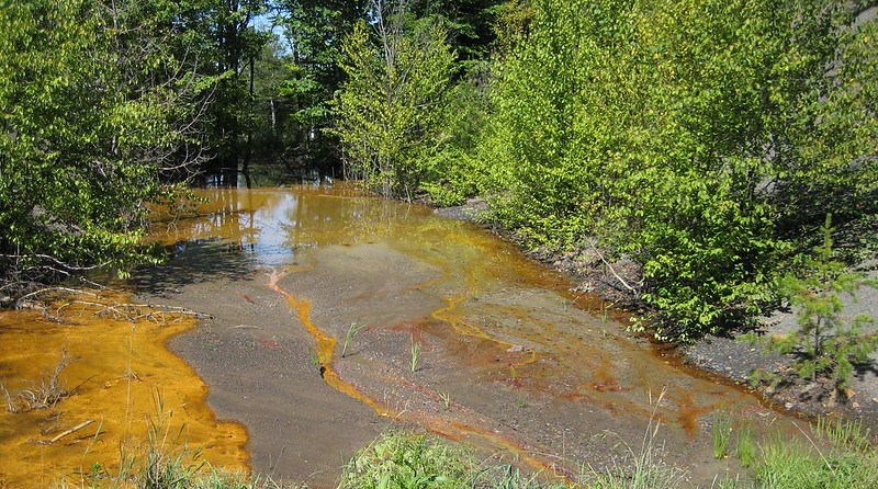
There’s also a lot of existing acid mine drainage across coal-mining communities, which is water that’s leaking iron oxides and other heavy metals from these abandoned mine lands. This is bad for the ecology of the streams, but heavy metals are also not safe for humans to be exposed to.
Acid mine drainage in a stream. Photo: Rachel Brennan (CC BY-NC 2.0) via The Revelator
There’s legislation in Congress now that could help deal with this issue. What are those bills?
One bill is the reauthorization of the abandoned mine land fund. That bill is absolutely critical because the fee on coal production, which is the only source of revenue for the fund, will expire at the end of September if Congress doesn’t take action.
If Congress fails to extend that, we may not see any more funding for the $11 billion needed to clean up abandoned mine lands. If passed, the bill would reauthorize the fee at its current level for 15 more years.
The challenge is that even if the fee is reauthorized, it’ll likely generate only around $1.6 billion — based on current coal-production projections — and that’s vastly inadequate to cover all of the liabilities that exist.
Also, when the abandoned mine land fund was first started, there were some funds that were not redistributed to states and tribes and have just remained in the fund — [about] $2.5 billion that’s not being dispersed on an annual basis.
So another bill, the RECLAIM Act, would authorize [an initial] $1 billion to be dispersed out of that fund that would go to approximately 20 states and tribes over the next five years. This money would be distributed differently than the regular funds in that any kind of project would have to have a plan in place for community and economic development.
So though the funds can only be used for reclamation, they need to be reclamation with a plan. There are so many high-priority and dangerous abandoned mine land sites that exist, and the RECLAIM Act funds would prioritize supporting community and economic development for communities adjacent to these lands.
How much support are you seeing for these bills?
We see momentum in this Congress, and there’s a lot of conversation around investing in our nation’s infrastructure. We see abandoned mine lands and their remediation as natural infrastructure that we need to invest in to keep our communities safe and prepare them for the future.
But we also see these bills as important pieces of an economic recovery package. COVID-19 has really exacerbated so many of the existing health and economic crises already in coal communities.
When we talk about economic stimulus and job creation, we also see reauthorizing the abandoned mine land fund as contributing to that because it takes a lot of work and creates a lot of jobs to do land reclamation.
Abandoned mines can pose serious health and safety hazards, such as landslides, erosion and surface instability. Photo: USGS via The Revelator
We’ve talked about the legacy issues from lands mined before 1977, but what concerns are there from current or recent mining? Is that reclamation being done adequately?
That’s an area that also needs a closer look.
As the industry declines, we’ve seen coal companies file for Chapter 11 bankruptcy or reorganization. And when they do this, oftentimes they’re granted permission to get rid of liabilities that would affect their solvency. Sometimes those liabilities are reclamation obligations, pension funds or black lung disability funds.
And then what you see is smaller companies taking on these permits that the reorganizing company no longer wants. But many are under-capitalized and they sometimes don’t have the ability to even produce coal, or if they do they can’t keep up with the reclamation. And it’s dangerous for communities if there’s environmental violations that aren’t getting addressed.
I’ll give you a recent example. Blackjewel [the sixth-largest U.S. coal producer] went bankrupt in the summer of 2019. Since then there’s been very little done to address any kind of environmental violations existing on their permits.
Because of SMCRA, companies are required to have bonds in order to obtain their mining permits, but these bonds are not always adequate. The Kentucky Energy and Environment cabinet made a statement in the Blackjewel bankruptcy proceedings that it estimated that reclamation obligations on these permits were going to fall short $20 to $50 million.
What else is needed to help coal communities transition to a low-carbon economy?
That’s a big question. We have to address these legacy issues in order to help transition these communities into the future. And we have to address the problems right now of folks who are losing their jobs and need to be supported through training programs or through education credits.
But we also need to be thinking about the future more broadly. What will be in place 20 years from now for the younger generation?
There’s going to be a lot of gaps in local tax revenues because so much of the tax base has been reliant on the coal industry, which makes it really difficult for communities to continue to provide public services and keep up infrastructure as that industry declines. It’s going to be critical to think about that and invest in that.
I think the best approach is to find solutions that work for [specific] places. And to do that we need to listen to community leaders and folks in these communities that have already been working to build something new for many years. There are solutions that I think can apply to all places, but there also needs to be a targeted intention to create opportunities where communities can develop their own paths forward.
The South Taylor pit is one of Colowyo Mine’s current active coal mining site. Photo by David Tan via CoalZoom.com
Image credit: Dan Winters
Coal plant water consumption in the American West. Graphic credit: The Energy Policy Institute
Coal train loading at Spring Creek mine, Montana. Photo: WildEarth Guardians, (CC BY-NC-ND 2.0).
Spring Creek Coal Mine. Photo credit: Cloud Peak Energy
One coal mine remains open in the North Fork Valley. Photo/Allen Best
The U.S. is the second-largest producer of coal in the world, thanks in part to massive surface mines like this one in Wyoming. Photo courtesy BLM.
West Virginia coal mine circa. 1908
December 22, 2008 Kingston Fossil Plant coal ash retention pond failure via the Environmental Protection Agency and the Tennessee Valley Authority
In 2018, Erin Light did something that had never before been done on the Yampa River downstream from Steamboat Springs. She placed a call.
As district water engineer, Light was responsible for administering Colorado’s complex matrix of water rights. Rights are ranked by date and volume, from earliest decreed and hence most senior to most recent and hence junior. A senior water-rights holder on the Yampa River at Lily Park, near the entrance to Dinosaur National Monument, had called to say he was not getting the water decreed to that property for irrigation of the hay meadows.
The call she placed that summer lasted 21 days, causing the most junior of users upstream to cease diversions until that senior right was met. Then came another hot and dry summer in 2020, and she placed another call, this one lasting 9 days. It was a paradigm shift for the Yampa, a river that through the 20th century always had had enough water for anybody who wanted to dip a straw into it.
If foreign to the Yampa River, such calls have long been commonplace on Colorado rivers. The premise is water scarcity, the idea that there just isn’t enough water for all who want it, at least all the time.
Colorado’s hierarchy of seniors and juniors, older and younger, is commonly traced to the development of irrigation agriculture in the Poudre Valley between Fort Collins and Greeley. The Greeley irrigators were first, but then came new irrigators upstream near Fort Collins. In a drought year, their new diversions had an effect on what was available downstream. Within a decade, soon after Colorado became a state, the first calls were placed on that river.
The Yampa River near the entrance to Dinosaur National Monument in the summer of 2018, the first year a call was administered on the Yampa River downstream from Steamboat Springs. Photo/Erin Light
It took little time for scarcity to be understood on all of Colorado’s rivers east of the Continental Divide. Scarcity was slower to be understood on the Western Slope, where there was more water and, even in the days of feverish gold- and silver-mining, fewer people. Yet over the decades, the Colorado and other rivers came to be fully appropriated.
The Yampa, though, stood alone among major rivers in Colorado in its relative plentitude. It routinely delivered water to all who wanted it. Even its reservoirs, modest in size, came relatively late in the 20th century, to help moderate flows.
The Yampa’s relative isolation played a role in this. It’s two mountain ranges distant from the Front Range, two significant fences to hop for Front Range cities and Great Plains farmers.
Climate also played a role. You can’t grow corn in the Yampa Valley with any reliability. You can grow hay, but the geography makes even that problematic.
Now that climate is shifting. Not enough to grow corn but enough to cause the Yampa to be marginally less robust and, as the 21st century has shown in 2018 and 2020, but also in other years before that, unable to deliver.
This has led to Light recommending that the Yampa be designated as “over-appropriated.” It’s a legal phrase that suggests something more odious than is actually the case. It sounds like the theater has been oversold and some people will be escorted from their seats to stand outside.
Over-appropriated doesn’t mean that. It does have implications for those wanting to drill large-capacity wells along the river. They must show the ability to deliver augmentation water, which is commonly purchased from an upstream reservoir. Most of Colorado’s rivers long ago were designated as over-appropriated.
In my reporting for a story commissioned by Aspen Journalism, which can be seen here and has more of the detail of interest to a local audience, I talked several times with Light. She chose her words carefully. She didn’t talk about climate change, only the direct evidence, the water years of 2018 and 2020. But there were other bad years, too, including 2012 and also 2002.
A gaging station in the Yampa River near Maybell has documented 1.5 million acre-feet a century ago to 1.1 million acre-feet now, with one recent year showing only 500,000 acre-feet. Photo/Allen Best
Light wasn’t the district engineer in 2002, and only recently did the downstream irrigator near Dinosaur explain why he hadn’t demanded his water that summer and fall. He just didn’t have the heart to cause so much pain upstream in that year of scorching temperatures, forest fires, and meager winter snows eviscerated by spring winds.
Perhaps the most compelling evidence from Light were these statistics, drawn from the U.S. Geological Survey gaging station at Maybell, located along the Yampa River (and Highway 40), between Craig and Dinosaur National Monument. A century ago, the gauging station recorded an average annual 1.5 million acre-feet. That has declined to 1.1 million in the 21st century. And, of course, some years are worse, including one year in the last decade of 500,000 acre-feet.
At a recent meeting of the Colorado Air Quality Control Commission, a representative of Boulder County mentioned drought caused by climate change in support of regulations to control methane emissions. One of the AQCC commissioners, Randy Ahrens, of Broomfield, wanted to know why, if the ski areas could talk about what wonderful record-breaking snows we had, we could still be in drought.
In that question I think I heard some skepticism, perhaps a wondering whether enviros were just a little too chicken-littlish. It was a legitimate question, though.
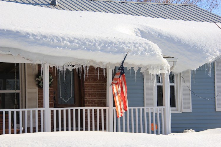
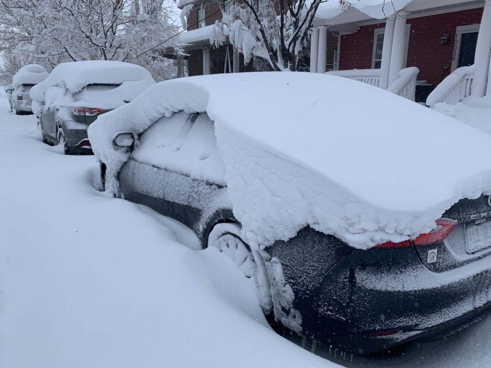
This roof in Craig in early March 2020 was testament to an above-average winter. Three months later, the snow-water equivalent had swooped from 116% of median to 69% of median. Photo/Allen Best
I saw the answer during my three trips to the Yampa Valley in 2020. In early March I visited Steamboat and then Craig, seeing evidence of a big snow year, reminiscent of the winter and spring I had spent there in 1979. I got skilled that winter at chaining up my Ford Pinto in the dark during a snowstorm while crossing Rabbit Ears Pass.
But those heavy snows I saw in March 2020 soon disappeared in a warm, dry spring.
Kelly Romero-Heaney, the water resources manager for Steamboat Springs, laid it out for me. The snow-water equivalent—a measure of the snowpack—showed 116% of median on March 1. It was down to 69% by June 1.
Then came summer, hot and dry, a record in both categories during August against 130 years of measurements.
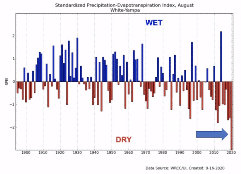
That heat and lack of precipitation, Romero-Heaney told me, drove a measure called the SPEI, or Standardized Precipitation Evapotranspiration Index. “The combination
of heat and lack of precipitation drove an SPEI figure that far exceeded drought years, such as 2002, 2012, and 2018,” she said.
Last August, when I returned again to explore the Little Snake River, it felt like an oven. Stopping for a sandwich in Steamboat on the return to the Front Range, it felt Denver hot. That afternoon I continued eastward across Cameron Pass then drove past Long Draw Reservoir and toward the headwaters of the Colorado River. A week later, it was afire.
That Cameron Peak Fire was still in advancing in early October when we returned to Craig a third time. It was a smoky time there—and everywhere.
On that October trip I drove up the Elk River northwest of Steamboat Springs to see Jay Fetcher. His ranch a few miles from Steamboat Lake had been his parents’ ranch when they arrived from Philadelphia in 1949 and he was a toddler. His parents had kept a record through their years of when the last snow disappeared from the meadow. His father died just a few years ago, a legend in Steamboat and beyond, partly because he was a co-founder of the ski area, but also because of his work in water.
Jay has continued the work of his parents, charting the withering of the winter snowpack. And the chart he gave me showed a clear progression toward earlier springs, particularly during the 21st century. There’ still great variability, but now more so. The “snow off meadow” date arrives an average one day earlier every five years. That means longer summers.
Jay Fetcher at his ranch along the Elk River northwest of Steamboat Springs in the hay meadow where he, and before that, his parents have carefully tracked the last disappearance of snowbanks each spring. Photo/Allen Best
The story here is that last year was emblematic of what has been happening in the Yampa River. There’s no longer enough water for everybody who wants it all the time. It’s not because of additional new diversions, although there are some. But that does not tell the story. The longer, hotter summers may cause ranchers to divert more water to irrigate. That could be part of the story.
The largest story is of the warming weather, the shifting climate.
Light has submitted her proposal for over-appropriation to her boss, Kevin Rein, the state water engineer. In an interview, he had also chosen his words about climate change carefully. Approving this, he said, would not be a prediction of a climate to come, only a recognition that the hydrological balance has shifted.
Brad Udall: Here’s the latest version of my 4-Panel plot thru Water Year (Oct-Sep) of 2019 of the #coriver big reservoirs, natural flows, precipitation, and temperature. Data goes back or 1906 (or 1935 for reservoirs.) This updates previous work with @GreatLakesPeck
Fair enough. But there’s the weight of evidence, almost crushing, that climate change has started playing a heavy hand in the Colorado River. There are the studies by Udall, et al, that point to the “hot drought” as the story, with roughly half the recorded declines due to temperature and not precipitation. There are, of course, the enduring images of the bathtub ring at Lake Mead. And there are the models that predict much more warmth is yet to come.
Climate change is not just the future. It’s here, it’s now. And from all available evidence, the climate scientists were too conservative in their predictions.
This was published in the March 18, 2020, issue of Big Pivots, an e-magazine. For a free subscription, go to http://BigPivots.com.
From the St. George Spectrum & Daily News (Joan Meiners):
Last week, Utah Gov. Spencer Cox issued an executive order declaring a statewide drought emergency. In the press release that followed, he urged Utahns to “evaluate their water use and find ways to save not only because of current drought conditions but also because we live in one of the driest states in the nation.”
[…]
These measures are needed because, according to the Governor’s March 17 release, “following a record dry summer and fall, this winter’s snowpack is about 70% of average for the year. For snowpack to reach average, Utah’s mountains would need to receive the remaining 30% before it starts to melt significantly, typically the first week in April. There is around a 10% chance of this occurring.”
[…]
In the very first edition of The Water Tap, The Spectrum & Daily News surveyed locals about their water use and found that, on average, we are using twice as much water at home as we think we are using (local estimated their home use at 127 gallons per day compared to the USGS-calculated 248). This is despite the fact that a majority of survey respondents reported being aware that water scarcity is an issue in southern Utah and said that they already make an effort to conserve water at home…
To be fair, some of our higher local water use is simply due to the realities of our environment here in the northern range of the Mojave Desert. Being one of the driest states — as Governor Cox pointed out — our outdoor landscapes will require more water to achieve the same result compared to lawns growing in Missouri or Virginia, due to drier soils and higher evaporative loss.
But that’s exactly why several other southwestern states sponsor programs to encourage people to replace their lawns with desert-friendly landscaping, or xeriscaping. Southern Utah does not currently offer any such turf removal incentives and, in past interviews, local water managers have been loathe to condemn the abundance of residential lawns, parks and golf courses throughout the region.
The initial The Water Tap also noted that domestic water use from the public supply makes up just 15% of total water use in Utah, while irrigation accounts for 72% of use, mostly to support local water-intensive crops like alfalfa. The fourth week of The Water Tap covered recent research findings that up to 55% of water throughout the Colorado River basin is spent irrigating cattle-feed crops.
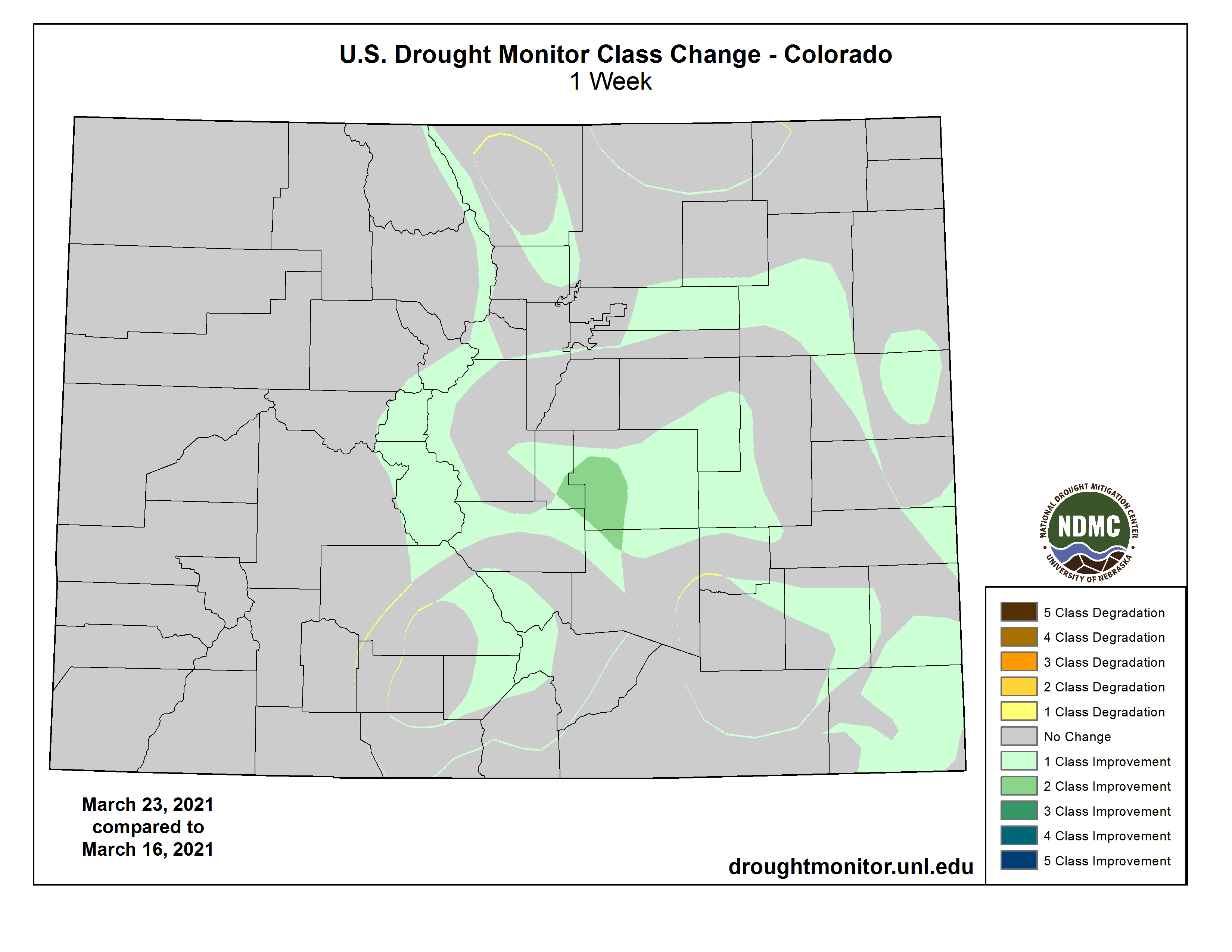
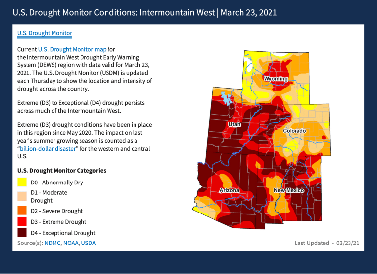
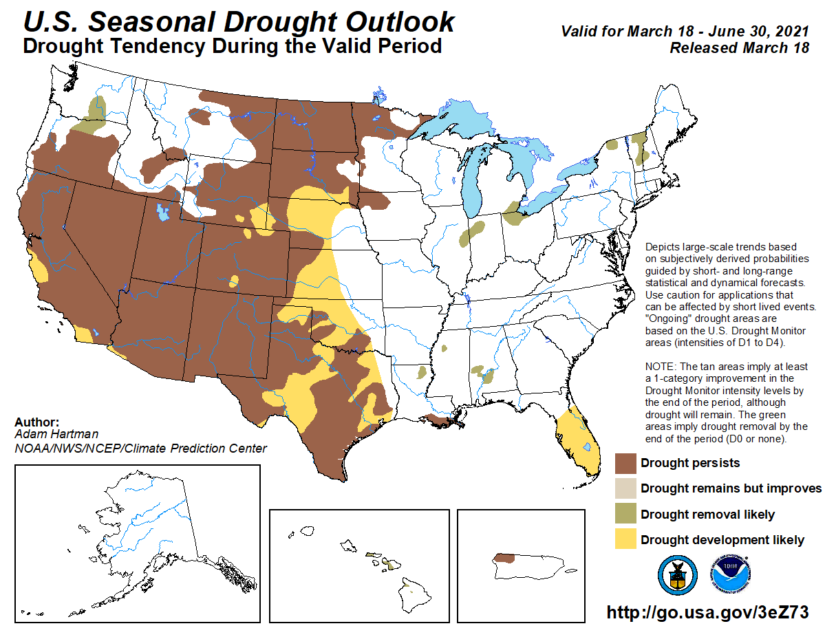
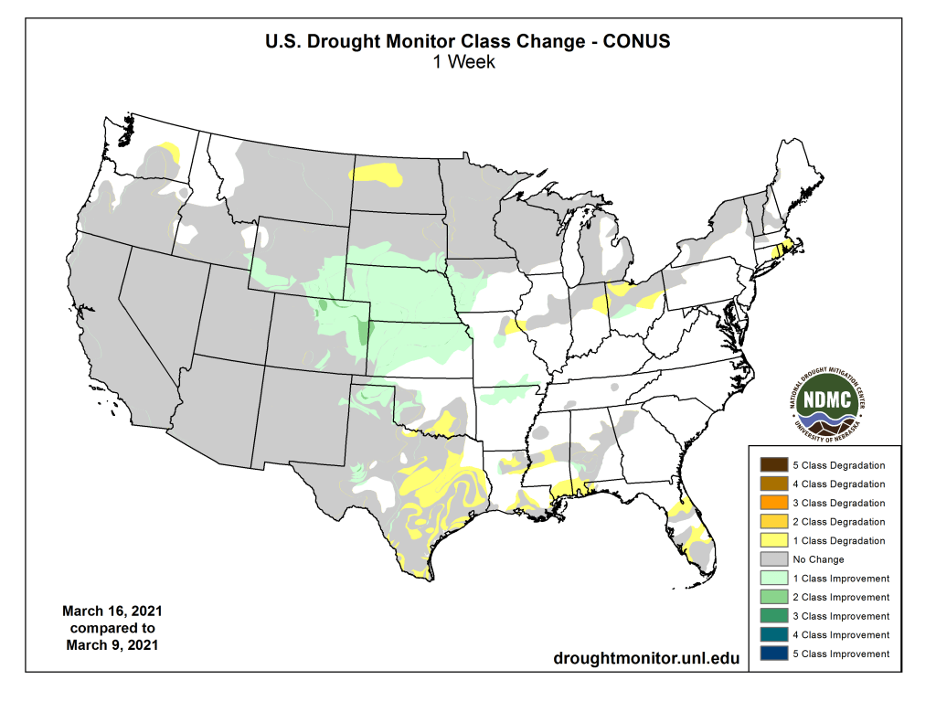
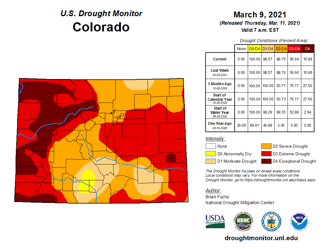
Additional moisture following a major snowstorm two weeks ago has provided additional drought relief to portions of Colorado’s eastern plains and mountain areas according to the latest update from the National Drought Mitigation Center.
Colorado Drought Monitor one week change map ending March 23, 2021.
The most notable change appeared in southwest El Paso County, where extreme drought decreased two categories to moderate conditions. Southern Teller and a small portion of northern Pueblo counties experienced a similar two category improvement.
Elsewhere in El Paso, Elbert, Lincoln, Pueblo, Prowers and Crowley counties, extreme drought moved into the severe category. Extreme conditions also decreased in Baca and Las Animas counties.
Central Kiowa County remained in extreme drought, while a small area of extreme conditions in the northwest of the county moved to severe.
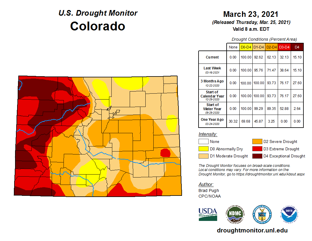
Colorado Drought Monitor March 23, 2021.
Areas of abnormally dry conditions expanded to replace moderate drought in the San Luis Valley and northern Colorado. Abnormally dry conditions also appeared in southern Yuma and eastern Kit Carson counties.
No improvement was noted in western Colorado, which has been dominated by extreme and exceptional drought for months.
Recent heavy snowfall brought snow water content close to average for mid-March across most of Colorado despite the ongoing areas of significant drought.
Colorado Drought Monitor March 16, 2021.
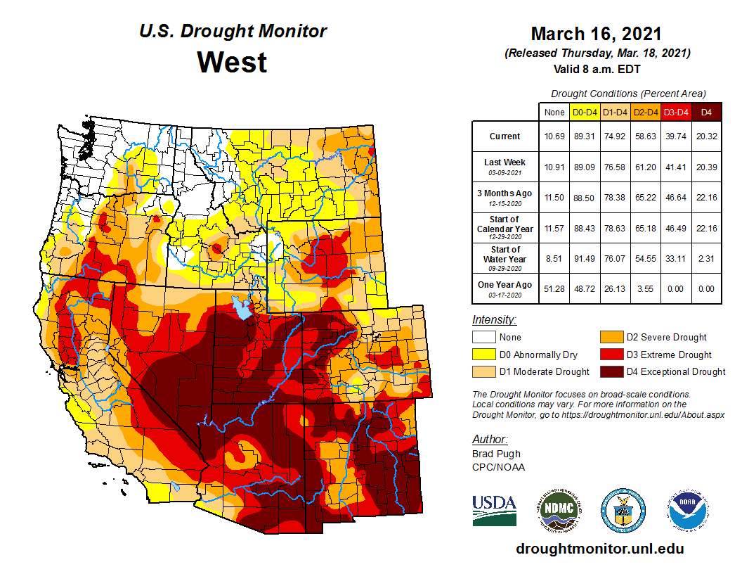
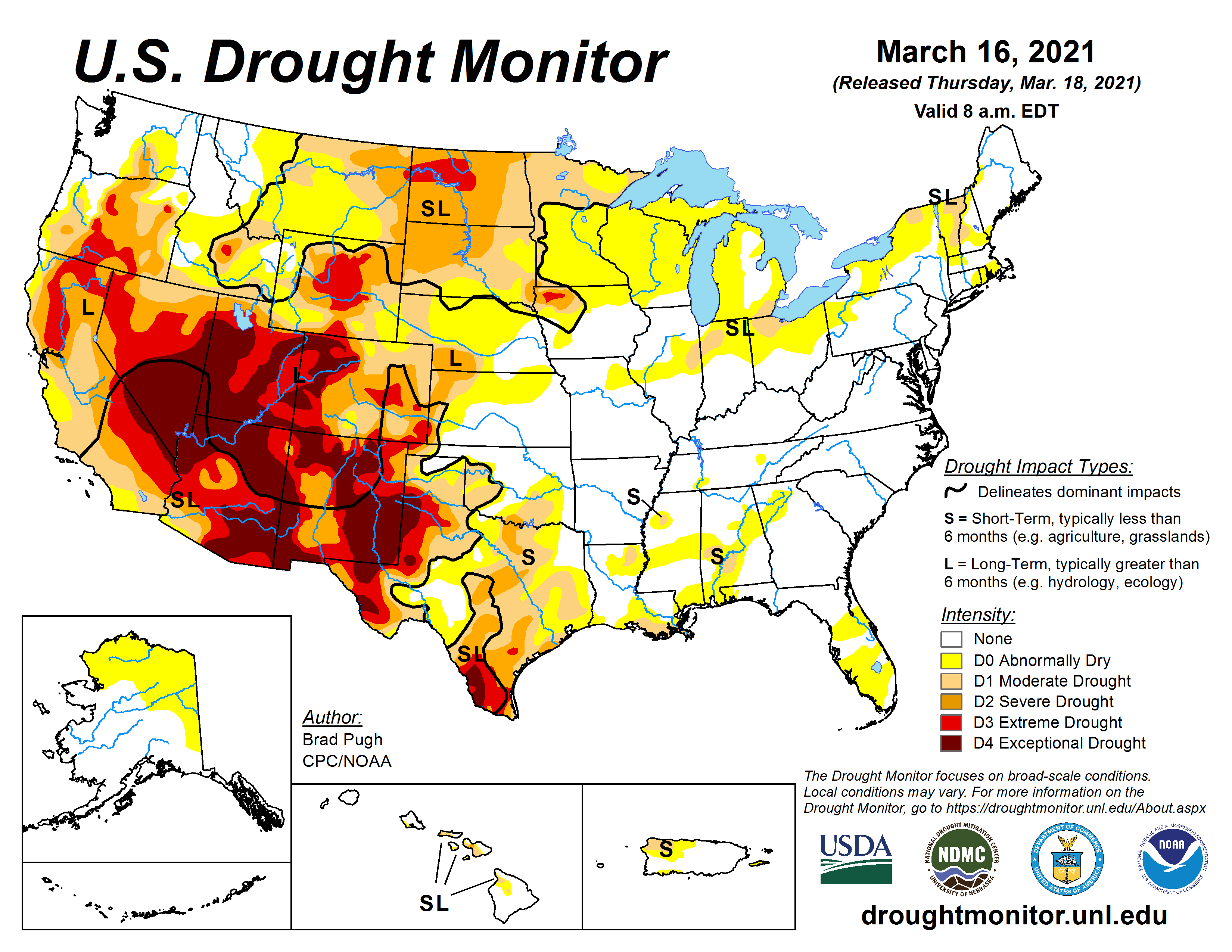
Overall, 15 percent of the state is in exceptional drought, unchanged from the prior week. Extreme drought fell from 24 percent to 17, while severe conditions dropped to 30 percent from 33. Moderate drought increased from 24 to 30 percent, while abnormally dry conditions increased from four to seven percent, offsetting areas of more significant drought. None of Colorado is free from drought. Percentages do not total 100 due to rounding.
A new computer model of climate effects and human economic activity reveals weaknesses and strengths of hundreds of river and water basins across the globe, as we face increasing levels of climate stress (source: Drought.gov)
Here’s the release from Tufts University (Mike Silver):
Computer model shows human economic activity can transmit and magnify climate change impact
Water scarcity is often understood as a problem for regions experiencing drought, but a new study led by Tufts University researchers finds that not only can localized water shortages impact the global economy, but changes in global demand can have positive and negative ripple effects in river basins across the globe.
In addition to Tufts engineers, the team included experts from the Joint Global Change Research Institute at the Pacific Northwest National Laboratory, and Cornell University.
“We’re finding that water scarcity dynamics are more complicated than traditionally acknowledged,” said Flannery Dolan, a graduate student at Tufts University and lead author of the study. “Changing water supply due to climate change is only part of the story. Regional water scarcity is also driven by changes in global water demands that are often hard to anticipate.”
The study, “Evaluating the economic impact of water scarcity in a changing world,” was published March 26 in Nature Communications, and uniquely captures the interdependent effects of global trade, population and technological growth, climate change, and land management decisions on regional river basins’ water scarcity and economic capacity to adapt to that scarcity.
The researchers used a computer model to simulate thousands of scenarios that reflect a broad array of potential climate, socioeconomic, and hydrologic (earth water cycles and management) conditions in 235 major river basins to better understand how regional water scarcity can have far-ranging impacts on the global economy. Those effects can include altering global trade and consumption patterns in industries such as agriculture, energy, transportation, and manufacturing.
“We are looking at water scarcity as a globally connected and multi-sector phenomenon,” said Jonathan Lamontagne, assistant professor of Civil and Environmental Engineering at Tufts University and corresponding author of the study. “As a result, the study reveals some interesting and sometimes unexpected insights into how local conditions can have reverberations across the globe.”
The research found that global trade dynamics and market adaptations to regional water scarcity can result in positive or negative economic outcomes in every regional river basin considered in the study, depending on both water supply (rainfall, snowmelt, and ground water), and demand-side factors like agricultural production, power generation, and municipal use.
Graphic credit: Western Water Assessment
The course and the major tributaries of the Indus in a geographical map of Upper South Asia. By The Edinburgh Geographical Institute, John Bartholomew and Company. Amended by Fowler&fowler (talk) 20:07, 6 February 2021 (UTC) – From personal copy (of Fowler&fowler (talk)) of Imperial Gazetteer of India volume 26, Atlas, published by the Secretary of State for India in Council, Oxford University Press, 1909, Figure 4, Orographical Features, Public Domain, https://commons.wikimedia.org/w/index.php?curid=99629481
For instance, in the lower Colorado River basin, the worst economic outcomes arise from limited groundwater availability and high population growth, but that high population growth can also prove beneficial under some hydrologic conditions. In contrast, the future economic outcomes in the Indus Basin depend largely on global land-use policies that discourage carbon emissions that can, in turn, encourage overuse of groundwater supplies.
“What is happening elsewhere in the world through differences in regional choices related to energy transitions, how land is being managed, as well as different regional water demands and adaptive choices, can shape relative advantages and disadvantages of a region’s water intensive economic activities,” said Patrick Reed, the Joseph C. Ford Professor of Civil and Environmental Engineering at Cornell.
Restrictions in water availability usually lead to a negative regional economic impact, but the research revealed that some regions can experience a positive economic impact if they hold an advantage over other water basins and become a virtual exporter of water. The Orinoco basin in Venezuela, for example, usually has a reliable supply of water and is often in a relative position that can benefit when other regions are under stress, according to the researchers.
The study also found that small differences in projections for future climate conditions can yield very large differences in the economic outcomes for water scarcity.
“Human activities and market responses can strongly amplify the economic effects of water scarcity, but the conditions that lead to this amplification vary widely from one basin to the next,” said Lamontagne.
A river basin can be considered economically robust if it is able to adapt to drought with alternative sources of water or adjust economic activity to limit usage. If a basin is unable to adapt its supply options and if prolonged water scarcity leads to persistent economic decline, then the researchers describe the loss in water basin adaptive capacity as having reached an ‘economic tipping point.’
For example, in the Indus region in South Asia, the water supply is under stress due to heavy agricultural use and irrigation leading to unsustainable consumption of groundwater, which places it close to the tipping point.
The conditions that lead to these tipping points are highly variable from basin to basin, depending on a combination of local factors and global conditions. In the Arabian Peninsula, low groundwater availability and pricing of carbon emissions are key factors. In the lower Colorado River basin, a mixture of low groundwater availability, low agricultural productivity, and strong economic demands from the U.S. and Europe lead to tipping points.
“It is noteworthy that the lower Colorado River basin has some of the most uncertain and widely divergent economic outcomes of water scarcity of the basins analyzed in this study,” said Reed. “This implies that assumed differences in regional, national and global human activities as well as the intensity of climate change can dramatically amplify the uncertainty in the basin’s outcomes.”
As climate change makes the physical and economic effects of water scarcity more challenging for policy makers to understand, the researchers hope their work will provide the basis for similar analyses and draw attention to the importance of expanded data collection to improve modeling and decision making.
Click here to read the update (Tracy Kosloff and Megan Holcomb):
A cold February came to a close as the first below average temperature month since October 2019 and the 25th coldest month on record in 127 years. The eastern side of the continental divide benefited more than the rest of Colorado from recent March snowstorms. The last 11 months (Apr 2020 to Feb 2021) are the driest on record for Colorado as a whole (when compared to the same 11 months for the period of record). The dryness will reduce springtime runoff, especially in western Colorado. While a warm and dry pattern has continued this winter, conditions are not as severe as they were in the fall with localized drought monitor improvements due to recent precipitation.
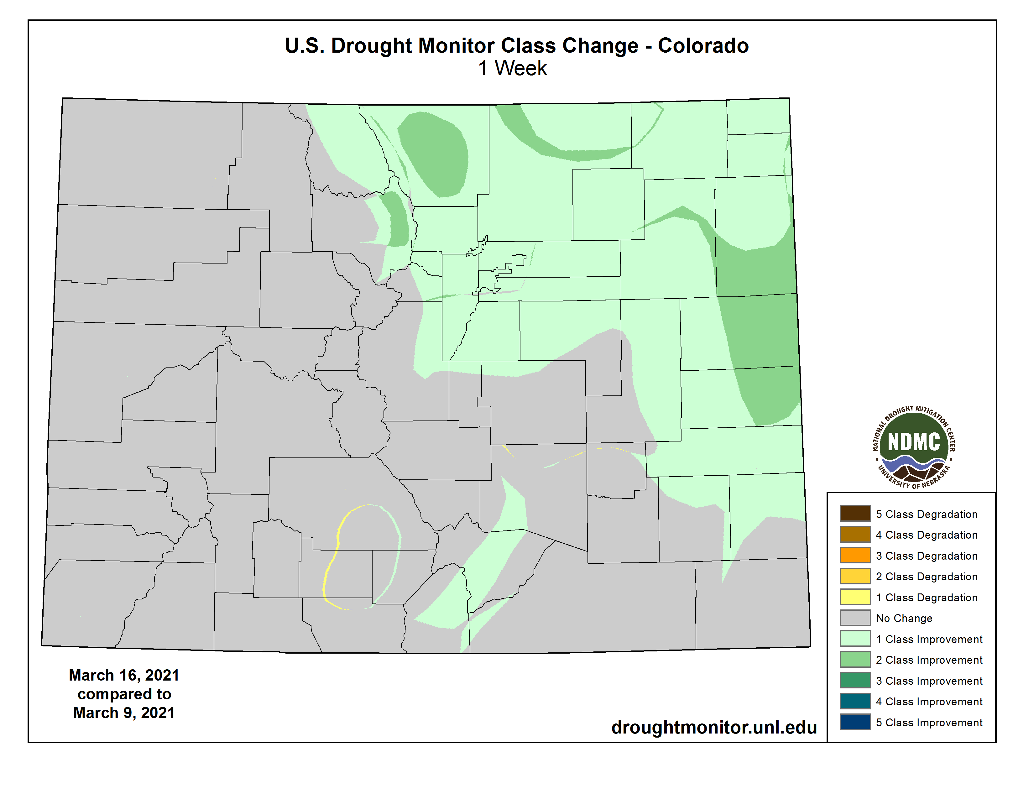
Colorado Drought Monitor March 23, 2021.
The U.S. Drought Monitor from March 23rd recorded recent improvements. Notably, a 2-category change in a one week period was observed in north and central areas of eastern Colorado between March 9-16th. The last 2-category improvement was recorded during the September 2013 floods. Exceptional (D4) drought currently covers 15% of the state; extreme (D3) drought covers 17%; severe (D2) drought covers 30%; moderate (D1) drought covers 30%; and recent precipitation created patches of abnormally dry (D0) areas in 7% of the state.
The 90-day Standardized Precipitation Index (SPI) values from Dec. 14 to Mar. 15 highlight continued dry conditions on the western slope. Eastern Colorado’s SPI data points reflect areas of above average precipitation after January and March snowstorms. The 12-month SPI map depicts the long-term drought conditions due to precipitation deficits of 2020 across the state.
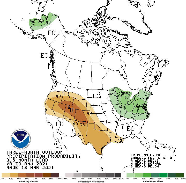
The NOAA Climate Prediction Center three month outlook indicates the current La Niña pattern may weaken by the spring and revert to neutral conditions in the summer. Above normal temperatures and below average precipitation are anticipated in the upcoming months. In contrast, March was expected to bring below average precipitation, which was not the case.
Colorado statewide snowpack basin-filled map March 25, 2021 via the NRCS.
As of March 17th, statewide snowpack is 83% of normal. Statewide reservoir storage is currently at 85% of average. Extreme soil moisture deficits and below normal precipitation means all basins should prepare for a low runoff year. The continuance of drought is expected through 2021 and the State Drought Plan remains in Phase 3 activation.
Water providers across the state report average to slightly below average storage levels and near normal winter demands. Drought management planning and potential restrictions are being discussed through multiple coordination groups. Stakeholders can follow along with state drought response actions and activities through public engagement pages for the Municipal Water Task Force and Agricultural Impact Task Force.
Moraine Park and the headwaters of the Big Thompson River in Rocky Mountain National Park. Moraine Park is on the east side of the park and of the continental divide, near the town of Estes Park. This region has a number of areas call “parks”, which refer to open, level areas in the mountains, usage which comes from the French word parque. The names of these areas predate the establishment of the national park and are unrelated to the use of the word “park” in that context. By The original uploader was Kbh3rd at English Wikipedia. – Transferred from en.wikipedia to Commons., CC SA 1.0, https://commons.wikimedia.org/w/index.php?curid=1009783
FromThe High Country News [March 18, 2021] (Anna V. Smith):
Four important decisions will impact the forests, lands and waters of tribal nations.
Tribal leaders see President Joe Biden’s administration as an opportunity to increase tribal consultation regarding issues like water management, oil and gas leasing, and land conservation. Here, we look at four major projects — all of them years in the making — that the new administration is tasked with advancing in the next four years. Most fall under the Department of the Interior, now headed by its first Indigenous secretary, Deb Haaland (Laguna Pueblo).
On his first day in office, Biden issued an executive order to revisit the U.S. Department of Agriculture’s Trump-era decision to exempt Alaska’s Tongass National Forest from a federal rule protecting 9.3 million acres of it from logging, mining and roadways. The Trump administration raced through the process despite the pandemic. The Tongass — the largest national forest in the U.S. — serves as a massive carbon sink and is of national importance. It also supports the old-growth red cedar, Sitka black-tailed deer and salmon that the Alaska Native tribes of the region rely on. None of the Southeast Alaska Native tribes who participated in the consultation process supported the exemption, and all withdrew in protest.
In addition to reviewing the Tongass protections, the Biden administration also has to decide on a rule proposed by 11 Southeast Alaska Native tribes in July 2020. The Traditional Homelands Conservation Rule would increase the role of Alaska Native tribes in the management of the forest’s trees, wildlife and waters. The tribes proposed the rule after decades of inadequate tribal consultation on the Tongass, their ancestral and current homeland.
From the 2018 Tribal Water Study, this graphic shows the location of the 29 federally-recognized tribes in the Colorado River Basin. Map credit: USBR
COLORADO RIVER BASIN GUIDELINES BY 2026
Negotiations among federal, tribal and state governments on water flows and allocations in the Colorado River Basin began last year and are set to conclude by 2026. At stake is the water supply for 40 million people.
The current set of interim guidelines was created in 2007 by the seven basin states — Colorado, Arizona, Utah, California, Nevada, Wyoming and New Mexico — and the federal government. None of the 29 federally recognized tribes in the Colorado River Basin were consulted, despite having senior water rights that account for 20% of the river’s water.
The negotiations are happening amid some of the most serious drought predictions the region has seen; in January, the river’s drought contingency plan was triggered for the first time. Climate change has brought extreme drought conditions to about 75% of the river’s Upper Basin, and that will no doubt influence the tenor of the negotiations.
Klamath River Basin. Map credit: American Rivers
KLAMATH RIVER DAM REMOVAL IN 2023
After years of political, social and regulatory barriers, the undamming of the Klamath River is within sight. When — or if — it’s completed, it will be the largest dam removal effort in U.S. history, bringing down four out of six dams on the river in southern Oregon and Northern California , including one that’s 103 years old. For now, the project is on track to begin in 2023, and by 2024 there could be free-flowing water in the river, opening up some 400 miles of habitat in California for salmon, lamprey and trout. The nonprofit charged with the dam removals, the Klamath River Renewal Corporation, still needs the Federal Energy Regulatory Committee, which is headed by political appointees, to approve its current plan.
Last year’s drought created more conflict over water allocations on the Klamath. In, August, the Bureau of Reclamation cancelled promised water flows for the Yurok Tribe’s Ceremonial Boat Dance. In response, the Yurok Tribe sued the agency. The federal government will need to bring stakeholders together for a large-scale agreement to end this cycle of seasonal litigation, something the Obama administration attempted unsuccessfully to do.
Oil and gas development on the Roan via Airphotona
OIL AND GAS LEASING PERMIT PAUSE ON FEDERAL LANDS
In late January, when Joe Biden signed multiple executive orders to address the “climate crisis,” he ordered Interior to put a temporary moratorium on new oil and gas leases on public lands and offshore waters. The administration called for a review of the leasing and royalties process, citing climate impacts and their growing cost, and specifically requested a review of leases in Alaska’s Arctic National Wildlife Refuge. President Donald Trump’s outgoing administration had opened ANWR for sale just weeks before Biden took office.
Biden’s executive orders don’t impact existing leases, or oil and gas on tribal lands. But much of the tribal opposition involves activities on ancestral territory that is currently public land, sometimes carried out without adequate tribal consultation. The Arctic Refuge and places like New Mexico’s Chaco Canyon have been flashpoints of conflict over leasing, and many advocates want Biden to extend the pause as a permanent ban. This was a key sticking point for many Republican senators during Haaland’s confirmation hearings, which Sen. Maria Cantwell, D-Wash., described as a “proxy fight over the future of fossil fuels.”
Anna V. Smith is an assistant editor for High Country News. Email us at editor@hcn.org.
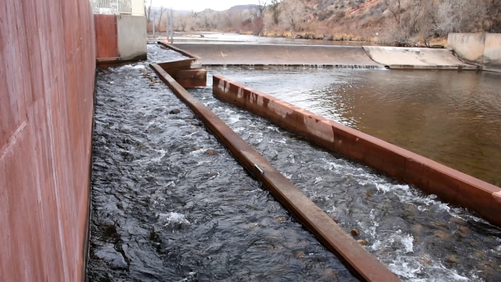
Watson Lake fish ladder. Photo credit: Colorado Parks & Wildlife
Here’s the release from Colorado Parks & Wildlife (Jason Clay):
Colorado Parks and Wildlife monitoring efforts of the fish ladder installed on the Cache la Poudre River at the Watson Lake State Wildlife Area two years ago shows it has been a success across several fronts.
The fishway was designed to allow passage around a diversion structure in the river for multiple species of fish. This project is a realization of a partnership formed between private and public entities.
“Overall, we are happy with the project and have documented fish moving upstream and downstream in the structure,” said CPW Aquatic Biologist Kyle Battige. “The fish ladder has improved conditions on the river and reconnected over two miles of river habitat by providing upstream movement opportunities for fish that had not existed at the Watson Lake Diversion Structure location since it was built in the 1960s.”
Watch trout swim in the fish ladder and hear more from aquatic biologist Kyle Battige
Two separate Passive Integrated Transponder (PIT) tagging efforts helped CPW in monitoring fish movement up and down the river after the ladder was installed. CPW tagged 71 fish on April 26, 2019 that were released in the downstream half of the fishway for initial evaluation. Researchers with Colorado State University also tagged fish downstream of the fishway as a part of a larger movement study on April 4, 2019.
Data from the PIT tags documented successful upstream and downstream movement with 41 of the 71 CPW tagged fish utilizing the ladder and 36 of those fish successfully ascending the entire structure. The other five fish were recorded on one of the other two operational antennas within the structure, but not at the top antenna. Our detection data indicates that 51 percent of fish tagged by CPW successfully ascended the entire structure.
Additionally, eight brown trout tagged by CSU and released 50 meters or further downstream have been documented using the fishway.
“Documenting 51 percent of the CPW-tagged fish along with CSU- tagged fish utilizing the structure over the course of several months is exciting,” Battige said. “The fish ladder is performing as designed and is allowing fish to move freely up and downstream through the reach as they want. Further evaluation is warranted to investigate movement success across a broader size range within each fish species, but to date we have documented adult fish successfully navigating the fishway”
Of the three species of fish tagged – longnose sucker, brown trout and rainbow trout – at least one individual across all tagged species has successfully navigated the fishway.
Other areas monitored that indicate a successful project are measured water velocities in the fishway, discharge measurements in the fishway and water delivery to the hatchery. In addition, the cone screen constructed above the fish ladder where water gets delivered to the hatchery prevented fish entrainment by screening water delivered to the hatchery and that has not clogged during the fall leaf seasons, decreasing CPW staff time spent cleaning old inlet infrastructure. The cone screen is powered by a solar panel and has been an overall benefit to hatchery operations while not impacting water delivery.
In order to satisfy measurement of Northern Water’s potential future augmentation flows from Glade Reservoir, the fishway was designed to carry up to 30 cubic feet per second (cfs) before spilling over the dam. Based on CPW measurements since construction was completed in the spring of 2019, the fishway more than meets that criteria, with its overall capacity being closer to 50 cfs.
Morning Fresh Dairy, one of the project partners, is also utilizing the structure to measure future water flows.
There was a seamless collaboration between public and private entities who came together on the project to improve the river and its habitat. Along with CPW and Morning Fresh Dairy, noosa yoghurt, Northern Water and Poudre Heritage Alliance all were key partners in the project.
Learning lessons gleaned from this project that can be applied to help future ladder designs include careful consideration of tradeoffs between flow measurement and fish passage along with minor design tweaks to optimize water velocities in fish ladders.
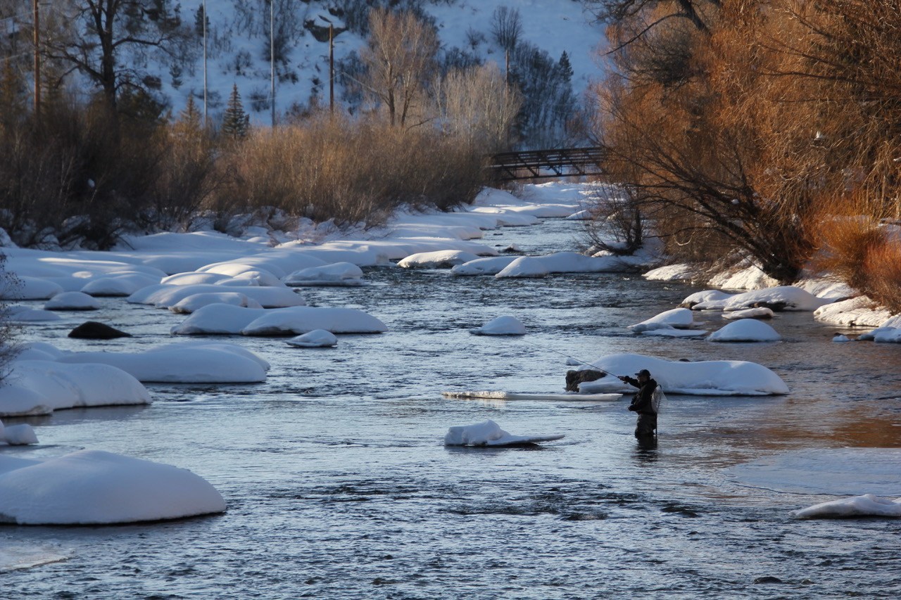
An angler in the Yampa River in Steamboat Springs in early March 2020. Designating part of the Yampa River as over-appropriated would require some water users with wells to have an augmentation plan. CREDIT: ALLEN BEST/ASPEN JOURNALISM
Here’s the release from the Colorado Water Conservation Board (Sara Leonard):
On March 17, amended rules governing the Colorado Water Conservation Board’s (CWCB) Instream Flow and Natural Lake Level Program became effective.
The amended rules create additional tools and expand CWCB’s authority regarding temporary loans of water rights to the agency for instream flow use, including the ability to improve the natural environment, and allowing loans to be renewed for two additional 10-year periods, among other features.
The rule revisions implement Colorado House Bill 20-1157, sponsored by Senator Kerry Donovan and Representatives Dylan Roberts and Perry Will. On January 26, 2021, CWCB held a rulemaking hearing at which public comments were heard and the CWCB ultimately adopted the amendments to its existing rules.
“The CWCB staff is looking forward to working with the water community on both expedited and renewable loans, and appreciates having additional tools for protecting flows in Colorado’s streams,” said Linda Bassi, CWCB Stream and Lake Protection Section Chief.
Colorado Water Legislator Webinar, March 30, 2021, Zoom, 8 – 8:45 am, Mountain Time, Free
Audience
This event will be tailored for Colorado legislators, but all members of the public are welcome to join.
Clean and reliable water supplies are essential to our ways of life in Colorado. All of us depend on healthy flowing rivers: agricultural producers, cities and towns, businesses, recreation, and the environment. 2021 is a key year for Colorado water. Up ahead are the update of the Colorado Water Plan, the beginning of the renegotiation around the Colorado River, deepening drought, wildfire impacts, and performance of the Colorado River Drought Contingency Plans, a temporary yet broad agreement to reduce water use and ensure that Lakes Powell and Mead continue to provide a reliable water supply. One thing is clear. We all play a role in sustaining Colorado’s water future. Join us in discussing its course.
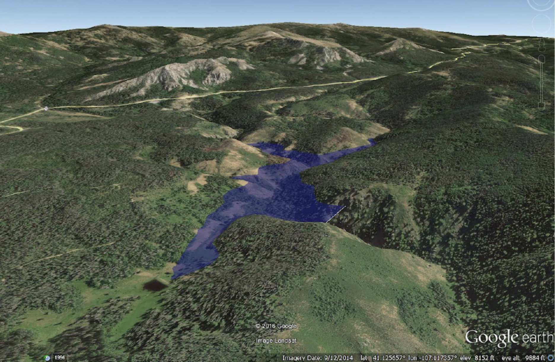
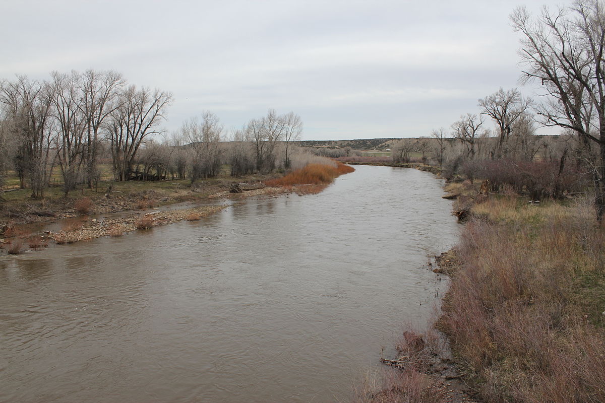
Wyoming’s efforts to build a 280-foot-high dam above the Little Snake River near the border of Colorado are “picking … back up,” after backers received a $1.2 million federal grant, the director of the Wyoming Water Development Commission said last week.
The funds, to be matched by Wyoming, will help consultants prepare federal environmental reviews. Planned for the West Fork of Battle Creek in Carbon County, the estimated $82 million dam and 10,000-acre-foot reservoir would be constructed in the Medicine Bow-Routt National Forest.
The Little Snake River as it passes under Wyoming Highway 70 near Dixon. Photo credit: Wikimedia
The dam on the tributary of the Little Snake River would serve 67 to 100 irrigators by providing late-season water. Irrigators are unable to finance the project, so 91% of the costs would be borne by Wyoming, a formula backers say is justified because the structure would produce $73.7 million in public benefits.
The U.S. Department of Agriculture Natural Resource Conservation Service in 2019 approved a $1.25 million grant to the Savery-Little Snake River Water Conservancy District and the neighboring Colorado Pothook Water Conservancy District to boost the project, according to federal records. The grant requires a matching contribution.
“It became a little bit dormant for a while,” Water Development Office Director Brandon Gebhart told members of the state water commission Thursday as he described the project. The grant will help consultants decide whether to pursue a land exchange with the U.S. Forest Service or try to construct and operate the facility through permits.
Previously rebuffed
The project faced scrutiny and criticism in the Legislature in 2018 when backers sought $40 million in construction funds. Lawmakers appropriated only $4.7 million, requiring none of the money be spent until two conditions were met.
One was securing “additional funding commitments from project beneficiaries in both Wyoming and Colorado on a pro-rata basis.” The second string the legislature attached required legislative approval before any of the 2018 appropriation be spent…
In addition to the $4.7 million 2018 appropriation, the West Fork account had some $6 million already appropriated in 2013, for a total of $10.9 million. The earlier appropriation did not include requirements for cost sharing with Colorado or for further legislative approval…
Lawmakers became wary of the dam project because of its cost, its location and the small number of Wyoming irrigators it would serve. Critics said it would only irrigate an additional 2,000 acres or so…
A Feb. 24 memo to commission members described Wyoming’s historic engagement with Colorado officials but with a contemporary revision. “All entities expressed support for additional storage in the Little Snake/Yampa River drainages and support for the West Fork project,” the memo reads.
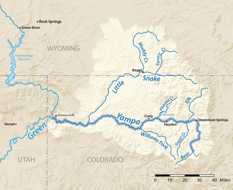
But that statement mischaracterizes Colorado’s position, said Cody Perry, vice president of Friends of the Yampa. The Little Snake River flows along the Wyoming/Colorado border and into the Yampa, a tributary of the Green River.
Wyoming tried to get the Yampa-White-Green Basin Roundtable to endorse the project in 2018. But that group would not sign a proposed letter backing the dam and reservoir.
Instead, the Roundtable said it would need to see the dam proposal “in a final format, after [National Environmental Policy Act analysis] has been completed.”
“The [Roundtable] membership would like to be clear that this is not support of the reservoir itself, only the process of the exploration…” the Colorado group’s letter stated.
Three members of the Colorado roundtable said the group’s position has not changed since 2018…
The Water Development Commission last week extended a planning contract for the project through the end of 2022. It had been set to expire June 30, 2021.
Old cottonwoods line the banks and trails of the historic Highline Canal, which is being converted into an ultra modern stormwater system even as its trail systems continue to serve metro area residents. July 21, 2020 Credit: Jerd Smith via Water Education Colorado
Here’s the release from Aurora Water:
Aurora Water is seeking volunteers for the 2021 High Line Canal Cleanup, slated from 8 a.m. to noon on Saturday, April 24, 2021. The event involves removing trash and debris from the 12-mile stretch of the canal that runs through Aurora to reduce the amount of pollution entering Sand and Toll Gate creeks. The High Line Canal Conservancy, a local nonprofit dedicated to preserving the future of the canal, is co-hosting the 2021 event. Denver Water is providing support.
Volunteers will be assigned to one of 15 segments along the route, which runs from the intersections of Havana Street and Alameda Avenue to Colfax Avenue and Tower Road. Trash bags and gloves will be provided. Segment leaders from Aurora Water and the High Line Canal Conservancy will be on hand to answer questions and assist throughout the morning.
The cleanup is a great way for youth, scouting or religious groups to make a difference to this popular recreational amenity. Volunteers must be 8 years old or older for most segments and minors must be accompanied by an adult. COVID-19 restrictions require participants to wear masks and practice social distancing. There will be a limit of 10 volunteers per team. Prior registration and a signed waiver of liability is required. In the event of inclement weather, the reschedule date is Saturday, May 1, 2021.
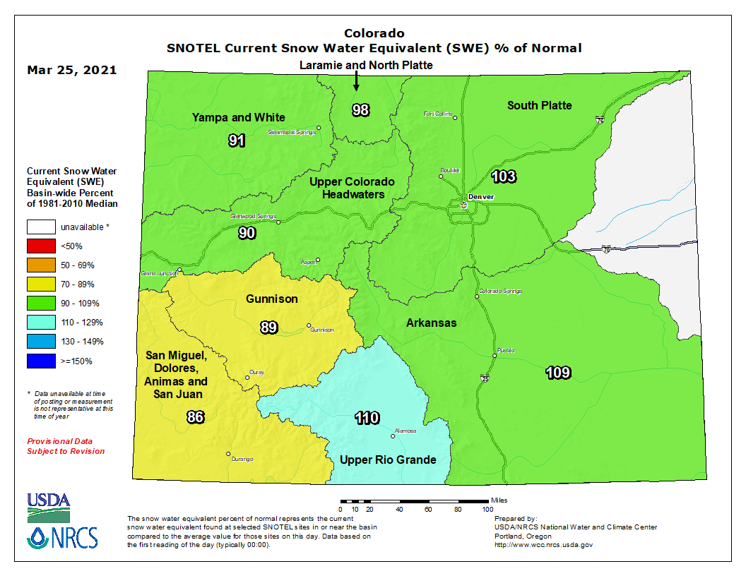
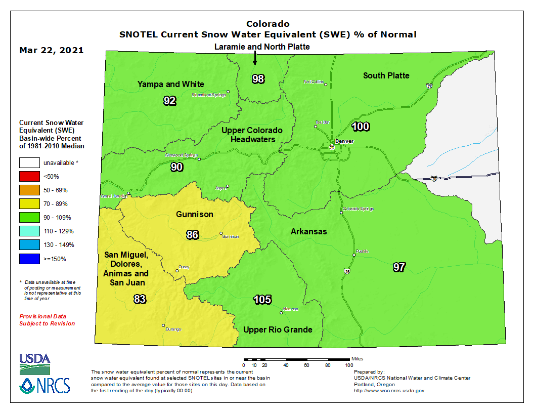
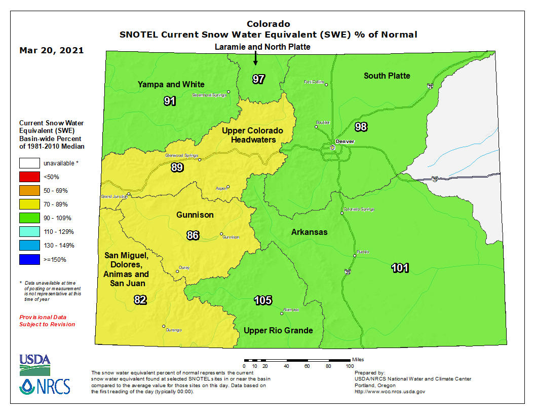
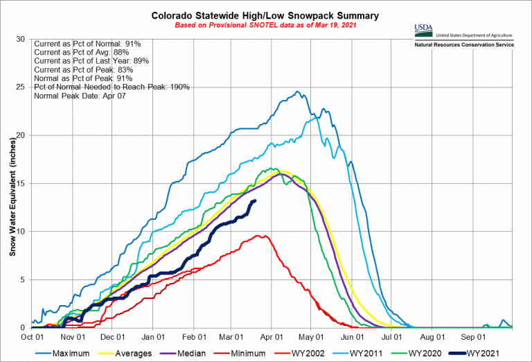
Despite the recent history-making blizzard on Colorado’s Front Range, statewide snowpack sits at 92 percent of average as of March 19, down from 105 percent of average at the end of February, according to the Natural Resources Conservation Service.
Just two river basins, the Arkansas and the Rio Grande, are registering above average at 101 percent and 106 percent respectively. Among the driest are the Gunnison Basin, at 86 percent of average, and the San Juan/Dolores, at 83 percent, both in the southwestern part of the state.
“The snowpack numbers are still below normal though they don’t look that bad,” said Peter Goble, a specialist with the Colorado Climate Center at Colorado State University. “But based on how dry soils were to start this accumulation season, we’re still pretty nervous about what water availability is going to look like.”
Those numbers are hard to believe for some, given that nearly 30 inches of snow fell in and around Denver the weekend of March 13, with some portions of the foothills and higher receiving more than three feet of snow. It is considered the fourth-largest storm in Denver’s history.
Colorado statewide snowpack basin-filled map March 25, 2021 via the NRCS.
According to the U.S. Drought Monitor, the entire state remains mired in drought, with nearly half classified as being extremely or exceptionally dry, the most dangerous categories.
Mountain snowpack is watched closely in Colorado and other Western states because as it melts, it fills rivers and reservoirs to supply the state’s cities, farms and industries with water for the coming year.
Thanks to 2020’s severe drought, in November, for only the second time in its history, the Colorado Water Conservation Board activated its municipal emergency drought response plan in an effort to help cities cope with the dry conditions.
As part of that effort some 14 metro area cities have agreed to coordinate how they inform community members of potential drought restrictions.
“The biggest thing is we don’t want to be counter-messaging anybody,” said Greg Baker, spokesperson for Aurora Water. Aurora is one of the members of the new drought coordination group. “Towns that have robust storage like Denver and Aurora may not need restrictions. But there are about 50 water utilities across the Front Range.”
Those that don’t have hefty storage systems might have to declare drought emergencies, as many did in 2012 and 2013, Baker said.
And when, for instance, major TV stations broadcast that there are no restrictions in Denver or Aurora, it makes it difficult for communities that have to impose limits to help customers understand the vast differences in drought response, he said.
How this year will play out isn’t clear yet, Baker said. Aurora’s reservoirs are at 63 percent of capacity, the low end of normal. Aurora draws its water from the mountains in the Arkansas, Colorado and South Platte river basins.
“A lot of customers forget that we may have had some good snow down here but that is not where we collect our water. It happens up in the mountains,” Baker said.
Even as mountain snows approach the average mark, soils remain dry and therefore capable of absorbing much of the snow that will melt in the spring.
“We’re getting reports that soil moisture is 10 inches below normal,” Baker said. “Will runoff be sucked up? We don’t know.”
Of particular concern to hydrologists and water watchers across Colorado is the forecast for the seven-state Colorado River Basin. The river begins high in Rocky Mountain National Park and, together with tributaries in Colorado like the Gunnison, Yampa, and Dolores rivers, it supplies all of the state’s Western Slope’s water as well as roughly half of the water for Front Range cities and tens of thousands of acres of farms in the Eastern Plains.
As it flows south and west, the river supplies not only Colorado but also Wyoming, Utah and New Mexico, a region known as the Upper Basin, and Nevada, Arizona and California, known as the Lower Basin. It also supplies Mexico.
The basin has two major storage reservoirs in the U.S. and they are filled almost entirely from the mountain snows generated in the Upper Basin. The forecast for the basin remains grim, with the U.S. Bureau of Reclamation estimating that Lake Powell will see inflows of just 47 percent of average as of March 3, the most recent data available.
According to Reclamation, the last half of 2020 was one of the driest periods on record in the Colorado River Basin, and closely resembles the deep droughts of 2002, 2012, 2013 and early 2018. These are, according to the March 3 report, four out of the five driest years on record.
Levels in Powell and Mead are likely to drop low enough this year to trigger additional cuts in water deliveries to Lower Basin states. The recent blizzard in Colorado, because it did not benefit Colorado’s Western Slope and the headwaters of the river as much as it did the Eastern Slope, aren’t likely to change that, according to Reclamation.
Jerd Smith is editor of Fresh Water News. She can be reached at 720-398-6474, via email at jerd@wateredco.org or @jerd_smith.
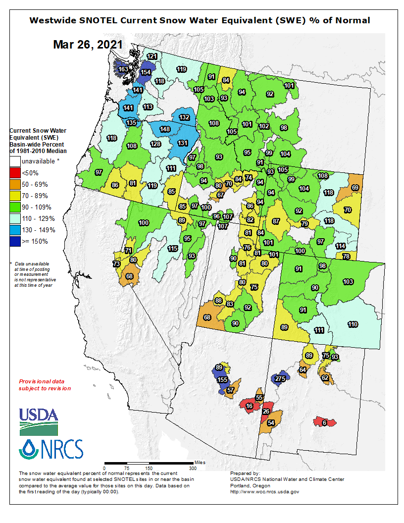
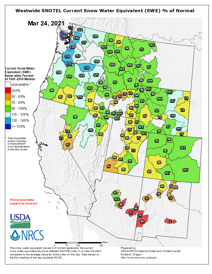
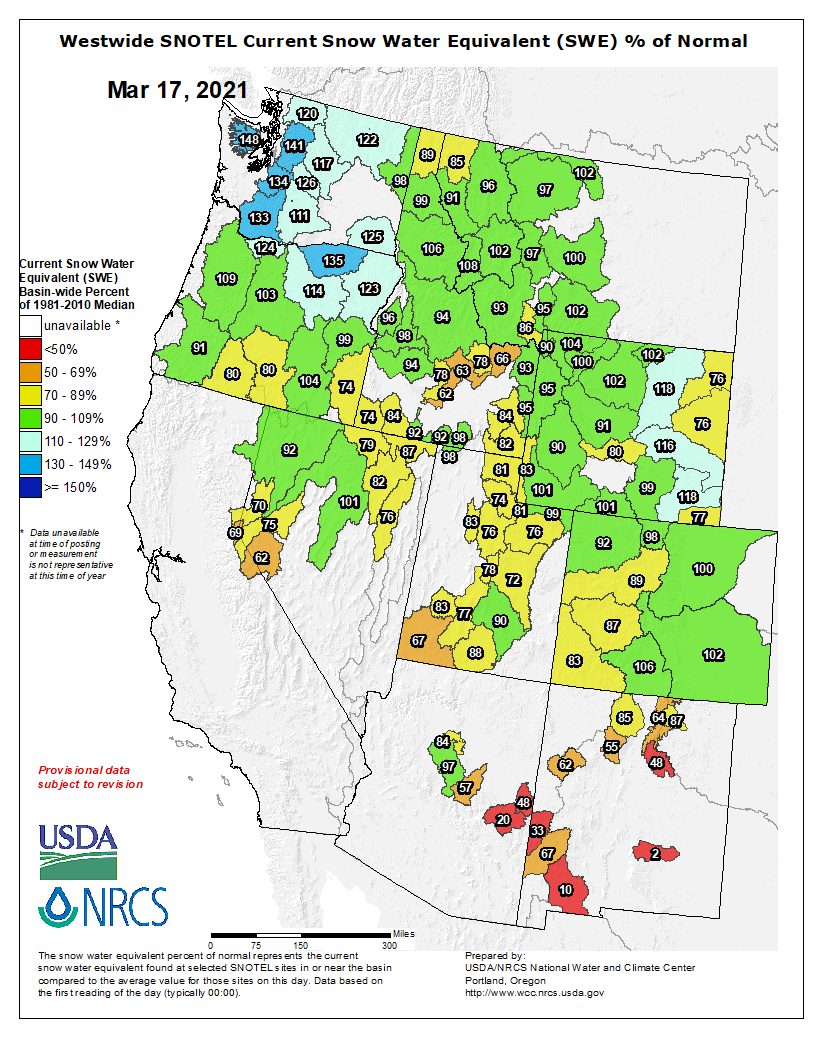
Westwide SNOTEL basin-filled map March 25, 2021 via the NRCS.
Unfortunately, recent snowstorms did very little to improve the mountain snowpack. And the near-term prediction for measurable precipitation isn’t promising.
That’s according to several sources of data and predictive models tracked by the USDA Natural Resource Conservation Service Colorado Snow Survey Program.
NRCS Hydrologist Karl Wetlaufer noted in his monthly snowpack report issued March 5 that, “While February snow accumulations did improve the snowpack in many parts of the state, snowpack still remains below normal levels in all major basins except the Rio Grande.”
At that time, the Colorado River Basin was at 84% of median snowpack, and just 71% of last year’s snowpack. Statewide, the median snowpack at that time was 85%, and only 77% of last year.
Then came the big one — sort of.
A major snowstorm the weekend of March 13 that mostly blanketed the the foothills and eastern Colorado with up to 2 feet of snow in places did have some impact on the high country snowpack. When it comes to Western Slope water, that’s where it mostly matters.
Just before that storm hit, on March 10, the Colorado River Basin was at 88% of median snowpack.
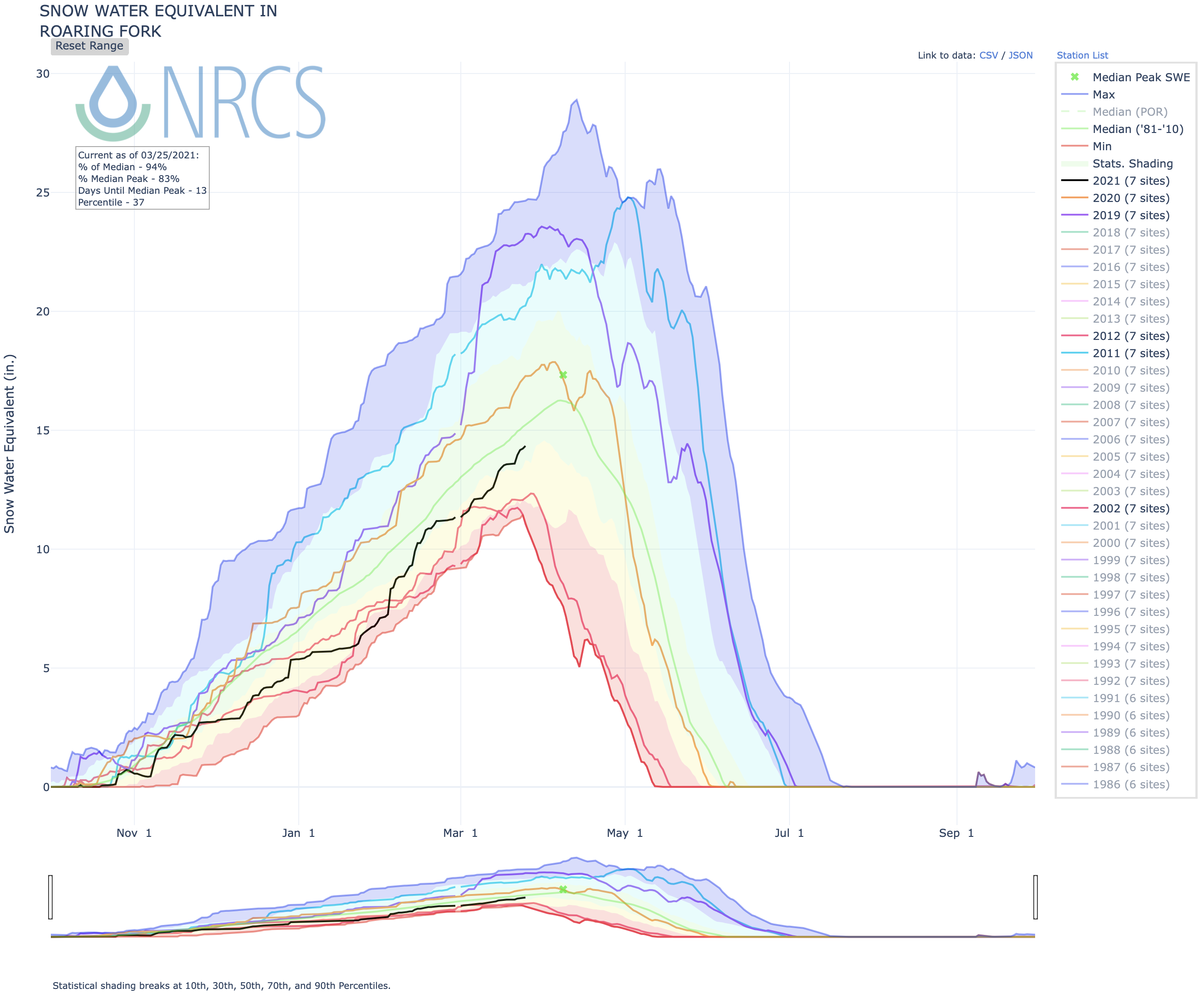
Likewise, one of the Colorado’s major drainages, the Roaring Fork River, with its headwaters on Independence Pass east of Aspen, was at 84% of median.
Afterwards, the area basin snowpack had improved to 91% and 90%, respectively.
As of Tuesday, with more localized snowfall in recent days, the Roaring Fork drainage had improved to 94% of median.
The summer and fall of 2020 was one of the driest periods on record in Colorado.
“This led to dry soil moisture conditions and the expectation is that snowmelt runoff will produce lower volumes than would commonly be observed with a similar snowpack,” Wetlaufer observed in his March 5 report.
Before winter even started, snow forecasters were saying Colorado would need multiple years of 150% to 200% of normal snowpack to improve the drought situation…
“There is currently a significant soil moisture drought that will consume a greater-than-average amount of snowmelt runoff, and leave less to streamflow runoff,” [Brian Domonkos] said. “To add to the complexity, low soil moisture means lower base flows in rivers and streams, which means more precipitation is needed to bring stream flows back to normal levels.”
Click on a thumbnail graphic to view a gallery of drought data from the US Drought Monitor website.
US Drought Monitor March 23, 2021.
West Drought Monitor March 23, 2021.
High Plains Drought Monitor March 23, 2021.
Colorado Drought Monitor March 23, 2021.
Click here to go to the US Drought Monitor website. Here’s an excerpt:
This Week’s Drought Summary
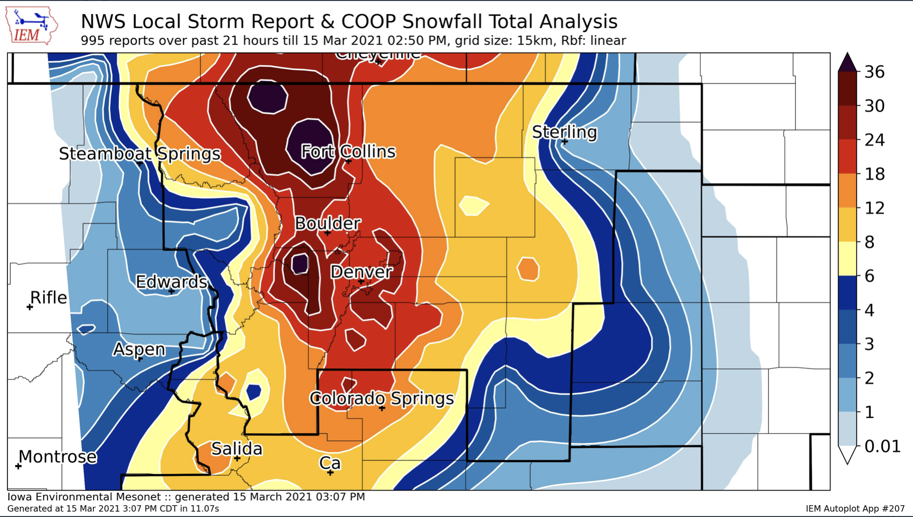
A couple of low pressure systems resulted in widespread precipitation (0.5 to 3 inches, locally more) across the central and southern Plains, Ohio and Tennessee Valleys, Southeast, and Mid-Atlantic from March 16 to 22. However, mostly dry weather persisted across southern Texas, the Florida Peninsula, northern New England, the Great Lakes, and northern Plains. Periods of rain and high-elevation snow occurred across the Pacific Northwest, northern California, and the central Rockies, but the Southwest remained mostly dry. As of March 23, 7-day maximum temperatures averaged above normal across the northern Plains and Upper Mississippi Valley…
Frequent precipitation during the past two weeks continues to result in additional improvements to parts of the central Plains and central Rockies. 7-day total amounts (March 16-22) ranged from 1 to 3 inches, locally more, across a broad region including south-central Nebraska and much of Kansas. As of March 22, Grand Island Nebraska has received 6.95” so far this month which makes it the wettest March on record. The drought amelioration extends west to the central Rockies where numerous improvements were made including a two-category change from D3 to D1 in southwest El Paso County and southeast Teller County as SPIs are now D1 at all timescales. The removal of D3 in southeast Colorado and southwest Kansas was based on: SPIs are either neutral or positive dating back to 6 months and improving soil moisture conditions. In contrast to the major improvements across the central Rockies and central Plains during the past two weeks, persistent dryness continues to support additional expansion of D2 (severe) and D3 (extreme) drought across parts of North Dakota…
A slight expansion of severe drought (D2) was made to northeast Montana, based on 90-day SPI and soil moisture below the 10th percentile. These low soil moisture conditions are related to the lack of snowfall this winter. In contrast to the northern high Plains, snow water content is running close to average for late March and led to the elimination of abnormal dryness (D0) across south-central Montana. Since parts of western Arizona and southeast California have received little to no precipitation during the past two month, D3 (extreme) and D4 (exceptional) drought were slightly increased. This expansion of D3-D4 was supported by 9-month SPI values which covers the failed 2020 monsoon and this past winter. An expansion of D2 (severe) and extreme (D3) drought across parts of southern California was based on large water year to date precipitation deficits and 6-month SPI values. No other changes were made at this time to the remainder of California as 6 to 12 month SPIs generally support the current depiction and snow water content is running near two-thirds of average for the Sierra Nevada Mountains. During subsequent weeks, the drought depiction will be reassessed across California. Although much of the precipitation this past week fell along the coast or over the Cascades, a reassessment of longer term SPIs dating back 6 to 12 months supported removal of the D2 (severe) drought in southwest Oregon. Due in part to recent high-elevation snow and rainfall during the past two weeks, a slight decrease in D3 (extreme) and D4 (exceptional) drought was made to northern and northeast New Mexico. However, widespread D4 persists across southeast New Mexico where dust storms have been quite frequent this month and soil moisture remains in the lowest one percentile…
The severe weather outbreak that affected the Southeast Region began across the Lower Mississippi Valley on March 17 and local rainfall amounts exceeded 2 inches across parts of Arkansas, Louisiana, and Mississippi where 1-category improvements were made. More widespread rainfall amounts of more than 1.5 inches increased soil moisture throughout nearly all of Tennessee. Based on this past week’s rainfall of 1 to 3 inches and improving soil moisture conditions, improvements were made to much of Oklahoma and parts of northern to central Texas. Small 2-category improvements were justified for the northeast Texas Panhandle and northwest Oklahoma where the heaviest rainfall occurred. Periods of above normal temperatures, enhanced surface winds, and below normal precipitation this month supported a continued worsening of drought conditions throughout southern Texas. Soil moisture declines rapidly from central to west Texas where indicators support D3 (extreme) to D4 (exceptional) drought categories…
Looking Ahead
During the next 5 days (March 25 to 29), a pair of low pressure systems are forecast to bring widespread precipitation (0.5 to 2 inches, locally more) to the Lower and Middle Mississippi Valley, Ohio and Tennessee Valleys, and Northeast. Farther to the south across the Florida Peninsula and southern Texas, dry weather is likely to persist. Little to no precipitation is also forecast for the northern Great Plains. Additional snow is expected throughout the Rockies, Intermountain West, and Cascades.
The CPC 6-10 day extended range outlook (valid from March 30 to April 3) favors near normal temperatures for much of the lower 48 in a variable pattern. Probabilities of above normal temperatures are elevated for the northern Plains, Florida, and California. Below normal temperatures are most likely across Alaska. Above normal precipitation is favored for the Northeast, Mid-Atlantic, western Gulf Coast, Rio Grande Valley, and Alaska. Increased chances of below normal precipitation are forecast across the Upper Mississippi Valley, much of the Plains, and throughout the West.
US Drought Monitor one week change map ending March 23, 2021.
Center pivot sprinklers in the Arikaree River basin to irrigate corn. Each sprinkler is supplied by deep wells drilled into the High Plains (Ogallala) aquifer.
Here’s a guest column from Kay Ledbetter, Texas A&M that’s running in No-Till Farmer:
The Ogallala Aquifer’s future requires not just adapting to declining water levels, but the involvement of a wide range of participants comfortable with innovation who will help manage the situation and drive future changes.
That was the message heard by more than 200 participants from across eight states who listened in and identified key steps in working together during the recent two-day Virtual Ogallala Aquifer Summit. The event was led by the U.S. Department of Agriculture-funded Ogallala Water Coordinated Agriculture Project, CAP, which includes Texas A&M AgriLife.
The group partners with the Kansas Water Office and USDA’s Agriculture Research Service-supported Ogallala Aquifer Program to coordinate this event with additional support from other individuals from all eight states overlying the Ogallala Aquifer.
“Technological innovation, financial and economic conditions, infrastructure changes, social values – all these factors drive change,” said John Tracy, Ph.D., director of the Texas Water Resources Institute, which is a partnering agency in the Ogallala Aquifer Program.
Often people feel the need to solve the issue of declining groundwater across many parts of the aquifer, when in fact, what is needed is to look at how we manage change, Tracy said. Adaptive management is about driving the change — realizing it is coming and trying to affect what is happening rather than just responding.
“So, large regions of the Ogallala are going to run out of water, particularly in the Southern High Plains – how are we going to embrace that and not just respond to the change?” he said. “Two important factors: first, this summit; have productive and transparent dialogue to move forward.
“The second thing we need to embrace is rethinking how we approach the changes happening in the Ogallala — this is not a problem to be solved; this is a situation to be managed. We must move into the mindset of changing programs in order to get out in front of the situation. One of the most important activities is looking forward to how we drive this conversation and turn talk into action through consensus building that is the product of shared dialogue amongst all of us.”
The Ogallala aquifer, also referred to as the High Plains aquifer. Source: National Oceanic and Atmospheric Adminstration
Meeting of the Minds
An inaugural eight-state summit, led by the Ogallala Water CAP and Kansas Water Office in 2018 focused on what actions were happening or could happen in terms of field management, science and, to some extent, policy.
After the 2018 summit, participants across the eight states helped lead the integration and merging of technology, the expansion of the Master Irrigator program into more states, as well as the development of new policies and incentives to support more conservation and other collaborative efforts. These efforts are helping develop a broader understanding of actions needed to address the region’s critical water issues.
The 2021 summit was intentionally framed to engage a broader community of actors.
Joining the conversation were representatives of energy co-ops, lenders, producers, federal agencies in each state, youth, non-profits, policymakers, commodity groups, tech and irrigation equipment dealers and multinational companies. Participants identified other groups, including absentee landowners and tribal representatives, that should be invited and engaged as a focus area of the conversation at a future summit event.
Key messages that surfaced from the two days of conversations were:
– Change is imperative to be sustainable. You must be adaptive, not reactive. Transition takes time.
– Learn from each other using inter-regional, interstate and peer-to-peer planning.
– Be willing to experiment with new ideas.
– The power of data drives good policy and real-time decision making for producers and helps break down silos.
– Water is a basic critical infrastructure; we need enough water to support our rural economy, but all industries are dependent on water and it affects the overall economy.
– Producers carry the brunt of what we talk about financially, and keeping them profitable as long as possible must be a priority.
– Engage and invest in youth. Invite them to join and foster conversations that instill a conservation mindset not just among their peers but with a wide range of stakeholders.
Changing the Mindset
The path forward begins with creating interest and providing education to the next generation of both producers and water conservation leaders. Fostering the transfer of knowledge between generations and developing leadership skills to position youth to step into groundwater district and other community leadership roles will be key.
David Smith, 4-H2O program coordinator with the Texas A&M AgriLife Extension Service, Bryan-College Station, described how the Texas 4-H Water Ambassadors program is creating water stewardship leaders.
The program provides an opportunity for youth to gain insight into water law, policy, planning and management, and potential career paths as they interact with representatives from state water agencies, educators, researchers, policymakers and water resource managers.
But education must also take place in the fields. It must provide an organized pathway where producers can find actions and dedicate the time needed to make a difference. Producer-to-producer learning approaches in partnership with university and industry, such as the Nebraska and Oklahoma Testing Ag Performance Solutions program, have been particularly effective.
Brent Auvermann, Ph.D., summit program chair and Texas A&M AgriLife Research and Extension Center director, Amarillo, said the adoption of technology can’t be taken for granted. Looking ahead, tech development and research must grapple with the human dimension of technology adoption.
“Technology will race ahead, but it will stay on the shelf until and unless we devise new ways to foster its adoption,” Auvermann said. “Using even a little bit more water than needed is a form of crop insurance and asking producers to rely on new technology to cut back on that water use increases the risk that they, their insurers and their lenders perceive.”
C.E. Williams, Panhandle Groundwater Conservation District general manager, White Deer, said when producers think about growing a crop, their concern shouldn’t be about bushels per acre — water is the limiting factor. They need to understand and invest in the technology that will ensure they are putting every drop in the right place.
“All the inputs you put in are important, but the bottom line is water,” Williams said. “Why did we use it? It is like money. You spend it; it is gone. What was your bottom line per water use? Rather than thinking of production in terms of bushels per acre, we should be thinking in terms of how many bushels per acre-inch or acre-foot of water used.”
Every drop saved adds up
We need to find a way to provide access to broad audience about the actions of many successful innovators who are having success with different precision management technologies and strategies, said Chuck West, Thornton Distinguished Chair in the Texas Tech University Department of Plant and Soil Science, Lubbock.
“There are a lot of little decisions that people can make all along the way that add up to considerable water savings,” West said.
Katie Ingels, director of communications with the Kansas Water Office, said several some of their Water Tech Farm producers are seeing the advantages of tech adoption, where a combination of slight adjustments in practice or integrating a new tool or strategy and related decisions each contribute some savings of money, time or water.
“There’s a mindset out there among some growers that they can’t make a tremendous difference because they are a smaller operation with only a few wells,” said panelist Cory Gilbert, founder of On Target Ag Solutions. “Every single system that adds to the acre-foot savings turns into a very big number very quickly in terms of conservation.”
Panelist Matt Long, producer and seed supplier, Leoti, Kansas, said water conservation is a quality of life issue.
“If you look at the communities you can see which ones are vibrant and they are the ones with a stable water supply that can support industry beyond cropping,” Long said. “Conserving water isn’t just about there being water for the future; it’s about having a community for the future. We have to have enough water to keep the people to keep the community.”
But at the same time, Auvermann said, communities need to be mindful of their water use.
“We city folks need to look no further than our front lawns to see why we’re in the pickle we’re in,” Auvermann said. “We run water down the curb to make sure our home’s appearance doesn’t suffer. Water is insurance for all of us.”
Building a Path Forward
Amy Kremen, Ogallala Water CAP project manager, Department of Soil and Crop Sciences at Colorado State University, said a continuing theme throughout the meeting was, “With limited water in the High Plains, the question is less about production that needs to feed the world’s population of 8 billion, it’s about keeping rural communities vital. We need to give people more flexible options that allow them to make decisions related to water use that are to their economic best advantage.”
Quality of life in these smaller communities, whether they are in Kansas or Texas or any of the states the Ogallala Aquifer supports, is what is important.
“We don’t want to dry up that life,” Kremen said. “We are all in this together. And together, we will come up with solutions better than any of us individually.”
Decisions must center on making conservation economical for agriculture producers, both short-term and with long-term sustainability, providing not only for the next generations on the farm, but for the sustainability of the local communities they support.
“We need to be willing to have uncomfortable conversations,” Auvermann said. “We need to talk candidly and be willing to entertain new, unfamiliar ideas. Sometimes we’ll make mistakes, but it’s not as though we’ve not been making them up to this point. Fear of making mistakes keeps us from innovating. Our dialogue has to be generous, congenial and optimistic to overcome that. We have to be trustworthy ourselves, and we have to be willing to trust.”
People are hungry to have these conversations, said Meagan Schipanski, Ph.D., associate professor, Department of Soil and Crop Sciences at Colorado State University and Ogallala Water CAP codirector.
“We need to have them happen in public, mini-summits or regional conversations,” Schipanski said. “We need to take on a stewardship that meets producer and community needs.”
Skeptics and public health officials dueled over the issue of water fluoridation during Wednesday’s meeting of the Loveland Utility Commission, which last heard similar concerns in 2014.
The skeptics failed to sway the commission, however, which voted at the suggestion of Loveland Water and Power director Joe Bernosky to recommend the city continue its practice of water fluoridation.
An anti-fluoridation panel spoke first, led by Traudl Renner, whose comments before the City Council in October prompted the meeting. She argued that emerging science has called into question the safety of fluoridation, which Loveland has undertaken since 1954.
She cited a study that indicated fluoride could damage the immune system (a panelist supporting fluoridation qualified this by saying the quoted section considered very high doses of the element)…
She also questioned the effectiveness of ingested fluoride in preventing tooth decay, which is the reason why communities such as Loveland introduce fluoride compounds into their water.
Renner and fellow anti-fluoride panelist Kathryn Jordan also brought up how accidents at water treatment facilities occasionally cause dangerous amounts of fluoride to be introduced into drinking water.
Joe Bernosky, director of Loveland Water and Power, later said he and water utilities manager Roger Berg were not aware of any such accidents having ever occurred in the city.
Jordan questioned the expense of programs such as Loveland’s, and asked why the city wouldn’t receive the chemical, which she said is the byproduct of certain industrial processes, for free…
Chris Neurath, research director for the American Environmental Health Studies Project, said studies also suggest the element is neurotoxic and notably dangerous for pregnant women and young children…
Neurath’s characterization of multiple studies was challenged by fluoridation advocates, particularly pediatrician Patricia Braun and dentist William Bailey of the University of Colorado’s Anschutz Medical Campus. The latter called water fluoridation an “ideal public health measure.”
“There’s nothing that you have to remember to do,” he said. “You don’t have to make an appointment. You don’t have to stand in line. You don’t have to go to the doctor. All you have to do is drink and use the water. It’s inexpensive. It helps tremendously with dental disease.”
“Community fluoridation is the most cost-effective and far-reaching strategy we have to prevent cavities,” Braun said, adding that tooth decay was the number one reason she saw children going into surgery.
Braun and Katya Mauritson, the Colorado Department of Public Health and Environment’s dental director, also spoke about the savings in medical expenses seen by communities that fluoridate their water, with Mauritson estimating that Loveland’s program saves residents more than $2 million in medical bills every year.
Commissioners voted unanimously to recommend the city keep up its water fluoridation program.
These wetlands, located on a 150-acre parcel in the Homestake Creek valley that Homestake Partners bought in 2018, would be inundated if Whitney Reservoir is constructed. The Forest Service received more than 500 comments, the majority in opposition to, test drilling associated with the project and the reservoir project itself. Photo credit: Heather Sackett/Aspen Journalism
OK is first step toward dam and reservoir on Homestake Creek
The U.S. Forest Service on Monday approved an application from the cities of Aurora and Colorado Springs for geotechnical drilling in the Homestake Valley, one of the first steps toward building a new dam and reservoir on Homestake Creek.
The approval allows the cities, operating together as Homestake Partners, to drill 10 bore samples up to 150 feet deep and for crews on the ground to collect geophysical data. The goal of the work, which is expected to begin in late summer and last 50 to 60 days, is a “fatal flaw” feasibility study to determine whether the soil and bedrock could support a dam and reservoir.
The project, known as Whitney Reservoir, would be located near the Holy Cross Wilderness Area, which is six miles south of Red Cliff. Various configurations of the project show it holding between 6,850 and 20,000 acre-feet of water. The area is home to a rare kind of groundwater-fed wetland with peat soils known as a fen.
Eagle-Holy Cross District Ranger Leanne Veldhuis approved the project despite receiving a total of 775 comments on the drilling proposal during the scoping period. According to the public scoping comment summary, the most common topics commenters had concerns about included the potential loss of wilderness, the destruction of fens and wetlands, impacts to water quality and disturbance to wildlife.
But just 80 letters — about 10% — were individual comments that the Forest Service considered substantive and specific to the geotechnical investigation. Most comments were form-letter templates from organizations such as Carbondale-based conservation group Wilderness Workshop or pertained to concerns about the Whitney Reservoir project as a whole, not the geotechnical drilling.
“A lot of the public comments were pertaining to a reservoir, and the proposal is not for a reservoir; it’s for just those 10 geotechnical bore holes,” Veldhuis said.
Many commenters also said the level of analysis under the National Environmental Policy Act wasn’t appropriate and questioned why the proposal was granted a categorical exclusion, rather than undergoing the more rigorous Environmental Analysis typical of big projects on Forest Service land. Veldhuis said the geotechnical investigation, a common occurrence on public lands, didn’t rise to the level of an EA; that could come later with any reservoir proposal.
“If the future holds any additional sort of proposal, then that would trigger a brand-new analysis with additional rounds of public comments,” she said. “Any future proposals for anything more would undergo an even bigger environmental analysis than this underwent.”
Homestake Creek flows from Homestake Reservoir near Red Cliff. Starting Wednesday, Homestake Partners will be releasing water out of the reservoir to make sure that water can get to the state line as another option to fulfill the state’s upstream duties of delivering water to the lower basin states (Arizona, California and Nevada). Photo credit: Bethany Blitz/Aspen Journalism
Whitney Reservoir
The proposed Whitney Reservoir would pump water from lower Homestake Creek back to Homestake Reservoir, about five miles upstream. Then it would go through a tunnel under the Continental Divide to Turquoise Reservoir, near Leadville, and then to the cities of Aurora and Colorado Springs. The idea of expanding the intrastate plumbing system to take more water from the headwaters of the Colorado River over to thirsty and growing Front Range cities doesn’t sit well with many people and organizations.
Wilderness Workshop issued a news release saying it would oppose the reservoir project every step of the way. The organization also launched an online petition Monday to rally opposers, which had already garnered more than 200 signatures as of Monday evening.
“We would like to see the Forest Service change course,” said Juli Slivka, Wilderness Workshop’s conservation director. The decision was discouraging, she said, but Wilderness Workshop will continue pressuring the federal agency. “The idea of moving water from the Western Slope to the Front Range is not very appreciated out here.”
A map from Colorado Springs Utilities that shows how tunnels could bring water to Whitney Reservoir from Fall and Peterson creeks, and from the Eagle River. The map also shows the route of a pipeline to pump water from Whitney Reservoir to Homestake Reservoir.
Eagle River MOU
But Front Range municipalities are not the only ones set to benefit from a new water-storage project. The Eagle River Memorandum of Understanding lays out a plan for both Front Range and Western Slope entities to develop water in the upper Eagle River basin. The agreement, signed in 1998, provides 20,000 acre-feet of water a year to Homestake Partners and 10,000 acre-feet a year to the Colorado River Water Conservation District, the Eagle River Water and Sanitation District, Upper Eagle Regional Water Authority and Vail Resorts, known collectively in the MOU as the “Reservoir Company.”
The Reservoir Company is not an applicant in the drilling proposal and none of the Western Slope entities that are parties to the MOU submitted comments on the drilling proposal.
Diane Johnson, communications and public affairs manager for the Eagle River Water and Sanitation District, said the water provider supports Homestake Partners’ right to pursue an application for their water.
“We trust the permitting process to bring all impacts and benefits to light for the community to consider and weigh in total,” Johnson said in an email.
The Forest Service also determined that impacts to wetlands from the drilling are negligible. Homestake Partners plans to place temporary mats across wetland areas to protect vegetation and soils from the people and machinery crossing Homestake Creek. In a June letter, a representative from the U.S. Army Corps of Engineers said the work did not require a permit from that agency.
The Forest Service also conducted a biological assessment and found that the drilling would not impact endangered Canada lynx.
This story ran in the March 23 edition of The Vail Daily and The Aspen Times.
The second-ever call on the Yampa River ended September 6, 2020. Here it flows near the diversion from the Hayden Generating Station on Aug. 3. Photo credit: Allen Best/Aspen Journalism
Here’s the release from the Colorado Division of Water Resources (Chris Arend):
The Colorado Division of Water Resources announced the commencement of a public comment process today on a proposed plan to designate the main stem of the Yampa River in Northwest Colorado as “over-appropriated.” An over-appropriated stream system is one in which at some or all times of the year, the water supplies of a stream system are insufficient to satisfy all the decreed water rights within that system.
Colorado water law is driven by a system of “prior-appropriation” or a first in time, first in right water right system. The system is designed for Colorado’s semi-arid climate to fairly and efficiently distribute the state’s limited water supply for the beneficial use of Coloradans. If a river system, such as the Yampa River, at times has insufficient supply to provide water to all decreed uses, then additional measures to protect those decree uses are necessary.
“The Yampa River is an incredibly important resource for Northwest Coloradans. It sustains our communities, farms, ranches, wildlife, outdoor recreation and power supplies,” said Erin Light, Division Engineer, Water Division 6, Colorado Division of Water Resources. “However, the combination of continued diversions by senior water rights and recent appropriations, along with recent climatic conditions, such as sustained drought, indicates a strong potential that the mainstem of the Yampa River meets the criteria of being “over-appropriated” and requires more careful administration to ensure senior water right holders are able to properly use their legal water rights. We want to make sure our water users and community are knowledgeable on this change in the river and are educated on the potential changes that may occur as water is developed in the Yampa River valley.”
The effect of this designation is the requirement that new well permits in the affected area will require an evaluation of their potential to cause injury to surface water rights and in many cases will need to secure a replacement supply of water to mitigate the impacts of their pumping through an “augmentation plan” before being issued a well permit by the Division of Water Resources.
“We understand this new well permitting process will be a change for water users and those looking to develop water in Yampa Valley,” Light added. “I want to assure community members that my office and our Division is here to assist you in these new measures as we all work towards equitably managing our scarce but critical water resources.”
Following the formal notice of this recommendation, which involves notifying members of the Division 6 Substitute Water Supply Plans (SWSP) Notification List and additional community input, the State Engineer and Director of the Colorado Division of Water Resources, Kevin Rein, will work with Erin Light to determine next steps, which may include additional public outreach. Rein will not make a final determination on the proposed “over-appropriated” designation until he is satisfied that the water users fully understand the effect of the designation.
Having a river system designated as “over-appropriated” is not a new concept in Colorado. In fact, only a small minority of river systems in Colorado are not considered to be over-appropriated. The South Platte, Rio Grande, and Arkansas River systems with their heavy agricultural and municipal and industrial water users have long been considered “over-appropriated.”
To submit comments on or any questions about the proposed plan please contact Erin Light, Division Engineer, Water Division 6, at erin.light@state.co.us or 970-879-0272 Ext. 3.
The Colorado River, which feeds into Lake Powell, begins its 1,450-mile journey in Rocky Mountain National Park near Grand Lake, Colorado. Denver Water gets half of its water from tributaries that feed into the Colorado River. Some of these tributaries include the Fraser River in Grand County and the Blue River in Summit County. Photo credit: Denver Water
Nestled high in the Rocky Mountains, a trickle begins. Humble, quiet, fragile, this small trickle winds and grows — fed by snowpack — into the mighty Colorado River that carved the Grand Canyon. This river and its canyons have been sacred to Indigenous communities for millennia, inspired generations of explorers, and form the lifeblood of the American West.
This water — that flows from the Colorado Rockies and into the dry, red canyons of Western Colorado and Utah, across tribal lands, through Lake Powell and Lake Mead in Arizona, and reaches toward the Colorado River Delta in the Sea of Cortez — is endangered. Like many of the world’s waterways, it faces the growing challenges of climate change and population growth.
But the river has endured. Today, on World Water Day, we take the opportunity to remember that no matter where we live, water is a vital resource to our environment, communities, businesses, families, and everyday lives — and as such, we must work together to protect it.
Water in Colorado impacts people everywhere.
The Colorado River, our state’s namesake river, originates in our high country but it, and its tributaries, directly support the people and wildlife of seven U.S. states, 29 tribal nations and Mexico, with $1.4 trillion in annual economic activity and 16 million U.S. jobs. Not only that, but over 40 million people depend on the Colorado River system for clean, safe, and reliable drinking water. River-related recreation — which contributes $19 billion annually to Colorado’s economy alone — feeds our souls, our lifestyle, and our identity in the American West. If you’ve ever eaten lettuce in the winter, carved down the ski slopes, or cracked open a local beer, you’ve interacted with the Colorado River. Can you imagine living in the West without this hardworking waterway?
Confluence of the Little Colorado River and the Colorado River. Climate change is affecting western streams by diminishing snowpack and accelerating evaporation, a new study finds. Photo credit: DMY at Hebrew Wikipedia [Public domain]
Without our rivers, everything changes.
Right now, the future of the Colorado River is precarious. Water is under extreme threat from a growing population, increasing demands of agriculture and industry, and the worsening impacts of climate change. Today, we both celebrate what water provides us and reflect on what we must do to protect it — here in Colorado, and around the world.
In households, schools, and workplaces water can mean health, hygiene, dignity, and productivity. In cultural, religious, and spiritual places water can mean a connection with nature, community, and oneself. In natural spaces, water can mean peace, rejuvenation, and preservation.
By celebrating all the different ways water benefits our lives, we value water in Colorado and beyond.
Looking down on camp at Big Pine, Red Canyon. The photo shows the SCREE Powell 150 expdition camp at Big Pine Campground in Red Canyon of the Green River, Utah. The large green tarp was set up to keep the kitchen area and campers dry. Two very large ponderosa pines are in the center of camp, and surely were witness to the 1869 Powell expedition. Photo credit SCREE via the USGS.
Coloradans are taking strides to protect our water.
The Colorado Water Plan recently celebrated its fifth anniversary and has seen huge successes in protecting our waters. The plan has set the first-ever statewide urban water conservation target to be achieved by cities and towns, prioritizing water conservation as never before. Annual funding for healthy rivers and watershed restoration is increasing — but more is needed to ensure that the environmental and recreational priorities in the plan are implemented. And Coloradans have, for two years in a row, voted to fund the conservation of our water through the ballot at both the local and state levels; these are first steps toward meeting a large funding shortfall.
If anything is clear: Coloradans understand the importance of water in our state — more so now than ever before, as the impacts of COVID-19 highlight hardships facing our communities and our water. If we don’t protect flows, the simple and essential act of washing our hands could become costly and uncertain. If we don’t proactively manage resource distribution, the disproportionate economic impact of the pandemic could affect farmers, ranchers, and recreation guides long after life returns to normal.
The work is never done, and the future of the Colorado River is far from certain. It is not the responsibility of one person, one government, or even one state to prioritize water and ensure lasting flow. We each need to take responsibility, and by working together, we can protect not only running taps and irrigated fields but our rivers and the Colorado way of life.
An angler in the Yampa River in Steamboat Springs in early March 2020. Designating part of the Yampa River as over-appropriated would require some water users with wells to have an augmentation plan. CREDIT: ALLEN BEST/ASPEN JOURNALISM
What’s your Colorado Water story?
On World Water Day this year, take a minute to think about your relationship with water in Colorado. On what stretches of riverbanks have you gathered, watched the sun come up, fished in cold eddies, or paddled through aspen groves? How do you honor and protect water in your home and community? Has a project funded by Colorado’s Water Plan come to your area and restored a place you love? Whether it’s for recreation, community gathering, business, or one of the hundreds of other reasons we love water, we hope you can honor and celebrate water in our state today and every day.
U.S. Forest Service District Ranger Leanne Veldhuis approved the cities’ plan Monday to drill into the high-alpine Homestake Valley and test whether the underlying geology could support a reservoir diverting water from the Colorado River to the growing municipalities.
It’s an early, key step in the effort to build the new reservoir, which would be called the Whitney Reservoir, in the National Forest about six miles southwest of the town of Red Cliff.
The cities have long held the water rights to build the new reservoir and divert the water, usually destined for the beleaguered Colorado River, to thirsty residents in Aurora and Colorado Springs.
With approval in tow, Aurora and Colorado Springs have the green light to test for several possible reservoir sites in the Homestake Valley.
Greg Baker, Aurora Water’s manager of public relations, told the Sentinel last year the reservoir could be built in about 25 years if the complicated approval process pans out. The new reservoir in the Homestake Valley could hold between 6,850 acre-feet and 20,000 acre-feet of water, according to the Forest Service…
Notably, the project requires environmental impact studies and possibly an act of Congress, according to Baker, to shave up to 500 acres from the popular Holy Cross Wilderness. However, he added that the plan is far from set in stone.
The plan has drawn scrutiny from conservation groups concerned about devastating the ancient wetland habitant that retains water — an increasingly scare commodity in the West. Various endangered fish species would be downriver from the dam.
The Colorado River itself has seen reduced flows in recent decades, in part because of human-induced climate change. Many environmentalists argue that as much water as possible should be left in the river, which multiple states and Mexico rely on…
Baker said in an email that the drilling study is “routine.”
“We value the collaborative process involved in exploring alternatives that minimize environmental impacts, are cost effective, can be permitted by local, state, and federal agencies, and which will meet the water requirements of the project partners,” he said.
Democratic state Sen. Kerry Donovan represents seven counties that include communities like Aspen and Crested Butte. In a letter opposing the project, Donovan wrote that, “she can’t express how sternly the people in her district dislike water diversion projects to the front range,” according to CPR.
This map shows the location of test holes Homestake Partners plans to drill as part of its geotechnical investigation into the feasibility of a dam site in the Homestake Creek valley. The Forest Service has received more than 500 comments, most of them in opposition to, the drilling and the overall reservoir project. Credit: USFS via Aspen Journalism
These wetlands in the Homestake Creek valley are near the site of the proposed Whitney Reservoir. The Forest Service is considering whether to issue a permit for drilling and a geotechnical study to test whether the site would support a dam. Photo credit: Heather Sackett/Aspen Journalism
These wetlands, located on a 150-acre parcel in the Homestake Creek valley that Homestake Partners bought in 2018, would be inundated if Whitney Reservoir is constructed. The Forest Service received more than 500 comments, the majority in opposition to, test drilling associated with the project and the reservoir project itself. Photo credit: Heather Sackett/Aspen Journalism
A map from Colorado Springs Utilities that shows how tunnels could bring water to Whitney Reservoir from Fall and Peterson creeks, and from the Eagle River. The map also shows the route of a pipeline to pump water from Whitney Reservoir to Homestake Reservoir.
A wetland area along Homestake Creek in an area that would be flooded by a potential Whitney Reservoir. The cities of Aurora and Colorado Springs are looking to develop additional water in Eagle County and divert it to the Front Range. Photo credit: Brent Gardner-Smith/Aspen Journalism
A map prepared by Aurora Water that shows a potential 500-acre adjustment to the Holy Cross Wilderness boundary near the potential Whitney Reservoir on lower Homestake Creek. The map as current as of July 16, 2019.
Homestake Reservoir, which is partially in Pitkin County, but mainly in Eagle County. Below the reservoir the Homestake Creek valley is visible, as well as short section of what’s known as Homestake Road. Water held in the potential Whitney Reservoir would be pumped up to Homestake Reservoir and then sent to the Front Range. Photo credit: Brent Gardner-Smith/Aspen Journalism
The dam in the Eagle River headwaters that forms Homestake Reservoir, which diverts water to the Front Range. If the wetlands in the Homestake Creek valley contain ancient peat bogs called fens, it could hinder the progress of the Whitney Reservoir project. Photo: Brent Gardner-Smith/Aspen Journailsm
FromThe Colorado Sun (Michael Booth and Jason Blevins):
The decision to let the Front Range water utilities move forward in taking more Western Slope water is only one of countless regulatory hurdles for a future Whitney Reservoir, but conservation groups say they are adamantly against any new water transfers to suburban water users across the Continental Divide and will oppose every approval step.
Colorado Headwaters, which opposes any new dams and water transfers, said it expected the approval but remains steadfast against any progress on the project. “We don’t think it will ever be built,” president Jerry Mallett said. “They haven’t done a transmountain diversion in 45 years. Water on the Colorado River is dropping from climate change. We don’t want to lose those natural resources.”
The decision from White River said the approval applies only to drilling 10 test bore holes the utilities applied for, and does not have bearing on any future decisions should the cities pursue the dam north of Camp Hale. The proposed reservoir would hold about 20,000 acre feet…
The cities partnered with Eagle County, the Colorado Water Conservation District, Vail Resorts and other Western Slope water users in 1998 in a deal that gave water rights to Eagle River communities and developed the 3,300 acre-foot Eagle Park Reservoir on the Climax Mine property.
The 1998 Eagle River Memorandum of Understanding included plans for possible reservoirs along Homestake Creek. The agreement — which brought together a diverse group of downstream users as “Homestake Partners” in the Eagle River Joint Use Water Project — also affirmed that no partner could object to a new reservoir plan if it met the memorandum’s agreement to “minimize environmental impacts” and could be permitted by local, state and federal agencies.
The proposed Whitney Reservoir project is not new and “represents our continued pursuit to develop water rights in existence for many years,” Colorado Springs Utilities spokeswoman Jennifer Kemp said.
Kemp said the cities have developed alternatives to building a new reservoir in the Homestake Creek drainage but those other options have not been proposed or discussed publicly. The results of the test boring and geotechnical work will help the two cities vet possible alternatives…
Environmental groups oppose new dams on Homestake in part because they would take water out of tributaries that feed the already-depleted Colorado River. But they are also focused on preserving complex wetlands called “fens” that develop over the long term and support diverse wildlife. They say fens cannot easily be recreated in any mitigation work that utilities traditionally include in dam proposals.
The headwaters group also questions why the Forest Service would encourage any steps when completion of a dam appears impossible. The utility proposals include shrinking the size of the Holy Cross Wilderness Area to create dam access, “which Congress will never approve,” Mallett said.
The city’s water utility introduces a fluoride compound into its drinking water to raise the concentration of the element to 0.7 milligrams per liter. About 0.2 milligrams of fluoride are naturally present in the water before it passes through the Loveland Water Treatment Plant.
Cities commonly add fluoride to their drinking water because of its effects on dental health. Loveland began fluoridating its water in 1954. Since then, the consensus among public health experts has been that fluoride is not harmful at the levels achieved by fluoridation.
The efficacy of water fluoridation is supported by the Larimer County Department of Health and Environment, Colorado Department of Public Health and Environment, Centers for Disease Control and Prevention, American Dental Association, American Water Works Association, U.S. Public Health Service and other agencies.
In October, Loveland resident Traudl Renner told the council that she and others believe water fluoridation causes various health problems and suppresses the immune system.
Council members ultimately agreed with a suggestion by City Manager Steve Adams that the topic be brought before the Loveland Utilities Commission, which advises the council on matters related to the city’s water and electric utilities.
The commission last addressed the fluoridation question in 2014 — after weighing presentations from health care professionals as well as citizens who voiced concerns similar to Renner’s, it voted to recommend the city continue adding fluoride to its water.
Wednesday’s meeting will be structured in a similar way, starting with presentations from a fluoride-skeptic panel, followed by a panel of doctors and representatives of agencies that support the practice.
Loveland Water and Power director Joe Bernosky said he expects the commission will vote to recommend whether the city should continue fluoridating its water, and he will write a memo summarizing the meeting to be reviewed by the council…
The Zoom webinar will be accessible at http://zoom.us/s/98404604379. To make a video comment, Zoom attendees should use the “raise your hand” feature and wait to be unmuted.
East Portal Gunnison Tunnel gate and equipment houses provide for the workings of the tunnel. Lisa Lynch/NPS
From email from Reclamation (Erik Knight):
Diversions to the Gunnison Tunnel will be ramping up for the irrigation season and releases from the Aspinall Unit will be adjusted to keep Gunnison River flows near the current level of 400 cfs. There could be fluctuations in the river throughout the day whenever Tunnel diversions increase.
On Wednesday, March 24th testing of the Crystal powerplant will result in a brief period of high flows in the Gunnison River through the Black Canyon and Gunnison Gorge. Crystal releases will be increased up to 1700 cfs over a couple hours before decreasing back to the current release rate.
Flows in the lower Gunnison River are currently above the baseflow target of 790 cfs. River flows are expected to stay above the baseflow target for the foreseeable future.
Pursuant to the Aspinall Unit Operations Record of Decision (ROD), the baseflow target in the lower Gunnison River, as measured at the Whitewater gage, is 790 cfs for March.
Currently, diversions into the Gunnison Tunnel are 400 cfs and flows in the Gunnison River through the Black Canyon are around 400 cfs. As Tunnel diversions increase, flows in the Gunnison River through the Black Canyon are expected to stay near 400 cfs. Current flow information is obtained from provisional data that may undergo revision subsequent to review.
Rising temperatures and lack of rain threaten to decrease water supplies and bring more wildfires this summer and in the years to come.
The Western US is in the midst of yet another dangerous dry spell. The drought has been building over the past year, and since November, a greater stretch of the West has been in the most severe category of drought than at any time in the 20 years that the National Drought Mitigation Center has been keeping records.
Western states are already facing water shortages, and with the National Weather Service projecting that the dry stretch will continue, the problems that accompany droughts are likely to pile up heading into this summer…
That last drought also led to other fallouts: billions of dollars in economic losses as farmers were forced to let fields lie fallow and a 50 percent drop in electricity production from dams. It also contributed to the death of over 100 million trees, which fuels bigger wildfires, like the ones that ripped through the West last summer. If the current drought continues, similarly stark consequences lie ahead.
Unfortunately, these droughts in rapid succession aren’t an aberration but rather a sign of what’s to come. Climate change is driving more severe droughts and spurring longer, more troubling “megadroughts” across the Western states. Here’s what you need to know about what the future holds for these states as temperatures rise.
The latest episode in a megadrought
This time last year, the West was relatively drought-free after a wet winter in 2019. But by now, the region has swung from 27 percent in drought to 77 percent, according to the latest data from the US Drought Monitor released March 11.
What happened?
Over the past year, the drought has been building due to a lack of rain, a weak summer monsoon in the Southwest, and intense summer heat waves. “If I had to pinpoint one thing that really drove the drought to where we are right now, it was the heat of last summer,” said Brian Fuchs, a climatologist at the University of Nebraska’s National Drought Mitigation Center.
High summer temperatures sucked the moisture out of the soil and evaporated water resources.
The Four Corners, where Utah, Arizona, New Mexico, and Colorado meet, has been the epicenter of this drought, Fuchs said. The dark splotch on the map below shows that those states as well as Nevada have been experiencing the most intense drought.
US Drought Monitor March 16, 2021.
Now the West is in the winter wet season, but due, in part, to the La Niña weather pattern, too little rain and snow is falling to make up for the preceding dry months.
Some rain and snow may still fall, but the National Weather Service’s seasonal forecast projects that drought conditions will persist across the Western US through May, the end of the current forecast period. “We do have some time to maybe put a dent in some of these deficits that we’ve seen through the winter,” said Fuchs. “Now the idea that we are going to catch up completely — that’s going to be tough.”
The trajectory of this drought episode remains unclear, but scientists say that it is actually part of a bigger megadrought — a decades-long dry spell, punctuated by severe droughts. This megadrought began around 2000, and as the chart below shows, the majority of land in the West has been in some level of drought ever since.
West drought time series ending March 18, 2021 via the US Drought Monitor.
To understand why the West is in a megadrought, the role of climate change, and what it means for the region’s future, we first need to look at some historical clues.
What’s behind longer and more intense droughts? Climate change.
Based on data from tree rings and other ecological records of weather and climate patterns of the last few thousand years, we know that the West is no stranger to drought. In an April 2020 tree ring study published in Science, researchers found that several megadroughts occurred between 850 and 1600 — before humans started pumping massive amounts of greenhouse gases into the atmosphere. These droughts were likely caused by cool temperatures in the Pacific Ocean that prevented rainfall from reaching the Southwest.
While natural variability has been a factor in recent droughts, the current megadrought is also being driven by climate change, according to the study. Higher temperatures, caused by greenhouse gases, have increased evaporation and decreased precipitation in the spring across the region. The researchers were able to identify that climate change accounted for 46 percent of the drought’s severity.
Without climate change, there still would have been a drought, but “anthropogenic warming was critical for placing 2000–2018 on a trajectory consistent with the most severe past megadroughts,” they wrote. The current megadrought, which they traced from 2000 through 2018, was the second driest 19-year episode in the 1,200-year record.
This finding is not just important for how we understand the current crisis, but also for the coming decades in the Western US as temperatures continue to climb.
The latest National Climate Assessment, authored by 13 US federal agencies in 2018, laid out a grim future for the Southwestern states: Rising temperatures will increase the likelihood of megadroughts in the region and make droughts more frequent and severe, according to the scientific literature cited.
While annual precipitation in the Southwest may not necessarily decrease, the hotter annual temperatures will burn off more moisture, contributing to droughts, the researchers explained in the Science tree ring study.
Following last weekend’s storm system that brought wet snow or rain to much of eastern Colorado, the state’s drought map has shown some signs of improvement according to the National Drought Mitigation Center.
The western half of the state saw little moisture and virtually no change in drought conditions. Much of the area is in extreme or exceptional drought, though parts of the southwest are experiencing severe conditions. Eastern portions of Jackson and Grand counties were on the edge of the storm system and move from extreme to severe drought.
Colorado Drought Monitor March 16, 2021.
The most notable improvements came in northeast Colorado, where areas of extreme drought received enough moisture to fall to severe or, in some locations, moderate conditions.
Central Larimer County moved from severe conditions to abnormally dry, along with portions of northern Weld and northwest Logan County. Severe drought remains in portions of Grand, Teller, El Paso, Pueblo, Crowley, Kiowa, Lincoln and Elbert counties.
In the southeast, severe conditions remain in Las Animas, Baca, and Prowers counties. Central Kiowa County, centered on Eads, had been the sole location on the Eastern Plains to remain in exceptional drought, however, after receiving an inch and a half or more of rain, the area moved into extreme drought. Most other portions of the County that had been in extreme conditions moved to severe drought.
US Drought Monitor one week change map for Colorado ending March 16, 2021.
[The National Drought Mitigation Center] reports that, across the region, the weekend’s strong and slow-moving low pressure system brought widespread heavy precipitation – more than two inches liquid equivalent – to northeast Colorado, southeast Wyoming, southwest South Dakota, northern Kansas, and much of Nebraska. Denver received 27.1 inches of snowfall March 13-14, making it the fourth largest snowfall on record.
The heavy snowfall brought snow water content close to average for mid-March across most of Colorado and Wyoming.
Overall, 15 percent of Colorado is in exceptional drought, while another 24 percent is experiencing exceptional conditions. Severe drought covers 33 percent of the state, with an addition 24 percent in moderate drought. Just four percent of the state is abnormally dry, and there are no drought-free areas.
Following last weekend’s major snowstorm, Colorado’s snowpack has improved, but it still lags behind the 30-year median.
The percent of normal snow-water equivalent — the amount of water held in the snowpack — in all eight of the state’s major river basins has increased since early March, according to the U.S. Department of Agriculture’s Natural Resources Conservation Service, but five basins remain below normal levels for this time of year.
The Upper Colorado basin, which Summit County falls into, has increased its snow-water equivalent by 4 percentage points since March 5 and is currently at 89% of normal according to the Conservation Service. Breaking things down even further, the latest numbers show that the snow-water equivalent is 87% of the 30-year median at Copper Mountain and 94% at Hoosier Pass.
Blue River sub-basin SWE March 22, 2021 via the NRCS.
While the snowpack isn’t quite where it normally is this time of year, the snow has picked up recently. National Weather Service reports show that March snowfall is above average with 12.5 inches tallied so far at the Dillon weather station. Normal snowfall accumulation recorded at the station through March 18 is 9.5 inches. March’s above-average snowfall follows snowfall that was below normal levels in December, January and February…
“That Blue River above Dillon SnoTel group … as of yesterday is showing 88% of normal,” Huse said in reference to Summit County’s snowpack level. “It went up with this last storm, maybe by an inch of snow-water equivalent, just not as much as areas east of the divide. So it got a little boost from this storm, still below normal, but a little better than it was.”
Treste Huse explained that the snowpack in Summit County looks similar to 2018 levels, which had the lowest snowpack of the previous five years. Huse said that by mid-April, hydrologists will be able to better gauge what the snowpack level will mean for the rest of the year in terms of water supplies, drought and other environmental factors and added that Summit County’s 88% snowpack “isn’t bad” for now…
Colorado snowpack basin-filled map March 22, 2021 via the NRCS.
Huse added that the drought severity in Summit County has been improving over the past month and a half, but things didn’t change this week. According to the U.S. Drought Monitor, which uses a scale of drought intensity that ranges from D0, abnormally dry, to D4, exceptional drought, the southern half of Summit County is in a D2 severe drought and the northern half is in a D3 extreme drought.
Colorado’s fire-scarred mountainsides, small-town water districts, drought-stricken rivers and ranches, and the Colorado Water Plan will see a one-time cash infusion of $32 million to $75 million under a bipartisan stimulus program approved by Gov. Jared Polis and Colorado lawmakers last week.
The Colorado Recovery Plan, as it is known, sets out a $700 million spending plan that includes funds for transportation, education and small businesses, among others, and also includes:
+$10 million to $25 million for wildfire recovery and risk mitigation;
+$10 million to $20 million for projects identified under the Colorado Water Plan;
+$10 million to $25 million for mountain watershed restoration; and
+$2 million to $5 million for agricultural drought response.
In hard-hit cities such a Glenwood Springs, where last summer’s Grizzly Creek fire came close to destroying its mountain water system, the cash could help the city’s multi-million-dollar effort to rebuild its water treatment plant and other projects.
“The details aren’t clear yet,” said Glenwood Springs City Manager Debra Figueroa, “but we absolutely plan to look into it.”
For groups that have been working for years to establish a permanent source of funding for the Colorado Water Plan’s myriad projects and programs as well as stream and watershed restoration projects, the funding is expected to provide a much-needed boost.
“The good news is that this will reach projects all over the state,” said Bart Miller, healthy rivers program director at Western Resource Advocates and member of the Water for Colorado Coalition. “I think it’s going to be money well spent. It’s one-time, but it’s going to have a big impact for the water plan and drought [mitigation].”
The Colorado Water Conservation Board oversees the water plan.
“We don’t yet have any plans in place to determine how the funding would impact our programs,” said spokesperson Sara Leonard. “Watershed funding is of course needed for post-fire mitigation needs, and we also look forward to working with the legislature on how funding can be put to the best use.”
The recovery plan also allocates millions of dollars for rural communities and the ranches and cattle operations that have struggled during the pandemic and persistent drought conditions.
“Agriculture has been hard hit by the drought, and we do need more money for water projects,” said Gene Manuello, an Eastern Plains rancher near Sterling.
But Manuello said the sprawling spending plan raised questions in his mind about whether the state was spending money too freely.
“I’m a Republican and I am, in general, not in favor of these kinds of government stimulus programs,” he said.
The $700 million recovery program is being funded by a better-than-expected recovery in state tax revenue collections. Last year as the pandemic swept the country, shutting down businesses and government offices, Colorado slashed $3.3 billion from the state budget, anticipating that it would take several years before tax revenues recovered enough to restore state spending.
But the turnaround came faster than expected, allowing lawmakers and the governor to jump-start infrastructure work and job creation in order to help the state recover faster.
Western Resource Advocates’ Miller said the $32 million to $75 million will be useful for dozens of groups and communities.
“I’m very encouraged,” Miller said. “It’s a great opportunity.”
Jerd Smith is editor of Fresh Water News. She can be reached at 720-398-6474, via email at jerd@wateredco.org.
The city of Aspen gets most of its potable water through this diversion on Castle Creek. Consultants for the city say both storage and new supplies should be part of Aspen’s water future. Photo credit: Heather Sackett/Aspen Journalism
A consultant working for the city of Aspen is presenting both new sources and storage as part of its water future.
Denver-based Carollo Engineers is working on Aspen’s Water Integrated Resource Plan, which aims to predict and plan for water needs through 2070.
A main goal of the plan is figuring out how to address what they say are potential future water shortages, especially in late summer under hotter and drier conditions fueled by climate change. Carollo expects to submit a final IRP with recommendations and a plan to implement them in late spring or early summer.
Engineers define a shortage as the inability to meet all water uses — potable, irrigation, goals for instream flow (ISF), and hydropower generation — at the same time. ISF water rights are held by the state of Colorado and set a requirement for minimum flows between specific points on a stream. They are aimed at improving the natural environment to a reasonable degree. The ISF for the creeks that provide Aspen’s municipal water is 14 cubic feet per second on Maroon Creek and 13.3 cfs on Castle Creek.
The city’s consultants calculated future water demands using the variables of population, occupancy rates, climate change, water-use efficiency and unmetered water use. They claim that Aspen’s future water demand for the next 50 years, depending on these variables, could be between 4,900 and 9,300 acre-feet per year, according to a slide show presented at a public engagement meeting March 3.
Consultants say they are planning for the worst and, instead of hoping for the best, making the IRP flexible and adaptable. The factors that, according to the consultants, would contribute to Aspen having 9,300 acre-feet of water demand would include a 3.6 degree (Celsius) increase in temperature due to climate change and an annual population increase of 1.8% by 2070, according to John Rehring, senior project manager and vice president of Carollo Engineers.
This demand forecast already includes conservation measures and drought restrictions, which would decrease indoor use by 2% and outdoor use by 5% to 15% by 2070.
Rehring said that even under stage-three drought restrictions limiting water use, his firm’s projections show future supply gaps.
For the past several years, Aspen’s water demands have hovered between about 4,000 and 5,000 acre-feet per year. A 2016 study by Wilson Water concluded that Aspen did not need any storage, although drought years could cause the creeks to dip below the ISF standard without more water conservation.
Aspen Utilities Director Tyler Christoff stands with an ice-breaking machine at the city’s Castle Creek diversion. With the help of a consultant, the city is exploring other sources of water in addition to Castle and Maroon creeks. CREDIT: HEATHER SACKETT/ASPEN JOURNALISM
Looking for storage locations
In this month’s earlier public meeting, consultants presented six different portfolios for meeting a potential projected shortage. Five of the six — all except the current status quo — included storage as a component.
The city has identified five potential reservoir sites: the city golf course; the Maroon Creek Club golf course; Cozy Point open space; the Woody Creek gravel pit; and a 63-acre parcel of land next to the gravel pit. Officials believe water could be stored underground at some of these sites.
A map included in the presentation with city officials and Carollo representatives on March 3 included three new possible sites: the Aspen airport, Zoline Open Space and North Star Nature Preserve.
But Aspen Utilities Resource Manager Steve Hunter said it’s highly unlikely the city would pursue water storage at these locations. Hunter said they were included on the map because the consultant used a geographic information system (GIS) mapping tool to pick out large tracts of city-owned land that would be big enough to store water.
“The three are low if not off the list,” he said. “I don’t see the city pursuing any of these three.”
According to Hunter, Zoline is probably too small and the airport too fraught with logistical challenges. North Star is valued for its natural beauty and important riparian habitat, and building city water infrastructure there is something Hunter said won’t happen.
“I don’t ever see it happening in my lifetime due to the pushback they would get,” Hunter said. “I’m almost 100% confident that is not going to fly.”
The pushback to which Hunter is referring would be of the same sort Aspen faced when it attempted to hang onto conditional water rights to build dams and reservoirs in the Castle and Maroon valleys. The Maroon Creek Reservoir would have held 4,567 acre-feet of water and the Castle Creek Reservoir would have held 9,062 acre-feet of water.
After a lengthy water court battle in which 10 entities opposed the city’s plans, the city gave up its water rights, which date to 1965, in those particular locations. The final water court decree in the case granted Aspen the right to store up to 8,500 acre-feet from Castle and Maroon creeks combined.
Now that the Castle and Maroon valleys are out of the question, part of the IRP process is figuring out where the city should store the water granted by those conditional water rights.
Consultants are proposing two different storage pools: seasonal/operational and emergency.
The seasonal/operational pool would be used as a traditional reservoir to retime flows by capturing spring runoff and saving it for use later in the summer, when creek flows have dwindled but demands — especially outdoor watering — are still high.
Emergency storage would be left untouched most years and only tapped if there was a disaster such as a wildfire or a flood that made the city’s water sources temporarily unusable. The two pools could be combined in the same reservoir or stored in two different locations.
Aspen Utilities Resource Manager Steve Hunter, left, and Aspen Utilities Director Tyler Christoff stand in the building that houses the infrastructure for the city’s Castle Creek water diversion. A consultant working on the city’s “integrated resource plan” will be recommending that storage and new sources be part of Aspen’s water future. CREDIT: HEATHER SACKETT/ASPEN JOURNALISM
Diversified supply of water encouraged
Consultants are also working toward a recommendation that the city develop additional sources of water in order to protect supply.
The city takes nearly all its water from Castle Creek and some from Maroon Creek, which consultants say makes Aspen vulnerable to drought, wildfire or avalanches. In addition to storage, the portfolio options included combinations of new sources from groundwater wells, tapping the flows of Hunter Creek, reuse of wastewater and enhanced conservation measures.
“We see strength in diversity, when we diversify the supply sources,” Rehring said.
Each of the six portfolios were ranked based on six criteria: supply availability; supply resilience; community and environmental benefits; affordability; ease of implementation; and ease of operations. (Supply availability is the most important of these.) Portfolio 6 — which includes storage, groundwater wells, enhanced conservation and reuse, in addition to current supplies from Castle and Maroon creeks — scored the highest.
The portfolios did not include an “everything but storage” option; storage was a part of all the portfolios except for the “do nothing” option. Rehring said storage is an effective way of helping the city use its current sources of Castle and Maroon creeks and avoid or defer bringing another water source online as quickly.
Hunter said he sees conservation, wells and reuse leading the charge on the front end, but he adds that the city will also use storage.
“Yes, storage will be a component,” he said. “It’s a phased approach — we don’t need to go out and put in … a 2,500 acre-foot reservoir and fill it up tomorrow.”
Aspen’s Leonard Thomas Reservoir, which feeds the city’s treatment plant, holds about 10 acre-feet of water. The city is exploring other locations where it could store water as part of the development of a water integrated resource plan. CREDIT: HEATHER SACKETT/ASPEN JOURNALISM
Stakeholder input
In addition to holding three public-engagement sessions on the IRP, the city also formed a technical working group — with representatives from Pitkin County, the Bureau of Reclamation, Western Resource Advocates, Aspen Global Change Institute, Colorado Parks and Wildlife, and other entities — to provide input.
Laura Belanger, a senior water-resources engineer and policy adviser with Western Resource Advocates and a member of the technical working group, said the city is doing a good job getting input from stakeholders, including those who have been opposed to some of Aspen’s water plans in the past. WRA was one of the 10 opposing parties in the city’s conditional water-rights case.
Belanger said it’s encouraging that the city is considering enhanced conservation and reuse as part of the IRP.
“I think we actually like the way the city is approaching this,” Belanger said.
Aspen Journalism covers rivers and water in collaboration with The Aspen Times. This story ran in the March 20 edition of The Aspen Times.
The South Platte and Arkansas river basins are closer to average after last week’s precipitation, but the Western Slope remains painfully dry.
Despite what multiple feet of snow on the ground might suggest to many Coloradans, the state’s long-term drought remains persistent. And water forecasters are worried that even if the state receives decent spring moisture, Colorado and the greater American Southwest will need lots more to emerge from this drought.
The record-breaking storms that buried Front Range and Eastern Plains gave a rare glimmer of hope in a drier-than-normal winter. But resolving a drought takes more than one big snowfall.
Compared to last week, there have been some improvements.
US Drought Monitor one week change map for Colorado ending March 16, 2021.
Denver received the fourth-largest snowfall on record from March 12 to 14, and the Front Range is still largely blanketed in slowly melting drifts. The highly anticipated storm significantly improved conditions east of the Continental Divide, according to the latest drought monitor report.
Brad Pugh, a meteorologist with the Climate Prediction Center and author of this week’s report, called last weekend’s snow an “ideal storm” for the area. The snow had a high water content, which means that lots of liquid water is released as it melts. Soils have started to thaw as well, especially on the northeastern plains, so that melted water is able to sink in and recharge the woefully dry ground. Resaturating soils is a necessary prerequisite before water can run off into streams and rivers.
Yet the driest parts of the state, which are mostly on the Western Slope, received scant precipitation from the storm and are still suffering under the worst category of “exceptional” drought. Storms there have had low water content and have been less frequent, and since the drought there has been so severe for so long, Pugh said it’s unlikely conditions will improve anytime soon.
Conditions were better one year ago, but still weren’t great.
Colorado Drought Monitor March 17, 2020.
Colorado Drought Monitor March 16, 2021.
Significantly more snow fell last winter than this one, which helped to resolve some drought conditions that had set in during the fall of 2019; the last drought monitor analysis to clear the state of any drought conditions was July 6, 2019. By March 17, 2020, about 30% of the state was out of drought, and none of the state was classified in the worst two categories of “exceptional” or “extreme.”
But an earlier-than-normal runoff threw typical patterns out the window. By May 2020, worsening degrees of drought began to creep back in, especially in the south and west of the state. Summer monsoons failed to materialize, and a wildfire-laden autumn with little precipitation led to 2021 starting with the worst drought conditions since 2002…
Snow metrics have improved in some river basins, but not enough.
Colorado statewide snowpack basin-filled map March 20, 2021 via the NRCS.
Last weekend’s snowstorm led to significant improvements in the Arkansas and South Platte river basins, which start in the mountains west of Denver and flow east across the plains. Karl Wetlaufer, a hydrologist with the National Resource Conservation Service, said that before the storm, more than half of the SNOTEL sites were marking their worst or second worst records of precipitation. Some of those have improved significantly since the storm…
Statewide snowpack Basin High/Low graph March 19, 2021 via the NRCS.
The snow-water equivalent — that is, how much liquid water is held in snow — for Colorado as a whole is lagging behind the median for this time of year. The metric usually peaks in mid-April. From the start of the water year on Oct. 1 through Thursday, current measurements are roughly 92% of the median.
Since this drought has lasted so long, it will also take a significant, sustained period of high quality snow and rain to recover, which is not common in Colorado. A couple of record-breaking storms could do the trick, but those are less likely still. Even if spring storms roll through bountifully, Wetlaufer said stream flows will likely be significantly lower than expected, which affects wildlife, plant health, agriculture and more.
The forecast isn’t good west of the Mississippi.
Colorado is not the only parched state; much of the western U.S., and especially the southwest, is experiencing drought to varying degrees, according to the National Oceanic and Atmospheric Administration. Climate scientists call this a “megadrought,” which has lasted since 1999.
Governor Hickenlooper, John Salazar and John Stulp at the 2012 Drought Conference
Here’s a guest column from John Stulp that’s running in the Sterling Journal-Advocate:
The proposed “Voluntary Soil Health Program,” (HB21-1181), would empower the Colorado Department of Agriculture (CDA) to develop voluntary, incentivized programs for Colorado farmer and ranchers that will support the vitality of agriculture statewide. This bipartisan legislation, HB21-1181, was introduced by State Reps. Karen McCormick (D-Longmont) and Perry Will (R-New Castle),and State Sen. Cleave Simpson (R-Alamosa).
As a longtime farmer and rancher involved with the Prowers Conservation District and who cares about Colorado agriculture and rural communities, I fully support this legislation and encourage others to study and support it as well.
No sector of our economy is more vulnerable to the unpredictable economic climate, weather extremes including drought, dwindling water supplies, and development pressures. These constraints have and are likely to become more extreme, and HB21-1181 can help Colorado farmers and ranchers continue their long legacy of land and soil stewardship that have helped them withstand these pressures to date.
Graphic via Aksik.org.
The experience of farmers and ranchers in Colorado and nationwide – and research by CSU scientists – shows that adopting best soil health practices can reduce input costs and at the same time improve soil productivity, drought resilience and, ultimately, increase long-term viability. For these reasons, farmers and ranchers are increasingly adopting best management practices. From 2012 to 2017 in Colorado: No-till acreage increased 5.0%; reduced till acreage increased 38.4%; and traditional “intensive tillage” land management decreased by 21.3%. Over half of the 12,407 Colorado livestock operations practiced adaptive grazing management in 2017.
Nonetheless, farmers and ranchers face barriers to adopting soil health practices. Investing in soil health means upfront costs, but long-term benefits. Additional funding, technical assistance and educational opportunities are needed. Colorado conservation districts have a great history of soil stewardship, but they often have insufficient resources to meet farmers and ranchers needs. Likewise, USDA NRCS programs are competitive and do not fully meet farmers and ranchers needs.
HB21-1181 would help fill those gaps. The voluntary soil health program would complement USDA NRCS programs and help farmers and ranchers better access those resources. The USDA is indicating that soil health is a high priority, and this legislation will position Colorado to better access those federal resources. It would also provide additional resources to conservation districts and counties who want to work with producers on soil health. Programs would also help farmers and ranchers enter established, as well as new and emerging, markets for alternative crops and crops grown using best soil health practices.
HB21-1181 is the result of a multi-year stakeholder process involving Colorado farmers, ranchers, producer groups, scientists, and conservation districts. This bill explicitly prohibits CDA from implementing any type of program that is mandatory or involuntary. To ensure that new programming works for farmers and ranchers, the bill establishes a state soil health advisory committee to develop voluntary and incentives-based programs based on the needs of the agricultural community. These include a grant program, a reduced cost soil health testing program, and other programs supported by the agricultural community.
Most of Colorado land — 51.8 million acres, or 78% — is used for some form of agricultural production. This bill will help keep that land in agriculture. The benefits of these programs will not only go to farmers and ranchers but will have a positive impact on our rural communities and be enjoyed for generations to come. Healthy soil is one of the most practical and available tools for farmers and ranchers to enhance their long-term viability. HB21-1181 will help ensure that resources are available to every Colorado farmer and rancher, regardless of size, who wants to improve their soil health.
I urge everyone who is concerned about the future of Colorado’s agriculture and rural communities to contact your representative and senator in the Colorado General Assembly and encourage them to support this common-sense legislation.
John Stulp is the former Commissioner of Agriculture under Governor Bill Ritter, Water Policy Advisor to Governor John Hickenlooper and a wheat and cattle farmer/rancher in Prowers County.
A showdown is looming on the Colorado River. The river’s existing management guidelines are set to expire in 2026. The states that draw water from it are about to undertake a new round of negotiations over the river’s future, while it’s facing worsening dry conditions due in part to rising temperatures.
That means everyone with an interest in the river’s future — tribes, environmentalists, developers, business groups, recreation advocates — is hoping a new round of talks will bring certainty to existing water supplies and demands.
The table at which those deals will be hammered out is beginning to take shape. The federal government, mostly in the form of the U.S. Bureau of Reclamation, and the seven basin states hold the greatest power in determining what will be up for debate, what will be left out, and whose voices are listened to.
To prepare for the talks, and to coalesce around a set of priorities, leaders in the individual states are attempting to settle their internal issues before coming to that broader negotiating table. We reached out to leaders in three of those states to learn how they’re preparing:
Sand Hollow Reservoir proposed terminal storage for the Lake Powell Pipeline. Photo credit: Utah Department of Natural Resources
Utah
In Utah, all eyes are pointing toward the state’s southwest corner. That’s where the proposed Lake Powell pipeline would transport water from the Colorado River’s second largest reservoir and deposit it near the fast-growing communities of Washington County.
The proposed pipeline is shaping up to be an important bargaining chip in the state’s overall Colorado River negotiation strategy.
Utah’s pursuit of the project has also led the six other states in the watershed — Colorado, Wyoming, New Mexico, Nevada, California and Arizona — to raise serious concerns…
Central Arizona Project Mark Wilmer Pumping Plant. By No machine-readable author provided. Kjkolb assumed (based on copyright claims). – No machine-readable source provided. Own work assumed (based on copyright claims)., CC BY 2.5, https://commons.wikimedia.org/w/index.php?curid=830400
Arizona
In Arizona, water from the Colorado River enters the Central Arizona Project (CAP) canal, and becomes a ribbon of blue that winds through miles of arid desert to reach the cities of Phoenix and Tucson, where it supplies homes, gardens, businesses, agriculture and golf courses.
Under the 2019 Drought Contingency Plan, Arizona is already taking cuts to its CAP supply. If current projections hold, those cuts will increase nearly three-fold next year, said Ted Cooke, the project’s general manager.
“So 512,000 acre-feet coming out of the CAP supply is about a third — 30% to a third. That’s a lot,” Cooke said.
Arizona could lose a lot more water if the levels in Lake Mead keep dropping. The state’s junior rights mean its Colorado River supply is more vulnerable than others. With drought plans in place now, Arizona is getting good practice at reining in its uses and finding flexibility as supplies shrink, he said…
Colorado River “Beginnings”. Photo: Brent Gardner-Smith/Aspen Journalism
Colorado
The Colorado River starts as a modest-sized stream high up in Colorado’s Rocky Mountain National Park. As the river flows through the Southwest, it picks up enough water from its tributaries to supply 40 million people across the seven basin states and Mexico.
About 70% of the river’s flow comes from Colorado’s Western Slope. That fact alone leads water officials in the state to feel protective of the river, said Colorado Water Conservation Board director Becky Mitchell. She also sits on the Upper Colorado River Commission.
“First and foremost, I think it’s important, as Colorado’s commissioner, that we’re looking at protecting our legal entitlement on the Colorado River and protecting our state’s waters for those who depend on it,” Mitchell said.
Leading up to this new round of negotiations, Upper Basin leaders, like Mitchell, have been under pressure to consider implementing what’s referred to as a “demand cap.” In theory, it could be one half of a “Grand Bargain,” a concept that’s been in the Colorado River management ether for years.
Water demands on the river in Colorado, Wyoming, Utah and New Mexico have been flat since the late 1980s. Putting a hard limit on future uses would give water planners throughout the entire basin more certainty, and could appease downstream users from ever issuing a dreaded Compact Call on the river. But Mitchell said that much buzzed-about concept is a non-starter.
Spruce Beetle-impacted forest in Southwestern Colorado. Photo Credit: Sarah Hart
Here’s the release from Colorado State University (Karina Puikkonen):
It’s no secret. Colorado’s forests have had a tough time in recent years. While natural disturbances such as insect outbreaks and wildfires occurred historically and maintained forest health over time, multiple, simultaneous insect disturbances in the greater region over the past two decades have led to rapid changes in the state’s forests.
A bird’s eye view can reveal much about these changes. Annual aerial surveys conducted by the Colorado State Forest Service and USDA Forest Service have provided yearly snapshots for the state. New collaborative research co-led by Colorado State University and the University of Wisconsin-Madison now supplements this understanding with even greater spatial detail.
The study titled Effects of Bark Beetle Outbreaks on Forest Landscape Pattern in the Southern Rocky Mountains, U.S.A. analyzed Landsat satellite imagery between 1997-2019 to quantify how outbreaks of three different insect species have impacted forests across high-elevation forests in Colorado, southern Wyoming, and northern New Mexico. The interuniversity team found that while these collective beetle outbreaks impacted around 40 percent of the area studied, the effects of these outbreak varied due to differences in forest structures and species composition across the region.
“In contrast to research that has examined the heterogeneous effects of wildfire on trees, there hasn’t been much work on the landscape-level variation in bark beetle effects on forests, particularly across broad areas,” said Sarah Hart, co-author and assistant professor in the Forest and Rangeland Stewardship department. “Heterogeneity plays an important role in how these forests will look in the future, where surviving trees will regenerate the forest, and what potential there is for future outbreaks.”
Their results indicate that most forest stands affected by insects still have mature trees that can be sources for reestablishing seeds and conditions for the next generation of trees to grow. Areas with tree mortality greater than 90 percent were relatively small and isolated. Unlike severe wildfires that can kill all trees in its path, trees typically survive bark beetle outbreaks, facilitating forest recovery in upcoming decades.
Spruce beetle-impacted forest in Southwestern Colorado with moderate levels of tree mortality. Photo credit: Sarah Hart
High-resolution, field-level accuracy
Widespread outbreaks of three important bark beetle species have occurred in Colorado’s forests since the turn of the century: mountain pine beetle, spruce beetle, and the western balsam beetle (that affects various fir tree species). These bark beetles primarily target large trees with reduced defenses due to lower precipitation amounts and higher temperature trends since the turn of the century.
This research team combined satellite imagery capable of identifying small groups of dead trees with a decade of extensive field data from nearly 250 plots to develop presence and severity maps for tree mortality caused by bark beetle attacks. Having this data combination gave the research team detailed information about how many trees have died in particular places, and helped to identify what may still be causing the death of individual trees.
“These maps give us unique insight into the effects of recent insect outbreaks because they span a large area but also show a lot of detail, and we are confident that they are showing us how many trees are dying because technicians counted trees on the ground,” Kyle Rodman, lead author and post-doctoral researcher at the University of Wisconsin-Madison said.
The maps the team produced indicate that areas most impacted by bark beetles are concentrated in northern and southwestern Colorado due to higher concentrations of old lodgepole pine and spruce forests which were then infested by mountain pine beetle and spruce beetle, respectively. Western balsam beetle impacts were also widespread across the region, but these beetles tended to kill fewer trees in any single location.
Example of presence and severity maps produced in the study.
“Satellite data is a crucial bridge that allows us to take detailed information from individual places and extend this localized knowledge to large areas,” Rodman said. “In using these maps, we can see how the forest has changed over the past 20 years during each of these outbreaks.”
Fortunately, much of the 25,000 square kilometer study area showed low to moderate levels of tree mortality, with high tree mortality being contained in small and isolated patches averaging only about nine city blocks in overall size.
“People tend to notice what has changed, rather than what has stayed the same,” Rodman said. “These forests have changed a lot, but I am hopeful. It will just take a little while for them to recover, but many of these beetle-killed forests are likely to recover within a few decades.”
This study was a multi-year, collaborative effort among the following institutions and organizations: Colorado State University, University of Wisconsin- Madison, Clark University, University of Colorado, The Nature Conservancy, Texas Tech University, University of Washington and Washington State University.
From The Upper San Juan Watershed Enhancement Partnership (Mandy Eskelson and Al Pfister) via The Pagosa Springs Sun
A Pagosa Springs-based collaborative group, called the Upper San Juan Watershed Enhancement Partnership (WEP), has been working since 2018 to identify concerns and opportunities to address the needs of the diverse water users of the Upper San Juan River Basin.
The WEP strives to be a community-driven effort that supports values and needs unique to our basin while assisting the broader state and regional goals of the Colorado State Water Plan and Southwest Basin Implementation Plan. The state calls these local planning efforts of multiple water uses either Stream Management Plans (SMP) or Integrated Water Management Plans (IWMP).
The WEP’s three-phased IWMP process is designed to ensure there is ample time to gather public feed- back, conduct analysis and create a plan with local priorities, which is why we encourage all community members to attend our upcoming virtual public meeting. We are excited to share our updates from our work and hear your ideas on how this information can be used to support local water users.
In Phase I, the WEP organized a steering committee comprised of representatives of the agricultural, environmental, municipal and recreational water users of our community to begin outlining water-related needs and issues. Through multiple public meetings, the steering committee gathered input on the geographic scope/focus, concerns and potential project opportunities to help guide what information was known, what gaps existed, new data to collect, and what analysis and modeling the community wanted in Phase II.
In 2020, as part of Phase II, the WEP has partnered with experts Lotic Hydrological and San Juan Conservation District/NRCS to analyze components identified as priorities during public meetings, such as current and future river flows, riparian habitat, forest health/wildfire risk influences on water resources, and agricultural infrastructure conditions and needs. Based on public feedback and the capacity of models and our partners, the WEP’s work has mainly focused on the upper San Juan watershed, but we continue to include steering committee members and project components from the Rio Blanco and Navajo watersheds.
Results from Phase II’s data analysis, field assessments and model outputs now need to be reviewed and approved by you, the community. Our upcoming public meeting on Wednesday, March 31, held via Zoom
from 5:30 to 7:30 p.m., will present the preliminary results of these assessments and models, gather feedback to ensure it aligns with local experience and knowledge, or identify where additional data and analysis may be needed. WEP steering committee members Joe Crabb and Justin Ramsey will also present on local water systems and drought preparations.
Learn how to access the March 31 public meeting and find additional information about the Upper San Juan Watershed Enhancement Partnership at http://www.mountainstudies.org/sanjuan/smp.
To learn more about other Colorado watershed groups conducting a SMP/IWMP process, visit www. coloradosmp.org. If you have questions, please contact Al Pfister at westernwildscapes@gmail.com or Mandy Eskelson at mandy@mountainstudies.org. We hope to “see” you on March 31.
The Pagosa Area Water and Sani- tation District (PAWSD) Board of Directors approved its drought management plan at its regular meeting on March 11, with things mostly staying the same from last year’s plan, except for changes made to drought triggers.
In an interview on Monday, PAWSD Manager Justin Ramsey explained the reason behind the changes in drought triggers.
“Historically, it’s been a cumulative amount of water: how much water is in the lakes, how much water is in the river, altogether,” he said. “Now, we’re going to break that up. If the lake gets too low, we’re going to go into drought management regardless of what the river is doing, or vice versa.”
Drought management stages could also be triggered by snow water equivalency (SWE) data and whether or not a call is made on Fourmile Creek, he added later.
“We did it the exact same way, we just broke it up so it’s not a cumulative amount of water, it’s individual pieces of water that could put us into a drought stage,” he said.
According to the plan, there are four stages of drought, which in- cludes a voluntary period of water
reduction.
The voluntary stage, according to the plan, is intended to give the community advanced notice about developing drought conditions and aims to start the process of water conservation, according to the plan.
Level-one drought management, or a low category of drought, could be triggered by a variety of methods, whether it be SWE, a call date on Fourmile, the reservoir level in Hatcher Lake, drought stages or the San Juan River flow, Ramsey noted.
Level one is categorized as being a stage that aims to build upon the voluntary efforts while also incorporating basic mandatory water-use restrictions that look to curb excessive outdoor irrigation. This stage would also include an “increase community outreach and awareness campaign,” according to the plan.
The plan further notes that there would no surcharges or modifications to rate structures, but penalties for noncompliance could be issued.
“For all of them, anything could go on depending on how early it happens,” Ramsey said of the four stages of drought triggers. “Any of these triggers could put you into a drought stage one through four. It just depends on what happens.”
Level two, or moderate level of drought, is described as an “advance notice” of severe drought conditions.
This stage of drought features amplified mandatory water-use restrictions, more aggressive com- munity outreach and a modified water-use rate structure for residential users.
Level three, or serious level of drought, is defined by the plan as drought conditions that threaten water availability.
“Mandatory water use restrictions are further amplified to curb water consumption and extend the usability of current water supplies,” the plan reads. “A drought surcharge will be implemented on both residential and commercial customers and the water use rate structure will be implemented for commercial customers and be further modified for residential customers.”
The final stage, level four, or severe drought, indicates “dangerously low” water supply levels, according to the plan.
This stage would feature drought surcharges and the water-use rate structure being further modified, according to the plan.
Ramsey explained that sur- charges will not be triggered until level three. There will be a charge for heavier water use at level two, but no surcharge will be incurred. The surcharge for drought stage three is $17.23 per equivalent unit (EU) and for drought stage four it’s $21.53 per EU, he noted.
With nearly two-thirds of the United States abnormally dry or worse, the government’s spring forecast offers little hope for relief, especially in the West where a devastating megadrought has taken root and worsened.
Weather service and agriculture officials warned of possible water use cutbacks in California and the Southwest, increased wildfires, low levels in key reservoirs such as Lake Mead and Lake Powell and damage to wheat crops.
The National Oceanic and Atmospheric Administration’s official spring outlook Thursday sees an expanding drought with a drier than normal April, May and June for a large swath of the country from Louisiana to Oregon. including some areas hardest hit by the most severe drought. And nearly all of the continental United States is looking at warmer than normal spring, except for tiny parts of the Pacific Northwest and southeast Alaska, which makes drought worse…
NOAA expects the spring drought to hit 74 million people…
US Drought Monitor March 16, 2021.
Thursday’s national Drought Monitor shows almost 66% of the nation is in an abnormally dry condition, the highest mid-March level since 2002. And forecasters predict that will worsen, expanding in parts of Florida, Texas, Oklahoma, Kansas, Nebraska, Colorado, Wyoming and South Dakota, with small islands of relief in parts of the Great Lakes and New England.
More than 44% of the nation is in moderate or worse drought, and nearly 18% is in extreme or exceptional drought — all of it west of the Mississippi River. Climate scientists are calling what’s happening in the West a “megadrought” that started in 1999…
With the Sierra Nevada snowpack only 60% of normal levels, U.S. Department of Agriculture meteorologist Brad Rippey said “there will be some water cutbacks and allocation cutbacks in California and perhaps other areas of the Southwest” for agriculture and other uses. It will probably hit nut crops in the Golden State.
Winter and spring wheat crops also have been hit hard by the western drought with 78% of the spring wheat production area in drought conditions, Rippey said.
The dry, warm conditions the upcoming months likely will bring “an enhanced wildfire season,” said Jon Gottschalck, chief of NOAA’s prediction branch.
Swain of UCLA said the wildfires probably will not be as bad as 2020 because so much vegetation already has burned and drought conditions retarded regrowth. Last year, he said, wildfire was so massive it will be hard to exceed, though this fire season likely will be above average.
Drought and heat breed a vicious cycle. When it’s this dry, less of the sun’s energy goes to evaporating soil moisture because it’s not as wet, Swain said. That leaves more of the energy to heat up the air, and the heat makes the drought worse by boosting evaporation…
In the next week or two, parts of the central United States may get pockets of heavy rain, but the question is whether that will be enough to make up for large rain deficits in the High Plains from the past year, Nebraska state climatologist Martha Shulski said.
The drought’s flip side is that for the first time in three years, NOAA is projecting zero major spring flooding, with smaller amounts of minor and moderate flooding.
Secretary of the Interior Deb Haaland is sworn into office by Vice President Kamala Harris. Haaland’s family surrounds her, and her daughter Somah Haaland holds a Bible. Sarah Silbiger/Getty Images via The High Country News
FromThe High Country News [March 18, 2021] (Graham Lee Brewer):
On her first official day in office, Secretary of the Interior Deb Haaland met briefly with a group of 10 Indigenous journalists from national, local and tribal publications, including High Country News. The press conference, which was organized by the Interior Department and the Native American Journalists Association, appears to be a sign of the kind of increased access Haaland is willing to offer tribal media. As Haaland, a member of the Pueblo of Laguna, has noted many times, both in her capacity as a member of Congress and a Cabinet nominee, she intends to make tribal concerns and regular consultation a significant part of her agenda. Here are some highlights from the half-hour session:
• Haaland spoke directly about her desire to involve tribes in federal decision-making in a new and unprecedented way. Tribal governments have long felt overlooked when it comes to consultation on federal contracts and land-management decisions, and their opinions have often been outright dismissed. Haaland said that she is determined to end that cycle. “So often everyone thinks that the BIA is the only location where Indian issues should be addressed, and we know that’s not true. Indian issues need to be addressed across the entire government.” She added that it’s important to consult with tribes early in any process, before decisions are made, and to give them proper access — no longer restricting public comments to online forums, for example, particularly when the tribal community in question might have limited broadband access. “I want the era when tribes were on the back burner to be over.”
• Tribal consultation also came up concerning the Biden administration’s commitment to protecting 30% of the country’s lands and water by the year 2030. Haaland touched on the necessity to revisit the boundaries of Utah’s Grand Staircase-Escalante and Bears Ears national monuments, as well as of New Mexico’s Chaco Canyon National Historical Park, an area that is part of some important ancestral homelands, including her own. Haaland said that management decisions have to be made between all the parties involved, including the public and tribes. “I know that a lot of people rely on pristine environment for the outdoor economy industry that is all over this country, so I think taking a balanced approach is absolutely something that we would like to do.”
• Assistant Secretary to the Interior Brian Newland, a citizen of the Bay Mills Indian Community (Ojibwe), also participated in the press briefing, and he indicated that the tribal recognition process — through which tribes seek federal recognition and access to federal funding and cultural protections — could evolve under Haaland’s tenure as well. “The department is consulting right now on a remand from two federal courts to look at whether tribes can petition again after they’ve been denied federal recognition from the department. We’ve gotten some feedback from the tribal consultation process and is something we are actively working on.” He added that the Biden administration is making it a priority to examine how lands are moved into federal trust, which is the process by which tribes turn private land into tribal-held land within their jurisdiction.
• Haaland shared an interesting anecdote from her early discussion with U.S. Rep. Tom Cole, an Oklahoma Republican and citizen of the Chickasaw Nation, regarding the recent U.S. Supreme Court decision to restore the reservation of the Muskogee (Creek) Nation. The decision has rippled across eastern Oklahoma and will likely lead to the restoration of four other reservations. Haaland said that, after the decision, she called Cole to ask for his advice; an Oklahoma court decision this month reaffirmed the Chickasaw Nation’s reservation boundaries. “He said, ‘Let the tribes talk it out, let the tribes come to their own decision, they should not have any interference from Congress at this point. They need to be able to make their own decision.’ So, I want to respect tribes in every possible way.” Oklahoma’s attorney general, members of its congressional delegation, and some tribes, including the Chickasaw Nation, believe that Congress should play a role in resolving the lingering issues created when the state of Oklahoma, for over a century, illegally assumed criminal jurisdiction over the land in question.
• Haaland also made what appeared to be her first public comments about the citizenship of Freedmen, the descendants of those formerly held in the bondage of slavery by tribes; she has been criticized for co-sponsoring the reauthorization of the Native American Housing Assistance and Self-Determination Act in 2019, which excluded Freedmen descendants from housing assistance. Haaland acknowledged the complicated nature of the issue, noting that even some of her immediate family members cannot enroll in her tribe due to the Pueblo of Laguna’s citizenship requirements. Haaland said the housing bill must be reauthorized constantly to assist tribes. “Largely, for me, it is seen as a positive thing, helping tribes to navigate those issues so that they can provide.” She said she’s open to speaking with tribal governments that want to discuss the issue and is eager to “respect the tribes’ sovereignty and authority to determine membership.”
• In her opening remarks, Haaland spoke of the devastating effects COVID-19 has had on Indigenous communities, noting that more than 80% of the Interior employees who died from the disease had worked in offices of the Bureau of Indian Affairs. A spokesperson for Interior later confirmed that 26 of the agency’s employees had died from the virus, and that 22 of them had been working in Indian Affairs.
Graham Lee Brewer is an associate editor at High Country News and a member of the Cherokee Nation. Email him at grahamb@hcn.org.
North American Indian regional losses 1850 thru 1890.
This map shows the location of test holes Homestake Partners plans to drill as part of its geotechnical investigation into the feasibility of a dam site in the Homestake Creek valley. The Forest Service has received more than 500 comments, most of them in opposition to, the drilling and the overall reservoir project. Credit: USFS via Aspen Journalism
FromColorado Public Radio (Michael Elizabeth Sakas):
Aurora and Colorado Springs want to bring more of that water to their growing cities, which are the state’s largest after Denver. To do that, they want to dam up Whitney Creek in Eagle County south of Minturn and create a reservoir that could supply water for thousands of new homes…
There are a few different spots along the creek that could be the home to the proposed Whitney Reservoir. The largest of the potential sites would hold about 20,000 acre-feet of water…
Tension between protecting wetlands and securing more water for growing cities
[Jerry] Mallett’s group works to restore and protect areas like this one — a wetland with fox and moose tracks in the snow.
Mallett has fought Aurora and Colorado Springs before. After these cities teamed up and built Homestake Reservoir in the 1960s, they tried to build the reservoir Homestake II. That project was shut down in the 1990s.
“We’re not saying you shouldn’t grow or that you’ve got to control the population, that’s your issue,” Mallett said. “Ours is protecting the natural resources for other values.”
Aurora and Colorado Springs are working together because they have the same problem: Planners don’t think they have enough water where they are to support the cities’ expected growth. If the cities get their way and dam up Homestake Creek, it would reduce the amount of water that ends up in the Colorado River — which the Front Range and some 40 million people have come to rely on over the decades…
That’s changed, Mallett said. West Slope communities now see water as a crucial part of keeping their economies alive and now fight for it to stay. Democratic state Sen. Kerry Donovan represents seven counties that include communities like Aspen and Crested Butte. In a letter opposing the project, Donovan wrote that, “she can’t express how sternly the people in her district dislike water diversion projects to the front range.
“West Slope is not in a position I think today where they’re going to roll over and say, ‘Fine, we’ll lose that water,’” Mallett said. “I think they’ve got the political clout now, it’s a new game.”
If Colorado Springs and Aurora secure permits to build the Whitney Reservoir, it would be the first major trans-mountain water diversion project in decades…
These wetlands, located on a 150-acre parcel in the Homestake Creek valley that Homestake Partners bought in 2018, would be inundated if Whitney Reservoir is constructed. The Forest Service received more than 500 comments, the majority in opposition to, test drilling associated with the project and the reservoir project itself. Photo credit: Heather Sackett/Aspen Journalism
Environmentalists are concerned about losing these wetlands, which are threatened by climate change. Delia Malone, an ecologist and wildlife chair of the Colorado Chapter of the Sierra Club, said most animals rely on wetlands…
Malone said the proposed reservoir locations could include areas that are home to fens, a type of wetland that is rare in the arid West and supports plant biodiversity. Fens have layers of peat, require thousands of years to develop and are replenished by groundwater. Fens also trap environmental carbon, improve water quality and store water…
Colorado and other states are obligated to send a certain amount of water downstream to states like California because of a century-old agreement. As the Colorado River dries with climate change, and more demand is put on the river, Udall said there’s higher risk for what’s called a “compact call,” a provision that gives downstream states like California authority to demand water from upstream states like Colorado for not sending enough water down the Colorado River.
If that happens, Udall said newer Colorado water projects — including the proposed Whitney Reservoir — could have to cut their usage to make sure enough water is sent downstream.
[Brad] Udall said the best available science is needed to answer the question: Is this water better left in the river or sent to Aurora and Colorado Springs?
Brad Udall: Here’s the latest version of my 4-Panel plot thru Water Year (Oct-Sep) of 2019 of the #coriver big reservoirs, natural flows, precipitation, and temperature. Data goes back or 1906 (or 1935 for reservoirs.) This updates previous work with @GreatLakesPeck
“The science really does need to be heard here,” Udall said. “It’s somewhat disturbing and is very different from the science that we used in the 20th century to assess the value and benefits of these kinds of projects.”
Officials in Colorado Springs and Aurora declined CPR News’ interview requests.
Before the cities can move towards building the reservoir, the U.S. Forest Service has to sign off on structural testing and surveying which requires drilling test holes in the wetlands. A decision is expected later this month on that permit, which has received more than 500 public comments, with most arguing against the drilling and the project as a whole.
Selection of the 2015 native heirloom maize harvest of the seed library of The Acequia Institute in Viejo San Acacio, CO Photo by Devon G. Peña
From the Water Education Colorado Blog (Willow Cozzens, Samantha Grant, Amelia Nill, and Andrew Primo):
This is the second blog post in a series on diversity, equity and inclusion in Colorado agricultural water planning. Find the first post here.
As discussed in our previous post, Colorado has an exciting opportunity to create a truly sustainable future for residents by making its water plan update process more inclusive. There are at least three groups that have been historically excluded from Colorado statewide agricultural water planning: the Colorado Ute tribes, those who operate under acequia management systems, and urban agriculture producers. While these groups have been included at an interstate level and at the local level through the Basin Roundtables, intrastate coordination and statewide inclusion of these folks is in need of improvement.
The 2015 Colorado Water Plan (CWP) acknowledges federally recognized tribes within Colorado and their federally reserved water rights, these important topics are only covered at a high level without in-depth examination of more local nuances. Additionally, the term acequia is mentioned only once in the entire 2015 CWP, in a footnote of a farmer profile.
Colorado should thoughtfully integrate more explicit inclusion for these groups not only in the Colorado Water Plan 2022 update, but also within the Interbasin Compact Committee, the Colorado Water Congress, and the Colorado Water Conservation Board (CWCB). The CWCB has made efforts to initiate more inclusion in the CWP update process through the newly announced Equity Committee. This Committee will constitute two representatives from each of the nine river basins, plus one representative from each of the two Colorado Ute tribes. The true purposes and outcomes from this committee, however, remain to be seen. To create a more thoughtful and equitable Colorado water planning process, the equity committee must focus on creating robust measures for water justice in each element of the Colorado Water Plan Update.
This post will focus particularly on agricultural stakeholders who have been excluded from Colorado water planning. The following sections will provide background and discussion for the three groups identified. While these groups are related in that they were not adequately included in the 2015 CWP, each community is quite distinct. Both acequia water management systems and tribal water users have a rich history in Colorado that must not be ignored in planning discussions. Separately, urban agriculture, while not entirely novel, is a rapidly emerging practice in Colorado’s cities and may serve as an important tool not only to preserve agricultural viability but also to facilitate water stewardship and education. These three communities each have uniquely valuable and important perspectives on regional water issues in the state and should be given specific consideration in the planning process.
San Luis People’s Ditch March 17, 2018. Photo credit: Greg Hobbs
Acequias in Colorado
For communities in Colorado and northern New Mexico, an acequia is a physical system, an irrigation ditch, but it is also a deeply embedded philosophy of community and governance. The philosophy revolves around loyalty to the community and a common understanding that water is both a shared resource and a shared responsibility. This ideology has shaped relationships between humans and the environment for centuries in Colorado, creating a resilient natural and cultural system that supports families, communities, and the food system.
Acequia water management systems have been largely excluded in Colorado’s state water planning process, despite the fact that there are thousands of acres of acequias between Colorado’s Rio Grande and Arkansas River Basins. Among the Statewide Water Supply Initiatives, the 2015 Colorado Water Plan, the 2017 Technical Update, and the 2019 Ripple Effects Report, the word acequia is mentioned only once一in a footnote in the 2015 Plan. Acequias are briefly discussed in the 2015 Rio Grande Basin Implementation Plan, and they are not mentioned in the 2015 Arkansas Basin Implementation Plan.
Fig. 2. Mexican Land Grants in Colorado and New Mexico. The Baumann map depicted here mislabels these Mexican land grants as “Spanish”. Source: Paul R. Baumann 2001. SUNY-Oneonta.
Acequia stakeholders are often absent from statewide planning process meetings and forums. The newly established Colorado Water Equity Task Force does not include any representation for acequia stakeholders. Excluding acequias from the Colorado water planning process shuns an entire population of Coloradans一primarily farmers of color一from statewide water planning and funding. Farmers and others who operate under acequia management must be recognized and included in the statewide planning process for the 2022 CWP update.
Colorado water planners may look to acequia management in New Mexico to model pathways for inclusion. Despite the similarities in culture and natural resource demands in the San Luis Valley, Colorado’s and New Mexico’s governance approaches to acequias are starkly different. Acequia recognition has been written into New Mexico law since the mid-19th century. Furthermore, throughout New Mexico’s statewide water plan, almost every time that agriculture or irrigation is discussed, so are acequias. For example, as mentioned above, the culture of shared scarcity that underlies acequias is crucial to farmers in times of drought. New Mexico’s Water Plan explicitly acknowledges this strength, illustrating that this type of water sharing should be encouraged to support holistic agricultural viability. Colorado water planning could benefit from a similar outlook on the resilience of acequias.
Though the 2009 Colorado Acequia Recognition Statute codified that acequias hold unique powers and rights under Colorado water law, the statute only allows acequias with written bylaws to have the special powers and unique rights recognized under Colorado law. This can be a barrier for acequia communities, as some producers may not have the means to hire a lawyer to draft legally acceptable bylaws. New Mexico’s Water Plan also discusses how the state supports acequia bylaw creation. Such programs are absent in Colorado, where acequia users rely on non-governmental organizations and academic institutions, such as the Getches-Wilkinson Center Acequia Assistance Project and the Sangre de Cristo Acequia Association, rather than on funds directly from the state.
Colorado water planners should consult with stakeholders within Colorado’s acequia communities on how to best include planning and funding for acequias in statewide water management. Historically, the relationship between acequia managers in the San Luis Valley and in the Arkansas Basin with the Colorado Water Conservation Board has not been the strongest. CWCB should be inclined to add another seat to the equity committee specifically for acequia representation to try to remedy this historic exclusion.
From the 2018 Tribal Water Study, this graphic shows the location of the 29 federally-recognized tribes in the Colorado River Basin. Map credit: USBR
Colorado Ute Tribes
The Ute peoples are the oldest continuous inhabitants of the land now called Colorado. They have been intimately tied to the waters of the region for many centuries, long before incursion by European colonizers and settlers. However, beginning in the mid-19th century, the United States federal and Colorado state governments began systematically dispossessing the Ute people of their land and separating them from their sources of water.
By the end of the 19th century, the only three bands of Ute peoples remaining in the state had been relegated to its southwest corner, in what are now the Southern Ute Indian and Ute Mountain Ute reservations. Although the Ute people had been gradually pressured to adopt a settled agricultural lifestyle, they were removed to some of the least suitable lands for agriculture in the state.
Despite these setbacks, both tribes have fostered successful agricultural communities on their reservations; the Ute Mountain Ute Tribe’s Farm and Ranch Enterprise, for instance, has been repeatedly recognized at both state and national levels for its products.
Much has been done in the last 30 years to address some of the historical inequities created by the separation of the Colorado Ute Tribes from their ancestral lands and traditional water sources. The 1988 Colorado Ute Indian Water Rights Settlement Act and subsequent 2000 Amendments clarified and quantified the Tribes’ reserved rights and authorized a reduced Animas-La Plata Project as well as deliveries from McPhee Reservoir to provide a reliable source of water to the tribes. Both tribes are active members of the Southwest Basin Roundtable and are represented on the Colorado Water Equity Task Force, and the importance of Tribal reserved rights is addressed in the 2015 Water Plan.
Both tribes, however, still face significant supply and infrastructure challenges, as detailed in the 2018 Colorado River Basin Ten Tribes Partnership Tribal Water Study. Some of these infrastructure projects, such as the Pine River Indian Irrigation Project, are nominally maintained by the federal Bureau of Indian Affairs, although that agency’s budget and staffing challenges make adequate upkeep difficult.
As holders of federal reserved water rights, the Southern Ute Indian and the Ute Mountain Ute tribes are invaluable partners to the State of Colorado and the Southwest Basin in addressing water management challenges, particularly issues of interstate compact compliance. Much of the groundwork for this partnership has been laid in the Ten Tribes Partnership Study, which provides detailed data on the challenges faced by the Colorado Ute Tribes, as well as opportunities that working closely with the tribes can provide state and regional water planners. The study provides an excellent starting point for addressing the challenges faced by the tribes and highlights their importance in addressing the water challenges faced by the State and the region.
Given the challenges and opportunities posed by the tribes’ unique water rights and the long history of oppression and exclusion of Indigenous peoples by both the federal and state governments, particular considerations of equity and justice must be extended to the Colorado Ute Tribes in regards to water issues. This is particularly important because tribes’ vital cultural, spiritual, and ceremonial uses are often not adequately addressed in Western legal and economic structures.
Careful, intentional, and respectful consultation with the tribes一as well as inclusion in statewide deliberative water planning processes一is essential to developing a robust understanding of their needs, as well as the cultural significance and intended uses of water.
The dome greenhouse gleams in the Sun at the center of the park. To the right is a new restroom and on the far left is the Community Garden. Along the walk way is a small paved amphitheater like space for presentations and entertainment. Photo credit The Pagosa Springs Journal.
Urban Agriculture
Urban agriculture (UA) is most simply defined as “all forms of agricultural production occurring within or around cities.” In any given urban area, this may include quite a variety of operations and projects, including ground-based outdoor gardens and farms, indoor hydroponic or aquaponic growing, rooftop gardens and farms, landscaping and nurseries, urban livestock, and more. The sector is growing as cities become home to more UA-focused organizations, citizens get more creative with urban landscapes, and policies incentivize green infrastructure. Such programs or policies are often intended to promote public health, economic development, and enhance socio-ecological relationships.
Over time, UA has taken on a new form and meaning. With connections now to social justice and environmental sustainability, urban farming has taken root in countless large and small city centers across the nation, oftentimes appearing in the form of community gardens, rooftop gardens, and greenhouses. UA is not recognized in the Colorado Water Plan, or many other western state water plans, despite its growing popularity across the nation. UA offers a multitude of exciting opportunities to foster resilience within western water planning and our food systems.
Regardless of the form it takes, all UA operations require water. Water resources may be utilized on a wide spectrum of UA irrigation tactics一from traditional flood irrigation in peri-urban fields to precision application in a vertical farm. The increasing prevalence of UA operations in Colorado cities requires more attention from water planners, especially as food production technology advances and local food becomes more popular among citizens. The CWP update should not only provide support for both existing operations, but also recognize the potential water-efficient food production in the future of UA. This will be especially important as Colorado could see a shifting food system in the face of climate change and urbanization. The current trajectory of UA could provide a significant contribution to water resilience planning and food production for Colorado.
Though this growth may represent an exciting shift in the food system, it is crucial to recognize UA’s capacity for exacerbating environmental injustices. Often, initiatives led by non-residents may be detrimental to local communities. This is especially prevalent when mostly young, white non-residents have led initiatives in predominantly Black and/or Latinx neighborhoods, “unintentionally excluding people of color from participating in or reaping the benefits of such efforts.” Furthermore, residents of lower-income communities and/or people of color are more likely to experience difficulty accessing land, funding, and political support for UA projects than white and middle class individuals or organizations. Therefore, in order to avoid perpetuating injustice, UA implementation must be nuanced and place-based. A successful and anti-racist CWP update will recognize possible inequities and provide support for urban residents to facilitate UA projects within their own neighborhoods.
This overview intends to provide the background and ethics necessary to integrate the Colorado Ute Tribes, acequias, and urban agriculture considerations into the Colorado Water Plan update. In an effort to begin the process of elevating voices of underrepresented communities, this research team hosted a virtual listening session and working meeting for water planning professionals and UA stakeholders. This event was meant to serve as a platform for stakeholder and administrator collaboration with the goal of creating a more equitable and inclusive CWP update. Our next post will detail the process and results of this meeting.
Rockfall destruction challenges green-power provider and the nonprofit, member-supported ice park as repair costs climb.
Workers arriving early at the Ouray Ice Park on Tuesday found a disaster.
A boulder the size of a pool table had sheared off the canyon wall and destroyed the metal walkway accessing the park’s popular ice climbs. And it ripped out the penstock that ferries water to the oldest operating hydropower plant in the U.S.
“Just water squirting everywhere and the access bridge, laying at the bottom of the canyon,” said Eric Jacobson, who owns the hydroelectric plant and pipeline that runs along the rim of the Uncompahgre River Gorge.
The rock tore through the penstock, its trestle and the decades-old steel walkway in the park’s popular Schoolroom area late Monday. There was no one in the gorge and no injuries.
When the overnight temperatures are cold enough in December, January and February, a team of ice farmers use as much as 200,000 gallons of water a night trickling from the penstock to create internationally renowned ice-climbing routes. More than 15,000 climbers flock to Ouray every winter to scale the 150-foot fangs of ice, supporting the city’s winter economy. And Jacobson generates about 4 million kilowatt hours a year from water flowing into his antiquated but updated Ouray Hydroelectric Power Plant. He sells the power to the San Miguel Power Association.
The plant generates about 5% of the association’s power needs, which has a robust collection of green power sources, including several small hydropower plants and a solar array in Paradox.
Click on a thumbnail graphic to view a gallery of drought data from the US Drought Monitor website.
US Drought Monitor March 16, 2021.
West Drought Monitor March 16, 2021.
High Plains Drought Monitor March 16, 2021.
Colorado Drought Monitor March 16, 2021.
Click here to go to the US Drought Monitor website. Here’s an excerpt:
This Week’s Drought Summary
A vigorous and slow-moving area of mid-level low pressure tracked from the Four Corners region to the Central Great Plains from March 13 to 15. Widespread precipitation (rain and snow totaling 2 to 6 inches, liquid equivalent) fell across the Central Rockies, Central Great Plains, and Lower Missouri River Basin. Snowfall amounts ranged from 2 to 4 feet from Colorado north to Wyoming. However, across North Dakota, dry weather continued. As a low pressure system tracked eastward, rainfall (locally more than 2 inches) overspread the Ohio and Tennessee Valleys along with parts of the Southeast on March 14 and 15. Mostly dry weather prevailed along the East Coast from March 9 to 15. During this 7-day period, below normal precipitation was observed throughout much of the Pacific Northwest while precipitation amounts exceeded 2 inches (liquid equivalent) for the Sierra Nevada Mountains and coastal ranges of California. A low pressure system and trailing front resulted in heavy rainfall and flooding across parts of the Hawaiian Islands during early March…
US Drought Monitor one week change map for Colorado ending March 16, 2021.
A strong and slow-moving low pressure system brought widespread heavy precipitation (more than 2 inches, liquid equivalent) to northeast Colorado, southeast Wyoming, southwest South Dakota, northern Kansas, and much of Nebraska. Denver, Colorado received 27.1 inches of snowfall on March 13 and 14, making it the 4th largest snowfall on record. According to the storm summary from the Weather Prediction Center, other notable snowfall amounts included: 42” near Buckhorn Mountain, CO, 27” near Hot Springs, SD, and 19” near Gering, NE. The highest snowfall amount reported from this storm was 52.5” at Windy Peak, WY. The heavy snowfall brought snow water content close to average for mid-March across most of Colorado and Wyoming. This recent heavy precipitation also eliminated precipitation deficits and resulted in precipitation surpluses for the past 90 days for much of the central Plains. Therefore, a broad 1-category improvement was made for areas that received 1 inch or more of precipitation. Based on SPI values at various time scales, small areas of 2-category improvements were justified for the central Great Plains west to the central Rockies. Please note that the drought impact type was changed from SL (short and long-term) to L (long-term) drought only where the heaviest precipitation occurred, but where long-term indicators such as SPI support a continuation of D1+ long-term drought.
Based on 120-day SPI values, a 1-category improvement was made to parts of southwest Wyoming and bordering areas of southeast Idaho and northeast Utah. Farther to the north, the northern third of South Dakota and North Dakota missed out on the drought relief. During the past two weeks, widespread 1 to 2-category degradations were made and only slight changes were necessary this week. However, based on soil moisture below the 5th percentile and SPI values, D3 (extreme) drought was introduced to parts of North Dakota. If below normal precipitation persists later into the spring when temperatures warm, rapid intensification of drought conditions may occur..
Below normal precipitation prevailed across the Pacific Northwest during the past week. Recent dryness during the past 30 days and below normal 28-day average streamflows supported a northward expansion of abnormal dryness (D0) across eastern Washington. Near to above normal precipitation was generally observed throughout California, the Great Basin, and Desert Southwest during early to mid-March. As of March 16, snow water content is running 60 to 75 percent of average across the Sierra Nevada Mountains. No changes were made this week to much of the moderate (D1) to exceptional (D4) drought areas across the West…
As an intense mid-level low pressure system crossed the Four Corners Region, an early season severe weather outbreak occurred across the Texas Panhandle on March 13. According to the Storm Prediction Center, more than a dozen tornado reports were tallied. Along with the severe weather, locally more than 1 inch of rainfall was observed across the Texas Panhandle, resulting in drought improvement. This 1-category improvement extended east to parts of southwest Oklahoma where Oklahoma Mesonet gauges recorded 1 to 2.5 inches of rainfall this past week. Elsewhere across the southern Plains, western Gulf Coast, and lower Mississippi Valley, mostly dry weather prevailed along with above normal temperatures and periods of increased winds. Based on short-term indicators, abnormal dryness (D0) and drought (D1-D3) were expanded in coverage across south-central Oklahoma and Texas. Wheat is entering the critical hollow stem stage across south-central Oklahoma. The northeast quarter of Louisiana has received less than 4 inches of precipitation during the past 60 days which prompted a slight increase in the coverage of short-term moderate drought (D1). An increase in the coverage of D0 was made across parts of Louisiana and Mississippi, due to increasing short-term precipitation deficits along with soil moisture and 28-day streamflows below the 30th percentile…
Looking Ahead
During the next 5 days (March 18 to 22), a low pressure system is forecast to bring widespread precipitation (0.5 to 2 inches, locally more) to the Ohio and Tennessee Valleys and Mid-Atlantic. Farther to the south across the Florida Peninsula, dry weather is likely to persist. Little to no precipitation is also forecast for the Southwest and northern Great Plains. As a mid-level area of low pressure progresses inland from the East Pacific, rain and high-elevation snow are expected to overspread the Pacific Northwest, northern California, and the northern and central Rockies.
The CPC 6-10 day extended range outlook (valid from March 23 to 27) favors above normal precipitation throughout most of the central and eastern U.S. except for the Florida Peninsula, where probabilities for below normal precipitation are slightly elevated. Increased chances of above (below) normal precipitation are forecast for the Southwest (West Coast). Above normal precipitation is favored for Alaska. Above normal temperatures are likely from the Mississippi River to the East Coast, while below normal temperatures are favored for much of the western U.S. and Alaska.
US Drought Monitor one week change map ending March 16, 2021.
It appears drought contingency planning is officially underway for 2021 and 2022 throughout the Colorado River Basin, and water banking in conjunction with conservation and curtailments may be the way of the future. As a newly appointed Colorado River District board member, Kathleen Curry gave Gunnison County commissioners an update recently on the River District board meeting she attended in late January.
Among the biggest concerns, said Curry, are drought conditions that persist even on years with pretty good snowfall. “Even when the snowpack is decent, it’s not all getting down to the major reservoirs. Maybe it is soil moisture, maybe ambient temperatures, I’m not sure that we know exactly why. But the whole system will be under a drought release scenario and that does include Aspinall unit operations,” she said.
As of March 9, the Upper Gunnison Basin snowpack was 76 percent of average according to the Gunnison River Basin website. The spring (April through July) unregulated inflow volume to Blue Mesa Reservoir is forecast to be 68 percent of average. The website estimates that flows originating from the Gunnison River Basin historically contribute about 17 percent of the total flows in the Upper Colorado River Basin, accounting for water that approximately 6.8 million people annually rely upon.
Lake Powell may drop
Curry described Bureau of Reclamation projections that Lake Powell will release 8.23 million acre-feet to Lake Mead, with around 6 million acre-feet coming in and resulting in an overall decline in water storage.
“So we have to send that water down to Lake Mead, but the Bureau is projecting this declining hydrology to put us into some new drought contingency planning,” she explained. The contingency plan has now formally been triggered per 2007 agreements…
“In 2022, our releases [from Aspinall] will decrease from 8.23 to 7.48 million acre-feet, which is good, it gives us a little bit of relief. But still, those releases are higher than the inflows, most likely. Powell will continue to drop,” she predicted…
Demand management and water banking
The River District has kicked off a stakeholder advisory group on demand management, which is also being discussed at state levels.
“It’s the talk of the town. Everybody’s been thinking about it for a couple of years now,” said Curry. The idea is a voluntary, temporary and compensated water conservation program could put water aside in a 500,000 acre-foot storage pool in Lake Powell to help the state deal with Colorado River Compact compliance issues and shortages. “There are a couple pieces to this demand management discussion,” said Curry.
She said there are questions of funding, impacts, participation and whether there could be enough water generated to make a difference. Five participants from the Gunnison Basin have joined the group, and will give input to the Colorado Water Conservation Board in June or July.
A lot of water rights in the Gunnison Valley are junior to the compact, and both those and senior water rights could become a part of the dialogue. “So we have an interest, since we are an agricultural basin, in this issue,” said Curry.
County commissioner Liz Smith asked how water banking could benefit the communities doing the conservation, versus that water being drawn from downstream users in the past. Curry agreed that there had not in the past been a way to account for historic consumptive use and subsequent water savings, but there are methods being developed for logging and saving that water.
Curry also reviewed some conservation techniques for water banking, including curtailment programs where ranchers would fallow their land for either part of a season or an entire season.
Here’s the release from the Bureau of Reclamation (Peter Soeth):
The Bureau of Reclamation is awarding $42.4 million in grants to 55 projects throughout 13 states. These projects will improve the water reliability for these communities by using water more efficiently and power efficiency improvements that water supply reliability and generate more hydropower. The projects are anticipated to conserve more than 98,000 acre-feet of water per year.
“Improving water and energy efficiencies is one way Reclamation is using its resources to provide communities in the West the ability to be resilient to climate change, because conserving water is also saving energy,” said Bureau of Reclamation Deputy Commissioner Camille Calimlim Touton.
These grants support President Biden’s new Executive Order on Tackling the Climate Crisis at Home and Abroad. These grants will help increase resilience to the impacts of climate change and conserve water.
The selected projects are in Arizona, California, Colorado, Idaho, Kansas, Montana, Nebraska, New Mexico, Oregon, Texas, Utah, Washington and Wyoming. Projects include canal lining and piping to reduce seepage losses; installation of advanced metering, automated gates, and Supervisory Control and Data Acquisition systems to improve water management; and programs in urban areas to install residential water meters.
The Confederated Tribes and Bands of the Yakama Nation located in central Washington will receive $570,965 to convert more than 15,000 feet of earthen canals to PVC pipe. The project will improve water use efficiency and reliability through optimal flow rates, reduced leakages and operational losses. The project is expected to result in an annual water savings of 1,504 acre-feet remaining in the system supporting the other needs within the irrigation project.
The Greenfields Irrigation District in Teton County, Montana, will receive $1.9 million to replace a concrete drop structure with an 11-foot diameter penstock and turbine with a planned capacity of 2,400 kilowatts. The project is also expected to save 1,190 acre-feet of water currently lost to seepage. The water saved will remain in the Sun River, improving flows for fish and recreation.
In California, near the Arizona border, the Bard Water District will receive $1.1 million to complete a canal lining and piping project. The project is expected to result in annual water savings of 701 acre-feet, which will remain in the Colorado River system for other uses. Once completed, the project will also better position farmers to work with Natural Resources Conservation Service’s Environmental Quality Incentives Program to improve on-farm irrigation systems.
Some projects complement on-farm irrigation improvements that can be carried out with the assistance of the U.S. Department of Agriculture’s Natural Resources Conservation Service to accomplish coordinated water conservation improvements.
“Infrastructure modernization is critical to enable agricultural producers to make additional improvements on their land,” said Astor Boozer, Regional Conservationist for NRCS’s western operations. “Using EQIP-WaterSMART Initiative assistance to reduce water losses and use irrigation water efficiently allows farmers to complement WEEG funded projects and to conserve additional water for prolonged droughts.”
Colorado River Indian Tribes, 73-19L-1 Canal Lining Project
Reclamation Funding: $209,182 Total Project Cost: $443,229
From the 2018 Tribal Water Study, this graphic shows the location of the 29 federally-recognized tribes in the Colorado River Basin. Map credit: USBR
The Colorado River Indian Tribes, located in western Arizona, will line 3,985 feet of the currently earthen 73-19L-1 canal reach of the Colorado River Irrigation Project with a geosynthetic membrane covered with shotcrete. This stretch of the canal has been identified as having the most significant seepage rate of all 232 miles of canals in the Colorado River Irrigation Project. The project is anticipated to result in annual water savings of 267 acre-feet currently lost to seepage. This area of Arizona is vulnerable to drought, having experienced drought conditions for the past 19 years, and the Tribes rely on the Colorado River as their sole source of water. The water conserved through the project will be utilized by the Tribes primarily to meet demands on the Reservation, within the limits of their existing water rights…
City of Aspen, Aspen Maroon Creek Penstock Lining Project
Reclamation Funding: $480,232 Total Project Cost: $3,001,452
A headgate on an irrigation ditch on Maroon Creek, a tributary of the Roaring Fork River. Photo credit: Aspen Journalism/Brent Gardner-Smith
The City of Aspen will line approximately 6,235 feet of existing concrete pipe that carries water from Maroon Creek to its raw water storage reservoir and will also install a 400-kilowatt hydroelectric generation facility. The City does not currently have a large storage reservoir like most local water systems, and supplies are direct-flow water rights which are directly impacted by seasonal fluctuations and environmental conditions. The project will result in annual water savings of 360 acre-feet currently lost through the existing pipeline. Water savings will be used to meet existing municipal demands and to reduce diversions and allow for increased instream flows in Maroon Creek…
Nebraska Bostwick Irrigation District, Superior Canal Delivery Efficiency Improvement Project
Reclamation Funding: $2,000,000 Total Project Cost: $4,507,591
Nebraska Rivers Shown on the Map: Beaver Creek, Big Blue River, Calamus River, Dismal River, Elkhorn River, Frenchman Creek, Little Blue River, Lodgepole Creek, Logan Creek, Loup River, Medicine Creek, Middle Loup River, Missouri River, Niobrara River, North Fork Big Nemaha River, North Loup River, North Platte River, Platte River, Republican River, Shell Creek, South Loup River, South Platte River, White River and Wood River. Nebraska Lakes Shown on the Map: Harlan County Lake, Hugh Butler Lake, Lake McConaughy, Lewis and Clark Lake and Merritt Reservoir. Map credit: Geology.com
The Nebraska Bostwick Irrigation District, located in south-central Nebraska, will construct two new diversions for the lower Superior Canal. The District holds storage rights in Harlan Reservoir, approximately 50 miles upstream of the Superior Diversion structure. Currently, much larger than required volumes of water must be released from the reservoir to overcome canal losses incurred delivering water to the users at the end of canal, which results in end-of-canal spills. The District will install two gallery wells in the north bank of the Republican River to supply water to the lower portion of the Superior Canal instead of transporting these supplies through the entire length of the canal. The gallery wells will be linked to the District’s main office through automation for instantaneous control of the pumps to increase system efficiency. Once complete, the project is expected to result in annual water savings of 3,400 acre-feet that will remain in the Harlan Reservoir and be made available in times of shortage, thereby reducing the District’s diversions from the Republican River. The project builds on efforts to more effectively manage operations of Harlan County Reservoir and the overall water supplies of the basin, with the goal of improving the flexibility and reliability of Republican River Compact compliance activities for Nebraska, Kansas, Colorado, and the various federal and local water interests in the basin…
Bard Water District, Concrete Lining of the Acoma Lateral & Decommissioning of the Titsing Sub-Main with New Pipeline (Phase 4)
Reclamation Funding: $1,117,994 Total Project Cost: $2,235,988
The Colorado River Delta via the Sonoran Institute
The Bard Water District, located in southern California near the Arizona border, will line 5,550 feet of the currently earthen Acoma Lateral with concrete and decommission the 2.5-mile Titsing Sub- Main to install a 36-inch diameter pipeline. The project is expected to result in annual water savings of 701 acre-feet, which is currently lost to seepage, evapotranspiration, and operational losses. Conserved water will remain in the Lower Colorado River System and can be used by other water users during drought years and in times of shortage, including the Quechan Indian Reservation. Once completed, the project will allow farmers to work with the Natural Resources Conservation Service’s Environmental Quality Incentives Program to improve irrigation systems.
Click on a thumbnail graphic to view a gallery of snowpack data from the NRCS.
Colorado statewide snowpack basin-filled map March 17, 2021 via the NRCS.
Statewide Basin High/Low graph March 16, 2021 via the NRCS.
Arkansas River Basin High/Low graph March 16, 2021 via the NRCS.
Upper Colorado River Basin High/Low graph March 16, 2021 via the NRCS.
Gunnison River Basin High/Low graph March 16, 2021 via the NRCS.
Laramie and North Platte Basin High/Low graph March 16, 2021 via the NRCS.
Upper Rio Grande River Basin High/Low graph March 16, 2021 via the NRCS.
San Miguel, Dolores, Animas, and San Juan Basin High/Low graph March 16, 2021 via the NRCS.
South Platte River Basin High/Low graph March 16, 2021 via the NRCS.
Yampa and White Basin High/Low graph March 16, 2021 via the NRCS.
FromThe Grand Junction Daily Sentinel (Dennis Webb):
Natural Resources Conservation Service data on Tuesday showed that snow water equivalent, or the amount of water in the state’s snow, is at 92% of median. That compares to 85% just before mid-month in February and only about three-quarters of normal around a month before that.
Snowpack in the Upper Colorado River Basin in Colorado is now sitting at 89% of median, compared to 82% a little more than a month ago, and the Gunnison River Basin is at 86%, a 7% increase during that same time period.
The state as a whole is now about three weeks from when it typically reaches its peak snowpack accumulation for the winter, according to the NRCS.
The weekend snow brought more than 27 inches of snow to Denver, making it the fourth-largest snowstorm in the city’s recorded history. But Erin Walter, a meteorologist for the National Weather Service in Grand Junction, pointed to some reports of high accumulations from the storm in and around the Western Slope. These included 19 inches on Douglas Pass, anywhere from 20 to 28 inches in the La Sal Mountains just over the Utah border, and 14 inches in Ouray.
Powderhorn Mountain Resort on Tuesday reported having received 8 inches in the previous 48 hours, with the Snowmass ski resort near Aspen having gotten nearly a foot over the same two days.
Grand Mesa Colorado sunset.
Snowpack levels at Grand Mesa NRCS measurement sites are now at between 76-77% of normal, after ranging from 62-72% of median just over a month ago, and just 46-57%, depending on the site, in mid-January…
Snowpack in major drainages in Colorado now ranges from 105% in the Upper Rio Grande Basin to just 82% in the combined San Miguel/Dolores/Animas/San Juan basins.
Colorado Drought Monitor March 9, 2021.
Water experts have continued to warn this winter that even a normal winter snowpack is expected to result in below-normal spring runoff due to dry soils. Almost all of Colorado remains in some level of drought, with a lot of western Colorado in extreme or exceptional drought, respectively the two worst categories, according to the U.S. Drought Monitor. Much of eastern and southern Mesa County is in exceptional drought, with the rest of the county in extreme drought…
Walter said March seems to be a typically wet month for Colorado, and it’s not uncommon to see snowpack levels move toward normal this time of year…
Unfortunately, the federal Climate Prediction Center is indicating above-average odds of above-normal temperatures and below-normal precipitation in Colorado over both the next month and next three months.
Here’s the Westwide SNOTEL basin-filled map for March 17, 2021 via the NRCS.
Westwide SNOTEL basin-filled map March 17, 2021 via the NRCS.
Denver got 2.88 inches of precipitation over 48 hours over the weekend. That’s more precipitation than it normally gets all of March and April combined, and many other spots in eastern Colorado also got two months’ worth of rain and melted snow.
The state climatologists say they expect a huge reduction in Colorado’s drought levels. The biggest relief will be east of the Continental Divide where most of the snow and rain fell, but the storm will not be a complete drought buster on its own…
Colorado mountain snowpack saw an incredible jump with this storm — the headwaters of the South Platte, Arkansas and Rio Grande river basins are now back up to average, while statewide we are just 9% below median.
The places that got the big 4-inch totals were between 7,000-9,000 feet in the foothills where they have been begging for a big one.
Monument and the Tri-Lakes were hit especially hard from last weekend’s storm, with snowfall totals up over 2 feet in some areas.
Palmer Lake amassed a whopping 28″ of snow from the storm, and experienced blizzard conditions nearly all day Sunday.
Many other areas in northern El Paso County and Teller County also came away with more than 20″ of snowfall…
As advertised, Colorado Springs probably saw the biggest range in totals from the storm. Southern sections of town came away with about 5″ of snowfall, while northern neighborhoods consistently reported more than a foot of snow…
The Colorado Springs Airport collected 6.4″ of snow, with a water equivalent of 0.59″.
Pueblo reported 3.8″ of snow and 0.49″ of liquid precipitation.
For the year, both cities are above average. In the Springs, we’ve seen more than double the value of a normal year so far.
The Bureau of Reclamation is pleased to announce the selection of Katrina Grantz as assistant regional director for its Interior Region 7 — Upper Colorado Basin.
Grantz, a 14-year Reclamation veteran, began her assignment March 14. As assistant regional director, she will oversee a range of water and hydropower programs in Arizona, Colorado, New Mexico, Texas, Utah and Wyoming.
“It is an honor and a privilege to serve with the dedicated employees of the Upper Colorado Basin Region,” said Grantz. “I look forward to working with our partners as we continue to make progress on important issues in the region, delivering water and power for the people of the American West.”
Grantz began her career with Reclamation in 2007 and progressed through increasing levels of responsibility. She began as a civil engineer in the Upper Colorado Basin Region performing reservoir operations and hydrologic modeling. She has served as the Glen Canyon Dam Adaptive Management program manager and most recently as the Safety and Technical Resources Division manager, overseeing regional issues of safety, security, dam safety, emergency management, water quality and engineering services.
“I am pleased to welcome Katrina to the Regional Director—s Office as the new assistant regional director,” said Regional Director Wayne Pullan. “With her extensive background and great ability, she will enhance the region—s ability to serve the public now and into the future.”
Leading the COVID-19 response for the Upper Colorado Basin Region, Grantz ensured employees— safety during the pandemic. She consistently informed employees of changing guidelines, set up protective guidance in offices, and made employee well-being a priority, all of which she will continue in her new leadership role.
Grantz—s experience includes volunteering for the Peace Corps for three years in Malawi, Africa, teaching math and physical science. She also conducted research in climate variability to improve water management in the American West at the Center for Advanced Decision Support in Water and Environmental Systems at the University of Colorado.
Grantz is a New Mexico native. She holds a doctorate and master—s degree in civil engineering from the University of Colorado, as well as bachelor—s degrees in physics and German from Grinnell College, Iowa.
Graphic credit: “Literature Review and Scientific Synthesis on the Efficacy of Winter Orographic Cloud Seeding” — CIRES
FromE&E News (Chelsea Harvey) via Scientific American:
Interest in cloud seeding is growing as temperatures steadily rise, increasing drought risks in places like the Mountain West. But there’s a catch. Scientists aren’t sure how well cloud seeding works today, let alone in a warmer climate.
Amid growing concerns about water resources in the western U.S., scientists are working to answer those questions. Today, cloud seeding research represents the cutting edge of weather and climate science—a convergence of questions about the influence of warming on our dwindling water resources and our ability to control those consequences.
“Certainly we’re in a better position now to address that question than we were 10 years ago,” said Jeff French, an atmospheric scientist at the University of Wyoming. “The state of the science has progressed to the point that it is a question that we can and should be trying to address now.”
Cloud seeding can take a few different forms. In some places, it’s used to boost rainfall or prevent hailstorms. But in the U.S., it most commonly aims to enhance snowfall, and usually with silver iodide.
Extra snow can be a boon for water resources, especially in places like the drought-plagued West…
Boosting snowpack is being pursued with growing urgency. Much of the western U.S. has been gripped by drought for the last 20 years…
Weather experiments are notoriously difficult to conduct. The scientific gold standard would be a study that proves cloud seeding produced an outcome that definitely would not have happened without it. But that kind of research requires a combination of specialized experimental design and highly advanced technology.
For most of cloud seeding’s long history, it just wasn’t possible. Only within the last few years has technology advanced enough for researchers to really dig into the problem…
Today, cloud seeding operations take place in at least eight states across the western U.S., with varying levels of investment often shared among state agencies, utilities and private companies such as mountain resorts.
Cloud seeding programs in the upper Colorado River Basin, for instance, cost around $1.5 million each year. The costs are split among state agencies in Colorado, Utah and Wyoming, where the majority of the operations take place, as well as Nevada, California, New Mexico and Arizona, which also stand to benefit from increased flow on the Colorado River.
In the last few years, cloud seeding has featured more prominently in drought management strategies across the West. The cost-sharing agreement in the Colorado River Basin was finalized in 2018, after states had spent years individually managing their cloud seeding operations. The agreement extends through the fall of 2026.
Since 2018, Wyoming and Colorado have strengthened their programs by investing in aerial cloud seeding operations—that’s seeding conducted by aircraft—in addition to the ground-based machines they already have scattered throughout the mountains.
These are relatively inexpensive investments, all things considered—a low risk for a potentially high reward. But is it actually making a difference?
Most programs point to statistical studies to justify their efforts. These studies indicate that seeded clouds can produce around 5% to 15% more snowfall compared with areas where no cloud seeding took place.
If that’s right, it puts the cost of cloud seeding at around a few dollars per acre-foot of water (equivalent to about half an Olympic-size swimming pool). That’s far less expensive than the cost of many other water-saving interventions, such as water conservation, recycling or desalination, which can cost hundreds of dollars per acre-foot.
Still, statistical studies don’t prove that cloud seeding is actually causing the heavier snowfall. That requires a more specialized scientific experiment—and only within the last few years have scientists finally been able to make that happen.
As recently as 2015, an extensive report prepared for the Bureau of Reclamation concluded that continued research is still warranted, but it noted that “the ‘proof’ the scientific community has been seeking for many decades is still not in hand.”
[…]
On Jan. 19, 2017, a research plane roared through the gray skies above Idaho’s Payette River Basin, spewing silver iodide into the air. Assembled on the snow-capped peaks below, snow gauges and portable radar machines were poised to measure the snow that scientists hoped would follow.
It was the beginning of an experiment that would turn cloud seeding science on its head. Known as the SNOWIE project—short for “Seeded and Natural Orographic Wintertime Clouds”—the study provided some of the first quantitative evidence that cloud seeding actually works.
For three days that January, weather conditions would align to set up the perfect cloud seeding experiment. The sky was cold and cloudy—but no snow was falling. Over the course of these three days, the research plane would make more than a dozen trips over the mountaintops, releasing the same amount of silver iodide each time.
“For three days there was cloud cover, but no snowfall, no natural precipitation,” said Katja Friedrich, an atmospheric scientist at the University of Colorado, Boulder, who helped lead the SNOWIE project. “We put the seeding material into the supercooled liquid cloud, and we were able to generate precipitation. And that was very revolutionary.”
Thanks to high-tech radar equipment, the scientists were able to monitor the response of the clouds from the moment the silver iodide was released into the air until the moment snow began to fall. Over the course of those three days, the scientists estimated that around 286 Olympic swimming pools’ worth of snow fell from the clouds they seeded.
Friedrich and her colleagues, including scientists from Colorado, Wyoming, Illinois and Idaho, published their findings in a groundbreaking paper last year in Proceedings of the National Academy of Sciences.
SNOWIE came in the midst of a kind of a renaissance for cloud seeding research in the United States. After years of relatively little scientific interest in weather modification, a series of projects over the last decade have paved the way for new insights.
Cloud Seeding targets North America. Map credit: North American Weather Modification Council
Scenes from the Seeded and Natural Orographic Wintertime Clouds: The Idaho Experiment (SNOWIE) project, which was undertaken in Idaho’s Payette Basin in winter 2017. Credit: Joshua Aikins via Aspen Journalism
Scenes from the Seeded and Natural Orographic Wintertime Clouds: The Idaho Experiment (SNOWIE) project, which was undertaken in Idaho’s Payette Basin in winter 2017. Credit: Joshua Aikins via Aspen Journalism
Scenes from the Seeded and Natural Orographic Wintertime Clouds: The Idaho Experiment (SNOWIE) project, which was undertaken in Idaho’s Payette Basin in winter 2017. Credit: Joshua Aikins via Aspen Journalism
Eric Hjermstad, field operations director, Western Weather Consultants, lights a cloud seeding generator north of Silverthorne, Colorado. Photo credit: Denver Water
Scientists used the Doppler on Wheels radar to measure snowfall in the Idaho mountains that was generated by cloud seeding during the SNOWIE field project. Photo by Joshua Aikins via NCAR
State cloud seeding programs. Graphic credit: The Huffington Post
Cloud seeding ground station. Photo credit H2O Radio via the Colorado Independent.
La Niña continues in the tropical Pacific, but it has weakened recently, and forecasters estimate about a 60% chance of a transition to neutral conditions in the late spring. Looking farther out into the fall of 2021, El Niño is unlikely to develop, and the chances of La Niña and neutral are similar.
Migratory birds
The February 2021 average sea surface temperature in the Niño3.4 region—our primary ENSO monitoring index—was just about the same as January, at about 1.0°C cooler than the 1991–2020 average, according to the ERSSTv5 dataset. (ICYMI: I covered the shift to the 1991–2020 average last month.) This comfortably exceeds the La Niña threshold of 0.5°C cooler than average.
Monthly sea surface temperature in the Niño 3.4 region of the tropical Pacific for 2020-21 (purple line) and all other years starting from first-year La Niña winters since 1950. Climate.gov graph based on ERSSTv5 temperature data.
Switching datasets so that we can see more recent activity, the weekly-updated OISST dataset shows an anomaly in the Niño3.4 index of about 0.7°C cooler than average last week. As Tom detailed in a post with my favorite title so far*, ERSSTv5 and OISST are different datasets with different methodologies, and they often show slightly different averages. OISST’s weekly updates can fluctuate and shouldn’t be used to judge things like how strong an ENSO event is. However, weekly updates, coupled with other observations, can give us an indication of what direction things are headed. In this case, signs are pointing to the Niño3.4 index moving closer to the long-term average.
Speaking of other observations, atmospheric coupling (the atmospheric response to the changed sea surface temperatures, aka ENSO’s hallmark) weakened during February. The atmospheric pattern we expect during La Niña—less rain and clouds over the central Pacific and more over Indonesia—was still present, but reduced from earlier in the winter.
Outgoing long-wave radiation anomaly for February 2021. Regions with more clouds and rain than average are shown in purple; areas with fewer clouds and less rain are shown in orange. Climate.gov image from CPC data.
We keep a close eye on the temperature of the water under the surface of the tropical Pacific, because the subsurface (approximately the upper 1,000 feet of the ocean) functions as a supply for the surface. The amount of cooler-than-average subsurface water diminished over February, further indication that La Niña is likely to continue weakening.
Songbirds
Most of the computer models predict a transition to neutral by spring, and the weakening conditions in the tropical Pacific add confidence to those predictions. But what about later in the year? Long-range ENSO prediction is notoriously difficult this time of year, as we head into the spring predictability barrier. What is this barrier, you ask? In brief, computer model predictions made in the spring are less reliable than predictions made in other times of the year. There are a lot of things going on in the spring that make forecasting challenging, including that ENSO is often changing from one phase to another (e.g., from La Niña to neutral).
The spring barrier is contributing to the split in the forecast probabilities for later this year, with odds of about 40-45% for neutral and 45-50% for La Niña for the fall. Forecasters think El Niño is unlikely, with about a 10% chance of development by the early winter.
The official CPC/IRI ENSO probability forecast, based on a consensus of CPC and IRI forecasters. It is updated during the first half of the month, in association with the official CPC/IRI ENSO Diagnostic Discussion. It is based on observational and predictive information from early in the month and from the previous month. Image from IRI.
El Niño has only developed following a first-year La Niña twice in our historical record (1950–present), as you can see in the graph earlier in this post. We have a few months of spring barrier to go, but by June we may be able to get a clearer picture of how the rest of the year will look, ENSO-wise.
Waterfowl
Overall, this La Niña has been an odd duck. It developed following a neutral winter—the first time in the historical record that has happened. Also, a “typical” La Niña sea surface temperature pattern is generally symmetric across the equator, with regions of cooler-than-average surface temperatures extending north and south toward Central America and South America. For most of the winter, this La Niña had a clear region of cooler surface waters in the eastern Pacific south of the equator, but lacked the mirrored signal north of the equator. This pattern did emerge somewhat during February, however.
February 2021 sea surface temperature departure from the 1981-2010 average. The cooler-than-average waters of La Niña are noticeable at the equator in the Pacific. Image from Data Snapshots on Climate.gov.
And, as Nat investigated last month, the jet stream pattern did not look very La Niña-y through much of the winter. This was despite the very clear La Niña patterns in the atmosphere and ocean across the tropical Pacific. One thing we can say with confidence is that La Niña 2020–21 will provide ENSO and climate researchers some interesting material.
Another thing we can say with confidence is that we’ll have our binoculars trained on the tropical Pacific so we can keep you updated on all things ENSO. And perhaps we’ll catch sight of a blue-footed booby, or a wandering albatross.
The Senate confirmed Ms. Haaland to lead the Interior Department. She’ll be charged with essentially reversing the agency’s course over the past four years.
Dozens of tribal leaders have called upon Biden to appoint U.S. Rep. Deb Haaland, D-N.M, an enrolled tribal member of the Laguna Pueblo. Photo credit: Bridget Badore via High Country News
Representative Deb Haaland of New Mexico made history on Monday when the Senate confirmed her as President Biden’s secretary of the Interior, making her the first Native American to lead a cabinet agency.
Ms. Haaland in 2018 became one of the first two Native American women elected to the House. But her new position is particularly redolent of history because the department she now leads has spent much of its history abusing or neglecting America’s Indigenous people.
Beyond the Interior Department’s responsibility for the well-being of the nation’s 1.9 million Native people, it oversees about 500 million acres of public land, federal waters off the United States coastline, a huge system of dams and reservoirs across the Western United States and the protection of thousands of endangered species.
“A voice like mine has never been a Cabinet secretary or at the head of the Department of Interior,” she wrote on Twitter before the vote. “Growing up in my mother’s Pueblo household made me fierce. I’ll be fierce for all of us, our planet, and all of our protected land.”
Republican opposition to her confirmation centered on Ms. Haaland’s history of fighting against oil and gas exploration, and the deliberations around her nomination highlighted her emerging role in the public debates on climate change, energy policy and racial equity. She was confirmed on a 51-40 vote. Only four Republican senators — Lisa Murkowski and Dan Sullivan of Alaska, Susan Collins of Maine and Lindsey Graham of South Carolina — voted for Ms. Haaland’s confirmation…
The new interior secretary will be charged with essentially reversing the agency’s mission over the past four years. The Interior Department, led by David Bernhardt, a former oil lobbyist, played a central role in the Trump administration’s systematic rollback of environmental regulations and the opening up of the nation’s lands and waters to drilling and mining.
Ms. Haaland is expected to quickly halt new drilling, reinstate wildlife conservation rules, rapidly expand wind and solar power on public lands and waters, and place the Interior Department at the center of Mr. Biden’s climate agenda.
At the same time, Ms. Haaland will quite likely assume a central role in realizing Mr. Biden’s promise to make racial equity a theme in his administration. Ms. Haaland, a member of the Laguna Pueblo who identifies herself as a 35th-generation New Mexican, will assume control of the Bureau of Indian Affairs and the Bureau of Indian Education, where she can address the needs of a population that has suffered from abuse and dislocation at the hands of the United States government for generations, and that has been disproportionately devastated by the coronavirus…
As the agency takes on a newly muscular role in addressing climate change, she added, the department “will have to deal with new strategies for managing more intense wildfires on public land and chronic drought in the West. It’s hard to overstate the challenges with water.”
Among the first and most contentious items on Ms. Haaland’s to-do list will be enacting Mr. Biden’s campaign pledge to ban new permits for oil and gas projects on public lands…
Ms. Haaland’s ability to implement that ban successfully could have major consequences both for the climate and for the Biden administration. According to one study by Interior Department scientists, the emissions associated with fossil fuel drilling on public lands account for about a quarter of the nation’s greenhouse gases. But the policy will most likely be enacted at a time when gasoline prices are projected to soar — spurring almost-certain political blowback from Republicans ahead of the 2022 midterm elections.
For the drilling ban to survive legal challenges, experts say, Ms. Haaland will have to move with care.
“They may attempt a total ban, but that would be more vulnerable to a court challenge,” said Marcella Burke, an energy policy lawyer and former Interior Department official. “Or there’s the ‘death by a thousand cuts’ approach.”
That approach would make oil drilling less feasible by creating such stringent regulations and cleanup rules that exploration would not be worth the cost…
Ms. Haaland is also expected to revisit the Trump administration’s rollback of habitat protections under the Endangered Species Act. Under the Trump rules, it became easier to remove a species from the endangered list, and for the first time, regulators were allowed to conduct economic assessments — for instance, estimating lost revenue from a prohibition on logging in a critical habitat — when deciding whether a species warrants protection.
Such rules led to an exodus of staff, particularly from the Fish and Wildlife Service, Mr. Clement said…
The Interior Department also must submit a detailed new plan by June 2022 that lays out how the federal government will manage the vast outer continental shelf off the American coastline, an area rich in marine wilderness and undersea oil and gas resources.
Given Mr. Biden’s pledge to ban new drilling, the new offshore management plan will quite likely reimpose Obama-era policies that barred oil exploration on the entire East and West Coasts of the United States — while possibly going further, by limiting drilling off the coasts of Alaska and in the Gulf of Mexico. But writing the legal, economic and scientific justifications will be difficult…
As the department moves against offshore drilling, it is expected to help ramp up offshore wind farms. Last week, the agency took a major step toward approving the nation’s first large-scale offshore wind farm, near Martha’s Vineyard, Mass., a project that had been in the works for years.