A report from Protect the Flows pegs the Colorado River recreation industry at $26 billion and a quarter of a million jobs

coloradoriverincprotecttheflowsmay2012.jpg

From the Colorado Independent (Scot Kersgaard):

The study — commissioned by Protect The Flows and performed by Southwick Associates — only looked at the money spent by residents of the six-state Colorado River Basin. It did not consider money spent by people from outside these states.

The study contends that nearly 80,000 Coloradans owe their livelihood to the river and that river-related retail sales alone generate more income than agricultural production in Colorado.

Of the six states studied, which included Arizona, Wyoming, Utah, Nevada and New Mexico, Colorado was by far the leader in terms of jobs generated and money spent. Direct spending in the region amounts to just over $17 billion a year, with just under $6.4 billion of that spent in Colorado. California was left out of the study because by the time the river reaches California it has lost most of its recreational value.

More Colorado River basin coverage here.

A report from Protect the Flows pegs the Colorado River recreation industry at $26 billion and a quarter of a million jobs

coloradoriverincprotecttheflowsmay2012.jpg

Thanks to U.S. Senator Mark Udall for the link. Here’s the report from Udall’s Scribd page.

From The Grand Junction Daily Sentinel (Matthew Berger):

The study, commissioned by Protect the Flows, a coalition of recreation and tourism businesses, also found that the river produces $26 billion in economic output, generated primarily by the recreation and tourism industries. By far the largest share of that total, $9.6 billion, occurs in Colorado.

The 234,000 jobs that the study, through surveys and economic modelling, found the river supports would place it ahead of companies like General Motors, Boeing and Disney. “That’s a pretty conservative number,” noted Protect the Flows’ Molly Mugglestone. “These are direct jobs we’re talking about.” They do not include the less direct economic benefits the river provides to farmers, ranchers, cities and power companies, nor to river users in Mexico. In order to ensure the river continues to be able to support those jobs, a summit of business and government leaders met Friday in Denver to discuss the report’s findings.

“You don’t have to spend much time around rivers to understand their importance,” said Sen. Mark Udall, D-Boulder. “The cynics might scoff at nonconsumptive uses…but it’s tough to know the value of something until it’s gone,” he said, referring to water that is left in rivers rather than withdrawn for irrigation or other consumptive uses.

More coverage from Catharine Tsai writing for the Associated Press via The Denver Post. From the article:

Southwick Associates Inc. developed the report by first conducting a telephone survey of people in all Colorado River basin states except California from Jan. 24 to Feb. 12 to estimate how many people hike, fish, raft, camp, picnic or otherwise play on the river system and how often. President Rob Southwick said California was excluded because only a small part of the state uses the river for recreation. Then, researchers matched the survey results with data on spending on travel and equipment for outdoor activities to estimate economic impacts. The study estimates that business activity from recreation focused on the river system supports about 234,000 jobs in Arizona, Colorado, Nevada, New Mexico, Utah and Wyoming and generates more than $1.6 billion in federal taxes annually and $1.6 billion in state and local tax revenues.

The figure of $17 billion in direct spending from river recreation would likely be higher if visits from outside the region were included, said Sarah Sidwell, manager of Tag-A-Long Expeditions in Moab, Utah. Sidwell said 40 percent of customers for her rafting and off-road business are international. “Our stake in this is huge,” Sidwell said of keeping the river system healthy. “We need to have a flowing river in order for me to have a job and 100 part-time employees to have jobs.”

Rhett Bain, owner of Reel Deal Anglers in Jackson, Wyo., said a seasonal guide for his business earns about $30,000 in 90 days including tips.

More Colorado River basin coverage here.

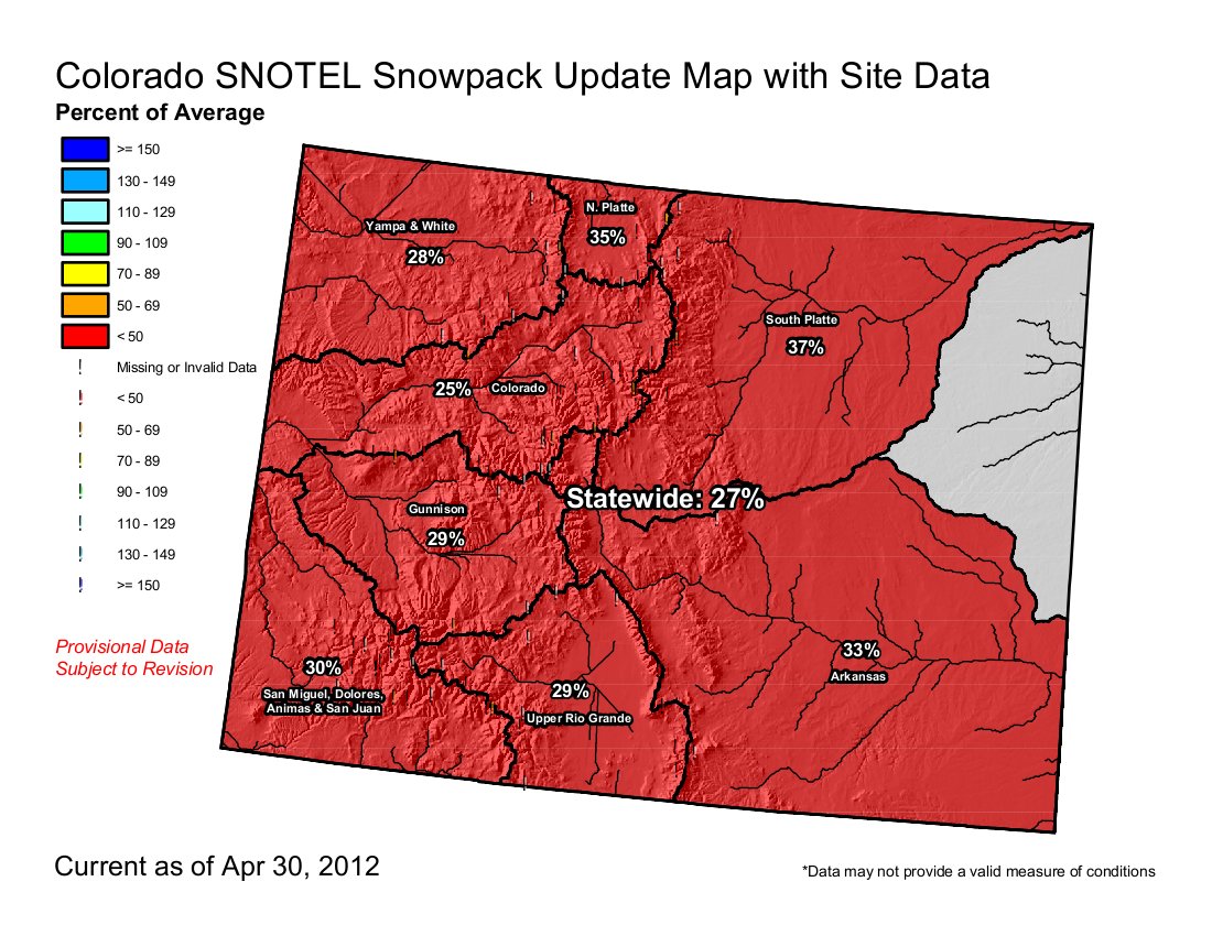
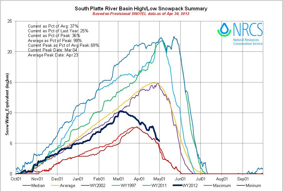
Snowpack/drought/runoff news: Upper Colorado River basin drops to 25% of average, South Platte = 37%

snowpackcolorado04302012.jpg

basinhighlowsouthplatte04302012.jpg

Click on the thumbnail graphics for the current statewide snowpack map and the Basin High/Low graph for the South Platte Basin (the basins that millions of Coloradans depend on) from the Natural Resources Conservation Service. The storm last week kept the South Platte about 1 inch of SWE above 2002 and moved the Upper Colorado River basin to the 2002 line. Keep doing your rain dances.

From The Denver Post (Kyle Wagner):

Colorado’s reservoirs are at normal levels, according to Denver Water, and state rivers are running at or below normal flows for this time of year. That means rafting, particularly for first-timers and families, could be just right.

“Here’s the thing that people forget,” says David Costlow, executive director of the Colorado River Outfitters Association. “Low season doesn’t mean no water. That snow still comes down that defined ditch. It might not ever get to the super-wild stage, but there’s water, and it flows. It will still be at an acceptable level for people to get out there and have a great time.”

Costlow says that despite rumors outside the industry, concerns that this season will be a repeat of the severe drought of 2002 are unlikely. “I make a point of keeping in contact with what I call the ‘water buffaloes,’ you know, Denver Water, CWC (Colorado Water Congress), to see what their take is. Well, it’s gonna be low, yes, but it’s not going to be 2002.”[…]

Outfitters on the Arkansas River are in especially good shape, Costlow says, because they’re on a voluntary flow-management program that allows for a dam release of water from the reservoirs upstream. “That water’s always there when they need it,” he explains. “Like last year, it wasn’t needed really until right at the end. This year, they’ll probably need it earlier.”

From The Aspen Times (Janet Urquhart):

Flows out of Ruedi increase seasonally on May 1, according to Kara Lamb, spokeswoman for the U.S. Bureau of Reclamation. The agency began increasing the release Monday, anticipating a hike in flows into the Fryingpan below the dam from 45 cubic feet per second to 80 cfs by the end of the day. Another increase Tuesday is expected to bring the flow on the lower Fryingpan to 110 cfs, which is typical for this time of year, according to Lamb.

In a normal spring, runoff from melting snow coming into the reservoir, located east of Basalt, would peak in late May or early June, she said. Next week, the bureau will have a better idea of what to expect this spring, after the latest data have been analyzed, but it’s a good bet flows coming into Ruedi won’t match the surge experienced last year…

The bureau expects Ruedi and the other reservoirs in the Fryingpan-Arkansas transmountain diversion system, as well as reservoirs in the Colorado-Big Thompson Project, to fill up this spring, according to Lamb. Both projects transfer water from Colorado’s Western Slope to the Front Range. The reservoirs started out in good shape because last year was a strong one for water collection, Lamb said…

Among Western Slope reservoirs that send water west instead of east, however, both Taylor Park and Blue Mesa reservoirs are expected to reach only 80 to 85 percent of capacity, according to Dan Crabtree, water management group chief for the bureau’s Grand Junction office. Other, smaller reservoirs, including Paonia, Ridgway and Silverjack, are all expected to fill up, he said…

…in the Roaring Fork River Basin on Monday, the snowpack was down to 19 percent of average, according to the Natural Resources Conservation Service, or NRCS. The SNOTEL measuring site on Independence Pass, located southeast of Aspen at 10,600 feet in elevation, was holding 4 inches of snow Monday, down from 7 inches Sunday. Snow at the measuring site is likely to be gone by Tuesday, said Mage Skordahl, assistant snow survey supervisor for the NRCS in Denver. That doesn’t mean snow has disappeared from the pass, but that it’s melted off the SNOTEL measuring station, she said.

Updated streamflow forecasts will soon be available, according to Skordahl, but projections based solely on snowpack put the flow into Ruedi Reservoir at 55 percent of average from April through July, she said. The Roaring Fork River flow at Glenwood Springs is expected to be at 45 percent of average for the same period.

IBCC: Gunnison Basin Roundtable non-consumptive needs workshop, May 3

gunnisonriverbasin.jpg

Click here for the agenda.

Reclamation’s Colorado River Supply and Demand Study update: ‘Protect the Flows’ goes to Washington

uppercoloradoriverbasinstatesultimatum09011925denverpost.jpg

From the Deseret News (Amy Joi O’Donoghue):

[Sarah] Sidwell’s Tag-A-Long Expeditions is one of 370 businesses that are part of the Protect the Flows coalition, which is offering up options to be weighed in the Colorado River Supply and Demand Study. The study is part of an exhaustive effort by the Bureau of Reclamation examining current and future imbalances in the Colorado River system over the next 50 years and ways to restore balance. After an evaluation period anticipated to last through June, the study will provide a road map of strategies that can be undertaken to help ensure the river system remains a viable water resource for the next 50 years…

The group said historical data complied by the U.S. Geological Survey with its streamflow monitoring system should be relied on extensively for determining a practical calculation of how much water actually exists in the system — not what is predicted through widely-varying snowpack seasons. “There is actual empirical evidence that shows how much water we can expect to have in the river,” Sidwell said.

The coalition was in Washington, D.C., earlier this year to present its ideas, which include establishing guidelines for new “water-smart” landscape designs, encouraging pool cover usage and providing incentives to farmers for incorporating more water-efficient irrigation technologies.

More Colorado River basin coverage here.

State of the Rockies Project: Will and Zak release a new video — ‘A Paddler’s Perspective on the Colorado River Delta’

willorzakcoloradoriverdelta2012stateoftherockies.jpg

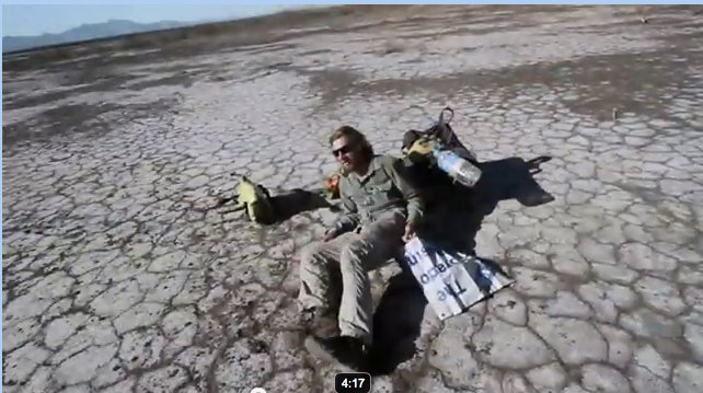
Here’s the link to the video. Will and Zak paddled from the headwaters of the Green River to the Colorado River Delta as researchers for Colorado College’s State of the Rockies Project.

More Colorado River Basin coverage here.

Montrose: BLM’s Regional Advisory Council to meet March 7-8, Upper Colorado fee hikes on the agenda

coloradorivergranby.jpg

From the Summit County Citizens Voice (Bob Berwyn):

At issue is a Bureau of Land Management proposal to up the daily fees at the Pumphouse and Radium sites from $3 to $5 per vehicle, as well as a small hike for commercial users, who make up the bulk of the use at the sites, from $1 to $1.25 per day.

“The river is popular because it’s affordable,” said Dave Costlow, executive director of the Colorado River Outfitters Association, explaining that a half-day run down the relatively gentle waters of the reach costs about $45 per person. “If you have a family of five, it all adds up,” Costlow said, describing it as a 25 percent increase that will be passed on to consumers. The BLM already gets 3 percent of every ticket sold, he added…

The increase is one of the agenda items at a March 7-8 meeting of the agency’s regional Resource Advisory Council in Montrose. The statewide Resource Advisory Council will also meet in Montrose (March 6-8) to consider other matters.

The additional fees at the Colorado River sites would boost the BLM’s revenue for the two sites by about $27,000, helping to boost services and possibly add new boating facilities. Additional road repair will help ease access to popular spots, and the BLM also plans to add a new storage facility and publish a new guide to the Upper Colorado.

More Colorado River basin coverage here.

The Northwest Colorado Council of Governments has released a report about the importance of water to Colorado’s headwaters counties

coloradotransmountaindiversionscu.jpg

From The Aspen Times (Scott Condon):

Pitkin County provides an estimated annual average of nearly 99,000 acre-feet via transmountain diversions to the Eastern Slope, according to the study, “Water and Its Relationship to the Economies of the Headwater Counties.” To put that amount into perspective, Ruedi Reservoir holds slightly more than 100,000 acre-feet. Among the headwater counties along the spine of Colorado’s Rocky Mountains, only Grand County loses more than Pitkin County through diversions. It supplies 307,500 acre-feet annually. Summit and Eagle counties are well behind Pitkin County in water diverted to the Eastern Slope. Gunnison and Routt counties are virtually untapped.

The mountain counties don’t want to suffer environmental or economic consequences from future diversions. An association that lobbies on their behalf, the Northwest Colorado Council of Governments, commissioned the study to show how vital adequate water supplies are not only to the mountain communities but also to the entire state…

The study isn’t intended to pit the mountain headwater counties against the Eastern Plains, said author Jean Townsend of the Denver firm Coley/Forest Inc. The headwater counties are simply saying, “There’s an economic impact to us, too,” she said. Pitkin County and the other headwater areas depend on streamflows for fishing, camping and boating activities. Townsend also noted that Aspen has a worldwide appeal. Its economy is built partially on real estate sales and service to second-homeowners. About 47 percent of homes in Pitkin County are owned by out-of-state residents…

A second message is that Colorado’s economy as a whole is dependent on a healthy mountain environment. The mountains not only draw people to the state and support a strong tourism industry, they also make Denver and the rest of the Front Range more attractive for businesses.

More transmountain/transbasin diversions coverage here.

Protect the Flows hopes to galvanize business interests the are dependent on wet water in the Colorado River

coloradoriverbasin.jpg

From the Summit Daily News (Janice Kurbjun):

[Zeke Hersh], the owner of Frisco’s Blue River Anglers joined a contingent of six who voiced the message of Protect the Flows, a brand-new, grassroots organization dedicated to raising awareness of water supply and related jobs in the Colorado River system — from the headwaters to the delta. The group represented river-related business interests from Colorado, Utah, Arizona, New Mexico and Nevada, Hersh said, adding that the group isn’t just gaining traction by sitting with legislators and leaders in the nation’s environmental governance. It’s also building a broader base, growing from 170 companies to 370 companies involved in the effort from its start in summer 2011 to today.

The goal in going to D.C. was to urge the Department of the Interior and legislators to consider plans that will employ smart, common-sense strategies to keep the Colorado River flowing when they finalize the Bureau of Reclamation’s Colorado River Basin Supply & Demand Study this summer.

Now that the “Options and Strategies Phase” of the Colorado River Supply and Demand Study is closed, submitted proposals will be considered and evaluated through June 2012. Upon completion, the study will define current and future imbalances in water supply and demand in the Colorado River Basin over the next 50 years, and will provide adaptation and mitigation strategies to resolve those imbalances…

As an angler, a guide, and a mountain biker who likes to cruise Moab, Utah and cool off afterwards in the lazy Colorado River that flows through town, Hersh said he can help provide valuable, first-hand insight into the river’s impact throughout the West. It goes far beyond drinking water needs and agricultural impact, he said. The message of Protect the Flows is that more than 800,000 jobs in the West (107,000 and more than $10 billion into the Colorado’s economy alone) come directly from the river, and those people must be considered when the fate of the water supply is considered…

While in DC, the business leaders asked the Department of Interior to implement a plan that will improve urban conservation, improve agricultural efficiency and provide options for existing water storage that will allow for keeping more water in the river. The coalition touts these measures as a way to balance supply and demand to continue to serve the 36 million who rely on the waterway for drinking water and protect the 800,000 river-related tourism and recreation jobs across the seven Colorado River Basin states.

“Department of Interior’s keen leadership is the key to ensuring that the Colorado River Basin Study results in solutions that will benefit all parties,” said Sarah Sidwell, sales director for Tag-A-Long Expeditions in Moab, Utah and member of the Moab Area Chamber of Commerce…

In D.C., they presented some viable ideas for handling the plethora of water issues facing the West, including the extremely difficult task of reworking the complicated water law. Water banks are first on the list, Hersh said. Initiated in Arizona, it allows those holding water rights to override the “use it or lose it” rule of thumb in years of excess flows. These folks can use what they need, and bank the rest for credit later. In the meantime, someone else can buy or borrow the water…

“Jobs are very important right now. We do not want to lose one job,” Hersh said … as we decide how to manage the water in the Colorado River and its tributaries.

More Colorado River basin coverage here.

Whitewater park for Longmont?

longmontwhitewaterparkproposeddecember2011

Here’s the release from the City of Longmont (Bill Powell):

The City of Longmont’s Concept Paper, the initial step in a full grant application to Great Outdoors Colorado (GOCO), has been approved to move to the final application step. It was one of 21 concept papers that were approved for this next step in the grant process by GOCO.

The City is planning a 65 acre river based district park along the banks of the St Vrain River within the Pavlakis Open Space in the heart of Longmont. The park will feature various amenities including a whitewater park on the St Vrain creek. The project is slated to begin design in early 2012.

The City is looking for partners from the community to assist in the grant process. Project partners are critically important in the final approval for grant funding. Partners would ideally provide financial participation. Support of any amount would be welcome!

More coverage from the Longmont Times-Call (Pierrette J. Shields) via the Boulder Daily Camera. From the article:

City planners hope to nab $500,000 in grant funds from Great Outdoors Colorado for a $3.1-million, 65-acre district park along the St. Vrain Greenway between Main and Martin streets south of the D-Barn. Planned amenities include a white-water course with five drops, a fishing pond, pond observation deck, river overlooks and habitat improvements along the greenway on the Pavlakis Open Space property…

Similar white-water courses are available in Lyons and Boulder, but Fitzgerald said Longmont’s more moderate course likely will be more family friendly because of lower water levels through the city.

Lower Dolores Boating Advocates will hold a public discussion of boating issues and possible changes below McPhee on November 30

snaggletoothrdoloresriver.jpg

From the Cortez Journal:

Everyone who rafts, kayaks and canoes on the lower Dolores River is invited to a presentation by Nathan Fey from American Whitewater at 7 p.m. Wednesday, Nov. 30, at the Dolores River Brewery, 100 S. Fourth St. Fey will lead a discussion about the ongoing negotiations with water managers about releases from McPhee dam. All whitewater boating enthusiasts are encouraged to attend to learn more about possible changes for the Dolores River. The event is sponsored by the Lower Dolores Boating Advocates. For more information, contact Jay Loschert at 799-1475.

More whitewater coverage here.

Eagle County officials hope to open more river access on the Colorado River between State Bridge and Dotsero

coloradorivereaglecounty.jpg

From the Vail Daily (Derek Franz):

“If we could get a boat ramp every eight or 10 miles (below State Bridge), that could spread the people out,” Treu said. “Right now, that stretch of river is too long and slow to appeal to many users. With the public access that’s currently available, there are no half-day floats — the trips are very long days.”

That’s why Eagle County has been working on some land deals that would gain public access to points along the Colorado River. Two of the deals have closed, and others are still being worked out…

Eagle County recently started the process to get “in-stream flow protection” and senior water rights to the isolated stretch of the Colorado. In this case, an in-stream flow protection would protect fish habitat by guaranteeing a minimum water flow. Other such protections also have been made for recreational rights, such as whitewater parks. “(The section from State Bridge to Dotsero) is the only section (of the Colorado) that doesn’t have in-stream flow protection,” Treu said. “If this section of river is not utilized, it will seem more acceptable for Denver to claim it.”[…]

“By getting in-stream flow protection, getting more people on that stretch and getting senior water rights, we will have a three-pronged attack,” Treu said. The claims are currently being processed in the Colorado water courts. A ruling isn’t expected anytime soon, however, because the state’s water rights are complex and the courts are slow.

More Colorado River basin coverage here.

Delta County: Three county commissioners, reps from the BLM the Town of Hotchkiss and conservationists hold meeting to discuss the Gunnison River as a recreation corridor through the county

gunnisonriver.jpg

From The Delta County Independent (Hank Lohmeyer):

The Hartland Dam Reconstruction project has ignited a blaze of local enthusiasm for a long stretch of recreational river. Excitement for the idea was running high last Thursday during a meeting of about 15 people who see river recreation as the next big thing. Represented at the session were the county (three commissioners, planning, and administration), the City of Delta (community development, parks, recreation), the Bureau of Land Management (Gunnison Gorge NCA manager), Town of Hotchkiss, Trout Unlimited, and the NFRIA Conservation Center of Paonia. The group’s idea is to complete a “concept paper” in two weeks that will outline a vision of a river recreation corridor through Delta County. The paper could lead to a planning grant from GOCO…

[County Commissioner Olen Lund] pointed out that there’s a lot of private ownership along the banks of the river, and private owners aren’t always receptive to river floaters and their sometimes inconsiderate ways. A county-sponsored public meeting of river corridor property owners took place in 2006 at the Bill Heddles Recreation Center. That meeting resulted in a deluge of opposition from landowners against promoting river recreation in the county. The meeting fairly stifled any broad discussion of the concept, until now.

Now, with the Hartland Dam reconstruction project connecting the river to boaters above and below Delta, and with the availability of GOCO money for comprehensive river corridor planning, the Gunnison River recreation idea has re-emerged.

More Gunnison River basin coverage here and here.

The City of Montrose is hoping that Montrose County will pitch in some dough for a whitewater park on the Uncompahre River

kayaker.jpg

From the Montrose Daily Press (Katie O’Hare):

“We have a lot of requests this year, but we can put it in with the other requests in preparing for our budget season,” Commissioner David White said.

City officials are seeking the county’s help to build a proposed white water park on the river. White said he was leery about allocating the money to the white water park after the county just recently completed it fairgrounds master plan, which includes several capital improvement projects…

Although the park is projected to cost between $600,000 to $900,000, Erickson said the annual economic benefits the area would realize would be far greater.

More whitewater coverage here.

Whitewater: Two standup paddlers traverse 225 miles of the Grand Canyon including the major rapids

standuppaddlinggrandcanyon2011

From Stand Up Paddle Surfing Magazine (Son of the Sea):

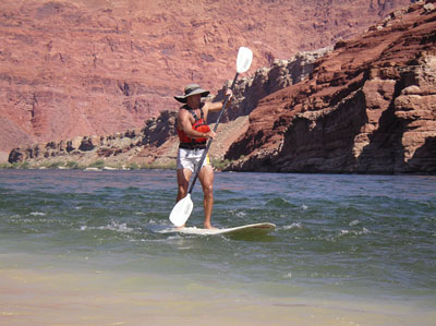
Whitewater expert Seth Warren and surf artist Drew Brophy rode standup paddleboards (SUPS) down 225 miles of the Colorado River through the Grand Canyon. The previous record was set by Hawaiian Archie Kalepa, who logged 187 miles in 2009.

On May 14, 2011, Brophy and Warren began their 16 day excursion at Lee’s Ferry, Arizona, navigating more than 125 rapids, with 42 major rapids rated between 5 and 10g on the Grand Canyon scale of 1 to 10g. They standup paddleboarded about fourteen miles each day. Their expedition ended at Diamond Creek, Arizona. Adding to the challenge of riding over rapids on stand-up paddleboards was the unusually high river water level. According to experts, the Colorado River was running at its highest level in thirty years.

The most challenging rapids they encountered included the infamous Lava, Hermit, Granite and Crystal Rapids. By day eight of the trip, their time on the river allowed enough experience to become skilled enough to stick it to the end of most of the 6 or 7 class rapids. But any class higher than 7 often landed the paddleboarders into the 42 degree waters. Brophy says, “There’s just no easy button. It’s amazing, the power of that water.”

More whitewater coverage here.

Runoff news: Horsetooth Reservoir is almost full

horsetoothreservoir.jpg

From the Fort Collins Coloradoan (Bobby Magill):

“Everybody’s just jazzed,” said Glen Werth, owner of Inlet Bay Marina on Horsetooth Reservoir. “The water levels are fabulous. Our rental business is fantastic. We have a lot of big boats, big groups.”

Brimming with water, Horsetooth Reservoir is expected to completely fill this week for the first time since 2004. “We do think Horsetooth is going to continue to rise,” said U.S. Bureau of Reclamation spokeswoman Kara Lamb. “We’re going to get pretty close to full.”

On Friday, Horsetooth Reservoir’s surface elevation was 5,425.25 feet above sea level, lower than its peak in 2010, when it hit 5,427 feet, said Brian Werner, spokesman for the Northern Colorado Water Conservation District. Horsetooth Reservoir’s full pool level is 5,430 feet. “By the end of next week, we will have Horsetooth full,” Werner said Friday.

The reservoirs are full here mostly because of the long, sustained runoff season from an abnormally large snowpack in the mountains. Werner said Northern Water’s forecasters say this year’s robust runoff is a “once-in-a-lifetime” event. “We’re smiling,” Werner said. “This is almost an ideal runoff year. We talk about this all the time and it never happens.” The runoff from the mountain snowmelt is expected to extend into August, which is nearly unheard of, he said.

Recent rains mean irrigators haven’t had to take water from the reservoir, allowing it to continue to rise. The Bureau of Reclamation has stopped taking water deliveries from the Colorado River through the Adams Tunnel, Lamb said.

More Colorado-Big Thompson Project coverage here.

From the Glenwood Springs Post Independent (Janice Kurbjin):

A sustained high water season on rivers in and around Summit County is coming to a close, and that means less juggling for local outfitters. “It was a challenge, for sure,” Arkansas Valley Adventures owner Duke Bradford said. AVA, like other companies, transferred trips based on flows to put ages and abilities on appropriate stretches. Someone who booked a Brown’s Canyon trip in the Arkansas River Valley may have gotten short notice that they’d now be running the more consistent Blue River, though it still ran quickly, about an hour north in Silverthorne…

“If you came to run whitewater, it’ll go down as one of the best whitewater seasons ever,” Bradford said, explaining that cooler temperatures helped sustain what many thought would be a sharp, severe spike in flows. Then, when the snowpack expired, rain and downstream water calls came. The high water lasted about six weeks…,/p>

Performance Tours and AVA have been back on the Numbers and Royal Gorge for about five days. And other trips are mostly back to normal minimum ages, with the exception of a still-high Clear Creek.

FIBArk Festival recap: Flying Ligers win raft rodeo

A picture named hooliganrace.jpg

From The Mountain Mail (Kevin Hoffman):

A panel of judges chose the best rafts loosely based on spectator reaction and criteria such as biggest flip and most creative pirating attempt. The Ligers were steered by Boulder residents Gary Lacy, Spencer Lacy and Shane Sigle along with Mark Poindexter of Austin, Texas. The crew had several passengers throughout the tournament, but Spencer Lacy won the crowd’s attention with several flips off the raft into the wave…

In second place the Black Sheep, a Raft Masters guide known as B.L., captained his boat solo. Two unidentified men steering a green craft aptly called the Leprechaun took third place in the event.

Click through for a photo of the event.

More whitewater coverage here.

Runoff/snowpack news: Water providers in the lower basin states are all smiles for a change

A picture named coloradoriverhooverdam.jpg

From the Albuquerque Journal (John Fleck):

Parched New Mexico won’t see much of that water [ed. northern Rocky Mountain snowpack] directly. Most of it fell to the north of the watersheds that feed the San Juan and Rio Grande, New Mexico’s two largest rivers. But we will nevertheless benefit in important ways, [Estevan López, head of the New Mexico Interstate Stream Commission] said, as the extra water from this year’s snowpack buys time to work on long-term problems in the Colorado Basin.

The problem for the past decade has been drought on the river system that supplies a significant amount of the water supplies used by seven Western states, including New Mexico. For us, the San Juan River, a tributary, supplies drinking water to Albuquerque and Santa Fe via the San Juan-Chama project. The San Juan also supplies water to meet the Navajo Nation’s water rights, as well as irrigating farms in the state’s northeastern corner.

The question lingering throughout the conference is how reliable that supply might be in the long run, for us as well as the six other U.S. states and Mexico that also rely on the Southwest’s largest river system. And if the Colorado gets less reliable – if, in the long run, it has less water to offer even as we keep growing and trying to use more of it – who will take the hit? Whose share of the limited resource will be reduced? A new federal study released in conjunction with the conference forecast that the Colorado could have 9 percent less water on average by 2050 as a result of climate change, with persistent drought growing more common…

And that is where the real benefit to New Mexico in the giant snowpack lies, López said. “This big snowpack in the basin has bought us some time to work on those issues.”

From The Denver Post (Analisa Romano):

Michael Lewis, who manages water data at the U.S. Geological Survey’s Water Science Center in Lakewood, said cooler temperatures over the weekend have resulted in a steadily melting snowpack instead of a dramatic peak, as was expected last week. Snowpack is still about 239 percent of the average for this time of year, which means rivers could flow at higher levels into the first week of July or longer in some areas, Lewis said…

Meanwhile, restrictions on inner tubes and air mattresses will remain in place for the Colorado River until June 24, and the Yampa and Poudre rivers until early July, officials said. Because of less dramatic water flow this week, Clear Creek and Boulder Creek do not have any restrictions in place.

From the Associated Press (Cristina Silva):

The [Lower Basin states] can thank the heavy and, in some cases, unprecedented snowpack in Wyoming, Utah and Colorado. The ripe June sun is sending snowmelt into the Colorado River, its tributaries and Lake Mead, the nation’s largest reservoir located outside Las Vegas. “This is obviously really welcome, great news,” said Jeffrey Kightlinger, CEO of the Metropolitan Water District of Southern California, which serves 19 million people. “It’s been a godsend.”

The water comes at a crucial time for the Southwest. After 10 years of receding water levels that threatened a regional water shortage, this year’s melting snows are expected to grow Lake Mead, the chief source of water for the three states and Mexico, by 40 feet or more. The jubilation in California, Arizona and Nevada is not a case of wishing neighbors ill, only the reality of nature’s polarizing impact in the water-poor West. Brutal, prolonged winters in the north produce robust, life-giving water flows in the south…

Roughly 96 percent of Mead’s water comes from melted snow in the upper Colorado River basin states: Colorado, Utah, New Mexico and Wyoming. By November 2010, the water in the reservoir had fallen to 1,081 elevation feet, a historic low and a mere six feet above the point that would trigger a large reduction of Arizona and Nevada’s share of the Colorado River. If that trend had continued, Arizona and Nevada could have had to begin water rationing this year. That outlook changed during late winter as snowstorms blanketed Western mountains from the Rockies to the Sierra Nevada. By June, there was more cumulative snow than ever in the upper basin states that feed into the Colorado River, said Kevin Werner, a hydrologist for the National Weather Service’s Colorado Basin River Forecast Center. As a result, Lake Mead is expected to grow to up to 1,126 feet by December. At full stage, the lake registers at more than 1,200 elevation feet. For public water utilities, the engorged river will buy officials more time to plan for the possibility of a future without Lake Mead, a nightmarish prospect across the Southwest. Some researchers believe long-term drought, climate change and an ever increasing demand for water could leave the lake dry by 2021.

Yampa River Festival recap: The sun showed up off and on on Saturday

A picture named yampariverfestival05282011standuppaddling.jpg

From Steamboat Today ( Luke Graham):

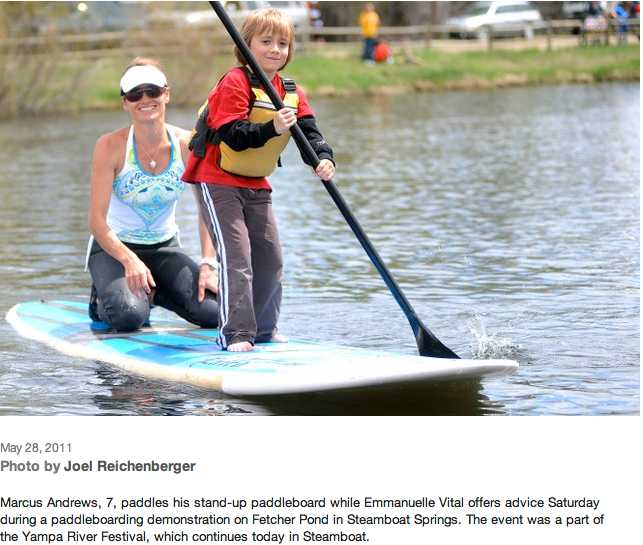
The Yampa River Festival featured a bit of everything Saturday. The day began off the water with 5- and 1-kilometer running races. There was a stand-up paddleboard race at Fetcher Pond, the cult-like raft race, the crowd-pleasing Crazy River Dog contest, an inner tube rodeo, and finally the kayak rodeo, where vintage crafts were the main show. The raft race, which began at Fetcher Pond and ended at the D-Hole in front of the Depot Art Center, featured competitor of all stripes. There were serious rafters, first-timers and people dressed in only their underwear…

The stand-up paddleboard race was a new event. Todd Givnish, who organized it, said he wasn’t expecting much. But by 12:45 p.m., people already were lining up to give the burgeoning sport of paddleboarding a try…

As one of the only events on the calm waters of Fetcher Pond, the paddleboard event brought out newbies and experienced paddlers for a timed race. Racers had to paddle the length of the pond and navigate around designated markers…

The Paddling Life Pro Invitational starts at 11 a.m. Monday with an extreme kayak race on Class IV-V Fish Creek followed by kayak rodeos at the D-Hole from noon to 5 p.m.

More Yampa River basin coverage here.

Runoff news: Garfield County is starting to prepare for possible runoff flooding

A picture named glenwoodwave.jpg

From the Glenwood Springs Post Independent (John Colson):

Most officials contacted for this story now predict that peak runoff, which normally would be happening in late May, will not arrive until the latter part of June. “The water’s peak should have been about a week ago,” said Tanny McGinnis, spokeswoman for the Garfield County Sheriff’s Office. Now she expects it to fall in the middle of June…

She said free sandbags are available at the county’s road and bridge facility near the Garfield County Regional Airport, where they were delivered a week ago…

In general, however, she said the county is expecting to get some warning from its neighboring counties upriver once the snow begins to melt in earnest. “The high water will hit Routt County and Eagle County before it gets to us,” she predicted. “We’ll have several hours of notice, at least.” The confluence of the Roaring Fork and Colorado rivers, she said, “are the areas they’re really keeping an eye on right now,” because the confluence area has been known to flood in the past…

Estimates of the snowpack in the mountains above the Roaring Fork and Colorado River valleys range as high as 400 percent of normal, according to recent news reports. But such numbers can be deceptive, according to Mike Gillespie, snow survey supervisor for the U.S. Natural Resources Conservation Service in Colorado. He explained that the “percent of normal” statistics relate to comparisons of the current snow depth to the average depth of the snow at a certain point in time. But as time passes, the average historical snow depth decreases sharply, so that in a year such as this one, the percent of normal increases to really high values simply because it’s being compared to a much lower number that is more typical for late May. But, he said, “That’s still a lot of water, a lot of snow.”

From the Summit County Citizens Voice:

“In spring, creeks and streams can be particularly dangerous as flows are often higher and faster than they are during the summer months and the water temperature is just above freezing,” said county emergency manager Joel Cochran…

“The rivers are deceptively dangerous this time of year,” said Sheriff John Minor. “During spring runoff, there is an incredible amount of debris in the water, and some of it is just under the surface” he said.

From the National Weather Service via the Cortez Journal:

Spring snow melt has caused high flows on many rivers and creeks in western Colorado and eastern Utah. However, cooler weather this spring has delayed the snow melt and kept copious amounts of snow at higher elevations especially in northwest and west central Colorado, as well as in northeast Utah. Therefore, river flows have not yet peaked. At higher flows, river banks can quickly become saturated and unstable. Caution is urged near waterways, as river banks can erode or collapse unexpectedly. Do not let children play near high flowing rivers, creeks, and canals.

From the Sky-Hi Daily News (Reid Armstrong):

The weather should start clearing Monday as the jet stream dips down over California, causing it to bow above Colorado, pulling warm dry conditions into the mountains, according to the Weather Service’s La Niña guru Mike Baker. Grand County could see temperatures start to warm up pretty fast with nighttime temperatures remaining above freezing for most of the week, Baker said. This is good if you’re a river raft guide, but maybe not so great if you’re a town manager worried about flooding…

As La Niña weakens in coming weeks, the jet stream should begin moving north, Baker said, leaving Colorado out of its path.

From the Loveland Reporter-Herald (Pamela Dickman):

“We’re looking at all-time-high flows,” said Brian Werner, spokesman for Northern Water. “Our minimum (estimate) would be an all-time record.” That means plenty of water for farmers and residents, the danger of possible flooding and both highs and lows for outdoor recreation…

Water and safety officials are worried about flooding if record snowpack disappears quickly, along with rain runoff. The snowpack is at 254 percent of average for this time of year, when snow typically already is melting…

Both Carter Lake and Horsetooth Reservoir will be full by the end of June.

From the Fort Collins Coloradoan (Bobby Magill):

The Poudre River is expected to remain low for most of the next week with almost no risk of flooding, but after that, all bets are off. “The next few days are fine because the temperatures are going to remain cool,” said hydrologist Treste Huse of the National Weather Service in Boulder.

From the Vail Daily (Scott N. Miller):

“If we can get through the Fourth of July we’ll be really pleased,” said Lisa Reeder, operations manager for Eagle-based Timberline Tours. “This year we’re pretty much guaranteed to get there, and we could see good water on the Eagle until Aug. 1.”

From the Cañon City Daily Record (Carie Canterbury):

The Natural Resources Conservation Service reported May 1, snowpack statewide was 135 percent of average, the highest since 1995, and the snowpack in the Colorado River basin was 151 percent of average, the highest since 1993…

John Van Oort, district 14 and 15 water commissioner for the Colorado Division of Water Resources, said the snowpack started to make its way downhill a couple of weeks ago, but stopped because it turned cold again. He said only Mother Nature knows when the frigid water will make its way down to the Arkansas River.

From the Fort Collins Coloradoan (Pat Ferrier):

Snowpack near the top of Poudre Canyon is more than 2½ times greater than last year when water ran higher and faster than it had in almost two decades…

A delayed, steady runoff – like manna from heaven – can sustain a rafting season well into August, and sometimes until Labor Day, said Pat Legel, owner of A Wanderlust Adventure, celebrating its 30th year of rafting the Poudre. Current conditions are similar to 1995 when spring was cool and rain fell 60 out of 61 days, Legel said…

Whitewater news: Still waiting for runoff

A picture named raftingarkriver.jpg

From The Denver Post (Jason Blevins):

That record-breaking snowpack — with the Colorado, Yampa and White river basins nearing 200 percent of their 30-year average and several others near 150 percent — harbors both a blessing and a curse for Colorado’s commercial rafting outfitters, who last year hosted more than 507,000 paddlers. When the weather warms, that initial surge of cascading snowmelt will certainly close stretches of steep and swollen rivers for commercial rafting and elevate the difficulty of traditionally mellower stretches. But that same bountiful snowpack also promises raging rafting deep into summer…

The last time the Eagle River ran deep into summer, in 2008 with the Colorado River Basin 146 percent of average in early June, the upper portion of the river hosted more than 4,300 commercial rafters. Last year, with a sudden early surge stealing all the flows and whittling the Colorado River basin to 57 percent of average in early June, the upper Eagle saw fewer than 1,100 commercial rafters.

More whitewater news here.

Whitewater news: Big year forecast for the Colorado River and the Green River

A picture named ohbejoyfulslatecreek.jpg

From BigTravelNews.info:

This spring / summer promises to be one of the top 10 best high water years on record for the Colorado River System in Utah and Arizona, reports Brian Merrill, CEO of Western River Expeditions http://www.westernriver.com/ that 50 years ago helped pioneer the sport of river rafting on white waters of the West.

“It’s possibly the best water year ever on Utah’s Green River in our half century of river running,” Merrill said. He noted that for raft enthusiasts and whitewater adrenaline junkies “2011 is THE year to book a river trip through Westwater or Cataract Canyons of the Colorado River or Gray and Desolation Canyons on the Green.” Also, the Bureau of Reclamation is releasing extra flow from Glen Canyon Dam which means higher water through the Grand Canyon this year. (The water release strategy is an effort to increase the level of Lake Mead.)

Merrill anticipated that high water would continue through late July this year; ordinarily it tapers off at the end of June. The public may monitor Colorado and Green River drainages on a daily basis by going to: http://www.cbrfc.noaa.gov/rec/rec.php.

More whitewater coverage here.

Rafters gearing up for what could be an ‘epic’ rafting season

A picture named raftingarkriver.jpg

From the Aspen Daily News (Dorothy M. Atkins):

The cold temperatures and large amounts of precipitation that have been plaguing Aspenites through the off-season have assured many rafters that the Roaring Fork River will have plenty of snowpack to pull from to maintain river flow well into the summer…

The Fork is fueled by snowmelt from snowpack located up Independence Pass. The gauging station located on Independence Pass is reporting 21.6 inches, — 159 percent of average snowpack — according to the Roaring Fork Conservancy…

This year with more snowpack and colder temperatures, the hope is that the Fork will remain navigable through August…

“I hate to say I have any expectations, because who knows what will happen,” said raft guide Casey Vandenbroek. “I would be so stoked to be on Slaughterhouse until mid August, and I feel like we have enough snow if we just get a nice steady melt.”

A nice steady melt is what everyone is hoping for this year.

From The Greeley Tribune (Dan England):

This season, boaters expect water levels may even surpass that 1983 record of just under 6,000 cubic feet per second. Those are water levels that bring elation from experienced boaters, concern from law enforcement and rescue personnel and a mix of the two from rafting companies…

The only thing for certain is the water should be higher than it’s been in years, and it will probably be a few weeks before boaters really see it. Even if it does warm up in a hurry, said Bell, a kayaker and atmospheric scientist, it takes a while to start the melt with such a deep snowpack, which could mean a peak later in June.

More whitewater coverage here.

Buena Vista: PaddleFest May 27 — 29

A picture named standuppaddling.jpg

From The Mountain Mail:

Hosted by Colorado Kayak Supply, the weekend celebrates the start of the summer paddling season. Additional events include water education, fun competitions, the Buena Vista Pro/Am Rodeo, beer gardens, live music, and movie premieres. Water events include free stand up paddle board and kayak demonstrations, competitions for youths and adults, and high caliber educational on-water courses. Competitions and river demonstrations will be at South Main Square. Flat water paddling events will use the town lake in McPhelemy Park…

More information is at www.ckspaddlefest.com.

More whitewater coverage here.

Runoff news: There’s a 50% chance that the peak could be 80,000 cfs in Cataract Canyon this year

A picture named cataractcanyon.jpg

From PRLog.org:

The latest projection from the Colorado Basin River Forecast Center in Salt Lake City, Utah has projected the Colorado River in Cataract Canyon to have a 50% chance of peaking at over 80,000 cfs (cubic feet per second). Since 1985 the Colorado River has only reached 80,000 cfs one time. That happened on June 19, 1995 when the Colorado River peaked at 80,700 cfs.

Dolores River: Reclamation hopes for a 10 day boating season downstream of McPhee Reservoir this year, Dolores River Dialogue meeting April 28

A picture named snaggletoothrdoloresriver.jpg

From The Durango Telegraph (Missy Votel):

“The spring wind and weather has been eating it up,” said Vern Harrell, Bureau of Reclamation liaison for the Dolores River Project, of the region’s snowpack. “This year we don’t even know if we’ll fill the reservoir.” The reservoir, which was a capacity of 229,000 acre-feet is expected to receive 225,000 acre-feet of runoff this spring. With the latest prediction, this would make for a 10-day spill of about 800 cfs in order to stretch the flows out as long as possible. However, when and if this happens is anybody’s educated guess. While the BuRec ideally shoots for Memorial Day Weekend, sudden temperature or precipitation spikes could influence it either way. “We’ll know more the week after the reservoir starts to fill, depending on weather and storm forecasts,” said Harrell. He said flows will most likely not be significant enough for commercial rafting companies to plan trips, but savvy local boaters at the ready could luck out with some careful monitoring of the BuRec’s web site at http://www.doloreswater.com. “That’s the best information out there,” said Harrell of the site, which is updated twice a week. In targeting Memorial Day Weekend, May 28-30, the spill will be held back until May 20, if possible. However, in 2009 McPhee filled early pushing up the release start date to May 11. Last year, cold weather caused the reservoir to fill slowly, holding back the spill until May 24…

A steering committee for the Dolores River Dialogue, a varied group of user interests which has been meeting since 2004, will be revealing two proposals to benefit the Dolores’ downstream fisheries next week. The flow from McPhee was originally conceived with the nonnative, cold-water trout sport fishery in mind, but the objective has since grown to include the warm-water fishery of native species such as suckers, chubs and pike minnows. There is also concern over the health of the river’s riparian zone as well as the geomorphology of the riverbed, including sediment build up and flow.

The steering committee’s first proposal looks at the use of “selective level outlet works,” which would basically allow water to be pulled from various elevations within the reservoir for release. “In the past, we have only pulled water from the bottom, because that’s the coldest water for the trout, but we can get better water quality for the native fish with warmer water higher up,” Harrell said.

The second proposal from the group calls for the Montezuma Irrigation Co. to lease 6,000 acre feet of water from the Colorado Water Conservation Board for downstream flows. The water would actually come from Groundhog Reservoir, north of Dolores, and flow through McPhee, which is overallocated as is. The lease would be for any three years out of a 10-year span, although the sequence of those three years remains to be seen. “We will have to develop that concept, but details still aren’t here yet,” Harrell said.

More Dolores River watershed coverage here and here.

Yampa River: American Whitewater survey of river users

A picture named yampariverbasin.jpg

Here’s the link from the American Whitewater website.

American Whitewater is working to identify the range of flows that support the full range of boating opportunities for the main stem and tributaries of the Yampa and White Rivers. As part of our Yampa River Project, we are working with the Colorado Water Conservation Board and the Yampa-White Basin roundtable to identify and define flows needed for continued recreational uses on Northwestern Colorado’s iconic rivers. THe results of our assessment will be used in future negotiations over water supply planning, and resouce management actions.

We have developed this survey so individuals can help American Whitewater represent recreational interests in deciding what the future of the Yampa and White Rivers will look like. Our goal is to utilize information from the survey to help us quantify flow preferences for whitewater boating, which will identify the range of flows necessary to provide whitewater recreation experiences, from technical low water to challenging high water trips. The information will provide us with the data necessary to describe flow-dependant recreation experiences and to protect and manage flows for river-based recreational opportunities.

AW is currently working with local governments, conservation groups, and State and Federal agencies to decide the future of the Yampa and White Rivers and their tributaries. Your honest participation in this study, will help American Whitewater Staff develop new instream flow guidelines for the Yampa and White Rivers.

Please encourage your fellow paddlers to participate in this study. The more responses we get the more robust our results will be. We will publish results of this survey for the benefit of paddlers with an interest in recreational opportunities on the Yampa and White Rivers.

From Steamboat Today (Mike Lawrence):

Survey results will be part of an extensive multiyear assessment of demands on the Yampa and could be used in future discussions of water policy and resource management. “This recreational flow survey is definitely something that’s pretty exciting for us,” said Kent Vertrees, a recreational representative on the Yampa/White River Basin Roundtable. “It’s just one of the components of the environmental and recreational nonconsumptive needs (assessments) of our basin.”[…]

“This has nothing to do with the recreational water right or establishing water rights in the future,” Vertrees said. “This is basically a study that the roundtable is doing to comply with what the state asked us to do, way back in 2005.”

More Yampa River basin coverage here and here.

Grand County files for a Recreational In Channel Diversion right on the Upper Colorado River

A picture named coloradorivergranby.jpg

From the Sky-Hi Daily News (Tonya Bina):

Appropriated on Dec. 21, the 2010 water rights, if realized, may give Grand County traction with future water cases affecting the Fraser and Colorado Rivers, according to county officials. A recreational in-channel diversion allows for a call in a certain place and time for the benefit of “boating, rafting, kayaking, tubing, floating, canoeing, paddling, and all other non-motorized recreational uses” as “part of (the county’s) ongoing effort to improve water-based recreational and economic opportunities for its citizens and the general public,” states the water rights application. The “byproduct” would be allowing Grand County to be “in the conversation” when it comes to decisions about future river uses, according to Grand County Commissioner James Newberry…

Objectors to the Division 5 conditional water rights filing in Garfield County’s 9th Judicial District Court, Glenwood Springs, have until the end of February to oppose the application. Town boards and rights holders from Kremmling to Winter Park are considering opposing the filing as a means to join the case to ensure their water interests are protected — in some cases, a position of objection could be viewed as “friendly opposition,” and in others, genuine opposition…

Grand County’s application for conditional rights names a Hot Sulphur Springs Whitewater Park in Pioneer Park near the town, with no rights at flows above 900 cubic feet per second (cfs), and a Gore Canyon Whitewater Park in two locations, one above and one below Pumphouse recreation area west of Kremmling, with no rights at flows above 2,500 cfs. One or more of these sites could be the source of calls for recreation water in the river from the headwaters of the Colorado and in the length of the Fraser River…

The county’s 2010 water right would be junior to existing rights and may only influence future development and diversions on the river, [Grand County Commissioner Gary Bumgarner] said.

More Colorado River basin coverage here.

Snowpack/streamflow/storage/whitewater news

A picture named snowpackcolorado02182011

From Steamboat Today (Tom Ross):

It almost sounds sacrilegious to talk about spring runoff as Steamboat bears down on what could be its fourth 400-inch winter in six seasons. With seven weeks to go in ski season 2010-11, Steamboat already has surpassed 310 inches at mid-mountain, putting the tally ahead of the recorded-history average of 308 annual inches…

Risa Shimoda, of USA Freestyle Kayaking, has announced that for the first time, Steamboat’s Paddling Life Invitational freestyle competition will be added to the premier freestyle kayaking point series in North America. The Steamboat event on May 30 will come right after the Pro Rodeo in Buena Vista on May 27 and 28, ensuring the best in the sport will be in the Steamboat neighborhood.

If you like a dash of controversy with your water on the rocks, we’ve just learned that the Grand County Commissioners have applied for water rights on the Colorado River, both in Hot Sulphur Springs and below Gore Canyon, to ensure adequate flows for all forms of recreation. The recreational in-channel diversion rights would be attached to whitewater parks in Hot Sulphur and below the canyon near Pumphouse, Nathan Fey, of American Whitewater, reports. Fey said Grand County is seeking to protect 900 cubic feet per second of flow at Hot Sulphur and 2,500 cubic feet per second below Gore Canyon.

From the La Junta Tribune-Democrat (Bette McFarren):

…all reservoirs in the state are up with the exception of John Martin and Trinidad. The realtime streamflow in Fountain Creek is normal. Flow on the Arkansas River below Timpas and below John Martin Reservoir is lower than normal. Above Pueblo, there is 91 percent of the water present last year. The snow pack in the upper basin is at 80 to 90 percent of peak, with possible early spillage…

The National Oceanic and Atmospheric Administration predicts drought conditions in the lower Arkansas basin through March and April.

Whitewater business news

A picture named raftingarkriver.jpg

From the Aspen Daily News:

According to the annual “Commercial River Use in the State of Colorado” report issued by the Colorado River Outfitters Association (CROA), commercial rafting companies in the state hosted 507,392 user days during the 2010 season, up 16,500 user days, or 3.4 percent, from 2009. A “user day” is defined as a paying guest on a river for any part of a day. The visitor figures have exceeded a half-million for four straight years from 2005-2008 before taking a temporary dip in 2009 during the heart of the national downturn. The rebound was warmly welcomed…

As the CROA report indicates, every user day contributed much-needed revenue to state coffers and local businesses. The combined economic impact of commercial river rafting in 2010 was $150.3 million, up 4.9 percent, or $7 million, from 2009. That was the second-highest total since CROA began tracking these statistics in 1988, trailing only the banner year of 2007.

Over a season that runs from April to September, CROA’s outfitters collectively raft more than 20 rivers across eight major basins. The Colorado and Arkansas rivers saw the largest increases from 2009 to 2010 and still have excess capacity to allow for more visitors. Many other rivers in the state have limits to increased use and therefore have seen their numbers stabilize. Overall, notes Cantamessa, the diversity of opportunity means that most Coloradans – and many in neighboring states – are within an easy day’s drive of a rafting vacation that suits their tastes.

More whitewater coverage here.

Whitewater rafting business news

A picture named cachelapoudreriver.jpg

From the Fort Collins Coloradoan (Pat Ferrier):

Guides brought nearly 37,400 people down the glistening waters of the Poudre River – about 400 more than the year before when the economic downturn hit the industry, according to a new report issued by the Colorado River Outfitters Association. The Poudre River was the sixth busiest of the 27 Colorado rivers with commercial activity…

With mountain snowpack at about 130 percent of average, [Brad Modesitt, owner of Mountain Whitewater Descents] already is getting bookings for summer trips. “We will have some water and we’ll have some fun out there.”[…]

Well-educated and affluent, customers of the five local rafting companies permitted to take visitors down the river spent $4.3 million on rafting, food, lodging, souvenirs in the area. That translates into an $11 million economic boon for the city and its surrounding area, according to the Colorado Tourism Board. The economic impact is up slightly from $4.2 million in direct expenditures and $10.8 million overall in the 2009 survey. Statewide, the 2010 economic impact totaled more than $150 million from more than a half-million rafters…

The Arkansas River was the busiest with 211,150 commercial user days, according to the Colorado River Outfitters Association.

More whitewater coverage here.

Pueblo: Arkansas River levee repairs update

A picture named puebloleveearkansasriver.jpg

From The Pueblo Chieftain (Chris Woodka):

The repair project will cost nearly $500,000 and must be completed before river flows increase in March, said Gus Sandstrom, president of the Pueblo Conservancy District, which maintains the levees. “We think it’s a crisis,” Sandstrom said. “If we didn’t do the work, we think we would flood parts of Downtown.”[…]

Although the levees along the Arkansas River and up Wild Horse Creek are maintained annually, the concrete levee along the Pueblo Whitewater Park was damaged during construction of the kayak course. “We noticed two years after the course was completed that the way they changed the flow had damaged part of the levee,” Sandstrom said. The U.S. Army Corps of Engineers accepted responsibility for three of the five areas of concern on the levee, while it determined the district would have faced similar problems at two other spots if no work had been done, Sandstrom said. Repairs will address water backing up at the kayak gates, causing flows to wash away the dirt behind the levee. The repair work will cost between $300,000 and $350,000, and will include piping that will allow water to wash under the levee without carrying dirt away, Sandstrom said.

Diverting the river will cost about $100,000 and work will begin Monday. It will require constructing a small levee in the channel to steer water away from the concrete levee on the north bank. The diversion would be from Fourth Street to the Santa Fe railroad bridge, and will not diminish flows upstream or through the Historic Arkansas Riverwalk of Pueblo.

More Arkansas River basin coverage here.

Whitewater news: Rafting numbers up in 2010

A picture named raftingarkriver.jpg

From The Pueblo Chieftain (Tracy Harmon):

According to Arkansas Headwaters Recreation Area Rationing Coordinator John Kreski, boating client use was up 2.56 percent over last year with a total of 262,122 people taking to the river on commercial rafting trips. A total of 254,431 clients rafted the river in 2009. “That’s good news,” said Bob Hamel of Cotopaxi, owner of Arkansas River Tours and president of Colorado River Outfitters Association. “That is what you would predict or hope for even in a good economy, so Colorado continues to hang in there.”

Hamel said he attributes the good numbers to several economic factors. He said shorter trips are still affordable for families, pricing has held for two to three years and discounts are available. The biggest jump in users came among anglers. Float fishing raft trips are a segment of the industry that bring in business during shoulder season months before and after the main rafting season of June, July and August.

Governor Ritter Creates Mediation Process for River Access Disputes

A picture named raftingarkriver.jpg

Here’s the release from Governor Ritter’s office (Myung Oak Kim/Todd Hartman):

Gov. Bill Ritter today issued a report outlining a series of proposals for resolving disputes between landowners and rafters in Colorado. He also signed an executive order creating the River Access Mediation Commission to provide a way for some of the most contentious conflicts between boaters and property owners to be addressed.

“I’m pleased to announce this report, and the formation of a mediation commission, so we can move forward in resolving these issues fairly and thoughtfully,” Gov. Ritter said. “I believe a mediation commission can work its way through these matters in a civil, reasoned way where all parties’ views are respected and considered in developing a resolution that could alleviate the need for litigation.”

The Governor’s River Access Dispute Resolution Task Force was a 17-member group created in July to help craft ways to sort out conflicts on Colorado rivers on a stretch-by-stretch basis as those disputes arise. Gov. Ritter created the task force through executive order as part of an agreement with stakeholders to set aside numerous conflicting ballot measures on the issue.

The task force report includes eight unanimous recommendations to the Governor on ways to limit disputes between various parties. The recommendations include creation of the River Access Mediation Commission to address the thorniest disagreements. Participation by disputing parties would be voluntary, and the commission would not have the power of arbitration. The report can be accessed on the website of the Colorado Department of Natural Resources at http://dnr.state.co.us/

“I commend the hard work of the task force in developing this report, and extend my thanks for its effort in working through difficult issues that required members to find common ground,” Gov. Ritter said. “The report includes a host of recommendations with great potential to reduce friction between rafters and landowners. I look forward to sharing the recommendations with Governor-Elect John Hickenlooper, and urge him, along with the State Legislature, to thoughtfully review the report.”

More coverage from the Associated Press via The Durango Herald:

The bill was prompted by disputes between landowners who don’t want boaters using waterways flowing through their property and boaters who say the state’s waters belong to the public. The conflict came to a head on western Colorado’s Taylor River last year when a developer told commercial rafters they could no longer float through his property.

“I believe a mediation commission can work its way through these matters in a civil, reasoned way where all the parties’ views are respected and considered in developing a resolution that could alleviate the need for litigation,” Ritter said in a statement.

More whitewater coverage here. More HB 10-1188 coverage here.

Durango: Winter maintenance for Smelter Rapid

A picture named kayaker.jpg

From The Durango Herald (Garrett Andrews):

Track hoes in the middle of the Animas River at Santa Rita Park were performing winter maintenance on rock formations Monday, capitalizing on the 180 cubic feet per second flow of the Animas, which can run at several thousand cfs in the spring. The work, overseen by the city’s Animas River Task Force and funded by Durango Whitewater, should wrap up by the end of the week. The excavators are replacing dislodged boulders moved during monsoons and high flows over the last two years. Monday, Miguel Montoya of Spriggs Excavation of Durango was trying not to kick up silt while refashioning a river run that churns heavily in high water…

Durango Whitewater received a permit from the U.S. Army Corps of Engineers and raised $14,000 to fund the project. Spriggs donated the track hoe and Montoya’s services. Wolf Creek Ski Corp. also donated a track hoe and operator.

More whitewater coverage here.

New whitewater park for Montrose?

A picture named kayaker.jpg

From The Telluride Watch (Peter Shelton):

Now retired from competition and fresh from the opening of the 2012 Olympic kayaking venue in London, which was built by his firm, S2O Design of Boulder, [Scott] Shipley made a pitch for a family-oriented whitewater park on the Uncompahgre River at Upper Cerise (Riverbottom) Park.

City Park Planner Dennis Erickson hosted the event at the Pavilion, which also included a presentation by lead planner Ann Christensen of DHM Design in Durango, who introduced the draft plan. Also on hand was Gabe Preston of CPI Consulting, who led the group in a keypad polling exercise on priorities within the draft plan.

Participants indicated their preferences – high priority, medium or low – for a number of goals being considered in the plan, including: developing new city-owned parks on the northern third of the 10-mile-long river corridor, building more pedestrian bridges across the river, connecting downtown Main Street more directly to the river, building tails to link existing and future parks, acquiring private property for river improvements, and preservation/enhancement of the river ecosystem.

A whitewater park scored high on the list. But the highest priority for the public on this night was clearly trails, bicycle/pedestrian trails, to connect parks and link existing segments of river trail, thereby providing alternate-transportation routes, not just for recreation, but for commuting and shopping as well.

More whitewater coverage <a href="

Pagosa Springs plans new features for their whitewater park

A picture named sanjuan.jpg

From the Pagosa Sun (Jim McQuggin):

…if Army Corps of Engineers (ACoE) permitting goes seamlessly, along with other variables, river enthusiasts could have as many as seven new whitewater structures in the river by next summer…

The two new features, set for completion before next spring, will be installed in the portion of the river adjacent to Town Park.

With two new features slated for completion by mid-December, the town also approved engineering for five additional features in the near future, with construction possible as soon as next spring if ACoE permitting can make it through the process prior to late-winter thawing. Of the five features, two are planned for installation just north of the bridge on east U.S. 160, adjacent to the River Center shopping complex. Farther down the river, one feature is planned for the portion of the river adjacent to Town Hall, with two more set for construction adjacent to Yamaguchi Park. With the construction of a total of seven new features in the San Juan River, Pagosa Springs could potentially become a premier destination for rafters, kayakers and other whitewater enthusiasts…

As far as the additional five structures, Pitcher said that engineering and surveying was in process, as well as necessary easement acquisition (to fulfill ACoE requirements). “That’s going good and, as far as easements, I think we’ll have that done. Everyone seems to be supportive of the project.” If Riverbend and the town can secure those easements along with amended ACoE permits, construction on a third phase of the project (for five more structures) could begin as early as next spring.

Meanwhile, a whitewater park may be on the horizon for Montrose. Here’s a report from Kati O’Hare writing for the Montrose Daily Press. From the article:

[Scott Shipley, a world champion kayaker and veteran whitewater park designer] spoke Wednesday to a crowd of about 50 about the Uncompahgre River’s potential for a park. The discussion was part of a follow-up presentation about the city’s ongoing Uncompahgre River Corridor Master Plan process. Shipley said Montrose has the river, with its flow, and all aspects needed for a successful whitewater park. “They’re designed to mesh with the environment” and consider fish passage, vegetation and river access, he said. Designers consider 100-year floods and “most important, are designed that it doesn’t have a negative impact on the community where you put it.”

More whitewater coverage here.

Should the Colorado National Monument and Dinosaur National Monument be designated national parks?

A picture named lodorecanyonfromdouglasmtnnps.jpg

From the National Parks Traveller (Kurt Repanshek):

Mary Risser, Dinosaur’s superintendent since 2005, answers the question by referring to the nomenclature of the National Park System.

“What they say is a national park contains a variety of resources and encompasses large land or water areas to provide adequate protection of the resources,” notes the superintendent. “A monument is intended to preserve at least one nationally significant resource. It’s usually smaller than a national park, and it lacks a diversity of attractions.

“So, when you look at the definition, Dinosaur would definitely qualify as a national park. When you think about the resources that we have here, you start with the Douglas Quarry, which is the world’s best window into the Jurassic-era dinosaurs, (and) we’ve just found probably one of the world’s most significant cretaceous area dinosaur quarries right across,” continues Superintendent Risser. “We have two of the West’s premier white-water rivers. … and then we have over 200,000 acres of wilderness. I think Dinosaur has features that you find in all the other national parks in the state (Utah).

“We can trace human history for 10,000 years here. It has the most complete geologic record in the National Park System, even more so than Grand Canyon. So it’s just a spectacular place.”

River Access Dispute Task Force meeting recap

A picture named taylorriver.jpg

From the Sky-Hi Daily News:

“We are going to try to get neighbors to meet with neighbors without having to have legislation,” said Bob Hamel, a member of the task force. Hamel is Colorado River Outfitters Association president and owner of Arkansas River Tours in Cotopaxi…

The rafting dispute came to a head on the Taylor River last year when a developer told commercial rafters they could no longer float through his property. State Rep. Kathleen Curry, an unaffiliated state representative from Gunnison, proposed a bill in favor of the rafters. But state lawmakers declined to intervene, and instead the 16-member Governor’s River Access Dispute Resolution Task Force was set up to resolve rafting disputes…

The task force also heard from Arkansas Headwaters Recreation Area Director Rob White, who said that the Arkansas River draws 42 percent of the state’s rafting business and called rafting a “huge economic machine” for the area. White said his agency hears disputes and issues warnings and tickets to trespassers. Greg Felt, who runs float fishing trips on the Arkansas River, said conflicts are often passive-aggressive. He said some private landowners have built rock diversions that force rafts to trespass because of low water. Others have hung big fish hooks or dead rattle snakes off of foot bridges to signal the rafters aren’t welcome.

More whitewater coverage here.

River Access Dispute Task Force meeting recap

A picture named raftingarkriver.jpg

From The Mountain Mail (Audrey Gilpin):

Arkansas Headwaters Recreation Area was presented as a “success story,” with park manager Rob White highlighting the citizens task force and river management plan as a way of monitoring river use and mitigating disputes among landowners, non-commercial boaters and private boaters. Comprised of anglers, private and commercial boaters, water users, environmental interests, property owners and local government representatives, White said the Arkansas headwaters task force creates a “communication tool” and management of the Arkansas River that’s “all about compromise,” White said…

The long-standing dispute about whether a “right to float” in Colorado exists or ought to exist, however, is not what the task force was charged to decipher. Mike King, deputy director of the Colorado Department of Natural Resources, said the task force is trying to find adequate processes and tools to mitigate disputes. Arkansas River Canyon landowner Tim Canterbury said he’d “hate” to see any standard go statewide. “We have a unique situation on the Arkansas River. Can you legislate respect?” he said…

Task force members will attempt to find “solutions” in dealing with problems identified during the meeting including criminal trespass, obstructions in the river such as diversions, fences and structures; issues with commercial and non-commercial boaters, volume of boaters and impact to natural resources. The Governor’s group will meet from 1-5 p.m. Oct. 13 in Glenwood Springs followed by a public input meeting from 5-7 p.m. The task force is to submit a final report to the governor no later than Dec. 31, identifying a framework for a “dispute resolution process for conflicts between rafters and landowners.”

More whitewater coverage here.

River Access Dispute Task Force meeting recap

A picture named raftingarkriver.jpg

From The Pueblo Chieftain (Tracy Harmon):

“We are going to try to get neighbors to meet with neighbors without having to have legislation,” said Bob Hamel, a member of the task force who also is Colorado River Outfitters Association president and owner of Arkansas River Tours in Cotopaxi. “We (outfitters) are not going to give up floating on any rivers in Colorado and it’s not about signing agreements, because every situation is unique.”[…]

Nathrop rancher Frank McMurry told the task force about his concerns from a private landowner’s perspective. He said he and other landowners feelvulnerable to lawsuits. “I own the last piece of private property before you go into Browns Canyon, and the carrying capacity is 300 rafts. With seven people in a raft, that is 2,100 rafters a day and that is not counting the private boaters,” McMurry said. “My property has become an attractive nuisance and rafters have caused a big part of that,” McMurry said. He described finding private boaters on his property who had set up a volleyball net and were playing volleyball. Another time, a group of private boaters had stopped to chase some of his heifers at a time when two bulls were with the cattle. “What if one of them was hurt by a bull? Who is liable for that? I think the state should afford us liability (insurance) as property owners,” McMurry said.

The public still can weigh in on the issue. Written input or comments may be provided to Governor’s River Access Dispute Resolution Task Force via e-mail at riveraccess@state.co.us, via mail at Colorado Department of Natural Resources, attention Kim Burgess, 1313 Sherman St., Room 718, Denver, CO 80203. For information, log onto the website http://www.dnr.state.co.us.

More whitewater coverage here.

Governor Ritter’s River Access Dispute Task Force to meet in Salida tomorrow

A picture named salidacolorado.jpg

From The Pueblo Chieftain (Chris Woodka):

The 17-member Governor’s River Access Dispute Resolution Task Force will meet from 2 to 7 p.m. at the Upper Arkansas Water Conservancy District officers, 339 E. Rainbow Blvd. (U.S. 50). Public input is set from 5 to 7 p.m. The task force was created to help craft a dispute-resolution process to resolve future conflicts between boaters and private landowners on Colorado waterways. It met earlier this month for the first time, and additional meetings are planned in October and November…

Written input or comments may be provided to the Governor’s River Access Dispute Resolution Task Force. Written comments will be compiled and delivered to Task Force members for their consideration.

By e-mail: riveraccess@state.co.us

By mail: Colorado Department of Natural Resources, 1313 Sherman Street, Room 718, Denver, CO 80203. Attention: Kim Burgess.

More whitewater coverage here.

Elk River: Rancher Jay Fetcher named to River Access Dispute Resolution Task Force by Governor Ritter

A picture named elkriver.jpg

From Steamboat Today (Mike Lawrence):

Gov. Bill Ritter named Jay Fet cher on Monday as one of 17 members of the River Access Dis pute Resolution Task Force. The group has until Dec. 31 to prepare a report for Ritter and the state Legislature that recommends methods for resolving disputes among landowners, commercial rafters, boaters and anglers on a case-by-case basis as disputes arise…

Fetcher was a logical choice for the task force, [Ritter spokesman Evan Dreyer said] said. “Jay (Fetcher) and his family have owned land and ranched in Northwest Colorado for decades and decades,” he said. “They have a unique perspective from a landowner’s viewpoint that will be extremely valuable to this task force and this process.”

Meanwhile, there is a dispute with the members of the dispute task force, according to a report from Shawn Martin writing for The Pulse- of Colorado Farm Bureau. From the article:

“In addition to the Governor making some questionable appointments to this taskforce, I am most disappointed that he clearly and purposely chose to alienate the organization whose members stand to potentially lose the most from this process. The Colorado Farm Bureau represents a large majority of riverfront landowners in Colorado, but our nominees to the task force are absent from the list of voting appointees,” said Alan Foutz, President of Colorado Farm Bureau. “It is disappointing that one of the organizations that was most engaged in the debate surrounding HB- 1188 is excluded from this process.”

In addition to a lack of diversity in political philosophy and vocation, the Governors list is also lacking members who live and work on the land of Colorado’s Western Slope. “Over half of the members of the taskforce reside in Front Range communities. It is apparent that the Governor is not serious about creating an equitable process that will yield fair and workable results for all parties involved. It shows his lack of seriousness about the issue,” continued Foutz.

More whitewater coverage here.

Steamboat Springs: Local whitewater enthusiasts contemplate replacing manmade water feature know as ‘Charlie’s Hole’

A picture named kayaker.jpg

From Steamboat Today (Joel Reichenberger):

The C-Hole is one of a number of features that have been built into the Yampa River and has long been the biggest and the best. It was named for Charlie Beavers, a local kayaker who died at age 21 in a non-kayak-related accident in North Carolina.

It was built in 2003 and partially washed out by a high runoff in its first season. That damage was repaired, but the Yampa hit its highest mark since that summer in early June this year, and again the hole was damaged. “It’s significantly changed for the worse,” local kayaker Dan Pia no said. “As the river was coming up this year, some thing shifted. There was a big crease in the wave I’ve never felt before. Then when the water came back down, the hole was just gone.”

Some speculate that the boulders moved, likely because the sediment under neath them was eaten away by the ferocious river. The rocks then sank into the hole dug by the flow…

Kent Vertrees, with Friends of the Yampa, said he’s contacted the city and everyone is eager to start work on repairs as soon as Stagecoach Reservoir is finished siphoning excess water into the river. That could mean work in October, though bad weather could push any repairs to the spring or fall 2011. “The city said they’re fully committed. We want to get this done,” Vertrees said. “This is a great amenity that needs to be taken care of.”[…]

The fix envisioned could help avoid similar troubles at the hole in the future. Planners hope to get approval to pour grout between the rocks actually in the river, though that’s not a sure thing and extra boulders might be needed to help lock the feature in place. A new hole won’t necessarily look like the big wave that left even the world’s best kayakers grinning. Organizers said they hope to consult and consider everyone from kayakers to tubers to fly fishers and surfers when deciding what work to do. “Part of the discussion is whether or not the formation should have more of a wave effect. The last feature was built with a little more retentiveness, a little ledgier with a drop-off, to create more of a hydraulic,” Van de Carr said.

More whitewater coverage here.

Governor Ritter names river access dispute resolution task force

A picture named taylorriver.jpg

Here’s the release from Governor Ritter’s office (Theo Stein/Evan Dreyer):

Gov. Bill Ritter today announced he has appointed 17 members to the River Access Dispute Resolution Task Force. The Task Force was created to help craft a dispute-resolution process to resolve future conflicts between river users and private landowners on Colorado waterways.

The Task Force appointments follow heated debate that occurred earlier this year over proposed legislation, a specific dispute along the Taylor River and the introduction of several ballot measures which have since been withdrawn.

The Governor appointed the following 14 members to serve as voting members of the Task Force. The terms expire at the pleasure of the Governor:

– Robert A. Hamel of Howard
– Greg Felt of Salida
– G. David Costlow of Fort Collins
– Thomas J. Klienschnitz of Grand Junction
– Leslie A. Tyson of Denver
– Jay P.K. Kenny of Denver
– Lee L. Spann of Gunnison
– James R. Ford of Pagosa Springs
– John G. Leede of Greenwood Village
– Charles B. White of Denver
– Jay Fetcher of Clark
– Paul C. Crane of Boulder
– Sen. Dan Gibbs of Silverthorne
-Undersheriff Richard D. Besecker of Gunnison

He also appointed three members to serve as non-voting members of the Task Force, also with terms expiring at the please of the Governor:

– Rebecca Swanson of Denver, to serve as a co-chair of the Task Force from the Governor’s Office

– Patrick D. Tooley of Denver, to serve as a non-voting ex-officio member and as a legal advisor to the Task Force

– Carolyn F. Burr of Denver, to serve as a non-voting ex-officio member and as a legal advisor to the Task Force

The executive director of the Department of Natural Resources, or a selected designee, will also serve as a co-chair. The charge of the Task Force is to develop a framework for resolving conflicts among landowners, anglers, commercial rafters, and the boating public on a stretch-by-stretch basis as disputes arise. The group will:

– Hold two public meetings in different parts of the state to gather stakeholder input.

-Hold at least four other open meetings to evaluate the public input and consider options for a dispute-resolution process.

– Prepare a final report with recommendations for the Governor and Legislature by Dec. 31.

More coverage from The Pueblo Chieftain (Patrick Malone). From the article:

The task force was created to help craft a dispute-resolution process to resolve future conflicts between river users and private landowners on Colorado waterways. During this year’s legislative session, a bill seeking to clarify whether rafters are entitled to float through rivers on private land failed to settle the question. The issue sprang from a dispute between a landowner along the Taylor River on the Western Slope and commercial rafters who for years had traversed the stretch through the land that the developer recently had acquired. The developer had threatened to halt passage through his property. A compromise was struck, avoiding about two dozen proposed ballot initiatives on the subject. The task force’s objective is to develop a framework for resolving conflicts between landowners, commercial rafters, anglers and the boating public on a stretch-by-stretch basis as disputes arise.

More whitewater coverage here.

Bailey Canyon: Bailey Fest 2010 Saturday and Sunday

A picture named kayaker

From The Denver Post (Scott Willoughby):

Legal-speak aside, the debut of a coordinated recreational water release through Bailey Canyon calls for a party. Bailey Fest 2010 will celebrate the optimal flow of 300 to 450 cubic feet per second (cfs) planned for release from Dillon Reservoir via the Roberts Tunnel into the often underserved stem of river running through Bailey Canyon and Foxton.

Kayakers are encouraged to come out and show their support of the rare summer release by paddling the classic Class IV/V run beginning at the town of Bailey on Saturday, followed by a takeout party with free food and beer from 2-6 p.m. at Pine Valley Ranch Park. Colorado Whitewater is planning a cruise down the more mellow Foxton section (Class III) on Sunday. In between, group camping is free to boaters and volunteers along Forest Road 550 near Buffalo Creek.

For more information, call Ian Foley at 303-907-1373 or Confluence Kayaks at 303-433-3676.

More whitewater coverage here.

Cache la Poudre River: New whitewater park for LaPorte?

A picture named kayaker

From the North Forty News (Cherry Sokoloski):

[Mandy Kotzman of LaPorte] is actively working on the creation of a whitewater park at Lions Park in LaPorte. The park could be a playground for folks with kayaks, rafts, canoes and even surfboards. It could also be home to a healthy population of trout, Kotzman said. “There’s no reason we can’t create something that will work for both,” she said. If more pools are created in the river, Kotzman noted, more fish might survive over the winter.

Kotzman has received 106 letters of support for the project, as well as offers of funding and labor. “I’ve been blown away” by enthusiasm for the water park, she said. The principal of Cache La Poudre Middle School wrote a letter of support, and she has received positive feedback from the three private property owners who would be directly impacted.

More whitewater coverage here and here.

Roaring Fork Valley: New whitewater park for Basalt?

A picture named kayaker

From the Aspen Daily News (Andrew Travers):

Pitkin County’s Healthy Rivers and Streams board voted unanimously Tuesday to move forward on the development of a water park on the Roaring Fork River in Basalt. The Pitkin County commissioners, in turn, asked their staff to research it further and apply for a state grant to help fund it…

The proposal would make a permanent whitewater wave on the Roaring Fork River in Basalt, similar to the popular wave in Glenwood Springs. It could also gain a water right for the county and, in turn, a fuller, healthier Roaring Fork River. Contractor Jason Carey sketched a plan of the park, and estimated moving rocks to create standing rapids there would cost $650,000. The Pitkin County Open Space and Trails Board fronted $100,000 for the project and Carey’s spec plans, and open space director Dale Will said at the meeting they are “a big enthusiast of this project … . We’d really like to see this happen.” The county is hoping the town of Basalt will chip in as well, and county attorney John Ely said Town Council members have “been very warm if not outright hot” on the idea. Eagle County has also expressed interest, he said, but with no attached dollar amount.

More whitewater coverage here.

Governor Ritter is taking applications for the 17-member River Access Dispute Resolution Task Force

A picture named taylorriver

Update: Here’s the release from Ritter’s office:

Gov. Bill Ritter’s office is now accepting applications through Aug. 6 for a new River Access Dispute Resolution Task Force, a working group of up to 17 members that will present the Governor and lawmakers with recommendations by the end of the year.

The Governor created the task force to help craft a dispute-resolution process to resolve future conflicts between river users and private landowners on Colorado waterways. The task force follows heated debate that occurred earlier this year over proposed legislation, a specific dispute along the Taylor River and the introduction of several ballot measures which have since been withdrawn.

“The charge of this new task force is not to resolve the longstanding legal and policy dispute over whether there exists or ought to exist a ‘right to float’ in Colorado,” Gov. Ritter said. “Instead, the task force’s charge is to establish a framework for landowners and boaters to efficiently and fairly resolve disputes over the use of rivers as they arise.

“Private landowners invest untold sums into maintaining and enhancing the waterways that run through their lands,” the Governor added. “And more tourists come to Colorado to raft than in any other state; this activity alone generates $132 million per year in revenue. It is in the interest of the entire state that landowners and rafters have a means of resolving their disputes in a manner that keeps waterways open to rafting while respecting the interests and investments of private landowners.”

The charge of the task force is to develop a framework for resolving conflicts among landowners, anglers, commercial rafters, and the boating public on a stretch-by-stretch basis as disputes arise. The group will:

Hold two public meetings in different parts of the state to gather stakeholder input.

Hold at least four other open meetings to evaluate the public input and consider options for a dispute-resolution process.
Prepare a final report with recommendations for the Governor and legislature by Dec. 31.

Those interested in serving on the task force should fill out and submit the application via fax (303.866.6368), email (boards@state.co.us) or U.S. Postal Service mail (Office of Boards and Commissions, 136 State Capitol, Denver, CO 80203). The deadline to submit applications is Aug. 6.

For more information, call 303.866.6380.

From The Pueblo Chieftain (Patrick Malone):

Ritter is seating the 17-member River Access Dispute Resolution Task Force to present recommendations to his office and lawmakers by the end of the year. Applications to serve on the task force are being accepted through Aug. 6. The conflict between rafters and landowners began with a dispute along the Taylor River on the Western Slope, when a developer threatened to close the river to passage through his property. After the Legislature failed to act on the issue, threats of up to two dozen ballot measures were averted when interested parties on both sides agreed to let the task force study solutions. “The charge of this new task force is not to resolve the longstanding legal and policy dispute over whether there exists or ought to exist a ‘right to float’ in Colorado,” Ritter said. “Instead, the task force’s charge is to establish a framework for landowners and boaters to efficiently and fairly resolve disputes over the use of rivers as they arise.”

The task force is designed to set up a system for settling those conflicts (including potential snarls between property owners and anglers, commercial rafters and the boating public) on a stretch-by-stretch basis as disputes emerge…

The group will hold two public meetings in different parts of the state to gather stakeholder input and hold at least four more open meetings to evaluate the public input and consider options for a dispute-resolution process. Its report containing recommendations to the governor and the Legislature is due Dec. 31. Anyone interested in serving on the task force can print an application from the state Boards and Commissions website, or call 303-866-6380 for more information. Completed applications can be faxed to 303-866-6368 or submitted by e-mail to boards@state.co.us.

More rafting rift coverage here and here.

Whitewater Standup Paddling

A picture named standuppaddling

From Ski Magazine:

Because the technique and the destinations are similar to kayaking, a lot of the first people to pick up the sport have been kayakers. “People who know how to read the river pick it up a little faster because they know the strokes,” Gregg says.

The main divergences between the sports are speed and maneuverability. “The ability to move around on the board is the difference,” Gavere says. “On a standup board you can move up and back quickly. You can get the board to plane quickly and get a lot more speed.”

There is also the reality that you’ll be off your board and in the water a lot. “When I first started I was always in the river. I’d swim 20 or 30 times. Now I’ll do the same thing and not swim at all,” Gavere says.

More coverage from the Honolulu Star Advertiser (Cindy Luis):

SUP has taken off from its birthplace of Hawaii and rode a global wave. One knows its gone mainstream when boards and paddles are being sold at Costco…

As the sport continues to grow in popularity, so it does in visibility. SUP divisions are being added to more competitions, such as the Teva Mountain Games in Colorado and this week’s China Uemura’s Longboard Classic. Last weekend’s Haleiwa Arts Festival had an SUP competition for the first time. “It’s huge and it’s only going to continue to grow,” Prejean said. “Most people pick it up pretty quickly and you don’t have to be a crazy athlete to be able to do it.”

More whitewater coverage here.