Misplaced Trust: Stolen Indigenous land is the foundation of the land-grant university system. #ClimateChange is its legacy — Grist

Eliseu Cavalcante / Grist

Click the link to read the article on the Grist website (Tristan Ahtone, Robert Lee, Amanda Tachine, An Garagiola, and Audrianna Goodwin):

February 7, 2024

This project was supported by the Pulitzer Center, the Data-Driven Reporting Project, and the Bay & Paul Foundation.

Alina Sierra needs $6,405. In 2022, the 19-year-old Tohono Oโ€™odham student was accepted to the University of Arizona, her dream school. She would be the first in her family to go to college.

Her godfather used to take her to the universityโ€™s campus when she was a child, and their excursions could include a stop at the turtle pond or lunch at the student union. Her grandfather also encouraged her, saying: โ€œYouโ€™re going to be here one day.โ€

โ€œEver since then,โ€ said Sierra. โ€œI wanted to go.โ€

Then the financial reality set in. Unable to afford housing either on or off campus, she couch-surfed her first semester. Barely able to pay for meals, she turned to the campus food pantry for hygiene products. โ€œOne week I would get soap; another week, get shampoo,โ€ she said. Without reliable access to the internet, and with health issues and a long bus commute, her grades began to slip. She was soon on academic probation.

โ€œI always knew it would be expensive,โ€ said Sierra. โ€œI just didnโ€™t know it would be this expensive.โ€

Alina Sierra poses for a photo while wearing a locket containing the ashes of her godfather. โ€œHe would tell me, like, โ€˜Further your education, education is power,’โ€ she said. โ€œBefore he passed away, I promised him that I was going to go to college and graduate from U of A.โ€ Bean Yazzie / Grist

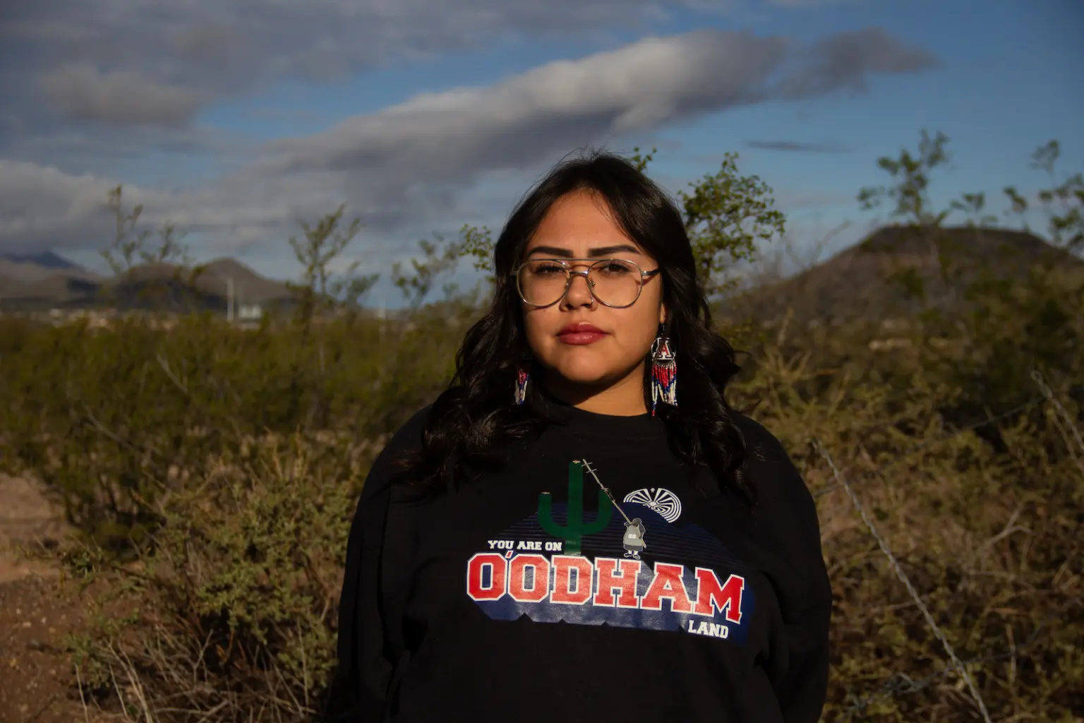
She was also confused. The university, known as UArizona, or more colloquially as U of A by local residents and alumni, expressed a lot of support for Indigenous students. It wasnโ€™t just that the Tohono Oโ€™odham flag hung in the bookstore or that the university had a land acknowledgment reminding the community that the Tucson campus was on Oโ€™odham and Yaqui homelands. The same year she was accepted, UArizona launched a program to cover tuition and mandatory fees for undergraduates from all 22 Indigenous nations in the state. President Robert C. Robbins described the new Arizona Native Scholars Grant as a step toward fulfilling the schoolโ€™s land-grant mission. 

Sierra was eligible for the grant, but it didnโ€™t cover everything. After all the application forms and paperwork, she was still left with a balance of thousands of dollars. She had no choice but to take out a loan, which she kept a secret from her family, especially her mom. โ€œThatโ€™s the number one thing she told me: โ€˜Donโ€™t get a loan,โ€™ but I kind of had to.โ€

Cacti grow behind a sign for the University of Arizona. Bean Yazzie / Grist

Established in 1885, almost 30 years before Arizona was a state, UArizona was one of 52 land-grant universities supported by the Morrill Act. Signed into law by President Abraham Lincoln, the act used land taken from Indigenous nations to fund a network of colleges across the fledgling United States. 

By the early 20th century, grants issued under the Morrill Act had produced the modern equivalent of a half a billion dollars for land-grant institutions from the redistribution of nearly 11 million acres of Indigenous lands. While most land-grant universities ignore this colonial legacy, UArizonaโ€™s Native scholars program appeared to be an effort to exorcise it. 

But the Morrill Act is only one piece of legislation that connects land expropriated from Indigenous communities to these universities. 

In combination with other land-grant laws, UArizona still retains rights to nearly 689,000 acres of land โ€” an area more than twice the size of Los Angeles. The university also has rights to another 705,000 subsurface acres, a term pertaining to oil, gas, minerals, and other resources underground. Known asย trust lands, these expropriated Indigenous territories are held and managed by the state for the schoolโ€™s continued benefit.

A parcel of land in Willcox, Arizona, granted to the University of Arizona. Eliseu Cavalcante / Grist

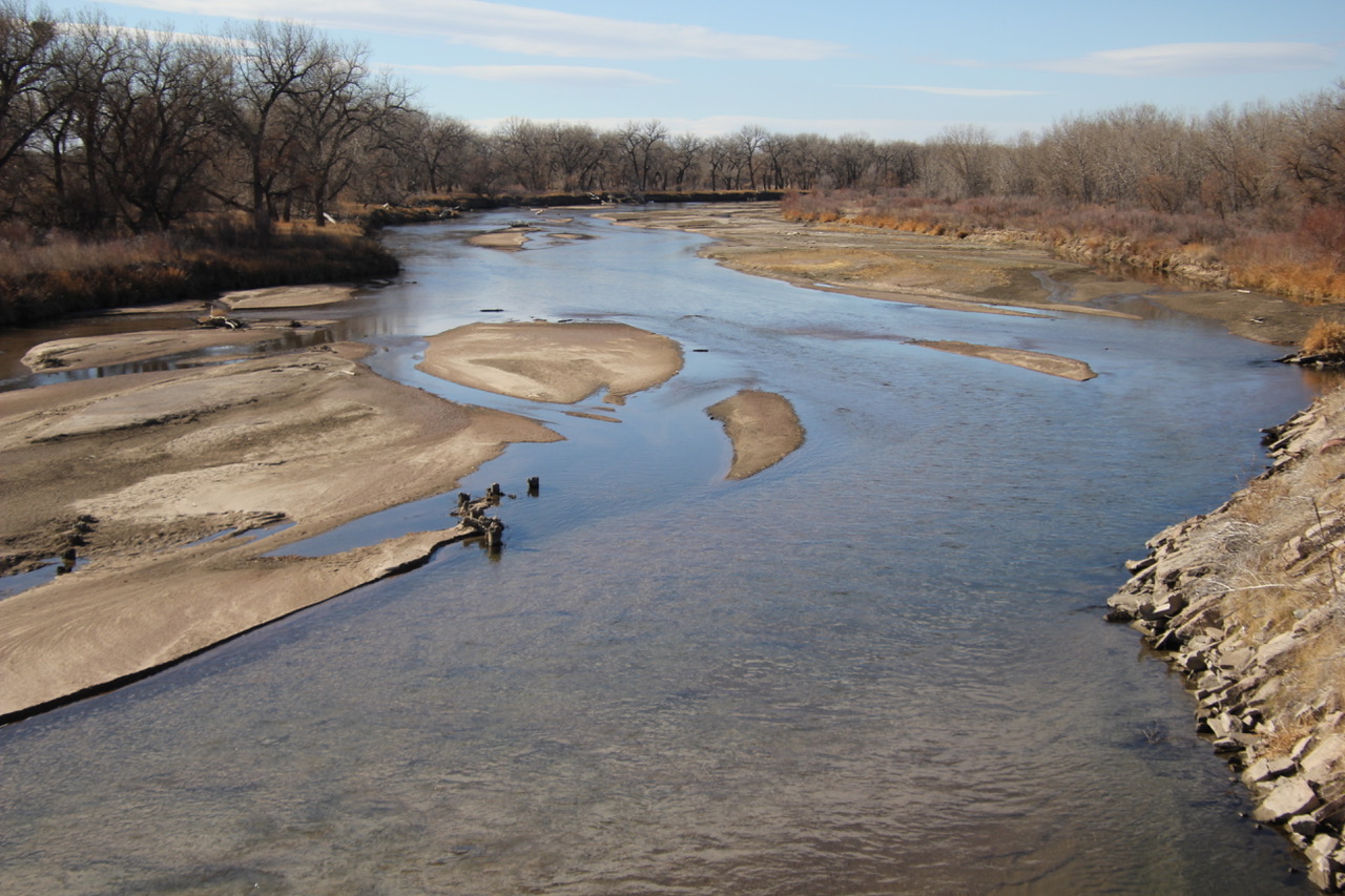
State trust lands just might be one of the best-kept public secrets in America: They exist in 21 Western and Midwestern states, totaling more than 500 million surface and subsurface acres. Those two categories, surface and subsurface, have to be kept separate because they donโ€™t always overlap. What few have bothered to ask is just how many of those acres are funding higher education.

The parcels themselves are scattered and rural, typically uninhabited and seldom marked. Most appear undeveloped and blend in seamlessly with surrounding landscapes. That is, when they donโ€™t have something like logging underway or a frack pad in sight.

In 2022, the year Sierra enrolled, UArizonaโ€™s state trust lands provided the institution $7.7 million โ€” enough to have paid the full cost of attendance for more than half of every Native undergraduate at the Tucson campus that same year. But providing free attendance to anyone is an unlikely scenario, as the school works to rein in a budget shortfall of nearly $240 million.

UArizonaโ€™s reliance on state trust land for revenue not only contradicts its commitment to recognize past injustices regarding stolen Indigenous lands, but also threatens its climate commitments. The school has pledged to reach net-zero emissions by 2040. 

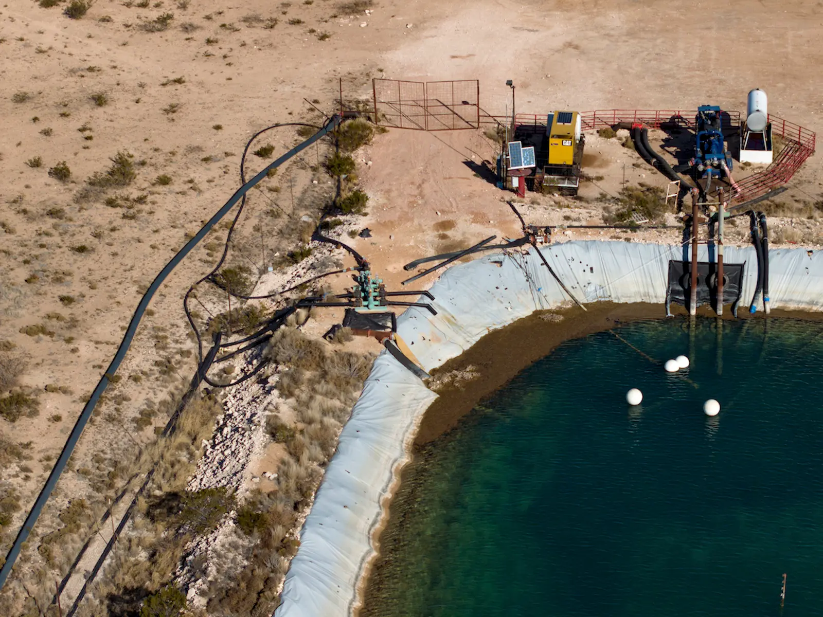
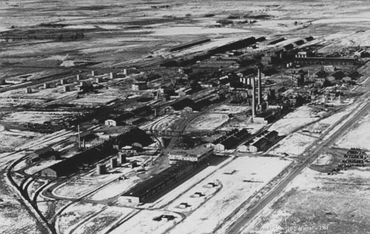
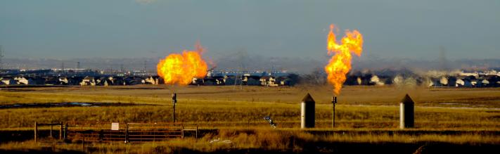
The parcels are managed by the Arizona State Land Department, a separate government agency that has leased portions of them to agriculture, grazing, and commercial activities. But extractive industries make up a major portion of the trust land portfolio. Of the 705,000 subsurface acres that benefit UArizona, almost 645,000 are earmarked for oil and gas production. The lands were taken from at least 10 Indigenous nations, almost all of which were seized by executive order or congressional action in the wake of warfare. 

Over the past year, Grist has examined publicly available data to locate trust lands associated with land-grant universities seeded by the Morrill Act. We found 14 universities that matched this criteria. In the process, we identified their original sources and analyzed their ongoing uses. In all, we located and mapped more than 8.36 million surface and subsurface acres taken from 123 Indigenous nations. This land currently produces income for those institutions.

โ€œUniversities continue to benefit from colonization,โ€ said Sharon Stein, an assistant professor of higher education at the University of British Columbia and a climate researcher. โ€œItโ€™s not just a historical fact; the actual income of the institution is subsidized by this ongoing dispossession.โ€

Indigenous landgranted to universities

The amount of acreage under management for land-grant universities varies widely, from as little as 15,000 acres aboveground in North Dakota to more than 2.1 million belowground in Texas. Combined, Indigenous nations were paid approximately $4.7 million in todayโ€™s dollars for these lands, but in many cases, nothing was paid at all. In 2022 alone, these trust lands generated more than $2.2 billion for their schools. Between 2018 and 2022, the lands produced almost $6.7 billion. However, those figures are likely an undercount as multiple state agencies did not return requests to confirm amounts.

This work builds upon previous investigations that examined how land grabs capitalized and transformed the U.S. university system. The new data reveals how state trust lands continue to transfer wealth from Indigenous nations to land-grant universities more than a century after the original Morrill Act.

It also provides insight into the relationship between colonialism, higher education, and climate change in the Western United States. 

Nearly 25 percent of land-grant university trust lands are designated for either fossil fuel production or the mining of minerals, like coal and iron-rich taconite. Grazing is permitted on about a third of the land, or approximately 2.8 million surface acres. Those parcels are often coupled with subsurface rights, which means oil and gas extraction can occur underneath cattle operations, themselves often a major source of methane emissions. Timber, agriculture, and infrastructure leases โ€” for roads or pipelines, for instance โ€” make up much of the remaining acreage. 

By contrast, renewable energy production is permitted on roughly one-quarter of 1 percent of the land in our dataset. Conservation covers an even more meager 0.15 percent.

However, those land use statistics are likely undercounts due to the different ways states record activities. Many state agencies we contacted for this story had incomplete public information on how land was used. 

โ€œPeople generally are not eager to confront their own complicity in colonialism and climate change,โ€ said Stein. โ€œBut we also have to recognize, for instance, myself as a white settler, that we are part of that system, that we are benefiting from that system, that we are actively reproducing that system every day.โ€

Students like Alina Sierra struggle to pay for education at a university built on her peoplesโ€™ lands and supported with their natural resources. But both current and future generations will have to live with the way trust lands are used to subsidize land-grant universities. 

In December 2023, Sierra decided the cost to attend UArizona was too high and dropped out. 

UArizona did not respond to a request for comment on this story.

Acreage now held in trust by states for land-grant universities is part of Americaโ€™s sweeping history of real estate creation, a history rooted in Indigenous dispossession. 

Trust lands in most states were clipped from the more than 1.8 billion acres that were once part of the United Statesโ€™ public domain โ€” territory claimed, colonized, and redistributed in a process that began in the 18th century and continues today.

The making of the public domain is the stuff of textbook lessons on U.S. expansion. After consolidating statesโ€™ western land claims in the aftermath of the American Revolution, federal officials obtained a series of massive territorial acquisitions from rival imperial powers. No doubt youโ€™ve heard of a few of these deals: They ranged from the  Louisiana Purchase of 1803 to the Alaska Purchase of 1867. 

Backed by the doctrine of discovery, a legal principle with religious roots that justified the seizure of lands around the world by Europeans, U.S. claims to Indigenous territories were initially little more than projections of jurisdiction. They asserted an exclusive right to steal from Indigenous nations, divide the territory into new states, and carve it up into private property. Although Pope Francis repudiated the Catholic Churchโ€™s association with the doctrine in 2023, it remains a bedrock principle of U.S. law.

Native land loss 1776 to 1930. Credit: Alvin Chang/Ranjani Chakraborty

Starting in the 1780s, federal authorities began aggressively taking Native land before surveying and selling parcels to new owners. Treaties were the preferred instrument, accompanied by a range of executive orders and congressional acts. Behind their tidy legal language and token payments lay actual or threatened violence, or the use of debts or dire conditions, such as starvation, to coerce signatures from Indigenous peoples and compel relocation. 

By the 1930s, tribal landholdings in the form of reservations covered less than 2 percent of the United States. Most were located in places with few natural resources and more sensitive to climate change than their original homelands. When reservations proved more valuable than expected, due to the discovery of oil, for instance, outcomes could be even worse, as viewers of Killers of the Flower Moon learned last year.   

The public domain once covered three-fourths of what is today the United States. Federal authorities still retain about 30 percent of this reservoir of plundered land, most conspicuously as national parks, but also as military bases, national forests, grazing land, and more. The rest, nearly 1.3 billion acres, has been redistributed to new owners through myriad laws.

A waste pond on a land-grant parcel in Carlsbad, New Mexico. Eliseu Cavalcante / Grist

When it came to redistribution, grants of various stripes were more common than land sales. Individuals and corporate grantees โ€” think homesteaders or railroads โ€” were prominent recipients, but in terms of sheer acreage given, they trailed a third group: state governments. 

Federal-to-state grants were immense. Cram them all together and they would comfortably cover all of Western Europe. Despite their size and ongoing financial significance, they have never attracted much attention outside of state offices and agencies responsible for managing them.

The Morrill Act, one of the best known examples of federal-to-state grants, followed a well-established path for funding state institutions. This involved handing Indigenous land to state legislatures so agencies could then manage those lands on behalf of specifically chosen beneficiaries.  

Many other laws subsidized higher education by issuing grants to state or territorial governments in a similar way. The biggest of those bounties came through so-called โ€œenabling actsโ€ that authorized U.S. territories to graduate to statehood. 

Every new state carved out of the public domain in the contiguous United States received land grants for public institutions through their enabling acts. These grants functioned like dowries for joining the Union and funded a variety of public works and state services ranging from penitentiaries to fish hatcheries. Their main function, however, was subsidizing education.

Since time immemorial, Indigenous peoples have lived with, and cared for, the lands they call home. But as settlers moved west, U.S. government and military officials forced those communities from their lands, sometimes through the signing of treaties, sometimes through military action. Once ceded, those lands became territories and then states. With statehood, those lands became part of America’s real estate system.

Lands inside newly formed states were overlaid with the Public Land Survey System โ€” a rectangular survey system designed by early colonists to map newly acquired Indigenous lands. One 6-by-6 mile square on the grid is known as a township. Inside each township are 36 more 1-by-1 mile squares called sections.

In most states, sections 16 and 36 of every township were automatically set aside to fund K-12 schools, known as common schools at the time. From the remaining 34 sections, states could choose which lands would benefit other public institutions, like hospitals, penitentiaries, and universities.

In the years since statehood, some of these lands have been sold or swapped, but most Western states have held onto their trust lands. Spread across the Western U.S. land grid, trust lands are often unseen, landlocked, and anonymous on the landscape.

Primary and secondary schools, or K-12 schools, were the greatest beneficiaries by far, followed by institutions of higher education. What remains of them today are referred to as trust lands. โ€œA perpetual, multigenerational land trust for the support of the Beneficiaries and future generationsโ€ is how the Arizona State Land Department describes them.

Higher education grants were earmarked for universities, teachers colleges, mining schools, scientific schools, and agricultural colleges, the latter being the means through which states that joined the Union after 1862 got their Morrill Act shares. States could separate or consolidate their benefits as they saw fit, which resulted in many grants becoming attached to Morrill Act colleges.  

Originally, the land was intended to be sold to raise capital for trust funds. By the late 19th century, however, stricter requirements on sales and a more conscientious pursuit of long-term gains reduced sales in favor of short-term leasing. 

The change in management strategy paid off. Many state land trusts have been operating for more than a century. In that time, they have generated rents from agriculture, grazing, and recreation. As soon as they were able, managers moved into natural resource extraction, permitting oil wells, logging, mining, and fracking. 

Land use decisions are typically made by state land agencies or lawmakers. Of the six land-grant institutions that responded to requests for comment on this investigation, those that referenced their trust lands deferred to state agencies, making clear that they had no control over permitted activities.

Credit: Grist

State agencies likewise receive and distribute the income. As money comes in, it is either delivered directly to beneficiaries or, more commonly, diverted to permanent state trust funds, which invest the proceeds and make scheduled payouts to support select public services and institutions. 

These trusts have a fiduciary obligation to generate profit for institutions, not minimize environmental damage. Although some of the permitted activities are renewable and low-impact, others are quietly stripping the land. All of them fill public coffers with proceeds derived from ill-gotten resources.

For a $10 fee last December, anyone in New Mexico could chop down a Christmas tree in a pine stand on a patch of state trust land just off Highway 120 near Black Lake, southeast of Taos. The rules: Pay your fee, bring your permit, choose a tree, and leave nothing behind but a stump less than 6 inches high.

โ€œThe holidays are a time we should be enjoying our loved ones, not worrying about the cost of providing a memorable experience for our kids,โ€ said Commissioner of Public Lands Stephanie Garcia Richard, adding that โ€œthe nominal fee it costs for a permit will directly benefit New Mexico public schools, so it supports a good cause too.โ€ The offer has been popular enough to keep the program running for several years.

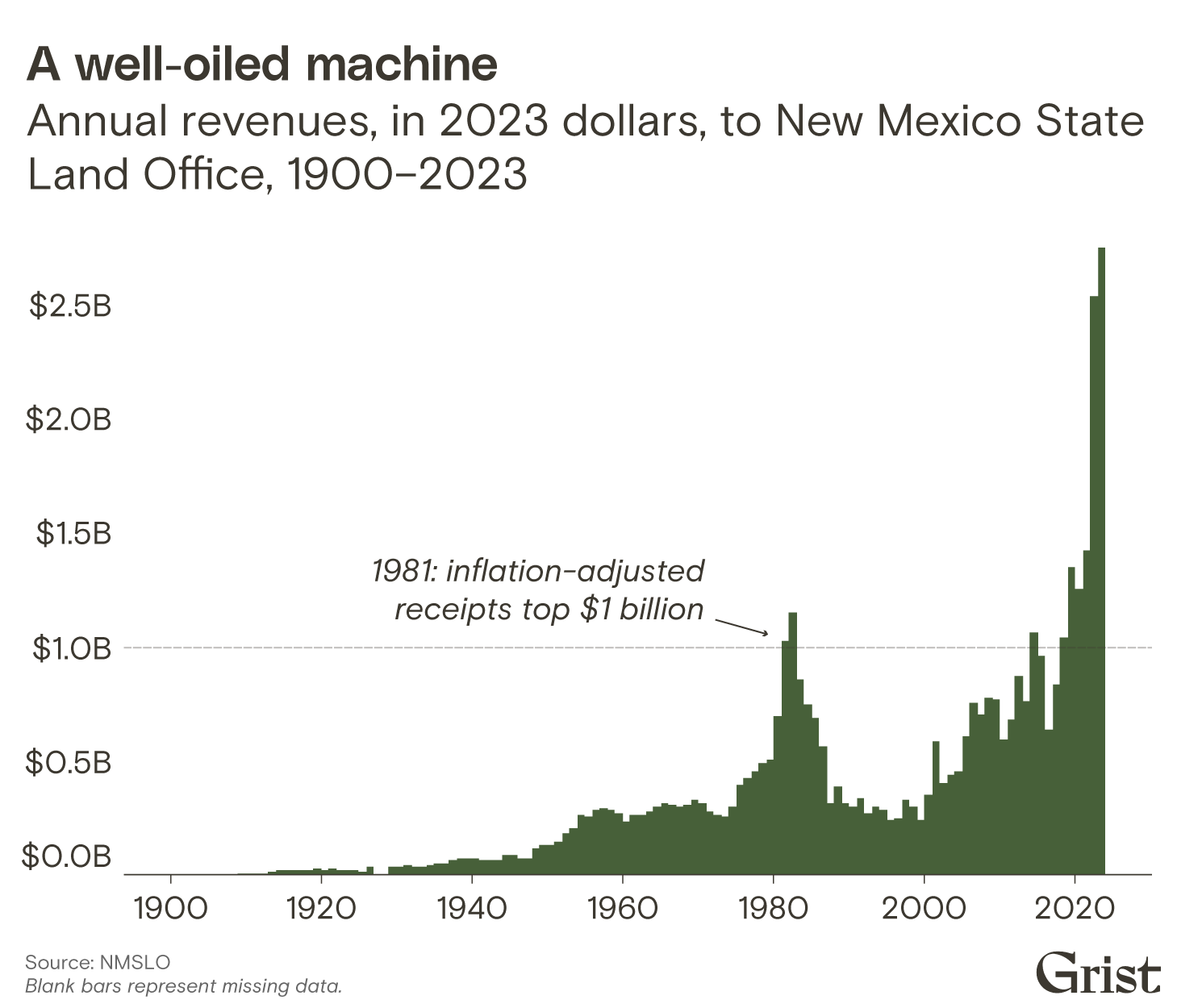
The New Mexico State Land Office, sometimes described by state legislators as โ€œthe most powerful office youโ€™ve never heard of,โ€ has been a successful operation for a very long time. Since it started reporting revenue in 1900, itโ€™s generated well over $42 billion in 2023 dollars.

All that money isnโ€™t from Christmas trees.

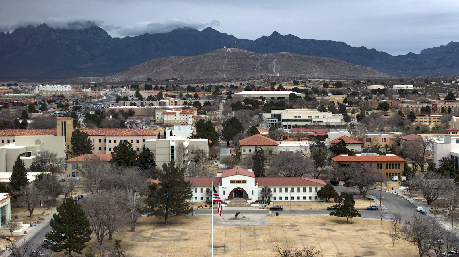
For generations, oil and gas royalties have fueled the stateโ€™s trust land revenue, with a portion of the funds designated for New Mexico State University, or NMSU, a land-grant school founded in 1888 when New Mexico was still a territory.

New Mexico State University, as seen in an aerial view, is a land-grant school founded in 1888. Eliseu Cavalcante / Grist

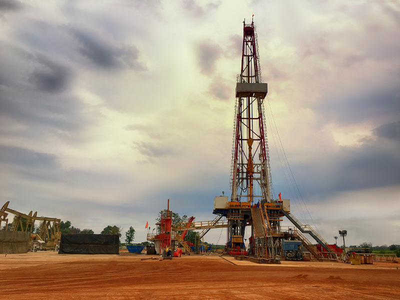
The oil comes from drilling in the northwestern fringe of the Permian Basin, one of the oldest targets of large-scale oil production in the United States. Corporate descendants of Standard Oil, the infamous monopoly controlled by John D. Rockefeller, were operating in the Permian as early as the 1920s. Despite being a consistent source of oil, prospects for exploitation dimmed by the late 20th century, before surging again in the 21st. Today, itโ€™s more profitable than ever.

In recent decades, more sophisticated exploration techniques have revealed more โ€œrecoverableโ€ fossil fuel in the Permian than previously believed. A 2018 report by the United States Geological Survey pegged the volume at 46.3 billion barrels of oil and 281 trillion cubic feet of natural gas, which made the Permian the largest oil and gas deposit in the nation. Analysts, shocked at the sheer volume, and the money to be made, have taken to crowningthe Permian the โ€œKing of Shale Oil.โ€ Critics concerned with the climate impact of the expanding operations call it a โ€œcarbon bomb.โ€

As oil and gas extraction spiked, so did New Mexicoโ€™s trust land receipts. In the last 20 years, oil and gas has generated between 91 and 97 percent of annual trust land revenue. It broke annual all-time highs in half of those years, topping $1 billion for the first time in 2019 and reaching $2.75 billion last year. Adjusted for inflation, more than 20 percent of New Mexicoโ€™s trust land income since 1900 has arrived in just the last five years.

โ€œEvery dollar earned by the Land Office,โ€ Commissioner Richard said when revenues broke the billion-dollar barrier, โ€œis a dollar taxpayers do not have to pay to support public institutions.โ€

Credit: Grist

Trust land as a cost-free source of subsidies for citizens is a common framing. In 2023, Richard declared that her office had saved every New Mexico taxpayer $1,500 that year. The press release did not mention oil or gas, or Apache bands in the state.

Virtually all of the trust land in New Mexico, including 186,000 surface acres and 253,000 subsurface acres now benefiting NMSU, was seized from various Apache bands during the so-called Apache Wars. Often reduced to the iconic photograph of Geronimo on one knee, rifle in hand, hostilities began in 1849, and they remain the longest-running military conflict in U.S. history, continuing until 1924.

In 2019, newly elected New Mexico Governor Michelle Lujan Grisham began aligning state policy with โ€œscientific consensus around climate change.โ€ According to the stateโ€™s climate action website, New Mexico is working to tackle climate change by transitioning to clean electricity, reducing greenhouse gas emissions, supporting an economic transition from coal to clean energy, and shoring up natural resource resilience.

โ€œNew Mexico is serious about climate change โ€” and we have to be. We are already seeing drier weather and rising temperatures,โ€ the governor wrote on the stateโ€™s website. โ€œThis administration is committed not only to preventing global warming, but also preparing for its effects today and into the future.โ€

No mention was made of increasingly profitable oil and gas extraction on trust lands or their production in the Permian. In 2023, just one 240-acre parcel of land benefiting NMSU was leased for five years for $6 million. 

NMSU did not respond to a request for comment on this story.


More than half of the acreage uncovered in our investigation appears in oil-rich West Texas, the equivalent of more than 3 million football fields. It benefits Texas A&M.

Take the long drive west along I-10 between San Antonio and El Paso, in the southwest region of the Permian Basin, and youโ€™ll pass straight through several of those densely packed parcels without ever knowing it โ€” theyโ€™re hidden in plain sight on the arid landscape. These tracts, and others not far from the highway, were Mescalero Apache territory. Kiowas and Comanches relinquished more parcels farther north.

A flare glows on a land-grant parcel in Pyote, Texas, associated with Texas A&M. Eliseu Cavalcante / Grist

In the years after the Civil War, a โ€œpeace commissionโ€ pressured Comanche and Kiowa leaders for an agreement that would secure land for tribes in northern Texas and Oklahoma. Within two years, federal agents dramatically reduced the size of the resulting reservation with another treaty, triggering a decade of conflict.

The consequences were disastrous. Kiowas and Comanches lost their land to Texas and their populations collapsed. Between the 1850s and 1890s, Kiowas lost more than 60 percent of their people to disease and war, while Comanches lost nearly 90 percent.

If this general pattern of colonization and genocide was a common one, the trajectory that resulted in Texas A&Mโ€™s enormous state land trust was not.

Texas was never part of the U.S. public domain. Its brief stint as an independent nation enabled it to enter the Union as a state, skipping territorial status completely. As a result, like the original 13 states, it claimed rights to sell or otherwise distribute all the not-yet-privatized land within its borders.

Following the broader national model, but ratcheting up the scale, Texas would allocate over 2 million acres to subsidize higher education. 

Texas A&M was established to take advantage of a Morrill Act allocation of 180,000 acres, and opened its doors in 1876. The same year, Texas allocated a million acres of trust lands, followed by another million in 1883, nearly all of it on land relinquished in treaties from the mid-1860s.

Today, the Permanent University Fund derived from that land is worth nearly $34 billion. Thatโ€™s thanks to oil, of course, which has been flowing from the universityโ€™s trust lands since 1923. In 2022 alone, Texas trust lands produced $2.2 billion in revenue.

The Kiowa and Comanche were ultimately paid about 2 cents per acre for their land. The Mescalero Apache received nothing. 

Texas A&M did not respond to a request for comment on this story.


For more than a century, logging has been the main driver of Washington State Universityโ€™s trust land income, on land taken from 21 Indigenous nations, especially the Confederated Tribes and Bands of the Yakama Nation. About 86,000 acres, more than half of the surface trust lands allocated to Washington State University, or WSU, are located inside Yakama land cessions, which started in 1855. Between 2018 and 2022, trust lands produced nearly $78.5 million in revenue almost entirely from timber. 

But it isnโ€™t a straight line to the universityโ€™s bank account.

โ€œThe university does not receive the proceeds from timber sales directly,โ€ said Phil Weiler, a spokesperson for WSU. โ€œLands held in trust for the university are managed by the Washington State Department of Natural Resources, not WSU.โ€

In 2022, WSUโ€™s trust lands produced about $19.5 million in revenue, which was deposited into a fund managed by the State Investment Board. In other words, the state takes on the management responsibility of turning timber into investments, while WSU reaps the rewards by drawing income from the resulting trust funds. 

โ€œThe Washington legislature decides how much of the investment earnings will be paid out to Washington State University each biennium,โ€ said Weiler. โ€œBy law, those payouts can only be used to fund capital projects and debt service.โ€

This arrangement yielded nearly $97 million dollars for WSU from its two main trust funds between 2018 and 2022, and has generally been on the rise since the Great Recession. In recent decades, the money has gone to construction and maintenance of the institutionโ€™s infrastructure, like its Biomedical and Health Sciences building, and the PACCAR Clean Technology Building โ€” a research center focused on innovating wood products and sustainable design. 

That revenue may look small in comparison to WSUโ€™s $1.2 billion dollar endowment, but it has added up over time. From statehood in 1889 to 2022, timber sales on trust lands provided Washington State University with roughly $1 billion in revenue when Grist adjusted for inflation. But those figures are likely higher: Between 1971 and 1983, the State of Washington did not produce detailed records on trust land revenue as a cost-cutting measure. 

Meanwhile, WSU students have demanded that the university divest from fossil fuel companies held in the endowment. But even if the board of regents agreed, any changes would likely not apply to the schoolโ€™s state-controlled trust fund, which currently contains shares in ExxonMobil, Shell, Chevron, and at least two dozen other corporations in the oil and gas sector.

โ€œWashington State University (WSU) is aware that our campuses are located on the homelands of Native peoples and that the institution receives financial benefit from trust lands,โ€ said Weiler. 


In states with trust lands, a reasonably comfortable buffer exists between beneficiaries, legislators, land managers, and investment boards, but that hasnโ€™t always been the case. In Minnesotaโ€™s early days, state leaders founded the University of Minnesota while also making policy that would benefit the school, binding the stateโ€™s history of genocide with the institution. 

Those actions still impact Indigenous peoples in the state today while providing steady revenue streams to the University.

Henry Sibley began to amass his fortune around 1834 after only a few years in the fur trade in the territory of what would become Minnesota, rising to the role of regional manager of the American Fur Company at just 23. But even then, the industry was on the decline โ€” wild game had been over-hunted and competition was fierce. Sibley responded by diversifying his activities. He moved into timber, making exclusive agreements with the Ojibwe to log along the Snake and Upper St. Croix rivers. 

His years in โ€œwild Indian countryโ€ were paying off: Sibley knew the land, waterways, and resources of the Great Lakes region, and he knew the people, even marrying Tahshinaohindaway, also known as Red Blanket Woman, in 1840 โ€” a Mdewakanton Dakota woman from Black Dog Village in what is now southern Minneapolis.

Sibley was a major figure in a number of treaty negotiations, aiding the U.S. in its western expansion, opening what is now Minnesota to settlement by removing tribes. In 1848, he became the first congressional delegate for the Wisconsin Territory, which covered much of present-day Minnesota, and eventually, Minnesotaโ€™s first governor. 

But he was also a founding regent of the University of Minnesota โ€” using his personal, political, and industry knowledge of the region to choose federal, state, and private lands for the university. Sibley and other regents used the institution as a shel corporation to speculate and move money between companies they held shares in.

n 1851, Sibley helped introduce land-grant legislation for the purpose of a territorial university, and just three days after Congress passed the bill, Minnesotaโ€™s territorial leaders established the University of Minnesota. With an eye on statehood, leaders knew more land would be granted for higher education, but first the land had to be made available. 

That same year, with the help of then-territorial governor and fellow university regent Alexander Ramsey, the Dakota signed the Treaty of Traverse De Sioux, a land cession that created almost half of the state of Minnesota, and, taken with other cessions, would later net the University nearly 187,000 acres of land โ€” an area roughly the size of Tucson.

Among the many clauses in the treaty was payment: $1.4 million would be given to the Dakota, but only after expenses. Ramsey deducted $35,000 for a handling fee, about $1.4 million in todayโ€™s dollars. After agencies and politicians had taken their cuts, the Dakota were promised only $350,000, but ultimately, only a few thousand arrived after federal agents delayed and withheld payments or substituted them for supplies that were never delivered. 

The betrayal led to the Dakota War of 1862. โ€œThe Sioux Indians of Minnesota must be exterminated or driven forever beyond the borders of the state,โ€ said Governor Ramsey. Sibley joined in the slaughter, leading an army of volunteers dedicated to the genocide of the Dakota people. At the end of the conflict, Ramsey ordered the mass execution of more than 300 Dakota men in December of 1862 โ€” a number later reduced by then-president Abraham Lincoln to 39, and still the largest mass execution in U.S. history

That grisly punctuation mark at the end of the war meant a windfall for the University of Minnesota, with new lands being opened through the stateโ€™s enabling act and another federal grant that had just been passed: the Morrill Act. Within weeks of the mass execution, the university was reaping benefits thanks to the political, and military, power of Sibley and the board of regents. 

Between 2018 and 2022, those lands produced more than $17 million in revenue, primarily through leases for the mining of iron and taconite, a low-grade iron ore used by the steel industry. But like other states that rely on investment funds and trusts to generate additional income, those royalties are only the first step in the institutionโ€™s financial investments.

Today, Sibley, Ramsey, and other regents are still honored. Their names adorn parks, counties, and streets, their homes memorialized for future generations. While there have been efforts to remove their names from schools and parks, Minnesota, its institutions, and many of its citizens continue to benefit from their actions.

The iron and taconite mines that owe their success to the work of these men have left lasting visual blightwater contaminationfrom historic mine tailings, and elevated rates of mesotheliomaamong taconite workers in Minnesota. The 1863 federal law that authorized the removal of Indigenous peoples from the region is still on the books today and has never been overturned.


Less than half of the universities featured in this story responded to requests for comment, and the National Association of State Trust Lands, the nonprofit consortium that represents trust land agencies and administrators, declined to comment. Those that did, however, highlighted the steps they were making to engage with Indigenous students and communities.

Still, investments in Indigenous communities are slow coming. Of the universities that responded to our requests, those that directly referenced how trust lands were used maintained they had no control over how they profited from the land. 

And theyโ€™re correct, to some degree: States managing assets for land-grants have fiduciary, and legal, obligations to act in the institutionโ€™s best interests. 

But that could give land-grant universities a right to ask why maximizing returns doesnโ€™t factor in the value of righting past wrongs or the costs of climate change.

โ€œWe can know very well that these things are happening and that weโ€™re part of the problem, but our desire for continuity and certainty and security override that knowledge,โ€ said Sharon Stein of the University of British Columbia.

That knowledge, Stein added, is easily eclipsed by investments in colonialism that obscure university complicity and dismiss that change is possible.

Though itโ€™s a complicated and arduous process changing laws and working with state agencies, universities regularly do it. In 2022, the 14 land-grant universities profiled in this story spent a combined $4.6 million on lobbying on issues ranging from agriculture to defense. All lobbied to influence the federal budget and appropriations.

But even if those high-level actions are taken, itโ€™s not clear how it will make a difference to people like Alina Sierra in Tucson, who faces a rocky financial future after her departure from the University of Arizona.

In 2022, a national study on college affordability found that nearly 40 percent of Native students accrued more than $10,000 in college debt, with some accumulating more than $100,000 in loans. Sierra is still in debt to UArizona for more than $6,000.

โ€œI think that being on Oโ€™odham land, they should give back, because itโ€™s stolen land,โ€ said Sierra. โ€œThey should put more into helping us.โ€ 

In January, Sierra enrolled as a full-time student at Tohono Oโ€™odham Community College in Sells, Arizona โ€” a tribal university on her homelands. The full cost of attendance, from tuition to fees to books, is free. 

The college receives no benefits from state trust lands.

CREDITS

This story was reported and written by Tristan Ahtone, Robert Lee, Amanda Tachine, An Garagiola, and Audrianna Goodwin. Data reporting was done by Maria Parazo Rose and Clayton Aldern, with additional data analysis and visualization by Marcelle Bonterre and Parker Ziegler. Margaret Pearce provided guidance and oversight. 

Original photography for this project was done by Eliseu Cavalcante and Bean Yazzie. Parker Ziegler handled design and development. Teresa Chin supervised art direction. Marty Two Bulls Jr. and Mia Torres provided illustration. Megan Merrigan, Justin Ray, and Mignon Khargie handled promotion. Rachel Glickhouse coordinated partnerships.

This project was edited by Katherine Lanpher and Katherine Bagley. Jaime Buerger managed production. Angely Mercado did fact-checking, and Annie Fu fact-checked the projectโ€™s data.

Special thanks to Teresa Miguel-Stearns, Jon Parmenter, Susan Shain, and Tushar Khurana for their additional research contributions. We would also like to thank the many state officials who helped to ensure we acquired the most recent and accurate information for this story. This story was made possible in part by the Pulitzer Center, the Data-Driven Reporting Project, and the Bay & Paul Foundation. 

The Misplaced Trust team acknowledges the Tohono Oโ€™odham, Pascua Yaqui, dxสทdษ™wส”abลก, Suquamish, Muckleshoot, puyalษ™pabลก, Tulalip, Muwekma Ohlone, Lisjan, Tongva, Kizh, Dakota, Bodwรฉwadmi, Quinnipiac, Monongahela, Shawnee, Lenape, Erie, Osage, Akimel Oโ€™odham, Piipaash, Oฤhรฉthi ล akรณwiล‹, Dinรฉ, Kanienสผkehรก:ka, Muh-he-con-ne-ok, Pฮฑnawฮฌhpskewi, and Mvskoke peoples, on whose homelands this story was created.

The amount of acreage under management for land-grant universities varies widely, from as little as 15,000 acres aboveground in North Dakota to more than 2.1 million belowground in Texas. Combined, Indigenous nations were paid approximately $4.7 million in todayโ€™s dollars for these lands, but in many cases, nothing was paid at all. In 2022 alone, these trust lands generated more than $2.2 billion for their schools. Between 2018 and 2022, the lands produced almost $6.7 billion. However, those figures are likely an undercount as multiple state agencies did not return requests to confirm amounts.

2024 #COleg: Western Slope lawmakers introduce rival bill to protect #Colorado wetlands — Summit Daily

Blanca Wetlands, Colorado BLM-managed ACEC Blanca Wetlands is a network of lakes, ponds, marshes and wet meadows designated for its recreation and wetland values. The BLM Colorado and its partners have made strides in preserving, restoring and managing the area to provide rich and diverse habitats for wildlife and the public. To visit or get more information, see: http://www.blm.gov/co/st/en/fo/slvfo/blanca_wetlands.html. By Bureau of Land Management – Blanca Wetlands Area of Critical Environmental Concern, Colorado, Public Domain, https://commons.wikimedia.org/w/index.php?curid=42089248

Click the link to read the article on the Summit Daily website (Elliot Wenzler). Here’s an excerpt:

March 22, 2024

House Bill 1379 is only one of the approaches being considered by the Colorado legislature this session.ย Senate Bill 127, introduced in February by Sen. Barbara Kirkmeyer, R-Brighton, proposes that the permitting system should instead be managed by the Colorado Department of Natural Resources.ย 

โ€œThey do the floodplain planning, the water planning, theyโ€™re responsible for the streams and rivers, thatโ€™s not the health department,โ€ she said. 

Kirkmeyer argues that the permitting shouldnโ€™t be under CDPHE because the department already has a huge backlog for its other permit programs.ย The two bills have several other key differences, including how they define which waters should be protected and how stringent the permitting process is for different industries, such as mining. Agricultural activities would be largely exempt under both bills.ย  Senate Bill 172 has a more narrow approach to which state waters should be protected, largely consistent with the Sackett decision. House Bill 1379 would go somewhat beyond the scope of what was protected before that ruling…

House Bill 1379 was assigned to the House Agriculture, Water and Natural Resources Committee. Senate Bill 172 is set to be heard by the Senate Agriculture and Natural Resources Committee April 4.

Climate change is shifting the zones where plants grow โ€“ hereโ€™s what that could mean for yourย garden

Climate change complicates plant choices and care. Early flowering and late freezes can kill flowers like these magnolia blossoms. Matt Kasson, CC BY-ND

Matt Kasson, West Virginia University

With the arrival of spring in North America, many people are gravitating to the gardening and landscaping section of home improvement stores, where displays are overstocked with eye-catching seed packs and benches are filled with potted annuals and perennials.

But some plants that once thrived in your yard may not flourish there now. To understand why, look to the U.S. Department of Agricultureโ€™s recent update of its plant hardiness zone map, which has long helped gardeners and growers figure out which plants are most likely to thrive in a given location.

A U.S. map divided into colored geographic zones with a numbered key.
The 2023 USDA plant hardiness zone map shows the areas where plants can be expected to grow, based on extreme winter temperatures. Darker shades (purple to blue) denote colder zones, phasing southward into temperate (green) and warm zones (yellow and orange). USDA

Comparing the 2023 map to the previous version from 2012 clearly shows that as climate change warms the Earth, plant hardiness zones are shifting northward. On average, the coldest days of winter in our current climate, based on temperature records from 1991 through 2020, are 5 degrees Fahrenheit (2.8 Celsius) warmer than they were between 1976 and 2005.

In some areas, including the central Appalachians, northern New England and north central Idaho, winter temperatures have warmed by 1.5 hardiness zones โ€“ 15 degrees F (8.3 C) โ€“ over the same 30-year window. This warming changes the zones in which plants, whether annual or perennial, will ultimately succeed in a climate on the move.

U.S. map showing large areas colored tan, denoting a 5-degree increase in average winter minimum temperatures.
This map shows how plant hardiness zones have shifted northward from the 2012 to the 2023 USDA maps. A half-zone change corresponds to a tan area. Areas in white indicate zones that experienced minimal change. Prism Climate Group, Oregon State University, CC BY-ND

As a plant pathologist, I have devoted my career to understanding and addressing plant health issues. Many stresses not only shorten the lives of plants, but also affect their growth and productivity.

I am also a gardener who has seen firsthand how warming temperatures, pests and disease affect my annual harvest. By understanding climate change impacts on plant communities, you can help your garden reach its full potential in a warming world.

Hotter summers, warmer winters

Thereโ€™s no question that the temperature trend is upward. From 2014 through 2023, the world experienced the 10 hottest summers ever recorded in 174 years of climate data. Just a few months of sweltering, unrelenting heat can significantly affect plant health, especially cool-season garden crops like broccoli, carrots, radishes and kale.

Radishes sprouting in a garden bed.
Radishes are cool-season garden crops that cannot withstand the hottest days of summer. Matt Kasson, CC BY-ND

Winters are also warming, and this matters for plants. The USDA defines plant hardiness zones based on the coldest average annual temperature in winter at a given location. Each zone represents a 10-degree F range, with zones numbered from 1 (coldest) to 13 (warmest). Zones are divided into 5-degree F half zones, which are lettered โ€œaโ€ (northern) or โ€œbโ€ (southern).

For example, the coldest hardiness zone in the lower 48 states on the new map, 3a, covers small pockets in the northernmost parts of Minnesota and has winter extreme temperatures of -40 F to -35 F. The warmest zone, 11b, is in Key West, Florida, where the coldest annual lows range from 45 F to 50 F.

On the 2012 map, northern Minnesota had a much more extensive and continuous zone 3a. North Dakota also had areas designated in this same zone, but those regions now have shifted completely into Canada. Zone 10b once covered the southern tip of mainland Florida, including Miami and Fort Lauderdale, but has now been pushed northward by a rapidly encroaching zone 11a.

Many people buy seeds or seedlings without thinking about hardiness zones, planting dates or disease risks. But when plants have to contend with temperature shifts, heat stress and disease, they will eventually struggle to survive in areas where they once thrived.

Successful gardening is still possible, though. Here are some things to consider before you plant:

Annuals versus perennials

Hardiness zones matter far less for annual plants, which germinate, flower and die in a single growing season, than for perennial plants that last for several years. Annuals typically avoid the lethal winter temperatures that define plant hardiness zones.

In fact, most annual seed packs donโ€™t even list the plantsโ€™ hardiness zones. Instead, they provide sowing date guidelines by geographic region. Itโ€™s still important to follow those dates, which help ensure that frost-tender crops are not planted too early and that cool-season crops are not harvested too late in the year.

Orange flowers blooming with other plants and grasses.
California poppies are typically grown as annuals in cool areas, but can survive for several years in hardiness zones 8-10. The Marmot/Flickr, CC BY

User-friendly perennials have broad hardiness zones

Many perennials can grow across wide temperature ranges. For example, hardy fig and hardy kiwifruit grow well in zones 4-8, an area that includes most of the Northeast, Midwest and Plains states. Raspberries are hardy in zones 3-9, and blackberries are hardy in zones 5-9. This eliminates a lot of guesswork for most gardeners, since a majority of U.S. states are dominated by two or more of these zones.

Nevertheless, itโ€™s important to pay attention to plant tags to avoid selecting a variety or cultivar with a restricted hardiness zone over another with greater flexibility. Also, pay attention to instructions about proper sun exposure and planting dates after the last frost in your area.

Fruit trees are sensitive to temperature fluctuations

Fruit trees have two parts, the rootstock and the scion wood, that are grafted together to form a single tree. Rootstocks, which consist mainly of a root system, determine the treeโ€™s size, timing of flowering and tolerance of soil-dwelling pests and pathogens. Scion wood, which supports the flowers and fruit, determines the fruit variety.

Most commercially available fruit trees can tolerate a wide range of hardiness zones. However, stone fruits like peaches, plums and cherries are more sensitive to temperature fluctuations within those zones โ€“ particularly abrupt swings in winter temperatures that create unpredictable freeze-thaw events.

Packages for hardy fig and kiwi seedlings.
Following planting instructions carefully can maximize plantsโ€™ chances of success. Matt Kasson, CC BY-ND

These seesaw weather episodes affect all types of fruit trees, but stone fruits appear to be more susceptible, possibly because they flower earlier in spring, have fewer hardy rootstock options, or have bark characteristics that make them more vulnerable to winter injury.

Perennial plantsโ€™ hardiness increases through the seasons in a process called hardening off, which conditions them for harsher temperatures, moisture loss in sun and wind, and full sun exposure. But a too-sudden autumn temperature drop can cause plants to die back in winter, an event known as winter kill. Similarly, a sudden spring temperature spike can lead to premature flowering and subsequent frost kill.

Pests are moving north too

Plants arenโ€™t the only organisms constrained by temperature. With milder winters, southern insect pests and plant pathogens are expanding their ranges northward.

One example is Southern blight, a stem and root rot disease that affects 500 plant species and is caused by a fungus, Agroathelia rolfsii. Itโ€™s often thought of as affecting hot Southern gardens, but has become more commonplace recently in the Northeast U.S. on tomatoes, pumpkins and squash, and other crops, including apples in Pennsylvania.

A stem dotted with small round growths.
Southern blight (small round fungal structures) at the base of a tomato plant. Purdue University, CC BY-ND

Other plant pathogens may take advantage of milder winter temperatures, which leads to prolonged saturation of soils instead of freezing. Both plants and microbes are less active when soil is frozen, but in wet soil, microbes have an opportunity to colonize dormant perennial plant roots, leading to more disease.

It can be challenging to accept that climate change is stressing some of your garden favorites, but there are thousands of varieties of plants to suit both your interests and your hardiness zone. Growing plants is an opportunity to admire their flexibility and the features that enable many of them to thrive in a world of change.

Matt Kasson, Associate Professor of Mycology and Plant Pathology, West Virginia University

This article is republished from The Conversation under a Creative Commons license. Read the original article.

EPA officials pledge to clean up old uranium mines at the first Navajo Superfund site — AZCentral.com

Graphic credit: Environmental Protection Agency

Click the link to read the article on the AZCentral website (Arlyssa D. Becenti). Here’s an excerpt:

March 23, 2024

Representatives from the U.S. Environmental Protection Agency met with Cove community members last week to discussย the agency’s decisionย to place the Lukachukai Mountains Mining District on the National Priorities List. Although the meeting was intended to be informational, tribal, Navajo EPA and community leaders expressed their uncertainty about whether the federal government will actually start addressing the cleanup of the abandoned uranium mines that landed the site on the EPA list, also known as the Superfund program. The mining district encompasses Navajo Nation communities of Cove, Round Rock and Lukachukai in the far northeastern corner of Arizona.ย 

โ€œWe are looking at what happened in the past and how the federal government could have prevented a lot of this contamination,โ€ said Council Delegate Amber Kanazbah Crotty, โ€œcouldโ€™ve prevented our community from getting sick. What I donโ€™t want them (children) to have to deal with is another three or four decades before actual action happens.โ€

[…]

Phil Harrison remembers when his childhood community of Cove was alive with family gatherings, ceremonies, rodeos, farming and ranching, but after decades of uranium contamination, those days are a thing of the past…Harrisonโ€™s father was a miner in the uranium mines of Cove, which was where uranium was first discovered on the Navajo Nation. Uranium production in the northern and western Carrizo Mountains of the Navajo Nation began in 1948, peaked in 1955 and 1956 and declined to zero again by 1967. 

Here’s how much #LakePowell is expected to rise this year — KSL.com #ColoradoRiver #COriver #aridification

Enigmatic artwork with Glen Canyon Dam in the background. Jonathan P. Thompson photo.

Click the link to read the article on the KSL.com website (Carter Williams, KSL.com). Here’s an excerpt:

March 20, 2024

Lake Powell is projected to receive about 5.4 million acre-feet of water based on conditions this winter, National Weather Service’s Colorado Basin River Forecast Center officials said on Friday. That would hoist the reservoir from 32% to 37% capacity after the snowmelt process wraps up in the early summer. The reservoir gained about 65 feet in water levels last spring, jumping from 21% to 38% capacity followingย last year’s record snowpack. If this year’s projections come to fruition, it would also be close to the reservoir peak in 2021. It would also be much lower than the 2010s average peak…

Graphic credit: Colorado Basin River Forecast Center

The center’s projections are based on a possible inflow of 85% of normal. Snowpack levels are generally between 85% and 130% of normal across the Upper Colorado River Basin region, and 120% and 125% across the Great Basin, Colorado Basin River Forecast Center officials wrote in a water supply report Tuesday. Officials clarified on social media the lower inflows are tied to drier conditions within the Green River and San Juan river basins, which flow into the Colorado River upstream of Lake Powell. They also said inflows were nearly twice the normal last year, which is why the reservoir gained so much in a short period.

Westwide SNOTEL basin-filled map March 23, 2024 via the NRCS.

Future of #LakeMead still unclear as negotiations flare — The Las Vegas Review-Journal #ColoradoRiver #COriver #aridification

Credit: Upper Colorado River Commisstion

Click the link to read the article on The Las Vegas Review-Journal website (Alan Halaly). Here’s an excerpt:

March 19, 2024

Coloradoโ€™s chief river negotiator doesnโ€™t find the other sideโ€™s proposal for basinwide water cuts after 2026 plausible, she told reporters Tuesday. When it comes to updating how water from the Colorado River is allocated, the Upper Basin states โ€” Colorado, New Mexico, Utah and Wyoming โ€”ย have been wrapped in a divisive battleย with the Lower Basin, which is composed of Nevada, California and Arizona. Both parties agree that the โ€œstructural deficit,โ€ meaning the 1.5 million acre-feet of water lost to evaporation and transport, should translate to cuts made by the Lower Basin states. However, a main point of contention lies in whether Upper Basin states also must bear the brunt of cuts past the structural deficit.

States such as Colorado are at the mercy of snowpack and climate change to determine water availability, said Becky Mitchell, Colorado stateโ€™s Colorado River commissioner. Thatโ€™s a far cry from a state like California, she said, which enjoys more certainty thanks to Lake Powell and Lake Mead, the two largest reservoirs in the country. Upper Basin states have estimated they suffer a 1.2 million acre-foot water shortage, on average, because of water loss to climate change.

โ€œIn short, our water users do not have security or certainty in their water supply because they absolutely have to live with what Mother Nature provides every year,โ€ Mitchell said. โ€œIn contrast, we have Lower Basin contractors whoโ€™ve been provided a high level of certainty in water deliveries and, in turn, have drawn down Lake Mead.โ€

[…]

There are other nuances that differentiate the two proposals, such as how much water to release from Lake Powell that will trickle into Lake Mead, which supplies about 90 percent of Southern Nevadaโ€™s water…Mitchellโ€™s group wants to base each yearโ€™s outflow on Lake Powellโ€™s levels on Oct. 1 of each year, while Lower Basin states hope to base that on the contents of more than just one reservoir.

Nevadaโ€™s chief negotiator and Southern Nevada Water Authority General Manager John Entsminger told the Las Vegas Review-Journal on Tuesday that the Lower Basin states are analyzing the Upper Basin proposal in more detail.

In #Denver, e-bike vouchers run out as fast as Taylor Swift tickets: The city estimates that its wildly popular subsidies are helping to eliminate 170,000 vehicle miles traveled per week — Grist #ActOnClimate

Electric bike sales are booming. In the United States, retailers more than doubled their sales in 2020 and demand has only increased. Globally, weโ€™re expected to reach 40 million e-bikes sold in the year 2023. Itโ€™s easy to see why. On the spectrum of transportation options, e-bikes have some clear benefits: They use a great deal less energy (and therefore cost less) than a personal car. They save a lot of effort (and are therefore more convenient) than a regular bike. And depending on your route, they can even be the fastest way to arrive at your destination. Itโ€™s easy to find testimonials from people on the internet who have swapped a car for an electric bicycle. In fact, we produced a video about this very topic with Grist reporter Eve Andrews a few years ago. These anecdotes often come from people living in dense cities, where trip distances tend to be shorter. But what about folks who live in suburban or rural towns โ€” are e-bikes still a good deal? As part of our video series Crunch the Numbers, we decided to look into how much carbon and cash the average American household could save if they swapped out their vehicle for an e-bike. Spreadsheet with calculator and sources: https://docs.google.com/spreadsheets/…

Click the link to read the article on the Grist website (Gabriela Aoun Angueira):

March 22, 2024

At 11 a.m. on the last Wednesday of February [2024], Denver opened the first application window of the year for itsย e-bike rebate program, which offers residents upfront rebates of $300 to $1,400 for a battery-powered bicycle. Within three minutes, all of the vouchers for low and moderate income applicants had been claimed. By 11:08 a.m., the rebates for everyone else were gone too, and the portal closed.ย 

Even in its third year, Denverโ€™s ambitious campaign to get residents to swap some of their driving for riding remains as popular as ever. โ€œItโ€™s exciting that people are really interested in this technology,โ€ Mike Salisbury, the cityโ€™s transportation energy lead, told Grist. โ€œEvery trip we can convert to an e-bike will be a big climate win.โ€

Transportation is among the biggest sources, if not the biggest source, of a cityโ€™s carbon emissions. To cut that footprint, officials often turn to costly, intensive transit projects and building out electric vehicle infrastructure. Denver is doing those things, but also propping up smaller forms of mobility. It spent more than $7.5 million in just two years on e-bike vouchers, supporting the purchase of nearly 8,000 of the battery-powered bicycles, which can zip along at up to 28 mph, power up hills, and carry passengers or cargo. 

โ€œWeโ€™re just very bullish on e-bikes,โ€ said Salisbury. โ€œThey have this huge potential to replace vehicle trips.โ€

The vouchers are saving some 170,000 miles in car trips per week and around 3,300 metric tons of greenhouse gas emissions annually, according to the city. Its Office of Climate Action, Sustainability, and Resiliency calls it โ€œone of the most effective climate strategies that the city and county of Denver has deployed to date.โ€ 

There are about 160 of these incentive programs across the U.S. and Canada, and while Denver wasnโ€™t the first to implement one, the size and success of its undertaking has attracted the attention of other governments and utilities. Congress is taking note as well: California Representative Jimmy Panetta reintroduced the federal Electric Bicycle Incentive Kickstart for the Environment Act, or E-BIKE Act, which would offer a 30 percent federal tax credit for e-bike purchases, last year. 

Funded through a voter-approved $40 million Climate Protection Fund, which directs a portion of the cityโ€™s sales tax toward decarbonization initiatives, the program offers income-based rebates that can be redeemed at designated bike shops. [ed. emphasis mine] Providing the discount at the register helps those who might otherwise be unable to afford the upfront cost, which typically begins around $1,200 and can reach several thousand dollars. 

Residents making less than 60 percent of the area median income of around $52,000 can get $1,200 for a standard e-bike and $1,400 for a cargo model (useful for carrying gear, making deliveries, or hauling kids). Moderate-income recipients receive between $700 or $900, and everyone else can get $300 or $500. Online applications open several times each year and vouchers are offered on a first-come, first-served basis. 

The goal is to reduce emissions from the transportation sector, Denverโ€™s second-largest contributor of greenhouse gases, by targeting short vehicle trips. According to Salisbury, 44 percent of residentsโ€™ trips are under 5 miles and most are under 10, feasible distances to travel on an e-bike.

โ€œE-bikes arenโ€™t going to replace every single trip for every single person,โ€ he said. โ€œBut thereโ€™s this huge potential to replace, especially in an urban environment, shorter distance trips that someone is making by themselves. Or they can use an e-cargo bike to take their kids to school.โ€

Thatโ€™s one of the many ways Jeff Gonzales, a marketing professional and father living near the University of Denver, uses the power-assisted bike that he bought two years ago with the help of a voucher. 

At the time, Gonzales drove a customized Toyota Tacoma pickup. โ€œIt was awesome, but it was a gas guzzler,โ€ he told Grist. Gas was so expensive that he and his wife were trying to minimize their driving as much as possible. But their two toddlers were getting too heavy to tow with the familyโ€™s bike trailer, affectionately called โ€œthe chariot.โ€ When an employee at his local bike shop mentioned the rebates for power-assisted bicycles, he decided to take one for a test ride. 

โ€œI was like, โ€˜This is pretty cool,โ€™ and then I asked them, โ€˜Can I hook the chariot behind it?โ€™ They said โ€˜Absolutely.โ€™โ€ Gonzales sold his truck, applied for a voucher, and bought the bike. He began riding it to the grocery store, taking the kids to school, and even making the 24-mile round-trip commute to his office twice a week. 

โ€œThat first summer we had it, I think there were times that we didnโ€™t get in the car for about two weeks at a time,โ€ he said. 

After selling his pickup truck, Jeff Gonzales began using an e-bike to take his kids to school and commute to work. Courtesy of the City of Denver / Jeff Gonzales

In a 2023 survey of voucher recipients, 43 percent of respondents cited commuting as their primary reason for getting an e-bike, and 84 percent said the machines replaced at least one vehicle trip per week. The city estimates that recipients are eliminating a weekly average of 21 miles in their cars. 

Commuting on two wheels often allows riders to avoid traffic or take more direct routes than those offered by public transit. โ€œPeople are sharing feedback with us on how itโ€™s enabled them to get to their job much faster, easier, at a much lower cost, without having to make two or three transit transfers to get to a place,โ€ said Salisbury. 

Gonzales said he often finds biking to work quicker, but even when the ride doesnโ€™t save time, itโ€™s more enjoyable. โ€œIt sucks to sit in traffic,โ€ he said. โ€œIโ€™d rather be moving on a bike, and if I get tired, I can increase the power level, but Iโ€™m still moving.โ€

The clean energy nonprofit Rocky Mountain Institute, or RMI, found that if the countryโ€™s 10 most populous cities shifted a quarter of all short vehicle trips to e-bike rides, they could save 4.2 million barrels of oil and 1.8 million metric tons of CO2 in one year. Thatโ€™s the equivalent of taking four natural gas plants offline. As an added bonus, those riders also would save a combined total of $91 million per month in avoided fuel and vehicle maintenance costs, according to RMI. 

But a recent study from Valdosta State University and Portland State University questions the cost effectiveness of achieving greenhouse gas emissions this way. โ€œEven when e-bike incentive programs are designed cost-effectively,โ€ the authors concluded, โ€œthe costs per ton of CO2 reduced still far exceed those of alternatives or reasonable social costs of GHG emissions.โ€ A rebate program can still be beneficial, the study concludes, but may need to be justified through its additional benefits, like promoting exercise and relieving traffic congestion.

Salisbury said the reportโ€™s critique overlooks how cities must tackle emissions in multiple ways. โ€œThere are lots of other things the city is working on, like building bus rapid transit and other infrastructure, but those take a long time,โ€ he said. โ€œIf we want to see reductions as soon as possible, we need to look at programs that can contribute to that right away.โ€

Aspinall Unit operations update: 550 cfs through the Gunnison Tunnel

Grand opening of the Gunnison Tunnel in Colorado 1909. Photo credit USBR.

From email from Reclamation (Erik Knight):

Gunnison Tunnel diversions will be increasing by 150 cfs on Monday, March 25. This will increase the total diversion from 400 cfs to 550 cfs. For this change in diversion, releases from the Aspinall Unit will remain constant at 1150 cfs. This will result in a drop in river flows of about 150 cfs downstream of the Tunnel

Flows in the lower Gunnison River are currently above the baseflow target of 1050 cfs. River flows are expected to remain above the baseflow target after this increase in Tunnel diversions.

Pursuant to the Aspinall Unit Operations Record of Decision (ROD), the baseflow target in the lower Gunnison River, as measured at the Whitewater gage, will be 1050 cfs for March through May.

Currently, Gunnison Tunnel diversions are 400 cfs and flows in the Gunnison River through the Black Canyon are around 670 cfs. After this release change Gunnison Tunnel diversions will be 550 cfs and flows in the Gunnison River through the Black Canyon will be near 520 cfs. Current flow information is obtained from provisional data that may undergo revision subsequent to review.

This scheduled release change is subject to changes in river flows and weather conditions. For questions or concerns regarding these operations contact:

Erik Knight at (970) 248-0629, e-mail eknight@usbr.gov

Acequia Assistance Project Members Attend 12th Annual Congreso de Acequias — Getches-Wilkinson Center

Click the link to read the article on the Getches-Wilkinson Center website (Megan Mooney & Hannah Loiselle):

March 19, 2024

Members of the Acequia Assistance Project, in conjunction with the Getches-Wilkinson Center and the Colorado Law School, made their way down to San Luis, CO earlier this month to attend the 12th annual Congreso de Acequias. There, Project members took a walking tour of San Luis, visited the Peopleโ€™s Ditch which holds the oldest water right in Colorado, met with clients, participated in community workshops, and dined at local favorite Mrs. Rios. This visit gave students the opportunity to better understand the San Luis community, the land that their work is influencing, and gain a deeper understanding of the importance of the acequia system within Coloradoโ€™s water laws.ย 

Congreso is a full-day conference that centers local voices, issues, and plans for the future. The event began with bendiciรณn de las aguasโ€“ the blessing of the waterโ€“ where water from each acequia in attendance was combined and blessed. At the first workshop of the day, titled โ€œRebuilding a Robust Local Food System,โ€ Colorado Open Lands and the Acequia Association brought together voices from around the Valley to discuss food sovereignty and how the community can work together to keep locally grown produce in the Valley, rather than export it, to address the lack of local access to healthy food. Representatives joined from the San Luis Peopleโ€™s Market, the San Luis Valley Food Coalition, local farms, and other organizations from around the Valley. In the second workshop of the day, โ€œRangeland and Grassland Drought Resilience,โ€ Annie Overlin from CSU Extension discussed how farmers and ranchers can maintain their crops and cattle during drought years by creating action plans in advance. To wrap up the morning programming, the Acequia Association presented awards to elementary-aged art contest winners, who created pieces exhibiting their relationship to water growing up in the Valley, and one 13-year-old community member shared the story of how he learned the importance of water during his childhood in San Luis.

Selection of the 2015 native heirloom maize harvest of the seed library of The Acequia Institute in Viejo San Acacio, CO Photo by Devon G. Peรฑa
San Luis garden, 2021. Photo credit: The Alamosa Citizen

Lunch consisted entirely of locally-sourced food and featured a performance from local singer, Lara Manzanares, who performed a series of songs which spoke to the experiences growing up in rural areas and her perspective on the land surrounding her. In the afternoon, Colorado Lawโ€™s student attorneys, Masters of the Environment (MENV) students, and Project Director MacGregor presented updates about current student projects to inform the community of legislative updates impacting the San Luis Valley, outcomes from ongoing research projects, and new opportunities to seek support from the project. To wrap up the dayโ€™s workshops, there was an in-depth presentation on current funding opportunities for acequias and farmers.

The final event was a discussion and film screening about the Cielo Vista Ranch dispute, which has been ongoing since the early 1980s. Many community members in San Luis have historic land rights to graze livestock, collect timber for firewood, and hunt on the land currently owned by the Cielo Vista Ranch. Texas billionaire William Harrison bought the mountain in 2017 and has continued to build an 8 to 10-foot tall animal fence that interferes with easement owners’ rights to the land, exacerbating the decades-long issue. Documentary producer, Juan Salazar, attended Congreso and introduced his film, titled La Tierra, which details the history of advocacy in the San Luis community and discusses the significance of community organizing and resistance. Community members, including activist Shirley Romero-Otero, led a discussion about the dispute following the documentary, which allowed students to gain a more well-rounded understanding of how the issue has been impacting the valley for generations.

Colorado Law student attorneys and MENV students attended Congreso along with Getches-Wilkinson Centerโ€™s Acequia Assistance Project Director Gregor MacGregor and supervising attorneys Bill Caile, Megan Christensen, Enrique Romero, Andrew Teegarden, and Aaron Villapondo. The Acequia Assistance Project has provided pro bono legal services to clients in the San Luis Valley since the Projectโ€™s founding in 2012, and this year is no different. The project currently has 18 open cases, providing a variety of services to clients in the San Luis Valley including legal and policy research related to the regionโ€™s water rights, drafting acequia bylaws and amendments, conducting community title searches, facilitating water right applications, completing Acequia Handbook updates, and providing application assistance to farmers seeking federal Regional Conservation Partnership Program (RCPP) funding. Throughout the day, Acequia Assistance Project members conducted client intake meetings, worked with farmers one-on-one to discuss upcoming funding opportunities, and collected comments to improve the communityโ€™s Acequia Handbook.

The Acequia Assistance Project is grateful for the opportunity to work with the San Luis community, learn alongside its members, and provide pro bono legal support to benefit community members. We cannot wait to return to Congreso in future years.

San Luis People’s Ditch March 17, 2018. Photo credit: Greg Hobbs

Colorado names new state engineer and director of Division of Water Resources: Jason Ullmann replaces long-time state engineer Kevin Rein — @AlamosaCitizen

Jason Ullmann. Photo credit: Colorado Division of Water Resources

Click the link to read the article on the Alamosa Citizen website:

March 21, 2024

Jason Ullmann is Coloradoโ€™s new state engineer and director of the Division of Water Resources. Governor Jared Polis and Dan Gibbs, Colorado Department of Natural Resources executive director made the announcement Thursday. 

Ullmann replaces long-time state engineer Kevin Rein. Hereโ€™s ourย exit interviewย with Rein, where he reflects on his time serving as the stateโ€™s top water engineer.ย 

โ€œI congratulate Jason as he steps into this new role,โ€ Gov. Polis said. โ€œJason brings years of experience in water management, from working with water users in the orchards and fields of the Western Slope to leading on interstate water issues like the Colorado River. At a time when the stakes are higher than ever before on water, I look forward to his contributions and leadership as our state engineer and know his expertise will help protect Coloradoโ€™s precious water resources.โ€

Ullmann has more than 20 years of experience in water resources engineering, 14 years of which have been at Coloradoโ€™s DWR as the deputy state engineer. Before his time with DWR, he gained experience in water resources management as a city engineer for Montrose and as a consulting engineer for ditch and reservoir companies throughout Colorado.

โ€œThe state engineer and director of the Division of Water Resources is charged with the difficult task of shepherding our stateโ€™s precious water to users within the state of Colorado and through our interstate compacts and decrees,โ€ said Dan Gibbs, executive director of the Colorado Department of Natural Resources. โ€œJason is the right person at the right time as our next state engineer as he must ensure these uses while balancing the increasing needs of outdoor recreation, wildlife and managing for the impacts of climate change on our water supplies. I know Jason is up for the challenge and look forward to working with him as state engineer and director at the Division of Water Resources.โ€

The Division of Water Resources, within Coloradoโ€™s Department of Natural Resources, has more than 270 staff members working in every watershed in Colorado. Its charge is to administer the stateโ€™s water rights, issue water well permits, represent Colorado in interstate water compact matters, monitor streamflow and water use, approve construction and repair of dams and perform dam safety inspections, issue licenses for well drillers, and assure the safe and proper construction of water wells, and maintain numerous nation-leading databases of publicly available Colorado water information.

โ€œAs a teenager I developed an understanding of the importance of water in Colorado, both working to set irrigation on my grandparentsโ€™ farm and backpacking to beautiful remote lakes. This turned into a passion for water that led me to pursue a career in water resources engineering,โ€ said Ullmann.

โ€œSince the appointment of the first state engineer in 1881,โ€ Ullmann continued, โ€œthe position has managed the staff in charge of directing the use of Coloradoโ€™s water resources based on the prior appropriation system and ensuring that Colorado meets its compact obligations to downstream states. Increasing demand, including to protect water in streams for environmental and recreational uses, paired with decreasing supply, has added to the complexity and challenges that DWR faces in fulfilling this role. It is an honor to be selected as the state engineer and director of the Division of Water Resources, and I look forward to leading our dedicated staff to tackle these challenges.โ€ย 

Ullmann grew up in Fort Collins and attended Colorado State University, where he earned a Bachelor of Science in Civil Engineering. Jason has spent the past 17 years in Montrose, where he has spent his time in numerous volunteer roles and raising three kids with his wife, Jessica.

State Engineer’s Office Division boundaries. Division 1 in Greeley: South Platte, Laramie & Republican River Basins. Division 2 in Pueblo: Arkansas River Basin. Division 3 in Alamosa: Rio Grande River Basin. Division 4 in Montrose: Gunnison & San Miguel River Basins, & portions of the Dolores River. Division 5 in Glenwood Springs: Colorado River Basin (excluding the Gunnison River Basin). Division 6 in Steamboat Springs: Yampa, White and North Platte River Basins. Division 7 in Durango: San Juan River Basin and portions of the Dolores River.

2024 #COleg: #Colorado Battles Another โ€˜Terribleโ€™ U.S. Supreme Court Decision With Wetlands Protection Bill — Colorado Times Recorder

Wetlands, which are havens of biodiversity, offer priceless ecological benefits. As wetlands are lost to development nationwide, critics of the dam project worry about its local impact. (Photo Credit: John Fielder via Writers on the Range)

Click the link to read the article on the Colorado Times Recorder website (David O. Williams):

March 21, 2024

Outrage over the Trump-packed U.S. Supreme Court rolling back federal reproductive rights has in some ways overshadowed the now 6-3 conservative majorityโ€™s relentless assault on environmental regulations that for decades protected Coloradoโ€™s clean air and water.

Former president and current GOP candidate Donald Trumpโ€™s recently installed SCOTUS (he appointed three of the six staunch conservatives in his last term), has consistently ruled against federal environmental regulation โ€“ from carbon-spewing power plants to downwind air pollution. And itโ€™s likely to rule against President Joe Bidenโ€™s new vehicle emissions limits.

Last yearโ€™s Sackett v. Environmental Protection Agency (EPA) decision โ€“ in which an Idaho couple simply didnโ€™t want to have to apply for a federal wetlands dredging permit โ€” largely flew under the national outrage radar, but it stripped away Clean Water Act protections for fully two-thirds of Coloradoโ€™s wetlands and streams, according to an amicus brief filed in support of those federal protections by Colorado Attorney General Phil Weiser.

Now Colorado lawmakers are trying to step into that regulatory void with Wednesdayโ€™s filing of the Regulate Dredge and Fill Activities in State Waters bill (HB24-1379). If passed, it would require a rulemaking process by the Colorado Department of Health and Environmentโ€™s Water Quality and Control Division to permit dredge and fill activities on both public and private land.

โ€œThereโ€™s no mistake that [the Sackett] decision came right after Trump appointed three new justices to the Supreme Court, where thereโ€™s a conservative majority who could issue an industry-favorable ruling on this issue,โ€ Conservation Colorado Senior Water Campaign Manager Josh Kuhn said in a phone interview.

โ€œItโ€™s unfortunate that the Supreme Court ruled in favor of industry but now it does create an opportunity for Colorado to create regulatory certainty, and itโ€™s imperative that we get this done the right way,โ€ Kuhn added. โ€œThe Supreme Courtโ€™s decision ignores the science of groundwater. What it did is it said if you are standing in a wetland, and you donโ€™t see surface water connecting that wetland to another covered [by EPA regulation] water body, it is no longer protected.โ€

Iron Fen. Photo credit from report “A Preliminary Evaluation of Seasonal Water Levels Necessary to Sustain Mount Emmons Fen: Grand Mesa, Uncompahgre and Gunnison National Forests,” David J. Cooper, Ph.D, December 2003.

Anyone whoโ€™s hiked Coloradoโ€™s backcountry knows there are all sorts of water bodies that are disconnected from rivers, streams and lakes, fed by springs and often only existing on the surface when itโ€™s been raining or following a decent snow year. In fact, the Colorado Wetland Information Center identifies 15 different types of wetland ecological systems in Colorado.

Those wetlands and ephemeral (not continually flowing) streams provide critical habitat for Coloradoโ€™s dwindling wildlife, guard against increasingly devastating wildfires fueled by manmade climate change and filter pollutants from vital sources of drinking water.

โ€œColorado has already lost half of our wetlands since statehood, and they are super-important for ecosystem services, where they mitigate floods, decrease the severity of wildfire, help retain water like sponges and release that water to provide base flows in drier parts of the year, providing critical wildlife habitat for about 80% of wildlife,โ€ Kuhn said.

Now, thanks to the right-leaning SCOTUS โ€“ including Coloradoโ€™s own Neil Gorsuch โ€“ 60% of those waterbodies are currently unprotected by the Clean Water Actโ€™s 404 permit process administered successfully for five decades by the U.S. Army Corps of Engineers. Now the state of Colorado must attempt to fill that role.

โ€œWater is a precious resource and is critical to our economy and way of life,โ€ Colorado Gov. Jared Polis wrote in a press release Wednesday. โ€œI am committed to protecting Coloradoโ€™s water today and building a more water-efficient, sustainable, and resilient future. Today, we further our commitment to protect Coloradoโ€™s water for the next generation of Coloradans.โ€

The Polis-backed bill is sponsored in the Colorado Senate by Dylan Roberts, D-Frisco, and in the Colorado House by state Rep. Karen McCormick, D-Longmont, and Speaker of the House Julie McCluskie, D-Dillon.

A competing bill (SB24-127) was introduced last month by Republican state Sen. Barb Kirkmeyer. That proposal, dubbed the Regulate Dredged & Fill Material State Waters bill, has the backing of the Colorado Association of Homebuilders โ€“ a development trade organization that did not return a call seeking comment on the Dem-backed bill.

โ€œNow that [definition of] Waters of the U.S. is much more limited than it was, the things that [SCOTUS] said are not โ€˜Waters of the U.S.โ€™ are ephemeral streams, disconnected wetlands and fens,โ€ Eagle County Commissioner Kathy Chandler-Henry said in a phone interview. โ€œSo on the Western Slope, the mountains, nearly all of our streams are not year-round streams. They flow when thereโ€™s water. So if those are not protected anymore by the feds, then are they going to be protected by the state or not? Thatโ€™s the question thatโ€™s going be answered in these two competing legislative bills.โ€

Chandler-Henry is currently the Eagle County representative for and president of both the Colorado River District and the Water Quality and Quantity (QQ) program of the Northwest Colorado Council of Governments. She said both groups are likely to weigh in on the new bill at some point.

Conservation Coloradoโ€™s Kuhn said the Kirkmeyer bill โ€œbasically draws a political line. It says that if waters are outside of 1,500 feet from the historical floodplain, they would be unprotected.โ€

That would make state regulation of dredge and fill more expensive, he argues, because the state would then have to physically survey and determine whether bodies of water outside of that boundary should be regulated. State regulation will primarily be paid for by permit fees and possibly some federal grants. Colorado is out front nationally on this contentious issue.

Blanca Wetlands, Colorado BLM-managed ACEC Blanca Wetlands is a network of lakes, ponds, marshes and wet meadows designated for its recreation and wetland values. The BLM Colorado and its partners have made strides in preserving, restoring and managing the area to provide rich and diverse habitats for wildlife and the public. To visit or get more information, see: http://www.blm.gov/co/st/en/fo/slvfo/blanca_wetlands.html. By Bureau of Land Management – Blanca Wetlands Area of Critical Environmental Concern, Colorado, Public Domain, https://commons.wikimedia.org/w/index.php?curid=42089248

โ€œThe Kirkmeyer bill houses the program in the Department of Natural Resources, and so that would also drive up the costs because youโ€™d have to create a new division, and youโ€™d also have to create a new commission and staff for that commission, whereas that expertise already exists within the [CDPHEโ€™s] Water Quality Control Division and the Water Quality Control Commission.โ€

Kuhn thinks Coloradoโ€™s agriculture industry should support HB24-1379.

โ€œWeโ€™re actually hopeful that ag will not be opposing this legislation because in the existing 404 program there are longstanding exemptions and exclusions,โ€ Kuhn said. โ€œOne of those exemptions is for certain types of agricultural activity. That would be copied and pasted into legislation and that should appease concerns from the ag community.โ€

And Kuhn added that while the new law will mostly focus on development aimed at dredging and filling bodies of water on private land, thereโ€™s a concern about protections for wetlands on Forest Service and U.S. Bureau of Land Management (BLM) land facing development.

โ€œThe [SCOTUS] ruling does apply to both public and private land, but the majority of the development pressure is on private land,โ€ Kuhn said. โ€œThat doesnโ€™t mean if there was a mining claim on Forest Service land and they wanted to build a road or something โ€“ [in the past] they would have had to secure a 404 permit โ€” but if those waters werenโ€™t jurisdictional today, they could just go out and destroy it without a permit.โ€

Mark Eddy, representing the Protect Colorado Waters Coalition, cited AG Weiserโ€™s contention that responsible industry should not fear reasonable regulation.

โ€œThatโ€™s the way we look at this is itโ€™s reasonable, itโ€™s transparent, everybody knows what the rules are, and it protects a valuable resource,โ€ Eddy said. โ€œIt is not saying you can never touch these places; itโ€™s that thereโ€™s a process in place to determine which ones you can touch, and then, when you do have to develop them, what kind of mitigation needs to occur.โ€

Tom Caldwell, co-owner and head brewer at Big Trout Brewing Company in Winter Park, said in a press release that his company needs clean, cold water to craft award-winning beer.

โ€œOur town depends on clean water for a multitude of tourist activities that bring people from all over the world,โ€ Caldwell said. โ€œWe need to protect our waterways and wetlands. House Speaker Julie McCluskie and Senator Dylan Robertsโ€™ bill is a needed remedy to a terrible decision by the U.S. Supreme Court.โ€

Colorado Rivers. Credit: Geology.com

Click the link to read “State lawmakers propose plan after half of Coloradoโ€™s waters lost federal protections: Bill would create state program to regulate dredging and filling waterways” on The Denver Post website (Elise Schmelzer). Here’s an excerpt:

March 21, 2024

Democratic lawmakers on Wednesday night introduced a bill that requires the state to create a permitting process for people who want to fill in, dredge or pave over waterways. Colorado has had no method to regulate these dredge-and-fill activities since the May court decision removed federal protection for more than half of Coloradoโ€™s waters…House Bill 1379 would require the Colorado Department of Public Health and Environment to develop a permitting process by May 1, 2025. That process would need to minimize harm to the environment when people want to dig up or fill in waterways while building housing developments, roads or utilities. The permitting process would mirror the federal process that no longer applies to wetlands and seasonal streams…

Both wetlands and seasonal streams serve critical roles in the stateโ€™s environment, conservation advocates said. Seasonal streams deliver snowmelt to larger streams during runoff season. Wetlands act like a sponge in the ecosystem โ€” they absorb floodwaters, serve as critical animal habitat and act as a buffer to wildfire…Half of Coloradoโ€™s wetlands have disappeared or been destroyed since the late 1800s, according to the Colorado Wetland Information Center…โ€œ

Wetlands, headwater streams, and washes are profoundly connected like capillaries of the circulatory system to larger waters downstream,โ€ Abby Burk, senior manager of the Western Rivers Program at Audubon Rockies, said in a news release. She called the waterways โ€œessential for birds and vital natural systems,โ€ which support the resilience of water supplies in Coloradoโ€™s drying climate.

Colorado River headwaters near Kremmling, Colorado. Photo: Abby Burk via Audubon Rockies

Click the link to read “Democratic leaders introduce bill to protect Colorado wetlands” on the Colorado Politics website (Marianne Goodland). Here’s an excerpt:

March 21, 2024

Nearly a million acres of wetlands in Colorado could gain state protection that lost federal oversight when the U.S. Supreme Court decided last year wetlands that lacked direct connection to bodies of water didn’t require Environmental Protection Agency preservations…Last summer, lawmakers heard from municipal and state officials that Colorado needed to develop its own protections for those wetlands…

Alex Funk, director of water resources and senior counsel for the Theodore Roosevelt Conservation Partnership, said in August that almost 90% of fish and wildlife in Colorado rely on the state’s wetlands at some point during their lifecycle. That includes species such as the Gunnison sage grouse, greenback cutthroat trout, and migratory birds. These ecosystems are also crucial to the state’s economy, Funk said. They provide other benefits, such as filtering pollutants from drinking water or regulating sedimentation that may otherwise clog up infrastructure and reservoirs…

The bill would apply to about 60% of Colorado’s wetlands and is intended to cover those wetlands that are not already federally protected. The permitting framework in HB 1379 “is based on well-established approaches already used by the Army Corps of Engineers and will provide clarity on when a permit is needed. Normal farming and ranching activities, such as plowing, farm road construction, and erosion control practices would not require a permit,” the statement said. Untilย Sackett, the Army Corpsโ€™ permitting program protected Colorado waters from pollution caused by dredge and fill activities.

“Dredge and fill activities involve digging up or placing dirt and other fill material into wetlands or surface waters as part of construction projects,” the statement explained.ย 

Rocky Mountain Alpine-Montane Wet Meadow. Photo credit: Colorado Natural Heritage Program

The #ClimateCrisis is a Water Crisis: Why Water Must Be at the Heart of #Climate Action — University of #Colorado #ActOnClimate

Photo credit: University of Colorado

Click the link to read the article on the University of Colorado website:

March 19, 2024

The Mortenson Center in Global Engineering & Resilience at the University of Colorado Boulder along with Castalia Advisors wereย commissioned by WaterAidโ€™s Resilient Water Accelerator (RWA), theย Voluntary Carbon Market Integrity Initiative (VCMI), and HSBC to discover an achievable pathway toย creating a green, resilient future for global water supplies supported by voluntary carbon markets.

Through their research, it was found that over 1.6 billion CO2 emissions could be saved per year in the global water sector, equivalent to nearly half of the EUโ€™s annual emissions, confirming the importance of placing water at the heart of climate action. Their report, just out, is titiled Decarbonizing Water: Applying the Voluntary Carbon Market Toward Global Water Security.

Evan Thomas, Director of the Mortenson Center in Global Engineering and Resilience and co-author of the report says, โ€œThe first thing many people notice about climate change is what itโ€™s doing to our water. Dry places are becoming drier; wet places are becoming wetter. But funding water security solutions is challenging because water is a local problem. In this report, we show how local water projects can be brought into a global carbon credit economy. Over 1.6 billion carbon credits could be generated per year from water security projects โ€“ for example to encourage water conservation in Colorado or water treatment in Rwanda.  These credits as part of a liquid market can be bought and sold and create revenue that incentivizes the actions we all need to take to make sure water is available for everyone, always.โ€ 

Resilient water, sanitation and hygiene systems are essential to building healthy communities and thriving economies, with the risk of water stress on the most vulnerable communities elevating climate, political and economic fragility, as noted in this yearโ€™s global Top Risks 2024. 

In practice, this would mean generating carbon credits from projects that deliver carbon savings as well as water benefits such as improved drinking water access in developing countries, reduced methane emissions from latrines and centralized wastewater treatment plants or restored coastal environments.

The research looked at where emissions come from within the water sector and found that delivering improvements in coastal blue carbon, wastewater treatment, drinking water treatment, irrigation, as well as energy efficiency more broadly, could improve water security and generate carbon credit emission reductions.

This work comes at a critical time with increasing recognition that the climate crisis is a water crisis. 90% of all natural disasters are water-related, whether it be experienced through too little or too much water. From flood defences to drought resistance, the solutions are out there. But more investment and management are needed now to develop robust and reliable water, sanitation and hygiene systems that can withstand any climate. 

The Resilient Water Accelerator is in an unique position to deepen access to the Voluntary Carbon Market. They are working to build and strengthen efforts to develop robust monitoring and management of water risk, and they are engaging with finance organizations such as African Development Bank, 2030 Water Resources Group and African Finance Corporation.

Cocopah Tribe will restore areas along the #ColoradoRiver to address #ClimateChange — AZCentral.com #COriver #aridification

Image from the design of the Cocopah West Restoration Project. Design and plans courtesy of Fred Phillips Consulting/Oxbow Ecological Engineering

Click the link to read the article on the AZCentral.com website (Debra Utacia Krol). Here’s an excerpt:

The Cocopah Tribe and two other Arizona tribal communities are working with new money and tools to address climate change after receiving grants from the U.S. Department of the Interior and several private funders. In 2023, the 1,000-member Cocopah Tribe, whose lands lie along the Colorado River southwest of Yuma, received $5 million from the National Fish and Wildlife Foundation’s America the Beautiful Challenge to support two riparian restoration initiatives. During the four-year project, the tribe will remove invasive species and replant 45,000 native trees, like cottonwood, willow and mesquite to restore 390 acres of the river’s historic floodplain close to the U.S.-Mexico border. The Cocopah Tribe also received $515,000 from the U.S. Fish and Wildlife Service and the Bonneville Environmental Foundation for the restoration effort.

โ€œThese are places where habitat has been lost over the last century because of damming, rechanneling the river, overuse, and climate change,” said Jen Alspach, director of the Cocopah tribe’s environmental protection office.

The goal of these projects is to restore habitat for native wildlife and migratory birds that depend on the native plants that once prospered in the floodplain, she said…The tribe will recreate and rehabilitate 41 acres along the Colorado River that have become choked with invasive plants. It will also create a youth corps to support the restoration efforts, according to aย release from the foundation…Restoring the river bottom is a priority as the tribe reintroduces plants and trees that have disappeared due to low river levels and invasive species, he said.

A Vermilion Flycatcher along the Laguna Grande Restauration Site in Baja California, Mexico. Photo: Claudio Contreras Koob

The latest seasonal outlooks through June 30, 2024 are hot off the presses from the #Climate Prediction Center

Coming April 5 – 6, 2024 in #Paonia, #Colorado The Rivershed: A Weekend of Awareness & Action to Promote a Resilient Watershed — Colorado Farm & Food Alliance

Click here to RSVP

Map of the Gunnison River drainage basin in Colorado, USA. Made using public domain USGS data. By Shannon1 – Own work, CC BY-SA 4.0, https://commons.wikimedia.org/w/index.php?curid=69257550

#Drought news March 21, 2024: The Southwestern precipitation, including high-elevation snow, resulted in some generous reductions in drought coverage, especially in parts of #Arizona, #Colorado, and #NewMexico

Click on a thumbnail graphic to view a gallery of drought data from the US Drought Monitor website.

Click the link to go to the US Drought Monitor website. Here’s an excerpt:

This Week’s Drought Summary

During the drought-monitoring period ending March 19, active weather shifted southward from the central Rockies and lower Midwest. Eventually, significant precipitation fell across much of the southern United States. Locally severe thunderstorms were most numerous from the southeastern Plains into the Ohio and Tennessee Valleys. Based on preliminary reports, the mid-March outbreak included more than three dozen tornadoes, one of which resulted in three fatalities in western Ohio on March 14. Meanwhile, the northern Plains and upper Midwest experienced mostly dry weather. Elsewhere, the southern High Plains escaped a short-lived round of windy, dry weather without any major wildfires, unlike the late-February episode. Recovery efforts continued in fire-affected areas, primarily across the Texas Panhandle, but extending to other areas on the central and southern Plains. As the drought-monitoring period progressed, record-setting warmth first retreated from the Midwest and Northeast into the Deep South, then appeared in the Northwest. By March 19, freezes deep into the Southeast threatened a variety of crops, including blooming fruits and winter grains. On that date in Alabama, both Anniston and Tuscaloosa posted daily-record lows of 28ยฐF…

High Plains

Generally minor changes in the drought depiction were observed on the High Plains. Some increases in the coverage of abnormal dryness (D0) were noted on the Plains from central and southwestern Kansas northward into parts of South Dakota. Despite the Plainsโ€™ pockets of dryness and drought, prospects for the winter wheat crop remained mostly favorable. In Kansas, 55% of the winter wheat was rated in good to excellent condition on March 17, with only 12% of the crop rated very poor to poor, according to the U.S. Department of Agriculture. Meanwhile, some drought reductions occurred in the Rockies of Colorado and Wyoming. In Colorado, March 13-15 snowfall totaled 12.9 inches in Colorado Springs. On the 14th, as rain changed to snow, Pueblo, Colorado, experienced its wettest day during March on record, with 1.53 inches (and 2.5 inches of snow). Previously, Puebloโ€™s wettest day during March had been March 18, 1998, with 1.26 inches. During the mid-month event, numerous 3- to 5-foot snowfall totals were noted in the Colorado Rockies, with Aspen Springs in Gilpin County receiving 61.5 inches…

West

Late-season precipitation in the Southwest contrasted with the arrival of record-setting warmth in the Northwest. The Southwestern precipitation, including high-elevation snow, resulted in some generous reductions in drought coverage, especially in parts of Arizona, Colorado, and New Mexico. Meanwhile, warmth appeared in the Northwest, where Quillayute, Washington, set a monthly record with a high of 80ยฐF on March 16. Quillayuteโ€™s previous record, 79ยฐF, had been set on March 20, 2019…

South

Pounding rains totaled 2 to 6 inches or more from southeastern Oklahoma and southern and eastern Texas to the Mississippi Delta. Improvements of up to one category were noted in areas where the heavy rain overlapped existing coverage of moderate to severe drought (D1 to D2), including northern Mississippi and western Tennessee. El Dorado, Arkansas, in an area not affected by drought, endured its wettest day during March on record, with the daily total of 6.31 inches on the 15th surpassing the mark of 5.85 inches set on March 28, 1914. Farther west, showers in Oklahoma and Texas were more scattered, with only targeted drought improvements. In fact, abnormal dryness (D0) expanded in parts of western Oklahoma and environs, as the effects of recent warmth and windy, dry conditions began to reduce topsoil moisture and adversely affect winter wheat. On March 17, according to the U.S. Department of Agriculture, topsoil moisture was rated 49% very short to short in Texas, along with 28% in Oklahoma. On the same date, winter wheat was rated 61% good to excellent (and 7% very poor to poor) in Oklahoma, and 46% good to excellent (and 19% very poor to poor) in Texas…

Looking Ahead

Back-to-back storms across the northern United States should produce significant snow from the northern Plains into the upper Great Lakes States. The second storm system, expected to reach peak intensity over the weekend or early next week, has the potential to double season-to-date snowfall totals in parts of the upper Midwest. In addition, wind-driven snow from both storms could complicate rural travel and lead to hardship for Northern cattle, especially newborns. Separately, a late-week storm will produce rain in the southern and eastern United States, with 1- to 3-inch totals possible in portions of the Gulf and Atlantic Coast States. Elsewhere, cool, unsettled weather will return across the West, especially from northern and central California and the Pacific Northwest to the northern Rockies.

The NWS 6- to 10-day outlook for March 26 โ€“ 30 calls for near- or above-normal temperatures in the East, while colder-than-normal conditions will stretch from the Pacific Coast to Mississippi Valley. Meanwhile, wetter-than-normal weather will cover the entire country, except the south-central United States, with the greatest likelihood of wet conditions focused across the West and the Southeast.

US Drought Monitor one week change map ending March 19, 2024.

From #Snowpack to Tap — Reclamation #ColoradoRiver #ArkansasRiver #COriver #aridification

This video shows how the Bureau of Reclamationโ€™s Water Crew helps prepare the Fryingpan-Arkansas Project collection system for springtime runoff. The Water Crew plows, snowshoes, shovels, and even bikes through the collection system to release water on an 87-mile journey from the Fryingpan River Basin in the snowy Rockies to Lake Pueblo on the dry Eastern plains.
Fryingpan-Arkansas Project via the Southeastern Colorado Water Conservancy District (Click to enlarge)

Does your #Colorado town have #PFAS in its water? Thereโ€™s help for that — Fresh Water News

A whistleblower and watchdog advocacy group used an EPA database of locations that may have handled PFAS materials or products to map the potential impact of PFAS throughout Colorado. They found about 21,000 Colorado locations in the EPA listings, which were uncovered through a freedom of information lawsuit. Locations are listed by industry category. (Source: Public Employees for Environmental Responsibility analysis of EPA database)

Click the link to read the article on the Water Education Colorado website (Jerd Smith):

March 20, 2024

Nearly $86 million in federal funding to help small Colorado communities with the daunting task of removing so-called โ€œforever chemicalsโ€ from their drinking water systems will begin flowing this spring, but whether it will go far enough to do all the cleanup work remains unclear.

Small Colorado communities are scrambling to find ways to remove the toxic PFAS compounds that wash into water from such things as Teflon, firefighting foam and waterproof cosmetics.

Thanks to the infusion of federal money this year, the Colorado Department of Public Health and Environment is offering what are known as small and disadvantaged community grants to help with cleanup costs.

Around the country, the EPA is racing to help communities that have historically been left out of national funding initiatives, according to Betsy Southerland, a scientist with the Environmental Protection Network, a nonprofit that advises communities nationwide on the scientific and technical issues inherent in treating water quality problems.

โ€œThis is a massive effort,โ€ Southerland said, likening it to the nationโ€™s $15 billion-plus effort under the Bipartisan Infrastructure Law to identify and remove aging lead pipes from drinking water delivery systems.

Hundreds of communities in Colorado, large and small,ย are monitoring for PFAS, and some are planning costly new treatment plants to address the issue.

Credit: City of Greeley

Greeley, which is eligible for the new grant program, has yet to detect PFAS contaminants in its treated water because much of its current water supply flows down from the headwaters of the Upper Colorado River and is relatively clean. But the fast-growing city is also planning to develop new groundwater supplies and is therefore planning a new treatment plant capable of addressing any future contamination should it occur, according to Michaela Jackson, Greeleyโ€™s water quality and regulatory compliance manager.

Colorado lawmakers are also working on new legislation to address the widespread contamination.

Still, word of the Emerging Contaminants in Small and Disadvantaged Communities Grant Program, as it is known, has been slow to spread, Colorado public health officials said, in part because the problem is still being understood and remedies are still being studied.

โ€œEmerging contaminant funding is relatively new. Many communities are still determining if they have a project they may need to request funding for,โ€ state health department spokesman John Michael said in an email.

Just four communities have applied to date: South Adams Water and Sanitation District in Commerce City; City of La JuntaLouviers Water and Sanitation District in Douglas County; and the Wigwam Mutual Water Company in Fountain.

Each year for the next five years, the state will offer two rounds of grants, with millions of dollars committed. Communities interested in applying can explore the program here. The next grant cycle opens in July, according to Michael.

This year, perhaps as soon as this month, the U.S. Environmental Protection Agency is expected to finalize the first PFAS drinking water treatment standard, which will require utilities to remove the contaminant at levels above 4 parts per trillion.

Prior to this, the federal oversight of the contaminants was advisory, meaning utilities were not technically required to remove it, according to state health officials. The advisory rule was set at 70 parts per trillion.

Still, most water providers have been testing and monitoring for the compounds for several years, and where contamination that exceeds federal advisory guidelines has been found, many have instituted efforts to filter the toxins out and bring in new sources of cleaner water to dilute any remaining contamination.

But for small communities lacking such resources, the costs and stakes are high.

Searching for millions of dollars more

The South Adams and Water Sanitation District, which serves Commerce City and unincorporated parts of Adams County, has been hard-hit by PFAS contamination in its groundwater wells. Where the toxins have come from isnโ€™t entirely known, but could include firefighting foam used nearby at a firefighting academy owned by the City of Denver.

When PFAS was first detected in 2018, the Adams County district had to shut down its most contaminated wells, build an expensive system of filters, and buy water from Denver to dilute its water sources enough so that PFAS could no longer be detected.

It also built a cutting-edge testing lab, so that it can know within 24 hours whether its extensive treatment system is working and respond immediately if it is not.

But that isnโ€™t enough. This year it will begin building a new $80 million treatment plant, $30 million of which will come from the new state grant program. It has also been approved for a special $30 million loan from the Colorado Water and Power Development Authority. It is still pursuing additional funding to minimize the amount it will have to seek from its customers to help cover the costs, according to Abel Moreno, the districtโ€™s manager.

โ€œItโ€™s absolutely critical that we find another source of funding because we donโ€™t believe the contamination was caused by our rate payers, and we do not believe they should be asked to pay for it,โ€ Moreno said.

And itโ€™s not just initial construction costs for treatment systems that will need funding. Operating the systems and disposing of contaminated treatment equipment can cost millions of dollars as well, according to the American Water Works Association, which has been critical of the pending federal standard because it believes it will cost utilities and ratepayers too much money. It has advocated a lower treatment standard, of 10 parts per trillion.

The 4 parts per trillion standard will require โ€œmore than $40 billion of capital investment plus significant investment for operation and maintenance,โ€ said Chris Moody, regulatory technical manager at the association, in an email. โ€œThe annual impact to communities and ratepayers is expected to exceed $3.8 billion, increasing household water rates by as much as $3,500 annually.โ€

But utilities such as the South Adams Water and Sanitation District believe there is no choice but to power ahead with the PFAS cleanup.

Rocky Mountain Arsenal back in the day

Decades of living near industrial producers and the Rocky Mountain Arsenal Superfund Site, and historic concern over the safety of its drinking water, have created a deep distrust among residents. Moreno says the district is working to rebuild faith in its water system.

โ€œIt is a priority of mine to change the trajectory of the districtโ€™s water image so the people we serve in this community have confidence in the work weโ€™re doing and the water we are producing,โ€ he said.

More by Jerd SmithJerd Smith is editor of Fresh Water News. She can be reached at 720-398-6474, via email at jerd@wateredco.org or @jerd_smith.

The South Platte River Basin is shaded in yellow. Source: Tom Cech, One World One Water Center, Metropolitan State University of Denver.

Desolation โ€“ Gray Canyons of the #GreenRiver — @AmericanRivers #ColoradoRiver #COriver #aridification

Desolation Canyon | Photo by the Bureau of Land Management

Click the link to read the article on the American Rivers website:

For 84 sinuous miles, the Green River of eastern Utah carves its way through one of the largest roadless areas in the lower 48 states, forming the remote and rugged country of Desolation and Gray canyons as it cuts through the Tavaputs Plateau. Desolation Canyon was so named when, in 1869, John Wesley Powell first chronicled the riverโ€™s nearly 60 side canyons, describing the journey as one through โ€œa region of wildest desolation.โ€ย 

Green River Basin

DESOLATION CANYON

Remote and spectacular, Desolation Canyon has been home to Fremont People, their stories left behind in the pictographs, petroglyphs, and ancient dwellings, towers and granaries that still decorate the canyonโ€™s walls. Since time immemorial, the Desolation Canyon region has also been home to the Ute Indian Tribe, whose Uintah and Ouray Reservation borders the east side of the river from above Sand Wash to Coal Creek Canyon, or 70 miles of Desolation/Gray Canyons.

Now, boaters of all persuasions relish multi-day river trips through relatively easy riffles and rapids, where sandy beaches with massive Fremont cottonwoods provide shade and cover from wind. The piรฑon, juniper and douglas fir-covered slopes of the canyon harbor wintering deer and elk, nesting waterfowl, bison, mountain lions, migrating birds and the occasional sun-bleached blackbear. Of the 84 river miles, 66 miles are within the Desolation Canyon Wilderness Study Area, the largest WSA in the lower 48 states. Looking up from the river, the edge of the canyon is nearly 5,000 feet overhead , and anywhere from 2-150 million years old. Of the canyonโ€™s unique and exposed geologic history, celebrated southwest writer Ellen Meloy wrote: โ€œYou launch in mammals and end up in sharks and oysters.โ€

Map of oil shale and tar sands in Colorado, Utah and Wyoming — via the BLM

THREATS

While itโ€™s true that Desolation Canyon remains one of the most remote places in the contiguous United States, the threats it faces are not so remote. And ironically, the canyonโ€™s deep and layered history and geology in some ways, threatenย  the river most. The Green River Formation, formed between 33-56 million years ago, is a much sought after petroleum resource. A recent report by the USGS posited that the formation could hold as much as 1.3 trillion barrels of oil. In order to convert tar sands and oil shale into usable oil (1.55 million barrels/day), producers would require about 378,000 acre feet of water per/year, likely from the Green. While the inner gorge of Desolation Canyon is a designated wilderness study area, on the state, tribal, and federal lands surrounding it, oil rigs march right ย to the canyonโ€™s edge.

Photo credit: Sinjin Eberle

Creeks tainted by produced water unable to sustain aquatic life, regulators say — @WyoFile #KeepItInTheGround #ActOnClimate

A DEQ worker collects samples from Alkali Creek below where produced water from the Moneta Divide Field is discharged. (Wyoming DEQ)

Click the link to read the article on the WyoFile website (Angus M. Thuermer Jr.):

March 20, 2024

Wyoming Department of Environmental Quality acknowledges years of built-up pollution from Moneta Divide field but has no plan to remove black sludge 6 feet deep

Two creeks tainted by decades of dumping from Moneta Divide oilfield drillers are officially โ€œimpairedโ€ and unable to sustain aquatic life, state regulators say in a new report.

Parts of Alkali and Badwater creeks in Fremont County are polluted to the point they donโ€™t meet standards for drinking, consumption of resident fish or sustaining aquatic life, a report by the Wyoming Department of Environmental Quality states. The agency listed 40.8 miles of the creeks as impaired in aย biannual reportย required by the U.S. Environmental Protection Agency.

The project is being developed by Aethon Energy Management and Burlington Resources Oil and Gas Company. Aethon Energy Management and its partner RedBird Capital Partners acquired the Moneta Divide assets from Encana Oil and Gas in May 2015. The environment impact assessment (EIA) process of the Moneta Divide field was commenced in 2011, while the final environmental impact statement (EIS) and resource management plan (RMP) for the project were released in February 2020. Photo credit: NS Energy

Parts of the creeks are polluted by oilfield discharges, including hydrogen sulfide, ammonia and chloride. The industrial activity is responsible for low levels of oxygen in the water, turbidity and a black sludge that critics say is up to 6 feet deep.

Arsenic also is present, but state monitoring couldnโ€™t determine its origin.

The report catalogs pollution downstream of discharge points where produced water โ€” effluent from natural gas and oil production โ€” flows from the 327,645-acre energy field operated mainly by Aethon Energy Operating in Fremont and Natrona counties.

The โ€œimpairedโ€ listings are a good thing that set the table for action, said Jill Morrison, who works on the pollution issue for the conservation group Powder River Basin Resource Council. But the listing comes only after years of badgering an agency that now should look to clean up the creeks.

โ€œWhat we are saying is โ€˜thank youโ€™ for stepping up to address these issues,โ€ Morrison said. โ€œWe wish it was done sooner. Youโ€™ve got enforcement power; what steps are you taking to make Aethon clean this up?โ€

Wyoming rivers map via Geology.com

Environmental stewards

The DEQ issued a revised permit to the private Dallas company in 2020 allowing it to discharge oilfield waste into Alkali Creek, which flows into Badwater Creek and the Boysen Reservoir, a source of drinking water for the town of Thermopolis. The permit calls for monitoring and testing, among other things.

About a year ago, however, the DEQ sent the company a letter of violation for โ€œreoccurring exceedancesโ€ of water quality standards for sulfide, barium, radium and temperature. Thatโ€™s a violation of the Wyoming Environmental Quality Act, state rules and regulations, and the permit itself.

The April 28 letter states that the DEQ hopes to resolve the violation through โ€œconference and conciliation.โ€ DEQ wants Aethon โ€œto show good faith efforts toward resolving the problem and to prevent the need for more formal enforcement action by this office.โ€

The alleged kid-glove treatment rankles Powder Riverโ€™s Morrison. โ€œThey trade, back and forth, nice conversations and nothing happens,โ€ she said.

An Aethon pump jack in the Moneta Divide oil and gas field east of Shoshoni. (Angus M. Thuermer Jr./WyoFile)

DEQ asked Aethon for a response within 30 days. WyoFile requested on March 6 that the agency provide a copy of Aethonโ€™s response but had not received it by publication time. Aethon typically does not respond to media questions regarding regulatory enforcement and did not answer a recent request for comment.

The 2020 permit also requires Aethon to dramatically reduce the amount of chloride โ€” salty water โ€” it pumps onto the landscape. DEQ said the company is preparing to meet a late-summer deadline for that standard.

โ€œAethon continues to diligently work toward resuming treatment of effluent using the Neptune reverse osmosis treatment plant,โ€ DEQ said in an email, โ€œin accordance with the established chloride compliance schedule.โ€

Aethonโ€™s website says the company has a โ€œcommitment to protect the environment and our people [and] operate responsibly.โ€ The company is a โ€œsteward of the environment,โ€ the website states.

Black sludge

The DEQโ€™s โ€œimpairedโ€ listing addresses surface water in the two creeks through whatโ€™s known as a draft Integrated 305 (b) report. It is open for comments through March 25. 

But thereโ€™s another issue that rankles critics, including the Wyoming Outdoor Council and the Powder River group โ€” black sludge.

DEQ surveys of the creeks revealed โ€œbottom depositsโ€ containing mineral deposits, iron sulfides and dissolved solids, all contributing to low oxygen levels that kill aquatic life. After a phone conference with DEQ in February, Powder Riverโ€™s Morrison said she learned that the bottom deposit of black sludge extends for about three miles and is from 6 inches to 6 feet deep.

A retired University of Wyoming professor who worked with the Powder River group analyzing Aethonโ€™s permit called the sediments โ€œtotally loaded.โ€ Harold Bergman said โ€œthat contaminated sediment will be leaching out contaminants into Boysen Reservoir for decades to come.โ€

He and Joe Meyer, a retired chemist who also worked with the conservation group, wrote that DEQโ€™s Aethon permit did not require enough testing for deleterious substances, did not consider what impact the mix of substances together has on aquatic life, and allowed as much as five times the proper amount of dissolved solids to flow out of the oilfield.

โ€œYou would not have that black gunk sediment if it werenโ€™t for the Aethon discharge,โ€ Meyer said.

A report of monitoring between 2019-โ€™22 shows that aluminum exceeded discharge standards up to 17% of the time. Other than that, thereโ€™s still a question of what else is in the sludge.

This image of Alkali Creek shows flows downstream of the Frenchie Draw oil and gas field discharge point in October 2021, according to the image title. The Powder River Basin Resource Council obtained this and other public records through a request to Wyoming DEQ. (DEQ)

โ€œWe donโ€™t know about individual organic chemicals,โ€ Meyer said. Reports only mention โ€œthe gross measures of organic compounds,โ€ he said.

โ€œThat doesnโ€™t tell us about individual chemicals,โ€ Meyer said. How much, if any, BTEX chemicals โ€” Benzene, Toluene, Ethylbenzene and Xylenes that are harmful to humans โ€” are in the sludge โ€œwe have no way of knowing.โ€

He stopped short of accusing DEQ of avoiding the question. For now, โ€œthey just wanted to get an overview analysis,โ€ he said.

DEQ said it has a plan for the sludge. โ€œDEQโ€™s Water Quality Division is monitoring any sediment flow in lower Badwater Creek to determine if there are any sediments that may mobilize towards Boysen Lake,โ€ an agency official said in an email.

For Morrison, โ€œthe big question is what DEQ is going to require Aethon to do to clean up this mess,โ€ she wrote in an email. Meyer and Bergman say simply dredging up the sludge is likely too dangerous because such an operation would dislodge substances and send them downstream. A more complex plan would be needed, they said.

Morrison criticized what she sees as the DEQโ€™s priorities. โ€œTheyโ€™re not putting the health and safety of these streamsโ€™ water quality, fish and downstream water users above the interests and profits of Aethon.โ€

#Aurora: $80 million farm, water purchase from #ArkansasRiver Valley not a โ€˜buy-and-dryโ€™: โ€˜Nothing like this has really been done exactly in #Colorado — The Aurora Sentinel

Catlin Ditch water serving the Arkansas Valley an Otero County Farm to be purchased by Aurora Water. The purchase allows for periodic water draws from the Arkansas River basin for Aurora, a unique water transfer proposal in Colorado, officials say. PHOTO COURTESY OF AURORA WATER

Click the link to read the article on the Aurora Sentinel Website (Max Levy and Kristin Oh). Here’s an excerpt:

The City of Aurora is poised to sign a deal that would allow it to periodically divert more than 7 billion gallons of water from the Arkansas River to the city every decade with the purchase of farmland in rural southeast Colorado. While the $80 million sale would see more water piped away from the already parched Lower Arkansas Valley, the city says the 4,806-acre property in Otero County will continue to be used to raise crops when Aurora isnโ€™t actively tapping its water rights.

โ€œItโ€™s a new idea,โ€ said Aurora Water general manager Marshall Brown. โ€œNothing like this has really been done exactly in Colorado.โ€

[…]

City of Aurora officials and representatives of C&A Companies โ€” to whom Aurora will lease the land, structures, equipment and water needed to grow crops โ€” insist the latest transaction is not a buy-and-dry…The property eyed by the city is irrigated by the Catlin Canal, which intercepts the Arkansas River about 40 miles southeast of Pueblo. Shares in the Pisgah Reservoir and the Larkspur and Otero ditches are also included in the purchase, though Baker said they are โ€œsupplementalโ€ and represent some storage in that area as well as a small fraction of the water historically used to irrigate the land. Under existing intergovernmental agreements and the City of Auroraโ€™s new agreement with C&A Companies, the city will be allowed to tap the water rights associated with the Otero County property no more than once a year, three times in any 10-year period, with each withdrawal not to exceed 7,500 acre-feet, or about 2.4 billion gallons of water. Aurora is and will continue to be limited to calling on its Arkansas River rights when its storage reservoirs are no more than 60% full.

#Colorado mountain #snowpack: โ€œWeโ€™re sitting pretty right nowโ€ (March 19, 2024) — The #Denver Post

Click the link to read the article on The Denver Post website (Bruce Finley). Here’s an excerpt:

Coloradoโ€™s mountain snowpack measured 109% of the 30-year norm on Monday after lagging earlier this winter, setting up potentially healthy water supplies. March snowstorms bolstered the snowpack, which typically peaks in mid-April before melting intensifies.

โ€œWeโ€™re sitting pretty right now,โ€ย National Weather Serviceย meteorologist Caitlyn Mensch said. โ€œWeโ€™re above 100% everywhere, which is positive to see as we head into spring.โ€

[…]

On Monday, those federal measurements of โ€œsnow water equivalentโ€ โ€“ the amount of water held in the snow โ€“ showed snowpack at 108% of the norm in the closely-watched Upper Colorado River Basin.

The snowpack in the South Platte River Basin, which supplies metro Denver and the farms and ranches across northeastern Colorado, has reached 114% of the norm, data shows. Before last weekโ€™s heavy snow along the Front Range, that basin was at 96% of the norm.

In the Arkansas River Basin that supplies farms on the southeastern Colorado plains, the snowpack measured 111%…

The Upper Rio Grande River in southern Colorado had a snow-water equivalent of 101%, data shows.

Southwestern Colorado mountains had a combined snow-water level of 103% of the norm in the San Miguel, Dolores, Animas, and San Juan river basins.

The Gunnison River Basin was at 103%; the Yampa and White river basins at 113%…

… and, the Laramie and North Platte basin at 106%.

Click the link to read “These Colorado areas got the most snow in last weekโ€™s storm” on the Fort Collins Coloradoan website (Ignacio Calderon). Here’s an excerpt:

Top 10 snowfall reports in Colorado

  1. Aspen Springs in Gilpin County: 61.5 inches
  2. Evergreen (5.4 miles northwest) in Clear Creek County: 61.0 inches
  3. Aspen Springs (1 mile west) in Gilpin County: 57.0 inches
  4. Rollinsville (1.1 miles south-southwest) in Gilpin County: 54.4 inches
  5. Idaho Springs (4.7 miles south-southeast) in Clear Creek County: 53.7 inches
  6. Nederland (4 miles east-northeast) in Boulder County: 53.0 inches
  7. Rollinsville (0.1 miles west-northwest) in Gilpin County: 50.7 inches
  8. Pinecliffe (4 miles south-southeast) in Jefferson County: 50.7 inches
  9. Pinecliffe (2.5 miles west-northwest) in Boulder County: 48.1 inches
  10. Nederland (4.3 miles east-northeast) in Boulder County: 47.5 inches

Feds publish “unprecedented” #BearsEars plan: Preferred alternative centers Indigenous knowledge, includes tribal co-management — Jonathan P. Thompson (@Land_Desk)

Fresh snow on Bears Ears. Photo credit: Jonathan P. Thompson/The Land Desk

Click the link to read the article on The Land Desk website (Jonathan P. Thompson):

March 12, 2024

The Bureau of Land Management and National Forest Service released the draft Bears Ears National Monument management plan last week and I donโ€™t think I exaggerate when I say it is potentially history-making. Thatโ€™s because the agenciesโ€™ preferred alternative โ€œmaximizes the consideration and use of Tribal perspectives on managing the landscapeโ€ of the national monument, and is intended to โ€œemphasize resource protection and the use of Traditional Indigenous Knowledge and perspectives.โ€ 

When it was established by President Obama in 2016, Bears Ears became the first national monument to be conceived of, proposed, and pushed to realization by Indigenous tribal nations. Now it is set to become the first to have a management plan centered around Indigenous knowledge. The Bears Ears Commission, made up of representatives from each of the five tribal nations that made up the inter-tribal coalition, will have an active managing role under the preferred alternative. 

National monument proclamations typically are overarching documents that set the general framework for what kind of protections they will offer the resources within their boundaries. The management plan, however, is where the rubber meets the road, as they say, and lays out more detailed regulations on recreation, grazing, off-road use, camping, and other activities. 

Creating a plan that covers 1.36 million acres of wildly varying landscapes is never going to be easy. But the Bears Ears process has been especially fraught. Before the agencies could even begin fashioning a framework for the Obama-era boundaries, the Trump administration eviscerated the national monument, dividing it into two separate units and shrinking the acreage substantially. A 2020 management plan functioned more like an anti-management plan, hardly bothering to protect what remained and replacing a tribal commission with a slate of vocal anti-national monument picks.

So, after President Biden restored the national monument in 2021, the agencies and the tribal commission had to start from scratch. The two-volume draft plan, covering about 1,200 pages, is the fruit of that labor. The agencies will accept public input for 90 days, after which they will finalize the plan. 

What the preferred alternative does โ€” and doesnโ€™t do

In February, Utah lawmakers nixed a proposed land exchange that would have swapped state lands within the national monument for more valuable federal lands outside the monument. Their stated reason: They had received โ€œsignalsโ€ that the Bears Ears management plan would be unduly restrictive. 

It appears that they were tuned into the wrong channel. 

In the draft plan, the agencies considered five alternatives, ranging from taking โ€œno action,โ€ or keeping the status quo, to Alternative D, the most restrictive, which would shut down grazing on about one-third of the monument, ban wood harvesting on another third, and close nearly 1 million acres to OHV use. And even that option doesnโ€™t go nearly as far as many environmentalists would like. 

The agenciesโ€™ preferred plan, or Alternative E, is decidedly less restrictive than Alternative D in most respects. Here are some of the details:

  • It wouldย manage recreation based on four zones: Front Country, Passage, Outback, and Remote.
    • Front Country, consisting of about 19,000 acres, would be the โ€œfocal point for visitation and located close to communities and along major paved roads.โ€ Visitor infrastructure development โ€” restrooms, trails, campgrounds, interpretive signs โ€” would be allowed there.
    • The 7,500 acres ofย Passage Zoneย would be along secondary travel routes such as maintained gravel roads. New facilities would be allowed here, but designed to be less obtrusive.ย 
    • Theย Outback Zoneย (265,299 acres) would โ€œprovide a natural, undeveloped, and self-directed visitor experience.โ€ New facilities or campgrounds would not be allowed.ย 
    • The 1.07 million acres in theย Remote Zoneย would emphasize โ€œlandscape-level protectionsโ€ and would include wilderness areas and other wilderness quality lands. No new sites, facilities, or trails would be developed here.ย 
  • Recreational shooting would be banned throughout the national monument. This may seem somewhat arbitrary. But based on my observations, shooting is the number one form of vandalism to rock art panels. Yes, some people actually use ancient paintings and etchings for target practice. Whether they do it out of depravity or because they have an IQ of a fence post, I do not know. (Apologies to fence posts.)ย 
  • Livestock grazing would be allowed on 1.2 million acres and will be banned on just under 170,000 acres. Ranchersโ€™ fears that a national monument would destroy their livelihood are clearly unfounded, as the preferred alternative represents very little change. Most of the non-grazing acreage under this plan was already off-limits to cattle prior to the monument designation. Livestock was banned in Arch Canyon, Fish Creek, and Mule Creek years ago, for example, after grazing cattle wrecked riparian areas and damaged cultural sites. And itโ€™s not allowed in Grand Gulch, Dark and Slickhorn Canyons and other areas, either. Those prohibitions will remain in place.
  • Two newย areas of critical environmental concernย โ€” including the Johnโ€™s Canyon Paleontological ACEC โ€” would be added under this alternative.ย 
  • Forest and wood product harvest would be allowed to continueย through an authorization system in designated areas. The managing agencies and the Bears Ears Commission would establish harvesting areas where cultural resources could be avoided, and where harvest could protect and restore vegetation, wildlife, and ecosystems. Certain areas might be closed permanently or seasonally if monitoring by the agencies and Bears Ears Commission determines they need a rest.ย 
  • Vegetation and fire management would emphasize traditional indigenous knowledgeย and fuels treatments would give precedence to protecting culturally significant sites.
  • Motorized aircraft takeoffs and landings would be limited to the Bluff Airport and Fry Canyon Airstrip. Drones (aka UASs) would generally be banned (with exceptions for formally permitted operations).ย 
  • About 570,000 acres would be managed as OHV closed areas and 794,181 acres as OHV-limited areas (where OHVs would be limited to designated routes, as is currently the case).ย This represents very little change from the status quo since nearly all of the new โ€œclosedโ€ areas would be in areas that donโ€™t have any designated routes now, meaning they are already effectively closed to motorized travel. The one significant exception isย Arch Canyon, which would be closed โ€” at last! โ€” to OHVs under the preferred alternative.ย 
  • Dispersed camping would continue to be allowed in most of the monument, but would be prohibited within one-fourth of a mile from surface water, except in existing or designated campsites. Camping would also be prohibited in cultural sites. Managers would be allowed to close additional areas to dispersed camping if it is found to be having an adverse effect on water bodies.ย Campfires would be limited to fire pans or restricted to metal fire rings when available.ย 
  • Swimming or bathing in โ€œin-canyon stream/pool habitatโ€ will be prohibited.ย 
  • Climbing will be allowed to continue on existing routes, but would not be permitted near cultural sites, to access cultural sites, or where it may interfere with raptor nests.ย 
The dark gray areas would be off-limits to grazing under the preferred alternative (E). Nearly all of these areas are already no-grazing zones. Alternative D, not shown, would nearly triple the acreage of no-grazing zones. Via Jonathan P. Thompson/The Land Desk
Motorized vehicle limited and closed zones under the preferred alternative. It marks a fairly minor shift from the status quo, but significantly closes Arch Canyon to OHVs. Note the squares scattered about: They are sections of state land that would be traded out in a land exchange. Right now it is on hold, however, thanks to Utah lawmakers. Via Jonathan P. Thompson/The Land Desk

This is merely a sampling of a few of the details of the preferred alternative, which is not necessarily the final choice. There are four other alternatives, as well, with varying levels of restrictions and different provisions, and they may be blended or borrowed from for the final plan. While plowing through the entire two volumes may not be your cup of tea, if youโ€™re interested in this kind of thing I would recommend skimming through and checking out the tables comparing the alternatives in volume 1. And then check out the maps in volume 2 which also compare alternatives cartographically. You have until early June to comment. 

Interested parties mayย check out the plan and related documentsย and submit comments through the โ€œParticipate Nowโ€ function on theย BLM National NEPA Registerย or mail input to ATTN: Monument Planning, BLM Monticello Field Office, 365 North Main, Monticello, UT 84535.


โ›๏ธ Mining Monitor โ›๏ธ

Remember how we wrote about a potential lithium extraction boom coming to Utah and how water protectors and advocates were concerned about its impacts? It turns out they were right โ€” to be concerned, that is. Last week one of A1/Anson/Blackstoneโ€™s exploratory drilling rigs encountered a subterranean pocket of carbon dioxide, leading to a bit of a blowout. Now water is apparently spewing from the drill hole and could wind up in the Green River. 

I learned about this incident from a new news outlet, the The Green River Observer, which comes in a print form and as a Substack e-mail newsletter. Iโ€™ve long thought the Substack platform would be a good one for hyperlocal coverage in so-called news deserts, and now Kenny Fallonโ€™s doing just that with the Observer. So far it has covered uranium and lithium mining, proposed water projects, housing, a local branding campaign, and more. Plus, it alerted readers to the blowout, complete with pictures and videos. Check it out!

Becoming Beavers, a Story About Low Tech Process Based Restoration — Fresh Water News

Click the link to read the article on the Water Education Colorado website (Alex Handloff):

March 18, 2024

When confronted with a challenge, whether it be in the natural world or even in a virtual one, we at Mountain Studies Institute (MSI) like to ask, โ€œWhat would nature do?โ€ This is not asking what we want nature to do, but rather what it already does, what it is perfectly suited to do. A good example is leap year which occurred this year. As humans, we count our journey around the sun in days so imperfectly that we have to add a day every four years. You may think that thatโ€™s pretty darn good, pretty darn accurate. However, does the moon not tell time perfectly? Or the seasons? Or the equinoxes? They never need to catch up with an extra day.

The reason I bring this up is that environmental challenges often arise from this misalignment, from doing things that arenโ€™t in harmony with the way the natural world works. It shouldnโ€™t come as a surprise that streams degrade, for example, when we extirpate beavers, channelize the stream, and divert water for irrigation. Too often, though, it does seem to hit us as a surprise, and our response is to collect information so that we can make adjustments. But we need to dig deeper than that and ask ourselves what the root problem is instead of constantly making leap year-like adjustments ad infinitum. We need to do what nature does.

That is the elusive idea of sustainability when it comes to stream restoration which asks us to make changes to ourselves, not to change the world around us.

We often donโ€™t know the consequences of our actions or inactions on the more-than-human world until a critical piece of nature no longer functions, and we have to restore it, not replace it. Such is the case for a degraded stream that is no longer connected to the floodplain, cannot support wildlife habitat, whose streambanks erode, and often runs dry. If we want that restoration to last โ€” and I mean last in a harmonious way, not in a concrete immovable way โ€” it must align with the way nature already works. Nature is not a machine with replaceable parts, but rather an ecosystem of emergence, of dynamic balance. Sometimes that restoration means embodying the missing pieces themselves, where people must become beavers.

Want to know how healthy a stream is? Ask the beavers! If they arenโ€™t there, ask the fish! If they arenโ€™t there, ask the bugs! If they arenโ€™t there, ask the plants! If they arenโ€™t there, well youโ€™ve got a pretty good answer about the streamโ€™s health โ€” not good. A healthy stream has all those features and more. Restoring it isnโ€™t as simple as plopping fish in a stream, planting willows on the streambanks, and parachuting in some beavers โ€” though those can certainly help.

There are quantitative ways to measure stream health, and those measurable pieces need to be paired with unmeasurable but equally important pieces. As we look at the presence or lack of things, the condition of things that exist, and the amount conditions that need to change to have a particular thing come back, we must look at the context in which those measurements are being made, the connections that are subtle and nuanced, and the system as a whole.

At Mountain Studies Institute, we explore a myriad of strategies, monitoring their effectiveness, and exploring questions and interventions that address our environmental challenges. In the case of stream restoration, weโ€™ve adopted a strategy based on nature itself and its beautiful complexity, something called low tech process based restoration (Utah State University has exceptional resources on the subject). That includes beaver dam analogues (BDAs) and post assisted log structures (PALS) which create pools, eddies, riffles, log jams and turns. Those features help promote conditions that help plants establish, reduce erosion, raise water tables, provide wildfire refugia, and establish wildlife habitat.

We at MSI are intimately involved in several stream restoration projects across the San Juan Mountains of Colorado and in northern New Mexico in partnership with incredible organizations and collaboratives, an example of which has already been highlighted by Water Education Colorado inย Headwaters Magazine article,ย Busy as a Beaver,ย discussing stream restoration on the Mancos River. Mancos River restoration is a long-term project at multiple sites for MSI and collaborative partners, including Ute Mountain Ute Tribe, Mancos Conservation District, Mesa Verde National Park, and private landowners along the river.

Claire Caldwell of Mountain Studies Institute stands atop a finished post assisted log structure in the Mancos River. Photo credit: Mountain Studies Institute

Additionally, MSI helps coordinate theย 2 Watersheds โ€“ 3 Rivers โ€“ 2 States Cohesive Strategy Partnership, which works across 5 million acres in southern Colorado and northern New Mexico to make forests, watersheds, and communities more resilient. We went to the site of a project on the Rito Penas Negras to tell the story of restoration, beavers, and our relationship with nature.

Overhead view of 2-3-2 Partnership volunteers constructing a beaver dam analog in the Rito Penas Negras. Photo credit: Mountain Studies Institute

We encourage you to listen to that story โ€” the story of stream restoration โ€” in our podcast, The Dirt and Dust, in an episode entitled, Becoming Beavers, which explores the idea of imitating nature to help restore a stream system all in the hopes that beavers come back and do the work themselves, that the dynamism and complexity of the natural system is restored.

I donโ€™t think weโ€™ll be changing leap year anytime soon, but we can change the way we think about the natural world and the role we play as humans. We can strive to work alongside nature, not against it, and hope that someday waterways like the Rito Penas Negras and Mancos River have fish, bugs, plants and beavers.

#Snowpack news March 18, 2024

Colorado snowpack basin-filled map March 18, 2024 via the NRCS.
Westwide SNOTEL basin-filled map March 18, 2024 via the NRCS.

2024 #COleg: Ute tribes discuss water rights, education, health and more with #Colorado legislature — The #FortCollins Coloradoan

Colorado Territorial Map early 20th Century via Greg Hobbs. Note the large rectanglular area from Four Corners north and east. Those were the lands originally promised to the Ute tribes.

Click the link to read the article on the Fort Collins Coloradoan website (Natasha Lovato). Here’s an excerpt:

March 15, 2024

For a second year, the Ute Mountain Ute Tribe and Southern Ute Indian Tribe addressed the General Assembly in their annual State of the Tribes. Signed into law in 2022,ย Tribal Governments Annual Address to Joint Session requires that any future speaker of the state House of Representatives and the president of the state Senate invite representatives from Colorado’s recognized tribes to give an address to a joint session of the General Assembly on an annual basis.

โ€œThe Native Ute people were here long before Colorado was a state, and they deserve to have their voices heard and their needs addressed,” said Rep. Barbara McLachlan. “This annual address helps us forge a path forward together to ensure weโ€™re fostering a strong inter-governmental relationship.โ€

[…]

Water rights

The Ute continue to experience shortfalls on water despite settlements, according to [Manuel] Heart. Heart stated that there must be a process through legislation to ensure water rights to tribes. [Melvin J.] Baker added that the lack of funding remains a critical issue for the Ute economy that depends on the water projects industrially and agriculturally.

“The Colorado river tribes have been left out of key conversations for too long,” Baker said. “We want a seat at the table, to be heard and part of the decisions, and not be overlooked. We want the commitment to protect water rights and no caps placed on the future developments of water resources.”

In response to this request Friday, a bipartisan resolution was passed by Speaker of the House Julie McCluskie (D); Rep. Barbara McLachlan (D); and Sens. Dylan Roberts (D) and Cleave Simpson (R) to urge Congress to fully fund the Water Infrastructure Improvements for the Nation (WIIN) Act, which would provide $35 million in funding for critical infrastructure projects across the country, including the Pine River Indian Irrigation Project, which carries freshwater to Southern Ute Indian Tribe land.

How do you sustainably filter stormwater to irrigate crops?: #Colorado State University Spur Water TAP lab aims to find out

The Minus Water Treatment System is one of the newest technologies inside Water TAP that is part of an effort to experiment with a more sustainable water treatment technology. Photo credit: Colorado State University

Click the link to read the release on the Colorado State University website (Allison Sylte):

March 7, 2024

Late last year, a seemingly nondescript black shipping container made its way down National Western Drive and through the garage doors of the Colorado State University Spur campusโ€™s Hydro building, capping off a 1,400-mile journey from Atlanta and the beginning of an effort to experiment with a more sustainable water treatment technology.

โ€œGetting it into this building wasnโ€™t easy,โ€ said Todd Shollenberger, the manager of Spurโ€™s Water Technology Acceleration Platform (TAP) Lab, who helped guide a forklift carrying the unwieldy container over sloped concrete into the facility. โ€œBut now that itโ€™s here, it will unlock some of the endless possibilities for this space.โ€

Whatโ€™s known as the Minus Water Treatment System is one of the newest technologies inside Water TAP. This shipping container houses a membrane-based ultrafiltration unit that can remove contaminants from stormwater without using more common treatment methods like chemicals or the energy required with ultraviolet light.

Sybil Sharvelle, the technical director of Water TAP and a professor in CSUโ€™s Department of Civil and Environmental Engineering, said the Spur campusโ€™s location in the heart of Denver offers a unique opportunity to test this technology.

โ€œWe obtain our stormwater from a roughly 20-acre area thatโ€™s heavily industrial and commercial, introducing a litany of contaminants,โ€ she said. โ€œThis means that we really get to challenge the system, especially because the quality of stormwater can be highly variable and hard to predict.โ€

Meet Sybil Sharvelle, Professor of Civil and Environmental Engineering at Colorado State University and head of the Water Technology Acceleration Platform Lab (Water TAP) here in the Hydro building. What excites her about the work that will be done here? Take a listen

Thatโ€™s where collaboration comes in. The Minus system came to CSU from Georgia Tech, and scientists from the two institutions will work together to develop a machine learning model to make its process more efficient.

โ€œThis project represents one of the first efforts of using a membrane filtration system for stormwater reuse, which is an essential strategy of enhancing the resiliency of our water supply in the context of climate change,โ€ said Tiezheng Tong, an associate professor in the Department of Civil and Chemical Engineering who is involved in the project. โ€œIt also innovatively applies machine learning to process control, providing a novel avenue to increase the efficiency and reduce the cost of the entire system.โ€

The goal is that this treated water will be the necessary quality to be used to irrigate edible crops for livestock or human consumption.

โ€œI think this is a really unique problem to try to solve, and since stormwater is often just wasted, it can have applications on a much larger scale,โ€ Sharvelle said. โ€œThis really enables the lab to go to the next level.โ€

One lab, six sources of water

In addition to stormwater, the scientists at the Water TAP Lab can draw on five other sources:

  • Greywater.
  • Roof runoff.
  • Wastewater.
  • Water from the nearby South Platte River.
  • Water trucked in from a variety of different sources, encompassing everything
  • from hydrofracking waste to agricultural runoff.

This water is stored in tanks scattered throughout the lab, and can be pumped through a variety of different treatment systems, including 10 constructed wetlands that incorporate plants for potential filtration.

Sharvelle said the ultimate goal is to figure out more efficient ways to use local water sources and potentially reduce the demand on finite resources like the Colorado River.

โ€œThe whole purpose of the lab is to enable the testing of technology to move development and policy forward,โ€ she said.

The Minus system is just one example of the technologies that will make their way through Water TAP in the coming years, and in addition to offering a real-world example of new filtration solutions to businesses, down the line, Sharvelle hopes it can also make the Spur campus itself more efficient in its water usage.

โ€œThe hope is that the water treated by the Minus system can be used to irrigate the plants on the green roof at Terra,โ€ Sharvelle said. โ€œThe CSU Spur campus offers us endless opportunities to collaborate and test what we do in the real world.โ€

Heat pumps slash emissions even if powered by aย dirty grid — Grist

The shiny new cold-weather air source heat pump installed during summer 2023 at Coyote Gulch Manor.

Click the link to read the article on the Grist website (Alison F. Takemura):

Installing a heat pump now is better for the climate, even if it’s run on U.S. electricity generated mostly by fossil fuels. Hereโ€™s why.

March 17, 2024

This story was originally published by Canary Media.

You might consider heat pumps to be a tantalizing climate solution (they are) and one you could adopt yourself (plenty have). But perhaps youโ€™ve held off on getting one, wondering how much of a difference they really make if a dirty grid is supplying the electricity youโ€™re using to power them โ€” that is, a grid whose electricity is generated at least in part by fossil gas, coal, or oil.

Thatโ€™s certainly the case for most U.S. households: While the grid mix is improving, itโ€™s still far from clean. In 2023, renewable energy sources provided just 21 percent of U.S. electricity generation, with carbon-free nuclear energy coming in at 19 percent. The other 60 percent of power came from burning fossil fuels.

So do electric heat pumps really lower emissions if they run on dirty gridย power?

The answer is an emphatic yes. Even on a carbon-heavy diet, heat pumps eliminate tons of emissions annually compared to other heating systems.

The latest study to hammer this point home was published in Joule last month by the National Renewable Energy Laboratory. The team modeled the entire U.S. housing stock and found that, over the applianceโ€™s expected lifetime of 16 years, switching to a heat-pump heater/โ€‹AC slashes emissions in every one of the contiguous 48 states. 

In fact, heat pumps reduce carbon pollution even if the process of cleaning up the U.S. grid moves slower than experts expect. Theย NRELย team used six different future scenarios for the grid, from aggressiveย decarbonizationย (95ย percent carbon-free electricity byย 2035) to sluggish (onlyย 50ย percent carbon-free electricity byย 2035, in the event that renewables wind up costing more than their current trajectories forecast). They found that depending on the scenario and level of efficiency, heat pumps lower household annual energy emissions on average byย 36 percent toย 64 percent โ€” orย 2.5ย toย 4.4ย metric tons ofย CO2ย equivalent per year per housing unit.

Thatโ€™s aย staggering amount of emissions. For context, preventingย 2.5ย metric tons ofย CO2ย emissionsย is equivalent toย not burningย 2,800ย pounds of coal. Or not driving for half aย year. Or switchingย to aย vegan dietย forย 14ย months. And at the high end of the studyโ€™s range,ย 4.4ย metric tons ofย CO2ย is almost equivalent to the emissions from aย roundtrip flight from New York City to Tokyo (4.6ย metric tons).

Eric Wilson, senior research engineer at NREL and lead author of the study, told me, โ€‹โ€œI often hear people saying, โ€‹โ€˜Oh, you should wait to put in a heat pump because the grid is still dirty.โ€™โ€ But thatโ€™s faulty logic. โ€‹โ€œItโ€™s better to switch now rather than later โ€” and not lock in another 20 years of a gas furnace or boiler.โ€

Emissions savings tend to be higher in states with colder winters and heaters that run on fuel oil, such as Maine, according to the study. (Maine seems to be one step ahead of the researchers: Heat pumps have proven so popular there that the state already blew past its heat-pump adoption goal two years ahead of schedule.)

A dirty grid, then, doesnโ€™t cancel out a heat pumpโ€™s climate benefits. But heat pumps can generate emissions in the same way standard ACs do: by leaking refrigerant, the chemicals that enable these appliances to move around heat. Though itโ€™s being phased down, the HVAC standard refrigerant R-410A is 2,088 times more potent a greenhouse gas than CO2, so even small leaks have an outsize impact.

Added emissions from heat-pump refrigerant leaks barely make aย dent, however, given the emissions heat pumps avoid, theย NRELย team found. Typical leakage rates of R-410A increase emissions on average by onlyย 0.07ย metric tons ofย CO2ย equivalent per year, shaving the overall savings ofย 2.5ย metric tons by justย 3ย percent, Wilson said.

2023 analysis from climate think tank RMI further backs up heat pumpsโ€™ climate bona fides. Across the 48 continental states, RMI found that replacing a gas furnace with an efficient heat pump saves emissions not only cumulatively across the applianceโ€™s lifetime, but also in the very first year itโ€™s installed. RMI estimated that emissions prevented in that first year were 13 percent to 72 percent relative to gas-furnace emissions, depending on the state. (Canary Media is an independent affiliate of RMI.)

Both the RMI and NREL studies focused on air-source heat pumps, which, in cold weather, pull heat from the outdoor air and can be three to four times as efficient as gas furnaces. But ground-source heat pumps can be more than five times as efficient compared to gas furnaces โ€” and thus unlock even greater greenhouse-gas reductions, according to RMI.

How much could switching to aย heat pump lowerย yourย homeโ€™s carbon emissions? For aย high-level estimate,ย NRELย put outย an interactive dashboard. In theย โ€‹โ€œstatesโ€ tab, you can filter down to your state, building type and heating fuel. For instance, based on aย scenario of moderate grid decarbonization in my state of Colorado, aย single-family home that swaps out aย gas furnace for aย heat pump could slash emissions by aย whoppingย 6ย metric tons ofย CO2.

You can also get an estimate from Rewiring Americaโ€™s personal electrification planner, which uses more specific info about your home, or ask an energy auditor or whole-home decarbonization company if they can calculate emissions savings as part of a home energy audit.

One final takeaway Wilson shared: If every American home with gas, oil, or inefficient electric-resistance heating were to swap it right now for heat-pump heating, the emissions of the entire U.S. economy would shrink by 5 percent to 9 percent. Thatโ€™s how powerful a decarbonizing tool heat pumps are.

2024 #COleg: #Coloradoโ€™s most aggressive steps yet to limit water for urban landscaping — Allen Best (@BigPivots)

Governor Jared Polis signs non-functional turf law. Photo credit: Allen Best

Click the link to read the article on the Big Pivots website (Allen Best):

March 18, 2024

Bill signed into law on Friday makes thirsty imported grasses a no-no in new road medians and other public places that rarely see human feet. Native grasses OK.

The remarks in the office of Colorado Gov. Jared Polis on Friday afternoon were brief, befitting the bill that was soon to be signed into law, the stateโ€™s most aggressive effort yet to curb water allocated to urban landscaping.

โ€œWe want folks to be part of the solution around water and to reduce the water needs of their non-functional turf, ranging from Colorado-scaping and xeriscaping to lower-water solutions with different types of grasses that may require less water,โ€ said Polis of SB24-005.

Taking the lectern, Sen. Dylan Roberts, a prime sponsor and a Democrat who represents much of northwestern Colorado, noted an irony. It had snowed hard the previous day along the northern Front Range, where about 75% of Coloradans live, and the snow was extremely wet, even for March.

โ€œItโ€™s funny, with all the snow right now, you might not think that we have to deal with a lot of water scarcity, but we do,โ€ said Roberts, a Frisco resident.

โ€œWe know that in Colorado we face a historic drought and we need to put in place every single common-sense tool to save water that we can. And this is one of those.โ€

Colorado in 2022 began incentivizing removal of what is commonly called non-functional turf. The phrase means imported grass species with high water requirements that typically get almost no use. A legislative allocation of $2 million resulted in grants to about three-dozen communities across Colorado but especially in Front Range cities where 85% of the stateโ€™s residents live.

In September 2023, the Colorado Water Conservation Board awarded a $1.5 million grant to Boulder-based Resource Central. The nonprofit was formed in 1976 to encourage conservation. In 2023, it completed 604 lawn-replacement projects along the Front Range. Its marquee program, Garden In A Box, provides low-water plants and has partnerships with several dozen municipalities along the Front Range. The state grant will allow Resource Central to expand its programming to the Western Slope.

In October 2023 a year-round legislative water committee that is chaired by Roberts heard a proposal from Denver Water, Western Resource Advocates and others. That proposal was the basis for the new law.

Instead of incentives to change, the new law draws lines of restraint. Beginning in 2026, local governments can no longer allow the installation, planting or placement of non-functional turf, artificial turf, or invasive plant species. This applies to commercial, institutional, and industrial properties, but also common-interest community property. Read that as HOAs.

Also verboten will be planting of non-functional turf in street rights-of-way, parking lots, median or transportation corridors.

Non-functional turf planted with thirsty imported species will be banned from new road medians and other public and commercial places in Colordo that see few human feet beginning in 2026, a year earlier in projects of state government. Photo/Allen Best

The law applies to new or redeveloped state facilities beginning in 2025.

Imported species such as Kentucky bluegrass can use twice as much water as native grass. Native species such as buffalo and blue gamma or species hybridized for arid conditions will be allowed.

Several Colorado jurisdictions have gone further. Aurora and Castle Rock in 2022 both adopted limits to residential water use for landscaping. The state law does not touch water use at individual homes. The two municipalities both expect substantial population growth but have limited water portfolios for meeting new demand.

Other municipalities and water providers from Broomfield to Grand Junction have also adopted laws crowding out water-thirsty vegetation. Their motives vary but all are premised on Coloradoโ€™s tightening water supplies. Cities use only 7% of the stateโ€™s water, and roughly half of that goes to landscaping.

Yet developing new sources of water requires going farther afield, usually converting water from agriculture, and can become very expensive. Consider plans by Parker Water and Sanitation District and Castle Rock. They are planning a pipeline to the Sterling area in coming years with a new if smallish reservoir near Akron. In this case, the project has support from an irrigation district in the Sterling area, but all this new infrastructure comes at a great expense.

The bill faced no major opposition in the Legislature, although most House Republicans โ€” nearly all from rural areas โ€” voted against it.

During her time at the microphone, Rep. Karen McCormick, a Democrat from Longmont, emphasized the need to define what constitutes non-functional turf.

โ€œComing up with those terms of functional versus non-functional turf was really important so that the people of Colorado understand that the choices that we have in these spaces (can resultย  in) beautiful, Western drought-tolerant grasses and bushes and flowers.โ€ she said.

State Rep. Barbara McLachlan, a Democrat from Durango, emphasized cost savings as well as water savings. โ€œIf youโ€™re not having a picnic on that little piece of turf or having a soccer game, you probably donโ€™t need to be spending the water and money it takes to keep that alive.โ€

Sen. Cleave Simpson, a Republican from Alamosa who represents much of southwestern Colorado and the fourth prime sponsor, was not present for the bill-signing.

Rep. Karen McCormick of Longmont said that urban landscapes of great beauty can be created that need less water. Photo/Allen Best

Those present for the bill signing included Denver Waterโ€™s Alan Salazar, the chief executive, and Greg Fisher, the manager of demand planning.

A Denver Water staff member decades ago had invented the word โ€œxeriscapingโ€ but the agency had never put much muscle into curbing water use. After all, it had a flush water portfolio. The thinking as explained in Patty Limerickโ€™s book about Denver Water, โ€œA Ditch in Time,โ€ was that if drought got bad enough, the agency could always squeeze residential use for water, as it did in the severe drought summer of 2002.

With new leadership and a worsening story in the Colorado River Basin, Denver had altered its thinking. The city โ€“ which provides water for about 1.6 million people, including many of the cityโ€™s suburbs โ€“ gets roughly half of its water from transmountain diversions. That statistic holds true for the Front Range altogether. Denverโ€™s water rights are relatively senior, but theyโ€™re junior to the Colorado River Compact of 1922.

That compact assumed far more water in the river than occurred in most of the 20th century. Flows during the 21st century have diminished, at least in part due to intensifying heat. That heating โ€“ and drying โ€“ will very likely worsen in coming decades. While Colorado accurately claims that it has not used its full allocations under river compacts, thereโ€™s the underlying and shifting hydrology that argues against any certainty.

The city this year will partner with Resource Central, a first, to encourage transformation of front yards with high water demands into less-needy landscapes.

Lindsay Rogers, a water policy advisor for Western Resource Advocates, said the key work during the next couple of years will be to work with local jurisdictions to implement the new law.

โ€œNot only that, theyโ€™ll need to figure out how theyโ€™re going to enforce their new landscaping standards. And if they do that well, this bill will be hugely impactful.โ€

She said this bill should be understood as being part of a โ€œgrowing understanding that everyone needs to do their part to conserve. There are lots and lots of opportunities across the land-use development spectrum.โ€

At least some of those ideas can be found in a report by a state task force issued in late January. Polis had appointed the 21-member group a year before and gave it the job of examining what steps Colorado could take to reduce water devoted to urban landscaping.

After seven meetings, the task force issued a report in late January that concluded that โ€œthe time to rethink our landscapes is now.โ€ It provided 10 recommendations.

Topping the recommendations was a statement in accord with the new law. The task force also called for continued support of turf replacement in existing development, promotion of irrigation efficiency and encouragement of pricing mechanism that steer decisions that promote water conservation.

Considering that it took well more than a century to install the existing urban landscapes, this shift will not be accomplished in a few short years. The climate could shift to produce more water for Colorado, but the warming atmosphere would almost certainly steal those gains.

In short, the water scarcity driving this new law is not going away.

See also this five-part series in 2023 published in collaboration with Aspen Journalism:

I. Colorado squeezing water from urban landscapes

II. Enough water for lawns at the headwaters of the Colorado River?

III, How bluegrass lawns became the default for urban landscapes

IV. Why these homeowners tore out their turf

V. Colorado River crisis looms over stateโ€™s landscape decisions

And also:ย Bill limiting nonfunctional turf planting clears Senate

Mrs. Gulch’s Blue gramma “Eyelash” patch August 28, 2021.

Why do trees need sunlight? An environmental scientist explains photosynthesis

The reason trees need sunlight is the same reason their leaves are green. Scottb211/Flickr, CC BY

Rebekah Stein, Quinnipiac University

Curious Kids is a series for children of all ages. If you have a question youโ€™d like an expert to answer, send it to curiouskidsus@theconversation.com.


Why do trees need sunlight? โ€“ Tillman, age 9, Asheville, North Carolina


Trees need sunlight for the same reason you need food. The energy from the Sunโ€™s rays is a crucial ingredient in how plants make their own food that helps them power all their cells. Since trees donโ€™t harvest or hunt food, they have to produce their own. The way they make their food is a unique and important chemical process called photosynthesis.

honey-comb pattern of rings each containing many small green spheres
Chlorophyll is what makes leaves green. Kristian Peters-Fabelfroh/Wikimedia, CC BY-SA

What is photosynthesis?

The cells in plants and all other living things have microscopic components called organelles. One type of organelle in plant cells is the chloroplast, and it contains the pigment chlorophyll, which is what makes leaves green. When chlorophyll receives sunlight, it starts the photosynthesis reaction.

The name photosynthesis comes from the ancient Greek words โ€œphoto,โ€ which means light, and โ€œsynthesis,โ€ which means to make. During this food-making process, plants take carbon dioxide from the air and water from the ground, and with the energy from sunlight, make glucose. Glucose is a very simple type of sugar. Because it is a simple compound, it is simple to make.

Most of the time, photosynthesis occurs in leaves, and leaves take in sunlight to make food. There are some special plants, though, that actually absorb sunlight on their stems. Some of these include cactuses like the balloon-shaped golden barrel cactus, the spiky Munzโ€™s Cholla and the paddle-shaped prickly pear. Some plants even have roots that can photosynthesize, like the rare palm Cryosophila albida.

A graphic diagram of a plant showing sun, soil, roots, leaves and a flower
Sunlight gives plants the energy to turn water and carbon dioxide into carbohydrates โ€“ the food their cells need to live and grow. At09kg/Wikimedia, CC BY-SA

Photosynthesis is billions of years old

Photosynthesis evolved more than 3.5 billion years ago. Initially, only single-celled organisms, kind of like todayโ€™s algae, could make sugar this way. Oxygen is a waste product from the photosynthesis process, and over time, these single-celled organisms released enough oxygen to change the Earthโ€™s atmosphere. Ultimately, we and all other animals needed this to happen to be able to live and breathe.

Over time, aquatic plants developed, and gradually plants moved to land around 500 million years ago to better access their most vital resource: sunlight. Plants eventually got taller by around 350 million years ago. This is when the first tree evolved, which grew up to 150 feet tall. These trees looked like the evergreen trees we see today โ€“ sort of like pines, firs and spruce. And about 125 million years ago, trees that looked like the maples, oaks and beech trees we see today shared the landscape when dinosaurs ruled the Earth.

Not just good for plants

The Sun provides energy for the Earth. However, we humans are not capable of taking in the sun directly and using it to power our bodies. So how do we make use of the Sunโ€™s energy? Plants do it for us.

Plants take in that energy and make food for us and other animals to eat and oxygen for us to breathe. We wouldnโ€™t exist without plants and photosynthesis.

Like the ancient tiny single-celled organisms from 3.5 billion years ago, some microorganisms today use photosynthesis. Specifically, the algae that you might see living on top of lakes and the ocean do. Chlorophyll is why algae is green.

There are aquatic plants that use sunlight to grow. They typically make use of less sunlight because sunlight does not travel well through water.

yellowish green grass-like plants underwater
Some plants can do photosynthesis underwater, where there is less sunlight. Chesapeake Bay Program/Flickr, CC BY-NC

In addition, there are a very few animals that can photosynthesize. The pea aphid uses pigment to harvest sunlight to make energy. The Oriental hornet uses a pigment in its exoskeleton to make energy from sunlight. The emerald-green sea slug eats algae and then incorporates chlorophyll from the algae into its body to photosynthesize. Because of this strategy, the sea slug can go nine months without eating.

So the answer to this question โ€“ why do trees need sunlight โ€“ is to make their food. And thanks to trees and other plants turning sunlight into their food, most of the rest of the living things on Earth get to eat, too!


Hello, curious kids! Do you have a question youโ€™d like an expert to answer? Ask an adult to send your question to CuriousKidsUS@theconversation.com. Please tell us your name, age and the city where you live.

And since curiosity has no age limit โ€“ adults, let us know what youโ€™re wondering, too. We wonโ€™t be able to answer every question, but we will do our best.

Rebekah Stein, Assistant Professor of Environmental Science, Quinnipiac University

This article is republished from The Conversation under a Creative Commons license. Read the original article.

As states butt heads over #ColoradoRiver plans, water experts gauge impacts to #Colorado — Fresh Water News #COriver #aridification

From left, J.B. Hamby, chair of the Colorado River Board of California, Tom Buschatzke, Arizona Department of Water Resources; Becky Mitchell, Colorado representative to the Upper Colorado River Commission. Hamby and Buschatzke acknowledged during this panel at the Colorado River Water Users Association annual conference that the lower basin must own the structural deficit, something the upper basin has been pushing for for years. CREDIT: TOM YULSMAN/WATER DESK, UNIVERSITY OF COLORADO, BOULDER

Click the link to read the article on the Fresh Water News website (Shannon Mullane):

March 13, 2024

Coloradoโ€™s water and reservoirs are in the thick of disagreements over Colorado River management in a drier future.

All seven Western states in the Colorado River Basin agree that climate change is exacerbating conditions in the basin, and water users need sustainable, predictable water management. They agree that the current rules, which expire in 2026, didnโ€™t do enough to keep reservoirs from dropping to critically low levels. They even agree that water cuts need to happen.

But theyโ€™re at loggerheads over how to share the pain โ€” and have been for years. Now, the Lower Basin officials have proposed a plan calling on all basin users, including Coloradans, to make sacrifices.

โ€œThis is not a problem that is caused by one sector, by one state, by one basin. It is a basinwide problem, and it requires a basinwide solution,โ€ John Entsminger, Nevadaโ€™s top negotiator, said during a news conference March 6.

Basin officials are negotiating Colorado River management in order to create new interstate water sharing rules that will replace the current agreements, which were created in 2007. The overburdened river system provides water to seven Western states, two Mexican states and 30 Native American tribes.

Basin states released competing proposals March 6, outlining their ideas for releasing, storing and cutting back on water use.

The Upper Basin proposal โ€” put forward by Colorado, New Mexico, Utah and Wyoming โ€” only includes cuts to the Lower Basinโ€™s water use, although the four states would continue developing voluntary conservation programs.

The Lower Basin alternative โ€” from Arizona, California and Nevada โ€” looks at the amount of water stored in seven federal reservoirs. When that storage falls below 38% of total reservoir capacity, all seven states would conserve water to cut their collective use by 3.9 million acre-feet. One acre-foot roughly equals the annual water use of two to three households.

Thatโ€™s a no-go for Upper Basin states, where water supply fluctuates yearly because it primarily relies on mountain snowpack. In 2020, a particularly dry year, the Upper Basin used 4.5 million acre-feet โ€” much less than its legal allotment of 7.5 million acre-feet. In 2021, another drought year, the states had to cut back further.

Thatโ€™s without any additional water cuts, like those proposed by the Lower Basin.

โ€œWhen weโ€™re looking at those years, like 2021 when our uses in the Upper Basin were at 3.5 million acre-feet, that represents almost a 25% cut,โ€ Commissioner Becky Mitchell, Coloradoโ€™s top negotiator, said. โ€œTo cut further in a year like that could wreck communities and economies.โ€

Coloradoโ€™s role in the Upper Basin plan

The Upper Basin proposal calls for few changes in the upstream states.

The Upper Basin would keep taking steps to ensure Lake Powell, located on the Utah-Arizona border, could make its required releases downstream, and to reduce Upper Basin water use through voluntary, temporary and compensated cuts, like the system conservation pilot program.

The rest of the proposal is meant to offer guidance to the Lower Basin, Mitchell said.

In the past, officials have changed how water is stored and released at lakes Mead and Powell based on the reservoirsโ€™ elevations. The Upper Basin plan links operations more closely to each yearโ€™s available water storage, a high priority for Colorado officials.

In years when Lake Powell is less than 20% full, the Upper Basin states suggested releasing as little as 6 million acre-feet of water downstream. Upper Basin states are legally obligated to let at least 7.5 million acre-feet flow to Lower Basin states (plus some for Mexico) annually, as averaged over a rolling 10-year period.

If reservoir storage dropped to certain trigger levels, Lower Basin states would also cut up to 3.9 million acre-feet in a year.

The approach is designed to replenish depleted water storage in reservoirs, like Mead and Powell. These two enormous reservoirs โ€” which function like savings banks for water users โ€” drained to a third of their volume in the early 2020s, prompting a crisis response among officials and ramping up concerns about water availability in the future.

It would also protect Lake Powellโ€™s ability to release water downstream according to water law, Mitchell said.

โ€œThat protects Colorado users. That protects all the Upper Basin statesโ€™ users,โ€ Mitchell said. โ€œThe rebuilt storage protects all 40 million people โ€” thatโ€™s the way that we protect all 40 million is to have a safety net.โ€

A call for widespread cuts

The Lower Basin officials say that the entire Colorado River Basin โ€” including Colorado and the other Upper Basin states โ€” must cut water use.

In their proposal, Lower Basin officials said they would take responsibility for the structural deficit, which refers to water losses from factors like evaporation, by cutting back on their water use by 1.5 million acre-feet in some years.

Credit: Upper Colorado River Commisstion

In years when the total storage in the system drops below 38%, the Lower Basin says the Upper Basin states need to help out so the basin as a whole can cut 3.9 million acre-feet.

If this plan had been in place since 1971, the states would have started taking cuts around 2000. For most of the past 24 years, the Lower Basin would have taken annual cuts of 1.5 million acre-feet. The Upper Basin would only have faced shortages in 2020 and 2021, according to Lower Basin officials.

โ€œItโ€™s very easy to craft an alternative that doesnโ€™t require any sacrifice, but thatโ€™s not what the Lower Basin alternative does,โ€ said JB Hamby, Californiaโ€™s top negotiator, during a March 6 news conference. โ€œThe Lower Basin is home to three-quarters of the Colorado River Basinโ€™s population, most of the basinโ€™s tribes, and the most productive farmland in the country. Our proposal requires adaptation and sacrifice by water users across the region.โ€

What would the Lower Basin option mean for Colorado?

Officials have released written plans, but it will take modeling out many different water supply scenarios to understand the impacts of each proposal, according to water experts.

But under the Lower Basin plan, Colorado could be on the hook for cutting its use by hundreds of thousands of acre-feet, said Colorado water expert Eric Kuhn.

In one hypothetical low-storage scenario, the Lower Basin would cut its use by 1.5 million acre-feet, then the two basins would each conserve an additional 1.2 million acre-feet, Kuhn said.

If Colorado took on a third of the Upper Basinโ€™s obligation โ€” and this is a big โ€œifโ€ โ€” it would mean cutting water use by nearly 400,000 acre-feet.

โ€œIf Colorado ever agreed to absorb a certain percentage of the final โ€ฆ cuts, itโ€™ll have a big impact on the state,โ€ Kuhn said. โ€œItโ€™s not theoretical; it would be quite significant.โ€

For reference, all of the cities, towns and industries in Colorado use a combined total of about 380,000 acre-feet per year from multiple water sources, including the Colorado River, according to the 2023 Colorado Water Plan.

Mandated cuts could even send states into litigation, which is the worst outcome, said one Colorado official. Once the issue moves to the courts, state officials canโ€™t talk to each other, and their future could be in the hands of U.S. Supreme Court justices who may not have expertise in the complex realm of Western water law.

โ€œWeโ€™ll talk 1-to-1 cuts when theyโ€™re down to 4.5 million acre-feet,โ€ said Steve Wolff, general manager of the Durango-based Southwestern Water Conservation District, referring to the average amount of water used by Upper Basin states. โ€œWhen youโ€™re still using twice as much as us, why should we agree to a 1-to-1 cut?โ€

Peter Ortego, general counsel for the Ute Mountain Ute Indian Tribe, said basin tribes that have made agreements to share in future shortages could be impacted. Most tribal nations have senior water rights, which get water first in dry years and should be protected from most water cuts, he said.

Environmental groups say more needs to be done to protect rivers and freshwater resources, which provide vital habitat for wildlife in the arid West.

In recent, very dry years, Colorado trout fisheries, like the Yampa River, have been shut down because of low flows and warmer water temperatures in mid-to-late summer. If modeling shows that federal or state plans would leave less water in the rivers, that would be concerning, said Jennifer Pitt, Colorado River Program director for the National Audubon Society.

Going forward, Pitt and other water experts will be watching for updates from the Bureau of Reclamationโ€™s analysis. Thatโ€™s when theyโ€™ll know more about possible impacts to Colorado.

Until then, Coloradans need to keep one thing in mind, Pitt said.

โ€œThis is not Colorado against the rest of the West. This is Colorado, part of a river basin that is shared,โ€ she said. โ€œAll those parties need each other to get through some challenging conditions in the future.โ€

Map credit: AGU

The latest El Niรฑo diagnostic discussion is hot off the presses from the #Climate Prediction Center

Click the link to read the discussion on the Climate Prediction Center website:

March 14, 2024

ENSO Alert System Status:ย El Niรฑo Advisoryย / La Niรฑa Watch

Synopsis:ย ย A transition from El Niรฑo to ENSO-neutral is likely by April-June 2024 (83% chance), with the odds of La Niรฑa developing by June-August 2024 (62% chance).

During February 2024, sea surface temperature (SST) anomalies continued to weaken across most of the equatorial Pacific Ocean. In the last week, below-average SSTs emerged in a small region of the eastern equatorial Pacific Ocean (~100ยฐW;ย [Fig. 1]). The weekly Niรฑo indices weakened but remained positive, with the latest value in Niรฑo-3.4 standing at 1.4ยฐCย [Fig. 2]. Area-averaged subsurface temperature anomalies were slightly negativeย [Fig. 3], reflecting the consequences of an upwelling Kelvin wave and associated below-average temperatures across the equatorial Pacific Oceanย [Fig. 4]. Low-level winds were near average over most of the equatorial Pacific, while upper-level wind anomalies were easterly over the east-central Pacific. Convection was enhanced near the Date Line and was suppressed near Indonesiaย [Fig. 5]. Collectively, the coupled ocean-atmosphere system reflected a weakening El Niรฑo.

The most recent IRI plume indicates a transition to ENSO-neutral during spring 2024, with La Niรฑa potentially developing during summer 2024ย [Fig. 6]. While different types of models suggest La Niรฑa will develop, the forecast team favors the dynamical model guidance, which is slightly more accurate for forecasts made during this time of year. Even though forecasts made through the spring season tend to be less reliable, there is a historical tendency for La Niรฑa to follow strong El Niรฑo events. In summary, a transition from El Niรฑo to ENSO-neutral is likely by April-June 2024 (83% chance), with the odds of La Niรฑa developing by June-August 2024 (62% chance;ย [Fig. 7]).

How has Front Range snowstorm forecasting advanced since March 2003? — @ColoradoClimate Center

My son about to hit the rail March 2003 blizzard.

Click the link to read the article on the Colorado Climate Center website (Russ Schumacher):

March 13, 2024

For those who were on Coloradoโ€™s Front Range in 2003, the epic snowstorm in mid-March likely still holds a place in your memory. This was the biggest snowstorm on record at Fort Collins, with 32.2โ€ณ of snow in two days on March 18-19. Denverโ€™s 32โ€ณ of snow is 2nd only to the 41.3โ€ณ in four days in December 1913. There were multiple reports of over 70โ€ณ of snow in the foothills around Nederland and Conifer.

The March 2003 storm was also known for very wet snow. Fort Collins received 5.29โ€ณ of liquid precipitation over three days, which is in the top-10 wettest 3-day periods and easily the wettest snowstorm. The roofs of multiple commercial buildings caved under the weight of the heavy, wet snow.

Snowfall totals in northern Colorado from the March 2003 snowstorm. Map produced by National Weather Service Boulder. Credit: Colorado Climate Center

At the time, the perception was that the March 2003 storm was very well forecast, far in advance of the storm. (State climatologist emeritus Nolan Doesken confirms this perception.) The forecasts of the March 2021 โ€œPi Dayโ€ storm also got plenty of attention at the time, and with another potentially big snowstorm on the way for the Front Range this week, letโ€™s take a look at how far forecasting has come in the 21 years since the March 2003 storm.

Aerial photo of the Bed Bath and Beyond on College Ave in Fort Collins with its roof collapsed from the March 2003 snow. Original image source unknown; this image was posted at https://www.rcgroups.com/forums/showthread.php?111045-Collapsed-building-in-Fort-Collins

Predictions of the March 2003 storm

Compared to whatโ€™s available today, the information available to forecasters in 2003 was pretty limited. The US essentially ran two numerical weather prediction models: an earlier version of the Global Forecast System (GFS), and the Eta model (predecessor to todayโ€™s North American Mesoscale (NAM) model). Ensemble forecasting was still a relatively new concept and not in wide use (more on this in a bit). Reading through National Weather Service forecast discussions leading up to the storm, the guidance from these two models was clearly what forecasters were relying on. Forecasts from the GFS are archived and accessible, but I wasnโ€™t able to find an archive of the Eta model output (except for shorter-range forecasts). Hereโ€™s what the GFS liquid precipitation forecasts looked like for the 5 days leading up to the storm, with the observations in the lower right.

NOAA GFS model precipitation forecasts for the 3-day period ending the morning of 20 March 2003, for forecasts nearing the storm (longer lead times in upper left to shorter in lower middle.) The lower right panel shows observations from the PRISM dataset (courtesy of the PRISM climate group, Oregon State University). Archived GFS forecasts obtained from NOAA/NCEI.

These actually donโ€™t look very good. Part of that is the coarse resolution of the model that was available at the time, so details are washed out. But part of it is that the heaviest precipitation wasnโ€™t really predicted in the right place! Thereโ€™s a signal for substantial precipitation, but it jumps from southern Colorado to Wyoming and never really locks in very well on northern Colorado. Thereโ€™s also nowhere near the over 6 inches of liquid precipitation (!) that fell in the Front Range foothills.

Fortunately, NWS forecasters are experts at what they do, and they use knowledge of meteorology rather than just what the models are showing. And this knowledge was critical in identifying what was likely to happen. Here are some quotes from the NWS area forecast discussions leading up to the storm:

Approximate time before snow startedSelected text from NWS area forecast discussion
~5 daysIF MODELS DO VERIFYโ€ฆWE COULD SEE A SIGNIFICANT STORM ALONG THE FRONT RANGE EASTWARD INTO NORTHEASTERN COLORADO MONDAY NIGHT INTO TUESDAY. CONDITIONS MAY IMPROVE ON WEDNESDAY. AT THIS TIME WILL KEEP POPS AT A CHANCE AS WE ARE STILL OUT SOME 156 HOURS.
~4 daysBEST BET LOOKS LIKE THE BEST STUFF WILL BE SOUTH OF USโ€ฆTHOUGH IT COULD STILL BE CLOSE ENOUGH TO GET GOOD SNOW ALONG THE FOOTHILLS NEAR DENVER.
~3 daysNOW FOR THE TROUBLE. ETA SHOWS A PRETTY WELL ORGANIZED CYCLONE DEVELOPING OVER SERN CO SUN NIGHT AND PARKING THERE FOR ETERNITYโ€ฆ MEANWHILE CONSENSUS OF THE OTHER MEDIUM RANGE MODELS HAS BEEN A STRONGER AND SLOWER SOUTHERN SYSTEMโ€ฆPERHAPS EVEN TOO FAR SOUTH TO BE GOOD FOR US.
~2 daysMODELS ARE COMING INTO BETTER AGREEMENT ON THE DEVELOPMENT OF A MAJOR WINTER STORM MON THROUGH WEDโ€ฆMODELS DEPICT FRIGHTFUL SNOW AMOUNTSโ€ฆ15 TO 20 INCHES FROM THE AVN ON THE PLAINS FROM MON NIGHT THROUGH WED NIGHT. ETA HAS HEAVIER AMOUNTS WITH 12 TO 18 INCHES ALONG THE FRONT RANGE BY TUE AFTERNOON IN THE MIDDLE OF THE EVENT.
~1.5 daysTHERE IS GREAT POTENTIAL IN THIS STORM TO PRODUCE THE BIGGEST PLAINS SNOWSTORM SINCE THE OCTOBER BLIZZARD OF 97โ€ฆIF ALL THE PIECES COME TOGETHER AT THE RIGHT TIMEโ€ฆRIGHT PLACEโ€ฆAND RIGHT INTENSITY.
~1 day CONFIDENCE INCREASING ON A BIG SNOW STORMโ€ฆ PERHAPS REALLY BIGโ€ฆTHE AVN GIVES STORM TOTALS OF 15 TO 20 INCHES FROM CHEYENNE TO DENVER AND OUT TO LIMON. THE ETA โ€ฆ SHOWS 35 TO 45 INCHES IN DENVER WITH 8 TO 20 INCHES ON THE MIDDLE PLAINS AND JUST AN INCH IN THE NE CORNERโ€ฆ.FOOTHILLS WILL GO NUTS ON WED IF THE ETA IS RIGHT.
start of eventINGREDIENTS ARE ALL COMING TOGETHER FOR SIGNIFICANT SNOW EVENT WHICH WL CONT FOR THE NEXT COUPLE DAYSโ€ฆFORECAST STORM TOTAL SNOW ACCUMULATIONS FROM THE MODELS ARE HOLDING STEADYโ€ฆETA HAS 30 TO 40 INCHES FOR DENVERโ€ฆGFS IS HOLDING STEADY WITH 15 TO 20 INCHESโ€ฆ. ETA GENERATES A BAND OF 80 INCHES OF SNOW IN THE HIGHER FOOTHILLSโ€ฆ SNOW MODEL GIVES INCH PER HOUR RATES FROM NOW THROUGH WED NIGHT. THE 5 FOOT LIMIT IN THE FOOTHILLS DOES NOT APPEAR TO BE ENOUGH. I WILL TRY 3 TO 8 FEET BUT THERE COULD BE SOME PRIME SPOTS THAT GET EVEN MORE. I SUPPOSE THERES NO DIFFERENCE EXCEPT FOR THE RECORD BOOKS.
Select text from NWS Boulder Area Forecast Discussions leading up to the March 2003 snowstorm. Obtained from theย Iowa Environmental Mesonet.

As of about 2 days before the start of the storm, this was a very accurate description of what would happen, especially for 2003 standards. But more than 3 days in advance, there wasnโ€™t much useful information beyond the idea that a storm was possible.

We can compare the graphic above to a similar one for the March 2021 Pi Day storm. For that storm, the GFS forecasts were remarkably consistent from 5 days in advance to when the event started. They all had the heaviest precipitation along the northern Front Range and southern Wyoming, extending out into Nebraska, and thatโ€™s what happened. The primary issue with these model runs is that some of them over-predicted the precipitation. So even though there was uncertainty in the details, the fact that there would be a big storm on the northern Front Range was quite clear at least 5 days in advance, which is a big improvement over what was possible in March 2003.

Similar to the above figure, but for GFS model forecasts of precipitation for the March 2021 Pi Day storm. Credit: Colorado Climate Center

A big advance: ensemble forecasting

Today, a critical tool in the forecasting toolbox is โ€œensembleโ€ forecasting, whereby many different model forecasts are made, using slight tweaks to the initial estimate of the state of the atmosphere, or different assumptions about processes like cloud microphysics, or both. This ideally provides a range of possible outcomes, and allows forecasters to highlight โ€œworst caseโ€ and โ€œbest caseโ€ scenarios. Hereโ€™s an example of an ensemble โ€œplumeโ€ for the big Pi Day storm in March 2021:

Plume diagram for accumulated precipitation at Fort Collins from NOAAโ€™s Global Ensemble Forecast System. Each colored line represents a different model run, all initialized at 0000 UTC 9 March 2021, out to 10 days. The thick black line is the mean of the 31 different forecasts. The dashed line shows the total precipitation that was observed from this storm in 2021 (2.39โ€ณ), which is close to the ensemble mean forecast. Available here for current forecasts. Credit: Colorado Climate Center

This forecast was made around 4 days in advance, and again, itโ€™s pretty clear that a big storm is on the way. But was also still a wide range of possible outcomes โ€” from lower-end amounts (around an inch of liquid) to some extreme amounts (5+ inches). The mean (thick black line) was a little over 2.5โ€ณ for this forecast, and turned out to be quite close to what happened (Fort Collins recorded 2.39โ€ณ of liquid in this storm.) This signal continued as the storm neared, and the NWS issued this remarkably good forecast early on March 12th (backed up by insightful discussions of the meteorology behind the forecast):

(left) Observed snow from the March 2021 โ€œPi Dayโ€ snowstorm (right) NWS snowfall forecast issued at 3:51am MST on March 12, 2021. Credit: Colorado Climate Center

Sure, you can find some details to quibble with (Fort Morgan got more snow than the forecast, while parts of El Paso County got less), but the overall pattern was right on. This level of detail also goes far beyond what was possible in March 2003. NWS now routinely provides the โ€œbest caseโ€ and โ€œworst caseโ€ scenarios, along with probabilities of exceeding certain snow amounts.

Still really difficult: rain vs. snow, details, and bands

You might notice that I mostly showed model depictions ofย liquid precipitationย rather than snowfall. Figuring out the changeover from rain to snow, and what the snow-liquid ratio will be, are big challenges that remain in snowfall forecasting. Think of it this way: on most days, you probably donโ€™t care if the temperature forecast is off by a couple degrees. If the forecast is 70 and it ends up being 68 or 72, no big deal. But when those couple degrees surround 32F, it can be the difference between a huge snowstorm or a miserable cold rain. [ed. emphasis mine] The complex terrain in Colorado complicates this further, because temperature can change rapidly with small changes in elevation. This is one of the big questions about the incoming storm on the eastern plains: thereโ€™s been a slam-dunk signal for a lot of liquid for nearly a week, but will it be cold enough for significant snow to accumulate? We shall seeโ€ฆ

National Weather Service snow total forecast for the March 13-15, 2024 snowstorm, issued at 2:06pm MDT on March 12, 2024. Some large ranges! From https://www.weather.gov/media/bou/DssPacket.pdf

Another big challenge is when the snow is arranged in โ€œbandsโ€. These bands can cause big snow totals in very localized areas, while nearby spots get next to nothing. One recent example was the 10+โ€ of snow that fell around Greeley on February 9-10, 2024. These are really hard to predict, and when there is a โ€œbustedโ€ forecast, itโ€™s often because of these snowbands.

Whatโ€™s also changed: dissemination of information

The other big change over the last 21 years is how information is communicated. TV meteorologists and newspapers still play an important role in getting the word out, but many people get their weather information from a smartphone app or social media. Most of us have internet-connected computers in our pockets, which makes it much easier to find credible forecast information, if you know where to look.1 But on the other hand, the potential for โ€œhypeโ€ ahead of a potential big storm is much greater, as is the criticism that forecasters receive if the predicted totals arenโ€™t right on. (Forecasters donโ€™t ever seem to get equivalent praise for getting it rightโ€ฆ)

The improvement in weather prediction over time has been called a โ€œquiet revolution.โ€ No single discovery or advance has led to these improvements, but instead the incremental increase in knowledge, data, and computing power. The forecasts of the March 2003 snowstorm by human forecasters were indeed very good for the time (the computer model output itself, maybe not so great.) But today, although snow forecasting remains difficult, itโ€™s usually possible to see whatโ€™s coming a lot farther in advance, and with a lot greater detail.

For further reading

If interested in more reading on Front Range snowstorms:

My own story from March 2003: my girlfriend at the time (now wife) and I had been in Florida for spring break, flying back to Colorado the evening of March 17. Despite the good forecasts noted above, we had no idea about the incoming snowstorm, because people werenโ€™t just on the internet all the time. That wouldnโ€™t happen today! We made a harrowing drive back to Fort Collins just as rain was changing over to snow, but it turns out that if we hadnโ€™t driven back that night we wouldโ€™ve been stuck at the airport for multiple days.

Upper Gunnison River Water Conservancy District forms collective to cover expensive snow survey flights — The Gunnison Country Times #GunnisonRiver #ColoradoRiver #COriver #aridification

Gunnison River in Colorado. Source: Bureau of Reclamation via the Water Education Foundation

Click the link to read the article on the Gunnison Country Times website (Bella Biondi). Here’s an excerpt:

March 13, 2024

Although the Upper Gunnison has proven the value of ASO flights, the agency โ€” as well as many other water districts in Colorado โ€” cannot pay for the costly technology alone. This year, the district created an Upper Gunnison Basin ASO funding partnership, a growing collective of local agencies that will divide the cost of running flights.ย 

Link to the Colorado Airborne Snow Measurement Program website

โ€œFor the Western Slope, itโ€™s incredibly important to be able to predict annual hydrology so that we can live within our means on the river,โ€ said District General Manager Sonja Chavez. 

The annual cost of conducting snow surveys for the East and the Taylor River watersheds exceeds $300,000. These basins, which encompass roughly 570 square miles, are prioritized because they typically hold the most snow and generate the largest amount of water in the spring…After a $50,000 investment from the water district, the Gunnison County Electric Association, the Lawrence Berkeley National Laboratory, the Upper Colorado River Commission and the Colorado Water Conservation Board (CWCB) helped cover the rest. Chavez said she plans to expand the partnership next winter.

Lower #ColoradoRiver Mainstream Evaporation and Riparian Evapotranspiration Losses Report — Reclamation #COriver #aridification

Click the link to access the report on the Reclamation website. Here’s the introduction:

The Colorado River System provides essential water supplies to approximately 40 million people, nearly 5.5 million acres of agricultural lands, hydroelectric renewable power, recreational opportunities, habitat for ecological resources, and other benefits across the southwestern United States and northwestern Mexico (Reclamation, 2012). While the annual flow of the Colorado River and its tributaries varies considerably from year to year, the Colorado River System is currently experiencing prolonged drought and low runoff conditions accelerated by climate change that have led to historically low water levels in Lakes Powell and Mead (Reclamation, 2021). The period from 2000 through 2022 is the driest 23-year period in more than a century and one of the driest periods in the last 1,200 years (Meko et al., 2007).

On August 16, 2022, the Bureau of Reclamation (Reclamation) and Department of the Interior announced several administrative actions for consideration to improve and protect the long-term sustainability of the Colorado River System (Reclamation, 2022a). These actions were identified in the context of the low reservoir conditions as described in Reclamationโ€™s Colorado River Basin August 2022 24-Month Study.

The administrative actions in the Lower Basin included reviewing and prioritizing additional administrative initiatives that would ensure maximum efficient and beneficial use of urban and agricultural water, and address evaporation, seepage, and other system losses in the Lower Basin. As part of that action, this report provides an overview of evaporation and riparian evapotranspiration (ET) losses along the lower Colorado River mainstream. The report presents methodologies that have been used to develop those datasets; however, it does not make recommendations on how to implement or account for system losses from the lower Colorado River mainstream. Data regarding seepage to groundwater were not included in this report. Seepage along the mainstream of the lower Colorado River is not considered to be a loss from the system as water entering the aquifer will re-emerge further downstream within the Colorado River.

Estimates of lower Colorado River mainstream evaporation and riparian ET losses provided in this report were divided into five reaches, as follows:

  • Reach 1: Lake Mead
  • Reach 2: Hoover Dam to Davis Dam
  • Reach 3: Davis Dam to Parker Dam
  • Reach 4: Parker Dam to Imperial Dam
  • Reach 5: Imperial Dam to the Northerly International Boundary (NIB) with Mexico

1 The Colorado River Basin natural flow record is available at https://www.usbr.gov/lc/region/g4000/NaturalFlow/provisional.html.
2 For more information on the 24-Month Study Projections, see https://www.usbr.gov/lc/region/g4000/riverops/24ms-projections.html.

Unique formal deal reached for middle #RioGrande irrigation district, state of #NewMexico: The Interstate Stream Commission said agreement a step in addressing a looming water crisis requiring an โ€˜all hands on deckโ€™ approach to deliveries downstream — Source NM

The Rio Grande at Isleta Blvd. and Interstate 25 on Sept. 7, 2023. (Photo by Anna Padilla for Source New Mexico)

Click the link to read the article on the Source NM website (Danielle Prokop):

March 13, 2024

New Mexico and Albuquerque-based irrigation officials have signed off on a first-of-its-kind cooperative agreement for โ€œemergency, short-term and long-termโ€ management of the Rio Grande.

Last week, the Interstate Stream Commission voted unanimously to allow its staff to enter an agreement with the Middle Rio Grande Conservancy District, which was signed Monday evening after receiving approval from the irrigationโ€™s board.

The deal will allow these governing bodies to better manage flood prevention, improve โ€œwater conveyance,โ€  meet interstate legal agreements and build species habitat for endangered animals in the Middle Rio Grande, said Hannah Riseley-White, the executive director for the Interstate Stream Commission.

โ€œIt exemplifies our commitment to each other to work together in solving and tackling these problems,โ€ she told commissioners in the March 5 meeting.

The five-year agreement will allow for communication and coordination between the state and irrigation district officials and outline responsibilities in the partnership, according to a packet given to commission members.

The Interstate Stream Commission is a division of the New Mexico Office of the State Engineer, charged with the โ€œbroad powersโ€ to protect, conserve, develop and investigate New Mexico surface waters โ€“ such as rivers, streams and lakes.

The Middle Rio Grande Conservancy District, based in Albuquerque, is the governmental body which oversees irrigation for land between Cochiti Dam to the Bosque Del Apache Wildlife Refuge. Irrigated lands in the district are ballparked between 55,000 to 58,000 acres with about 11,000 active irrigators, said Conservation Program Supervisor Casey Ish.

Top officials for the irrigation district and the state agency said the agreement puts an unofficial two-decade partnership to paper.

The state and district face colliding concerns of climate change causing more fires and floods in the region; difficulty in sending water downstream for legal agreements and a need to build habitats for endangered species, Riseley-White said.

As federal funds pour in from infrastructure and climate-adaptation projects, the agreement will help address difficult reaches in the irrigation districtโ€™s area, Jason Casuga, chief engineer and CEO for the irrigation district, told commissioners last week.

In a summary given to commissioners, the partnership is necessary to meet legal obligations to Texas and Mexico users downstream, made in treaties and a nearly 80-year old agreement.

โ€œThe looming water crisis is prompting an โ€˜all hands-on deckโ€™ approach by water managers in the Rio Grande basin to ensure New Mexico can maintain water deliveries within the Middle Rio Grande under the Rio Grande Compact,โ€ the summary said.


Concerns raised by Interstate Stream commissioners

Board members had questions for how the agreement might impact relationships with other irrigation districts and tribal governments of Cochiti, Santo Domingo, San Felipe, Santa Ana, Sandia and Isleta Pueblos.

At the March 5 meeting, board member Phoebe Suina (Cochiti), a hydrologist, asked if any of the six middle Rio Grande Pueblos were consulted, or going to be included formally in future project planning or agreements.

Riseley-White said the stateโ€™s intent would be engaging relevant parties, including tribes, on specific projects.

โ€œI think those six Middle Rio Grande Pueblos are important partners for us in figuring out what this needs to look like, and it will be critical to engage with them effectively,โ€ she said.

Casuga further responded that the projects would target โ€œbenefiting all middle Rio Grande users.โ€

โ€œWhen we get into project specifics and the funding associated with those, thatโ€™s when I think we would engage individually with the constituents who would be affected by this,โ€ he said.

Board member Greg Carrasco, a Las Cruces farmer and rancher, asked if this agreement impacts the stateโ€™s relationship with other irrigation districts.

Riesely-White replied that the agreement has no impact on other relationships.

State Engineer Mike Hamman addressed the commission, calling the agreement a โ€œstarting pointโ€ for the state to work with other irrigation districts, Pueblos and other water users to address โ€œmutual interestsโ€ and leverage federal dollars.

Hamman noted upcoming settlements in adjudication for the six middle Rio Grande Pueblosโ€™ water rights and the pending settlement agreement in the Rio Grande U.S. Supreme Court lawsuit between Texas and New Mexico, could operationally impact the Rio Grande and Rio Chama.

He said that meeting those legal agreements to ensure water in rivers flows to recipients poses a challenge to both entities, requiring a โ€œsymbiotic relationshipโ€ to turn it around.

โ€œWeโ€™re in a compact-deficit situation drifting towards potential violation in theory,โ€ Hamman said, referencing the Middle Rio Grandeโ€™s debit of about 25,000 acre feet owed to Elephant Butte Dam for users downstream in Texas and Mexico.

Hamman said both the irrigation district and the state were concerned about delays in construction on the El Vado Dam, and how that is impacting sending water downstream.

Before the vote, Suina urged soliciting Pueblosโ€™ inclusion on upcoming projects, saying the land and water stewardship of the Pueblos has often been overlooked in the past century of water planning.

She noted that Pueblo governments have pushed back against assertions that the middle Rio Grande is โ€œat the end of its life cycle,โ€ saying that the river itself is a necessity.

โ€œI want to encourage that engagement, encourage the collaboration, I see this [agreement] as a step towards that,โ€ Suina said. โ€œBut even in that state, just not to forget our Pueblo communities.โ€

Suina voted yes, but appended her vote with a comment.

โ€œI have confidence in director Riseley-White to have that Pueblo engagement that enables me to say yes to this,โ€ she said.

Rio Grande and Pecos River basins. Map credit: By Kmusser – Own work, Elevation data from SRTM, drainage basin from GTOPO [1], U.S. stream from the National Atlas [2], all other features from Vector Map., CC BY-SA 3.0, https://commons.wikimedia.org/w/index.php?curid=11218868

2023 Report on the Health of #Colorado’s Forests — Colorado State Forest Service

Choristoneura occidentalis, Western Spruce budworm. By Jeffrey J. Witcosky, USDA Forest Service – http://www.forestryimages.org/browse/detail.cfm?imgnum=1441043, CC BY 3.0, https://commons.wikimedia.org/w/index.php?curid=7494807

Click the link to access the report on the Colorado State Forest Service website:

Forest Pests Continue to Spread in Colorado Despite Milder Year

Colorado experienced wetter, cooler conditions in 2023 compared to recent years. This was good for many species of trees in areas of Colorado suffering from prolonged drought, but trees will need several years of adequate moisture and lower temperatures to recover, regain their health and ward off attack from bark beetles and other forest pests. Populations of bark beetles and western spruce budworm remain high in forests and a milder year is not enough to reverse recent trends.

Western spruce budworm remains the most widespread forest pest in Colorado, according to aerial survey data from the Colorado State Forest Service and U.S. Forest Service Rocky Mountain Region. Data from the aerial survey also indicate that western balsam bark beetle remains the deadliest forest pest for the second year in a row, despite it impacting fewer acres of Coloradoโ€™s forests in 2023.

Scientists and water managers are keeping their eyes on a โ€œnastyโ€ layer of dust deposited in the #RoaringForkRiver watershedโ€™s #snowpack during two windstorms in late February and early March — The #Aspen Daily News #ColoradoRiver #COriver #aridificationย 

Albedo effect

Click the link to read the article on The Aspen Daily News website (Austin Corona). Here’s an excerpt:

March 15, 2024

The storms (Feb. 26-27 and Mar. 2-3) were western Colorado’s first major dust event this year. Windstorms carrying dust from the arid Four Corners region commonly hit the Colorado Rockies in spring, depositing dark layers in the local snowpack. The dust often causes snow to melt faster, meaning there is less water available in local rivers and streams by late summer and fall. Rafting companies and recreators have less time to play, and some farmers and ranchers must stop irrigating earlier. Snow researchers say the combined event was relatively large and may have hit the Roaring Fork watershed harder than other areas. The dust has been visible on Aspen ski mountains, including at the bottom of this yearโ€™s FIS Alpine World Cup course on Ajax…

Jeff Derry โ€” executive director of the Silverton-based Center for Snow and Avalanche Studies โ€” said the event was widespread, depositing dust in an area spanning from the San Juan Mountains near Telluride to Rabbit Ears Pass near Steamboat Springs. Andrew Temple, a field assistant at CSAS, said McClure Pass south of Carbondale received more dust than any other site he visited for snow observation this week, including Park Cone east of Crested Butte and Spring Creek Pass south of Lake City…

In April, a dust storm arrived just as local snowpack was hitting its peak, meaning it remained high in the snow layers and affected almost the entire runoff process. Even with last yearโ€™s wet, cloudy spring conditions, Deems estimates the dust cut a month off the spring runoff season.

Westwide SNOTEL March 16, 2024 via the NRCS.

As the #ColoradoRiver shrinks, states continue to tussle over cuts — Jonathan P. Thompson (@Land_Desk) #COriver #aridification

Enigmatic artwork with Glen Canyon Dam in the background. Jonathan P. Thompson photo.

Click the link to read the article on The Land Desk website (Jonathan P. Thompson):

The two groups of Colorado River watershed states โ€” the Upper Basin and the Lower Basin โ€” have each come up with a respective preliminary plan for how to deal with a shrinking supply of water in the river and its tributaries. And, surprise surprise, they donโ€™t agree: They both want the other team to take a bigger hit. 

Way back in early 1900s, the question facing these seven states was how to divide up the waters of the Colorado River, first between the two basins, then between the states within each basin. The 1922 Colorado River Compact answered that question. Sort of. The Compact isย flawed in many ways, including that the folks who signed onto it thought there was a bunch more water than actually flowed in the river โ€” even back then.ย 

I like to run this one again from time to time, just to remind folks how much the population of the West has grown over the last century. This is what the signers of the Colorado River Compact were dealing with as far as water users go โ€” compared to some 40 million users now. Source: USGS.

Now thereโ€™s even less water and higher consumption. If the river users donโ€™t make some major cuts and soon, the reservoirs will dry up and leave the Southwestโ€™s cities, towns, and farms to fight over the diminishing scraps. 

โ€œWe can no longer accept the status quo of the Colorado River operations,โ€ said Becky Mitchell, Coloradoโ€™s representative on the Upper Colorado River Commission, in a press release. โ€œIf we want to protect the system and ensure certainty for the 40 million people who rely on this water source, then we need to address the existing imbalance between supply and demand.โ€ย 

Map of the Colorado River drainage basin, created using USGS data. By Shannon1 Creative Commons Attribution-Share Alike 4.0

So now the question facing the states is similar to the one they asked 102 years ago, but with a twist: How should those deep cuts be divided up now that global heating is depleting the riverโ€™s flow? 

Itโ€™s a tough question with no easy answers. And itโ€™s all made more difficult by a lack of clarity regarding the definition of terms in the original Compact such as โ€œbeneficial consumptive useโ€ and โ€œsurplus,โ€ and how to measure those things. Where does use of tributaries that run into the Colorado below Lee Ferry, such as the Gila River, the Little Colorado, and the Virgin River fit into all of this?

The โ€œnatural flowโ€ is the estimated amount of water that would flow past Lee Ferry (below Glen Canyon Dam) if there were no upstream dams, diversions, or withdrawals. The Colorado River Compact was based on the assumption that about 16 million acre-feet flowed past Lee Ferry per year (which is not unreasonable given the abnormally high flows between 1906 and the late 1920s). In fact, the 1906-1923 median is about 14.5 MAF (with an average of about 14.7 MAF). And the 1991-2023 average is 13.2 MAF. Yikes! Source: Bureau of Reclamation.

Until those definitions are agreed upon, we wonโ€™t really know whether the Lower Basin is using the amount of water allocated to it in the Compact (8.5 million acre-feet), or significantly more than that (10.1 million acre-feet). Until we know what โ€œsurplusโ€ means, we wonโ€™t know who is responsible for ensuring Mexico gets its allocated share. So far there is no agreement on those definitions. (For a detailed and intelligent take on this, please see Eric Kuhnโ€™s and John Fleckโ€™s piece on Fleckโ€™s Inkstain blog). 

The good news is that the current proposals arenโ€™t final; there is still time for the basins to negotiate. And the two basinsโ€™ representatives are inching closer to accord, finding harmony where it previously eluded them. The two alternatives agree:

  • That consumption cuts should be triggered not by forecasted water levels in Lake Mead, but by current hydrologic conditions throughout the entire system.ย However, they differ on how to measure those conditions.ย 
  • And that the Lower Basin should include evaporation and seepage โ€” totaling an estimated 1.3 million acre-feet per year โ€” in its consumptive use, as the Upper Basin has always done. They plan to offset this loss by cutting consumption by 1.5 million acre-feet per year.ย 
Total losses (evaporation and riparian ET) from Reach 1 through Reach 5. Credit: USBR

The main sticking point comes when reservoirs shrink to critically low levels:

  • Under theย Upper Basinโ€™s plan, as storage levels drop, they would release progressively less water from Lake Powell. So if water storage is 81% to 100% full, then theyโ€™d release 8.1 to 9 MAF from Glen Canyon Dam, giving the Lower Basin their full allocation. But if storage is less than 20% full, it would release just 6 MAF per year, giving the Lower Basin 2.5 MAF less than their allocation that year โ€” presumably forcing them to cut that same amount of consumption. Whether and how much consumption the Upper Basin would have to cut under this scenario would depend on how much water is actually in the river. Itโ€™s important to note that the Upper Basin does not and has never used its full allocation of 7.5 MAF per year.
  • Under theย Lower Basinโ€™s plan, when the system is between 38% and 70% full, the Lower Basin would cut its consumption by 1.5 MAF per year. When system water levels drop below that, then the Lower Basin would continue its 1.5 MAF per year cuts, and the two basins would share any cuts above that up to a maximum of 3.9 MAF per year. So under the maximum cuts, the Lower Basin would reduce usage by 2.7 MAF while the Upper Basin would cut use by 1.2 MAF.ย 
The Upper Basinโ€™s alternative, summed up. Source: Upper Colorado River Commission.
The Lower Basinโ€™s proposed framework for reductions. The Lower Basin would make all of the cuts (1.5 MAF per year) down to 38%, after which the two basins would evenly split any reductions beyond 1.5 MAF. Source: Lower Basin states.

Both basinsโ€™ alternatives mention and acknowledge that many tribal nationsโ€™ water rights remain unfulfilled, and yet say little about how the situation might be rectified. And each Basin says its respective plan is the most sustainable, is most likely to keep Hoover and Glen Canyon dams from being compromised, and complies with the Law of the River โ€” or the set of treaties, compacts, and court cases that govern how the river is used. 

Yet the sustainability or health of the Colorado River as an entity โ€” a breathing, flowing, living being โ€” is barely mentioned. Little thought is given to the ecosystems, cultures, and creatures the river sustains. I realize thatโ€™s not the point of this exercise. And yet, ultimately, it will be the River itself that lays down the law, not century-old compacts or legal precedents or antiquated water rights. Perhaps we ought to pay it a little more respect. 

FURTHER READING: 

  • Ya gotta check out theย Colorado River Science wiki. All kinds of good resources there.ย 
  • Ditto forย On the Colorado, a clearinghouse for all kinds of information on the River.
  • Aspen Journalismโ€™s Heather Sackett did aย thorough writeupย of the two proposed alternatives.ย 
  • You want the wonky, nitty-gritty details on Western water? Then go to John Fleckโ€™sย Inkstain blogย and spend some time.ย 
  • And finally, a Land Desk primer on the Colorado Compact. For paid subscribers only, Iโ€™m afraid:

The Colorado River Compact 

JONATHAN P. THOMPSON March 8, 2024

Colorado River, Black Canyon back in the day, site of Hoover Dam

Editor’s Note: This essay first appeared in the High Country News November 11, 2022.

Read full story

#Drought news March 14, 2024: West-central #Wyoming, north-central #Colorado, and northeast #Utah all saw areas of improvement due to lower evaporative demand and improving #snowpack

Click on a thumbnail graphic to view a gallery of drought data from the US Drought Monitor website.

Click the link to go to the US Drought Monitor website. Here’s an excerpt:

This Week’s Drought Summary

Moderate to heavy rain amounts fell across parts of the Southeast and Northeast this week, leading to localized improvements to ongoing drought and abnormal dryness in the Southeast, and mostly unchanged conditions in the Northeast, aside from western New York, which missed out on the heavier precipitation and saw minor degradations. The central third of the contiguous U.S. saw a mix of improvements and degradations, based on where heavier precipitation did or did not fall and where dry and windy conditions continued. Parts of Illinois, Indiana, Ohio, the Michigan Lower Peninsula, southern Missouri and southeast Kansas saw improving conditions after heavier rains fell there. Meanwhile, moderate drought expanded in northwest Missouri and portions of west-central Wisconsin, Minnesota, northwest Iowa, the far southern Michigan Upper Peninsula and far northeast Wisconsin. Much of Texas remained the same, with a few degradations in the southeast corner and several degradations in central and southern Texas where long-term drought conditions are still causing impacts. Recent dryness and warm and windy weather in northwest Oklahoma and the Texas and Oklahoma panhandles led to abnormal dryness developing there. Short-term dryness and high evaporative demand led to large areas of degrading conditions in northeast Wyoming, while west-central Wyoming, north-central Colorado, northeast Utah, western Montana, and the northern Idaho Panhandle all saw areas of improvement due to lower evaporative demand and improving snowpack recently. In Hawaii, an active trade wind pattern continued, leading to some improvements on the windward (northeast) slopes of the Big Island and Kauai, while a small area of moderate drought developed on the leeward (southwest) portion of Kauai. In Puerto Rico, a few improvements were made where recent rainfall has improved streamflows and crop stress, and lessened rainfall deficits and raised reservoir levels. No changes were made to the Drought Monitor this week in Alaska…

High Plains

Eastern parts of the High Plains region were mostly warmer than normal this week, with temperatures 8-10 degrees above normal occurring in the eastern Dakotas. Colder-than-normal weather occurred in western Wyoming and parts of Colorado. Localized heavy rains from severe thunderstorms this week occurred in parts of central and southeast Kansas, leading to localized improvements to ongoing drought and abnormal dryness. In south-central and southwest Kansas, abnormal dryness developed where dry weather from the past couple of months combined with warm and windy conditions, similar to those experienced in northwest Oklahoma and parts of the Texas and Oklahoma panhandles. In southwest Nebraska, localized improvements were made to an area of abnormal dryness after a major snowstorm struck the area. Recent dry, warm and windy weather led to a small expansion of abnormal dryness in northeast Nebraska and far southeast South Dakota. In northeast Wyoming and adjacent southwest South Dakota, recent dry, warm and windy weather led to expansions of abnormal dryness and moderate and severe drought. Recent snowpack improvements in the Wyoming Range of west-central Wyoming and in the Never Summer and Medicine Bow Mountains of northern Colorado led to improvements to ongoing abnormal dryness in both areas…

Colorado Drought Monitor one week change map ending March 12, 2024.

West

Temperatures across the West this week were primarily near normal or colder than normal. Compared to normal, the coldest area was southern Idaho, where temperatures mainly ranged from 6-12 degrees below normal. Portions of central and southeast Montana were 3-6 degrees above normal. Heavy precipitation fell in parts of north-central and northwest California, and along the Oregon and Washington coasts. Elsewhere, precipitation also fell in some of the mountainous parts of the northern half of the West region. After recent heavy precipitation in western Oregon and improvements to streamflow and long-term precipitation deficits, an area of abnormal dryness was removed from west-central Oregon. Given recent wetness, further improvements in the area may occur in coming weeks. In western Montana and northern Idaho, recently improved snowpack and lessening precipitation deficits led to several improvements to ongoing drought and abnormally dry conditions. Due to low evaporative demand and improved long-term precipitation deficits, northeast Utah saw reduced coverage of abnormal dryness this week…

South

Rainfall amounts this week in the South region varied widely. In western Oklahoma, south Texas, and the Oklahoma and Texas Panhandles, the weather this week was mostly dry. In north-central Texas, portions of Louisiana and Arkansas, central and southern Mississippi, and south-central Tennessee, rainfall accumulations of 1-2 inches occurred, with locally higher amounts. Much of the central and eastern part of the region saw above-normal temperatures, with readings commonly falling into the 2-8 degrees above normal window. In western Texas and the Oklahoma Panhandle, temperatures were generally closer to normal, with most readings falling somewhere between 4 degrees cooler than normal and 4 degrees warmer than normal. In south-central and southeast Tennessee, recent rainfall improved streamflows and precipitation deficits enough to result in improvements. Farther west in west-central and northwest Tennessee and adjacent east-central Arkansas, abnormally dry conditions expanded where short-term precipitation deficits paired with high evaporative demand and lowering streamflow. In areas of recent heavy rainfall in Louisiana, precipitation deficits lessened and soil moisture profiles improved enough for improvements in areas of abnormal dryness and moderate drought. In southeast Texas and nearby southwest Louisiana, abnormal dryness expanded and moderate drought developed where recent dryness and high evaporative demand combined with decreasing soil moisture and streamflow numbers. In central Texas, recent localized dryness occurred on top of long-term dryness and drought, which combined with very low streamflow in many locations to lead to expansion of drought and abnormal dryness areas. In the northeast Texas Panhandle and adjacent Oklahoma Panhandle and northwest Oklahoma, dry weather over the last couple of months combined with high evaporative demand led to the development of abnormal dryness. In these areas, wildfires have been common recently…

Looking Ahead

According to forecasts from the National Weather Service Weather Prediction Center, heavy snowfall is forecast in the Colorado Front Range area near the beginning of the forecast period (March 14-15), while heavy precipitation with this storm system is also likely across other parts of the Four Corners states. Aside from portions of the Four Corners states, much of the West is likely to stay dry through Monday evening. Farther east, through Monday evening, half an inch (or more) of precipitation is forecast from central Nebraska eastward into parts of the Rust Belt. Rainfall amounts of a half inch to 2 inches, with locally higher amounts, is also forecast from central Texas eastward through southeast Oklahoma, Arkansas and southeast Missouri to most of Georgia and Tennessee and southern Kentucky.

The National Weather Service Climate Prediction Center 6-10 day forecast favors near-normal precipitation or above-normal precipitation across the contiguous U.S., covering the period from March 19-23. The highest confidence areas for above-normal precipitation are the Florida Peninsula, along the Gulf Coast, and from the Arizona/New Mexico border northward through Montana. Warmer-than-normal temperatures are favored across parts of the West, especially in Utah, Nevada, California, Idaho, Washington and Oregon, and in parts of the central and southern Great Plains. Below-normal temperatures are favored in the Southeast, excluding the southern Florida Peninsula where near- or above-normal temperatures are favored. Below-normal temperatures are also favored from central Montana eastward through North Dakota and northern South Dakota, Minnesota, Wisconsin and Michigan, with below-normal temperatures slightly favored in the Ohio River Valley and Rust Belt.

In Hawaii, cooler-than-normal temperatures are favored. Below-normal precipitation is likely on all islands except for the Big Island, where near-normal precipitation is favored. Warmer-than-normal weather is favored in Alaska, especially in the western reaches of the state. Wetter-than-normal weather is favored for central, northern and western Alaska, while drier-than-normal weather is favored in southeast Alaska.

US Drought Monitor one week change map ending March 12, 2024.
Westwide SNOTEL basin-filled map March 15, 2024 via the NRCS.

Earth just had its warmest February on record: Northern and Southern Hemispheres had record-warm seasons — NOAA

Chile forest fires: At least 112 dead in Valparaรญso region | BBC News

Click the link to read the article on the NOAA website (John Bateman):

Last month continued the worldโ€™s record-warm streak, with February 2024 ranking as the planetโ€™s warmest February on record โ€” the ninth month in a row of record-warm months.

Whatโ€™s more, February 2024 wrapped up both hemispheresโ€™ warmest December-through-February period on record, according to scientists from NOAAโ€™s National Centers for Environmental Information.

Below are highlights from NOAAโ€™s latest monthly global climate report:

Climate by the numbers

February 2024 | Season (December 2023 โ€“ February 2024)

The February global land and ocean surface temperature was 2.52 degrees F (1.40 degrees C) above the 20th-century average of 53.8 degrees F (12.1 degrees C), ranking as the warmest February in NOAAโ€™s 175-year global climate record.

Looking how continents ranked, Europe, North America and South America had their warmest February on record, while Africa had its second warmest.

The three-month season (December 2023โ€“February 2024) was the Northern Hemisphereโ€™s warmest meteorological winter and the Southern Hemisphereโ€™s warmest meteorological summer on record, with a global surface temperature of 2.45 degrees F (1.36 degrees C) above the 20th-century average. 

The year-to-date (January and February 2024) temperature currently ranks as the worldโ€™s warmest such period on record.ย There is a 45% chance that 2024 will be the warmest year in NOAAโ€™s 175-year record and a 99% chance it will rank in the top five.

An annotated map of the world plotted with February 2024’s most significant climate events. See the story below as well as the report summary from NOAA NCEI at http://bit.ly/Global202402 offsite link. (Image credit: NOAA/NCEI)

Other notable climate events

Global sea ice coverage was sparse: Global sea ice extent (coverage) was the fourth smallest in the 46-year record, at 460,000 square miles below the 1991โ€“2020 average. Arctic sea ice extent was slightly below average (by 100,000 square miles), whereas Antarctic sea ice extent was substantially below average (by 370,000 square miles), ranking second smallest on record.

Tropical activity was above average:ย Eleven named storms spun around the globe in February, which was above the 1991โ€“2020 average of seven named storms. Only two storms made landfall, both bringing gusty winds to northern Australia. The only major tropical cyclone was Very Intense Tropical Cyclone Djoungou, which remained in the central Indian Ocean, well away from any major land masses. There were no active storms in the Pacific Ocean or the North Atlantic, but there was one weak tropical cyclone (Akara) in the South Atlantic, which is notable because atmospheric conditions usually inhibit tropical storm development in that basin.

More >ย Access NOAAโ€™s latest climate report and download the images.

Record Demand for #Colorado Water Conservation Board Water Plan Grant Funding — @CWCB_DNR

South Platte River at Goodrich, Colorado, Sunday, November 15, 2020. Photo credit: Allen Best

From email from the Colorado Water Conservation Board (Katie Weeman):

March 13, 2024 (Denver, CO)ย – The Colorado Water Conservation Board (CWCB) approved 52 Water Plan Grant applications today, which will distribute $17.4 million to fund critical projects to manage and conserve water, improve agriculture, spark collaborative partnerships, and much more. This funding cycle, CWCB received a record 70 applications requesting $25.6 millionโ€”$8.2 million more than is currently available.ย 

โ€œWater is on the top of many Coloradansโ€™ minds. And the projects this program funds are critical to meet and mitigate our stateโ€™s most critical water challenges,โ€ย said Lauren Ris, CWCB Director.ย โ€œWe received significantly more applications than we had funding for this cycle of Water Plan Grants, showing just how much demand there is for this important funding, and how critical it is that we continue to fuel this effort.โ€

Every year, theย Water Plan Grant Programย provides millions of dollars of funding for projects in five key categories: Water Storage & Supply, Conservation & Land Use, Engagement & Innovation, Agricultural Projects, and Watershed Health & Recreation. Water Plan Grants support the Colorado Water Plan, and funded projects are wide-ranging and impactful to the state, focusing on enhancing water infrastructure, restoring ecosystems, supporting education and community collaboration, boosting water conservation and efficiency, guiding resilient land use planning, and more.

During this fiscal year, the CWCB awarded 83 grants totaling $25.2 million. CWCBโ€™s Water Plan Grants run on two application cycles: the December application deadline receives final Board approval during the March Board Meeting, and the July deadline receives votes in September. On March 13, 2024, the Board voted to approve Decemberโ€™sย 34-project cohort.

This cycleโ€™s project applications are diverse in scope and location. A few examples include:ย 

  • South Platte River Basin Salinity Studyย (Agricultural, $464,361): Colorado State University will conduct a comprehensive study on salinization across seven regions in the South Platte River Basin, to understand the severity and variability of salinity in water and land resources.
  • Denver One Water Plan Implementation Phase 2ย (Conservation & Land Use, $200,000): Mile High Flood District will continue Phase 2 of Denverโ€™s One Water Plan, which promotes coordination and collaboration among various city departments, organizations, and agencies in charge of managing all aspects of the urban water cycle.
  • Watershed PenPal Programย (Engagement & Innovation, $136,947): Roaring Fork Conservancy will connect communities across the Roaring Fork Valley and Front Range, fostering understanding of water challenges through discussion, letter writing, and shared experiences.
  • Park Creek Reservoir Expansionย (Water Storage & Supply, $1,750,000): The North Poudre Irrigation Company will expand the Park Creek Reservoir, increasing water storage capacity by 3,010 acre-feet to benefit agricultural use and water management.
  • South Boulder Creek Watershed Restoration Phase 3ย (Watershed Health & Recreation, $1,000,000): Colorado Trout Unlimited will build upon previous phases of this project to support final design and permitting for multiple in-stream diversion structures in South Boulder Creek in Boulder, Colorado.

Looking forward, the CWCB hopes to continue and advance the Water Plan Grant program for decades to come. Projects funded and supported through this program address water-related challenges by harnessing the latest research, tapping into community engagement, and developing innovative solutions that allow water partners, agencies, and Coloradans to work together.

Article: US oil and gas system emissions from nearly one million aerial site measurements — Nature #ActOnClimate #KeepItInTheGround

Natural gas flares near a community in Colorado. Colorado health officials and some legislators agree that better monitoring is necessary. Photo credit the Environmental Defense Fund.

Click the link to access the article on the Nature website (Evan D. Sherwin, Jeffrey S. Rutherford, Zhan Zhang, Yuanlei Chen, Erin B. Wetherley, Petr V. Yakovlev, Elena S. F. Berman, Brian B. Jones, Daniel H. Cusworth, Andrew K. Thorpe, Alana K. Ayasse, Riley M. Duren, & Adam R. Brandt). Here’s an excerpt:

As airborne methane surveys of oil and gas systems continue to discover large emissions that are missing from official estimates, the true scope of methane emissions from energy production has yet to be quantified. We integrate approximately one million aerial site measurements into regional emissions inventories for six regions in the USA, comprising 52% of onshore oil and 29% of gas production over 15โ€‰aerial campaigns. We construct complete emissions distributions for each, employing empirically grounded simulations to estimate small emissions. Total estimated emissions range from 0.75% (95% confidence interval (CI)โ€‰0.65%, 0.84%) of covered natural gas production in a high-productivity, gas-rich region to 9.63% (95% CI 9.04%, 10.39%) in a rapidly expanding, oil-focused region. The six-region weighted average is 2.95% (95 % CI 2.79%, 3.14%), or roughly three times the national government inventory estimate. Only 0.05โ€“1.66% of well sites contribute the majority (50โ€“79%) of well site emissions in 11 out of 15โ€‰surveys. Ancillary midstream facilities, including pipelines, contribute 18โ€“57% of estimated regional emissions, similarly concentrated in a small number of point sources. Together, the emissions quantified here represent an annual loss of roughly US$1โ€‰billion in commercial gas value and a US$9.3โ€‰billion annual social cost. Repeated, comprehensive, regional remote-sensing surveys offer a path to detect these low-frequency, high-consequence emissions for rapid mitigation, incorporation into official emissions inventories and a clear-eyed assessment of the most effective emission-finding technologies for a given region.

Romancing the River: Running the Real River — George Sibley (Sibley’s Rivers) #ColoradoRiver #COriver #aridification #CRWUA2023

DALLE Image by Scott Harding American Whitewater

Click the link to read the article on the Sibley’s Rivers website (George Sibley):

March 13, 2024

I really like the AI image above, created by a couple creatives at American Whitewater, Scott Harding and Kestrel Kunz. for a presentation at the Colorado River Water Users Association convention in January. It shows โ€˜the people who run the riverโ€™ running the river. But if you have ever been in that whitewater situation, you know that the river is really in charge; you run the river on the riverโ€™s terms. The guy standing up in the back of the boat is in charge of the boat, giving the others in the boat commands like โ€˜Five forward (strokes of the oars) on the right!โ€™ โ€˜Two back on the left!โ€™ โ€˜Everybody three forward!โ€™ โ€“ trying to keep the boat on a โ€˜lineโ€™ he or she perceives through the rocks of the rapids. Thinking like the river to run the river.

We can draw some obvious analogies to Colorado River management โ€“ as Scott and Kestrel do in the picture above of the people in suits who โ€˜run the river.โ€™ But the analogy breaks down quickly around the fact that they are all โ€“ we are all โ€“ in a boat without a boatman. Instead of all those who are running the river following directions from one person who is using his past experience to pick a line through the rocky places โ€“ โ€˜A 100,000 acre-feet to the Navajo!โ€™ โ€˜Everybody cut 10 percent!โ€™ โ€“ we are doing it through committees, groups, divisions, maybe some factions by James Madisonโ€™s classic definition (groups whose acts are โ€˜adverse to the rights of other citizens, or to the permanent and aggregate interests of the communityโ€™).

In this case we have the Lower Colorado River Basin on one side of the raft, the Upper Basin on the other side; they are each forming a perspective on the rocky places ahead and describing a line through them that requires issuing some advice or orders to those with oars on both sides of the boat about forward or backward actions, resulting mostly in quite a lot of noise, in which the intelligence from both sides gets rendered unintelligibleโ€ฆ.

There are various possible resolutions to such a situation. Some will say we have to have a boatman, one person to whom we will all listen and for whom we will all act obediently. On the real river, boatmen have to earn their right to be that person through experience. But on the metaphorical boat on the allegorical river, it is not always easy to select a boatman to get through the hard places because โ€“ what experience counts? What background is necessary and sufficient? What demonstrable skills? And there is always a loud narcissist in the boat who trumps the discourse by trumpeting that he or she is โ€˜the one, the only one that can get you through thisโ€™; those โ€˜strongmenโ€™ appeal to many in the boat, when the better idea might be to just pull off the river before the hard place, unpack the lunch along with the situation, and work out a plan democratically before plunging inโ€ฆ.

That is, in a sense, what is going on today in the Colorado River Region (natural basin plus out-of-basin extensions). Everyone knows that there are hard places as we all try to face up to some hard realities the river is imposing on us (at least partly because of hard things we have imposed on the river).

After a feel-good conference this January of the Colorado River Water Users Association, the seven basin states and representatives from the basinโ€™s 30 First People nations sat down to work out a new set of โ€˜Interim Guidelinesโ€™ for an โ€˜interimโ€™ beginning in 2027, to replace the tattered, battered and bandaged Interim Guidelines that the Colorado River waterworks have been working off of since 2007 with a โ€˜use byโ€™ date of 2026.

The structural deficit refers to the consumption by Lower Basin states of more water than enters Lake Mead each year. The deficit, which includes losses from evaporation, is estimated at 1.2 million acre-feet a year. (Image: Central Arizona Project circa 2019)

That larger gathering hung together for several sessions; then, as I understand it, the three Lower Basin states withdrew to figure out how to handle a โ€˜structural deficitโ€™ that is about one-fourth of their 8.5 million acre-feet (maf) allotment from the 1922 Colorado River Compact, which deficit they finally conceded was their responsibility โ€“ just their concession being a major step forward. The โ€˜other side of the boat,โ€™ the Upper Basin states, began meeting on their own.

Now, just this week, the Basins have each submitted draft plans for post-2026 river management to the Bureau of Reclamation โ€“ the Upper Basin Tuesday March 4, and the Lower Basin Wednesday March 5.

I wanted to get something online this same week about this so my faithful readers would not think that I am asleep at the wheel or lost in river history, but there is no way to even obtain and read these plans, let alone try to make sense of them together, before my webmeisterโ€™s Friday deadline. So Iโ€™ll be back with you either next week or the week following with my two-bits on whatโ€™s going on.

Total losses (evaporation and riparian ET) from Reach 1 through Reach 5. Credit: USBR

But we can do a little backgrounding now. The โ€˜structural deficitโ€™ the Lower Basin has finally conceded it must deal with is a substantial omission not covered in either the 1922 Compact nor in the subsequent elements of the Law of the River. It is, first, a compilation of all the โ€˜system lossesโ€™ from evaporation, bank storage, riparian vegetation, et cetera, from Mead Reservoir to the Mexico border โ€“ estimated by the Bureau of Reclamation to be around 1.3 million acre-feet (maf).

It also includes, second, up to 750,000 acre-feet that is the Lower Basinโ€™s share of the Mexican obligation. Responsibility for these has been dismissed by the Lower Basin as being covered by โ€˜surplus flowsโ€™ โ€“ anything over the 7.5 maf the Upper Basin is committed to send through the canyons. For most of the 20th century this surplus was legitimate: water not yet being used by the Upper Basin and the Central Arizona Project, plus the occasional blessings of big water years. But for roughly the last quarter century that surplus has largely been a paper accounting; the โ€˜structural deficitโ€™ that emerged was basically the Bureau drawing down storage in a time of drought to keep nurturing the โ€˜surplusโ€™ fiction while praying for snow.

The 2007 Interim Guidelines were created to try to address this problem โ€“ but without really addressing it. The Guidelines were kind of a shell game, โ€˜balancingโ€™ the contents of Mead and Powell reservoirs, with tipping points in the storage of both that would precipitate shortages being imposed on the Lower Basin states โ€“ but doing obeisance to Californiaโ€™s senior water rights by shorting the other two states first and most. And they continued releasing the substantial โ€˜structural deficitโ€™ water to not force the Lower Basin states cut back on their own.

These ineffective guidelines led to the Bureauโ€™s realization in 2022 โ€“ the centennial year of the Compact โ€“ that they might be two or three years from losing the storage in the big reservoirs entirely for much of the year, resulting in the quasi-panicky call to the seven states to cut consumption within a year by 2-4 maf.

I will not go through again all the plans and counter-plans that were proposed and analyzed to answer the Bureauโ€™s call, but do want to call attention to the fact that the situation did revive a spate of โ€˜Caliphobia,โ€™ when six of the Basin states prepared a plan for a proportionate sharing among the Lower Basin states of cuts that amounted to the structural deficit, but California would only participate if its substantial senior water rights were honored, with the other two states bearing the brunt of the cuts.

The Compactโ€™s Signers. Photo via InkStain

This was โ€“ for me, at any rate โ€“ just more evidence of the extent to which the Colorado River Compact is a failed document. It was Caliphobia that had brought the seven states together in 1922 โ€“ California unenthusiastically โ€“ to create the Compact. All seven states had variations on the doctrine of prior appropriation as their foundational water law, and knew that the logic of the law meant they had to honor each otherโ€™s senior appropriations. But California was growing so fast, with claims on so much Colorado River water, that the other six states were concerned that there might not be enough water left for their own slower development.

Upper Basin States vs. Lower Basin circa 1925 via CSU Water Resources Archives

Their goal in coming together was to create a division of the river among the seven states that would override appropriation law at the interstate level, eliminating a seven-state appropriation horserace in which California was already lapping the field. California participated in the compact negotiations because Congress said there would be no money to build the big flood control and storage structures California desperately wanted until the seven states were in agreement on how the riverโ€™s water would be apportioned.

They were, however, unable to do the seven-state division they needed. They each came from their own state with estimates of their future needs that, in total, added up to half-again more water than even the 18 maf pluvial river carried in that first quarter of the 20th century. They were operating on dreams, not data, and after a couple days of critiquing each otherโ€™s numbers and defending their own, that gave up on the seven-state division.

The best they were able to do, in their November ten-day eleventh-hour do-or-die charrette was the two-basin division that gave the four states above the canyons some protection against California growth, but left the other two states below the canyons in the cage, as it were, with the thousand-pound gorilla, California. The Compact goal of โ€˜promoting interstate comityโ€™ failed when Arizona refused to even ratify the Compact. And as average flows declined from the 1930s on, the Upper Basinโ€™s Compact charge to โ€˜not cause the flow of the river at Lee Ferry to be depleted belowโ€™ the Lower Basinโ€™s apportionment began to make the Upper Basin states feel more like juniors shorted to fulfill a senior water right than participants in an โ€˜equitable apportionment.โ€™

“New plot using the nClimGrid data, which is a better source than PRISM for long-term trends. Of course, the combined reservoir contents increase from last year, but the increase is less than 2011 and looks puny compared to the โ€˜holeโ€™ in the reservoirs. The blue Loess lines subtly change. Last year those lines ended pointing downwards. This year they end flat-ish. 2023 temps were still above the 20th century average, although close. Another interesting aspect is that the 20C Mean and 21C Mean lines on the individual plots really donโ€™t change much. Finally, the 2023 Natural Flows are almost exactly equal to 2019. (17.678 maf vs 17.672 maf). For all the hoopla about how this was record-setting year, the fact is that this year was significantly less than 2011 (20.159 maf) and no different than 2019” — Brad Udall

Add in the failure to even mention the basinโ€™s substantial system losses, and the Compact and subsequent Law of the River have not done much to โ€˜remove causes of present and future controversies,โ€™ culminating in the situation we are in now, with California playing the seniority card on the other states, the Upper Basin and Lower Basin having different ideas about what it actually means to โ€˜not cause the flow of the river at Lee Ferry to be depleted belowโ€™ an average of 7.5 maf/year, and no one really wanting to face the fact that the Compact was written for a river half-again larger than the river we have now โ€“ with a modest but steady decline in this river as we continue to warm the world around it. We are going to have to impose, and accept, significant shortages that will have impacts on all of us, on the way we eat nationwide and how much we pay, as well as how we use water everywhere in the region.

What is truly โ€˜equitableโ€™ when it comes to administering shortages? Or cutting right to the chase โ€“ to what extent should the appropriation doctrine dominate the discourse? Is โ€˜first-come-first-servedโ€™ to be the only measure for โ€˜equitable allocationโ€™?

To put the question another way: could we acknowledge a distinction between water-use issues and all-river issues? Water-use issues can occur between agricultural users, and between agricultural and urban areas, and between urban areas. We have decided culturally to resolve those kinds of issues through the first-come-first-served laws, and whether that is the best way to resolve issues over water use or not, it is the way we do it. (Although it should be noted that, among multi-generation neighbors, with century-old water rights differing by a year or two, seniors seldom place โ€˜callsโ€™ on their junior neighbors; they work out โ€˜gentlemenโ€™s agreementsโ€™ to share the available water. Appropriation law can be brutal when strictly enforced.)

But all-river issues are matters above and beyond questions of prioritizing water use. Discovering that we are dealing with a river that is only two-thirds the size of the river the Compact was created for is an all-river issue. Trying to figure out how to do long-delayed water justice for 30 First People nations of varying sizes (with two-thirds of them in one state) on a fully appropriated river is an all-river issue. Managing for the unknown but unfolding consequences of a changing, warming climate is an all-river issue.

All-river issues are everyoneโ€™s problems, created and perpetrated by everyone, whether consciously or unconsciously; and in a just world everyone would share the pain of resolution in some equitable and proportionate way. With an all-river issue, โ€˜seniorityโ€™ just means the water user has been part of the problem, consciously or unconsciously, for a longer time.

I have some thoughts about how we could deal with some of our all-river issues, which I will no doubt unload on you over the next several posts, but I hope that if you have thoughts on it, you will unload them on me in comments below.

And I also hope some of the people actually at the table(s) are also trying to think beyond the limitations of the Compact and of the foundational law of the river, the prior appropriation doctrine that the Compact wanted to address but couldnโ€™t. Like Becky Mitchell, Coloradoโ€™s main negotiator, said, โ€˜We must plan for the river we have, not the river we dream of.โ€™

Colorado River “Beginnings”. Photo: Brent Gardner-Smith/Aspen Journalism

Yellowstone seeks to stiffen invasive species rules, ban some boats: To defend against troublesome mussels, large motorboats and sailboats would have to be dried for 30 days before being launched — @WyoFile #YellowstoneRiver #MissouriRiver #SnakeRiver

A motorboat on Yellowstone Lake. (NPS/Diane Renkin)

Click the link to read the article on the WyoFile website (Angus M. Thuermer Jr.):

March 12, 2024

To protect the headwaters of three major Western rivers from invasive, troublesome mussels, Yellowstone National Park wants to require larger boats to undergo a 30-day โ€œdry timeโ€ before launching.

New rules up for comment also would ban any boat thatโ€™s once been contaminated by invasive Dreissena zebra or quagga mussels, regardless of decontamination cleaning.

The proposal builds on existing rules, including inspection of all watercraft, designed to protect Yellowstone and downstream waters from the fingernail-sized freshwater bivalves that cling to hard structures like boat hulls, docks and irrigation headgates. The proposal would help protect the ecological integrity of Yellowstone Park and the Yellowstone, Missouri and Snake rivers downstream in Idaho, Montana and Wyoming.

Map of the Yellowstone River watershed in Wyoming, Montana and North Dakota in the north-central USA, that drains to the Missouri River. By Background layer attributed to DEMIS Mapserver, map created by Shannon1 – Background and river course data from http://www2.demis.nl/mapserver/mapper.asp, CC BY-SA 4.0, https://commons.wikimedia.org/w/index.php?curid=9355543
Map of the Missouri River drainage basin in the US and Canada. made using USGS and Natural Earth data. By Shannon1 – Own work, CC BY-SA 4.0, https://commons.wikimedia.org/w/index.php?curid=67852261
Map of the Snake River watershed, USA. Intended to replace older File:SnakeRiverNicerMap.jpg. Created using public domain USGS National Map data. By Shannon1 – Own work, CC BY-SA 4.0, https://commons.wikimedia.org/w/index.php?curid=62294242

Under the proposed rules, boats with inboard, inboard/outboard and inboard jet motors โ€” as well as sailboats โ€” would have to be dried under a certified program for 30 days before launch. โ€œLarge, complex, trailered watercraft pose the highest risk of transporting and introducing invasive mussels โ€ฆ because they are difficult to inspect and less likely to โ€ฆ be fully decontaminated,โ€ the park said in a release.

Manual cleaning is not 100% effective, the park said.

Mussels were recently discovered in waters within a dayโ€™s drive of Yellowstone, including the first found in the Columbia/Snake drainage last year near Twin Falls, Idaho. The year before, mussels showed up in Pactola Reservoir, South Dakota, not far from Wyomingโ€™s eastern state line.

People can comment online through April 5 or to Yellowstone Center for Resources, Attn: AIS Proposed Changes, PO Box 168, Yellowstone National Park, WY 82190.

Spreading threat

The zebra mussel is native to the Black, Caspian, and Azov Seas and the quagga also comes from that area of Europe. They have infected the Midwest and lower Colorado River drainage.

Zebra Mussels in Lake Ontario. (John Manier/USGS)

They could threaten Yellowstone cutthroat trout, a species the park has spent more than two decades restoring. The mussels can also be destructive to water and power infrastructure, according to the U.S. Department of Interior. There are no known ways to eradicate the mussels. Any invasion would be expensive to mitigate.

Motor- and sailboats falling under the new rule would be inspected and sealed to a trailer for the 30-day dry period. Seals from Yellowstone National Park, Idaho State Department of Agriculture, Montana Fish, Wildlife, and Parks and Wyoming Game & Fish Department would be honored.

Once-infected boats would be banned because of the possibility they could, even if cleaned, cause a false detection during routine DNA monitoring and consequently waste resources.

Spawning cutthroat trout, Lamar Valley; Jay Fleming; July 2011. By Yellowstone National Park from Yellowstone NP, USA – Spawning cutthroat trout, Public Domain, https://commons.wikimedia.org/w/index.php?curid=50246593

Huge telecom tower on its way to Bears Ears? Plus: A cool old video of the lower #DoloresRiver; #Snowpack watch — Jonathan P. Thompson (@Land_Desk)

The plan for the tower. Credit: The Land Desk

Click the link to read the article on The Land Desk website (Jonathan P. Thompson):

March 1, 2024

๐Ÿ Things that get my Goat ๐Ÿ

Exhibit One of the consequences of Utah lawmakers nixing the Bears Ears National Monument land exchangeA company is proposing to build a 460-foot telecommunications tower, complete with two sets of blinking red lights, on state trust land just outside Natural Bridges National Monument in the heart of Bears Ears. 

Last month, the San Juan County Planning Commission voted 3-2 to approve a conditional use permit for the tower. The county commission is expected to consider whether to grant the developer a variance, since the maximum structure height for the parcel is 35 feet. The Utah Trust Land Administration and Federal Communications Commission would also need to grant permission prior to construction. 

Neither the Bureau of Land Management (which manages Bears Ears NM) nor the National Park Service (which manages Natural Bridges NM) have much say in the matter, because the tower is on state land that would have been included in the swap โ€” if it had occurred. And yet, the ginormous tower (460 feet is really big) would be visible throughout much of both national monuments

Presumably the tower will extend telecommunication signal to the vast cell phone dead zone that, in my experience, begins around Salvation Knoll and stretches westward to the Henry Mountains. It would have obvious public safety implications by allowing folks to call for help if they happen to venture out on an โ€œImpassible When Wetโ€ road just as an April slush storm is rolling in and end up in a ditch โ€” or worse. 

I must admit, there have been times when Iโ€™ve been out there that I would have liked to have cell signal so I could let my family knowย I was alive. Or when access to a current weather forecast may have led me toย make better decisionsย (yeah, right!). Or when being able to work online would have allowed me to stay out in the canyons for a few more precious days. This tower would make all of that possible, I guess.

But is it really worth it? The site of the proposed tower and its red lights is one of the nationโ€™s few remaining dark sky regions, where light pollution has yet to dim out the stars and the night. Similarly itโ€™s one of the only refuges from the otherwise omnipresent social media, text messages, emails, and ringing phones โ€” a digitally dark area, if you will. The tower will disrupt both. 

(Thanks to the folks at SUWA for alerting me to this issue). 

Reminder

I should have put this link in Tuesdayโ€™s dispatch, but spaced it. Anyway, itโ€™s just a reminder that mineral withdrawals for national monuments or other purposes donโ€™t affect existing valid mining claimsValid โ‰  Active. In order for a claim to be valid, the claimant must demonstrate the presence of a valuable mineral deposit there. Itโ€™s a small distinction, but an important one. In the end, however, the point remains: a national monument designation would not block existing mining operations or potential operations on valid claims.

๐ŸŽฅ What Weโ€™re Watching ๐ŸŽž๏ธ

You gotta check out this video that reader Robert Dundas alerted us to (and that was posted to Vimeo by Rig to Flip).ย Itโ€™s footage from southwest river-running pioneer Otis โ€œDocโ€ Marstonโ€™sย May 1948 run down the lower Dolores Riverย with his wife Margaret, friends Becky and Preston Walker, and Ditty the dog. Itโ€™s fascinating, even though it lacks audio or narration (it helps to put on your own background music).ย 

Ottis Marston – Dolores Footage. No Audio. Huntington Library, Marston Collection.
Filmed in 1948.

Itโ€™s a bit long, too, but do watch it all the way through, because a lot of the best stuff is near the end, when they deal with some very big water โ€” i.e. about 11,000 cubic feet per second. If the footage is too slow moving, just put the video on double-speed, which puts it almost on pace with our frenetic modern society. The scenery is, of course, fantastic. And the river-running gear and attire is really something to behold, as is Preston Walkerโ€™s method of guiding โ€œDocโ€ through the rapids by standing on the bow, shirtless and life-preserver-less, pointing the way with a lit cigarette as if it were a conductorโ€™s baton. 

Most of the places in the video havenโ€™t changed that much, aside from Marstonโ€™s launch point, which is now under McPhee Reservoir. Oh, and the Dewey Bridge, near where they take out, hadnโ€™t burned (it looks shiny and new). Thereโ€™s some cool shots of the hanging flume, in a more-intact-than-now state. 

I was a bit baffled when, about four minutes into the video, I spied a Spanish colonial style church in or near what appears to be the Castle Valley east of Moab. I mean, it ainโ€™t no LDS stake house, thatโ€™s for sure. But a closer examination revealed it was part of a movie set. It took a bit of searching and old-Western trailer viewing, but Iโ€™m pretty sure that the church was from John Fordโ€™s Rio Grande, starring a youthful John Wayne and Maureen Oโ€™Hara. The church shows up at about 1:15 in this trailer:

Rio Grande (B&W). In this John Ford classic, John Wayne and Maureen Oโ€™Hara are embroiled in an epic battle with the Apaches and each other. Lt. Col. Yorke (John Wayne) leads his cavalry troops to the Rio Grande to fight a warring tribe. Yorkeโ€™s toughest battle lies ahead when his unorthodox plan to outwit the elusive Apaches leads to possible court-martial. Locked in a bloody war, he must fight not only to save his family, but also to redeem his honor.

๐Ÿฅต Aridification Watch ๐Ÿซ

I was looking forward to today, the first day of meteorological spring, because I could finally deliver the good news about the big improvements to the snowpack during February. And things are looking up! Albeit maybe not as much as weโ€™d expect, given the huge dumps some places have received in the last month. 

To sum things up, the snowpack across much of the West is right around average. Not great, not anything like 2023, but also far better in most places than this time of year in 2021. Letโ€™s just jump into the graphs:

The snowpack for the San Juan Mountains of southwestern Colorado is at about 91% of the median. Winter started slow, there were some huge dumps in early February, and then things slowed down a bit. Big San Juaners are possible and even likely in March and April, so thereโ€™s still plenty of time for snow levels to jump above normal. Source: National Water and Climate Center.
Zooming out to the Upper Colorado Basin as a whole and you get a slightly brighter picture โ€” and a better outlook for Lake Powellโ€™s levels this summer. The early February storms brought levels up to normal and theyโ€™ve continued to come.
This oneโ€™s a bit bizarre to me, because California (this is in the Sierra Nevada near Lake Tahoe) has had a few pretty good storms this year. But they havenโ€™t delivered the goods to the mountains. At least not yet. As I write this an atmospheric river is bearing down on California and is expected to bring up to 12 feet of snow to the mountains.
This is more like it! This station is up near Mt. Charleston west of Las Vegas. It appears to be a bit of a sweet spot as far as this yearโ€™s snowfall goes.

The latest #climate briefing (March 11, 2024) is hot off the presses from Western Water Assessment

Click the link to read the briefing on the Western Water Assessment website:

March 11, 2024 – CO, UT, WY

February was warmer and much wetter than normal across the majority of the region. Snowpack conditions improved and are above normal in Utah (119%), near-normal in Colorado (97%), and slightly-below normal in Wyoming (88%). Seasonal streamflow volume forecasts are below normal to near-normal for the majority of the region, except for northern Utah in the Great Salt Lake region where forecasts are above normal. Regional drought coverage slightly improved and now covers 13% of the region. There is a 70% chance of ENSO-neutral conditions starting in April-June. The NOAA precipitation outlook for the region in March suggests an increased probability of above normal precipitation.

February precipitation was above to much-above normal for the majority of the region, with pockets of below normal conditions on the West Slope of Colorado, southern Utah, and northeastern Wyoming. Areas of 200% or more of normal precipitation occurred throughout the majority of the Front Range, eastern and northwestern Colorado, western Wyoming, and northern Utah in the Great Salt Lake region with pockets scattered throughout the state. Areas of 400% or more of normal precipitation occurred in El Paso and Pueblo Counties in Colorado, Box Elder and Tooele Counties in Utah, and Sweetwater County in Wyoming. Record-wet conditions occurred in each state, with particularly large record-wet areas in Larimer, Weld, and Pueblo Counties in Colorado, and Box Elder County in Utah.

Regional temperatures were slightly-above to above normal in February. The majority of the region experienced 0-3ยฐF or 3-6ยฐF above normal temperatures with large areas of 6-9ยฐF above normal temperatures in northeastern Colorado and northeastern Wyoming. Pockets of 6-9ยฐF above normal temperatures occurred in southeastern and northwestern Colorado, northeastern and northwestern Utah, and southeastern and western Wyoming. Temperature percentile rankings for February were above normal (top 33%) to much-above normal (top 10%) throughout almost the entirety of the region.

Regional snowpack ranged from below normal conditions in northern Wyoming to above normal conditions in Utah with near-normal conditions prevalent in southern Wyoming, southern Utah, and most of Colorado. As of March 1st, statewide percent median snow-water equivalent (SWE) was 97% in Colorado, 119% in Utah, and 88% in Wyoming. The Belle Fourche Basin in Wyoming had the lowest percent median SWE (57%) and the Lower San Juan Basin in Utah and Colorado had the highest percent median SWE (128%) by the end of the day on February 29th.

Regional April-July streamflow volume forecasts are mostly below normal (70-90%) to near-normal (90-110%), with much-below normal (<50-70%) forecasts for the Escalante Desert-Sevier Lake River Basin in Utah and the Cheyenne River Basin in Wyoming. However, there are above normal (110-130%) streamflow forecasts for basins surrounding the Great Salt Lake, including the Great Salt Lake, Lower Bear, Jordan, and Weber River Basins. In most locations, forecasted streamflow volume increased compared to the February 1st forecast. The forecast for the inflow to Lake Powell is 78% of average, up 4% from the February 1st forecast and up 12% from the January 1st forecast.

Regional drought conditions improved in February and now cover 13% of the region, a 5% decrease in drought coverage since the end of January. Severe (D2) drought developed in north-central and northeastern Wyoming while extreme (D3) drought improved in south-central Colorado and moderate (D1) drought improved in southwestern Colorado and southeastern Utah.

El Niรฑo conditions continued during February and there is an 80% chance of these conditions continuing during March. However, there is a 70% chance of El Niรฑo conditions transitioning to ENSO-neutral conditions during April-June. The NOAA precipitation outlook for March suggests an increased probability of above normal precipitation for the entire region with likely above normal precipitation (50-60% chance) throughout most of Colorado, Utah, and southern Wyoming. The NOAA temperature outlook for March suggests an increased probability of above normal temperatures in northeastern Wyoming and below normal temperatures throughout the majority of Utah, particularly in the southwest. The NOAA seasonal temperature outlook for March-May suggests an increased probability of above normal temperatures throughout the northern, central, and western regions of Wyoming and the northern and western regions of Utah.

February significant weather event:ย Record-wet snowstorm in the Front Range. From February 2-3, the Front Range experienced an intense 18-hour precipitation deluge, with some areas receiving over 2 inches of liquid equivalent (rain and melted snow water), surpassing the total precipitation of the previous two months. A southern-track low-pressure system originating in southeastern Colorado was responsible for this substantial moisture. The storm brought heavy upslope precipitationโ€”rain and heavy snowโ€”to northern Colorado. Boulder received a record-breaking 1.74 inches of precipitation, making it the all-time wettest February storm since recordkeeping began in 1897 and surpassing the previous record of 1.41 inches from February 3-4, 2012. Boulder received 9.1 inches of snow, Denver received 5.5 inches, and the lower foothills received a maximum of 20.3 inches. The storm’s unique characteristics, including the lack of a cold air mass and the presence of a large-scale low-pressure system that pulled in moisture and warmth from a Pacific Ocean atmospheric river and from the Gulf of Mexico, made the storm one of rain instead of snow to start. The warmer air caused snowflakes falling from a sub-freezing cloud layer to melt and turn to rain before they hit the ground, which eventually cooled the air to the point of freezing, finally allowing for snowfall and accumulation. These factors and many more created significant forecasting uncertainty as to how much snow, or precipitation in general, would fall across northern Colorado. Weather models were highly volatile days in advance to hours before the storm due to the many different atmospheric variables in this stormโ€™s setup. This weather event highlights the evolving nature of warmer winter storms in a warming climate.

City of #Rifle commits $100,000 to the Shoshone Water Rights Purchase — The #GlenwoodSprings Post-Independent #ColoradoRiver #COriver #aridification

Photo: 1950 โ€œPublic Service Damโ€ (Shoshone Dam) in Colorado River near Glenwood Springs Colorado.

Click the link to read the article on the Glenwood Springs Post-Independent website (Katherine Tomanek). Here’s an excerpt:

The Rifle City Council listened to a funding request from a Colorado River District representative during their Wednesday regular session.

โ€œWe are asking that the City of Rifle consider a funding request for $100,000,โ€ Amy Moyer said, Director of Strategic Partnerships for the Colorado River District…

The City Council authorized staff to sign a letter committing $100,000 to the purchase of the Shoshone Water Rights. This would be in the budget for 2025. 

โ€œI just want everyone to realize how historic this Shoshone Water Rights Purchase is and how it can totally save the western slope in case something ever happened to Xcel or that power plant. So Iโ€™m glad they came in and Iโ€™m glad weโ€™re partnering with them,โ€ Councilor Clint Hostettler said in their closing comments for the meeting.

#ColoradoRiver basin states offer divergent plans to govern operations after 2026 — #Colorado Politics — #COriver #aridification

“New plot using the nClimGrid data, which is a better source than PRISM for long-term trends. Of course, the combined reservoir contents increase from last year, but the increase is less than 2011 and looks puny compared to the โ€˜holeโ€™ in the reservoirs. The blue Loess lines subtly change. Last year those lines ended pointing downwards. This year they end flat-ish. 2023 temps were still above the 20th century average, although close. Another interesting aspect is that the 20C Mean and 21C Mean lines on the individual plots really donโ€™t change much. Finally, the 2023 Natural Flows are almost exactly equal to 2019. (17.678 maf vs 17.672 maf). For all the hoopla about how this was record-setting year, the fact is that this year was significantly less than 2011 (20.159 maf) and no different than 2019” — Brad Udall

Click the link to read the article on the Colorado Politics website (Marianne Goodland). Here’s an excerpt:

The U.S. Bureau of Reclamation set a deadline of Monday for the seven states to come up with plans, but a hoped-for joint plan was not in the cards. By the end of 2024, the Bureau of Reclamation anticipates having what’s called a draft “environmental impact statement” that will present alternatives for how the Colorado River will operate in the decades to come. Those new guidelines will also determine the management and facilities of the two reservoirs, as well the Hoover and Glen Canyon dams…

Upper Basin plan

The plan submitted by the Upper Basin states calls for the following:

โ€ข A commitment from the Upper Basin states to help preserve the ability to make releases from Lake Powell, the nation’s second-largest reservoir that provides power through the Glen Canyon dam

โ€ข For Lake Powell: Modeled releases from Lake Powell that are based on hydrologic conditions and designed to rebuild storage to protect Lake Powellโ€™s ability to make releases consistent with the Law of the River, as dictated by the 1922 Colorado River compact

โ€ข Lake Mead: Modeled Lower Basin operations adapted from a concept first provided by the Lower Basin States based on the combined storage of Lake Powell and Lake Mead…

The Lower Basin plan

Tom Buschatzke, the director of the Arizona Department of Water Resources and the state’s principal negotiator on matters relating to the Colorado River, said while he has not yet fully examined the upper division states’ alternative plan, he told Colorado Politics he is disappointed by what he’s seen so far.

โ€ข Addresses the structural deficit in the Lower Basin

โ€ข Operates the reservoirs based on system contents, rather than elevations at Lake Powell and Lake Mead

โ€ข Shared water use reductions broadly

โ€ข Creates provisions for the storage and delivery of stored water

โ€ข Releases from Lake Powell that are adaptable to a broad range of hydrology and “hydrologic shortages”

The alternative dictates cuts calculated by state โ€” every state, not just those in the Lower Basin โ€” depending on how much the levels drop at Lake Mead.