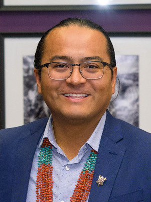
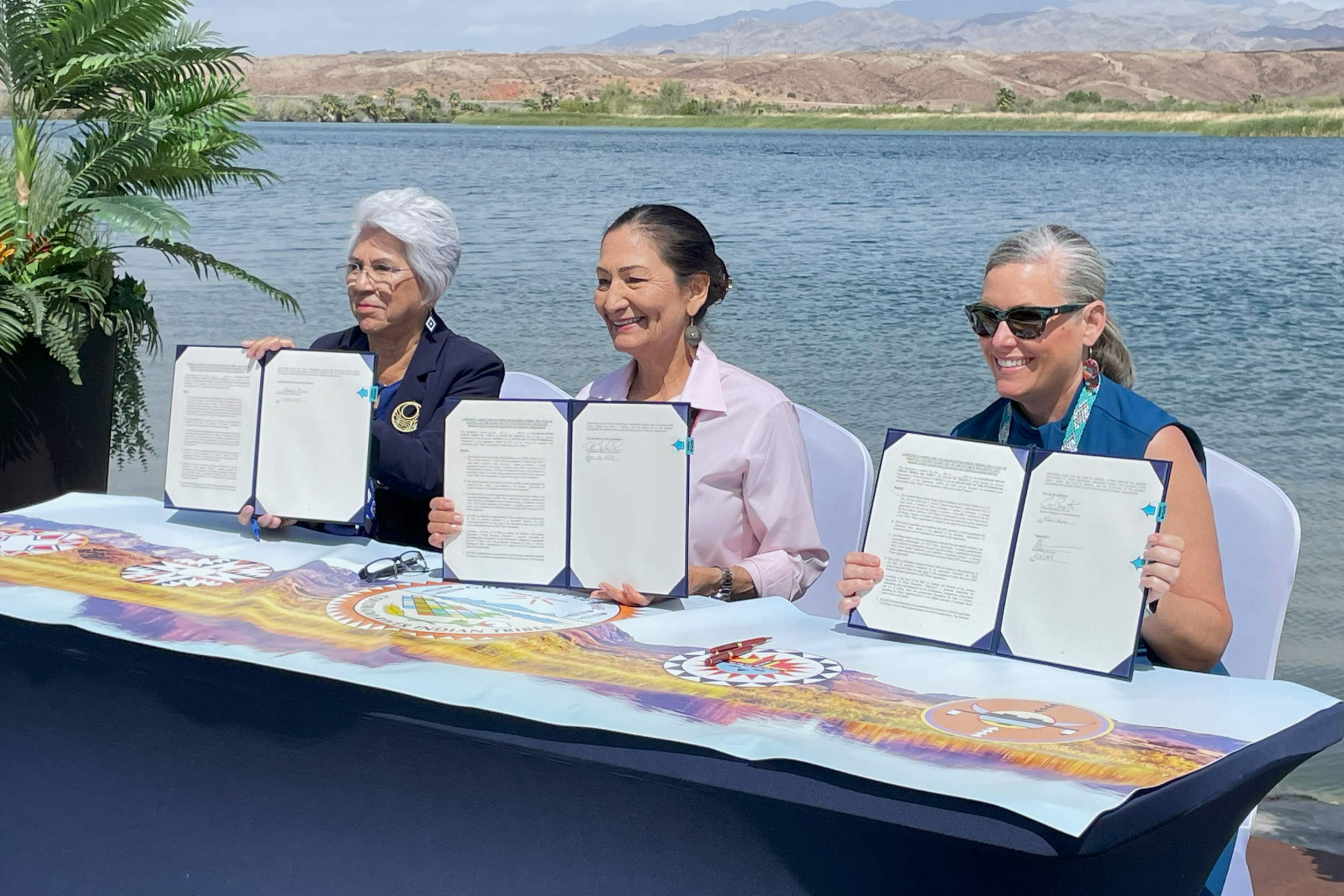
Navajo Nation President Buu Nygren signed a historic water settlement with the federal government on Friday, the day after the Navajo Nation Council approved it unanimously. Speaker Crystalyne Curley said she believes Congress will support the measure, finally bringing the promise of water for thousands of people. The Northeastern Arizona Indian Water Rights Settlement Agreement, once passed by Congress, will settle the Navajo Nation’s claims to water rights to all Colorado River water in Arizona.
The separate Rio San José Stream System Water Rights Settlement Agreement will settle water rights claims in the Rio San José Stream System and the Rio Puerco Basin in New Mexico for the Navajo Nation if considered by Congress…
Included in the agreement is proposed funding of about $5 billion to build essential water projects required by the Navajo Nation, money that would require appropriations by Congress.
After the 25th Navajo Nation Council took office, along with Nygren and Vice President Richelle Montoya, a consensus emerged to address water rights claims, initiating discussions that had dragged on for years. Leaders emphasized that the effort was a collaborative endeavor involving Navajo Nation leadership, the Navajo Department of Justice, the Navajo Attorney General’s office, the Navajo Department of Water Resources and the Navajo Nation Water Rights Commission.
The states are currently negotiating how the river and its reservoirs should be operated after current agreements expire in 2026.
This article is published through the Colorado River Collaborative, a solutions journalism initiative supported by the Janet Quinney Lawson Institute for Land, Water, and Air at Utah State University.
Another point of agreement between the basins: states should use actual hydrologic conditions to determine how to operate the country’s two largest reservoirs, Lake Powell and Lake Mead, instead of unreliable forecasts.
Ridgway’s Rail. Photo: Robert Groos/Audubon Photography Awards
Click the link to read the release on the Audubon website (Jennifer Pitt):
May 21, 2024
The Colorado River is flowing again in its delta. While this is welcome news for birds and people, the long-term progress to keep the Colorado River alive in Mexico with habitat restoration and water deliveries depends on high stakes negotiations currently underway.
For the third time since 2021, the United States and Mexico are collaborating to deliver water to improve conditions in the long-desiccated delta. Environmental water deliveries began mid-March and will continue into October, ensuring the river flows through the summer’s heat, making restored riverside forests and wetlands more hospitable to birds like Abert’s Towhees and Crissal Thrashers and other wildlife including beavers and lynxes. We know that birds rely on water in the Delta as they migrate to locations all over the United States.
Restoration in the Colorado River Delta is implemented by Raise the River, a coalition of NGOs including Audubon, in partnership with U.S. and Mexican federal agencies. Funds, water, and collaboration for this work were committed first in Minute 319 and again in Minute 323, the United States–Mexico treaty agreements that have been widely hailed for modernizing Colorado River management with a host of benefits to water users in both countries including rules for sharing water shortages, as well as work to use relatively small volumes of water to revive the delta for wildlife and people. The terms of Minute 323 sunset in 2026, but delta restoration efforts remain a work in progress.
The good news: the United States and Mexico are poised to negotiate a successor agreement to Minute 323 in parallel with new federal rulemaking in the United States for Colorado River management. Domestic Colorado River rules, like the binational agreements, have for decades been the result of consensus-based negotiations, in this setting between the seven Colorado River Basin States with concurrence of the U.S. Bureau of Reclamation. This domestic rulemaking also has a 2026 deadline.
The bad news: at the moment, the Colorado River Basin states appear to be nowhere near consensus, with disagreements about which states, and which water users, will cut back when there’s not enough to satisfy all. These are difficult and high stakes negotiations. Failure to reach agreement increases the risk of water supply crises and could even throw the dispute in front of the U.S. Supreme Court.
That brings me back to the Abert’s Towhees and Crissal Thrashers, the beavers and lynxes in the Delta. If the Colorado River Basin states fail to reach consensus, there’s considerable risk that the work of restoring the Colorado River in its delta comes to a halt. Delta restoration depends on binational consensus, and binational consensus depends on a U.S. domestic consensus. It’s an extraordinarily complex decision-making framework for governance of water supply for 40 million people. The failure to reach consensus may create problems for some people who use Colorado River water, but it is certain to create collateral damage in Colorado River ecosystems including the Delta.
Two key takeaways from Monday’s (May 13, 2024) Middle Rio Grande Conservancy District board meeting:
El Vado Dam, crucial for managing irrigation, municipal, and environmental water through New Mexico’s Middle Rio Grande valley, will be out of service indefinitely – for many, many years.
The vague structure of alternative storage options, using other existing dams, is beginning to take shape.
El Vado, built in the 1930s on the Rio Chama, has been out of service since 2022 for rehabilitation work by the US Bureau of Reclamation’s dam safety program. Challenges in fixing it have sent Reclamation’s engineering team back to the drawing boards. Work was supposed to be done by 2025. It’s now clear that the dam will be out of service for the foreseeable future.
Without the ability to store some of each year’s spring runoff for use in late summer and fall, the Rio Grande through Albuquerque is at the mercy of summer rains, without which it will dwindle to near nothing every year unless or until El Vado is fixed or we sort out alternative storage arrangements.
More on this part – the status of trying to fix El Vado – in a separate post to come later (once I write it I’ll add a link here), because the more important bits at Monday’s meeting involved the first cagey public discussions about what we will do in the meantime.
EXPLORING WATER STORAGE ALTERNATIVES FOR THE MIDDLE RIO GRANDE
The always quotable Socorro farmer and MRGCD board member Glen Duggins offered a simple plea: “Just give us somewhere to park our water.”
Much of Monday’s discussion – sometimes explicit, sometimes in coded language – focused on this question.
If you look at the monthly reservoir storage graphic from Reclamation printed as a handout for Monday’s meeting (printed as a handout for every meeting), you’ll see there are two other reservoirs flanking El Vado upstream and downstream, and they have enough empty space in them to make up for most, if not all, of El Vado’s now unusable ~180,000 acre feet of capacity.
Abiquiu Reservoir currently has ~100,000 acre feet of available storage space
Heron Reservoir has ~300,000 acre feet of available storage space
But the details of using them for this new purpose, storing Middle Valley irrigation and environmental water, which is different than the purposes for which they were built, are staggeringly tricky.
Abiquiu
Abiquiu Reservoir, built in the 1960s by the U.S. Army Corps of Engineers on the Rio Chama as part of a massive federally funded project to protect the Middle Rio Grande Valley from flooding, is huge.
In 1981, Congress authorized a change in use to allow imported San Juan-Chama water to be stored in Abiquiu – up to 200,000 acre feet. (It requires an act of Congress.) Subsequent to that, the Albuquerque Bernalillo County Water Utility Authority got a storage permit from the New Mexico Office of the State Engineer (Storage requires a state permit, I hope you can see what I’m doing with the parentheticals.) to store its SJC water in Abiquiu. Then in 2020 another act of Congress did something I’m a bit confused about that allowed native water storage, not just San Juan-Chama water, and maybe more than the 200,000 acre feet, I think (Note: Another act of Congress required.) And then the Army Corps of Engineers had to rewrite its water operations manual, which nearly four years later is just now being completed. (It requires not only an act of Congress to change the purpose of use at Abiquiu, but also a lengthy Corps process to rewrite its rules.)
My Utton Center colleagues are far smarter than I about these institutional nuances – Utton has long worked on the legal plumbing – but I wasn’t about to wake them up at 6 in the morning, so you’re stuck with me.
So yes, there is space in Abiquiu for us to park our water. But the rules tangle is of Gordian proportions.
Heron
Upstream, Heron Reservoir sits on a tributary to the Chama, built in the 1970s to store water imported beneath the continental divide from three Colorado River headwaters streams. It seems ill-suited for storing Rio Grande water.
It currently holds ~100,000 acre feet of imported San Juan-Chama project water, with room for another ~300,000 acre feet. (Note bene: I’m rounding all the numbers off here to one or a few significant digits.) The trick here is to hold the San Juan-Chama water in Heron and then do a series of carryover accounting and maybe native water swaps that I can’t begin to understand, let alone explain, in order to kinda sorta use Heron as well.
THE NEGOTIATIONS
One of the reasons the discussions about all of this at yesterday’s board meeting were kinda vague is that the three parties crucial to cutting the Gordian tangle – MRGCD, the Bureau of Reclamation, and the Albuquerque Bernalillo County Water Utility Authority – are in negotiations about what sort of parenthetical agreements might be needed to make it all work.
They need space to sort out thorny incentive problems – the interests of the municipal water utility to protect and manage its own municipal supply will be key. In this regard alone, it my be in the water utility’s best interests to help. Low late summer river flows, which are inevitable without storage, force the utility to switch to groundwater pumping to get water to my tap. As a result, the aquifer recovery, of which we are rightly proud in Albuquerque, has stalled.
Also key will be the broader community interests of flowing ditches and a flowing river, which while not directly related to ABCWUA’s water supply nevertheless may be things the water utility’s board members – city councilors and county commissioners – care about.
The typically blunt Duggins was unusually cryptic at Monday’s meeting, but I infer this is what he was talking about when he said: “We’re neighbors. I don’t understand why it would take a year or two to get papers signed.”
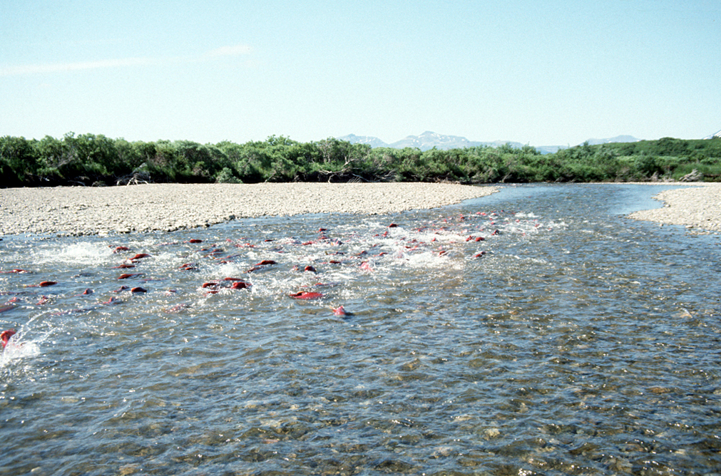
Spawning Salmon in Becharof Stream within the Becharof Wilderness in southern Alaska, USA. By U.S. Fish and Wildlife Service – US Fish & Wildlife Service – [1], Public Domain, https://commons.wikimedia.org/w/index.php?curid=3525119
Click the link to read the article on the NOAA website:
May 22, 2024
NOAA is recommending nearly $240 million in funding for 46 fish passage projects this year, as well as an additional $38 million in funding in future years. The projects are funded under the Biden-Harris Administration’s Bipartisan Infrastructure Law and Inflation Reduction Act. With this historic level of funding, our partners will reopen migratory pathways and restore access to healthy habitat for fish across the country.
Twenty-one of these projects—more than $112 million in funding—will be led by tribes and tribal organizations. This will include projects for fish passage and for building tribal organizational capacity. In addition to projects led by tribes, more than half of the remaining projects will directly involve tribes and are aligned with tribal priorities. Across these projects, tribes will:
Play key roles in decision-making,
Build capacity to help recover tribally-important migratory fish
Provide community and economic benefits such as jobs and training opportunities
These projects will help recover endangered migratory fish and support the sustainability of commercial, recreational, and tribal fisheries. They will also support coastal communities by:
Removing derelict and unsafe dams
Removing contaminated sediments
Improving opportunities for recreation
Adapting to climate change by reducing flooding and improving threatened infrastructure
This funding builds on the more than $166 million awarded for 36 projects through our first round of fish passage awards, which will provide significant benefits to endangered migratory fish and sustainable fisheries.
Tribal Priority Fish Passage Projects Recommended for Funding
These projects will support tribes in their role as managers and stewards of tribal trust resources for cultural, spiritual, economic, subsistence, and recreational purposes. They will support tribally important fish passage barrier removal projects and help to increase tribal capacity to participate in developing current and future fish passage projects.
These projects will help restore access to healthy habitat for migratory fish across the country through efforts, including:
On-the-ground fish passage restoration
Engineering and design
Future project development
Building the capacity of new and existing partners to design projects and manage multi-faceted restoration efforts
Fish Passage and NOAA
Every year, millions of fish migrate to their spawning and rearing habitats to reproduce. Some fish need to swim thousands of miles through oceans and rivers to reach their destinations. They are often blocked from completing their journey by barriers like dams and culverts. When fish can’t reach their habitat, they can’t reproduce and maintain or grow their populations. As a result, many fish populations have declined. NOAA works to reopen these migratory pathways, restoring access to healthy habitat for fish.
NOAA’s Office of Habitat Conservation has a long history conducting habitat restoration efforts, including fish passage, with large-scale competitive funding opportunities and expert technical assistance through our Community-based Restoration Program. The Bipartisan Infrastructure Law and Inflation Reduction Act provide a historic opportunity for us to continue supporting fisheries, protected resources, and coastal communities. In our first round of funding opportunities, we awarded more than $480 million for 109 projects across the country through this funding.
Lincoln Creek flows into Grizzly Reservoir and is a source of drinking water for Colorado Springs. Experts say mineral concentrations are increasing in streams across Colorado due to climate change. CREDIT: HEATHER SACKETT/ASPEN JOURNALISM
Colorado’s mountains are pockmarked with orange tailings piles, adits, tunnels and rusted tramways, the remnants of a historic mining industry often blamed for fouling the state’s waterways.
But a recent study points the finger at a different culprit as the cause of increasing metals concentrations in Colorado’s high mountain streams: climate change. And these findings have implications for local ecosystems and the water supplies of mountain communities.
Scientists from the U.S. Geological Survey and the University of Colorado Boulder analyzed water chemistry data over the past 40 years for 22 stream sites throughout Colorado’s mountains. They found that concentrations of zinc and copper have doubled over the past 30 years, with melting of previously frozen ground being a likely major cause.
“These trends are concerning because, even at low concentrations, dissolved metals can negatively affect downstream ecosystem health and the quality of water resources,” reads the paper, which was published in Water Resources Research in late April.
Tanya Petach, a climate scientist at the Aspen Global Change Institute, worked on the study. She said the trend of increasing metals concentrations is relatively steep and widespread across Colorado’s mountains.
“There’s this theory that those increases in metal concentrations in these streams are really driven by a climate change signal,” Petach said. “We are really used to tying increases in metals to mining activities, but in this case, we’re only seeing a climate response.”
The process that causes metals leaching into streams can be both naturally occurring and caused by mining activities. In both cases, sulfide minerals in rock come in contact with oxygen and water, producing sulfuric acid. The acid can then leach the metals out of the rock and into a stream, a process known as acid rock drainage. As temperatures warm, rock that has long been encased in ice becomes exposed to weathering.
“These high-elevation streams, some of them have mean annual air temperatures right around freezing,” Petach said. “So you go from having permafrost to melting that permafrost. Once you lose the ice, you’ve created a phenomenal conduit for new water and oxygen to come into contact with sulfide minerals that have been blocked for centuries, if not millennia.”
Diane McKnight, an environmental engineering professor at CU Boulder’s Institute of Arctic and Alpine Research, has been measuring the pH levels of the upper Snake River in Summit County for decades. On a recent trip with students, a stream that usually had a pH level of about 4 measured 2.75, meaning the acidity had greatly increased.
“I said: Wait, the probe must be wrong, the probe must be broken,” McKnight said. “Guess what, the probe was not broken. … The public should be aware the world is changing and there are surprises.” [ed. emphasis mine]
The study says declining streamflows are also contributing to increasing metals concentrations, but not as much as the increase in acid rock drainage caused by climate change.
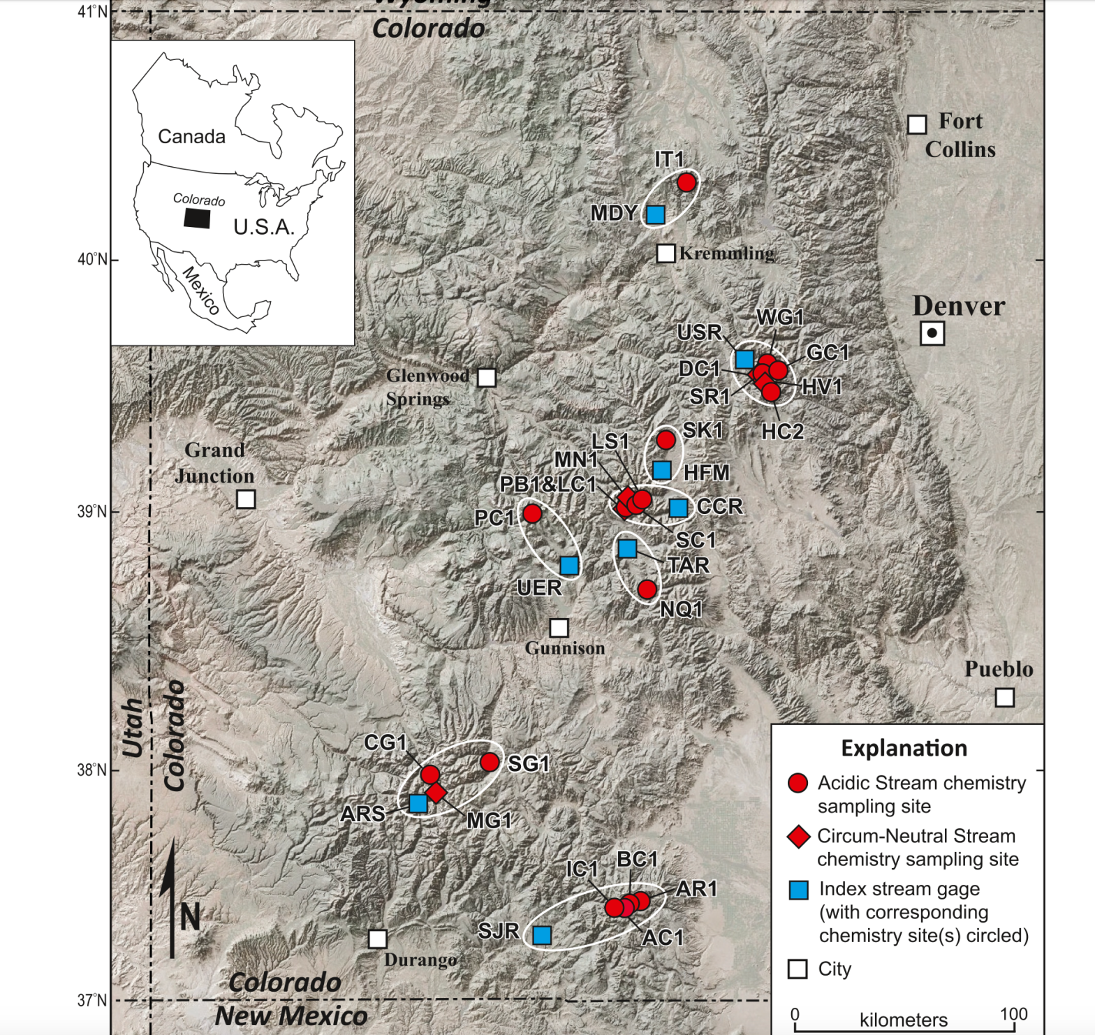
This map shows 22 stream sites throughout Colorado’s mountains where scientists from the U.S. Geological Survey and the University of Colorado Boulder analyzed water chemistry data over the past 40 years.
Lincoln Creek similarities
These findings on the Snake River and other sites in Colorado are important for the members of a workgroup trying to figure out how to address increasing metals concentrations in Lincoln Creek above Aspen. Although Lincoln Creek wasn’t one of the sites included in the study, the conditions in Lincoln Creek mirror many of the headwaters study sites.
“Lincoln Creek is very intriguing because it matches a similar pattern,” Petach said. “The Lincoln Creek system seems fairly similar to a lot of these other high-elevation headwaters catchments where this occurs.”
Water quality issues in Lincoln Creek have been a concern for years and have been getting worse. A November report by the U.S. Environmental Protection Agency showed that metals concentrations in Lincoln Creek are high enough to be toxic to fish and aquatic life. The creek above Grizzly Reservoir exceeds state water quality standards for aluminum, cadmium, copper, iron, lead, manganese and zinc, and aluminum and copper concentrations were higher than standards set by the Colorado Department of Public Health and Environment (CDPHE) in multiple locations.
The report found that the vast majority of the contamination was coming from a “mineralized tributary” to Lincoln Creek and not from the nearby Ruby Mine, where prospectors in the early 1900s dug for gold, silver and lead.
A workgroup dedicated to Lincoln Creek and composed of officials from state, local and federal agencies, nonprofit environmental groups and others has been meeting often since the EPA report was released. Since the EPA is authorized to address elevated metals concentrations only from human-caused activities like mining, it’s unclear how the contamination would be cleaned up or what agency is responsible for it.
But the workgroup is making headway on the issue, said member Karin Teague, executive director of the nonprofit environmental group Independence Pass Foundation.
“It could be a model for how a community might respond to contamination in its watershed,” Teague said. “We are really getting our arms around the problem, the extent of it, the nature of it, and then, of course, the million-dollar question being: What, if anything, can be done about it?”
Pitkin County Environmental Health Manager Kurt Dahl and Pitkin County Healthy Rivers Administrator Lisa Tasker gave an update on the group’s progress to county commissioners at a work session Tuesday. There are plans for four different water quality projects this summer: the U.S. Forest Service plans to collect water quantity and flow data; Colorado Parks and Wildlife will monitor metals concentrations in Lincoln Creek and the Roaring Fork River; the Roaring Fork Conservancy will take samples below Grizzly Reservoir to look for impacts related to a Grizzly Dam rehabilitation project; and scientists and students from CU’s INSTAAR program will look for rare earth metals in the water, sediment and bugs of Lincoln Creek. Pitkin County has approved grants for three of the four projects so far.
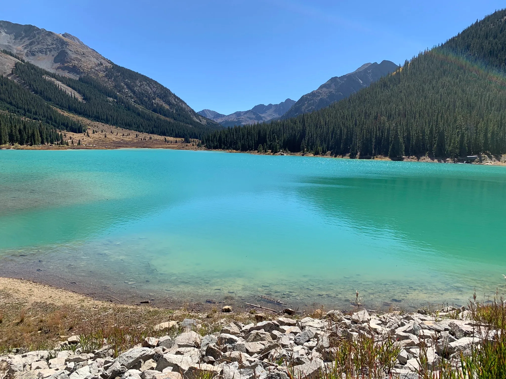
Grizzly Reservoir was a bright shade of turquoise in September 2022. The man-made alpine lake has high concentrations of metals that are toxic to fish, according to a report from the Environmental Protection Agency.
CREDIT: HEATHER SACKETT/ASPEN JOURNALISM
What about the water supply?
Lincoln Creek is one of seven streams in the Roaring Fork basin’s headwaters that feed the Twin Lakes Reservoir and Canal Co.’s Independence Pass transmountain diversion system, which provides drinking water sources for Front Ranges cities, including Colorado Springs, which owns a majority of the system’s water. Grizzly Reservoir, on Lincoln Creek below the contamination source, is used as a collection pool for water collected from the creeks, which is sent through the Twin Lakes Tunnel to the Arkansas River basin and eventually to the Front Range. The Snake River system where McKnight has conducted research flows into Dillon Reservoir, Denver Water’s biggest storage bucket.
A map of the Independence Pass Transmountain Diversion System, as submitted to Div. 5 Water Court by Twin Lakes Reservoir and Canal Co.
The EPA report said that in the case of Lincoln Creek, the dilution, the distance the water travels and the water-treatment process limit the impacts to drinking water. But since the issue is widespread across Colorado’s mountains, communities that get their drinking water from high-elevation streams could be impacted.
“These metal concentrations tend to be diluted when the small tributaries confluence with larger, cleaner streams, so we don’t tend to think of these as being a huge problem for large municipal water supplies,” Petach said. “But the place where it could impact the drinking water supply is in high-elevation mountain communities that are receiving waters from smaller tributaries.”
The city of Aspen gets the majority of its drinking water from Castle Creek, a mountainous tributary of the Roaring Fork River. Aspen’s Utilities Resource Manager Steve Hunter said that source water protection is a key concern for the city.
“After talking with our water treatment staff, they are not seeing a rise in these metals at the treatment plant and all treated water meets or exceeds CDPHE/EPA requirements,” Hunter said in a prepared statement. He added that the city has not done source water sampling for these compounds in either Castle or Maroon Creek watersheds as CDPHE/EPA does not require testing Aspen’s source water for these compounds.
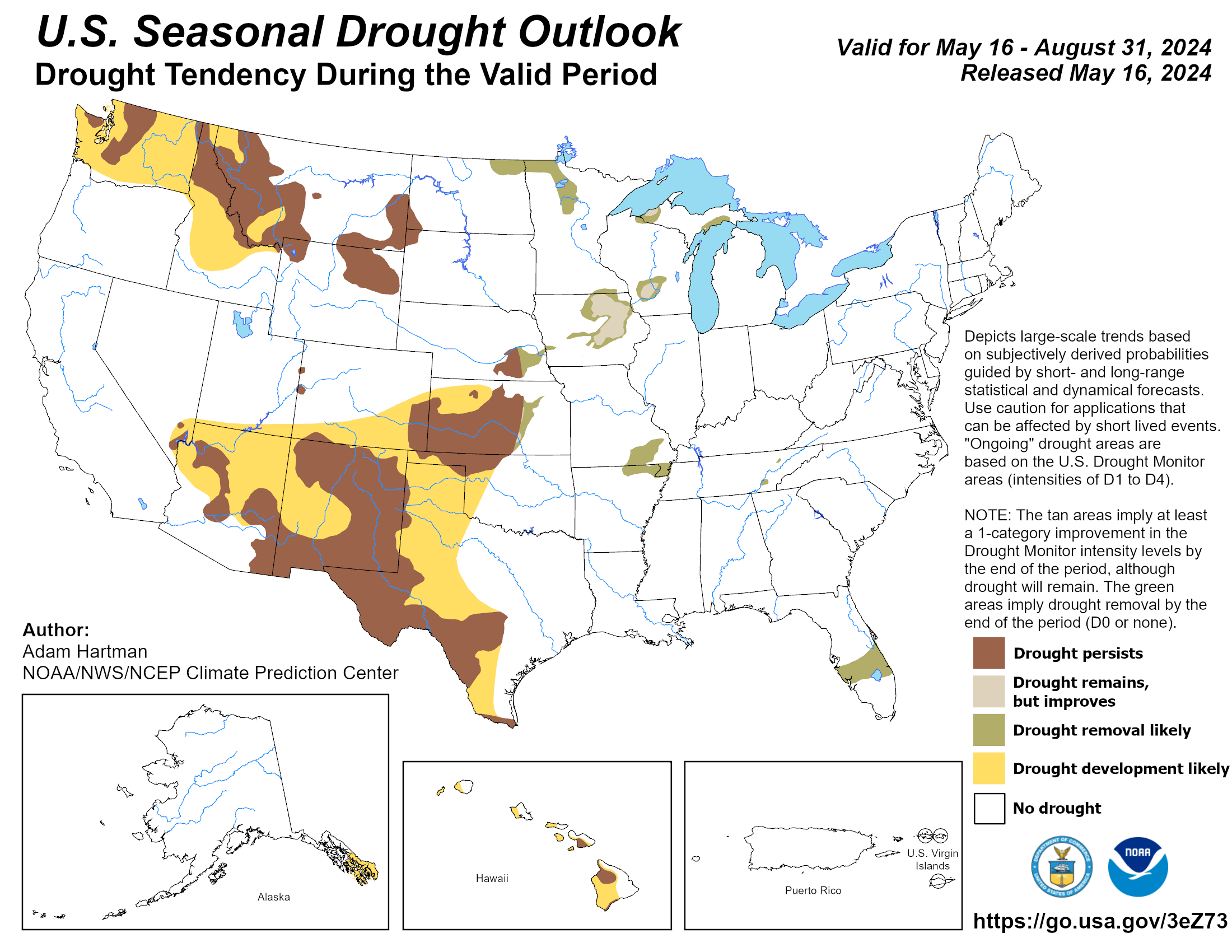
It wasn’t exactly the news anyone wanted to hear, but the West’s two-year snowpack party looks like it may be coming to an end for a while.
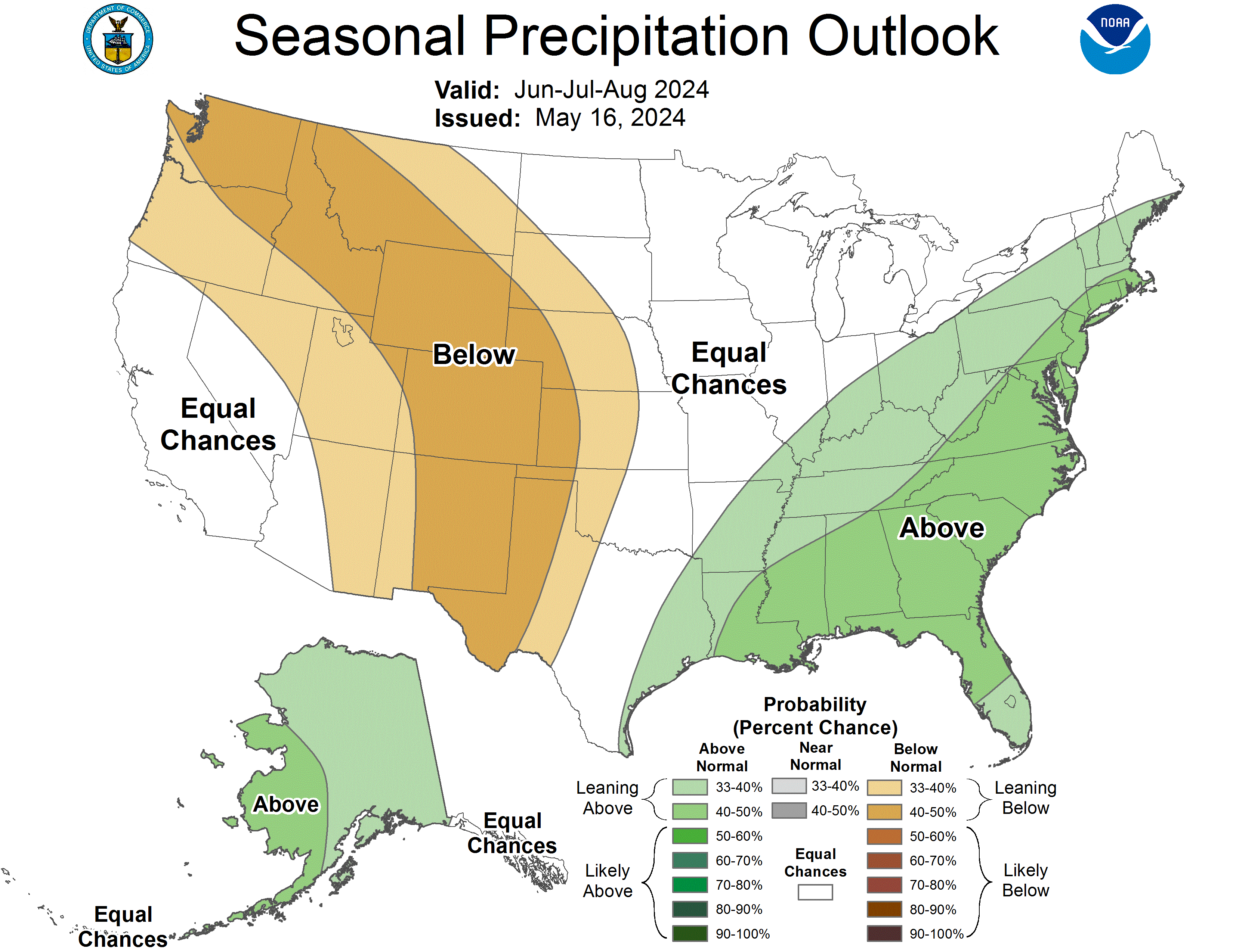
According to a report from the National Weather Service’s lead forecaster, the Southwest is in line for the effects of a strong “La Nina” condition in the eastern Pacific Ocean, indicating drier-than-normal months to come.
“We’re seeing the first vestiges of a La Nina effect now,” said Mark O’Malley of the National Weather Service at a meeting of the Drought Interagency Coordinating Group on Tuesday. “It’s going to be the largest climate driver of the next 12 months.”
The Interagency Coordinating Group (ICG) is an advisory body to the Governor on Arizona drought issues, co-chaired by the ADWR Director.
It’s comprised of state, federal and non-governmental organizations, and meets twice a year to evaluate drought conditions in Arizona and across the West and to consider recommendations to the governor.
To exactly no one’s surprise, the ICG panelists chose to recommend to Governor Hobbs that the state’s Drought Emergency Declaration be continued for at least until the next meeting of the panel six months from now.
“My viewpoint is that we’ll be recommending to the Governor to continue the Drought Declaration,” said ADWR Director Tom Buschatzke at the meeting’s end as he watched panelists nod in agreement.
The U.S. Southwest has experienced two consecutive healthy seasons of moisture, including a near-record setting 2022-2023 winter snowpack season, as well as coastal storms that brought dozens of “atmospheric rivers.” Now, the forecasters say that we could be facing a dry spell. How likely is it? Alas, their computer modelling projections are telling them that it is looking pretty certain.
“We’re seeing fairly good agreement in models,” observed O’Malley. “Normally we see uncertainty. We see that July, August and September will be dipping into La Nina and in the fall we’ll be falling into a full La Nina state.”
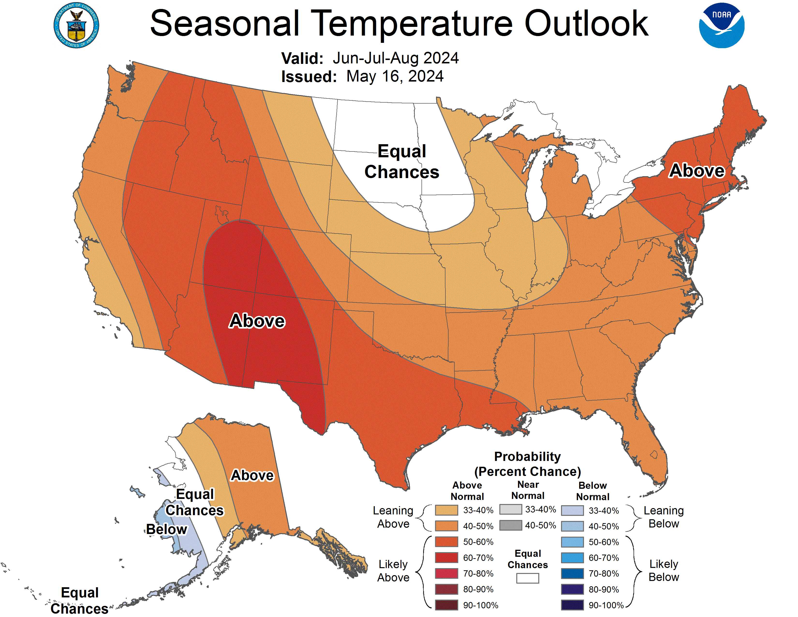
The region is looking at a “better than 80 percent chance of a full La Nina in 2024-2025 Winter,” he said, with the odds tilted in favor of above normal temperatures.
The Phoenix area is looking at a 60 percent chance of above normal temperatures this summer, a trend the south-central part of the state has been experiencing for a long time.
“Last summer was quite warm and there is no sign of this slowing down anytime soon,” he said.
North American Monsoon graphic via Hunter College.
On the plus side, O’Malley said Arizona can anticipate “a fairly average monsoon” in terms of rainfall, but that, overall, a La Nina winter produces below average water years and warmer temperatures.
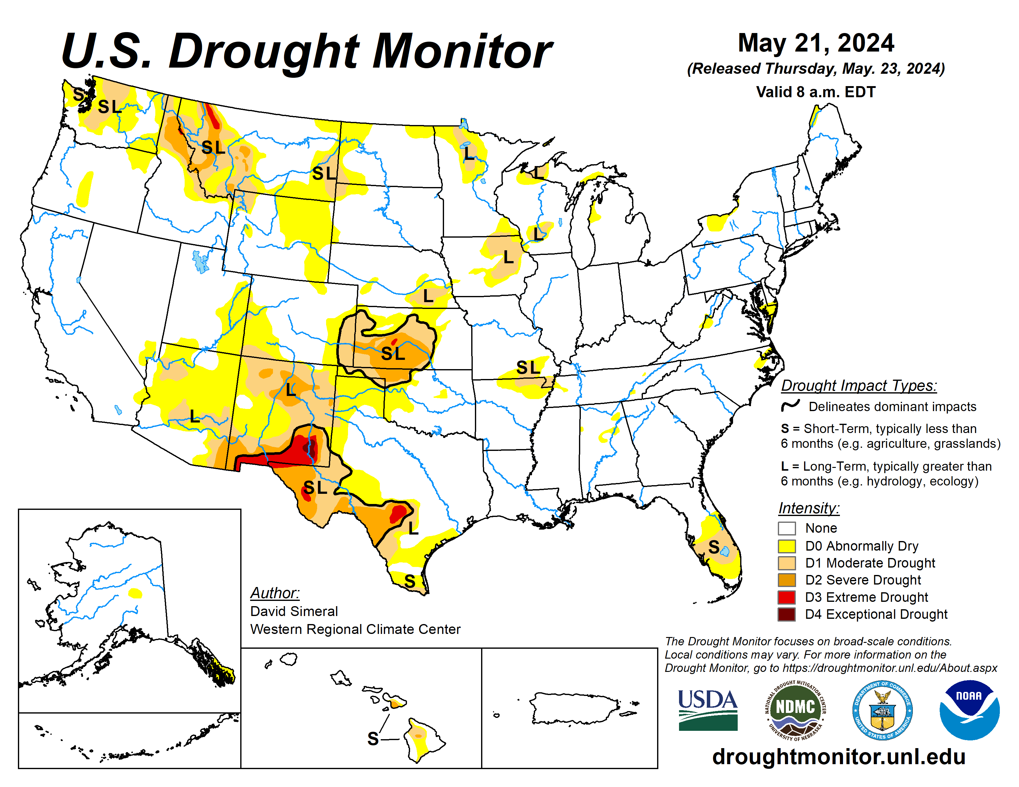
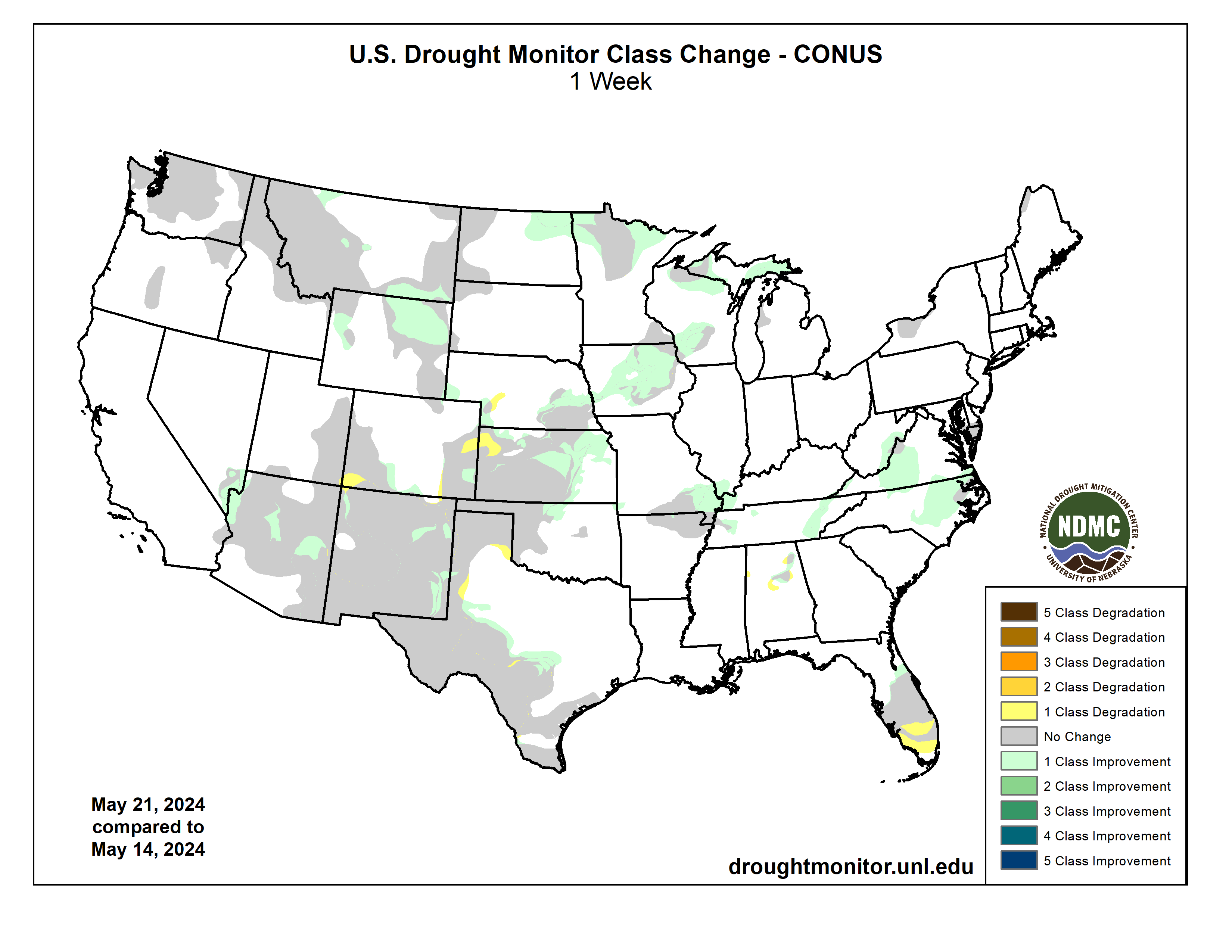
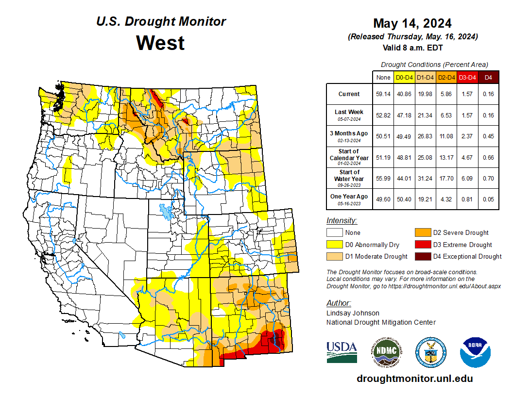
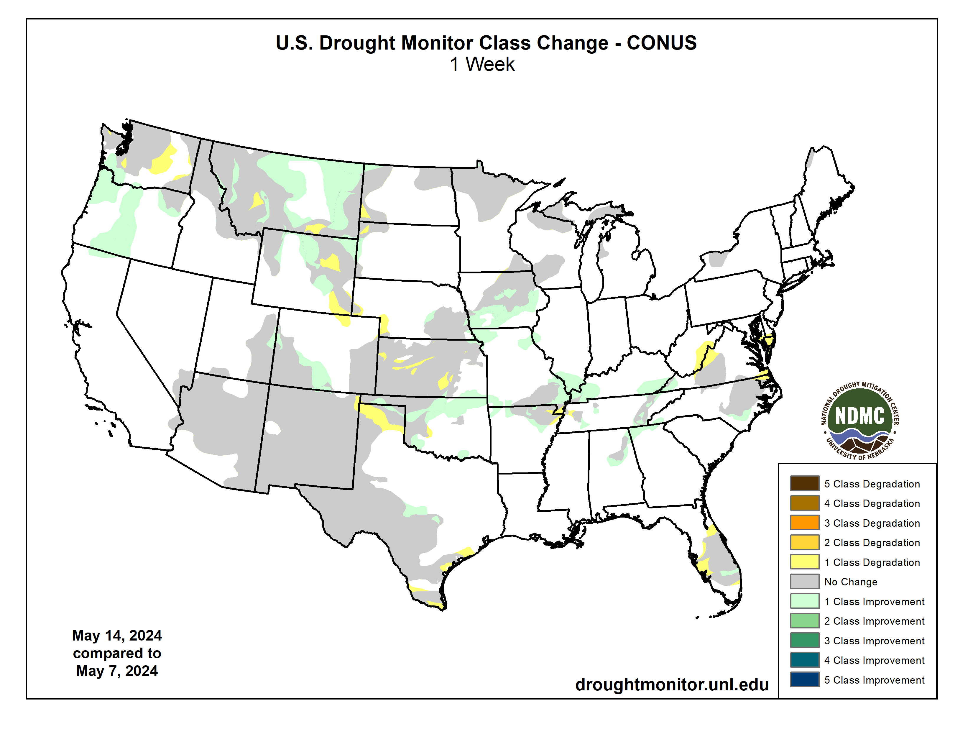
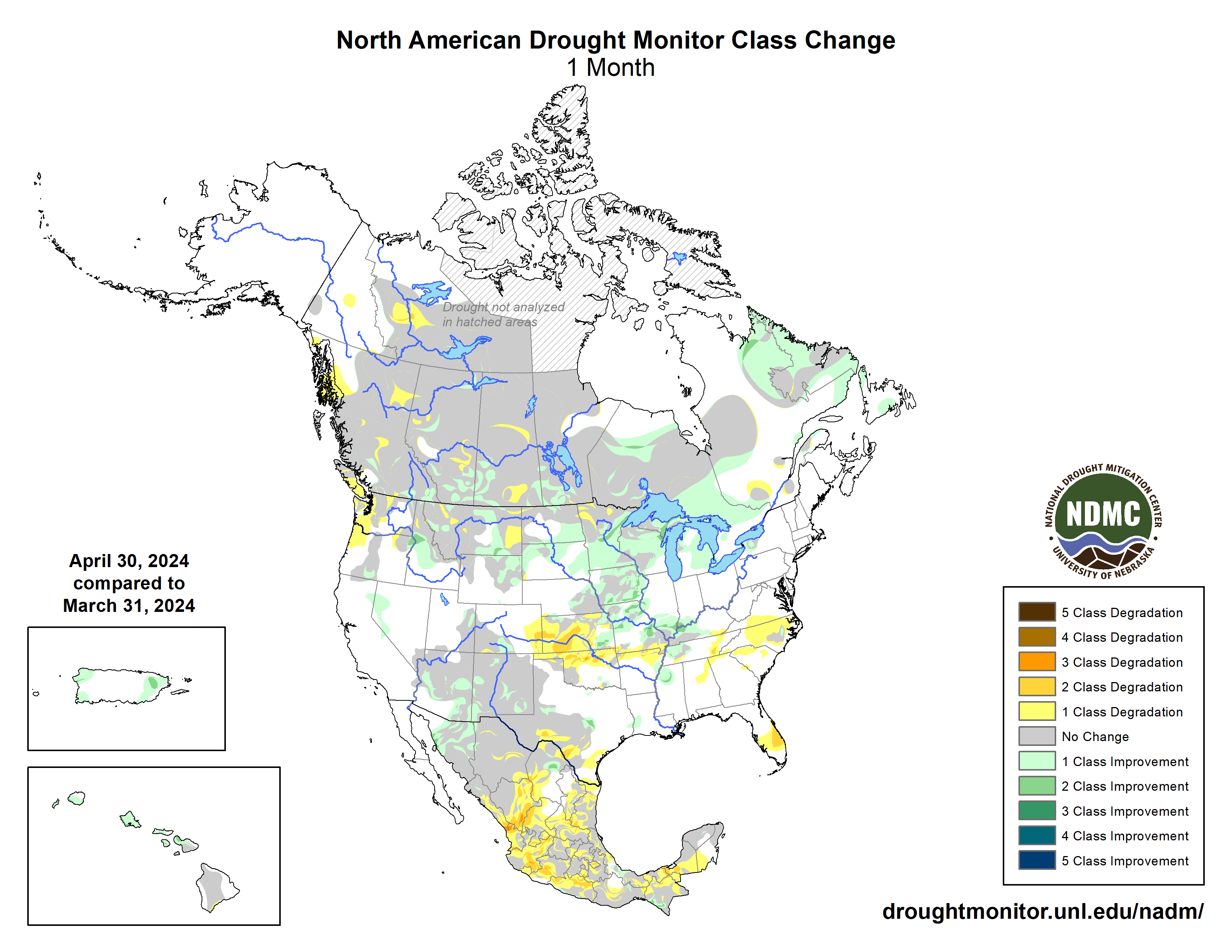
This U.S. Drought Monitor (USDM) week saw widespread improvement in drought-related conditions on the map across areas of the South, Plains, Midwest, Mid-Atlantic, and the West. In the Plains and Midwest, locally heavy rainfall accumulations (up to 7 inches) were observed in drought-affected areas of Oklahoma, Kansas, Nebraska, Missouri, and Iowa leading to continued improvements of conditions on the ground (vegetation health, soil moisture, surface water) as well as reductions in the longer-term precipitation deficits. Likewise, above-normal precipitation during the past several months led to removal of areas of drought on the map in Michigan’s Upper Peninsula as well as in southern Wisconsin. In the South, isolated areas of central and west-central Texas saw minor improvements in response to recent rains and improving conditions during the past 30-day period. In the Mid-Atlantic, 1-6-inch accumulations were observed in areas of North Carolina and Virginia this week leading to removal of areas of Abnormally Dry (D0). Out West, some minor improvements were logged in central and northern Arizona where precipitation has been above normal since January 1. In southeastern Montana, recent rains erased Water Year (since October 1) deficits and have improved soil moisture conditions and vegetation health. Across the border in the Bighorn Mountains of north-central Wyoming, areas of Moderate Drought (D1) were removed in response to above-normal snowpack conditions observed in its associated drainage basins. In California, the state’s reservoirs are above normal levels moving into the dry season with the state’s two largest reservoirs (Lake Shasta and Lake Oroville) at 115% and 126% of their historical average for the date (May 21), respectively. In the Southwest, Lake Powell is currently 33% full (58% of typical storage level for the date) and Lake Mead is 35% full (62% of average) with the total Lower Colorado system at 42% full as of May 20 (compared to 37% full at the same time last year), according to the U.S. Bureau of Reclamation. In Arizona, the Salt River Project is reporting the Salt River system reservoirs at 95% full, the Verde River system at 70% full, and the total reservoir system at 92% full (compared to 99% full a year ago). In New Mexico, the state’s largest reservoir along the Rio Grande is currently at 23% full (59% of average). In the Pacific Northwest, Washington’s Franklin D. Roosevelt Lake is at 87% full (176% of average for the date). In terms of degradations on the map this week, the only noteworthy ones were made in areas of South Florida where areas of Moderate Drought (D1) expanded in response to dry conditions during the past 60-day period with reports of various impacts including burn bans, lake levels dropping at Lake Okeechobee, reduced soil moisture, and some minor impact in the recreation sector due to low surface water levels. Overall, looking at the broader drought situation across the conterminous U.S., the total percentage of drought coverage is at its lowest since 2020…
On this week’s map, Kansas, Nebraska, North Dakota, and the eastern Plains of Montana saw improvements in drought-affected areas. In Kansas and Nebraska, moderate to heavy rainfall accumulations (2 to 7+ inches) led to a reduction in areas of drought and provided a boost in soil moisture and streamflow levels. In North Dakota, areas of Moderate Drought (D1) were reduced in response to above-normal precipitation during the past 30-to-90-day period as well as numerous recent field reports coming into the National Drought Mitigation Center’s Condition Monitoring Observer Reports (CMOR) system. According to the USDA (May 19), statewide pasture and range conditions rated good to excellent are as follows: North Dakota 68%, South Dakota 83%, Nebraska 56%, and Kansas 42%. According to the latest USDA Kansas Crop Progress and Condition Report (May 19), winter wheat condition was rated 11% very poor, 20% poor, 36% fair, 30% good, and 3% excellent. In terms of NOAA NCEI’s regional climatological rankings, the Great Plains Region observed its 44th wettest (near normal) and 12th warmest (+3.9 degrees F anomaly) January-April period on record…
Drought Monitor one week change map ending May 21, 2024.
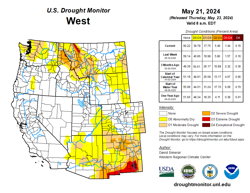
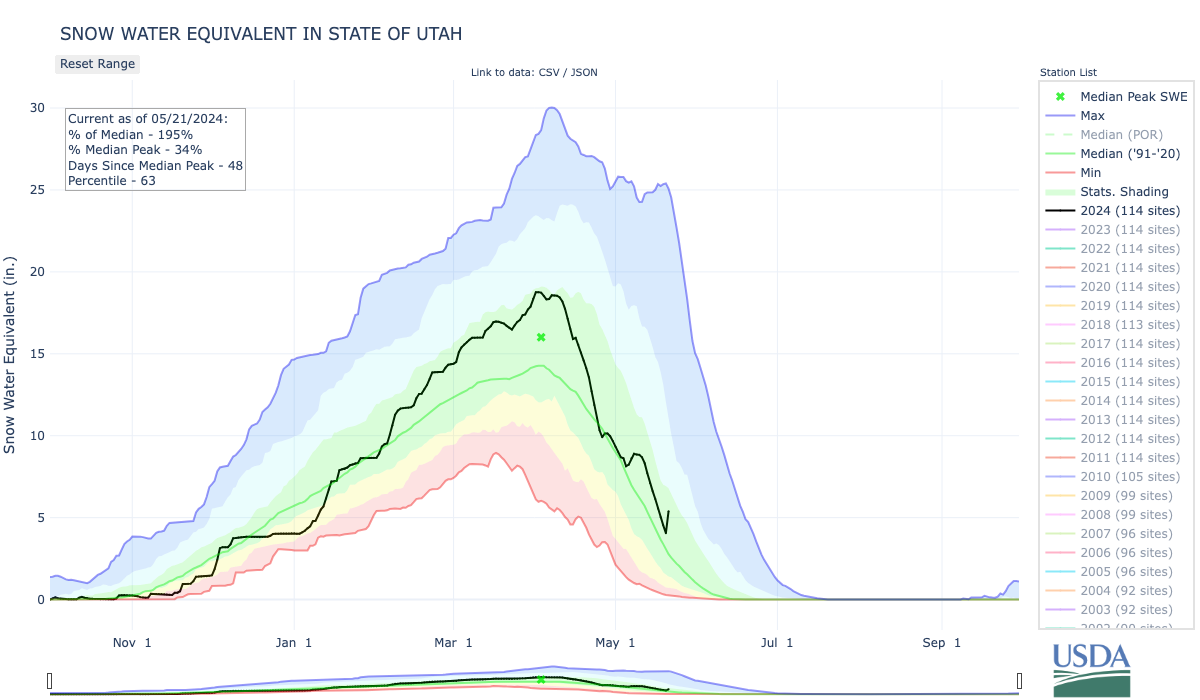
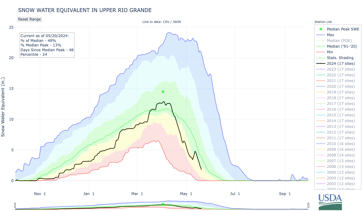
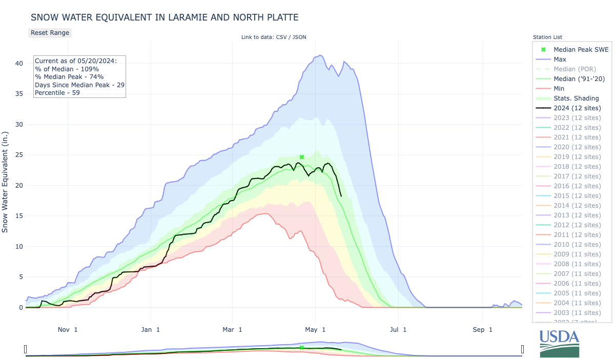
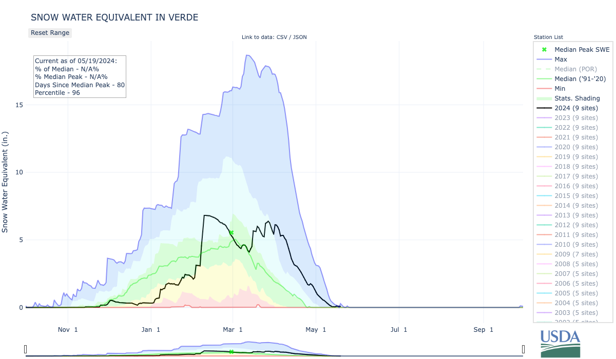
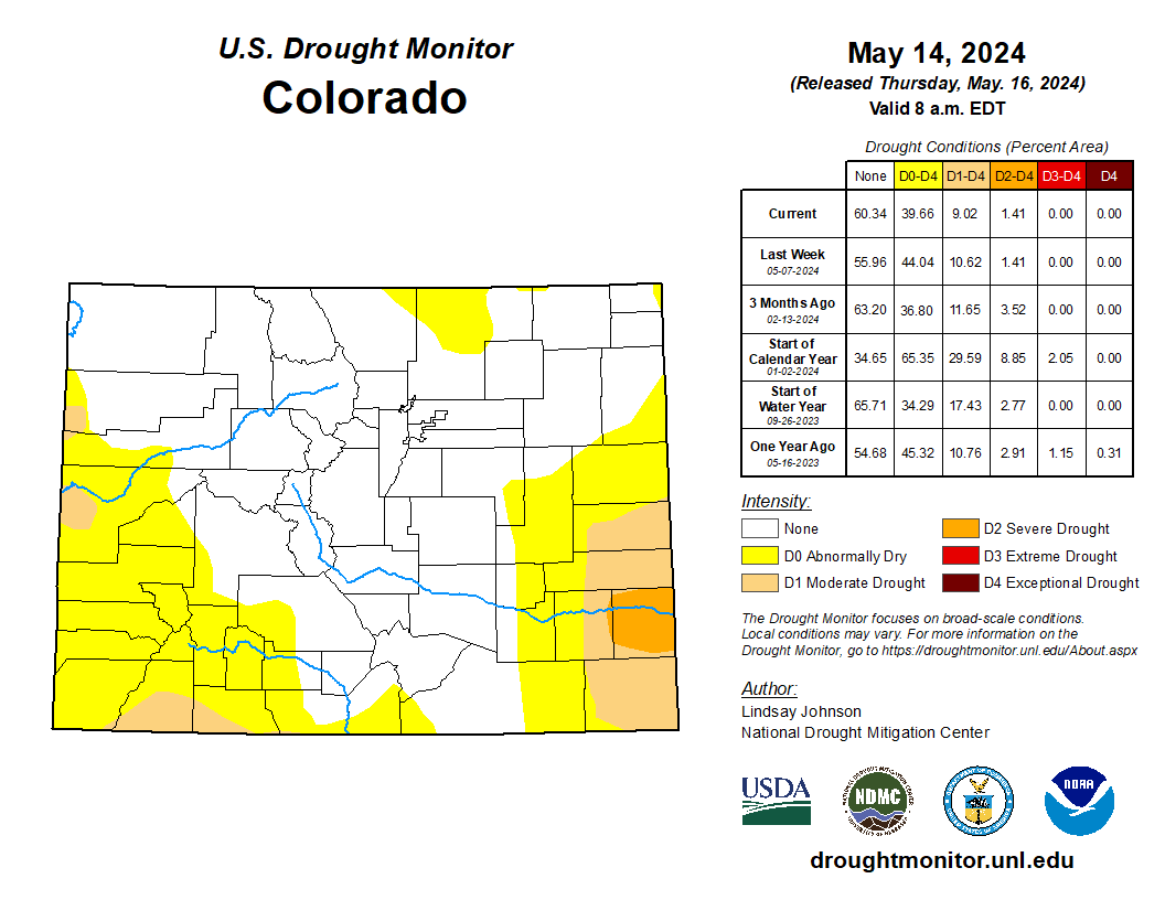
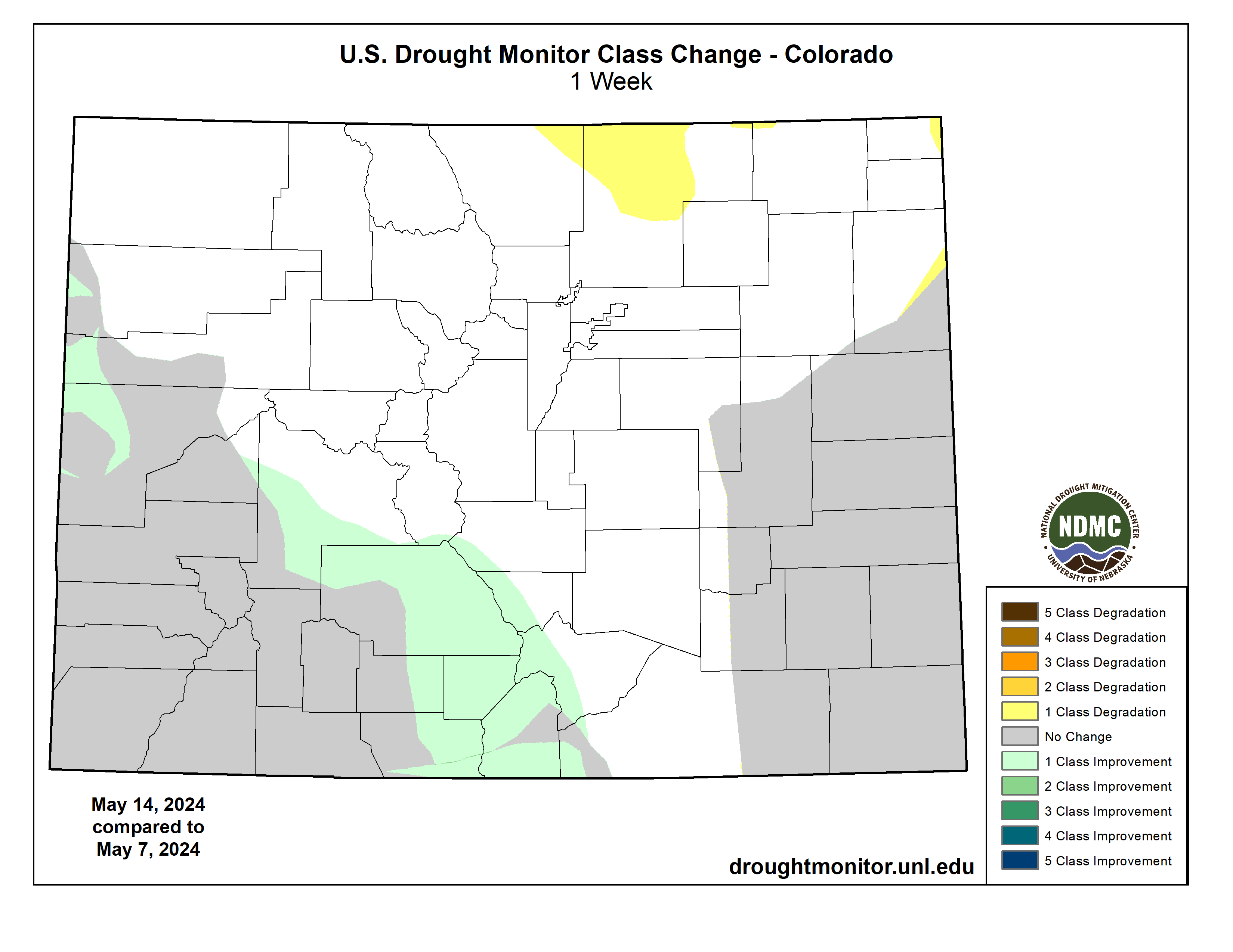
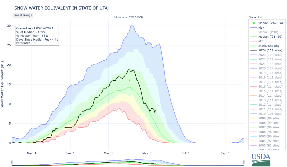
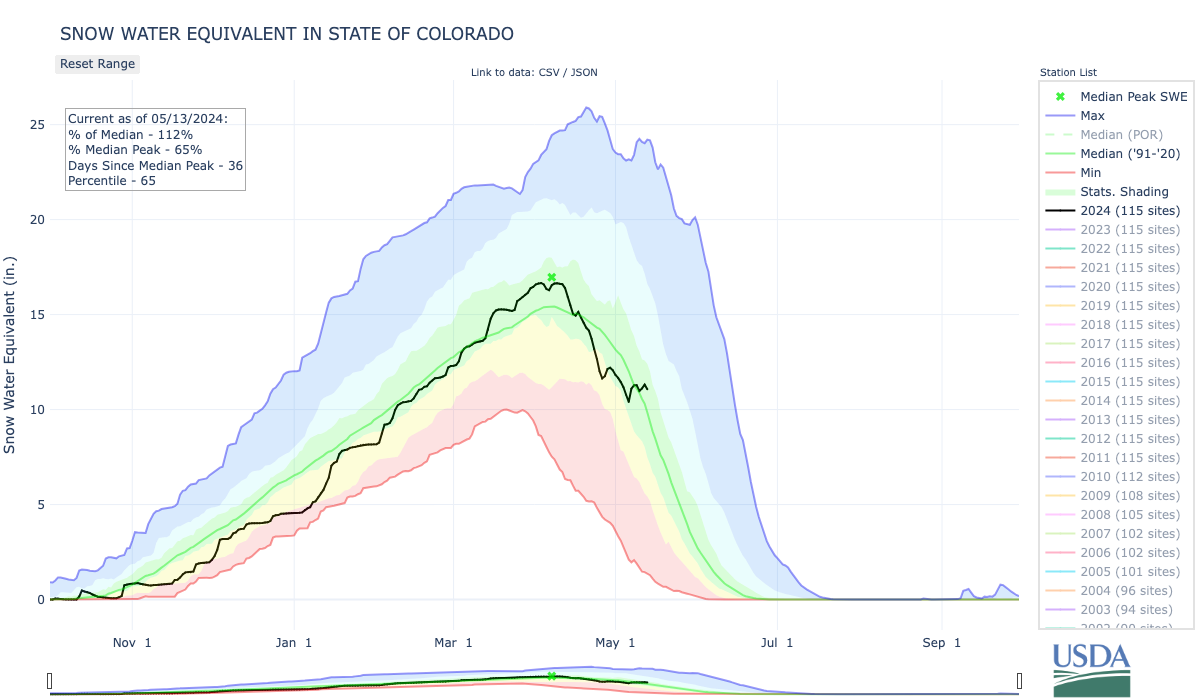
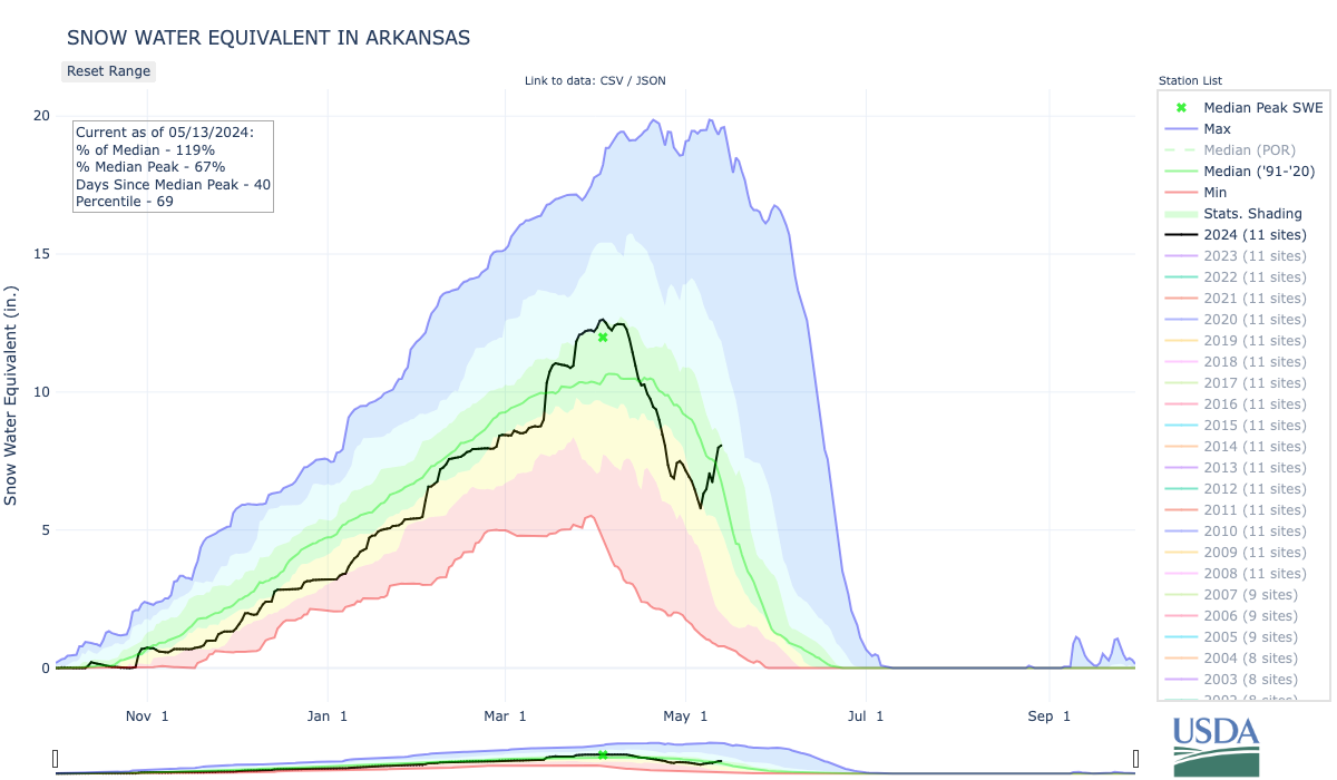
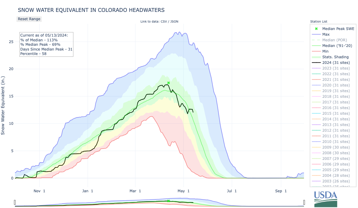
Out West, some minor improvements were made on the map in central and northern Arizona, eastern New Mexico, southern Colorado, southern Nevada, north-central Wyoming, and southeastern and central Montana. Looking at precipitation across the region, the start of the Water Year was not looking good with most of the region experiencing below-normal precipitation levels. However, the period from January 1 to current (May 21) was much more promising with above-normal precipitation observed across much of the region, with the exception of areas of the Pacific Northwest including Washington, northern Idaho, and western and central Montana as well as areas of the Southwest (eastern New Mexico and northwestern Arizona). In terms of snowpack, the Natural Resources Conservation Service SNOTEL network is reporting (May 21) the following region-level (2-digit HUC) snow water equivalent levels (percent of 1991-2020 median): Pacific Northwest 73%, Missouri 100%, California 147%, Great Basin 137%, Upper Colorado 112%, Arkansas-White-Red 140%, Lower Colorado 232%, and Rio Grande 52%. For the week, conditions were very dry across the region except for some isolated, light shower activity in eastern portions of New Mexico, Colorado, Wyoming, and Montana…
Across portions of the region, the active pattern continued with significant rainfall accumulations observed in portions of eastern Texas, southern Louisiana, and southern Mississippi, where 7-day totals ranged from 2 to 8 inches. Moreover, beneficial rainfall continued to help ease drought-related conditions in areas of Texas and Oklahoma. On the map, isolated rainfall activity this week led to some minor improvements in north-central Oklahoma, while areas of central and west-central Texas saw minor improvements. According to Water for Texas (May 22), statewide reservoirs are currently at 77.3% full with numerous reservoirs in the eastern part of the state near capacity, while many reservoirs in the western half of the state are experiencing below-normal levels. In terms of pasture and range conditions across the region, the USDA (May 19) is reporting statewide pasture and range conditions rated good to excellent as follows: Tennessee 74%, Mississippi 65%, Arkansas 61%, Louisiana 61%, Oklahoma 57%, and Texas 33%. Looking at climatological rankings for the January 2024-April 2024 period, the region experienced its 19th wettest (+2.32-inch anomaly) and the 11th warmest (+3.2 degrees F anomaly) on record, according to NOAA NCEI…
Looking Ahead
The NWS Weather Prediction Center (WPC) 7-Day Quantitative Precipitation Forecast (QPF) calls for moderate-to-heavy rainfall accumulations ranging from 2 to 5 inches across areas of the eastern portions of the Southern Plains (Oklahoma), South (northeastern Texas, Arkansas, northern Mississippi, Tennessee, Kentucky) and the Midwest (Illinois, Indiana, Ohio) while lesser accumulations (1 to 2.5 inches) are expected in areas of the Upper Midwest, Mid-Atlantic, Northeast, and out West in isolated areas of the Northern Rockies, and eastern plains of Montana. Dry conditions are expected across California, the Great Basin, the Southwest, and the southern extent of the Intermountain West. Likewise, much of the Gulf Coast region is expected to experience relatively dry conditions. The Climate Prediction Center (CPC) 6-10-day Outlook calls for a moderate-to-high probability of above-normal temperatures across much of the South, Southeast, lower Mid-Atlantic, and northern portions of the Northeast. Likewise, above-normal temperatures are expected across most of the western U.S., with the exception of the Far West coastal areas from California to Washington where near-normal temperatures are expected. Conversely, below-normal temperatures are expected in eastern portions of the Central Plains and across much of the Midwest. In terms of precipitation, there is a low-to-moderate probability of above-normal precipitation across the South, Southeast, Mid-Atlantic, and Northeast, while below-normal precipitation is expected across most of the western U.S., Northern Plains, and areas of the Upper Midwest.
US Drought Monitor one week change map ending May 21, 2024.
Click the link to read the article on the Big Pivots website (Allen Best):
May 14, 2024
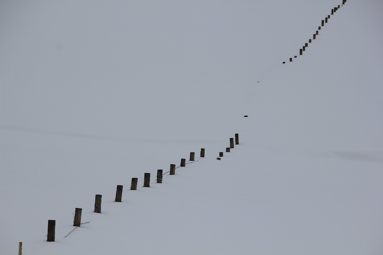
Ranchers in Colorado’s Yampa River Valley traditionally measured the severity of winters by snow accumulation on their stock fences. Plentiful accumulation put the snow at the top wire, making it a three-wire winter. Four wires have become the norm on stock fences. No matter. By early March 2023, those wires at the foot of Rabbit Ears Pass were covered too. The Yampa Valley was sublimely white. It was a winter like the old days.
As expected, runoff was big and thrashing. Creeks tumbling through Steamboat Springs in May spilled over their banks. Downstream 75 miles, the Yampa River at Maybell peaked on May 18 at 16,500 cubic feet per second, more than 200% the average peak streamflow at that gauging station.
What happened afterward was very different. By July, the Yampa’s meager flows in Steamboat so concerned water managers that they nearly closed the warming river to recreationists in order to protect fish.
Snow topped the stock fences at the foot of Rabbit Ears Pass on March 4, 2023. Photo/Allen Best
That big snowpack that resulted in head-high snowbanks along the streets in Steamboat? It produced a big runoff. But thievery had also occurred. Who or what absconded with the water? And how?
This mystery was not entirely new. April 1 snow depth in the Yampa and most of Colorado’s river basins has rarely correlated perfectly with runoff. Whether spring weather turns wetter and cooler or hotter and drier can alter the runoff dynamics. “There is always that component of what the temperature and precipitation regimes are from April 1 through July,” says Karl Wetlaufer, a hydrologist and assistant supervisor at the Natural Resource Conservation Service, the federal agency that delivers the longest-running and most-used runoff forecasts. “They really drive a lot of what those forecast errors end up being.”
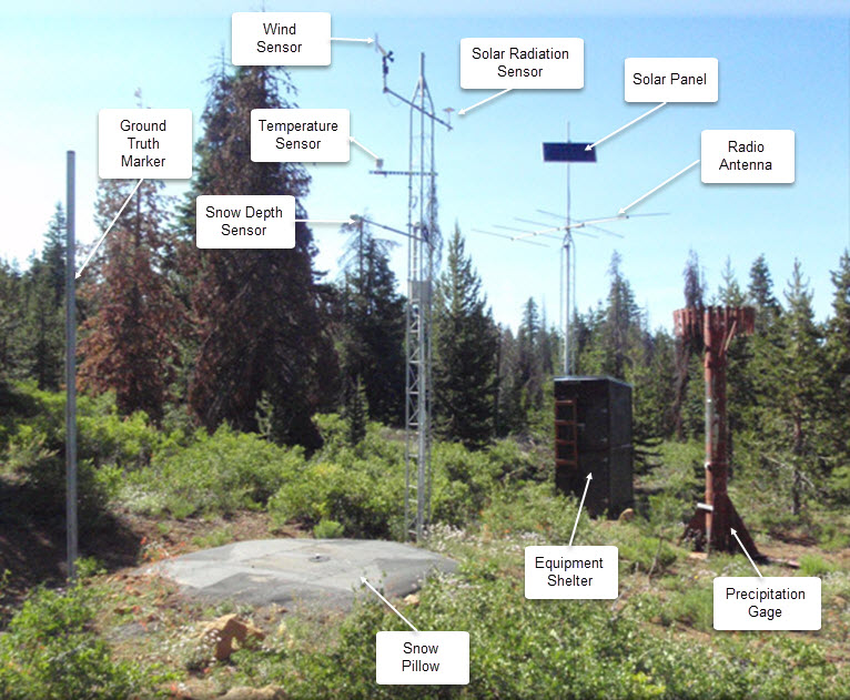
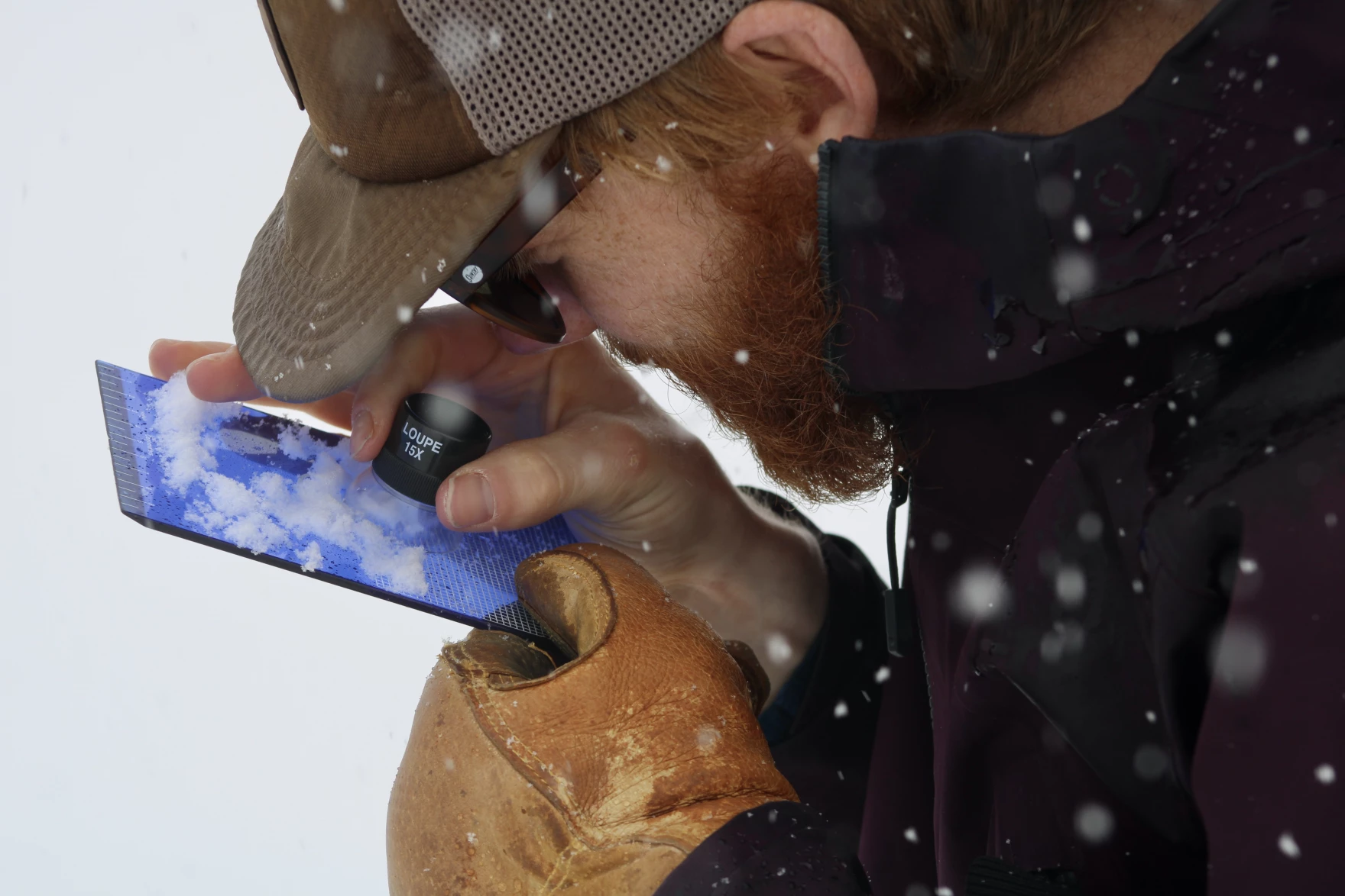
SNOTEL automated data collection site. Credit: NRCS
Then, too, the traditional methods for measuring snowpack have fallen short. Data from snow telemetry (SNOTEL) sites, is collected automatically from stations across Colorado. But those stations are relatively few compared to the complex geography. One station provides insights about one station, not a whole hillside or mountain. They provide an index.
A climate that has turned warmer and some say weirder during the last 10 to 20 years has some water managers wanting new tools. Whether in the San Luis Valley or the Yampa River Valley, what lies on the ground on April 1 remains the best predictor of river flows come July, August and September.
Water managers, from ranchers and farmers to reservoir operators and city staff, though, want improved models and data that more completely reveal the complexity of what is happening. They want to better understand why a huge snowpack can, by July and August, be such a dud.
What’s up with soil cracks and a changing climate?
Patrick Stanko, at his ranch four miles downstream from Steamboat Springs, has been puzzling over changes since he was a boy in the 1970s and 1980s. Summers have become hotter, winters less cold. Snow is gone sooner.
“The big snow banks of winter just disappear,” says Stanko. Water disappearing into the atmosphere is not a new process. But higher temperatures exacerbate it, whether that loss is to sublimation, where snow transforms directly into a gas, or evaporation, where snow melts and that water enters the atmosphere as a gas.
Milk Creek, which flows through the ranch that has been in his family since 1909, had become intermittent in its flows. Late-season grasses that his 100 head of cattle graze have become sparser with lessening summer rains.
Most striking are cracks in the ground that Stanko has noticed in recent years. He believes they have something to do with the shifted summer dynamics — dynamics that have implications into the next year’s runoff.
North American Monsoon graphic via Hunter College.
“We don’t get the rains that we used to get,” he says. “You used to be able to set your clock by the monsoon that would come.”
Haying in the Yampa River and other high country locations traditionally began in July or early August. Rain storms arrived almost simultaneously. If the rain forced ranchers to leave the grasses to dry, it was also helpful. Stanko says hay is best with 10% to 14% moisture content. Now, the timothy hay, brome grass and dryland alfalfa he grows on his 600 acres is often too dry after being cooked by hot winds.
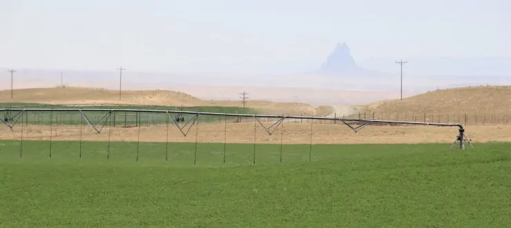
Alfalfa growing on the Ute Mountain Ute land in southwestern Colorado in October 2022. Photo credit: Allen Best/Big Pivots
Drying soils in fall have implications for spring runoff—the soils want their share of water first. That could bite into the total runoff, particularly in dry winters. Rainstorms in September have the reverse effect.
The 2024 Climate Change in Colorado report confirms many of Stanko’s observed changes. For example, summer precipitation has decreased 20% across northwest Colorado in the 21st century as compared to 1951-2000. Models suggest drier summers may become the norm — even with increased winter precipitation.
And warming has made the atmosphere thirstier. Evaporative demand is another name for this thirst. Warm air can hold more moisture than cool air. If nothing else changes, warmer temperatures increase evaporative demand.
The Climate Change in Colorado report, which was commissioned by the Colorado Water Conservation Board, cites a measure of evaporative demand called potential evapotranspiration (PET). It refers to the amount of water that would be evaporated or sublimated from the snow, soil, crops, and ecosystem if sufficient water was available. Between 1980 and 2022, PET increased 5% during Colorado’s growing season. When the ground holds less moisture, more of the sun’s energy heats the land’s surface and the atmosphere above it instead of evaporating moisture. This drives faster warming and lowers humidity.
Since 2000, streamflow across Colorado’s major river basins has been 2% to 19% less compared to the half-century before. Modeling studies have attributed up to half the declines to warming temperatures. And with declining streamflows, the need to make the most of available streamflows is heightened.
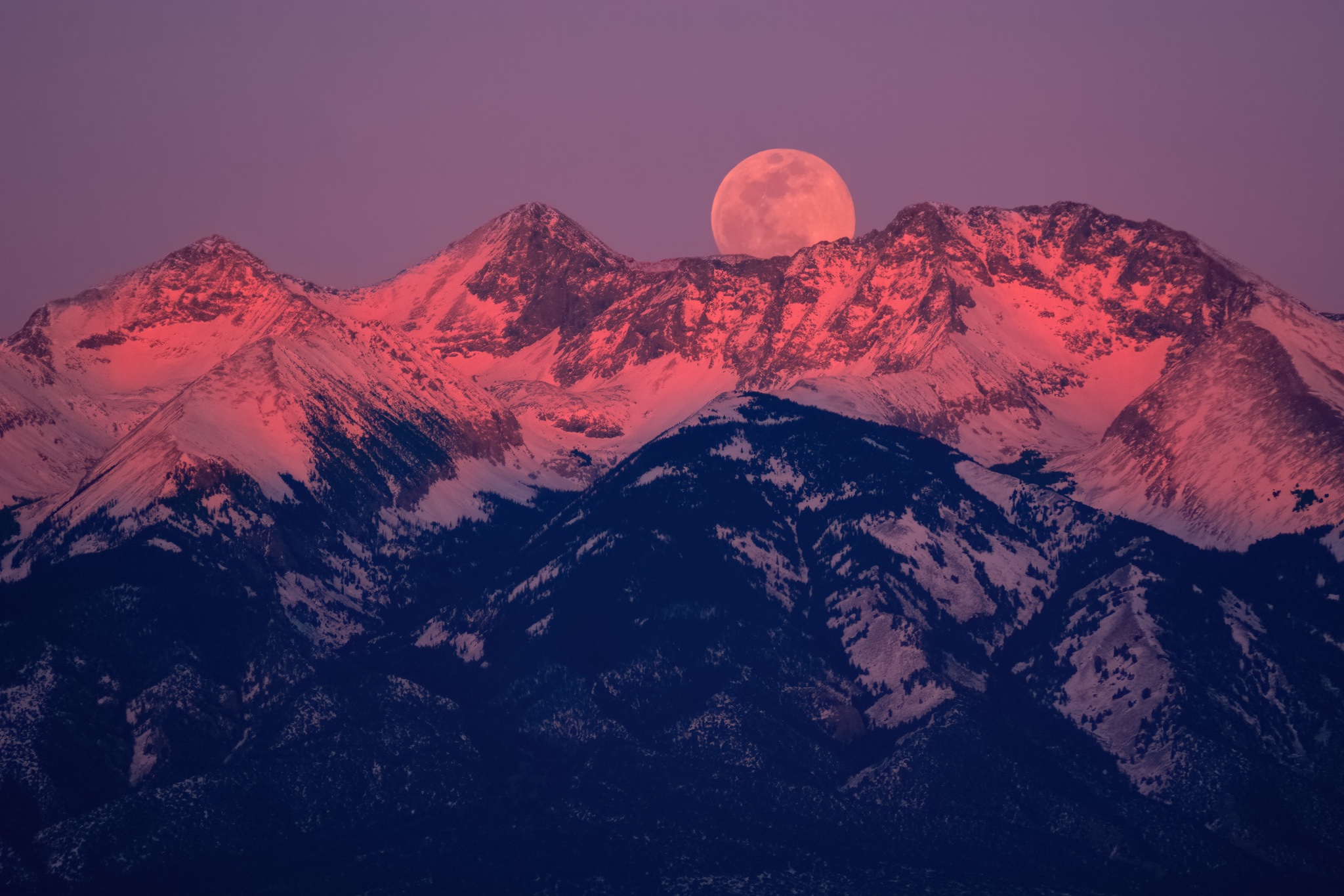
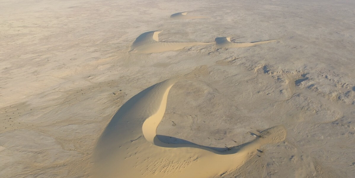
The Blanca massif, located just south of Great Sand Dunes, has been been a landmark for people for thousands of years. The #SnowMoon rising behind it is the full moon that occurs each February. Photo: NPS/Patrick Myers 2024
San Luis Valley and improved runoff forecasting
The story of dry conditions and low streamflows echoes 250 miles to the south in the San Luis Valley. There, water appropriation dates are older, elevations a little higher, and mid-summer temperatures a trifle toastier. Fifteen of the 20 hottest daily maximum temperatures recorded in Alamosa, including several in 2023, have occurred in the 21st century.
Snowfall in the San Juan Mountains largely determines how much alfalfa Cleave Simpson can grow on his farm south of Alamosa. The farm has water rights from 1879, but that isn’t senior enough to ensure reliable water deliveries, says Simpson, who is a Colorado state senator in addition to being a farmer and general manager of the Rio Grande Water Conservation District. State officials make adjustments to the water that can be diverted. “They do that every day,” says Simpson. “All in an effort to deliver to the state line as close as is possible the amount that we’re required to deliver.”
The Rio Grande Compact specifies how much water Colorado must deliver to downstream states. Depending on the year’s flows, Colorado sends between 35% and 70% of the Rio Grande’s water downstream. To ensure those deliveries, water managers must carefully calibrate flows they expect against demand from irrigators. Like those on the Yampa, water managers have wanted new ways of forecasting flows. “Because the old ways just aren’t working that well,” explains Craig Cotten, Colorado’s Division 3 water engineer, who leads administration in the Rio Grande Basin.
The old ways use primarily snow telemetry data, better known as SNOTEL data, which is automatically collected from stations across the state. That data is used to project flows using what Cotten describes as a “fairly simple regression analysis.” In other words, if X amount of snow in the past produced Y amount of water, then the same formula should hold today. But in the early 2000s, Cotten began to see that in some years, streamflow forecasts were not as accurate as he would have liked, he says.
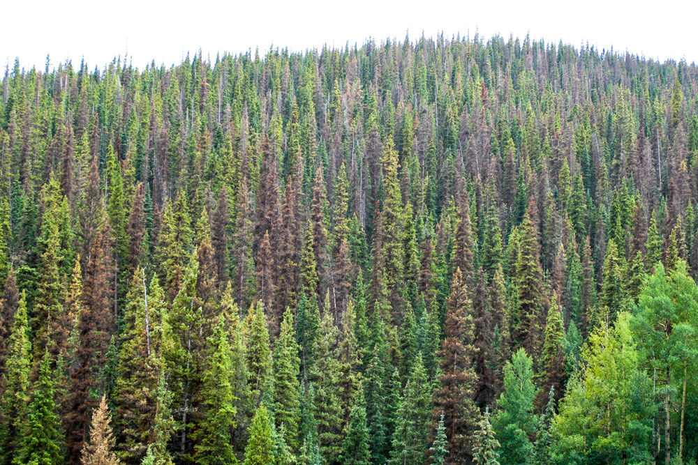
Spruce beetle-impacted forest in Southwestern Colorado with moderate levels of tree mortality. Photo credit: Sarah Hart
What changed? Bark beetle infestations, by stripping trees of needles and exposing more snow to sunlight, altered runoff. So did wildfires, which in 2013 scarred 113,000 acres in Rio Grande headwaters areas. “That changed the dynamics of the forest system and how it related to the snowpack melting and running into the streams,” says Cotten, a 33-year veteran with Colorado’s Division of Water Resources. Dust-on-snow events work the same way. Dust blown from distant deserts accumulates on snow, drastically reducing the albedo, or reflectivity. The warmed snow melts more rapidly.
Overall flows have trended down. Flows on the Rio Grande at a gauging station near Del Norte, upstream from most diversions, averaged 8% less from 2000 through 2022 than during the preceding 50 years.
Snowpack in the Rio Grande’s headwaters in the San Juan Mountains was above average in 2019 and again in 2023, Cotten points out. But late-summer seasonal flows were below average. “Even in a good year, our farms and ranches struggle in the late season because we have below-average streamflow at that time.” And always, there’s the need to meet compact obligations, a task that Cotten says has become harder because of tightening water supplies.
The Dolores River between Rico and Dolores in southwestern Colorado on Memorial Day 2009. Photo credit: Allen Best/Big Pivots
With stretched water supplies, accuracy in forecasting is increasingly important. A new tool, the high-resolution LiDAR of Airborne Snow Observatories (ASO) has meant better data on the amount of water contained in snowpack, and has improved runoff projections. Through ASO, a plane flies over entire watersheds or basins, collecting snow-depth data. Flights in 2024 include the Conejos River – of help to Cotten — and the Yampa and Elk rivers.
“Whether it’s a county commissioner, a dam operator, or maybe Craig Cotten or another division engineer, their challenge is that they’ve got a forecast of runoff, timing and volume,” says Jeff Deems, a snow scientist and part-owner of ASO. “They need to operate their headgates, their allocation, their dam, et cetera, while recognizing that their forecast is uncertain and that there’s a range of outcomes that could be undesirable. They need to make the best decision possible under that uncertain framework.”
This map shows the snowpack depth of the Maroon Bells in spring 2019. The map was created with information from NASA’s Airborne Snow Observatory, which will help water managers make more accurate streamflow predictions. Jeffrey Deems/ASO, National Snow and Ice Data Center
ASO claims it can achieve 98% accuracy in forecasting the amount of water contained in snow, known as the snow water equivalent, or SWE, across large areas. Water managers across Colorado, with the help of state funding, are contracting with ASO to collect data and boost their forecasting.
“It opens up understanding of different physical processes related to the snowpack that otherwise we may not understand very well,” says Angus Goodbody, of ASO. Goodbody is a forecast hydrologist with the NRCS.
While this data is invaluable to many water managers, NRCS can’t yet use ASO data in its modeling. But NRCS, too, is rolling out a new forecast system this winter. Goodbody describes the forecasting tools as improving incrementally. By using various forecasting tools and models to analyze data, NRCS aims to mitigate “the vulnerability of any one of those models on their own,” he says.
If a liquid like water is present in a way of tiny drops, in air, in a substance or on a surface we called it as moisture. But it is very difficult to define the “soil moisture”. Normally, soil moisture can be defined as the water that retain in between the spaces of the soil and rock particles. This is of two types. Those are: surface soil moisture; and, root zone soil moisture. Credit: Modern Farming
Digging into soil moisture
New tools have also topped Andy Rossi’s wish list for the Yampa. From the Steamboat Springs office of the Upper Yampa Water Conservancy District, where he has been the district’s general manager since 2020, Rossi directs operations of the district’s two upstream reservoirs, Stagecoach and Yamcolo, which provide water to ranches and municipalities, including Steamboat Springs.
When he started working for the Upper Yampa district as an engineer in 2009, runoff forecasts were “becoming more and more unreliable and really difficult for us to get our arms around what was going on in the basin,” he explains.
Temperature records for the Yampa Basin were very good. Soil moisture records? Not so much. Runoff predictions from past years mentioned soil moisture but relied solely on models. “There was no direct measurement of soil moisture going into our forecasting,” Rossi says. He decided the Yampa Valley needed more diverse measuring infrastructure to better collect data about soil moisture and atmospheric processes in order to see if and how soil moisture factors into runoff. Were dry soils sapping runoff, preventing it from reaching rivers? The puzzle was missing pieces. Integrating more non-snow data into runoff projections might result in better forecasts.
A partnership began to coalesce in 2018 between the Yampa Valley Sustainability Council, Colorado Mountain College, and the Scripps Institution of Oceanography’s Center for Western Weather and Water Extremes. Guided by a team of 15, the collaboration yielded a pilot soil moisture and weather monitoring station in September 2022 near Stagecoach Reservoir. In 2023, with aid from the Colorado Water Conservation Board and the Colorado River District, two additional stations were installed in the basin. The team in early 2024 was working on six more stations upstream of Craig. The stations collect continuous soil moisture measurements and data on meteorological conditions with the goal of sharing that data so that stakeholders can make management choices about changing water supplies.
The aim, in part, was to generate new and valuable data that wasn’t being collected elsewhere, says the sustainability council’s Madison Muxworthy, the project manager. “We didn’t want to duplicate existing efforts, such as SNOTEL stations,” she says.
The sustainability council has collaborated with the NRCS to install more soil moisture sensors at SNOTEL stations to go along with snowpack, precipitation and temperature data. The team will install four stations this summer and two more in 2025.
It’s still too soon to know the results of this monitoring. Measurements obtained from these new stations may reveal short-term changes, but other insights may require 10 to 20 years of data.
A similar network of soil moisture stations already exists in Colorado’s Roaring Fork Valley. There, 10 stations have been installed in an elevation band of 5,880 feet from Glenwood Springs to above 12,000 feet at Independence Pass. All stations have sensors to monitor soil moisture at depths of 5, 20 and 50 centimeters, and monitor soil temperature at 20 centimeters deep. They also record air temperature, relative humidity, rainfall, and more, recording measurements at least hourly.
This network was created by the Aspen Global Change Institute in response to local interest in measuring soil moisture in the Roaring Fork watershed. In 2012, as bark beetles proliferated, scientists at a small meeting on forest health identified soil moisture as a critical, understudied component of ecosystem vitality. With more than a decade of measurements, the data may help answer questions about hydrology and ecology in mountain systems.
A rambunctious Fryingpan River in the vicinity of Norrie was in a hurry to get to Ruedi Reservoir in late June 2018. Photo credit: Allen Best/Big Pivots
Key research questions for the Roaring Fork network include how will climate change impact water availability and timing in the watershed? And how can in-situ soil moisture data be used in water supply forecasts and models to better inform decision making for water managers and cities?
Elise Osenga, the Aspen Global Change Institute’s community science manager, stresses the complexities of runoff now further confused by climate change. Soil moisture plays a role, but it’s among many factors.
“You’re trying to predict the future based on how conditions played with each other in the past,” explains Osenga. “And now in the future, different wrenches will be thrown into the system where the past may not be a perfect representation.”
If dry soils only tell a small percentage of the story of this runoff thievery, that’s where the institute’s microscope is being applied. “Finding the quantitative relationship between a dry soil and change in runoff is going to be hard because it’s a small percent to begin with. It’s not that it doesn’t matter, but it’s also not the silver bullet,” Osenga says.
Soil moisture refers to water held in the pores of soil. Going deeper – the depth varies but often begins around a meter down—takes you to a saturated zone of groundwater. Groundwater adds further complexity to the question about runoff prediction. Rosemary Carroll is conducting research on that interplay. She’s a research professor in hydrology affiliated with the Desert Research Institute but based at Colorado’s Mt. Crested Butte.
Groundwater, she says, moderates flows between the years of big water and high flows and those of lesser runoff. During the big years, the water goes into storage in the form of groundwater. It stabilizes flows.
Healthy mountain meadows and wetlands are characteristic of healthy headwater systems and provide a variety of ecosystem services, or benefits that humans, wildlife, rivers and surrounding ecosystems rely on.
The complex of wetlands and connected floodplains found in intact headwater systems can slow runoff and attenuate flood flows, creating better downstream conditions, trapping sediment to improve downstream water quality, and allowing groundwater recharge. These systems can also serve as a fire break and refuge during wildfire, can sequester carbon in the floodplain, and provide essential habitat for wildlife. Graphic by Restoration Design Group, courtesy of American Rivers
But groundwater declines during hotter and drier years—think 2002, 2012 and 2018. Streamflow is sensitive to declines in groundwater storage, Carroll says, so flows also drop. Modeling that Carroll has worked on shows a loss of 30% in streamflows over the next century or so, assuming a 4 degree temperature increase.
Groundwater may seem to be on the margins of why runoff predictions on April 1 fail to materialize in July, but Carroll believes it needs to be part of the discussion. That connection will become more important in coming decades as temperatures continue to rise. “It’s really important, and it’s not often talked about,” she says.
Late season weather prediction accuracy
Despite all this research that seeks to narrow the uncertainty, uncertainty will remain in streamflow forecasting for the foreseeable future. That’s the conclusion drawn by Peter Goble, of the Colorado Climate Center, and Russ Schumacher, Colorado State Climatologist, in a study published in the Journal of Hydrometeorology December 2023 issue.
“What influences seasonal runoff more: antecedent soil moisture and groundwater conditions or meteorological conditions following April 1?” they asked. Sifting through evidence from 2020 and 2021, they reached a clear conclusion: “This study demonstrates that existing soil moisture and groundwater models are unlikely to provide ‘low-hanging fruit’ for improving forecasts.”
Improved weather forecasting skills will matter more, Goble and Schumacher said.
Weather forecasts are remarkably good for a week to 10 days. Beyond? Not so much. Will that change? Goble and Schumacher indicate little optimism.
Then there’s the shifting climate. If weather continues to become more variable, “that is only going to decrease our ability to predict ahead of time what the runoff is going to be,” Goodbody says. Too, if warmer winter temperatures produce more rain, there will be less snow to measure. “Then predictability by definition goes down until we actually can predict the future [after April 1] weather with more certainty,” Goodbody says.
The Little Snake River is about to join the Yampa River on Oct. 8, 2020. Photo credit: Allen Best/Big Pivots
Improved forecasts, however, won’t deliver more water. For management purposes, stored water still matters greatly. Consider the Yampa River after that three-wire winter of 2023. The rapidly slackening flows of the river through Steamboat during July surprised water managers and state officials. That year, the snowpack in the Yampa River Basin was dusty, moving the snow to melt and runoff to occur earlier than usual. Officials came close to closing the river to commercial fishing access, as they had the four previous years because of either low flows, high temperatures, or both.
Through a water lease agreement orchestrated by the Colorado Water Trust—a nonprofit that uses voluntary water-market transactions to restore streamflows—the Upper Yampa district released between 18 cubic feet per second and 40 cfs from Stagecoach from late August through late October to keep the Yampa flowing and at a cooler temperature. This added water helps the City of Steamboat Springs stay in compliance with federal water quality standards governing stream temperatures below the city’s wastewater treatment plant. It also benefits fish and those angling at them.
“We thought we were in great shape and thought we wouldn’t need [special] releases out of Stagecoach [Reservoir],” says Julie Baxter, water resources manager for the City of Steamboat Springs.
“It was definitely a big surprise.”
This story was published in the Spring 2024 issue of Headwaters magazine, a publication of Water Education Colorado. See the full contents here.
Climate change is worsening floods, droughts and is reducing water quality, posing an increasing threat to our health, according to a European Environment Agency (EEA) report published today. Fast-tracking implementation and better coordination of efforts by governments, water authorities and healthcare providers are urgently needed to prevent and reduce health impacts.
Between 1980 and 2022, 5,582 flood-related deaths and 702 wildfire-related deaths were recorded across 32 European countries. Already today, one in eight Europeans lives in areas potentially prone to river floods and around 30% of people in southern Europe face permanent water stress. Climate change will further increase exposure of people to weather extremes with serious health consequences. Senior citizens, children, those in poor health, lower income groups, farmers and emergency service teams are among the groups experiencing greatest health impacts from floods, droughts, wildfires or water- and vector-borne diseases.
With these facts, the report underscores the critical need to urgently implement existing EU legislation, notably various European climate, water and health policies and integrate them further, and roll out the already existing solutions across all sectors and government levels to protect lives, prevent adverse health outcomes and increase wellbeing.
“Protecting human lives and health from the impacts of climate change, including droughts, floods and worsened water quality is of utmost importance and urgency. Existing European climate, water and health policies offer a solid foundation for action, but they need to be implemented more broadly and systematically. To ensure our future well-being all levels of government across many sectors need to put in place effective solutions so that we can prevent and reduce physical and mental health impacts. We support them with knowledge through the activities of the EEA and the European Climate and Health Observatory.” — Leena Ylä-Mononen
Faster rollout of effective solutions
To enhance our preparedness for future climate-related challenges to health from floods, water scarcity and deteriorated water quality, responses are needed in both the health sector and other sectors that have an impact on health, including water management, spatial planning, building design or insurance.
The EEA report seeks to inspire action by showing various examples of practical solutions implemented in the EEA member and collaborating countries.
A precondition for upscaled action is the greater integration of climate change into health policies in Member States and increased resources and competencies for climate change adaptation with a focus on health at subnational levels. Quick wins include raising public awareness about the risks and solutions, while longer-term actions, including infrastructure improvements and nature-based solutions, require systematic planning and investment. The differences in vulnerability of various population groups and the geographical variation of impacts require an equity-based, targeted approach to preventing health impacts for all under the changing climate.
Sources/Usage: Public Domain.
Post-wildfire flooding and debris flow in a small canyon above the Las Lomas debris basin in Duarte, the winter after the the June 2016 Fish Fire in Los Angeles County, California.
Key risks calling for action
Floods
Between 1980 and 2022, 5,584 flood-related deaths were recorded in the 32 EEA member countries.
Currently, around 53 million people (12% of Europe’s population) live in areas potentially prone to river flooding, although often with flood defences in place. This number increased by 935,000 between 2011 and 2021, showing continuous development on floodplains.
One in nine hospitals in Europe is located in areas potentially prone to river flooding.
US Drought Monitor June 28, 2012
Droughts and water scarcity
Due to demand for water and droughts, regions in Europe are under nearly permanent water stress, and not just in the south.
Prolonged spells of dry and hot weather facilitate the spread of wildfires, mainly in southern Europe, but increasingly in other regions. Between 1980 and 2022, 702 people lost lives directly through wildfires in the 32 EEA member countries, and many more were affected by wildfire smoke.
Waterborne diseases are a significant global concern, particularly in regions with inadequate sanitation and contaminated water sources. Understanding the symptoms of waterborne diseases and implementing preventive measures is crucial to maintaining public health. Credit: Medium
Water quality
Rising air and water temperatures facilitate pathogen growth, increasing the risk of waterborne diseases.
Heavy rainfall events make it twice as likely to have harmful pathogen concentrations in water bodies due to contaminated run-off and combined sewage overflows.
In low-lying areas, sea level rise causes intrusion of saline water into groundwater and surface water aquifers, with spillover effects on crops.
Low flows during dry periods result in higher concentrations of pollutants, requiring costly wastewater treatment. During dry and hot periods, cyanobacterial blooms in nutrient-rich waters can jeopardise water quality.
About the report
The report is published as part of activities of the European Climate and Health Observatory, building on and complementing the Observatory’s work. The report follows from the European Climate Risk Assessment published earlier this year, which highlighted health as one of the at-risk sectors.
The federal government expects Lake Powell to rise, despite one Utah lawmaker’s claim that levels are ‘intentionally’ being kept low
Utah’s reservoirs are still at what the state calls “impressive” levels, with most hovering around 90% capacity — by comparison, statewide levels were a little over half full this time last year.
But Lake Powell, the country’s second-largest reservoir, is an outlier. According to the U.S. Bureau of Reclamation, it’s currently at about 35% capacity.
During a Legislative Water Development Commission meeting in Salt Lake City last week, director of the Utah Division of Water Resources Candice Hasenyager gave lawmakers an update on the state’s water outlook.
“Our reservoirs are about full, we’re at about 90% of our statewide average,” she said. But, she noted Lake Powell as a glaring exception.
“That’s still definitely a concern that we have,” Hasenyager told lawmakers.
In a statement, the U.S. Bureau of Reclamation said Lake Powell should not be compared to other reservoirs in the state because of its size and the various policies that dictate its levels.
“Lake Powell is substantially larger, with a live capacity of nearly 25 million acre-feet,” a spokesperson for the bureau said. “This capacity is more than eight times the capacity of Strawberry Reservoir.”
Those levels are often out of the state’s control, and are in part due to the complexity of the Colorado River Basin and the system that allocates water to seven states and Mexico, called the Colorado River Compact.
Through the compact, the bureau “has modified the operating guidelines for Glen Canyon and Hoover dams through 2026, to protect these facilities and lake levels if poor hydrologic conditions persist,” the spokesperson said.
Despite Lake Powell appearing to be far behind Utah’s other reservoirs in terms of capacity, the bureau noted that the situation is much better than last year — currently, it sits at about 24 feet higher than last May, and officials say levels will continue to rise, expected to hit about 41% capacity in June. After that, the bureau said it will decline until spring runoff in 2025.
Still, the state’s lack of control over Lake Powell drew some disapproval from outgoing Rep. Phil Lyman, R-Blanding, who is currently running for governor. Lyman, a fierce critic of the federal government’s presence in Utah, lamented the levels being “set by the Secretary of the Interior.”
“Are we working with the Secretary of the Interior, are we working with the federal government to keep that at a viable level?” Lyman asked. “What we’ve really seen is intentional, keeping that below a viable recreation level and I hope the legislature can influence that decision in the future.”
In response to Lyman’s comments, the Bureau of Reclamation pointed to the bevy of compacts, federal laws, court decisions, contracts and regulatory guidelines that control flows in the Colorado River and levels at Lake Powell.
“Reclamation has a long-standing history of working with all stakeholders in the basin on cooperative agreements that help define operational actions at critical times and to protect the levels at Lake Powell and sustain and protect the Colorado River Basin,” the bureau said.
When asked about Lyman’s comments, Utah Gov. Spencer Cox responded, “I have no idea what he’s talking about.”
“People can make up stuff all they want. Nobody is deliberately keeping the water levels low at Lake Powell,” the governor said during his monthly PBS news conference on Thursday, calling his gubernatorial opponent’s claim “bonkers.”
Cox pointed to ongoing negotiations among water managers from Colorado River basin states who are working on a new management plan ahead of 2026, when the current guidelines expire.
Cox told reporters the state has been releasing its own water from Flaming Gorge Reservoir to ensure the Glen Canyon Dam at Lake Powell can continue generating power. Some of that water was released to Lake Mead, he said — now, the state is hoping to get that water back.
“There are big discussions about where that water goes and where our portions of the water go. We’ve had huge releases from upstream reservoirs that have gone into Lake Powell,” Cox said. “That’s mostly our water. …These are very, very complex negotiations that are going back and forth, and part of the negotiations and what we’re doing right now is making sure we can restore the water that we released.”
‘Exactly what we need’
On Thursday, the Division of Water Resources said over half of the snow from this winter has melted, with recent weather patterns resulting in “optimal spring runoff.”
“A slow warmup is exactly what we need to have a safe and effective spring runoff,” Hasenyager said in a statement. “We still have a good amount of snow in the mountains, so we are hoping for a gradual snow melt.”
Here are some key takeaways from the state:
As of May 1, Utah’s major watersheds are at or above about 90% of normal precipitation, with northern Utah’s basins doing exceptionally well.
The state’s streams are flowing at about 89% of normal, which the division called a “widespread positive trend.”
The Great Salt Lake has risen about three feet since October. According to state data, the south arm of the lake is at above 4,195 feet, about three feet away from the bottom of the spectrum of what’s considered a healthy level, 4,198 feet.
It’s filling up. Already nine ballot measures have been approved for Colorado voters to decide in the Nov. 5 general election. Two of the measures are citizen initiatives – one requiring the state to seek voter approval to retain property tax revenue projected to increase more than 4 percent over the prior year; another asking voters to signal the right to an abortion, including allowing for health insurance coverage for public employees.
The other seven measures were sent to the ballot by the Colorado Legislature. Those include:
A proposed amendment to the Colorado Constitution that removes the provision that states, “Only a union of one man and one woman shall be valid or recognized as a marriage in the state.”
A ballot measure that would collect an 11 percent retail sales tax from firearms dealers, manufacturers, and ammunition vendors. The collected revenue would fund the Firearms and Ammunition Excise Tax Cash Fund that would support programs for crime victims, education, and mental and behavioral health for children and veterans.
A legislative-approved ballot measure that asks voters to allow the state to retain tax revenue collected above $29 million annually from sports betting. The money kept by the state would be used to pay for projects in the Colorado Water Plan.
In an episode of The Valley Pod, Colorado State Sen. Cleave Simpson and State Rep. Matthew Martinez talked about their support for the state legislature’s referred-measure to amend the Colorado Constitution on the definition of marriage. If adopted the amendment essentially would remove the ban on a same-sex marriage in the Colorado Constitution.
“Nobody here (in Colorado) has been denied a marriage license for same-sex marriage because of the direction from the U.S. Supreme Court. This just affirms and puts us in that position,” said Simpson. “And I have any number of same-sex marriage friends and acquaintances, and I just think out of respect to them, and this should be something that the people of Colorado should decide. It doesn’t have huge financial implications. It doesn’t have huge personal implications other than folks, I know that this impacts them. And I think this is something that the voters should be able to decide.”
“I think it’s pretty straightforward. And we’ve had this control through the legislature, the ability to have same-sex marriage for some time,” said Martinez. “This just really aligns what we’re already doing, both with the state and with the federal level.”
Simpson also weighed in on allowing Colorado to keep gambling revenue that exceeds $29 million in any given year. Currently revenue above $29 million that’s collected goes back to the casinos that generated the revenue.
In addition to the measures already on the ballot, there are 25 others with petitions out collecting voter signatures to try to qualify. Here’s a look at what’s qualified so far:
Other proposed amendments to the Colorado Constitution referred by the Colorado Legislature
Colorado Independent Judicial Discipline Adjudicative Board Amendment – Amendment to the Colorado Constitution concerning judicial discipline and establishing an independent judicial discipline adjudicative board, setting standards for judicial review of a discipline case, and clarifying when discipline proceedings become public.
Initiative No. 50 Voter approval to retain additional property tax revenue – Proposal “conditionally decreases property tax revenue in years when statewide property tax revenue is projected to grow more than 4 percent over the prior year, unless voters approve a ballot measure allowing for the additional revenue to be retained.” The initiative is sponsored by Advance Colorado Institute, a conservative think tank.
Initiative No. 89 Right to Abortion – Proposals reads, “The right to an abortion is hereby recognized. Government shall not deny, impede, or discriminate against the exercise of that right, including prohibiting health insurance coverage for abortion.” Initiative submitted by Dusti Gurule of the Colorado Organization for Latina Opportunity and Reproductive Rights; and Dani Newsum, director of strategic partnerships at Cobalt, reproductive advocates.
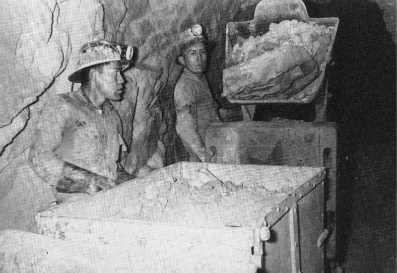
Kathleen Tsosie remembers seeing her dad come home every evening with his clothes covered in dirt. As a little girl, she never questioned why, and she was often more excited to see if he had any leftover food in his lunchbox.
“We used to go through his lunch and eat whatever he didn’t eat,” Tsosie said, recalling when she was around 4 years old. “And he always had cold water that came back from the mountain.”
Tsosie’s father, grandfather, and uncles all worked as uranium miners on the Navajo Nation near Cove, Arizona, from the 1940s to the 1960s. The dirt Tsosie’s father was caked in when he arrived home came from the mines, and the cold water he brought back was from the nearby springs.
In the late 1960s, Tsosie said her grandfather started getting sick. She remembers herding sheep with him and how he would often rest under a tree, asking her to push on his chest because it hurt.
Tsosie said she was about 7 years old when her uncles took her grandfather to the hospital. At the time, she didn’t know why he was sick, but later on, she learned he had cancer. Her grandfather died in October 1967.
Over a decade later, Tsosie’s father also started getting sick. She remembers when he came to visit her in Wyoming; she was rubbing his shoulders when she felt a lump. She told him to get it checked out because he complained about how painful it was.
Her father was diagnosed with cancer in 1984 and went through treatments, but died in April 1985.
“When my dad passed away, everybody knew it was from the mine,” Tsosie said. He was just the latest on a long list of Navajo men from her community who worked in the uranium mines and ended up getting sick and passing away.
She recalls how her father used to tell her that, one day, it may happen to him, but she did not want to believe him. Her dad worked in the uranium mines for over 20 years.
The sickness did not stop there. In February of 2007, Tsosie was diagnosed with breast cancer, and she would spend years in treatment and eventually go into remission in December 2007.
But, this year, Tsosie got the news in February that her cancer has returned, and she is now taking the steps toward getting treatment.
Tsosie’s family history with uranium mining and growing up in an area downwind from nuclear testing sites is similar to many Navajo families in Arizona, Utah and New Mexico. Her family is among the thousands potentially impacted by radiation from nuclear weapon testing, according to National Cancer Institute research.
Because of that history, Tsosie became an advocate for issues related to downwinders and uranium mine workers from the Navajo Nation, including the continuation of the Radiation Exposure Compensation Act.
The Radiation Exposure Compensation Act, or RECA, provides a program that compensates individuals who become ill because of exposure to radiation from the United States’ development and testing of nuclear weapons.
RECA was initially set to expire in 2022, but President Joe Biden signed a measure extending the program for two more years. Now, it’s set to expire in less than a month.
Tsosie first heard of the program in the 1990s after her mother applied for it because her father was a uranium mine worker. She remembers the day her mother got a compensation check for $100,000 and handed it to her.
“She gave it to me, and she said, ‘This is from your dad,’” Tsosie said, adding that her mother didn’t go into many details at the time, only saying that families with loved ones who died of cancer were getting checks.
Tsosie said she was upset about the check because her father had died, and $100,000 was nothing in comparison.
“I was really mad, and that’s just how the federal government thinks of us as Navajo people,” she explained.
The second time she worked with RECA was for her own case. After her cancer treatments concluded in December 2007, she took some time to heal before determining in March 2008 whether she qualified for RECA. She did qualify and received compensation.
Since RECA was passed in 1990, more than 55,000 claims have been filed. Of those, more than 41,000 claims, or about 75%, have been approved — and roughly $2.6 billion had been paid out as of the end of 2022.
Claims for “downwinders” yield $50,000. For uranium mines and mill workers providing ore to construct nuclear weapons, claimants typically receive $100,000.
Proving that exposure to nuclear waste and radiation causes cancers and other diseases is difficult. However, the federal program doesn’t require claimants to prove causation: They only have to show that they or a relative had a qualifying disease after working or living in certain locations during specific time frames.
In July 2023, the U.S. Senate voted to expand and extend the RECA program, and it was attached as an amendment to the National Defense Authorization Act, which funds the Department of Defense.
It could have extended health care coverage and compensation to more uranium industry workers and “downwinders” exposed to radiation in several new regions — Colorado, Missouri, New Mexico, Idaho, Montana, and Guam — and expanded coverage to new parts of Arizona, Nevada and Utah.
The defense spending bill for 2024 was signed into law on Dec. 22 by Biden, but the RECA expansion was cut from the final bill before it landed on his desk.
When she heard that the Radiation Exposure Compensation Act amendments failed to pass, Tsosie said it really impacted her, and she cried because so many people deserve that funding.
“I know what it feels like. I know what it feels like to suffer,” she said.
The sunset of the Radiation Exposure Compensation Act is approaching fast, and leaders from the Navajo Nation are urging Congress to act on the expansion bill that has been waiting for the U.S. House of Representatives to take it up for more than two months.
“Time is running out,” Justin Ahasteen, the executive director of the Navajo Nation Washington Office, said in a press release.
“Every day without these amendments means another day without justice for our people,” he added. “We urge Congress to stand on the right side of history and pass these crucial amendments.”
The bill passed through the U.S. Senate with a bipartisan 69-30 vote on March 7. But since being sent to the House on March 11, the bill hasn’t moved.
The RECA expansion bill would include more communities downwind of nuclear test sites in the United States and Guam. It would extend eligibility for uranium workers to include those who worked after 1971. Communities harmed by radioactive waste from the tests could apply for the program, and expansion would also boost compensation payments to account for inflation.
“The Navajo Nation calls for immediate passage of S. 3853,” Ahasteen said in a press release. “This is to ensure that justice is no longer delayed for the Navajo people and other affected communities.”
Ahasteen told the Arizona Mirror in an interview that congressional leaders holding the bill back due to the program’s expense is not a good enough reason not to pass it.
“They keep referencing the cost and saying it’s too expensive,” he said. But, he explained, the RECA expansion is only a sliver of U.S. spending on foreign aid or nuclear development.
And it shouldn’t even be a matter of cost, Ahasteen said, because people have given their lives and their health in the interest of national security.
“The bill has been paid with the lives and the health of the American workers who were exposed unjustly to radiation because the federal government kept it from them and they lied about the dangers,” he said.
Navajo uranium miners at the Rico Mine in 1953. (Source: The Navajo Uranium Miner Oral History and Photography Project at the Center for Southwest Research, University Libraries, University of New Mexico)
From 1945 to 1992, the U.S. conducted a total of 1,030 nuclear tests, according to the Arms Control Association.
Many were conducted at the Nevada Test Site, with 928 nuclear tests conducted at the site between 1951 and 1992, according to the Nevada National Security Site. About 100 of those were atmospheric tests, and the rest were underground detonations.
According to the United Nations Scientific Committee on the Effects of Atomic Radiation, atmospheric tests involved unrestrained releases of radioactive materials directly into the environment, causing the largest collective dose of radiation thus far from man-made radiation sources.
Between the 1940s and 1990s, thousands of uranium mines operated in the United States, according to the United States Environmental Protection Agency. Most operated in Colorado, Utah, Wyoming, New Mexico and Arizona, typically on federal and tribal lands.
The number of mining locations associated with uranium is around 15,000, according to the EPA, and of those, more than 4,000 have documented uranium production.
Navajo Nation leaders advocated and worked with officials in Washington, D.C., for decades to get the amendments added to the RECA that would benefit more Navajo people who have been impacted by uranium mining, as well as radiation exposure.
Their efforts continue with the current expansion bill: Navajo Nation President Buu Nygren, Navajo Nation Council Speaker Crystalyne Curley and the Navajo Nation Washington Office team have been working on an advocacy push this week with congressional leaders.
“Our people have borne the cost of America’s nuclear program in their health and well-being,” Nygren said in a written statement. “The amendments we advocate for today are not merely legislative changes; they are affirmations of justice and a commitment to heal the wounds of the past.”
On May 14, Nygren and Curley met with former Navajo uranium miners and members of Congress to urge passage of the amendments before RECA expires in a few weeks.
“As the Navajo Nation, we feel that that’s the best fit for us, especially for our miners,” Curley told the Mirror about her support of the expansion bill.
Curley said she’s spent her time in Washington educating congressional leaders about the Navajo Nation and the impact uranium mining has had on their people.
“A lot of our Navajo fathers, grandparents, and uncles went into these mines without any protection,” she said. “And now, many decades later, we’re dealing with the health effects.”
The legacy of uranium mining has impacted the Navajo Nation for decades, from abandoned mines to contaminated waste disposal.
From 1944 to 1986, nearly 30 million tons of uranium ore were extracted from Navajo lands, according to the EPA, and hundreds of Navajo people worked in the mines, often living and raising families in close proximity to the mines and mills.
Ahasteen said those numbers show exactly how large the uranium operations were on the Navajo Nation and the impact it would have on the Navajo people.
“There are photos on record to show Navajo people being exploited, not given any proper protective equipment, but (the federal government) knew about the dangers of radiation since the ’40s,” Ahasteen said. “They were given a shovel and a hard hat, and they were told: Go to work. You’ll earn lots of money. You’ll have a nice life, and we did that, but it didn’t work so well for us.”
Although the mines are no longer operational across the Navajo Nation, contamination continues, including 523 abandoned uranium mines in addition to homes and water sources with heightened levels of radiation.
The health risks associated with this contamination include the possibility of lung cancer from inhaling radioactive particles, as well as bone cancer and impaired kidney function resulting from exposure to radionuclides in drinking water.
“We want to remind all of the members of Congress that it was because of the Navajo Nation that we are where we are today,” Ahasteen said. “It is because of the uranium workers (that) the United States is the nuclear power that it is today.”
Ahasteen said the Navajo people have demonstrated their patriotism for the U.S. time and time again, but the country continues not to recognize that.
“That’s really what’s appalling,” he added.
As of December 2022, the U.S. Department of Justice stated that 7,704 claims from tribal citizens representing 24 tribal nations had been filed with the RECA program, 5,310 had been granted and more than $362.5 million had been awarded.
Navajo people make up 86% of the claimants, according to the DOJ, and they have received awards totaling more than $297 million.
RECA’s downwind affected area covers land within multiple federally recognized tribal nations, including the Navajo, Hopi and White Mountain Apache.
Ahasteen provided RECA claim numbers for Arizona as of April 2023. A total of 15,603 RECA claims had been submitted in Arizona, 3,052 of which came from the Navajo Nation.
“That accounts for about 20% of all claims in Arizona,” he said.
In New Mexico, he said that there were a total of 7,300 claims, and 2,900 were Navajo.
“That means 40% of all of New Mexico claims are Navajo,” Ahasteen said. “Combined between Arizona and New Mexico, Navajo makes up about a fourth of all RECA claims.”
Ahasteen said it is disappointing that the program is approaching expiration and that the expansion bill still hasn’t moved in the House.
“We are hopeful that when it is brought to the House floor for a vote, Congress will speak, and they will move forward with the amendments because it’s the right thing to do,” he added.
Arizona Mirror is part of States Newsroom, a nonprofit news network supported by grants and a coalition of donors as a 501c(3) public charity. Arizona Mirror maintains editorial independence. Contact Editor Jim Small for questions: info@azmirror.com. Follow Arizona Mirror on Facebook and Twitter.
Kindra Arnesen is a 46-year-old commercial fishing boat operator who has spent most of her life among the pelicans and bayous of southern Louisiana, near the juncture where the 2,350-mile-long Mississippi River ends at the Gulf of Mexico.
Clark Porter is a 62-year-old farmer who lives in north-central Iowa where he spends part of his day working as an environmental specialist for the state and the other part raising corn and soybeans on hundreds of acres that his family has owned for over a century.
Though they’ve never met, and live 1,100 miles apart, Arnesen and Porter share a troubling kinship – both of their communities are tied to a deepening water pollution crisis that is fouling the environment and putting public health in peril across multiple US states.
Gulf hypoxic dead zone
Arnesen’s home lies near an oxygen-depleted expanse of the northern Gulf known as the “dead zone,” where dying algae blooms triggered by contaminants flowing out of the Mississippi River choke off oxygen, suffocating shrimp and other marine life.
Porter’s farm is positioned at the center of the Upper Mississippi River Basin where streams and other surface waters saturated with farm wastes flood into the big river, and contaminated groundwater permeates drinking water wells. Cancer incidence in Iowa is among the nation’s highest, and is rising.
Unprotected farm fields yield topsoil as well as farm fertilizers and other potential pollutants when heavy rains occur.
The culprit at the center of it all is a colossal tide of fertilizer and animal manure that runs off fields in Iowa and other farm states to find its way into the Mississippi River. The same agricultural pollution problems are plaguing other iconic US waterways, including Chesapeake Bay and Lake Erie.
US farmers use more fertilizer and spread more manure than in most other countries, accounting for roughly 10 percent of global fertilizer use, behind China and India. But while the nutrients contained in animal manure and fertilizer are known to nourish crop growth, the resulting nitrogen and phosphorous that end up in waterways are known to create severe health problems for people.
A grand government plan to address the problem has cost taxpayers billions of dollars with minimal results so far, and nowhere is the problem more pronounced than in the Mississippi River Basin.
The reasons for the persistent pollution problem are multi-fold, including strong industry opposition to regulations to control the farm contaminants, and a perverse system in which some government programs incentivize farming practices that add to the pollution even as other government programs try to induce farmers to reduce the pollution.
“You’re talking about systemic dysfunction,” said Matt Liebman, professor emeritus of agronomy and sustainable agriculture at Iowa State University.
(The MARB has some of the most productive farming regions in the world and contains parts of 31 states. Source: Paper No. JAWR-20-0047-P of the Journal of the American Water Resources Association.)
An “extraordinary task”
The US Environmental Protection Agency (E.P.A) has called nutrient pollution “the single greatest challenge to our nation’s water quality,” and acknowledges that much of the nutrient pollution flowing into the northern Gulf originates on agricultural land. For nearly 30 years the agency has led a task force that includes tribal leaders and officials from 12 states working together to try to impede fertilizer and manure from running off cropland at the center of the country.
The task force has set a goal of reducing the five-year average extent of the hypoxic zone in the Gulf to less than 2,000 square miles by 2035. To meet that goal, the task force has been trying to cut total nitrogen and phosphorous loads in the water 20 percent by 2025 and 48 percent by 2035.
Key to the effort are a suite of voluntary conservation practices promoted by the US Department of Agriculture (U.S.D.A.) aimed at reducing the pollution, including idling land, not tilling before planting, using cover crops to protect the soil, and building retention ponds and wetlands to collect and absorb nitrogen. Farmers are also encouraged to plant nitrogen-absorbing vegetation in buffer strips along streams. The U.S.D.A. said in 2015 that the conservation programs were making headway, but in 2022 reported that efforts to reduce flows of nitrogen and phosphorus off farmland were showing negligible results.
The E.P.A. did not respond to a request for an interview. The U.S.D.A. said in an email message that In separate reports in 2017 and 2022 agency researchers “documented some promising trends nationally for reducing nutrient losses, such as increases in cover crop use, increased use of advanced technologies such as use of enhanced efficiency fertilizers and use of variable rate fertilizer application technologies, and a slight increase in soil testing. However, the key finding was that there was a national decline in nutrient management over a decade resulting in an increased loss of subsurface nitrogen and soluble phosphorus loss.”
The US has spent more than $30 billion since 1997 on efforts to clean up the Mississippi Basin, but in a 2023 progress report to Congress the E.P.A. said much more work is needed. Reducing nutrient loads is “an extraordinary task,” the E.P.A. report states. “Attempts to intercept, treat, or otherwise address nutrients after they are mobilized on the landscape are complex, difficult, and often costly.”
Last summer, the oxygen-depleted Gulf “hypoxic” zone measured roughly 3,000 square miles, which was smaller than in previous years. But experts said that was mostly due to a deep drought in the Midwest that reduced the river’s flow into the Gulf. In 2021, after a wet spring and summer, the Gulf’s hypoxic zone was close to 6,000 square miles.
And despite government efforts, nutrient loads to the Gulf in 2020 tallied roughly 3.7 billion pounds of nitrogen and 452 million pounds of phosphorous from what the government calls the Mississippi/Atchafalaya River Basin (MARB), the task force said in its report. That was up from total MARB nutrient loads to the Gulf in 2017, which were approximately 3.3 billion pounds of nitrogen and 314 million pounds of phosphorus, according to the 2019 task force progress report.
“More nitrogen is coming off the fields,” said R. Eugene Turner, professor emeritus of oceanography and coastal sciences at Louisiana State University and an expert on the Gulf hypoxic zone. “On average the load and the concentrations of nitrogen in the river are not coming down.”
The primary cause is more nitrogen pouring off the land from the big upper Mississippi River Basin farm states. From 2010 to 2022 the average annual amount of nitrogen leaving farmland in Iowa was 666 million pounds. That was 14 percent more nitrogen than from 1980-1996, according to state data.
In Minnesota, state authorities found nitrogen in major rivers, including the Mississippi increased from 21 percent to 55 percent over the past 20 years, according to a summary report in 2020.
Silvia Secchi, a professor and natural resource economist at the University of Iowa, agreed. Government agencies “tell you they are spending all this money, therefore they must be doing something right. But if you look at water quality data, at what’s really happening, it’s getting worse, not better.
“We have a tremendous amount of nutrients that pollute all the waters here, and end up killing fish and damaging the environment downstream,” Secchi said.
Jerry Stoefen, a farmer from New Liberty, Iowa concerned about nutrient pollution reads results of a nitrate test strip that shows nitrate concentrations in Rock Creek behind his house at 20 parts per million, or 20 times natural background levels. Nitrate, a toxic pollutant, forms when nitrogen mixes with oxygen. Photo credit: Circle of Blue
“Like a jigsaw puzzle”
There’s a reason federal and state agencies count so heavily on conservation practices to cure nutrient pollution. In field trials conducted by agricultural universities, and where farmers apply them over a period of years, they really work. The use of cover crops, which are planted not to be harvested but to provide a protective layer over soil, have been found to significantly reduce nutrient runoff. Planting vegetation in drainage ditches, installing sediment retention ponds, and building wetlands are also known to be effective.
Two of the largest conservation programs are the Conservation Stewardship Program (CSP) and the Environmental Quality Incentives Program (EQIP), both administered by the US Department of Agriculture (U.S.D.A).
Last year, the U.S.D.A. spent $400 million in CSP and EQIP payments in the six biggest Mississippi River Basin farm states – Illinois, Indiana, Iowa, Minnesota, Missouri, and Wisconsin. It’s a portion of the roughly $2 billion that the federal and state governments annually spend on conservation programs in the Mississippi Basin, according to Michael Happ, a researcher at the Minneapolis-based Institute of Agriculture and Trade Policy
But farmers in those six states – the basin’s largest source of nitrogen – applied CSP and EQIP practices to fewer than 3 million acres, according to federal data. That’s less than 3 percent of the 119 million acres of cropland in those states.
Sociologists who study why producers aren’t flocking to be paid to improve soil, conserve water, reduce runoff, and lower expenses, say the biggest impediments are the substantial changes required in how they farm. And their fear of losing productivity and revenue.
As a specialist with the Iowa Department of Agriculture who counsels farmers on best management practices, Porter explains it this way: “It’s perceived risk. Fear and worry about the effects on their drainage and their bottom line, and on yields. It’s a different system of farming than the one they’re using.”
Porter says his Iowa farm is an example of how effective changing farm practices can be in improving water quality. He started planting cover crops in 2011 on 550 acres to reduce erosion, build soil health, and keep excess nitrogen fertilizer in the ground. He constructed buffer zones in low-lying areas to prevent nitrogen from draining into streams. He retired 13 acres and raised a fertilizer-free meadow. The cost has been paid by state and federal grants.
As his diligence and techniques took hold over a decade, the farm’s soil fertility improved and the amount of fertilizer he spread diminished, as did the level of toxic nutrients leaving his land. Samples of water draining from his farm showed nitrogen concentrations of 1 to 2 parts per million, equivalent to natural background levels.
“It’s a little like a jigsaw puzzle,” said Porter. “It’s a systemic solution with multiple layers of best management practices that you fit together based on your topography, your soil types. It’s all available. It can work.”
Porter is trying to convince other farmers in his state to follow in his footsteps. “I’m getting yields that I’m happy with. I’m not spending as much money on the front end,” he said. “I feel better about the effects on my neighbors and people downstream.”
Nancy Rabalais, a marine ecologist at Louisiana State University, has led voyages to document the expanse of the Gulf hypoxic “dead” zone, since 1985. (Photo courtesy of Nancy Rabalais)
“Not like it is now”
One big reason many farmers have not been eager to embrace changes that lead to cleaner water is simply because they have not had to.
The federal Clean Water Act enacted in 1972 provided the E.P.A and states powerful authority to limit chemicals and contaminants from being discharged into US waterways through a “point source”, defined as pipes and manmade ditches. The law does not consider flows from irrigated croplands or stormwater discharges as point sources.
At the time in the early 1970s, the implications of waiving oversight of farm pollution was not thoroughly evaluated. US agriculture largely consisted of smaller, lower-polluting, mixed crop and livestock farms that grazed animals in manure-absorbing pastures.
But carving farms out of the Clean Water Act’s reach has since proved to be a significant factor in worsening water quality. Had the farm sector been held accountable for its waste, it would have been compelled to keep fertilizer and manure spread on fields out of surface and groundwater. That, in turn, would have kept farms operating at a scale that brought environmental costs in line with revenue.
Another barrier to any meaningful reduction in nutrient pollution is the action by Congress to incentivize farmers to plant corn, a crop that when conventionally grown requires large amounts of nitrogen fertilizer. US farmers grow more corn each year than they can sell, driven by government incentives – a practice that enriches companies selling corn seed and the chemicals used to grow corn – but results in range of harmful environmental injuries, including fouling waterways.
“The scale of the problem dwarfs the level of response, unless you change the design of the dominant crop and livestock production systems,” said ISU’s Liebman.
When it was first identified in the 1950s, what scientists now call the Northern Gulf Hypoxia Zone was seen as a small biological curiosity. But in the 1980s, as researchers gained greater understanding of the peril to marine life, they started mapping the size of the toxic zone, documenting its ominous growth. Congress passed the Harmful Algal Bloom and Hypoxia Research and Control Act in 1998 to address pollution in US coastal waters by pinpointing sources of nutrient contamination and their environmental consequences, and working to slash the pollution.
Now, more than two decades later, the money and time seems largely wasted, at least to Arnesen, who sees the deadly toll the toxic tide takes on marine life in her work operating a fishing boat.
“I started fishing offshore in the Northern Gulf of Mexico 25 years ago,” she said in an interview. “We caught everything. Not like it is now. Algae blooms cause massive fish kills. We’re seeing it all over the northern Gulf. It’s affecting the overall ecology of the system. It also affects me as a human being. We consume water out of the river. I try not to think about it. It scares me.”
This report was originally published by The New Lede and is part of an ongoing series looking at how agricultural policies are affecting human and environmental health.
Created by Imgur user Fejetlenfej , a geographer and GIS analyst with a ‘lifelong passion for beautiful maps,’ it highlights the massive expanse of river basins across the country – in particular, those which feed the Mississippi River, in pink.
A wetland along Castle Creek. Photo credit: Brent Gardner-Smith/Aspen Journalism
Click the link to read the article on The Denver Post website (Elise Schmelzer). Here’s an excerpt:
May 18, 2024
Nine major bills aim to reduce water use in cities, replace nixed federal protections of wetlands and minimize the amount of toxic “forever chemicals” leaching into water supplies. Gov. Jared Polis already has signed four of the bills into law, while four more await his signature and one will go to voters…But momentum must continue if Colorado is to avoid looming water shortages, lawmakers and advocates said. Critical conversations about paying farmers and others to use less water and making sure that conserved water is used thoughtfully must turn into policy, they said…
The biggest achievement this year, lawmakers and advocates said, was the passage of House Bill 1379, which fills a gap in wetlands and stream protection created by a U.S. Supreme Court decision last year…Among other water-related bills passed this session were two focused on quality: Senate Bill 81, which has been signed into law, bans the sale of some consumer products with intentionally added PFAS chemicals — like cookware and ski wax — beginning in 2026 and another class of products in 2028, in part to reduce how much of the chemicals reach waterways. And Senate Bill 37 (not yet signed into law) orders a study of ways to use “green infrastructure” to improve water quality…Voters will be asked in November to decide a ballot measure referred by House Bill 1436 allowing the state to keep more sports betting tax revenue for state water projects. The measure would remove the cap on the amount of money that goes for those projects…
Several other bills are targeted at conservation in various ways:
Senate Bill 197 (not yet signed into law), would implement recommendations from the Colorado River Drought Task Force convened last year. That includes making it easier for tribal nations to apply for state water grants and allowing people who hold agricultural water rights to loan them to the state water conservation board to boost flows.
House Bill 1362 (signed into law), allows the installation of graywater systems in new construction statewide. Graywater systems collect water after its first use and reuse it for a variety of purposes, like flushing toilets or watering plants.
House Bill 1435 (not yet signed), would allocate $56 million to water projects through state agencies, including water supply forecasting and turf replacement. The bill also includes $20 million for the purchase of the Shoshone power plant water rights.
Snow-covered area was 203 percent of average for April, ranking second highest in the 24-year satellite record.
Despite a snowy April, snow cover days were below average because of a widespread slow start to the snow season.
Fifty-three percent of sites measuring snow water equivalent (SWE) reported above-average SWE at the beginning of April 2024, compared to only 30 percent of stations by the end of the month.
Stations in northern states reported widespread below-average SWE while stations in southern states had a mixture of above and below average SWE at the end of the month.
Overview of conditions
Snow-covered area in April 2024 across the western United States was 203 percent above average, more than double for this time of year (Table 1). Although the 500,000 square kilometers (193,000 square miles) of snow cover for April 2024 was still below last year’s record setting snow cover, this year ranked as the second highest April over the 24-year satellite record. There was nearly four times more snow cover in April 2024 than April 2015, the lowest year on record.
Table 1. April 2024 Snow Cover in the Western United States (relative to the 24-year Satellite Record
Snow-covered area
Square Kilometers
Square miles
Rank
April 2024
500,000
193,000
2
2001 to 2023, Average
246,000
95,000
—
2023, Highest
558,000
215,000
1
2015, Lowest
127,000
49,000
24
Above-average or near-average snow-covered area was measured in most states and large river basins during April 2024 (Figure 1). As in March 2024, the southwest region had the highest relative snow cover: Arizona had 193 percent of average, New Mexico had 171 percent of average, and the Lower Colorado River basin had 179 percent of average. The Northern Great Plains region continued to have relatively dry conditions, with snow cover in Montana at 80 percent of average and the Missouri River basin at 74 percent of average. No snow cover above the minimum detectable threshold was recorded in South Dakota during April 2024. Washington, Oregon, and the Pacific Northwest basin had slightly below-average snow cover.
Figure 1. The left bar graph shows the percent-of-average snow-covered area in April 2024 in the western United States, while the graph on the right depicts the percent-of-average snow-covered area in hydrologic unit code 2 (HUC2) basins for the same month. — Credit: Ross Palomaki, Karl Rittger, Sebastien Lenard, Institute of Arctic and Alpine Research
Conditions in context: Snow cover
A spike in snowstorms at the end of March and in early April increased daily snow-covered area by 25 percent above average (i.e. 75th percentile), resulting in a second highest average for the month in the satellite record (Figure 2, upper left). Despite these above-average conditions, peak snow cover has passed; and thus, snow-covered area continued to decrease over the month of April.
Throughout the states of California, Nevada, Utah, New Mexico, and Arizona snow-covered area was above average with snow line elevations lower than typically seen in April (Figure 2, upper right). The Yellowstone region saw significant snowfall, bouncing back after a dry March. Colorado and Idaho had mostly above-average snow-covered area. Snow-covered area in most of the northern states was a mixture of above- and below-average. Montana and Washington had the least relative snow-covered area compared to historical April conditions.
The number of snow cover days averaged over the western United States from October 1 to March 31 remained below the twenty-fifth percentile because of the late start to the snow season (Figure 2, lower left). Despite the early snow deficit, the snowfall in April may lead to above average conditions later in May and June.
Across the western United States differences from average snow cover days in April 2024 were nearly identical to those last month (Figure 2, lower right). Snow cover days accumulate from October 1 each year. While this April had the second highest snow-covered area in the satellite record, it was not enough to bump the snow cover days back to average values in Utah, Nevada, Wyoming, and Montana.
Conditions in context: Snow water equivalent (SWE)
Although several late-season snowstorms contributed to the second-highest snow-covered area in April on record, it was not enough to fully replenish snow water equivalent (SWE). At the beginning of April 2024, 53 percent of stations reported above-average SWE (Figure 3). Most of these stations were concentrated in the south, including California, Nevada, Utah, and Colorado. Although snow at many of the lower-elevation stations in Arizona and western New Mexico had melted out by the beginning of April 2024, stations in higher elevations reported above-average SWE. By contrast, most stations in the north reported below-average SWE at the beginning of April 2024. Some of the driest regions included the Washington Cascades, the Bitterroot Range in northern Idaho, the Bighorn Mountains in northern Wyoming, and most ranges across western Montana. Some regions, including the San Juan Range in Colorado, the Cascades and Blue Mountains in Oregon, and the Greater Yellowstone ecoregion in Wyoming, Montana, and Idaho showed mixed conditions with both above-average and below-average SWE across the regions.
By the end of April 2024, only 30 percent of stations reported above-average SWE. Several regions which started the month mostly above-average showed both above and below average conditions by the end of the month, including the Sierra Nevada range in California, the Wasatch Range in Utah, and the Colorado Front Range. Utah’s Uinta Mountains went from mostly above-average to mostly below-average SWE over the course of the month. Regions that started the month with mixed conditions showed mainly below-average SWE at the end of the month. Across Washington, Oregon, Idaho, Montana and Wyoming, 160 stations (39 percent of all stations in those states) reported SWE below 50 percent of average conditions for the end of April.
Figure 3. The left map shows snow water equivalent (SWE) at monitoring sites at the start of April 2024, and the right map shows SWE at the end of April 2024. SWE is expressed as percent of average conditions at each site, with warmer colors indicating below average SWE, or less water in the form of snow, cooler colors indicating above average SWE, or more water, and white areas indicating average SWE. For stations where the long-term average SWE is zero but the current date shows SWE above zero, the station is plotted with the darkest blue color. The green shading delineates mountainous areas as represented in Environmental Protection Agency (EPA) data. — Credit: Ross Palomaki, Institute of Arctic and Alpine Research, M. Raleigh, Oregon State University
The net change in SWE over April 2024 (Figure 4) provides helpful context to interpret current SWE shown in Figure 3. For example, although most stations in the Sierra Nevada range recorded net SWE loss during April 2024 (Figure 4), many of the same stations started and ended the month at above-average SWE (Figure 3). Taken together, these data indicate a typical and gradual start to the melt season after an above-average accumulation period. A similar story is apparent in the Wasatch Mountains. In other locations, including the Uinta and San Juan Mountains, net SWE losses brought stations from above-average to below-average conditions during April 2024. This indicates some combination of near-average SWE at the beginning of the month and above-average snowmelt.
By contrast, some stations in Wyoming’s Bighorn Mountains recorded considerable net SWE gains during April 2024, including a couple stations in the northern part of the range that gained more than 7 inches (18 centimeters) of water. However, these late-season storms were insufficient to bring SWE levels in the Bighorns to average conditions; stations in these mountains reported below-average SWE at the beginning and end of April 2024 despite the net SWE gains. Similar conditions are apparent across the Greater Yellowstone Ecoregion. Effects of late-season storms are also visible across the Colorado Front Range, where net SWE gains kept many stations at above-average SWE at the end of the month.
Figure 4. The left map shows the net change in snow water equivalent (SWE) in inches that occurred during April 2024 with blue indicating a net SWE gain (more snowfall than snowmelt) and red indicating a net SWE loss (more snowmelt than snowfall). Note that the color bar at the bottom of the left-side map is not linear and exhibits different increments across the warm and cool colors to represent the values best visually in the map. The green shading delineates mountainous areas as represented in Environmental Protection Agency (EPA) data. The chart on the right shows the monthly SWE changes recorded at the stations (circles) in each state and the Canadian province of British Canada (not visible in the map); the averages (diamonds) are also shown. Notably, the monitoring station averages are not necessarily indicative of the true state averages because the stations are not distributed evenly in space or elevation. — Credit: Ross Palomaki, Institute of Arctic and Alpine Research, Mark Raleigh, Oregon State University
Peak snow water equivalent (SWE): When and how much
Although many stations reported well below their average peak SWE at the end of March, the timing of peak SWE varies across the western United States. SWE values can be examined further to assess when peak SWE occurred and by how much. In Figure 5, states close to the center of the plot were experiencing typical end-of-April conditions for both SWE accumulation and timing. For example, state-wide conditions in Colorado showed peak SWE accumulation at 98 percent of average, with peak SWE happening approximately two days later than average. By contrast, Montana had only 69 percent of average SWE accumulation, which occurred more than three days earlier than average. Washington and Arizona also had these low/early SWE. Nevada had the highest relative peak SWE at 125 percent of average, while California had the largest shift in peak SWE timing at nearly 11 days later than average. As the melt season continues, the timing and amount of peak SWE will interact with temperature and precipitation patterns to determine available water resources for later spring and summer.
Figure 5. The x-axis shows 2024 peak snow water equivalent (SWE) values relative to 25+ year historical average, with numbers greater than 100 indicating above-average SWE and numbers less than 100 indicating below-average SWE. The y-axis shows the difference in peak SWE timing relative to 25+ year historical average, with positive numbers indicating that peak SWE occurred later than average and negative numbers indicating that peak SWE occurred earlier than average. Data from all available stations for a given state were averaged to determine the state-wide metrics. — Credit: Ross Palomaki, Institute of Arctic and Alpine Research, Mark Raleigh, Oregon State University
A Western Slope fundraising effort to buy the historic Shoshone hydroelectric plant water rights is now more than half of the way toward succeeding thanks to a $2 million contribution by the City of Glenwood Springs, just downstream of the Glenwood Canyon facility. Glenwood’s City Council unanimously approved the funding Thursday. The city’s recreation-based economy relies in part on reliable Colorado River flows through the canyon, which the plant’s water rights help assure by virtue of their seniority. The fundraising effort, led by the Colorado River District, now has raised more than $50 million toward the $99 million effort to purchase the water rights from Xcel Energy…
The river district and Xcel signed a purchase agreement for the water rights in December. The Shoshone rights include a 1902 right to flows of 1,250 cubic feet per second, and a second right to 158 cfs that was appropriated in 1929. The rights prevent upstream water diversions involving junior rights, including to Front Range cities, when there otherwise wouldn’t be high enough flows in the river to meet the power plant’s needs…
The release said that in 2022, the Colorado River Outfitters Association estimated that commercial river rafting through Glenwood Canyon created an economic impact of $23.5 million. Private boating and fishing are popular in the canyon too, as well as downstream of it.
The river district continues to pursue more funding from Western Slope sources, and plans to seek whatever remaining funding is needed, up to $49 million, from federal Inflation Reduction Act funding through the Bureau of Reclamation. Moyer said the river district expects the criteria for the Inflation Reduction Act funding opportunity to come out this summer.
Click the link to read the article on the AZCentral.com website (Brandon Loomis). Here’s an excerpt:
May 16, 2024
A dry April around the Colorado River Basin melted hopes for a second-straight banner year of big runoff to swell Lake Powell’s reservoir storage, government hydrologists say. The result is a likely holding pattern for drought responses over the next two years, according to the U.S. Bureau of Reclamation. Water levels in Lake Powell and Lake Mead are unlikely to rise as they did after the strong snowpack that accumulated over the 2022-2023 winter, but are also unlikely to tip the Southwest into a new tier of water austerity measures. The mountain snow season started out dry, came on strong in the middle, and came to an abrupt standstill in April.
With the exception of the Colorado headwaters and Arizona’s Verde River, most areas of the seven-state watershed experienced below-average April snow and rain, according to the Colorado Basin River Forecast Center. What had generally been above-average snowpack water content throughout the region in late-winter turned toward normal or below average as meltwater started flowing toward Lake Powell.
Snowpack numbers drop during a drier April
For the water year that began in October, total precipitation in areas flowing toward Lake Powell stood at about 97% of the 30-year average this month, he said. A relatively dry month above the big reservoir had reduced an April 1 snow-water equivalent reading that was 113% of the median to just 89% by May 1. Snow-water equivalent describes the amount of water that would result from melting snow.
Reclamation, which manages Powell’s releases past Glen Canyon Dam, now predicts the water flowing toward the reservoir through the end of runoff season in July will come in at 81% of average, totaling 7.9 million acre-feet. With the agency set to release 7.48 million acre-feet toward Lake Mead this year, Powell’s storage capacity is not expected to change much. It is currently 34% full and most likely will end the year at 37%, according to the agency’s calculations…
Within Arizona, the Salt River Project’s outlook for water supplies is strong for the second year in a row. The metro Phoenix supplier said its Salt and Verde watershed reservoirs entered May at 93% of capacity.
Manager of the Conejos Water Conservancy District and fourth-generation farmer and will lead the nine-member board
Conejos County’s Nathan Coombs was elected new chair of the Colorado Water Conservation Board this week. It’s a major role for the fourth-generation farmer who will lead the 15-member board for the next year.
The Colorado Water Conservation Board includes nine representatives from each major Colorado river basin as well as the Denver area.
“I’m honored to serve as chair of the CWCB, to bring in my experience working in the challenging landscape of the San Luis Valley, and lean on the experiences of the rest of the board,” said Coombs.” We face so many water challenges in Colorado, so it’s critical we all come together to find creative solutions.”
The Rio Grande cutthroat is the only trout native to the San Luis Valley. Evidence suggests it was a native fish to Lake Alamosa 700,000 years ago. Photo credit: Ryan Michelle Scavo
Coombs serves as the representative of the Rio Grande Basin and is manager of the Conejos Water Conservancy District. In recent years, Coombs has partnered with biologists at Trout Unlimited to improve habitat for fish in the region’s rivers and streams. Coombs takes over as CWCB board chair from Greg Felt, representative of the Arkansas River basin and chair from 2023 to 2024.
Lorelei Cloud, Vice-chair of the Southern Ute Tribal Council, and Southwest Colorado’s representative of the Colorado Water Conservation Board, which addresses most water issues in Colorado. Photo via Sibley’s Rivers
Lorelei Cloud was elected as vice chair. Cloud serves as the representative of the San Miguel-Dolores-San Juan drainage basin, and also serves as vice chair of the Southern Ute Indian Tribe. Cloud is the first tribal council member to join the board and is a leader in Colorado, bringing critical tribal voices to the table.
In March 2023, Colorado Governor Jared Polis appointed Coombs and Cloud to the CWCB to represent their basins.
“Directors Coombs and Cloud joined as board members last March, and have made valuable contributions over the last year,” said CWCB Director Lauren Ris. “We are excited to see what they do in the next year in these leadership roles – from navigating tough conversations to leading productive brainstorming to listening to viewpoints from across the state.”
Editor’s note: This story was adapted from a press release originally published by Stanford University.
The huge, long-lasting wildfires that have become increasingly common in recent years can cause changes in soil chemistry that affect water contamination, air quality and plant growth. These changes, however, are poorly monitored and rarely factor into post-fire recovery efforts or risk assessments, according to a CSU-led article published May 14 in Nature Reviews Earth & Environment.
The literature review, initiated and led by Thomas Borch, a soil chemist and professor in CSU’s Department of Soil and Crop Sciences, found that better techniques are needed to monitor fire-induced changes in soil chemistry. This enhanced monitoring could inform decisions on how to treat drinking water sourced from burned areas, support reforestation, and protect workers against toxins during post-fire cleanup, rebuilding or revegetation.
The work was conducted in collaboration with researchers at Stanford University. CSU doctoral student Jacob VanderRoest and postdoctoral researcher Holly Roth also contributed to the review article.
“A better understanding of the molecular mechanisms in soil can help explain, for instance, why drinking water from a forest fire-impacted watershed is suddenly more toxic, or why a forest is not coming back,” said Borch, a senior author of the study.
“In our study, we mesh organic and inorganic chemistry together, whereas a lot of fire research will typically just consider one subject area,” said Claudia Avila, a soil biogeochemist who co-led the study with Alandra Lopez while both researchers were postdoctoral scholars in the lab of Stanford Doerr School of Sustainability Professor Scott Fendorf.
Credit: Colorado State University
The review highlights evidence from recent studies suggesting wildfires may release more planet-warming carbon dioxide into the atmosphere than anticipated. Charcoal-like remnants of burned wood and other organic materials, known as black carbon, may not trap carbon dioxide for as long as scientists had hoped.
“Carbon that’s gone through forest fires and becomes black carbon can actually turn more readily into carbon dioxide by microbes than previously thought,” said Fendorf, the Terry Huffington Professor at Stanford.
“From a climate perspective, we still have a poor understanding of how much of the carbon that is left after a fire has the potential to be transformed into greenhouse gasses, such as carbon dioxide,” said Borch, who worked in Fendorf’s lab as a postdoctoral fellow 20 years ago.
Wildfires can have many benefits for ecosystems, the authors note. For example, some fires can increase the nitrogen content in soil organic matter and augment the water solubility of soil organic carbon, setting the stage for regrowth. However, recovery depends on the presence of other chemicals. For instance, certain types of organic molecules formed in soil during fires, called karrikins, are needed for many seeds to germinate. If the local soil chemistry and fire conditions do not produce enough of these karrikins, revegetation may be stunted.
Other research included in the new review has shown that wildfires can double the soil concentration of a group of toxic chemicals known as polycyclic aromatic hydrocarbons, which can induce chemical reactions that inhibit revegetation. These molecular-scale effects could well explain the mystery of vast areas where trees have struggled to reestablish after wildfires in the Rocky Mountains, Borch said.
Wildfires can also alter the chemical properties of inorganic materials such as metals within soils. Fire can change the metals into dangerous forms that readily move through the environment, ending up in the air or nearby water, the authors explained. The collaborators from Stanford University had previously documented high levels of a hazardous form of the metal chromium at wildfire sites resulting from heat-induced transformation of naturally occurring, benign forms of chromium. At sites where extremely hot, long-lasting fires cooked soils to high temperatures for extended periods, chromium persisted for many months until the next large rain event.
Other research on chromium indicates that after lower-intensity fires, remnant plant and animal tissue in soil can allow the toxic form of chromium to return to its inert form. Taken together, these studies illustrate the broader reality that wildfire impacts on soil chemistry depend on the intricate nature of the fire and landscape, including fire duration and temperature.
Predicting and mitigating wildfire risks
Broader surveillance and modeling could inform wildfire management decisions and strategies for protecting lives, property and natural resources. Avila offers an example of how this approach to informed stewardship could help prevent the leaching of metals into drinking water supplies.
“By identifying an area that has a high potential for, say, chromium release, we can call for prescribed burns that are lower intensity and reduce the potential for high-intensity, toxin-releasing fires,” said Avila, who is now an assistant professor of environmental and ocean sciences at the University of San Diego.
“If we can grasp the complexity of the intertwined processes that are happening both on the organic and the inorganic side, then that helps give us the ability to predict outcomes for different fire, landscape and geological conditions,” Fendorf said.
Summers of Smoke
For decades, Colorado State University has been at the forefront of fire science, earning its reputation as one of the leading institutions studying wildfires. Explore other stories on wildfire research at CSU.
West Fork Fire June 20, 2013 photo the Pike Hot Shots Wildfire Today
BIG NEWS: On May 16, the Bureau of Land Management proposed ending new federal coal leasing in the Powder River Basin in Wyoming and Montana, which is by far the nation’s largest coal-producing region. The announcement comes on the heels of the finalization of a trio of more stringent rules for power plants. Together, the two moves could one day substantially diminish coal-fired electricity generation in the U.S., if not wipe it out altogether.
CONTEXT: Can we please stop accusing President Biden of “climate indifference” — and worse? I mean, seriously, folks: He may not have ended oil and gas drilling on public land, but he is standing up to the fossil fuel industry more potently than any president before him.
Granted, this is not a ban on coal mining. The gargantuan mines of the Powder River Basin will continue to churn out the carbon-intensive fuel for years. But when they deplete their current lease areas, which is expected to occur between 2035 and 2060, depending on the mine and region, they won’t be able to expand. That could potentially keep more than 48 billion tons of coal in the ground that otherwise would be mined and burned, thereby avoiding a heck of a lot of greenhouse gas emissions and other pollutant-spewing.
“This decision opens new doors to a future where our public lands are not sacrificed for fossil fuel profits and, instead, can prove a bulwark of ecological and community resilience in the face of a warming climate,” said Erik Schlenker-Goodrich, executive director of the Western Environmental Law Center, in a written statement.
The coal industry, as one might expect, is enraged, as are Wyoming and Montana leaders. Even Sen. Jon Tester, the Montana Democrat running for re-election against a full-blown climate change denier, is pushing back and considering ways to kill the plan. You can count on lawsuits challenging the plan, but keep in mind that the proposed leasing halt is the outcome of environmentalists challenging a Trump-era land-use plan.
Thing is, if the coal-burning industry continues to follow current trajectories, it may have perished on its own by the time this leasing ban kicks in. Yes, the Big Breakdown of coal has faltered somewhat in places: Rocky Mountain Power recently announced it was extending the life of some of its coal plants, for example. But it’s still underway as can be seen in the Powder River Basin, where first quarter 2024 coal production was more than 20% lower than a year earlier.
Coal-burning is going bye-bye, one way or another. Instead of trying to fend off the inevitable, local and state officials would be far better off seeking alternatives and ways to ensure that the transition is just and less painful.
Waste rock from the Sunday Mine Complex near Slick Rock, Colorado. Western Uranium & Vanadium hopes to start producing ore here in the next year or so. Jonathan P. Thompson photo.
On May 13, President Biden signed into law the Prohibiting Russian Uranium Imports Act, which does exactly what it says: bans imports of low-enriched uranium from Russia or Russian entities. And the domestic uranium mining industry is radiating with joy (see what I did there?) over the possibility it will boost efforts to reopen long-idled mines in the West.
Sen. John Barrasso, the Republican from Wyoming, first introduced the legislation back in 2022, shortly after Russia invaded Ukraine, as a way to cut off funding for Putin’s war machine. Sen. Ted Cruz put it on ice, purportedly to get his way with some other legislation, but finally removed his hold on it this spring. And, despite the MAGA GOP’s growing fondness for Putin, the bill finally made it through the House and Senate earlier this year before heading to Biden’s desk.
This is a big deal because U.S. utilities currently get almost all of their nuclear reactor fuel, i.e. uranium, from non-domestic suppliers. In 2022, about 12% of U.S. uranium purchases — or 4.9 million pounds of it — came directly from Russia. And another 25%, or some 10 million pounds, came from Kazakhstan, where the mines are mostly operated by Uranium One, a subsidiary of the Russian state-owned firm Rosatom. Uranium One also operates in Namibia and Tanzania. (Uranium One formerly owned mines and in-situ operations in Wyoming, too, but sold out of the U.S. in 2021).
In other words, the ban potentially creates a 15-million-pound gap between supply and demand that must be filled to keep reactors running. And domestic suppliers are scrambling to fill the void by reopening long-idled mines and constructing new ones in Utah, New Mexico, Arizona, Wyoming, and Colorado. Energy Fuels — which owns the White Mesa uranium mill in southeastern Utah, the Pinyon Plain near the Grand Canyon, and several other projects in Utah, New Mexico, and Wyoming — was giddy over the ban, tweeting: “We stand ready to help supply the #nuclear market with responsibly produced US #uranium.”
As the Land Desk has written before, much of the talk of a uranium mining renaissance is merely hype intended to mine investors’ bank accounts more than to extract actual ore. And most of the press releases about this or that upcoming firm’s latest exploratory drilling results are just a bunch of ballyhoo. Even if they do pan out, it wouldn’t be until years or even decades from now.
But the import ban, paired with sustained high uranium prices — around $90 per pound for the past six months — certainly will shoot some adrenalin into the figurative veins of established producers, which have been in a zombie state for the past several years. Energy Fuels, for instance, reports that it is producing uranium ore at its Pinyon Plain (Arizona) and La Sal and Pandora (Utah) mines, though it is stockpiling the rock for now rather than shipping it to its Utah mill for processing. The company is also preparing its Nichols Ranch (Wyoming) mine for production as well as its Whirlwind Mine, which lies along the Colorado-Utah state line on the eastern slopes of the La Sal Mountains outside of Gateway.
But even Energy Fuels’ outlook is tempered: They say they’ll start shipping ore, start producing at other mines, and ramp up permitting for other projects, if market conditions remain strong. And they may not. Miners in Canada and Australia may respond to the high prices and the Russia ban by substantially ramping up production and exports to the U.S., which would dampen prices and make it once again unfeasible for American mines to operate.
But in the short-term, it appears that uranium country is going to experience at least a mild mining resurgence. And it’s happening under some of the same mining laws that failed to mitigate the devastating impacts of past booms.
One of the ways I like to procrastinate — er, learn new things — is to cruise around the West via Zillow in search of the last affordable place to buy a home. Usually I don’t find much. But last week, the Los Angeles Times did my work for me by publishing a list of the only towns in the state where the median home sale price is $150,000 or less. LA Times staffer Terry Castleton writes:
Damn, I thought, these sound like some nice little secret gems! So I read on. These are some of the towns they came up with: Trona, Dorris, Macdoel, Tulelake, Boron, Yermo, Hinkley, Johannesburg.
Now, you might be thinking: Why is this jerk sharing this? Isn’t he worried the towns will be overrun and gentrified if the word gets out?
Well, no, I’m not too worried. First of all, it already appeared in a very big newspaper. Second of all, I’m not sure most of these towns are prime candidates for gentrification. I mean, consider Trona: a tiny little place sandwiched between an old coal plant/soda ash processing facility and a sprawling borax evaporation ponds.
Trona, California, from the sky. It’s still affordable and wonderful for folks who want to live in an industrial site. Source: Google Earth.
Here’s a sampling of homes on the market in Trona:
So, yeah, not bad prices, really. Especially considering that beyond the industrial facility is a bunch of desert expanse that I’m sure is beautiful.
Yermo, also on the list, looks similar, but it’s far less remote. And the LA Times story seems to have gone to its head, real estate-wise. The four homes on the market aren’t all that cheap (between $175k and $229k) — possibly due to its proximity to that desert gem of a city, Barstow. Ditto with Hinkley, famous for being the polluted place in Erin Brokovich. Yay.
I actually considered moving to Boron, another one on the list, after I graduated from college. The local high school was desperate for teachers and willing to hire folks without a teaching certificate. It was tempting, I must admit, especially for a desert rat like myself who could appreciate the sublimity of living on the edge of an open pit borax mine. Thing is, a lot of the land around there is an air force base, and the mountains are kind of far away, limiting exploration. I demurred.
Anyway, it’s worth checking out the other towns on the list if you’re seeking something affordable. They may be the only places left in all the Western U.S.
A view from Handies Peak in Hinsdale County. The peak, which rises to 14,048 feet and is pictured in July 2011, is the highest point of land managed by the Bureau of Land Management outside of Alaska. (Bob Wick/BLM/Public Domain Mark 1.0)
Click the link to read the guest column on the Colorado Newsline website (Becky Edwards and Jen Clanahan):
May 15, 2024
As Mamas, we are constantly seeking balance, whether it is managing our responsibilities at work and home, finding time for our own interests, budgeting or, quite literally, when we are teaching our children to ride bikes or trek across a log over a stream. Balance keeps things in check and benefits all of us.
It is in the spirit of balance that the new Bureau of Land Management Public Lands Rule was penned. Previously, the management of these public lands has focused on other uses, while conservation has been left out of the equation. Drilling, grazing, ranching and recreation were taken into consideration, but not conservation and land preservation.
Until now.
Recently, the Department of the Interior announced a final rule to guide the BLM on managing resilient ecosystems that will weather a changing climate, protect existing landscapes that provide critical wildlife habitat, clean air and water, and take into consideration how communities are impacted by a changing world. These decisions will be made based on science, data and Indigenous knowledge.
While the Federal Land Policy and Management Act, the act that supplied the BLM with its modern mission, does require the BLM to protect public lands, the Public Lands Rule provides guidance and resources to achieve it.
It will give land managers tools to protect, restore and maintain our public lands and waters. In Colorado, the BLM manages more than 8.3 million acres of our public lands.
This rule could not have come at a more crucial time. Our public lands are feeling the strain of climate change and increased use. Recognizing that we are at a pivotal point in time where we must preserve, protect and properly manage our public lands, the new rule will bring balance to today’s activities, which will also determine the state in which we pass these treasured lands to future generations.
Our public lands are the backbone of our way of life in the Western states. They are where we teach our kids to fish, camp and hike. They are where we go ourselves to find solitude, recreate, and slow down from our busy lives.
Communities situated near these lands and waters are changing too. Some are experiencing the benefits of booming economies, while others scramble to maintain their way of life as once-sleepy towns get busier. About 4.3 million jobs are created across the U.S. through outdoor recreation, like wildlife watching, boating and hiking, on public lands. These activities contribute about $11.4 billion to the national economy, especially impacting gateway communities to these areas. Now, there will be new opportunities for people to engage in decision-making when it comes to issues that are close to home.
We are grateful that we are able to enjoy these varied and vast lands with our families. We believe it is our responsibility to care for them during our time here and maintain them for our kids, and theirs. This new rule will help ensure that these treasured lands remain healthy and ready to welcome future generations.
We would like to thank BLM Director Tracy Stone-Manning for her leadership on the rule and Colorado’s Sens. Michael Bennet and John Hickenlooper for their support, and Montana Sen. Jon Tester.
Click the link to read the article on The Denver Post website (Elise Schmelzer). Here’s an excerpt:
A company in Leadville wants to truck 1.2 million tons of the waste to a mill on the southwestern edge of the high mountain city, use cyanide to extract gold and silver from the rocks, and then return the hills to a more natural state. CJK Milling says its proposed operation would be “one of the largest, most innovative environmental cleanups of abandoned mine waste” in Leadville — and a model for other historic mining areas.
But the company’s proposal has prompted skepticism and alarm in Leadville, with some locals opposing the additional trucks the project would put on roads in the area. Others fear the use of toxic cyanide — up to 600 pounds a day — so close to town and the Arkansas River. They worry about the project’s potential impacts on soil, water and air quality.
The proposal has also raised a broader question: What is the future of mining in a town that once relied on it but has cultivated a new identity as a high-altitude hub for tourism and recreation?
[…]
Company leaders, however, say their project is not a mining operation — and instead is focused on removing the waste piles and returning the land they sit on to its natural state. The project could be an example of profitable, privately funded cleanup of mining waste, said Nick Michael of CJK Milling.
Airborne sounding radars can perform comprehensive mapping within a few hours compared to existing in-situ methods that would take a few years
Photo credit: University of Southern California
May 16, 2024
Water shortages are expanding across the Earth. This is particularly acute in desert areas of the Middle East that are subject to both drought and extreme conditions such as flooding. As a result of these uncertainties, there is an increasing reliance on shallow aquifers to mitigate these shortages. However, the characteristics of these aquifers remain poorly understood due to the reliance on sporadic well logs for their management.
To address this challenge a team of researchers at the USC Viterbi School of Engineering Ming Hsieh Department of Electrical and Computer Engineering along with collaborators at Metric Systems Corporation, Caltech, Institute of Flight System Dynamics at the Technical University of Munich, the Department of Electrical Engineering at Qatar University, the Qatar Environment and Energy Research Institute at Hamad Bin Khalifa University, Bin Omran Trading & Telecommunications, the Earth and Life Institute at Catholic University of Louvain, the Department of Civil and Environmental Engineering at University of Hawai’i at Manoa, and The Aerospace Corporation, developed a new prototype for what the team is calling an “Airborne Sounding Radar for Desert Subsurface Exploration of Aquifers,” nicknamed “Desert-SEA.” The new technique will map the top of the aquifer, called the “water table,” spanning areas as large as hundreds of kilometers using a radar mounted on a high-altitude aircraft. According to the researchers, Desert-SEA will measure, for the first time, the variabilities in the depth of the water table on a large scale, allowing water scientists to assess the sustainability of these aquifers without the limitations associated with in-situ mapping in harsh and inaccessible environments.
“Understanding how shallow groundwater moves horizontally and vertically is our primary objective as it helps us answer several questions about its origin and evolution in the vast and harsh deserts. These are questions that remain unanswered to this day,” says Heggy, a research scientist at USC who specializes in radar remote sensing of deserts and the lead author of the paper outlining the technology in IEEE-Geoscience Remote Sensing magazine.
How it works: The technique uses low-frequency radar to probe the ground. The radar sends a series of pulsed waves into the ground, which are reflected when interacting with the water-saturated layer. From the reflected signal, and using an array of advanced antennas combined with computational techniques, the water table can be mapped with relatively high vertical and spatial resolution.
When imaged, a stable water table usually appears as flat reflector as the amounts of water withdrawn and the amount of water that enters the system (its “recharge”) are nearly equal. However, if there is any imbalance, this will be reflected in the resulting image showing an upward or downward deflection in shape of the water table.
A similar technique is widely used for probing ice in the Antarctic and planetary bodies; however, adapting it to sense shallow aquifers in the deserts required resolving several challenges in the radar design that took three years of hard work with industry partners in Carlsbad, CA, to resolve it.
“In particular, we had to resolve the blind zone near the surface. The highly radar-attenuating ground, unquantified sources of noise, and complex clutter can mask the detection of shallow aquifers. Our system’s probing and surveying capabilities surpass those of commercial ground penetrating radars, whether surface or drone-mounted. Our system transmits stronger signals, has more sensitive receivers, and operates faster by several orders of magnitude,” says Heggy.
Current shallow groundwater maps in several parts of arid deserts, such as the Sahara, rely on data from wells that are tens, hundreds, and sometimes even thousands of miles apart, which could lead to inaccurate estimates of their volume and dynamics. Heggy suggests that this would be like finding out data about groundwater in the entire United States solely by looking at data from a well in New Jersey. (The desert area of North Africa and the Arabian Peninsula is twice the size of the continental United States). Thus, well logs alone cannot give a proper assessment of their rapid evolution, cautions Heggy.
According to the researchers, Desert-SEA’s capability to transmit high-power signals and use advanced onboard processing can fill the gaps in the data presented by well logs’ geographical distribution.
With this new prototype, Heggy predicts that even with a small airplane flying at two hundred miles per hour, the team could cover in an hour what researchers would normally cover in a year from well log data.
Co-author Bill Brown was the lead engineer on the project. Brown says, “The Desert Sea Radar represents a significant advancement in airborne sensing and environmental engineering. By integrating high-frequency radar with AI technologies, it can generate real-time, three-dimensional mappings of subterranean water sources. This capability is crucial for securing sustainable water management in arid regions.”
While this technology will be tested in the Middle East, it has wide application to other places that are subject to extended droughts, notably in central Asia and Australia, and even in US deserts.
This technology works best in very dry areas like sand and its particular importance goes beyond understanding the current water supply. It can also be deployed for repeated assessments to understand sustainability for agriculture and, consequently, for ensuring food security for inhabitants of these extreme environments.
“Having the ability to peer more than 100 feet deep through dry sand, across vast deserts and in record time, is going to allow us to answer fundamental questions about the ebb and flow of groundwater in these regions and how we can use it in a more sustainable way,” said Elizabeth Palmer, a Fulbright Fellow working on the project.
“I am always glad to participate in airborne research missions. However, because the Desert-SEA mission will have a humanitarian impact on relieving water stress, it gives me unique feelings of motivation and pride,” Akram Amin Abdellatif, a researcher at the Technical University of Munich (TUM) noted.”
The next step for the research team is to take this designed prototype and build a flight model to be implemented on helicopters and fixed-wing aircraft.
Colorado lawmakers gave the thumbs-up to 10 water measures this year that will bring millions of dollars in new funding to help protect streams, bring oversight to construction activities in wetlands and rivers, make commercial rainwater harvesting easier, and support efforts to restore the clarity of Grand Lake.
Sen. Dylan Roberts, D-Frisco, chair of the Senate Agriculture and Natural Resources Committee, expressed gratitude for the legislature’s focus on water issues and for funding the Shoshone purchase. “This continues to show the state’s financial investment in our water future,” he said, “and we’ll now ask voters to retain even more money from sports betting to continue that funding commitment.”
Roberts was referring to a ballot initiative that will ask voters in November to allow the state to hold onto more of the tax revenue generated by sports betting.
Another major law created a new permitting program to protect wetlands and streams from construction, road building and development activities. Those federal regulations were wiped out last year by the U.S. Supreme Court in its Sackett v. EPA decision. Two competing measures were initially introduced, but lawmakers joined forces toward the end of the session to arrive at a bipartisan consensus.
In another action, lawmakers approved a narrow change to storm water storage rules that will allow an innovative commercial rain-water harvesting pilot program in Douglas County’s Sterling Ranch development to proceed.
“Dominion is excited to continue to advance the only regional rainwater harvesting project in the state, which now can be completed in a cost effective and timely manner with the unanimous support of the Colorado Legislature and the governor,” said Andrea Cole, general manager of Dominion Water and Sanitation, which is conducting the pilot program and which serves Sterling Ranch.
And lawmakers also approved two high-profile resolutions, one supporting efforts to restore clarity in the state’s Grand Lake, and a second resolution urging Congress to provide funding to help repair aging water systems serving tribal communities and others in southwestern Colorado. A third identifies projects eligible for funding through the Colorado Water and Power Development Authority. Resolutions, unlike laws, don’t usually come with money and have little legal weight.
Here’s a look at the most significant measures that passed.
House Bill 1435 — Colorado Water Conservation Board projects
This is an annual bill that provides grants and loans to projects requested by the Colorado Water Conservation Board. None of the money is from the state’s general fund; it includes interest earned from CWCB loans, severance taxes and sports betting revenue. The largest amounts this year are for two CWCB loans: up to $155.65 million for the Windy Gap Firming Project, and up to $101 million for the Northern Integrated Supply Project. The balance is for grants that include:
$23.3 million to help implement the state water plan (all of it from sports betting revenue, up from $10 million last year)
$20 million to support the purchase of Shoshone power plant water rights by the Colorado River Water Conservation District
$4 million for drought planning and mitigation projects
$2 million for the turf replacement program.
House Bill 1379 — Regulating dredge and fill activities in state waters
This bill grew out of the May 23, 2023 U.S. Supreme Court decision in Sackett v. U.S. Environmental Protection Agency, which narrowed the scope of waters protected under the federal Clean Water Act. It ruled that federal regulation of dredge and fill activities applies only to wetlands that have a “continuous surface connection” to rivers and other permanent bodies of water where it would be difficult to determine where the river stopped and the wetland began, eliminating federal protection to large areas of wetlands and seasonal streams in Colorado.
House Bill 1379 requires the Water Quality Control Commission in the Colorado Department of Public Health and Environment to develop rules by Dec. 31, 2025, to implement a state program that is at least as protective as the guidelines developed under Section 404 of the Clean Water Act. It covers discharges to “state waters,” which are defined as “any and all surface and subsurface waters that are contained in or flow in or through the state, including wetlands.” House Speaker Julie McCluskie, D-Dillon, said that by shifting from a “gap” program that covers only those waters left unprotected by Sackett to a “state waters” approach “we ensure clarity and certainty.”
The bill exempts certain activities and excludes some waters from coverage. Activities not requiring a permit include normal farming, ranching and forestry operations, along with maintenance of currently serviceable structures and construction or maintenance of irrigation ditches. Excluded waters include those in ditches and canals, wetlands adjacent to ditches or canals that are supported by water in the ditch or canal, and artificially irrigated areas that would revert to upland if irrigation ceased. Rep. Karen McCormick, D-Longmont, said that “codifying in statute the exemptions rather than leaving it to rulemaking” avoids some of the “unpredictability that existed at the federal level.”
Senate Bill 148 – Rain water harvesting, storage
Allows, with proper authorization, those operating an approved rain water harvesting pilot project to store water in a detention facility.
Senate Bill 197 — Water conservation
Senate Bill 197 contains provisions that were either recommendations or items discussed by the Colorado River Drought Task Force the General Assembly created last year. The bill allows the owner of a storage water right to loan water to the CWCB for stream sections where the CWCB does not hold an instream flow right. It permits the creation of agricultural water protection programs statewide instead of just in the South Platte, Republican and Arkansas river basins in eastern Colorado, and authorizes an irrigation water right holder to request a change in use to an agricultural protection water right that would allow the lease, loan or trade of up to 50% of the water.
The bill also allows electric utilities that plan to close coal-fired power plants in the Yampa River basin in northwestern Colorado from losing their water rights if they decrease or do not use the water for a specified period of time. Roberts said this would allow electric utilities “to temporarily toll their water rights and protect them from abandonment while those companies explore alternative energy development” to align with the state’s clean energy and greenhouse gas reduction goals.
The drought task force included a sub-task force to study tribal matters, which recommended a provision in the bill that requires the CWCB to reduce or waive any matching requirements for state water plan implementation grants awarded to the Ute Mountain Ute Tribe or the Southern Ute Indian Tribe.
House Bill 1436 — Sports betting revenue
Sports betting revenue has been used to help fund implementation of the Colorado Water Plan since passage of Proposition DD by the electorate in 2019, which legalized sports betting and taxed its proceeds. The amount of revenue that can be used to support the state water plan was capped at $29 million, a figure that is likely to be exceeded this year. Rather than refund the excess money to casinos and licensed sport betting operators that paid the tax, House Bill 1436 refers a ballot measure to the voters in November asking them to remove the cap and allow the state to keep all revenue and use it to fund water conservation and protection projects.
The bill’s fiscal note projects that sports betting revenue will exceed $29 million this fiscal year by $2.8 million, by $5.2 million in fiscal year 2025, and by $7.2 million in fiscal year 2026 (the actual revenue is distributed the year following its collection and spent the year after). Rep. Marc Catlin, R-Montrose, noted that sports betting revenue has exceeded expectations, and if the voters approve, “this seems to be the easiest way to fund these kinds of projects (because) you don’t have to go and ask for property tax revenue or for tax money out of the state general fund.”
Senate Bill 5 — Prohibiting certain landscaping practices to conserve water
Faced with climate change and increasing water demand, Senate Bill 5 is designed to reduce water used for landscaping in new development projects. It prohibits local governments from allowing the installation of nonfunctional turf — grass that is not used primarily for recreational purposes — in commercial, institutional, industrial or common interest community property, street rights-of-way, parking lots, medians or transportation corridors after Jan. 1, 2026. It does not apply to residential property or to turf that is part of a water quality treatment program, native grasses or artificial turf on athletic fields. The bill also prohibits the Department of Personnel from installing the same types of turf in any new state facility construction project after Jan. 1, 2025.
Roberts noted that irrigating nonfunctional turf “is responsible for what is believed to be up to 50% of municipal water use,” and pointed out that Senate Bill 5 builds on legislation passed two years ago that provides funding for a turf replacement program.
Senate Bill 37 — Green infrastructure to improve water quality
Senate Bill 37 calls for a study of how “green infrastructure” might replace traditional concrete and steel wastewater treatment plants in managing water quality. Green infrastructure, according to bill writers, is “a strategically planned, managed, and interconnected network of green spaces, such as conserved natural areas and features, public and private conservation lands, and private working lands with conservation value.” It can improve water quality by reducing stormwater runoff as pollutants are absorbed into soils and filtered before entering waterways, and lessen the need for expensive wastewater treatment plants, also known as gray infrastructure.
The bill requires the University of Colorado and Colorado State University — in collaboration with CDPHE — to conduct a feasibility study of how green infrastructure can be used as an alternative to gray infrastructure in complying with water quality regulations, and the types of new funding mechanisms that might support it. The universities, with CDPHE’s approval, may conduct up to three pilot projects to test their findings. CDPHE and the universities must complete the study by April 1, 2026, and submit a report summarizing its findings and any recommendations to the General Assembly’s Water Resources and Agriculture Review Committee no later than Nov. 1, 2026.
Sen. Cleave Simpson, R-Alamosa, noted the cost-effectiveness of green infrastructure, especially in rural communities like those in his district where “to invest tens of millions of dollars in a new wastewater treatment plant to serve small numbers of people is just problematic.” He views Senate Bill 37 as offering “a different path forward where you can get the same outcomes but with more natural investments.”
The midwest and south have been very active with severe weather lately, but it’s been relatively quiet here in Colorado so far. But we’ve reached the middle of May, which is the time of year when the threat for severe thunderstorms and tornadoes in Colorado rises rapidly. In this blog post, we’ll walk through some of the interesting aspects of Colorado’s severe weather climatology, and what history shows about what we could expect in the coming months. (If you like to explore data on your own, you can jump right over to the set of severe weather maps and graphs on our website.)
Where does severe weather tend to happen in Colorado?
First, let’s look at where severe weather happens in Colorado. (Below is a static map, but do check out the interactive map on the website where you can zoom in, select specific hazard types, etc.) The first thing you likely notice from this map is that severe storms happen a lot more frequently in eastern Colorado than on the western slope. This probably isn’t a huge surprise. There are four ingredients required to get severe thunderstorms: moisture and instability in the atmosphere, a mechanism to lift the air, and vertical wind shear (the change in wind speed and/or direction as you go up in height). Those ingredients are in place a lot more often in eastern Colorado than to the west — especially the moisture and instability. It’s tough to get enough moisture for really intense thunderstorms up in the high country.
Map showing reports of tornado (red), severe hail (green), and severe thunderstorm wind gusts (blue) in Colorado from 1955-2022. Visit the interactive version at: https://climate.colostate.edu/severe_storms.html
Now, if you look even closer at the map of reports, you might notice some other interesting patterns. For example, in southeast Colorado, can you pick out Highway 50? Your eye might also be drawn to clusters along the Front Range urban corridor, or even other roads. There’s not any reason to believe that hail falls more frequently on highways than in open fields: instead, this demonstrates that the primary source of severe weather data is reports made by people, so there are more reports where people tend to be! (More of them in cities and on roadways, fewer in rural areas away from towns and major roads.)
When does severe weather tend to happen in Colorado?
Next, we can take a look at when during the year that severe weather reports tend to happen. The black lines in these graphs show a smoothed version of the average number of reports per day. For tornadoes, the frequency ramps up through May and reaches a peak in early June, with a slow decline through the summer and into the fall. The graph for severe hail looks similar, but shifted a little later: the peak is in mid-June. The graph for severe wind reports looks a little strange, though, with a big spike on a particular day. That spike comes from the unusual derecho that swept across the country on June 6, 2020. Just in Colorado, there were 137 reports of severe thunderstorm winds (58 mph or stronger) and 36 reports of winds exceeding 75 mph on that one day, far more than any other day in Colorado records.1 That single storm system was able to alter what the severe weather climatology looks like in Colorado!
Another way to look at the data, which smooths out the effect of individual rare events, is “severe weather days”: the number of days that had one or more report of a particular hazard. The tornado and hail graphs look pretty similar to the ones above, but now the wind graph is better behaved. It shows that severe thunderstorm wind gusts are more frequent later in the summer, with a peak in early to mid-July. (An important note is that this only considers wind gusts produced by thunderstorms. Other types of intense wind tend to happen in the winter and spring.)
Distribution of the average number of days per year with tornado, hail, and wind reports in Colorado across the year. Visit the interactive version at: https://climate.colostate.edu/svr_days_dist.html
Especially when it comes to hail, 2023 was a year for the record books, with the largest number of reports on record across every size category. (Keep in mind, though, that hailstorms have not been consistently recorded over time, and population has grown, so it’s tough to look at trends of hail reports over the long term. The 2023 data are also still awaiting final confirmation.)
How to get severe weather warnings; how to submit reports
If severe weather is in the forecast, it’s important to have more than one way to get warnings from the National Weather Service. Make sure that Wireless Emergency Alerts (WEA) are active on your phone. Get a NOAA Weather Radio, especially for times when you might be outside of cell service, like when camping. Follow your local broadcast meteorologists and your local National Weather Service office. Think about the safe place where you, your family, and your pets can go if a warning is issued.
If severe weather happens to occur in your area, you can also help by reporting what happened to the National Weather Service. They accept reports over social media, or if you’re especially dedicated you can get trained to be a Skywarn spotter, submit reports on your phone using mPING, or join the Community Collaborative Rain, Hail, and Snow (CoCoRaHS) network where you can submit detailed information about hail, heavy rain, and other hazardous weather. All of these reports are useful both for knowing what is happening while storms are ongoing, and for researchers to understand how to make better forecasts and warnings in the future.
In future posts, we’ll take a deeper dive into some of the most unusual and highest-impact storms that have occurred in Colorado in its history, and other interesting aspects of the severe weather climatology.
Further reading
For further reading, check out this paper by former CSU PhD student Sam Childs: Childs, S. J., and R. S. Schumacher, 2019: An Updated Severe Hail and Tornado Climatology for Eastern Colorado. J. Appl. Meteor. Climatol., 58, 2273–2293, https://doi.org/10.1175/JAMC-D-19-0098.1.
The previous highest number of thunderstorm wind reports on a day was 30 severe reports (58+ mph), and 7 “significant” (75+mph) severe reports. ↩︎
Last night’s storm (July 30, 2021) was epic — Ranger Tiffany (@RangerTMcCauley) via her Twitter feed.
In a historic move, the U.S. Bureau of Land Management has proposed ending federal coal leasing in the Powder River Basin. The region, which extends from northeast Wyoming to southern Montana, is the nation’s largest coal supplier, and for 50 years a pillar of Wyoming’s economy.
The federal agency on Thursday issued its final supplemental environmental impact statement and proposed amendment to its Buffalo Field Office land use plan, selecting a “no future coal leasing alternative.” Mining companies can still develop their existing federal coal leases, which would allow for the region’s current rate of production to continue through 2041, according to the agency’s estimates.
The BLM was required by court order to rework its land use plan updates for the Buffalo, Wyoming and Miles City, Montana field offices after local conservation groups successfully argued it had not fully considered environmental, climate and human health impacts resulting from further coal leasing in the region. The agency’s action this week opens a 30-day “protest” period, and a final order is due later this year.
To submit a written protest, visit the BLM’s Filing a Plan Protest page for instructions. Protests must be submitted by June 17.
Though the Powder River Basin coal industry has been in decline since 2008, the BLM’s decision — even if it is defeated by legal challenges — sends a strong signal to the industry, as well as Wyoming and Montana leaders, that mining in the region will come to an end, said Shannon Anderson, attorney for the Sheridan-based landowner advocacy group Powder River Basin Resource Council.
“This recognizes the reality of where things are headed and provides us certainty,” Anderson told WyoFile. “It also provides the opportunity to responsibly close these mines to ensure reclamation gets done.”
Coal trucks prepare to dump their payload at Arch Resources’ Black Thunder coal mine in northeast Wyoming. (Dustin Bleizeffer/WyoFile)
Wyoming’s congressional delegates blasted the decision.
“This will kill jobs and could cost Wyoming hundreds of millions of dollars used to pay for public schools, roads, and other essential services in our communities,” Sen. John Barrasso, a Republican and vocal industry advocate, said in a statement. “Cutting off access to our strongest resources surrenders America’s greatest economic advantages — to continue producing affordable, abundant, and reliable American energy.”
Retired Powder River Basin coal miner Lynne Huskinson, also a member of the Powder River Basin Resource Council and Western Organization of Resource Councils that challenged the BLM, applauded the agency’s decision.
“As someone who lives near some of the largest coal mines in the nation, I’m thankful for the leadership from the BLM in finally addressing the long-standing negative impacts that federal coal leasing has had on the Powder River Basin,” Huskinson said in a statement. “For decades, mining has affected public health, our local land, air, and water, and the global climate. We look forward to BLM working with state and local partners to ensure a just economic transition for the Powder River Basin as we move toward a clean energy future.”
Wyoming coal production — primarily in the Powder River Basin — recently fell 20% with forecasts for lower-than-average demand for the rest of the year.
Despite declining demand, Wyoming Mining Association Executive Director Travis Deti believes cutting off coal leases will bring dire consequences. “In a time of deteriorating grid reliability and soaring electricity demand, make no mistake about it — the lights are going out,” Deti said in a prepared statement.
Gordon promises to sue
The BLM’s coal leasing decision is the latest in a series of federal rules aimed at drastically reducing greenhouse gas and other pollutants from fossil fuels, earning accolades from environmental groups and ire from states dependent on coal, oil and natural gas production.
The actions hit particularly hard in Wyoming where the BLM manages 18 million surface acres and about 43 million acres of subsurface minerals, including the vast majority of coal in the Powder River Basin.
The BLM in March announced its “final Methane Waste Rule” requiring oil and gas producers to curb greenhouse gas emissions from operations on federal and tribal lands — designations that describe 70% of Wyoming’s mineral acreage.
The agency is finalizing another rule to put conservation on par with the “multiple-use” doctrine guiding federal lands — another threat to Wyoming’s oil and gas industry, according to opponents.
The U.S. Environmental Protection Agency in April issued four “final” rules aimed at drastically cutting coal pollution, including a mandate that existing coal-fired power plants cut or capture 90% of their planet-warming carbon dioxide emissions by 2032 or convert to natural gas or close altogether.
The culmination of Biden administration actions, according to Gov. Mark Gordon, appears to be a deliberate attack on fossil fuel jobs and the economies of energy-producing states.
Gov. Mark Gordon spoke with Advance Casper members Feb. 13 2024 in Casper. (Dustin Bleizeffer/WyoFile)
“With this latest barrage in President Joe Biden’s ongoing attack on Wyoming’s coal country and all who depend upon it, he has demonstrated his lack of regard for the environment, for working people, and for reliable, dispatchable energy,” Gordon said in a statement. “This decision [to end coal leasing], compounded by the recent EPA rules, ensures President Biden’s legacy will be about blackouts and energy poverty for Wyoming’s citizens and beyond.”
Gordon promised to “fully utilize the opportunities available to kill or modify this Record of Decision before it is signed and final.”
Praise for federal environmental actions
Environmental groups say the bold federal actions to curb planet-warming greenhouse gas emissions are long overdue.
“The only way to address the climate crisis is to transition to a renewable energy economy, and America’s public lands are at the center of that transition,” Center for Western Priorities Deputy Director Aaron Weiss said in a statement. “We’re thankful to Interior Secretary Deb Haaland, BLM Director Tracy Stone-Manning, and all of the hard-working scientists and land managers who prepared these [Powder River Basin coal leasing] management plans.”
The main operations of the North Antelope Rochelle coal mine, as captured by satellite image. (Google Earth)
Conservation groups have also noted that the pollution reduction rules are accompanied by unprecedented spending via the Inflation Reduction and Infrastructure Investment and Jobs acts, injecting billions of dollars into communities throughout the nation, including funds that are specifically targeted to help energy communities transition away from fossil fuels.
Though coal has long powered the nation, markets are already adapting to cleaner forms of energy that will allow the nation to move beyond the greenhouse gas-emitting fuel, according to the Western Organization of Resource Councils’ Board Chair Paula Antoine.
“BLM’s announcement recognizes that coal’s era is ending,” Antoine said in a statement, “and it’s time to focus on supporting our communities through the transition away from coal, investing in workers, and moving to heal our lands, waters and climate as we enter a bright clean energy future.”
In the mid-to-late 1800s, well-financed livestock operations drove tens of thousands of cattle onto the “public domain” — i.e., onto the lands stolen from Indigenous people in the Interior West, where the grass grew as high as a pony’s belly and appeared to be free for the taking. The livestock industry, along with mining, soon dominated the region’s colonial-settler culture, economy and politics.
By the end of the century, however, the big cattle drives were becoming a thing of the past. In the ensuing decades, ranches gave way to energy fields and suburban sprawl, and the industry’s economic power faded. And yet, the West is still Cattle Country: The cowboy myth endures, fueling tourism. Ranching wields an outsized influence over state and federal politics. And the cattle themselves are still here, millions of them, squeezed into massive feedlots, scattered across public lands and pumping out milk in industrial-scale dairies.
More of the region’s irrigation water and farmland goes to alfalfa and other livestock feed than to any other crop. Cows are walking, cud-chewing methane dispensers, creating massive “hotspots” of greenhouse gas above overcrowded feedlots. And they continue to roam the West’s public lands, decimating grasslands, facilitating the spread of noxious weeds, destroying cryptobiotic crusts, trampling riparian areas and fouling desert streams.
In 1965, Arizona researchers found that cattle grazing in the Sonoran Desert had caused a “shift in the regional vegetation of an order so striking that it might be better associated with the oscillations of Pleistocene time than with the ‘stable’ present.” The landscape has been so altered by livestock that we can barely imagine what it looked like before the herds arrived. Forget the Anthropocene; the West is still stuck in the Beefocene.
34 The GWP drops to about this amount once in the atmosphere over a 100-year interval, after methane slowly breaks down into carbon dioxide and water.
86 Global warming potential (GWP) of methane over a 20-year interval, meaning it is 86 times more potent than carbon dioxide in the near term.
A single cow-calf pair emits 233 pounds of methane annually.
31.3 million acres Minimum amount of land in the Western U.S. dominated by cheatgrass, a noxious, fire-prone weed spread by grazing, as of 2000.
123.5 million Tons of carbon lost to the atmosphere as of 2000 due to the conversion of native rangelands to cheatgrass in the Wyoming big sagebrush biome.
$1.35 Grazing fee per AUM on BLM land in 2024 and the previous several years, meaning that’s how much it costs a rancher to keep one cow and calf on public land for a month, during which they’ll consume 600-to-1,000 pounds of forage. This is the minimum amount Congress allows the BLM to charge.
$8-$12 Administrative cost per AUM to manage livestock on public lands.
$5.498 million Amount that industry, including livestock lobbying groups, donated to Frank Mitloehner, a UC Davis animal science professor who downplays cattle’s contribution to climate change.
$36 Social cost of greenhouse gas —the estimated cost of damage done to the climate — for one AUM on Western public lands.
$105.9 million Amount budgeted to the Interior Department for rangeland management in 2020, meaning taxpayers are subsidizing grazing operations to the tune of $90 million per year.
650,000-2 million Gallons of water needed annually to irrigate an acre of alfalfa, depending on location and climate.
$2.5 billion Total amount of federal conservation, disaster, commodity and crop insurance subsidies paid to ranchers and farmers in the 11 Western states between 1995 and 2020.
SOURCES: U.S. Department of Agriculture, Bureau of Land Management, Bureau of Reclamation, Environmental Working Group, Environmental Protection Agency; “Water Scarcity and Fish Imperilment Driven by Beef Production,” by Brian Richter, et al.; “The animal agriculture industry, US universities, and the obstruction of climate understanding and policy,” by Viveca Morris and Jennifer Jacquet; “Livestock Use on Public Lands in the Western USA Exacerbates Climate Change: Implications for Climate Change Mitigation and Adaptation,” by J. Boone Kauffman, et al.
Data visualization by Jennifer Di-Majo/High Country News
LONGMONT, COLO – A St. Vrain trans-basin diversion, which has been a cornerstone of Colorado’s water rights history for over 140 years while simultaneously drawing environmental concern because of impacts to the South St. Vrain Creek, is making history again.
The South St. Vrain Diversion was at the center of the controversial 1882 Colorado Supreme Court water rights case Coffin v. Left Hand Ditch Company that set the precedent for water rights across the western United States for establishing the “first in time, first in right” doctrine. Now the diversion structure is the first in the St. Vrain basin to employ remote operations of the diversion.
Coffin vs. Left Hand Ditch location map via the Left Hand Watershed Center
A collaboration between the Left Hand Ditch Company, the Left Hand Water District and the St. Vrain and Left Hand Water Conservancy District authorized the installation of new technology last year that directs more precise stream flows and provides better monitoring and metering.
The ability to operate this diversion remotely through a mobile phone app enables rejuvenating flows into South St. Vrain Creek. The upcoming summer months may be among the first to see water flow down South St. Vrain Creek for the first time in over a century. Previously, operating this diversion required a three-hour drive from Niwot to above the Peak-to-Peak Highway when the mountain access point was accessible and then required manual operation of a century-old diversion wheel. In winter, the only option of reaching the diversion was often via snowshoes. The new diversion operations equipment is charged by solar and controlled by cellular data. Flows as low as 5 cubic feet per second (CFS) can make a big difference to the health of the stream.
The collaborative project came about when the Left Hand Ditch Company sought expertise and funding from the St. Vrain and Left Hand Water Conservancy District to implement the infrastructural advancements. Because it derives water supply from Left Hand Creek below the diversion and because it shares a similar interest in the health and the integrity of the watershed, the Left Hand Water District provided additional funding for a total of $24,000. This initiative signifies a shift in the relationship between historical water management practices and environmental values, which have sometimes been at odds. The project demonstrates Left Hand Ditch Company’s interest in enabling environmental flows and could set a precedent for collaborative conservation efforts in the future. As Terry Plummer, Superintendent of Left Hand Ditch Company, concluded, “We’ve got to grow and change with the times.”
“The collaboration between the three entities represents trust, partnership, and environmental dedication,” said Sean Cronin, Executive Director at the St. Vrain and Left Hand Water Conservancy District. “This project underscores our unwavering commitment to preserving Colorado’s waterways while ensuring sustainable agricultural practices.”
“As the primary water manager on Left Hand Creek, we use this water and want to contribute to its success,” said Christopher Smith, General Manager of Left Hand Water District.
For media inquiries, interviews, or further information, please contact Jenny McCarty at 303.772.4060 or jenny.mccarty@slvh.gov.
About the St. Vrain and Left Hand Water Conservancy District
The St. Vrain and Left Hand Water Conservancy District (“District” and “SVLHWCD”), created in 1971, is your trusted local government working to safeguard water resources for all. The District’s work is founded in the Water Plan five pillars: protect water quality and drinking water sources, safeguard and conserve water supplies, grow local food, store water for dry years, and maintain healthy rivers and creeks. Aligned with the Water Plan, the District is pleased to promote local partner water protection and management strategies through the Partner Funding Program.
As a local government, non-profit agency formed at the request of our community under state laws, the District serves Longmont and the surrounding land area or basin that drains into both the St. Vrain and Left Hand Creeks. Learn more at http://www.svlh.gov.
About the Left Hand Ditch Company
The Left Hand Ditch Company, based in Niwot, CO, was established in 1866 to irrigate 30K acres of land along Left Hand Creek. It is a unique ditch company in the west for many reasons, the first of which being that several individual ditches gave up their individual operations to come together and form the single ditch company to manage the entire Left Hand Creek system most efficiently.
Today, the Left Hand Ditch Company’s mission to manage and deliver water for all of its shareholders effectively is as strong as ever, and the Left Hand Ditch Company embraces new technology, like remote operation at the South St. Vrain Diversion, to accomplish this mission in modern times. Learn more at http://www.lefthandditchcompany.com.
About the Left Hand Water District
Left Hand Water District is a quasi-municipal corporation and a political subdivision of the State of Colorado, governed by Colorado Revised Statutes Title 32 Special Districts. The District has served customers in unincorporated areas of Boulder and Weld Counties since the early 1960’s. The Left Hand Water District’s service area is generally bounded by the City of Longmont on the north, the Cities of Boulder, Lafayette, and Erie on the south, I-25 on the east and the foothills on the west. Learn more at http://www.lefthandwater.gov.
Heavy precipitation fell across the Rocky Mountains of Montana, Wyoming and Colorado, as well as a large part of the South and southern Midwest. This brought widespread improvements to much of the South and Midwest, with scattered or widespread improvements in the Great Plains and Midwest. Heavy precipitation falling over the Southeast brought improvements from central Alabama into the southern Appalachian Mountains, as well as the area surrounding the convergence of the Ohio, Mississippi, and Tennessee rivers. A small area of the Mid-Atlantic region missed out on much of the precipitation, leading to minor degradations. Very dry weather for the past few months led to increased fire danger in parts of the Florida Peninsula, and short-term moderate drought and abnormal dryness expanded in coverage. Texas saw isolated degradations in the panhandle and south – where record breaking temperatures converged with the lack of precipitation. The High Plains were a mixture of light to moderate precipitation, which greatly influenced where improvements or degradations were made. Kansas, Colorado and Wyoming saw improvements where measurable precipitation fell. Degradations occurred in western Kansas and eastern Wyoming, where trace amounts of precipitation fell. Montana saw heavy precipitation, which improved conditions across much of the state. Isolated storms in western Oregon and Washington brought widespread improvements in Oregon, which continued into southwestern Washington. Central Washington, meanwhile, missed out on the precipitation and saw further expansion of abnormal dryness…
The High Plains was a mixed bag of light to moderate precipitation, as well as improvements and degradations. Wyoming and Colorado saw improvements and degradations closely aligning with areas of moderate and light precipitation respectively. Northern and central Wyoming saw improvements, which were a continuation of improvements made in Montana and South Dakota. However, degradations occurred in areas that received trace amounts of precipitation along the eastern and southeastern part of these states into northern Colorado. Northeastern Colorado also saw a slight introduction of abnormally dry (D0) conditions as overflow from adjoining area of western Nebraska, where precipitation was low. Slight improvements occurred in south and northeast areas of Kansas that received precipitation. Elsewhere, conditions in central and western Kansas continued to degrade as streamflows, soil moisture, and groundwater continued to deteriorate. Southeast Nebraska saw slight improvements from continuous moisture over the past few weeks…
Colorado Drought Monitor one week change map ending May 14, 2024.
Temperatures across the northern and Pacific coast of the West saw temperatures of 2 to 6 degrees above normal. Areas in northern California, northwest Oregon, south and central Washington and northeastern Montana experienced temperatures 6 to 8 degrees above normal. Little to no measurable precipitation fell over much of the West, except for Montana where 1 to 3 inches of precipitation fell. Conditions improved through most of central and western Montana with slivers of improvement in the parts where the short-term dryness from the weeks past have shown improvement. There were some isolated areas in western and southern Montana that saw degradations. Oregon saw widespread improvements in part due to the isolated precipitation and improved streamflow and soil moisture. These conditions were also seen in southern Washington where improvements were made. Central Washington, however, missed out on any meaningful precipitation and saw temperatures of 4 to 8 degrees above normal, leading to abnormal dryness (D0) expansion…
The South saw a mixture of improvements in the north and degradation in the western and southern parts of the region. Western Texas, central Arkansas and northern Mississippi saw trace amounts of precipitation, while central and eastern Texas, Louisiana, and central and southern Mississippi saw between 2 to 5 inches of precipitation. Precipitation helped alleviate conditions in northern, western and southern Oklahoma. Following the precipitation, further improvements occurred across northern Arkansas and western and eastern Tennessee.
The Texas panhandle and southern parts of Texas saw expansion of existing abnormal dryness – and a small sliver of moderate drought (D1) in far south Texas – with a lack of measurable precipitation and above-normal temperatures. Southern Texas saw temperatures of 6 to 8 degrees above normal with Brownsville (124°F), Harlingen (125°F), and McAllen (122°F) breaking May temperature records of 115°F (5/4/1999), 121°F (5/26/1973), and 119°F (5/13/1995) respectively. A small area around the Missouri Bootheel also saw moderate drought (D1) expansion…
Looking Ahead
Over the next five days (May 16-21), heavy precipitation of2 to 5 inches is expected to continue to fall in the far South from central Texas to western Georgia, with 1 to 2 inches of rain expected in surrounding areas into the southern Midwest and Mid-Atlantic coast. The rest of the central and eastern United States will see some light precipitation. Much of the West will miss out on this precipitation.
The National Weather Service Climate Prediction Center’s 6-10 day outlook heavily favors above-normal temperatures from New Mexico to Wisconsin, Maine, and down into Florida, with the greatest possibility being in southern Texas. The Southwest and High Plains are expected to be near normal temperature and everything to the west is likely going to be cooler than normal. Hawaii and northern Alaska are likely going to be warmer than normal, whereas parts central and western Alaska are leaning towards below-normal temperatures. For precipitation, much of the country is leaning towards above-normal precipitation. New Mexico and central and southern Texas are leaning toward below-normal precipitation, with the western and eastern coasts likely to be around normal. The Big Island of Hawaii is likely to see above-normal precipitation, along with central and northern Alaska. Southern Alaska is leaning toward below-normal precipitation.
US Drought Monitor one week change map ending May 14, 2024.
From left: Amelia Flores, Colorado River Indian Tribes chairwoman, Secretary of the Interior Deb Haaland and Arizona Gov. Katie Hobbs approve the tribe’s authority to lease, exchange or store its portion of Colorado River water. Credit: Noel Lyn Smith/Inside Climate News
The Colorado River Indian Tribes now have the ability to lease their water rights off-reservation, a move that could ease pressures on communities facing the effects of climate change through drought. The option may prove to be financially beneficial for the Colorado River Indian Tribes, also known as CRIT, but experts say the ability of the tribe to enter the water market is an outlier: For Indigenous Nations in the Southwest with a desire to sell their water, the process is so convoluted, it may take years before tribes, or non-tribal communities to see any financial benefit or much needed water.
This month, CRIT leadership, Interior Secretary Deb Haaland, and Arizona Governor Katie Hobbs signed a historic agreement on the banks of the Colorado River, allowing their water to be leased to off-reservation parties like government entities and corporations. “This is a significant event in the history of CRIT. These agreements clear the path for CRIT to be finally recognized as a central party in all future decisions regarding the Colorado River,” Chairwoman Amelia Flores wrote in a press release.
But it wasn’t easy to get here.
CRIT comprises four tribes: the Mohave, Chemehuevi, Hopi, and Navajo, who, in 1964, secured their water rights along the river — 719,248 acre feet of water annually, making CRIT the largest water rights holders in the basin. Today, CRIT maintains a number of agricultural projects on about 80,000 acres of land, growing alfalfa, cotton, potatoes, and wheat. But much of the water infrastructure used to support those operations was built in the late 1800s and suffers from problems like unlined canals and deteriorating irrigation gates.
Around 2018, CRIT became interested in leasing water to nearby communities as a way to make money and potentially conserve water, and in 2022, Congress passed the Colorado River Indian Tribes Water Resiliency Act, legislation that would allow CRIT to enter into water sharing agreements with the federal government and the state of Arizona. But this need for legislation is the central issue: Indigenous Nations are not allowed to lease or sell their lands or water without congressional approval due to the Indian Non-Intercourse Act passed in 1834. According to Daniel Cordalis, an attorney with the Native American Rights Fund, it’s a law that has long outlasted its usefulness.
Another tribal community, the Gila River Indian Community, a few hours southwest of CRIT, has been able to lease water for decades. After securing their water rights in 2004, Gila River negotiated a settlement in exchange for federal funding for water infrastructure and access to water delivery systems to the tune of $850,000. Originally they asked for 2.1 million acre feet of water, but they received 653,500 acre feet. The state and Interior still have a say in what they are allowed to do with their water.
But again, these two tribes are the outliers — most tribes still can’t lease their water. In order to get on the water market, tribes have to figure out how much water is theirs, have their right to that water recognized by the federal government, petition Congress for permission to lease some of that water, then get state and federal officials to sit down and sign an agreement that allows that tribe to enter into additional agreements that must then be approved by those same state and federal officials.
Liliana Soto, the press secretary for Arizona Governor Katie Hobbs, she said that water agreements with tribes could lead to water conservation, shortage mitigation, and alternatives to groundwater use.
“The state’s collaboration with CRIT has been key to making this leasing possibility a reality, and Governor Hobbs sees this as one of the many ways we are strengthening partnerships with tribal nations,” she said.
Another solution to this long water leasing process is to create a uniform system for tribes to enter into off-reservation leasing. Samuel Joyce is an attorney with a focus on tribal law, who this year published in the Stanford Law Review about the issue with CRIT’s situation and the larger implications. As the Colorado River Indian Tribes Water Resiliency Act only applies to one tribe, Joyce argued that Congress could pass legislation that would make it easier for tribes to enter the water market.
“Reforms to make it easier for tribes to quantify their water rights should accompany leasing authorization,” Joyce wrote. “Even though tribes have senior water rights, political opposition will only grow as non-Indian users expand and climate change further reduces available water in the Colorado basin, putting priority on quantifying tribal water rights now.”
In another paper released last year, written by Bryan Leonard, a professor of environment and natural resources at the University of Wyoming, tribes were estimated to earn between $938 million and $1.8 billion in revenue a year if they were able to use all of their water allocations. Currently, tribes use only about 8 percent of their allocated water, and the rest flows downstream to users who essentially get it for free.
“Markets are only as good as the underlying property rights and institutions,” Leonard said. “The unfortunate thing for reservations is that they’re saddled with colonial-era institutions to manage their resources.”
Per the Colorado River Indian Tribes Water Resiliency Act, the tribe can only lease water in the Lower Basin, which is most of the state of Arizona. With a population boom in Phoenix, only a few hours away from CRIT, the tribe’s water could help the next influx of those flocking to the West.
I wrote this on the occasion of Greg Hobbs’ retirement from the Colorado Supreme Court and ran across it yesterday on the Colorado Central website (August 1, 2015):
Greg Hobbs is calling it quits after 19 years as the Colorado Supreme Court’s “water expert.”
Early in his career he clerked for the 10th Circuit, worked with David Robbins at the EPA, and worked at the Colorado Attorney General’s office. AG duties included the natural resources area – water quality, water rights and air quality issues. He represented the Northern Colorado Water Conservancy district before forming his own firm, his last stop on the way to the Court.
He told the Colorado Statesman that he always had his eye on the Supreme Court. While serving at the 10th circuit, Judge William Doyle told encouraged him to set his sites on the Supreme Court, saying “They do everything over there.”
When he appointed Hobbs to the court, Governor Roy Romer told him to “get a real tie,” according to the Statesman. A bolo tie, as Hobbs usually wears, didn’t seem to qualify.
The justice is hardworking outside his court duties. He is often asked to speak at conventions and meetings around the state. He is deeply driven to learn about others and to share his knowledge of law and history.
A few years ago, over in Breckenridge, the Summit Daily News reported that Hobbs said, “The water ditch is the basis of civilization.”
His passion is to explain current opportunities and problems within a historical context. He describes himself as a “failed PhD,” having dropped out of a PhD Latin American History program at Columbia University.
One opinion in particular illustrates the importance of history to Hobbs:
Will Hobbs, Greg Hobbs, Dan Hobbs, and a string of fish for dinner, Mary Alice Lake, Weminuche Wilderness, 1986 via Greg Hobbs
The University of Denver Water Law Review honored Justice Hobbs at their annual shindig. Former Justice Mike Bender told attendees about a case where a man had been arrested after police entered and searched his zippered tent in a campground.
In his opinion, Hobbs detailed the history of Coloradans that lived in tents. The plains Indians and their teepees, the miners camps dotted all over the mineral belt and elsewhere, and more than a few homesteaders, also. He said that in Colorado, there is an expectation of privacy when you close up your tent dwelling, and that it is no different from the expectation for a more permanent structure.
The police violated the man’s Fourth Amendment rights by not obtaining a search warrant, he said.
The justice credits luck for his interest in water law. He got in on the ground floor of the environmental movement during the early days of the Clean Water Act and the Clean Air Act.
He has a deep and abiding respect for Colorado water law.
During his time on the court, there were two interesting cases dealing with the “speculation doctrine” – that is, a water diverter must put the water to beneficial use, not hold on to it and auction it to the highest bidder.
Pagosa Springs Water and Sanitation District was told it was not allowed a 100-year planning horizon. High Plains A&M was denied a change of use – agricultural to municipal and industrial – for lower Arkansas Basin water on the High Line Canal, because they didn’t have any firm customers for the water they were changing.
The Court recognized the Legislature’s legal ability to create whitewater parks as a beneficial use.
Perhaps one of the most remarkable insights that Justice Hobbs realized pertains to environmental flows within Colorado water law:
When Amy Beatie, director of the Colorado Water Trust, was clerking for the justice, she told him that her primary interest was working for the environment. He advised her to go into private practice, learn about the workings of water law, the mechanics and hydrology of diversions, and the art of finding common ground at water court. Then, he said, have faith that there will be a way to work for the environment within the water rights system.
Ms. Beatie paid attention.
Her organization just secured an instream flow right for the Colorado Water Conservation Board on a tributary of the Gunnison River, the Little Cimmaron River. The trust purchased shares of the McKinley ditch and assigned them to the CWCB – the only entity under state law that can hold rights for instream flows.
The water rights are senior and near the confluence with the Gunnison. Therefore, in times of low flows they are capable of calling out diversions above them. Water bypasses the McKinley headgate and stays in the stream for the fish and other critters. Further development of junior water rights won’t affect the arrangement, since the instream flow will always be in line ahead of newer ones.
This agreement and decree were a big deal since they were the first of their kind, with a willing seller, an organization dedicated to finding deals that benefit instream flows, an entity that can legally hold those rights, and an active water rights market.
At this summer’s Martz Conference hosted by the CU law school, Justice Hobbs spoke about Colorado’s water market. Many groups and individuals decry the current state of water in the western U.S. Brad Udall, for example, told attendees at last fall’s Colorado River District Annual Symposium, that we are living with 19th-century laws, 20th-century infrastructure and 21st-century problems.
Hobbs reminded attendees at Martz 2015 that Colorado has the most active water market in the U.S. and it evolved under those 19th-century laws. Colorado water law is there to protect all appropriators and works very well, albeit slowly. Things move along more quickly as case law grows.
The basis of Colorado water law is the “doctrine of prior appropriation,” which is really a doctrine of scarcity, as just about anyone can administer a stream with average or above average flows. The art comes when there are low flows, so the state engineer has the priority system in his toolbox for those dry times.
Greg has become a friend to me over the years and I already miss him on the court.
He assures me that he will keep writing and speaking. After all, he asserts, “Coloradans love a good story.”
Science just proved it: Conservation efforts around the world are working.
According to a study published April 26 in the journal Science, human efforts to help endangered and at-risk species have proven overwhelmingly successful at improving their status.
The researchers — 33 authors from universities and conservation groups — examined 186 studies that measured the effectiveness of conservation efforts over time. The meta-study put the results clearly:
Interestingly, the study found that more recent conservation projects were the most likely to have gone well. We’ve learned a lot over the past few decades, which means we’re doing better all the time.
Toward that point, the paper found that even conservation efforts that don’t work can provide critical information to help future programs, as two of the study authors wrote for The Conversation: “For example, in India, removing an invasive algae simply caused it to spread elsewhere. Conservationists can now try a different strategy that may be more successful.”
And here’s the even bigger takeaway: The benefits aren’t just for the species that are direct targets of conservation efforts. “One of the most interesting findings was that even when a conservation intervention didn’t work for the species that is was intended, other species unintentionally benefited,” lead author Penny Langhammer, executive vice president of the conservation group Re:wild, told BBC News. That often happens when conservationists mitigate a threat in order to help one species but help other nearby plants or animals in the process.
Of course, we could be doing even better: Even though we know conservation works, there’s just nowhere nearly enough funding to help every species in need. As the authors wrote in The Conversation:
The paper itself lists dozens of great conservation examples, but you can find even more in recent news:
Critically endangered red wolves (Canis rufus) have enjoyed a much-needed baby boom, with eight new cubs born to a pack in North Carolina last month. Red wolves only have one breeding male left in the wild, so these cubs represent the future of the species. (The proud papa came from a conservation breeding center in Washington state after the previous male was killed by a car — further proof that these wolves wouldn’t continue to exist without dedicated humans looking out for their future.)
Devil’s Hole pupfish (Cyprinodon diabolis) are also having a helluva good time and have reached their highest spring population level in 25 years. At just 191 tiny fish, they’re not exactly populous, but this is a huge boost from 2013, when the species’ spring population plummeted to a low of just 35. This sets them up for a good breeding season ahead, when their population (which fluctuates according to the time of year) could hit 500 or more.
Meanwhile giant ground pangolins (Smutsia gigantea) have returned to Kenya for the first time in more than half a century. Conservationists put the current population at just 30-80 animals, but it’s a start, and it’s all due to the nonprofit Project Pangolin’s work to remove electric fences and other threats that prevented the return of these heavily poached animals.
Similarly, spotted hyenas (Crocuta crocuta) have taken up residence in Gabon for the first time since 1949. A few individuals had briefly wandered into the country over the past few decades, but none of these important predators had stuck around. Now a new study reveals that some of them have finally decided to call their former country home once again — a call for scientists to understand how they did it so others can follow.
Also in Gabon, a new study shows that forests certified by the Forest Stewardship Council in that country and the Republic of Congo now enjoy greater abundances of large mammals such as elephants and gorillas, as well as other critically endangered species.
Asian elephants living in recently protected habitats in Cambodia appear to have increased in number and now travel in groups of up to 20 or 30, compared to groups of 3-5 just a few years ago.
In the UK 150 harvest mice (Micromys minutus) have been reintroduced into a nature reserve near London, the first time they’ve lived in the area since 1979. Conservationists have protected meadows and created wildlife corridors to make the wooded reserve more hospitable to the rewilded mice.
That just scratches the surface, but it proves a point: Humans pushed most of these species toward extinction, but we can also lift them back, given enough time, effort and funding.
Counterpoint
Of course, not everything goes well for imperiled wildlife.
As Mongabay reports, a single gang of poachers may have killed at least 10% of the entire Javan rhino species (Rhinoceros sondaicus) since 2019. A 2021 camera-trap survey put the Javan rhino population at 34 confirmed individuals, although a government report earlier that year estimated the number at 76. Either count was bad enough, and now this gang is suspected to have killed at least seven of the rhinos, according to government officials, pushing the species ever closer to extinction.
This brutal news hit the environmental media like a lead balloon. Other than Mongabay, no media outlets covered the story in English in the week that followed, according to freelance journalist Jeremy Hance broke the news and later wrote on social media, “How can we do anything about the mass extinction crisis if the news refuses to cover it?”
This story — and the journalistic apathy around it — cuts deep. I’ve long been vocal in my criticism that environmental journalism doesn’t do enough to cover wildlife issues and the extinction crisis. Climate change — as critical as it is — has sucked much of the air from the room and left little space for covering other topics.
Part of the challenge is that bad news about endangered species and wildlife is often so heart-wrenching. Stories like poachers killing Javan rhinos embody the cruelest aspects of human character and social conditions. Faced with painful facts and few actionable solutions, many readers tune it out and turn the page.
But we can’t turn a blind eye to the multiple crises around the world. The media needs to cover them, and people who care need to read and share them along with the good-news stories — to help inspire further action and fight the overwhelming ennui that can settle on us in the face of destruction.
If the bad news makes you angry, use that anger. And look to the success stories to keep you going and build on what’s already been done.
Despite bipartisan agreement on a handful of key reforms, Colorado’s 2024 legislative session highlighted the deep divides and entrenched interests that define some of the state’s thorniest and longest-running environmental challenges.
Colorado Democrats and environmental groups began the year with an ambitious plan to crack down on ozone pollution from the oil and gas industry. It was the most significant new attempt to regulate drilling since a sweeping health and safety overhaul passed by Democrats in 2019, and the opposition it drew from deep-pocketed industry groups was similarly intense.
In an eleventh-hour deal brokered by Gov. Jared Polis, proponents abruptly changed course, agreeing to drop most of the proposed regulations in favor of a new fee on oil and gas production to fund public transit and conservation projects. Other bills approved by lawmakers this session, which ended Wednesday [May 8, 2024], aim to establish or expand protections for disproportionately impacted communities, drinking water supplies and wild streams and wetlands.
“The 2024 legislative session was a win for the climate, for Colorado consumers, and for equity,” Elise Jones, executive director of the Southwest Energy Efficiency Project, said in a statement. “In particular, lawmakers approved unprecedented funding for bus and rail service across the state, and adopted a package of climate-friendly land use bills to enable more affordable and abundant housing opportunities in Colorado’s cities along transit lines, while reducing transportation pollution and traffic congestion.”
Separately from the package of ozone reforms, lawmakers for the first time considered a bill that sought to put an end date on oil and gas extraction in Colorado as part of the state’s efforts to address climate change. Similar plans to phase out drilling are underway in states like California and in countries around the world, but Colorado’s Senate Bill 24-159 likely never stood a chance; facing a veto threat from Polis, a Democrat, and lacking support from key Democratic lawmakers, it died in its first committee hearing in March.
One of two bills introduced late in the 2024 session as part of the compromise on oil and gas issues, SB-229 will make a relatively minor set of reforms to the way state agencies issue permits and enforce regulations on oil and gas operations. It will give Colorado’s Energy and Carbon Management Commission more explicit power to penalize operators and address the problem of orphaned wells, and codify a mandate on oil and gas producers to reduce emissions of so-called ozone precursors, which Polis first issued in an executive order last year.
Beginning in July 2025, this bill will levy new fees on oil and gas production in Colorado. The per-unit fees will be adjusted quarterly based on benchmark prices, but will roughly equate to a surcharge of about 0.5% per barrel of crude oil, and will raise between $100 million and $175 million in a typical year. The revenue will fund projects to offset the impacts of oil and gas pollution, with 80% allocated to public transit projects and the remainder used by Colorado Parks and Wildlife for land acquisition and habitat projects.
SB-230’s fees will substantially increase the share of oil and gas production revenue collected by the state, while doing little to offset its exceptionally low rates of conventional taxes on the industry, a Newsline analysis found.
Sponsored by Democratic state Reps. Manny Rutinel of Commerce City and Elizabeth Velasco of Glenwood Springs, HB-1338 directs the Colorado Department of Public Health and Environment to carry out the recommendations of the state’s Environmental Justice Action Task Force. Those measures include increased oversight of the state’s only petroleum refinery, the Suncor facility in Commerce City, and the creation of a “rapid response” inspection team to act quickly to address air quality complaints.
Sponsored by Democratic House Speaker Julie McCluskie of Dillon and Republican state Sen. Barbara Kirkmeyer of Weld County, HB-1379 reestablishes protections for certain streams and wetlands following a 2023 Supreme Court decision that excluded them from the federal Clean Water Act. The bill creates a new CDPHE permitting program to regulate dredge and fill activities that impact those waters, with a variety of exemptions, including for many agricultural operations.
Another bipartisan water bill, SB-197 would implement several conservation proposals endorsed by last year’s Colorado River Drought Task Force, including the expansion of a program for the temporary loaning of water rights to the Colorado Water Conservation Board to protect the environment.
SB-81 expands the state’s ban on products containing cancer-causing PFAS, so-called “forever chemicals,” to include new categories of items like nonstick cookware, ski wax and artificial turf.
It was signed into law by Polis on May 1.
Land use and transportation
For the second legislative session in a row, climate and environmental advocates lined up in support of a push to steer Colorado land-use policy towards more abundant, higher-density housing development. Proponents say the reforms are a critical step towards meeting the state’s clean transportation and energy goals, but they’ve run into stiff opposition from local governments and homeowners who object to the state interfering in local zoning and development policies.
Following the defeat of a sweeping package of land-use reforms in the 2023 legislative session, sponsors revived several of its components in piecemeal fashion this year.
The most ambitious of 2024’s housing bills, HB-1313 sets goals for Colorado’s most populous cities to increase housing density in areas nearest to public transit stations. It establishes a $35 million fund to support infrastructure in communities that meet the goals, but a controversial provision that would’ve withheld state highway funding from local governments that failed to comply was stripped from the bill prior to its passage by the Senate.
Accessory dwelling units, sometimes called “granny flats,” are housing units built on a property with an existing single-family home. HB-1152 would legalize the construction of ADUs across virtually all residential areas in Colorado’s most populous cities and suburbs, prohibiting local governments from restricting their construction on any land zoned for single-family residential development.
HB-1007 bars local governments from regulating the number of unrelated people who can live together in a housing unit, except for standards enforced based on building or fire codes. Low occupancy limits in cities like Boulder — which prohibited more than three unrelated people from living together until last year, when it raised the limit to five — have been a flashpoint in local battles over housing affordability.
The bill was signed into law by Polis on April 15.
HB-1304 would prohibit local governments from enacting minimum parking requirements for new housing developments in areas nearest to transit service. Critics of such ordinances say they inflate the cost of constructing new housing units while exacerbating traffic congestion and vehicle pollution.
Polis signed the bill into law on May 10.
Senate Bill 24-184: Support surface transportation infrastructure development
As the state ramps up efforts to win federal funding for a new passenger rail system along the Front Range, SB-184 would create a new revenue stream for rail infrastructure spending by levying a new fee of up to $3 per day on rental cars. Transportation officials said the $58 million raised annually by the new fee will help the state “compete effectively” for federal passenger rail grants.
A late-season bump from storms in the Colorado Rockies has boosted snowpack levels, helping the region rebound after levels fell below normal at the end of April. That’s important for Las Vegas, which depends on the Colorado River for 90% of its water. Snowpack is currently at 107% of normal in the Upper Colorado River Basin, up from just 89% on May 1. On April 1, typically the peak for snowpack levels, data showed the amount of water stored in the snowpack at 111% of normal.
The blue box at the center of the map shows precipitation (103%) and snow water equivalent (107%) levels in the Upper Colorado River Basin. (U.S. Bureau of Reclamation)
Separately, Northern Nevada counties got some good news as the U.S. Department of Agriculture said Lake Tahoe would fill for the first time since 2019. The Nevada Water Supply Outlook Report showed snowpacks in the eastern Sierra Nevada far above normal levels for the second consecutive year. Most key reservoirs in Northern Nevada are expected to fill this year. The dramatic snow levels in the Sierra Nevada last year erased a two-decade megadrought in that region, according to a report by The Associated Press.
That won’t have any impact on Southern Nevada, where 90% of the water used comes from the Colorado River. The weather that has the greatest effect on the Las Vegas valley’s water supply happens hundreds of miles away. Lake Mead had fallen to 35% of capacity as of Thursday, according to data from the U.S. Bureau of Reclamation. Water from snowmelt in parts of Colorado, New Mexico, Utah and Wyoming feeds the flow of the river as it makes its way to Lake Powell. From there, water flows down the Grand Canyon and into Lake Mead.
Ruedi Reservoir on the Fryingpan River as seen on March 24. The reservoir is at its lowest level in nearly two decades, but U.S. Bureau of Reclamation officials say if forecasts hold, it should still be able to fill in 2022. CREDIT: HEATHER SACKETT/ASPEN JOURNALISM
Ruedi Reservoir is expected to hit full capacity for only the second time in five years, according to projections shared by reservoir managers. The managers don’t know exactly when the reservoir will hit capacity, though Tim Miller, hydrologist for the Bureau of Reclamation — the federal agency that operates Ruedi Dam — said it will likely stay full through July. Miller said calls for Ruedi water farther down the Colorado River could change that timeline. Ruedi is currently 68.8% full.
Ruedi did not reach its full capacity for three years between 2020 and 2022. Low runoff kept the reservoir from filling in 2020, and then overshoots in inflow projections and dry soils caused the reservoir to miss its capacity again in 2021. Reservoir levels then dropped to a 20-year nadir in March 2022 and never quite reached full capacity during a rebound that summer. Those three years were the only multiyear stretch in which Ruedi failed to fill in the last 10 years. Reservoir levels also fell short in 2018. Ruedi ended its dry streak after a wet winter in 2023, with Miller reporting in August that last year was almost flawless for reservoir operations.
This year, Miller said snowpack and runoff projections look similar to 2023. Water supply forecasts from the National Oceanic and Atmospheric Administration’s Colorado Basin River Forecast Center project a total Fryingpan River April-July runoff volume at Ruedi roughly 10% higher than projections from the same time in 2023 (this year’s May 1 projection is 135,000 acre feet). Miller said the Ruedi may receive even greater flows than expected this year because of operational issues at a connected facility on the eastern slope. Miller said water managers may have to leave more water in the Fryingpan River this year than usual if Turquoise Lake, an eastern slope reservoir that receives Fryingpan water through a tunnel under the continental divide, fills up. Miller said Turquoise’s outflow will be limited this year because both pump/turbine units at the Mount Elbert pumped-storage powerplant, which constitutes one outlet for the reservoir, are not operating this summer.
NEWS: The Bureau of Land Management cancelled 25 Trump-era oil and gas leases totaling more than 40,000 acres in the Lands Between, an area in southeastern Utah rich with cultural resources between Bears Ears and Hovenweep/Canyon of the Ancients National Monuments.
CONTEXT: There is a place known as the Great Sage Plain or, in more recent times, the Lands Between, a place of mesas and sagebrush and broad canyons spread that spread out north of the San Juan River and west of the Utah-Colorado state line. The beauty is more subtle here than in the serpentine gorges to the west, but it’s also ubiquitous, found in lichen-splattered stone, in the way the light plays across rain-soaked sagebrush, in the lascivious dusk bloom of the sacred datura.
And human history is omnipresent here, layers upon layers of reminders of those who came before. Cultural sites abound, some obvious, many barely discernible. The Lands Between is one of the most archaeologically rich swaths of land in the nation. And yet, the place is often ignored and more often abused.
In 2018, as part of its marauding quest for “energy dominance,” the Trump administration offered up thousands of acres in the Lands Between for oil and gas leasing. Tribal nations with ancestral ties to the land, environmental groups, and historic preservation advocates protested nearly all of the parcels. The administration cast the protests aside, however, and in March and December of that year, energy company representatives logged onto EnergyNet.com and bid between $2 and $91 per acre for the right to drill, with companies like Wasatch Energy, Kirkwood Oil & Gas, and Ayers Energy walking away with the spoils.
Friends of Cedar Mesa (now Bears Ears Partnership), sued the Trump administration, alleging that the BLM violated federal environmental law by issuing the leases. Early last year the BLM agreed to re-evaluate the leases, and launched a new environmental assessment process. That process culminated this week with the cancellation of 25 of 28 of the leases under review, with three leases affirmed.
BLM map of the contested and canceled leases.
Reasons for the decision included:
More than 900 National Register-eligible historic sites were identified within the leases, along with hundreds more within the half-mile buffer zone around the leases;
Twelve of the leases lie within the Alkali Ridge Area of Critical Environmental Concern and contain a total of 806 documented cultural resources, including Three Kiva Pueblo.
“Recent concerns brought forth by the Pueblo of Acoma, including the need to conduct a ‘more comprehensive review’, and a ‘structured consultation process with the Pueblo of Acoma and other tribes, ensuring that tribal expertise and cultural knowledge guide the evaluation and management of these lands.’
Detail of a site on the eastern edge of the Lands Between. Jonathan P. Thompson photo
While compelling, I was most interested in “topographic anomalies” identified by LiDAR, or a sort of laser-based radar used more and more frequently in archaeology, especially to find ancient “roads” such as the ones that radiate out from Chaco Canyon. The agency was tipped off to these anomalies by Winston B. Hurst’s draft report titled: “LiDAR’s Gifts: Firstlook Insights into Puebloan Roads and Berm-Swale Field Systems in Utah and Neighboring Sections of the Northern San Juan Region.” Hurst identified a number of these features within the lease areas and their five-mile buffer zones.
In its record of decision cancelling the leases, the BLM writes that the anomalies, which potentially are berm-swale fields, ancient roads, or other architectural features with unknown function, warrant more study, and adds:
So there you have it. It’s probably not a good idea to go in and wreck these significant cultural objects with well pads and drilling rigs and pipelines and roads. And the BLM seems to understand that, at last.
“Acoma is deeply grateful for the BLM’s decision to cancel these leases, which affirms the importance of this landscape for the Pueblo of Acoma and other Pueblos and Tribes. This landscape is a living testament to our ancestors and our ongoing cultural traditions. Preserving these areas from development allows us to maintain our deep connection to our history and educate future generations about their rich cultural heritage,” said Governor Randall Vicente of the Pueblo of Acoma in a written statement.
But the fight’s not over yet. Acoma is also challenging leases in the same area sold in 2019.
Read more about the Lands Between, national monuments, and the inadequacy of “identify and avoid”. But first, subscribe to get a taste of these delicious archives:
Valley of the Gods from Cedar Mesa. Valley of the Gods was included in the original Bears Ears National Monument but taken out by President Trump. Now President Joe Biden is expected to restore the original boundaries. Photo credit: Jonathan P. Thompson/The Land Desk
A major project to update the Maybell Diversion and headgate on the Yampa River is nearing completion as its users prepare for irrigation season. The Nature Conservancy, Maybell Irrigation District and JHL Constructors have worked together on the $6.8 million endeavor, which makes possible the first remote operation of the headgate in over 126 years.
Maybell is home to one of the largest irrigation diversions on the Yampa River. It provides water to about 2,000 acres of irrigated hay meadows in Northwest Colorado through a series of lateral ditches that come off the Maybell Diversion located just west of Craig toward Dinosaur National Monument…In the past, the headgate was manually operated, requiring a 3-mile round-trip hike and special tools and equipment to open the gates to the ditch. This often meant water was not used efficiently or at the most opportune times for ranchers. In addition, the Maybell Diversion has previously posed challenges for both fish and recreational boat passage through that part of the river in Juniper Canyon. In the past, fish movement was constrained by low river flows, especially during irrigation season. The Maybell reach has been considered a recreational-use hazard due to landslides, large boulders that block the river and push-up dams that hinder fish and boaters alike.
The newly modernized diversion and headgate will allow for remote operation and improved water delivery control to agricultural lands. It also aims to improve fish passage and recreational boat access. The redesign will connect two sections of floatable river with a constructed riffle at the diversion.
“We are excited to have this project completed,” said Mike Camblin, president of the Maybell Irrigation District. “Water is a precious resource, and this project allows us to manage it in the way the 21st century demands. We’re grateful to our partners, The Nature Conservancy, JHL Constructors and others who made this possible.”
Runoff from mountain snowpack is particularly precious in Utah. It provides 95% of the state’s water supply. In recent years, however, getting above-average snowpack hasn’t necessarily led to above-average runoff. Historically, water managers could count on those numbers to more-or-less match, said Colorado River Authority of Utah Chair Gene Shawcroft. This discrepancy — and the uncertainty it brings — makes the already tricky job of managing water in the West even harder, he said.
“That’s part of the challenge we have with everything we do in the water world. Not only are we pressured to make sure there’s water for the future. We’re also wrestling with, ‘What happens if our water supply is less than what we’ve anticipated?’”
When snowpack peaked in the Colorado River’s Upper Basin in early April, it was 112% of its historical normal. But the actual runoff for April was just 99% of normal. As of May 10, snowpack was still above average at 107% of normal. The most recent streamflow forecast for May-July, however, predicts runoff to only be 87% of normal. Localized examples of this gap show up in southern Utah, too. In the southwestern region, which includes St. George and Kanab, snowpack levels hit 101% of normal on May 1. But the May-July streamflow forecast expects runoff to be just 60% of normal. The Escalante-Paria basin from Bryce Canyon National Park to the southern edges of Lake Powell had snowpack levels that were 262% of normal on May 1, but the latest streamflow forecast anticipates runoff to be 101% of normal…
So, why is this happening? One big factor is how parched the ground is. Soil moisture and groundwater levels are still trying to claw their way back from the extreme drought Utah had between 2020 and 2022, said Utah Snow Survey Program Supervisor Jordan Clayton. The ground became so dried out, that it soaked up a disproportionate amount of snowmelt in the subsequent runoff seasons. Even during the past two years, the ground beneath some of that snow has remained on the dry side…
Another factor is how fast the snowpack melts. If it goes quickly, the ground will likely stay saturated and a much larger percentage of the water will make it downstream. If it happens in fits and starts, however, the ground has more chances to dry out between melting periods and could absorb more of that water…
Where the snow falls also matters. As Clayton looked at Utah’s snow conditions this winter, he noticed that the middle and lower-elevation mountains had especially high snowpack levels compared to their historical normals. The problem is that most of Utah’s water doesn’t come from those lower elevations, but from sites with an altitude of around 10,000 feet.
Click the link to read the release on the NRCS website:
As of May 1st, 2024, Colorado’s snowpack exhibits a distinct north-south divide and is at 90% of median. The northern basins display persistent snowpack levels from 95% of median in the combined Yampa-White-Little Snake basins to 105% in the South Platte. In stark contrast, the southern basins are below median ranging from 57% in the Upper Rio Grande to 84% in the Arkansas. Statewide precipitation has reached 105% of median for the water year to date (WYTD), while April’s drier conditions have resulted in 88% of median precipitation. This monthly subnormal statewide median, when disaggregated, reveals a stark contrast in precipitation distribution, particularly with southern basins ranging from 54% to 68% and northern basins ranging from 82% to 102%. Southern basins have not only received less precipitation compared to the state’s median but also when set against their historical medians. The combined San Miguel-Dolores-Animas-San Juan (SMDASJ) basins are at 88% WYTD, dipping further to 68% for April totals.
Streamflow projections echo snowpack and precipitation variances, with the state averaging forecasts at 95% of median. A closer look reveals 34 of 86 streamflow stations predicting above median flows. The Yampa-White-Little Snake forecast an above median flow at 109%, reflecting sustained snowpack levels. Conversely, the combined SMDASJ basins, experiencing reduced snowpack at 72%, project streamflow at 73% of median. Specific sites like Navajo Reservoir inflow and the Animas River at Durango are anticipating below median streamflow at 440 cubic feet per second (CFS) and 279 CFS, respectively.
Karl Wetlaufer, a hydrologist with the NRCS Water and Climate Center, highlights the impact of recent weather patterns on streamflow projections: “The month of April brought above normal temperatures and below normal precipitation across the Upper Colorado and the Rio Grande basins. These conditions contributed to rapid snowmelt in most of the basins and above normal monthly streamflow in many sub-basins. All of these contributing factors led to a drop in total seasonal (April-July) volumetric forecasts since April 1st in most sub-basins with the exception of the Colorado Headwaters where forecasts remained most similar to last month.”
“The rapid onset of warmer temperatures in late April accelerated snowmelt rates, particularly in the Upper Colorado and Gunnison basins, highlights a potential for early peak streamflow,” comments Nagam Gill, NRCS hydrologist. SNOTEL data at the Schofield Pass and Red Mountain Pass sites in the Gunnison basin, show that snow water equivalent (SWE) was reduced to 75% and 90% of the seasonal peak, respectively, by early May. This trend is also observed at the Upper Taylor SNOTEL, where the snow water equivalent decreased to 48% of its peak by the same time, earlier than the historical median melt-out dates. Despite the past peak in SWE, ongoing weather patterns into May and June can still influence streamflow. Late spring rains, although not as impactful as winter snowpack, can help sustain streamflow and top up reservoirs levels before the drier summer months set in.
As of the end of April, reservoir storage across Colorado is at 97% of median an improvement from 86% observed this time last year. Most basins are reporting near to above median, ranging from 106% in the South Platte to 124% in the Colorado Headwaters. The combined SMDASJ basins are the exception at 84% of median slightly above last year’s 82% at this time. Despite less robust snowpack conditions this year, reservoir levels have benefited from last year’s abundant snowpack, which has helped maintain relatively high-water storage levels.
* San Miguel-Dolores-Animas-San Juan River basin * *For more detailed information about April mountain snowpack refer to the May1st, 2024 Colorado Water Supply Outlook Report. For the most up to date information about Colorado snowpack and water supply related information, refer to the Colorado Snow Survey website.
Danny Hogan, a snow researcher with the University of Washington, studies snowflakes on a “crystal card.” Out of the 135 terms these researchers could use to describe snowflakes, they choose about 10 to categorize these ones. Photo credit: Alex Hager/KUNC
Click the link to read the article on the KUNC website (Alex Hager):
May 10, 2024
This story is part of ongoing coverage of the Colorado River, produced by KUNC in Colorado and supported by the Walton Family Foundation. KUNC is solely responsible for its editorial coverage.
A team of researchers has been hard at work in the Rocky Mountains to solve a mystery. Snow is vanishing into thin air.
Now, for the first time, a new study explains how much is getting lost , and when, exactly, it’s disappearing . Their findings have to do with snow sublimation, a process that happens when snow evaporates before it has a chance to melt.
Perhaps most critical in the new findings is the fact that most snow evaporation happens in the spring, after snow totals have reached their peak. This could help water managers around the West know when to make changes to the amount of water they take from rivers and reservoirs.
“This lets us make much better decisions and understand processes that there was not data available to understand before,” said Jessica Lundquist, the study’s author. “These data are absolutely critical.”
Researchers across the western U.S. have been producing increasingly granular data about snow over the past two decades. Eighty-five percent of the Colorado River starts as high-altitude snow in the mountains of Colorado and Wyoming. As climate change and steady demand are putting a strain on the river’s supplies, scientists have sought to develop a better understanding of how snow behaves and give policymakers a more nuanced idea of how to manage reservoirs.
A field of thin metal towers holds more than a dozen sensors used to measure environmental factors that impact snow sublimation. Eli Schwat, a scientist with the University of Washington, said the research site looked like Hoth, the icy planet from Star Wars. Photo credit: Alex Hager/KUNC
Water managers often see a gap between the amount of water they expect to melt into rivers and streams each year and the amount that actually does. A number of climate factors are to blame, such as dry, thirsty soil that soaks up snow melt on its way downhill.
This new data, published in the Bulletin of the American Meteorological Society, helps explain how sublimation also contributes to that gap.
Lundquist said it will help make snow prediction models more accurate. This winter, models projected that 30 %-40% of snow would be lost to sublimation. She and her students found that about 10% of snow was actually lost to sublimation, less than models predicted.
“Before this study, there was no place you could get enough measurements to evaluate whether your model was getting all of the different processes right,” Lundquist said.
In March 2023, KUNC visited the research site to watch data collection in progress. It involved a network of more than 100 high-tech sensors, plus a small crew of hardy PhD students trekking through the snow with shovels and old-school hardware to gather measurements.
Those researchers found that wind is a major driver of snow sublimation during colder months, and heat from the sun is a major driver during the spring.
Colorado Snow Survey supervisor Brian Domonkos, who was not involved in the study, said he hopes to see more research like this carried out over a wider geographic range.
“One spot is a great start,” he said. “A study of this depth and this breadth, with all of the sensors that they deployed , is a spectacular start. Ideally, we would love to see this same study, sensors and whatnot, distributed across a number of sites in many locations across Colorado.”
Snow falls on the Colorado River near New Castle, Colorado on January 11, 2023. Months of snow and rain soaked a region in the grips of drought and helped replenish reservoirs along the Colorado River. Photo credit: Alex Hager/KUNC
The initial study was carried out in Gothic, Colorado, near Crested Butte. Gothic, a once-abandoned 1800s mining town, has long hosted the Rocky Mountain Biological Laboratory. Each year, legions of scientists live in its cabins and study the natural world.
The site, Domonkos said, experiences a wide range of conditions throughout the winter and is a reasonably good representation of other places in Colorado’s mountains.
Lundquist, the study’s author and an engineering professor at the University of Washington, also wants to see more research on the matter going forward, especially during the spring months.
“Science is often led by the motivation of the scientists, and people love to go do research at places you can ski to in the winter, and places you can hike or drive to in the summer,” Lundquist said. “In the mud season, you can’t quite ski or hike or drive very well, and it’s a little bit harder to do. But that’s what we need to do to find the key answers to where the water’s going.”
A greater volume of data about snow could help hone forecasts with wide-reaching implications, as water managers as far away as Phoenix and Los Angeles turn to mountain snow data each year to more accurately plan how much water will be available for cities and farms around the Southwest.
The East River Valley, northwest of the historic town of Gothic, home to the Rocky Mountain Biological Laboratory. The mountain with the pointed peak in the distance is Mount Crested Butte. Photo credit: Mark Stone/University of Washington
The state Division of Water Resources recently reported about 35 miles of dry channel with no flow on the Humboldt River. (Photo Credit: Colton Brunson, Water Commissioner, Nevada Division of Water Resources)
After two decades of dwindling aquifers, landowners in northern and central Nevada are choosing to surrender their groundwater rights to the state in exchange for cash payments, and more are waiting in line.
Everyone from family farmers to residents in mid-sized towns depend on groundwater in Nevada, but over-pumping and persistent drought means there is simply not enough water to go around.
The Voluntary Water Rights Retirement Program was allocated a total of $25 million in funding last year to address groundwater conflicts by purchasing groundwater rights from private landowners in over-pumped and over-appropriated basins in northern and central Nevada communities, and there’s been massive interest.
While the program is only available to landowners in about half of Nevada’s counties, water rights sellers have offered to sell a total of $65.5 million in water rights in a matter of months — about $40 million more than available funding.
“Farmers want to farm,” said Jeff Fontaine, the executive director of the Central Nevada Regional Water Authority and the Humboldt River Basin Water Authority. “But a lot of them see the writing on the wall.”
Throughout the Central Nevada Regional Water Authority region — an agency created to proactively address water resource issues in the region — there are 25 over-appropriated groundwater basins, eight of which are also over-pumped. An over-pumped basin is one that is pumped at a greater rate than it is replenished.
Water regulators have until September to enter into contractual agreements and acquire those groundwater rights, but as of May the program has already received commitments to retire more than 25,000 acre-feet of ground water annually. That’s about the average amount of water in both the Boca Reservoir and Donner Lake any given year.
“We’re gonna do that in one year,” said James Settelmeyer, director of the Nevada Department of Conservation and Natural Resources, during a Joint Interim Standing Committee on Natural Resources meeting Friday.
Due to high interest in the program not every application will result in a purchase, but state water regulators noted that not a single applicant has voluntarily dropped out of the program.
“We had some of the oldest ranches in the state that were looking at selling,” Settelmeyer said, adding that the decision came down to the rising cost of digging deeper and deeper wells to reach the shrinking water table.
Water rights holders are asking “’Do I drill another well or take my old well and go down an additional 200 to 300 feet? Or do I look at this program?’” he said, adding, “there are some that are getting a bit older and may not have someone willing to take over the property.”
Nevada landowners understand they’re between a rock and a hard place, said local water regulators.
Fontaine, the executive director of the Central Nevada Regional Water Authority and the Humboldt River Basin Water Authority, said sharply declining groundwater levels is what motivated farmers in Humboldt County’s Middle Reese River Valley and Antelope Valley to sell.
“Some of the applicants we talked to were looking at having to spend potentially hundreds of thousands of dollars to deepen their wells. And at some point they realized that the situation isn’t getting any better anytime soon,” Fontaine said, during the Friday meeting.
Most of the funding will likely go to Eureka’s Diamond Valley, a small farming community in central Nevada, and the state’s only “critical management area,” as designated by the Nevada State Water Engineer. The designation means the valley’s groundwater levels are rapidly declining, and groundwater rights holders in the area are required to create a plan to address over-pumping or risk losing their rights.
More water rights than water
If all sales go through, the state expects to retire about 30% of the annual groundwater yield in Diamond Valley, Fontaine said.
Water regulators said the program application process was designed to purchase water rights that are in regular use and to weed out water rights sellers who have not pumped over the last five years, in order to effectively address shrinking aquifers in northern and central Nevada.
Decades of granting more water rights than actual available water has left Nevada in a difficult position. Before electricity and modern pumping technology was available, there was little threat of draining an aquifer “but times have changed,” Fontaine said.
“The state did over-appropriate these groundwater basins. The past thinking was that water users were not going to put their entire allocations to use,” he said.
Colorado, Kansas and Oregon have set up similar programs. But those programs have not seen the level of interest and demand Nevada’s water retirement program has.
“There was a lot of interest in this program. In fact, I would say that it exceeded our expectations,” Fontaine said.
During the meeting, water managers and conservation groups in the state emphasized the need to establish a permanent statewide voluntary water rights retirement program based on the success of the limited program currently available for select counties.
Republican Nevada State Sen. Pete Goicoechea sponsored a bill in 2023 that would have created a statewide program to buy and retire water rights. But the legislation never made it to the floor for a vote.
“As we go into the next legislative session, we have the chance to take this pilot project and its learnings and create a stable funding mechanism to ensure that we can leverage these opportunities in the future,” said Peter Stanton, the CEO of the Walker Lake Conservancy, which focuses on restoring and maintaining Walker Lake.