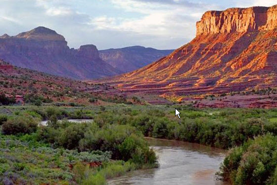
Be sure to check out this short, but great video overflight of 3 dam systems that are being proposed to be built within the Little Colorado River Gorge. These dams would significantly impact unique cultural landscapes that are important for several Indigenous tribes, as well as impact critical, natural habitat for the endangered Humpback Chub. […]
Click here to read the discussion from the Colorado Basin River Forecast Center. Here’s an excerpt:
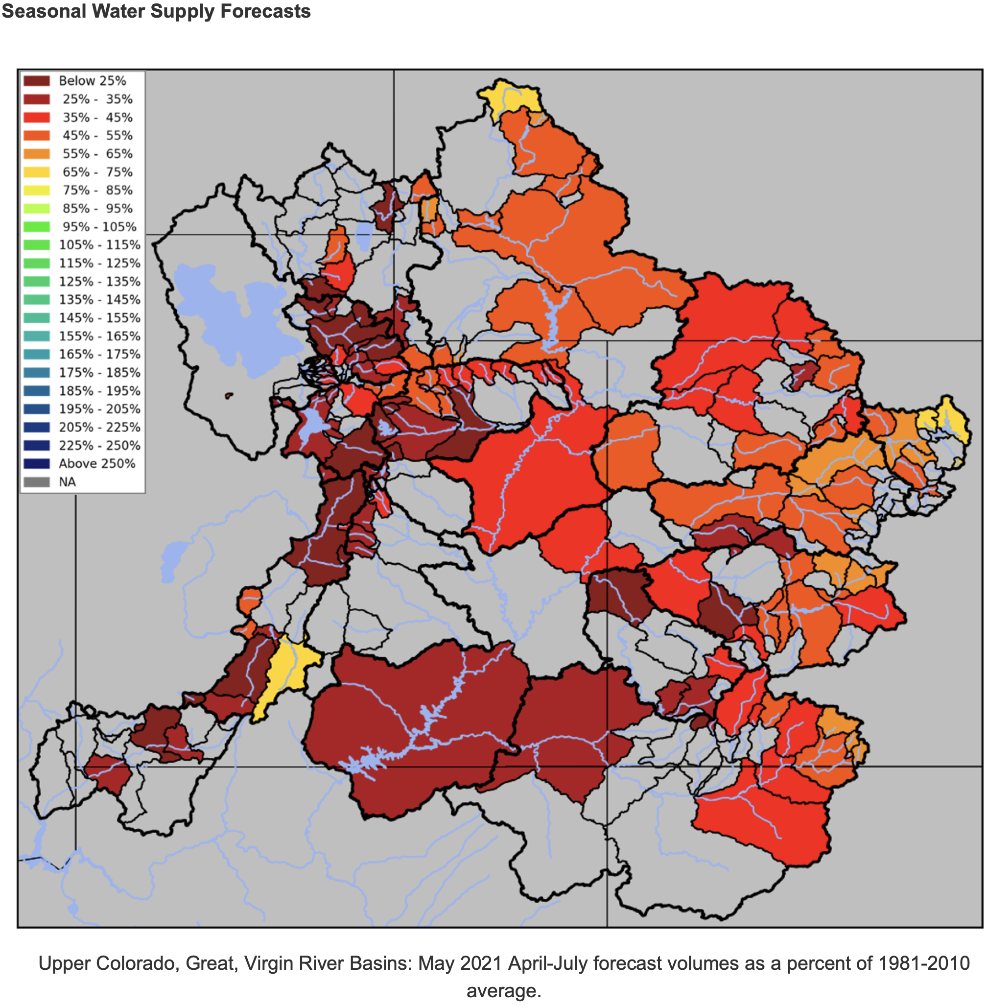
The Colorado Basin River Forecast Center (CBRFC) geographic forecast area includes the Upper Colorado River Basin, Lower Colorado River Basin, and Eastern Great Basin.
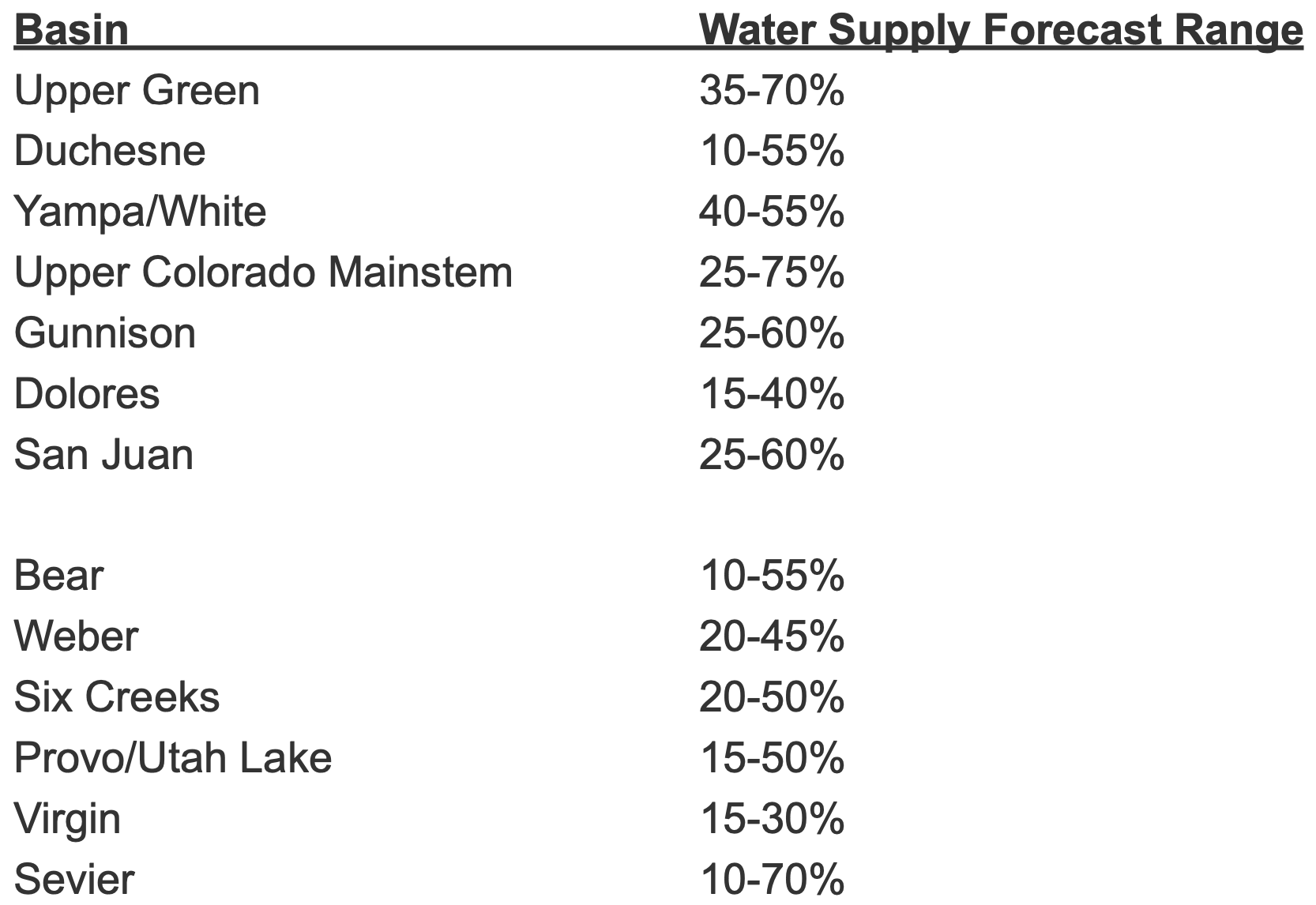
Water Supply Forecast Summary
Early May water supply volume forecasts are below to much below normal throughout the Colorado River Basin and Great Basin. Upper Colorado River Basin water supply forecasts range between 15-75% of the 1981-2010 historical April-July average. Great Basin water supply forecasts are 10-70% of average. Water supply guidance as a percent of average decreased by 10-20% across the majority of the Upper Colorado River Basin and decreased by 5-15% across the majority of the Great Basin over the past month. Many April-July volume forecasts fall in the bottom (driest) five on record. Water supply forecast ranges (percent of normal) by basin are listed below.
April average temperatures were slightly below normal across the north and slightly above normal across the south. April precipitation was mostly below to well below normal across the Upper Colorado Basin and Great Basin. Several SNOTELs in the San Juan, Gunnison, and Yampa River Basins were below the 10th percentile for April precipitation. Below normal soil moisture and snowpack conditions in addition to below average April precipitation and relatively mild (near normal) April temperatures across the Upper Colorado River Basin and Great Basin lead to mostly below normal and in some cases record low observed April flows (unregulated streamflow volumes) across the region. A number of streamflow sites had record low April flows with many locations falling in the bottom five of their period of record.
Snow water equivalent (SWE) at the majority of SNOTEL stations across the region peaked between 70-85% of the normal peak SWE. Early May SWE conditions are below to much below normal (median) throughout the CBRFC forecast area. Upper Colorado River Basin SWE conditions generally range between 50-75% of the 1981-2010 historical median and Great Basin SWE generally ranges between 30-60% of normal.
April-July unregulated inflow forecasts for some of the major reservoirs in the Upper Colorado River Basin include Fontenelle 380 KAF (52% of average), Flaming Gorge 450 KAF (46%), Green Mountain 150 KAF (55%), Blue Mesa 340 KAF (50%), McPhee 81 KAF (27%), and Navajo 325 KAF (44%). The Lake Powell inflow forecast is 2.0 MAF (28% of average), a 17% decrease from April.
In response to increasing flows in the critical habitat reach, the Bureau of Reclamation has scheduled a decrease in the release from Navajo Dam from 500 cubic feet per second (cfs) to 400 cfs on Saturday, May 8th, starting at 0400 AM. Releases are made for the authorized purposes of the Navajo Unit, and to attempt to maintain a target base flow through the endangered fish critical habitat reach of the San Juan River (Farmington to Lake Powell).
The San Juan River Basin Recovery Implementation Program recommends a target base flow of between 500 cfs and 1,000 cfs through the critical habitat area. The target base flow is calculated as the weekly average of gaged flows throughout the critical habitat area from Farmington to Lake Powell. Please be advised, due to the dry conditions this year, more release changes than usual may occur.
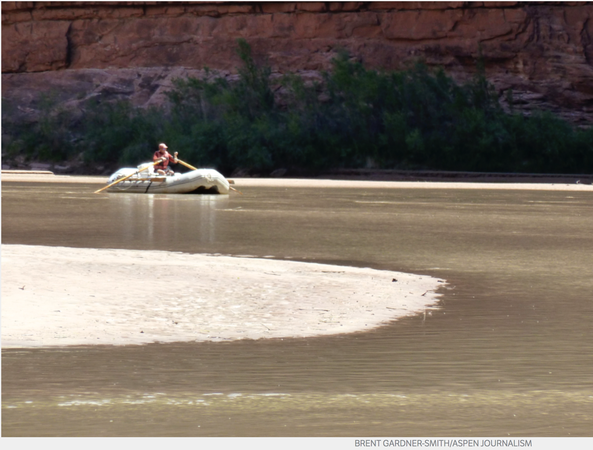
A boater, John Dufficy, makes his way down the lower end of the San Juan River toward the take-out, in 2014. Photo Credit: Aspen Journalism/Brent Gardner-Smith
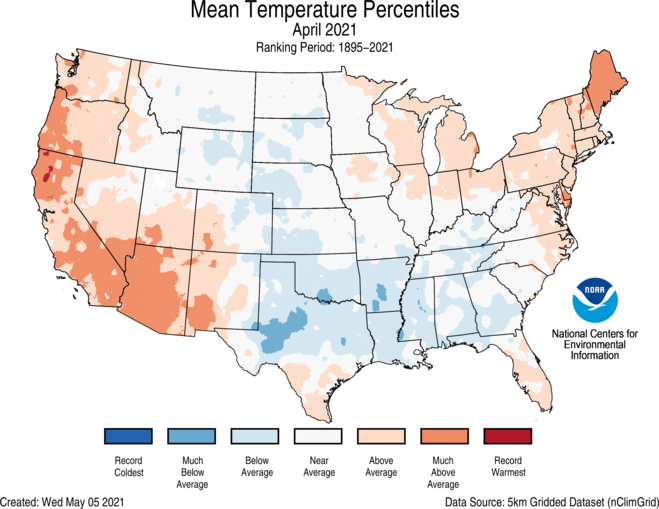
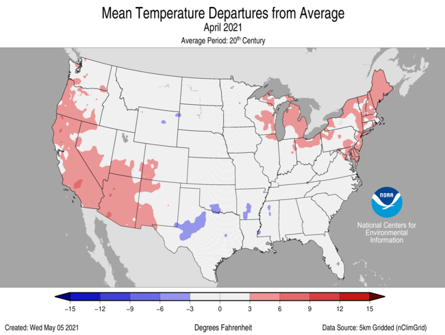
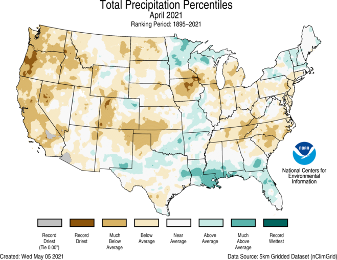
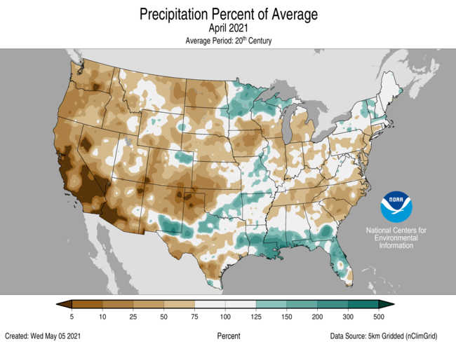
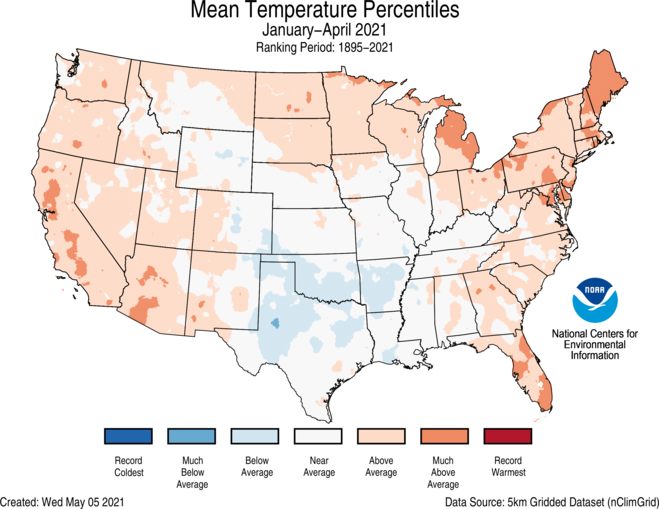
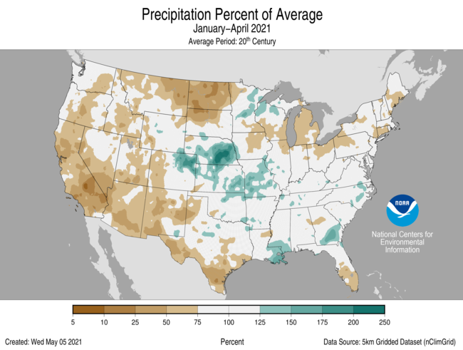
During April, the average temperature of the contiguous United States was 51.9°F, 0.9°F above the 20th-century average. This ranked in the middle third of the 127-year period of record. The year-to-date (January-April) average contiguous U.S. temperature was 40.7°F, 1.6°F above average, ranking in the warmest third of the record. The April precipitation total for the contiguous U.S. was 2.03 inches, 0.49 inch below average, and ranked as the 14th-driest April in the 127-year period of record. This was the driest April since 1989. The year-to-date precipitation total was 8.63 inches, 0.85 inch below average and ranked in the driest third of the January-April record.
The preliminary count of 73 tornadoes reported in April was the lowest April total since 53 tornadoes were reported in 1992 and was also nearly half of the April 1991-2010 average of 155 tornadoes.
This monthly summary from NOAA National Centers for Environmental Information is part of the suite of climate services NOAA provides to government, business, academia and the public to support informed decision-making.
April
Temperature
Temperatures were above average across much of the West Coast, Southwest, Northeast, Great Lakes and parts of southern Texas and Florida. Maine ranked fifth warmest on record for April.
A large portion of the southern Plains and Gulf Coast states experienced below-average temperatures, as did portions of the northern and central Rockies, northern and central Plains and the Tennessee Valley.
The Alaska April temperature was 23.6°F, 0.3°F above the long-term average, ranking in the middle third of the 97-year period of record. In general, the interior portions of the state were cooler than average, while the Aleutians experienced above-average temperatures for the month.
Despite the mild average, large temperature swings were seen throughout the month as records were set for both coldest temperatures seen so late and warmest temperatures seen so early in the season across portions of Alaska.
Bering Sea ice cover for April was 80 percent of average and the highest for April since 2016.
Precipitation
A majority of the Lower 48 experienced below-average precipitation during April with four states across the West ranking among their 10-driest Aprils on record. Oregon ranked third driest while California ranked fifth driest on record for April. Precipitation was above average across portions of the northwest Great Lakes, New England, Midwest, southern Plains and Gulf Coast.
April is climatologically either the driest or second-driest month of the year across Alaska. For April 2021, precipitation received was above average for the state as a whole. Fairbanks saw significant April snowfall with more than 16 inches reported for the month — its second-highest April total on record.
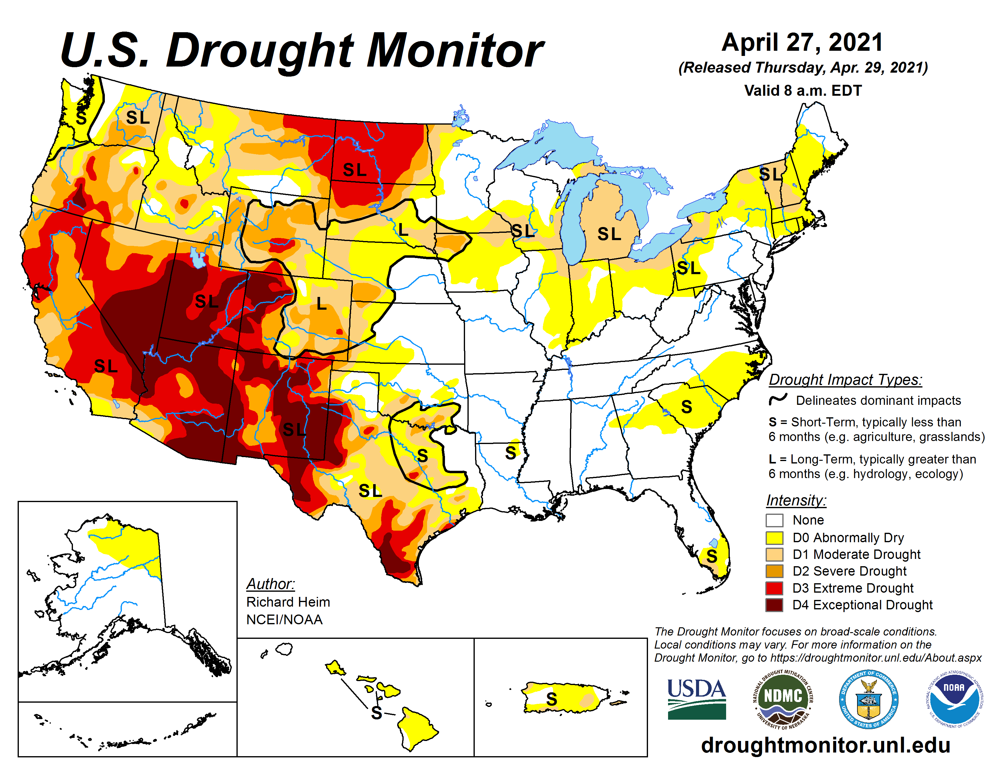
According to the April 27 U.S. Drought Monitor report, 48.4 percent of the contiguous U.S. was in drought, up nearly 4.5 percent since the end of March. Drought conditions intensified and/or expanded across the eastern Great Lakes, Northeast, northern Rockies, northern Plains and the West Coast. Drought intensity and/or severity lessened across portions of the Upper Mississippi Valley, southern Plains and central Rockies.
Year-to-date (January-April)
Temperature
Temperatures were above average over much of the West, northern Plains, Great Lakes, Northeast and Southeast. Maine ranked fifth warmest on record for the first four months of the year. Below-average temperatures were primarily found across portions of the southern Plains.
The Alaska January-April temperature was 11.1°F, 0.8°F above the long-term average and ranked in the middle third of the record. Temperatures were below average across portions of the Southeast Interior, Northeast Gulf and Cook Inlet regions and above average over much of the Bristol Bay and Aleutian regions.
Precipitation
Below-average precipitation extended from the West Coast to the northern Plains and from the southwestern Great Lakes to the Northeast, and across southern Texas. North Dakota ranked driest for this four-month period while Montana and Connecticut ranked seventh and ninth driest, respectively. Above-average precipitation was limited to portions of the central Plains, northwest Great Lakes, central Gulf Coast and parts of the Southeast.
Precipitation across Alaska for the January-April period ranked in the wettest third of the 97-year record.
Steamboat Springs has been seeing some much needed rain to start the month of May, which is historically the wettest month of the year for the Yampa Valley.
The Community Collaborative Rain, Hail and Snow Network, which is a collection of volunteers that submit data to the Colorado Climate Center, have observed about 0.3 inches of rain in Steamboat since Sunday…
Despite recent rain, however, water experts say it’s not enough.
“There hasn’t been a tremendous amount of rain, and it is pretty standard for us to get some spring rain, so I don’t think it is going to overcome the deficit that we were already in,” said Erin Light, Division 6 engineer for the Colorado Division of Water Resources.
Light placed water restrictions on the river last year and in 2018, but it is still too early to know if that will be needed this year. She said they are working with the Colorado River District to find ways to avoid a call, potentially releasing water from Elkhead Reservoir.
If a call is avoided, Light said it would likely be because of this collaboration. Still, reservoir releases don’t necessarily fix the problem.
“It doesn’t eliminate the fact that there may be no more stream flow left in the river,” Light said. “It is very possible that we are going to get to a point where our natural stream flow runoff has gone to nothing, and the only thing we are seeing in the river is reservoir water at certain locations.”
This is what happened at the end of summer 2020 and in 2018 to trigger the call.
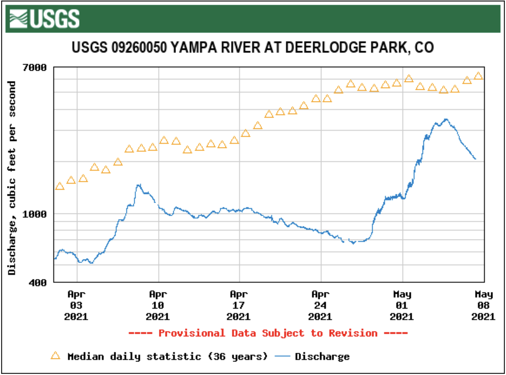
Light said she is mainly looking at stream flows particularly farther down the river. She focuses on the gauges near Maybell and Deerlodge Park that are both in Moffat County, downstream from many irrigators that pull from the Yampa River west of Steamboat.
“You can only put so many straws in the river before you start to run out of water,” Light said, adding that both of the gauges have hit record lows in recent weeks…
At 10 a.m. Wednesday, both gauges showed flows were only about 20% as strong as they were this time last year. When looking at three-month outlooks, it suggests this summer will be both hotter and drier than normal, Light said.
Steamboat typically receives about 2.5 inches of rain in May, according to the 30-year average from the National Oceanic and Atmospheric Administration.
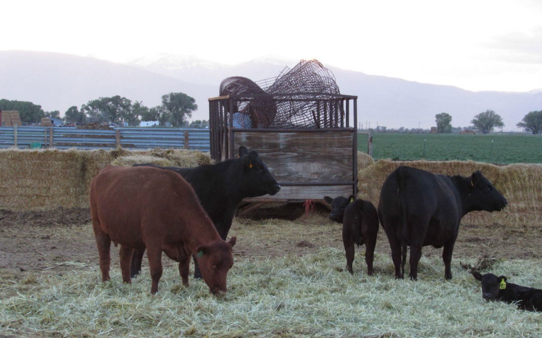
Bill Fales cutting hay near Carbondale August 2020. The summer’s drought led to a 40% smaller crop than what he would normally harvest at the first cutting of the season. “I’m going to have to sell cows because I just don’t have enough hay and it’s too expensive to buy to feed to cattle,” he says. Photo credit: Laurine Lassalle / Aspen Journalism
The year of COVID-19, a yoyo ride with China exports, processor uncertainty, head-spinning pricing, the rising reality of a drought devastating rangelands, and the need to fight off swarms of animal rights attacks, not the least of which is the Initiative 16, aimed at terminating livestock husbandry, leaves the typical meat producers gasping for breath and fighting for his/her life.
While demand is up well over last year and prices are climbing, Colorado ranchers face some uncertain times. Consumers will be facing higher prices, especially in the food service industry. Packers say there is plenty of beef in the pipeline. But demand is raising numbers. Last year a tenderloin was selling at about $8 a pound. The uptick in wholesale prices has the same cut now selling for double that. One would think this is good medicine for cattle producers. But other factors are at work. One is the lack of water…
The Forest Service and BLM managers are presently looking at dropping permit carrying numbers by as much as 20 to 40%. For a permit allowing, say 15 cows per section, that is a call for serious herd culling…
Daris Jutten, a member of the Uncompahgre Water Users Association board looks at the situation from a water manager and rancher perspective.
“I think it (the cattle count) has to be going down. The whole west is in a serious drought,” he says. On the numbers, Jutten sees maybe 30% less turned out to grass (turned onto summer range) in the west, as a whole.”
[…]
Kurt Sanburg, longtime Bostwick Park operator, says about the moisture, “We haven’t received a 10th of an inch yet but it’s drizzling (on Monday this week). I will be reducing our number of cows pretty significantly. I will drop the cow count by as much as 25%,” he says.
Meanwhile, another Sanburg, Hugh, who ranches a lot of the southern slope of the Grand Mesa, is looking at down numbers as are his neighbors. “There have (already) been some reductions around here due to the drought conditions. I don’t have a crystal ball, but if the severe drought conditions persist through the summer, I would expect to see more movement of cattle within the drought affected areas.”
Sanburg is referring to moving cattle off the range, in other words culling. All the while, praying for rain…
Colorado fed cattle prices bottomed out in July of last year at about $91/cwt. The prices have been up and down and up again until April 22, when they hit $123. But, with costs continuing to go up and range capacity falling, marginal producers will be looking at slim times. That is a sad thing to report considering the rocket ride that whole beef prices are on as restaurant ramps up from the Covid-19 crater of last year.
The slaughter count on all beef is hovering in the high range, although below the peak last year that occurred just before the drastic tumble when the COVID and packer crises hit.
It’s been a noticeably wet and snowy start to the year in Denver. In fact, it’s been the wettest start to a year since the early 1940s.
The Mile High City has seen close to 8 inches of precipitation this year already thanks to the big March blizzard bringing us the equivalent amount of moisture as a monsoon thunderstorm as well as multiple over-performing weather events after that.
Annually, Denver picks up just over 14 inches of precipitation, leaving us well ahead of schedule as we head into the hot, summer months…
Colorado Drought Monitor map May 4, 2021.
Most of the recent storms have been helping out the northern Front Range and the northern Front Range only. Areas near Grand Junction, Telluride, Durango, Pagosa Springs and Glenwood Springs are suffering from severe and exceptional drought and have been for quite some time.
Since May 2019, select areas across the Western Slope and southwest Colorado have seen the rainfall deficit grow to over 20 inches, but most areas have a deficit between 12 and 20 inches over the past two years. The drought that has been ongoing in this area of the state has been growing in size and intensity, leaving the upcoming summer a season with looming fire and water supply concerns.
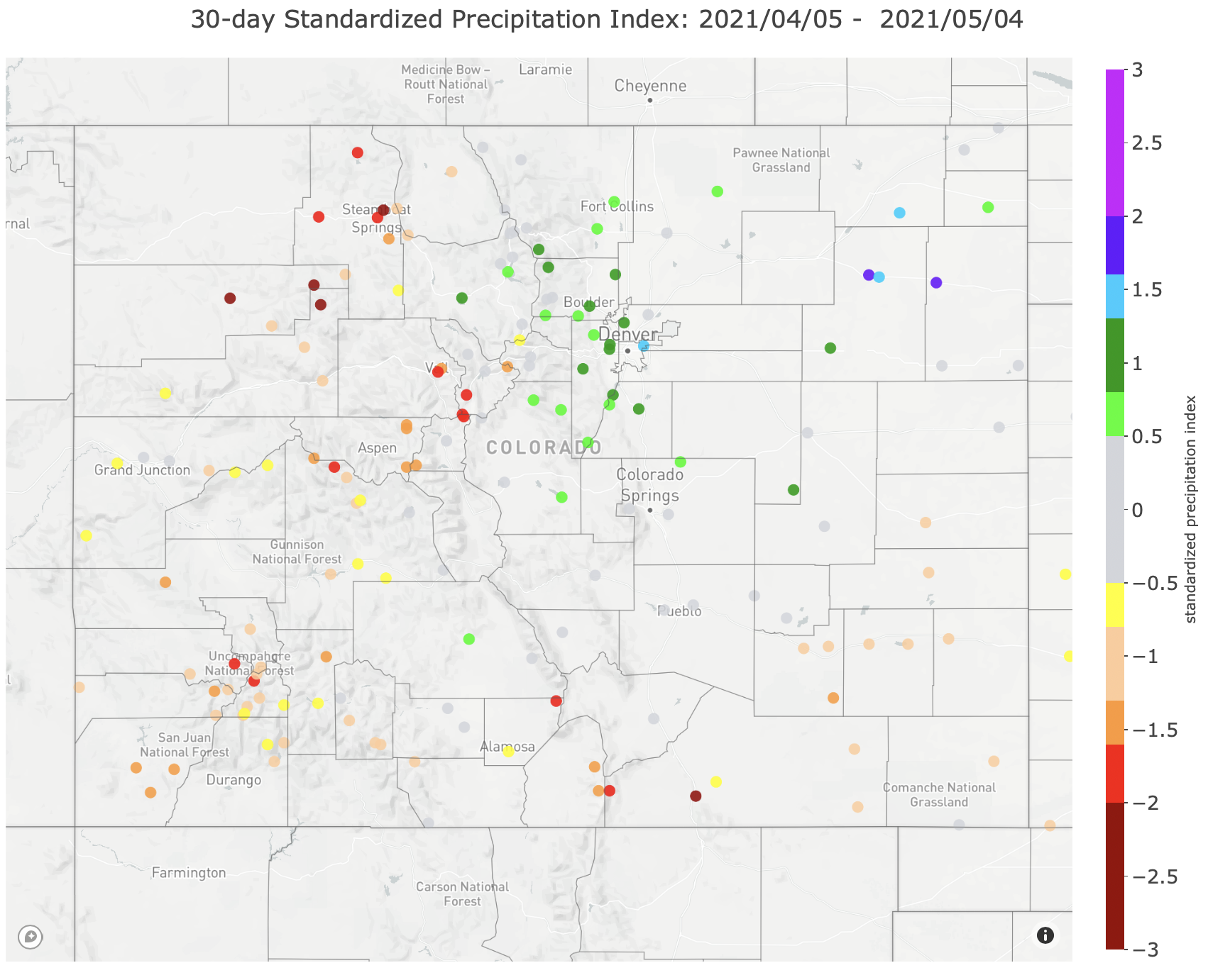
30-Day Standardized Precipitation Index Map May 7, 2021 via the Colorado Climate Center.
The Standardized Precipitation-Evapotranspiration Index measures drought in an area based on the size and duration and until recently, the worst SPEI reading for the Western Slope came in 2002 with a value of -1.7. The current SPEI index is sitting at -2.1, the worst that has ever been seen since records started in the late 1800s and a very concerning number as we head into the hot, dry months.
As the national climate advisor, Gina McCarthy has the ear of President of Joe Biden in all matters climate.
But in the opening session of the 21st Century Energy Transition Symposium on Tuesday, she barely mentioned climate except to vaguely affirm “the science” and to describe the Biden response to climate change as a “very different framing than we’ve had before.”
The framing she described is that of opportunity in the clean energy economy—including the potential for Colorado to be part of the solutions needed in the energy shift.
“We have to look at the opportunities (in a clean energy economy) and get people excited about the benefits it brings to them,” she said before describing cleaner air and jobs.
“(Biden) embraced this not as a wonky science problem but fundamentally a people problem,” she said.
Gina McCarthy via The Mountain Town News.
McCarthy described her job as sitting at the table with the cabinet secretaries, making sure that there’s a climate change overlay in all matters, whether housing or transportation, and helping knit together the response. It isn’t to be just an Environmental Protection Agency problem or a Department of Energy problem.
“It has to be a whole government approach because without that we would lose these synergies and these momentums,” she said.
Biden, she said, saw the response to climate change delivering answers to how we get out of the pandemic and restart the economy. Economic strategies that result in investment of “tremendous resources in a way that wins the clean energy future” will also fuel economic growth. As for covid and climate, addressing their challenges both require acceptance of science.
Another major driver of Biden’s view of domestic policy was the new lens of equity, including that of environmental or energy justice. The pandemic showed that impacts did not hit all communities equally, and by extension, energy systems of the past had more deleterious impacts to some groups than others. This understanding should be seen less as a challenge than a reckoning, said McCarthy.
Not all answers to reducing greenhouse gas pollution are yet evident, even if there are strong winds in the sails of renewable generation of electricity. That’s OK, she said.
“We don’t always need the answer,” she said. “We need to be leaning forward and looking at where we want to go.”
That was a theme in the two-day conference. In session after session, speakers described both clear direction going forward in reducing greenhouse gas emissions from energy, but uncertainties that they hope will be resolved in the next 5 to 10 years.
“That we don’t have all the answers shouldn’t be a barrier to action in the short term,” said Bryan Willson, executive director of the Energy Institute at Colorado State University.
“We don’t need to let the perfect get in the way of the good,” said Steven Hamburg, a senior scientist with the Environmental Defense Fund. If uncertainties should not delay forward movement of the broad strokes of action, he counseled caution to avoid “big and expensive mistakes.”
Executives at Colorado’s two largest electrical utilities, Xcel Energy and Tri-State Generation & Transmission, described a similar mix of bold actions and uncertainty.
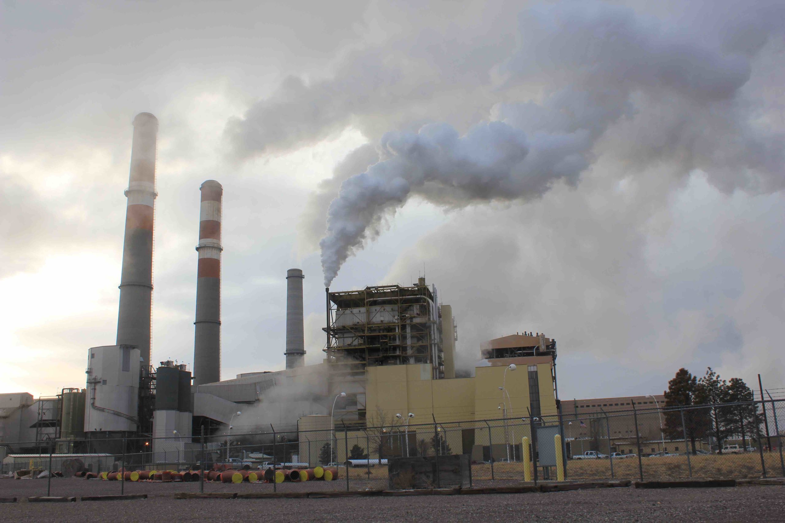
In 2020, coal-fired generation delivered 26% and natural gas 38% of electricity distributed by Xcel. The company projects coal generation will fall to 4% and natural gas 16% by 2030.
That remaining coal-fired power will come from Comanche 3, the only coal-fired plant in Colorado that Xcel plans to continue operating, but at a reduced rate. Why not also close Comanche 3?
If Xcel Energy is comfortable closing Comanche units 1 and 2 in 2022 and 2024, it wants to keep Comanche 3 operating until 2040, if at minimal capacity. Photo/Allen Best
Alice Jackson, chief executive of Xcel’s Colorado division, explained that continuing operation of Comanche 3 will ensure a softer financial transition for Pueblo County, where the plant is located. The plant will also be needed to ensure reliability, as storage needs technological advancement and lower prices. “It’s really a broad evaluation and not just one factor,” she said.
Tri-State also awaits some technological innovation. It plans to close its three units at Craig in 2025, 2028 and 2029. Duane Highley, the chief executive, said Tri-State has closely been monitoring technological innovation in hopes of technology that can store energy for days, not just hours. “We’re looking hard at hydrogen and also looking at ammonia,” he said. QUESTION
Transmission also figures prominently into the thinking about the energy systems of the next decade. One Colorado energy official calls it the “secret sauce” necessary for deep decarbonization.
In Colorado, electrical demand is projected to grow 50% in the next 30 years as we electrify transportation and, a little more slowly, replace fossil fuels in heating our homes and water. Xcel has proposed investment of $1.7 billion in new transmission lines in eastern Colorado. Other utilities have not yet played their cards.
But some energy analysts see need for even more ambitious investment in a grid that better links different parts of the country so that renewable energy can be matched with demands.
The Texas disaster in February helps illustrate why. Texas was ill-equipped for the deep freeze. It lost natural gas generation because of lack of winterization. But it almost completely lost wind generation, which plummeted from 68,000 megawatts to 2,000 megawatts as the storm began dropping a rare three-inch snowfall on Houston. Had Texas been connected with regions of the country where the sun was shining or the wind blowing, it might have imported enough power to keep on the lights.
It wasn’t just Texas, though. The same loss of wind generation that accompanied the deep freeze posed worrisome problems to Fort Collins-based Platte River Power Authority, which issued a precautionary warning. Tri-State also noted the loss of wind generation in the still atmosphere that accompanied the cold.
More transmission can allow utilities to draw on a broader menu of renewables in such situations, even on a daily basis. The Great Plains boast great winds, the Southwest blazes with solar.
How is this knitting together to be done? Transmission in western states must inevitable cross the vast public lands. In Colorado, 36.2% of the state is administered by federal land agencies, principally the Bureau of Land Management and the U.S. Forest Service. New Mexico is close behind at 35%. Wyoming is 48%. In Utah, it’s 70%.
“On public lands, as important as they are, a balance has to be struck,” said McCarthy, “but the balance cannot get in the way of effectively addressing climate change, which is an existential threat to all of us.” And, she added, hewing to the sales pitch of the Biden administration, “to take advantage of the economic benefits that a clean energy jobs provide.”
McCarthy, a live wire herself in her public appearances, also pointed to the joint announcement by the federal transportation and energy departments of a plan to expand use of rights of way for highway and railroads for transmission. This will help more expeditious investment in transmission, she said.
“There are probably 20 areas where we would be able to immediately make investments in transmission in ways to utilize those rights of ways to open up new transmission and opportunities for renewable energy,” she said.
Colorado has a goal of 80% decarbonization of the electrical grid by 2030 and 50% decarbonization of its economy altogether. Biden had offered a far more aggressive target, 100% decarbonization of the electrical grid by 2035 and a 50% to 52% economy wide target.
To push this decarbonization of electricity, McCarthy said she leans toward a clean energy standard, as advocated by Holy Cross Energy, an electrical cooperative, and 12 other utilities from New York to California, in a letter sent to Biden in April. The letter called for a federal requirement that electrical utilities be able to supply 80% of their power from non-carbon sources by 2030 as compared to 2005 levels.
“If you nationalize, you get some terrific opportunities,” said McCarthy. “Most of us are shifting from cap and trade, because of the complexity, but looking more at direct investments and things like the clean electricity standard.”
Carbon pricing, she added, “is not something that is going away. I just find it less satisfying.”
In all this, the Biden administration sees need for more research. McCarthy mentioned technological innovations that have occurred in the last 50 years since the United States put Neil Armstrong’s footprint on the moon. The federal government has often played a role in instigating technological innovation, she said, using federal funds to spur innovation and investment in the private sector.
McCarthy said the Department of Energy has billions of dollars of loans and an accelerator that uses the green bank model.
Former Colorado Gov. Bill Ritter interviews Amory Lovins at the Center of the New Energy Economy conference on Oct. 30, 2017. Photo/Maury Dobbie
Colorado State University has already played a role in the Biden administration’s view of innovation, Ritter told McCarthy in what he described as a “shameless plug.”
A group of researchers and academics at CSU was the source of an idea contained in the Biden campaign Energy and Environment Platform. That idea, to create an advanced research project agency for climate, also called an ARPA-C, within the Department of Energy, has become part of the Biden budget proposal.
It would stand alongside the existing ARPA-E, which is devoted to technical solutions. For example, it recently announced a $35 million grant program for ideas to reduce emission of methane from oil and gas supply chains, coal mines and other sources.
CSU’s idea, Ritter explained, is to offer a multi-disciplinary—and not purely technical approach—to climate solutions. Those in the social sciences would be included.
“When you are making a shameless plug, it’s good to be telling the truth,” McCarthy replied. “It’s well deserved.”
Reservoir expected to reach only about 90% of capacity this summer
The dry, warm month of April prevented the snowpack from building and sunk the chances to fill Ruedi Reservoir this summer, according to the U.S. Bureau of Reclamation…
The snowpack in the upper Fryingpan Valley was only about 60% of median as of May 1, he said. Forecasts are for runoff into the reservoir to be only about 55% of average…
Ruedi Reservoir is at about 60% full right now. It holds 102,000 acre-feet of water. It would need about 42,000 acre-feet to fill.
Current projections are for it to reach about 90,000 acre-feet this summer, according to Miller…
The Roaring Fork River basin, like much of Colorado and the Western United States, has been battling a prolonged drought. AccuWeather Inc. reported Wednesday that 75% of the Western U.S. is experiencing drought conditions. About 21% of the areas are facing exceptional drought, which is the most extreme…
West Drought Monitor map May 4, 2021.
A lower water level in the reservoir also will mean lower releases into the lower Fryingpan River through the summer. Water levels won’t be as high as usual in late spring and early summer, so there won’t be a disruption to the Gold Medal trout stream.
However, low water levels and high summer temperatures are a regular cause for concern. The Basalt-based Roaring Fork Conservancy has sounded the alarm in past summers about high water temperatures stressing trout.
Water releases could increase in June once downstream entities that possess senior water rights make a “call” for water for agricultural uses, Miller said.
April Long, director of the Ruedi Water and Power Authority, said the reservoir is used to meeting numerous water needs in the Roaring Fork Valley and on the Colorado River system. It is hard to know the full impact of the reservoir not filling, she said.
Navajo Reservoir, New Mexico. View looking north toward marina. The Navajo Dam can be seen on the left of the image. By Timthefinn at English Wikipedia – Transferred from en.wikipedia to Commons., Public Domain, https://commons.wikimedia.org/w/index.php?curid=4040102
From email from Reclamation (Susan Novak Behery):
In response to forecast warmer weather and increasing flows in the critical habitat reach, the Bureau of Reclamation has scheduled a decrease in the release from Navajo Dam from 600 cubic feet per second (cfs) to 500 cfs on Friday, May 7th, starting at 0400 AM. Releases are made for the authorized purposes of the Navajo Unit, and to attempt to maintain a target base flow through the endangered fish critical habitat reach of the San Juan River (Farmington to Lake Powell).
The San Juan River Basin Recovery Implementation Program recommends a target base flow of between 500 cfs and 1,000 cfs through the critical habitat area. The target base flow is calculated as the weekly average of gaged flows throughout the critical habitat area from Farmington to Lake Powell. Please be advised, due to the dry conditions this year, more release changes than usual may occur.
Here’s the release from the Department of Interior:
Today, the U.S. Fish and Wildlife Service announced a proposed rule to revoke the January 7, 2021, final regulation that limited the scope of the Migratory Bird Treaty Act (MBTA). Significant concerns about the interpretation of the MBTA have been raised by the public, legal challenges in court and from the international treaty partners.
This proposed rule provides the public with notice of the Service’s intent to revoke the January 7 rule’s interpretation of the MBTA and return to implementing the MBTA as prohibiting incidental take and applying enforcement discretion, consistent with judicial precedent.
“The Migratory Bird Treaty Act is a bedrock environmental law that is critical to protecting migratory birds and restoring declining bird populations,” said Secretary Deb Haaland. “Today’s actions will serve to better align Interior with its mission and ensure that our decisions are guided by the best-available science.”
“Migratory bird conservation is an integral part of the U.S. Fish and Wildlife Service’s mission,” said Service Principal Deputy Director Martha Williams. “We have heard from our partners, the public, Tribes, states and numerous other stakeholders from across the country that it is imperative the previous administration’s rollback of the MBTA be reviewed to ensure continued progress toward commonsense standards that protect migratory birds.”
On January 7, the Service published a final rule defining the scope of the MBTA as it applies to conduct resulting in the injury or death of migratory birds protected by the MBTA. This rule made significant changes to the scope of the MBTA to exclude incidental take of migratory birds, with an effective date of February 8.
The Service extended the effective date until March 8 and opened a public comment period. Rather than extending the effective date again, the agency believes the most transparent and efficient path forward is instead to immediately propose to revoke the rule.
The Service requests public comments on issues of fact, law and policy raised by the MBTA rule published on January 7. Public comments must be received or postmarked on or before June 7, 2021. The notice will be available at http://www.regulations.gov, Docket Number: FWS-HQ-MB-2018-0090, and will include details on how to submit your comments.
The agency will not accept email or faxes. If you provided comments in response to the February 9, 2021, notice to extend the effective date, you do not need to resubmit those comments. All comments will be considered.
On March 8, 2021, Interior rescinded the 2017 Solicitor’s Opinion M-37050 on the MBTA that had overturned decades of bipartisan and international consensus. The reasoning and basis behind that M-Opinion were soundly rejected in federal court. The Endangered Species Act and the Bald and Golden Eagle Protection Act, as well as state laws and regulations, are not affected by the Solicitor’s Opinion M-37050 or the January 7 final regulation.
Click on a thumbnail graphic to view a gallery of drought data from the US Drought Monitor.
US Drought Monitor map May 4, 2021.
West Drought Monitor map May 4, 2021.
High Plains Drought Monitor map May 4, 2021.
Colorado Drought Monitor map May 4, 2021.
Click here to go to the US Drought Monitor website. Here’s an excerpt:
This Week’s Drought Summary
This U.S. Drought Monitor (USDM) week saw an active weather pattern with severe weather observed across portions of the central and southern Plains, Texas, mid-South, Midwest, and the Northeast. In Texas, 7-day rainfall accumulations ranged from 2 to 10+ inches leading to significant improvement in drought-related conditions across the state. Likewise, areas of northeastern Colorado and portions of the central Plains received much-needed rainfall (2-to-4-inch accumulations) leading to improvements on the map. Out West, 83% of the region is currently in moderate-to-exceptional drought with the most severe conditions centered on the Four Corners states, California, and Nevada. In California, conditions deteriorated on this week’s map in response to a combination of factors including back-to-back dry water years, above-normal temperatures, below-normal snowpack, and drought impacts (agricultural, ecosystem health, water supply, recreation)…
On this week’s map, areas of the region—including Kansas, Nebraska, Colorado, and Wyoming—saw improvements, including a reduction in areas of Severe Drought (D2) in southwestern Nebraska and northwestern Kansas as well as in areas of Moderate Drought (D1) in northeastern Colorado and southeastern Wyoming. In northeastern Colorado, 2 to 4+ inches of rainfall were observed during the past week, which provided a timely boost in soil moisture conditions for recently planted crops. Elsewhere, areas of Extreme Drought (D3) expanded in northern South Dakota and southern North Dakota. In northwestern South Dakota, the town of Lemmon saw its driest January through April period on record with only 0.71 inches of precipitation observed. The South Dakota State Extension and the North Dakota State Climate Office are both reporting drought-related impacts in their respective states, including poor water quality for livestock and dry stock ponds. In western North Dakota, dry conditions and strong winds have been exacerbating fire-related conditions as firefighters are battling two wildfires in the Dakota Prairie Grasslands. Average temperatures for the week were above normal across the region with positive temperature anomalies ranging from 2 to 9 deg F above normal…
On this week’s maps, areas of drought expanded across California, Oregon, and Washington following a very dry April. In California, areas of Extreme Drought (D3) expanded across the northern and central Sierra Nevada, as well as in areas of the San Joaquin Valley where water deliveries have been severely reduced due to the poor snowpack conditions across the Sierra (59% of normal on April 1 statewide) and below normal reservoir conditions. For the Water Year (since October 1), precipitation across most of California has been much below normal (bottom 10th percentile) with some locations—including areas of southeastern California, and the greater Bay Area—experiencing record or near-record dryness. In Marin County, the Marin Water District declared a water shortage emergency on April 20 in response to Marin’s total reservoir storage level dipping to 50% of capacity, whereas average storage for the date (May 4) is normally 90% of capacity. California’s two largest reservoirs, Lake Shasta and Lake Oroville, were at 50% and 42% of normal, respectively, on May 4. Across the region, statewide reservoir storage levels were below normal in Arizona, California, Colorado, Idaho, Nevada, New Mexico, and Washington according to the NRCS on April 1. On the Colorado River system, the U.S. Bureau of Reclamation (May 5) is reporting Lake Mead at 38% of capacity while upstream Lake Powell is 35% full. In Oregon, drought-related conditions continue to deteriorate in western Oregon after a dry April. On the map, areas of D1 to D4 expanded in Oregon this week in response to a rapid decline of the mountain snowpack across the Cascades in addition to anomalously dry soils and well-below-normal streamflow levels. For the week, average temperatures were above normal (2 to 10 deg F) across most of the West, with the exception of areas of southeastern Arizona and southern New Mexico where temperatures were 2 to 9 deg F below normal…
On this week’s map, widespread improvements in areas of drought were made across Texas (and southern and eastern Oklahoma) in response to significant precipitation accumulations (ranging from 2 to 10+ inches) with areas along the Texas Gulf Coast and the Hill Country receiving the heaviest accumulations. The slow-moving front that entered the region last week brought severe storms with frequent lighting, tornados, and softball-sized hail that caused extensive property damage with damage estimates expected to exceed $3 billion. This week’s rainfall significantly improved soil moisture levels across much of Texas, but negative soil moisture anomalies remained across the Trans-Pecos and the Texas Panhandle regions according to the NASA Crop-CASMA. According to Water Data for Texas (May 4), monitored water supply reservoirs are currently 83.6% full, with most of the reservoirs in the eastern half of the state ~80% to 100% full and reservoirs in the western half of the state generally <50% full. Average temperatures for the week were below normal (2 to 10 deg F) in the Trans-Pecos, Edwards Plateau, and southern High Plains regions of Texas, whereas the rest of the region was above normal with the greatest anomalies (5 to 15+ deg F) observed in eastern Texas…
Looking Ahead
The NWS WPC 7-Day Quantitative Precipitation Forecast (QPF) calls for moderate-to-heavy liquid accumulations ranging from 2 to 4+ inches across the mid-South and lower Midwest while portions of the Plains, Northeast, Mid-Atlantic, and the Southeast are expected to receive <1-inch accumulations. In the Intermountain West and Pacific Northwest, light precipitation (<1-inch accumulations) is forecasted for areas of the central and northern Rockies, and portions of the Cascades. The CPC 6-10-day Outlook calls for a moderate-to-high probability of above-normal temperatures in the Far West, Southwest, Great Basin, and Florida while a high probability of below-normal temperatures is forecasted across most of the Eastern Tier. In terms of precipitation, there is a moderate probability of above-normal precipitation across areas of the central and southern Plains, as well as the southeastern tier of the U.S. Below-normal precipitation is expected across the Pacific Northwest, Great Plains, and areas of the Intermountain West.
Here’s the one week change map ending May 4, 2021.
US Drought Monitor one week change map ending May 4, 2021.
Just for grins here are US Drought Monitor maps for early May for the past few years.
Here’s the release from the University of California, Santa Cruz (Tim Stephens):
Despite differences in aquatic life and toxic metals in streams across a broad region of the western United States, scientists found common responses to cleanup of acid mine drainage
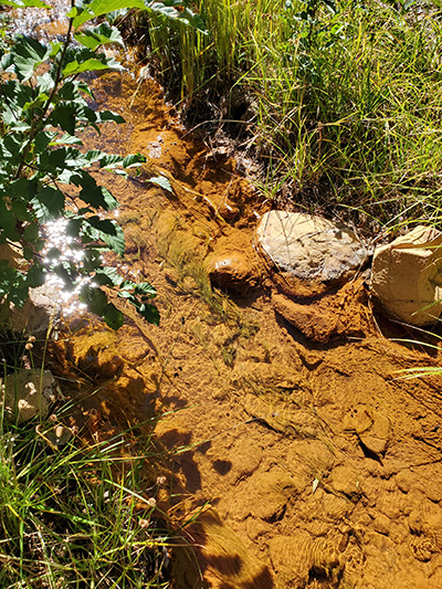
Leviathan Creek below an abandoned open pit mine, an EPA Superfund site in the Sierra Nevada, where iron oxide deposits coat the stream bottom. (Photos by David Herbst)
Many miles of streams and rivers in the United States and elsewhere are polluted by toxic metals in acidic runoff draining from abandoned mining sites, and major investments have been made to clean up acid mine drainage at some sites. A new study based on long-term monitoring data from four sites in the western United States shows that cleanup efforts can allow affected streams to recover to near natural conditions within 10 to 15 years after the start of abatement work.
The four mining-impacted watersheds—located in mountain mining regions of California, Colorado, Idaho, and Montana—were all designated as Superfund sites under the Comprehensive Environmental Response, Compensation, and Liability Act (CERCLA), which helps fund the cleanup of toxic-waste sites in the United States. They are among the few acid mine drainage sites where scientists have conducted extended studies to monitor the effectiveness of the remediation efforts.
“The good news from them all is that Superfund investments can restore the water quality and ecological health of the streams,” said David Herbst, a research scientist at UC Santa Cruz and coauthor of a paper on the new findings to be published in the June issue of Freshwater Science, now available online.
A few kilometers downstream from the mine, significant recovery of water quality and aquatic life has occurred since remediation of acid mine drainage. Photo credit: David Herbst
Leviathan
For the past two decades, Herbst has been monitoring streams affected by acid mine drainage from the Leviathan mine in the central Sierra Nevada. The new study developed out of discussions he had with other scientists involved in long-term studies of similar sites.
“There are not many of these long-term studies of impacted watersheds, and by combining our data we could identify the common threads of recovery between these different sites,” Herbst said.
To assess the recovery of aquatic life in streams and rivers severely polluted by the abandoned mines, the researchers combined data from long-term monitoring over periods of 20 years or more. They used aquatic insects and other diverse invertebrate life (such as flatworms and snails) as indicators of the restoration of ecological health, with nearby unpolluted streams serving as standards for comparison.
Even with differing mixes of toxic metals and different treatment practices used to control the pollution at each site, the studies documented successful recovery to near natural conditions within 10 to 15 years. Much of the recovery was rapid, occurring within the first few years of treatment.
“These promising results and shared paths suggest that even daunting environmental problems can be remedied given the effort and investment,” Herbst said.
Common responses
The research also revealed that the sites shared common responses despite differences in the species of aquatic life occurring across this broad geographic region. Shared feeding habits, patterns of development, and behavioral characteristics unified how stream invertebrates responded to the alleviation of metal pollutants.
Species with traits such as feeding on algae, long life cycles, and clinging to the surfaces of stones became increasingly common as toxicity declined over time. Species that were more prevalent when metal concentrations were higher had traits such as rapid development, short life cycles, feeding on deposits of organic matter, and an ability to escape quickly off the bottom by drifting into the flow of water.
The species most sensitive to toxic metals are the mayflies, stoneflies, and caddisflies. Across all streams, the loss of these sensitive insects occurred at a toxicity level predicted by lab bioassays based on the combined levels of the toxic metals present.
“The convergence of these responses across streams and at a level consistent with how water quality criteria are established lends support to guidelines established for what chemical conditions are protective of stream and river ecosystems,” Herbst said.
The additive toxicity of the metals present determined the response to pollutants, he noted, showing that water quality standards should be based on combined metals present rather than singly for each metal. In other words, even if a metal is below its toxic level, when it is present with other metals the combined effect may exceed the tolerance of aquatic life.
“It is vital to account for this factor in how water quality standards for metals are applied,” Herbst said.
The other coauthors of the study are William Clements at Colorado State University in Fort Collins, Michelle Hornberger and Terry Short at the U.S. Geological Survey in California, and Christopher Mebane at the USGS in Idaho.
A network of streams, lakes and marshes in Florida is suing a developer and the state to try to stop a housing development from destroying them.
The novel lawsuit was filed on Monday in Orange county on behalf of the waterways under a “rights of nature” law passed in November. It is the largest US municipality to adopt such a law to date.
The listed plaintiffs are Wilde Cypress Branch, Boggy Branch, Crosby Island Marsh, Lake Hart and Lake Mary Jane.
Laws protecting the rights of nature are growing throughout the world, from Ecuador to Uganda, and have been upheld in courts in India, Colombia and Bangladesh. But this is the first time anyone has tried to enforce them in the US.
The Orange county law secures the rights of its waterways to exist, to flow, to be protected against pollution and to maintain a healthy ecosystem. It also recognizes the authority of citizens to file enforcement actions on their behalf.
The suit, filed in the ninth judicial circuit court of Florida, claims a proposed 1,900-acre housing development by Beachline South Residential LLC would destroy more than 63 acres of wetlands and 33 acres of streams by filling and polluting them, as well as 18 acres of wetlands where stormwater detention ponds are being built.
In addition to seeking to protect the waterways’ intrinsic rights, the suit claims the development would disrupt the area’s hydrology and violate the human right to clean water because of pollution runoff from new roads and buildings.
Chuck O’Neal, president of campaign group Speak Up Wekiva who will be representing the wetlands in court, told the Guardian he looks forward to giving them a voice. “Our waterways and the wildlife they support have been systematically destroyed by poorly planned suburban sprawl. They have suffered in silence and without representation, until now.”
The housing development, known as the “Meridian Parks Remainder Project”, needs a development permit from the city of Orlando and a dredge-and-fill permit from the Florida department of environmental protection to proceed. The suit seeks to block these from being issued.
O’Neal said he hopes the court “reaches beyond current conventional thinking” in considering the case. “This is how the evolution of rights has occurred in western law since the signing of the Magna Carta through the abolition of slavery, through women’s suffrage and through court decisions such as Brown vs the Board of Education and most recently the acceptance of marriage equality.”
Thomas Linzey, senior legal counsel at the Center for Democratic and Environmental Rights who helped secure Orange county’s rights of nature law last year, said: “Given the rampant development that’s occurred in Florida over the past 30 years, and the power struggle between the state government and local government over these issues, there are multiple grounds for a court to hold that the development cannot proceed as proposed.”
Conscience Bay Company President Eli Feldman stands at a headgate on the Alfalfa Ditch near Cedaredge. Feldman, whose company owns Harts Basin Ranch and irrigates with water from the ditch, has been accused of water speculation: buying the ranch just for the future value of the water. CREDIT: LUKE RUNYON/KUNC via Aspen Journalism
State work group trying to balance risks from investors, negative impacts to agriculture
Melting snow and flowing irrigation ditches mean spring has finally arrived at the base of Grand Mesa in western Colorado.
Harts Basin Ranch, a 3,400-acre expanse of hayfields and pasture just south of Cedaredge, in Delta County, is coming back to life with the return of water.
Twelve hundred of the ranch’s acres are irrigated with water from Alfalfa Ditch, diverted from Surface Creek, which flows down the south slopes of the Grand Mesa. The ranch has the No. 1 priority water right — meaning the oldest, which comes with the ability to use the creek’s water first — dating to 1881.
What makes the ranch unique among its Grand Mesa-area neighbors is its owner. Conscience Bay Company, a Boulder-based private real estate investment firm, bought the property in 2017.
That fact alone has brought its owners scrutiny from neighbors and Western Slope water managers. Conscience Bay and its president, Eli Feldman, have been accused of water speculation — which means buying up the ranch just for its senior water rights and hoarding them for a future profit.
That is an accusation Feldman denies.
“Any time you come into a place that you’re not from, people are curious at best and skeptical and concerned at worst,” he said.
The ranch raises organic beef using regenerative techniques that operators say are better for soil health. Conscience Bay holds grazing permits on tracts of public land in western Colorado and Utah where the cattle feast on grass before being sent to California to be finished, slaughtered and sold under the brand name SunFed Ranch.
To the charges that he’s doing something untoward by investing in the ranch’s land and abundant water rights, Feldman said he’s just like any other major water user in the state putting it to beneficial use. The ranch is using the water to irrigate, he said.
“We’re growing grass and feeding it to cows and trying to improve the ground, improve the soil health and make a business out of it,” Feldman said.
Cowgirls lasso calves so they can be branded and vaccinated at Harts Basin Ranch in April. The Delta County ranch, whose owners have been accused of water speculation, raises organic cattle. CREDIT: HEATHER SACKETT/ASPEN JOURNALISM
Speculation work group
The conversation around water speculation has been heating up in Colorado in recent months. At the direction of state lawmakers, a work group has been meeting regularly to explore ways to strengthen the state’s anti-speculation law. The topic frequently comes up at meetings of Western Slope water managers: the Colorado River Water Conservation District, basin roundtables and boards of county commissioners.
Investments such as Feldman’s have been of interest to the work group, which consists of water managers and users from around the state and is chaired by Kevin Rein, state engineer and head of the Division of Water Resources.
“I think it’s a valid concern because they do see unusual parties, large parties that, again, aren’t the typical parties, purchasing those water rights, and so that’s the concern,” Rein said. “Are they speculating or are they purchasing just so they can flip it, as people say, in a few years for more money?”
Under Colorado law, a water-rights holder must put their water to “beneficial use,” meaning continuing to use the water for what it was decreed in order to hang onto it. But Colorado also treats the right to use water as a private-property right. People can buy and sell water rights, change what the water is allowed to be used for and, if given a court’s blessing, move the water from agricultural use to growing cities.
This system, used widely in the western United States, creates an opening for investors who see water as an increasingly valuable commodity in a water-short future, driven by climate change. A private-equity fund, Water Asset Management, is now the largest landowner in the Grand Valley Water Users Association, which provides water for farmers in the intensely irrigated valley, a short drive from Harts Basin Ranch. The purchases of the New York City-based company have raised suspicions among water managers and prompted the formation of the speculation work group.
Similar concerns have cropped up in agricultural communities throughout the West. A water transfer in Arizona from agricultural lands on the Colorado River to a rapidly expanding Phoenix exurb recently stirred up controversy. In Nevada, Water Asset Management is trying to market water held in an underground aquifer.
Colorado’s current anti-speculation doctrine is based on case law that says those seeking a water right must have a vested interest in the lands to be served by the water and must have a specific plan to put the water to beneficial use.
The work group has identified the following risks from speculators: investors’ obtaining a monopoly over a local water market; large-scale, permanent dry-up of agricultural lands; less water availability for other water users; and violation of Colorado’s values to see a vital public resource traded as a commodity.
Part of Harts Basin Ranch’s hayfields are irrigated with sprinklers. The ranch is owned by Boulder-based Conscience Bay Company and has the oldest water right on the Alfalfa Ditch. CREDIT: HEATHER SACKETT/ASPEN JOURNALISM
Potential risks and solutions
The potential solutions to these risks are many, according to a draft document. The work group is exploring several of these, including creating a process to determine the intent of the purchaser; taxing profits from the sale of water rights at varying rates to encourage beneficial use and to discourage profiteering; imposing time limits on turnover of ownership to discourage short-term “flipping”; encouraging local governments to police investments through their 1041 powers; and creating a public-review process for water transfers that exceed some threshold.
The group has not coalesced around any of these potential solutions, but state officials said they are zeroing in on using the water court process to evaluate transfers as a way of spotting speculation.
The work group is supposed to submit a report, along with any recommendations from members, to state officials by August. But so far, the group has had a difficult time making sense of the thorny questions raised by these issues. Even trying to define what speculation is (and isn’t) and who is considered a speculator has been a struggle.
“It’s one thing to point at something and say, ‘Oh, that’s probably speculative.’ Another to actually put the legal definition on it,” said Alex Funk, agricultural water-resources specialist with the Colorado Water Conservation Board. Funk is also a member of the work group.
Discussions so far about reining in speculation have focused on the intent of the buyer. Can the state determine whether someone who is purchasing water rights intends to grow hay or build a residential subdivision? Or are they solely focused on the water rights’ future value? And how do you tell the difference?
“Do we want to protect against certain types of intent?” Rein said. “And then how do we determine that?”
Predetermining a water-right purchaser’s intent could prove to be a difficult task, akin to stopping a crime before it’s actually committed. Funk invoked the 2002 film “Minority Report,” in which a police detective (played by Tom Cruise), with the help of three psychics, tracks down would-be murderers and arrests them before any gun goes off.
“There aren’t speculation police running the state and breaking up these investments, right?” Funk said.
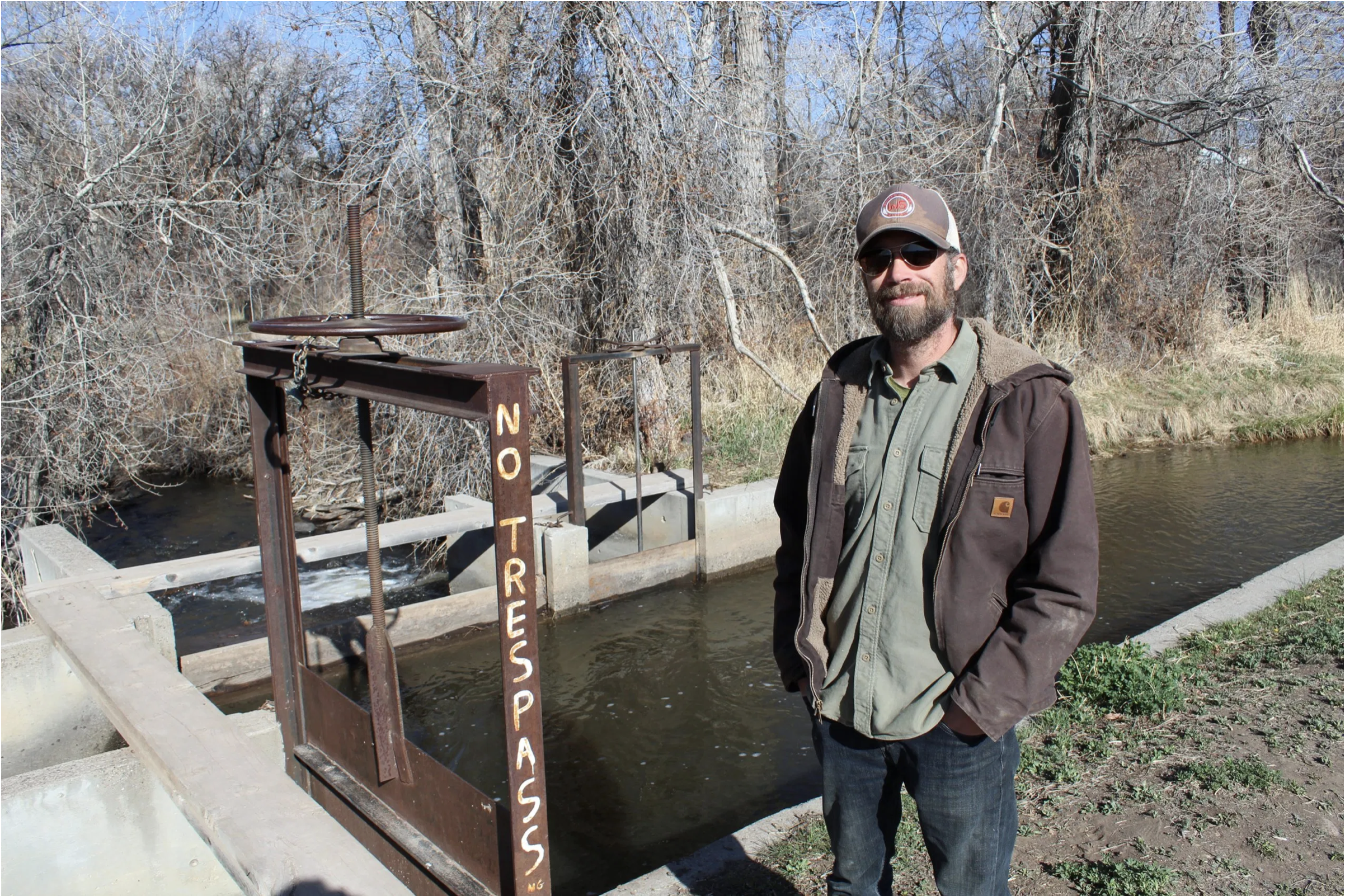
A parshall flume measures the water in the Alfalfa Ditch, which diverts water from Surface Creek, near Cedaredge. The water is used to irrigate hayfields at nearby Harts Basin Ranch. CREDIT: LUKE RUNYON/KUNC via Aspen Journalism
Financial water speculation
A draft report by the work group attempts to define two different types of speculation.
The first is traditional water speculation, which involves obtaining a water right without any plan or intent to put that water to beneficial use. The intent is to obtain a desirable priority date and then sell the water right to others who have a beneficial use.
This type of speculation has been addressed before in Colorado water law in what is known as the High Plains case. In 2005, the Colorado Supreme Court determined that a water-investment company was speculating because its plan for using the water was too expansive and nebulous, and the plan did not identify either the structures through which the water would be diverted or the specific locations where the water would be used.
The second type of speculation — and, because of WAM’s dealings in the Grand Valley, the one on which the work group is more focused — is financial water speculation. The work group defines this as the purchase and use of water rights with the primary purpose of profiting from increased value of the water in a short period of time. Financial water speculation may run counter to Colorado’s prior-appropriation doctrine because the primary intent is profit rather than beneficial use.
The concerns over speculation tap into a deep-seated anxiety that is prevalent in Western farm towns: the transfer of water from agriculture to cities. There are real examples of agricultural water being sold to cities, sometimes derisively described as “buy and dry,” and some rural communities have suffered economically as a result.
In some ways, the work group’s discussion of how to prevent speculation is really a broader discussion of how to prevent water transfers away from agriculture. The group has identified the large-scale, permanent dry-up of agricultural lands as the No. 1 risk from speculators. Part of Funk’s job is to head up a program of “alternative transfer methods,” which allow cities to temporarily buy or lease water from agriculture, but without the severe economic impacts.
“I think the issue with speculation is that what on paper might seem a very sort of small, isolated issue, as soon as you start sort of unpacking it a little bit, it’s essentially all the problems that Western water and rural communities are facing in, like, one issue,” Funk said. “So, as soon as you start unraveling it, you start running into other forces at play that are really beyond the state’s control or any one individual producer’s control.”
Harts Basin Ranch is a 3,400-acre expanse of hayfields and pasture just south of Cedaredge in Delta County. The ranch is owned by Boulder-based Conscience Bay Company and has the oldest water right on the Alfalfa Ditch. CREDIT: HEATHER SACKETT/ASPEN JOURNALISM
Impacts to ag
The work group is walking a fine line to come up with ways to deter speculation while not harming traditional agriculture producers in the process. In a big-picture sense, irrigators may worry about the impact to their community and way of life if all their neighbors sell to hedge funds. But when it’s their turn to receive a check for their water rights, they don’t want regulators doing anything that would make the process harder or devalue the ranch they have put their lives into, including restricting whom they can sell to.
It’s an oft-repeated adage that a rancher’s land and water rights are their 401(k) or their child’s college fund, and some say any new rules aimed at speculators should not make it more difficult for traditional ag producers to cash out if and when they want.
So far, the investment firms active in western Colorado have continued to lease their land back to farmers, or farm it themselves.
Carlyle Currier, a rancher in Molina and president of the Colorado Farm Bureau, has a seat on the Colorado River Basin Roundtable and his family has ranched in the Grand Mesa area for more than a century. Currier said until the investors attempt to sell it off, they’re not doing anything illegal.
“If the government can tell (someone) they can’t buy a farm and farm it, well, then they could tell me that, too. And I don’t want them telling me that,” Currier said.
The speculation discussion is also set against the backdrop of a potential demand-management program, the feasibility of which the state is currently studying. A demand-management program would pay irrigators on a temporary, voluntary basis to fallow fields and leave more water in the river. This water would be sent to Lake Powell to fill a 500,000-acre-foot pool that could be used to help the upper-basin states avoid a protracted legal battle with states downstream on the Colorado River.
Some say the exploration of demand management — including pay-to-fallow pilot projects in the Grand Valley — could have opened the door for investors who want to take advantage of the program to make easy money. Where there are opportunities, there are opportunists.
“Here in Mesa County, we’ve been watching a Wall Street investment firm buying up agricultural properties all with pre-compact water rights,” Steve Aquafresca, Mesa County’s Colorado River District representative, said at a board meeting last month. “I think it could be safely said that these actions probably would not have occurred if the state were not discussing the possibility of a demand-management program and if one particular major irrigation-water provider was not showing some willingness to entertain a demand-management program.”
The Alfalfa Ditch, seen here in April, takes its water from Surface Creek. The owners of Harts Basin Ranch, which has a water right on Alfalfa Creek dating to 1881, have been accused of buying the ranch just for its old and valuable water rights. CREDIT: HEATHER SACKETT/ASPEN JOURNALISM
Suspicion of outsiders
For all the concern about water speculation, there’s scant proof that it’s happening on a large scale on the Western Slope. Even WAM is not speculating, according to the current definition, as long as they keep the land in agricultural production.
“It does seem like there’s a lot of speculation about speculation,” Feldman of investment firm Conscience Bay said.
Instead, he said, old-fashioned suspicion of outsiders is at the heart of the issue.
“There’s people that view us as outsiders and we are not from here,” he said. “We know that. We know that damn well. And that’s not news to us.”
And there’s some evidence that he’s right. The Colorado River District, which protects Western Slope water interests, is developing a policy statement about water speculation. A draft of the policy says the district “recognizes the importance of locally owned agricultural lands and waters” and will work “to protect our state’s water resources from out-of-state special interests.”
And although these ideas didn’t get much traction, the work group has also floated two more potential solutions targeting outsiders: restricting the ability of out-of-state entities to participate in Colorado water court proceedings and prohibiting out-of-state entities from holding water rights.
“Is speculation just another word for investment (but it has) a negative connotation to it because it’s somebody that’s not from here?” Feldman said. “OK, well, do you not want to have investment in rural Colorado? Is that what we’re after? That’s where it would go if you put up enough barriers and hoops.”
Feldman says he is not the enemy. His operation isn’t the mom-and-pop homestead ranch of the Old West. It’s the investor-owned, employee-operated, risk-taking ranch of the New West. Harts Basin Ranch is looking for innovative ways to adapt to water scarcity and is participating in a program with environmental group Trout Unlimited to study consumptive use and how agriculture can stay productive while using less water. The group receives funding from the Walton Family Foundation, which also funds KUNC’s Colorado River reporting.
Feldman sees the heated discussion about speculation as a symptom of how Western communities are choosing to grapple with increasing water scarcity under climate change. There are those who explore new ways of running an old business and there are those who want to protect the status quo.
“At its core you see a real friction or conflict between a group of people that’s trying to make water policy more flexible to adapt to a changing climate,” Feldman said, “and those that are trying to impose more rigidity and prevent any change from occurring.”
This story was part of a collaboration between KUNC in Colorado and Aspen Journalism. Aspen Journalism is a local, nonprofit and investigative news organization that covers water and river issues. KUNC’s Colorado River reporting project is supported by a grant from the Walton Family Foundation. KUNC is solely responsible for its editorial content.
As the coronavirus pandemic stretches past a year, the world has become accustomed to facing problems we rarely, if ever, anticipated before. These new challenges extend beyond logistical work-from-home issues to graver concerns: For example, how do we keep our water systems safe from hackers?
In Florida, a water treatment plant ran into that very issue in February when a hacker breached its remote system. The hacker, who is still unknown, reportedly adjusted the sodium hydroxide — added to alkalize water and limit lead leaching from pipes — in the city’s water to poisonous levels. While the threat was quickly addressed, the incident highlighted the weaknesses of remote access operations.
The Florida water plant is far from the only utility that’s fallen victim to a cyberattack. Similar threats have happened in Colorado, too. For example, in 2019, hackers demanded a ransom from the Fort Collins Loveland Water District and South Fort Collins Sanitation District. (The districts were able to resolve the issue on their own).
And just last month, the Colorado Department of Public Health and Environment’s Water Quality Control Division warned of recent phishing attempts at various water utilities.
The Cybersecurity and Infrastructure Security Agency, or CISA, works to help organizations bolster their technology and counter cyberattacks. “Water utilities face the same types of cyberattacks as any other organization: phishing schemes, ransomware attacks and other malware designed to steal credentials,” said Dave Sonheim, Colorado CISA cybersecurity advisor. “While technology creates many advantages, it also brings with it the risk of cybercrime, fraud and abuse.”
COVID-19 has intensified the problem, he said, because it necessitated remote work, making operations for many utilities more vulnerable.
“What we know is that breaches in cybersecurity can knock on a bazillion doors electronically until one opens,” explained John Thomas, professor of engineering practice at the University of Colorado. To prevent cyber threats from escalating, Thomas says it’s important to consider as many challenging scenarios as possible and work backward to build a more adaptable system.
Cyber issues predate the pandemic but because water utilities typically use electronic control systems that were developed in the 1960s, their technology tends to be older, too. Older tech combined with pandemic conditions exacerbated an already existing weakness.
“Systems are still outdated and not really designed to be operated on the internet, and with all the issues surrounding COVID-19 suddenly requiring remote administration and access — it’s kind of a perfect storm,” Thomas said.
As hacks have increased, regulators have responded with more explicit guidance. The Water Information Sharing and Analysis Center offers 15 cybersecurity fundamentals targeted for the water sector. Additionally, the Water Infrastructure Act of 2018 requires larger water utilities to conduct risk and resilience assessments of their cybersystems. These kinds of threats have long been on the radar of utilities like Denver Water, which follows the U.S. Environmental Protection Agency’s best practices to stop cyberattacks before they begin.
“Denver Water has a designated cybersecurity team, along with an emergency preparedness program, that investigates the best ways to detect, defend, respond to and recover from cybersecurity attacks, including those similar to the one that occurred in Florida,” said Denver Water spokesperson Todd Hartman. Hartman said Denver Water follows guidelines set by CISA.
But these policies may not be enough. A recent paper on how COVID-19 might transform infrastructure resilience noted that “older best practices that focus on efficiency and stability are becoming increasingly insufficient.” That presents a new opportunity to rethink how infrastructure operates and how it can be designed to respond to unexpected situations.
Emily Bondank, a science and technology fellow with the American Association for the Advancement of Science and one of the paper’s authors, said current guidelines are limited to what utilities can imagine as a future threat. But what about things they can’t imagine, like a global pandemic?
“COVID impacted us in an interesting way because it wasn’t recognized as being a threat to infrastructure at all,” Bondank said. “Even though people know cybersecurity is an issue for the water sector, it just hasn’t been invested in enough for them to really understand the vulnerabilities and threats around it.”
Alejandra Wilcox is a journalist currently based in northern Colorado. Her work has been broadcast on KGNU and has appeared in the Huffington Post, among other outlets.
On Friday, April 23 — the day after Earth Day — a quarter or more of Colorado’s streams, rivers, and wetlands lost critical protections as the Navigable Waters Protection (NWP) Rule went into effect in the state following a year of legal efforts to prevent it.
Until this week, Colorado remained the only state to successfully avoid application of the Trump administration rule, which last year rolled back key protections in the Clean Water Act — the bedrock environmental law protecting our drinking water from pollution. A judicial stay issued as a result of a legal challenge by Colorado Attorney General Phil Weiser has kept the state’s waterways protected until now. The appeals court recently lifted the stay, so the NWP Rule will take effect in Colorado Friday, April 23.
The NWP Rule will impact the protections of critical sources of drinking water and leaves at least 25% of Colorado’s streams and 22% of wetlands vulnerable to pollution. The rule hits “ephemeral” streams, those that flow seasonally, particularly hard, curtailing critical safeguards for waterways that respond primarily to precipitation events — which make up 68% of waters in Colorado. It also threatens the safety and reliability of clean drinking water, which 94% of Westerners say is essential. Below maps developed by Water for Colorado Coalition partner’s Trout Unlimited and The Nature Conservancy illustrate the extent to which this policy will threaten Colorado’s water.
“In a state known for its work to conserve the natural resources that are vital to so many Coloradans’ well-being and livelihoods, it is shocking that this rollback is drifting by so quietly,” said Josh Kuhn, Water Advocate for Conservation Colorado, a Water for Colorado Coalition partner. “Colorado serves a vital national role as a headwaters state, and we need our lawmakers to take action now protecting our rivers, streams, and wetlands from irreversible harm.”
It is now up to the legislature to prevent this dangerous rule from taking effect and removing safeguards for water sources. Colorado needs state policies protecting clean drinking water and our waterways more broadly regardless of who is in the White House. While policy changes in the new federal administration could reestablish protections, that will take years — by then, the damage done to our waters will be irreparable. If Colorado leadership doesn’t step in, streams and wetlands could be filled with construction debris, subject to polluted runoff from nearby development sites or obliterated by bulldozers.
“We need immediate legislative action to ensure our water is treated as the precious natural resource it is,” said Melinda Kassen, Sr. Counsel, Theodore Roosevelt Conservation Partnership. “The Colorado Legislature has prioritized critical funding for the Colorado Water Plan — but if they don’t protect our streams and wetlands from pollution, what are we funding? Our streams, rivers, and wetlands need safeguards from activities that would release pollutants into them. Without this, unregulated construction may impair sources of drinking water and the streams and wetlands that support hunting and angling in Colorado.”
The Water for Colorado Coalition has environment, legal, and policy experts available to discuss the implications of this rule’s implementation, and the need for immediate state action.
About the Water for Colorado Coalition
The Water for Colorado coalition is a group of nine organizations dedicated to ensuring our rivers support everyone who depends on them, working toward resilience to climate change, planning for sustained and more severe droughts, and enabling every individual in Colorado to have a voice and the opportunity to take action to advocate for sustainable conservation-based solutions for our state’s water future. The community of organizations that make up the Water for Colorado Coalition represent diverse perspectives and share a commitment to protecting Colorado’s water future to secure a reliable water supply for the state and for future generations.
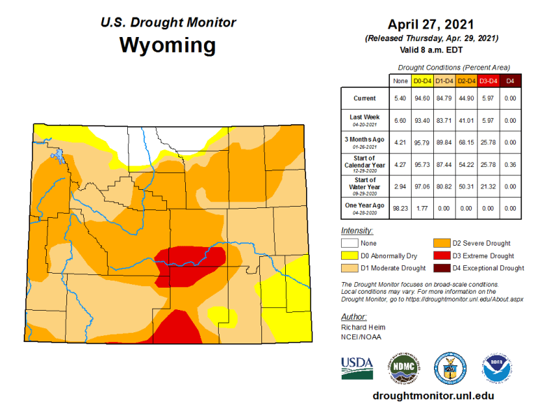
Ninety-five percent of Wyoming is abnormally dry or worse, according to a nationwide drought monitor map released Thursday.
The pervasive dryness may have significant near-term impacts on grazing and irrigation, and could result in down-stream calls on Wyoming water as early as next year, experts say.
The current conditions statewide mark a seismic shift from a year ago when only 2% of the state registered abnormally dry or drier, according to the National Drought Mitigation Center at the University of Nebraska-Lincoln.
The driest areas — classified as “extreme drought” and covering 6% of Wyoming — span parts of Carbon and Natrona counties, plus small areas in Sweetwater and Fremont counties. There, a poor snowpack will produce runoff “inadequate for ranching and farming,” the center says.
Only parts of Sheridan, Johnson, Big Horn and Park counties are at or above normal moisture levels.
The monitor map, updated monthly, shows “exceptional” D4 drought — the driest condition on the center’s scale — in parts of Utah and Colorado and other areas of the southwest, but not Wyoming.
Western residents are already feeling the effects. Early season wildfires in the Black Hills of South Dakota caused Gov. Kristi Noem to declare a state of emergency there through June 1. Southwestern water scarcity along the Colorado River may curtail water use in other states but shouldn’t affect Wyoming this year, said Steve Wolff, head of the State Engineer’s Office Interstate Streams Division…
Snowpack vs runoff
This week remote monitors measured the water content of the snowpack statewide at 89% of median, according to Fahey’s weekly report. The Powder and Tongue rivers in the northeast had the highest readings at 129% and 124% of normal respectively. The Upper Bear River Basin in western Wyoming measured lowest at 57% of median…
“Even though the snowpack is almost 100%, runoff [could be] 50%, give or take,” Wolff said. “A lot of that water is just going to soak into the ground.”
[…]
The drought map shows that about 40% of Wyoming suffers from moderate, D1, drought, a level in which hay and forage yield is low, fire danger is elevated, fewer wildflowers bloom and less irrigation water is available.
“Severe, D2, drought” affects another 39% of Wyoming, stressing trees and reducing water pressure in some wells. In D2 drought, pastures are poor, overgrazing occurs and producers begin to sell cattle, according to the center.
See-saw changes in recent weeks saw areas west of the Continental Divide dry out. “Much of that area, especially in Teton County, was the one part of the state that had been doing quite well in terms of the drought map,” said Tony Bergantino, acting director at the Water Resources Data System in the Wyoming State Climate Office.
But last week severe drought, D3, moved into Teton County for the first time since 2016, he wrote in an email. That severe drought also grew to cover a large area of Lincoln County.
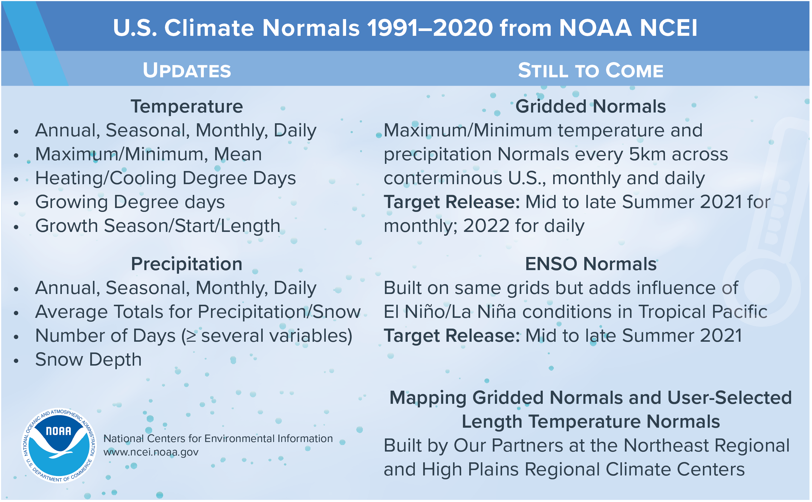
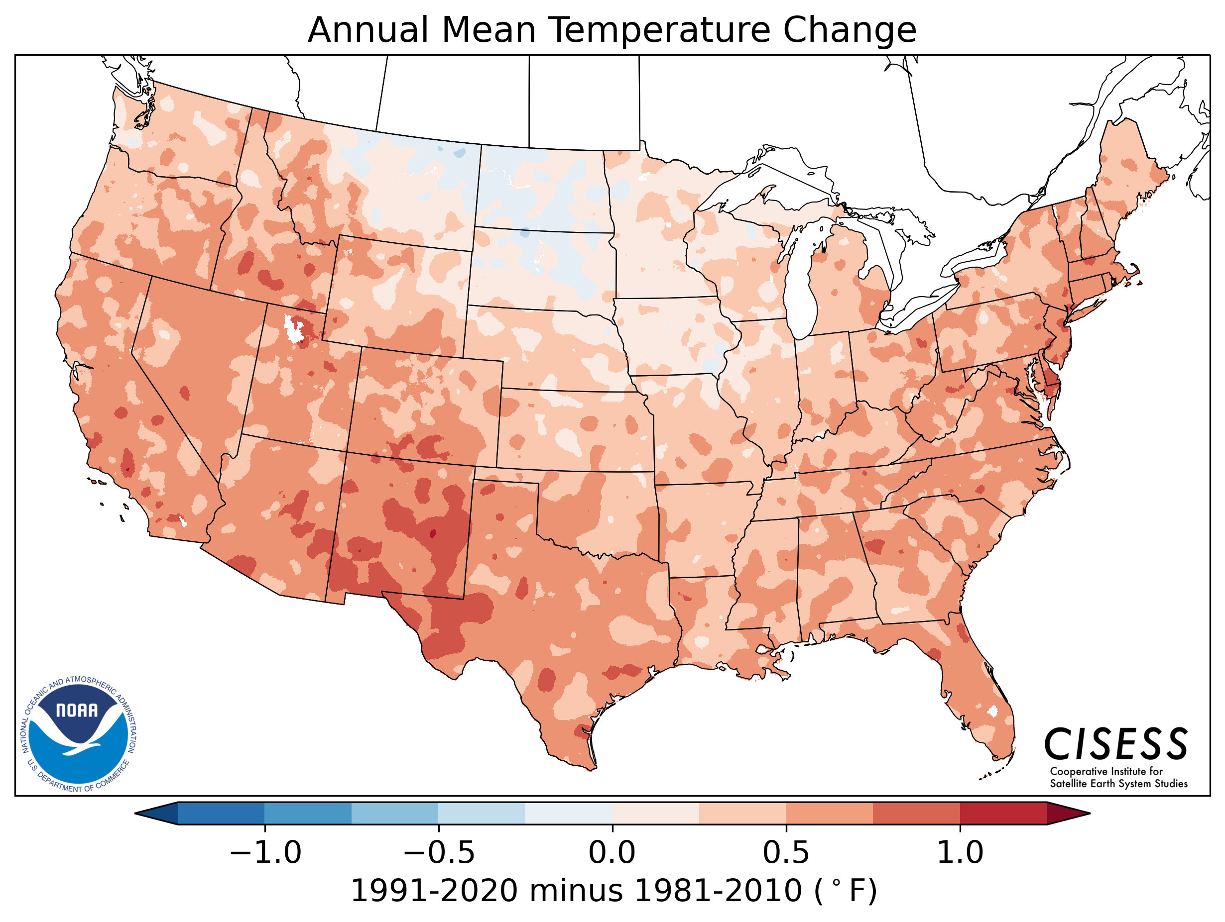
NOAA’s new U.S. Climate Normals give the public, weather forecasters, and businesses a standard way to compare today’s conditions to 30-year averages. Temperature and precipitation averages and statistics are calculated every decade so we can put today’s weather into proper context and make better climate-related decisions.
Normals may be familiar to most Americans by their inclusion in local daily weather information from television, radio, print, and digital media. Not only do Normals indicate how conditions measure up for the nation as a whole, but also for specific locations—from Bangor, Maine, to San Diego, California. And, from Nome, Alaska, to San Juan, Puerto Rico.
U.S. Climate Normals are designed—and best-suited for—better understanding what is happening today. Rather than assess long-term climate trends, Normals reflect the impacts of the changing climate on our day-to-day weather experience. Normals are not merely averages of raw data. Thirty years of U.S. weather station observations are compiled, checked for quality, compared to surrounding stations, filled in for missing periods, and used to calculate not only averages, but many other measures. These then provide a basis for comparisons of temperature, precipitation, and other variables to today’s observations.
Supplemental Normals for the 15-year period 2006–20 are being released simultaneously with conventional 30-year Normals for users who require information for periods closer to the present.
Why Update U.S. Climate Normals?
Member states of the World Meteorological Organization (WMO) are required to calculate their country’s normals at ten-year intervals. Countries follow recommendations by the WMO, which provides a framework for international cooperation among meteorologists, climatologists, and hydrologists.
The decadal update is the equivalent of the Census for those who use the dataThe decadal update is the equivalent of the Census for those who use the data. It replaces the previous set of U.S. Normals, which cover all 50 states and U.S. territories such as Puerto Rico and Guam. NCEI and its predecessors have been the official source for U.S. Climate Normals since the 1950s. New data come from approximately 8,700 National Weather Service stations operated by NOAA, which include Automated System Observing Stations (ASOS) and Cooperative Observer Program (COOP) stations.
For the first time, Precipitation Normals have been created for more than 770 Snow Telemetry (SNOTEL) stations managed by the U.S. Department of Agriculture and for more than 5,400 citizen science observation stations from the Community Collaborative Rain, Hail, and Snow (CoCoRaHS) Network. Calculating and making available the new averages is a significant undertaking that requires months of preparation by a team of climate scientists, including NCEI partners from the Cooperative Institute for Satellite Earth System Studies (CISESS) and NOAA Regional Climate Centers (RCCs).
Several new Normals will be introduced for the first timeNormals provide information about national and localized average temperature and precipitation as well as other parameters, such as snowfall, heating and cooling degree days, frost and freeze dates, and growing degree days. Several new Normals will be introduced for the first time, including Seasonal Normals representative of different states of the El Niño/Southern Oscillation (ENSO) and High-resolution Gridded Normals, which are data that represent Climate Normals at 5 km intervals north and south across the contiguous U.S. to allow for easier calculations and mapping of climate averages and departures from normal. New Normals access tools will also be forthcoming from our RCC partners.
2021 Normals Table via NOAA.
By comparing averages to weather observations, anyone interested in the conditions at specific locations can learn whether a variable is above, below, or near average. For instance, the average temperature during the February 2021 Arctic air cold outbreak in the Dallas–Fort Worth area was 42°F below normal on February 16, according to the 1991–2010 Normals.
Along with the National Weather Service (NWS) and meteorologists and forecasters in the private sector, the new Normals impact the work of numerous public and private stakeholders, including the energy and agricultural sectors of the American economy, building design, infrastructure, construction, and several governmental organizations, such as the USDA.
Changes Since 1981–2010 Climate Normals
Changes can be subtle, depending on the region, season, and timeframeAs anticipated, changes have occurred in averages since the last ten-year update. Since two-thirds of the data (1991–2010) in the new set overlap with the previous version, changes can be subtle, depending on the region, season, and timeframe. Nonetheless, an upward shift in temperature averages is evident, but warming is not ubiquitous across the contiguous U.S. in either geographic space or time of year. Changes vary from season-to-season and month-to-month.
For instance, the north-central U.S. Temperature Normals—for those in the Northern Plains and Upper Midwest—have cooled from 1981–2010 to 1991–2020, especially in the spring. The South and Southwest are considerably warmer. Normals were also generally warmer across the West and along the East Coast.Precipitation-wise, the Southwest was drier; wetter averages emerged in the U.S. east of the Rocky Mountains, especially the Southeast in the spring.
Average annual temperature change in degrees Fahrenheit for the contiguous U.S. from the 1981–2010 U.S. Climate Normals to the newest data in the 1991–2020 Normals, released by NOAA, May 2021. Averages indicate a warming pattern occurred in all but portions of the Upper Midwest and Northern Plains. Courtesy of CISESS.
Annual U.S. precipitation changes by percentage from the 1981–2010 U.S. Climate Normals to the newest data in the 1991–2020 Normals, released by NOAA, May 2021. Decreases indicate a drier Southwest, and increases indicate wetter sections of the Northern Plains, Great Lakes region, and Southeast. Courtesy of CISESS.
In the transition to the new set of Normals, shifts in the relative frequency of above- and below-normal conditions will occur. Shifts will be most discernible in areas of the country undergoing substantial warming in the last decade, as experienced in the West and Florida. In those cases, comparisons of averages to current conditions will trigger below-normal temperature days more frequently. This does not mean that conditions are “colder” in the absolute sense; in actuality, higher averages have raised the bar for warmth.
Climate Normals and Climate Change
U.S. Normals are useful to understand present-day conditionsRather than track or define long-term trends or changes in climate, U.S. Normals are useful to understand present-day conditions. For climate monitoring activities at NCEI, longer periods are referenced. The monthly State of the Climate reports produced for the United States and globe use twentieth-century averages (1901–2000) as benchmarks and will continue to do so. The yearly Bulletin of the American Meteorological Society State of the Climate report also relies on longer periods of record.
Several reasons underlie the use of the twentieth-century averages for climate change monitoring:
The 1901–2000 baseline offers more consistency as conditions change over time and is not subject to updates every 10 years.
The period is an easy-to-understand range when discussing long-term climate change with non-technical audiences.
However, long-term trends from decade to decade can affect baseline “normal” weather conditions. For instance, the last decade includes the warmest seven years on record for the globe, according to NCEI.
Future Releases
Additional products and services will be released later in 2021 and into 2022, including Daily Gridded Temperature and Precipitation Normals. Plans are also underway for NOAA NCEI to become a repository for climate normals from countries around the world.
Thousands of amateur meteorologists across the United States help the National Weather Service track weather patterns by performing a daily task – checking the temperature and precipitation amounts on their property. These citizen scientists record and report their findings to the agency, every day.
Daily temperature and precipitation observations collected by volunteer cooperative observers and Automated Surface Observing Systems are used by NOAA scientists to develop the 30-year average of weather and climate data, known as Climate Normals, set to update on May 4.
“Forecasts are for today, observations are forever,” said National Weather Service Director Louis W. Uccellini, Ph.D. “Thanks to all of our cooperative observers. Your work is key to sustaining the climate record as we compute the average temperatures over the last 30 year period.”
The National Weather Service Cooperative Observer Program, launched in 1890, is a network of over 10,000 volunteers gathering observations at roughly 8,100 weather stations located on farms, in urban and suburban areas, in National Parks, and on seashores and mountaintops. There are observers in every state and U.S. territory from Palau to Puerto Rico.
“The century-long accumulation of weather observations taken by volunteer observers provide a baseline to compare yesterday’s weather and tomorrow’s forecast and establish record amounts,” said National Cooperative Observer Program Manager Amy Fritz. “The climate normals dataset are critical to several weather-related functions and help inform activities in many economic sectors such as agricultural, energy and travel.”
Farmers and pilots were early adopters to the importance of weather observations
Farmers know crop growth success is closely related to the weather. Monitoring local climate was and is a constant for them. In the early 1900’s, many farmers felt it their duty to the country to record and provide valuable weather data to the National Weather Service. Many cooperative observer weather stations have been passed down in families for generations. For 165 years, the Maddox Family from Rome, Georgia has provided the longest continuous record by a cooperative observer. As for farming locations, the Wright Family of Redrock, New Mexico, has been taking observations from their 320 acre farm for multiple generations.
In 1926, the Air Commerce Act directed the National Weather Service to provide weather services to civilian aviation, so pilots would have information they needed to fly safely. This led the way for gathering weather observations at airports. Today, airports across the country have Automated Surface Observing Systems – instead of taking manual observations – gathering weather data to support airport operations and provide input for the climate record.
More than 900 ASOS stations in the U.S. have been in continuous service for almost 30 years. Providing observations every minute of every hour of every day, each station includes sensors to measure wind speed and direction, dew point, air temperature, precipitation type and amount, visibility, cloud height and thickness, and station pressure.
Assuring accuracy of local surface temperatures and precipitation is a challenging and evolving undertaking. Daily reports from the Cooperative Observer Program along with data from Automated Surface Observing Systems are quality controlled first by National Weather Service meteorologists then by a comprehensive sequence of automated computer procedures at NOAA’s National Centers for Environmental Information (NCEI). In some cases, additional manual quality assessments are performed at NCEI.
“If NOAA says a record temperature was set, you can trust that record,” said Fritz.
Dave Kanzer, deputy chief engineer, and Don Meyer, senior water resources engineer, provided a disheartening update to the Colorado River District Board of Directors on the continuing drought and dire water supply outlook in 2021. Unfortunately, conditions have only worsened since January.
For most of the last two years, monthly precipitation amounts have been below average within the Colorado River District. As of April 30, the snow water equivalent is well below average across the Western Slope with the Colorado basin at 72% of average, the Gunnison at 62% and the Yampa & White at 72%.
In addition to the below-average seasonal snowpack, the temperature and precipitation model forecasts from the National Weather Service’s Climate Prediction Center are predicting a hot and dry summer with above-average temperatures across most of the southwest. Forecasters also predict below-average precipitation, particularly in the Upper Colorado River Basin. Most of the Colorado River Basin is currently in extreme or exceptional drought conditions.
Adding insult to injury, low soil moisture will adversely impact runoff. Models from the Colorado Basin River Forecast Center suggest the majority of the Upper Colorado River Basin has such low soil moisture that it will require up to 12 inches of water to reach saturation. This means that most of the snowpack is absorbing into the soils and not turning into runoff. With the sizable reservoir drawdowns from last year, very few reservoirs are likely to fill in the upcoming water year. This soil moisture deficit presents a significant challenge to refilling the Colorado River storage system, especially the lower, larger facilities, like Lakes Powell and Mead.
The U.S. Bureau of Reclamation’s mid-term modeling forecasts project this water year to be below average, with inflow into Lake Powell at about 5.13 million acre-feet, less than 47% of the long-term average. Furthermore, Reclamation projects that Lake Powell will end the water year near 3,557.03 feet elevation, holding about 8.10 million acre-feet in storage, which is 33% of its capacity.
With these projections for Lake Powell, combined with similarly low projections for Lake Mead, Drought Contingency Plan operations will continue to be in effect for the Lower Basin in 2021 with lowered deliveries to the Central Arizona Project, Southern Nevada and Mexico. Should these projections continue to play out, the Lower Basin will enter a higher tier of shortage in 2022, prompting mandatory cutbacks under the 2007 Interim Guidelines.
If the level of Lake Powell is projected to fall below 3,535 feet in elevation by October 2022 — which is currently within the worst-case scenario forecast — it would activate the Upper Basin Drought Contingency Plan. This would trigger coordinated releases into Lake Powell from Flaming Gorge Reservoir and other upstream reservoirs to protect reservoir levels and maintain power generation at Glen Canyon Dam.
There is still time for conditions to improve, but the outlook is not good.
From the San Luis Valley Ecosystem Council (Zaylah Pearson-Good):
Introduction
Each spring and fall, thousands of feathers slice through the brisk San Luis Valley (SLV) sky, alerting resident wildlife, local farmers, and eager birders to the change of season. Ranging from shorebirds to songbirds, a myriad of avian species visit this high-elevation desert as they migrate along the Central Flyway to their breeding and wintering grounds. Nurtured by the Valley’s mosaic of wetlands, riparian corridors, and agricultural fields, the SLV is a critical stopover for these determined travelers.
Foundational to the health of any stopover habitat is the presence of water. As local hydrology continues to be threatened by high agricultural demands, persistent drought, mining of the aquifer, and water export proposals, the future of the San Luis Valley as a migratory stopover is unknown. By protecting both ground and surface water reserves, we honor the miraculous winged creatures that bring energy, life, and color to the San Luis Valley.
The Importance of Migratory Stopovers
From distributing nutrients, seeds, and pollen, to balancing local food chains, animal migrations enhance ecosystem health. Spanning hundreds to thousands of miles in distance, these impressive voyages speak to the beauty, intelligence, endurance, and collective determination of species worldwide. Coming at tremendous energetic costs, migrations also highlight the importance of maintaining healthy habitat along migratory corridors.
Jenny Nehring and Cary Aloia, SLV biologists and partners at Wetland Dynamics, explain that many people “overemphasize the importance of wintering and breeding grounds,” when in fact, a successful migration also requires the presence of intact, resource rich habitats along the way (Interview, 2021). Without areas to rest and refuel like the SLV, birds would arrive to their destinations underweight and undernourished. For this reason, birds navigate not by the arbitrary borders and boundaries designed by humans, but by the geographical landmarks, such as rivers and wetlands, that represent feeding and resting opportunities.
Connected by threads of wetland and marsh habitats, the Central Flyway offers safe passage to thousands of birds during their biannual migrations. From the thick boreal forests of Canada to the Gulf Coast of Texas, this flight path is believed to support the movement of over 400 bird species each year (Bode, 2020). The San Luis Valley, a vast high desert shrubland in Southern Colorado, is a critical stopover for many migratory species. Blessed with interspersed wetlands, it is an especially important stop for Central and Pacific Flyway ducks, water birds, shorebirds, and the iconic Sandhill Crane (Ducks Unlimited).
SLV Significance to Migratory Birds
According to soil scientist and field ornithologist John Rawinski, the SLV’s drastic range in elevation, and therefore climate, creates a variety of distinct habitats for birds. Cradled by the impressive San Juan Mountains to the west and Sangre de Cristo’s to the east, the semiarid San Luis Valley ranges in elevation from 7,600 feet on the valley floor to over 14,000 feet in the Sangre de Cristo Mountains. From the harsh alpine tundra to the tranquil grasslands of the lowlands, this diverse habitat in the SLV yields impressive avian biodiversity. Over 360 species have been recorded in this Valley and surrounding mountains (Rawinski, Interview, 2021). Over 250 bird species have been identified at the Great Sand Dunes National Park and Preserve alone. Of this count, many are migratory species including the Great Blue Heron, American Avocet, Snowy Plover, Burrowing Owl, Black-chinned Hummingbird, Lewis’ Woodpecker, and Cedar Waxwing, (GSDNPPC,pgs. 1-8).
The SLV Wetland and Wildlife Conservation Assessment identifies the San Luis Valley as being the “southernmost significant waterbird production area in the Central Flyway and the most important waterfowl production area in Colorado…” (Wetland Dynamics, 2019, pg. 19). For birds that winter in Mexico and South America, the area is ideal for breeding. In fact, it is one of North America’s most critical breeding grounds for various species of duck and colonial wading birds, specifically the Cinnamon Teal (Ducks Unlimited). Similarly, priority duck species, such as Mallard and Northern Pintail depend on the Valley’s flooded wetlands and densely vegetated habitats for migration, nesting, and wintering (Wetland Dynamics, 2019, pg. 19).
For bigger bird species and waterfowl, the Valley functions as a vital rest-stop to regain stamina for the journey onward. For example, the SLV is an important destination for nearly the entire Rocky Mountain Population of Greater Sandhill Cranes as they fly along the Central Flyway. Due to their spectacular numbers and continued presence, this iconic wading bird highlights the value of the SLV’s high quality habitat.
Sandhill Cranes in the SLV
Sandhill Cranes West of Dunes by NPS/Patrick Myers
Human Connection
Dynamic, loud, and majestic, the Rocky Mountain Sandhill Greater Sandhill Crane migration has attracted perhaps the most attention out of any bird to visit the Valley. These grey, long-bodied creatures have flocked to the San Luis Valley for ages, inspiring ancient Native American petroglyphs that date back up to 3,000 years (Rawinski, Interview, 2021). Spanning nearly 6 feet in length, the “Big Bird” petroglyph located outside of Del Norte speaks to the impact that cranes have always had on SLV residents.
As the cultural landscape of the region changed throughout time, so did the cranes’ relationship to the land. For example, early cranes primarily ate the resources found in wetlands such as mice, frogs, snails, tubers, and invertebrates (Rawinski, Interview, 2021). As European settlement and widespread agriculture took root in the SLV, cranes adapted their diet to become more general. Waste grain from farmlands, especially barley, began to comprise a large portion of their diet. While the cultural and physical environment has changed overtime, humans continue to celebrate this majestic bird. Since 1983, locals and tourists have gathered to honor, experience, and learn from the species at the Monte Vista Crane Festival. The annual celebration attracts thousands of visitors each year to marvel at nearly 20,000 dancing, chortling, and swooping cranes.
Experiencing a Sandhill Crane migration can be a surreal and incredible moment. Cody Wagner, Conservation Program Manager at the Ian Nicolson Audubon Center (INAC), shares that Sandhill Crane migrations are “one of the last great migrations on the planet,” comparable to the caribou in Canada (Interview, 2021). It is incredibly powerful, and spiritual for some, to witness such a large quantity of charismatic travelers.
Like the SLV, Nebraska’s Platte River (INAC’s location) is a critical stopover for cranes along the Central Flyway, hosting copious amounts of birds each season. Wagner reports that there can be as many as 200,000 Lesser Sandhill Cranes on any 5-mile segment of the river at a given time. One thing that Wagner loves about being surrounded by so many cranes is that by watching them, you find they have a lot of relatable qualities. Like humans, cranes dance, play, get loud, and also show both an awkward and elegant side. When out on the river, he describes their calls as being “ancient,” “unique,” and “a thing of beauty.” (Wagner, Interview, 2021).
Local SLV ornithologist and soil scientist John Rawinski shares a similar sentiment with Wagner. Visiting the cranes every chance he gets at the Monte Vista Refuge, he describes the encounter as deeply therapeutic. By “observing the beautiful sounds of the cranes, their majestic flight, and archaic appearance” it sets his day at peace (Interview, 2021). While he acknowledges that one can view the migration of the cranes in various locations on the continent, there is something extraordinary about their presence in the SLV. Snow-capped peaks, a crisp blue sky, and a vast open valley all combine to set an incredible backdrop for the spectacular crane spectacle.
SLV Significance to Cranes
Due to the memory of high-quality resources, nearly the entire population of Rocky Mountain Sandhills bottleneck in the SLV during their migration (Nehring & Aloia, Interview, 2021). In early February, the birds follow the Rio Grande River northward from their wintering grounds in New Mexico’s Bosque del Apache National Wildlife Refuge. Upon reaching the SLV, they scatter themselves throughout barley fields, lakes, wetlands, and the Rio Grande, feeding on high calorie grains and nutrient dense aquatic invertebrates.
While waste grains from the agricultural fields provide the birds with energy-rich carbohydrates, they derive the majority of their nutrients from invertebrates, which are especially important for healthy eggshell production (Wagner, Interview, 2021). For 1-2 month periods, flocks of cranes congregate in the region’s National Wildlife Refuges (Alamosa, Monte Vista, Baca), Blanca Wetlands, and Russell and San Luis Lakes State Wildlife Area, where there are high concentrations of viable habitat (Wetland Dynamics, pg. 73).
Travelling up to 300 miles in a single day, Sandhills exert incredible energy during their biannual migrations (INAC). The stopover in the Valley allows the cranes to regain energy and strength to complete the journey to their breeding grounds in the greater Yellowstone ecosystem (including portions of Wyoming, Montana, Idaho, and Utah). The Lesser Sandhill Crane, a slightly smaller version of the Greater Sandhill, travels even farther with its northern territory extending into the arctic. In the fall, the Valley will again serve as a rest-stop for the cranes as they venture back to their winter home in New Mexico.
John Rawinski speaks to the importance of the Valley as a safe resting place for the cranes. He describes the aquatic habitats of the San Luis Valley as a“safe haven” for birds to relax and rest (Interview, 2021). By roosting in 6-8 inches of water, Sandhills are protected from predators such as coyotes, raccoons, and foxes. Water serves as an alarm system for the birds, as few predators can enter their roosting habitats without splashing loudly and alerting the birds to danger.
From a conservationist perspective, the current Rocky Mountain Population of Greater Sandhill Cranes is stable. As omnivores, cranes have a fairly generalist and diverse diet, which speaks to their resilience as they do not depend on one sole food source to be well nourished. As well, cranes can modify their route if they sense insufficient resources along their traditional path. Rerouting demands additional energy, however, which can hurt crane populations and lead to malnourishment and unhealthy body weight (Nehring & Aloia, Interview, 2021). Efficiency is an important component to avian migration, and thus is the significance behind reliable, consistent stopover destinations.
While cranes fortunately exhibit some resilient traits, they are currently vulnerable due to loss of habitat and the unforeseen impacts of climate change. The species, along with other migratory birds, cannot survive without wetlands. Wetlands are currently one of the most endangered ecosystems in North America, putting the cranes and countless other species in danger. By recognizing the significance of the San Luis Valley as a migratory stopover, we are helping to keep habitat along migratory corridors connected. In this way, conserving ecosystems in the Valley is essential for the wellbeing of all birds along the Central Flyway.
The Importance of Water
Receiving less than 8 inches of precipitation each year, the San Luis Valley is one of the driest regions in the state of Colorado. In the past two decades, drought, reduced precipitation, and high rates of ground and surface water withdrawals have threatened some of the Valley’s most precious habitats: wetland and riparian areas.
Sunrise Over Wetland by NPS/Patrick Myers
SLV Wetland Habitats
Whether it is for nesting, breeding, feeding, or resting, all species that migrate through the San Luis Valley depend on the region’s wetlands. Wetlands are highly productive ecosystems that exist in low-lying depressions in the terrain. They are often referred to as the “kidneys” of the earth because they filter out pollutants, excess nutrients, and sediment from surface waters. They are also essential to the recharging of groundwater and protection against flooding and erosion events.
Depending on the type of wetland, the habitat may be wet permanently, semi-permanently, seasonally, or temporarily. Variations in soil type, elevation, location, vegetation and climate create distinct types of wetland habitats, that service wildlife in different ways and at different times in their life history (Wetland Dynamics, pg. 17). For example, the Mallard and Northern Pintail ducks require wetlands with shallow water to forage, but seek refuge in wetlands with tall emergent vegetation during sheltering periods (Wetland Dynamics, pg. 20). During nesting, both waterfowl species require distinct habitat, with the Mallards preferring habitats abundant with Baltic rush, and the Pintails choosing less dense vegetation, such as greasewood (Wetland Dynamics, pg. 20).
The SLV supports such a thriving community of migratory species, in part, because of its wide range of seasonal wetlands. In an analysis submitted to the Bureau of Land Management on SLV habitats and bird migration, Animas Biological Studies determined that shallow emergent and playa wetlands are “the most critical habitat type for migratory birds in both spring and fall” (pg. 15). Shallow emergent wetlands host a wide range of migratory species in their shallow pond and marsh like habitats. Characteristic of emergent vegetation like rushes and sedges, these habitats offer excellent feeding, nesting, and resting opportunities for migratory wading birds, waterbirds, and secretive marsh birds (ABS, pg. 3). Due to their semi-permanent to permanent quality, these SLV habitats are believed to be the most densely populated and used habitats by migratory shorebirds and waterbirds (ABS, pg. 3).
Also supporting high biological density and diversity, playa wetlands are some of the Valley’s most unique wetland habitats. Intermittently saturated by either surface or groundwater, these wetlands have high soil alkalinity and salinity that may result in the formation of a white crust during drying cycles. According to John Rawinski, playa wetlands are both the most critical and vulnerable of wetland habitats because they host species that cannot survive in other environments. For example, SLV playas represent the largest nesting area for the Snowy Plover, a threatened North American shorebird that thrives in dry salt flats (Rawinski, Interview, 2021). Additionally, several birds classified as “rare” are known to inhabit these distinctive wetlands, especially at the Great Sand Dunes National Park and Preserve: Long-billed Curlew, Short-eared Owl, Black-crowned Night-heron, Foster’s Tern, and the White-faced Ibis (Malone, p. 3) Playa wetlands are also host to a globally endangered plant species, the slender spider flower (Malone, p. 4).
Wetland threats in the SLV
Wetlands are both the Valley’s most valuable and vulnerable ecosystems. While only representing 2% of Colorado’s total area, wetland and riparian habitats support over 80% of wildlife species throughout their lives (Wetland Dynamics, p 36, 2019). Furthermore, wetlands are believed to be the most imperative habitats for birds that are classified as “at-risk” (Rondeau et al., pg. 93). In other words, Colorado’s most threatened species are also most reliant on wetland ecosystems.
Unfortunately, wetland conservation has been historically insufficient. In a report prepared by the Colorado Natural Heritage Program, the authors write that “Threats to wetland species are high and protection is generally poor” (Rondeau et al., p 128). Cody Wagner with the Audubon confirms this point in saying that many people undervalue these habitats; “Wetlands are held in less esteem by the public and have been historically viewed as a waste of space” (Interview, 2021). As a result, across the country, these habitats have been intentionally drained, burned out, converted into cropland/developments, polluted, or compromised by invasive species.
Due to reduced precipitation, severe droughts, earlier peak runoff, unsustainable agricultural practices, and high demands from water users, wetlands in the SLV have suffered. Wetland Dynamics, a small business committed to the conservation of critical SLV ecosystems, reports that nearly half of the Valley’s total wet acres have been lost since the 1980’s (pg. 80). With water use continuing to exceed supply, conservation of local water resources will be instrumental to restoring and protecting these habitats.
Wetland declines are of great concern for many reasons. Not only does it strain bird migrations, but losses also pose a threat to the surrounding environment. With less available habitat, birds will be forced to congregate in the few viable wetlands that remain. According to a study under the Society for Conservation Biology, wetlands overburdened by high densities of birds can cause “the destruction of wetland vegetation, impose heavy losses in local agricultural crops, increase the risk of infectious disease outbreaks, and decrease water quality” (Post, et al., p. 911). Furthermore, crowded habitat is also detrimental to wildlife, potentially leading to increased competition for resources, poor reproductive success, and reduced longevity.
Willet and White Faced Ibis by NPS/Patrick Myers
Riparian Habitat
Defined as the interface between a river or stream and the surrounding terrain, riparian areas are hotspots for migratory species. Densely vegetated with native grasses, willows, sedges, rushes, and cottonwoods, these areas are sanctuaries for resident and seasonal wildlife in the arid SLV. Common bird species to utilize these local ecosystems include the Bullock’s Oriole, Great Horned Owl, Northern Flicker, American Robin, Yellow Warbler, and the American Kestrel (USFWS, 2014). Similar to wetlands, riparian habitats are some of the sparsest habitats in the region. Riparian habitats support about 80% of resident bird species but represent only 3% of the landscape in the Intermountain West (Wetlands Dynamic, p 20).
Intersecting the SLV near Del Norte, the Rio Grande supports imperative riparian habitat for avian species. For example, the San Luis Hills State Wildlife Area protects 4.5 miles of the Rio Grande, which is considered “Critical Habitat” for the federally-endangered Southwestern Willow Flycatcher (COGO, 2018). The surrounding uplands (sagebrush and grasslands) host Sage Thrashers and Mountain Plovers, both of which are suffering a decline in population (GOCO, 2018). The Higel State Wildlife Area also protects several miles of the Rio Grande. This area is known to be critical habitat and breeding ground for the Willow Flycatcher, and the threatened, Yellow-billed Cuckoo (Wetland Dynamics, pg. 42).
The Rio Grande is considered a critical migratory corridor as it offers species a continuous stretch of riparian habitat along their path. From the San Juan Mountains of southern Colorado to the Gulf of Mexico, the Rio Grande River supports an otherwise thirsty landscape along its 1,900-mile path. Feeding seasonal wetland and riparian habitats, the Rio Grande brings life to parched deserts and valleys, allowing for both human and wildlife communities to thrive.
Jenny Nehring describes the Rio Grande as a “green ribbon in a very dry landscape” that directs birds towards resources along their high-energy voyage (Interview, 2021). The Rio Grande offers safe passage to countless migratory species, including the Sandhills, who utilize the river for both navigation and nourishment. Audubon New Mexico reports that roughly 18,000 Greater Sandhill Cranes, 200,000 waterfowl, and thousands of other water and shorebird species utilize New Mexico’s Rio Grande Corridor. Whether it is for wintering, migration, resting, feeding or nesting, the Rio Grande is an irreplaceable resource for migratory birds.
Threats to the Rio Grande
Excessive water use of the Rio Grande has become a growing concern. As early as the start of the 20thcentury, surveyors were already noticing the impact of SLV irrigation on the river. A USGS survey of the San Luis Valley in the early 1900s relayed that “the waters of this stream [Rio Grande river} are greatly over appropriated, even in the flood season” (Siebenthal, pg. 19). Currently, high water demands by agriculturalists, coupled with the drying impacts of climate change, have continued to tax this critical water supply. The upper Rio Grande is projected to decrease in volume by one-third in the coming years (Audubon New Mexico). Furthermore, over 90% of historical wetlands and riparian habitat along Rio Grande Corridor have already been lost in the last 150 years (Bode, 2020).
Wetland Dynamics shares that with the projected impacts of climate change, warmer water temperature and reduced stream flow could decrease the Rio Grande’s “extent of overall flooding across the watershed” (pg. 28). Already, the Rio Grande Basin Implementation plan is anticipating a 30% decrease in the river’s stream flow (Wetland Dynamics, pg. 28). Reduced flow and thus flooding from the Rio Grande would have dramatic consequences for the wetland and riparian ecosystems that require surface water input. Visiting and resident wildlife would greatly suffer as a result of this major habitat loss.
Young Great Horned Owl by NPS/Patrick Myers
A Changing World for Birds
Due to horrific collapses in bird populations across North America, birds depend on intact and healthy habitats perhaps more than ever. Extreme weather events, droughts, mismanaged resources, development, and loss of habitat have all contributed to the shocking losses in bird life. John Rawinski laments that today “we have 3 billion less birds (down 33%) in North America than we had in 1970” (Interview, 2021). Having started birding in the 70’s himself, he has seen this tremendous decline firsthand. He reports seeing fewer and fewer birds each year, and mass die offs, such as those experienced across the Southwest during the 2020 unseasonal summer snowstorm event. As a passionate birder and scientist, Rawinski begs the question: “Who will speak for the birds?” He urges that we need to start taking action now, before it is too late. Without important resting stops like the SLV, and intact migratory corridors such as the Rio Grande, migratory bird species do not stand a chance against climate change.
The Importance of Birds
Besides their striking beauty and relaxing melodies, birds play essential roles in balancing ecosystems and ensuring a healthy environment. During migrations, birds visit a diverse range of landscapes. Travelling thousands of miles, birds pick up and disperse nutrients and seeds. This process contributes to a more biologically diverse and productive ecosystem. Many birds also consume large quantities of insects as they migrate, which serves as a natural pest control for farmers. Lastly, certain aerial migrants, such as bats and hummingbirds, are important pollinators along their respective flyways. This is especially true for flower pollination.
In addition, birds are sensitive to environmental fluctuation, and therefore are considered good indicators of ecosystem health. Scientists have used the presence or lack of birds to learn about the impact of toxic pollutants such as PCBs and heavy metals in the environment. By ensuring healthy landscapes for birds, we reflect a healthy environment for human residents too. In this way, birds play a helpful role in teaching humans about the land in which they are a part. In the San Luis Valley, the continued visitation of large numbers of migratory species indicates that our landscape is blessed with prosperous habitats capable of supporting a wide range of life forms. With water export proposals such as RWR threatening our local water reserves, we cannot take these ecosystems for granted.
Renewable Water Resources (RWR) Proposal Connected by a series of pipelines running through Poncha Pass, Renewable Water Resources (RWR) proposes to remove 22,000 acre-feet of SLV water from the deep aquifer each year. This trans-basin water diversion would transfer local water to growing municipalities in the Front Range at the cost of SLV’s economy, ecology and future. Backed by former deputy chief of staff Sean Tonner and former Governor Bill Owens, RWR is one of many nonlocal investors who have attempted to remove thousands of acres of feet of water from the SLV a year. Opposed by SLV water managers, towns, environmental advocacy groups, and many ranchers/farmers, the impacts of RWR’s proposal would have horrific impacts on the local environment.
Potential Impact
Central to the study of ecology is that everything is connected. Hydrology is no different. By removing thousands of acres of water out of the deep aquifer each year, the health of the shallow aquifer, as well as wetlands and rivers that sustain life above it, are put at risk. As SLV ground and surface water reserves are already over-appropriated and declining, the San Luis Valley cannot afford to lose any more water. As a scientist and advocate for the environment, John Rawinski notes that, whenever there is potential for water to leave the San Luis Valley, “the big loser is always wildlife” (Interview, 2021). While humans have the ability to buy and transport water, wildlife and the habitats on which they depend do not have this freedom. The resident and migratory species of this Valley cannot afford to lose their most precious resource at the hands of those who desire to profit from it.
Conclusion
Spanning nearly 120 miles from north to south, the San Luis Valley supports vibrant communities of wildlife. Attracting avian species from all across North America, the SLV stands out as a significant stopover for migratory species. High quality wetlands and riparian areas sustain these winged travelers as they cover thousands of miles during their migrations. These incredible voyages attract nature lovers, balance local ecosystems, and encourage local biodiversity. However, the future of the San Luis Valley as a migratory stopover is jeopardized due to water scarcity. The Valley is faced with an urgent call to conserve water resources. For wildlife and human inhabitants, we must prevent water miners from exporting water, implement more sustainable forms of irrigation and land stewardship, consider water re-use, and unite private and public landowners in habitat conservation. The future of wildlife and humans in the San Luis Valley is depending on a commitment to protect our water.
Works Cited
Animas Biological Studies (ABS). “2015 Migratory Waterbird and Shorebird Surveys to Inform Solar Energy Zone Planning, Avian Impact Minimization, and Species Conservation in the San Luis Valley, Colorado.” 2016.
Audubon New Mexico. “Priority Birds in New Mexico.” National Audubon Society. https://nm.audubon.org/birds/priority-birds
Bode, Christi. The Fragile Flyway: Conserving the Rio Grande Corridor. Vimeo, 4 November 2020, https://vimeo.com/475587503
Ducks Unlimited, “Colorado Conservation Projects.” https://www.ducks.org/colorado/colorado-conservation-projects
Great Outdoors Colorado (GOCO). “New State Wildlife Area in Colorado’s San Luis Valley, Thanks to Collaborative Effort on the Upper Rio Grande.” 2018. https://goco.org/news/new-state-wildlife-area-colorado’s-san-luis-valley-thanks-collaborative-effort-upper-rio-grande
Ian Nicolson Audubon Center (INAC) at Rowe Sanctuary, “Sandhill Crane Facts.”National Audubon Society.https://rowe.audubon.org/crane-facts
Malone, Dee. “Ecological Systems of Colorado: Inter-Mountain Basins Playa.” Colorado Natural Heritage Program (CNHP). November 2017. https://cnhp.colostate.edu/projects/ecological-systems-of- colorado/details/?elementID=365181&wetland=1
Great Sand Dunes National Park and Preserve Colorado (GSDNPPC). “Bird Checklist.” National Park Service, 2006. https://www.nps.gov/grsa/learn/nature/upload/bird-checklist-2006-508.pdf
Nehring, Jenny & Aloia Cary (SLV Biologists and Owners of Wetland Dynamics). Personal Interview. Conducted by Zaylah Pearson-Good, 8 March 2021.
Post, et al. “ The Role of Migratory Waterfowl as Nutrient Vectors in a Managed Wetland.” Conservation Biology, Vol. 12, No. 4, 1998.
Rawinski, John. (SLV soil scientist and ornithologist). Personal Interview. Conducted by Zaylah Pearson-Good,12 March 2021.
Rondeau, R., et al. “The State of Colorado’s Biodiversity.” Colorado Natural Heritage Program,ColoradoState University, Fort Collins, Colorado, 2011. Siebenthal, C.E. “Geology and Water Resources of the San Luis Valley, Colorado. United States Geological Survey, Water Supply paper #240, 1910.
U.S. Fish and Wildlife Service (USFS) “Baca National Wildlife Refuge, Wildlife and Habitat.” 2014. https://www.fws.gov/refuge/Baca/wildlife_and_habitat/index.html
U.S. Fish and Wildlife Service (USFS). “Monte Vista National Wildlife Refuge, Colorado” 2020. https://www.fws.gov/refuge/Monte_Vista/wildlife_and_habitat/index.html.
Wagner, Cody. (Conservation Program Manager at the Ian Nicolson Audubon Center). Personal Interview. Conducted by Zaylah Pearson-Good, 2 March 2021.
Wetland Dynamics. “San Luis Valley Wetland and Wildlife Conservation Assessment: Historic and Current distribution of Wetlands and Riparian Areas Recommendations for Future Conservation.” Final Edition 2, 8 May 2019,
A truck drives out to Ritschard Dam, which forms Wolford Reservoir, on July 13, 2016. The River District will spend $323,840 to study potential cracking and erosion at the dam after a study found it is at greater risk of failure than previously thought. CREDIT: BRENT GARDNER-SMITH/ASPEN JOURNALISM
The Colorado River Water Conservation District’s board of directors has approved a contract with an engineering firm to address problems with a dam that are turning out to be worse than previously thought.
At its second quarterly meeting, held in April, the River District board agreed to pay $323,840 to HDR Engineering to further study the movement and potential cracking at the district-owned Ritschard Dam. The dam forms the 66,000-acre-foot Wolford Mountain Reservoir across Muddy Creek, about 5 miles north of Kremmling in Grand County. Muddy Creek is a tributary of the Colorado River.
River District staff, aware since 2008 that the dam is settling and moving more than expected, have been monitoring the situation. However, a 2020 Comprehensive Dam Safety Evaluation prepared in December by HDR Engineering for the state’s Dam Safety section of the Division of Water Resources found that the risk of internal erosion of the dam due to cracking had increased from a 2016 evaluation. That year’s evaluation estimated the chances of a dam failure at 1 in a billion in any given year; the 2020 report found a 1.5-in-10,000 chance of a dam failure.
A crack causing internal erosion is the primary driver of the risk of dam failure.
“It is currently expected that the core will crack at some point, if it has not already done so,” the report reads. “Although a deep crack through the core would represent a severe defect and a serious dam safety incident that significantly compromises the dam’s ability to store water, formation of a crack does not necessarily mean the dam would breach.”
Ritschard Dam has an impermeable clay core that is covered on the upstream and downstream sides with rockfill. Because the rock-fill is poorly compacted, the dam’s outer shells are still moving, especially on the downstream side. The 122-foot-tall dam was built for the River District in 1995 by D.H. Blattner and Sons of Minnesota. The cost was $42 million.
According to the report, normal reservoir operations that involve cycles of drawdown and refill appear to have a detrimental effect on the deformations. Even if the dam does not breach, there could still be very serious incidents that necessitate emergency actions and downstream evacuations or a reservoir restriction.
“The probability of a serious dam safety incident will only increase over time as deformations continue, and therefore there is urgency in taking actions,” the report reads.
The report said risk of dam failure at Ritschard is about the same as the historical failure rate for dams built prior to modern dam safety. Generally, a dam designed and constructed in the 1990s should have a much lower risk of failure than the historical rate.
The River District has been monitoring the dam with instruments, but HDR Engineering will help identify areas that could benefit from additional inclinometers, which measure slope angle, and piezometers, which measure underground water pressure.
“First and foremost, the River District puts public health and safety as our number one priority always, and every action we take is with public safety in mind,” said River District chief of operations Audrey Turner, who is acting as spokesperson on Ritschard Dam matters. “The River District has and will continue to increase our monitoring and emergency preparedness at the dam as recommended by the report.”
The River District also will use a LiDAR survey program — which utilizes lasers for remote sensing — to track and visualize dam deformation, stockpile emergency materials onsite such as gravel and riprap and is planning an exercise for the fall that will improve the community’s emergency preparedness.
It’s still unclear whether or when the dam will need to be rehabilitated; that’s what adding more monitoring instruments may help the district figure out.
“There are still some other areas of exploration and additional information before any decision is made toward the rehabilitation of the dam,” Turner said.
A view of the upstream side of the dam that forms Wolford Reservoir, on Muddy Creek, a tributary of the Colorado River, above Kremmling. A recent dam safety evaluation found that the dam is at greater risk of cracking and internal erosion than previously thought. CREDIT: BRENT GARDNER-SMITH / ASPEN JOURNALISM
Runoff season operations
The dam deformation won’t stop the reservoir from filling this runoff season. The plan is to still fill the reservoir, as long as the drought conditions allow. Turner said the River District also will still be able to fulfill all of its contract demands for water later in the summer.
Dam Safety has signed off on the district’s operation plan, which calls for letting Denver Water make releases from Wolford instead of from other Western Slope reservoirs in order to get the reservoir level down to 10 feet below the crest as soon as possible after it fills with runoff.
“The plan looks well thought out, and we appreciate the proactive steps taken to continue to monitor conditions and toward emergency preparedness,” Bill McCormick, chief of Colorado’s Dam Safety Branch, said in an email to the River District.
Denver Water leases 40% of the water in Wolford. After 2020, the Front Range water provider was supposed to have become the owner of that water. But the deal is off, at least temporarily, while the dam’s problems are studied.
“The River District and Denver Water have temporarily postponed that transfer of ownership to allow the parties to conduct further study related to the risk-assessment recommendations,” Turner said.
Denver Water spokesman Todd Hartman said the two entities mutually decided to extend the lease temporarily while they determine the next steps.
“We were supportive of the 2020 risk assessment and shared some costs of that process along with the expertise and guidance of our engineering team,” Hartman said in an email. “We’ve continued to consult on the path ahead and will remain engaged in helping to develop and guide the upcoming engineering study.”
Aspen Journalism covers rivers and water in collaboration with The Aspen Times and other Swift Communications newspapers. This story ran in the May 3 edition of The Aspen Times, the Vail Daily, and Steamboat Pilot & Today.
Wolford Mountain Reserovir, and the Gore Range. Photo: Brent Gardner-Smith/Aspen Journalism
The downstream face of Ritschard Dam, which forms Wolford Reservoir. Photo: Brent Gardner-Smith/Aspen Journalism
The outlook works at Ritschard Dam, which forms Wolford Reservoir. Photo: Brent Gardner-Smith/Aspen Journalism
Wolford Mountain Reservoir. An aerial view of Wolford Reservoir, formed by Ritschard Dam. The Colorado Water Plan outlines many different types of projects, including reservoirs and dams, that need funding.
Muddy Creek outfall Wolford Mountain Reservoir
A graphic of the issues at Ritschard Dam from the Colorado River District
Ritschard Dam movement graphic Colorado River District
From email from the Colorado Cattlemen’s Association (Phil Brink):
Topics and Presenters:
1) Environmental Quality Incentives Program (EQIP) funding for ditch and irrigation companies: For the first time, ditch and irrigation companies can now apply for USDA-NRCS Environmental Quality Incentives Program (EQIP) funding. What types of improvements are eligible for funding, and what are the payment rates and eligibility requirements?
2) Mountain Meadow Deficit Irrigation (early) Results: During the summer of 2021, irrigated meadows in the Kremmling area were deficit irrigated to learn more about the effects of deficit irrigation on forage production, soils, and the amount of water that could be conserved.
Presenter: Dr. Perry Cabot, Irrigation and Water Resources Leader, CSU Western Colorado Research Center, Fruita, CO.
3) How to Secure your Water Right and Navigate Division of Water Resources (DWR) Records for Information: Water rights are valuable. You will learn how to access information about your water rights via the DWR HydroBase online resource AND the steps needed to help secure your water rights.
Presenters: John Rodgers, P.E., Colorado DWR HydroBase Coordinator and
To prepare your computer or mobile device in advance: https://zoom.us/download. Otherwise, you will be prompted to download and install Zoom when you join the meeting.
Contact: Phil Brink at phil@brinkinc.biz or Erin Karney; erin@coloradocattle.org; 303-431-6422
Cattle have their evening meal in the San Luis Valley. Credit: Jerd Smith
FromThe New Mexico Political Report (Hannah Grover):
As much of New Mexico faces exceptional drought conditions, the Interstate Stream Commission authorized its chairman to ask the Department of Interior for financial support.
The commission approved delegating that authority to commission chairman during its meeting on Friday.
The chairman will work with State Engineer John D’Antonio to request funding for both long-term and short-term drought relief.
The short-term relief could be something like assistance for farmers, said ISC Director Rolf Schmidt-Peterson…
Low water flow in rivers
The major water basins in the state are experiencing low flows in rivers.
The Upper Colorado River Basin had 89 percent of normal snowpack this year, but the back-to-back years of drought left the soil dry. This led to more of the runoff soaking into the ground rather than flowing downstream, according to the staff report at the start of the meeting. This has left flows in the San Juan, Animas and La Plata rivers at 50 percent of the historic average during March and April.
Meanwhile, the Gila and San Francisco rivers are flowing at 5 to 21 percent of the historic average for March and April.
The headwater tributaries of the Pecos River were flowing at 39 to 47 percent of average during the time period from October to March, according to information from the New Mexico Drought Taskforce. In the Canadian River Basin, the headwater tributaries were flowing at 18 to 67 percent of average.
During the October to March time period, the Rio Grande streamflow upstream of Albuquerque ranged from 35 to 67 percent of average, according to the drought taskforce report…
The Rio Grande Compact is preventing New Mexico from storing water in reservoirs built after 1929 because of the low levels and the state currently owes water from the Rio Grande to downstream users.
Meanwhile, water users in the Pecos River basin will be relying on augmentation wells this year.
Reservoirs below capacity
As streamflow in much of the state is well below average, the reservoirs have dropped.
Ute Reservoir near Logan is at 65 percent capacity, leaving community boat docks on dry land and needing to be shut down. Other reservoirs in the Canadian River Basin aren’t faring any better. Eagle Nest Reservoir is at 43 percent capacity and Conchas Reservoir is at 23 percent capacity.
Meanwhile, in the northwest portion of the state, Navajo Reservoir is 62 percent full. Because of the low amount of water in Navajo Reservoir, the U.S. Bureau of Reclamation is not having the spring peak release this year that is usually done to clear out the channel and improve habitat for endangered fish like the Colorado pikeminnow.
One week after Colorado saw the first drought-free area in the state since mid-2020, drought worsened for part of the state according to the latest report from the National Drought Mitigation Center.
The change came in northwest Colorado, where much of Rio Blanco County, and smaller areas in Moffat and Garfield counties slipped from extreme drought into exceptional conditions. Recent higher temperatures – occasionally reaching 80 degrees – along with little moisture over the past week, contributed to the decline. The area also saw red flag warnings for high fire danger.
Much of western Colorado has been in extreme and exceptional drought since late summer.
Colorado Drought Monitor one week change map ending April 27, 2021.
The remainder of the state remained stable for the week, though late-week moisture may show some additional improvements in the next report. Northeast Colorado received rain during the week, with portions of Logan and Phillips counties falling under flood warnings as late as Thursday morning. There were a few reports of as much as 11 inches of rain in parts of those counties, which contributed to flooding that damaged local roads and closed Highway 59 at one point…
Colorado Drought Monitor April 27, 2021.
USDA statistics rate more than half of the topsoil short or very short of moisture in Colorado (57%), Montana (57%), and Wyoming (55%), and nearly two-thirds or more so rated in South Dakota (62%) and North Dakota (80%). In Colorado, 32 percent of the winter wheat crop was rated in poor to very poor condition. Several Colorado communities were asked to voluntarily conserve water.
Overall, one percent of the state is drought-free, with an additional 10 percent in abnormally dry conditions, both unchanged from the previous week. Moderate and severe drought were also unchanged at 29 and 28 percent, respectively. Extreme and exceptional conditions swapped, with extreme drought falling to 15 percent from 17, while exceptional drought increased to 17 percent from 15 in the prior week.
Three new water treatment plants in Fountain, Security and Widefield needed to remove toxic “forever chemicals” from the groundwater, carrying a heavy price tag of $41 million, are nearing completion.
The plant in Widefield was finished in February, the Security plant is expected to be operational this week and the Fountain plant is expected to be complete in June, following a pause in construction that lasted more than a month, officials with each district said.
Construction of the Fountain plant was halted because the supplier of critical piping for the plant could not provide it, said Dan Blankenship, utilities director for Fountain, adding that the supplier’s work was delayed by the coronavirus. In a written statement the Air Force Civil Engineer Center said work on the $7 million plant in Fountain is expected to resume May 3. The other two plants are expected to cost a combined $34 million, the statement said.
The Air Force is paying for the water treatment plants that will remove per- and polyfluoroalkyl substances (PFAS) from groundwater because investigations showed the contamination came from Peterson Air Force Base, where firefighters used a foam rich in one of those compounds for decades to put out aircraft fires…
Widefield aquifer via the Colorado Water Institute.
Water providers stopped using the groundwater after the contamination was discovered in 2015 and 2016, and studies are still ongoing to learn about the long-term health consequences of the contamination. The compounds’ ability to stay in the body led to their nickname “forever chemicals.”
Encouraging results from one of the studies conducted by the Colorado School of Public Health and Colorado School of Mines showed that the amount of chemicals in blood samples taken from 53 exposed residents dropped from 2018 to 2019, according to a presentation of results. The median level of the chemical most closely associated with firefighting foam dropped 50% in the participants, results showed…
The new treatment plants are meant to protect the public from additional exposure to the chemicals and allow the districts in some cases to return to using a key water source.
In Security, the new plant was tested in December, and water samples showed it was removing problematic chemicals down to undetectable levels, said Roy Heald, general manager of the Security Water and Sanitation Districts.
It’s hard to imagine, but for some rafting company owners, COVID concerns did not decimate business last summer. In his 10 years at the helm of Rocky Mountain Outdoor Center, owner Brandon Slate has never been as busy as he was last summer despite the global pandemic.
“Last year (in the spring) phones were not ringing at all and we ended up having the busiest season since I’ve been running the company,” Slate said. “It was crazy.”
Andy Neinas, Echo Canyon River Expeditions owner, said he is ready to put the challenging year of 2020 behind him and focus on the upcoming summer season. It was the restaurant portion of his business and the high costs of transporting customers to the river that hurt his bottom line…
According to the Colorado River Outfitters Association’s annual report, the late start to the rafting season was compounded by the health regulations which forced rafting companies to run at partial capacities…
“Reduced rafting participation is reflected in the 2020 economic impact on the state’s economy,” the report reads. “Due to high unemployment, the downturn in travel and reduced discretionary spending, this report reflects the significant impacts our industry encountered.
“However, outfitters displayed resiliency and adaptability in an unprecedented environment.”
Overall number of rafters taking to Colorado waterways totaled 430,175 last summer, a reduction of 112,230 customers or a nearly 21% decline. On the Arkansas River, the impact was not as stark.
There were 182,005 rafting clients boating the Arkansas in 2020, down just 8,241 customers or 4.3% less when compared to 190,246 rafters in 2019.
The statewide economic impact for commercial rafting in 2020 was $148. 7 million, compared to a 2019 impact of $184.9 million. Although there was a $26.2 million difference, the numbers were “much more robust than anticipated,” according to the report.
In the Arkansas River Valley, rafting brought $24.5 million in direct expenditures to rafting companies in 2020, down just $1.3 million from 2019’s $25.8 million. All totaled, the economic impact of rafting — when other expenditures such as lodging, restaurant, dining and gasoline sales are figured in — was $62.9 million to the area in 2020, down $3.1 million for 2019.
At Nucla and Naturita, two small communities in Western Colorado, the transition from a coal economy has begun. As for a just transition?
No, not yet says Sarah Backman, a local attorney who, like many others in these towns an hour west of Telluride, wears a lot of hats.
Backman and others hope that the proposed Just Transition appropriation bill being heard in the Colorado Legislature for the first time on May 6 will deliver money for their communities, to continue the work already underway.
“I don’t feel like we have a just transition, but hopefully if this bill passes, (the money) can be allocated quickly so that we can continue our efforts to transition our community,” she says.
Nucla Station was a 100-megawatt plant that was closed by Tri-State Generation and Transmission in September 2019 in response to anti-haze enforcement by the federal government. The plant faced more stringent regulation of emissions of nitrous oxide, a component in haze, also called smog, and upgrades to the aging plant would have been expensive.
The first unit at Craig Station will also be closed by the end of 2025 as a result of the same settlement.
Nucla Station had 76 employees and the accompanying mine 35 at one time. At closing in November 2019, they had 35 and 23, according to Tri-State. Ten remain at work on reclamation of the sites.
As for the roughly $2 million in property taxes paid annually by Tri-State, that is mostly gone, too. The plant and mine represented about 43% of property tax valuation in the west end of Montrose County, where the communities are located.
This is from the April 30, 2021, issue of Big Pivots, an e-journal covering the energy and water transitions in Colorado and beyond. Sign up at http://Big Pivots.com.
In small communities, a few people tend to wear a lot of hats. It’s often the same faces on the water districts, chamber, historical society – you name it.
Backman is one of those in addition to being a young mother. She says that the prevailing vision in the communities is of developing an economy more strongly reliant on tourism. Tourism has its weaknesses, she says, but it’s not boom or bust. And, if far off the beaten paths of Colorado, Nucla and Naturita have much to work with.
Telluride lies an hour to the east, and some in the community work there or have businesses catering to the Telluride economy. Moab lies 90 minutes to the west, and Grand Junction a little longer to the north.
There are slickrock canyons of the San Miguel River, the eye-pleasing forests of the Uncompahgre Plateau. In the west end of Montrose County, a place with 2,500 residents in the 2010 census, there is a place called Bedrock, located in the Paradox Valley, so-named for its queer geology. It is bisected by the Dolores River.
There’s also a place called Uravan, from which the uranium used by Madame Curie in her experiments during the 1920s was mined.
The Manhattan Project of World War II spurred a boom in uranium mining. That boom petered out in the 1960s and 1970s, leaving widows who, as Peter Hessler documented in his 2010 piece in the New Yorker (and this writer learned in a 2006 visit), pined for the good old days and a return to uranium mining. It hasn’t happened yet. See: “The Uranium Widows”
With this focus on tourism, not uranium, the effort is on drawing visitors for events such as the dark skies festival, scheduled for June. In this, the community will be in the company of Idaho’s Sun Valley and Canada’s Banff resort communities in celebrating dark skies.
Canyon country abounds west and north of Nucla and Naturita. Photo/West End Economic Development Corporation via The Mountain Town News
Another multi-hatted community doer is Aimee Tooker, the president of the West End Economic Development Corporation since its founding in 2014.
“We have been working on economic development ever since then,” she says. In 2017, the group got a $836,000 economic development grant to pay for programming funding., but that grant will be exhausted within the next year. She hopes that Colorado funding will continue to put wind into the sails of this effort.
The coal plant’s closing was done two years earlier than expected. Tri-State was paying $2 million in property taxes to local jurisdictions. That’s not a huge sum in many places, but these are small places. The population of Nucla is 644, and that of Naturita is 486.
“This is 67% of the tax base of our emergency services district,” says Tooker.
Tri-State is providing a $500,000 grant to the communities over the course of five years to West End Pay It Forward Trust. It’s welcome but not enough, say those in the Nucla-Naturita community trying to build a bridge to a new, more diversified economy.
How will state funding help these two communities? “By keeping our boots on the ground,” replies Tooker. She cites a plan to beautify the main street in Nucla.
Paul Major has worked with the Nucla-Naturita community. Until recently, he operated the Telluride Foundation, a philanthropy. He remains on Colorado’s Just Transition advisory committee.
He credits Tooker, Backman, and others for their drive and ambition. Instead of whining about the closing of the plant, he says, they’re working hard to make their community a great place to live. “It’s a cliché, but they are really leaning into it,” he says.
From the Environmental Defense Fund (Naomi Cohen-Shields):
Spring is in full swing across the U.S. – flowers are blooming, pollen is blowing – and this means that the 2021 heat wave, hurricane, and wildfire seasons are just around the corner.
After the 2020 Atlantic hurricane season produced a record number of named storms and record-breaking wildfires ravaged the Western U.S., vulnerable communities are bracing for more. However, another extreme weather event linked to climate change has been quietly afflicting the U.S. year-round with no signs of letting up and at risk of becoming permanent – widespread drought.
Drought conditions have been ongoing since early summer 2020 – and have persisted, worsened, and expanded dramatically – across vast portions of the continental U.S. Since October 2020, almost all of the High Plains and Western regions and more than half of the South have been experiencing some level of drought. More than 50% of Western drought conditions are categorized as either extreme or exceptional drought. Even more drastically, extreme and exceptional drought have comprised more than 75% of drought conditions across the Four Corners region (Arizona, Utah, Colorado, and New Mexico) since late autumn.
NOAA predicts that these widespread dry conditions are likely to continue and spread throughout the spring, especially in the Southwest. This poses major threats to the region, including increased risks of wildfires, parched rangelands, stressed irrigation systems, and crop failures.
Just as climate change has worsened many extreme weather events, it has also impacted droughts. The excess heat now trapped in the climate system draws out more moisture from soils, thereby worsening drought conditions. Reduced snowpack volumes, earlier snowmelt, and changing precipitation patterns – also linked to climate change – exacerbate the water stress induced by droughts. And for numerous individual events across the world, scientists have attributed the increased likelihood and severity of droughts to human-driven climate change.
The severe drought currently afflicting the Western U.S. is exacerbated by both climate change and a La Niña event – where cooler water temperatures in the Pacific Ocean result in less rainfall over the southwestern U.S.
The role of climate change in droughts
Droughts are often defined as periods of relative dryness and reduced soil moisture. Although droughts can be influenced by water management and land use practices, climate-related factors such as rainfall and evaporation determine underlying conditions. Today’s climate change, driven by increased emissions of heat-trapping gases, is playing a major role in the increasing severity of drought through its influences on both rainfall and evaporation.
Here are the three main ways that human-caused climate change is influencing droughts:
Increasing temperatures are enhancing evaporation and therefore drying out soils and vegetation. For example, last summer was one of the hottest and driest on record in the western U.S. This spring, soil moisture content in the West is at its lowest level in 120 years, and fuel moisture content in the Santa Cruz mountains is at a record low.
Altered circulation patterns are impacting characteristics of storms, such as where they develop and what path they take. For example, the 2020 summer monsoons never arrived in the Southwest, further exacerbating water stress there.
Reduced snowpack volumes and earlier, quicker snowmelt from increasing temperatures and changing precipitation patterns threaten to lower water supply in many regions. For example, snowpack volumes have decreased by around 40% in some western areas over the past 35 years. This year alone, snowpack in California is less than 50% of its normal volume, and snowpack in the Upper Colorado River Basin reached only 75% of its median.
Scientists have found that human-caused climate change increased drought severity in the Mediterranean, Western Amazon, South Africa, Russia, India, Australia, and southern Europe. Many of these locations are already areas that suffer from water scarcity.
Scientists have also studied individual drought events across the world, and found that many major droughts were made worse by climate change, including in Texas (2011-2012), East Africa (2011), California (2013-2015), Kenya (2016-2017), and Cape Town (2018). Researchers found that human-caused climate change made the majority of the drought events studied more severe or more likely to occur. In Cape Town in particular, scientists suggest that human-driven climate change tripled the likelihood of the 2018 water crisis.
Why droughts are so devastating
The U.S. has experienced at least one billion-dollar drought every year from 2011-2018. In comparison, the country experienced only four billion-dollar droughts throughout the entire 1980s. While droughts occur most frequently in the Southwest, the most damaging and costly droughts have occurred in the Southern Plains – where major impacts to the agricultural and ranching industries have been devastating. Like with other extreme weather events, the impacts of severe droughts disproportionately burden already disadvantaged communities.
Unlike other weather-related disasters that make headlines from immediately visible damages, droughts are simmering disasters whose impacts gradually accumulate with time. However, the effects of severe drought are felt acutely across society and ecosystems:
Agriculture: Water stress and increased temperatures lead to crop losses that can devastate farmers who are dependent on crop yields for their livelihoods. Increasingly dry rangeland also negatively impacts livestock production, as it becomes increasingly difficult to feed and hydrate large herds.
Ecosystems: Drought can result in major fish kills as bodies of water dry up. They can also lead to pest outbreaks, declines in wildlife, and forest diebacks – all of which reduce the viability of key ecosystem services that we depend upon.
Infrastructure: Outdoor recreation industries may see declines as a result of drought, and physical infrastructure can be damaged from shifting soil and moisture levels. Drought conditions are also likely to increase the risk and severity of destructive wildfires.
Economy: Droughts have resulted in $249.7 billion in damages since 1980, with an average of $9 billion in damages each year since 2010.
Future droughts in a warming world
Droughts are expected to last longer and become more severe in the years to come. This is because we anticipate further warming from continued emissions of heat-trapping gases. While we also expect more rainfall overall across the U.S., scientists predict that increases in evaporation will outpace increases in precipitation, leading to more frequent and extensive dry periods.
The U.S. Southwest in particular is projected to trend towards megadrought periods – which can last two decades or longer – as climate change continues. For other regions of the country, such as the West Coast, rapid flips between droughts and floods are predicted. These abrupt changes will make it much harder to effectively balance water storage and flood management. There is also a concern of permanent drought.
In 2015, Texas experienced the highest summer drought threat of any U.S. state, by a wide margin. By 2050, nine states are projected to face an even higher summer drought threat than Texas currently does. Drought and water deficits, which go hand in hand, are together projected to become the highest risk climate impact for 40% of U.S. cities.
We can still change course
No matter how the weather fluctuates in the near future, if we continue to emit heat-trapping gases into the atmosphere at unprecedented rates the threats from droughts will continue to pile up. We must act now to slow down climate change and mitigate the worst impacts.
If we take concrete steps to limit global warming to 1.5 degrees C instead of 2 degrees C by the end of the century, we could avoid doubling the level of global water scarcity. This may prevent 318 million people from being exposed to water stress.
But some temperature increases are already locked in, so we must also prepare our communities – especially farmers and vulnerable populations – to deal with increased water stress. This includes strategies such as draining less water from major river sources, crop-switching to alternatives that need less water, supporting water re-use policies, and enacting drought contingency plans across affected regions.
A bill proposing to allocate $15 million toward just transition of Colorado’s coal-dependent communities and associated workers has been introduced in the Colorado General Assembly.
This should be understood as just the beginning of what will be needed, as Colorado begins laying down its giant fleet of coal-powered power plants in the next decade, says Dennis Dougherty, executive director of the Colorado AFL-CIO.
Dougherty co-chairs the just transition advisory committee created by legislators in 2019 when they set up the Office of Just Transition. The office is charged with identifying or estimating the timing and location of facility closures and job layoffs in coal-related industries and their impact on affected workers, businesses, and coal transition communities. It is also to help coal-dependent communities such as Craig, Hayden, Pueblo, and Brush create transition plans.
Dennis Dougherty
“This is a good step forward,” Dougherty told Big Pivots. “When we get closer to coal closures, we are going to see a magnitude of 10 to 15 times that amount annually.” He expects about $100 million a year will be needed as the coal plant closures accelerate in around 2025 and 2026.Best of all, he said, would be if the federal government steps up to shoulder most of the financial burden of the transition from coal to other fuel sources, mostly renewables. The stimulus package provides one opportunity.
In Nucla and Naturita, where a coal plant and mine closed in 2019, local leaders hope state aid will allow them to continue efforts to fill the void created by the loss of coal jobs. See story, “No Just Transition yet.”
The bill, HB21-1290 (Additional Funding For Just Transition), has bi-partisan sponsorship, including Rep. Daneya Esgar, of Pueblo, and Sen. Steve Fenberg, of Boulder the Democratic majority leaders in the two chambers of the Colorado Legislature. Other sponsors are Rep. Perry Will, of New Castle, and Sen. Bob Rankin, of Carbondale. Both are Republicans whose districts include the state’s coal plants and mines in the Yampa River Valley.
Of that proposed allocation, $8 million would go to a fund for assistance in development of rural economic diversification and transition roadmaps as was set forth in the final Just Transition Action Plan issued in December by the state’s embryonic Office of Just Transition.
Dougherty emphasized that the goal will be to assist communities such as Craig in defining their futures, not impose plans from Denver.
“Our top priorities are equipping community leaders with the resources and staff they need to do impactful economic development work,” he wrote in an op-ed with Beth Melton, a Routt County Commissioner, who is co-chair of the advisory committee.
Craig and Moffat County have had active transition planning for several years, although the urgency picked up after Tri-State announced in January 2019 its plans to get out of coal in Colorado by 2030. A transition committee has accelerated its work in the Nucla-Naturita area.
Pueblo recently has begun forming a just transition team, with representation from the city, the county, its two colleges, and the International Brotherhood of Electrical Workers, among others.
Another $7 million of state funds would be earmarked for a coal transition worker assistance program. The money could be used to expand existing apprentice programs, the training capacity of such programs, and the placement of coal transition workers into such programs.
This is from the April 30,2021, issue of Big Pivots, an e-magazine tracking the energy and water transitions in Colorado and beyond. Subscribe at http://bigpivots.com.
The bill further stipulates that the money could be used to provide tuition reimbursement and provide for job search assistance and individualized financial transition. This would include job search assistance but also family assistance.
A maximum of 5% could be used for administrative purposes in the Office of Just Transition, to a maximum of $750,000. In a 2019 law, legislators created the office in 2019 and also an advisory committee with diverse representation.
The proposed law specifies that a “coal-transition worker” can include not just miners but also those working at power plants and in transportation, including railroads. Eligible workers would include those laid off after Jan. 1, 2017.
Colorado had several relatively small coal-plant closures prior to 2017 and one plant, the Cherokee power plant north of downtown Denver, whose fuel was switched from coal to natural gas.
Since then, Tri-State Generation & Transmission’s small coal plant near Nucla, in southwestern Colorado, was closed in September 2019. Xcel plans to close Comanche 1 and 2, its plants near Pueblo, in 2022 and 2025. From 2025 to 2030, coal plants at Craig and Hayden will also be closed. Xcel plans to retain its Pawnee coal-fired power plant at Brush but switch the fuel to natural gas in 2028.
By decade’s end, Colorado could just have one coal-fired power unit remaining, the Comanche 3, which was completed in 2010. But its status is uncertain, as it has been a lemon so far, with many costly repairs paid for by Xcel ratepayers. Minority owners of the plant are Intermountain Rural Electric Association and Holy Cross Energy.
Wyoming’s Integrated Test Center will host one of two projects selected by the U.S. Department of Energy (DOE) for Phase III funding of a large-scale pilot carbon capture project.
DOE announced today it has awarded $99 million to two projects for Phase III of their Demonstration of Large-Scale Pilot Carbon Capture Technologies funding opportunity. Membrane Technology and Research (MTR) was awarded $51,699,939 from DOE, and with additional non-federal funding, this project will bring over $64 million in research dollars into Wyoming.
“I am delighted that Membrane Technology and Research (MTR) has been selected to move forward in this process, and that Wyoming has been chosen to host this important demonstration of cutting edge carbon capture technology,” Governor Mark Gordon said. “This is exactly the type of research that was envisioned when the ITC was developed and Wyoming will continue to support these efforts.”
“Membrane technology is a most promising version of carbon capture, and now it can move forward to the pilot project phase,” the Governor added. “This is also an example of technology that, if commercially successful, can be exported for carbon capture projects at home or abroad. The more carbon capture technologies that are available, the more likely it is that Wyoming coal will be an important part of our future electricity supply.”
The Integrated Test Center and MTR have been working together since 2018 when MTR selected the ITC as its testing location as part of the Phase II tasks related to this funding opportunity.
“We could not be more thrilled for MTR and we are excited to welcome them onsite as they start working on this next phase of testing,” said Jason Begger, Managing Director of the ITC. “At this scale, we will be able to demonstrate carbon capture technology at a sufficient level to demonstrate to utilities the next step can be a commercial version.”
MTR will be operating in the large test bay at the ITC and utilizing approximately 10MWe of flue gas from Dry Fork Station.
More information on this project is available on the DOE website. Learn more about the Wyoming Integrated Test Center here.
Average temperatures are rising in the Greater Yellowstone Area, resulting in less snow, earlier runoff and major economic implications in the western headwaters region, according to a newly released climate study. The changes threaten to upset traditional land uses and commerce for a region that has seen its population more than double in the past 50 years.
“Temperature increases will bring warmer days and nights, warmer winters, and hotter summers in the coming decades,” according to the draft climate and water assessment for the region. “These warmer conditions will affect water supplies, natural and managed ecosystems, economies, and human and community well-being in the [Greater Yellowstone Area].”
It’s the first major climate assessment to focus on the Greater Yellowstone Region, which the National Park Service describes as “one of the largest nearly intact temperate-zone ecosystems on Earth.” The region is the ancestral home to more than a dozen Native American tribes, a diversity of wildlife, hydrothermal features and, of course, the nation’s first national park.
According to the study:
Average temperatures are projected to increase 0.31°F per decade.
Snowpack is shrinking between 5,000 and 7,000 feet of elevation.
Drier conditions will make the region more prone to fire.
Mature whitebark pine trees are dying off.
The region is more prone to invasive species outbreaks.
Changes in the timing and rate of snowmelt are affecting fish spawning and the health of aquatic systems.
Changes in grassland habitats are altering bison migratory patterns.
Rising temperatures are affecting food availability for songbirds.
The assessment has implications for a large portion of Wyoming beyond the borders of Yellowstone National Park and the Greater Yellowstone Region, said Bryan Shuman, director of the University of Wyoming-National Park Service Research Center at the AMK Ranch in Grand Teton National Park, a lead author of the report.
he Senate on Thursday overwhelmingly approved a $35 billion measure to clean up the nation’s water systems, offering a brief moment of bipartisan cooperation amid deep divisions between the two parties over President Biden’s much larger ambitions for a multitrillion-dollar infrastructure package.
Republicans and Democrats alike hailed passage of the bill on an 89-to-2 vote as evidence that bipartisan compromise is possible on infrastructure initiatives, but lawmakers in both parties suggested that the spirit of deal-making could be fleeting.
Mr. Biden and Democratic leaders have said they want Republican support for a broad infrastructure package that aims to improve the nation’s aging public works system and address economic and racial inequities, after pushing a nearly $1.9 trillion pandemic relief bill into law with just Democratic votes. But Republicans have panned those proposals, which are to be financed with tax increases on high earners and corporations, and Democrats have said they may have to move them unilaterally if no compromise can be reached.
“We’re trying to work in a bipartisan way whenever we can — and this bill is a classic example,” Senator Chuck Schumer of New York, the majority leader, said of the water bill. “It doesn’t mean that we’ll be able to do the whole thing bipartisan, but we’ll do as much as we can.”
The legislation approved on Thursday would authorize funding to shore up the nation’s water systems, particularly in rural and tribal communities that have long been neglected and suffer from poor sanitation and unclean drinking water. A House Democratic aide, speaking on the condition of anonymity, said House committees had their own substantial proposals and looked forward to negotiations.