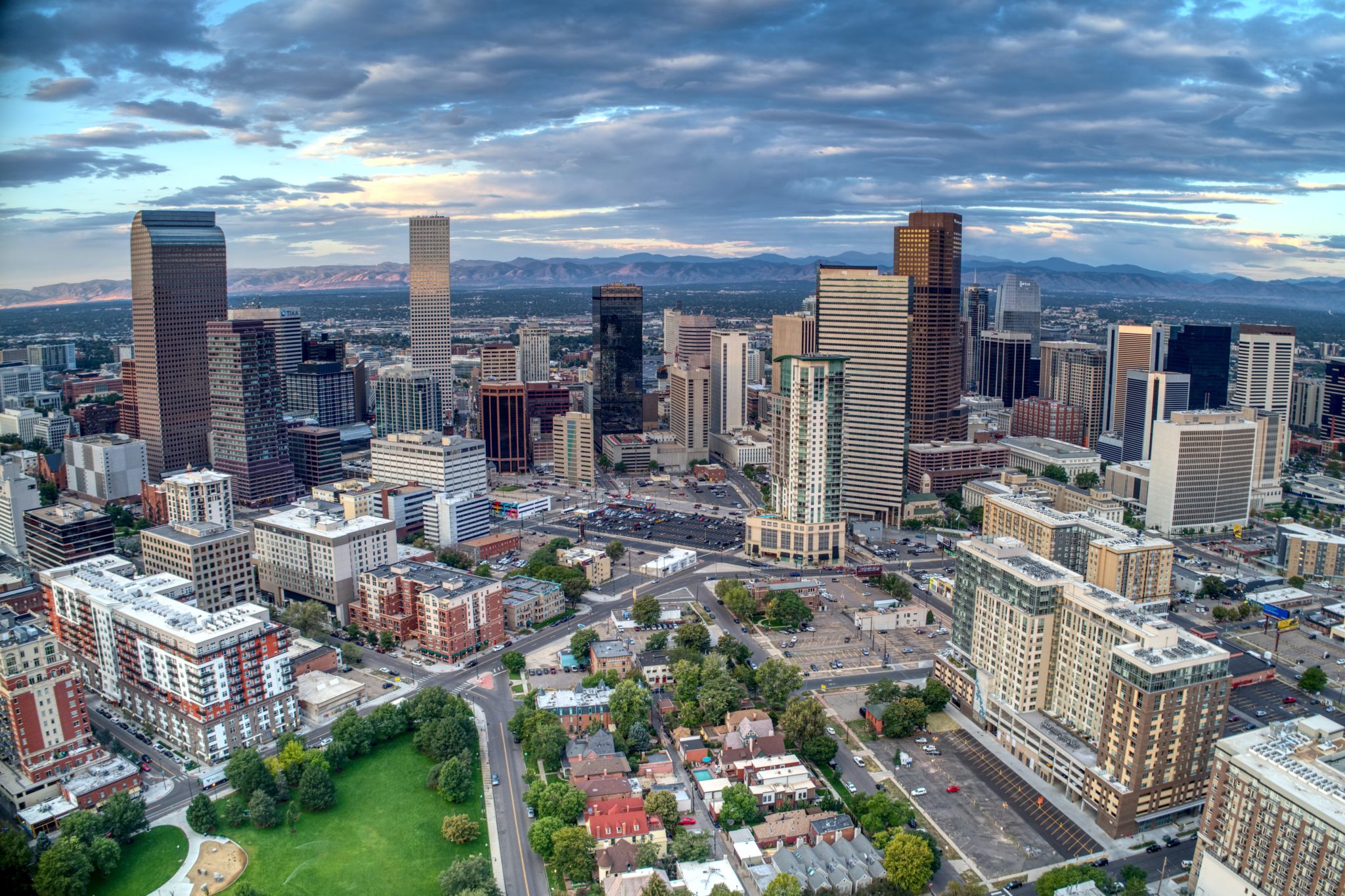
Denver. A pilot program between CSU’s Salazar Center for North American Conservation and Denver Parks and Recreation will make up to $150,000 available to one to two research teams to identify and fund actionable research that support the city’s climate management needs and decision-making. Photo credit: Colorado State University
Are you a researcher focused on urban equity and climate resilience? The Salazar Center for North American Conservation, along with Denver Parks and Recreation (DPR), is currently seeking proposals from CSU faculty and research staff to support and advance DPR’s efforts in equitable climate resilience. The goal of this pilot program is to identify and fund actionable research that supports the city’s climate management needs and decision-making.
The Salazar Center’s mission is to accelerate the pace and scale of equitable, innovative, and durable solutions for nature and all people by connecting diverse leaders, communities, and resources across the North American continent. With Denver as a leader in climate action, this partnership will lead to durable natural climate solutions through a health-equity lens to improve the well-being of Denver’s landscapes and people. This program aims to bridge the gap between innovative CSU researchers and the city of Denver to advance solutions for meaningful work in urban conservation.
Core themes
The Center invites proposals that address one of four core research themes, developed in collaboration with DPR:
Climate impacts on landscapes
Native pollinators and climate change
Urban tree canopy and climate change
Soil carbon sequestration
In alignment with the Center and DPR’s programmatic priorities, proposals should also address how the research will support solutions that deliver equitable benefits across Denver’s communities. More information and guiding questions for each theme are available in the complete RFP.
Funding and Eligibility
The RFP opens to applications June 30, and proposals are due by August 5; 2022 proposals are to be submitted via the Center’s online application form. This program will make up to $150,000 available and award one to two research teams.
Any researcher affiliated with CSU may apply as a principal investigator, whether they are pre- or post-tenure, affiliates, or staff with any of the relevant centers, institutes, departments, extension offices, or other campus entities. While non-affiliates may not serve as PI, non-PI members of the research team may come from partner entities external to CSU. Teams that are interdisciplinary and cross-sector in nature, and proposals that include a spatial component and/or utilize GIS data, are encouraged.
Research funds will be awarded through a competitive process guided by a selection committee comprising staff from the Salazar Center and DPR, as well as CSU experts.
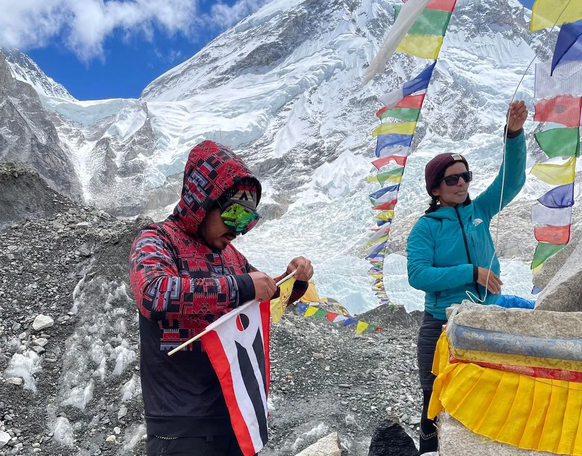
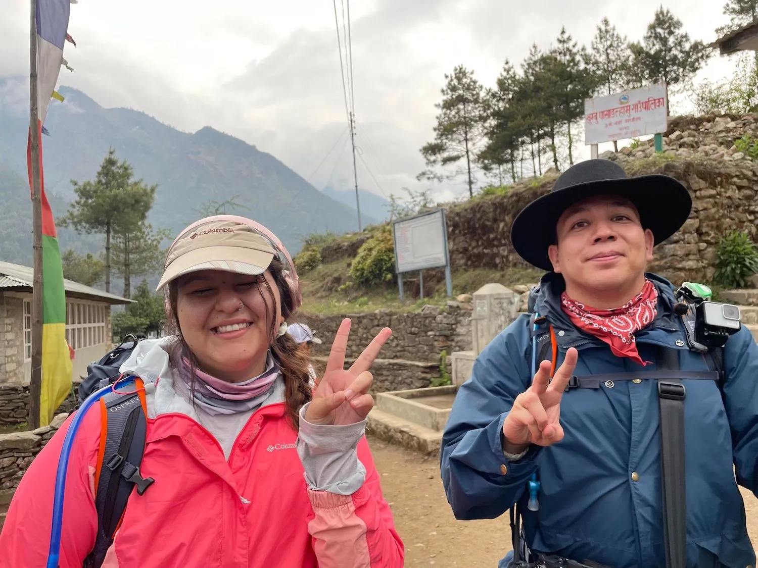
CWC ICCE Everest team member Red Thunder Spoonhunter, with a Northern Arapaho flag, and Adina Scott, engineer with the all-Black Full Circle climbing team, on Everest. (CWC ICCE Everest team)
Click the link to read the article on the WyoFile website (Katie Klingsporn):
Full Circle’s accomplishment was widely celebrated. What was lost in much of the coverage, however, was this detail: Five college students from central Wyoming trekked to base camp to help Full Circle test climate sensor technology.
The Wyoming group, affiliated with the Central Wyoming College’s Interdisciplinary Climate Change Expedition program, included two Eastern Shoshone students, two Northern Arapaho students and one bike shop mechanic who’s the first in his family to go to college.
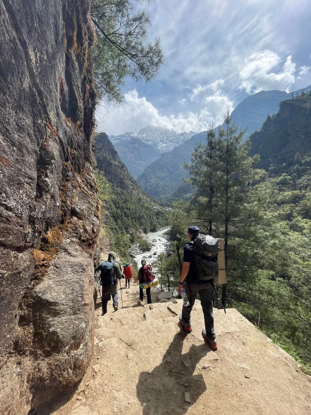
Members of the CWC ICCE Everest team hike toward the Himalayas. (CWC ICCE Everest team)
On the expedition, they met Full Circle’s climbers, tested emerging technology that may provide clearer data on high-altitude climate change and visited communities dealing with impacts of a changing climate. It was eye-opening, said Ryan Towne, the bike mechanic.
“The communities who are least responsible for climate change do not deserve to bear the brunt of its consequences,” he said. “Whatever we can do, as a school, as a community, to spread awareness for these cultures and their struggles is, you know, all that I can hope for.”
The young adults also had an adventure of a lifetime touring the vibrant city of Kathmandu, sharing meals with Nepali hosts, hiking into the thin Himalayan air and bonding as friends. They played a role in a historic achievement that felt singular in its own merit.
“I can say that I, a Native American female, have reached Everest base camp conducting climate change research,” student Jada Antelope wrote about the trip. “For this, I am beyond proud…”
An Everest expedition arises
Central Wyoming College’s ICCE program launched in 2014. The undergraduate research program weaves together science and outdoor education skills, and its students have undertaken expeditions to Tanzania (in partnership with the National Outdoor Leadership School), the Great Divide Mountain Bike Route and the Wind River Range.
The Everest project started as a nebulous concept and narrowed into focus only a couple months before it took place, said Jacki Klancher, director of instruction and research at CWC’s Alpine Science Institute, who wrangled the expedition. It spawned in part out of Klancher’s relationships with Full Circle members Phil Henderson and James “KG” Kagambi — all three have worked for Lander-based NOLS.
In conversations with the climbers ahead of their Everest attempt, Klancher said, the concept of a CWC student team came up. “They embraced us,” she said. “And the idea was we work with them to get their electrical engineer help testing some tech that we wanted to test.”
The concept of beta testing climate sensors, meanwhile, has roots in a NASA National Space Grant Consortium meeting in Jackson Hole in October, where young and promising STEM scientists gathered, Klancher said. That’s where she put out the message that she was seeking a portable climate sensor, something she has been wanting for some time for Alpine Science Institute programs.
“I was like, ‘y’all, all I want is a portable location-enabled temperature and [relative-humidity] sensor. Can anybody help?’” she said. That led to conversations with scientists from universities like Penn State, as well as the company MeteoTracker, who showed interest in developing prototypes.
As those conversations evolved and with a green light from Full Circle, Klancher next set out to secure funding and assemble a team. Several funders, such as Wyoming NASA Space Grant Consortium and Wyoming EPSCoR, backed the project. In selecting students, she first turned to program veterans like Towne and Aidan Darissa Hereford, who had ridden in the bike trek, and Red Thunder Spoonhunter, who was on the Tanzania expedition.
When Klancher first proposed the expedition, Hereford said, she was reluctant. Hereford was unsure about traveling abroad during a pandemic for one, she said.
“It seemed pretty scary,” she said. “So I was just debating on it for … about a week. [Then] I thought ‘why not? Just go for it. This is a once-in-a-lifetime chance.’”
Antelope, who along with Spoonhunter is Northern Arapaho, and Antoine Day, who like Hereford is Eastern Shoshone, rounded out the team.
Once the team solidified, Klancher and the students scrambled to apply for funding, train for high altitude trekking, expedite passport applications and secure requisite vaccinations with barely any time to spare.
On April 25, they left Fremont County on the first leg of an enormous journey. In the end, base camp occupied two days of their experience-rich three-week adventure.
Travel weary and trekking
After a ride on a triple-decker plane and a long layover in Dubai, the students landed in the teeming city of Kathmandu on April 28, jet-lagged from the 12-hour time difference. They spent a couple days touring temples and negotiating the incessant city traffic before riding a helicopter to the precarious Lukla airport. From Lukla, a carless city roved instead by yaks and trekkers, they set out on foot. They hiked for 10 days, stopping at tea houses, learning Nepali words from their guides and experiencing the countryside one step at a time.
“It was really surreal,” Hereford said. “And it was really nice to see, like, the villages and see how they live and how things are just really different over there.”
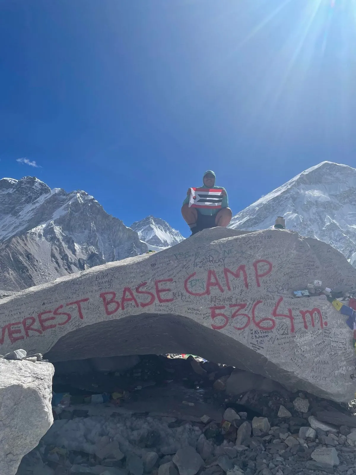
Jada Antelope perches on a boulder at Everest base camp with the Northern Arapaho flag. (CWC ICCE Everest team)
Each day was vibrant, Klancher said. “It was spectacular — tea houses and people and culture and the landscape. It felt like we did a month’s worth of living in those 10 days.”
The expedition wasn’t without trials. The team had to manage a gamut of illnesses — including acute mountain sickness, which felled Hereford — and contend with foul weather.
Members healthy enough to keep hiking reached base camp on May 9. It was a different world at 17,600 feet, Day said. “Base camp is tent city, tents everywhere,” he said, with constant helicopter traffic overhead.
There, they met the Full Circle team and hiked to the ice fields. They partnered with Adina Scott, a Full Circle researcher and engineer, to work with the sensor prototypes, and Towne carried one on the trek down.
After two nights at base camp, the students started the journey home. Full Circle reached the summit of Everest on May 12.
It was a wild ride. But reminders of home helped bridge the familiar with the foreign, Hereford said. “What I really loved the most was waking up every day and smelling … over here in our community, you know, we burn sweetgrass … and so it smelled like that every morning, but they called that juniper.” One thing that helped her through her altitude sickness, she said, was eating a Nepali version of fry bread.
Crunching data, telling the tale
The team returned on May 19. In early June, members were still processing the adventure, and hadn’t yet determined the quality of the data the prototypes collected or the technology’s potential.
“We were successful in doing what we wanted to do, which was to partner with Full Circle to beta test these prototype units and go, ‘Can these things even do what MeteoTracker says?’” Klancher said.
Not knowing the answer to that immediately illustrates the long and sometimes painstaking process of science, she said
Aidan Hereford and Antoine Day on the trek. (CWC ICCE Everest team)
“So, you know, like people asked, ‘What did you learn?’ It’s like, well, we didn’t solve climate change for all time and save the Nepalese and 1.6 billion people from surface water crises,” Klancher said. Instead, they tested an idea, and will offer feedback in an attempt to improve the devices and ultimately the science, Klancher and Day said.
It’s “baby steps,” Klancher said, that one day could lead to, for instance, Sherpas carrying the units to gauge high-altitude climate conditions.
“Did we meet my objectives of diversity, equity, inclusion in STEM? We did,” she said. “Did we educate students and help provide them with professional preparation…? Yes. Did we contribute to climate and water science data and tech? Yes. Did we work on a ton of partnerships…? Yes.
“And did we have a blast? Yes,” Klancher said. The team was a delight, she said. “These guys just figured it out and laughed so much. …I did not have to do a lot of interpersonal group management … It was kind of the magic group.”
The students will present on their expedition in September in Riverton, and Day will curate a photography exhibit of images he took later in the fall.
Due to current drought conditions and decreasing water supply levels, the Pagosa Area Water and Sanitation District (PAWSD) began implementation of Level 1 water-use restrictions last week. Below is an abridged summary of the levels of water-use restrictions. A full and detailed explanation of forthcoming water use restrictions will be mailed to all PAWSD customers. It is expected that all affected customers will become familiar with the requirements and employ the demand reduction mandates so as to preserve the current water supply.
Copies of the PAWSD Drought Management Plan are available at http://www.pawsd.org or at the PAWSD office located at 100 Lyn Ave.
The Pagosa Area Water and Sanitation District (PAWSD) is currently providing water for Chama, N.M., with that community facing a water shortage and lack of running water. District Manager Justin Ramsey explained in an interview with The SUN that PAWSD is currently working with the New Mexico Department of Homeland Security and Emergency Management (DHSEM) to provide water for Chama.
According to Ramsey, DHSEM has a contract with PAWSD for up to 150,000 gallons of water a day for five days, which they are currently drawing from to help provide water for Chama, which is facing extensive water line breakages and extreme water shortages from a lack of running water.
“I know it’s gonna seem odd ‘cause we just went into drought restrictions, but this is an emergency,” Ramsey said of PAWSD’s involvement. “They have no water … to water their grass and their vegetables, … so we opted to be good neighbors.”
Ramsey also commented, “We’re trying to get ‘em to take it from … the fill station at [the PAWSD Vista office] and the fill station at Trails so that it’s coming from our San Juan plant. … Once it passes that diversion at San Juan, it’s gone, we don’t have it anyway, so that’s where we’re trying to grab it from. It’s water that would flow by us anyway.”
Rivers and drought
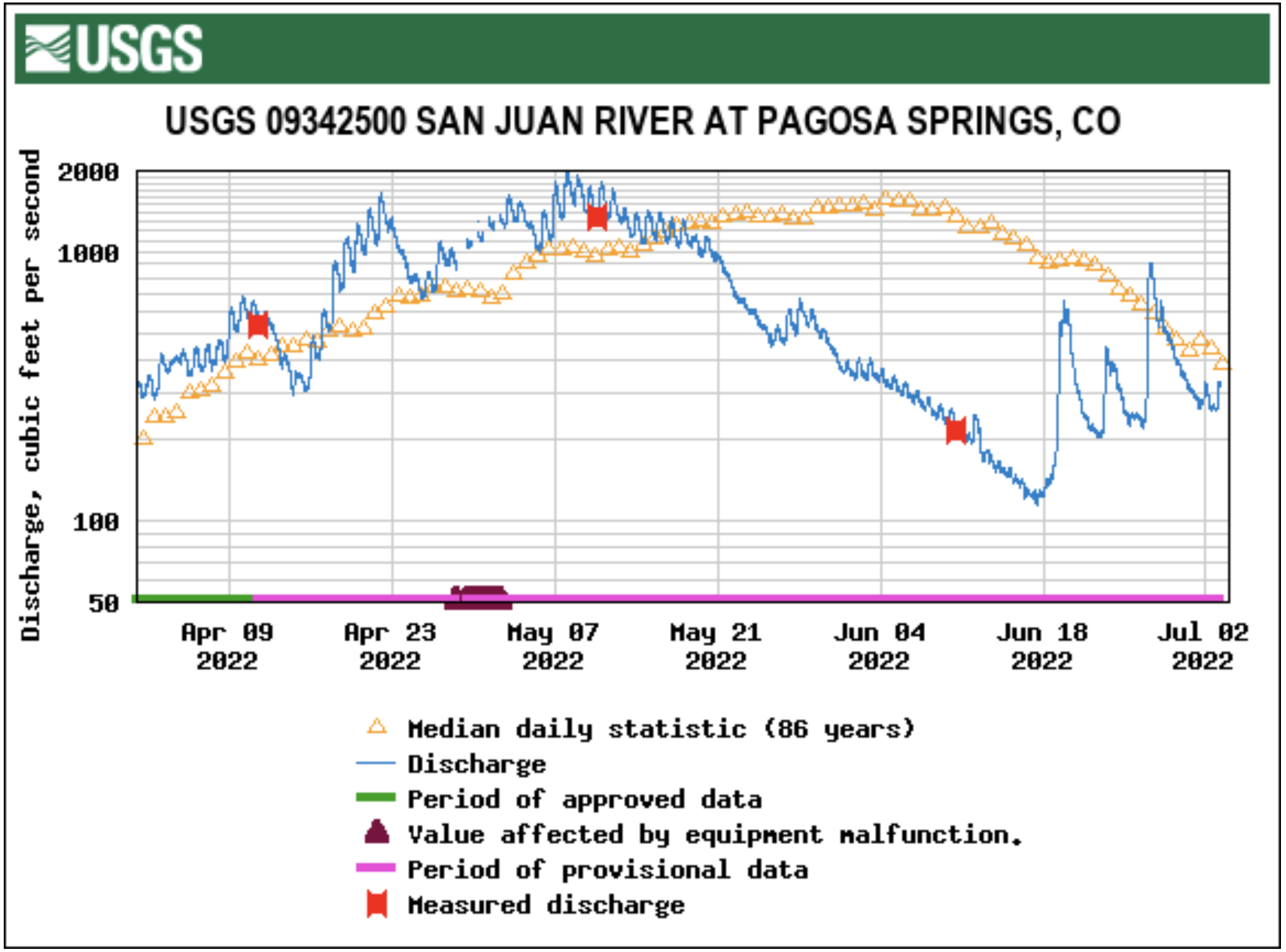
Stream flow for the San Juan River on June 29 at approximately 9 a.m. was 402 cubic feet per second (cfs), according to the U.S. Geological Service (USGS) National Water Dashboard. This is down from a recent peak of 911 cfs at 6:30 a.m. on June 27 and up from last week’s reading of 220 cfs at 9 a.m. on June 22.
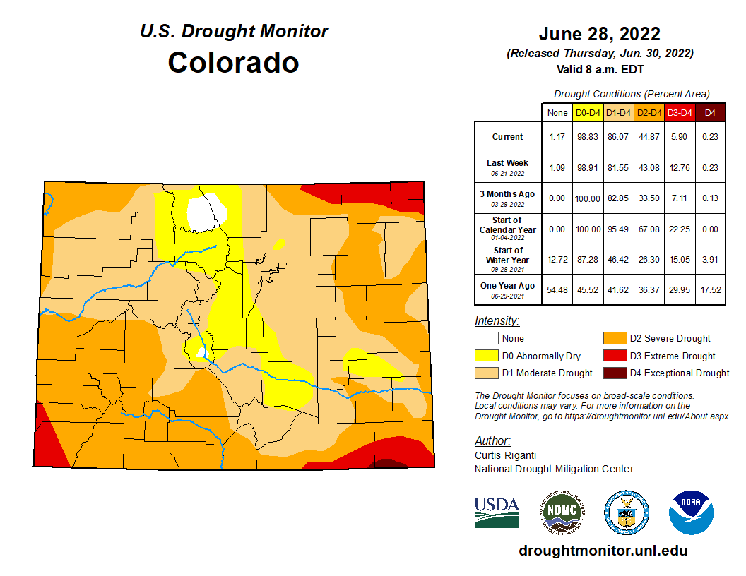
Colorado Drought Monitor map June 28, 2022.
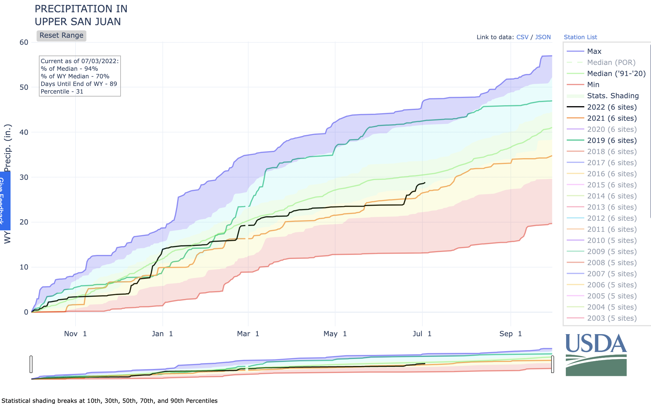
The National Oceanic and Atmospheric Administration (NOAA) National Integrated Drought In- formation System (NIDIS) reports that 100 percent of the county is experiencing drought. The NIDIS indicates May 2022 was the 19th driest May in 128 years, with 1.03 fewer inches of precipitation than normal, and with 2022 to date being the sixth driest year in the last 128 years, with 5.22 inches of precipitation less than normal. The NIDIS places the entire county in a severe drought, which the website notes may cause farm- ers to reduce planting, producers to sell cattle and the wildfire season to be extended, among other impacts. The NIDIS also notes that a severe drought is associated with low surface water levels and reduced river flows. The NIDIS also places a portion of the county in an extreme drought…
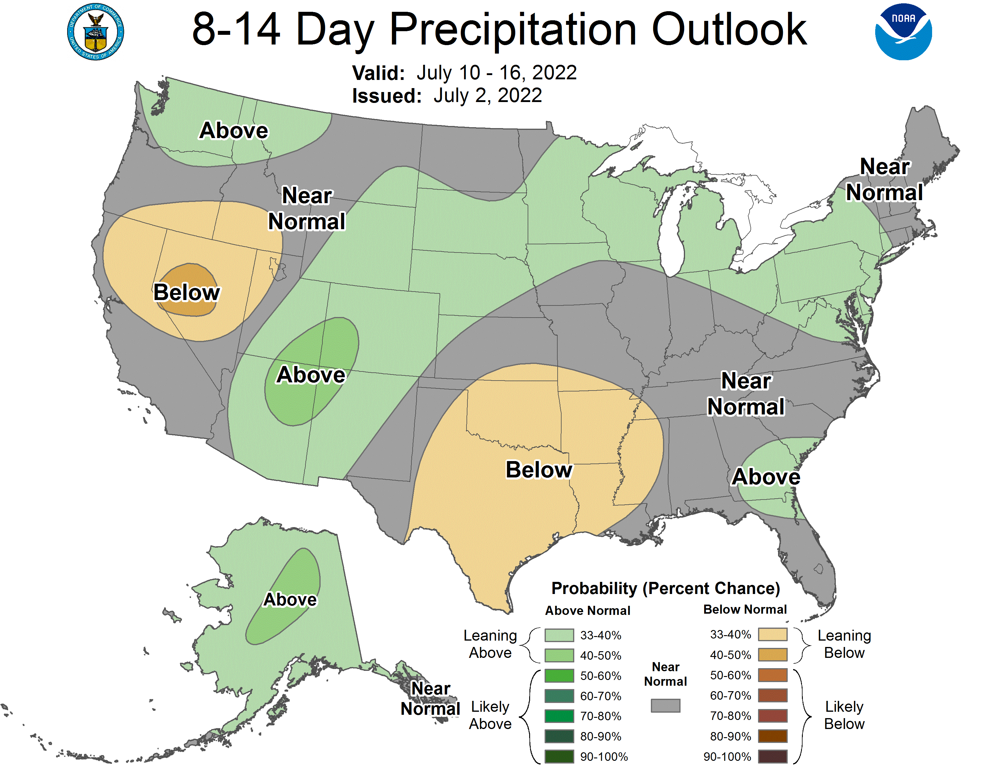
The forecast for the area indicates that in the next two weeks, the majority of Archuleta County will be experiencing extreme wet conditions, while the four-week forecast shows the county will be experiencing a mix of extreme wet and exceptionally wet conditions.
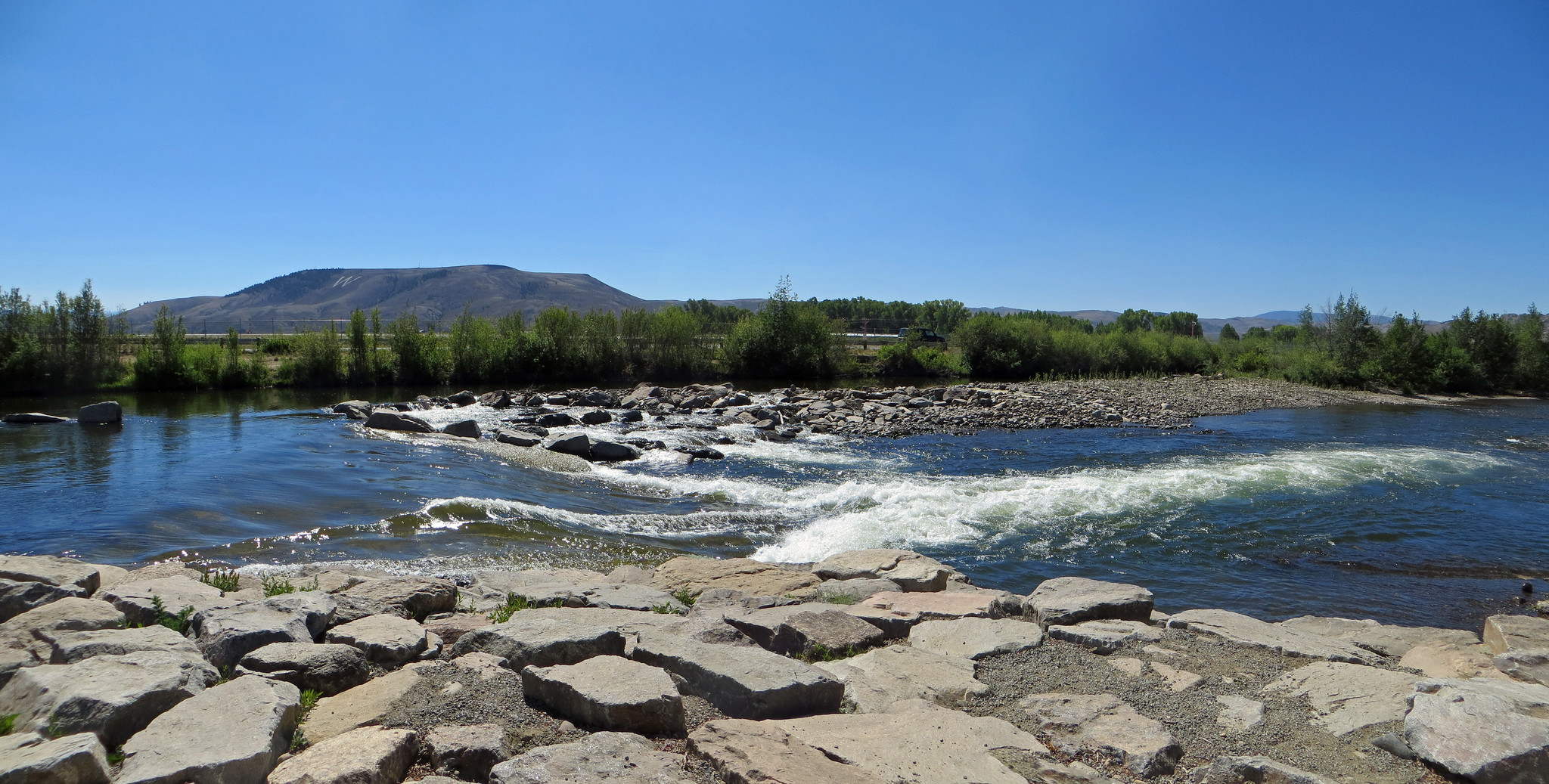
Gunnison Waves and other river users have asked local leaders to add a waveshaper to the whitewater park — a device that is prized by surfers for its ability to create a consistent wave when flows vary along the river.
Gunnison County, along with the Upper Gunnison River Water Conservancy District, are collecting feedback from local surfers and other river users on proposed improvements at the Gunnison Whitewater Park. Conceptual plans include moving and replacing the second wave or “Drop #2,” and adding an adjustable waveshaper. Although a waveshaper is widely supported by the river community, county staff are still exploring its feasibility due to staffing issues and added costs.
McLaughlin Whitewater, the design and engineering firm the county works with to assess conditions at the park, has been monitoring Drop #2 yearly since wave three was rebuilt in 2015 due to scouring underneath. According to project manager Ben Nielsen, although the current condition of Drop #2 does not pose a safety risk to surfers, it is worsening and following the same trajectory as wave three.
Jason Lakey, one of the original founders of Gunnison Waves, said the drop first shifted in 2019 after a big snow year. Users began to notice a decrease in the waves performance in 2020, where waves were harder to catch and stay in, he said.
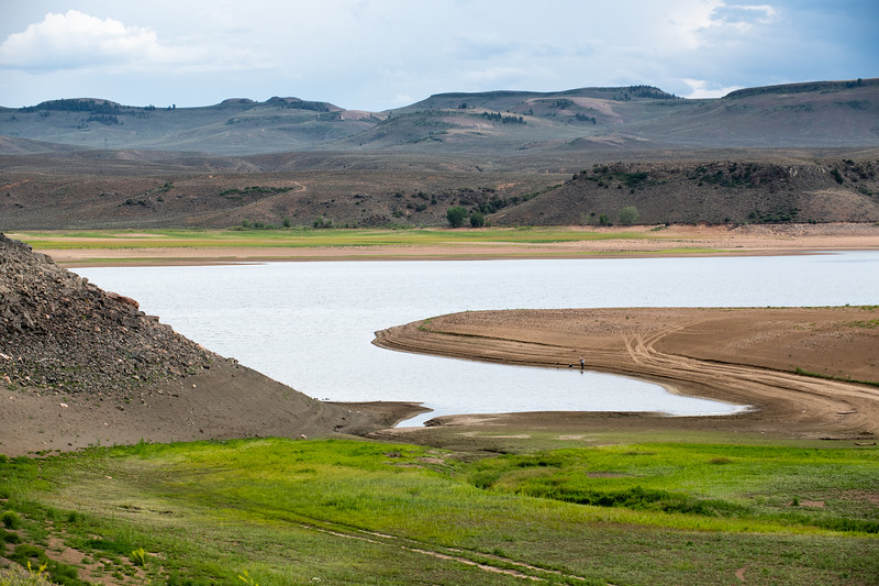
Blue Mesa Reservoir is the largest storage facility in Colorado in the Upper Colorado River system. Prolonged drought and downriver demand is shrinking the reservoir. Credit: Tom Wood, Water Desk
Click the link to read the article on the KUNC website (Luke Runyon and Alex Hager). Here’s an excerpt:
Colorado’s water shortages are not relegated to the distant future. Water supplies cannot meet current demands in many communities, and are only likely to worsen as climate change heats up and dries out the state’s cities and farms. That message is front and center in the Colorado Water Conservation Board’s first draft of a comprehensive update to the Colorado Water Plan, originally passed in 2015. Its initial creation was spurred by then-governor John Hickenlooper.
The plan anticipates a supply-demand gap of 240,000 to 740,000 acre-feet for cities and industries by 2050…For agricultural users, shortages are already a way of life. The plan projects that an existing shortfall of 2.6 million acre-feet for farmers and ranchers could increase to 3.5 million acre-feet by the middle of this century.
The plan is candid about the harsh effects of climate change, and the likelihood that Colorado’s water future will be shaped by warming and drying patterns. This includes acknowledgements of “aridification” – the idea that the West is not just experiencing the normal ebb and flow of drought, but instead becoming permanently drier. Climate scientists broadly agree that rising temperatures are driving a batch of changes that result in a shrinking water supply for much of the Southwest.
Today, the Colorado Water Conservation Board (CWCB) released the draft update of the Colorado Water Plan for a 90-day public comment period. The plan, originally developed in 2015 under the direction of Governor John Hickenlooper, is meant to address growing water scarcity in Colorado and ensure the state has a sustainable water future that meets the needs of a wide range of water uses by all Coloradans. In response to the release of the updated plan, Water for Colorado has issued the following statement.
“We appreciate all of the hard work by CWBC staff and board members and Department of Natural Resources to prepare a draft update to the Colorado Water Plan. We have already begun our thorough and detailed review and we look forward to providing comments. Our coalition was founded seven years ago to help influence the development of the 2015 Water Plan through providing technical review and driving civic engagement. We will submit comments and engage in a robust conversation with stakeholders on how we can best protect Colorado’s watersheds and rivers for all Coloradans and for future generations. We look to this Water Plan update to improve water security throughout the state by equitably addressing many of our watershed and water conservation needs.
This revision of the Colorado Water Plan will certainly play an important role in advancing our water goals throughout the state. But it alone will not be sufficient to meet the growing water challenges we face. This was further emphasized by recent statements by federal officials about the need for substantial water reductions by all states and in all water sectors to avoid critically low levels in the Colorado River basin’s largest reservoirs. Worsening hydrology and increased demands placed on dwindling water resources guarantee that additional, urgent actions will need to be taken to ensure a secure water future for Colorado. Governor Polis has called 2022 the “year of water” for Colorado, and we look forward to working with Governor Polis and his administration, other elected officials, Basin Roundtables, and communities on the critically important issues facing our state in 2022 and beyond. We must meet this pivotal moment in a way that positions Colorado as a leader in collaborative water management — our state’s future depends on it.”
The coalition has spokespeople available for comment now and in the coming 90 days, during which both partner organizations and the public have a vital opportunity to ensure that their voices are heard, that their interests are considered, and that Colorado’s water plan is truly that — a plan for the entire state.
Pathfinder Dam part of the North Platte Project (originally the Sweetwater Project) is an irrigation project in the U.S. states of Wyoming and Nebraska. The Interstate Canal is part of the project. By Josh Hallett – originally posted to Flickr as Pathfinder Dam – Wyoming, CC BY-SA 2.0, https://commons.wikimedia.org/w/index.php?curid=4171115
From email from Governor Gordon:
Governor Mark Gordon has mobilized the Wyoming National Guard and multiple state agencies to provide assistance to the residents of Lingle and Goshen County in response to flooding that is occurring as a result of a breach in the Interstate Canal north of Lingle.
“I want to thank our state agencies for their quick response to this concerning situation and I praise them for their hard work and dedication to help minimize the impact on our citizens and communities there. Thanks to the quick and competent response from our state agencies, including the Wyoming Office of Homeland Security and the State Engineer’s Office, we were able to rapidly respond to the situation.
At my request, Secretary of State Buchanan is on the ground to personally survey the scope of the damage and to ascertain what resources are needed to help the citizens of Goshen County. Secretary Buchanan has reported the local folks are working together to sandbag the canal. As I have said many times before, I am proud of our Wyoming people who do what they do best—helping neighbors.
My office has been in contact with Governor Ricketts of Nebraska, as the majority of the water in the canal flows to our neighbors in Nebraska. We will continue to communicate with Nebraska officials as we work to resolve the issue.” Gov. Gordon said.
After Goshen County Commissioners issued an emergency declaration, the Governor activated the Wyoming National Guard to place 1,000-pound sandbags in the breach. The Laramie County Fire Authority assisted the State by transporting the sandbags to the site of the canal breach.
Staff from the Wyoming Office of Homeland Security, the State Engineer’s Office and county officials immediately traveled to the site to assess the situation. The Wyoming Public Service Commission is working with utilities. Water was promptly diverted from the canal at the Whalen Diversion Dam and parts of Lingle were evacuated. Early estimates determined that water levels would begin receding around 2 p.m. this afternoon. However, water is expected to continue flowing for the next twelve hours, as the canal was full prior to diversion.
There comes a phase in almost any large-scale, controversial project on public or private land when the questions arise and the lawsuits begin. The proposed Uinta Basin Railway (UBR) is no different.
Everything about the venture is large-scale, from its nationwide scope to potential global impacts. Although the UBR, at 88 miles, is considered a “short line,” it would create a new link in the oil supply chain connecting the vast, fracked-oil fields in northeast Utah’s Uinta Basin to the national rail network, passing through Glenwood Canyon on its way to the refineries on the Gulf Coast. The UBR, approved by the Federal Surface Transportation Board (FSTB) in late 2021, would provide enough transportation capacity to increase oil production in the Uinta Basin from between 80,000 and 90,000 barrels per day (B/D) currently to 350,000 B/D — essentially quadrupling output.
The increase in CO2 from expanding Uinta Basin production would come at a time when scientists around the world are sounding an alarm. In 2022, the Intergovernmental Panel on Climate Change stated that global greenhouse gas emissions must peak by 2025, drop by half by 2030 with net-zero CO2 emissions by 2050 to avoid catastrophic and possibly irreversible climate changes.
Combined CO2 emissions from the estimated fracked-oil operations in the Uinta Basin as result of the UBR and end-product combustion range from about 20 to 55 megatons per year, which, at the high end, is equal to about 1% of the U.S. or 17.5% of the United Kingdom CO2 output in 2020.
The Uinta Basin is shown on this map, along with existing rail terminals in Carbon County, Utah, where limited amounts of the basin’s waxy crude is loaded into train cars. A proposal to create a direct rail link to the basin would provide shippers with enough transportation capacity to quadruple output.
Salt Lake City refineries at capacity
The type of oil found in the Uinta Basin is tricky to transport and difficult to refine. Called “waxy crude” because of its high paraffin content, it solidifies at about 100 degrees Fahrenheit. The Utah Department of Environmental Quality states that it must be “heated in the field and transported in insulated trucks.”
As explained by Adam Sayres, president of Axia Energy II, which operates in the Uinta Basin, Uinta crude is like Chapstick. He gave a detailed presentation to the Board of Trustees of Utah’s School & Institutional Trust Lands Administration (SITLA) in May 2018, stating that the crude is liquid underground at about 225 degrees, but once it hits the surface, it has to be kept in heated tanks at 180 degrees. Then, it’s loaded onto insulated trucks that head for Salt Lake City refineries, about 150 miles away.
According to Matt Sands, host of the Mineral Rights Podcast, in 2019, those refineries had a total production capacity for 189,000 B/D but only about 88,000 B/D for Uinta Basin waxy crude. Salt Lake City was declared a nonattainment area by the Environmental Protection Agency for air-quality standards twice in one decade — in 2009 for fine particulate matter and in 2015 for ozone — which proved problematic for those wanting to increase Uinta Basin waxy-crude production. “Production has had to mirror the refining capacity,” Sayres told the SITLA board.
Bryce Bird, director of the Utah Division of Air Quality, told Aspen Journalism that ozone levels have not improved and emissions from all refining operations are capped due to air-quality concerns. “Without getting permit changes or offsetting emissions, the refineries cannot increase production,” he said.
Wendy Park, an attorney for the Center for Biological Diversity, a conservation group opposed to the UBR, said Uinta Basin oil producers are locked into the Salt Lake City refinery market, which gives the refineries a distinct advantage. “The Salt Lake City refineries can ask for a discount because there isn’t much competition for this waxy crude oil, [since companies] can’t get it to other customers,” she said. “The increase in markets for Uinta Basin crude would allow oil producers to charge higher prices, which would spur increased drilling.”
The only way to increase production in the Uinta Basin is to refine the waxy crude somewhere else. Proponents of the UBR say the best way to do that is to link the Uinta Basin by rail to the national rail network, near Price, Utah, and take that crude to Gulf Coast refineries that can handle it.
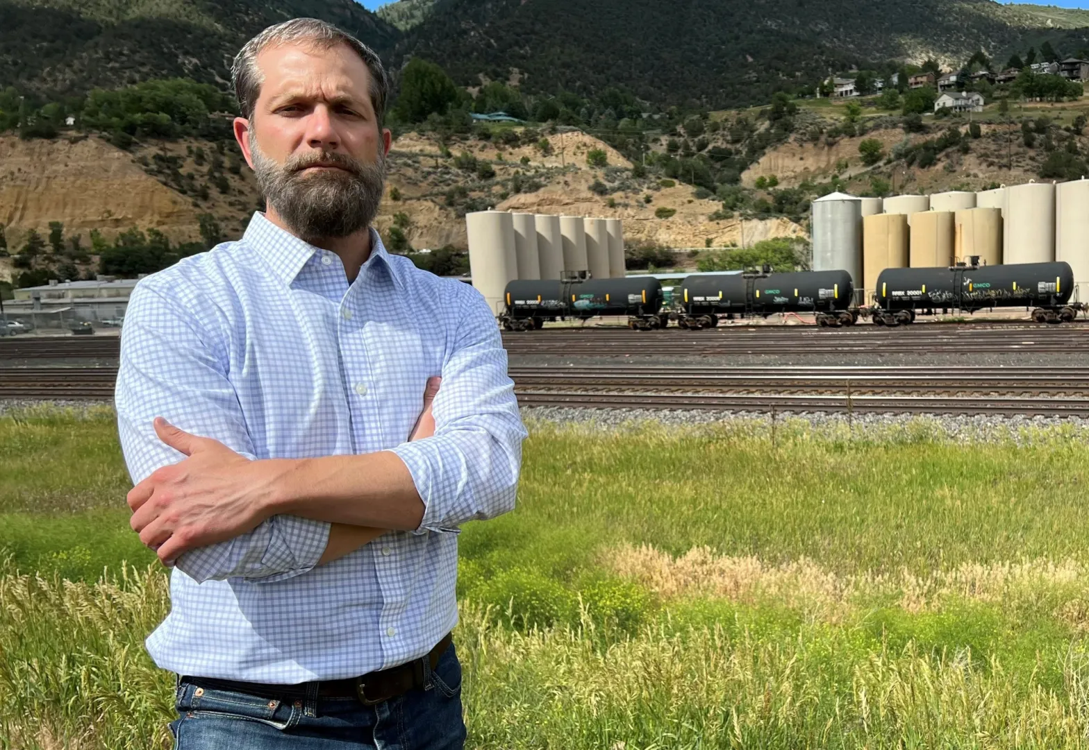
Glenwood Springs Mayor Jonathan Godes near the Union Pacific rail yard just west of downtown. Godes is opposed to oil trains from the Uinta Basin coming through Glenwood Springs.
Oil trains would go through Colorado
The UBR promises to add from three to 10 oil trains daily to the national railway running through Colorado. The trains would share the tracks with Amtrak and freight haulers, winding through Glenwood Canyon and up through the Moffat Tunnel before descending to Denver and then east and south. The waxy crude would be shipped in heated unit cars — approximately 110 cars per train with the capacity to carry about 642 barrels in each car.
Communities along the Colorado route, including the city of Glenwood Springs, have written to U.S. Sens. Michael Bennet and John HIckenlooper against the UBR, citing concerns about air quality, wildlife, water and public safety. Glenwood Springs Mayor Jonathan Godes told Aspen Journalism that an accident or spill in Glenwood Canyon would be disastrous all the way to the Sea of Cortez. “To say it’s a far-fetched possibility, I think, is to ignore reality,” he said. “If that waxy crude that’s heated in order to stay viscous spills into our watershed and into the Colorado River, it would be a massive cleanup where they would have to remove tons of soil and debris.”
Eagle County officials, who are party to a lawsuit challenging the FSTB’s December approval of the UBR, have also voiced concerns that the long-dormant Tennessee Pass rail line would be revived as an alternate route for the oil trains should the national rail network through Colorado — particularly the Moffat Tunnel — become crowded.
Texas-based Rio Grande Pacific Corp (RGPC), which plans to build and operate the UBR, also owns Colorado, Midland & Pacific Railway (CMP), which, in late 2020, attempted to lease a portion of the Tennessee Pass line from UP for possible commuter/passenger service and freight options, and applied for fast-track approval from the FSTB. RGPC made a point of stating that it “has no plan to operate oil trains over Tennessee Pass.” RGPC even went so far as to amend its plan a week before the FSTB made its decision, requesting restriction from hauling crude oil, coal and hazardous materials in the proposed lease.
But Eagle County Commissioner Matt Scherr is not convinced. “There is no way they can commit to that,” he told Aspen Journalism. “They are not allowed to officially make a promise that [they] will not do some sort of activity on a line that has a general practice of moving freight.”
The FSTB denied the application — and, by extension, RGPC’s proposed amendment — on March 25, 2021, for a variety of reasons, including public opposition and RGPC’s apparent rush to get it done. But the decision left the door open for CMP to reapply with a more comprehensive impact review and a full application process. “So, the proposal could come back,” said Park.
Click the link to go to the Colorado Water Plan website:
The Colorado Water Plan provides a framework for helping Colorado meet its water challenges through collaborative action around water development and water conservation. The plan includes a range of collaborative partner actions that stakeholders can advance through grant funding & local projects, as well as specific actions the Colorado Water Conservation Board and other agency partners will commit to in order to advance the plan. The plan guides future decision-making and supports local actions to address water challenges with a collaborative, balanced, and solutions-oriented approach that builds resilience.
The Colorado Water Plan uses state-of-the-art data and tools to analyze the state’s water issues, including adapting to aridification and climate change, embracing innovative ideas and new technology that align with Colorado’s evolving water goals. The Plan includes four main focus areas that work together for a stronger state: Vibrant Communities, Robust Agriculture, Thriving Watersheds, and Resilient Planning.
Colorado Water Plan grants support a range of multi-beneficial projects for water storage, water conservation, the water-land use nexus, agricultural efficiency, water education and awareness, watershed health, and outdoor recreation. The Colorado Water Plan’s focus areas will address overlapping themes to address identified risks and challenges: funding, supply, equity, climate change, land use planning, storage, efficiency, education, and forest health.
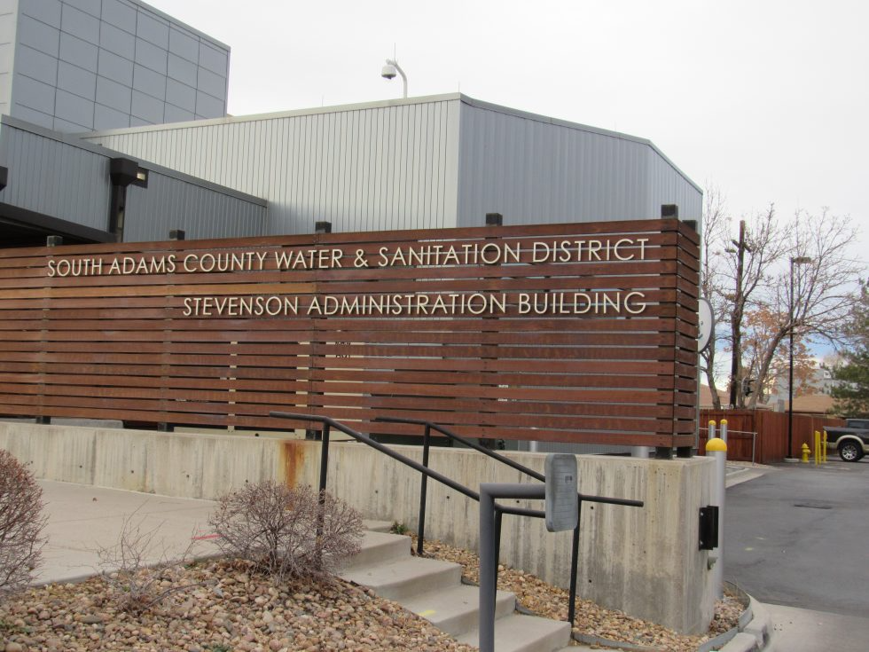
The South Adams County Water and Sanitation district is one of several water providers around the state now treating to remove PFAS from its drinking water supplies. Nov. 23, 2021. Credit: Jerd Smith
The EPA issued new or updated health advisories for four PFAS chemicals: PFOA, PFOS, GenX, and PFBS.
Health advisories are not enforceable.
The science behind the health advisories will inform federal drinking water standards that will be published later this year.
The U.S. Environmental Protection Agency’s new warnings about the danger of certain PFAS chemicals to human health are a stepping stone toward the agency’s development of national drinking water standards later this year. The warnings also test the limits of laboratory observation.
On June 15, the agency substantially lowered existing health advisories for two of the so-called “forever” chemicals, PFOA and PFOS. The agency also posted first-ever advisories for two additional chemicals, GenX and PFBS.
The new interim advisory levels for PFOA and PFOS are almost inconceivably small. So small, in fact, that laboratory methods cannot detect the chemicals in drinking water at these levels: 0.004 parts per trillion for PFOA and 0.02 parts per trillion for PFOS. The previous advisory level, set in 2016, was 70 parts per trillion combined — more than 10,000 times higher than the new level for PFOA.
“It’s unclear what to do,” said Alan Roberson, executive director of the Association of State Drinking Water Administrators, a group that represents state regulators. Roberson said a health advisory set below the detection level has never happened before.
For members of the general public who are attuned to drinking water contaminants, the EPA announcement is raising concerns, according to John Lovie, president of the Whidbey Island Water Systems Association. Located in Washington state, the association counts about 100 water systems as members, which range in size from several thousand customers to just three or four. The town of Coupeville, one of the largest in the association, is dealing with PFAS chemicals in its water.
Lovie said that people on the island have already started to ask water systems what they are planning to do about the health advisories.
“The short answer is: not very much at the moment,” Lovie said.
Not very much because of the nature of the tool that the EPA is using. Unlike federal drinking water standards, health advisories are not enforceable. Water utilities are not punished if they exceed the limits. The advisories instead are meant as guidance for utilities, notifying them of chemical concentrations at which health damage can occur.
The EPA’s 2016 revision of the PFOA and PFOS health advisories helped to lift the class of nonstick, water-repelling chemicals into the national spotlight. Found in cookware, clothes, carpets, firefighting foams, and burger wrappers, PFAS chemicals number in the thousands. They have been linked to a cluster of undesirable health problems: high cholesterol, kidney cancer, low birth weight, and hampered immune systems.
In developing the new advisory levels, the EPA considered recent scientific findings that suggest health damage occurs at minuscule concentrations. The revised health advisories for PFOA and PFOS are due in large part because the chemicals inhibit vaccine response in children. The advisories are based on a lifetime of tap water consumption.
Two other PFAS chemicals received their first health advisories. The advisory level for GenX (10 parts per trillion) was based on liver damage. The advisory level for PFBS (2,000 parts per trillion), on thyroid effects.
Lovie is concerned that drinking water is being “singled out” in the regulatory world because measuring PFAS in water is easier compared to measuring exposure from other sources of PFAS, like clothing, food packaging, or dental floss.
“It’s thrown a lot of pressure on water systems to do something,” Lovie said. “It seems a bit of a mess.”
Health advisories are the EPA’s first step. The official name for an enforceable federal drinking water standard is a maximum contaminant level, or MCL. The EPA intends to publish draft MCLs for PFOA and PFOS by the end of 2022 and finalize the rules next year.
The lack of federal rules has not stopped states from acting. According to the Association of State Drinking Water Administrators, 11 states have instituted their own health advisories, MCLs, or notification levels. These rules are a mixed bag of mandates and guidance, covering nine PFAS chemicals.
Roberson said that many states are waiting for the federal MCL before taking any additional action.
New Hampshire set its own standards in 2019. Jim Martin, a spokesperson for the New Hampshire Department of Environmental Services, said the state will be engaging with the EPA as the MCL process unfolds.
That process has a second layer. At the same time as the MCL, the EPA will publish a maximum contaminant level goal, or MCLG. This is the level below which no health problems are expected for people who drink tap water over a lifetime.
Because the MCL incorporates economic factors like the cost of compliance, it will undoubtedly be higher than the MCLG. According to an EPA spokesperson, the MCLG will be based on the same science that the agency consulted when developing the health advisories.
For Lovie, the likely divergence between a regulatory standard in parts per trillion and a health advisory in parts per quadrillion means that the EPA and utilities will confront a public communications challenge. They will need to explain why the federal standard is higher than the level which provides the most health protection.
“Hopefully they’re going to come up with some further information on how to rationalize an MCL that’s going to be probably 1,000 times higher at least than the lifetime health advisories that they put out there,” Lovie said. “That’s a hard circle to square.”
PFAS contamination in the U.S. via ewg.org. [Click the map to go to the website.]
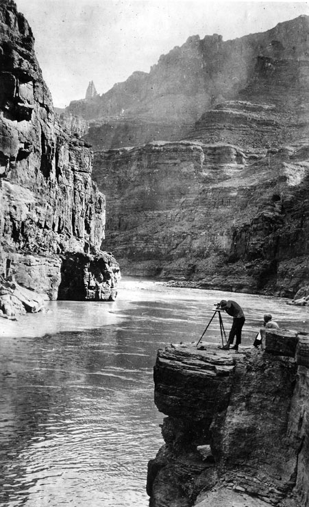
In this photo we have Claude Birdseye (right) – expedition leader and Chief Topographic Engineer of the USGS, and Roland Burchard (left) – expedition topographer. Photo credit: USGS
Click the link to read the article on the NREL website (Harrison Dreves. Photos by Dennis Schroeder. Video by Josh Bauer):
Low-Impact Development of Solar Installations Could Be Win-Win-Win for Food, Water, and Renewable Energy
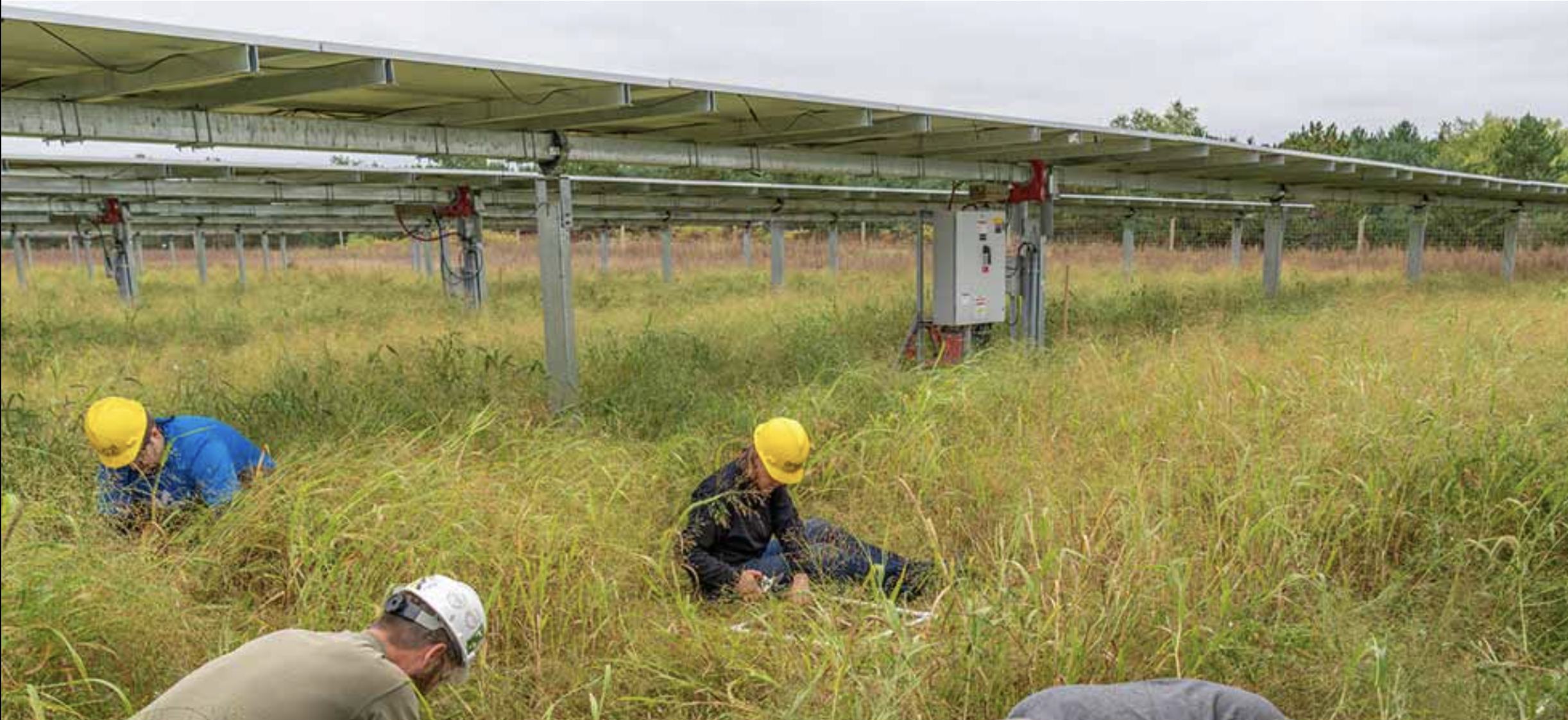
On a humid, overcast day in central Minnesota, a dozen researchers crouch in the grass between rows of photovoltaic (PV) solar panels. Only their bright yellow hard hats are clearly visible above the tall, nearly overgrown prairie grasses—which are growing exactly as expected.
Bent over white, square frames, some of the researchers catalog the number and type of native plants growing on a square foot of land. Others press double-forked meters into the ground, measuring the soil moisture below the solar panels and in open ground. Nearby, beekeepers check on the health of local hives.
Their research is part of an ongoing study to quantify the benefits of a new approach to solar installations: low-impact solar development.
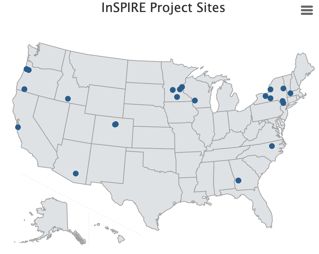
To better understand the benefits of—and barriers to—low-impact solar development, the Innovative Site Preparation and Impact Reductions on the Environment (InSPIRE) project brings together researchers from the U.S. Department of Energy’s (DOE’s) National Renewable Energy Laboratory (NREL), Argonne National Laboratory, universities, local governments, environmental and clean energy groups, and industry partners. The project is funded by DOE’s Solar Energy Technologies Office.
Credit: NREL
Bees Benefit—and That’s Just the Beginning
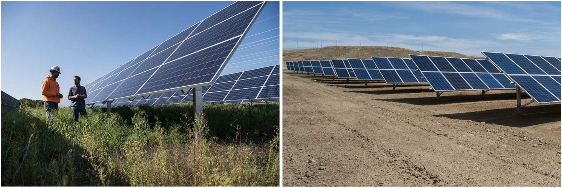
Traditionally, large solar installations are deployed on land that is first leveled, removing much of the topsoil and vegetation. After the mounting racks and solar panels are installed, the ground is covered in gravel or turf grass. With low-impact solar development, the ground may also be leveled in some places, but the topsoil is preserved. After the panels are installed, native and other beneficial vegetation—often friendly to bees and other pollinators—is planted.
A greener way to go green—NREL Analyst Jordan Macknick and Jake Janski of Minnesota Native Landscapes survey the Aurora Solar Project’s low-impact installation (left). Compare that to a traditional solar installation at Ft. Carson Army Base in Colorado Springs, Colorado (right). Photo credit: NREL
The deep roots of native vegetation retain more water than turf grass and gravel during heavy storms and periods of drought. They also help retain topsoil and improve soil health over time, even in “brownfield” areas with polluted soils.
Perhaps most importantly, native and flowering vegetation provides a habitat for native species, especially pollinators and other beneficial insects that can improve yields at nearby farms.
Native solitary bee. Photo: The Xerces Society / Rich Hatfield
“One surprising thing is how rapidly and significantly pollinator-friendly solar has taken off in the states,” said Jordan Macknick, NREL’s lead energy-water-land analyst and principal investigator for the InSPIRE project. “Every state we work with wants more information on pollinator-friendly solar.”
At several InSPIRE sites, local beekeepers and university and national laboratory researchers are tracking their bees’ visits to the pollinator-friendly vegetation under the solar panels. The goal is to determine how vegetation at solar sites can benefit insect populations and to understand the extent to which pollinator-friendly solar installations can boost crop yields at surrounding farms.
The low-impact approach also benefits solar developers. For example, skipping the removal of topsoil reduces site preparation expenses. As prices continue to fall for solar panels and other hardware, nonhardware costs (including site preparation) will soon account for 20% of total utility-scale solar costs. Native vegetation, if selected appropriately, also requires less ongoing maintenance than traditional gravel or turf grass approaches, as there is less of a need for mowing or spraying.
Photo credit: NREL
Flourishing vegetation can even boost energy production from solar panels. Warmer temperatures can reduce the efficiency with which PV cells convert sunlight into electricity. The ground shading and increased evaporation provided by a healthy layer of undergrowth can actually cool solar panels, increasing their energy output.
So, why isn’t low-impact solar development more widely adopted?
“In a risk-averse industry, this is perceived as a risky practice because there haven’t been any studies and there isn’t any data to say that this works or that there can be benefits to the solar project,” said Macknick. “That’s why we are doing the first systematic and robust research on low-impact solar development—to see what works and to quantify costs and benefits.”
Low-Impact Solar Saves More Than Soil
At the Minnesota test site, Macknick and his colleagues have planted nine different seed mixes and are studying their impact on temperatures, soil moisture levels, energy production, and maintenance over several years. At sites in six other states, representing the country’s diverse climates, similar research is underway.
To ensure research stays abreast of current industry practices, an InSPIRE stakeholder group called ASTRO (Agriculture and Solar Together: Research Opportunities) brings together researchers, solar developers, and government agencies to share the latest data and best practices. Ultimately, InSPIRE’s research should yield actionable suggestions for the solar industry, answering questions such as “What seed mixes do we plant to minimize maintenance costs in certain climates?” or “How frequently do we mow?”
Photo credit: NREL
At InSPIRE’s Massachusetts, Arizona, and Oregon sites, the team is testing a particular low-impact approach that adds food to the mix: agrivoltaics. Growing agricultural crops under the shade of solar panels uses water much more efficiently while shielding plants from the worst of the midday heat.
Agrivoltaics probably won’t be feasible for large-scale, single-crop farms that rely on heavy machinery. But preliminary results already suggest it can significantly boost the yields of certain plants in hotter-than-average years. At the Arizona site, cherry tomato yields are doubled and require less water when grown in the shade of solar panels.
The solar energy generation also offers farmers a steady, additional source of income—a valuable assurance in a potentially volatile agriculture industry.
For states and municipalities with limited farmland, agrivoltaics offers another benefit. Gerry Palano, an energy program coordinator for the Massachusetts Department of Agriculture, has been working with cities and farmers to ensure new solar projects strike a balance between meeting the state’s renewable energy goals and maintaining local agriculture.
Agrivoltaics could help offset the impacts of extreme weather by reducing water use, increasing food yields, and limiting the negative effects of heat on solar panels.
Low-impact solar development does require additional up-front planning and expenditures, but—according to the data gathered by InSPIRE researchers so far—offers surprisingly robust benefits over time.
Perhaps most importantly, low-impact solar development can make solar projects more responsive to the priorities and concerns of local communities.
NREL researcher Jordan Macknick and Michael Lehan discuss solar panel orientation and spacing. The project is seeking to improve the environmental compatibility and mutual benefits of solar development with agriculture and native landscapes. Photo by Dennis Schroeder, NREL
Click the link to read “Inside Clean Energy: Yes, There Are Benefits of Growing Broccoli Beneath Solar Panels” on the Inside Climate News website (Dan Gearino). Here’s an excerpt:
Despite being “yucky” according to some picky eaters, broccoli is well-suited to grow alongside solar panels, according to a new study.
The research from Chonnam National University in South Korea is part of the growing field of “agrivoltaics,” in which agronomists and energy experts look for opportunities for solar power and agriculture to exist on the same land in an effort to meet the world’s needs for both energy and food.
The findings, published in the journal Agronomy, show that shade provided by solar panels helps to make broccoli a deeper shade of green, which makes the vegetable more appealing for grocery stores and consumers without a significant loss of the crop’s size or nutritional value.
But the greatest financial benefits for farmers come from producing energy. Income from solar was about 10 times the income from broccoli, which indicates that farmers already growing the vegetable are missing out on an opportunity by not having solar panels in the same fields, according to the study. The authors include Kang Mo-Ku, a horticulture professor.
The paper is “a great case study,” said Jordan Macknick, a lead analyst at the National Renewable Energy Laboratory in Colorado, whose work deals with agrivoltaics.
His main caveat is that the results only apply to one crop being grown in one region. He said the paper provides evidence that should encourage additional research in other places and with other crops.
He would know. His team at NREL has several projects involving solar alongside carrots, chard, kale, peppers and tomatoes, among others.
Blue Mesa Reservoir is the largest storage facility in Colorado in the Upper Colorado River system. Prolonged drought and downriver demand is shrinking the reservoir. Credit: Tom Wood, Water Desk
As back-to-back drought years continue to reduce snowpack and spring runoff, Colorado’s reservoirs are seeing little to any recovery in storage levels, members of the state’s Water Availability Task Force said Tuesday.
“It’s going to be a challenge for this year and the forseeable future until we get a banner snowpack year,” said Karl Wetlaufer, assistant snow survey supervisor for the Natural Resources Conservation Service (NRCS) and a task force member.
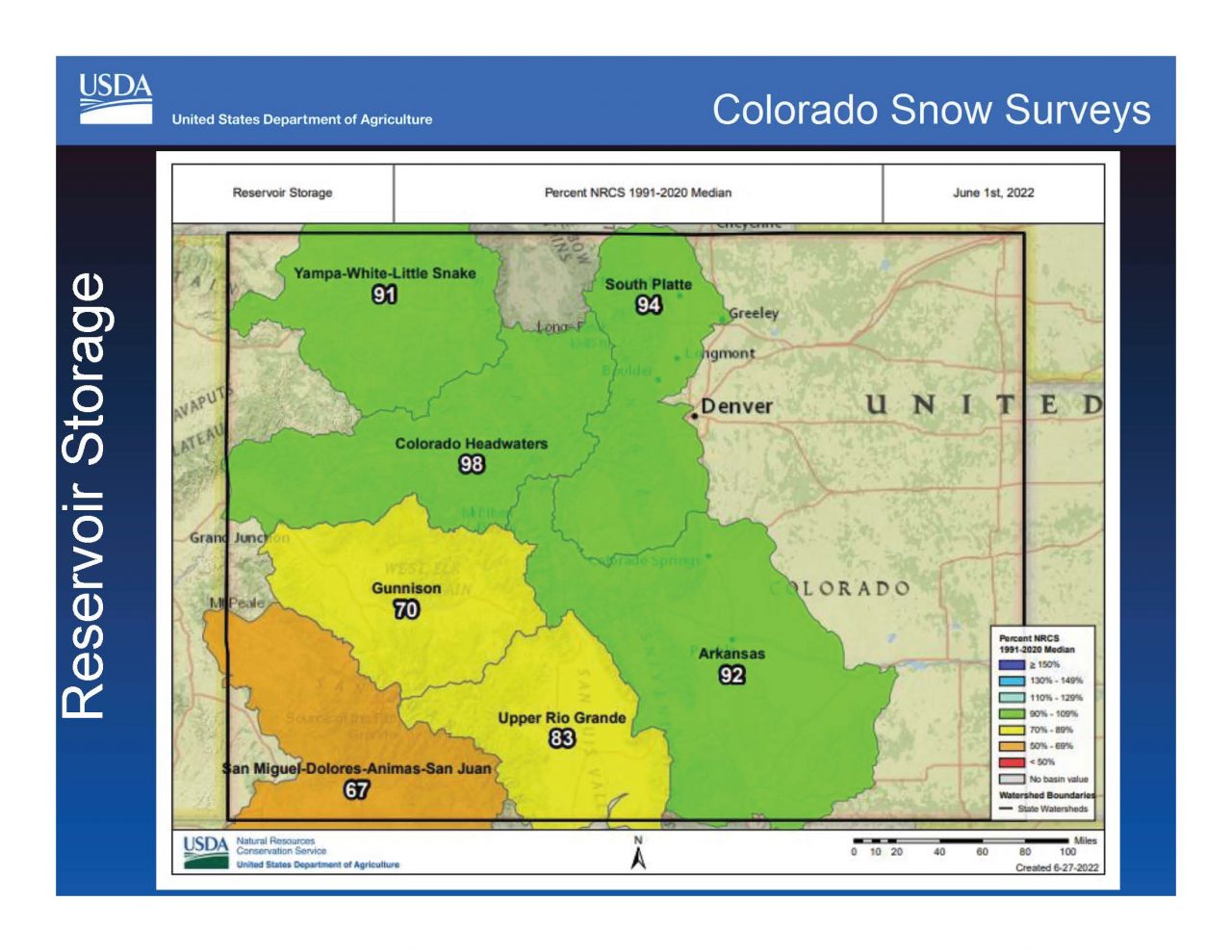
Statewide reservoir storage is at 85% of average, a number that hasn’t improved much in the past three years, Wetlaufer said.
Colorado derives the majority of its drinking and farm water supplies from mountain snows that are collected in reservoirs, and as a result, reservoir levels are closely watched.
Across the state’s eight major river basins, those to the north remain the wettest, with the South Platte Basin, which includes metro Denver and the Northern Front Range, seeing storage levels at roughly 94% of normal.
The Colorado River Basin headwater region has storage levels of 98%.
But to the southwest, in the hard-hit San Juan Dolores Basin, which includes Durango, reservoir storage levels are the lowest in the state, registering just 67% of normal
Colorado Drought Monitor map June 28, 2022.
At the same time, a new report from the U.S. Drought Monitor shows that the majority of Colorado remains in moderate to severe drought, with the southern portion of the state still mired in extreme drought.
Looking ahead to September, the forecast shows near normal precipitation for the state, but much higher temperatures as well.
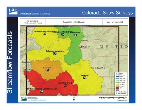
At the same time, the drought continues to sap Colorado’s rivers. Statewide stream flows are expected to hit just 69% of average. And in the picture in the dry southwest corner of the state is grim, with the San Juan Basin expected to see stream flows of just 26% of normal, while the Rio Grande Basin streams are expected to hit 33% of average, according to the NRCS.
Task force member Becky Bolinger, assistant state climatologist at Colorado State University’s Climate Center, said the drought will likely continue into the fall and early winter. Though summer rains will help improve soil moisture levels, it won’t be enough to compensate for the damage already done this year.
According to Bolinger, it is likely that La Niña conditions will continue into the fall and beginning of winter. But if the fall is warm and dry, that could worsen drought conditions and Colorado could start another snowpack season at a deficit.
Still, Colorado’s ability to store water is a bright spot in the broader Colorado River Basin, where Lake Mead and Lake Powell are hovering around just 25% full.
The seven Colorado River Basin states, which include Colorado, New Mexico, Utah and Wyoming, in the Upper Basin, and Arizona, California and Nevada, in the Lower basin, are under an emergency order to come up with a plan to slash water use by 2 million to 4 million acre-feet by August or face mandatory cuts imposed by the federal government.
“We are not getting enough years like 2019 (which had above average mountain snowpacks) to boost reservoirs again,” Bolinger said. “The more likely scenarios are for less water.
“Despite sounding all gloom and doom, if everybody knows what they have to work with, they will adjust. When you know what you’re working with, then you can make good decisions,” she said.
Jerd Smith is editor of Fresh Water News. She can be reached at 720-398-6474, via email at jerd@wateredco.org or @jerd_smith.