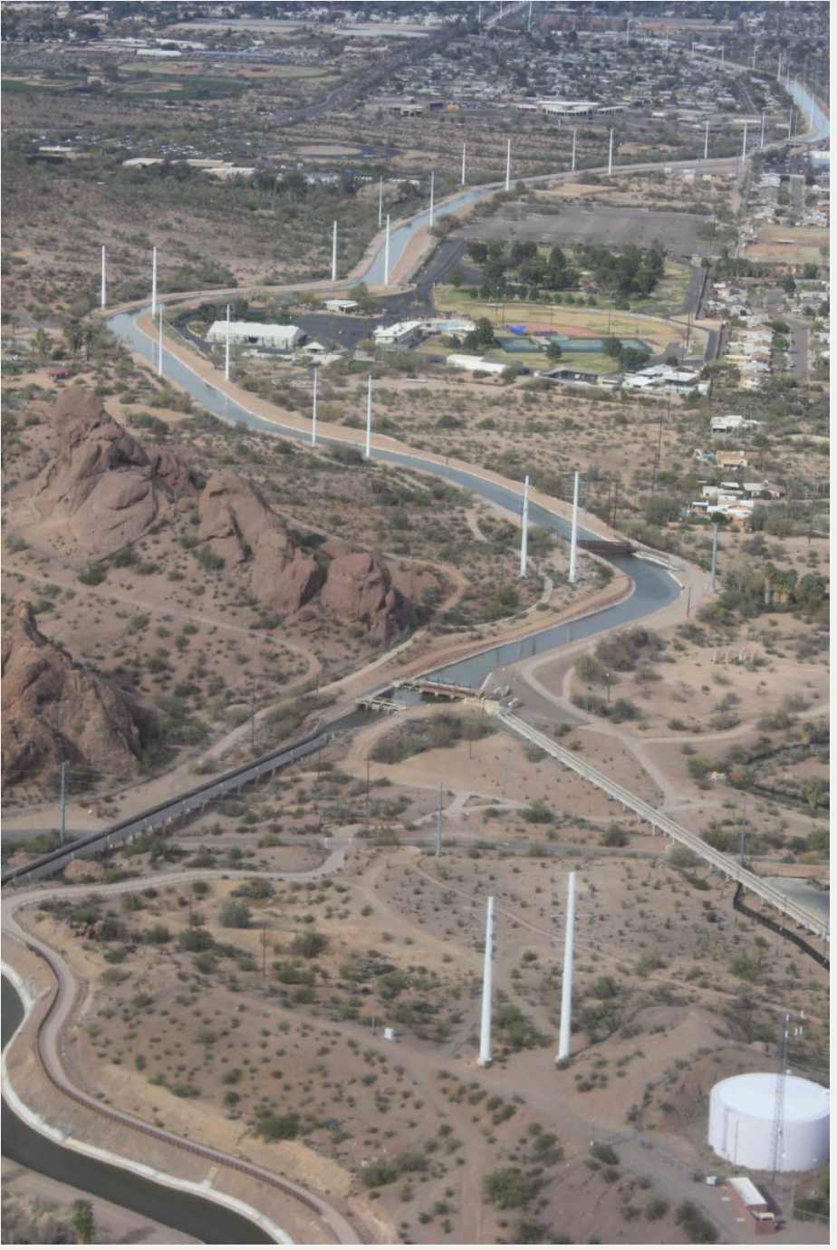
In an effort to keep water levels in Lake Mead from declining at a drastic rate, the City of Phoenix announced that it will leave an additional 14,000 acre-feet of Colorado River water in the lake this year.
Mayor Kate Gallego and members of the Phoenix City Council approved the move on July 1 as part of the 500+ Plan, an organized effort among various entities to stop the lake’s decline by conserving 500,000 acre-feet a year.
GET THE MORNING HEADLINES DELIVERED TO YOUR INBOX
“In this time of extreme drought, it is not easy to convince governments to leave water behind,” Gallego said in a press release. “However, I believe we are all acutely focused on what it will take to help Arizona communities thrive for the long term. In Phoenix, that means we make reasonable sacrifices now, to ensure we can continue to welcome people who want to live here, as well as the businesses that want to set up shop here.”
The City of Phoenix made its first contribution to the 500+ Plan in January, and with the July 1 action, it will have contributed a total of 30,000 acre-feet.
By leaving water in Lake Mead, the City of Phoenix will receive about $7.8 million in funding from the Central Arizona Water Conservation District, the press release stated. The funds will be placed in the city’s Water Revenue Fund to help purchase water from other sources and fund conservation programs.
The Gila River Indian Community, the City of Tucson, the City of Phoenix and other communities across the region, and the state, have agreed to be part of the solution by making their own contributions.
The 500+ plan aims to add 500,000 acre-feet of additional water to Lake Mead both this year and in 2023 by supporting and funding actions to conserve water across the Lower Colorado River Basin, according to the Gila River Indian Community.
An acre-foot is the amount of water necessary to flood one acre of land to a depth of one foot, the City of Phoenix stated. That equals about 326,000 gallons, or enough water for three single-family homes in the Phoenix metro area.
Gallego thanked Gila River Indian Community Gov. Stephen Roe Lewis for his leadership in bringing stakeholders together.
In December 2021, Lewis signed two agreements with the United States Bureau of Reclamation stating that the Gila River Indian Community would conserve over 129,000 acre-feet of its Colorado River water entitlement in 2022 to keep Lake Mead from falling to critically low levels.
“It is also true that cities and Indian communities cannot solve this issue on our own,” Gallego said in a written statement. “We need to see proportional action across sectors – particularly agriculture, which uses 70% of available Colorado River water.”
Water users in Phoenix consume 30% less water per capita than they did 30 years ago, according to the City of Phoenix, even as the city has experienced massive population growth over the same period.
“We need that conservation trend to continue,” Gallego said. “But as the drought stretches on, we are constantly looking for ways to be even better stewards of our most precious resource.”
SUPPORT NEWS YOU TRUST.
Arizona Mirror is part of States Newsroom, a network of news bureaus supported by grants and a coalition of donors as a 501c(3) public charity. Arizona Mirror maintains editorial independence. Contact Editor Jim Small for questions: info@azmirror.com. Follow Arizona Mirror on Facebook and Twitter.
Remains from a batch plant used in construction of Glen Canyon Dam emerged from the receding waters of Lake Powell in February. Photos/Allen Best
Click the link to read the article on the St. George News website (David Dudley). Here’s an excerpt:
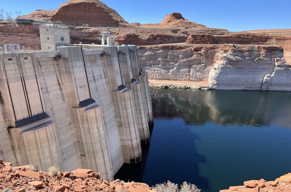
Just below the dam, railroad tracks run along the canyon wall — the ghostly remains of a concrete batch plant that was created to construct the dam in the early 1960s.
“This is the first time they’ve been above water in 60 years,” said Gus Levy, U.S. Bureau of Reclamation’s deputy field division manager at Glen Canyon Dam.
They may not be visible for much longer. Beginning in May, the Bureau of Reclamation began the process of releasing 500,000 acre-feet of water from the Flaming Gorge. That water will flow from northern Utah down into Lake Powell, where it will collect and, officials hope, enable the Glen Canyon Dam to continue providing water and electricity for millions of people…
Gene Shawcroft is the general manager for Central Utah Water Conservancy District, the state’s largest water district. Shawcroft, who is also the Colorado River commissioner of Utah, earned degrees in engineering from Brigham Young University. He originally grew up on a farm in southern Colorado, where he enjoyed working and playing in the water.
“There are two elevations that we’re concerned about right now,” Shawcroft told St. George News, referring to Lake Powell’s water level. “The first is 3,525 feet; the second is 3,490 feet.” The latter is the point at which the turbines at Glen Canyon Dam, which supplies millions with power, would be turned off, an unprecedented situation…To prevent that, Shawcroft said that various Upper Colorado River Basin states, which include Colorado, Wyoming, Utah and New Mexico, are working together. While some water from smaller basins has been released, Shawcroft said that the 500,000 acre-feet of water flowing from Flaming Gorge is meant to replenish Lake Powell…
Jack Schmidt is a professor as well as the Janet Quinney Lawson chair in Colorado River Studies at Utah State University. He’s researched the Colorado River and the Grand Canyon for over 30 years. Schmidt’s appraisal of the situation may feel grim to some, but it may also offer hope.
“We are the problem,” he told St. George News. “But we can also be the solution.”
One way people contribute to the problem is overuse of water in the face of the Colorado River’s dwindling water flows. The weather plays a crucial role, too.
The pie chart shows how much water each sector uses in Colorado, as well as how much water originating here leaves the state. CREDIT: COURTESY COLORADO WATER PLAN
Click the link to read the article on the KRDO website (Mallory Anderson). Here’s an excerpt:
A draft of the 2023 Colorado Water Plan has been released and outlines what the state needs to do in order to conserve resources as rivers, lakes, and reservoirs dry up…
A new analysis by the Colorado Water Conservation Board (CWCB) says up to 740,000 additional acre-feet of water could be needed by 2050 to meet community and industrial demands. For agriculture, an even bigger number. An estimated 2.6 to 3.5 million acre-feet of water is needed.
“I think we’re presenting a very honest view of where things are at,” said Russ Sands, Section Chief for Water Supply Planning with the Colorado Water Conservation Board. “It’s going to be tough. We can’t change things like mega-fires. We can’t stop the drought. But, we can do a lot of things to work together to mitigate the worst impacts of what is headed our way.”
[…]
A major way the Colorado Water Plan hopes to mitigate impacts is through local projects the CWCB is ready to give grants to…The Water Plan estimates that $20 billion is needed to address the water crisis…Despite the high price, the CWCB is staying positive when looking towards the future of water in our state…Public comment is now open for the Water Plan draft and closes on September 30, 2022.
A turbine whirls on a farm east of Burlington, Colo. Colorado’s eastern plains already have many wind farms—but it may look like a pin cushion during the next several years. Photo/Allen Best
The plan contains no silver bullet for the challenges facing cities, farms, forests, recreation and conservation areas in the state. It does lay out the challenges and points toward potential solutions to a future far shorter on water than what the recent past has experienced.
As noted in a quotation from former Colorado Justice Gregory Hobbs in a preamble to the document, “The 21st Century is the era of limits made applicable to water decision making. Due to natural western water scarcity, we are no longer developing a resource. Instead, we are learning how to share a developed resource.”
The plan picks up Hobbs’ “sharing” advice with a call for greater collaboration between the water basins and water decision makers in the state and beyond.
Headwinds in the use of Colorado water include multiple factors:
The population is growing. It’s nearly 6 million now and will be 8.5 million by 2050.
Nineteen other states plus Mexico also depend upon water that originates in Colorado.
It’s getting hotter. Average temperatures are up 2 degrees Fahrenheit in the past 30 years.
Rainfall is coming less often. It’s been below average since 2000.
Yet some progress in meeting challenges has been made, the report said.
Conservation efforts have reduced per capita water consumption by 5% since 2000.
Cities have worked collaboratively to lease 25,000 acre feet of agricultural water since then, instead of buying-and-drying.
About 400,000 acre feet of storage has been created since the turn of the century, too.
The Biden administration is set to approve another key permit for a new railroad in Utah that is expected to drastically increase the amount of crude oil hauled through Colorado by rail, dismissing objections from environmental groups and Colorado communities along the impacted route.
Officials with the U.S. Forest Service on Tuesday rejected a challenge to its decision to allow part of the proposed 88-mile Uinta Basin Railway to cross a protected roadless area in the Ashley National Forest. Securing the right-of-way is a critical step for the project, which is backed by a public-private partnership between seven Utah county governments, Drexel Hamilton Infrastructure Partners and the Rio Grande Pacific railroad company.
Utah’s oil and gas industry has eagerly supported the proposed rail line, which is projected to significantly increase oil production in the Uinta Basin by connecting the region to the national rail network, allowing crude oil to be transported over the Rocky Mountains to refineries along the Gulf Coast. An environmental impact statement prepared by federal regulators estimated that the increased production from the Uinta Basin alone could increase total annual U.S. greenhouse gas emissions by nearly 1%, at a time when scientists are urging drastic global emissions cuts to avoid the worst impacts of climate change.
GET THE MORNING HEADLINES DELIVERED TO YOUR INBOX
“President Biden should be doing everything in his power to respond to the climate emergency, but he’s about to light one of the nation’s biggest carbon bombs,” Deeda Seed, a senior campaigner with the Center for Biological Diversity, said in a statement. “This is pouring another 5 billion gallons of oil on the fire every year and bulldozing a national forest in the process. It’s a horrifying step in the wrong direction.”
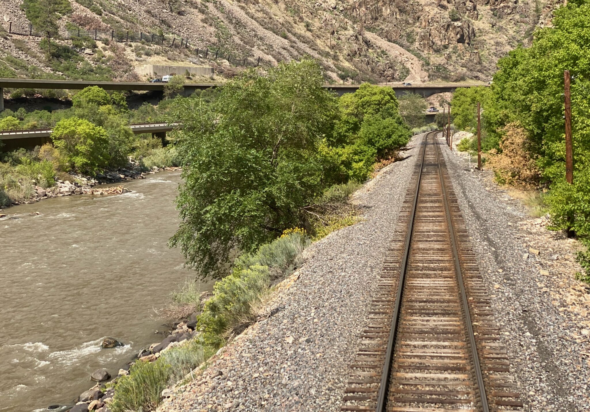
Much of the additional crude oil produced as a result of the Uinta Basin Railway would be hauled through Colorado on a route that passes through Glenwood Canyon along the Colorado River, then through the Moffat Tunnel and central Denver. Up to 10 two-mile-long trains would travel the route daily, and because the Uinta Basin produces a type of oil known as “waxy” crude, the tank cars used to transport it need to be heated, creating additional safety and environmental risks.
Dozens of cities, counties and water districts along the route have voiced opposition to the project, including Glenwood Springs, where city officials worry about potential impacts to the Colorado River Basin, and Eagle County, which has joined environmental groups in suing the U.S. Surface Transportation Board in a federal appeals court over its 4-1 vote to approve the project as a whole in December.
This is pouring another 5 billion gallons of oil on the fire every year and bulldozing a national forest in the process. It’s a horrifying step in the wrong direction.
– Deeda Seed, a senior campaigner with the Center for Biological Diversity
At least 21 oil train derailments have occurred in the U.S. and Canada since 2013, according to a 2021 report from the nonprofit Sightline Institute. Such incidents frequently result in fires and spills, including the 2016 derailment of an oil train in Oregon’s Columbia River Gorge, in which an estimated 42,000 gallons of crude oil were spilled.
The partnership behind the railway project says it’s “committed to minimizing and mitigating environmental impacts where possible,” and will comply with “all federal, state, and local environmental regulations.”
In a notice sent on Tuesday, Forest Service officials rejected the Center for Biological Diversity’s challenge to the Ashley National Forest right-of-way permit, writing that despite some “concerns” about the environmental impact statement prepared by the Surface Transportation Board, the agency believes the analysis “supports permit issuance.”
“There is nothing in the proposal that would suggest that the Forest Service must reject the proposal or deny the application,” wrote Deb Oakeson, deputy regional forester for the USFS Intermountain Region. “Analysis in the (environmental impact statement) has led to certain protective measures and mitigations that would be stipulated conditions of any potential special use permit.”
Backers say the $1.5 billion Uinta Basin Railway would be the largest new railroad project in the United States in nearly 50 years. Construction could begin as early as next year.
Opponents, however, still hope to prevail in several legal challenges, including Eagle County’s suit against the Surface Transportation Board and a separate complaint alleging misuse of state funds in connection with the project’s financing. Eagle County and other petitioners in the federal lawsuit are scheduled to file opening briefs in the case by Aug. 4.
In a letter sent earlier this year, more than 50 Colorado city and county governments urged Democratic Sens. Michael Bennet and John Hickenlooper to speak out in opposition to the project. Both senators have said that they share Colorado communities’ “concerns” about the proposal.
Meanwhile, more than 100 environmental groups from Colorado, Utah and other Western states have voiced their opposition, objecting to the railway’s potential to do “tremendous harm to the environment.”
“This area is already facing water and air quality issues,” Jonny Vasic, executive director of Utah Physicians for a Healthy Environment, said in a statement Wednesday. “The railway will quadruple production of oil in the Uinta Basin, resulting in dire consequences for air quality, public lands, water, public safety and the climate.”
SUPPORT NEWS YOU TRUST.
Colorado Newsline is part of States Newsroom, a network of news bureaus supported by grants and a coalition of donors as a 501c(3) public charity. Colorado Newsline maintains editorial independence. Contact Editor Quentin Young for questions: info@coloradonewsline.com. Follow Colorado Newsline on Facebook and Twitter.
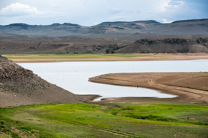
Blue Mesa Reservoir is the largest storage facility in Colorado in the Upper Colorado River system. Prolonged drought and downriver demand is shrinking the reservoir. Credit: Tom Wood, Water Desk
Click the link to read the article on The Montrose Press website (Katharhynn Heidelberg). Here’s an excerpt:
Bureau of Reclamation Commissioner Camille Touton in June 14 remarks to the U.S. Senate said the ongoing drought has put the Colorado River Basin at “the tipping point.” According to published reports, she also called on the basin states to reduce water use by 2 million to 4 million acre feet over the next 18 months and told the states to come up with a plan to do so in the next 60 days…
State Rep. Marc Catlin, a Colorado River District board member, is alarmed by the timeline — 60 days from Touton’s request is in mid-August.
“Historically, we haven’t been able to decide the shape of the table in 60 days,” Catlin said of talks between the basin states. “I really think what we’re looking at is more of what the water plan will be in water year 2023.”
[…]
BuRec is attempting, under drought response actions announced May 3, to boost storage in Powell by about 1 million af by next April. Flaming Gorge Reservoir will release 500,000 af, as called for by the drought contingency plan. Additionally, BuRec is reducing Glen Canyon Dam’s annual release volume from 7.48 million af to 7 million af.
Grand Junction City Council approved Wednesday a 25-year lease of Vincent Reservoir No. 2, a currently unused reservoir on Grand Mesa which the city owns, to Snowcap Coal Co. According to a staff, Snowcap plans to rehabilitate the 40-acre reservoir and dam while using the reservoir to augment any stream depletions in Rapid Creek caused by the Roadside Portals Mine, an abandoned mine-owned by Snowcap. The mine causes limited impacts to Rapid Creek, according to the lease, which by Colorado law are required to be augmented by Snowcap.
“Snowcap has identified the reservoir as a source for the storage of augmentation water to remedy the Stream Depletions,” the lease states. “Snowcap has investigated the Reservoir and Dam and has determined that rehabilitation of the Dam would benefit its efforts to comply with the Consent Order and its legal obligations under Colorado law.”
The augmentations will help keep the water rights for Rapid Creek and the Colorado River whole, according to Snowcap legal counsel John Justus. Snowcap has never operated the Roadside Portals mine and does not have any plans to re-start operations at the mine, Justus said.
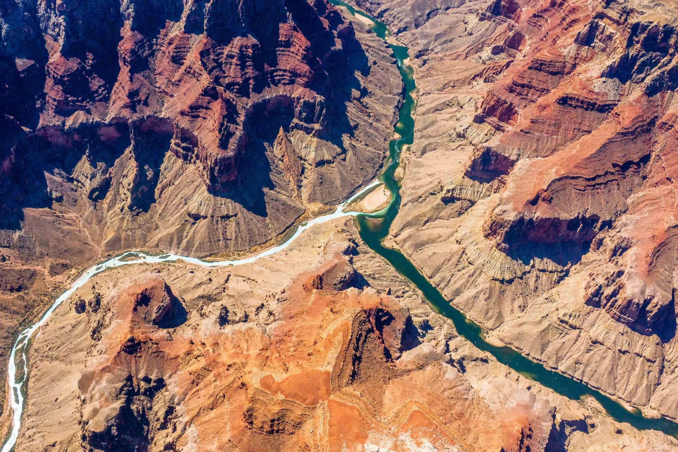
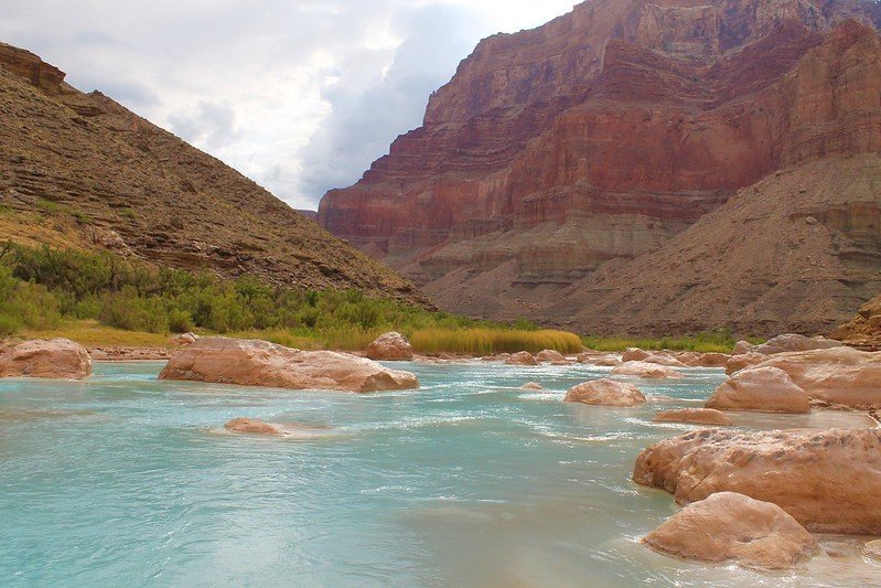
The confluence of the Colorado and Little Colorado rivers in the Grand Canyon, shown here in a September 2020 aerial photo from Ecoflight, represents an area where the humpback chub has rebounded in the last decade. That progress is now threatened by declining water levels in Lake Powell, which could lead to non-native smallmouth bass becoming established in the canyon. CREDIT: JANE PARGITER/ECOFLIGHT
Colorado has no plans to make additional cuts to water use next year to meet the Bureau of Reclamation’s demand to conserve millions of acre-feet of water, a step needed to preserve power production in Lake Powell and Lake Mead. Instead, Colorado officials insist that other states should do the cutting.
“I think that at this point, we stand ready to hear what the Lower Basin has in mind,” said Amy Ostdiek, a section chief with the Colorado Water Conservation Board.
Ostdiek told The Gazette the Upper Basin states — Colorado, New Mexico, Wyoming and Utah — dramatically reduced their water use in 2021 because of drought conditions. Specifically, they cut 1 million acre-feet in use in 2021 compared with 2020, bringing it down to 3.5 million acre-feet. But, at the same time, total water use in the Lower Basin has not been cut enough to preserve levels in the lakes, said Ostdiek, who is chief of the Interstate, Federal, and Water Information Section. She said water users in Colorado cut their consumption to meet the obligations of the 1922 river compact that governs use between the seven states and Mexico, who all share the river.
“The most impactful thing we can do is live within the means of the river,” she said.
Map of the Colorado River drainage basin, created using USGS data. By Shannon1 Creative Commons Attribution-Share Alike 4.0
I moved to Wyoming a few years ago for its outdoor recreation, but I also liked the state’s history of championing equal rights for women. As early as 1869, it codified women’s voting rights, 50 years before the 19th Amendment did the same thing. Western women in the 19th century quickly proved their mettle, helping to build communities in rugged and isolated landscapes.
But now, sadly, Wyoming has agreed to subjugate women. In March, Wyoming’s governor signed a “trigger bill” that would ban abortions in the state five days after the Supreme Court overturned Roe v Wade, which it did June 24.
Around the West, other states including Idaho, Utah, North Dakota, South Dakota and Oklahoma also passed bills restricting women’s reproductive health soon after the Supreme Court acted. Texas had a tough law that banned virtually all abortions since 2021, although their new law, set to take effect in the next month, introduces even harsher measures — a near-total ban, even after incest and rape.
Fortunately, some Western states recognize the needs of women, and are already being sought out by women seeking abortions who are blocked at home. Colorado passed an act in March giving anyone pregnant the “fundamental right to continue the pregnancy… or to have an abortion.”
Three coastal states, California, Washington and Oregon, said they would be havens for women seeking abortions. In addition, Oregon allotted $15 million to help cover abortion costs even for non-residents.
Corporations are also becoming allies. Apple, Citi, and Yelp adjusted their corporate policies in Texas to include travel for abortions as part of health insurance packages. Lyft and Uber have promised to pay legal fees if their drivers are charged with the crime of “assisting” abortion patients.
Ironically, when Covid-19 was rampant, I often heard Westerners express a common sentiment about getting vaccinated, or not: “It’s my body and my choice.” I almost laughed, as that’s the cry of women who want the choice of becoming a mother, or not.
Before the Supreme Court decision was announced, I began talking to people about their views on access to abortion, and as you would expect, reactions were mixed, though no one I spoke to for this opinion agreed to be quoted by name due to privacy concerns. At a block party, a 22-year-old Jackson man, who self-identified as Hispanic, said he thought of abortion as “one of the worst sins.” Then he surprised me by adding, “But a woman should be able to make that decision.”
At a pizza joint, a fourth-generation Jackson resident I’ve gotten to know, said, “I don’t think the government should have a say about your individual body… The government should be building roads. We don’t believe in big government.”
An Indigenous man in his late 20s said, “Humans should be able to make choices for their own human bodies. Otherwise, we’re going back to slavery.”
Still, I get the sense that many well-intentioned men, trying to be supportive of the women around them, are opting to step back and let women fight this battle. This reticence has started to feel like men are saying, “Not my body, not my problem.” Perhaps our state legislators recognize this reluctance to get involved, thus freeing them to vote against women’s rights.
Sometimes an abortion is unwanted but necessary for a woman’s health. Sometimes an abortion is wanted but will now be illegal. I think whatever a woman decides must be her decision, not a ruling from the out-of-touch Supreme Court or from a male-dominated state legislature.
Five years ago, a friend was forced to travel to a Wyoming clinic to get an abortion after a doctor in Idaho told her that abortion was “wrong.” She was angry, and later when she told her father, he said he was proud of her for “sticking up for herself.”
“It was the best money I’ve ever spent,” my friend told me later. “I wouldn’t be half the person I hope to be without making that decision.”
Men retain control over their bodies, but in too many parts of this country, women no longer can. Deciding whether to bear a child is perhaps the biggest decision in any woman’s life. Controlling and criminalizing a woman’s choice is a tragic mistake.
Rebecca (Bex) Johnson is a contributor to Writers on the Range, http://writersontherange.org, an independent nonprofit dedicated to spurring lively conversation about the West. She works and writes in Jackson, Wyoming.
This view is from the top of John Martin Dam facing west over the body of the reservoir. The content of the reservoir in this picture was approximately 45,000 acre-feet (March 2014). By Jaywm – Own work, CC BY-SA 4.0, https://commons.wikimedia.org/w/index.php?curid=37682336
Here’s the release from the Colorado Division of Water Resources:
The Arkansas River Compact Administration (ARCA) passed a resolution on July 1, 2022 establishing a 20,000-acre feet multi-purpose storage account in John Martin Reservoir. This new account is intended to benefit water users in Colorado and Kansas and promote commonly held interests not directly related to the Kansas-Colorado Arkansas River Compact such as water quality improvements.
This is a pilot project to determine how a multi-purpose storage account could operate, document benefits, and determine if there are any adverse impacts from such an account. The account will be operated in accordance with an operating plan agreed to by the states and will terminate on March 31, 2028, unless extended by ARCA. This account is in addition to other accounts that are present in John Martin Reservoir.
The need for a multi-purpose storage account was recognized by municipalities, well augmentation and surface irrigation improvement replacement groups, water conservancy districts, and other water users within the Arkansas River Basin in Colorado. The concept of a multi-purpose account was brought to ARCA in 2013. The Lower Arkansas Valley Water Conservancy District with funding support from the Colorado Water Conservation Board helped further develop this account for the states to consider. Kansas and Colorado worked through issues and negotiated for much of the past decade to agree upon establishing this account in John Martin Reservoir as a pilot project through March 2028.
ARCA administers provisions of the Compact, including operations of the John Martin Reservoir. Colorado has three representatives who serve on ARCA: Rebecca Mitchell, director of the Colorado Water Conservation Board; Lane Malone, Holly, Colorado; and Scott Brazil, Vineland, Colorado. Kansas has three representatives who serve on ARCA: Earl Lewis, chief engineer of the Kansas Department of Agriculture’s Division of Water Resources; Randy Hayzlett, Lakin, Kansas; and Troy Dumler, Garden City, Kansas. Jim Rizzuto, Swink, Colorado, serves as the federal chair.
July 6, 2022 – CO, UT, WY
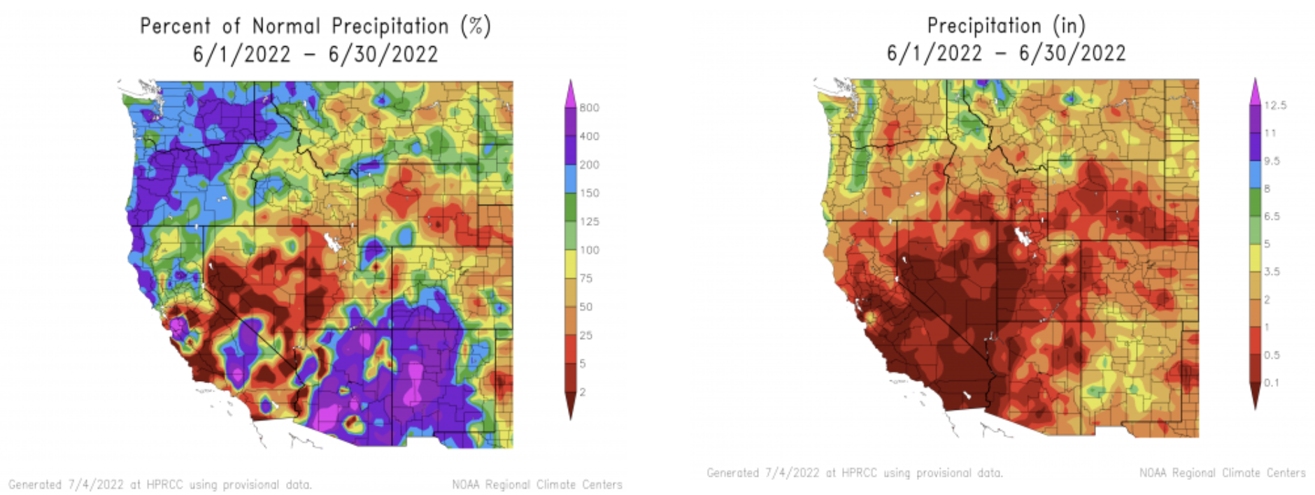
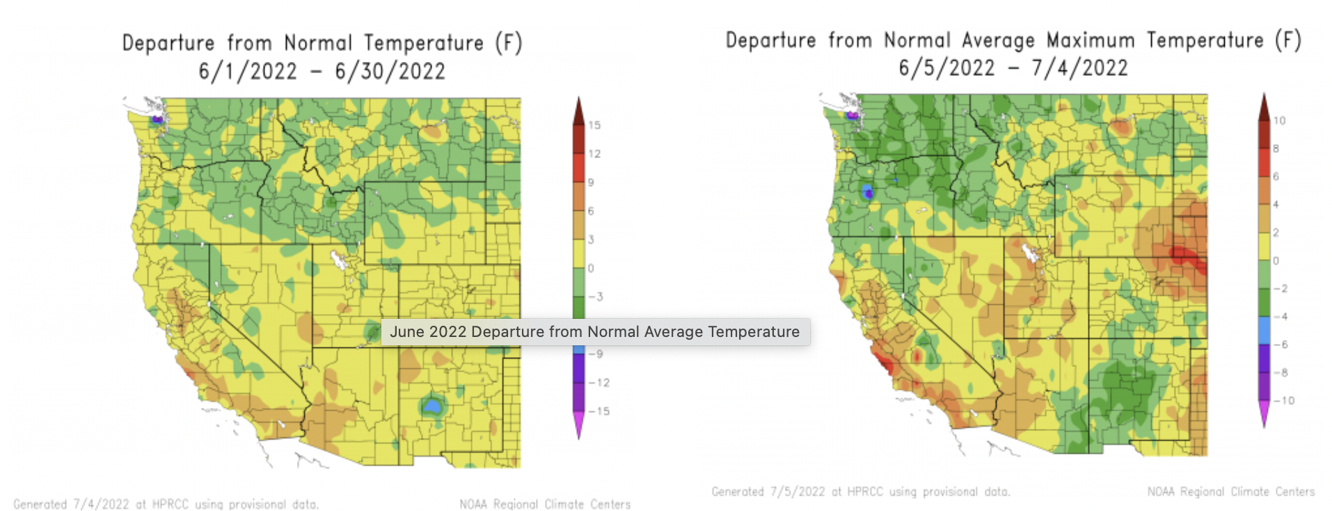
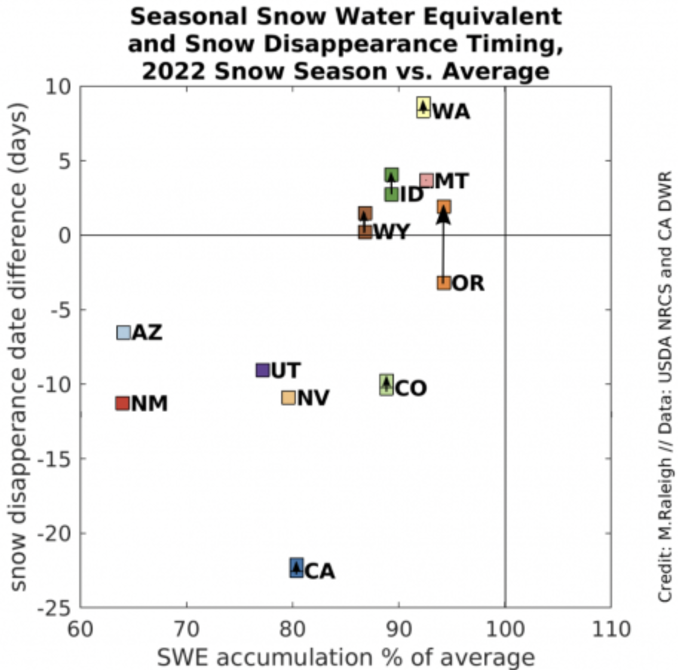
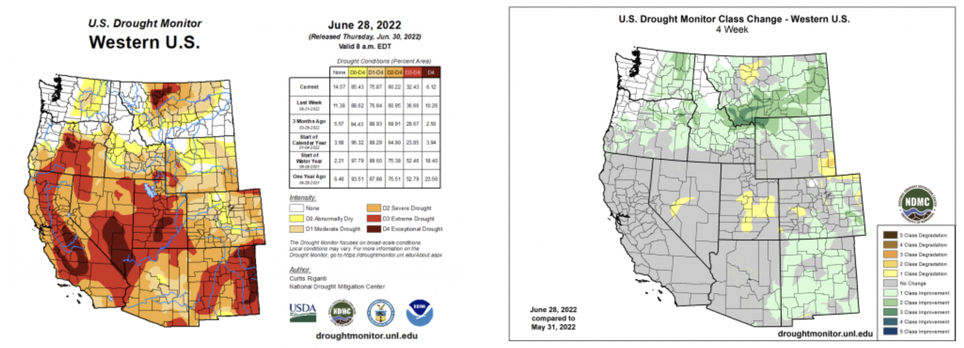
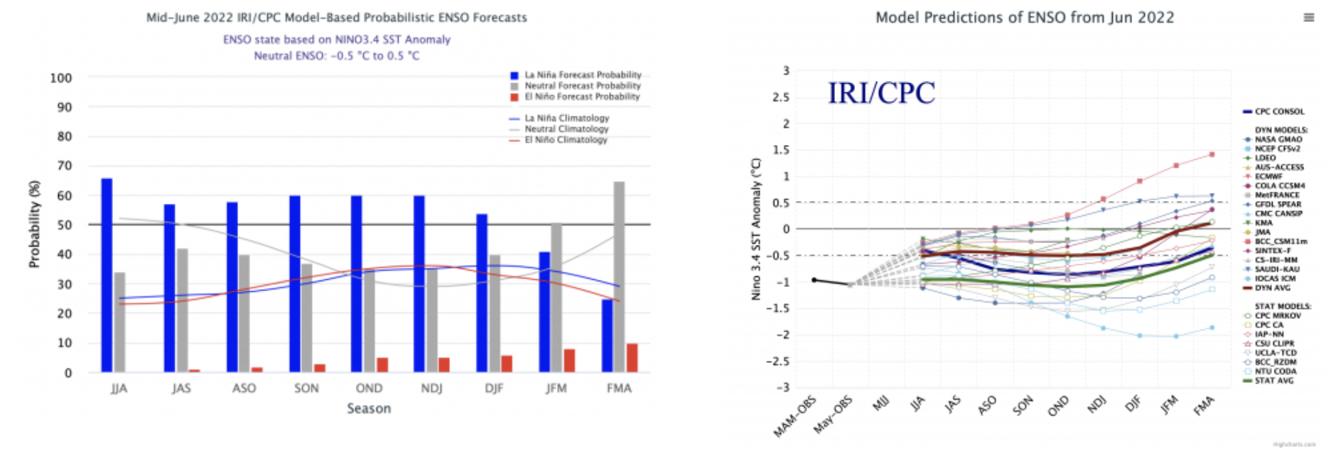
The region experienced a wide range of precipitation conditions during June. An atmospheric river and rapid snowmelt in northwest Wyoming produced record floods in Montana, early onset of the North American Monsoon caused much-above average precipitation in southern Colorado and Utah and much of Utah and Wyoming saw less than 1” of rainfall. Snow entirely melted out during June; melt was nearly ten days early in Colorado and Utah. Regional drought coverage decreased to 81% during June. Drought was completely removed in northern Wyoming and improvements to drought conditions occurred in southern Colorado, southern and eastern Utah and the Upper Snake River Basin. There is a 50-60% probability that mild La Niña conditions will persist through winter.
June precipitation was dominated by an early surge of monsoonal moisture in the southern portion of the region and an atmospheric river-type event in northwestern Wyoming. Southern Colorado and southeastern Utah received 200-800% of normal June precipitation due to the formation of the North American Monsoon. Monsoonal precipitation also produced above average precipitation in the Uinta Mountains of Utah. A strong atmospheric river event produced 2-5” of rain in northwestern Wyoming during early June; the combination of heavy rainfall and snowmelt caused extreme flooding in Yellowstone National Park and southwestern Montana. June precipitation was less than 50% of average in most of Utah and Wyoming with large areas of both states receiving less than 1” of rain.
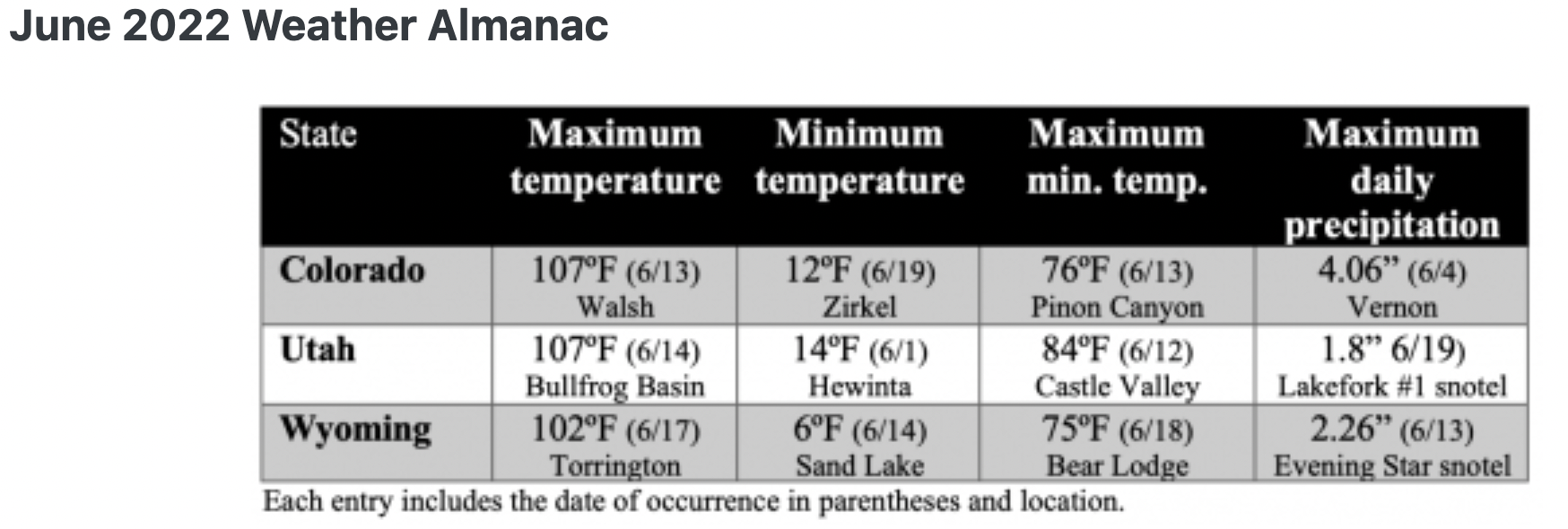
Regional temperatures were slightly above normal during June for most of Colorado, Utah and Wyoming. June temperatures were slightly below normal in northwestern Wyoming. Daily maximum temperatures were up to 8 degrees above normal in northeastern Colorado during June.
Snowpack completely melted out at all snotel sites in Colorado, Utah and Wyoming. Averaged across all snotel sites, snow melted out 10 days earlier than average in Colorado and 9 days early in Utah. In Wyoming, snow melted out 2 days later than average.
Record-high flows were observed on the Clarks Fork of the Yellowstone, Gardner, Lamar and Yellowstone Rivers after an atmospheric river combined with rapid snowmelt. Record-low flows were observed on the Escalante, Sevier and Weber Rivers in Utah and the Purgatoire River in southeastern Colorado. Regional streamflow volume forecasts for July 1st were not published at the time of this briefing. Check back early next week for July streamflow forecast information.
Drought continues in the Intermountain West, but the coverage of drought decreased from 92% on June 1st to 81% on July 1st. Moisture from the early June atmospheric river in Wyoming caused the complete removal of drought conditions in northern and central Wyoming and the removal of D3 drought conditions from the Upper Snake River Basin. Above average precipitation from monsoonal moisture led to the removal of D4 drought in southern Utah and D3 drought in southern Colorado and central to eastern Utah. In northeastern Colorado, D3 drought was removed from Washington County, but emerged to the north in Weld, Logan and Sedgwick Counties. Drought continues to impact Utah most severely with 82% of the state in extreme (D3) drought conditions.
La Niña conditions continue in the eastern Pacific Ocean with sea surface temperatures 0.5 to 1.5 degrees Celsius below normal. La Niña influenced weather patterns during the first half of June with above normal precipitation and cooler temperatures in Wyoming and drier, warmer conditions to the south. There is a 55-65% probability of La Niña conditions continuing through mid-winter 2023. The average of sea surface temperature models project that ocean temperatures remain at least 0.5 degrees Celsius below normal through late-winter 2023.
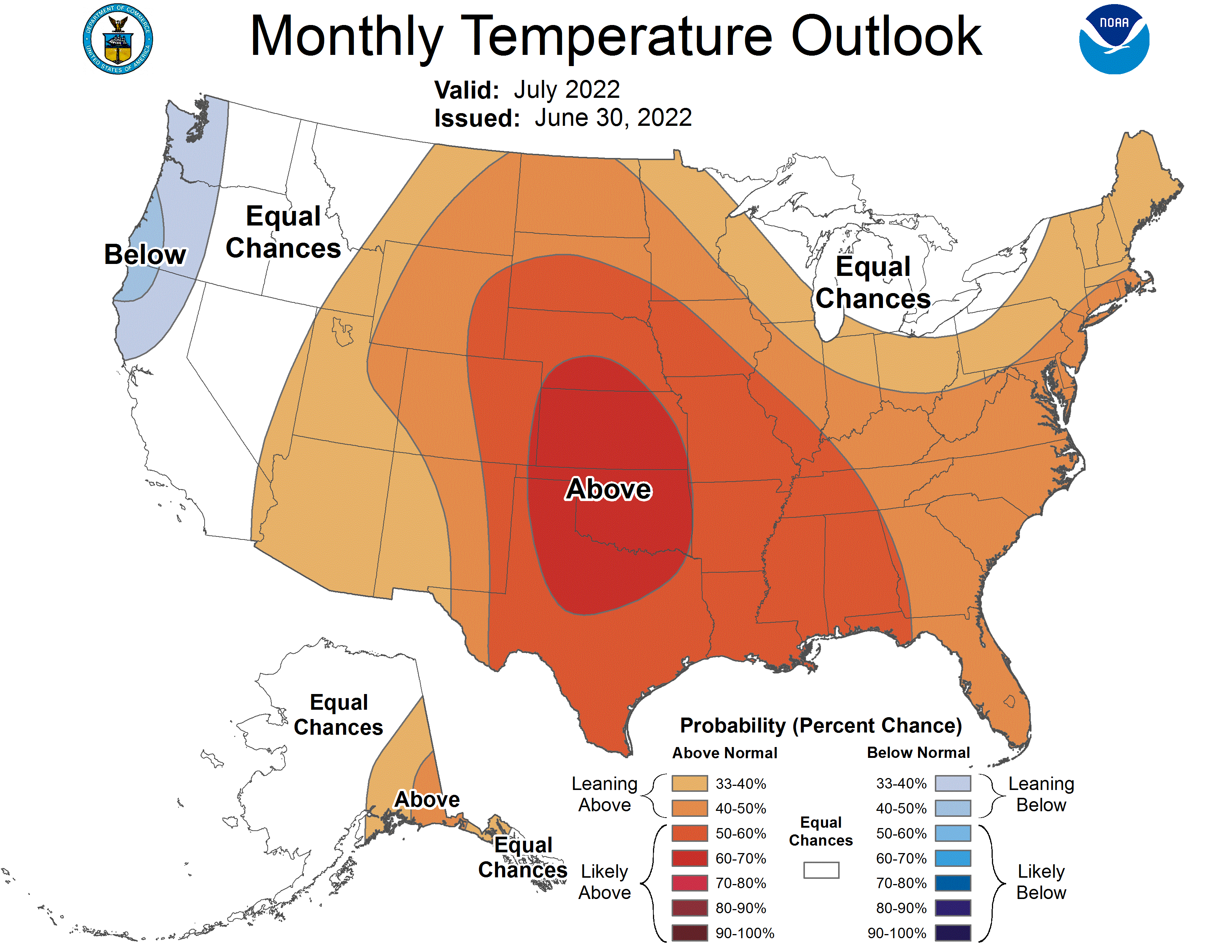
The NOAA precipitation outlook for July suggests there is an increased probability of above average precipitation for southwestern Colorado and southeastern Utah and an increased probability for below average precipitation in northwestern Utah. The seasonal precipitation outlook for July – August predicts an increased probability of above average precipitation for southern Utah, suggesting that a stronger than average monsoon continues, and below average precipitation for much of Colorado and Wyoming. There is up to a 70% probability of above average temperatures for the entire region; Utah and western Colorado are most likely to see high temperatures.
Significant June weather event. Major flooding in Yellowstone National Park (YNP). From June 12-13, a warm atmospheric river-type storm dumped 2-4” of rain in northwestern Wyoming. Snowpack was much-above average in YNP during June and heavy rainfall combined with an estimated 5.5” of snowmelt to produce record-high flows on the Gardner, Lamar, Yellowstone and Clarks Fork of the Yellowstone Rivers. The Yellowstone River (Corwin Springs, MT) peaked at 49,400 cfs on June 14th, shattering the previous record of 32,200 cfs in 1996. Extensive damage was caused by flooding on the Gardner and Yellowstone Rivers in southwestern Montana and along Rock Creek in Red Lodge, MT. The Gardner River peaked at 2,980 cfs, 40% higher than the previous maximum flow, destroying several sections of the road from the North Entrance of Yellowstone to Mammoth Hot Springs. Yellowstone National Park was completely closed for 9 days and the North and Northeast Entrances are expected to remain closed until at least fall 2022…
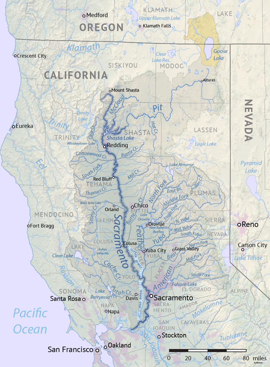
Map of the Sacramento River drainage basin. The historically connected Goose Lake drainage basin is shown in orange. Made using USGS National Map and NASA SRTM data. By Shannon1 – Own work, CC BY-SA 4.0, https://commons.wikimedia.org/w/index.php?curid=79326436
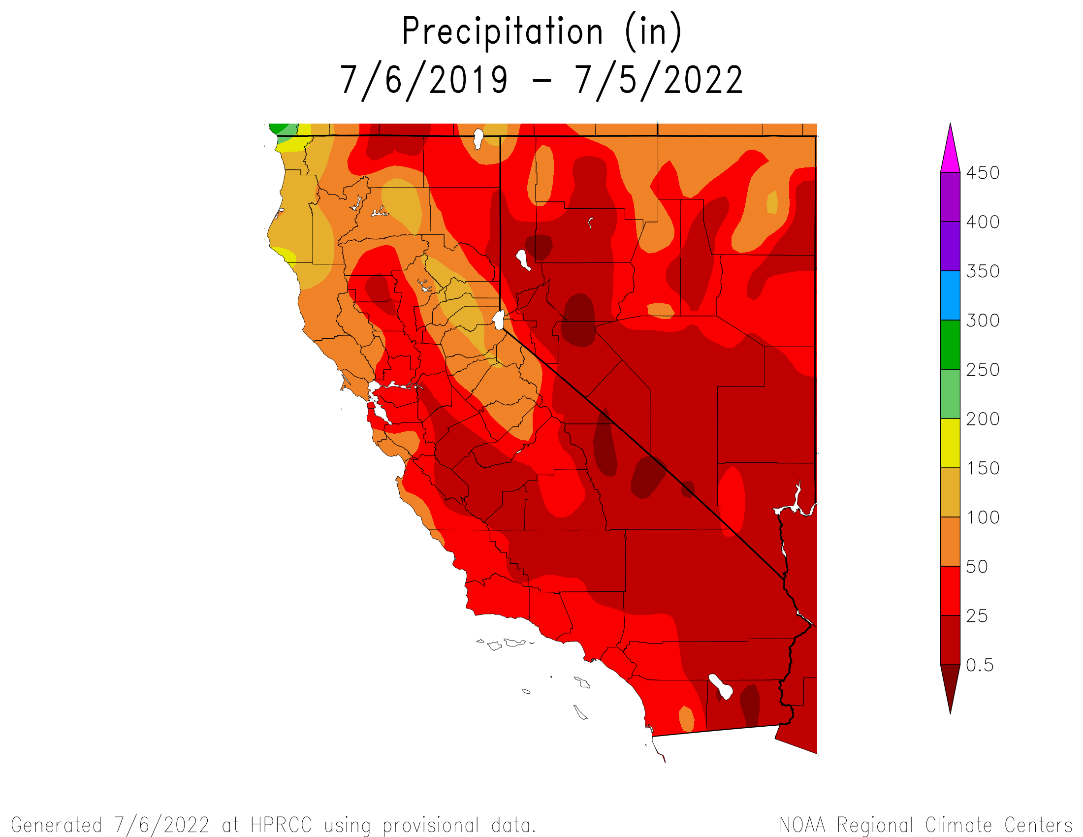
The order, which took effect Thursday, puts a hold on about 5,800 water rights across the Sacramento and San Joaquin rivers’ watersheds, reflecting the severity of California’s extreme drought. Together with a similar order in June, the State Water Resources Control Board has now curtailed 9,842 water rights this year in the Sacramento and San Joaquin watersheds, more than half of the nearly 16,700 existing rights…The number of water rights that fall under this year’s orders is slightly less than the 10,200 curtailed in 2021. But the latest cuts have come earlier in the summer, affecting many farmers at the peak of their growing season, when they typically irrigate more.
Mammatus clouds, associated with strong convection, grace a sunset over Fort Collins, Colorado, home of the NOAA Cooperative Institute for Research in the Atmosphere at Colorado State University. Photo credit: Steve Miller/CIRA
Earlier this year, council decided to create 1041 regulations specifically for new major water or sewer systems and new highways or interchanges. They placed a moratorium on review of those kinds of projects until Dec. 31, but that moratorium applies only to projects that would cross through city parks or natural areas…
The proposed review process is a tiered system where the intensity of the review would depend on the impacts of the project. The draft regulations contain a long list of impact categories that staff would use to decide a route of review for the project. To name a few impact categories: local infrastructure or services such as roads, housing or stormwater management; recreational opportunities; visual quality; air quality, surface water or groundwater; wildlife; riparian areas or wetlands; and noise, dust or odors. The draft regulations also include impact categories specific to water or highway projects, such as impacts to natural resources or the productivity of agricultural lands for water projects and impacts to local traffic for highway projects. If staff find that a project isn’t likely to create any significant adverse impacts, the city could issue a “finding of no significant impacts” (FONSI) and waive the permit requirement. Projects going through the FONSI route could still be subject to other types of city review, and staff’s decision could be appealed to the Planning and Zoning Commission. The commission’s decision could then be appealed to City Council.
The other two review types would be “full permit” and “administrative permit.” The full permit process would be reserved for projects that would probably create multiple types of significant impacts or require eminent domain. The administrative permit process would be reserved for projects that would probably create significant impacts in just one category and not require eminent domain. The main difference between a full permit and an administrative permit is who makes the decision. For a full permit, staff would review the application and City Council would make the final, unappealable decision on the permit. For an administrative permit, the city’s director of community, development and neighborhood services (currently Paul Sizemore) would decide whether to issue the permit. That decision could be appealed to the Planning and Zoning Commission, whose decision could be appealed to council.
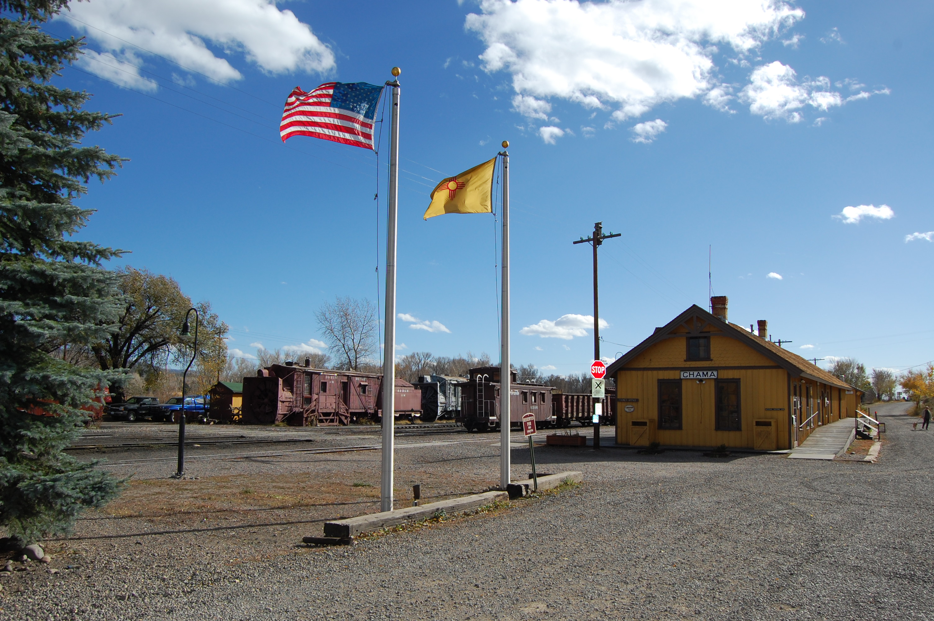
The Pagosa Area Water and Sanitation District (PAWSD) is continuing to provide water to Chama, N.M., with that community continuing to deal with a water shortage. PAWSD Manager Justin Ramsey reported Wednesday the district will continue to provide water through July 10. Ramsey elaborated on PAWSD’s involvement in providing water for Chama in a June 30 press release.
The release states, “Due to a pipeline break and operator issues the community of Chama New Mexico is suffering a severe water issue. The state of New Mexico has declared a state of emergency due to this predicament. The Chama community has asked for our help to provide some relief to this dire situation. The Pagosa Area Water and Sanitation District (PAWSD) has agreed to provide Chama with temporary emergency water.
“This may appear imprudent on PAWSD’s part due to our own drought concerns. However, PAWSD has developed a plan allowing 6,000 gallon tanker trucks to use uptown fill stations with water coming from our San Juan Water Treatment Plant to transport up to 150,000 gallons per day to Chama. Using these fill stations and water from the San Juan Water Treatment Plant has the lowest impact on our water reserves.
Rivers and drought
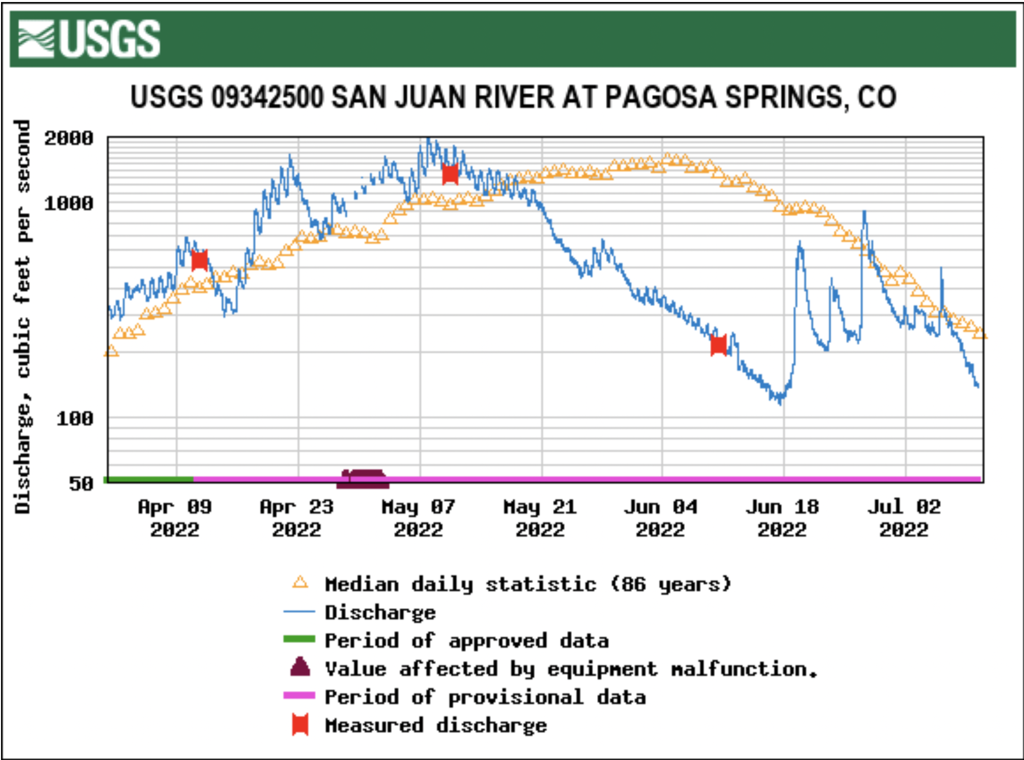
Stream flow for the San Juan River on July 6 at approximately 9 a.m. was 328 cubic feet per second (cfs), according to the U.S. Geological Service (USGS) National Water Dashboard. This is down from a nighttime peak of 499 cfs at 3 a.m. on July6. Over the night, due to heavy rains, the flow rose from 239 cfs at 7 p.m. on July 5 to the peak early in the morning of July 6. Flows are down from last week’s reading of 402 cfs at 9 a.m. on June 29.
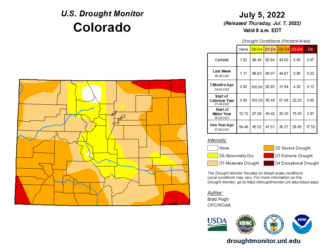
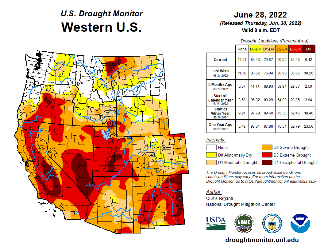
Colorado Drought Monitor map July 5, 2022.
The National Oceanic and Atmospheric Administration (NOAA) National Integrated Drought Information System (NIDIS) reports that 100 percent of the county is experiencing drought…
The NIDIS also provides an evaporative demand (EDDI) forecast, an experimental tool for predicting drought conditions through measuring atmospheric evaporative demand or the “thirst of the atmosphere.” The forecast for the area indicates that in the next two weeks, the majority of Archuleta County will be experiencing extreme wet conditions, while the four-week forecast shows the county will be experiencing a mix of extreme wet and severe wet conditions.
AS you come into Saguache, about a half-mile out and to the west, you’ll find the start of the Hazard ranch and owners of the number one water right on Saguache Creek.
The Hazards have been ranching in Saguache forever, back to the 1870s, as everyone in the town and the county will tell you, which is why it comes as somewhat of a shock to the ranching and farming community that the Hazard family has sold the ranch to the Rio Grande Water Conservation District.
The transaction very likely could save the rest of what’s remaining of ranching and farming in Subdistrict 5 of the Rio Grande Water Conservation District. Without the purchase of the Hazard ranch, neighboring farm and ranch operations were facing ongoing curtailment of wells from the state Division of Water Resources because the subdistrict was unable to offset the injury depletions to Saguache Creek.
Saguache Creek. Photo credit: The Alamosa Citizen
n this particular instance,” said George Whitten, vice president of Subdistrict No. 5 Board of Managers, “had we not been able to secure that water and we weren’t able to actually establish an annual replacement that satisfies the state, then there would have been about 8,000 acres of meadow land that would have been lost.”
So now you understand the importance of the acquisition and how the Hazard family, a symbol of historical and cultural pioneering in Saguache, came to save the day.
“What Perry (Hazard) told me is that as a family they decided the thing to do was sell it to the subdistrict and that way a lot of people around here could benefit from that water rather than selling it to a developer or something like that,” Whitten said.
The sale was for $2.8 million. But really it’s the symbolism and meaning of the sale by one of the Valley’s oldest ranching families, a generational family that saw the end of the line and gave life to the other farms and ranches still trying to make it.
Nightmarish well curtailment
It’s been a rollercoaster 15 months for Subdistrict 5, with irrigators losing critical production time the last two irrigation seasons – 2021 and 2022 – after the state first shut down 230 or so wells in the subdistrict on April 1, 2021.
The subdistrict, like the others in the Rio Grande Water Conservation District, is required to file an Annual Replacement Plan with the state Division of Water Resources that shows precisely how farm operators are returning water to the Upper Rio Grande Basin tied to the amount of well pumping that occurs.
The state rejected the 2021 Subdistrict 5 Annual Replacement Plan because it didn’t have a source of water to remedy its depletions on Saguache Creek. When that happened the farmers and ranchers in the subdistrict had their worst fears come true.
The state initially had wells shut down from April 1 to June 22, 2021, before a challenge by the Rio Grande Water Conservation District was successful and wells were turned on again. By that time, though, operators like North Star Farm, a hay provider for large dairy operations in California that runs 28 circles in Subdistrict 5, lost critical time in their growing season.
he subdistrict also still did not have a remedy to its depletions on Saguache Creek when the 2021 appeal went through and had to figure that out in time to file its 2022 Annual Replacement Plan.
The state has a period of May 1 to April 30 of the following year as the annual replacement plan year for Valley irrigators.
The transaction on the Hazard ranch wasn’t finalized until May, and so at the start of May the state curtailed water wells in Subdistrict 5 for the second year in a row until it reviewed and approved the 2022 Annual Replacement Plan and the sale of the ranch.
“We get credit for the water that that property is not going to consume for the rest of the year, and we use that water and leave it in the stream to remedy the injury caused by the wells,” said Chris Ivers, program manager for Subdistrict 5.
The subdistrict has been letting the ranch dry up the past 40 days or so since it’s owned the property, Ivers said.
“The location of this water right and this property, it helps us tremendously because that stretch of the stream historically has always been wet,” Ivers said. “So we can have this water in place for dry years, and then in wetter years the stream goes farther so we can have sources of remedy down lower on the stream that can come to play in those years.”
Saguache Creek
The expectation is that the sale of the Hazard ranch will go a long way toward keeping that stretch of the Upper Rio Grande Basin and the confined aquifer sustainable, and help other cattle ranchers and hay farmers stay in business.
The sale also means there will be fewer cattle being raised in the Valley. It’s what the Hazard family did and had done for decades, but now it’s given up its farm and the water rights and others will carry on.
“It’s an incredibly fortunate thing for us to be able to require that water right. You couldn’t pick a better one,” Whitten said.
“We will need this water going into the future. It’s part of the long term plan,” said Ivers.
The Colorado River from Navajo Bridge below Lee’s Ferry and Glen Canyon Dam. The proposed Marble Canyon Dam would have been just downstream from here. Jonathan P. Thompson photo.
Click the link to read the article on the Associated Press website (Brittany Petersen). Here’s an excerpt:
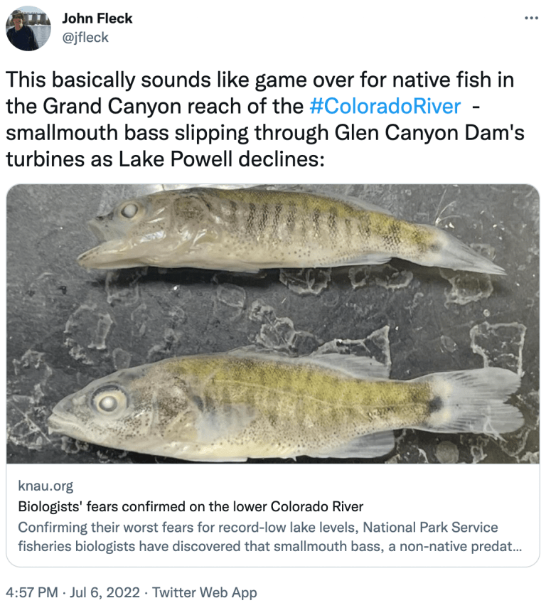
For National Park Service fisheries biologist Jeff Arnold, it was a moment he’d been dreading. Bare-legged in sandals, he was pulling in a net in a shallow backwater of the lower Colorado River last week, when he spotted three young fish that didn’t belong there. “Give me a call when you get this!” he messaged a colleague, snapping photos.
Minutes later, the park service confirmed their worst fear: smallmouth bass had in fact been found and were likely reproducing in the Colorado River below Glen Canyon Dam.
The confluence of the Colorado and Little Colorado rivers in the Grand Canyon, shown here in a September 2020 aerial photo from Ecoflight, represents an area where the humpback chub has rebounded in the last decade. That progress is now threatened by declining water levels in Lake Powell, which could lead to non-native smallmouth bass becoming established in the canyon. CREDIT: JANE PARGITER/ECOFLIGHT
They may be a beloved sport fish, but smallmouth bass feast on humpback chub, an ancient, threatened fish that’s native to the river, and that biologists like Arnold have been working hard to recover. The predators wreaked havoc in the upper river, but were held at bay in Lake Powell where Glen Canyon Dam has served as a barrier for years — until now. The reservoir’s recent sharp decline is enabling these introduced fish to get past the dam and closer to where the biggest groups of chub remain, farther downstream in the Grand Canyon.
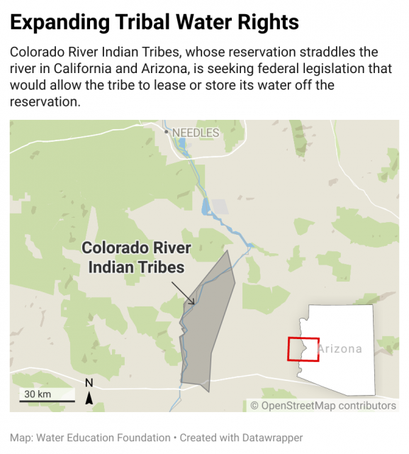
Western Water Q&A: CRIT chair Amelia Flores says allowing tribe to lease or store water off reservation could aid broader Colorado River drought response and fund irrigation repairs
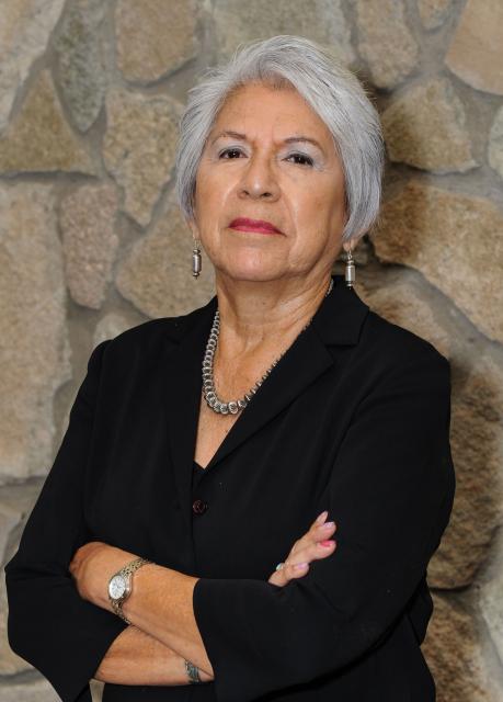
Amelia Flores, chairwoman of the Colorado River Indian Tribes. (Source: CRIT)
As water interests in the Colorado River Basin prepare to negotiate a new set of operating guidelines for the drought-stressed river, Amelia Flores wants her Colorado River Indian Tribes (CRIT) to be involved in the discussion. And she wants CRIT seated at the negotiating table with something invaluable to offer on a river facing steep cuts in use: its surplus water.
Wheat fields along the Colorado River at the Colorado River Indian Tribes Reservation. Wheat, alfalfa and melons are among the most important crops here. By Maunus at English Wikipedia, CC BY-SA 3.0, https://commons.wikimedia.org/w/index.php?curid=47854613
CRIT, whose reservation lands in California and Arizona are bisected by the Colorado River, has some of the most senior water rights on the river. But a federal law enacted in the late 1700s, decades before any southwestern state was established, prevents most tribes from sending any of its water off its reservation. The restrictions mean CRIT, which holds the rights to nearly a quarter of the entire state of Arizona’s yearly allotment of river water, is missing out on financial gain and the chance to help its river partners.
Flores, as CRIT’s tribal chair and the first woman to hold that post, is leading her tribe’s effort to persuade Congress to allow the tribe to lease or store its water off reservation lands like tribes in Arizona and other Colorado River Basin states with congressionally approved deals already can. If Congress grants the request by CRIT, Flores said, the tribe would offer water to aid struggling Arizona farmers and cities as well as wildlife restoration sites throughout the Lower Basin. The bill is pending in a U.S. Senate committee.
CRIT is comprised of members from four distinct ethnic groups, the Mohave, Chemehuevi, Hopi and Navajo tribes, and has set its sights on having a voice in renegotiation of operating guidelines for the Colorado River, which must be renewed by 2026. Flores contends the tribe has proven itself as a valuable partner by recently leaving water in Lake Mead to alleviate shortages. She hopes CRIT will finally have a voice in determining the river’s future, unlike previous negotiations that were crafted without tribal input.
In an interview with Western Water, Flores explains CRIT’s cultural ties to the Colorado River, the proposed legislation and the need for tribes to play larger roles in the upcoming renegotiations.
WESTERN WATER: You refer to the tribes as Aha Makhav, or people of the river. Can you talk briefly about the tribe’s historical relationship with and its cultural ties to the Colorado River?
AMELIA FLORES: Our creator Mataviily created first the stars and the planets and then after he created the animals, he created the people. To go along with that, he created the river and laid aside the lands for us to live off of. This is in our clan songs. The clan songs followed the river from Avii Kwa’ame north of Laughlin, and the Newberry Mountain Range. That is our sacred mountain to the Mohave people. And not only to the Mohave, but to the other tribes along the river. I can’t leave out the mountains. The mountains are very sacred to the Mohave people and they all have names. As stewards of the land and of the river, our identity is in the land and the water. We are the river.
WW: In December of 2020, you were elected by a wide margin to become the first female chair of the Colorado River Indian Tribes. What inspired you to run for the position and, as you said after the election, break the glass ceiling?
FLORES: It goes back to me serving the tribal membership for 29 years as the library archivist. And during that time I was mentored by the Mohave elders, and these were male elders, about the history and the culture of our tribe. The knowledge they passed on was inspiring and I think that is part of me wanting to serve on the tribal council level. And so, it was just moving on to the next level (to become CRIT chair). Also, the passion that I have to serve and help my people is another part that inspired me to continue working for my people.
With the trust and the support of the people, I was elected. It was their support and their vote that broke the glass ceiling, not me. I can provide a woman’s voice to the decisions and to the government.
WW: Under your leadership CRIT is pursuing federal legislation that would allow it to lease or store some of its Colorado River water off the reservation. How would the bill benefit the tribe and how does it fit into broader efforts to share water across the entire Lower Colorado River Basin?
FLORES: The CRIT Resiliency Act didn’t happen overnight. Our past tribal councils had been looking at how we could get more benefit out of, and authority over, our water. Over at least the last 20 years other tribes in Arizona started getting their settlements. With their settlements, they’re able to lease their water that they use from the Colorado River.
Agriculture is the main economic venture on CRIT’s reservation, where a range of crops like alfalfa, cotton and sorghum thrive in the rich soil along the banks of the Colorado River. (Source: CRIT)
WW: Looking ahead, what sort of role might CRIT and other tribal groups play in the discussions about the next set of river operating guidelines, which must be finalized by the year 2026? What are some of CRIT’s main priorities heading into these renegotiations?
FLORES: I can only speak for CRIT, not for the other tribes. But we all should play equal roles to the states in these discussions. Each tribe is vital and for so long we’ve been left out of the discussions, we’ve been left out of when plans are developed. With the drought and given the conditions [on the river], we are now being invited to the table, which has been a wake-up call for the Bureau of Reclamation and the United States. We’re all sovereign, we all have our own water rights. But ultimately the United States has its obligations to protect our resources and that’s not only water but other resources, like land for the individual tribes.
I think we need to remain vigilant. We need to hold the Bureau of Indian Affairs and the federal government to their policies. And I believe through negotiation and being at the table, we have a better chance of holding them accountable. We don’t ever want to go back to 10 years, even five years ago when we weren’t consulted.
WW: What is your greatest concern with the Colorado River, especially given the drought?
FLORES: My concern is that there’s a risk the Colorado River could stop flowing if the megadrought continues. Although we would be the last to be cut, it would greatly impact our tribal government and our services to the people. It would impact our environment and the habitat preservation we have going on at the Ahakhav Preserve. I’m hanging on to hope that we have a change in our climate, but there’s a possibility that no water could be flowing along the banks of the river.
WW: CRIT in recent years has participated in the 2019 Drought Contingency Plan and done things like fallow farmland in order to help avoid shortages elsewhere in the Lower Colorado River Basin. Do you think the federal government and the other river users will recognize and credit CRIT’s cooperation and actions during the renegotiation process?
FLORES: Oh yes. With the 200,000 acre-feet of water that we’ve already left in Lake Mead, I don’t think they could overlook us anymore and what we have contributed. And we are now in a relationship with the Arizona Department of Water Resources and also CAP. So in developing those relationships over the years they see us as a vital part of saving the river.
Glen Canyon Dam creates water storage on the Colorado River in Lake Powell, which is just 27% full in June 2022. Bureau data on the reservoir’s water-storage volume showed a loss of 443,000 acre-feet. Credit: U.S. Bureau of Reclamation
After inputting the new data on July 1, 2022 storage values at the current elevation dropped 6%
The Bureau of Reclamation last week revised its data on the amount of water stored in Lake Powell, with a new, lower tally taking into account a 4% drop in the reservoir’s total available capacity between 1986 and 2018 due to sedimentation.
Bureau data on the reservoir’s water-storage volume showed a loss of 443,000 acre-feet between June 30 and July 1 — a 6% drop in storage from 6.87 million acre-feet (which is 28.28% of live storage based on 1986 data) to 6.43 million (26.46% of full).
The cause was a recalculation of water stored based on a Bureau of Reclamation and U.S.Geological Survey study released in March — the first such analysis in more than 30 years — about Lake Powell’s loss of storage capacity due to the amount of sediment that the Colorado River and other tributaries deposit into the reservoir. The study was based on data about sediment in the lake collected in 2017 and 2018.
“After inputting the new data on July 1, 2022, storage values at the current elevation were updated, resulting in a decrease of 443,000 acre-feet,“ bureau officials wrote in an email.
The Bureau of Reclamation has performed two prior sediment surveys: pre-impoundment (before the construction of the dam — up to 1963) and in 1986.
Storage capacity figures prior to the release of the report in March had been based on 1986 data, Casey Root, a hydrologist for the U.S. Geological Survey’s Utah Water Science Center, said in an email.
The new data will be included in the upcoming July 24-Month Study, scheduled to be released in mid-July, which forecasts the reservoir’s volume and surface elevation, and in any subsequent operational projections.
Slackwater delta
“Like most reservoirs, Lake Powell loses storage capacity as a result of sedimentation from its source rivers,” said Root, who worked on the most recent USGS and Bureau of Reclamation study.
The paper explained that Lake Powell has continuously trapped sediment — including silt, sand and mud — from the Colorado and San Juan rivers since the Glen Canyon Dam impounded the rivers in 1963. The meeting of the free-flowing rivers carrying sediment with the slack water of the reservoir creates a delta, where the sediment falls to the lake’s bottom.
Root explained that the delta regions are located at the furthest extents of Lake Powell and that these areas typically contain the most sediment.
“Sediment isn’t deposited uniformly across the reservoir but rather far from the dam,” he said. “Over time, these deposits can laterally build toward the dam.”
Since it began filling in 1963, the reservoir has lost on average about 33,270 acre-feet in storage capacity each year, according to the study.
“Lake Powell is unique in that it is a long, narrow, steep-walled canyon, so the deltas have historically been about 150 miles away from Glen Canyon Dam,” Root said. “Simply being far away from the deltas can help buffer the dam and its operations against sedimentation.”
Due to this sedimentation, Lake Powell’s storage capacity at full pool decreased by 6.79% from 1963 to 2018, or a 1.83 million acre-foot loss.
Between 1986 and 2018, it dropped by 4%, which represents a loss of 1.05 million acre-feet in 32 years.
This animation shows the sedimentation process in Lake Powell.
Sedimentation and the limits on useful life
While sedimentation is shrinking Lake Powell’s storage capacity, the 2022 study shows that storage loss has remained stable since 1963.
From 1963 to 1986, Lake Powell had lost on average 33,390 acre-feet in storage capacity each year; from 1986 through 2018, 33,180 acre-feet per year was lost, according to the report.
“As a first-order approximation, the average annual storage loss in Lake Powell indicates the remaining volume at full pool will be filled in approximately 750 years. However, the reservoir fills laterally, from the deltas toward Glen Canyon Dam, and would likely cease to be useful sooner,” the study pointed out.
Several other variables — including sedimentation rates and climate sensitivity among others — need to be taken into consideration to better evaluate the remaining useful life of the reservoir.
Researchers are currently working on the July 24-Month Study, which should offer further insights on the reservoir’s future operations when it gets published later this month. Lake Powell dropped to its lowest level since filling prior to this spring’s runoff, which has been increasing reservoir levels since late April. At its lowest point, Lake Powell’s surface elevation at the Glen Canyon Dam dropped to 3,522.24 feet above sea level on April 22, just 32 feet above the minimum level required to generate hydropower. Water volume at the reservoir on that day was listed as being at 23.68% of full pool.
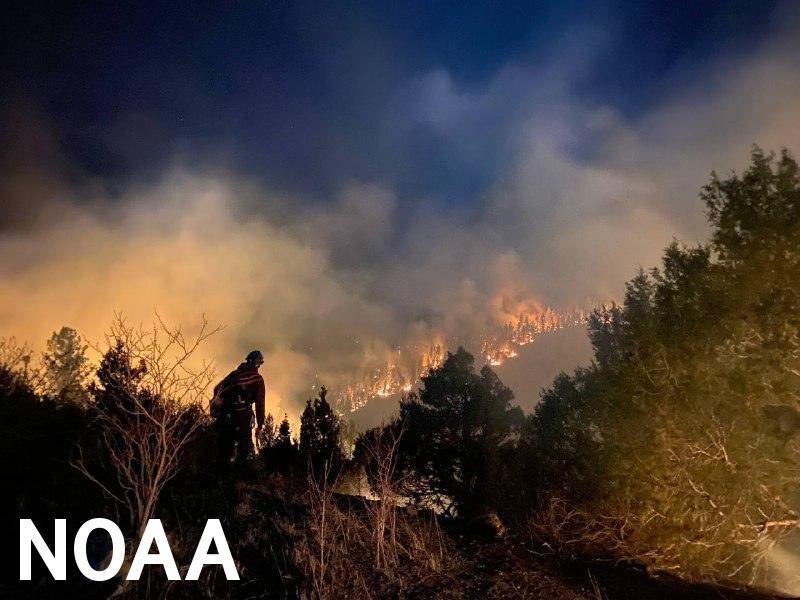
The Silver City Hotshots conduct firing operations along Highway 518 west of Holman, New Mexico, on May 9, 2022, during the Hermits Peak Fire. The fire became New Mexico’s largest wildfire in state history in May 2022, scorching more than 315,000 acres. (Inciweb)
Click the link to read the article on the USDA website:
Today, the Departments of Agriculture, the Interior and Homeland Security through the Federal Emergency Management Agency (FEMA) are announcing the selection of members to the Wildland Fire Mitigation and Management Commission.
Established by President Biden’s Bipartisan Infrastructure Law, and announced in December 2021, the Wildland Fire Mitigation and Management Commission will play a key role in recommending ways that federal agencies can better prevent, mitigate, suppress and manage wildland fires. It will also recommend policies and strategies on how to restore the lands affected by wildfire.
The call for nominations for the non-federal members was issued in March. More than 500 applications were received, and 36 non-federal members — 18 primary and 18 alternates — have been selected to serve on the commission. Along with 11 federal members, the commission will be co-chaired by Departments of Agriculture, the Interior and FEMA leadership. Commission members represent federal agencies, Tribes, state and local municipalities, and private entities, as directed by the Bipartisan Infrastructure Law.
he commission will prepare a report with policy recommendations and submit them to Congress within a year of its first in-person meeting in August. A virtual introductory call is scheduled for this month. The Departments of Agriculture, the Interior and FEMA will provide support and resources to assist the commission with coordination and facilitation of their duties.
The commission’s work will build on existing interagency federal efforts such as the Wildland Fire Leadership Council and the White House Wildfire Resilience Interagency Working Group and will continue to pursue a whole-of-government approach to wildfire risk reduction and resilience. It’s creating comes at an important time as shifting development patterns, land and fire management decisions, and climate change have turned fire “seasons” into fire “years” in which increasingly destructive fires are exceeding available federal firefighting resources.
In addition to establishing the commission, the Bipartisan Infrastructure Law provides historic funding for a suite of programs aimed at reducing wildfire risks, detecting wildfires, instituting firefighter workforce reforms and building more resilient infrastructure.
This year, the Departments of Agriculture and the Interior have allocated an initial $234 million in Bipartisan Infrastructure Law investments for wildfire resilience efforts and established a new joint mental wellness program to equip federal wildland firefighters with post-traumatic stress disorder care and address environmental hazards to minimize on-the-job exposure.
These investments support the USDA Forest Service’s “Confronting the Wildfire Crisis” (PDF, 32 MB) strategy, which aims to treat 20 million acres of national forests and grasslands and 30 million acres of state, local, Tribal and private lands over the next 10 years to reduce wildfire risk where it matters most. They also support efforts to implement the Department of the Interior’s “Five-Year Monitoring, Maintenance, and Treatment Plan,” which aligns with the USDA 10-year strategy and provides a roadmap for addressing wildfire risk on Department of the Interior and Tribal lands.
The Bipartisan Infrastructure Law also supports landmark pay increases for federal wildland firefighters, announced on June 21, which aim to bring federal firefighter pay in alignment with their state and local counterparts, while aiding in recruitment and retention of a more permanent and stable wildland firefighting force across the federal government.
For more information visit the commission website or email wildlandfirecommission@usda.gov.
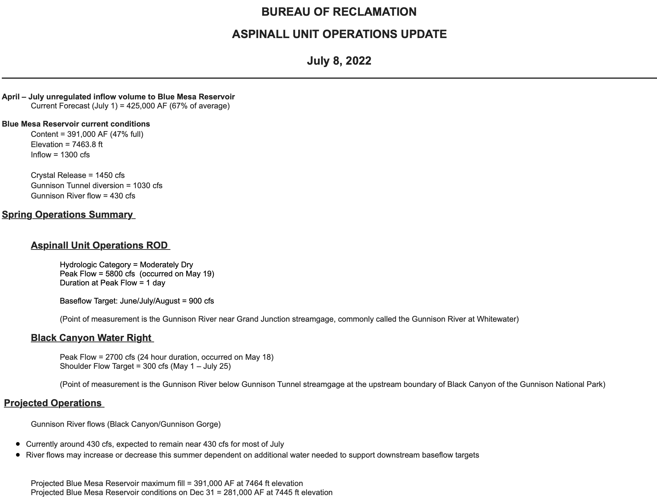
Releases from the Aspinall Unit will be increased from 1350 cfs to 1450 cfs on Friday, July 8th. Releases are being increased to maintain flows above the baseflow target on the lower Gunnison River. The forecasted April-July runoff volume for Blue Mesa Reservoir is 67% of average.
Flows in the lower Gunnison River are currently above the baseflow target of 900 cfs. River flows are expected to drop below the baseflow target without this additional increase in release from the Aspinall Unit.
Pursuant to the Aspinall Unit Operations Record of Decision (ROD), the baseflow target in the lower Gunnison River, as measured at the Whitewater gage, is 900 cfs for June, July and August.
Currently, Gunnison Tunnel diversions are 1030 cfs and flows in the Gunnison River through the Black Canyon are around 335 cfs. After this release change Gunnison Tunnel diversions will still be around 1030 cfs and flows in the Gunnison River through the Black Canyon will be near 435 cfs. Current flow information is obtained from provisional data that may undergo revision subsequent to review.
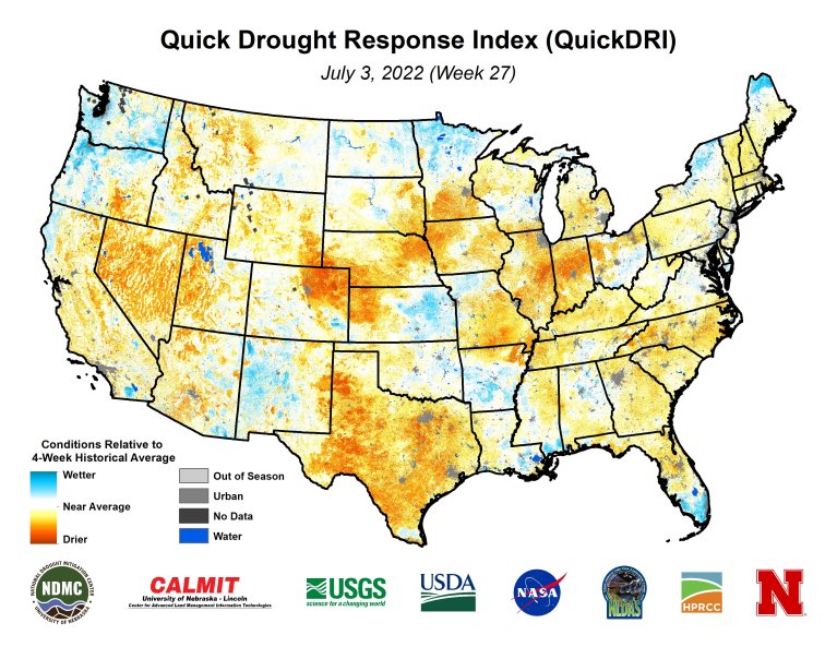
Short-term drought continued to rapidly expand across the Ohio, Tennessee, and Middle Mississippi Valleys along with parts of the Corn Belt. Thunderstorms brought locally heavy rainfall and drought relief to parts of the central to northern Great Plains. However, 7-day temperatures averaged above-normal throughout the Great Plains. A tropical disturbance in the western Gulf of Mexico and a trough of low pressure resulted in heavy rainfall and improving drought conditions to southeast Texas and southwest Louisiana. Convective rainfall was highly variable this past week across the Southeast with isolated amounts exceeding 3 inches while other areas remained mostly dry with worsening drought conditions. New England experienced a week of mostly dry weather and expanding drought coverage. Following the unusually heavy Monsoon rainfall during late June, heavy amounts were more localized this past week across New Mexico. Seasonal dryness prevailed throughout California, while much of the Pacific Northwest became drier after a wet spring. Drier-than-normal conditions persisted for much of Alaska into the beginning of July. A tropical wave of low pressure tracked northwest from the central Atlantic and brought heavy rainfall to eastern Puerto Rico…
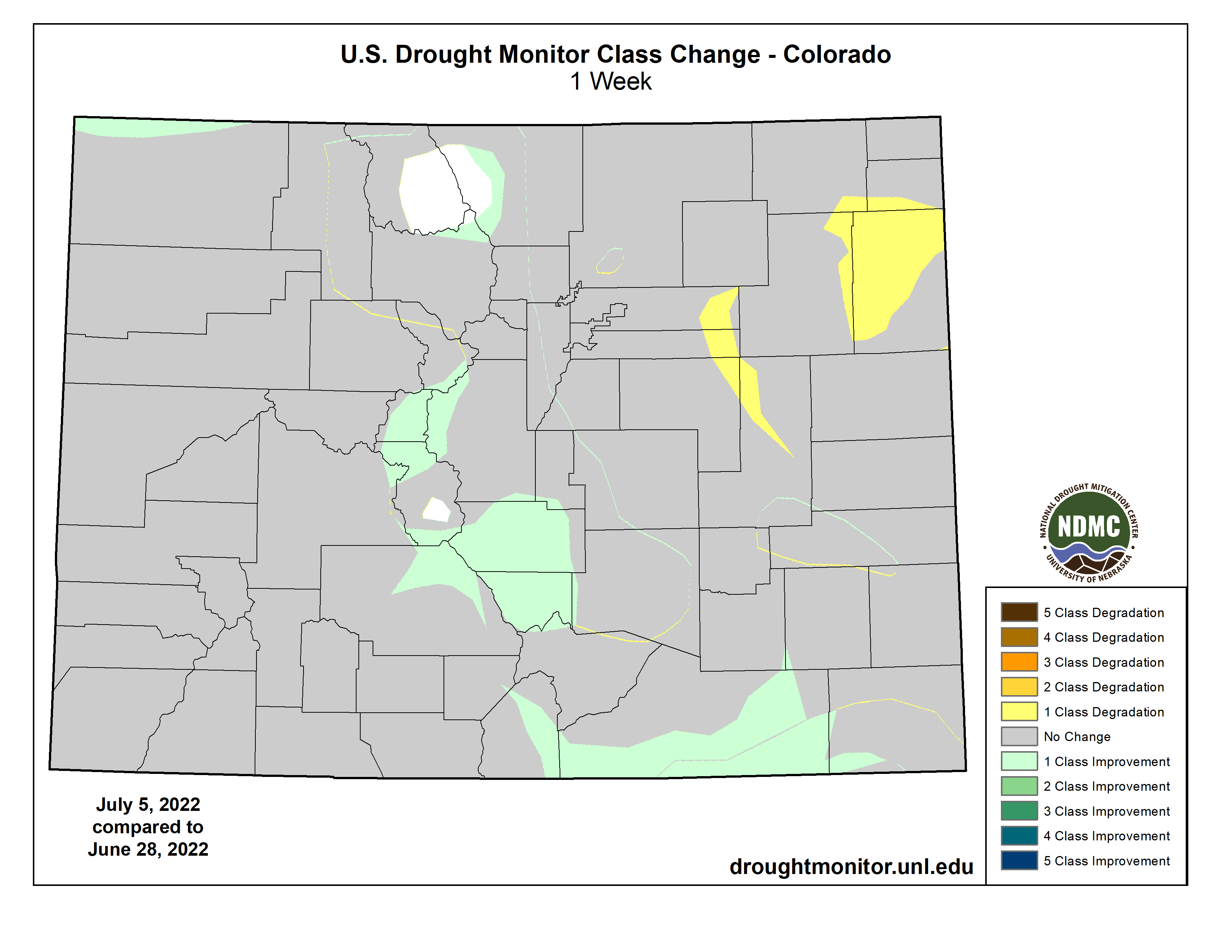
Locally heavy rainfall (more than 1 inch) this past week resulted in 1-category improvements to parts of Kansas, Nebraska, and South Dakota. Based on increasing short-term precipitation deficits and consistent with worsening soil moisture indicators, severe drought (D2) expanded across north-central Nebraska and extreme drought (D3) was added to more of northeastern Nebraska. Recent precipitation and reassessment of longer term SPI values supported a slight reduction of severe drought (D2) in southwestern Wyoming. Following a drier-than-normal June with above-normal temperatures (+3-4 degrees F), degradations were made to northeastern High Plains of Colorado. Recent monsoonal rainfall and the “convergence of evidence” of multiple indicators led to improvements for southern Colorado…
Colorado Drought Monitor one week change map ending July 5, 2022.
The North American Monsoon remained robust into the beginning of July, resulting in near to above normal precipitation across Arizona and New Mexico. Following the widespread 1-category improvement made the previous week throughout New Mexico, improvements were limited to areas of the heaviest rainfall. Additional improvements may be necessary in subsequent weeks depending on the Monsoon rainfall. Beneficial rainfall (more than 1 inch) continued to result in drought elimination across eastern Montana. Parts of north-central Montana have remained drier since the spring and extreme drought (D3) was expanded which was supported by soil moisture data. Drought coverage and intensity remained steady for the remainder of the West…
The rapid onset of drought continues to affect parts of the Tennessee and Lower Mississippi Valley with a continued increase in coverage of short-term moderate drought (D1). Western Tennessee and northern Mississippi were especially dry the past two weeks with many areas receiving less than 0.25 inches of rainfall. This dryness was combined with above-normal temperatures. Therefore, severe drought (D2) was added to parts of northern Mississippi and western Tennessee. 30-day SPEI, EDDI, and soil moisture indicators were used as guidelines in these degradations. Likewise, D0-D1 was also expanded across northeast Texas, southeast Oklahoma, and Arkansas. The number of Arkansas counties, designated with burn bans, continues to increase. In the 6 week period since May 25, Jonesboro, Arkansas has recorded 1.17″ of precipitation, or about 25% of normal. This is the driest such period since 1952. SPI values, starting at 120 days through the past 24 months, along with CPC’s leaky bucket soil moisture (lowest percentile) supported an expansion of D4 across the Texas Panhandle.
Closer to the Gulf Coast, heavy rainfall (more than 1.5 inches) resulted in widespread 1-category improvements to southern Louisiana and southeastern Texas. In areas that received more than 5 inches of rainfall such as southwest Louisiana, a 2-category improvement was justified. A small 2-category improvement was also made to northeastern Texas that received 3 to 6 inches of rainfall. Recent, heavy rainfall also led to a trimming of the extension of moderate drought (D1) across central Mississippi…
Looking Ahead
A major heat wave is forecast to affect much of the south-central U.S. through at least July 7 or 8 with the anomalous heat becoming centered across the Southern Great Plains and West by mid-July. A swath of heavy rainfall (1 to 3 inches, locally more) is forecast from the Middle Mississippi and Ohio Valleys southeastward to the Mid-Atlantic States from July 7 to 11. Mostly dry weather is expected for the Northeast, Gulf Coast States, Lower Mississippi Valley, and Southern Great Plains. Monsoonal rainfall is forecast to be lighter compared to late June.
The Climate Prediction Center’s 6-10 day outlook (valid July 12-16, 2022) favors above-normal temperatures throughout the West, Great Plains, and Gulf Coast States. Below-normal temperatures are more likely for the Great Lakes and Midwest. Below-normal precipitation is favored for the northern Great Plains and Middle to Upper Mississippi Valley. Probabilities for above-normal precipitation are elevated across eastern Alaska, the Great Basin, Southwest, Southern Great Plains, and along the East Coast.
Just for grins here are early July drought monitor maps for the past few years.
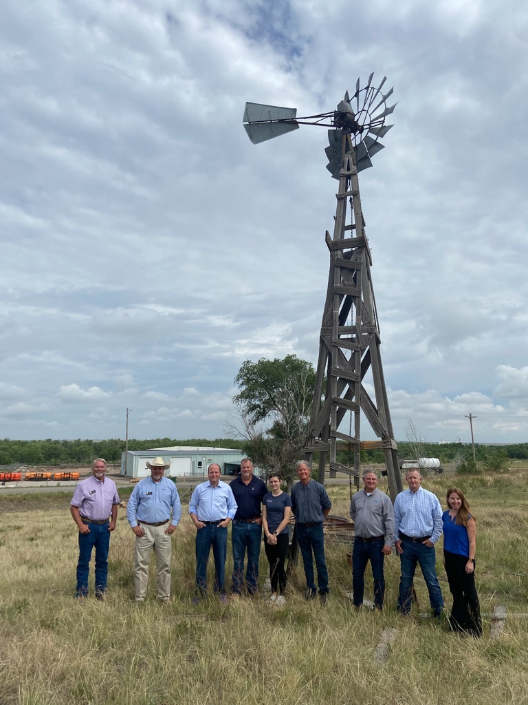
Today [July 6, 2022], Governor Jared Polis traveled across the Eastern Plains to hear directly from farmers, ranchers, and local leaders working to boost Colorado’s agriculture economy and to protect Colorado’s water.
This morning, Governor Polis, administration officials and community members visited Julesburg Gauge on the South Platte River to discuss water issues.
“It was great to be in Sedgwick, Phillips, Yuma, Kit Carson, Cheyenne, Kiowa, Lincoln, and Elbert counties hearing directly from producers and discussing how our administration is working together even more to protect Colorado’s water, grow Colorado’s thriving agriculture industry, and support our hardworking farmers and ranchers,” said Governor Polis.
Gov. Polis was then joined by the Commissioner of Agriculture Kate Greenberg, and toured Vision Angus, a local family owned ranch and farm in Phillips county that has been passed down for four generations. Vision Angus is a second year recipient of the Agricultural Workforce Development Program which aims to keep developing the next generation farmers and ensure our agriculture industries continued growth.
Governor Polis then headed to the South Republican State Wildlife Area and was joined by board members and other officials to discuss groundwater conservation in Yuma county. The Republican River Basin is supported by SB22-028, which was signed by Gov. Polis creates groundwater compact compliance and sustainability fund water conservation efforts in order to protect our water supply and retain irrigation systems in the river basins across Colorado. The Polis-Primavera administration is fighting to ease the effects of climate change induced drought seen across the state.
Governor Polis then visited the Eads Fire Department in Elbert county and met with first responders to discuss the Polis Administration’s continued support for first responders, including legislation that Governor Polis signed into law this year to provide additional resources and support for volunteer firefighters.
Governor Polis then traveled to Kit Carson county to visit the Old Town Museum. The museum is a historic site that has been restored to display the history of the Colorado Plains and local agriculture.
Governor Polis later traveled to Cheyenne county to sit down with local leaders and county commissioners from Cheyenne and Kiowa counties to discuss soil health and drought resilience efforts. Cheyenne Conservation District will receive support from SB22-195, a bipartisan law signed by Governor Polis which allocates additional annual funding for conservation districts across the state.
Governor Polis then visited two recipients of the Colorado Proud grant, Grant Grains and the Cleantec Mushroom Facility in Lincoln and Elbert counties, and where he discussed the administration’s support for producers and discussed tax relief for farmers including a bipartisan bill the Governor signed into law in the form of SB21-293.
(Gov. Polis in Phillips County touring Vision Angus family farm). Photo credit: Governor Polis’ office
Click the link to read the article on the Sacramento Bee website (Dale Kasler). Here’s an excerpt:
In March the U.S. Environmental Protection Agency invited the backers of Sites Reservoir — a mammoth water storage project in the Sacramento Valley that’s being personally led by Durst — to apply for a $2.2 billion construction loan. The loan is far from a done deal, but the invitation means the EPA is seriously interested in backing the project, bringing Sites tantalizingly close to reality after years of planning.
“I was ecstatic. We finally convinced people this was a worthy project,” said Durst, chairman of the Sites Project Authority.
But the reservoir, planned for a spot straddling the Glenn-Colusa county line, 10 miles west of the Sacramento River, won’t dig California out of its current mega-drought. Even if all goes according to plan — a pretty big if — Sites wouldn’t finish construction until 2030. The status of Sites says a lot about how things stand in the third year of California’s terrible drought. There are no quick fixes, no immediate remedies. The only way out of this, for the time being, is conservation, forcing farmers and homeowners alike to make do with less water.
“What people have got to realize is,” Durst said, surveying one of his unplanted rice fields recently, “there’s no easy solutions left.”
[…]
A simple, non-controversial water project in rural south Sacramento County, designed to “bank” billions of gallons of water below ground as a reserve for drought periods, won’t be ready until late 2024. A more ambitious project, a multibillion-dollar recycling plant capable of putting a significant dent in the Los Angeles area’s water woes, is moving through the planning process but won’t produce drinkable water for another 10 years. The fact is, California is responding to the drought at something other than lightning speed. Its urban residents aren’t heeding Gov. Gavin Newsom’s call to cut their water usage by 15%. Since he made his plea last July, water savings total just 3%. And its public officials are struggling to get water-infrastructure projects over the finish line.
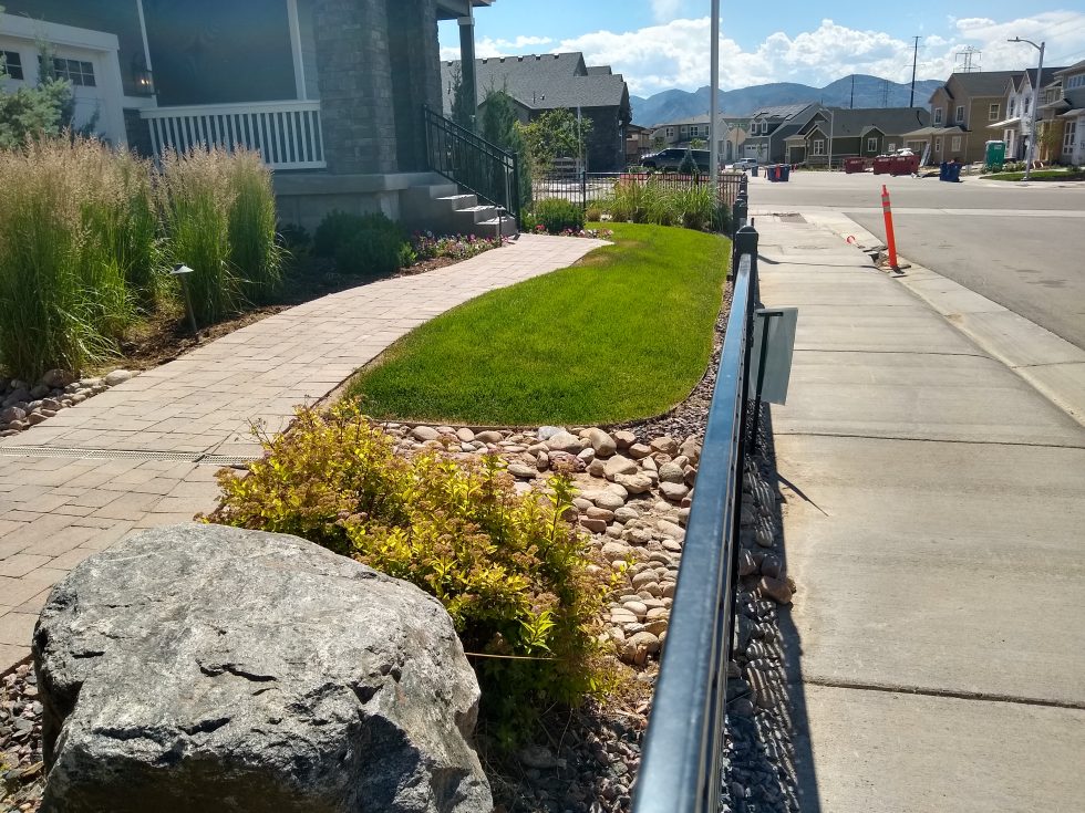
A small yard in Sterling Ranch, a Douglas County community that is the first in the state to undertake a rainwater harvesting project. June 27, 2022. Credit: Jerd Smith, Fresh Water News
Sterling Ranch, a conservation-oriented, fast-growing Douglas County community, is launching the first commercial effort to harvest rainwater in Colorado.
If the commercial pilot project succeeds, it could be used statewide to reduce water use in new developments, creating a supply of water that legally hasn’t existed before.
Andrea Cole is general manager of Dominion Water and Sanitation District, which serves Sterling Ranch. She said the project should prove that rain that runs off paved surfaces in developed areas can be used without harming natural water supplies that existed prior to development.
“When you change the landscape to a hardscape you produce more runoff,” Cole said. “The point is to capture the water off of a developed site without taking the water that would naturally be there.”
Sterling Ranch has been monitoring rainfall and infiltration of water into soils to ensure that the proposed collection system is gathering only the additional runoff from hard surfaces, and not the historic amount that the prairies collected pre-development.
Sterling Ranch must also convince its bigger neighbors, including Denver Water and Highlands Ranch, that Sterling’s rainwater collection is, in fact, a result of higher runoff from paved surfaces, not from the naturally occurring rain that falls in Douglas County.
“We’ve already heard from Denver and Centennial (the water district that serves Highlands Ranch) that we will have to prove we are not harming their water rights,” Cole said.
Swithin Dick, Centennial’s water rights administrator, said his agency was taking a wait-and-see approach to the rainwater pilot.
“If their application explains a project and plan that does not have the potential to injure Centennial’s water rights, and is consistent with existing law, it is not likely Centennial will oppose it,” Dick said via email.
Denver Water spokesman Todd Hartman said the agency had not yet taken a formal position on the project.
While collecting rainwater for drinking and irrigation is common elsewhere, it has been illegal in Colorado until recently because every drop of water that falls to the ground is owed to the rivers and streams, under the state’s 150-year-old allocation doctrine known as Prior Appropriation.
In 2016, Colorado legislators passed a law allowing individual homeowners to collect rainwater in two barrels per property with a combined storage capacity of up to 110 gallons, and also authorized a pilot program to see if a larger-scale, commercial effort could be done without harming downstream water users.
Harold and Diane Smethills began developing Sterling Ranch in 2004 and it now has 1,324 homes and will eventually have 12,050. The homes are among the most water-efficient that can be built and utilize small lots, hyper-efficient faucets and showers, and separate meters for indoor and outdoor water use.
Most Douglas County communities rely heavily on wells that tap water from deep, non-renewable aquifers, but heavy pumping over the years has lowered the aquifers’ levels. Water was already in short supply when Smethills first proposed Sterling Ranch, and he had to convince Douglas County planners that he could build the new development using much less water than the .75 acre-feet per single-family home the county required at the time. He also had to prove that he could do it using renewable surface water supplies in the South Platte River Basin.
He was eventually able to convince county planners that he could serve the community using .40 acre-feet of water per home, a number that now is closer to .20 acre-feet. An acre-foot equals 326,000 gallons, or enough to cover an acre of land with 12 inches of water.
Smethills and his team have been awarded two state grants worth roughly $111,500. The latest grant, awarded in March, will be used to help complete the feasibility studies and begin design work.
Cole said the project should generate 400 acre-feet of water annually that can be captured and used to irrigate the community’s small parks, allowing the community to use its existing supplies elsewhere.
But hurdles remain. Sterling Ranch may have to seek new legislation in the face of new stormwater rules that require separate storage facilities for stormwater and rainwater, Cole said, because the new rules would significantly increase the capital costs of the collection and distribution systen.
And as with almost all new water projects seeking a legal right to collect water, the project will have to go through an extensive review in a special water court, where anyone who has a water right in the region can submit concerns and challenge the process.
Sterling Ranch will apply to water court later this year, Cole said, and because of what she believes will be significant opposition, she expects it to take up to three years to complete the legal process and win the right to legally collect rainwater.
“Will there be opposition? Yes,” said Smethills, “Everybody else is watching to see how we do and if we can get it through water court. We’re at the bleeding edge. But this isn’t amateur night. We’ve spent millions of dollars to capture this data.”
Jerd Smith is editor of Fresh Water News. She can be reached at 720-398-6474, via email at jerd@wateredco.org or @jerd_smith.
Heavy rain combined with melting snow can be a destructive combination.
In mid-June 2022, storms dumped up to 5 inches of rain over three days in the mountains in and around Yellowstone National Park, rapidly melting snowpack. As the rain and meltwater poured into creeks and then rivers, it became a flood that damaged roads, cabins and utilities and forced more than 10,000 people to evacuate.
The Yellowstone River shattered its previous record and reached its highest water levels recorded since monitoring began almost 100 years ago.
Although floods are a natural occurrence, human-caused climate change is making severe flooding events like this more common. I study how climate change affects hydrology and flooding. In mountainous regions, three effects of climate change in particular are creating higher flood risks: more intense precipitation, shifting snow and rain patterns and the effects of wildfires on the landscape.
This occurs because warmer air can hold more moisture. The amount of water vapor that the atmosphere can contain increases by about 7% for every 1.8 degrees Fahrenheit (1 degree Celsius) of increase in atmospheric temperature.
Extreme rain storms triggered flooding and mudslides in Western Europe in 2021, killing more than 200 people. Thomas Lohnes/Getty Images
The latest assessment report published by the Intergovernmental Panel on Climate Change shows how this pattern will continue in the future as global temperatures continue to rise.
More rain, less snow
In colder areas, especially mountainous or high-latitude regions, climate change affects flooding in additional ways.
When rain falls on snow, as happened in the recent flooding in Yellowstone, the combination of rain and snowmelt can lead to especially high runoff and flooding.
In some cases, rain-on-snow events occur while the ground is still partially frozen. Soil that is frozen or already saturated can’t absorb additional water, so even more of the rain and snowmelt run off, contributing directly to flooding. This combination of rain, snowmelt and frozen soils was a primary driver of the Midwest flooding in March 2019 that caused over US$12 billion in damage.
While rain-on-snow events are not a new phenomenon, climate change can shift when and where they occur. Under warmer conditions, rain-on-snow events become more common at high elevations, where they were previously rare. Because of the increases in rainfall intensity and warmer conditions that lead to rapid snowmelt, there is also the possibility of larger rain-on-snow events than these areas have experienced in the past.
The 2022 Yellowstone flood inundated communities and swiftly eroded the land beneath this cabin that housed park employees. Gina Riquier via National Park Service
In lower-elevation regions, rain-on-snow events may actually become less likely than they have been in the past because of the decrease in snow cover. These areas could still see worsening flood risk, though, because of the increase in heavy downpours.
Compounding effects of wildfire and flooding
Changes in flooding are not happening in isolation. Climate change is also exacerbating wildfires, creating another risk during rainstorms: mudslides.
With the uptick in wildfires due to climate change, more and more areas are exposed to these risks. This combination of wildfires followed by extreme rain will also become more frequent in a future with more warming.
Global warming is creating complex changes in our environment, and there is a clear picture that it increases flood risk. As the Yellowstone area and other flood-damaged mountain communities rebuild, they will have to find ways to adapt for a riskier future.
The Little Colorado River is best known for its milky blue waters that flow into the mainstem Colorado River in the Grand Canyon. These waters carry so much life-giving significance. For millennia, they have provided physical and spiritual sustenance for Indigenous peoples and supported plants, wildlife, communities, and more.
Grand Falls Little Colorado River, Spring of 2010.
But the Little Colorado River is not always blue. Sometimes it runs as thick and brown as chocolate milk. With a little knowledge of the river’s annual peaks and lows and an eye on the weather gauge, you can predict whether it will be brown or that remarkable turquoise blue.
So why and when is the Little Colorado River so blue?
Confluence of the Little Colorado River and the Colorado River. Climate change is affecting western streams by diminishing snowpack and accelerating evaporation. The Colorado River’s flows and reservoirs are being impacted by climate change, and environmental groups are concerned about the status of the native fish in the river. Photo credit: DMY at Hebrew Wikipedia [Public domain]
The source of its milky blue waters
The Little Colorado River gets its blue color from dissolved calcium carbonate in the water. This mineral is found in chalk, antacids, eggshells, dark green vegetables, rocks, and more. In the Little Colorado River, calcium carbonate forms a type of limestone called travertine that creates white, pillowy deposits along the riverbed. Most of the turquoise-blue water in the Little Colorado River comes from springs 10 to 13 miles upstream of the confluence. Thanks to these groundwater-fed springs, the last 13 miles of the Little Colorado River flow year-round at an average rate of 220 cubic feet per second (cfs) until joining the mighty Colorado River, which has an average flow between 8,000 and 25,000 cfs!
The Little Colorado River’s year-round flows are important for the region’s largest population of humpback chub. The warm, cloudy waters make excellent habitat for this threatened fish species.
Little Colorado River. Photo credit: Sinjin Eberle via American Rivers
Other colors of the Little Colorado River
When the Little Colorado River begins its journey from its headwaters in the White Mountains, its waters are not yet blue. The clear mountain stream flows north into the desert lands below, picking up sediment, minerals, and debris along the way. But less than 20 miles from its source, the Little Colorado River dries up. And for the next 300 miles, the river relies on precipitation to send water downstream. Modern-day water use is a major culprit of this dry stretch of the Little Colorado River. Year-round flows return near Blue Spring, 13 miles upstream of the confluence.
During two high runoff periods each year — in the spring from snowmelt and in the late summer from monsoon rains — the Little Colorado River runs red. During these periods, from February to April and July to September, the Little Colorado River may spike to 18,000 cfs. At this runoff level, the water can be so thick and muddy that placing your hand just an inch below the surface of the water makes it invisible to the naked eye.
The cultural significance of the Little Colorado River’s blue waters
The Little Colorado River’s blue waters have been of deep cultural significance to Native peoples since time immemorial. At least 10 tribes have traditional connections to what Zuni people refer to as “the umbilical cord” of the world. For Hopi people, the Little Colorado River is the home of their emergence story, and its waters, springs, and salt remain important to this day. Adjacent Diné (Navajo) communities, whose land may be affected by proposed dam development, are considering a sacred site designation for the area to prevent development threats like the former Escalade tram proposal.
But to truly understand the importance of the Little Colorado River, I suggest you go directly to the source. Visit the Lifeways of the Little Colorado River collection to hear 11 Native voices share their personal and cultural ties to this life-sustaining river.
Low flows during drought on the Crystal River. Photo credit: Colorado Water Trust
Here’s the release from the Colorado Water Trust and the Cold Mountain Ranch (Alyson Meyer Gould and Bill Fales):
Cold Mountain Ranch and Colorado Water Trust finalized an agreement intended to increase streamflow in the Crystal River in drier years. The six-year agreement will compensate the Cold Mountain Ranch owners, Bill Fales and Marj Perry, for retiming their irrigation practices to leave their irrigation water in the Crystal River when the river needs it most.
The Crystal River, in 2012, was listed as the eighth most endangered river in the country by American Rivers. It is still a struggling river today. Owing to diversions off the river and the impacts of climate change decreasing snowpack, it runs very low or dry in most years. This impacts the fish and wildlife that depend on it. Colorado Water Trust and Cold Mountain Ranch are trying to help. This innovative agreement would provide the ranch the opportunity to add flows to their local river when it needs it most and hopefully contribute to a healthier aquatic and riparian habitat for those that depend on it. Together, we aim to show that agriculture and conservation can go hand in hand.
Cold Mountain Ranch relies on the Crystal River to irrigate pastures and hay fields that support its cow-calf operation. Under the agreement, Colorado Water Trust will monitor flows in the river and if flows fall to 40 cubic feet per second (cfs) in August or September, the ranch may voluntarily decide to shift its irrigation schedule to allow Colorado Water Trust to lease the water for environmental benefit. Colorado Water Trust will monitor and measure the changed practice and pay the ranch a $5,000 bonus for signing the agreement at the outset of the five-year contract and then $250 per cfs per day to encourage that shift. Once streamflows reach 55 cfs, payments would cease. The agreement can restore up to 6 cfs in the Crystal River.
In 2018, Colorado Water Trust and Cold Mountain Ranch signed a similar three-year pilot agreement that ended in 2020. Unfortunately, within this initial three-year period, Colorado Water Trust and Cold Mountain Ranch were unable to run the project. In 2018, the Crystal River’s flows were too low to implement the agreement – there was not enough water available to result in significant benefits instream. In 2019, the river was high enough to avoid triggering the agreement during the timeframe of the agreement. Although it flirted with the low flow trigger in the late fall, the timing was out of range for the agreement. And in 2020, because of dry and hot conditions and impacts to their irrigated crops, Colorado Water Trust’s partners at Cold Mountain Ranch needed to use as much water as possible to maximize their late season production and keep their ranching operation sustainable.
Colorado Water Trust and Cold Mountain Ranch’s initial three-year pilot agreement was the first crack at a highly customized, market-based solution that works for agriculture and rivers on the Crystal River, and offered lessons for the renewal and re-tooling of that initial agreement. In this new six-year contract, the partners tried to account for drier years and changing climatic conditions, as well as the economic needs of the Ranch. The changes include a $5,000 bonus to support agricultural operations, additional payment and flexibility for coordination, and extending potential coordination into October.
One of the most important goals of Colorado Water Trust’s work on the Crystal River was to design a solution that allows water rights owners to maintain healthy agricultural operations – and Colorado Water Trust continues to accomplish that goal.
Our past agreement also shows other ranchers on the Crystal River that when we say our solutions are voluntary and are NOT designed to harm their operations, we mean it. The vision for this project is that other ranchers on the Crystal River will see that Cold Mountain Ranch is fully empowered to make their own decisions in the best interest of their business, and will feel comfortable to sign on to the project as well. The Crystal River needs more water than just that of Cold Mountain Ranch’s and we hope others will get involved to maintain a healthy river.
ABOUT COLORADO WATER TRUST: Colorado Water Trust is a statewide, nonprofit organization that restores water to Colorado’s rivers in need. Colorado Water Trust accomplishes its mission with voluntary, market-based projects.
One of the City of Northglenn’s water diversions on Berthoud Pass that was vandalized the week of June 19. | City of Northglenn / Courtesy Photo Unknown-1
Click the link to read the article on the Sky-Hi News website (Tracy Ross). Here’s an excerpt:
The Grand County Sheriff’s Office reported last Friday that several water diversion gates on Berthoud Pass that deliver water to the city of Northglenn were intentionally damaged or destroyed, creating “monumental losses” for that city. Northglenn officials first contacted the sheriff’s office on June 22. They reported a theft of water and criminal mischief of the diversion gates on the Berthoud Pass Ditch in Current Creek Basin. Northglenn collects water from the ditch and diverts it into Clear Creek, said Andy Miller, president of the board of directors of the Upper Colorado River Watershed Group. On June 22, Northglenn staff reported “a sudden and significant decrease in water output routed for Northglenn” on the two days previous to their call. When Northglenn staff responded to the ditch, they found that several water diversion gates were intentionally damaged or destroyed…
Some are questioning whether the vandalism was sabotage by a water conservation group. Kirk Klancke, president of the Colorado River Headwaters chapter of Trout Unlimited, said a similar act happened at the same spot several years ago. In 2019, vandals caused an estimated $1 million worth of damage to the City of Northglenn’s collection system and disrupted both Northglenn and Golden water supplies…
Northglenn’s water right on Berthoud Pass is 600 acre feet of water per year, available between May 15 and October 15. Northglenn’s average annual water use is 6,000 acre feet, “so this is about one-tenth of our annual water supply,” said Moon. “It doesn’t seem like a lot, but on a good year, Berthoud Pass water is incredibly important to us. And now that we’re watching climate change change our weather patterns, and summer weather getting drier and drier, getting that water early in the season and being able to use it is one of the ways we can keep our residents from having water restrictions when we see our neighbors not the doing the same.”
Colorado transmountain diversions via the State Engineer’s office
The Yampa Valley has seen above average rainfall for the second straight month, with June seeing just shy of 3 inches of precipitation compared to the 1.6-inch average. While this year is trending better than the past handful, Van De Carr said talk of a closure [of the river] could swiftly surface…
The Yampa River below Stagecoach closed to fishing in early June because of low flows, which dropped to just 10 cfs flowing out on June 14. On Sunday afternoon, about 51 cfs was flowing into the reservoir and about 41 cfs out, according to data from the U.S Geological Survey…
Speaking before the Senate Committee on Energy and Natural Resources on June 14, Bureau of Reclamation Commissioner Camille Calimlim Touton warned that water users along the Colorado River must slash their usage by as much as one-fourth by the end of next year to “help preserve and protect power pool” at Glen Canyon and Hoover dams — both of which produce hydropower for millions across the region. Touton said Reclamation has seen similar patterns across every major basin in the West — hydrologic variability, hotter temperatures, dry soil — leading to earlier snowmelt and low runoff. Coupled with the lowest reservoir levels on record, “there is so much to this that is unprecedented,” she said.
“But unprecedented is now the reality,” Touton said…
“It is in our authority to act unilaterally to protect the system, and we will protect the system,” she said.
When looking to reduce usage by 4 million acre-feet, John McClow, general counsel for the Upper Gunnison River Water Conservancy District, said the answer is obvious. The Upper Basin states, situated at the headwaters of the Colorado River, have continued to take involuntary shortages each year, dependent on ebb and flow of rain and snowmelt.
“We haven’t got anything to give,” he said. “They’ve had perfect control of their supply ever since Hoover Dam was built. Their system is a lot easier to operate, you just turn on the tap … We don’t have those resources in the Upper Basin.”
[…]
UCRC Executive Director Chuck Cullom said he believes both the Upper and Lower basins need to contribute to a solution.
“I think the Upper Basin has taken significant efforts and suffered significant pain,” Cullom said. “There is more that can be done. Most of the work going forward should come from the area where there’s significant water use. And that’s, again, downstream.”
Cullom said although he is optimistic water users, tribes and the federal government can negotiate a plan within the 60-day window, emergency releases in 2021 and Touton’s call for more water reflects that the existing rules have been exhausted.
“Now that we’ve depleted the storage, the only choice is to adapt,” he said.
Some of the snowmelt flowing in the Blue River as it joins the Colorado River near Kremmling, Colo., will reach the Lower Basin states. Dec. 3, 2019. Credit: Mitch Tobin, the Water Desk
Click the link to read the article on the Summit Daily website (Eliza Noe). Here’s an excerpt:
The plan focuses on four “interconnected action areas,” including resiliency planning, thriving watersheds, robust agriculture and community. It describes 50 “partner actions,” or project ideas that could be supported by Water Plan grants, as well as 50 “agency actions,” to support local projects, conservation and wise-water development. Overall, however, basin roundtables and stakeholders identified more than 1,800 potential future projects statewide, and 321 are in the Colorado Basin with 36 being in Summit County. In total, over $20 billion would be spent on the projects by 2050. Russ Sands, senior program manager of water supply planning for the Colorado Water Conservation Board, said that projects in the database are designated as near-term, midterm or long-term when it comes to getting them done. They’re also not all infrastructure projects. Some may work toward water conservation and others may be educational projects or environmental…
According to the plan, the Colorado Basin — which includes Summit County and the Blue River — faces issues such as competing resources for agriculture, tourism, protection of endangered species and potential for Colorado River Compact administration. The basin encompasses about 6% of the state’s population, and between 2015 and 2050, population is expected to increase 48-88%. Flows are also projected to be variable over the next several decades. Decreased peak flows across the basin create risks for wetland plants and fish habitats. Instream flows and recreational in-channel diversions may not be met if summer flows decrease due to climate change. Each year, water providers in the South Platte and Arkansas Basins export approximately 480,000 acre-feet each year from the Colorado Basin for eastern slope agricultural, municipal and industrial uses. Across the basin, as much as 70% of the river’s water flows out of Colorado…
The pie chart shows how much water each sector uses in Colorado, as well as how much water originating here leaves the state. CREDIT: COURTESY COLORADO WATER PLAN
“(June 30) opens up the 90-day public comment period,” Rebecca Mitchell, director of the Colorado Water Conservation Board, said. “This updated new and improved Water Plan is designed to meet today’s water challenges and builds on the legacy that we have in Colorado of collaborative statewide water planning.
Raymond Langstaff, a rancher and president of the Bookcliff Conservation District, irrigates a parcel north of Rifle. The 2023 Water Plan update says agriculture could experience an even bigger water supply gap in the future. CREDIT: HEATHER SACKETT/ASPEN JOURNALISM
State officials are hoping dire climate predictions and water shortages will convince Coloradans to get involved in planning how to share a dwindling resource.
Colorado Water Conservation Board staff released the second iteration of the Colorado Water Plan on Thursday, which is now open for public comment. The first version of the plan was implemented in 2015.
Words from the late water expert and former Colorado Supreme Court Justice Greg Hobbs set the tone on page 1 of the document: The 21st century is no longer about developing a resource, it is now an era of limits and learning how to share a developed resource.
“I think we get to educate and engage and inspire and be an example and I think that’s the benefit,” said CWCB Executive Director Becky Mitchell. “I think when we are given the opportunity to lead, Coloradans do that.”
The updated plan lays out four interconnected areas for action: vibrant communities, robust agriculture, thriving watersheds and resilient planning. Although municipal and industry does not currently experience a gap, the plan predicts a 230,000 to 740,000 acre-foot shortfall for cities and industries by 2050. According to the plan, about 20% of agriculture diversion demand is currently not met statewide, and that gap could grow to a 3.5 million acre-foot shortfall by 2050 under the “hot growth” scenario that would see temperatures rise 4.2 degrees Fahrenheit.
Meeting these supply-demand gaps will require hundreds of water projects throughout Colorado’s eight river basins, and carries a price tag of $20 billion. These projects, many of which have benefits to more than one water-use sector, are laid out in each roundtable’s Basin Implementation Plan.
Boaters float the Yampa River. According to the updated state Water Plan, summer recreation flow needs may not be met in the future due to lower peak flows, fueled by climate change. CREDIT: HEATHER SACKETT/ASPEN JOURNALISM
Backdrop of climate change
The 239-page document is set against the backdrop of climate change, which plays a bigger role in this water plan than in the 2015 version. The first water plan did not include projections of future climate change in its analyses. Three of the five planning scenarios now include assumptions of hotter conditions in the years to come.
According to the plan, Colorado has had three of the top five driest years on record since 2000 and has experienced a 2 degree Fahrenheit increase in average temperature. The state may see an additional 2.5 to 5 degree warming by 2050. Most projections show a decline in spring snowpack and more frequent heat waves, drought and wildfire, all of which have implications for water.
Environmental and recreation water needs could see the worst impacts since those uses generally have the most junior water rights.
“Peak runoff may shift as much as one month earlier, which could lead to drier conditions in summer months and impact storage, irrigation and streamflow,” the plan reads. “Decreased peak flows across the basin create risks for riparian/wetland plants and fish habitat. Instream flows and recreational in-channel diversions may not be met if June-August flows decrease due to climate change.”
The pie chart shows how much water each sector uses in Colorado, as well as how much water originating here leaves the state. CREDIT: COURTESY COLORADO WATER PLAN
Old tensions and trends
The new plan addressed a tension from the first plan: Front Range water providers would like the ability to develop new transmountain diversions in the future, while Western Slope stakeholders say not to look to the Colorado River basin for more water for thirsty cities. Colorado’s Front Range currently takes about 500,000 acre-feet of water a year from the headwaters of the Colorado River basin across the Continental Divide.
The plan stopped short of a detailed analysis of transmountain diversions because of ongoing litigation and permitting processes, but promised that state staff would facilitate discussions about transmountain diversions before the next update to the plan.
“Our promise to West Slope folks was when we could get past those legal barriers, we would take an honest look at trying to have a better conversation,” said Russ Sands, senior program manager for the CWCB’s water supply planning section. “I think we owe it to our stakeholders to try and focus on analysis.”
The plan says Colorado will continue the slow but steady transformation of moving water from agriculture — by far the largest water user — to cities, with nearly 14,000 acres of irrigated land expected to be urbanized, one-third of that in the Grand Valley. Stakeholders estimate the loss of irrigated land to “buy-and-dry” to be even greater at 33,000 to 76,000 acres, which is three times higher than the 2015 Water Plan estimate.
But this could be eased by innovative and flexible agreements between water users that allow the temporary transfer of water from one use to another. Formerly known as Alternative Transfer Methods, state officials have rebranded them Collaborative Water Sharing Agreements, which allow water sharing, but prevent the permanent removal of water from the land.
The Crystal River wends its way downstream along the flanks of Mount Sopris to its confluence with the Roaring Fork River near Carbondale. State officials have released an update to the 2015 Water Plan, which includes hotter and drier future planning scenarios. CREDIT: HEATHER SACKETT/ASPEN JOURNALISM
Equity and engagement
State officials have also made an effort to be more inclusive this time around and in March 2021 convened a Water Equity Task Force to help shape a guiding set of principles around equity, diversity and inclusion to inform the water plan. Abby Burk, the western rivers regional program manager with Audubon Rockies, was an equity task force member.
“People are engaging and leaning into the space other than just the water right owners,” she said. “We are all supported by water every single day. How do we expand this decision-making to include more voices? How do we open our arms and encourage more people to come into this space?”
The 2015 Water Plan racked up more than 30,000 comments and state officials are hoping Coloradans become even more involved this time around. The plan lays out three levels of engagement citizens can take and encourages Coloradans to promote water conservation, join water-focused stakeholder groups and coordinate with local leaders to advance water policy.
And there is a small bright spot that shows the potential for change when citizens get engaged: The plan says that Coloradans have reduced their per-person water use from 172 to 164 gallons a day, a 5% reduction in demand since 2008, mainly due to conservation efforts.
Sands said the tough conditions can open people’s minds and make them more willing to come to the table to talk.
“I think we are actually going to see more collaboration than ever,” he said.
The update to the Colorado Water Plan is open for public comment until September 30 and CWCB staff will also hold four online listening sessions. The plan is scheduled to be finalized by the CWCB in January 2023.
Aspen Journalism covers water and rivers in collaboration with The Aspen Times.
Colorado River “Beginnings”. Photo: Brent Gardner-Smith/Aspen Journalism
Click the link to read the article on the Colorado Public Radio website (Michael Elizabeth Sakas). Here’s an excerpt:
The mid-August deadline is quickly approaching for the states — Colorado, Utah, Wyoming, New Mexico, California, Nevada and Arizona — to figure out how to cut water usage down by 2 to 4 million acre-feet. For context, the entire state of Arizona is allowed to use 2.8 million acre-feet of river water each year.
Becky Mitchell, the commissioner of the Colorado Water Conservation Board, represents Colorado at the planning table with other states in the basin. Right now, her work is focused on collaborating with the other states in the upper part of the river basin — Utah, Wyoming and New Mexico — to come up with a list of ways their states can cut down on how much water they use. In a conversation on CPR’s Colorado Matters, Mitchell said most of that responsibility should be on the states in the lower part of the river basin: Arizona, Nevada and California.
“They’re using more than mother nature provides,” Mitchell said.
Mitchell said the states in the upper part of the river basin had been forced to use less water because of ongoing drought worsened by climate change. The states in the lower basin use water stored in Lake Powell and Lake Mead, the two largest reservoirs in the U.S., which she said has allowed those states to increase their water usage in the last few years. Mitchell said water stored in Lake Powell and Lake Mead allows the lower basin states to use more water than the river can provide, which has significantly dropped after decades of ongoing drought and the impacts of climate change.
Crop residue November 4, 2021. Photo credit: Joel Schneekloth
Click the link to access the paper on the Nature Sustainability website (Chloe MacLaren, et al.). Here’s the abstract:
Ecological intensification (EI) could help return agriculture into a ‘safe operating space’ for humanity. Using a novel application of meta-analysis to data from 30 long-term experiments from Europe and Africa (comprising 25,565 yield records), we investigated how field-scale EI practices interact with each other, and with N fertilizer and tillage, in their effects on long-term crop yields. Here we confirmed that EI practices (specifically, increasing crop diversity and adding fertility crops and organic matter) have generally positive effects on the yield of staple crops. However, we show that EI practices have a largely substitutive interaction with N fertilizer, so that EI practices substantially increase yield at low N fertilizer doses but have minimal or no effect on yield at high N fertilizer doses. EI practices had comparable effects across different tillage intensities, and reducing tillage did not strongly affect yields.
Some parts of the Rio Grande already experience a dry river most of the year. Photo by WildEarth Guardians.
Click the link to read the article on the Texas Observer website (Dylan Baddour). Here’s an excerpt:
Near Santa Elena Canyon, a river gage measured 0 cubic feet per second for the first time on record on April 28, and it stayed that way for most of the next month. It’s a grim warning sign for the lower reaches of the Rio Grande, which provide water to millions of acres of crops and to many people in Texas and Mexico. The river has dried up in other spots off and on for decades now, battered by drought and overuse, but never in these places. No one alive has seen the river as it looks today.
“The scope of this is significantly more widespread than I have ever seen,” said Raymond Skiles, a retired park ranger who spent 31 years at Big Bend National Park and grew up in the region.
Heavy rains fell in West Texas and North Mexico over the first weekend in June, sending a raging pulse of water down the canyons of Big Bend and wetting the riverbed again. It was sweet relief from the ongoing drought, but nothing near enough to bring the once-great river of Texas back to life.
What seems like the death throes of this river began slowly. Upstream, between El Paso and Presidio, the so-called “forgotten” stretch has run dry intermittently for the last 40 years. But water from the Rio Conchos, which meets the Rio Grande at Presidio, always brought the river back to life before.
Skiles said he only saw the river dry up once below the Conchos in Big Bend National Park. It was 2003 and it happened along a particularly remote area, accessible only via a 15-mile round-trip hike. The phenomenon lasted only several weeks and never affected more visited stretches of river upstream, so few visitors noticed.
My latest article about the conservation work we completed in the Bears Ears area is now available via the link below. The piece is featured in the Spring/Summer 2022 edition of the Grand Canyon Trust’s publication, “Advocate Magazine”. Ancestral Lands Conservation Corps, Zuni #642. Photo: Lyle Balenquah Please consider supporting the Grand Canyon Trust in […]
The following is a short piece that I wrote for the radio program, “Earth Notes”, produced by KNAU and the Sustainable Communities Program at Northern Arizona University (Flagstaff, AZ). Hear the story HERE I wrote this for a couple reasons, one being that I have strong interest in turquoise and jewelry made from/with turquoise. But […]
In this blog post, we’re going to discuss meteorological and hydrological drought metrics. Droughts are an important but difficult hazard to characterize. Whereas hurricanes or tornadoes occur suddenly and persist for a short and clearly defined interval, a drought is usually thought of as a “creeping disaster”, in which it is often difficult to pinpoint […]
In honor of author Ben Goldfarb’s visit to Buffalo Peaks Ranch to talk about his book Eager, we have created a Buffalo Peaks Ranch Beaver Believer Tee! You can order a Beaver Believer Tee through our fundraising store at Bonfire—there are a lot of different sizes, colors and styles. Front of the Beaver Believer Tee […]
Editor’s note: This story was originally posted on TAP in 2017, 15 years after the Hayman Fire, then the largest in Colorado’s history, burned 137,760 acres in the summer of 2002. But following the summer and fall of 2020, the Hayman Fire fell to fourth on the list of Colorado’s biggest fires.
Colorado’s biggest wildfires are: the Cameron Peak fire, which started Aug. 13, 2020, and burned 208,913 acres; the East Troublesome fire, which started Aug. 14, 2020, and burned 193,812 acres; and the Pine Gulch Fire, which started July 31, 2020, and burned 139,007 acres.
The Hayman Fire is the state’s largest recorded wildfire. Smoke from the massive blaze could be seen and smelled across the state. Photo credit to Nathan Bobbin, Flickr Creative Commons.‘
The ominous plume of smoke rising in the skies southwest of Denver. The ash falling on cars like large dried-up snowflakes. Many who lived in Colorado in the summer of 2002 will never forget the Hayman Fire, which burned 137,760 acres before it was over. Hayman still holds the dubious title as Colorado’s largest recorded wildfire.
This June marks the 15th anniversary of the destructive blaze, and Denver Water continues to deal with the aftermath. The fire seared through sizable portions of Denver Water’s watershed, reaching Cheesman Reservoir on its second day, where it destroyed 7,500 of the 8,500 forested acres Denver Water owns at the reservoir.
Front-row seat
Bill Newberry, one of Denver Water’s caretakers at Cheesman, got a front-row seat to the fire’s destruction. Newberry, who retired in 2014, stood near the reservoir’s shoreline as the fire blew through the area. He said the firestorm roared like a hurricane as it approached, and there was considerable heat and smoke, though he didn’t have to go into the water to escape the blaze.
Thankfully, the fire spared all of Denver Water’s caretakers, homes and buildings at Cheesman other than three small storage sheds. But what it left in its wake was a blackened landscape with only a few trees lining the reservoir, creating a danger of erosion and sedimentation problems from subsequent rains.
Traps and racks
Sediment traps made of straw bales and trash racks were fashioned from downed trees following the fire. The traps and racks were positioned across drainages to catch ash and debris after heavy rains to prevent it from entering the reservoir and causing operational challenges. Photo credit: Denver Water
Immediately following the fire, Denver Water sent employees to help erect sediment traps made of straw bales and trash racks fashioned from downed trees. The traps and racks were positioned across drainages to catch ash and debris after heavy rains. Denver Water then built more permanent rock sediment traps to capture ash, sand and other debris from Turkey and Goose creeks, preventing that material from entering the reservoir and causing operational challenges.
US Drought Monitor August 6, 2002
The crews building the traps were used to spending their days laying new pipe in Denver’s streets, and many had never even used a chainsaw. But given the 2002 drought that had parched the city and led to severe watering restrictions, Denver Water had suspended new pipe installation. Each day, 40 to 45 workers were bused from Denver to Cheesman to help build the sediment traps.
Bobby Padilla saws timber to build a sediment trap to slow runoff.
“I was on a pipeline crew in Denver, and they moved us up there after the fire hit,” said Bobby Padilla, now a senior work planner at Denver Water. He worked at Cheesman for three years after the fire, helping with the restoration efforts. “I’ll always remember the devastation. The burnt trees looked like telephone poles with nothing on them, and everything was burnt and dark. When it rained, there were rivers everywhere — there was nothing to slow down the water.”
Fifteen years after his unusual work assignment, Padilla is still in awe at the damage of the fire. “I can’t believe how fire damages and ruins land. You could tell it was intense,” he said.
Financial flames
When Hayman tore through the watershed, Denver Water was still dealing with fire fallout from the 1996 Buffalo Creek fire, which burned 11,900 acres near Cheesman. In the aftermath of both fires, Denver Water has spent more than $27 million on water quality treatment, sediment and debris removal, reclamation techniques and infrastructure projects.
The combination of the two fires, followed by significant rainstorms, resulted in more than 1 million cubic yards of sediment accumulating in Strontia Springs Reservoir. Prior to the wildfires, the reservoir had approximately 250,000 cubic yards of sediment, which had been accumulating since 1983, when the dam was completed. Increased sediment creates operational challenges, causes water quality issues and clogs treatment plants.
Sprouts of recovery
A ponderosa pine seedling peeks out of the Hayman-Fire scarred landscape near Cheesman Reservoir. After the fire, Denver Water spent more than 10 years working with volunteers and Colorado State Forest Service crews to plant about 25,000 trees per year on the 7,500 acres of Denver Water property destroyed by Hayman. Photo credit: Denver Water
After the fire, Denver Water spent more than 10 years working with volunteers and Colorado State Forest Service crews to plant about 25,000 trees per year on the 7,500 acres of Denver Water property destroyed by Hayman.
Following the tree-planting effort, the From Forests to Faucets partnership began in 2010 between Denver Water and the U.S. Forest Service – Rocky Mountain Region. More than 48,000 acres of National Forest System lands have been treated so far, accomplishing important fuels reduction, restoration and prevention activities.
But in many areas, the fire burned so hot it changed the chemistry of the soil in the months following the fire. Natural regeneration has been difficult, which is why Denver Water continues to work to reduce the risk of catastrophic wildfires.
After signing the renewal for the From Forests to Faucets partnership in February 2017, Denver Water CEO/Manager Jim Lochhead reiterated the need to stay vigilant. “We have a responsibility to our customers to provide safe, reliable water,” he said. “We also have an obligation to be a good steward of our natural resources. By protecting our watersheds, we’re also preserving our water.”
More photos of the Hayman Fire aftermath:
The devastation following the Hayman Fire, coupled with the crippling effects of a severe drought, stretched as far as the eye could see in this photo of Cheesman Reservoir taken in August 2002. The fire destroyed 7,500 of the 8,500 forested acres Denver Water owns at Cheesman Reservoir. Photo credit: Denver Water
Subsequent rains following the Hayman Fire in 2002 led to erosion problems and silt buildup in the creeks surrounding the reservoir. Photo credit: Denver Water
Immediately following the Hayman Fire, Denver Water sent employees to help erect sediment traps made of straw bales and trash racks fashioned from downed trees. The crews building the traps were used to spending their days laying new pipe in Denver’s streets, but given the 2002 drought parched the city and led to severe watering restrictions, Denver Water suspended new pipe installation. Photo credit: Denver Water
Following the Hayman Fire, Denver Water built large sediment traps to capture ash, sand and other debris from Turkey and Goose creeks, preventing that material from entering the reservoir. Photo credit: Denver Water
Click the link to read the article on the Big Pivots website (Allen Best):
Colorado’s largest electrical utility has halved its coal generation since 2005 and will achieve effectively zero by 2030. Surely this investment ranks as among the biggest, most important of the last century
A cliché seems like a terrible way to begin a story that strives for deeper analysis of this milestone in Colorado history, but I’m not clever enough to come up with my own simile or metaphor, so here goes:
Colorado’s reinvention of its energy system is like trying to rebuild an airplane in mid-air. Plans by Xcel Energy, by far the state’s largest utility, to revamp its electrical generation constitute the most compelling exhibit.
Colorado has been flying a plane using technology and infrastructure from the 1970-1990s. The rebuilding has been underway for awhile now, particularly since 2016, after prices of wind, in particular, had plummeted, and utilities satisfied themselves that they could integrate renewables without endangering reliability.
Now comes the giant stride. This coupled with new transmission could yield investment of up to $10 billion.
I’d suggest that Colorado has had few singular rivals in the last 100 years in terms of investment in public and quasi-public infrastructure. The splurge of roadbuilding unleashed by the National Interstate and Defense Highways Act of 1956 certainly surpasses this. I’d single out the Colorado-Big Thompson water diversion project of the ‘40s and ‘50s. Arguably construction of DIA, too. Buy me a beer, and we can chew through this at length.
But by whatever yardstick you choose, this is – and you knew I had to say this – a Big Pivot. This represents Colorado’s most muscular turn yet from centralized power generation from fossil fuel sources to more dispersed renewables.
Click the image to go to Xcel’s project page and the interactive map.
The landscape of eastern Colorado can be expected to look substantially different by the end of 2025. The plans — approved conceptually in a series of meetings during recent weeks by the Colorado Public Utilities Commission —will yield thousands and thousands of new wind turbines during the next few years scattered across eastern Colorado, likely massive amounts of solar, and game-changing amounts of storage. I can’t cite precise numbers, because they are yet to be worked out.
More clear is the transmission needed for this farm-to-market delivery of renewable energy: up to 650 miles of high-strung wires looping around eastern Colorado in a project called Power Pathway. Also possible is a 90-mile extension from a substation north of Lamar to the Springfield area.
Driving this hurried, gold rush-type of development in Colorado’s wind-rich regions is the state’s determination to dramatically reduce carbon dioxide emissions from electrical generation during this decade. It aims to do this even as it displaces use of fossil fuels in transportation and for space and water heating in buildings.
A hard deadline is imposed by the expiration of federal tax credits for wind and solar at the end of 2025.
An Xcel representative, Amanda King, had testified to the importance of completing the first two Power Pathway transmission segments sooner rather than later. The PUC commissioners cited that testimony in their June 2 decision approving the transmission lines:
“The company asserts that by having these segments in-service by the end of 2025, wind and solar developers will be able to interconnect resources prior to the expiration of the production tax credit and step-down of the investment tax credit, which would represent cost savings of approximately $300 million per (gigawatt) of interconnected wind capacity and $100 million per (gigawatt) of interconnected solar capacity, in net present value, to customers,” the decision said.
“It’s a pretty amazing amount of infrastructure that needs to go into the ground in a really short time,” says one individual, a stakeholder in the PUC process, speaking on condition of confidentiality.
Because of that exigency, a written decision is likely in July, no later than August. Appeals by Xcel or other stakeholders could delay the actual green light, but not for long.
For some, this represents a triumph of arguments going back almost two decades.
“It helps unleash the innovation we need to build the 21st century electrical system,” said Leslie Glustrom, who wears various hats but was speaking as a representative of the Colorado Renewable Energy Society the day I talked with her.
She uses the metaphor of inheritance vs. income. In this case, fossil fuels are the inheritance. In the future we must live off the income of renewables.
“If you were lucky enough to have a big inheritance you could buy three houses and five condos,” she said. Living off income poses a major challenge, she says, especially if you haven’t acquired the skills you need.
“We can do it,” she adds, “especially if we are better at matching our demands to the times when we have an abundance of wind and solar.”
Risk is inherent in this process of transition. But risk cuts both ways, as pointed out by Gwen Farnsworth, senior policy advisor for Western Resource Advocates. The PUC deliberations are focused on how to evaluate those risks of relying upon fossil fuel generation in terms of system reliability and climate change. The commission, she says, is “pushing Xcel so that its future resources are cleaner, more flexible and more reliable.”
With this triumph also comes anxiety. The three commissioners used the word “uncertainty” maybe a dozen times when they deliberated during a long afternoon on June 10.
Eric Blank. Photo via Big Pivots
“We are making decisions about billions of dollars of investments under conditions that may have unprecedented uncertainty,” said Eric Blank, the chair, while mentioning climate change, inflationary pressures, rising labor costs, and supply chain disruptions.
Renewables won’t be the steal they were in 2018. Demand has grown. This is the gold rush. California alone wants to add 8,000 megawatts of renewable generation.
Closely related is the growing concern about “resource adequacy” mentioned by Commissioner Megan Gilman and also Commissioner John Gavan. Can Xcel keep the air conditioners on during a really, really hot day—or, as in February 2021, on a very cold day?
After, I talked with Jeffrey Ackermann, the chair of the PUC for four years prior to Blank, to get his big-picture assessment of what this represents.
“I think everyone – regulators and utilities, but stakeholders, too – are eager to move forward while also realizing that you can’t get it mostly right. It has to be 100% right.”
Ackermann was referring to the greater complexity of the electrical grid being assembled with its more diverse resources and greater interplay between utilities and consumers. The stakes have also elevated.
Jeffrey Ackermann. Photo via Big Pivots
Overlay that onto the burgeoning Western markets that are still taking shape, which provokes new questions about resource adequacy and reserve margins. What if the interconnected utilities from Montana to New Mexico get struck by a heat wave at the same time?
In the PUC handling of this complex case, Ackermann commends his successor, Blank.
“I like how this chairman has sequenced the conversation,” he said. “It affirms the complexity of this and also the uncertainty. At the same time it doesn’t shy away from realizing that some tough decisions need to be made now if you want to achieve 2030 goals and beyond. It’s a tough balance.”
Ron Lehr, who chaired the PUC beginning in 1983, concedes the complexity, acknowledges the uncertainty – although pointing out that in 1983, interest rates stood at 18%. (I can confirm; I was suffocating that year, paying 21% interest on my loan for a purchase of a trailer in Granby).
Colorado’s planning process, says Lehr, deserves credit. For outsiders, it’s maddeningly complex and anything but transparent. Even those deeply engaged in the process sometimes get frustrated with the filing system at the PUC. Joe “Schmo,” public citizen? Fuggedaboutit.
Despite these shortcomings, Lehr argues the process itself has been very effective and has improved over time. It creates a forum for diverse voices to exchange ideas.
That process yields some crackpot ideas, he said, “but you weed through them. Then you can diversify your thinking and create a lower-risk template that can attract investment from the private sector.”
Colorado’s process, he added, has drawn national attention for yielding lots of bids for electrical generation — and lower prices.
“The more inclusive and integrated our planning and the more far-sighted the planning, the better we can handle the uncertainty,” he told me.
The story about moving on from coal is the easy story here, but Lehr thinks a side story – about the impacts of Winter Storm Uri on natural gas prices in Colorado — will move the needle past natural gas, too.
“Gas is a bankrupt long-term strategy. You don’t have it when you need it.”
Back to the metaphor of rebuilding the airplane in mid-flight. It was given to me by Mike Kruger, the chief executive of the Colorado Solar and Storage Association, and in a far more colorful way than I’ve articulated here.
We wouldn’t be remodeling this plane in flight if it wasn’t necessary, he says. Yes, uncertainties exist, and likely new uncertainties will become apparent. But the status quo of centralized fossil fuel generation isn’t working.
“We have to try something.”
Despite its cumbersome aspect, he believes Colorado’s legal structure and the stakeholders – Xcel but also the business, consumer, environmental, government, and other groups – have enough flexibility to respond rapidly if necessary.
“If in two and a half years we find we missed the mark on something, I would be surprised if the industry and the environmental and labor groups and Xcel would not be able to figure how to correct it quickly.”
Segments of wind turbine towers at the former Vestas (now CS Wind) factory in Pueblo with the smokestacks of Comanche Generating Station in the background, unit 3 on the left. Photo/Allen Best
That brings up Colorado’s newest coal plant, not quite a dozen years old, and also its largest, at 750 megawatts: Comanche 3.
(Some refuse to call it by that name in the belief that it besmirches tribal people. I couldn’t help note that almost invariably in the PUC discussions it was referred to as unit 3 or Pueblo unit 3.” Maybe Leslie Glustrom’s rants on this are being heard).
When the plant was formally approved in 2005, Colorado’s first major wind farm, Colorado Green, located near Lamar, had just begun producing electricity. It was the future, not coal, but most utilities had not yet gotten that memo. Tri-State was about to start spending $100 million on a humongous coal plant downstream along the Arkansas River in Kansas—a decision from which it has not fully recovered. And, of course, Comanche 3 cost upwards of $1 billion in today’s dollars. Xcel still had humongous debt, a central issue in how soon it is retired.
Coal’s rapid fall from favor and competitiveness is told in these numbers. The fuel produced 66% of Xcel’s electricity for Colorado retail and wholesale customers in 2005. Last year It had fallen by more than half, to 32%. It should be close to zero by 2030. (Xcel may still buy some power from the market that will come from coal plants).
As Noah Long of the Natural Resources Defense Council pointed out in a May 25 posting, this electric resource plan being approved could put Xcel on track to achieve approximately 90% carbon emissions’ reductions as compared to 2005 when Comanche closes, no later than New Year’s Eve of 2030.
Actually, the plant will likely close before then, perhaps long before.
Operations of Comanche will be determined, in part, by a new filter, the social cost of carbon, as specified by new Colorado laws in the last several years.
Another element of the plan being approved by the PUC will create a performance-incentive mechanism (PIM, in the acronym-heavy soup of PUC discussions) to give Xcel financial incentives to steer the plant with decarbonization goals in mind.
The PUC commissioners are going beyond the settlement agreement submitted to them in May by Xcel and the various stakeholder groups. At the suggestion of Blank, the commissioners plan to adopt an additional review governing operations and management that is to be tripped if another major investment is needed to continue operations of the plant.
At issue is how much money will be poured into propping up what one person close to these proceedings described as a “dog.” The analogy is to a car. At what point do you just walk away from it?
“Five years down the road we may have another turbine-bearing outage, and it just isn’t worth it,” said Commissioner Gavan, alluding to the cause of the most recent outage that has had “Pueblo unit 3” off-line for most of 2022 (it’s back in operation now). It was also off-line for most of 2020.
It seemingly has been cursed with problems since it began operations in the summer of 2010. The latest evidence was the deaths of two men in a slide of coal outside the plant on June 5. Their bodies were found under about 60 feet of coal.
A sharper definition of the closing should come into view during a “Just Transition” proceeding that begins in 2024. That proceeding will consider another round of new generation, presumably renewables, likely with a preference for those that can be added to property tax rolls in Pueblo County, to compensate for the loss of property tax there as the coal plants get retired.
The Pawnee Power Plant near Brush is to be converted to natural gas, but with retirement of some components of the coal-burning operation. Photo/Allen Best
In all this, the PUC has much balancing to do. Xcel is ultimately responsible for reliability of electricity, the PUC in protecting the interests of ratepayers. At least in theory – and I believe in practice – both have an interest in reducing greenhouse gas emissions, while Xcel has the additional motivation of delivering profits to investors.
This gets into a complex area of cost-recovery. As Glustrom points out, “these are not insignificant numbers.” The Colorado Renewable Energy Society documented undepreciated assets of the Hayden coal units of somewhere around $70 million, the Pawnee plant at Brush of $170 million, Comanche 3 even more.
Glustrom has long argued that state regulators allow Xcel and its investors unreasonably large returns on their investments. The authorized rate of return is 9.3%. If the utility’s decisions are risk free, then the return on equity should be below 5%, she says. Most everybody else is inclined to be more generous to Xcel than Glustrom.
What almost certainly will come into play is a concept called securitization. It’s fundamentally a way for an investor-owned utility to shuffle its debt into lower-interest long-term bonds. This will be part of the process going forward and, once again, could alter the retirement date of Comanche 3.
This area of cost recovery, almost certainly will be controversial – and might trigger an appeal by Xcel.
Three of the many additional elements of this deserve mention.
Pre-construction development
One is the idea advanced by Blank to give Xcel some leeway to begin planning and incurring expenses for gas-fired generation, but also wind, solar, and storage – with the expectation that the company will be able to recoup costs short of actual commissioning construction of the assets. It’s called “pre-construction development assets.”
This provision reflects the concern about the uncertainties and fluidities that Blank talked about in the June 10 meeting. This gives the company some rope to move forward but only so far.
Yampa River. Photo credit: Yampa River Integrated Water Management Plan website
Status of water
Another new element never seen before in Colorado – and perhaps no other state, either – is a provision that Xcel must report the status of its water rights associated with its retiring coal plants. Think particularly of Hayden, although Xcel has an interest in the coal plants at Craig, too. And then there is Comanche 3.
At first glance, this seems like a strange requirement. After all, Colorado state government already has a Division of Water Resources. Why does the PUC need to poke its nose into water?
That was essentially Xcel’s argument. The PUC commissioners, though, hesitated not at all in embracing this requirement
The idea had been advanced by Western Resource Advocates. WRA’s Ellen Howard Kutzer explains the expansive view here: Water is an essential component of the coal-fired steam plants built by the monopoly to create a public good, the production of electricity. As the coal plants go, the PUC should have some purview over the disposition of those assets. And Xcel has the staff that can provide the essential information in a way that is understandable to PUC staff.
True, the state water agency gets the same information. But the water world gets weirdly wonky at times. So, Xcel’s water staff can translate it for non-water-wonks. It won’t be a major imposition.
Five coal-burning units at Craig and Hayden now require water, but by 2030 those uses of Yampa River water will crease. Future uses remain unclear. 2020 photo/Allen Best
But why does this information matter?
Xcel likely has not decided, and certainly has not disclosed, what it will do at Hayden. It has talked about molten salt but has not dismissed the possibility for green hydrogen or other technologies that may – or may not – be ready for prime time. They can involve water.
The way Western Resource Advocates sees the water, it should be considered as part of the just transition process for Yampa Valley communities. The water that is kept there will most benefit the local communities.
The fear here is of water export, particularly to the Front Range. I dove deeply into this in late 2019 and early 2020 on behalf of Aspen Journalism. Geography matters entirely here. Exporting the water would require pumping it over two mountain ranges. That’s a big lift. That said, money has surfaced recently to reanimate the even bigger stretch of exporting water from Flaming Gorge Reservoir to the Front Range, so who knows.
Just how much water is involved in water for the coal plants? I forget the precise volumes, but they are not as much as you might think, but neither were they insignificant. Importantly, they have relatively high seniority.
WRA’s position, Howard Kutzer said, is that it’s not right to leave the utility to do with the water entirely what it pleases.
“They used these public resources to create a public good, so ultimately — not now, but in the future — the PUC should be able to say whether transferring those water rights is in the public interest.”
Level playing field for storage
Finally, the PUC affirmed their support for the treatment of storage proposed by Colorado Solar and Storage.
“Storage will be a critical path to getting the grid of the future that we want,” said Gilman at the June 10 meeting of the commissioners in endorsing the recommendation of the trade group.
The critical issues here are of the value assigned to storage and the role of private operators in providing that storage as opposed to company-owned storage. The limitations of storage are well known. Lithium-ion batteries currently can store reserves for about four hours. Because of that, Xcel Energy wanted to assign a lower value, but others wanted a higher value. This outcome favors higher value and hence greater incentive for private developers to propose projects.
Fred and Kay Lynn Hefley arranged to have a wind turbine erected on their farm near Walsh, in southeastern Colorado, to record the wind speeds and durations. 2021 photo/Allen Best
Other elements of this plan being approved could deserve mention. An entire story could be written through the lens of Pueblo County (and maybe I will—later).
Or through the lens of Akron, or Cope or Walsh, places on the eastern plains near which these new transmission lines will be draped, along with wind turbines. I hear diverse voices. Some resent the coming wind turbines, an intrusion into rural life to benefit city residents. Others – more commonly those who will directly benefit from lease payments – welcome the development of wind and solar resources.
This won’t solve all the problems of eastern Colorado, where mechanization has left farmers arguably more prosperous but it’s the main street of towns ever more anemic. Many, like Yuma County, had larger populations 100 years ago than they do today. Several times in recent years, I’ve had young people from eastern Colorado say to me, “I just wish Kit Carson had two or three restaurants,” or “It would be nice if Lamar was just a bit bigger.”
This won’t make that happen, but it will at least slow some of the erosion.
What’s next in this transition? So many things are up in the air. Rules are being drawn up governing the minimized use of natural gas in buildings (and boy, is that stuff tedious).
Then there will be the question of demand-side management and energy efficiency. Xcel is expected to submit its plans for that and for beneficial electrification of buildings on July 1. Expect a lot of push and pull here, as there has been over Comanche 3. The environmental community believes Xcel has vastly under-estimated what it can do in terms of reducing demand and shaping demand to better correspond with this vast fleet of renewables soon to take shape on Colorado’s High Plains.
There’s good cause for high-five’s, but there will be little time to dawdle.
Sandhill Cranes and Snow Geese. Photo: Marti Phillips/Audubon Photography Awards
Click the link to read the article on the Audubon website (Karyn Stockdale):
News headlines in mid-June captured what Audubon’s Western Water team knows well: the Colorado River Basin and Great Salt Lake are in trouble—both facing historically unprecedented risks. Both may be headed towards ecological disasters, years in the making, the result of a pernicious combination of climate change aridifying the region and water management that does not adequately prioritize the environment. In the Colorado River Basin and at Great Salt Lake, warming temperatures and declining river flows threaten people and nature. And, we know there’s significant quality wildlife and bird habitat still worthy of attention and investments.
Birds tell us that water-dependent habitats across the arid West are essential oases and they are in decline. The water issues created by a century of law and infrastructure development are magnified by today’s climate crisis. For over 100 years, we’ve operated under a legal framework in the West where water has been “developed” without consideration for the Indigenous communities that have been on the land since time immemorial, and at the expense of the environment, sometimes draining the last drops of water that supported habitats. Across the West, water stress is evident—and people and birds will feel its effects. Audubon is working on some solutions (make sure you keep up with our ongoing posts), but for now, let me paint a picture of how dire the situation is.
News headlines in mid-June captured what Audubon’s Western Water team knows well: the Colorado River Basin and Great Salt Lake are in trouble—both facing historically unprecedented risks. Both may be headed towards ecological disasters, years in the making, the result of a pernicious combination of climate change aridifying the region and water management that does not adequately prioritize the environment. In the Colorado River Basin and at Great Salt Lake, warming temperatures and declining river flows threaten people and nature. And, we know there’s significant quality wildlife and bird habitat still worthy of attention and investments.
Birds tell us that water-dependent habitats across the arid West are essential oases and they are in decline. The water issues created by a century of law and infrastructure development are magnified by today’s climate crisis. For over 100 years, we’ve operated under a legal framework in the West where water has been “developed” without consideration for the Indigenous communities that have been on the land since time immemorial, and at the expense of the environment, sometimes draining the last drops of water that supported habitats. Across the West, water stress is evident—and people and birds will feel its effects. Audubon is working on some solutions (make sure you keep up with our ongoing posts), but for now, let me paint a picture of how dire the situation is.
With Great Salt Lake reaching its lowest ever recorded water levels, ongoing drought and increasing development pressures diverting the water flowing down rivers to the lake, a drying Great Salt Lake threatens the health of Salt Lake City residents, the future of key Utah industries, and the survival of millions of migratory shorebirds, waterfowl, and other wildlife. We are currently in uncharted territory as we test thresholds of water levels and this could have cascading effects that would ripple throughout the ecosystem. Although Auduboners tend to focus on the birds and ecology (where else in the West does one find FIVE globally Important Bird Areas at one location?), Great Salt Lake generates enormous impact for Utah and the region with $1.56 billion annually in economic contributions through mineral, aquaculture, and ski industries, and other recreation activities. The potential economic cost of the drying Great Salt Lake could reach $25.4 billion to $32.6 billion over 20 years, according to a 2019 report from the Great Salt Lake Advisory Council. Much like the Salton Sea in California – another giant salt lake—which is already experiencing severe air quality issues from the exposed dry lakebed, the public health and quality of life for communities around Great Salt Lake are at risk from increased dust from larger areas of exposed lakebed. Increased dust on snow also has the potential to compound the timing of snowmelt and thus water availability.
This photo from December 2021 shows one of the intake towers at Hoover Dam. Federal officials said basin states must conserve 2 to 4 million acre-feet to protect reservoir levels in 2023. CREDIT: HEATHER SACKETT/ASPEN JOURNALISM
Glen Canyon Dam creates water storage on the Colorado River in Lake Powell, which is just 27% full in June 2022. Bureau data on the reservoir’s water-storage volume showed a loss of 443,000 acre-feet. Credit: U.S. Bureau of Reclamation
Even more stunning is the realization that the Colorado River’s major reservoirs—water supply for some 40 million people—are on life support. The federal U.S. Bureau of Reclamation in March took the unprecedented step of claiming a human health and safety emergency to justify reducing the water it releases from one of those reservoirs. At a U.S. Senate hearing in mid-June, Reclamation Commissioner Touton stated that net Colorado River water uses must be reduced in the next year by 2-4 million acre-feet, a staggering volume that amounts to about 30 percent of average consumptive use.
Brad Udall: Here’s the latest version of my 4-Panel plot thru Water Year (Oct-Sep) of 2021 of the Colorado River big reservoirs, natural flows, precipitation, and temperature. Data (PRISM) goes back or 1906 (or 1935 for reservoirs.) This updates previous work with @GreatLakesPeck.
Our water supplies across the dry West are in severe crisis because of historic over-development, compounded today by climate change. Warming temperatures are creating “hot droughts” that deplete flows in rivers, the flows that people and nature depend on. Today there is no longer enough water to supply all of the demands. Colorado River flows in the first two decades of the 21st century are 20 percent lower than flows in the last century. In years when we see “average” snowpack levels in the mountains, river flows are low: last year in the Colorado River’s headwater mountains, a 91 percent snowpack yielded only a 55 percent flow. That discrepancy demonstrates an impact of climate change between the mountain tops and the valley bottoms. Snowmelt isn’t reaching the rivers in the same way; warmer temperatures drive evaporation, turning the soils into thirsty sponges.
At the recent Colorado River-focused Getches-Wilkinson Center’s Colorado Law Conference aptly named “Hard Conversations About Really Complicated Issues,” Reclamation’s Jim Prairie shared the numbers behind the problem. The volume of water flowing into the Colorado River’s largest reservoirs—Lakes Powell and Mead—has declined, while uses have not. Over the past 20 years, this imbalance has resulted in a 40 million acre-foot decline in Colorado River reservoir storage – a volume that exceeds by a factor of three the Colorado River’s annual average flow. With so little water remaining in the reservoirs, the risks – including infrastructure failure, inability to deliver water to major population centers, and even the risk of no water flowing in the Grand Canyon – are untenable. Moreover, while Reclamation’s call for additional water conservation in the coming year should prevent things from getting worse in 2023, it is not projected to address recovery of the reservoirs, and is not expected to solve the problem beyond 2023 unless those enormous volumes of water can be conserved year after year.
Blowing Alkali Dust at Owens Lake, California. Photo credit: Eeekster (Richard Ellis) via Wikimedia
Stakes are high, and mitigation will be costly. We learned that lesson at Owens Lake in California, where the costs to remediate the lake’s historic drying after Los Angeles diverted 100 percent of its water continue to grow. In order to address extreme dust pollution and loss of migratory bird habitat, the Los Angeles Department of Water and Power invested hundreds of millions of dollars to “rebuild” the ecosystem with pumping and piping of water, infrastructure and many dust control methods – resulting in annual maintenance costs estimated at $17 million. And the costs of restoring a small portion of flows and habitat in the once-vast Colorado River Delta underscore how much more expensive it is to try and fix rivers and lakes once they have been decimated.
This should be a wake-up call to everyone. This water crisis isn’t just impacting those of us who live in the West; it affects people who live in the East too. Not only did the Colorado River form beloved places like the Grand Canyon, it supports an enormous part of our American economy, and has outsized importance to wildlife and birds, with around 70 percent of all species in the region depending on the riparian corridor at some point in their life-cycle. On top of that, Great Salt Lake is essential to the world’s populations of Wilson’s Phalaropes, Eared Grebe, and American Avocet.
So what are some key takeaways that keep me up at night?
1) Today’s hydrologic cycle is vastly different than 50 years ago. Climate change is water change and climate continues to influence the hydrology in the West. And we have dry soils compounding the problem.
2) Solutions exist, but we need them to scale up. Quickly. Public funding—including the massive investments of last year’s Bipartisan Infrastructure Law—will help immensely. We must move swiftly to implement multi-benefit projects that protect our water resources. Ideas to improve the resilience of the West to declining water supplies abound. But will we respond fast enough? And don’t get me started about needed global climate change solutions to reduce carbon emissions…
3) In addition to scaling up solutions, representatives of Tribal and conservation interests need to be included in negotiations to define solutions. To leave out these voices would continue the systematic exclusion of Tribes and nature. Declining water supplies have amplified the problems created through inequitable access to water.
4) The immediacy of the situation. Although the environmental catastrophe looms large and needs immediate steps to reverse the trends—especially because nature impacts people—the risk of a catastrophic collapse of major Colorado River infrastructure is here. Soon. Federal leaders want the Colorado River Basin States to define plans in less than 60 days, noting that if the states cannot come to agreement on how to reduce water uses, the federal government will take unilateral action. Watch for Reclamation’s mid-August water forecast and announcements.
The buzz is around shared sacrifice. Politically, all sectors need to shoulder some of the burden of reducing water use. In all likelihood, despite having senior water rights, agricultural producers who rely on irrigation with Colorado River water will be required to take compensated cuts in their water use. As was pointed out at the Colorado River conference, we cannot conserve the 2-4 million acre-feet of water needed by evacuating the cities that rely on Colorado River water. Water conservation in the agricultural sector has implications for rural economies and the environment. It’s a terrible situation, and important that we are doing what we can to support rural economies and to increase investments in freshwater-dependent ecosystems.
San Luis Valley wetlands. Photo credit: Ryan Michelle Scavo via The Alamosa Citizen
Water management systems in the West are breaking. As decision-makers revise the rules that shape water management systems, we need to urge them to incorporate today’s 21st century values, including equitable treatment of vulnerable communities that lack access to water, and emphasis on supporting water needs in the natural world around us. With even less water, the hard conversations on water conservation efforts should include both using less water while also ensuring water supply to all households in the Colorado River region, as well as minimum water flows to protect hydrologic connections and quality habitats as crucial steps to preserving our future in this landscape. We can’t let the water crisis allow bad projects to get approvals—they would create both short-term and long-term issues for the landscape. We’ve already lost too many wetlands and riparian habitats across the West—and birds are suffering in response. And birds tell us, we have to act on climate change and reduce carbon emissions. Because as bad as this seems, it can still get worse.
We are at a fundamental inflection point for the Colorado River and for Great Salt Lake. While this is a dire update, we need to stay focused to protect our future in the West. These immense water challenges underscore how essential Audubon’s work is to save and allocate water to these critical habitats and ecosystems. There is more to come this summer, and hopefully, we can find some breathing room to create the medium and long-term plans we need to protect water in the West.
Summer (June–August) temperatures for the contiguous United States compared to the 20th-century average from 1895–2021. NOAA Climate.gov image, based on data from NCEI Climate at a Glance.
Click the link to read the article on The Washington Post website (Anna Phillips, Brady Dennis, Jason Samenow, John Muyskens and Naema Ahmed). Here’s an excerpt:
Summer temperatures in Reno have risen 10.9 degrees Fahrenheit, on average, since 1970, making it the fastest warming city in the nation during the hottest months, according to an analysis by the nonprofit research group Climate Central. For two consecutive summers, smoke from blazes burning in California has choked the region, sending residents to the emergency room, closing schools and threatening the tourism industry. It is among the sharpest examples of how climate change is fundamentally altering the summer months — turning what for many Americans is a time of joy into stretches of extreme heat, dangerously polluted air, anxiety, and lost traditions.
Wildfire smoke over Fort Collins. Photo credit: Yale Climate Connections
Though the summer season of 2022 is young, parts of the nation already have experienced punishingly high temperatures, extreme drought, wildfires, severe storms, flooding or some combination. Projections from federal agencies suggest more abnormally hot weather, an expansion of drought and well above average wildfire and hurricane activity in the months ahead.
West Drought Monitor map June 28, 2022.
Scientists say the recent spate of severe summers is a clear change from previous generations. The average summer temperature in the past five years has been 1.7 degrees (0.94 Celsius) warmer than it was from 1971 through 2000, according to a Washington Post analysis of data from the National Oceanic and Atmospheric Administration. But some parts of the country have been much harder hit, with the West showing a 2.7 degrees (1.5 Celsius) increase.
Coyote Gulch’s new bicycle arrives home November 2, 2019.
Coyote Gulch’s Leaf charging at the City of Thornton’s Infrastructure Maintenance Center August 31, 2019. Charging infrastructure partially paid for with a grant from the Colorado Energy Office.
The San Juan Generating Station in mid-June of this year. The two middle units (#2 and #3) were shut down in 2017 to help the plant comply with air pollution limits. Unit #1 shut down today and #4 will shut down on Sept. 30 of this year. Jonathan P. Thompson photo.
By now I suspect most of you are aware of the bad news of the day when it comes to the federal government’s power to limit carbon dioxide emissions from power plants. That power has been taken away by the conservative majority of the Supreme Court, which is on a rampage lately.
The case, West Virginia v. EPA, concerned the Obama administration’s Clean Power Plan, which limited carbon dioxide emissions from power plants in a manner that aimed at phasing out coal-fired power plants altogether — albeit not immediately and, some might say, not quickly enough. The Court ruled, 6-3, that only Congress can limit carbon dioxide emissions to a level that forces a nationwide transition away from coal, which is to say: Given that most of Congress is owned by corporations and so will do nothing, this ruling essentially gives corporations free rein to spew climate changing pollutants into the atmosphere. “The Court appoints itself — instead of Congress or the expert agency — the decisionmaker on climate policy,” noted Justice Elena Kagan in her dissent. “I cannot think of many things more frightening.”
Yeah, same here. I haven’t delved too deeply into the decision and all of its intricacies yet. But, from what I can tell, we aren’t doomed entirely by this decision, alone. That’s because it leaves a lot of tools intact that can be used to limit other pollutants, aside from carbon dioxide, from coal power plant stacks. And because in most places coal is being phased out anyway, thanks to economics, to years of tenacious environmentalists’ efforts, to state-level regulations, and, in some cases, thanks to corporate shareholders actually pushing companies to clean up their act.
This is where we get to today’s good news. Today (June 30) Public Service Company of New Mexico shut down one of two remaining units on the coal-burning San Juan Generating Station in northwestern New Mexico. In three months, PNM will abandon the entire plant and, if all goes according to plan, it will be demolished, the accompanying mine will shut down and be reclaimed, and a major solar array will be constructed nearby to utilize the capacity on the high-voltage transmission lines that spoke out across the West from the Shiprock Substation.
The smokestacks will cease emitting thousands of pounds of sulfur dioxide, mercury, arsenic, nitrogen oxides, and other harmful pollutants along with millions of tons of climate-warming carbon dioxide each year. The plant will stop gulping up more than 5 billion gallons of San Juan River water annually, leaving that water for other uses or to stay in the river for the fishes’ sake. And it will no longer dump millions of tons of toxic coal combustion waste in the mine and in settling ponds nearby. (The Four Corners Power Plant, a dozen miles away, will continue to burn coal and emit pollution).
And, to help offset the economic pain from losing one of the region’s biggest employers and tax payers, PNM will pay the affected communities tens of millions of dollars to develop their economies and help and retrain workers.
Yes, there is a hitch or two standing in the way of cleaner air and a diversified economy.
For starters, an obscure company called Enchant Energy has teamed up with the City of Farmington in a long-shot bid to take over ownership of the plant and keep it running as is until it can scrape up $1.4 billion or more to install carbon capture equipment on the plant. It’s a long-shot for a number of reasons, most of which are outlined in a story I wrote for the Energy News Network. But to sum up the obstacles:
Enchant has not lined up investors or financing for the project, in part because the only thing making the project remotely economically feasible are federal tax credits for capturing carbon;
Enchant has not secured water rights, transmission capacity, a coal contract, or any of the permits it would need to continue running the plant, let alone construct carbon capture and sequestration infrastructure;
PNM doesn’t want to buy electricity from the plant, and even if it did, New Mexico’s Energy Transition Act wouldn’t allow it to due to emissions limits;
New Mexico’s environment department is about to implement a rule that would prohibit the plant from running without carbon capture starting Jan. 1 of next year;
While Enchant might be able to sell power from the plant in the near-term, since many utilities are facing generation crunches this summer and next summer, it’s unlikely that many utilities are going to be willing to purchase dirty coal power in the future;
The idea of installing carbon capture on aging coal plants in order to keep them running is insane. If you’re really concerned about preserving jobs and tax revenues, why not invest that $1.4 billion (probably more like $1.7 billion, at least) directly into the affected communities? Why spend so much damned money just to keep polluting? And yes, even if the carbon capture equipment were ever installed, the plant would continue to spew out other pollutants at the current rate. Carbon capture may have a place on cement plants, for example, or even natural gas plants. Not on coal plants.
Most environmentalists I’ve spoken to are optimistic about Enchant, which is to say they are pretty confident that their attempt to keep the plant running after PNM leaves is not going to fly.
I hope they’re right. However, I can imagine a scenario in which Enchant and city leaders leverage the region’s deep ties to and reliance upon fossil fuels, along with the Biden administration’s apparent zeal for carbon capture, to lure federal subsidies to the project, maybe get some exemptions from state or federal agencies, and so forth, if only to keep dragging this scheme out for years. Maybe they’ll even switch gears and team up with the governor to create some sort of blue hydrogen production plant.
But I’m not going to let those unlikely scenarios get me down. I’m going to celebrate. I’ll wait a few days for the air to clear, then I’ll go up to a favorite high spot of mine atop the McElmo Dome and look out onto the landscape. And so long as there’s no wildfire smoke blowing through, I should be able to see it more clearly than I ever have before. And it should only get better.
Banner image: Wil Srubar holds a sample cube of concrete that contains biogenic limestone produced by calcifying macro- and microalgae. (Credit: Glenn Asakawa/CU Boulder)
Global cement production accounts for 7% of annual greenhouse gas emissions in large part through the burning of quarried limestone. Now, a CU Boulder-led research team has figured out a way to make cement production carbon neutral—and even carbon negative—by pulling carbon dioxide out of the air with the help of microalgae.
The CU Boulder engineers and their colleagues at the Algal Resources Collection at the University of North Carolina Wilmington (UNCW) and the National Renewable Energy Laboratory (NREL) have been rewarded for their innovative work with a $3.2 million grant from the U.S. Department of Energy’s (DOE) Advanced Research Projects Agency–Energy (ARPA-E). The research team was recently selected by the HESTIA program (Harnessing Emissions into Structures Taking Inputs from the Atmosphere) to develop and scale up the manufacture of biogenic limestone-based portland cement and help build a zero-carbon future.
“This is a really exciting moment for our team,” said Wil Srubar, lead principal investigator on the project and associate professor in Civil, Environmental and Architectural Engineering and CU Boulder’s Materials Science and Engineering Program. “For the industry, now is the time to solve this very wicked problem. We believe that we have one of the best solutions, if not the best solution, for the cement and concrete industry to address its carbon problem.”
Concrete is one of the most ubiquitous materials on the planet, a staple of construction around the world. It starts as a mixture of water and portland cement, which forms a paste to which materials such as sand, gravel or crushed stone are added. The paste binds the aggregates together, and the mixture hardens into concrete.
To make portland cement, the most common type of cement, limestone is extracted from large quarries and burned at high temperatures, releasing large amounts of carbon dioxide. The research team found that replacing quarried limestone with biologically grown limestone, a natural process that some species of calcareous microalgae complete through photosynthesis (just like growing coral reefs), creates a net carbon neutral way to make portland cement. In short, the carbon dioxide released into the atmosphere equals what the microalgae already captured.
Ground limestone is also often used as a filler material in portland cement, typically replacing 15% of the mixture. By using biogenic limestone instead of quarried limestone as the filler, portland cement could become not only net neutral but also carbon negative by pulling carbon dioxide out of the atmosphere and storing it permanently in concrete.
If all cement-based construction around the world was replaced with biogenic limestone cement, each year, a whopping 2 gigatons of carbon dioxide would no longer be pumped into the atmosphere and more than 250 million additional tons of carbon dioxide would be pulled out of the atmosphere and stored in these materials.
This could theoretically happen overnight, as biogenic limestone can “plug and play” with modern cement production processes, said Srubar.
“We see a world in which using concrete as we know it is a mechanism to heal the planet,” said Srubar. “We have the tools and the technology to do this today.”
A scanning electron micrograph of a single coccolithophore cell, Emiliania huxleyi. (Credit: Wikimedia Commons / Alison R. Taylor, University of North Carolina Wilmington Microscopy Facility)
Limestone in real time
Srubar, who leads the Living Materials Laboratory at CU Boulder, received a National Science Foundation CAREER award in 2020 to explore how to grow limestone particles using microalgae to produce concrete with positive environmental benefits. The idea came to him while snorkeling on his honeymoon in Thailand in 2017.
He saw firsthand in coral reefs how nature grows its own durable, long-lasting structures from calcium carbonate, a main component of limestone. “If nature can grow limestone, why can’t we?” he thought.
“There was a lot of clarity in what I had to pursue at that moment. And everything I’ve done since then has really been building up to this,” said Srubar. He and his team began to cultivate coccolithophores, cloudy white microalgae that sequester and store carbon dioxide in mineral form through photosynthesis. The only difference between limestone and what these organisms create in real time is a few million years.
With only sunlight, seawater and dissolved carbon dioxide, these tiny organisms produce the largest amounts of new calcium carbonate on the planet and at a faster pace than coral reefs. Coccolithophore blooms in the world’s oceans are so big, they can be seen from space.
“On the surface, they create these very intricate, beautiful calcium carbonate shells. It’s basically an armor of limestone that surrounds the cells,” said Srubar.
The coccolithophore has been part of the Black Sea ecology for millennia, and in the summer these calcite-shedding phytoplankton can color much of the Black Sea cyan. (Credit: NASA Goddard Space Flight Center, Flickr)
Commercializing coccolithophores
These microalgae are hardy little creatures, living in both warm and cold, salt and fresh waters around the world, making them great candidates for cultivation almost anywhere—in cities, on land, or at sea. According to the team’s estimates, only 1 to 2 million acres of open ponds would be required to produce all of the cement that the U.S. needs—0.5% of all land area in the U.S. and only 1% of the land used to grow corn.
And limestone isn’t the only product microalgae can create: microalgae’s lipids, proteins, sugars and carbohydrates can be used to produce biofuels, food and cosmetics, meaning these microalgae could also be a source of other, more expensive co-products—helping to offset the costs of limestone production.
To create these co-products from algal biomass and to scale up limestone production as quickly as possible, the Algal Resources Collection at UNCW is assisting with strain selection and growth optimization of the microalgae. NREL is providing state-of-the art molecular and analytical tools for conducting biochemical conversion of algal biomass to biofuels and bio-based products.
There are companies interested in buying these materials, and the limestone is already available in limited quantities.
Minus Materials, Inc., a CU startup founded in 2021 and the team’s commercialization partner, is propelling the team’s research into the commercial space with financial support from investors and corporate partnerships, according to Srubar, a co-founder and acting CEO. Minus Materials previously won the university-wide Lab Venture Challenge pitch competition and secured $125,000 in seed funding for the enterprise.
The current pace of global construction is staggering, on track to build a new New York City every month for the next 40 years. To Srubar, this global growth is not just an opportunity to convert buildings into carbon sinks but to clean up the construction industry. He hopes that replacing quarried limestone with a homegrown version can also improve air quality, reduce environmental damage and increase equitable access to building materials around the world.
“We make more concrete than any other material on the planet, and that means it touches everybody’s life,” said Srubar. “It’s really important for us to remember that this material must be affordable and easy to produce, and the benefits must be shared on a global scale.”
Students working in the Living Materials Laboratory, which utilizes calcifying microalgae to produce limestone and create a carbon neutral cement, as well as cement products which can slowly pull carbon dioxide out of the atmosphere and store it. (Credit: Glenn Asakawa/CU Boulder)
Students working in the Living Materials Laboratory, which utilizes calcifying microalgae to produce limestone and create a carbon neutral cement, as well as cement products which can slowly pull carbon dioxide out of the atmosphere and store it. (Credit: Glenn Asakawa/CU Boulder)
Click the link to read the briefing on the Alamosa Citizen website (Chris Lopez). Here’s an excerpt:
Those June rains
June 2022 was a good month for precipitation, measuring 1.27 inches and finishing above the .043 inches that is normal for the month of June in Alamosa, according to the National Weather Service Pueblo station.
For the past two years, 2021 and 2022, the month of June has measured above the historical norm, reversing a June pattern in 2020 and 2019 that fell below the norms.
When the winter months don’t yield the snowpack and spring runoffs needed to feed the Upper Rio Grande Basin, then it becomes essential that the summer rains show up to deliver some relief. So far, so good in 2022.
July 2021 was also good, bringing 1.14 inches of rain. Here’s to at least 1.04 inches of rain in July 2022 which would be considered a normal July year.