
All this worry about warming when it’s just a natural cycle. The climate is always changing and today’s no different — right? Global Weirding is produced by KTTZ Texas Tech Public Media and distributed by PBS Digital Studios. New episodes every other Wednesday at 10 am central. Brought to you in part by: Bob and Linda Herscher, Freese and Nichols, Inc, and the Texas Tech Climate Science Center.
Month: April 2024
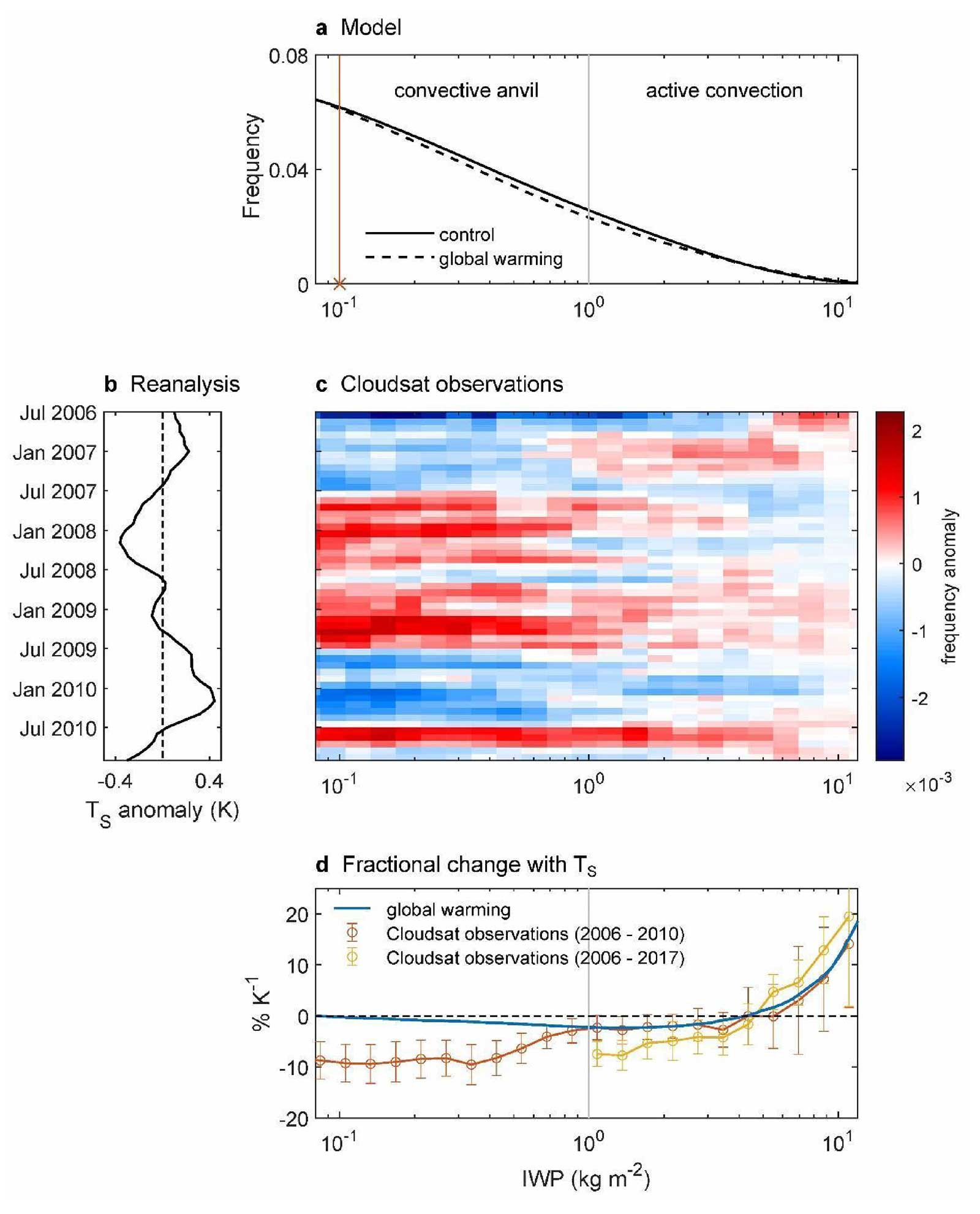
Kilometer-scale #GlobalWarming simulations and active sensors reveal changes in tropical deep convection — NOAA #ActOnClimate

Click the link to read the article on the General Fluid Dynamics Laboratory website
March 28th, 2024
Key Findings
- GFDL’s X-SHiELD experimental global storm-resolving model was used to compute the response of cloud ice in simulations of global warming.
- The responses of active sensor measurements of cloud ice to interannual variability and next-generation global storm-resolving model simulations to global warming show similar changes for events with the highest column-integrated ice.
- Ice loading decreases outside the most active convection but increases at a rate of several percent per Kelvin surface warming in the most active convection.
- Changes in ice loading are strongly influenced by changes in convective velocities, suggesting a path toward extracting information about convective velocities from observations.
Maximilien Bolot, Lucas M. Harris, Kai-Yuan Cheng, Timothy M. Merlis, Peter N. Blossey, Christopher S. Bretherton, Spencer K. Clark, Alex Kaltenbaugh, Linjiong Zhou and Stephan Fueglistaler. npj Climate and Atmospheric Science. DOI: 10.1038/s41612-023-00525-w
Under global warming, changes in the location and structure of the deep convection in the tropics have profound consequences for tropical climate. The tropics are characterized by the ubiquitous presence of high ice clouds formed by detrainment from precipitating deep convection. The bulk of these clouds are so-called anvil clouds in extensive formations that shield the convective centers. These can persist for several hours after the decay of active convection and they carry low to moderate ice loads.
The centers of active convection, on the other hand, correspond to a small fraction of the cloudy region and are typically of kilometric scale. Ice loads in the convective centers are very high, reaching tens of kilograms of ice per square meter, and can only be maintained by the strong convective velocities existing at these locations. Changes in ice loading in active convection thus have the potential to shed light on changes of convective velocities with warming.
Tropical deep convection is one of the leading sources of uncertainty in future projections of the Earth’s temperature. In particular, there remain major uncertainties in the radiative response of convective clouds, which can have negative or positive radiative effects depending on their optical depth, and on the response of convective velocities with warming. This response, the focus of this paper, is particularly difficult to quantify due to the small scales involved.
The authors used GFDL’s X-SHiELD experimental global storm-resolving model to compute the response of cloud ice in simulations of global warming. This kilometer-scale model explicitly represents convection worldwide instead of relying on a deep convective parameterization. In comparing the response in the model with the response of active sensor measurements to interannual variability, they found similar changes for events with the highest column-integrated ice. The changes reveal that the ice loading decreases outside the most active convection but increases at a rate of several percent per Kelvin surface warming in the most active convection.
Conducting an additional simulation where the response of vertical velocities is muted, the authors were able to prove that the changes in ice loading are modulated by changes in convective velocities and are not simply set by conditions at the surface. Namely, the ice signal is strongly modulated by structural changes of the vertical wind field towards an intensification of strong convective updrafts with warming.
This study shows the potential of kilometer-scale climate models to interpret high-resolution observations such as those provided by the CloudSat radar measurements. The results indicate that deep convective ice clouds will experience changes at the kilometer-scale and mesoscale, and that these changes are manifest in the presently available high-resolution radar measurements. The fact that changes in the distribution of vertical velocities will be registered in the ice field suggests a path toward extracting information about convective velocities from observations.
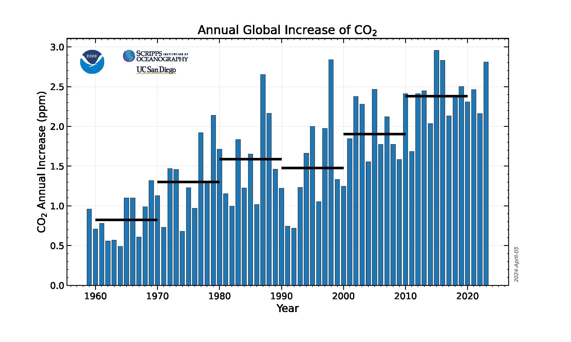
No sign of greenhouse gases increases slowing in 2023 — NOAA #ActOnClimate
Click the link to read the article on the NOAA website (Theo Stein):
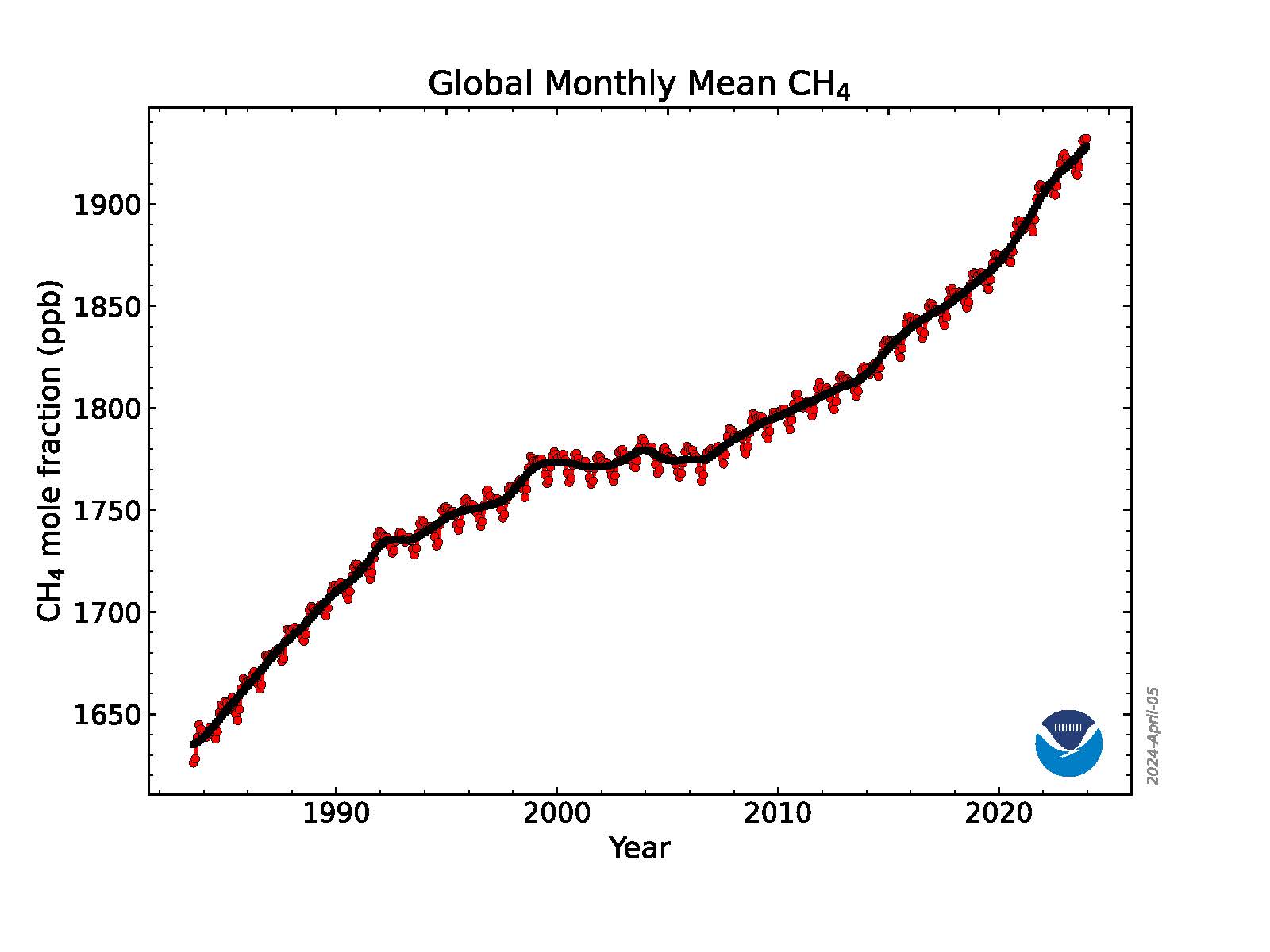
Levels of the three most important human-caused greenhouse gases – carbon dioxide (CO2), methane and nitrous oxide – continued their steady climb during 2023, according to NOAA scientists.
While the rise in the three heat-trapping gases recorded in the air samples collected by NOAA’s Global Monitoring Laboratory (GML) in 2023 was not quite as high as the record jumps observed in recent years, they were in line with the steep increases observed during the past decade.
“NOAA’s long-term air sampling program is essential for tracking causes of climate change and for supporting the U.S. efforts to establish an integrated national greenhouse gas measuring, monitoring and information system,” said GML Director Vanda Grubišić. “As these numbers show, we still have a lot of work to do to make meaningful progress in reducing the amount of greenhouse gases accumulating in the atmosphere.”
The global surface concentration of CO2, averaged across all 12 months of 2023, was 419.3 parts per million (ppm), an increase of 2.8 ppm during the year. This was the 12th consecutive year CO2 increased by more than 2 ppm, extending the highest sustained rate of CO2 increases during the 65-year monitoring record. Three consecutive years of CO2 growth of 2 ppm or more had not been seen in NOAA’s monitoring records prior to 2014. Atmospheric CO2 is now more than 50% higher than pre-industrial levels.
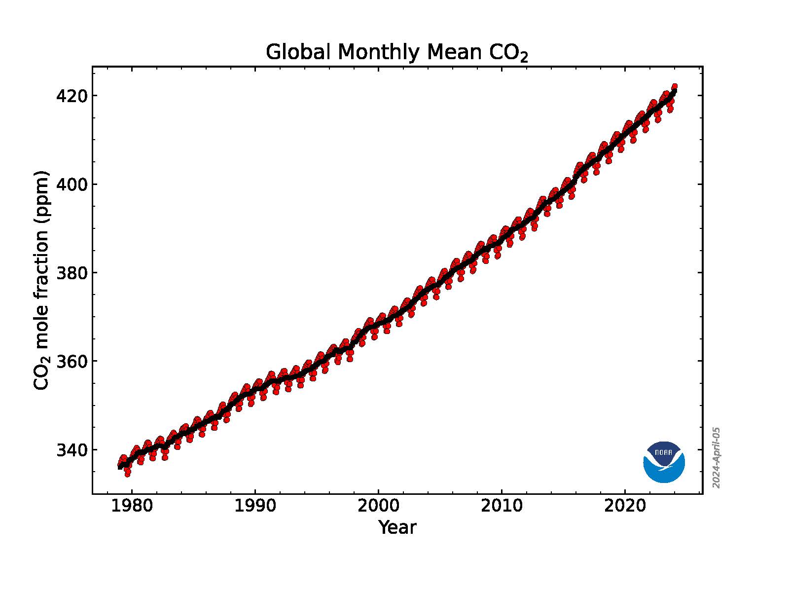
“The 2023 increase is the third-largest in the past decade, likely a result of an ongoing increase of fossil fuel CO2 emissions, coupled with increased fire emissions possibly as a result of the transition from La Nina to El Nino,” said Xin Lan, a CIRES scientist who leads GML’s effort to synthesize data from the NOAA Global Greenhouse Gas Reference Network for tracking global greenhouse gas trends.
Atmospheric methane, less abundant than CO2 but more potent at trapping heat in the atmosphere, rose to an average of 1922.6 parts per billion (ppb). The 2023 methane increase over 2022 was 10.9 ppb, lower than the record growth rates seen in 2020 (15.2 ppb), 2021(18 ppb) and 2022 (13.2 ppb), but still the 5th highest since renewed methane growth started in 2007. Methane levels in the atmosphere are now more than 160% higher than their pre-industrial level.
In 2023, levels of nitrous oxide, the third-most significant human-caused greenhouse gas, climbed by 1 ppb to 336.7 ppb. The two years of highest growth since 2000 occurred in 2020 (1.3 ppb) and 2021 (1.3 ppb). Increases in atmospheric nitrous oxide during recent decades are mainly from use of nitrogen fertilizer and manure from the expansion and intensification of agriculture. Nitrous oxide concentrations are 25% higher than the pre-industrial level of 270 ppb.
Taking the pulse of the planet one sample at a time
NOAA’s Global Monitoring Laboratory collected more than 15,000 air samples from monitoring stations around the world in 2023 and analyzed them in its state-of-the-art laboratory in Boulder,Colorado. Each spring, NOAA scientists release preliminary calculations of the global average levels of these three primary long-lived greenhouse gases observed during the previous year to track their abundance, determine emissions and sinks, and understand carbon cycle feedbacks.
Measurements are obtained from air samples collected from sites in NOAA’s Global Greenhouse Gas Reference Network, which includes about 53 cooperative sampling sites around the world, 20 tall tower sites, and routine aircraft operation sites from North America.
Carbon dioxide emissions remain the biggest problem
By far the most important contributor to climate change is CO2 , which is primarily emitted by burning of fossil fuels. Human-caused CO2 pollution increased from 10.9 billion tons per year in the 1960s – which is when the measurements at the Mauna Loa Observatory in Hawaii began – to about 36.8 billion tons per year in 2023. This sets a new record, according to the Global Carbon Project, which uses NOAA’s Global Greenhouse Gas Reference Network measurements to define the net impact of global carbon emissions and sinks.
The amount of CO2 in the atmosphere today is comparable to where it was around 4.3 million years ago during the mid-Pliocene epoch, when sea level was about 75 feet higher than today, the average temperature was 7 degrees Fahrenheit higher than in pre-industrial times, and large forests occupied areas of the Arctic that are now tundra.
About half of the CO2 emissions from fossil fuels to date have been absorbed at the Earth’s surface, divided roughly equally between oceans and land ecosystems, including grasslands and forests. The CO2 absorbed by the world’s oceans contributes to ocean acidification, which is causing a fundamental change in the chemistry of the ocean, with impacts to marine life and the people who depend on them. The oceans have also absorbed an estimated 90% of the excess heat trapped in the atmosphere by greenhouse gases.
Research continues to point to microbial sources for rising methane
NOAA’s measurements show that atmospheric methane increased rapidly during the 1980s, nearly stabilized in the late-1990s and early 2000s, then resumed a rapid rise in 2007.
A 2022 study by NOAA and NASA scientists and additional NOAA research in 2023 suggests that more than 85% of the increase from 2006 to 2021 was due to increased microbial emissions generated by livestock, agriculture, human and agricultural waste, wetlands and other aquatic sources. The rest of the increase was attributed to increased fossil fuel emissions.
“In addition to the record high methane growth in 2020-2022, we also observed sharp changes in the isotope composition of the methane that indicates an even more dominant role of microbial emission increase,” said Lan. The exact causes of the recent increase in methane are not yet fully known.
NOAA scientists are investigating the possibility that climate change is causing wetlands to give off increasing methane emissions in a feedback loop.
To learn more about the Global Monitoring Laboratory’s greenhouse gas monitoring, visit: https://gml.noaa.gov/ccgg/trends/.
Media Contact: Theo Stein, theo.stein@noaa.gov, 303-819-7409
#GunnisonRiver Basin ends winter season at about average #snowpack: Almost half the basin is dry or in moderate #drought — The #CrestedButte News

Click the link to read the article on The Crested Butte News website (Katherine Nettles). Here’s an excerpt:
April 17, 2024
As winter transitions to spring in the high country, the Upper Gunnison Basin might be heading into a warm and dry spell and holds at about average for the year on snowpack. A three-month forecast is predicting spring might be (mostly) here to stay, with warmer and drier weather to come. Spring runoff may be kicking into high gear in the next few weeks as the layers of dust within the snowpack from two recent wind events could lead to a faster melt off period as well…According to Upper Gunnison River Water Conservancy District (UGRWCD) senior program manager Beverly Richards, soil saturation and weather could make a difference for spring runoff season.
“The soil moisture at this time is a little dryer than this time last year so the combination may have an effect on runoff amounts and timing,” she said.
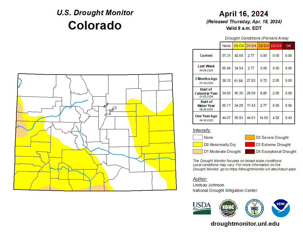
Drought conditions around the basin range from absent to moderate. As of April 2, 53% of Gunnison County was experiencing no drought conditions, and 47% of the county was experiencing abnormally dry to moderate drought conditions. In the 129-year record, this winter (January to February) was the 56th wettest year and February was the 64th driest, Richards said…
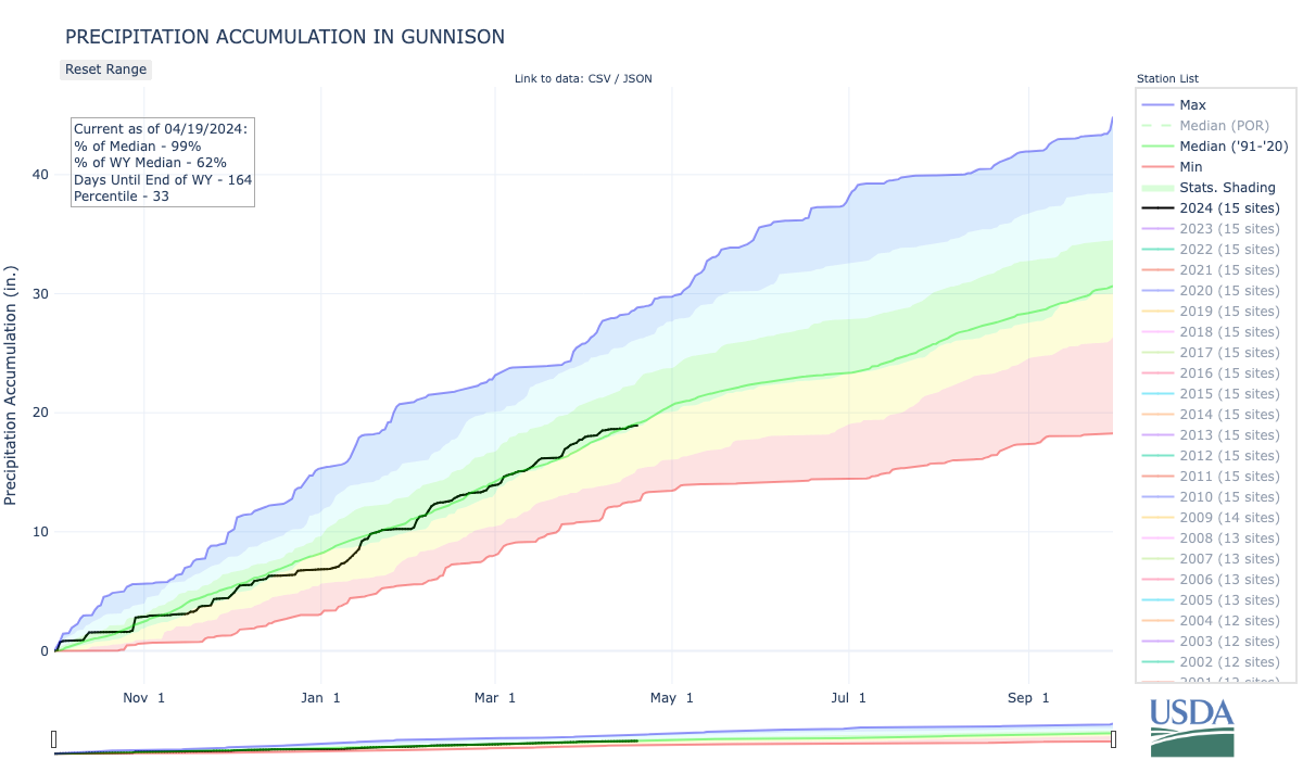
As of April 8, precipitation has ranged from 50% to 150% of normal in the county over the past 30 days, and a small portion in the southeastern corner of the county measured up to 200% of normal during the same period.
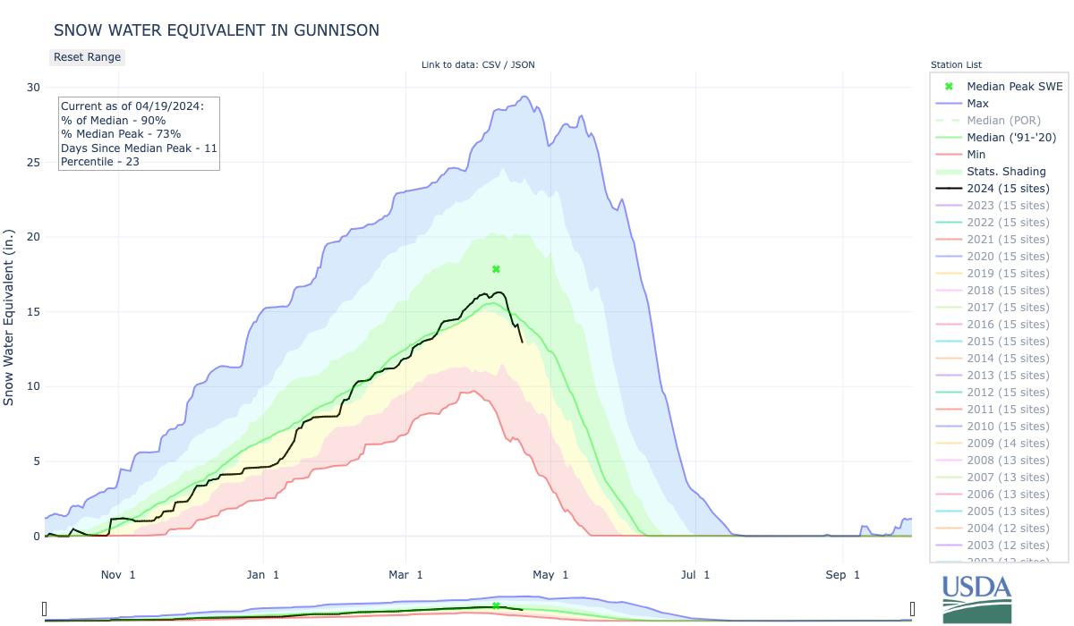
According to the National Resources Conservation Service (NRCS) the Upper Gunnison Basin snow water equivalent (SWE) as of April 7 has been measured as 116% of normal overall. Specific locations measured as follows: 125% of normal at the Upper Taylor River location; 122% of normal at the Butte location; 107% of normal at Schofield; 126% of normal at Park Cone; 127% of normal at Porphyry Creek; and 92% of normal at Slumgullion.

Blue Mesa Reservoir is projected to fill to about 85% this spring. Reservoir storage for the entire Gunnison Basin is at 63% of average, and 65% for the Upper Gunnison Basin. The Bureau of Reclamation (BOR) has projected that Blue Mesa will fill to 85% in 2024. The National Park Service reported that Elk Creek boat ramp at Blue Mesa opened on April 11, and the reservoir was at 7,485 feet elevation as of April 10. This is about 34 feet (10 meters) below full pool at 7,519 feet (2291 meters). The BOR has reported that among reservoirs in the Upper Colorado River Basin, the Flaming Gorge is 86% full; Fontenelle is 33% full; Morrow Point is 94% full, Blue Mesa is 66% full, Navajo is 65% full, Lake Powell is 33% full and total storage across the basin is at 63%.

2024 #COleg: Bill would protect #YampaRiver Valley #coal plants’ water from abandonment: Water would stay in river after plants close in 2028 — @AspenJournalism #GreenRiver #ColoradoRiver #COriver #aridification

Click the link to read the article on the Aspen Journalism website (Heather Sackett):
April 17, 2024
State lawmakers are considering a bill that would let two energy companies with coal-fired power plants in northwest Colorado hang on to their water rights even after the plants’ planned closures in 2028.
Senate Bill SB24-197 says that industrial water rights held by Xcel Energy and Tri-State Generation and Transmission Association Inc. will be protected from abandonment through 2050. Under Colorado law, a water right that is not being used could end up on an abandonment list, which is compiled every 10 years.
Abandonment is the official term for one of Colorado’s best-known water adages: Use it or lose it. It means that the right to use the water is essentially canceled and ceases to exist. The water goes back into the stream where another water user can claim it.
Supporters of the bill say this protection from abandonment would give the companies a grace period to transition to clean-energy sources and eventually use the water again in new methods of energy production. In the meantime, the water will remain in the stream for the benefit of the environment, recreation and downstream irrigators.
State Sen. Dylan Roberts, D-Frisco, is one of the bill’s sponsors, and represents Clear Creek, Eagle, Garfield, Gilpin, Grand, Jackson, Moffat, Rio Blanco, Routt and Summit counties.
“The idea is if we can find a way to ensure that the water rights of the power companies are protected over the next couple of decades, this will give them a stronger incentive to find a new way to produce energy in the region,” Roberts said.
Tri-State plans to shut down its coal-fired power plant in Craig in 2028, the same year that Xcel Energy plans to close the Hayden Generating Station, which has prompted questions about what will happen to the water currently being used by the facilities.
Jackie Brown is a senior water and natural resource advisor at Tri-State. She said the bill preserves future opportunities for economic development by energy utilities in Moffat and Routt counties.
“The measures in this bill provide Tri-State with certainty that our water resources remain intact and available for future dispatchable, carbon-free generation as needed and projected in our Electric Resource Plan,” Brown said in a statement. “While we continue our planning process, keeping the utility water in the Yampa River helps all water users, creating a win-win situation.”
According to Brown, the water used from the Yampa River by both energy companies is estimated to be about 44 cubic feet per second of flow. But, if the bill passes, engineers will officially quantify by 2030 the amount of water that the industries have historically used, and that is the amount that will be protected from abandonment. Any portion of the water rights that the energy companies lease to a third party would not be protected from abandonment.
The Yampa River begins in the Flat Tops Wilderness, flows through the city of Steamboat Springs and west through Routt and Moffat counties to Dinosaur National Monument, and eventually joins with the Green River. The Yampa River basin was one of the last to be developed in the state and in recent years has begun experiencing some of the issues long present in other areas such as shortages, calls, an overappropriation designation and stricter enforcement of state measurement rules.
In 2018, irrigators placed the first call on the river, triggering cutbacks from junior water users. When an irrigator is not receiving the entire amount of water to which they are legally entitled, they can place a call, which requires water-rights holders with younger water rights to stop irrigating so the senior water user can get their share. The Colorado River Water Conservation District, the Colorado Water Trust and others have made releases out of Elkhead Reservoir to get extra water to these senior downstream irrigators and keep the call off the river.

CREDIT: HEATHER SACKETT/ASPEN JOURNALISM
Support from environmental groups
SB 197 has gained support from environmental groups, including Conservation Colorado, The Nature Conservancy and Western Resource Advocates. Josh Kuhn, senior water campaign manager with Conservation Colorado, said leaving the water in the river will have environmental benefits such as lowering the often-too-high temperature of the Yampa, boost flows for recreation and the environment, and prevent calls on the river.
But the benefit to the river and water users from SB 197 may only be temporary. The energy companies will still own the water rights and may begin using them again whenever they want.
“It has been made clear that there’s no assurances that the water will be there on a permanent basis because Tri-State wants the ability to use that water to generate additional renewable clean-energy supplies in the future,” Kuhn said. “So there is a shared understanding that this is being done on a temporary basis.”
With the impending closure of the coal mines and power plants that by one estimate will result in 800 lost jobs, some see the Yampa River as an underutilized amenity that could supply recreation jobs and enhance quality of life. Supporters of the bill say keeping the energy companies’ water in the river and protected from abandonment will ensure that the water is not diverted out of the basin.
“The Yampa is already a river that suffers the impacts of climate-driven drought,” Kuhn said. “And so, in order to help protect that river and the economy that’s dependent upon it, they were looking for solutions to make sure that none of that water was exported to another basin.”
The protection of the energy companies’ water rights is just one facet of SB 197, which would also implement recommendations from last year’s Colorado River Drought Task Force. These include expanding the state’s instream-flow temporary loan program to let owners of water stored in reservoirs to loan it for the benefit of the environment in stream reaches where the state does not hold an instream-flow water right; expanding the state’s agricultural water rights protection program; and waiving the matching funds requirement for water project grants to the Southern Ute and Ute Mountain Ute tribal nations.
Roberts was the sponsor of 2023’s SB 295, which created the drought task force. Although the 17-member task force did not advance protections for industrial water rights from abandonment as an official recommendation (it failed on a 9-7 vote), it was included in the narrative section of the report that it provided to lawmakers.
“I’ve been working on this for months with the energy companies, with the state, with environmental groups and with local stakeholders in Routt and Moffat counties,” Roberts said. “And we narrowed the proposal significantly, and now almost everybody who was opposed on the task force is supportive of this idea moving forward.”
SB 197 passed unanimously in the Senate on Wednesday [April 17, 2024] and will now be up for approval by the House.

Native American voices are finally factoring into energy projects – a hydropower ruling is a victory for environmental justice on tribal lands — The Conversation #ActOnClimate
Emily Benton Hite, Saint Louis University and Denielle Perry, Northern Arizona University
The U.S. has a long record of extracting resources on Native lands and ignoring tribal opposition, but a decision by federal energy regulators to deny permits for seven proposed hydropower projects suggests that tide may be turning.
As the U.S. shifts from fossil fuels to clean energy, developers are looking for sites to generate electricity from renewable sources. But in an unexpected move, the Federal Energy Regulatory Commission denied permits on Feb. 15, 2024, for seven proposed hydropower projects in Arizona and New Mexico.
The reason: These projects were located within the Navajo Nation and were proposed without first consulting with the tribe. FERC said it was “establishing a new policy that the Commission will not issue preliminary permits for projects proposing to use Tribal lands if the Tribe on whose lands the project is to be located opposes the permit.”
We are a cultural anthropologist and a water resource geographer who have studied tensions between Indigenous rights, climate governance and water management in the U.S. and globally for over 20 years. In our view, the commission’s decision could mark a historic turning point for government-to-government relations between the U.S. government and tribal nations.
How might this new approach shape future energy development on tribal lands throughout the U.S.? Given the federal government’s long history of exploiting Native American resources without tribal consent, we’re following FERC’s actions for further evidence before assuming that a new era has begun.
Extraction on tribal lands
Around the world, many Indigenous communities argue that their lands have been treated as sacrifice zones for development. This includes the U.S., where the federal government holds 56.2 million acres in trust for various tribes and individuals, mostly in western states.
The trust responsibility requires the U.S. government to protect Indigenous lands, resources and rights and to respect tribal sovereignty. Consulting with tribes about decisions that affect them is fundamental to this relationship.
Energy resources on U.S. Native lands include coal, oil, uranium, solar, wind and hydropower. There is a long history of coal and uranium mining in Navajo territory in the Southwest, and tribal lands now are targets for renewable energy projects. Large fractions of known reserves of critical minerals for clean energy, like copper and cobalt, are on or near Native lands.
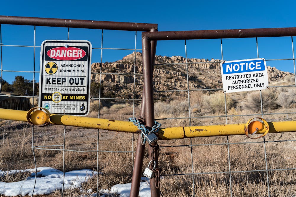
Many past energy projects have left scars. Navajo lands are studded with abandoned uranium mining sites that threaten residents’ health. Over 1.1 million acres of tribal lands have been flooded by hundreds of dams built for hydropower and irrigation. Fossil fuel pipelines like Dakota Access in North Dakota and Line 5 in Wisconsin and Michigan carry oil across Native lands, threatening water supplies in the event of leaks or spills.
Hydropower project impacts
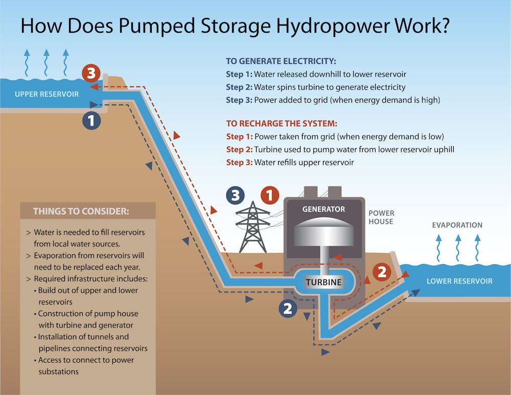
The seven permits FERC denied in February 2024 were requested by private companies seeking to build pumped hydropower storage projects. These systems pump water uphill to a reservoir for storage. When power is needed, water is released to flow downhill through turbines, generating electricity as it returns to a lower reservoir or river.
Currently there are over 60 pumped storage proposals pending across the U.S. Pumped storage typically requires constructing massive concrete-lined tunnels, powerhouses, pipelines and transmission systems that can damage surrounding lands.
Withdrawing water for hydropower could disrupt rivers and sacred sites that are culturally and spiritually important for many tribes. These projects also threaten water security – a critical issue in arid western states.
Colorado River water is already over-allocated among western states, which hold legal rights to withdraw more water than is in the river. As a result, many pumped storage projects would require groundwater to fill their reservoirs. The proposed Big Canyon project in Arizona, for example, would require up to 19 billion gallons of groundwater, taken from aquifers that support local springs and streams.
FERC’s trust responsibility
The Federal Energy Regulatory Commission is an independent agency that licenses and oversees interstate transmission of electricity, natural gas and oil; natural gas pipelines and terminals; and hydropower projects. Under a 1986 law, the agency is required to consider factors including environmental quality, biodiversity, recreational activities and tribal input in making licensing decisions.
However, the U.S. government has a long record of carrying out projects despite Native opposition. For example, under the Pick-Sloan Plan, the U.S. Army Corps of Engineers built five dams on the Missouri River in the late 1950s and early 1960s that flooded over 350,000 acres of tribal lands. Tribes were not consulted, and communities were forcibly relocated from their ancestral homelands.
In 2000, President Bill Clinton issued Executive Order 13175, directing federal agencies to engage in “regular and meaningful consultation and collaboration with tribal officials” in developing federal policies that affect tribes. Each agency interprets how to do this.
In his first week in office in 2021, President Joe Biden reaffirmed this responsibility and nominated U.S. Rep. Deb Haaland as Secretary of the Interior – the first Native American to head the agency that administers the U.S. trust responsibility to Native Americans and Alaska Natives.
FERC’s new direction
Tribes have called FERC’s record of consultation with Native Americans “abysmal.” Recently, however, the agency has started to make its operations more inclusive.
In 2021, it created a new Office of Public Participation, a step its then-chair, Richard Glick, called “long overdue.” And in 2022, the agency released its Equity Action Plan, designed to help underserved groups participate in decisions.
In canceling the projects in February, FERC cited concerns raised by the Navajo Nation, including negative impacts on water, cultural and natural resources and biological diversity. It also stated that “To avoid permit denials, potential applicants should work closely with Tribal stakeholders prior to filing applications to ensure that Tribes are fully informed about proposed projects on their lands and to determine whether they are willing to consider the project development.”
Aligning clean energy and environmental justice
Many more energy projects are proposed or envisioned on or near tribal lands, including a dozen pumped storage hydropower projects on the Colorado Plateau. All 12 are opposed by tribes based on lack of consultation and because tribes are still fighting to secure their own legal access to water in this contested basin under the 1922 Colorado River Compact.
We recently analyzed FERC’s handling of the Big Canyon pumped hydropower storage project, which would be located on Navajo land in Arizona, and concluded that the agency had not adequately consulted with the tribe in its preliminary permitting. In the wake of its February ruling, the agency reopened the public comment period on Big Canyon for an additional 30 days, with a decision likely later in 2024.
The Biden administration has set ambitious targets for halting climate change and accelerating the shift to clean energy while promoting environmental justice. In our view, meeting those goals will require the federal government to more earnestly and consistently live up to its trust responsibilities.
Emily Benton Hite, Assistant Professor of Sociology and Anthropology, Saint Louis University and Denielle Perry, Associate Professor, School of Earth and Sustainability, Northern Arizona University
This article is republished from The Conversation under a Creative Commons license. Read the original article.
Biden-Harris Administration Finalizes Strategy to Guide Balanced Management, Conservation of Public Lands
Click the link to read the article on the U.S. Department of Interior website:
April 18, 2024
Public Lands Rule will help conserve wildlife habitat, restore places impacted by wildfire and drought, expand outdoor recreation, and guide thoughtful development
WASHINGTON — The Department of the Interior today announced a final rule to help guide the balanced management of America’s public lands. The final Public Lands Rule provides tools for the Bureau of Land Management (BLM) to help improve the health and resilience of public lands in the face of a changing climate; conserve important wildlife habitat and intact landscapes; facilitate responsible development; and better recognize unique cultural and natural resources on public lands.
The Public Lands Rule builds on historic investments in public lands, waters and clean energy deployment provided by President Biden’s Investing in America agenda, which recognizes the critical value of our public lands to all Americans. It also complements the President’s America the Beautiful initiative, a 10-year, locally led and nationally scaled effort to protect, conserve, connect and restore the lands, waters and wildlife upon which we all depend.
Building on decades of land management experience and emphasizing the use of science and data, including Indigenous Knowledge, to guide balanced decision-making, the rule applies the existing fundamentals of land health across BLM programs, establishes restoration and mitigation leases, and clarifies practices to designate and protect Areas of Critical Environmental Concern (ACECs). The rule will help to ensure the BLM continues to protect land health while managing other uses of the public lands, such as clean energy development and outdoor recreation.
“As stewards of America’s public lands, the Interior Department takes seriously our role in helping bolster landscape resilience in the face of worsening climate impacts. Today’s final rule helps restore balance to our public lands as we continue using the best-available science to restore habitats, guide strategic and responsible development, and sustain our public lands for generations to come,” said Secretary Deb Haaland. “Complemented with historic investments from President Biden’s Investing in America agenda, we are implementing enduring changes that will benefit wildlife, communities and habitats.”
“America’s public lands are our national treasures and need to be managed and made resilient for future generations of Americans,” said John Podesta, Senior Advisor to the President for International Climate Policy. “Today’s final rule from the Department of the Interior is a huge win for ensuring balance on our public lands, helping them withstand the challenges of climate change and environmental threats like invasive species, and making sure they continue to provide services to the American people for decades to come.”
“The Interior Department is ensuring our public lands are managed with an eye to future generations, complementing President Biden’s ambitious conservation agenda,” said White House Council on Environmental Quality Chair Brenda Mallory. “From the most rugged backcountry spots to popular close-to-home recreation areas, these reforms will help deliver cleaner water, healthier lands, abundant wildlife, and more recreation opportunities for all of us.”
The final rule comes amid growing pressures and historic challenges facing land managers. The impacts of climate change—including prolonged drought, increasing wildfires, and an influx of invasive species—pose increasing risks to communities, wildlife and ecosystems. The Public Lands Rule will help the BLM navigate changing conditions on the ground, while helping public lands continue to serve as economic drivers across the West.
“The BLM received and considered over 200,000 comments on the proposed rule from individuals, state, Tribal and local governments, industry groups and advocacy organizations, which led to important improvements in this final rule,” said Principal Deputy Assistant Secretary for Land and Minerals Management Dr. Steve Feldgus. “Continued broad collaboration with this diverse group of partners will be key to our implementation of this rule to ensure that our public lands are being managed for all Americans.”
“Our public lands provide wildlife habitat and clean water, the energy that lights our homes, the wood we build with, and the places where we make family memories,” said BLM Director Tracy Stone-Manning. “This rule honors our obligation to current and future generations to help ensure our public lands and waters remain healthy amid growing pressures and change.”
The final rule clarifies and refines concepts first proposed in April 2023. The BLM provided a 90-day comment period on this rule, holding five public meetings and receiving over 200,000 comments, the vast majority of which supported the effort. In response to the substantive comments received, the BLM clarified and refined concepts laid out in the proposed rule.
The final rule:
- Directs BLM to manage for landscape health. Successful public land management that delivers natural resources, wildlife habitat and clean water requires a thorough understanding of the health and condition of the landscape, especially as conditions shift on the ground due to climate change. To help sustain the health of our lands and waters, the rule directs the BLM to manage public land uses in accordance with the fundamentals of land health, which will help watersheds support soils, plants, and water; ecosystems provide healthy populations and communities of plants and animals; and wildlife habitats on public lands protect threatened and endangered species consistent with the multiple use and sustained yield framework.
- Provides a mechanism for restoring and protecting our public lands through restoration and mitigation leases. Restoration leases provide greater clarity for the BLM to work with appropriate partners to restore degraded lands. Mitigation leases will provide a clear and consistent mechanism for developers to offset their impacts by investing in land health elsewhere on public lands, like they currently can on state and private lands. The final rule clarifies who can obtain a restoration or mitigation lease, limiting potential lessees to qualified individuals, businesses, non-governmental organizations, Tribal governments, conservation districts, or state fish and wildlife agencies. Restoration and mitigation leases will not be issued if they would conflict with existing authorized uses.
- Clarifies the designation and management of ACECs. The final rule provides greater detail about how the BLM will continue to follow the direction in the Federal Land Policy and Management Act to prioritize the designation and protection of ACECs. Following public comments, the final rule clarifies how BLM consideration of new ACEC nominations and temporary management options does not interfere with the BLM’s discretion to continue advancing pending project applications.
The Public Lands Rule complements the BLM’s recently announced final Renewable Energy Rule, providing consistent direction and new tools for mitigation, helping advance the efficient and environmentally responsible development of renewable energy on BLM-managed public lands, providing greater clarity and consistency in permitting, and allowing for the continued acceleration of project reviews and approvals, while managing public lands under the principles of multiple use and sustained yield.
The final rule will publish in the Federal Register in the coming days.
R.I.P. Dickey Betts: “And when it’s time for leavin’, I hope you’ll understand, that I was born a ramblin’ man”

Click the link to read the obit from The New York Times (Alex Williams). Here’s an excerpt:
Dickey Betts, a honky-tonk hell raiser who, as a guitarist for the Allman Brothers Band, traded fiery licks with Duane Allman in the band’s early-1970s heyday, and who went on to write some of the band’s most indelible songs, including its biggest hit, “Ramblin’ Man,” died on Thursday morning at his home in Osprey, Fla. He was 80…
Despite not being an actual Allman brother…Mr. Betts was a guiding force in the group for decades and central to a sound that, along with the music of Lynyrd Skynyrd, came to define Southern rock. Although pigeonholed by some fans in the band’s early days as its “other” guitarist, Mr. Betts, whose solos on his Gibson Les Paul guitar seemed at times to scorch the fret board, proved a worthy sparring partner to Duane Allman, serving as a co-lead guitarist more than a sidekick…
With his chiseled facial features, Wild West mustache and gunfighter demeanor, Mr. Betts certainly looked the part of the star. And he played like one.
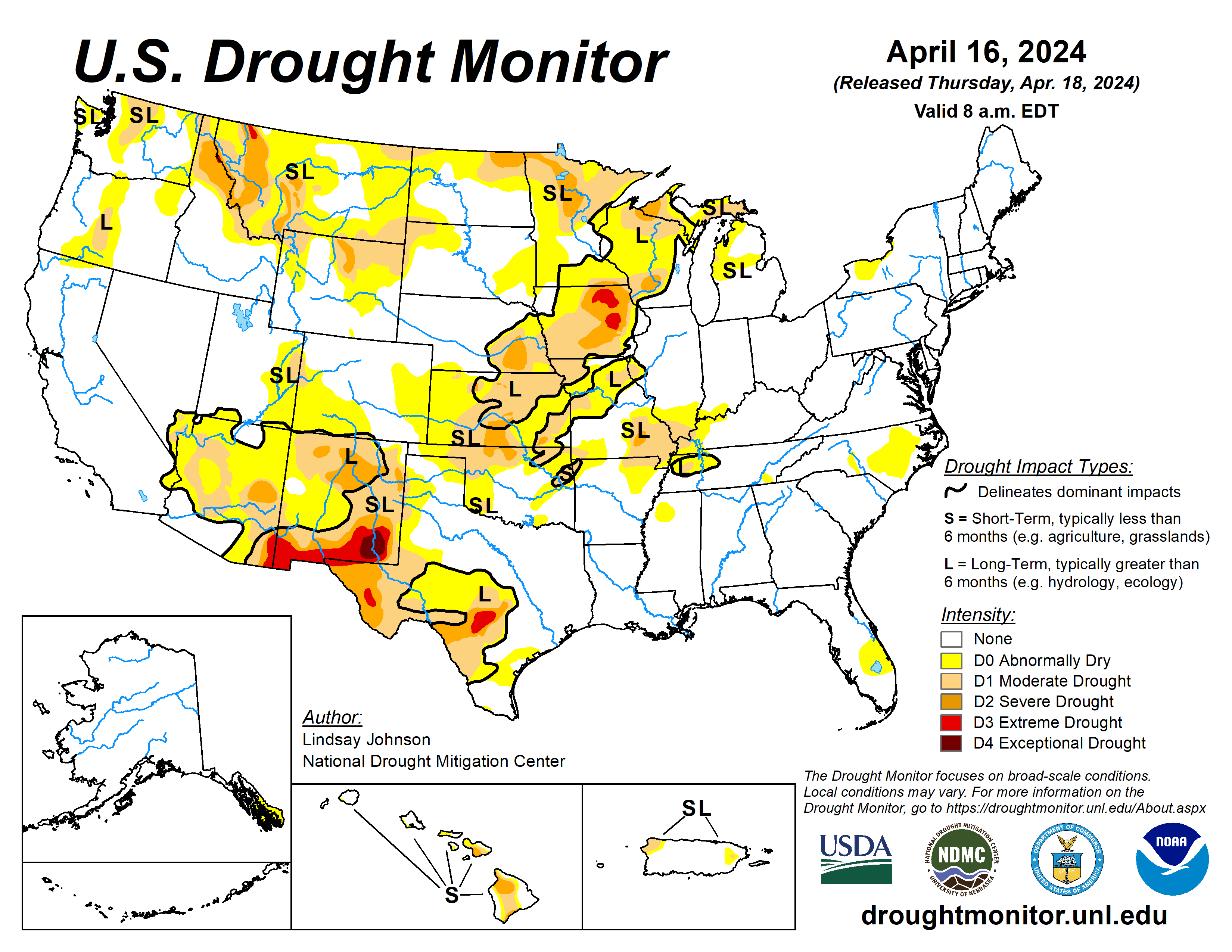
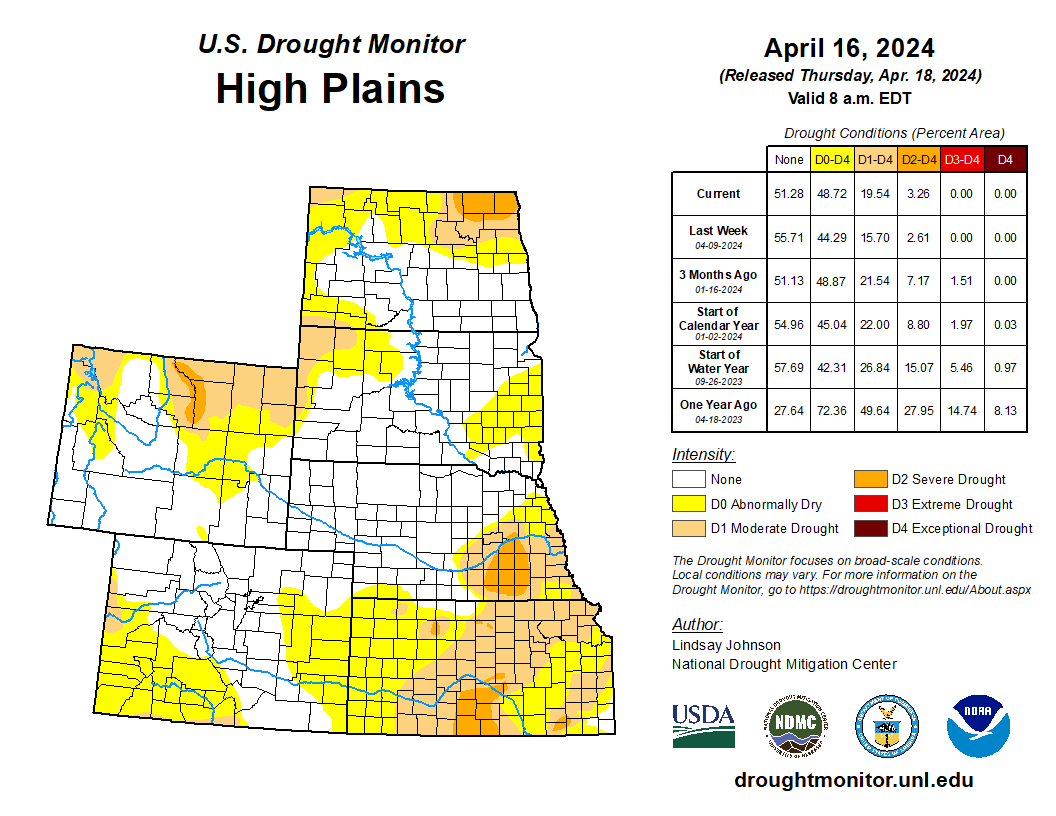
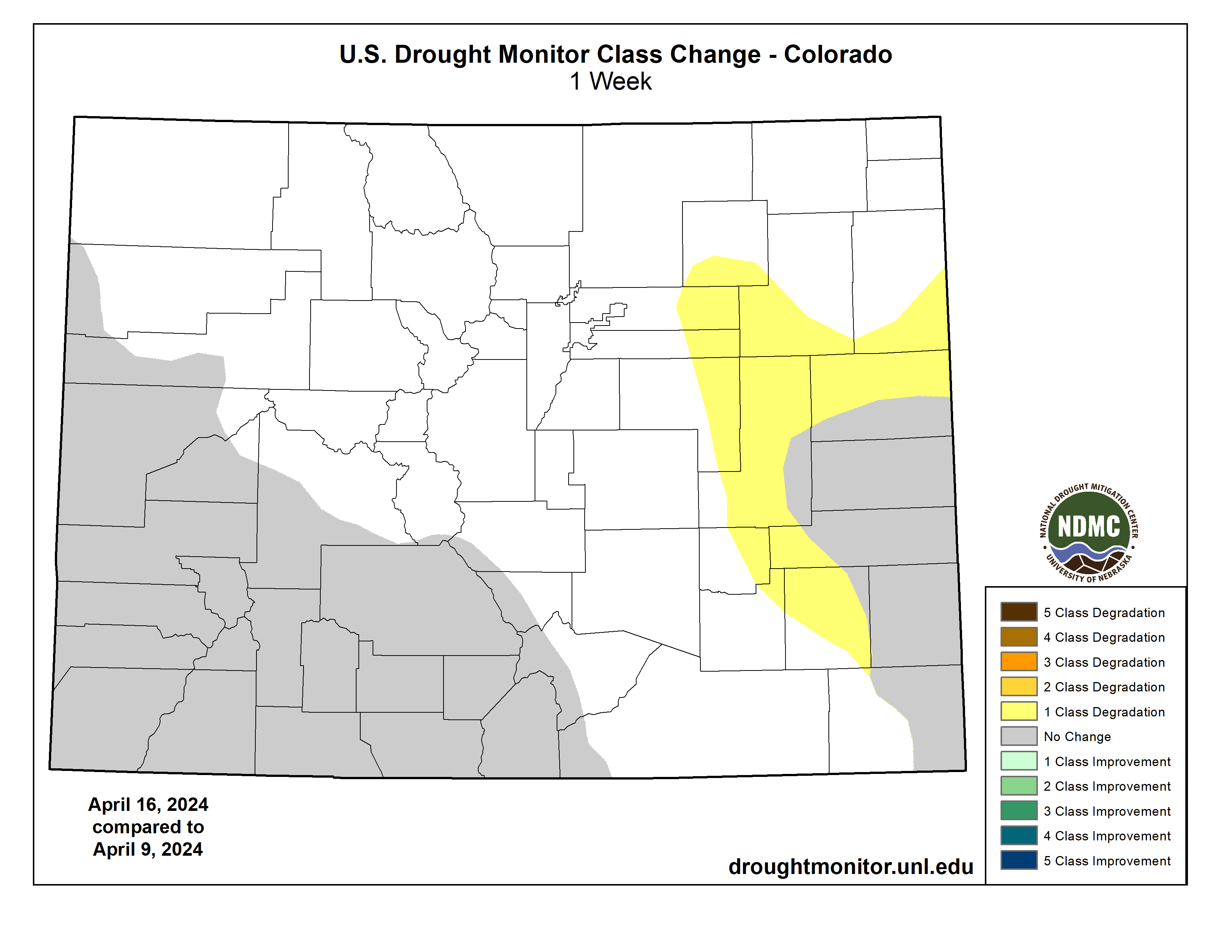
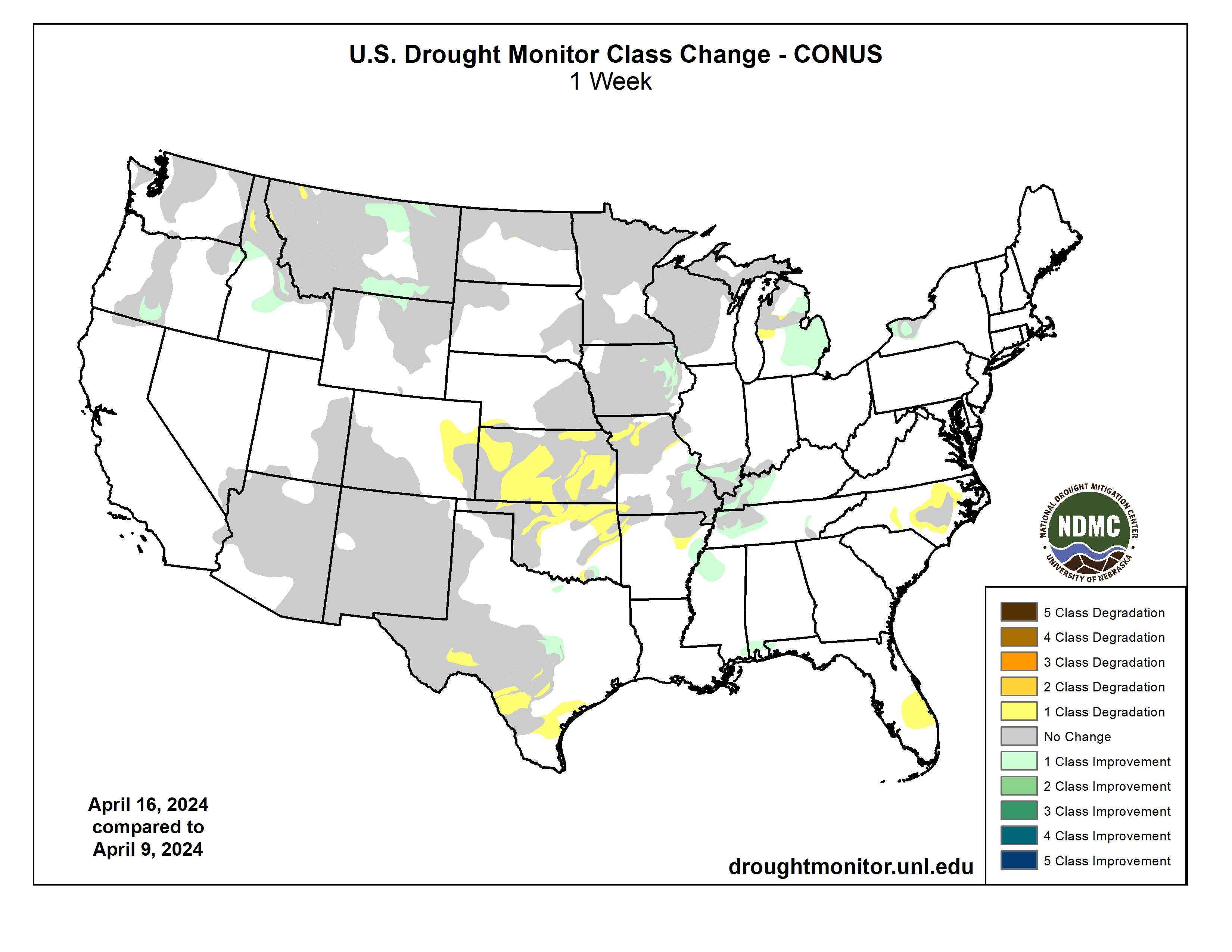
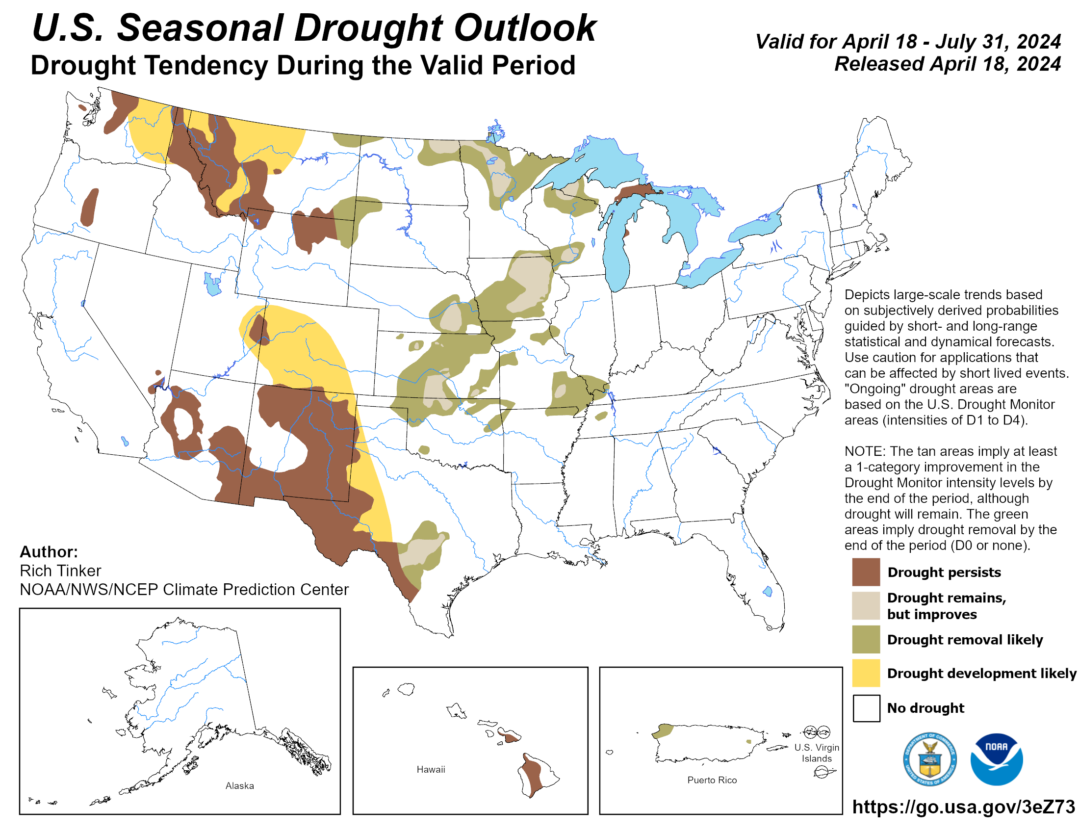
#Drought news April 18, 2024: The southern High Plains are in the grips of rapidly drying conditions, leading to degradations across #KS, with conditions bleeding into E. #Colorado and S. #NE. W. #Kansas has not seen precipitation in over two weeks
Click on a thumbnail graphic to view a gallery of drought data from the US Drought Monitor website.
Click the link to go to the US Drought Monitor website. Here’s an excerpt:
This Week’s Drought Summary
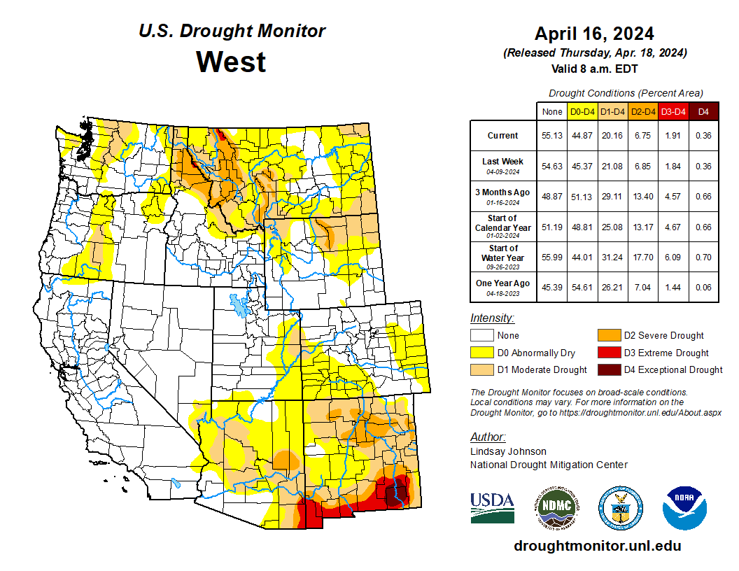
Heavy precipitation fell across much of the central and eastern parts of the country, bringing improvements along the Mississippi River and Great Lakes regions. There were also isolated areas of improvement in Oregon, Idaho and Montana. Extreme drought conditions were introduced in the mountainous region along the Idaho and Montana border due to concerns about low snow amounts and possible early snowmelt. Across the country in the Southeast, areas in North Carolina and southern Florida are seeing drying conditions due to low precipitation over the past few weeks. Western and southern Texas, which largely missed this week’s precipitation, saw an expansion of abnormal dryness, moderate and severe drought conditions. Flash drought conditions are appearing in Oklahoma, and Kansas, with some spillovers in eastern Colorado and western Missouri. Weeks with little precipitation, warming temperatures, dry soils and low streamflow levels are leading to rapid degradations. degradation…
High Plains
The southern High Plains are in the grips of rapidly drying conditions, leading to degradations across Kansas, with conditions bleeding into eastern Colorado and southern Nebraska. Western Kansas has not seen precipitation in over two weeks, providing no relief to the rapidly drying soils and low streamflows. Conditions in Kansas into Oklahoma are seeing rapid deterioration and short-term dryness indicating flash drought conditions…
West
The West saw conditions remain mostly the same, with areas in the Northwest seeing some improvements. Regions along the Pacific coast received some precipitation but not in areas needing moisture. There was some improvement in southern Oregon where precipitation did fall. Southern Idaho also saw improvement with the precipitation and decent snowpack. Northern Idaho into Montana did see some degradation, with mountainous areas seeing snow at extremely low levels. Western Montana experienced improvements in the east-central part of the state…
South
Heavy precipitation fell across eastern Texas, Louisiana, southern Arkansas and west-central Mississippi. This brought improvements in northeast Mississippi, leaving the state drought-free with only some lingering abnormally dry conditions. While less precipitation fell in Tennessee, the western part of the state also saw improvements. Conversely, southern Texas and Oklahoma are seeing conditions worsen as conditions continue to quickly deteriorate. Conditions in Oklahoma into Kansas are seeing rapid degradation and short-term dryness indicating flash drought conditions…
Looking Ahead
Over the next 5 days (April 19-23), more heavy precipitation is expected in the Plains and Midwest. Iowa, Nebraska and South Dakota could see upwards of 2.5 inches of precipitation. Northeast Texas, southeastern Oklahoma, and western Arkansas could see 1.5 to 2 inches of precipitation. Areas of higher elevation in the Rockies of Colorado and Wyoming are also expected to see between 1-2 inches.
The National Weather Service Climate Prediction Center’s 6 to10-day outlook (Valid April 22) favors above-normal precipitation for southern parts of the U.S., particularly along the eastern Gulf Coast from Texas and Louisiana into parts of Arkansas and Oklahoma. Florida is also favoring above-normal precipitation. The Northwest and Northeast are leaning towards below-normal precipitation. From the middle of Pennsylvania northward, below-normal precipitation is likely to occur. Hawaii is also leaning towards below-normal precipitation and Alaska is leaning towards above-normal precipitation. In terms of the temperature outlook, above-normal temperatures are expected from the West into the High Plains, as well as along the Gulf Coast and Florida. Utah, Nevada, northern Arizona, northern New Mexico and western Colorado are showing a 70-80% likelihood of above-normal temperatures. Eastern Alaska is also leaning towards above-normal temperatures. The Mid-Atlantic region and the eastern Midwest are leaning toward below-normal temperatures. Hawaii and western Alaska are favoring below-normal temperatures.
#Wyoming Lawmakers OK $2 million for cloud seeding program — Wyoming Public Radio

Click the link to read the article on the Wyoming Public Radio website (David Dudley). Here’s an excerpt:
April 15, 2024
During the final days of the budget session, lawmakers gave $2 million to the Wyoming Water Development Office to fund its cloud seeding program. They hope it will help mitigate the impacts of ongoing drought in the Western U.S. Rep. Jon Conrad (R-Mountain View) advocated for the program during the budget session. He urged his peers to do whatever they can to ensure that the state has enough water as upper and lower basin states clash over their use of the Colorado River. As the conflict intensifies, he said, the program is an asset.
“We know that cloud seeding has a positive impact upon snowpack, precipitation and streamflow,” said Conrad. “With the challenges that exist with our current climate, meteorological conditions and the loss of needed precipitation to sustain agriculture, etc., cloud seeding is a viable tool that continues to improve.”
[…]
Dr. Bryan Shuman is a professor with the Department of Geology and Geophysics at the University of Wyoming. His research expertise is in how climate change has impacted drought and water resources, and ecological processes throughout Wyoming. He said since the 1950s, Wyoming has seen a significant drop in snowfall and snowpack…
he funds will support the program through 2026.
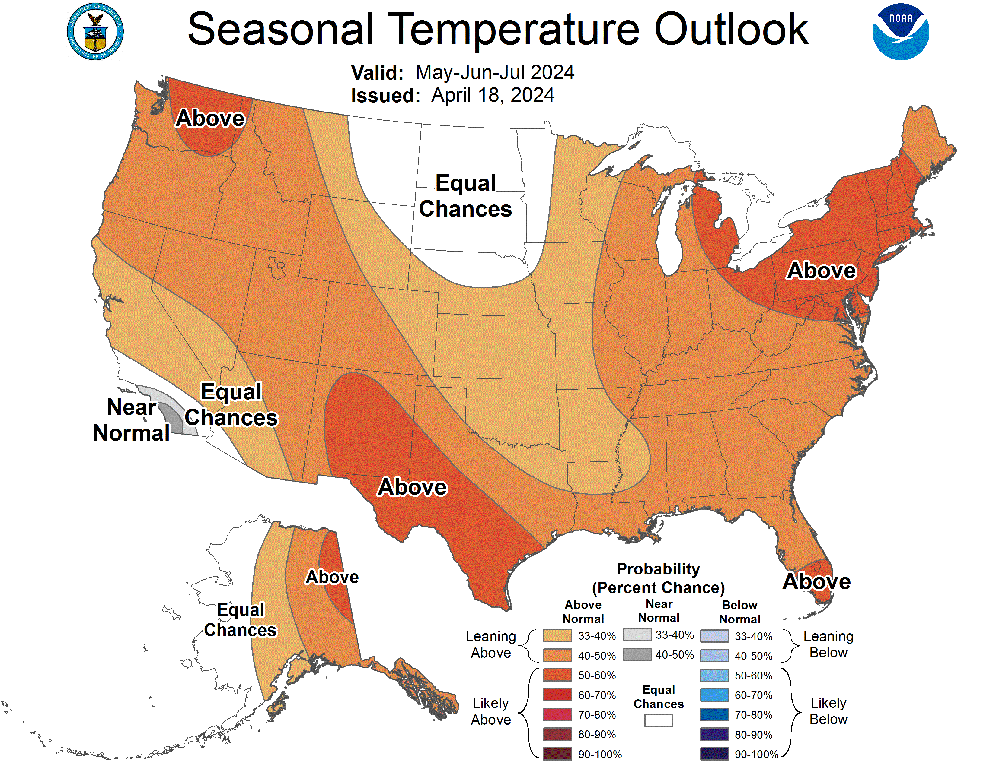
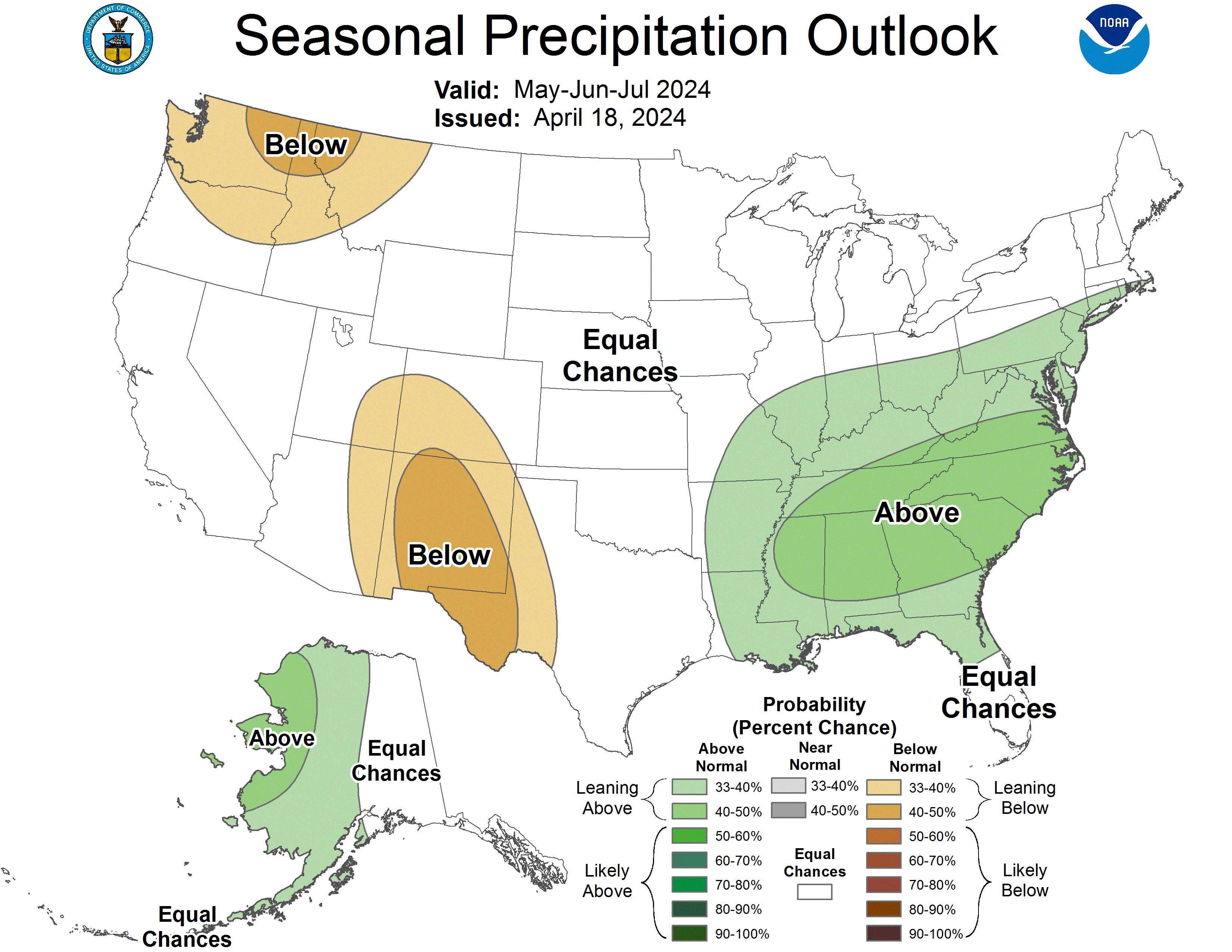
The latest seasonal outlooks through July 31, 2024 are hot off the presses from the #Climate Prediction Center
New #ColoradoRiver proposals put environmental needs front and center in deciding river’s future — Fresh Water News #COriver #aridification

Click the link to read the article on the Water Education Colorado website (Shannon Mullane):
April 17, 2024
Environmental groups and water experts say the U.S. Bureau of Reclamation should give nature a say in how it manages the Colorado River for years to come.
In March, seven states, including Colorado, released two competing proposals for how to manage two enormous reservoirs in the Colorado River Basin and make painful decisions about cutting back on water use once current operating rules expire in 2026.
But they’re not the only ones throwing out ideas: Water experts and environmental advocates have submitted two proposals of their own. They want to make sure endangered fish, Grand Canyon ecosystems, and more aren’t left out of the conversation.
The experts hope their proposals, which highlight changing climate data and environmentally focused reservoir releases, help inform the Bureau of Reclamation’s final report for how the river should be managed after 2026. A draft of that report is expected in December.
“If you don’t care about the environment, then the whole system crashes,” said John Berggren, a regional policy manager with Western Resource Advocates. “That’s not to say the environment takes priority over water supply and other issues, but rather they can be integrated.”
The current operating rules, established in 2007, focus on how water is stored in Lake Powell on the Utah-Arizona border, released to Lake Mead on the Nevada-Arizona border, and then released to millions of water users in the Lower Basin states of Arizona, California and Nevada.
Together, lakes Powell and Mead make up about 92% of storage capacity, about 58.48 million acre-feet, in the Colorado River Basin. Both are about one-third full.
One acre-foot roughly equals the annual water use of two to three households.
High-stakes negotiations stalled early this year with states at loggerheads over how to share water cuts. The four Upper Basin states — Colorado, New Mexico, Utah and Wyoming — only included cuts to the Lower Basin’s water use, although the states promised to pursue voluntary conservation programs. The three Lower Basin states called on all seven states to make cuts when the amount of available water falls below 38% of the total capacity in seven federal reservoirs.
Several tribal nations submitted their own proposal to advocate for tribal water rights in the federal process.
These proposals have the potential to impact water users across the basin, which provides water to 40 million people, more than 5 million acres of farmland, two states in Mexico, and cities including Los Angeles, Las Vegas, Phoenix and Denver.
One perspective all of the proposals have in common: The status quo operations aren’t going to work in the future.
“We need to use less water, and there’s going to be shortages for the Colorado River going forward,” Berggren said. “We wanted ours to focus more on how to integrate environmental considerations regardless of who’s taking shortages.”
Giving nature a seat at the table
Neither proposal from the basin states places a heavy emphasis on incorporating environmental concerns into how lakes Powell and Mead are managed, and there are plenty of environmental hotspots in the basin.
The Grand Canyon sits below Lake Powell, and its ecosystems and landscape can be helped or hurt by the reservoir’s releases. In 2011, water officials released an 11 million-acre-foot surge of water into the canyon — the right amount of water according to the current rules — that was too big and ended up eroding sandbars where people camp and view the national park. That sand is hard to replace since most of the Colorado River’s sediment is trapped in Lake Powell.
The Upper Colorado River Endangered Fish Recovery Program is trying to boost endangered fish populations in the face of growing numbers of predatory, invasive fish. The Salton Sea in California is shrinking, exposing dry shorelines with toxic dust particles to the wind. The once-vibrant ecosystem in the Colorado River Delta, where the river meets the Gulf of California, is now diminished.
With these areas in mind, one environmental proposal advocates for linking environmental priorities to how the reservoirs operate. It also suggests using updated climate data, in addition to reservoir storage, to determine releases from lakes Mead and Powell.
This proposal was put forward by Western Resource Advocates, Audubon, American Rivers, Environmental Defense Fund, The Nature Conservancy, Trout Unlimited and the Theodore Roosevelt Conservation Partnership.
Since 2007 under the current guidelines, when the water in lakes Mead and Powell dropped to pre-decided water levels, officials knew to release a predetermined amount of water.
Another environmental proposal suggests a more flexible approach: On an annual basis, the secretary of the Interior would decide how much water to release from Lake Powell based on the environmental, recreational, water supply and hydropower goals for that year — rather than using a fixed rule for years to come.
This adaptive-management proposal was submitted by well-recognized Colorado River experts Jack Schmidt, former chief of the federal Grand Canyon Monitoring and Research Center; Eric Kuhn, former Colorado River District general manager and author of “Science be Dammed”; and Kuhn’s co-author John Fleck, a journalist-turned academic at the Utton Transboundary Resources Center at the University of New Mexico School of Law.
“What I have learned in a 40-year career in the Grand Canyon is that scientific understanding evolves, changes and improves,” said Schmidt, currently the director of the Center for Colorado River Studies at Utah State University. “Going forward, we’re making a mistake to define hard and fast rules for what the releases from Lake Powell to Lake Mead would be.”
Big ideas and key questions
Environment and water experts say they are mainly trying to elevate their concerns and the role of nature in the federal process. When it comes to the nitty-gritty, however, each of the proposals raises some key questions for other Colorado water experts.
The joint environmental proposal, which Berggren helped with, identifies several environmental hotspots, like the Grand Canyon, Salton Sea and endangered fish programs, and proposes incorporating them into how lakes Mead and Powell are managed in the future.
For example, the post-2026 operating rules could include minimum flows from Powell into the Grand Canyon of 4.34 million acre-feet per year to ensure that ecosystems, from the lower canyon’s Sonoran Desert to the North Rim’s coniferous forest, stay healthy.
“You incorporate environmental considerations, and suddenly you have a more healthy, flowing Colorado River, which allows the basin states to have a more reliable water supply,” Berggren said.
But incorporating so many different environmental concerns in one document was a big “red flag” for Jennifer Gimbel, a senior water policy scholar at the Colorado Water Center and former deputy commissioner for the Bureau of Reclamation.
How officials manage each of these environments is tied to years of work by programs, rulemaking documents, legislation and more. Reservoir releases that aim to help the environment are often wrapped into established rules that govern how each reservoir operates.
“That is one scary document if we’re looking at how to manage everything on the river,” Gimbel said. “I’m not sure how practical they are with trying to move that forward.”
The environmental groups’ joint proposal also suggested that officials look at both total reservoir storage and updated climate data to guide operations at lakes Mead and Powell.
The climate data would come from a federal three-year climate model that factors in temperature, precipitation, snow and more to guide operations at lakes Mead and Powell. The total reservoir storage would be based on the amount of water stored in seven reservoirs, including federal reservoirs in the Upper Basin such as Flaming Gorge, Blue Mesa and Navajo reservoirs. That’s similar to the Lower Basin states’ proposal.
Considering both factors together would help avoid unreliable forecasting and adjust to changing conditions, according to the proposal. Upper Basin reservoirs would help with calculations but would not be used to move water from one reservoir to another, Berggren emphasized.
But including Upper Basin reservoirs in how lakes Mead and Powell operate is a flashpoint in the Colorado River negotiations.
Officials like Becky Mitchell, Colorado’s top Colorado River negotiator, have been fighting attempts to include these reservoirs in the operations for Lake Powell and Lake Mead. Flaming Gorge and Blue Mesa, Colorado’s largest reservoir, had to release water to boost Lake Powell’s historically low water levels in 2021, and then Flaming Gorge released more in 2022.
“These reservoirs are not intended to protect Lake Mead or provide for additional Lower Basin supply, but are for Upper Basin uses and environmental flows, among other purposes,” Mitchell said in a written statement, adding that her team was still analyzing the proposal. “They are also essential to the success of the recreational and tourist economies in the region.”
The three water experts’ proposal says the post-2026 rules should include instructions on how to reduce water use when available water is unusually low. But the rules should not include prescriptive annual releases from Lake Powell.
“Because the science on which those rules were developed is going to change in the next 20 years, and then you’re going to have to renegotiate the whole damn thing again,” Schmidt said.
Instead, the annual releases from Powell can fluctuate, as long as they comply with water law. For example, instead of releasing too much water from Powell because the rules say so — and harming the Grand Canyon’s landscape in the process — the Secretary of the Interior could have more flexibility to decide how much water to release.
Deciding releases annually, instead of setting up fixed rules, has caused other water officials to balk, according to Schmidt.
“I have already had behind-the-scenes, off-the-record conversations with some state people, and they basically said, ‘you’re out of your mind. We need certainty,’” he said.
But if water managers do not create rules that are flexible enough to adapt to changing conditions in the river basin, they will continue to run into problems, Schmidt said.
“How do you incorporate flexibility in a water supply negotiation that seeks certainty?” he said. “That is the fundamental problem.”

Removing PFAS from public water will cost billions and take time – here are ways to filter out some harmful ‘forever chemicals’ at home

Kyle Doudrick, University of Notre Dame
Chemists invented PFAS in the 1930s to make life easier: Nonstick pans, waterproof clothing, grease-resistant food packaging and stain-resistant carpet were all made possible by PFAS. But in recent years, the growing number of health risks found to be connected to these chemicals has become increasingly alarming.
PFAS – perfluoroalkyl and polyfluoroalkyl substances – are now either suspected or known to contribute to thyroid disease, elevated cholesterol, liver damage and cancer, among other health issues.
They can be found in the blood of most Americans and in many drinking water systems, which is why the Environmental Protection Agency in April 2024 finalized the first enforceable federal limits for six types of PFAS in drinking water systems. The limits – between 4 and 10 parts per trillion for PFOS, PFOA, PFHxS, PFNA and GenX – are less than a drop of water in a thousand Olympic-sized swimming pools, which speaks to the chemicals’ toxicity. The sixth type, PFBS, is regulated as a mixture using what’s known as a hazard index.
Meeting these new limits won’t be easy or cheap. And there’s another problem: While PFAS can be filtered out of water, these “forever chemicals” are hard to destroy.
My team at the University of Notre Dame works on solving problems involving contaminants in water systems, including PFAS. We explore new technologies to remove PFAS from drinking water and to handle the PFAS waste. Here’s a glimpse of the magnitude of the challenge and ways you can reduce PFAS in your own drinking water:
Removing PFAS will cost billions per year
Every five years, the EPA is required to choose 30 unregulated contaminants to monitor in public drinking water systems. Right now, 29 of those 30 contaminants are PFAS. The tests provide a sense of just how widespread PFAS are in water systems and where.
The EPA has taken over 22,500 samples from about 3,800 of the 154,000 public drinking water systems in the U.S. In 22% of those water systems, its testing found at least one of the six newly regulated PFAS, and about 16% of the systems exceeded the new standards. East Coast states had the largest percentage of systems with PFAS levels exceeding the new standards in EPA tests conducted so far.
Under the new EPA rules, public water systems have until 2027 to complete monitoring for PFAS and provide publicly available data. If they find PFAS at concentrations that exceed the new limits, then they must install a treatment system by 2029.
How much that will cost public water systems, and ultimately their customers, is still a big unknown, but it won’t be cheap.
The EPA estimated the cost to the nation’s public drinking water systems to comply with the news rules at about US$1.5 billion per year. But other estimates suggest the total costs of testing and cleaning up PFAS contamination will be much higher. The American Water Works Association put the cost at over $3.8 billion per year for PFOS and PFOA alone.
There are more than 5,000 chemicals that are considered PFAS, yet only a few have been studied for their toxicity, and even fewer tested for in drinking water. The United States Geological Survey estimates that nearly half of all tap water is contaminated with PFAS.
Some money for testing and cleanup will come from the federal government. Other funds will come from 3M and DuPont, the leading makers of PFAS. 3M agreed in a settlement to pay between $10.5 billion to $12.5 billion to help reimburse public water systems for some of their PFAS testing and treatment. But public water systems will still bear additional costs, and those costs will be passed on to residents.
Next problem: Disposing of ‘forever chemicals’
Another big question is how to dispose of the captured PFAS once they have been filtered out.
Landfills are being considered, but that just pushes the problem to the next generation. PFAS are known as “forever chemicals” for a reason – they are incredibly resilient and don’t break down naturally, so they are hard to destroy.
Studies have shown that PFAS can be broken down with energy-intensive technologies. But this comes with steep costs. Incinerators must reach over 1,800 degrees Fahrenheit (1,000 Celsius) to destroy PFAS, and the possibility of creating potentially harmful byproducts is not yet well understood. Other suggested techniques, such as supercritical water oxidation or plasma reactors, have the same drawbacks.
So who is responsible for managing PFAS waste? Ultimately the responsibility will likely fall on public drinking water systems, but the EPA has no waste regulations for PFAS.
Steps to protect your home from PFAS
Your first instinct might be to use bottled water to try to avoid PFAS exposures, but a recent study found that even bottled water can contain these chemicals. And bottled water is regulated by a different federal agency, the Food and Drug Administration, which has no standards for PFAS.
Your best option is to rely on the same technologies that treatment facilities will be using:
- Activated carbon is similar to charcoal. Like a sponge, it will capture the PFAS, removing it from the water. This is the same technology in refrigerator filters and in some water pitcher filters, like Brita or PUR. Note that many refrigerator manufacture’s filters are not certified for PFAS, so don’t assume they will remove PFAS to safe levels.
- Ion exchange resin is the same technology found in many home water softeners. Like activated carbon, it captures PFAS from the water, and you can find this technology in many pitcher filter products. If you opt for a whole house treatment system, which a plumber can attach where the water enters the house, ion exchange resin is probably the best choice. But it is expensive.
- Reverse osmosis is a membrane technology that only allows water and select compounds to pass through the membrane, while PFAS are blocked. This is commonly installed at the kitchen sink and has been found to be very effective at removing most PFAS in water. It is not practical for whole house treatment, but it is likely to remove a lot of other contaminants as well.
If you have a private well instead of a public drinking water system, that doesn’t mean you’re safe from PFAS exposure. Wisconsin’s Department of Natural Resources estimates that 71% of shallow private wells in that state have some level of PFAS contamination. Using a certified laboratory to test well water for PFAS can run $300-$600 per sample, a cost barrier that will leave many private well owners in the dark.
For all the treatment options, make sure the device you choose is certified for PFAS by a reputable testing agency, and follow the recommended schedule for maintenance and filter replacement. Unfortunately, there is currently no safe way to dispose of the filters, so they go in the trash. No treatment option is perfect, and none is likely to remove all PFAS down to safe levels, but some treatment is better than none.
Kyle Doudrick, Associate Professor of Civil and Environmental Engineering and Earth Sciences, University of Notre Dame
This article is republished from The Conversation under a Creative Commons license. Read the original article.
Is it cheaper to refuel your EV battery or gas tank? We did the math in all 50 states — The Washington Post #ActOnClimate

Click the link to read the article (and peruse the graphics) on The Washington Post website (Michael J. Coren). Here’s an excerpt:
August 14, 2023
…I asked researchers at the nonpartisan Energy Innovation, a policy think tank aimed at decarbonizing the energy sector, to help me nail down the true cost of refueling in all 50 states by drawing on data sets from federal agencies, AAA and others. You can dive into their helpful tool here. I used the data to embark on two hypothetical road trips across America, delivering a verdict on whether it costs more to refill or recharge during the summer of 2023. The results surprised me (and they might really surprise my neighbor)…The bottom line? In all 50 states, it’s cheaper for the everyday American to fill up with electrons — and much cheaper in some regions such as the Pacific Northwest, with low electricity rates and high gas prices…In Washington state, with prices around $4.98 per gallon of gas, it costs about $115 to fill up an F-150 which delivers 483 miles of range. By contrast, recharging the electric F-150 Lightning (or Rivian R1T) to cover an equivalent distance costs about $34 — an $80 savings. This assumes, as the Energy Department estimates, drivers recharge at home 80 percent of the time, along with other methodological assumptions at the end of this article. But what about the other extreme? In the Southeast, which has low gas prices and electricity rates, savings are lower but still significant. In Mississippi, for example, a conventional pickup costs about $30 more to refuel than its electric counterpart. For smaller, more efficient SUVs and sedans, EVs save roughly $20 to $25 per fill-up to cover the same number of miles…
An American driving the average 14,000 miles per year would see annual savings of roughly $700 for an electric SUV or sedan up to $1,000 for a pickup, according to Energy Innovation…
On the emissions front, EVs pulled well ahead. EVs emit less than a third of the emissions per mile than their gasoline counterparts — and they’re getting cleaner every year. America’s electricity mix emits justunder a pound of carbon emissions for every kWh generated, according to the Energy Information Administration. By 2035, the White House hopes to drive that closer to zero. This meant the conventional F-150 spewed five times more greenhouse gas emissions into the atmosphere than the Lightning. The Tesla Model Y represented 63 pounds of greenhouse gas emissions on the trip compared to more than 300 pounds from all the conventional vehicles…Ultimately, we may never agree on what it costs to refuel an electric vehicle. That may not matter. For the everyday driver in the United States, it’s already cheaper to refuel an EV most of the time, and it’s expected to get cheaper as renewable capacity expands and vehicle efficiency improves.
What Happens if there is no Agreement on Post-2026 #ColoradoRiver Operations? — Eric Kuhn (InkStain.net) #COriver #aridification

Click the link to read the article on the InkStain.net website (Eric Kuhn):
April 15, 2023
Given how far apart the competing proposals from the Colorado River Upper and Lower Division States are, a legitimate question is – “what happens if we get to the summer of 2026 and there is still no agreement on the post-2026 operational guidelines?” Well, believe it or not, that is a question upon which the seven basin states and the Secretary of the Interior already agree. The Upper Division States made the following comment in their proposal:

The language quoted by the Upper Division States letter comes from the Record of Decision (RoD) for 2007 Interim Guidelines (Section 8. C.). This termination language was included with the consent of the states. So, the obvious questions are – if the operating criteria are to revert to the LROC, what are the LROC, and what specifically do they mean for the operation of Lakes Mead and Powell?
WHAT IS THE LROC?
The long-range coordinated operating criteria or “LROC” are a requirement of the 1968 Colorado River Basin Project Act, the federal legislation that, among many other things, authorized the Central Arizona Project (CAP). Prior to the creation of the 2007 Interim Guidelines for the coordinated operation of Glen Canyon and Hoover dams, the LROC created the framework for determining how much water to release from Lake Powell to Lake Mead each year.
The 60s were a turbulent decade for the Colorado River Basin. In 1962 Flaming Gorge and Navajo Reservoirs began filling, then in 1963, Lake Powell began filling. To manage the filling of over 30 million acre-feet of vacant space (25 maf in Lake Powell), in 1962 the Secretary issued filling criteria. And, as luck would have it, the 1960s were relatively dry. The filling criteria were controversial in both basins. A significant concern was power generation. The Upper Basin wanted to fill the reservoirs as fast as possible so the Upper Basin fund would begin accruing revenues that would be used to subsidize irrigation projects under the 1956 Colorado Storage Project Act. The Lower Basin was concerned with the impact of power generation at Hoover Dam – the revenues from which were being used to repay the federal treasury for Hoover Dam and other projects on the lower river.
The Upper Division States became concerned that the Lower Division States would continually interfere with the storage of water in the Upper Basin Reservoirs using Article III(e) of the Colorado River Compact, which states:

The Upper Division States (via the UCRC) decided they needed to use the federal legislation then pending before Congress to authorize the CAP to clarify the rules under which water would be stored and released from Lake Powell and the other CRSP storage reservoirs. A critical question that needed to be answered was how much holdover storage the Upper Division States would need to meet their compact obligations under Articles III(c) and III(d) of the compact. This was a difficult question to answer given that the two basins had very different interpretations of these provisions, especially the obligation off the Upper Division States to Mexico under the 1944 Treaty. Today the two basins still have very different interpretations of these provisions.
The specific language of Section 6 of the 1968 Act was negotiated by the states with input from Reclamation. With Congressman Aspinall (the House Interior and Insular Affairs Committee Chair from Western Colorado) insisting that operating language be included in any legislation, the UCRC had the better hand. Colorado’s Felix Sparks (its CWCB Director and UCRC Commissioner) said “we wrote every word of Section 6.”
The requirement for the LROC is included in Section 602(a):

Section 602(b) required that the Secretary submit draft criteria to the states by January 1, 1970, and, after receipt of comments, adopt criteria by July 1, 1970.
The language of the first two priorities for releases from Glen Canyon Dam appears straight forward, but there are still implementation questions. The first priority is to release water to meet the obligation of the Upper Division States to Mexico, if any. Today, the Upper Division States believe they have no obligation to Mexico, but the Lower Division States believe it’s at least 750,000 af per year. Thus, lacking either an agreement among the states or an interpretation of Article III(c) by the Supreme Court, this priority is unquantified. The second priority is to meet the Upper Division State’s 75 maf every ten years non-depletion obligation under III(d). It’s an average of 7.5 maf per year, but the language does not require a specific flow amount in any one year. To add uncertainty, the Upper Division States believe that if climate change, not Upper Basin depletions, is a cause of ten-year flows falling below 75 maf, there is no violation of Article III(d).
The third priority is more complicated (perhaps convoluted). It’s designed to address the question of how much holdover storage the Upper Basin can keep in the Lake Powell and the other CRSP reservoirs. Although the language may be confusing, the intent is simpler. The Upper Basin may keep as much storage as the Secretary determines necessary to allow the States of the Upper Division to meet their compact obligations during the most critical drought of record. If there is more than that amount in storage, then they must share the extra water with the Lower Basin, but only to the extent necessary to equalize active storage in Lakes Mead and Powell. Thus, was borne the term “equalization.”

After the 1968 Act passed, the Department of the Interior immediately began an effort to prepare a draft LROC. The effort involved a federal-state task force. It also involved the first comprehensive use of a computer to simulate numerous different reservoir operational scenarios (I wonder how many of us still remember the days of computer punch-card decks?). Interior officials quickly realized that the effort was going to be complicated and contentious. For Interior’s version of the events, see Chapter VII of the 1978 version of the Hoover Dam Documents. The contentious issues were the annual release amount from Glen Danyon Dam and how to calculate the amount of allowable holdover storage (now commonly referred to as “602(a) storage”). Colorado’s Felix Sparks put it this way: “Everything we do at Glen Canyon Dam is ultimately about the Colorado River Compact.”
After numerous meetings and conferences, on June 9, 1970, Secretary Walter Hickel formally approved the first LROC. Much of the language parroted the 1968 Act provisions for the CRSP reservoirs and for Lake Mead, the language of the 1964 decree implementing the 1963 decision in Arizona v. California. For the Upper Division States, however, the Secretary made three decisions that they strongly opposed. First, the LROC included a provision for an annual “minimum objective release” from Glen Canyon Dam of 8.23 maf. The problem was that this number was derived as 7.5 maf plus 750 kaf (the LB’s interpretation of the UB’s Mexican Treaty obligation) less 20 kaf (the mean flow of the Paria River). The Secretary accepted recommendations from the UCRC for language clarifying that the minimum objective release was an “objective” not a “requirement” and that the Secretary was not interpreting the Compact. The second problem was that the Secretary rejected their recommendation that a probability rule curve be used to set the 602(a) level. Instead, the Secretary determined that the 602 (a) level would be set on an annual basis. Finally, with the adoption of the LROC, the UCRC recommended that the lake Powell filling criteria be terminated. The problem with the filling criteria from the Upper Division States perspective was that it required revenues from power generation at the CRSP units be used to keep the Lower Basin whole for the impact of filling Lake Powell on power generation at Hoover Dam. The Secretary rejected this recommendation and the filling criteria stayed in effect through 1980.
The rejection of its important recommendations left the UCRC members bitter. New Mexico State Engineer and UCRC Commissioner, Steve Reynolds, put in his plain-spoken language – “they crammed it down our throats” (expletive deleted).
SO WHAT HAPPENS IF WE CONTINUE TO USE THE LROC?
So, the big question is – if there is no agreement on post-2026 operating guidelines between the basins and the Secretary determines that the annual operation of Lakes Mead and Powell for Water Year 2027 (and perhaps beyond) will be guided by the LROC, what does this mean for the reservoirs? For Lake Powell, the answer may be not much. It means an annual release of 8.23 maf (or perhaps 8.1 maf -taking into account the river inflows immediately below the dam). Depending on the runoff in 2025 and 2026, there’s a reasonable chance that this would be the amount released under a continuation of the 2007 Interim Guidelines. The differences are that there would be no balancing of the storage levels in Lakes Mead and Powell as is allowed by the three balancing tiers of the 2007 Interim Guidelines and if the next two years are dry, there could be some debate over whether the Secretary has the authority to reduce releases below 8.23 maf – something that might be needed given the need to protect elevations below 3,500 feet at Lake Powell because of concerns about use of its outlet works.. I believe the answer to this question is clearly yes. In a June 2, 2005, letter, Secretary Norton wrote “the Department retains the authority pursuant to applicable law and the Operating Criteria to adjust releases from Glen Canyon Dam to amounts less than 8.23 million acre-feet per year. Specifically, the Department transmitted the following statement to the Governors of each of the Colorado River Basin States on June 9, 1970: “…(T)he operating Criteria imposes no firm or fixed obligation the 8.23 million acre-feet be released each year from lake Powell. That quantity is stated as an “objective” ….”
As for releases greater than 8.23 maf, under the authority referenced in the June 2, 2005, letter the Secretary might also have the authority to increase releases. The LROC, however, anticipated that the occasional releases greater than 8.23 maf would be made as equalization releases under the Section 602(a)(iii) third priority. The LROC provides that the Secretary determines the equalization or 602(a) storage level annually, but it appears that in the near to mid-term future, there is very little risk that the storage level in Lake Powell will be anywhere near a level that would require a large equalization release (as happened in 2011). Based on the table in the 2007 Interim Guidelines, the end of water year elevation of Lake Powell would have to exceed 3666’ (100’+ higher, or 10+ maf more than the current level). Further, I would argue that the 3666’ level is no longer current. It assumed that 1954-65 was the critical drought. The recent 2000-2022 drought is every bit as dry and twice as long as the 1954-65 drought, therefore, a better estimate of today’s 602(a) level is “all of the available CRSP storage plus a lot more.” The Upper Division State’s proposal, in fact, does not even include an equalization provision. Furthermore, in separate studies in 1969 and 2004, Reclamation concluded that in the future, the 602(a) level would exceed the available CRSP storage capacity. This is one of the reasons that in 1970, the Secretary rejected the rule curve. Reclamation modelling concluded that with future Upper Basin development, the result of applying the UCRC’s proposed rule curve (98.4%) meant that all available CRSP storage was needed to protect the Upper Basin. For more information on “602(a),” see Reclamation’s 2004 Environmental Assessment on this subject. The Upper Basin depletions have not achieved the level of development anticipated in either 1969 or 2004, but natural flows have been far less. From Lake Powell’s perspective there is no difference between upstream depletions and climate change caused reductions in natural flow.
For Lake Mead, operating under the LROC may be more complicated. The “70R” criteria is a flood control strategy for Lake Mead. Given the current reservoir levels, the chances of encroaching on the flood control space in Lake Mead is very small. The most pressing problem would be that after the termination of the 2007 Interim Guidelines, there would be no “current” guidance on the specifics of when and how much for the shortage levels that would still need to be imposed on Lower Basin mainstem users in 2027 and beyond. Under the 1964 Decree, however, the Secretary has the clear authority, if not a mandate, to set shortages. I think it’s likely that the Secretary and three Lower Division States would agree on Lake Mead deliveries. A more difficult question may be the level of the annual deliveries to Mexico. If there is no internal U.S. agreement on the post-2026 guidelines, will Mexico be interested in extending Minute 323?
Operating under the LROC might be manageable
The bottom line is that if there is no agreement among the Basin States for consensus post-2026 operating guidelines, it may not be the ideal outcome the states want but given the broad authority and flexibility the Secretary has under the 1970 LROC, the situation would be manageable. In fact, operating Lake Mead and Lake Powell under the flexibility provided by the 1922 Compact, Section 602 of the 1968 Act, and the 1970 LROC might provide opportunities for a more flexible management approach that can be designed to address a broader range of issues, including balancing recreation resources, and addressing environmental conditions in the Grand Canyon.
‘Water is more valuable than oil’: the corporation cashing in on America’s #drought — The Guardian
Click the link to read the article on The Guardian website (Maanvi Singh). Here’s an excerpt:
Tucked into the bends of the lower Colorado River, Cibola, Arizona, is a community of about 200 people. Maybe 300, if you count the weekenders who come to boat and hunt. Dusty shrublands run into sleepy residential streets, which run into neat fields of cotton and alfalfa. Nearly a decade ago, Greenstone Resource Partners LLC, a private company backed by global investors, bought almost 500 acres of agricultural land here in Cibola. In a first-of-its-kind deal, the company recently sold the water rights tied to the land to the town of Queen Creek, a suburb of Phoenix, for a $14m gross profit. More than 2,000 acre-feet of water from the Colorado River that was once used to irrigate farmland is now flowing, through a canal system, to the taps of homes more than 200 miles away. A Guardian investigation into the unprecedented water transfer, and how it took shape, reveals that Greenstone strategically purchased land and influence to advance the deal. The company was able to do so by exploiting the arcane water policies governing the Colorado River…
In February, a federal judge ruled that the Cibola-Queen Creek transfer was done without proper environmental review, ordering the federal Bureau of Reclamation to complete a more thorough evaluation. The US Department of Justice, which is representing the bureau in the legal proceeding, declined to comment on whether the bureau would be appealing the decision.
Meanwhile, Greenstone – which appears to be the first water brokerage firm to sell rights to the Colorado River – could help chart the course of how the resource can be bought and sold in the west… in 2018, the company sold the water tied to that farmland to Queen Creek, a fast-growing sprawl of gated communities on the outskirts of Arizona’s capital. The city’s government agreed to pay the company $24m for the annual entitlement to 2,033 acre-feet of Colorado River water. In July of last year, amid continuing legal challenges and national scrutiny, that water was finally diverted. The alfalfa and cotton fields were fallowed – reduced to dry brush and cracked earth…
On its website, Greenstone describes itself as “a water company” and as “a developer and owner of reliable, sustainable water supplies”. Its CEO, Mike Schlehuber, previously worked for Vidler Water Company – another firm that essentially brokers water supply – as well as Summit Global Management, a company that invests in water suppliers and water rights. Greenstone’s managing director and vice-president, Mike Malano – a former realtor based in Phoenix who remains “active in the Arizona development community”, per his company bio – got himself elected to the board of the Cibola valley irrigation and drainage district, a quasi-governmental organization that oversees the distribution of water for agriculture in the region.
[Holly] Irwin was horrified. She felt that a company with ties to big banks and real estate developers, posing as a farm, had infiltrated her small town and sold off its most precious resource. The deal won’t have an immediate impact on Cibola’s residents. It doesn’t affect the municipal water supply. But she worries that the transfer will be the first of many. And if more and more farms are fallowed to feed water to cities, what will become of rural towns along the river?
Mrs. Gulch’s landscape April 16, 2024
Mrs. Gulch’s landscape April 16, 2024.
America’s Most Endangered Rivers of 2024 — @AmericanRivers
Ten rivers. Ten solutions. Ten opportunities to protect the rivers on which all life depends. America’s Most Endangered Rivers® of 2024 shines a spotlight on threats to clean water, and how pollution impacts to our health and our communities.
#1: Rivers of New Mexico New Mexico is the state hardest hit by a recent Supreme Court ruling that slashed protections for streams, threatening drinking water sources and livelihoods across the state.
#2: Big Sunflower and Yazoo Rivers A massive pumping project would impact thousands of acres of wetlands vital to wildlife and the Mississippi Delta ecosystem.
#3: Duck River The drinking water source for 250,000 people and one of the richest rivers for biodiversity is threatened by excessive water withdrawals.
#4: Santa Cruz River This symbol of restoration and resilience is threatened by climate change and water scarcity.
#5: Little Pee Dee River A major highway project is putting clean water and wildlife habitat at risk.
#6: Farmington River A hydropower dam is threatening fisheries and harming water quality in this important drinking water source.
#7: Trinity River This important tributary to the Klamath River is at risk from excessive water withdrawals, threatening both salmon and people.
#8: Kobuk River Road development and mining threaten clean water, wildlife, and Iñupiat culture.
#9: Tijuana River Pollution is choking the river, causing sickness, forcing beach closures, and endangering local economies.
#10: Blackwater River A proposed highway project would be a disaster for water quality and fish and wildlife habitat.

Problems with #GlenCanyon Dam could jeopardize water flowing to Western states — The #Utah News-Dispatch
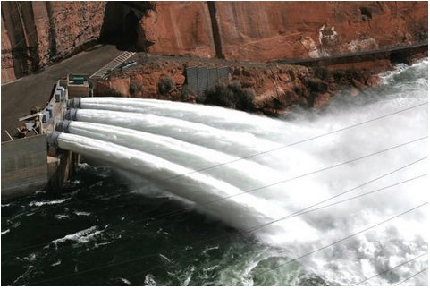
Click the link to read the article on the Utah News-Dispatch website (Kyle Dunphey):
April 12, 2024
A new memo from the U.S. Bureau of Reclamation is raising concern about the infrastructure at the Glen Canyon Dam and its ability to deliver water downstream should levels at Lake Powell continue to decline.
Environmental groups are calling it “the most urgent water problem” for the Colorado River and the 40 million people who rely on it.
Water stored at Lake Powell, the country’s second largest reservoir, typically moves through the Glen Canyon Dam hydropower turbines — the Glen Canyon Power Plant produces about 5 billion kilowatt hours of power each year, distributed to Utah, Wyoming, Colorado, New Mexico, Arizona, Nevada and Nebraska, according to the Bureau of Reclamation.
Below the turbines are the dam’s river outlet works, a separate set of steel pipes originally designed to release excess water. If Lake Powell were to drop below the elevation of 3,490 feet, the outlet works would be the only way to convey water through the dam and downstream to the 30 million people and billion-plus dollar industries that rely on the lower Colorado River basin.
In February 2023, lake levels reached an all-time low of 3,521.95 feet, nearly 30 feet away from forcing the bureau to use the outlet works.

But a March 26 memo from the Bureau of Reclamation suggests those outlet works aren’t as reliable as previously thought.
“There are concerns with relying on the river outlet works as the sole means of sustained water releases from Glen Canyon Dam,” the memo reads, noting that the bureau should “not rely” on the outlet works to release water downstream.
Without upgrades to the dam’s infrastructure, the bureau’s ability to get water downstream to the lower Colorado River basin as required by the Colorado River Compact could be in jeopardy. Even after record-breaking snowfall in 2023 and an above average 2024 winter, Lake Powell remains at about 32% full, according to data from the bureau. And scientists estimate flows in the river have decreased by roughly 20% over the last century, with warming temperatures resulting in a 10% decrease in runoff.
“We call this the biggest problem in the Colorado River basin,” said Zach Frankel, executive director of the Utah Rivers Council. “What is the chance Lake Powell drops below the hydropower turbine level in the next 10 years? If you ask me, I would say it’s almost guaranteed. We just had the biggest runoff in 40 years in the Colorado River basin a year ago. It’s only been a year since the biggest runoff in almost four decades and Lake Powell is still only at 32% capacity.”

The Bureau of Reclamation’s findings come after officials recently used the outlet works to deliver more water downstream, an effort to boost ecosystems and study the ecology and hydrology of the Colorado River. The outlet works experienced cavitation, which according to the bureau, is a result of bubbles forming in high velocity flows that can damage or erode coatings, concrete and steel. Repairs could include adding a new epoxy lining to the outlet works, which the bureau has scheduled for later this year. Or even a river-level bypass system, which the Utah Rivers Council has advocated for, allowing water to flow around the dam.
“If we drop everything to solve it, the solution will still take 10 years to implement — so why are we procrastinating?” said Eric Balken, the executive director of Glen Canyon Institute.
The cavitation means the outlet works currently can’t sustain the volume of water required to pass through the dam and deliver the roughly 9 million acre-feet of water allocated to California, Arizona, Nevada and Mexico, should Lake Powell drop below 3,490 feet.
And if the lower basin doesn’t get its water, it could unravel an already tense situation in the drought-plagued region. Frankel said it could lead to litigation among states, the lower basin demanding the upper basin make substantial cuts, or a depletion of reservoirs in Utah and other upper basin states. The economic impact of not delivering water to the lower basin could have far-reaching ripple effects, possibly reducing agricultural production, impacting urban growth and damaging recreation.
“This is a big problem that 1 in 8 Americans needs to have resolved,” Frankel said.
Water managers from Colorado River basin states are currently working on new management plans ahead of 2026, when current guidelines are set to expire. The states have yet to reach an agreement, but Kyle Roerink, executive director of the Great Basin Water Network, said the issues identified at the Glen Canyon Dam should be a part of the planning process.
“The Bureau has procrastinated solving Glen Canyon Dam’s plumbing problems long enough. This urgent problem needs to be solved ASAP, during the current Interim Guideline process,” Roerink said in a statement.
Navajo Unit Coordination Meeting April 23, 2024 — Reclamation

#Colorado U.S. Senator Bennet Announces Nearly $130 Million for #Colorado Projects in First Round of Senate Appropriations Bills
Click the link to read the release on Senator Bennet’s website:
March 8, 2024
Bennet Secured Nearly $91.5 Million for 78 Colorado Projects
Washington, D.C. — Colorado U.S. Senator Michael Bennet announced that he secured nearly $91.5 million for 78 Colorado projects through the congressionally directed spending (CDS) in the first round of Fiscal Year 2024 (FY24) Senate appropriations bills. In total, the six bills included nearly $130 million in funding for projects across Colorado. The Senate is currently working to pass another six FY24 appropriations bills which could include additional funding for Colorado projects.
“Throughout this process, I’ve sat down with municipalities, nonprofits, and leaders across the state to hear directly about the challenges their communities face and how Washington can be a better partner,” said Bennet. “I’m glad we were able to support nearly eighty projects across thirty Colorado counties in this round of funding. From funding water infrastructure in Lamar to a business park in Craig and a housing affordability project in Fort Collins, these investments will help Coloradans meet the changing needs of their communities.”
Colorado projects secured by Bennet in FY24 Senate appropriations bills:
PROJECT TITLE RECIPIENT FUNDING AMOUNT LOCATION ALSO REQUESTED BY 211 Colorado Upgrade Mile High United Way $500,000 Denver Hickenlooper, Crow 3rd and Knox Affordable Housing Project Habitat for Humanity of Metro Denver, Inc. $750,000 Denver Hickenlooper, DeGette Auraria Early Learning Center and Mixed-Use Development Auraria Higher Education Center $2,000,000 Denver Hickenlooper Breakthrough Program Expansion Breakthrough $353,000 Denver Hickenlooper Central Corridor RTD $850,000 Denver Hickenlooper, DeGette Central Public Library—Renovation City of Aurora, CO $3,000,000 Aurora Hickenlooper, Crow Chambers Avenue Widening Colorado Department of Transportation $4,116,279 Commerce City Hickenlooper, Caraveo City of Aurora for Pressure Regulating Valve Relocation City of Aurora $900,000 Aurora Hickenlooper, Crow City of Aurora for Water System Improvements City of Aurora $2,000,000 Aurora Hickenlooper City of Evans for Waterline Replacement Project City of Evans $677,000 Evans Hickenlooper, Caraveo City of Gunnison for Water Treatment Plant Project City of Gunnison $1,750,000 Gunnison Hickenlooper, Boebert City of Lamar for Wastewater Treatment Plant Improvements City of Lamar $1,800,000 Lamar Hickenlooper City of Longmont Micro Transit System City of Longmont $1,000,000 Longmont Hickenlooper, Neguse City of Westminster for New Water Treatment Facility City of Westminster $959,752 Westminster Hickenlooper, Pettersen Clear Creek Schools Foundation Childcare Center Clear Creek Schools Foundation $1,616,279 Idaho Springs Neguse Colorado Rural Impact Programs County Sheriffs of Colorado $917,000 Statewide Colorado State University Multiuse UAS Airfield Project Colorado State University $500,000 Fort Collins Hickenlooper, Neguse Compactor/Roller Attachments for Road Safety Colorado Department of Transportation $396,000 Golden Hickenlooper Cottonwood Pass Blue Hill Project Colorado Department of Transportation $1,500,000 Eagle County Hickenlooper, Boebert Deer Creek Water District for Water Meter Upgrades Deer Creek Water District $80,000 Parker Hickenlooper Denver Fire Station 40 City and County of Denver $850,000 Denver Hickenlooper, DeGette Denver International Airport Electrification Plan City and County of Denver – Mayor’s office $300,000 Denver Hickenlooper, DeGette DigitalBridge Colorado – Phase 2 WRC – Connected Communities $270,000 Grand County Douglas County for Wildfire Mitigation Douglas County $800,000 Douglas County Eagle County Regional Airport Federal Inspection Station Eagle County Regional Airport $500,000 Gypsum Hickenlooper, Neguse Ecological Prediction Lab: Airborne Coverage to Inform Water and Forest Health Management Rocky Mountain Biological Laboratory (RMBL) $975,000 Crested Butte Hickenlooper Food Bank Distribution Center Renovations Care and Share Food Bank for Southern Colorado $800,000 Colorado Springs Hickenlooper Former DPS Bus Barn Remediation City and County of Denver $500,000 Denver Hickenlooper, DeGette Fort Collins Affordable Housing Preservation Neighbor to Neighbor $1,000,000 Fort Collins Hickenlooper Gateway Domestic Violence Services Aurora Arapahoe Battered Women’s Shelter, DBA Gateway Domestic Violence Services $1,616,279 Aurora Crow Greeley Neighborhood Safety Program Colorado Department of Transportation $500,000 Greeley Hickenlooper Greeley Teen Center Boys & Girls Clubs of Weld County $850,000 Greeley Hickenlooper, Caraveo High Plains Boulevard I–25 Arterial Road Colorado Department of Transportation $1,000,000 Weld County Hickenlooper, Caraveo High-Temperature Fuel Cells Colorado School of Mines $3,000,000 Golden Hickenlooper History Colorado for Fort Garland Geothermal & Weatherization Project History Colorado $164,000 Fort Garland Hickenlooper Holyoke Community Childcare Initiative Holyoke Community Childcare Inititative $1,000,000 Holyoke Hickenlooper Hope Center Facility Rehabilitation Hope Center, Inc. $2,000,000 Denver Huerfano County for Wastewater System Improvements Huerfano County $500,000 Gardner Hickenlooper I-70 Interchange at 29 Road Colorado Department of Transportation $2,000,000 Grand Junction Hickenlooper, Boebert Idledale Water and Sanitation District for Water Infrastructure Upgrades Idledale Water and Sanitation District $959,752 Idledale Hickenlooper, Pettersen Jane’s Place Multi-family Affordable Housing Solar Arrays Chaffee County Government $300,000 Salida Hickenlooper, Pettersen Jefferson County for Forest Health Youth Corps Jefferson County Open Space $80,000 Jefferson County Hickenlooper KidsPak Capital Improvements & Equipment KidsPak $118,000 Loveland Hickenlooper Kiowa County Hospital Replacement Facility: Phase 1 Kiowa County Hospital District $1,917,000 Eads Hickenlooper Lake County Community Housing Leadville Lake County Regional Housing Authority (LLCRHA) $850,000 Leadville Hickenlooper, Pettersen Lookout Mountain Water District for Waterline Replacement Lookout Mountain Water District $959,752 Golden Hickenlooper, Pettersen Maple Street Bridge Replacement Colorado Department of Transportation $1,750,000 Fruita Hickenlooper Mobile Facilities for Homelessness and Eviction Assistance The Community Firm (DBA Community Economic Defense Project) $840,000 Statewide Crow Moguan Aftercare Housing Facility Ute Mountain Ute Tribe $2,000,000 Towaoc Hickenlooper Nine Mile Pedestrian/Bicycle Bridge over SH–83 Colorado Department of Transportation $850,000 Aurora Hickenlooper, Crow Open Soil Water Sensor Colorado State University $1,450,000 Fort Collins Hickenlooper Park Avenue Inn Colorado Coalition for the Homeless $4,116,279 Denver Hickenlooper, DeGette Quebec Street — 136th Avenue to north of 138th Avenue Widening Design Colorado Department of Transportation $850,000 Thornton Hickenlooper, Caraveo Regional Workforce Center for Career and Technical Training Build Pagosa $1,000,000 Pagosa Springs Hickenlooper Residences on Acoma Second Chance Center $1,500,000 Denver Hickenlooper Riverside Educational Center Renovation Riverside Educational Center $168,000 Grand Junction Hickenlooper Rock Creek Affordable Housing & Associated Infrastructure Southern Ute Indian Tribe $3,000,000 Ignacio Hickenlooper Rural eConsult Expansion University of Colorado Anschutz Medical Campus $402,785 Aurora Hickenlooper, Crow San Luis Valley Health Workforce Housing Project Lutheran Hospital Association of the San Luis Valley dba San Luis Valley Health $2,000,000 Alamosa Hickenlooper Securing Southwest Colorado Police and Emergency Communications Montezuma County $50,000 Montezuma County Hickenlooper Social Fabric (Community Center) Colorado Asian Culture and Education Network (CACEN) $500,000 Aurora Hickenlooper, Crow South Adams County Water and Sanitation District for PFAS Drinking Water Treatment Plant Project South Adams County Water & Sanitation District $959,752 Commerce City Hickenlooper, Caraveo Steamboat Springs WorkforceHousing Pedestrian and Bicycle Connection Project City of Steamboat Springs $1,000,000 Steamboat Springs Hickenlooper, Neguse Teller County Water & Sanitation District 1 for Radium Mitigation Teller County Water & Sanitation Special District #1 $959,752 Woodland Park Hickenlooper, Pettersen The Commons Phase Two – Supportive Housing Homeward Pikes Peak $3,000,000 Colorado Springs The Craig Business and Industrial Park City of Craig $2,500,000 Craig Hickenlooper Thornton Community Center Reconstruction Project City of Thornton $1,000,000 Thornton Hickenlooper, Caraveo Three Lakes Water and Sanitation District Septic System Upgrades Three Lakes Water & Sanitation District $1,000,000 Grand Lake Hickenlooper Timberline Fire Protection District Fire Station Timberline Fire Protection District $908,279 Black Hawk Hickenlooper, Neguse Town of Dolores for Water Distribution System Replacement Phase 2 Town of Dolores $750,000 Dolores Hickenlooper Town of Gypsum for Wastewater Infrastructure Project Town of Gypsum $959,752 Gypsum Hickenlooper, Neguse Town of Silt for Water Plant Renovations Town of Silt $2,053,000 Silt Hickenlooper, Boebert Training and Technical Assistance to Combat Human Trafficking The Exodus Road $750,000 Statewide U.S. Highway 160/East Bayfield Parkway New Signalized Intersection Colorado Department of Transportation $1,547,000 Bayfield Hickenlooper, Boebert Urban Agriculture and Education in Westwood Re:Vision $800,000 Denver DeGette Vail Valley Affordable Home Ownership Development Habitat for Humanity Vail Valley $1,500,000 Eagle County Hickenlooper Westwood Community Recreation Center City and County of Denver Mayor’s office $1,000,000 Denver Hickenlooper, DeGette Workforce Training and Education Space Community College of Aurora $850,000 Aurora Hickenlooper, Crow
Proposed ballot measure directs more money to water projects — The #GrandJunction Daily Sentinel

Click the link to read the article on The Grand Junction Daily Sentinel website (Charles Ashby). Here’s an excerpt:
April 13, 2024
HB24-1436, introduced by a bipartisan group of four Western Slope lawmakers, would increase the $29 million cap that voters approved when they legalized sports betting in the state, money to be used entirely for water projects. That happened in 2019 when voters narrowly approved Proposition DD, which legalized sports betting in Colorado and imposed a 10% tax on proceeds. Under the bill, which was introduced by House Speaker Julie McCluskie, D-Dillon, and Rep. Marc Catlin, R-Montrose, the state would be able to retain an additional $15.2 million over the next three years…
Tax money from sports betting goes into the Colorado Water Plan Implementation Fund, which is administered by the Colorado Water Conservation Board. That panel doles out the money in the form of grants for projects already identified under the Colorado Water Plan. That plan, implemented in 2015, identified about $20 billion worth of water projects that would be needed to offset dwindling supplies and a handle a growing population.
‘Forever chemicals’ found in Sleepy Bear well water system: City water shows undetectable amount of PFAS — Steamboat Pilot & Today

Click the link to read the article on the Steamboat Pilot & Today website (Suzie Romig). Here’s an excerpt:
April 14, 2024
Children age five and younger, and women who are pregnant, planning to become pregnant or breastfeeding, are more susceptible to health impacts from commonly called “forever chemicals,” which have been found so far in unhealthy levels in one neighborhood water system in Routt County…Sleepy Bear mobile home park, located along U.S. Highway 40 on the western edge of Steamboat Springs, has recorded PFAS levels in the neighborhood water system that are higher than health advisory and national drinking water standards. The mobile home park is not part of the city water system and uses a well water system, according to the local park manager…
“Most people living in the United States have some amount of these chemicals in their blood,” according to the Colorado Department of Public Health & Environment. “People in communities that have been contaminated by PFAS — through water or other sources — are more likely to have health impacts.”
[…]
Consumer drinking water testing for Sleepy Bear showed 9.2 parts per trillion of PFOA, which is more than double the newly released legally enforceable standards set by the U.S. Environmental Protection Agency. The EPA limits PFOA and PFOS drinking water standards to four parts per trillion. The CDPHE, which issues water system permits in the state, advised Sleepy Bear residents to “consider taking action to reduce your exposure.” Since the EPA previously issued a health advisory in June 2022, Sleepy Bear voluntarily participated in a proactive testing program for PFAS water sampling in June 2023. Sleepy Bear contracted water operator Ron Krueger, owner of Crystal Clear Water Treatment in Lakewood, said Thursday he is awaiting direction from the CDPHE for next steps…

Mount Werner Water & Sanitation District General Manager Frank Alfone said the district has been conducting voluntary PFAS testing that will continue throughout 2025. The most recent testing in February showed no detectable levels of PFAS in the city drinking water supply.
#Colorado State University scientist leads half of USDA update to methods for measuring greenhouse gas #ActOnClimate
Click the link to read the release on the Colorado State University website (Jayme DeLoss)
April 2024
The U.S. Department of Agriculture has released updated methods to help farmers, ranchers and forest landowners estimate greenhouse gas emissions on their land. Three of the federal report’s six chapters were authored by Colorado State University scientist Stephen Ogle, one of the world’s top experts in greenhouse gas inventories.
The report provides the best available science-based methods for estimating greenhouse gas emissions from land management decisions, updating a 2014 USDA report. Methods outlined in the report will be used to evaluate government conservation and climate-smart agriculture programs that encourage practices such as soil carbon sequestration.
“We, as a group of authors, pulled the latest science and best information that’s available into these methods so that farmers will have a good tool for estimation and to know the benefit of what they’re doing on their farms,” said Ogle, lead technical compiler for the national greenhouse gas inventory and professor of ecosystem science and sustainability in the Warner College of Natural Resources.
Landowners can use these methods to gauge potential benefits from land management changes. The methods are incorporated into COMET-Farm, an online tool developed by CSU and USDA that farmers and ranchers can use to estimate soil carbon changes and greenhouse gas emissions on their land based on various management practices.
“With growing importance of reducing emissions in agriculture through the new climate-smart agriculture program that’s been funded through the Inflation Reduction Act, this tool is likely going to be very important for farmers to estimate the benefit and for reporting,” Ogle said. “The $19.5 billion climate-smart ag program is a significant investment by the U.S. government to reduce greenhouse gas emissions in agricultural systems, and these methods are pivotal in that policy.”
Ogle added that the new report includes details on how to implement quantification methods that haven’t been released in previous reports.
Ogle served as lead author for the croplands and grazing land systems, managed wetland systems and land-use change chapters and co-authored a fourth chapter, uncertainty quantification, with CSU Professor Emeritus Jay Breidt, who is now at the University of Chicago. Shawn Archibeque, professor of animal sciences, and Crystal Toureene, an agronomist and researcher in the Department of Soil and Crop Sciences, co-authored the animal production systems chapter.
The 2024 update is the result of four years of work by a team of more than 60 authors, including USDA scientists, university researchers and experts from non-governmental organizations and research institutions, who have developed consistent metrics for estimating changes in greenhouse gas emissions and carbon sequestration for farm, ranch and forest operations. The updates to the report were reviewed by more than two dozen scientists, other federal agencies, the public and a panel of interdisciplinary experts.
“USDA’s updated greenhouse gas methods report represents a critical scientific consensus which ensures confidence in the benefits from climate-smart agriculture and forestry,” Agriculture Secretary Tom Vilsack said in a USDA press release. “This report will help guide conservation efforts, improve our greenhouse gas estimation on U.S. farms, and support markets for carbon and climate-smart products nationwide.”
Read the report, Quantifying Greenhouse Gas Fluxes in Agriculture and Forestry: Methods for Entity Scale Inventory.
This epic slice of Arizona feeds their [Navajo Nation] souls but lacks a basic necessity: Water — The Los Angeles Times #SanJuanRiver #ColoradoRiver #COriver #aridification

Click the link to read the article on The Los Angeles Times website (Tyrone Beason). Here’s an excerpt:
April 7, 2024
The Navajos live in the same 1,400-mile-long Colorado River Basin that brings fresh water to millions in Southern California, yet about 30% of homes on the reservation were built without indoor plumbing. With the absence of pipes connecting homes in this isolated corner of the reservation to a water source, many Navajos must spend hours each week driving to a community center in the tribal settlement of Dennehotso to refill portable tanks. While California wrangles with other Western states over the Colorado River’s drought-stricken water supply, Navajo water rights advocates estimate that the 175,000 members who live on the reservation subsist on average on just 5 to 10 gallons a day per person. Compare that to the 76 to 100 gallons of water the Environmental Protection Agency says most Californians use daily…
Some see hope in a proposed landmark agreement that would settle all outstanding water rights disputes between the Navajo, Hopi and San Juan Southern Paiute tribes and the state of Arizona. If the final terms of the agreement are approved by the tribal government, the Navajos will ask Congress for $5 billion in federal funding to expand the reservation’s water delivery infrastructure, says Navajo Nation Council Speaker Crystalyne Curley.
“In the past, we’ve tried to get all of the parties to the table to secure water rights, which since time immemorial we’ve had to fight for,” Curley says…
The failure to extend water service to all Indigenous Americans is especially galling given their traditional role as nature’s caretakers, says Heather Whiteman Runs Him, associate clinical professor and director of the Tribal Justice Clinic at the University of Arizona in Tucson.
“We respect water in ways that many other Americans don’t,” says Whiteman Runs Him, a Crow tribal member from Montana. “The vast majority of Americans take water access for granted. You pay a water bill but don’t think about what you’re paying for.”
[…]
The disparity in water access between Navajo tribal members and other Americans was dramatized in a recent U.S. Supreme Court ruling. Brushing aside a host of treaties and legal precedents dating to the formation of the reservation on a fraction of Navajo ancestral territory in 1868, the court determined that the federal government is not obligated to help the tribe get more access to water from natural sources such as the Colorado River basin.

2024 #COleg: #Colorado Wetlands: Lawmakers clash as they seek state protections — Colorado Politics

Click the link to read the article on the Colorado Politics website (Marianne Goodland). Here’s an excerpt:
April 13, 2024
This month, lawmakers looked at the dueling approaches contained in two measures seeking to implement a way for the state to manage “dredge and fill discharge” permits tied to a recent U.S. Supreme Court decision [Sackett vs. EPA] that redefined how a body of water can be protected under the Environmental Protection Agency’s “Waters of the United States” rule…Supporters of the first bill, which gives the task to the Colorado Department of Public Health and Environment, insist it’s the proper venue because it already experience dealing with permitting and water quality issues. Supporters of the second measure, which hands the responsibility to the Colorado Department of Natural Resources, maintain that the Department of Natural Resources is better equipped, since it already deals with related disciplines, such as water resource management, water rights law and land management.
In any case, policymakers agree that Colorado residents, industries and the wetlands needs certainty…Alex Funk with the Theodore Roosevelt Conservation Partnership told a legislative committee last August that almost 90% of fish and wildlife in Colorado rely on the state’s wetlands at some point during their lifecycle. House Speaker McCluskie told the House agriculture committee on April 8 that since Sackett v. Environmental Protection Agency held that only permanent streams and rivers are protected under the federal Clean Water Act, those with a continuous surface connection to another permanent water body. That puts Colorado waters at risk, she said. Pitkin County Commissioner Greg Poschman also noted that the state’s headwaters are made up of small streams that do not have year-round flow because they are under snowpack half the year — suggesting Sackett would put those waters at risk.
The Loss of El Vado Dam — John Fleck (InkStain.net) #RioGrande

Click the link to read the article on the InkStain website (John Fleck):
April 10, 2024
The Bureau of Reclamation’s announcement at Monday’s meeting of the Middle Rio Grande Conservancy District that it is halting work on El Vado Dam repairs raises hugely consequential questions about water management in New Mexico’s Middle Rio Grande Valley.
The short explanation for the halt is that the current approach to repairing the 1930s-era dam wasn’t working. (The meeting audio is here, though at “press time” for this blog post this week’s is not yet up.) I’ll leave it to others to suss out the technical and bureaucratic details of the repair project, and the endless finger-pointing that’s sure to ensue. My interest here is to begin to sketch out the implications here in the Middle Valley of an indefinite period – a decade or more? – without El Vado.
The Middle Rio Grande Conservancy District built El Vado (with substantial federal subsidy) in the 1930s to provide irrigation supplies by storing high spring runoff for use in summer and fall. But while its purpose was irrigation, it completely changed the Middle Valley hydrograph in ways that all the other water uses have adapted to, both human and ecosystem.
Without El Vado (or some interim replacement – see below), we should expect the Rio Grande to routinely go functionally dry in late summer unless propped up by monsoon rains, which are sporadic and unpredictable.
I see impacts in three areas, only one of which is related to El Vado’s initial purpose.

1: IRRIGATION
This is the obvious one. Until El Vado is repaired or some sort of replacement schemed out, irrigators should expect a high risk of low or no supply in late summer and fall. Alfalfa will remain a reliable if modest crop (it can hunker down and wait out the dry), but the few commercial operators who need a more reliable supply for their crops – think pecans and chile – will have to depend on groundwater, with all the problems that entails.

2: MUNICIPAL SUPPLIES
Albuquerque’s use of its imported San Juan-Chama water in summer indirectly depends on El Vado. Without MRGCD water, released from El Vado, as “carriage water”, the Albuquerque Bernalillo County Water Utility has to leave its imported San Juan-Chama water parked in Abiquiu Reservoir, switching to groundwater. This is what we have done over the last few years, and our much-vaunted aquifer recovery has, as a result, stalled.
This poses a huge challenge for the Albuquerque Bernalillo County Water Utility Authority.

3: ENVIRONMENTAL FLOWS
The idea of an agricultural irrigation dam providing the water for environmental flows seems super weird. But that’s basically the way it’s worked for years here in the Middle Valley. Releases from El Vado, sent downstream to irrigators, provide environmental benefits along the way. For the last couple of years, without El Vado water to supplement flows in late summer, the Rio Grande has operated on a knife’s edge between flowing and dry through Albuquerque.
This poses a huge challenge for efforts to nurse the Rio Grande silvery minnow back from extinction.

STORAGE ALTERNATIVES
First and foremost, there is a fast-moving and scrambling discussion about storage alternatives.
Abiquiu Reservoir, a flood control facility on the Rio Chama built, owned, and managed by the U.S. Army Corp of Engineers, is an obvious replacement. The part in italics yields knowing nods, or perhaps grimaces, from folks who work in Middle Valley water management, because the Corps is well known for an exceedingly cautious interpretation of its statutory mandates. “Filling in as a water storage facility to replace El Vado” is only sorta barely at the edge of that mandate. Getting the Corps on board to help with this fix will be key.

Heron Reservoir, on a Rio Chama tributary, stores San Juan-Chama water imported through tunnels beneath the continental divide. It physically can’t replace El Vado because it’s in the wrong place. But discussions have already touched on the idea of doing it on paper via accounting swaps – hold back San Juan-Chama water, let SJC customers use native Rio Grande water via an accounting swap, then deliver Heron water as if it had been El Vado water.
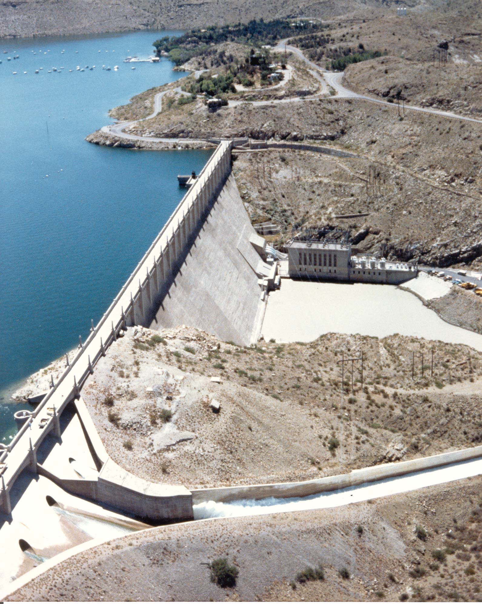
Elephant Butte? Again, it’s in the wrong place, but accounting swaps here are also on the table.
INSTITUTIONAL FRAMEWORK
The most important subtext is the institutional framework behind all of this. The loss of El Vado is not solely an MRGCD/Bureau of Reclamation problem. It implicates all the Middle Valley’s water stakeholders – especially Albuquerque’s Water Utility Authority, but also the Corps of Engineers, the Fish and Wildlife Service (because of ESA issues), the state water agencies, the communities on the valley floor that have avoided responsibility for any of this by depending on the state’s obscenely permissive domestic well statute.

Navajo Dam operations update: Bumping releases down to 350 cfs April 16, 2024 #SanJuanRiver #ColoradoRiver #COriver #aridification

From email from Reclamation (Susan Novak Behery):
April 15, 2024
In response to increasing flows in the critical habitat reach, the Bureau of Reclamation has scheduled a decrease in the release from Navajo Dam from 500 cubic feet per second (cfs) to 350 cfs for tomorrow, April 16th, at 4:00 AM.
Releases are made for the authorized purposes of the Navajo Unit, and to attempt to maintain a target base flow through the endangered fish critical habitat reach of the San Juan River (Farmington to Lake Powell). The San Juan River Basin Recovery Implementation Program recommends a target base flow of between 500 cfs and 1,000 cfs through the critical habitat area. The target base flow is calculated as the weekly average of gaged flows throughout the critical habitat area from Farmington to Lake Powell.
#Snowpack news April 15, 2024
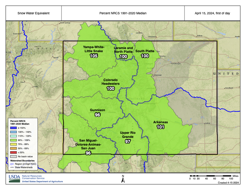
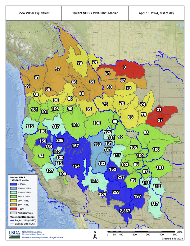
Wet March 2024 boosts #snowpack, streamflow forecasts: #Runoff still depends on temperature, dust on snow — @AspenJournalism

Click the link to read the article on the Aspen Journalism website (Heather Sackett):
April 12, 2023
The month of March in Colorado was wet, with several storms bumping snowpack and spring runoff forecasts to above average across nearly all of the state.

That is the main take-away from the April 2024 Water Supply Outlook Report from the National Resources Conservation Service and good news for those who depend on water from the drought-plagued Colorado River basin.
All major river basins around the state received above-average precipitation for March, boosting snowpack to above median. March precipitation ranged from 138% of median in the northwest corner of the state to 186% of median in the Arkansas River basin.
“The March 13 through 15 storm cycle brought an even greater increase in precipitation across the state, with some areas of the Front Range and southern mountains receiving three to five feet of snowfall,” the report reads.
Snow water equivalent — a measure of how much water is contained in the snowpack — ranged from 121% of median in the South Platte basin to 104% of median in the San Miguel/Dolores/Animas/San Juan basin in the southwest corner of the state as of April 1. The Colorado River headwaters stood at 108% of median and the Roaring Fork River basin was at about 112% of median.
Since most of the West’s water supply is snowpack-driven, a snowpack snapshot at the end of the season can be a predictor of runoff volume. But there are other factors that could affect how much water ultimately ends up in rivers and eventually in the nation’s second largest reservoir, Lake Powell.
Higher-than-normal temperatures and windstorms that drop dust on the snowpack can both cause runoff to happen earlier and faster, and hot temperatures can also reduce streamflow amounts in other ways.
“What really influences our water supply is yet to come and that’s temperature, it’s dust, it’s weather,” said Dave Kanzer, director of science and interstate matters with the Colorado River Water Conservation District. “It’s not only the weather for the next 8 to 14 days, but 30 to 60 days that can quickly turn a good thing bad or a bad thing good. We are right at the fulcrum of our water supply.”

Streamflow forecast volumes across the state are at 103% of median. For the Colorado River headwaters streamflow is forecast at 105% of median; the Yampa/White/Little Snake is at 120% of median and the Gunnison River basin is at 104% of median. The southwest corner of the state is lagging behind, with a forecast of just 82% of median streamflow. Locally, streamflows in the Roaring Fork basin are forecast to be 104% of median.

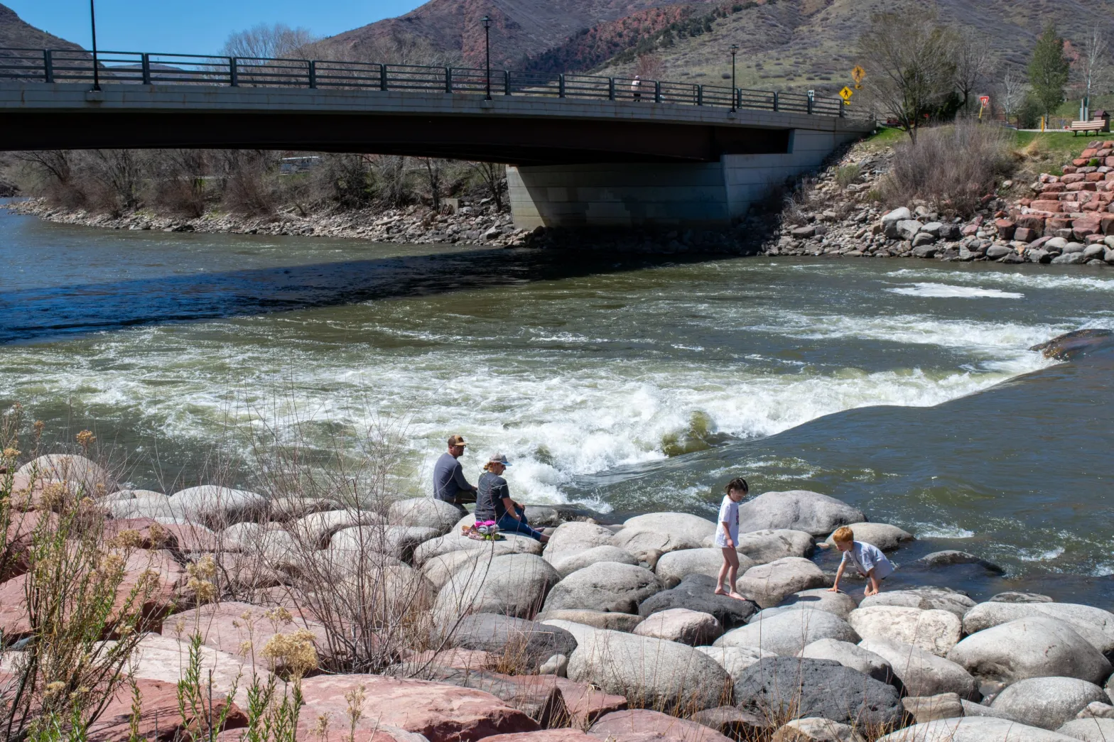
High temperatures and dust on snow
Higher-than-normal temperatures can rob rivers of their flow. Studies have shown that Colorado River flows have declined nearly 20% from the 20th century average and that about one-third of that can be attributed to higher temperatures driven by climate change. Higher temperatures mean both a thirstier atmosphere and thirstier plants, which can suck up snowmelt before it makes it to rivers.
According to temperature data from snow telemetry (SNOTEL) sites, the months of October through February were all above average in the Colorado River headwaters. March temperatures, which set record highs worldwide according to the National Oceanic and Atmospheric Administration, were 100% of median in the Colorado River headwaters.
“We’ve had some cold snaps, but overall this warm winter doesn’t do us any favors in preserving the snowpack,” Kanzer said.

Like Kanzer mentioned, dust on snow can also cause rapid melting. White snow reflects the sun’s rays, but when the snowpack is coated with a darker layer of dust, it absorbs solar radiation, causing earlier and faster-than-normal melt out.
According to Jeff Derry, executive director of the Silverton-based Center for Snow and Avalanche Studies, Colorado’s mountains have experienced four storms that dropped reddish-brown dust from the desert southwest onto the snowpack, including a severe wind event March 1-3.
“That was a walloper, that was a biggie. It was pretty dirty,” Derry said. “Once that dirt layer is at the surface, it’s going to really kick things into gear.”
Oil and gas development, grazing, off-road vehicles and anything else that disturbs soil makes that soil susceptible to being carried by prevailing winds to the Colorado mountains. Derry said Colorado averages about eight or nine dust-on-snow events a year, some of which are probably yet to come.
“We get the most dust events in March, April and May,” he said. “So we are maybe just halfway through the dust season.”
Even though conditions are above average in the Colorado River headwaters, Lake Mead and Lake Powell still hover just above crisis level, a result of more than two decades of drought, increasing temperatures and overuse. In its mid-March 24-Month Study, which is the most recent available, the U.S. Bureau of Reclamation put the most probable spring runoff inflow forecast for Lake Powell at 78% of average. Lake Powell is currently about 33% full, at elevation 3,558 feet.
“From a water supply planning perspective, things are good short term and locally,” Kanzer said. “The long term, regional picture rapidly declines when you get to Lake Powell and below Lake Powell. Those chronic or persistent water supply concerns remain.”
#Missouri could crack down on water exports to drought-weary West — The Washington Post

Click the link to read the article on The Washington Post website (Scott Dance). Here’s an excerpt:
Missouri lawmakers say water has almost always been plentiful in their state, giving no reason to think twice about a concept known as riparian rights — the idea that, if you own the land, you have broad freedoms to use its water. But that could change under a bill advancing quickly in a state legislature that is normally sharply divided. The measure would largely forbid the export of water across state lines without a permit, even though there is no evidence that is happening on any large scale.
Just the specter of water scarcity is inspiring bipartisan support. Besides persistent drought in parts of the state and plummeting Mississippi River levels in recent months and years, lawmakers are wary of the West, and the chance that thirsty communities facing dwindling water supplies will look east for lakes and rivers to tap…
“They’re not being real responsible,” state Rep. Jamie Burger (R), one of the bill’s lead sponsors, said of states like California and Arizona. “We feel like we need to be responsible in Missouri and protect what we have.”
If passed, the new limits would be the latest domino to fall as climate change makes droughts more frequent and intense across huge swaths of the United States, and threatens to exhaust water supplies in some parts of the West within the foreseeable future. States including Oklahoma, Iowa and Nebraska already have similar safeguards on water exports in place, while a compact among Great Lakes states has largely banned exports beyond the limits of their watershed since 2008.
Meanwhile, California has struggled to capture vast amounts of rain water, Arizona faces booming growth and depleting aquifers, and states across the Colorado River basin are at odds over solutions to keep that vital waterway flowing.

Aspinall Unit Coordination Meeting April 18, 2024 #GunnisonRiver #ColoradoRiver #COriver #aridification
From email from Reclamation (Erik Knight):
The next coordination meeting for the operation of the Aspinall Unit is scheduled for Thursday, April 18th 2024, at 1:00 pm.
This meeting will be held at the Western Colorado Area Office in Grand Junction, CO. There will also be an option for virtual attendance via Microsoft Teams. A link to the Teams meeting is below.
The meeting agenda will include a review of operations and hydrology since January, current soil and snowpack conditions, a discussion of hydrologic runoff forecasts, the weather outlook, and planned operations for this water year.
Handouts of the presentations will be emailed prior to the meeting.
Data Dump: Exporting hay (and water): Western states export hay, but maybe not as much as you think– Jonathan P. Thompson (LandDesk.org)
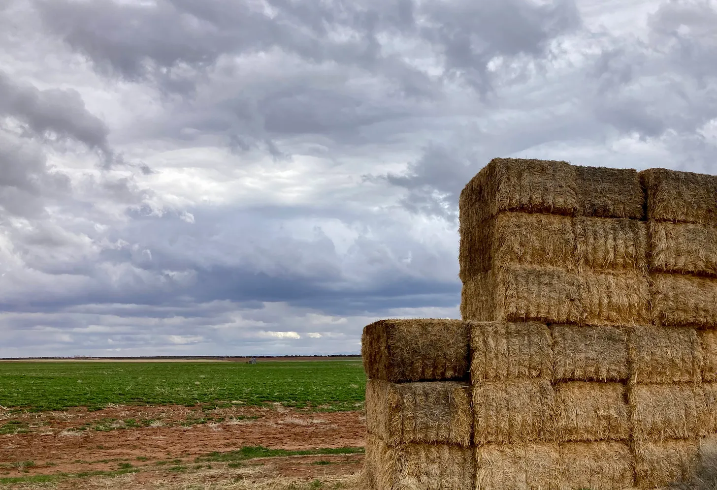
Click the link to read the article on The Land Desk website (Jonathan P. Thompson):
April 12, 2024
Pretty much every time I write about the amount of Colorado River water that is consumed to irrigate alfalfa and hay, readers respond with a comment or question about how much of the alfalfa — and therefore Colorado River water — is shipped overseas.
And then, sometimes, Teal Lehto, a.k.a. westernwatergirl, uses one of my pieces on alfalfa and water to do one of her cool and informative Instagram videos:
And that’s when the comments really start to fly, e.g.:
- “… pretty much all of that alfalfa doesn’t stay in the United States and is grown by Saudi Arabia …”
- “… Saudi Arabia is using most of the land and water to grow the alfalfa…”
- “The #$% kicker is that most of the alfalfa is being sold to foreign countries like China.”
Let’s look into this a bit.

It is true that Western farms export alfalfa to foreign countries. And it’s also true that Saudi Arabia-based food giant, Almari, owns at least one farm in Arizona where it grows alfalfa that is shipped overseas to feed its massive herd of dairy cattle. While Arizona Gov. Katie Hobbs cancelled some of the company’s state land leases, thereby ending groundwater pumping at those locations, the company still has other holdings in the state where it presumably continues to farm. A United Arab Emirates companyand a major global hay exporter also operates farms in Arizona and California.
But there’s a big caveat here: Many farms in Arizona — and most if not all of the Saudi Arabia owned ones — irrigate with groundwater, not with water diverted from the Colorado River. While groundwater pumping ultimately has an effect on surface waters, the water these farms pump is not counted against Arizona’s Colorado River use. So shutting down these farms’ groundwater spigots is unlikely to have much bearing on the Colorado River crisis.
And, similarly, the data below show each states’ total hay exports, because the Foreign Agricultural Service does not break it down by county. So some of the exported hay from California may be grown in, for example, the Central Valley, which would not be irrigated by Colorado River water. So while this is not an accurate representation of how much Colorado River water is exported in the form of hay, it does give a general sense of things. I took a look at stats from all seven Colorado River Basin states. But I didn’t include Colorado, Wyoming, or New Mexico in the charts because their export amounts were almost zero.
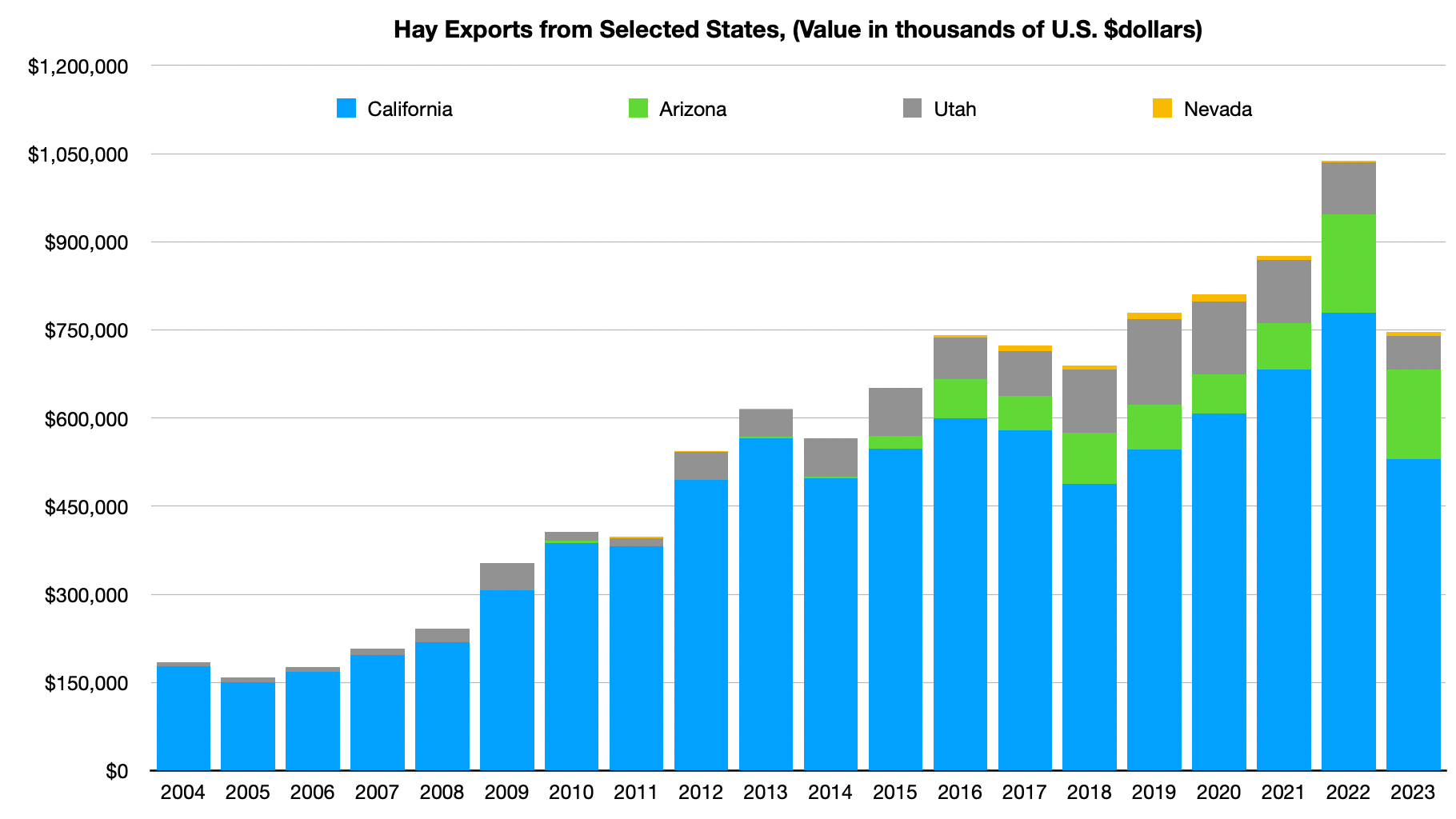
These four states exported about $1 billion worth of hay — alfalfa and other varieties — in 2022. The amount dropped significantly, mostly due to a cutback from California, in 2023. California also produced far less hay that year, most likely due to water shortages. It’s still a lot of hay. But how does it compare to totals?

Unfortunately, the FAS only supplies the value of the exports, not tonnage, which makes the comparison a bit squishy, it seems (since producers may fetch more or less per ton for exports). But as far as total value goes, it looks as if about 30% of the hay produced in the main exporting states of the Colorado River Basin is shipped overseas.
As you can see, hay, in general, is pretty big business in the West, with a value of more than $2.5 billion from these four states alone, about $2 billion of which is alfalfa.
And where does each state’s hay go?
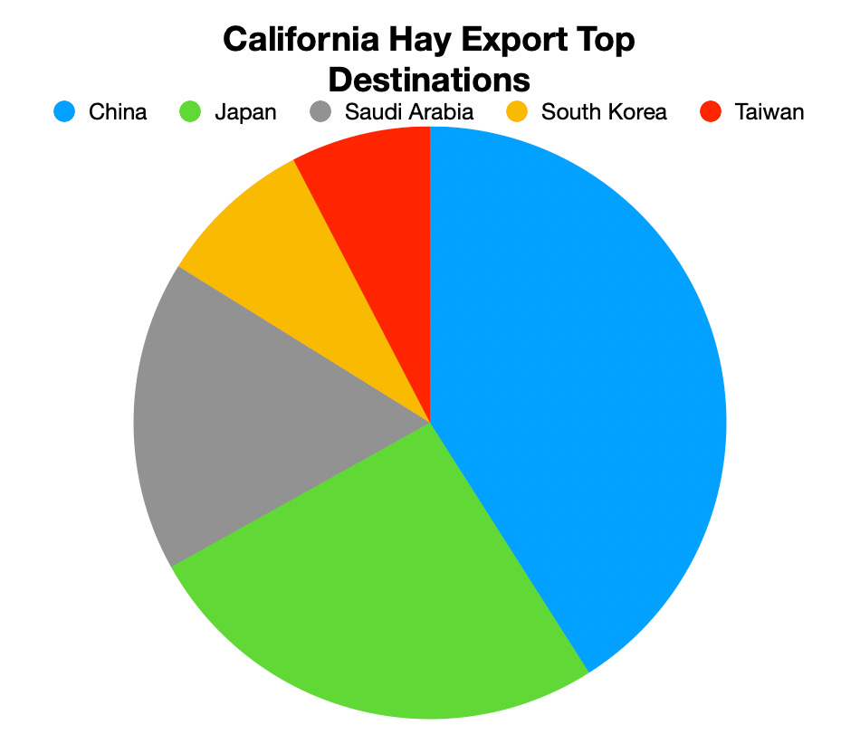
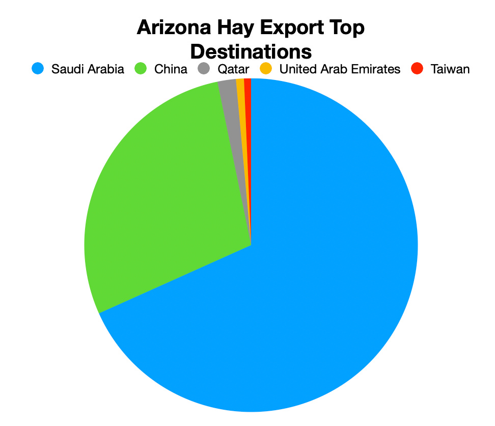
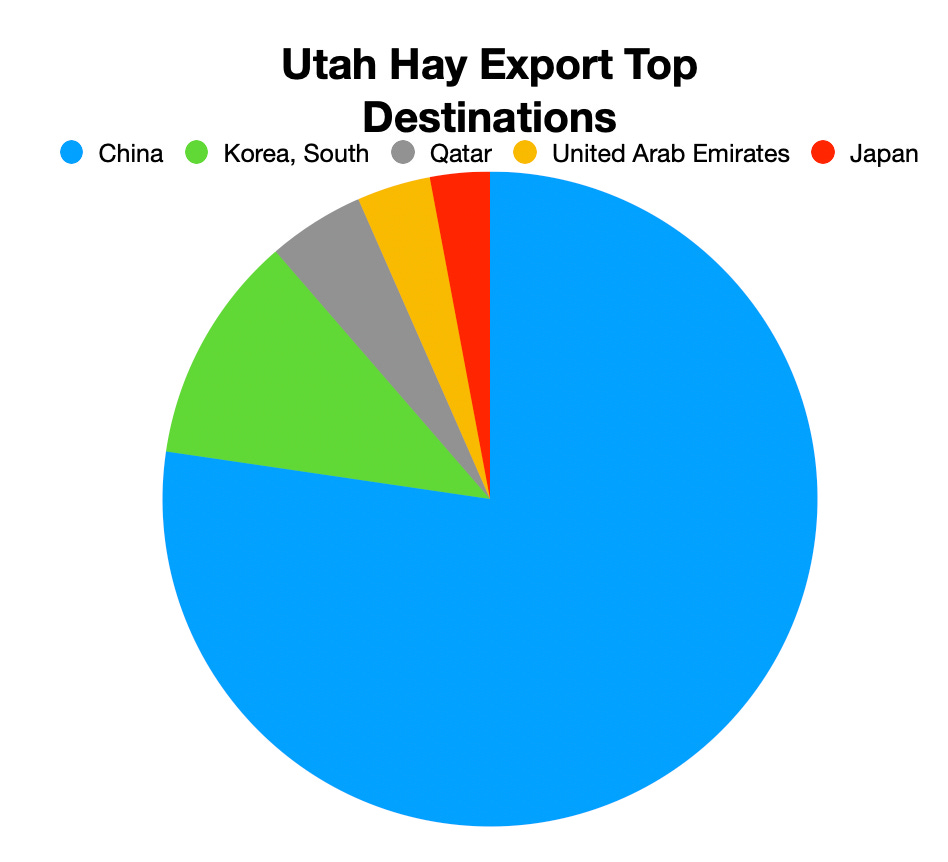
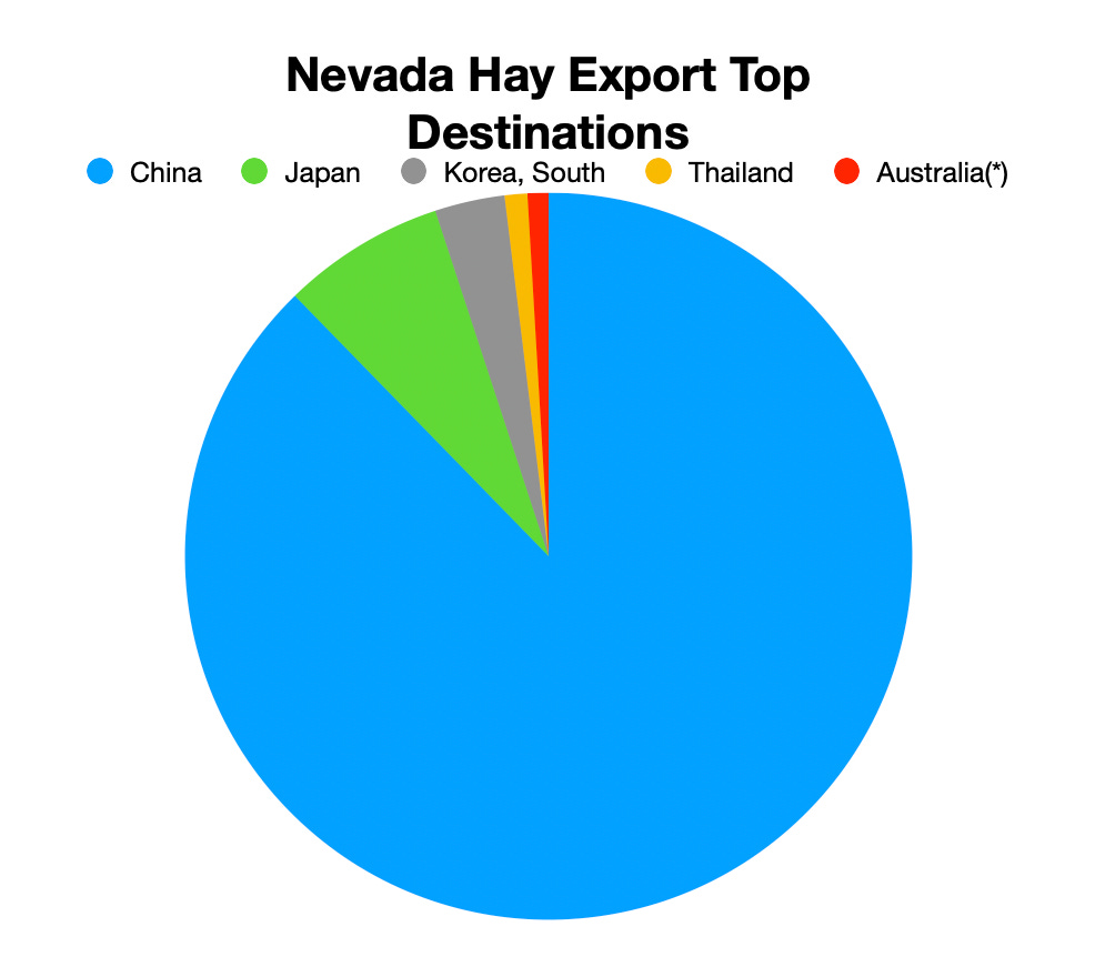
Overall, most Western U.S. hay exports are China-bound. But Arizona hay is most likely to be on its way to Saudi Arabia for the aforementioned reasons. It will be interesting to see if that changes this year as Almari cuts back farming in the state.

And the heat keeps coming: Global temperature record broken for 10th month in a row in March — The Los Angeles Times #ActOnClimate

Click the link to read the article on The Los Angeles Times website (Hayley Smith). Here’s an excerpt:
April 13, 2024
Earth’s worrisome warming trajectory continued unabated last month, with March marking the 10th month in a row that the planet has broken global heat records, international climate officials announced this week. With an average surface temperature of 57.45 degrees Fahrenheit, last month was warmer globally than any previous March on record, according to the European Union’s Copernicus Climate Change Service. The month was about 0.18 of a degree warmer than the previous hottest March, in 2016, the service said.
“March 2024 continues the sequence of climate records toppling for both air temperature and ocean surface temperatures, with the 10th consecutive record-breaking month,” read a statement from Samantha Burgess, Copernicus’ deputy director. “The global average temperature is the highest on record, with the past 12 months being 1.58 degrees Celsius above pre-industrial levels. Stopping further warming requires rapid reductions in greenhouse gas emissions.”
Indeed, March was well above the 1.5-degree Celsius (2.7 degrees Fahrenheit) international target for limiting the worst effects of climate change. The global average temperature measured about 3 degrees, or 1.68 degrees Celsius, warmer than the designated 1850 to 1900 preindustrial reference period. What’s more, the global average temperature for the last 12 months — April 2023 through March 2024 — is the highest on record, at 2.8 degrees, or 1.58 degrees Celsius, above the preindustrial average.
Birdwatchers, boaters and families visit #LakeNighthorse on opening day — The #Durango Herald #AnimasRiver #SanJuanRiver #ColoradoRiver #COriver #aridification

Click the link to read the article on The Durango Herald website (Christian Burney). Here’s an excerpt:
April 13, 2024
Kayakers, bird watchers, trail hikers and parents with energetic toddlers were some of the first to visit Lake Nighthorse on opening day of the spring season Friday. The waters of Lake Nighthorse reflected pleasant, blue skies, although the reflection was elusive because there was hardly a trace of clouds above. Lake Operations Supervisor Sean Willis said six or seven vehicles were lined up at the entrance when the lake opened at 9 a.m. By 10:30 a.m., between 30 and 35 people had crossed the entrance.
Amanda White, co-vice president of Durango Bird Club, stood by a pier near the designated swim beach with her weighted tripod and spotting scope. She looked over the lake through the lenses with narrowed eyes with her dog Josie by her side.
She said the lake is a “spectacular” resource for migratory birds.

Five Major Proposals for Post-2026 management of the #ColoradoRiver — John Fleck (Inkstain.net) #COriver #aridification

Click the link to read the article on the Inkstain website (John Fleck):
April 3, 2024
With the submission of two additional proposals last week, we now have five major proposals for post-2026 Colorado River management.
The folks at the Water and Tribes Intitiative have helpfully organized them in a single place. (Click on the
“Proposed Alternatives for Post-2026 Operating Guidelines” bubble.)TRIBAL PRINCIPLES
A set of guiding principles proposed by 17 of the basin’s sovereign indigenous communities. (click here)
UPPER BASIN PROPOSAL
What the label says, you already know about this one. (click here)
LOWER BASIN PROPOSAL
What the label says, you already know about this one. (press release, alternative, presentation)
ENVIRONMENTAL NGOS
The “Big Seven” Colorado River Basin environmental groups (click here)
LAKE POWELL/GRAND CANYON/LAKE MEAD ECOSYSTEM PROPOSAL
A proposal from Jack Schmidt, Eric Kuhn, and John Fleck suggesting ways to manage the storage and distribution of water to provide more flexibility for environmental and other non-water supply benefits. (click here)
Audubon: New Rule for #FossilFuel Development on Federal Lands Long Overdue #ActOnClimate #KeepItInTheGround
Click the link to read the release on the Audubon website (Jason Howe):
(Washington, DC-April 12, 2024) – The U.S. Bureau of Land Management (BLM) today announced a rule updating the cost of doing business on public lands and helping to balance the extraction of natural resources with the conservation of wildlife habitat and the preservation of landscapes sacred to Indigenous peoples.
In addition to siting oil and gas development away from wildlife habitat and cultural resources, the new regulations increase fees – including royalty and rental rates, and minimum bids associated with oil and gas development – bringing them in line with what many states require; and reduce so-called “speculative leasing”, where companies hold leases on land with little potential for development.
The BLM manages 245 million acres, nearly 40 percent of U.S. public lands. The agency is charged with balancing the protection of America’s natural legacy with managing the 30 percent of the nation’s mineral wealth that lies beneath the surface. But over the past 50 years, the agency has mainly focused on extractive uses (coal, and oil and gas), applying rules governing that extraction that have been unchanged for decades. An estimated 300 bird species spend at least part of their lives there, including Burrowing Owls and the Greater Sage-Grouse, which is already under stress across much of its range.
“When BLM oil and gas leasing policy was last updated, Gerald Ford was in the White House, the Bee Gees were on the radio and a gallon of gas cost an average of 59 cents,” said Christopher Simmons, senior manager of public lands policy for the National Audubon Society. “The BLM’s approach to oil and gas leasing has been the equivalent of a polyester leisure suit – painfully outdated. This is a big step forward towards the BLM fulfilling its mission, delivering common-sense policies that balance responsible development with land and wildlife conservation.”
For decades, oil and gas policies prioritized development on public lands over activities like hunting, fishing, birding, hiking, grazing and restoration. When oil and gas companies left behind a mess on public lands, American taxpayers were previously forced to foot the bill. Before today’s update, taxpayers could have been responsible for as much as $15 billion in clean-up costs.
A plumbing issue at this #LakePowell dam could cause big trouble for Western water — KUNC #ColoradoRiver #COriver #aridification

Click the link to read the article on the KUNC website (Alex Hager):
April 12, 2024
This story is part of ongoing coverage of water in the West, produced by KUNC in Colorado and supported by the Walton Family Foundation. KUNC is solely responsible for its editorial coverage.
Conservation groups are calling for changes to the management of Lake Powell, the nation’s second largest reservoir, after the discovery of damaged plumbing within the dam that holds it back.
The damage is to Glen Canyon Dam’s “river outlet works,” a critical set of small tubes near the bottom of the dam that were originally intended to release excess water when the reservoir is nearing full capacity.
The reservoir is currently only 32% full, beleaguered by climate change and steady demand. Water experts think the river outlet works may soon become the only way to pass water from Lake Powell, situated in far northern Arizona, to the Colorado River on the other side. Experts worry that damage to those tubes could impede the ability to use them regularly.
It’s the latest twist in the saga of Glen Canyon Dam, which has been at the center of recent concern about the shrinking Colorado River, even before news of the damaged pipes came to light. Water experts fear Lake Powell could drop so low that water would be unable to pass through hydropower turbines that generate electricity for about 5 million people across seven states. If it falls even lower, water would be unable to pass through the dam at all, keeping it out of the Grand Canyon just downstream of Lake Powell.

The threat of that reality has led nonprofit advocacy groups to sound the alarm.
“I think it’s really important for people to recognize how much of a threat this is to our water delivery system,” said Eric Balken, executive director of the Glen Canyon Institute. “This is a really big infrastructure problem, and it has a big impact on how water is managed throughout this whole basin.”
The recent damage to the outlet works is the product of a process called “cavitation.” It happens when small air bubbles in the water pop while passing through the dam’s plumbing. That implosion is strong enough to create shock waves that tear away small chunks of protective coating on the insides of pipes.
In recent years, the outlet works has been used to release temporary bursts of water designed to boost ecosystems in the Grand Canyon. The cavitation damage was discovered during inspections of the pipes after a series of those planned water bursts in April 2023.
In an informational webinar on Monday, Reclamation officials explained the damage and said it was not the result of one specific event, but has occurred over time.
Nick Williams, Upper Colorado River power manager for the Bureau of Reclamation said cavitation damage is more likely when reservoir levels are low.
The river outlet works can still carry water, but will require repairs – such as a fresh coating of epoxy that is scheduled for either later this year or early 2025.
Legal risk and harm to fish
Even with a fully functioning river outlet works system, those pipes are only capable of carrying a relatively small amount of water. If the outlet works become the only means of passing water through the dam, the Colorado River’s Upper Basin states – Colorado, Wyoming, New Mexico, and Utah – could fail to meet a longstanding legal obligation to pass a certain amount of water to their downstream neighbors each year.
The Colorado River Compact, a 1922 legal agreement that forms the foundation of modern water management in the arid West, requires the Upper Basin to pass 7.5 million acre-feet of water to the Lower Basin states of California, Arizona and Nevada each year.
An acre-foot is the amount of water needed to fill one acre of land to a height of one foot. One acre-foot generally provides enough water for one to two households for a year.
Lake Powell is often described as the Colorado River’s “savings account,” where the Upper Basin states stash water to make sure there’s always enough to meet their legal requirement to send some downstream. Then, the Lower Basin stores those water deliveries in Lake Mead, its “checking account.” Mead, he nation’s largest reservoir, holds water that will eventually flow to cities such as Las Vegas, Phoenix and Los Angeles, as well as sprawling farm fields in California and Arizona.
Conservation groups have cited the limited capacity of the outlet works in previous calls to change the way Lake Powell is managed. The recent damage, they said, could make the outlet works unusable, only worsening the challenge of keeping water flowing downstream from Lake Powell.
“If you lose your job, you don’t go out and buy yourself an elaborate dinner, justifying it by saying, ‘I still have money in my checking account,’” said Zach Frankel, executive director of the Utah Rivers Council. “You go, ‘Wow, I lost my income. I better look at my expense budget and see if it’s time to tighten my belt.’ The Colorado River Basin has not yet learned to do that.”
In recent years, Lake Powell has barely stayed high enough for water to pass through hydropower turbines. That’s the result of a shell game by water managers, who have shuffled water into Lake Powell from upstream reservoirs on an emergency basis.
Damage to the outlet works also raises concern about invasive fish entering a section of the Colorado River that flows through the Grand Canyon. Dropping water levels have allowed invasive smallmouth bass to swim through to the other side, where they can eat native humpback chub, a species protected by the Endangered Species Act.
Recently, federal water managers released plans to help protect those at-risk chubs. Those plans partially hinge on the ability to release cold water through the river outlet works and into the Grand Canyon. Wildlife advocates criticized those plans even before the news of damage to the river outlet works, which could further jeopardize native fish conservation efforts.
Fixes for the future
The seven states which use the Colorado River are currently caught in a standoff about how to cut back on water demand. They are currently negotiating a new set of rules for sharing the river, designed to replace the current guidelines that expire in 2026—but are stuck at an ideological impasse.
That new set of rules could theoretically introduce a long-term plan for managing the West’s major reservoirs sustainably, allowing water managers to move on from a patchwork of emergency measures that have only temporarily staved off problems at Glen Canyon Dam.

Balken, with the nonprofit Glen Canyon Institute, said policymakers should consider major changes to how the dam is operated.
“If we’re going to update this river system to be climate resilient, and if we’re going to upgrade our infrastructure to deal with what climate change is handing us, we really have to take a hard look at bypassing Glen Canyon Dam,” Balken said.
In March, Upper Basin and Lower Basin states each released competing plans for post-2026 river management. Later a coalition of environmental nonprofits released their own. A group of tribes that use the Colorado River has issued a set of principles it hopes will be incorporated into future water management.
The Biden administration is urging states to find compromise before the end of 2024, in hopes of averting any complication that could be brought on by a change in presidential administration following the November election.
Article: Is the Atlantic Overturning Circulation Approaching a Tipping Point? — Oceanography

Click the link to read the article on the Oceanography website (Stefan Rahmstorf). Here’s an excerpt:
DRASTIC PAST AMOC CHANGES
Based on this understanding of AMOC instability mechanisms, we can examine some dramatic climate changes that have happened in the recent past—“recent,” that is, from a paleoclimate perspective, namely in the last 100,000 years.
In 1987, Wally Broecker published a now famous article in the journal Nature titled “Unpleasant surprises in the green- house?” (Broecker, 1987). In it, he dis- cusses data from deep-sea sediment cores and holes drilled into the Greenland ice cap, noting that these data reveal that “climate changed frequently and in great leaps” rather than smoothly and gradu- ally. Given the regional patterns of these changes, he identified the AMOC (at the time referred to as the “Atlantic conveyor belt”) as the culprit. He warned that by releasing greenhouse gases, “we play Russian roulette with climate [and] no one knows what lies in the active cham- ber of the gun.”
In the decades since then, we have come to distinguish two types of abrupt climate events that repeatedly occurred during the last Ice Age, centered around the northern Atlantic but with global repercussions (Rahmstorf, 2002).
The first type is Dansgaard-Oeschger (DO) events, named for Danish ice core researcher Willy Dansgaard and his Swiss colleague Hans Oeschger. More than 20 events prominently show as abrupt warming spikes of 10°–15°C within a decade or two in Greenland ice core data (Dansgaard et al., 1982). They can be explained as sudden start-ups of ocean convection in the Nordic Seas when Ice Age convection was mostly only occur- ring in the open Atlantic to the south of Iceland (Figure 5). The warm ocean cir- culation configuration that reached far north was apparently not stable under Ice Age conditions: it gradually weakened, until after some hundreds of years, the convection and warm event ended again. It is thus an example of a convective flip- flop as discussed above, with the Nordic Seas convection turning on and off.
The second type is Heinrich events, named for the German scientist Hartmut Heinrich (Heinrich, 1988). It involves huge masses of ice that episodically slid into the sea from the thousands of meters thick Laurentide Ice Sheet that covered northern America at that time. These iceberg armadas drifted out across the Atlantic, leaving behind telltale layers of ice-rafted debris on the ocean floor and adding fresh meltwater to the ocean sur- face. This led to even more dramatic cli- mate changes, linked to a complete break- down of the AMOC. So much ice entered the ocean that sea levels rose by several meters (Hemming, 2004). Evidence that this amount of freshwater entering the northern Atlantic shut down the AMOC is found in the fact that Antarctica warmed while the Northern Hemisphere cooled (Blunier et al., 1998), indicating that the AMOC’s huge heat transport from the far south across the equator to the high north had essentially stopped.
Both the Dansgaard-Oeschger events and the Heinrich events, although strongest around the northern Atlantic, had major global climate repercussions even far from the Atlantic as they affected the tropical rainfall belts that result from the rising motion of warm air above the “thermal equator.” During the warm Dansgaard-Oeschger events, these rain- fall belts shifted north, leading to warm and humid conditions in the north- ern tropics as far as Asia. But during Heinrich events, the rainfall belts shifted south, leading to catastrophic drought in the Afro-Asian monsoon region (Stager, 2011). Could similar shifts in tropical rainfall belts be in store for us in future?
THE “COLD BLOB”: AN OMINOUS SIGN OF A SLOWING AMOC?
Let us look how the AMOC is already responding to ongoing global warm- ing, which has already pushed Earth’s cli- mate outside the envelope of the stable Holocene (Osman et al., 2021) in which Homo sapiens developed agriculture and started to build cities.
Unfortunately, AMOC data only go back a few decades, drawn from just a handful of cross-Atlantic cruises since the 1950s and the RAPID-AMOC array of stations that has collected continuous measurements of salinity and current velocities from the near surface to the seafloor across the Atlantic at 26°N since 2004 (Smeed et al., 2020). Therefore, we must turn to indirect evidence. Exhibit No. 1 is the “warming hole” or “cold blob” found on maps of observed global tem- perature change (Figure 6). While the entire globe has warmed, the subpolar North Atlantic has resisted and even cooled. This is exactly the region where the AMOC delivers much of its heat, and exactly the region where climate models have long predicted cooling as a result of the AMOC slowing down.
A seminal study by Dima and Lohmann (2010) analyzed global pat- terns of sea surface temperature changes since the nineteenth century and con- cluded “that the global conveyor has been weakening since the late 1930s and that change (Caesar et al., 2018). This result confirms that on longer timescales, the AMOC is the dominant factor, allowing the conclusion that the cold blob so far corresponds to about 15% weakening of the AMOC.

The cold blob is not just a surface phenomenon; it is also clearly vis- ible (Figure 8) in the trend of ocean heat content of the upper 2,000 m (Cheng et al., 2022).
But apart from the cold blob, AMOC slowing has another telltale effect.
A SHIFTING GULF STREAM
Fluid dynamics on a rotating globe like Earth has some peculiar effects that are not intuitive. They result from the fact that the Coriolis force changes with latitude. In 2007 and 2008, two studies conducted by AMOC researcher Rong Zhang demonstrated how a basic law of physics, angu- lar momentum conservation, acting at the point where the deep south- ward AMOC flow crosses under the Gulf Stream, makes the Stream shift closer to shore when the AMOC weakens (Zhang and Vallis, 2007; Zhang, 2008). Her studies describe a “fingerprint” of a weakening AMOC that not only includes the cold blob but also a sea surface temperature anomaly of opposite sign off the American Atlantic coast north of Cape Hatteras.
Caesar et al. (2018) compared this fingerprint to observed sea surface temperature changes since the late nineteenth century and found strong agreement (see Figure 9). The observational data are much less detailed because they rely on relatively sparse ship measurements, but more detail is in the satellite data. Although the time periods for the observed and the satellite data are different, the trends are divided by the global
mean temperature change to make them roughly comparable in magnitude. Thus, for the relatively short satellite period there is much stronger random variabil- ity relative to the signal (“noise”), and the signal-to-noise ratio declines from top to bottom in the three images. Despite the differences in other variability, the finger- print of AMOC decline is very clear in all three Figure 9 plots.
As a side note, all three diagrams show a warming patch in the Arctic off Norway; in the model, this is due to increasing ocean heat transport from the Atlantic into the Arctic Ocean (Fiedler, 2020). This flow may be unrelated to the AMOC, or possibly anti-correlated to the AMOC and thus a third part of its fingerprint.
The strong warming off the North American Atlantic coast is again not caused by surface heat fluxes, as the reanalysis data show the surface heat flux has changed in the opposite direction, toward increasing heat loss (Figure 7). Also, the current generation of climate models (CMIP6) indicate a clear correla- tion of AMOC strength with this finger- print pattern of sea surface temperatures, including both the cold blob and the warming part (Latif et al., 2022).
Furthermore, a recent study using the three-dimensional observational ocean data collected by Argo profil- ing floats (https://argo.ucsd.edu/) shows that the Gulf Stream has shifted about 10 km closer to shore since the beginning of this century (Todd and Ren, 2023). From the RAPID array we know that the AMOC has indeed weakened during this time span. In addition, there has been a “robust weakening of the Gulf Stream during the past four decades observed in the Florida Straits” (Piecuch and Beal, 2023), which, although not necessarily linked to an AMOC weakening, is at least consistent with it.
Additional evidence consistent with AMOC slowing also comes from salin- ity changes. The northeastern subpolar Atlantic is freshening (Figure 10), likely through a combination of increased as well as the melting of sea ice and the Greenland ice sheet, plus the effect of ocean circulation changes bringing less salty subtropical waters to the north. The Iceland Basin registers the lowest salinity in 120 years of measurements (Holliday et al., 2020).
At the same time, salinity is increasing in the subtropical South Atlantic, which is considered an AMOC fingerprint less affected by short-term variations than the northern Atlantic temperature fingerprint; this suggests an accelera- tion of AMOC slowdown since the 1980s (Zhu et al., 2023).
Yet more evidence comes from analysis of seawater density in the upper 1,000 m in the subpolar gyre region, which cor- relates closely with the AMOC and shows a decline over the past 70 years. This decline implies an AMOC weakening of ~13% over this period (Chafik et al., 2022), consistent with the 15% weaken- ing suggested by the cold blob data.
PFAS ‘forever chemicals’: Why EPA set federal drinking water limits for these health-harming contaminants

The more scientists learn about the health risks of PFAS, found in everything from nonstick cookware to carpets to ski wax, the more concerning these “forever chemicals” become.
The U.S. Environmental Protection Agency now believes there is no safe level for two common PFAS – PFOA and PFOS – in drinking water, and it acknowledges that very low concentrations of other PFAS present human health risks. The agency issued the first legally enforceable national drinking water standards for five common types of PFAS chemicals, as well as PFAS mixtures, on April 10, 2024.
I study PFAS as an environmental health scientist. Here’s a quick look at the risks these chemicals pose and efforts to regulate them.
What exactly are PFAS?
PFAS stands for per- and polyfluoroalkyl substances. This is a large group of human-made chemicals – currently estimated to be nearly 15,000 individual chemical compounds – that are used widely in consumer products and industry. They can make products resistant to water, grease and stains and protect against fire.
Waterproof outdoor apparel and cosmetics, stain-resistant upholstery and carpets, food packaging that is designed to prevent liquid or grease from leaking through, and certain firefighting equipment often contain PFAS.
In fact, studies have found that most products labeled stain- or water-resistant contain PFAS, and another study found that this is even true among products labeled as “nontoxic” or “green.” PFAS are also found in unexpected places such as high-performance ski and snowboard waxes, floor waxes and medical devices.
At first glance, PFAS sound pretty useful, so you might be wondering what’s the big deal?
The short answer is that PFAS are harmful to human health and the environment.
Some of the very same chemical properties that make PFAS attractive in products also mean these chemicals will persist in the environment for generations. Because of the widespread use of PFAS, these chemicals are now present in water, soil and living organisms and can be found across almost every part of the planet, including Arctic glaciers, marine mammals, remote communities living on subsistence diets and in 98% of the American public.
The U.S. Geological Survey estimates common types of PFAS are now in at least 45% of the country’s tap water. PFAS maker 3M, facing lawsuits, announced a settlement worth at least US$10.3 billion in June 2023, with public water systems to pay for PFAS testing and treatment.
What are the health risks from PFAS exposure?
Once people are exposed to PFAS, the chemicals remain in their bodies for a long time – months to years, depending on the specific compound – and they can accumulate over time.
Research consistently demonstrates that PFAS are associated with a variety of adverse health effects. A review by a panel of experts looking at research on PFAS toxicity concluded with a high degree of certainty that PFAS contribute to thyroid disease, elevated cholesterol, liver damage, and kidney and testicular cancer.

Further, they concluded with a high degree of certainty that PFAS also affect babies exposed in utero by increasing their likelihood of being born at a lower birth weight and responding less effectively to vaccines, while impairing women’s mammary gland development, which may adversely affect a mom’s ability to breastfeed.
The review also found evidence that PFAS may contribute to a number of other disorders, though further research is needed to confirm existing findings: inflammatory bowel disease, reduced fertility, breast cancer, and an increased likelihood of miscarriage and developing high blood pressure and preeclampsia during pregnancy. Additionally, current research suggests that babies exposed prenatally are at higher risk of experiencing obesity, early-onset puberty and reduced fertility later in life.
Collectively, this is a formidable list of diseases and disorders.
Who’s regulating PFAS?
PFAS chemicals have been around since the late 1930s, when a DuPont scientist created one by accident during a lab experiment. DuPont called it Teflon, which eventually became a household name for its use on nonstick pans.
Decades later, in 1998, Scotchgard maker 3M notified the Environmental Protection Agency that a PFAS chemical was showing up in human blood samples. At the time, 3M said low levels of the manufactured chemical had been detected in people’s blood as early as the 1970s.
The Agency for Toxic Substances and Disease Registry has a toxicological profile for PFAS. And the EPA had issued advisories and health-based guidelines. But despite the lengthy list of serious health risks linked to PFAS and a tremendous amount of federal investment in PFAS-related research in recent years, PFAS hadn’t been regulated at the federal level in the United States until now.
The new drinking water standards set limits for five individual PFAS – PFOA, PFOS, PFNA, PFHxS and HFPO-DA – as well as mixtures of these chemicals. The standards are part of the EPA’s road map for PFAS regulations.
The EPA has also proposed listing nine PFAS as hazardous substances under the Resource Conservation and Recovery Act, a move that worries utilities and businesses that use PFAS-containing products or processes because of the expense of cleanup.
While waiting for federal action, states have taken their own steps to protect residents against the risk of PFAS exposure.
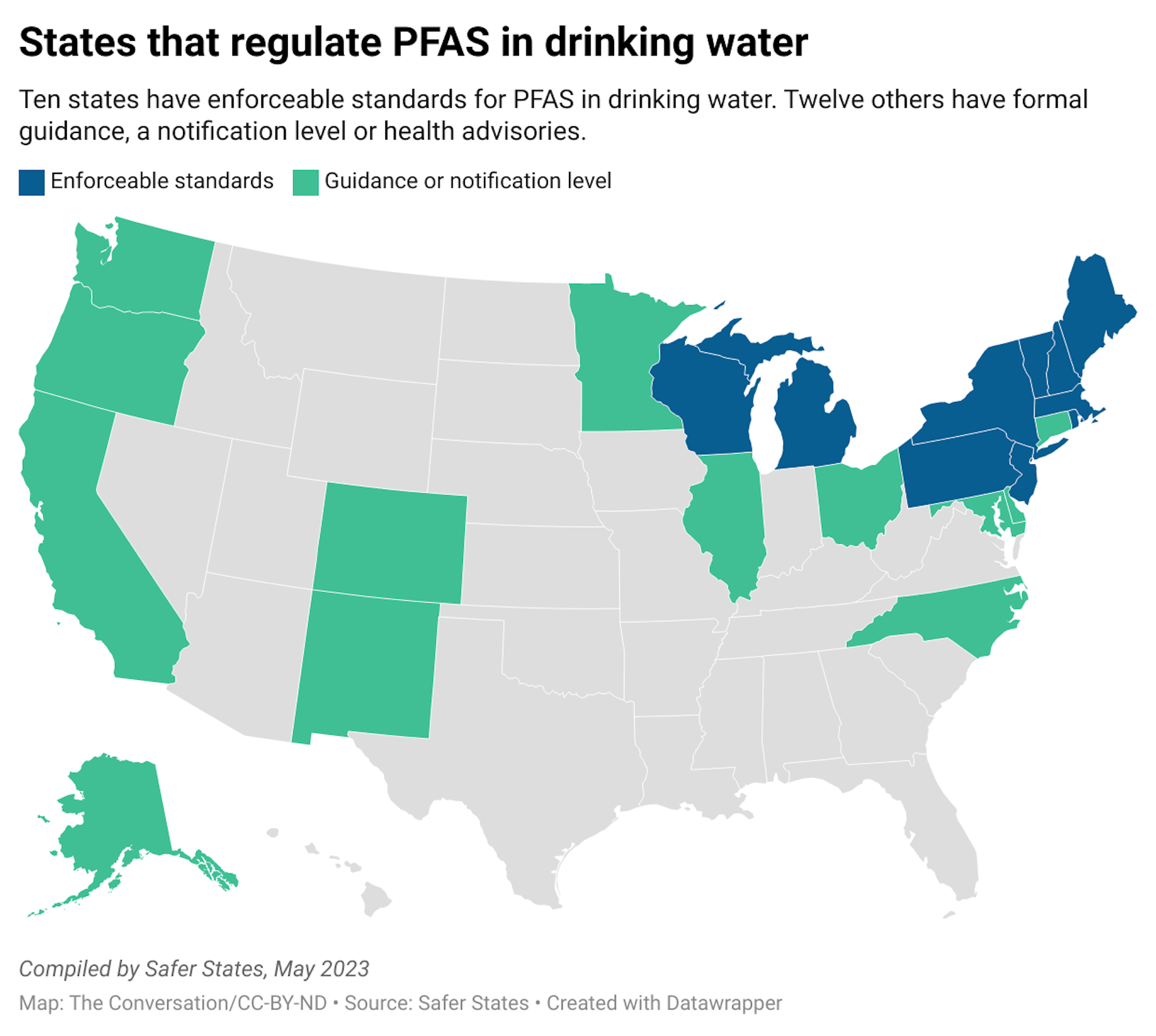
At least 28 states have laws targeting PFAS in various uses, such as in food packaging and carpets. About a dozen have drinking water standards for PFAS. But relying on state laws creates a patchwork of regulations, which places burdens on businesses and consumers to navigate regulatory nuances across state lines.
How can you reduce your PFAS exposure?
Based on current scientific understanding, most people are exposed to PFAS primarily through their diet, though drinking water and airborne exposures may be significant among some people, especially if they live near known PFAS-related industries or contamination.
The best ways to protect yourself and your family from risks associated with PFAS are to educate yourself about potential sources of exposure.
Products labeled as water- or stain-resistant have a good chance of containing PFAS. When possible, check the ingredients on products you buy and watch for chemical names containing “fluor-.” Specific trade names, such as Teflon and Gore-Tex, are also likely to contain PFAS.
Check whether there are sources of contamination near you, such as in drinking water or PFAS-related industries in the area. Strategies for monitoring and reporting PFAS contamination vary by location and PFAS source, so the absence of readily available information does not necessarily mean the region is free of PFAS problems.
For additional information about PFAS, check out the Agency for Toxic Substances and Disease Registry, EPA and U.S. Centers for Disease Control and Prevention websites, or contact your state or local public health department.
If you believe you have been exposed to PFAS and are concerned about your health, contact your health care provider. The National Academies of Sciences, Engineering, and Medicine have published guidance on PFAS exposure, testing and clinical follow-up, which includes information to help health care professionals understand monitoring and clinical implications of PFAS exposure.
This is an update to an article originally published June 21, 2022.
Kathryn Crawford, Assistant Professor of Environmental Health, Middlebury
This article is republished from The Conversation under a Creative Commons license. Read the original article.
Memo reveals damage to pipes inside #GlenCanyon Dam, a threat to #ColoradoRiver water supply — 8NewsNow.com #COriver #aridification
Click the link to read the article on the 8NewsNow.com website (Greg Haas). Here’s an excerpt:
April 12, 2024
Nearly a year ago, the Colorado River was raging through the Grand Canyon, carrying enough water to raise Lake Mead by an astonishing 2½ feet in just five days. The surge that began on April 25, 2023, was part of a “High Flow Experiment” release from Glen Canyon Dam, churning up sediment to rebuild beaches and sandbars through the canyon. But the pipes used to send that gush of water from Lake Powell through Glen Canyon Dam are in trouble, a memo produced by the U.S. Bureau of Reclamation reveals.
“In summary, at reservoir levels below the minimum power pool (elevation 3,490 ft), there are concerns with relying on the river outlet works as the sole means of sustained water releases from Glen Canyon Dam,” the memo said.
The “river outlet works” is a backup system at Glen Canyon, used infrequently because Reclamation needs to generate as much electricity as possible by sending water through the hydropower penstocks, a much larger set of tubes higher up…A special inspection that happened around last year’s High Flow Experiment found erosion within the four 8-foot pipes of the river outlet works. The evidence of “cavitation” is being described by conservation groups as a new part of the “spectacular water crisis” that demonstrates the magnitude of problems with the dam. Cavitation produces shock waves that are powerful enough to damage steel, according to David Wegner, who worked 20 years as an engineer for Reclamation. He was lead scientist for environmental impact studies of Glen Canyon Dam, and a founding member of the Glen Canyon Institute. Wegner is now a senior staff member for the U.S. House of Representatives Water Resources and Environment Subcommittee. He is also a member of the National Academy of Sciences Water Science and Technology Board.
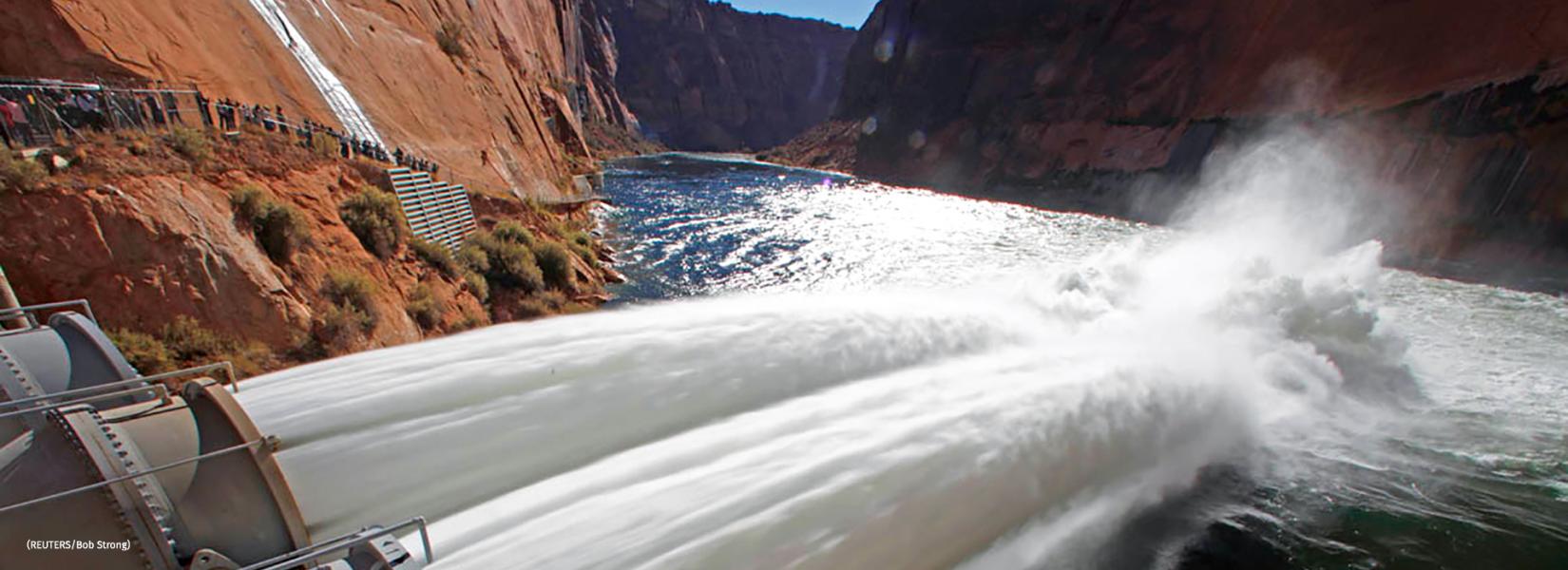
#Drought news April 11, 2024: Although it was a mostly dry week for the Southwest, a reassessment of SPIs at various time scales led to targeted improvements for parts of #NewMexico
Click on a thumbnail graphic to view a gallery of drought data from the US Drought Monitor website.

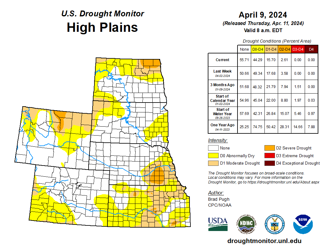
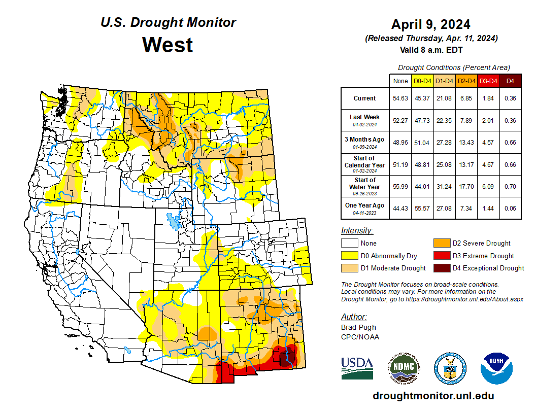
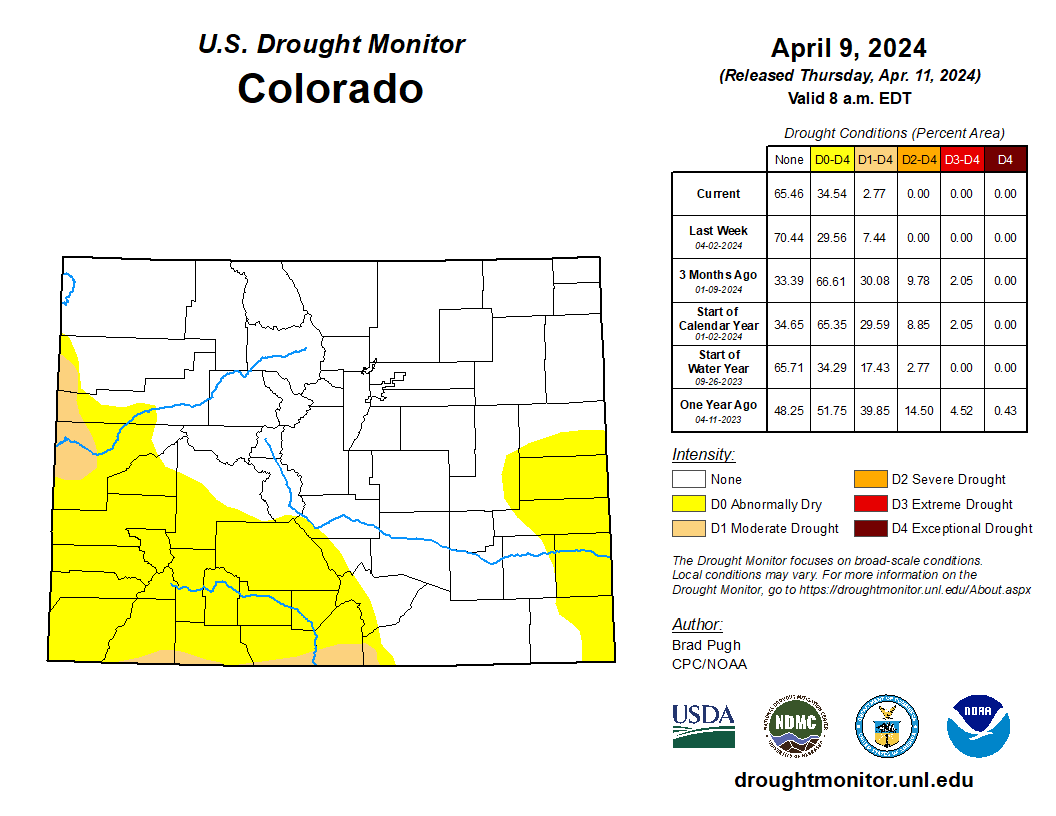
Click the link to go to the US Drought Monitor website. Here’s an excerpt:
This Week’s Drought Summary
Following the El Nino winter and an active early spring pattern, drought coverage is at its lowest since the spring 2020. A strengthening low pressure system and trailing cold front progressed east from the Mississippi Valley to the East Coast at the beginning of April. This storm brought heavy snow (6 to 18 inches, locally more than 2 feet) to the Upper Peninsula of Michigan, Wisconsin, and northern New England. The recent precipitation (rain and snow) during the past few weeks continued to ease drought conditions across the Upper Midwest. From April 5 to 7, a strong storm system tracked east from the Rockies to the Great Plains. Heavy snowfall (6 to 12 inches, locally more) occurred across parts of Idaho, Montana, and Wyoming. Total precipitation amounts of 1 to 2 inches, liquid equivalent, resulted in drought improvement from the north-central Rockies to western South Dakota. Drought continued to develop or intensify across parts of the southern Great Plains and lower Ohio Valley along with Hawaii. Please note that heavy rainfall across the South, occurring after April 9th at 8am EDT, will be considered in next week’s U.S. Drought Monitor…
High Plains
Widespread rain and snow (1 to 2 inches of precipitation, liquid equivalent) on April 7 led to a 1-category improvement across parts of northeastern Wyoming and western South Dakota. Despite the recent heavy precipitation, 6-month SPI along with 28-day average streamflow support a continuation of moderate drought (D1) across the High Plains. Following another week of precipitation along with considerations of soil moisture and SPI values of neutral to positive, abnormal dryness (D0) coverage was reduced throughout the Dakotas. A strengthening low pressure system on April 6 and 7 brought high winds to the Great Plains which dried out topsoil especially across Kansas and southeastern Colorado. A reassessment of SPIs at various time scales and given snow water equivalent is slightly above average, D1 coverage was reduced for southern Colorado…
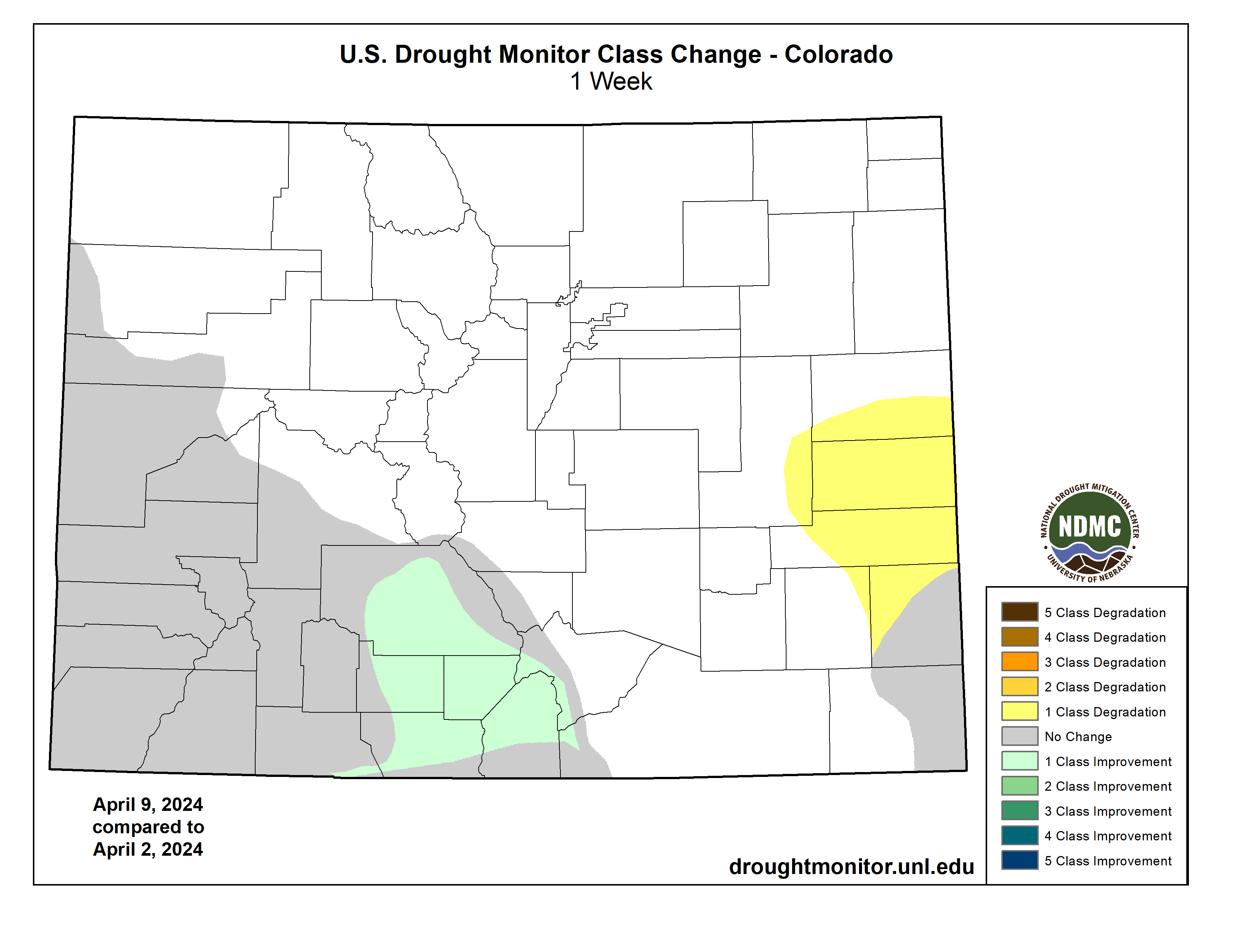
West
As a low pressure system shifted inland, widespread precipitation (rain and high-elevation snow) overspread the West from April 3 to 6. Heavy precipitation (more than 1.5 inches, liquid equivalent) along with snow water equivalent (SWE) amounts near average supported a 1-category improvement to western Idaho and northeastern Oregon. Parts of western Montana also had a 1-category improvement due to a wet week and considerations such as SWE and SPIs at various time scales. The current depiction of moderate to severe drought across Idaho and western Montana lines up well with the 6 to 9-month SPI. On April 5 and 6, a major storm developed across the northern Rockies and high Plains with precipitation amounts exceeding 1.5 inches (liquid equivalent) across southern Montana. Based on this heavy precipitation and lack of support from SPIs at various time scales, a 1-category improvement was made to this region. Neutral to positive SPIs at multiple time scales and SWE near to slightly above normal supported the removal of D0 (abnormal dryness) from western Nevada and adjacent areas of California. Farther to the north, low snowpack resulted in a second week of D0 and D1 expansion across north-central and northeastern Washington. Although it was a mostly dry week for the Southwest, a reassessment of SPIs at various time scales led to targeted improvements for parts of New Mexico.
South
Major drought relief, associated with El Nino, occurred this past winter across the lower Mississippi Valley. Precipitation from April 2-8 led to a small decrease in abnormal dryness (D0) and moderate drought (D1) to parts of this region. Heavy precipitation that occurred after 7am CT Tuesday, April 9th, will be factored into next week’s depiction. A strengthening low pressure system on April 6 and 7 brought high winds and elevated wildfire danger to the southern Great Plains which dried out topsoil, especially across northwestern Oklahoma. 30 to 90-day SPEI along with the lack of vegetation green up supported an expansion of D0 and D1 across parts of Oklahoma. Northern Arkansas and northwestern Tennessee also had an increase in D0 and D1 coverage as short-term precipitation deficits became larger dating back to 60 days.
Looking Ahead
During the next five days (April 11-15, 2024), a low pressure system and trailing cold front will move offshore of the East Coast on April 11th. Locally heavy rainfall (more than 1 inch) is forecast to accompany this cold front. From April 12 to the 14th, much drier weather is forecast throughout the eastern and central U.S. By April 14th, another low pressure system is expected to track inland to the West with additional rain and high-elevation snow. Later on April 15th, another round of wet weather is anticipated for the northern Great Plains and Midwest.
The Climate Prediction Center’s 6-10 day outlook (valid April 16-20, 2024) favors above-normal temperatures across the eastern and southern contiguous U.S. (CONUS) with below-normal temperatures most likely across the northern Great Plains, northern to central Rockies, and Pacific Northwest. Increased above-normal precipitation probabilities are forecast for most of the eastern and central CONUS excluding Florida where below-normal precipitation is slightly favored. Below-normal precipitation is also more likely along the West Coast.

Southeastern #Colorado Water Conservancy District Board: #Aurora water purchase violates 2003 Agreement #ArkansasRiver

Here’s the release from Southeastern Water (Chris Woodka):
April 9, 2024
The impending purchase of an Otero County farming operation by the city of Aurora violates the 2003 Intergovernmental agreement between the Southeastern Colorado Water Conservancy District and Aurora, according to a resolution passed unanimously Tuesday, April 9, 2024 by the District’s Board of Directors.
The action came after Marshall Brown, General Manager of Aurora Water explained details of the purchase and Aurora’s interpretation of the IGA to the Southeastern Board. Aurora intends to spend $80.4 million to buy 5,200 acres of land and the water used to irrigate 4,806 acres. Most of the water used to irrigate the land is through Catlin Ditch shares, along with other water rights in the Arkansas Valley.
Aurora would use the water three years out of every 10 and lease water back to a farming company, C&A Companies, in seven years out of every 10. Brown stressed that Aurora wants to keep farming alive in the Arkansas Valley.
Southeastern claims the sale violates an IGA signed in 2003 that cleared the way for Aurora to use Fryingpan-Arkansas Project facilities to move water out of the Arkansas River basin into the South Platte River basin under a 40-year contract with the Bureau of Reclamation. The IGA also is the foundation for a series of other agreements over the next eight years with other major water providers in the Arkansas basin, including Colorado Springs Utilities, Pueblo Water, the Lower Arkansas Valley Water Conservancy District, Fountain, the Upper Arkansas Water Conservancy District and Fountain.
The major points made in the resolution include:
- The central purpose of the 2003 IGA is to prevent Aurora from purchasing any additional agricultural water rights and permanently transferring those rights out of the basin for permanent use.
- The provision in the agreement to transfer water when Aurora’s storage is below 60 percent refers to storage that was available in 2003, rather than additional storage Aurora may have gained since then or is contemplating building.
- The purchase of additional Arkansas River basin water rights to transfer out of the basin for municipal use in Aurora violates the 2003 IGA, and the Board urges Aurora to refrain from or cease all violations.
- The 2003 IGA is a foundational and beneficial document for the Arkansas River basin and in order to maintain regional cooperation and relationships with water rights owners and entities within the basin, both the District and Aurora must remain in compliance with the IGA.
The 2003 IGA was written following Aurora’s second purchase of Rocky Ford Ditch shares and required payments of $25.5 million to the Southeastern District over 40 years as compensation for the loss of agricultural land. It also allows Aurora to lease water in dry years, and only when Aurora’s reservoirs are less than 60 percent full – so-called “Category 2” water.
During a question-and-answer session, Southeastern Board members sparred with Brown over several topics, including whether Aurora would be willing to put conservation easements on its farmland to assure that irrigation would occur in perpetuity, how Aurora would account for the 60 percent storage requirement, if agricultural conservation and rotating fallowing would be used and why Aurora believes the current IGA has limited its ability to move water.
For the most part, those questions were left unresolved, and Brown indicated Aurora is open to more negotiations. Southeastern Board President Bill Long reminded Brown of the importance of the 2003 IGA: “We have taxpayers who have been part of the District since 1958. … It was this basin who developed the project for the people of this basin. We have people asking, ‘Why are we diverting water out of our basin to build houses in Northern Colorado?’ So, we have issues in this basin we have to work through. The Project absolutely is not being utilized for what its original purpose is for. … This Board will comply with the IGA and defend the IGA on behalf of our constituents, and our view of the agreement may be a bit different than yours.”
#NewMexico’s #RioGrande reservoirs: Running on Empty — John Fleck (InkStain.net)
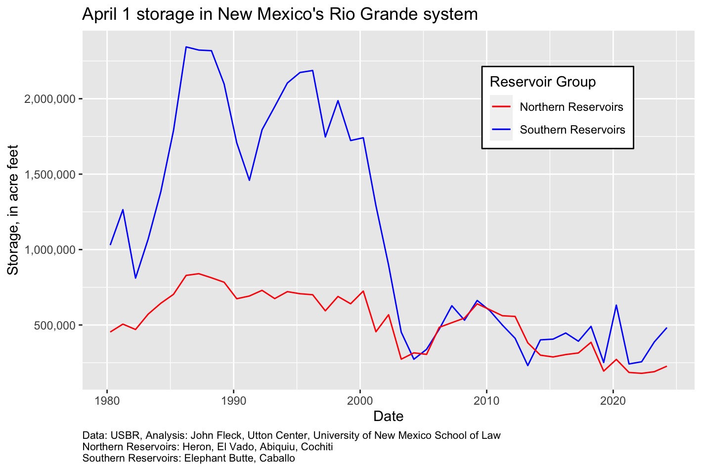
Click the link to read the article on the Inkstain website (John Fleck):
April 1, 2024
Inspired by Jack Schmidt’s monthly “how much water is in Colorado River storage” posts (see here for last month’s), I’ve been playing with a similar tool to help me think about the status of our reservoirs on the Rio Grande system here in New Mexico.
The graph above helps me with two important intuitions about how the system is functioning.
At the decadal scale, the water management shift in the early 2000s from a time of plenty to a time of not plenty is dramatic.
At the interannual scale, the decline in water kept in storage upstream of the middle valley (the red line above) goes from bad to worse beginning in the late teens.
Data choices
NORTH AND SOUTH
Based on a useful conversation with Jack about this, it makes sense here to split things up into two bins – the northern reservoirs (which hold the water available for our use here in New Mexico’s Middle RIo Grande Valley) and the southern reservoirs (which hold storage for the Elephant Butte Irrigation District, El Paso and surrounds, and Mexico).
TIME SERIES
Because of a quirk in the data I have access to, and because I am too lazy to do the work to overcome the quirk, it makes sense to start the time series at 1980. But that also makes conceptual sense in terms of how I think about the system – our “modern era” of water management includes these two broad multi-decadal periods – the wet stuff 1980-2000, and the dry stuff ever since.
TIME STEP
I find it most helpful to plot this at an annual time step. How does storage right now compare to last year at this time? So the graph above is the storage as of April 1 (actually March 31). I’ve plotted it both ways (daily as well), but the interannual ups and downs make it harder for me to see what’s going on.
2024 v. 2023
After last year’s unusually wet year:
- Northern reservoirs are up ~27,000 acre feet on April 1
- Southern reservoirs are up ~95,000 acre feet.
The Loss of El Vado

The loss of El Vado Reservoir, currently under repair, is striking. But what’s also striking is how significantly we were draining it in recent years, before the current repairs started in 2022.
The Middle Rio Grande Conservancy District built El Vado in the 1930s (with an under-appreciated amount of federal subsidy) to extend the irrigation season, capturing spring runoff for use in the dry months of late summer and fall. (“Canals move water in space, dams move water in time.”)
I’m still playing with how best to illustrate this. The graph above shows how full El Vado gets each year as it swells with spring runoff (blue dot) and how far we’ve drained it by the end of the year (red dot).
Catchy Song Lyric version

An Invitation to Play the #ClimateChange Game — Writers on the Range

Click the link to read the article on the Writers on the Range website (Pepper Trail):
April 10, 2024
Let’s play a game, the climate-change game that every living thing on Earth has no choice but to play, starting … now.
The game is called Adapt/Move/Die, and the rules are simple. The object of the game is not to die. And the winners, well, the winners get to keep playing the game.
You may say wait, what about Solve? Isn’t solving the climate crisis an option? Yes, of course, and a worthy goal.
But even if humanity somehow musters the now-lacking resolve to rapidly phase out fossil fuels, greenhouse gases already in the atmosphere are higher than at any time in hundreds of thousands of years. The effects on climate will continue to unfold for centuries.
Adapt/Move/Die used to have another name: Evolution. But Evolution was played without a time clock over centuries or millennia. Adapt/Move/Die is customized for our fast-paced world. Every round is a lightning round, and there are no time-outs.
Let’s get started! Who’s on Team Adapt? You already know some of them well because they are all around us — pigeons and rats, cockroaches and coyotes, dandelions and thistles. No matter how the climate changes, these adapters will find a way, and a place, to survive.
Under the old evolution rules, most species belonged to Team Adapt. But the pace of the new game has changed everything.
Just take a look at your local forest. Its trees were once adapted, attuned to the temperature, soil, patterns of rain and snow and natural pests.
But now, every forest is full of dying trees. A report from the Forest Service estimated that over 36 million, yes, million, trees died in 2022 just in California.
For many plants facing rapid climate change, their only choices are Team Move, or Team Die. It is an unanswered and existential question whether the plants that support the biosphere can move fast enough.
And what of people? As befits our huge numbers and our great cleverness, it is likely that no species on Earth will show such complicated game play.
Team Adapt will mostly be drawn from the global North, where climate extremes may (repeat, may) be somewhat buffered, and where great economic resources can be brought to bear in the name of adaptation.
Here, we hope, coastal cities can be protected behind seawalls and levees. Infrastructure can be strengthened or moved or repaired. Some emergency assistance will be available for victims of “natural” disasters.
Tragically, none of these fixes will be available, or be enough, for huge numbers of people. The United Nations estimates that extreme weather caused 2 million deaths in the past 50 years, but that pales in comparison to what’s coming.
The World Health Organization predicts that climate change will cause an estimated 250,000 additional deaths per year between 2030 and 2050 from disease, starvation and heat stress.
If true, Team Die will claim 5 million members over that 20-year span. Many of those deaths will come from the poorest countries, where people lack even the resources to join the last team: Team Move.
“Move” will, in fact, be the most disruptive play in the game. The UN High Commissioner for Refugees estimates that between 2008 and 2016, an average of 21.5 million people per year were displaced by climate-related events like floods, storms and wildfires.
But again, that is just a mild preview of what could be coming. The same report concludes that 1.2 billion people, or over 10% of the world’s population, could be displaced globally by 2050.
When playing “Move” involves crossing national borders, it often has another name: illegal immigration. From the United States to Europe to Australia, illegal immigration is already considered to be a crisis, and has been a key factor in the rise of right-wing political parties. Given the harsh response to the existing level of illegal immigration, it is frightening to imagine what the future flood of climate refugees could face.
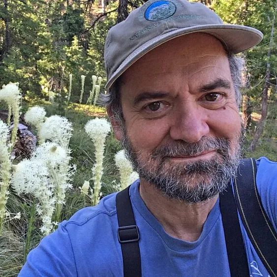
There is only one way to win the game of Adapt/Move/Die. That is to recognize that we all share this critically damaged planet. To succeed, adaptation will require cooperation. To survive, those who must move will require help and compassion.
We can play the game together and win the right to keep playing, that is, to live. Or we can enlist in Team Die by choosing isolation and conflict.
Anyone want to roll the dice?
Pepper Trail is a contributor to Writers on the Range, writersonthernage.org, an independent nonprofit dedicated to spurring lively conversation about the West. He is a conservation biologist who has written widely on evolution and climate change. He lives in Ashland, Oregon.
A classic comeback for Old Man Winter — The #Aspen Daily News
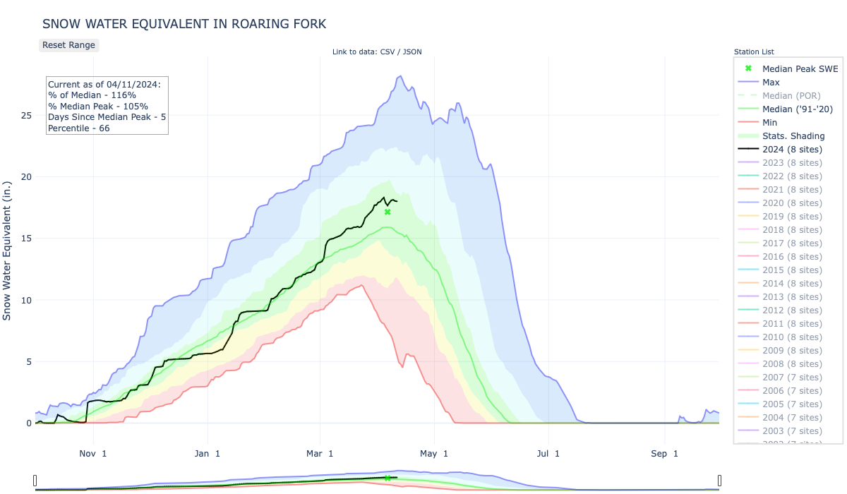
Click the link to read the article on The Aspen Daily News website (Scott Condon). Here’s an excerpt:
April 10, 2024
The snowpack for the Aspen-area mountains was about 46% below the 30-year median after a dry November and was about 35% below in December, according to Sam Collentine, a Basalt-based chief operating officer and meteorologist for OpenSnow.com. Conditions improved slightly in January when the snowpack ended up 3% above the 30-year median for the month, despite a dry stretch for a good share of the month. Conditions finally flipped in February, when the snowpack was 20% above median, and especially in March, which ended at plus 74%…The season started with a lot of promise with two big snowstorms in October that established an impressive base. But, as is typical for Colorado, conditions dried out in November and into December…
Snowmass collected 94.6 inches of snow in March, or 172% of normal. Aspen Mountain recorded just shy of 86 inches or 175% of normal, according to Aspen Weather…OpenSnow’s Collentine took a look for snowfall at the Aspen-Snowmass ski areas for Oct. 1 into early April and found Aspen Highlands nosed out Snowmass with 312 inches to 310 inches. Highlands finished the season at 105% of the 30-year median while Snowmass was at 101%. Aspen Mountain recorded 257 inches or 107% of median while Buttermilk was at 161 inches and 106%…
As a whole, the Roaring Fork basin’s snowpack was at 115% of median on Tuesday. Collentine noted that conditions around Aspen were similar to those in the Upper Colorado River Basin and the state as a whole. The Upper Colorado Basin, which the Roaring Fork is part of, is at 106% of the 30-year median and the statewide snowpack is at 108%.
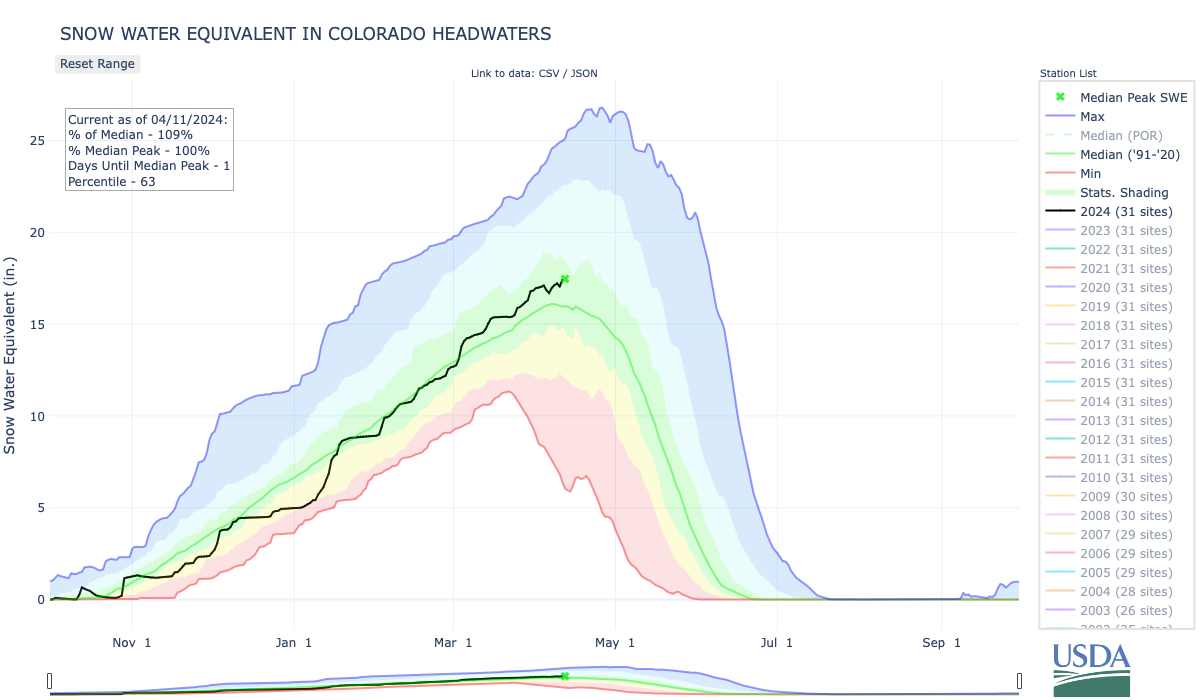
#ColoradoRiver district seeks Summit County’s help in clinching $99 million Western Slope water rights deal — The Summit Daily #COriver #aridification
Click the link to read the article on the Summit Daily website (Robert Tann). Here’s an excerpt:
April 9, 2024
During a Tuesday, April 9, Summit Board of County Commissioners meeting, river district General Manager Andy Mueller told officials that his organization’s efforts to acquire water rights along a segment of the Colorado River “is vital to the health of all of our rivers in the Western Slope.”
Western Slope communities aren’t the only beneficiaries of the current system, with the [Shoshone Hydroelectric] plant’s water rights strengthening flows in Grand, Summit and Eagle counties, providing security to areas that depend on the Colorado River for a host of economic and environmental reasons. If the current water rights were not in place, the main beneficiaries would be Denver Water and other trans-mountain diverters which would experience increased yield through their respective collection systems, according to the river district…
In order to keep the same volume of downstream flow under new ownership, the river district will need to secure a water right for an instream flow, which can only be operated by the Colorado Water Conservation Board. The river district is currently in talks with the board to create a contract to do just that. But the crux of the river district’s deal is the water right’s $99-million price tag.
Sedimentation and Dam Removal: Bringing a River Back to Life — American Rivers

Click the link to read the article on the American Rivers website (Serena McClain):
August 23, 2023
Sediment forms when rocks and soil weather and erode. We think of rivers as something that moves water, but just as important is its ability to move and shape the earth.
One of the primary concerns when planning for dam removal is the impact of sediment transport on water quality, river health, and the communities that depend on healthy rivers. Sediment forms when rocks and soil weather and erode. We think of rivers as something that moves water, but just as important is its ability to move and shape the earth. Sediment comes in all shapes and sizes—everything from silts and clays to coarse sand and gravel. Each of these kinds of sediment mean different things for rivers and aquatic life. Coarser material like gravel and sand often makes up the bed of the river and help create and maintain complex habitat upon which many aquatic communities depend. The presence of dams can starve downstream reaches of sediment, which can lead to increased bank erosion.
Dams create reservoirs and reservoirs accumulate sediment over time—more than 100 years in the case of the four dams being removed from the Klamath River. The degree of sedimentation downstream following a dam removal depends on multiple factors, such as sediment volume, sediment management plans (i.e., phased removal of a dam and passive release of material, dredging), the river’s geomorphology, and the composition of the sediment itself (e.g., fine grain, mud, or coarse). Studies of previous dam removals have shown the resilience of rivers following dam removals. Rivers have the capacity to recover from the influx of sediment after dam removal within a period of days to a few years and tend to thrive afterward. After an initial phase of disturbance following a large removal, the geomorphology of the river stabilizes as the river begins to heal.
We can get a sense sense of how one day the Klamath River will thrive again by looking to other successful removals. The removal of Edwards Dam on the Kennebec River in 1999 is a story of restoration and revitalization. Its removal reconnected migratory corridors that had been cut off for 162 years, improving habitat for Sturgeon, alewife, eagles, and osprey. Millions of alewife now return to the Kennebec.
Another high-profile dam removal where passive release of sediment was utilized is the Condit Dam on the White Salmon River in Washington State. The 125-foot-tall Condit Dam impounded 2.4M cubic yards of sediment, 59% of which was comprised of silt, clay, and very fine sand. More than 60% of the reservoir sediment eroded within 15 weeks of breaching the dam Salmon and steelhead have rapidly recolonized the White Salmon River mainstem and tributaries thanks, in part, to natural river dynamics that allow these systems to recover quickly. In fact, according to the U.S. Fish and Wildlife Service, redds were found throughout the former lake area less than a year after the dam was initially breached.
The 2018 Bloede Dam removal on the Patapsco River in Maryland serves as another useful case study. The 34-foot-tall dam impounded approximately 186,600 m3 of stored sediment, 50% of which eroded within the first six months following removal. River herring were documented (via eDNA) upstream of the former dam site within the first year following removal, and American eel populations skyrocketed from 36 in 2018 to more than 36,500 in 2022. Like the Klamath River dam removals, each of these removals entailed a period of recovery and depended on cross-sector collaboration and advocacy.


While the impacts of dam removals vary significantly, the evidence of the last 20 years points to the effectiveness of dam removal and the long-term benefits for communities, fish, and wildlife. With more than 91,000 dams inventoried by the U.S. Army Corps of Engineers and several hundred thousand more low-head dams, aquatic ecosystems in steep decline (freshwater ecosystems are dealing with extinction at twice the rate of terrestrial ecosystems), and the impacts of climate change altering weather and precipitation patterns threatening the stability and durability of water infrastructure, dam removal has become an increasingly urgent priority in terms of ecological health, community safety, and climate resilience. Simply put, the fastest way to heal a river is to remove a dam.
Switching to #drought-resistant crops ‘ain’t pretty’ – but support for farmers is there — The #Durango Herald

Click the link to read the article on The Durango Herald website (Reuben M. Schafir). Here’s an excerpt:
March 27, 2024
As state negotiators haggle over who will reduce their use of the over-allocated Colorado River, the farmers who ultimately have to implement the inevitable cuts to water consumption are strategizing how to meet that challenge. Why aren’t farmers just planting crops that use less water? That’s what Greg Peterson, executive director of the Colorado Agriculture Water Alliance called “the big question” during a panel on innovative solutions for agriculture Wednesday at the Southwestern Water Conservation District’s 40th annual water seminar…
But large-scale crop-switching “ain’t pretty.” New crops demand new labor skills, expensive new equipment and different processing facilities. And the market for new, water-efficient crops might be small or nonexistent.
“(It’s a) misconception that farmers are market-makers,” said Perry Cabot, a research and extension leader with Colorado State University. “Farmers are market-takers.”
Greg Vlaming runs a soil health consulting business in Lewis, north of Cortez, and works with farmers to take advantage of some of the state’s incentives. Farmers who install soil moisture sensors see the water-saving benefits of improved soil health, he said. The programs help purchase new equipment that minimize the number of passes a farmer must make over a field, or introduce diverse crops with different rooting characteristics…
“You’re wasting everybody’s time if you’re saying, ‘Hey all of you, let’s go grow some Kernza,’” he said.
Instead, the entities pushing for the adoption of more drought-resistant crops need to teach farmers how to farm them. Peterson points to Colorado Mills in Lamar as an example. The company struggled for five years to teach producers to grow sunflowers for sunflower oil before the operation really succeeded.
#Paonia Spring Workshops Teach About Regenerative AG Practices: #Colorado Farm & Food Alliance Regenerative Agriculture Gardens & Classroom at Arbor Farm launches with series featuring regional practitioners and experts
Here’s the release from the Colorado Farm & Food Alliance:
Paonia, CO. (April 9, 2024) – The Colorado Farm & Food Alliance is kicking off our Spring Workshops just as the growing season begins, this weekend (April 13) at our new learning center on Lamborn Mesa, just outside Paonia, Colorado.
Miles Filipeli will lead the inaugural offering this Saturday – Natural Farming with Local Amendments, April 13 – provided to the community by the CO Farm & Food Alliance on a gift model by donation with $20 suggested but none required. The following Saturday will showcase Building Soil and Families: Holistic Grazing, April 20, with Jason Wrich of Wrich Ranches.
Workshops continue May 4 with Cover Crops with Jon Orlando of Rock n Roots Farm and Colorado Farm & Food Alliance’s Elizabeth Agee, May 18 with Native Pollinators in the Market Garden with Paige Payne of Online Landscape Design, and May 25, with our final offering, Alley Cropping with Elizabeth Agee. Information on the series and the full schedule can be found at colofarmfood.org/blog.
Colorado Farm and Food Alliance is excited to bring this series to the Regenerative Agriculture Gardens and Classroom, which is back at its new location in partnership with our host, Arbol Farm, a working farm with a multi-generational legacy of hosting educational events as well as the early days of the local farmers market on-site. (The market has since moved but has kept the Arbol name).
The practices these workshops cover, and that will be demonstrated at our Gardens & Classroom, can offer many benefits to Colorado’s producers. These include market benefits like improved yields and nutrition, as well as more system resilience, habitat enhancements and boosted ecosystem services, and increased adaptation to and mitigation of the effects of climate change.
The Regenerative Ag Gardens and Classroom is the centerpiece of our Just Good Food program, and includes both an indoor and outdoor learning space. Workshops mostly feature a classroom component followed by a hands-on project or planting to solidify the learning in action. The Just Good Food program works to teach, model and advance practices and to promote engagement to further food security, farm resilience, and rural equity. Through these workshops, participants can creatively engage with and explore ways to incorporate some of these practices in their operations.
Colorado Farm and Food Alliance is grateful to continue the educational legacy of Arbol Farm by offering a fun and engaging space for learning, with demonstration and food gardens, workshops of regenerative agriculture principles, movie nights and pizza parties this summer, and more!
Learn about all our upcoming workshops and events at www.colofarmfood.org/events