Silly me. Silly, silly me. And that goes for all of those federal and state officials who have been wringing their hands and gnashing their teeth over the West’s water situation, trying to find some way to keep the region from drying up as the Colorado River shrinks. When all along, the answer was staring us all right in the face: We just had to turn on the big faucet. You know, the big one up there somewhere that collects all the water from the snowcaps that climate change is melting. I think?
Former President Donald Trump unveiled this solution in an address in California. Seriously. You can watch it yourself on this YouTube clip Jeff Tiedrich put up on his newsletter:
And just in case the link doesn’t work or something, here’s the transcript (with punctuation added by me where it seemed to fit):
I had to watch the clip several times, and search around for the context, to make sure I wasn’t missing a lead-in or punchline to the joke. I wasn’t. He was serious.
As much as my snarky side would like to draw this whole thing out for humor’s sake, none of us have time for that. So I’m going to end the suspense: There is no faucet. There is no pipeline, canal, or other infrastructure in place that could move that water southward. And all that gibberish about the Department of Commerce, Gov. Newsom, and 30 gallons per day is nonsense. Maybe Trump believes in the Giant Faucet. Or maybe he just thinks the people listening to him are dumb enough to believe it and vote for him so that he can get someone to go up there and turn the big-as-a-wall faucet and turn California’s brittle forests into lush oases.
There are those who will get mad because I’m being too partisan by beating up on Trump. Believe me, if a Democrat said something this silly I’d be even more scathing in my response. Others will say I should just laugh it off; you can’t take anything the guy says seriously. Which is true. And yet, if Trump is elected, he or someone he appoints will be in charge of big water-related decisions. What are they going to tell him when he orders them to turn on the Giant Faucet?
As I Googled around on this one, it was interesting to see the lengths to which various water experts — especially those friendly ones from Canada — went to explain what Trump might have been talking about. Sure, there’s no faucet, but there have been proposals to ship water from the Columbia River southward — proposals that will never come to pass, because they would cost trillions of dollars and would involve a war with Canada. That’s probably what he was talking about. (It was called the North American Water and Power Alliance. Michelle Nijhuis wrote a fascinating history of the scheme in now-defunct Buzzfeed, which is preserved on the Wayback Machine).
I doubt it. More likely, he was just pulling a random assemblage of concepts out of his a&%. Maybe it’s best to just laugh it off as the ravings of a lunatic in cognitive decline, like all the talk of sharks and batteries and Hannibal Lecter. Thing is, even if it is crazy, it does come from — and reinforce — a common misconception that we can build our way out of the water crisis. It is the tragic Myth of More: If we just add a few more dams, diversions, and canals; if we just shoot some more silver iodide into the clouds; if we could just find some great big person to turn that Giant Faucet, everything will be fine.
Desalination is one of those infrastructure ideas that has long-been held up as an easy solution to the West’s water problems, but which has never caught on because of the crazy expense, energy-intensity, and the environmental impact of sucking water out of the ocean and disposing of the leftover brine. But Hannah Ritchie, at her Sustainability by the Numbers Substack, gives the technology another look. She finds that the technology has evolved, bringing energy use and operating costs down. A U.S. household would use less energy to desalinate all of its water than it does to heat the same water or to heat or cool the home. And it would end up costing the average American household about $154 per year. Not nothing, but not terrible, either.
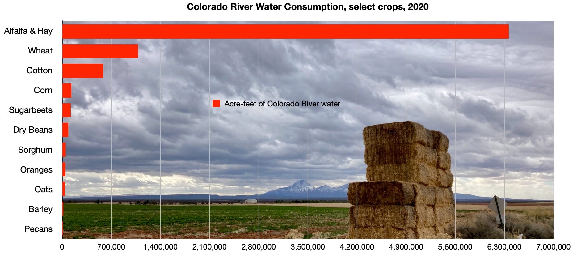
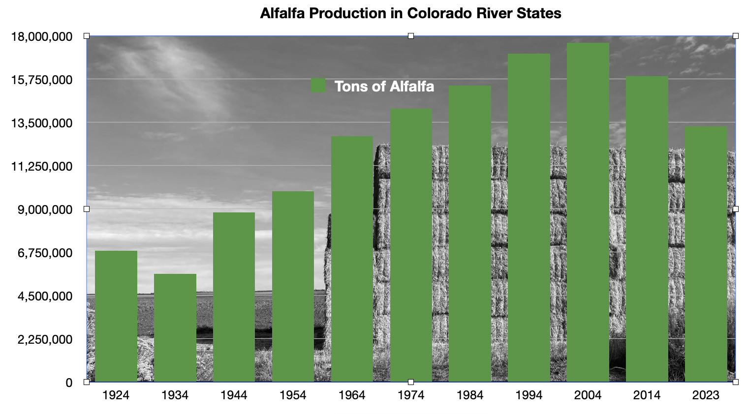
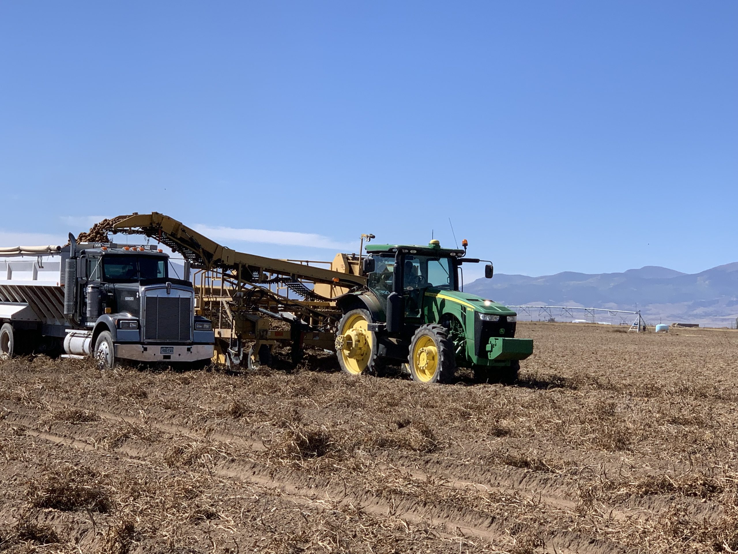
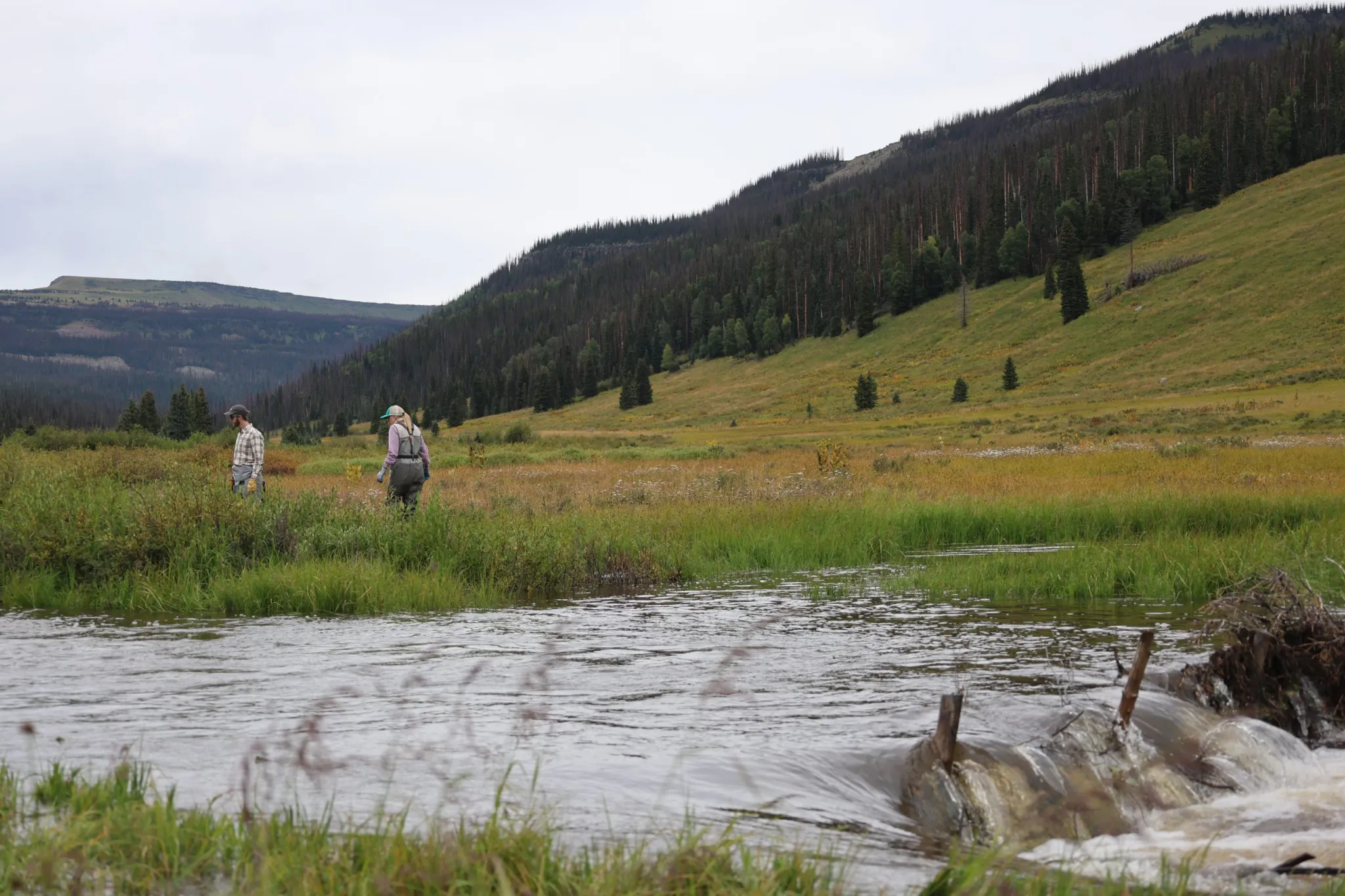
If all irrigation of alfalfa and hay was stopped, it would put more than 6 million acre-feet of water back into the Colorado River system. But it would also wreak havoc — and conflict with the law and values. Credit: Jonathan P. Thompson/The Land Desk
So can we solve the Colorado River shortage by desalinating seawater? Probably not. In theory, municipalities near the coasts could get most of their water from desalination. They could even pump and pipe that water further inland (which requires energy, and therefore increases cost). But relying on desalination for agricultural irrigation would be prohibitively expensive due to the huge volumes of water needed for crops. And, as you’ve read here before, agriculture takes up the lion’s share of the Colorado River.
***
📈 Data Dump 📊
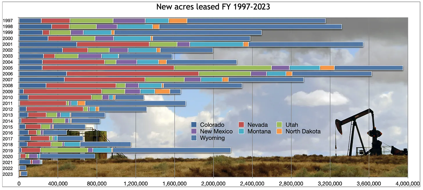
I’ve had a lot of charts on here showing how many drilling permits the Biden administration has issued vs. other administrations. It’s more than some, less than some. But perhaps more important over the long-term is how much new land is leased to oil and gas companies. And by that measure, Biden is way ahead — or behind — of everyone else, depending on your point of view. He’s leased out a record-low amount of land. The totals aren’t yet in for fiscal year 2024 (which ends at the end of this month), but I’m fairly sure they’ll look more or less the same as 2022 and 2023.
Click the link to read the article on the Pagosa Springs Sun website (Danyelle Leentjes). Here’s an excerpt:
September 30, 2024
The Upper San Juan Watershed Enhancement Partnership (WEP) is inviting the public to attend a presen- tation and Q-and-A of the 60 percent designs of the Pagosa Gateway River Project on Oct. 10 from 5:30 to 7 p.m. at the Ross Aragon Community Center.
The public can also view and make comments on the designs on mypa- gosa.org.
The Pagosa Gateway Project is a vital restoration endeavor targeting approximately 2 miles of the San Juan River upstream of the Town of Pagosa Springs. A recent environmental and rec- reational water supply needs assess- ment, commissioned by the WEP, identified potentially significant changes in hydrology and limiting conditions for aquatic life in this sec- tion of the San Juan River. Assessment results suggest late summer and fall flows may restrict the availability and quality of aquatic habitat for fish and other aquatic species, as well as the number of days in a year when recreational craft can successfully navigate this segment of the San Juan mainstem.
Click the link to read the obit on The New York Times website (Bill Friskics-Warren). Here’s an excerpt:
September 29, 2024
He wrote songs for hundreds of other artists, including “Me and Bobby McGee” for Janis Joplin and “Sunday Morning Coming Down” for Johnny Cash, before a second act in film.
Kris Kristofferson, the singer and songwriter whose literary yet plain-spoken compositions infused country music with rarely heard candor and depth, and who later had a successful second career in movies, died at his home on Maui, Hawaii, on Saturday. He was 88. His death was announced by Ebie McFarland, a spokeswoman, who did not give a cause. Hundreds of artists have recorded Mr. Kristofferson’s songs — among them, Al Green, the Grateful Dead, Michael Bublé and Gladys Knight and the Pips. Mr. Kristofferson’s breakthrough as a songwriter came with “For the Good Times,” a bittersweet ballad that topped the country chart and reached the Top 40 on the pop chart for Ray Price in 1970. His “Sunday Morning Coming Down” became a No. 1 country hit for his friend and mentor Johnny Cash later that year…
Kris Kristofferson & Johnny Cash – Sunday morning coming down (1978 Johnny Cash Christmas Show)
Mr. Kristofferson and Rita Coolidge, who were married for much of the ’70s, won Grammy Awards for best country vocal performance by a duo or group with “From the Bottle to the Bottom” (1973) and “Lover Please” (1975). They also appeared in movies together, including Sam Peckinpah’s gritty 1973 western, “Pat Garrett & Billy the Kid,” in which Mr. Kristofferson played the outlaw Billy the Kid. Peckinpah cast Mr. Kristofferson in the film after seeing him perform at the Troubadour in Los Angeles and in “Cisco Pike” (1972), his big-screen debut.
Martin Scorsese then cast Mr. Kristofferson, whose rugged good looks lent themselves to the big screen, as the laconic male lead, alongside Ellen Burstyn, in the critically acclaimed 1974 drama “Alice Doesn’t Live Here Anymore.” He later starred opposite Barbra Streisand in Frank Pierson’s 1976 remake of “A Star Is Born,” a performance for which he won a Golden Globe Award. Over four decades Mr. Kristofferson acted in more than 50 movies, among them the 1980 box-office failure “Heaven’s Gate” and John Sayles’s Oscar-nominated 1996 neo-western “Lone Star.” Singer-songwriters may not be the likeliest of movie stars, but Mr. Kristofferson consistently revealed onscreen a magnetism and command that made him an exception to the rule. In 2006 he was inducted into the Texas Film Hall of Fame, along with Matthew McConaughey, Cybill Shepherd and JoBeth Williams. Mr. Kristofferson’s last major hit as a recording artist was “The Highwayman,” a No. 1 country single in 1985 by the Highwaymen, an outlaw-country supergroup that included his longtime friends Waylon Jennings, Mr. Nelson and Mr. Cash.
Click the link to read the article on The Denver Post website (John Aguilar). Here’s an excerpt:
September 29, 2024
Westminster is making it clear the city doesn’t want to increase access to hikers and cyclists visiting the Rocky Flats National Wildlife Refuge — the one-time site of a Cold War nuclear weapons plant that continues to spark health worries 30 years after it closed. The city last week became the second community surrounding the 6,200-acre federal property to withdraw from an intergovernmental agreement supporting construction of a tunnel and bridge into the refuge, home to more than 200 wildlife species, including prairie falcons, deer, elk, coyotes and songbirds. Broomfield exited the $4.7 million Federal Lands Access Program agreement four years ago, and both cities point to potential threats to public health from residual contamination at the site — most notably the plutonium that was used in nuclear warhead production over four decades — for their withdrawal…
Westminster’s withdrawal comes less than a month after a federal judge denied several environmental organizations a preliminary injunction that would have stopped the project cold. The plaintiffs had sued federal agencies in January, claiming the refuge is not fit for human use.
As part of the City Council’s 4-3 vote last week, Westminster will not pay the nearly $200,000 it owes to the project. The city also will no longer complete a 0.4-mile trail segment in its Westminster Hills Open Space property that would bring hikers and cyclists traveling from the east to the bridge to cross into Rocky Flats.
A prescribed fire along the Colorado Trail near Buffalo Creek in June 2023 is an example of other fuel reduction treatments in the Pike National Forest. Photo credit: Andrew Slack, Colorado Forest Restoration Institute.
The San Juan National Forest is receiving $5 million to restore forest health on 3,000 acres of high-risk fireshed near homes outside Durango. The Wildfire Risk Reduction and Restoration Project will mechanically treat 3,000 acres of forest in the San Juan National Forest, enabling an additional 9,000 acres of future prescribed fire treatment. This project is located between Falls Creek and Durango Hills subdivisions, which are northwest and northeast of Durango, respectively. The treatment will be done in areas where the forest meets homes, called “wildland-urban interface,” said District Ranger for the Columbine ranger district of the SJNF Nick Glidden. The treatment ranges from thinning the trees out so fires spread slower to mechanical brush mastication, which is mulching of vegetation using heavy equipment. The funding is a part of a larger investment from the Biden administration to prepare forests for wildfires…
This project is important because healthy forest fires restore the forest by cleaning up dead material in the forest and increasing soil nutrients, Glidden said. In the past, the USFS has focused on fire suppression. Now, the agency’s wildfire crisis strategy places an emphasis on restoration by reducing the available fuels…On the SJNF, fire managers are striving to work with what they call “good fire.” Pat Seekins, fuels program manager for the SJNF told The Durango Herald last year that the SJNF needs “30,000 to 40,000 acres of prescribed fire” annually to restore lands. Glidden said this number would allow the forest to catch up to full restoration, but the USFS is prioritizing areas that are close to homes with this newly funded project. To put the funding in context, the USFS burned 9,528 acres in the SJNF from Oct. 1, 2022, to Sept. 30, 2023.
On Sept. 19, the Pagosa Springs Town Council adopted new rates for the geothermal water that the town sends to The Springs Resort. The new rates are based on what the council deemed as the “fair mar- ket” values of the heat and mineral content of the water. The council decided that a fair market rate for the heat/energy of the water should reflect the same per- centage of rate increases that general customers have experienced. Geothermal utility customers saw a 100 percent rate increase in the 2022-2023 heating season and a 50 percent increase for the 2024-2025 season. The council’s calculations deem that if The Springs Resort also paid these rate increases for the geother- mal energy, its rate would be $2,084 per month or $25,007 annually, and this rate would be the fair market value for the heat/energy component of the water. On the mineral component, the council decided that the fair mar- ket value would be determined by the daily entry fee that The Springs charges its nonresident visitors. Currently, the resort charges out-of-town purchase the water at these new rates…
The council ultimately decided on $1,675 per month, or $20,100 annually, for the usage of the water’s mineral component, which was calculated by multiplying The Springs’ daily nonresident price of $67 by the number of its soaking pools (25).
The decrease in reservoir storage following the 2024 inflow season has been thankfully modest, but not as favorable as it was at this time last year. Perseverance reducing consumptive uses and losses is needed for reliability and security in the water supply and to regain reservoir storage.
Between mid-April and early July 2024, reservoir storage in the Colorado River basin increased by 2.45 million acre feet (af). Now we are in the nine-month period of progressive decline as reservoir storage supports consumptive uses and losses throughout the basin until the 2025 spring snowmelt season begins. As of 1 September 2024 basin reservoir storage was 28.9 million af, and the combined storage in Lake Mead and Lake Powell was 18.0 million af. Those amounts are similar to conditions from spring 2021 when media outlets began reporting on the emergence of a water crisis. That crisis continues.
It is useful to monitor changes in basin reservoir storage because it is the “bank account” from which we can make withdrawals during dry years. Basin water managers have little control over each year’s watershed runoff, but they have a continuing ability to reduce water consumption.
Basin water managers have a long way to go to replenish reservoir storage to amounts that ensure a secure and reliable water supply. Today’s water in the basin’s reservoirs is slightly more than a two-year supply, based on the average rate of water consumption and losses[1] in the basin. It remains in a precarious state should a string of very dry years occur, as was the case between 2002 and 2004 and between 2020 and 2022.
Although the ultimate cause of the ongoing crisis in water supply is a declining watershed runoff associated with a warming climate, the proximate cause is the inability to reduce consumptive uses to match the declining supply[2]. John Fleck summarized recent progress in reducing Lower Basin water use[3]— that is the kind of progress needed throughout the basin.
Where We Stand Today
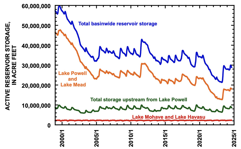
Figure 1 is a reminder that present reservoir storage remains low in relation to conditions throughout the 21st century. Today, 62% of total basin storage is in Lake Mead and Lake Powell, 30% of storage is in reservoirs upstream from Lake Powell, and 8% of storage is in Lake Mohave and Lake Havasu. Storage in reservoirs upstream from Lake Powell increases during each year’s snowmelt season, and subsequently decreases to sustain consumptive uses. Storage in Lake Mohave and Lake Havasu change little. The big changes in the basin are mostly due to changes in storage in Lake Mead and Lake Powell.
Figure 1. Graph showing reservoir storage in the Colorado River basin between 1 January 1999 and 31 August 2024.
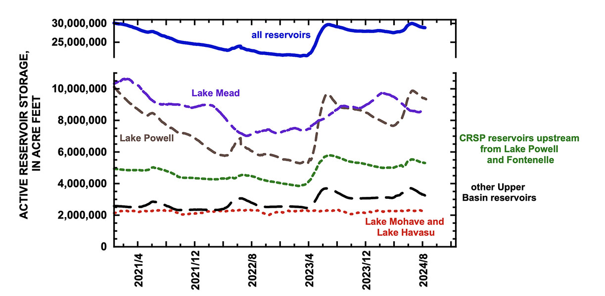
The water supply in Lake Mead and Lake Powell, as well as Lake Mohave and Lake Havasu, supports water use in the Lower Basin and in Mexico. Lake Powell is downstream from virtually all Upper Basin water use. Essentially, Lake Powell and Lake Mead are one reservoir, separated into two parts by the Grand Canyon. Nevertheless, Lake Mead and Lake Powell are operated differently, as is evident in Figure 2. In spring and early summer, snowmelt runoff is captured in Lake Powell, and storage increases there even though storage at the same time decreases in Lake Mead in some years. Once the snowmelt season ends, water is transferred to Lake Mead, and Lake Powell storage slowly declines. Figure 2 demonstrates that changes in water storage in Lake Mead occur over longer cycles than do the annual cycles of storage change that occur in Lake Powell. Because of the different operating rules of the two reservoirs, basin water storage conditions are better reflected by the combined storage contents of the two reservoirs rather than conditions in either Lake Mead or Lake Powell.
Figure 2. Graph showing reservoir storage in different parts of the Colorado River basin since 1 January 2021.Note that water storage in Lake Powell increased greatly during the 2023 inflow season, declined thereafter until the beginning of the 2024 inflow season, increased again in spring 2024, and is now declining.
Despite the modest inflow season of 2024 when unregulated inflow to Lake Powell was only 83% of average, reservoir storage increased by 300,000 af, because losses from the basin’s reservoirs between mid-July 2023 and early April 2024 were less than the gains in storage that occurred in spring 2024[4]. The total decrease in storage between mid-July 2023 and early April 2024 was the smallest in the past decade and was primarily due to reduced consumptive uses in the Lower Basin.
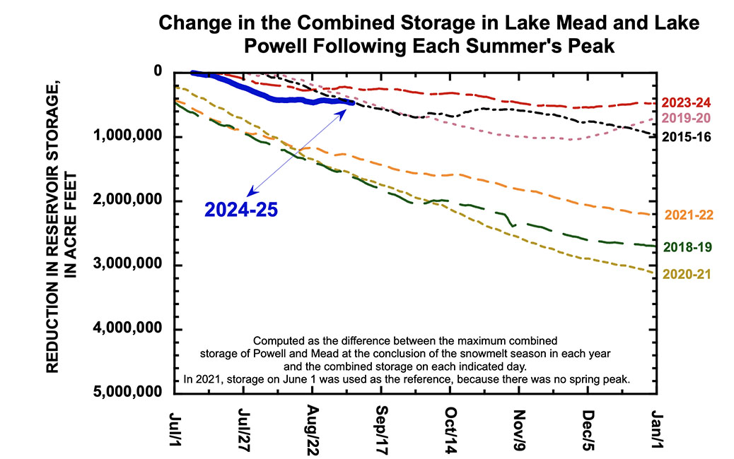
One way to keep track of the loss in reservoir storage due to consumptive uses and losses is to monitor changes in storage that occur after the early summer peak occurs, as is depicted in Figure 3. For example, the dark blue line in Figure 3 was computed by subtracting the total basin reservoir storage on each day from the peak value of 30.0 million af that occurred on 6 July 2024. On 31 August 2024, total basin storage of 28.8 million af was 1.12 million af less than the early July peak. This amount of loss is midway in the range of reservoir loss that has occurred during the past decade. Reservoir storage declined little following inflow in 2017 (2017-2018); 2019 (2019-2020); and 2023 (2023-2024). Storage declined by large amounts following inflow in 2018 (2018-2019); 2020 (2020-2021); and 2021 (2021-2022). These data demonstrate that the current rate of decrease in reservoir storage has been “average” for the last decade but is much greater than the remarkably small rate of loss last year.
Figure 3. Graph showing the decrease in total basin reservoir storage in 2024 (2024-2025) following the early summer peak, compared with the decrease in some other years of the past decade. Loss in reservoir storage was greatest following the 2020 inflow season (2020-2021) and least following the 2023 inflow season (2023-2024). This year’s loss is midway between those extremes.
The rate of decrease in the combined contents of Lake Mead and Lake Powell since early July 2024 has been comparable to the loss in other years of small decline, as is evident in Figure 4. It is especially encouraging that storage in Mead and Powell greatly slowed since mid-August.
Figure 4. Graph showing the decrease in the combined contents of Lake Mead and Lake Powell following peak storage of 18.5 million af that occurred on 8 July 2024, compared with the decrease in some other years of the past decade. Loss in reservoir storage was greatest following the 2020 inflow season (2020-2021) and least following the 2023 inflow season (2023-2024). This year’s loss is similar to years when the loss in combined storage was relatively small.
[1] Basin consumptive uses and losses averaged 13.0 million af/yr for 2021-2023, based on the latest published reports of the Bureau of Reclamation.
[2] Schmidt, J. C., Yackulic, C. B., and Kuhn, E. 2023. The Colorado River water crisis: its origin and the future. WIREs Water 2023;e1672.
[3] Fleck, J. 2024. Imperial Irrigation District’s water use on track for a record low, as is U.S. Lower Basin use. Inkstain, 9 September 2024, https://www.inkstain.net/.
[4] The gain is reservoir storage during the 2024 inflow season was 2.45 million af, and preceding decreases in storage between mid-July 2023 and mid-April 2024 were only 2.15 million af. Thus, inflows in 2024 added 300,000 af to total basin reservoir storage (Schmidt, 2024. The 2024 runoff season comes to an end- how did we do? Center for Colorado River Studies, 17 July 2024, https://qcnr.usu.edu/coloradoriver/).
The challenge, they argue, is the lack of the institutional framework we need to address evolving societal values around the river’s management in a changing world.
Cloud is Vice-Chairman of the Southern Ute Tribe and has become a major voice in the effort to rethink the role of indigenous people in management of the Colorado River. Berggren, now at Western Resource Advocates, is the author of one of the most insightful analyses of Colorado River governance we’ve had in recent years. (I hope that link works for folks, this might also.)
They catalog the remarkable efforts within the last decade or more to create new frameworks for Tribal involvement in Colorado River governance, notably the Ten Tribes Partnership and the Water and Tribes Initiative. Here’s Cloud:
The challenge, as Berggren documented in his thesis, is a set of water management institutions – by “institutions” here I mean the formal rules we wrote to manage water – which are antecedent to the government agencies and political power centers that emerged to carry them out – created to allocate water for municipal and agricultural use.
Because those rules were allocative in nature, the government agencies and political power centers that emerged to carry them out focused almost entirely on carving up the water supply and getting it efficiently to farms and cities. Which worked great, until it didn’t. As the twin challenges of climate change and evolving values emerged, those institutional structures have proven maladaptive.
But it’s a path dependence from which it is hard to dislodge ourselves as new, changing values emerge. These new values (“New” here seems weird, the indigenous communities represent the oldest values! Maybe “newly recognized”?) don’t have a seat at the table.
I don’t know if their proposed solution, is the right one:
But if not this tool, then what should we do instead?
Native America in the Colorado River Basin. Credit: USBR
The U.S. House of Representatives passed a bill sponsored by Utah Republican Rep. John Curtis on Tuesday that includes the Great Salt Lake in the federal government’s Colorado River water conservation plan, possibly freeing up federal funds to help the Beehive State’s beleaguered saline lake.
The Great Salt Lake Stewardship Act tweaks the Central Utah Project Completion Act, which takes water from the Colorado River basin in eastern Utah, and through a system of reservoirs, rivers and pipelines, diverts it to the Wasatch Front where it’s used for municipal and industrial use. The project is described by the Department of Interior as Utah’s “largest and most comprehensive federal water resource development project.”
Now, the secretary of the department can use their budget authority to take water conservation measures “within the Great Salt Lake basin,” according to the bill text.
Curtis says this will give water managers greater flexibility when making conservation decisions regarding the Great Salt Lake, allowing them to take steps to protect “Utah and the West from the economic and public health risks of an ecological disaster.”
“Utahns have worked tirelessly to protect the Great Salt Lake, but persistent drought conditions now threaten its long-term viability. Recognizing the urgency of this issue, the Great Salt Lake Stewardship Act would expand the Colorado River water conservation program to include the lake,” Curtis said in a statement.
The bill was co-sponsored by members of the Utah Delegation, including Republican Reps. Celeste Maloy, Blake Moore and Burgess Owens.
Utah’s Great Salt Lake Commissioner Brian Steed said the bill could have “a huge impact on the lake and its future.”
“It is great to have partners in Congress who recognize these issues and are willing to collaborate to create innovative and effective solutions,” Steed said in a statement.
Water levels at the Great Salt Lake have been in steady decline since peaking in May — currently the south arm of the lake sits at about 4,192.5 feet, with the north arm, separated by a railroad causeway, at about 4,191.8 feet.
That’s a far rosier outlook than years prior, when the lake hit a historic low of 4,188.5 feet in November 2022.
Still, according to the Great Salt Lake Strategic Plan released earlier this year, the lake needs between 471,000 and 1,055,000 acre-feet of additional water delivered each year for it to reach 4,198 feet in elevation, which is considered the “low end” of the healthy range. An acre-foot is almost 326,000 gallons.
Curtis, who has represented Utah’s 3rd Congressional District since 2017, is not running for reelection, instead vying to replace outgoing Utah GOP Sen. Mitt Romney.
Megan Hill is an assistant professor of chemistry and leader of the Hill Lab in Colorado State University’s College of Natural Sciences. Her research leverages organic chemistry to design advanced polymeric materials for applications in sustainability, catalysis and soft materials. She recently sat down with SOURCE to answer some common questions.
What are microplastics?
Given their name, they are micro-sized bits of plastic. There are even smaller nanoplastics that are below that (.5 mm in diameter) threshold (about the size of a grain of rice). They are pieces of plastic that have broken down but never fully degraded.
How long has synthetic, mass-produced plastic been around?
Let’s say about 100 years. Chemists spent a lot of time and effort optimizing polymerization techniques, eventually making catalysts that enabled extremely fast, cheap and easy production of plastic materials. Once the industry realized how useful these lightweight, durable and cheap materials were, then it just kind of exploded. It’s much more complex than that because there was government assistance in making these types of products more affordable. Within the last 10 to 20 years, people started to realize, “Wow, this stuff is still around, and it doesn’t seem like it’s going away anytime soon.”
Dr. Megan Hill at Colorado State University where she teaches. “There’s not a future that is without plastic, but there should be a future with much less and better plastic.” Photo credit: Colorado State University
Have we had better living through chemistry, i.e. plastics, in the past century?
You absolutely have to take that into account. Plastics make cars and airplanes lighter, reducing the amount of fuel that is needed. Wind turbines are made from epoxy resins, crosslinked polymer networks. Polyethylene is used in hip replacements, and Kevlar is something that saves people’s lives. These are all plastic materials.
What are the unintended consequences?
We’ve never had to deal with materials that have such a long lifetime. Every material that we’ve worked with in the past has been environmentally degradable over at least long periods of time. People didn’t realize how long it would actually take these materials to degrade. But now we are facing the fact that nearly every piece of plastic that has ever been made still exists, except for a small percentage that has been incinerated.
Is it bad that microplastics are found in virtually every part of human bodies?
We still have a lot to learn about how microplastics affect our health. Initially, it was thought that it wouldn’t be that big of an issue because particles have to be really small to pass through your esophagus or digestive tract, so we assumed microplastics would not persist in the body. But as these particles have become smaller and smaller, now they’re accumulating in tissues and throughout our bodies. We are still not sure what this means to our health. Plastics are designed to be inert, so the chemical structures are not likely interacting with anything in our body, but they are foreign objects that your body will likely react to. There’s still a lot unknown about the severity or what might actually happen as these particles accumulate more in animals and then humans as it goes up the food chain.
Dr. Megan Hill in the chemistry lab at Colorado State University where she teaches. Photo credit: Colorado State University
What’s an example of your lab’s research in polymers?
One area of research our lab focuses on is integrating reversible or degradable bonds into polymer networks and backbones. By making some of the bonds reversible, we can improve the ability for the materials to be broken and reformed, without compromising their material properties — a big problem plastic recycling is currently facing. Another CSU group has pioneered polymer materials that can be chemically recycled, a route that enables polymers to be broken down to their starting materials so they can be remade into the high-quality materials that are needed in industry.
What does it mean for a polymer to be sustainable?
It means finding starting materials that aren’t derived from oil. [ed. emphasis mine] It means using processes that are less energy intensive. It means thinking about the end-of-life of the materials we are making. We still aren’t exactly sure how long it’s OK for something to persist in the environment, and the answer will certainly depend on several different circumstances, but it needs to be addressed. Something I find hopeful and inspiring is how the whole polymer community, and chemistry community, has refocused our attention on these issues. I wouldn’t say that anyone’s doing research now without thinking about the end fate of the materials they are making, which is something that people just didn’t consider before.
What are some positive developments?
Scientists have teamed up and come up with some really promising solutions. They have developed new recycling methods, they have engineered enzymes that are more efficient at breaking down plastics, they have developed catalysts that can convert plastics into useful chemicals, etc. There is also funding for researchers to develop sustainable materials, figure out creative methods to tackle the abundance of plastic waste, and for people to start companies. So I see a very bright future in this. It would help if the government would make plastic a little more expensive or have some sort of incentives to get companies to stop using it. It’s incredibly difficult for individual consumers to avoid all the plastic that is cheap and easy.
What can people do to help?
Every little action helps. Support companies that try to steer away from plastics, vote for politicians who support research, and if you can, spend or give a little extra money to show it’s something you care about.
Top 10 sources of plastic pollution in our oceans.
The Department of the Interior today marked major progress for the short and long-term health of the Colorado River System. In Santa Fe, New Mexico, Bureau of Reclamation Commissioner Camille Calimlim Touton joined leaders from the Imperial Irrigation District (California), Bard Water District (California), Metropolitan Water District (California) and Gila River Indian Community (Arizona) to sign five water conservation agreements that will leverage funding from President Biden’s Investing in America agenda to help advance water conservation across the West.
Short-term agreements with the Imperial Irrigation District, Bard Water District and Metropolitan Water District are expected to conserve over 717,000 acre-feet of water by 2026. The agreements with the Gila River Indian Community are the first long-term agreements to be signed and have the potential to create system conservation of over 73,000 acre-feet within the next 10 years.
“The Biden-Harris administration is committed to making western communities more resilient to the impacts of climate change,” said Secretary Deb Haaland. “With transformational resources provided through President Biden’s Investing in America agenda, the Interior Department is collaborating with states, Tribes and partners to make smart investments to strengthen the stability and sustainability of the Colorado River System to support the families, farmers and ecosystems that rely on this vital basin.”
“We are proud to announce these agreements that will support the long-term health of the Colorado River System by shoring up elevations,” said Reclamation Commissioner Camille Calimlim Touton. “The agreements with the Imperial Irrigation District and the Bard Water District in partnership with the Metropolitan Water District will contribute a significant amount of system conservation through 2026 and the new agreements with the Gila River Indian Community are the beginning of our long-term investments that will improve the sustainability of our river for generations to come.”
The lifeblood of the American West, the Colorado River Basin provides water for more than 40 million people and fuels hydropower resources in seven U.S. states. It is a crucial resource for 30 Tribal Nations and two states in Mexico and supports 5.5 million acres of agriculture and agricultural communities across the West, in addition to important ecosystems and endangered species. It is currently experiencing the longest and worst drought on record, driven by hotter temperatures under climate change. The Biden-Harris administration is leading a comprehensive effort to make Western communities more resilient to climate change and address the ongoing megadrought across the region, by harnessing the full resources of President Biden’s historic Investing in America agenda.
Short Term Conservation Agreements
Conservation agreements signed today with the Imperial Irrigation District and Bard Water District in partnership with the Metropolitan Water District signify the final short-term agreements signed under “Bucket 1” of the Lower Basin System Conservation and Efficiency Program with funding from the Inflation Reduction Act. The agreement with the Imperial Irrigation District is the largest from the Bucket 1 effort, expected to provide up to 700,000 acre-feet of system conservation water to Lake Mead between 2024-2026 with a total investment of approximately $589.2 million. The agreement with the Bard Water District in partnership with the Metropolitan Water District conserves up to 17,100 acre-feet of water during the same time period at a cost of about $6.8 million. This water will remain in Lake Mead in an effort to benefit the Colorado River System and its users.
Reclamation has now executed 25 agreements that are projected to conserve more than 2.28 million acre-feet of water. The agreements are part of the three million acre-feet of system conservation commitments made by the Lower Basin states.
Long Term Conservation Agreements
An initial $700 million investment from the Inflation Reduction Act was announced in June to support long-term conservation in the system. Today’s agreements with the Gila River Indian Community represent the first agreements signed under this investment. The agreements invest approximately $107 million into three projects with the potential to create system conservation of over 73,000 acre-feet within the next 10 years. Reclamation is also working with Southern Nevada Water Authority, the Metropolitan Water District of Southern California, Coachella Valley Water District, City of Tucson, San Diego County Water Authority, Town of Gilbert, Salt River Valley Water Users’ Association & Salt River Project Agricultural Improvement and Power District and City of Phoenix in the Lower Colorado Basin to negotiate water conservation contracts for up to 10 additional proposed projects.
Overall, the funding for long-term water conservation initiatives in the Lower Basin is expected to save more than 1 million-acre-feet of water, putting the Colorado River Basin on a path to a more resilient and sustainable water future.
Historic Investments to Address the Drought Crisis
President Biden’s Investing in America agenda represents the largest investment in climate resilience in the nation’s history and is providing much-needed resources to enhance the resilience of the West to drought and climate change, including to protect the short- and long-term sustainability of the Colorado River System. Through the Bipartisan Infrastructure Law, Reclamation is investing $8.3 billion over five years for water infrastructure projects, including water purification and reuse, water storage and conveyance, desalination and dam safety. The Inflation Reduction Act is investing an additional $4.6 billion to address the historic drought.
To date, the Department has announced the following investments for Colorado River Basin states, which will yield hundreds of thousands of acre-feet of water savings each year once these projects are complete:
Aging Infrastructure: More than $1.02 billion for infrastructure repairs on water delivery systems in the Colorado River Basin states from the Bipartisan Infrastructure Law, which will preserve ability to deliver water and power benefits to over 40 million people every year in the Colorado River Basin.
Water Storage and Conveyance: More than $648 million in new water storage and conveyance investments in Colorado River Basin states, which will grow the supply of new water or enhance benefits from existing reservoirs within the Basin states.
Water Recycling: $505 million for 26 water recycling projects in the Colorado Basin that are expected to increase annual water capacity by hundreds of thousands of acre-feet annually
Water Conservation: More than $416 million in WaterSMART grants in Colorado River Basin States, which will conserve tens of thousands of acre-feet of water and make Basin water supplies more resilient.
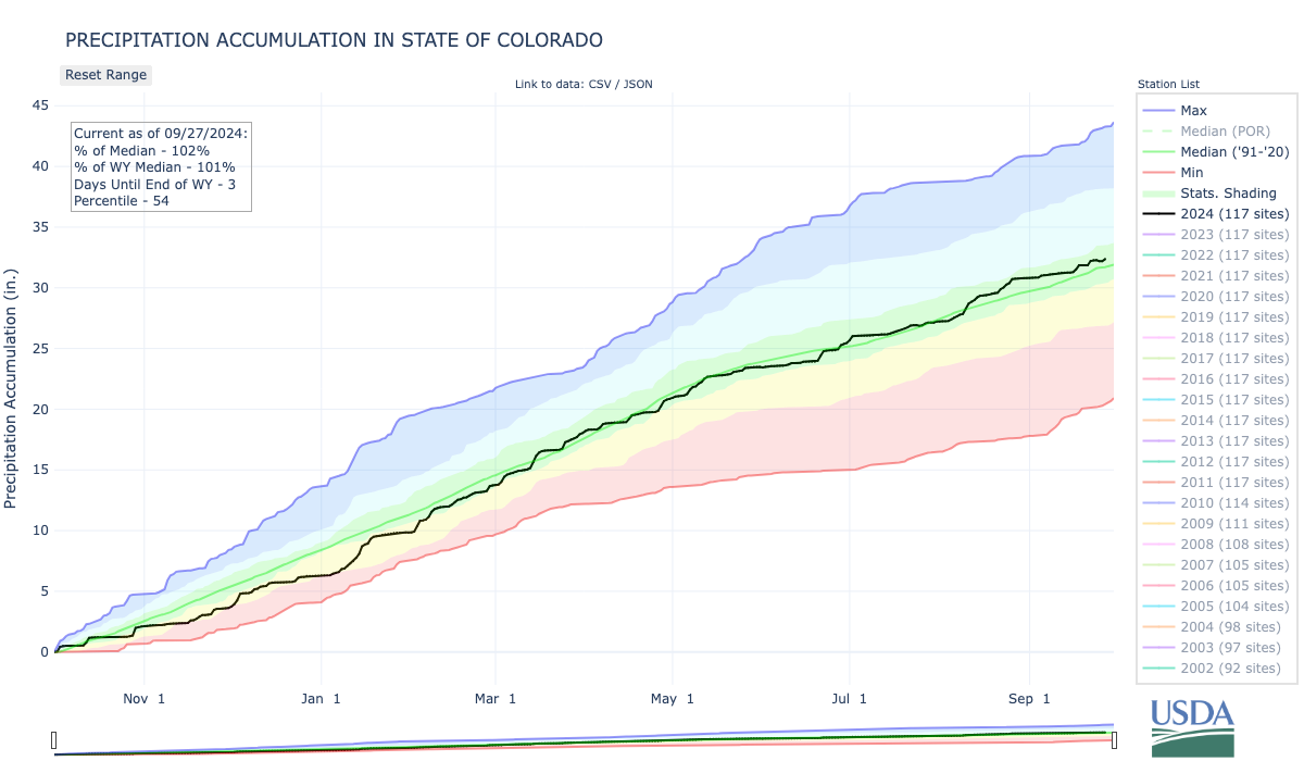
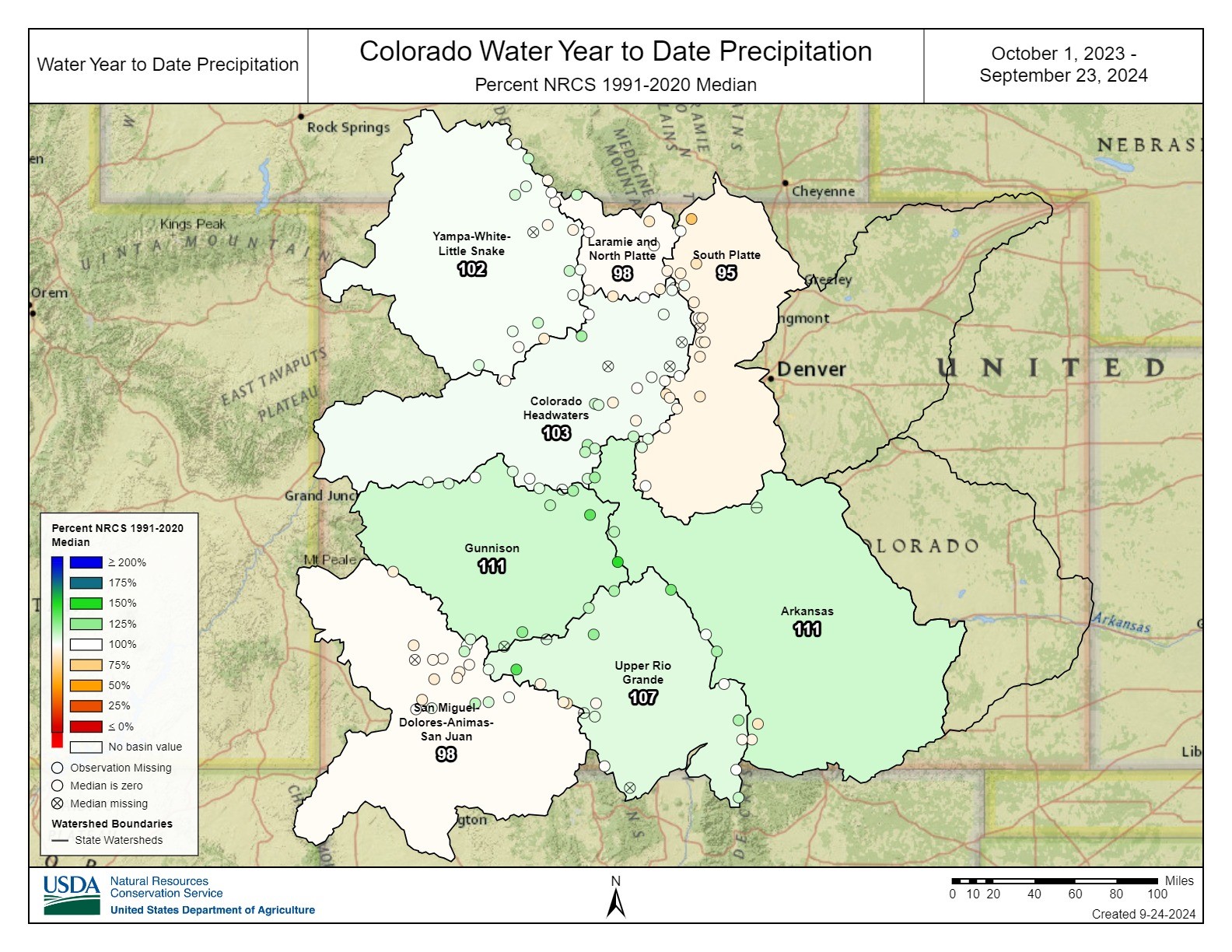
Just for a moment, forget about drought and water shortages, because this year, it’s been wet in Colorado, with precipitation hitting 102% of normal.
The wet weather hasn’t pulled the state or the American West out of its naggingly, sometimes desperate, dry existence, but it has delivered some surprises, according to experts reviewing data at the state’s water monitoring committee meeting Sept. 24.
“Much of northern Colorado has been drier than normal, but areas of southern Colorado have been wetter than normal,” said Peter Goble, assistant state climatologist at Colorado State University’s climate center.
So wet, in fact, that it helped pull the statewide average above 100%.
Weather watchers, researchers and hydrologists track water based on a reporting period known as the “water year.” It begins Oct. 1 and ends Sept. 30, a time that captures the buildup of winter snowpacks and spring runoff. Most of the state’s water supplies come from these sources.
As the 2024 water year comes to a close on Monday, Peter Goble, assistant state climatologist, said the numbers were refreshingly normal, with some surprises in parts of the state normally starved for water: The Arkansas and Upper Rio Grande river basins, which routinely fall last in line when it comes to storm systems.
The Arkansas Basin, for instance, saw precipitation that topped 111% of normal, while the Rio Grande’s numbers hit 107%.
“It’s good news when we’re above average for the basin,” said Jack Goble, general manager of the Lower Arkansas Water Conservancy District in Rocky Ford in the Lower Arkansas Basin. He is not related to Peter Goble. “But as is typical, it depends on where you are. You can drive 20 or 30 miles in any direction and go from green to brown.”
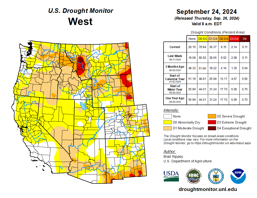
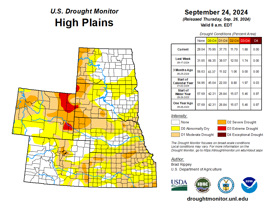
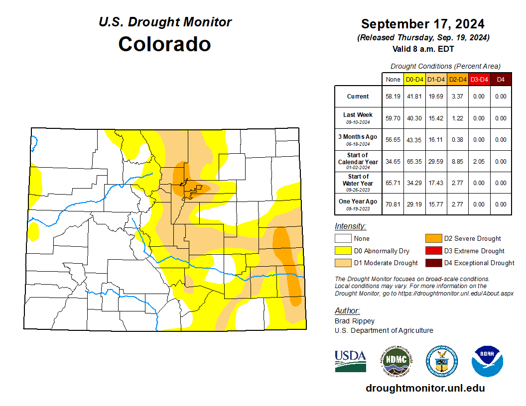
In fact, according to the U.S. Drought Monitor, drought is already beginning to reappear in parts of the Arkansas Basin and other areas on the Front Range.
Colorado Drought Monitor map September 24, 2024.
Another surprise: Even with ultra hot temps in places like Grand Junction, precipitation was heavy.
“Warm and wet is a bit unusual for Colorado for the summer,” Peter Goble said. “Usually it’s warmer going drier and cooler going wetter.”
The South Platte River Basin, which includes metro Denver and Fort Collins, saw a slightly different scenario, with precipitation registering slightly below normal and temperatures coming in at record highs.
“It was a hot summer,” said Nathan Elder, Denver Water’s manager of water supply. “But Denver fared all right,” in part because customers stuck to their lawn-watering schedules and the utility, the largest in the state, had a strong spring runoff that allowed its reservoirs to fill.
In fact, reservoirs across the state have healthy supplies, coming in at 93% of normal, according to Nagam Gill, a hydrologist with the Natural Resources Conservation Service in Lakewood.
“Our reservoir storage is in good shape,” Gill said, “and many basins are reporting above-average levels.”
Looking ahead, Peter Goble said there is an 80% chance that a La Niña weather pattern will develop early this winter, which could mean a delayed start to the snow season but heavy snowfall eventually for the northern Rockies. La Niña refers to a time period when colder temperatures prevail in certain parts of the Pacific Ocean.
For water utilities, a La Niña doesn’t offer much predictability in terms of next year’s water supplies, and so the go-to strategy is to keep reservoirs as full as possible.
“We’ve seen wet years and we’ve seen dry years,” Denver Water’s Elder said. “To deal with the uncertainty, we set up our system this time of year so that we have an equal chance of filling all our reservoirs, and we rely on our customers to use water wisely.”
More by Jerd Smith. Jerd Smith is editor of Fresh Water News. She can be reached at 720-398-6474, via email at jerd@wateredco.org or @jerd_smith.
Prior to mining, snowmelt and rain seep into natural cracks and fractures, eventually emerging as a freshwater spring (usually). Graphic credit: Jonathan Thompson
Across the state, Colorado has 23,000 abandoned mines awaiting cleanup. Untreated, these mines spread acid mine drainage into an estimated 1,800 streams. Many of these legacy mines — inoperational areas with historic mining activity — leach heavy metals into watersheds, harming aquatic ecosystems. Cleaning up mines could help improve water quality and contribute to healthier watersheds. Colorado’s Water Resources and Agriculture Review Committee recently advanced a bill to help remove dangerous mining waste. Bill 4 would establish a new permit process through the Division of Reclamation, Mining, and Safety in the Department of Natural Resources (DNR) to facilitate the removal of mining waste. The permits are intended for projects that would improve water quality by cleaning up mines that are no longer operational. Currently, Colorado laws make some cleanup efforts challenging due to strict regulations that are intended to protect the ecosystem from mining operations — not reclamation of legacy mines. The new permit type would focus on areas that are “sources of discharge,” leaking acid mine drainage or heavy metals into the watershed. Permit applicants would still be required to comply with any applicable surface or groundwater water quality conditions. If approved, the bill would help expedite “reclamation-only” permits issued starting in July 2025…
The “Bonita Peak Mining District” superfund site. Map via the Environmental Protection Agency
Locally, the region’s history of mining still affects water quality today. Critical headwaters in the San Juans are surrounded by old mining areas. On Red Mountain Pass between Ouray and Silverton, Red Mountain Creek runs orange. Both natural minerals and ceased mining operations contribute to the creek’s hue. Heaps of mine tailings also funnel the river in a straight line into the Uncompahgre River and down into Ridgway. Bill 4 is intended to incentivize clean up of some of these 23,000 abandoned mines across the state, while improving water quality.
The Town of Palisade is pursuing a federal grant that would help it fund the remediation and regrading of its sewer lagoons and turn a portion of that property into a constructed wetlands for migrating waterfowl. Town Administrator Janet Hawkinson told the Palisade Board of Trustees at its Tuesday meeting that the grant is through the Bureau of Reclamation and could provide several million dollars without requiring a match.
“We are working right now with our town engineers on a cost estimate to look at if it’s $2 million, $3 million or $6 million we’ll request for this grant application,” Hawkinson said.
The town has a grant and loan from the Department of Agriculture to build a pipeline to the Clifton Sanitation District’s wastewater facility for its sewage. Once that is complete the current lagoons will be remediated. Palisade Community Development Director Devan Aziz said the proposed plan would improve water quality, mitigate health hazards and restore habitat in the area of the sewer lagoons. The lagoons are located along the Colorado River just east of Riverbend Park.
“The proposal would be to create a constructed wetlands for migratory waterfowl, as well as removing invasives like tamarisk and Russian olive and enhancing plant biodiversity,” Aziz said. “This project directly addresses drought related habitat loss while fostering environmental regeneration.”
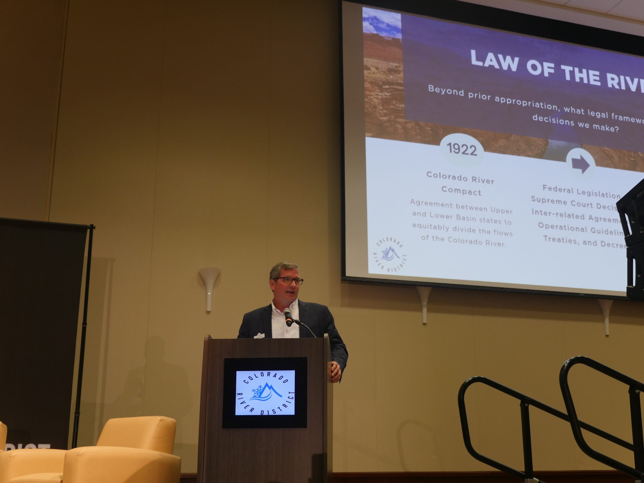
Andy Mueller, general manager of the Colorado River District, speaks at the district’s annual water seminar on Friday, Sept. 20 at Colorado Mesa University in Grand Junction. Colorado River District/Courtesy photo
Water availability on Colorado’s Western Slope is under increasing pressure and uncertainty from climate change, population growth, and ongoing negotiations.
“We’re seeing a shrinking resource, and one trend that is likely to continue to accelerate whether we have more precipitation or not … is the warming temperatures are going to drive less water available for human use,” said Andy Mueller, general manager of the Colorado River District. “The question is: Can we as a society come together and plan for that? We haven’t done a great job of doing that so far, but perhaps we can.”
He posed this question to a room full of water managers, agricultural producers, and elected officials in Grand Junction on Friday, Sept. 20, for the Colorado River District’s annual water seminar. This year’s seminar encouraged attendees to “meet the moment” and to find clarity, solutions, and opportunities amid water insecurity in the West. As the event kicked off, attendees were asked to share the biggest challenge facing water management in their community. Words like “drought,” “scarcity,” “lack,” “quantity,” “politics,” “knowledge,” “climate change,” and “agreement” dominated the responses from attendees…
With these negotiations underway in the basin, conflict is likely unless stakeholders begin working together, planning, and learning from past mistakes and challenges…This collaboration includes bringing more voices to the table, particularly those left out of historic water negotiations. Lorelai Cloud, vice chairman of the Southern Ute Indian Tribal Council and director for the Colorado Water Conservation Board, said the 30 Native American tribes in the Colorado River Basin are 100 years behind on the conversations after being left out of the initial compact negotiations and many of the subsequent discussions.
“New plot using the nClimGrid data, which is a better source than PRISM for long-term trends. Of course, the combined reservoir contents increase from last year, but the increase is less than 2011 and looks puny compared to the ‘hole’ in the reservoirs. The blue Loess lines subtly change. Last year those lines ended pointing downwards. This year they end flat-ish. 2023 temps were still above the 20th century average, although close. Another interesting aspect is that the 20C Mean and 21C Mean lines on the individual plots really don’t change much. Finally, the 2023 Natural Flows are almost exactly equal to 2019. (17.678 maf vs 17.672 maf). For all the hoopla about how this was record-setting year, the fact is that this year was significantly less than 2011 (20.159 maf) and no different than 2019” — Brad Udall
Crews scrambled in 2023 to repair multiple breaks in a water pipeline that serves the twin towns of Kemmerer and Diamondville. (courtesy/Kemmerer-Diamondville)
Waking up to long-overdue system upgrades, dozens of towns that were awarded federal ARPA dollars may see them ‘clawed back’ for lack of resources to complete paperwork.
This story is part of an ongoing series between WyoFile and The Water Desk exploring water issues in Wyoming. —Ed
After a town council shakeup, Micah Foster was suddenly mayor of his tiny eastern Wyoming agricultural town. A wave of resignations last April meant that in addition to getting up at 2 a.m. each day for his regular job — delivering bread to grocery stores for Bimbo Bakeries — Foster found himself running his 400-person town.
In June, as Foster was still adjusting to his new role, he got some good news. Lingle was awarded a $1.4 million American Rescue Plan Act grant to upgrade aging sewage pipelines — a big deal for any small town, sparing it from having to borrow the money because it cannot possibly raise rates high enough to cover such an expense. Lingle even secured the required 10% match from the state, Foster said.
But there was a hitch. To complete the required engineering plan, the town still needed the cooperation of BNSF Railway to cross its tracks on the south side — a slow process and an effort that the town’s small, overworked staff struggled to accomplish.
Wyoming officials, in July, reminded town leaders that the engineering plan must be complete, contracts signed and the project “shovel-ready” by Oct. 1, or the state would be forced to revert, or claw back, the grant to pre-empt the federal government from taking the money back — from Lingle and the state.
“There’s no way we can get that done,” Foster said, adding, “We’re not Cheyenne,” referring to the capital city’s advantage in having a full professional staff. “We don’t have an engineer on staff to do this and push it. So we were happy [when initially approved for the grant] and then we were sad.
“It’s like dangling a carrot in front of you but it was never really there,” he added.
Many Wyoming towns and entities that have been awarded ARPA grant dollars administered by the state worry they may suffer the same fate. In August, the Office of State Lands and Investments hosted a webinar with municipalities and others, striking a tone of urgency as staff reiterated the Oct. 1 deadline to prove ARPA grant projects are ready for shovels to hit dirt, or lose the money.
“We want to have this opportunity to make long-term investments with these dollars,” Wyoming Grants Management Office Administrator Christine Emminger told attendees. “So create the pressure on your contractors to get these dollars obligated, get them contracted at your local government or your entity level. Because if they are not contracted, and you do not provide that evidence to the Office of the State Lands and Investments (OSLI), we will have to go back and recapture those dollars.”
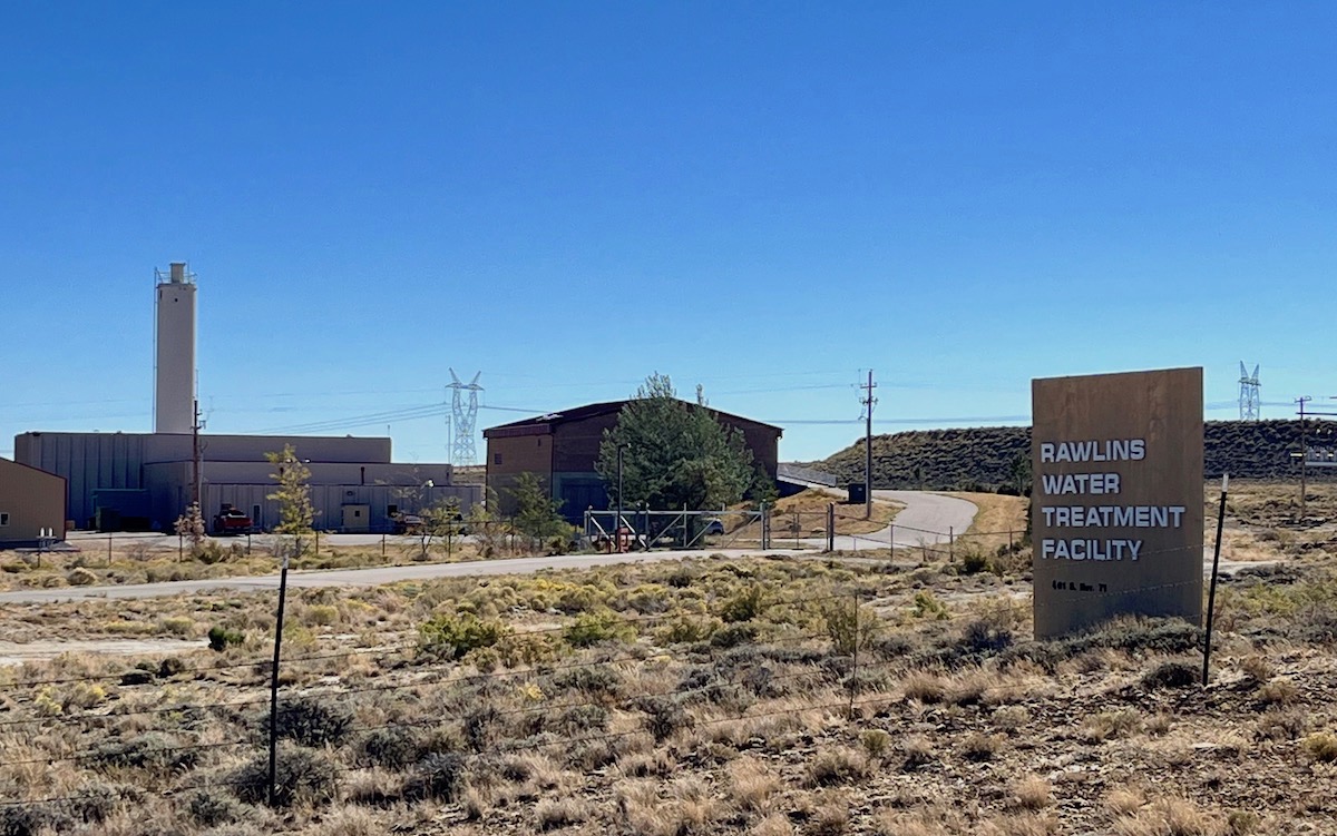
The Rawlins water treatment facility, pictured Sept. 16, 2022. (Dustin Bleizeffer/WyoFile)
More than 50 of 159 state-administered ARPA grant recipients for water and sewer projects have yet to file completed compliance documents to avoid recapture, according to state officials.
“OSLI is in regular communication with all the entities that have not yet provided the necessary information, and are making every effort to provide assistance, where possible,” Gov. Mark Gordon’s press secretary Michael Pearlman told WyoFile.
The state is also facing a tight deadline, and is at risk of losing potentially tens of millions of federal dollars that budget-strapped communities desperately need. Wyoming’s mineral royalty revenues, which used to fund such water infrastructure funds, are drying up due to the declining coal industry.
State officials, under the guidance of the governor’s office, will determine in October which ARPA grants to claw back, then rush to “redeploy” those dollars before the federal government’s Dec. 31 deadline, they say. Though Gordon has indicated his priorities for redeploying ARPA dollars, exactly who and what projects the state might choose before the end of the year is yet to be determined.
“Any funds available after the Oct. 1 deadline may be deployed to local governments to reimburse or reduce local matches for previously approved water infrastructure projects,” according to an Aug. 19 press release from the governor’s office.
Meanwhile, there’s an increasingly urgent need among Wyoming towns to update water and sewer systems.
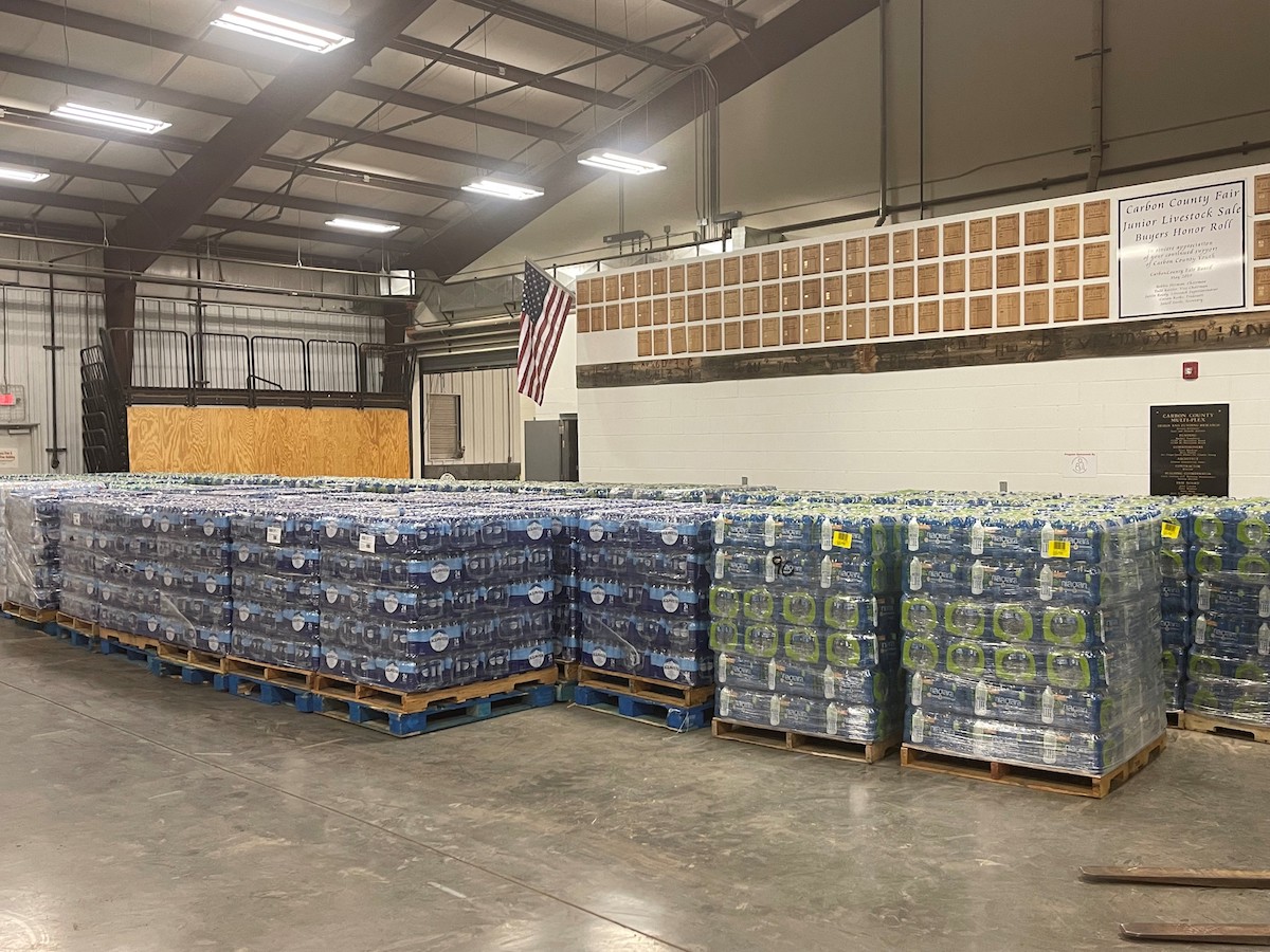
A stockpile of bottled water was collected to help residents in Rawlins and Sinclair to get through a temporary boil advisory in March 2022. (courtesy/City of Rawlins)
The neighboring oil boom-and-bust towns of Midwest and Edgerton in the middle of the historic Salt Creek oilfield are relying on ARPA dollars to help cover an estimated $5 million cost to replace 7 miles of potable water pipeline at risk of corrosion due to acidic soils in the oilfield.
In the neighboring towns of Kemmerer and Diamondville (with a combined population of about 3,000) in the state’s southwest corner, town officials have described a chicken-and-egg dilemma to fund long-overdue upgrades necessary to not only meet current demands, but to meet the needs of construction workers arriving for the $4 billion Natrium nuclear energy project already underway. The construction workforce is expected to peak at 1,600 in 2028, although many of the workers will commute from other nearby towns, according to officials. Project developers, backed by both the U.S. Department of Energy and Microsoft billionaire Bill Gates, say it’s up to local government entities in Wyoming or the federal government to make any needed investments.
Human-caused climate change plays a role, too, forcing many towns to consider increasing competition for secure sources of water made more scarce due to warming and drying trends.
Cascading water challenges
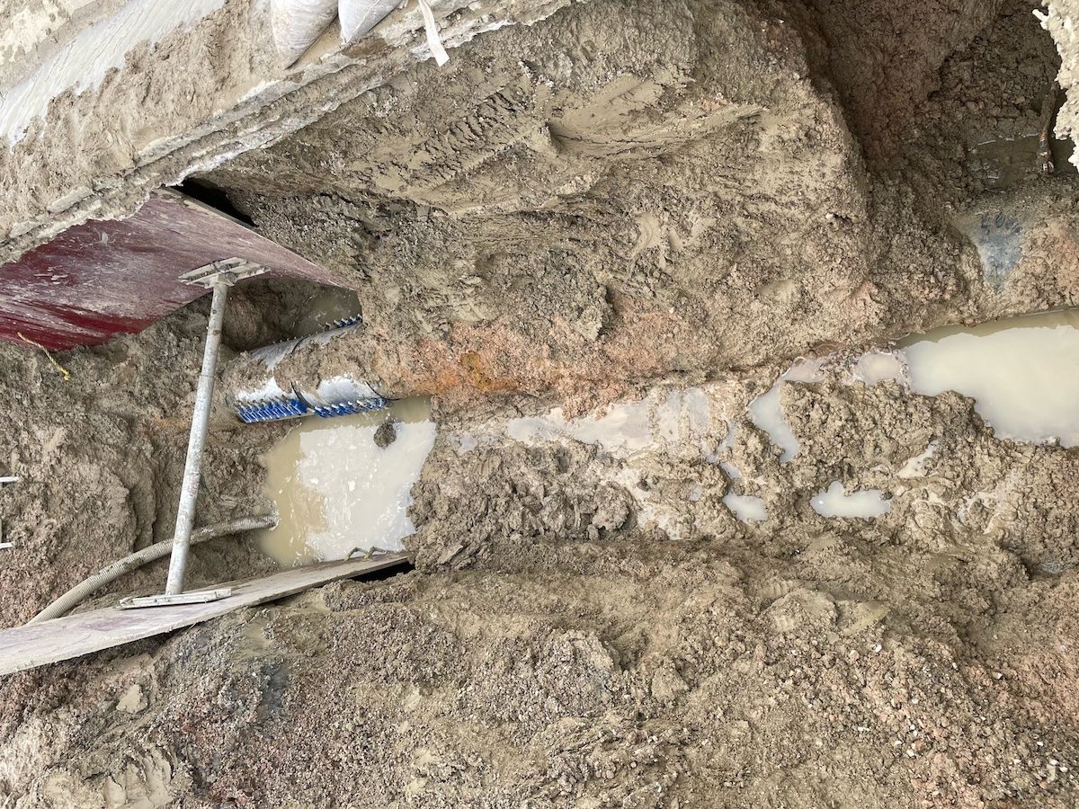
Sometimes when you patch a leak, you spring another one down the line. Then another, and another.
That was the challenge for city water crews in Rawlins over Labor Day weekend. They chased and patched six leaks at gushing “weak points” in the aging municipal water system that serves both Rawlins and neighboring Sinclair without major interruptions to water deliveries, according to officials.
Rawlins relies on several natural springs in the Sage Creek Basin for its municipal water supply. (courtesy/City of Rawlins)
It’s a routine that many water crews in Wyoming towns have become well practiced at in recent years: Fixing one leak in a frangible network begets another — a result of depressurizing then re-pressurizing segments of pipe. The problem worsens when you’re dealing with an aging system long overdue for upgrades.
And towns like Rawlins aren’t just patching leaks. They’re looking at systemwide water and sewer upgrades vital to simply meet existing demand, not to mention potential population growth and previously unfathomed pressures of climate change.
In March 2022, Rawlins residents were under a boil order for nearly a week due to a “catastrophic” failure in the 100-plus-year-old wood-stave pipelines that deliver the majority of water to the municipal system from springs 30 miles south of town.
In addition to the expense and task of gradually upgrading the wooden pipelines — nearly 2 miles have been replaced so far — the town also brought back online a long-derelict pre-water treatment plant so it can supplement its water supply by pumping from the North Platte River, as needed. Flow from the springs that provide Rawlins and Sinclair most of their water varies greatly, depending on seasonal snowpack, according to city officials. And those seasonal flows are only becoming more unpredictable.
All told, it will take nearly $60 million for necessary water system upgrades, according to Rawlins officials. They’ve already had some success landing grant dollars from state and federal sources, including ARPA dollars. But to secure those grants, and other fundsin the form of loans, water users have been asked to pony up.
The average residential water utility bill has increased by about $30 per month since 2022, officials say.
“Our rates were too low to support the maintenance and the work that we have to do on our lines,” Rawlins City Manager Tom Sarvey said.
“A lot of these grants or loans require that you show community buy-in,” Rawlins spokesperson Mira Miller said. “So you can’t apply for these things if you can’t show that you are charging your customers a fair rate.”
Rawlins — because it’s been in emergency mode for the past two years — is confident about the security of its state-administered ARPA funding so far, according to officials. But many other towns with pressing water system improvement needs aren’t so sure.
Many small towns, even those that clearly qualify for federal grants, struggle to complete engineering and other required planning in the arduous process due to a basic lack of resources and expertise, Wyoming Association of Municipalities Member Services Manager Justin Schilling said.
Kemmerer, population 2,800, was selected as the host community for TerraPower’s Natrium nuclear reactor power plant. (Dustin Bleizeffer/WyoFile)
“Municipal government, it’s a constant rotation of people, so they might not have been aware how urgent [completing grant requirements] was,” Schilling said. “So, we had a bunch of these small communities that got a lifeline tossed to them, but because of engineering delays, the state’s got to pull it back and slide it to shovel-ready projects so that it doesn’t just go back to the feds.”
State officials, in their August webinar with ARPA recipients in the state, fielded about a dozen questions from concerned community leaders.
“I know the process has been cumbersome,” State Loan and Investments Grants and Loans Manager Beth Blackwell told attendees, adding that state officials knew all along that the ARPA requirements were going to be a major challenge for many small, resource-strapped towns to meet. “My staff is working extremely hard, and it’s just, we’ve got to make sure that at the end of the day, the state’s not on the hook to paying these funds back.”
In Lingle, without the ARPA grant, there’s no alternative plan in the works to fund the wastewater system upgrades, Mayor Foster said.
From email from Reclamation (Western Colorado Area Office):
With forecast sufficient flows in the critical habitat reach, the Bureau of Reclamation has scheduled a decrease in the release from Navajo Dam from 700 cubic feet per second (cfs) to 600 cfs for Friday, September 27th, at 4:00 AM.
Next week, on October 1st at 7:30 AM, Reclamation will begin a maintenance project that will necessitate a switch to the 4×4 for the release point. The release may fluctuate slightly during the switch, and the water downstream of the dam may be silty for a day or two following this release point change. The maintenance project will continue throughout October and November.
Releases are made for the authorized purposes of the Navajo Unit, and to attempt to maintain a target base flow through the endangered fish critical habitat reach of the San Juan River (Farmington to Lake Powell). The San Juan River Basin Recovery Implementation Program recommends a target base flow of between 500 cfs and 1,000 cfs through the critical habitat area. The target base flow is calculated as the weekly average of gaged flows throughout the critical habitat area from Farmington to Lake Powell.
This scheduled release change is subject to changes in river flows and weather conditions. If you have any questions, please reply to this message, call 970-385-6560, or visit Reclamation’s Navajo Dam website at https://www.usbr.gov/uc/water/crsp/cs/nvd.html.
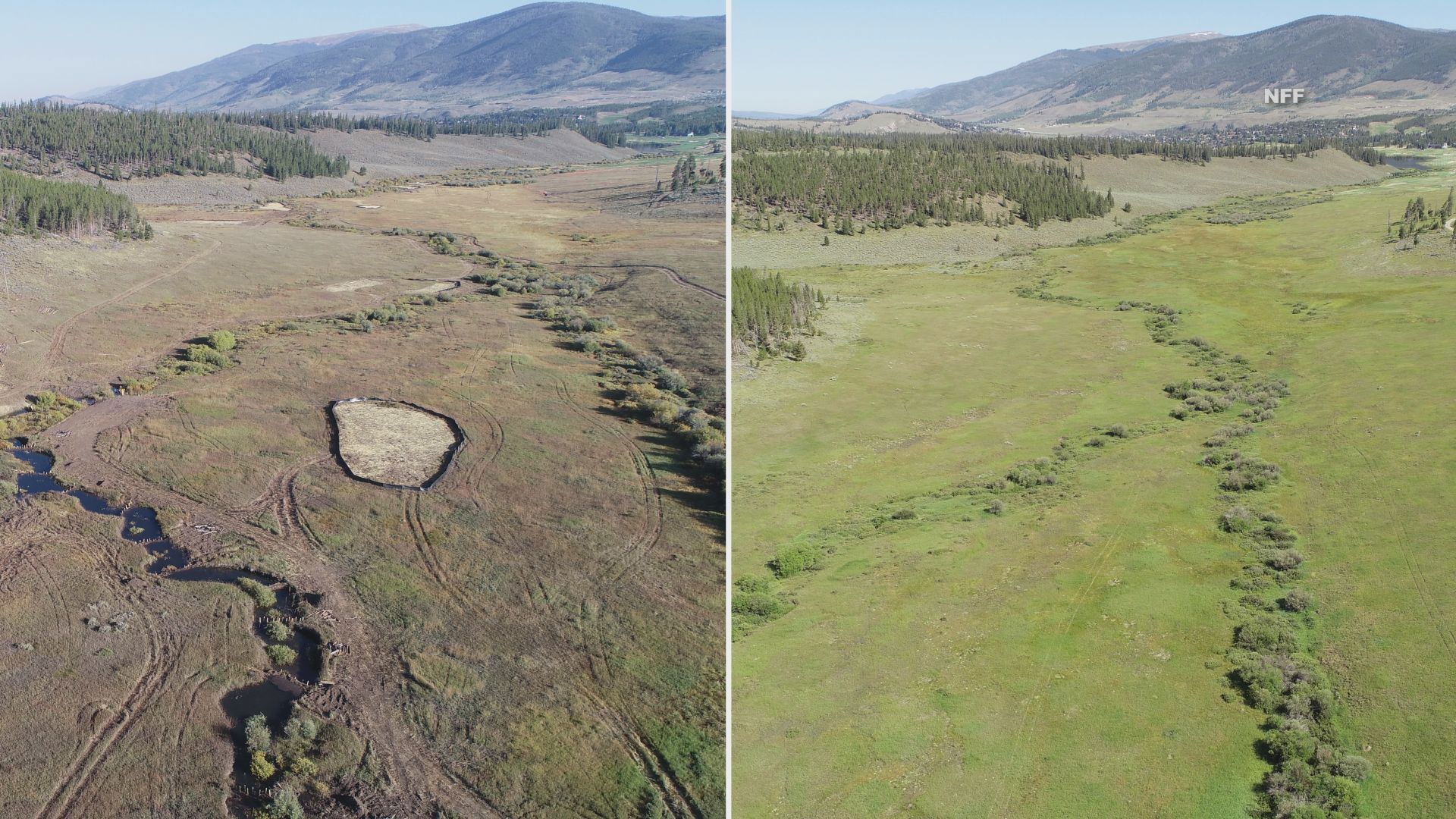
Before and after photos show a drastic change to the landscape. Credit: National Forest Foundation
Click the link to read the article on the 9News.com website (Brianna Clark). Here’s an excerpt:
September 17, 2024
Wetlands play a major role in keeping our water clean. Yet, according to the National Forest Foundation, the U.S. has lost more than half of them in the lower 48 states because of infrastructure development and agricultural practices. The Soda Creek Restoration Project hopes to undo some of that loss in Colorado…The project is part of a larger effort to restore 40 acres of wetlands in the White River National Forest, reestablishing nearly 30 acres while rehabilitating another 12.5 acres. The NFF started the project last month and all the work is being done by hand with the help of volunteers. One of several things they’re doing is creating dams to slow down the water allowing it to spread out over the valley. NFF Colorado River Watershed Program Coordinator Adde Sharp said the historic wetland in Summit County was converted into a cabbage farm more than a hundred years ago, causing the area to dry up and the landscape to change. Sharp said turning the area back into a wetland is a big deal because Soda Creek is upstream of Dillon Reservoir, which provides drinking water to the Denver area.
“Wetlands dramatically improve water quality because they’re like sponges or filters that are filtering out sediment and different contaminants in the water, heavy metals, etc.,” said Sharp. “If you live downstream of a wetland- and we all do, there are wetlands upstream of all of us- this is really improving your water quality.”
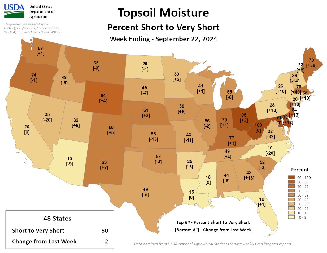
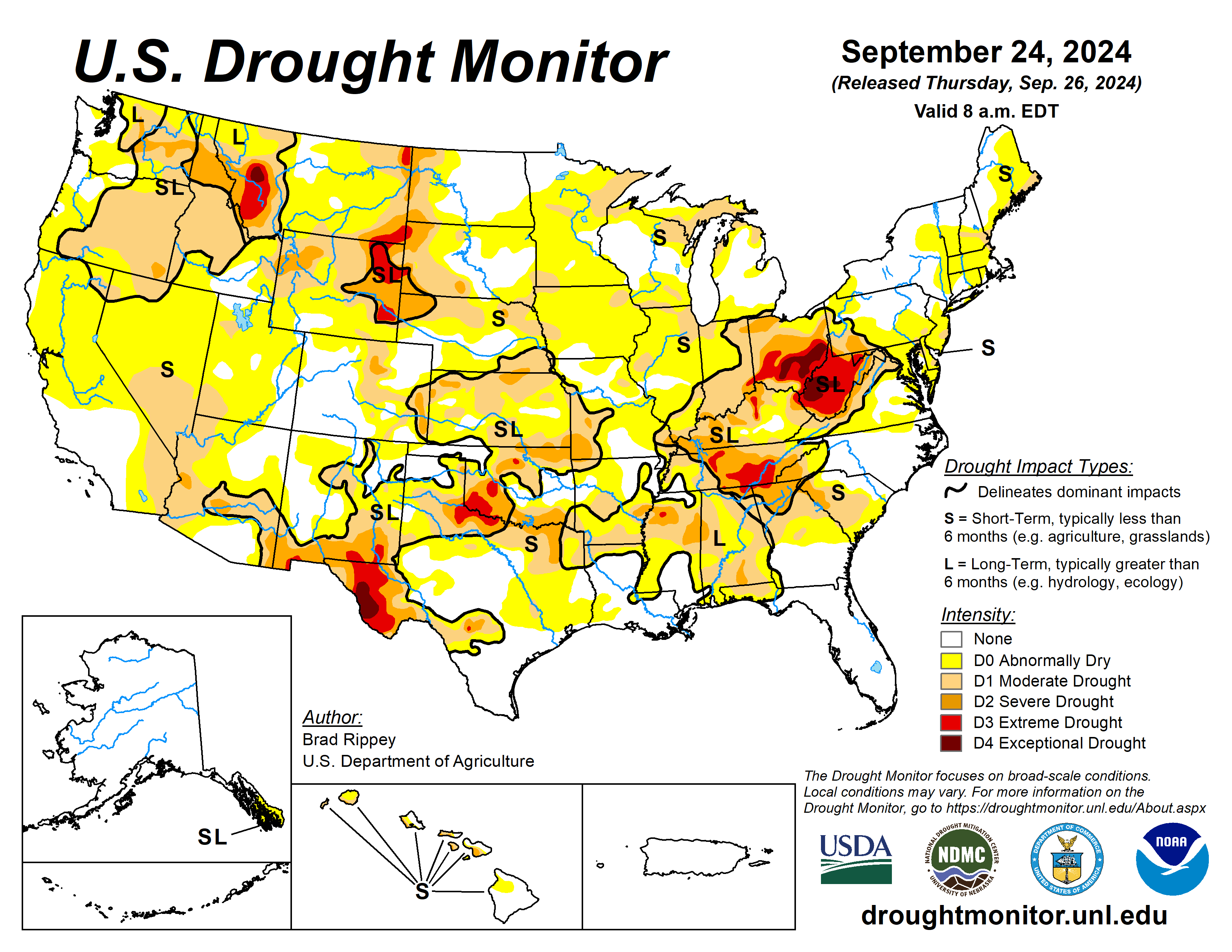
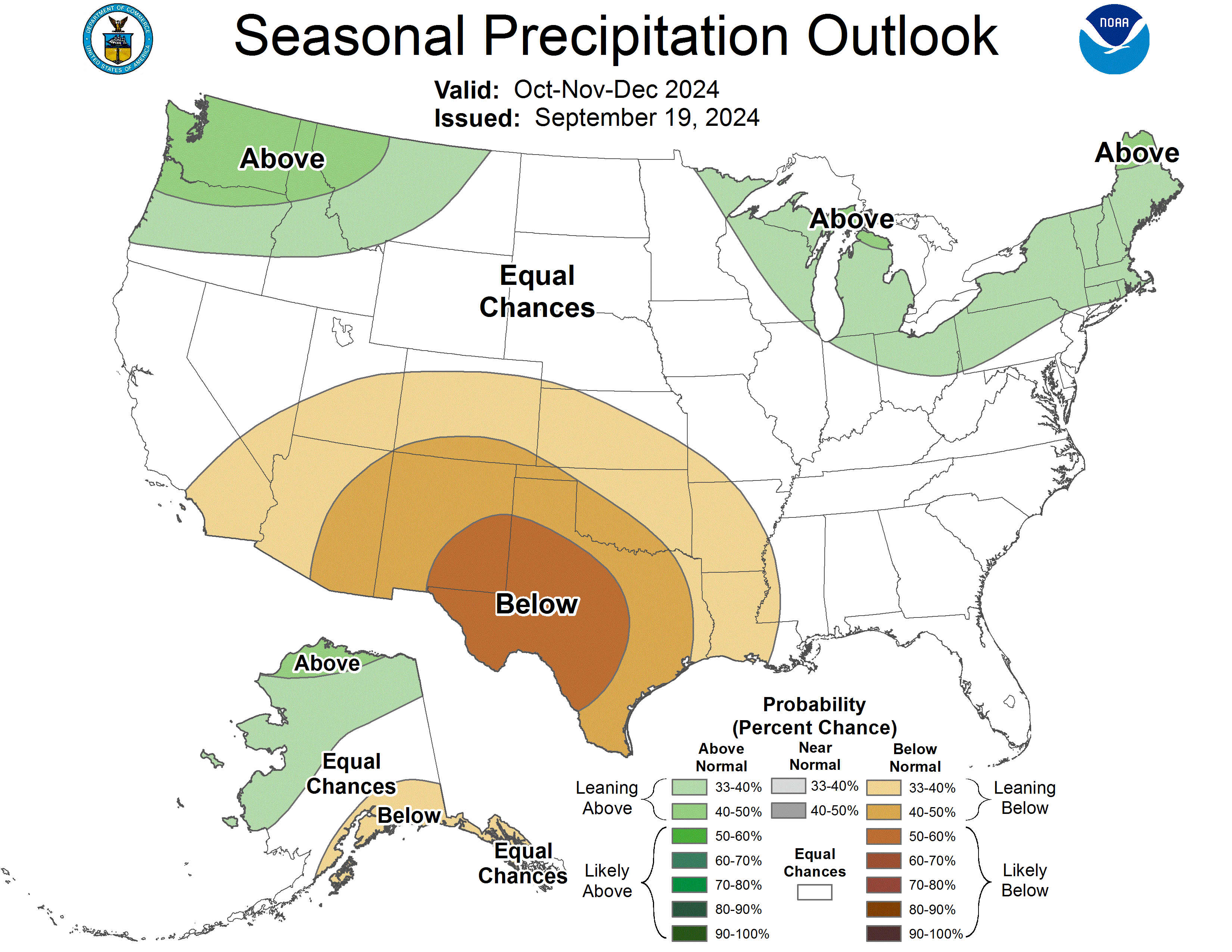
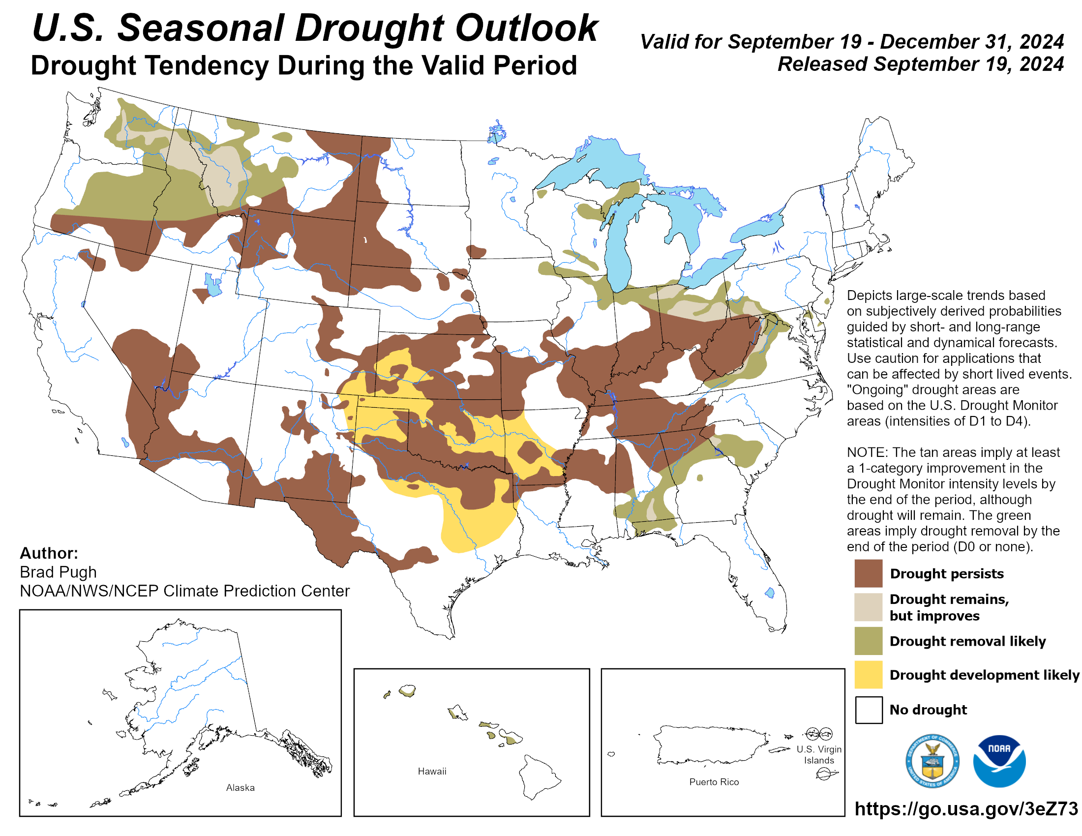
Following the previous drought-monitoring period’s extensive rainfall associated with Hurricane Francine and Potential Tropical Cyclone Eight, drought-easing precipitation developed farther west, across portions of the central and southern Plains and the middle Mississippi Valley. Another area of significant precipitation fell across the northern High Plains and environs, including parts of Montana. However, large sections of the country remained dry, with worsening drought conditions. Some of the most notable increases in the coverage of dryness and drought occurred in the upper Midwest and the Northeast, as well as parts of the western Gulf Coast region and the interior Southeast. Nationally, nearly one-half (45%) of the rangeland and pastures were rated in very poor to poor condition on September 22, according to the U.S. Department of Agriculture, up from an early-summer minimum of 19%…
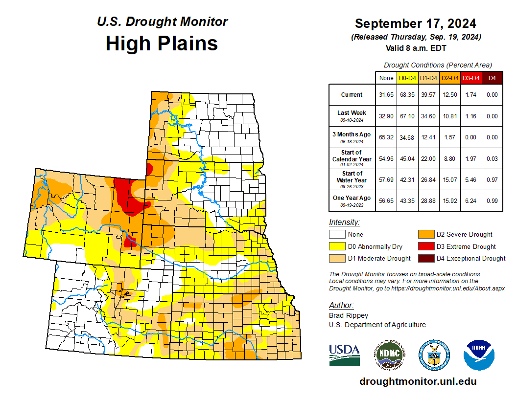
Aside from Kansas, where rainfall provided widespread drought relief, most of the High Plains experienced unchanged or worsening drought conditions. On September 22, topsoil moisture rated very short to short ranged from 29% in North Dakota to 84% in Wyoming, with values also above 50% in Colorado, Kansas, and Nebraska. Wyoming led the region on that date with 68% of its rangeland and pastures rated very poor to poor, followed by South Dakota at 44%…
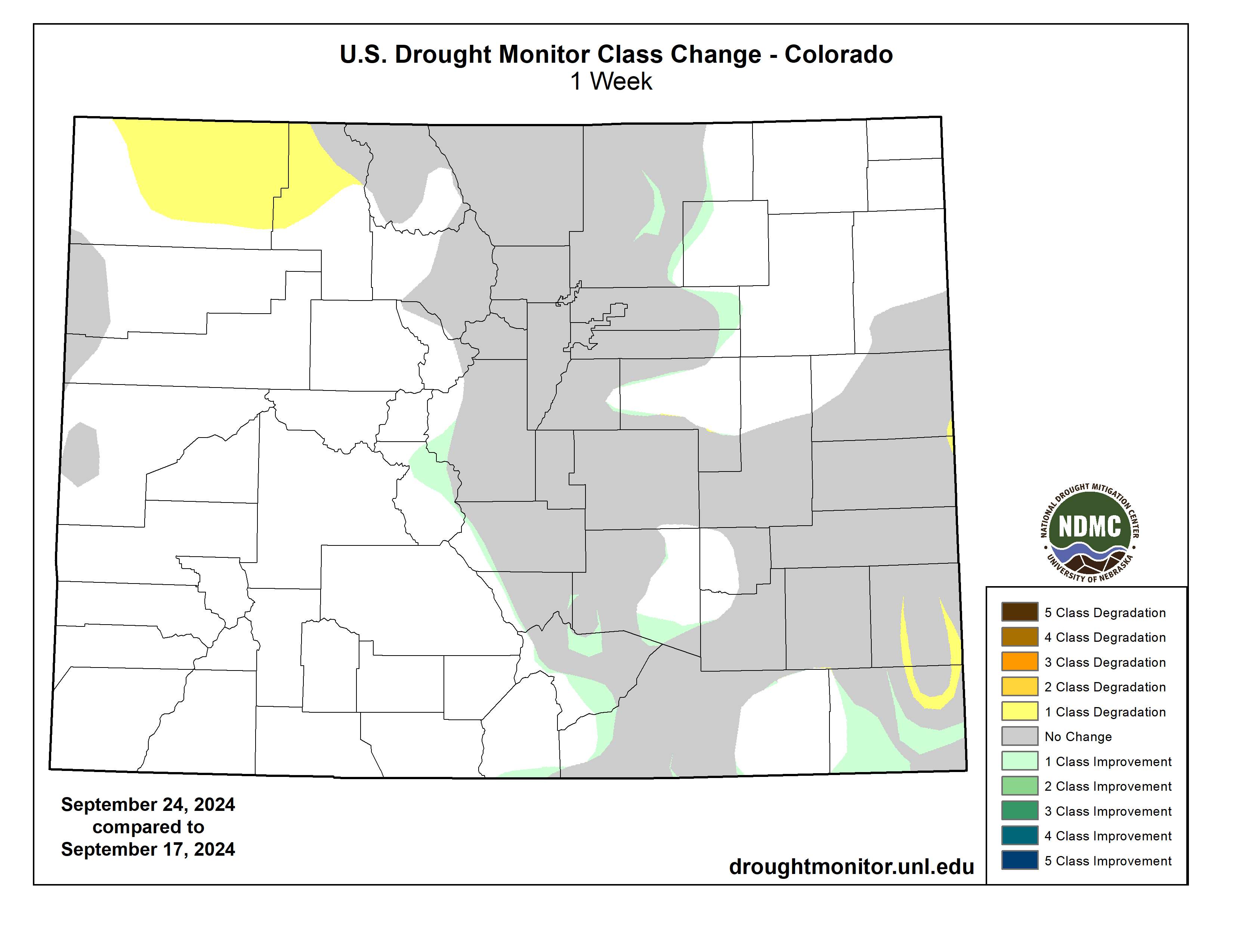
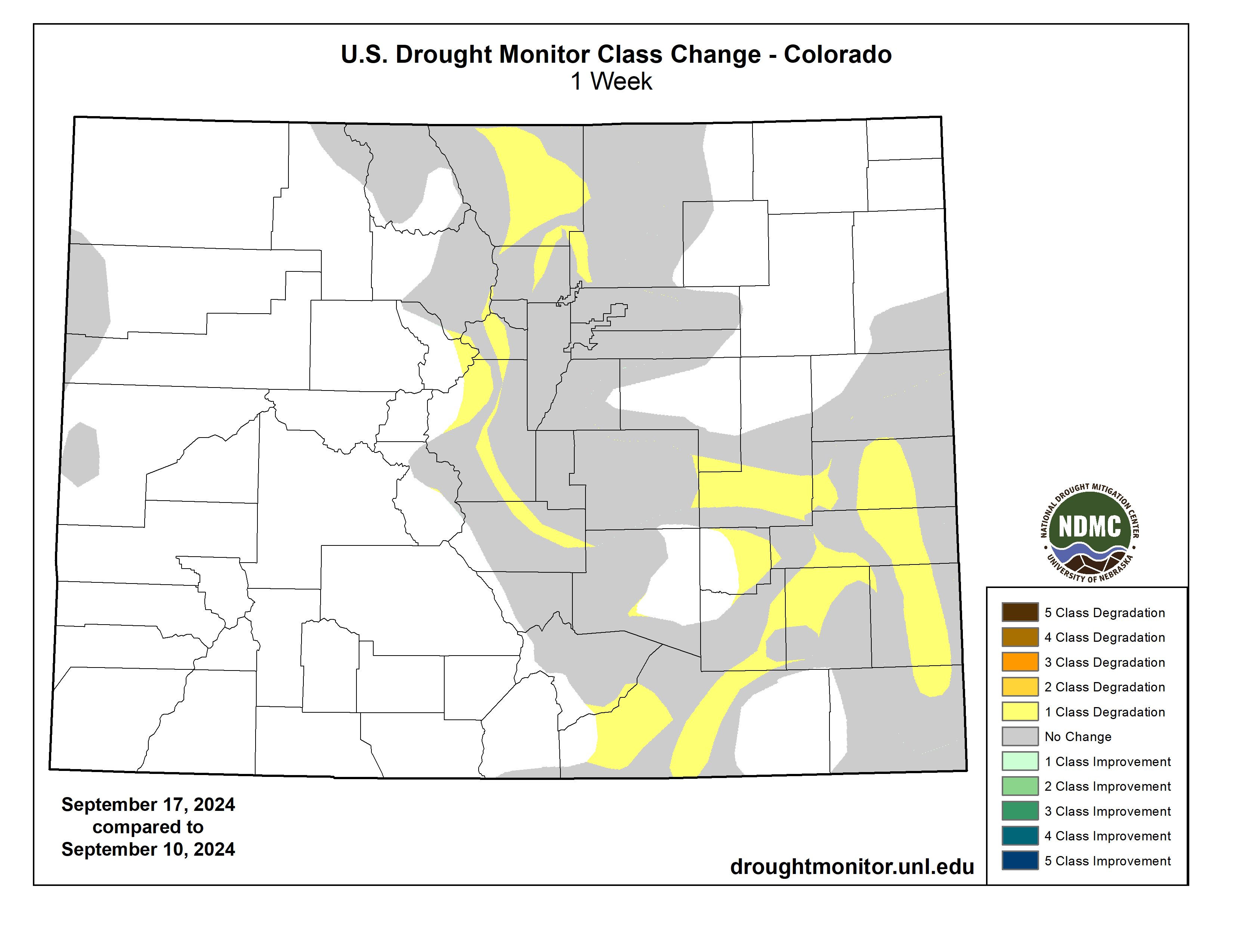
Colorado Drought Monitor one week change map ending September 24, 2024.
There were only minor changes in the Western drought depiction, aside from improvement due to heavy precipitation in parts of Montana. Dry conditions remained a concern in many areas, with statewide topsoil moisture rated very short to short on September 22 as high as 84% in Montana and 74% in Oregon. Northwestern rangeland and pastures remained largely in terrible shape, following a hot, dry summer, and by September 22 were rated more than 60% very poor to poor in Montana, Oregon, Washington, and Wyoming. Dry conditions also favored winter wheat seeding, with Washington leading the nation on September 22 with 54% of its intended acreage planted…
The South remained an odd mix of drought improvement and deterioration. Tennessee and Texas were notable for seeing large drought changes in both directions, with Tennessee noting drought deterioration in central and eastern areas and improvement in the west. Similarly, Texas saw improvement in some northern and central areas, along with a large expansion of abnormal dryness (D0) in the east-central part of the state. Oklahoma led the region on September 22 with statewide topsoil moisture rated 57% very short to short, followed by Texas and Tennessee both at 49%. Meanwhile, at least one-half of the rangeland and pastures were rated in very poor to poor condition in Tennessee (53%) and Texas (50%). Texas also led the U.S. with 48% of its cotton rated in very poor to poor condition on that date, well above the national value of 33%…
Looking Ahead
Hurricane Helene is forecast to strike Florida’s Big Bend late Thursday, with an intensity and pre-landfall path similar to that observed with Category 3 Hurricane Idalia, on August 30, 2023. Less than 2 months ago, Category 1 Hurricane Debby also moved ashore in the same general area of Florida. With Helene, a potentially catastrophic storm surge may occur along and to the east of where the eye crosses the Gulf Coast, with notable surge-related impacts also expected along the west coast of Florida’s peninsula. In addition, a significant inland push of hurricane-force winds (74 mph or greater) is expected across north-central Florida and southwestern Georgia, with likely impacts on timber and crops such as cotton and pecans. Damaging winds could reach higher elevations of the southern Appalachians. After punching inland, Helene should veer northwestward and decelerate due to interaction with a disturbance over the lower Mississippi Valley, heightening the risk of Southeastern flooding. Storm-total rainfall could broadly reach 6 to 12 inches, with locally higher amounts. During the next 5 days, much of the remainder of the country will experience warm, dry weather, ideal for summer crop maturation and harvesting, as well as winter wheat planting. However, lack of soil moisture for the establishment of winter grains and cover crops will remain a concern in drought-affected areas.
The NWS 6- to 10-day outlook for October 1 – 5 calls for near- or above-normal temperatures nationwide, with the Southwest having the greatest likelihood of experiencing warm weather. Meanwhile, near- or below-normal precipitation across much of the country should contrast with wetter-than-normal weather a few areas, including western Washington, peninsular Florida, and much of the Northeast.
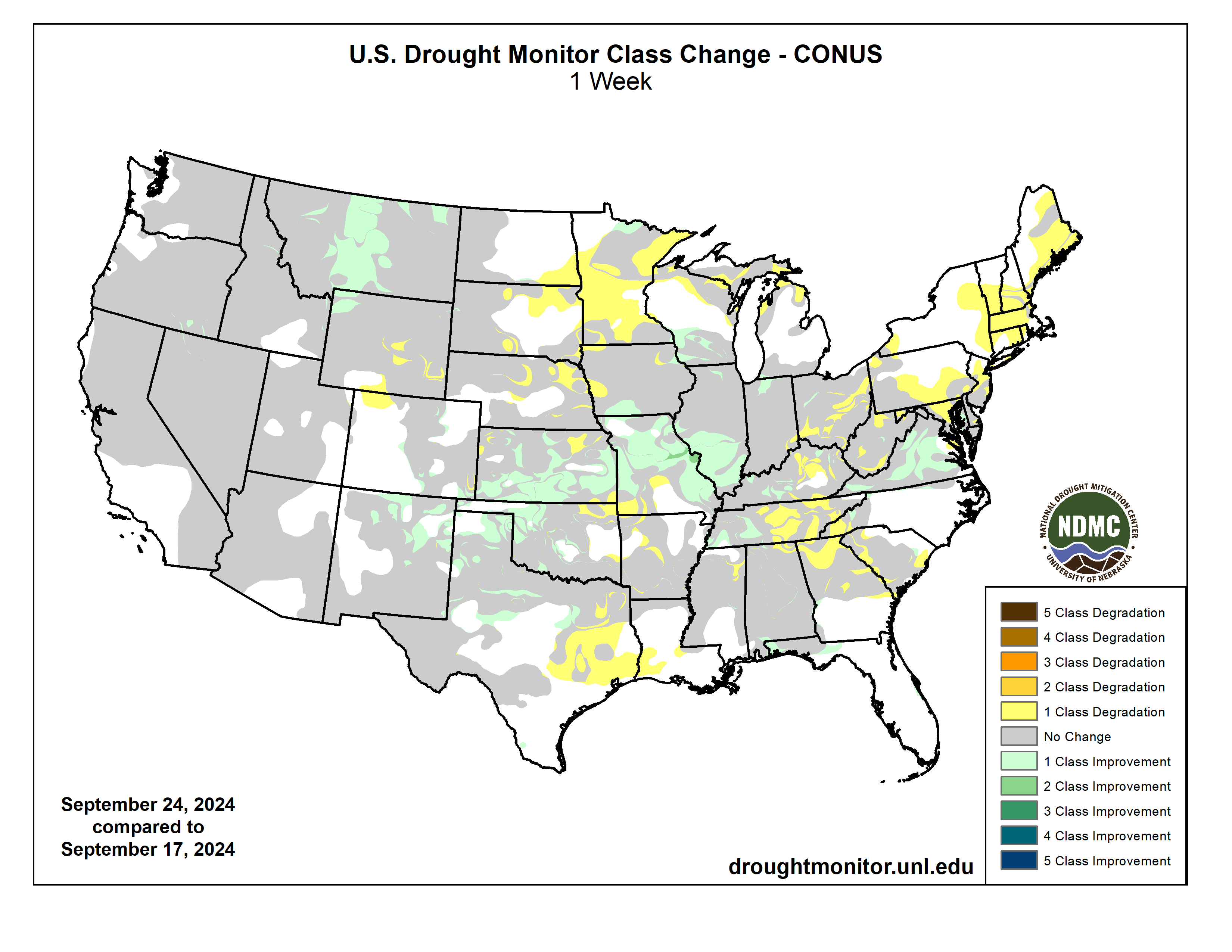
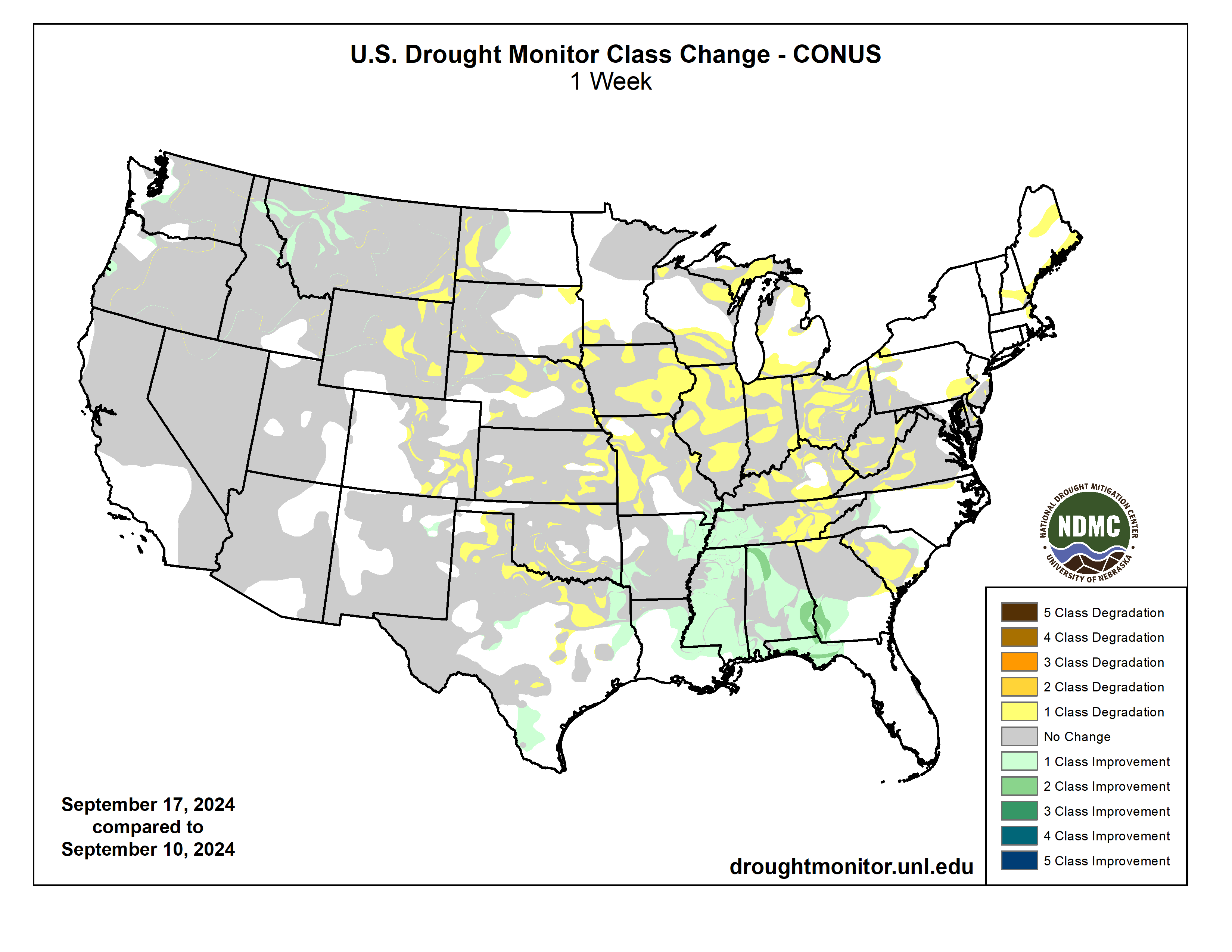
US Drought Monitor one week change map ending September 24, 2024.
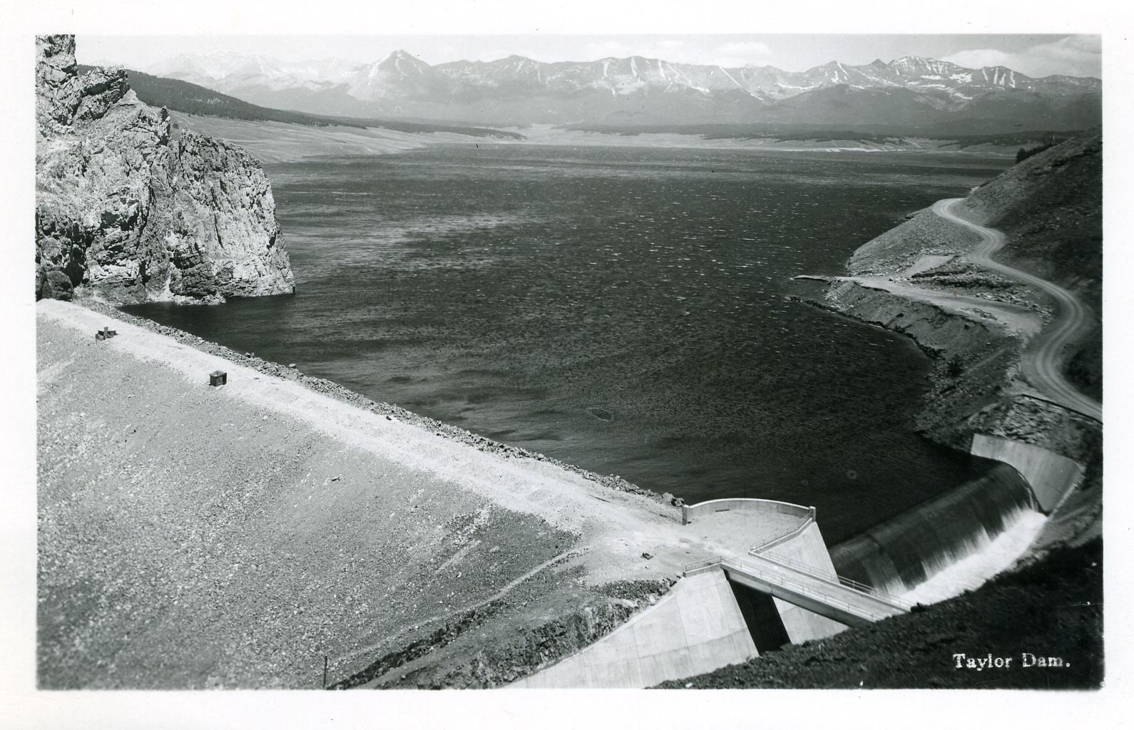
Local electric cooperative Gunnison County Electric Association (GCEA) has a new way of generating energy for the Gunnison Valley with the recent completion of its Taylor River Hydropower construction project. GCEA and the Uncompahgre Valley Water Users Association (UVWUA) commemorated the completion of the plant’s construction phase last week with a ribbon cutting ceremony, and plan to begin commercial power production around September 20. The $3.6 million project located at the Taylor Park Dam is a partnership between GCEA and the UVWUA. The new 500-kilowatt (kW) hydroelectric turbine and generator at the site will operate at or near full capacity 24 hours a day, year round, to produce an average of 3.8 million kilowatt-hours (kWh) annually. That amount of generation compares to some 2,500 kW (2.5 megawatt) fixed tilt-solar arrays and, according to GCEA strategy execution specialist Matt Feier, will provide clean electricity to approximately 500 local homes and businesses in Gunnison County…Construction on the project began in May 2023, but the hydroelectric vision has been in the works far longer…
GCEA provides the electric infrastructure and UVWUA manages the water flowing through the dam. The plant connects to the existing dam penstock and GCEA’s single-phase distribution line. Feier explained the process: “The new facility draws approximately 65 cubic feet per second of water out of the eastern penstock within the existing valve house. This water is piped to our Frances turbine within the newly constructed metal building at the base of the dam. The turbine spins, which in turn spins the generator and generates an electric current. This energy flows into GCEA’s existing distribution system and down to GCEA’s Alkali substation (located near Jack’s Cabin Cutoff) where it is distributed within GCEA’s service territory. After turning the turbine, the water flows back into the same spilling basin as the Taylor Dam’s main outflow,” he said. “This hydro generator will be a ‘run of the river’ facility and will not affect river flows within the Taylor River.” Feier said the Taylor River Hydro project is a welcome addition to GCEA’s current clean energy portfolio, and it will bump up GCEA’s local renewable energy generation. “This new hydroelectric facility will get us to approximately 3% local generation and we are working to gain the other 2%+ from local solar array developments,” he said.
The Taylor River, jewel of the Gunnison River basin. Photo: Brent Gardner-Smith/Aspen Journalism
View of Shoshone Hydroelectric Plant construction in Glenwood Canyon (Garfield County) Colorado; shows the Colorado River, the dam, sheds, a footbridge, and the workmen’s camp. Creator: McClure, Louis Charles, 1867-1957. Credit: Denver Public Library Digital Collections
The 2024 Annual Water Seminar was hosted by the Colorado River District at Colorado Mesa University. The event featured many big names in the community including John Marshall, Andy Mueller, David Payne, Merrit Linke, Bart Miller, Cleave Simpson, and many more…Their goal was to highlight the challenges the Western Slope faces now and will face in the future. These challenges pertain to the ever-present climate change crisis and bureaucracy…
According to Andy Mueller, the general manager of the Colorado River Water Conservation District, one of those bureaucratic obstacles is an agreement that was signed in the 1920s. This limits our entitlement to around 55% of the flow of the Colorado River. Another issue he tells us is communities in the Lower Basin—areas in California and Arizona—are keen on securing water. And with a growing population on the Front Range, Mueller says there is a heightened emphasis on securing the Shoshone Water Rights. “We are concerned that if we do not lock in the Shoshone Water Rights, we will see more water leave the Colorado River Basin, and there will be less water for the population and environment on the Western Slope.”
The Shoshone Water Plant is expected to have a $99 million price tag and is slated to increase the amount of available water to farmers and consumers. So far, we are told $56 million has been raised.
“New plot using the nClimGrid data, which is a better source than PRISM for long-term trends. Of course, the combined reservoir contents increase from last year, but the increase is less than 2011 and looks puny compared to the ‘hole’ in the reservoirs. The blue Loess lines subtly change. Last year those lines ended pointing downwards. This year they end flat-ish. 2023 temps were still above the 20th century average, although close. Another interesting aspect is that the 20C Mean and 21C Mean lines on the individual plots really don’t change much. Finally, the 2023 Natural Flows are almost exactly equal to 2019. (17.678 maf vs 17.672 maf). For all the hoopla about how this was record-setting year, the fact is that this year was significantly less than 2011 (20.159 maf) and no different than 2019” — Brad Udall
Click the link to read “Climatologist: Warming of state almost certain to continue” on the Grand Junction Daily Sentinel website. Here’s an excerpt:
September 21, 2024
On the heels of Grand Junction’s hottest summer on record, Colorado’s state climatologist advised Friday that the state’s warming trend over recent decades is all but certain to continue in coming ones. Russ Schumacher, also director of the Colorado Climate Center at Colorado State University, said at an event at Colorado Mesa University that temperatures in Colorado and globally have been warming and the projection is for continued warming in the future, “and there is very high confidence in that.”
Colorado statewide annual temperature anomaly (F) with respect to the 1901-2000 average. Graphic credit: Becky Bolinger/Colorado Climate Center
There’s less certainty about what the future holds for precipitation levels in the future in the state, other than that they will continue to be highly variable. But increasing temperatures will have water-related impacts even if precipitation patterns don’t change much, he said during the Colorado River District’s annual water seminar. He said seven of Colorado’s nine warmest years on record, averaged across the state, have occurred since 2012 and the warming trend has been particularly notable in the summer and fall. This year’s climatological summer, from June through August, tied for the sixth-warmest on record in the state, and the nine hottest summers all have been since 2000, he said. The average summer temperature at the Grand Junction Regional Airport this year was the hottest on record, he said…lows in the Colorado River have been declining since 2000. Annual flows at Lees Ferry below Lake Powell averaged 15 million acre feet during the 20th century but have averaged about 12.5 million acre feet since 2000, which has had some very dry years, he said…
The Colorado Climate Center addressed the impacts of climate change in the state in a report it issued in January. It projects that by 2050, under a medium-low carbon emissions scenario, Colorado statewide annual temperatures will warm between 2.5 to 5.5 degrees Fahrenheit compared to a 1971-2000 baseline, and 1 to 4 degrees compared to today.
Shumacher said that although there’s less certainty how climate change will affect precipitation in the state, warmer temperatures along with wind and low humidity result in increased evaporative demand, with dry air pulling moisture from trees, soils, crops and surface waters. That means there are times even when precipitation levels are higher that the water doesn’t go as far. Higher evaporative demand also increases the odds of drought happening and makes droughts more intense…At the Colorado River at Dotsero, peak flows already are declining and there has been about a 25% decline in flows in July and August, he said. Climate projections for the river at Dotsero show increased streamflows in the spring as runoff happens earlier due to earlier snowmelt, but then big declines in flows in July and August, “which is when you really need (water), especially if you don’t have storage,” Schumacher said. The changing climate also is expected to result in a continued trend of more and bigger wildfires, and possibly cause more extreme precipitation and flooding, among other hazards. But Schumacher said it’s important to remember that what is projected to happen in the Colorado Climate Center report isn’t all locked in, as it is a trajectory based on where things are headed now in terms of carbon emissions and the climate policies currently in place.
Bonita Mine acid mine drainage. Photo via the Animas River Stakeholders Group.
Click the link to read the article on The Denver Post website (Elise Schmelzer). Here’s an excerpt:
September 24, 2024
Organizations and local governments that want to fix the acidic drainage from a mine outside of Alma — and the hundreds of thousands of other abandoned mines across the West — are hopeful about new legislation under consideration in Congress. By removing liability burdens, the bill would finally give them more leeway to stop the pollution seeping into the streams relied upon for drinking water, recreation, and fish and animal habitat.
“This is a problem that is generally unseen to the general public,” said Ty Churchwell, a mining coordinator with Trout Unlimited who has worked for more than two decades to create better policy for abandoned mine cleanup. “As long as they can walk over to their tap and turn it on and clean water comes out, too often people don’t think about what’s happening at the top of the watersheds. “But it’s a horribly pervasive problem, especially in the West. It’s hurting fisheries, tourism and recreation, domestic water — it’s a problem that needs to be solved.”
Acidic drainage pollutes at least 1,800 miles of Colorado’s streams, according to a 2017 report from state agencies. About 40% of headwater streams across the West are contaminated by historical mining activity, according to the Environmental Protection Agency…But nonprofits, local governments and other third parties interested in fixing the problem are deterred by stringent liability policies baked into two of the country’s landmark environmental protection laws: Superfund and the Clean Water Act. Anyone attempting to clean up sources of pollution at a mine could end up with permanent liability for the site and its water quality…State officials, nonprofit leaders and lawmakers for decades have worked to find a solution that allows outsiders — called “good Samaritans” — to mitigate the pollution infiltrating thousands of miles of streams. That work may finally bear fruit as Congress considers a solution that advocates believe has a good chance of passing. Federal legislation to address the problem cleared the Senate with unanimous support, and on Wednesday it passed out of the House Transportation and Infrastructure Committee — the farthest any good Samaritan mine cleanup bill has proceeded.
The Animas River running orange through Durango after the Gold King Mine spill August 2015. Photo credit: Jonathan P. Thompson/The Land Desk
Mount Elbert Forebay Dam seen in winter with snow part of the Frying-Pan Arkansas Project. Elbert Forebay Dam seen in winter. Reclamation is investing in snow monitoring technologies for water supply forecasting. Photo credit: USBR
Reclamation awarded $4.6 million to five projects to advance snow monitoring technologies for water supply forecasting. Projects awarded include an additional $4.6 million in cost share funding, totaling over $9.2 million in investment for snow monitoring.
“Reclamation is thrilled to announce this award to advance five pivotal projects focused on snow monitoring advancement,” said Reclamation’s Senior Advisor for Research and Development Levi Brekke. “Our Research and Development Office remains dedicated to supporting innovative solutions that address critical water challenges and foster sustainable practices for our communities.”
Reclamation’s Research and Development Office sought proposals for projects implementing airborne lidar snow surveys for the improvement of water supply forecasting and water management decision making. All of the selected projects include acquisition of lidar snow survey flights, demonstration of the use of lidar snow survey data in water supply forecasting, and the development of techniques to maximize the value of the snow survey data for water supply forecasting.
Funding Awardees:
Arizona State University: Fusing Airborne and CubeSat Methods for Snow Estimation and Supply Forecasting into Salt River Project Reservoirs. Reclamation Funding: $974,265 Total Project Cost: $1,274,265
Friant Water Authority: Snow Water Supply Forecasting in the Upper San Joaquin River Watershed Reclamation Funding: $ 702,169 Total Project Cost: $ 3,556,798
Oregon State University: Fusing LIDAR and In-Situ Community Measurements to Improve Estimates of Snowpack Reclamation Funding: $ 946,203 Total Project Cost: $ 1,198,187
Oregon State University: The utility of aerial LiDAR snow surveys to improve water supply forecasts across the western United States: comparing the relative importance of current snow conditions and future weather Reclamation Funding: $ 971,862 Total Project Cost: $ 1,230,504
Utah Division of Water Resources: Wings Over Weber Reclamation Funding: $ 975,844 Total Project Cost: $ 1,951,689
Reclamation’s Snow Water Supply Forecast Program aims to enhance snow monitoring and to advance emerging technologies in snow monitoring and subsequent water supply forecasts. The program activities are working to build climate change resilience by enabling improved water management. To learn more and read full project descriptions, please visit the program website.
Audubon supports the Yavapai-Apache Nation’s water rights settlement and pending legislation, the Yavapai-Apache Nation Water Rights Settlement Act of 2024.
The Yavapai-Apache Nation and other parties in Arizona have come to a historic agreement with the settlement now before Congress. Not only will this settlement—when passed by Congress and signed by the President—ensure a reliable and sustainable water supply for the Yavapai-Apache Nation in north central Arizona’s iconic “Verde Valley,” it will preserve the Verde River and its precious habitat by reducing reliance on groundwater.
Healthy mountain meadows and wetlands are characteristic of healthy headwater systems and provide a variety of ecosystem services, or benefits that humans, wildlife, rivers and surrounding ecosystems rely on. The complex of wetlands and connected floodplains found in intact headwater systems can slow runoff and attenuate flood flows, creating better downstream conditions, trapping sediment to improve downstream water quality, and allowing groundwater recharge. These systems can also serve as a fire break and refuge during wildfire, can sequester carbon in the floodplain, and provide essential habitat for wildlife. Graphic by Restoration Design Group, courtesy of American Rivers
Within the Verde Valley, Audubon has identified four Important Bird Areas, all of which rely on healthy groundwater levels to sustain flowing rivers and streams and the rich plant life and wildlife they support. One of the many benefits of this settlement includes helping to sustain a portion of the Verde River downstream of the Yavapai-Apache Nation that was designated as a Wild and Scenic River by Congress in 1984.
The settlement is the result of innovative and creative thinking from the Yavapai-Apache Nation, Salt River Project, the Town of Camp Verde, the Town of Cottonwood, the Town of Clarkdale, and others. The settlement includes building a 60-mile water pipeline from C.C. Cragin Reservoir on the Mogollon Rim, north of Payson, increasing the capture of wastewater into sewer systems, boosting the use of reclaimed water, and the potential for regional water planning and collaboration among nearby municipalities and the Yavapai-Apache Nation.
Audubon Southwest, our regional office in Arizona and New Mexico, is also part of the Water for Arizona Coalition. In 2022, Water for Arizona outlined a vision for how to improve Arizona’s water outlook, called the Arizona Water Security Plan. One of the six key tenets is: Continue to support Tribes in resolving Tribal water issues. This settlement is a key milestone as Arizona works to improve its overall water security.
It is long past due for the Yavapai-Apache Nation to have secure and reliable water supplies, and this settlement is a monumental step forward for their growing community. Bipartisan, bicameral legislation to enact and fund the settlement is sponsored by Arizona’s Senators Kelly (D) and Sinema (I) in the U.S. Senate. Representative Schweikert (R) introduced the U.S. House bill, cosponsored by Representatives Ciscomani (R), Lesko (R), Stanton (D), and Gallego (D).
Audubon supports the passage of the settlement legislation and the provision of approximately $1 billion to ensure the project is brought to completion. As part of our support, we sent a letter to Arizona’s Congressional delegation, which you can view below.
Note: Here’s the second and final part of this little essay/data dump. Yeah, it’s paywalled AGAIN! I know, I know. I’ll be back next week with more good content for you free-riders. In the meantime, consider becoming a paid supporter of the Land Desk and knock down that paywall in the process.
The math and the charts in Part I of this essay are discouraging to many of us because they mess with our value system. There’s just not enough water in the places that we feel should be cut, for moral or practical or aesthetic reasons, to make much of a difference. I mean, sure, halting evaporation from the reservoirs would get you about 2 million acre-feet in cuts. But the only way to do that is to come up with a couple 250-square-mile swimming pool covers — one for Lake Mead and one for Lake Powell. Or you could just take down the dams, but I won’t wade into that one right yet.
The math dictates that the biggest user, irrigated agriculture, is going to have to make the biggest cuts. And the crop that uses the most water? Alfalfa — by a mile. About 6.3 million acre-feet of Colorado River water is consumed to irrigate alfalfa and other hay crops.
If all irrigation of alfalfa and hay was stopped, it would put more than 6 million acre-feet of water back into the Colorado River system. But it would also wreak havoc — and conflict with the law and values. Credit: Jonathan P. Thompson/The Land Desk
This isn’t news to Land Desk readers; I’ve been pointing it out for a long time. And it’s this simple observation, this acknowledgment of the math, that has the Family Farm Alliance demonizing me for supposedly demonizing alfalfa. Apparently those folks would rather we journalists ignore these numbers and fuzzy-up the math, make some insignificant cuts here and there while continuing to send gobs of water to hay fields, and continue drawing down the reservoirs until there’s no savings account left. Then, when we have another year like 2002 or 2021, when there were 10 million acre-feet deficits, the entire region will devolve into chaos. Seems like a bad idea to me.
Alfalfa has a lot of uses: It can be made into pellets for rabbits and other animals, it is a good cover crop that retains soil nutrients, it can be fed to horses, and you can even go down to your health food store and pay a small fortune for some alfalfa extract, which is apparently full of nutrients. But mostly it goes to livestock, especially cattle.
This is state-level data, so includes alfalfa grown with water that’s not from the Colorado River system. But a look at the county level shows similar trends in Colorado River-irrigated areas, especially in Arizona and California. Also note that some alfalfa in Arizona is grown using groundwater, which is not included in Colorado River accounting (although really, it should, since groundwater pumping ultimately affects surface water). Credit: Jonathan P. Thompson/The Land Desk
Over the past five decades, the Colorado River states have grown more and more alfalfa. There are a number of reasons for this. Alfalfa is a valuable crop that is relatively drought tolerant, it can be harvested a couple of times each summer even in cold climates — more than that in southern California — and it’s a perennial, meaning you don’t have to till the soil every year.
But the main driver is demand, and demand is growing because people want more beef, right? Well, yeah, maybe. But — to the chagrin of my vegetarian friends — beef is not the primary culprit, it’s the world’s ever-growing hunger for dairy. Because of the specific nutrients in alfalfa, it is favored by dairy operators: At least 75% of the 3 million tons of alfalfa grown annually in California goes to milk cows. Which is to say that my ice-cream and cheese habit is playing an even bigger role in draining the Colorado River dry than my green-chile hamburger. The growing demand is regional: Over the past several decades there has the astronomical rise in the number of large-scale dairies in the West, especially in California and New Mexico.
Colorado was a big milk state back in the 1930s, then the dairy industry collapsed over time before bouncing back (my grandparents’ small-scale dairy farm outside Durango shut down in the mid-1970s). New Mexico and Arizona, meanwhile, have seen a substantial increase in industrial dairies over the last couple of decades. Credit: Jonathan P. Thompson/The Land Desk
California has more than twice the number of dairy cattle now — more than 1.7 million — than it did fifty years ago. Wyoming is one of the only Western states where beef cattle dominate. Note: Different charts have different scales. Credit: Jonathan P. Thompson/The Land Desk
There’s also been an explosion of demand on the global level, as other nations that once mostly relied on goat or sheep milk have developed a taste for cow’s milk. That has led to a rise in alfalfa exports from Western states — hitting over $1 billion in value in 2022. However, exports still represent a small proportion of total production.
Credit: Jonathan P. Thompson/The Land Desk
Credit: Jonathan P. Thompson/The Land Desk
So, that’s the math. And it seems to suggest the Colorado River’s problems all could be solved if growing alfalfa stopped, right?
Maybe. But I kind of doubt it. This isn’t about a crop. It’s about water consumption.
This is where the law comes in and screws with both the math-oriented and the value-oriented solutions.
I mean, first of all, I doubt that a state or federal decree banning alfalfa growing would fly in the courts unless alfalfa was determined to be an illicit drug or something. And even if you could pull that one off, it wouldn’t accomplish much.
Alfalfa tends to be thirstier than other crops, but not significantly so. It uses such a huge percentage of Colorado River mostly because there’s so much of it and because of its long growing season. That means that if you were to replace all the alfalfa with other crops, you wouldn’t necessarily cut water consumption by that much. Maybe the new crop would use less water, but would the farmers then simply return the surplus water to the river? Not likely. Probably they would just grow more of the new crop and, ultimately, consume the same amount of water.
The only thing that would work is cutting off irrigation to all of those alfalfa fields, no matter what is being grown there. That would certainly be effective, though it would probably lead to a Dust Bowl, would make Ben & Jerry’s ice cream — and a lot of other food products — more expensive, and would wreck economies. And legally? I think not.
Western water law can be distilled down to one sentence: First in time, first in right. It is an almost sacred concept among Western water users, akin to the first lines of the U.S. Constitution or even the Bible.
It means, in the simplest of terms, that whoever appropriates a set amount of water for “beneficial use” first has the most senior rights to it1. When there’s not enough water in the river to fulfill all of the rights, then the senior users can make a “call,” forcing the most junior rights-holders to take the first cuts, and it goes on down the line from there. These rights are usually for a particular ditch or diversion, not an individual user. In the North Fork Valley, for example, the Farmers Ditch has some of the most senior rights, with 1896 appropriation and 1901 adjudication dates; individual property owners own shares of that ditch and the water in it. During dry years, Farmers Ditch is usually among the last to lose water. But if a downstream, more senior user were to put a legitimate call on the river, Farmers Ditch might also be shut down. These water rights are administered state-by-state.
If you have two shares of the Farmers Ditch, then you have no incentive to use less than that. If you conserve, the surplus water will simply keep going down the ditch to the next person. In fact, in most states there’s a “use it or lose it” provision. Though rarely enforced, and revoked in some places, it is still a dominant mindset; I’ve seen property owners pull their full share of water out of the ditch just to let it run down their driveway, perhaps because they just want what’s “theirs,” or maybe because they worry about losing their rights due to non-use.
The largest single water user on the Colorado River, which happens to have some of the most senior water rights, is the Imperial Irrigation District in southern California. They grow a lot of crops, but their primary one is alfalfa. The Colorado River Compact — and a series of compacts and court cases that ensued — adds another layer to all of this by apportioning water between the basins and the states2. Under this set of laws, California and the Imperial Irrigation District are senior, for example, to the Central Arizona Project, which conveys Colorado River water to Phoenix and Tucson.
In theory, the Upper Basin states and Lower Basin states are on an equal footing: Each gets 7.5 million acre-feet of water from the river. Since the Upper Basin uses less than its full allotment, it should be able to continue to use water at its current rate. But there’s one little provision in the Compact that makes that impossible, and that essentially makes the Upper Basin into the junior water rights holders. It reads:
There are conflicting interpretations over the clause, “will not cause … to be depleted.” But for now let’s go with the predominant, historic understanding of the whole sentence, which is that an average of 7.5 million acre-feet must come out of Lake Powell, the Upper Basin’s savings account, and pass Lee Ferry each year to be “delivered” to the Lower Basin’s savings account, i.e. Lake Mead.
This is no problem during an especially wet decade, or even during a dry one when Lake Powell is fairly full. But a string of drought years now, when the savings account has been depleted, could theoretically force the Upper Basin to either violate the provision, or to make some seriously painful cuts to comply.
So if values are trumped by math, and math is trumped by law, how the hell are we supposed to make this all work?
“New plot using the nClimGrid data, which is a better source than PRISM for long-term trends. Of course, the combined reservoir contents increase from last year, but the increase is less than 2011 and looks puny compared to the ‘hole’ in the reservoirs. The blue Loess lines subtly change. Last year those lines ended pointing downwards. This year they end flat-ish. 2023 temps were still above the 20th century average, although close. Another interesting aspect is that the 20C Mean and 21C Mean lines on the individual plots really don’t change much. Finally, the 2023 Natural Flows are almost exactly equal to 2019. (17.678 maf vs 17.672 maf). For all the hoopla about how this was record-setting year, the fact is that this year was significantly less than 2011 (20.159 maf) and no different than 2019” — Brad Udall
All I know for sure is there are no easy answers. We all can eat less cheese and ice cream and beef, we can install low-flow shower-heads and tear out those turf lawns. Cities can limit the size of or ban swimming pools and golf courses, implement tiered and progressive water rates that incentivize efficiency and hit gluttons in the pocketbook, and ban ornamental turf. They can embark on major leak-detecting and repair programs (it’s amazing how much water is lost to leaky pipes). And they can recycle water by treating it and reusing it for, at the very least, irrigation. With today’s treatment technology “toilet-to-tap” is just fine, and is not as gross as it sounds.
Federal and state governments can lease water from farmers for a year or so, paying them to shut off their headgates so the water stays in the river, instead. And they can incentivize folks to put less water on their crops, be it alfalfa or something else. That’s happening in the Imperial Valley, where the federal government is paying farmers some $700 million to stop irrigating alfalfa for 60 days this summer3. The effort is expected to save about 700,000 acre-feet of water, or twice the amount southern Nevada uses each year, through 2026, according to an excellent story by the Desert Sun’s Janet Wilson. Already the effects are being seen, with the IID forecast to pull their lowest amount of water from the Colorado River since 1941, according to John Fleck at his Inkstain blog. That should leave more water for the savings account-reservoirs, and for the river, itself.
As Wilson points out, there are drawbacks to the plan: irrigation runoff from the Imperial Valley fields runs into the Salton Sea. Without as much of it, the waterbody will shrink, exposing an additional 13,000 acres of lakebed, which is bad for the sea and for the air, as it will liberate a lot of pesticide-laden dust that will be picked up by the wind and dropped on nearby communities. The savings are large, but still not large enough. Plus, what happens when the funding runs out?
And, finally, the small ditch companies and farmers, including the ones in the North Fork or McElmo Canyon, are going to have to get more efficient. This will probably mean lining some laterals, piping some ditches, replacing flood irrigation with low-evaporation sprinklers or drip lines, and replacing water-intensive crops with ones that can get by on less irrigation. My question is how can this be done without destroying the distinct, post-irrigation character of these places? Could you leave some leaks to allow water to flow to some of the artificial wetlands? Could you lease water from the guy who allows the ditch to run down his driveway unused and irrigate the cottonwoods, willows, and milkweed? I’d love to hear readers’ ideas on this and, especially, examples of places where efficiency measures have worked to save water — without killing the character.
It’s true that the water saved would likely reach California, eventually, and might even be used to water a lawn or irrigate an alfalfa field. But in the many miles in between the two places, it would also add a little more water to the river for the fish and for boaters and for all of us. Maybe values, math, and Western water law can align.
The upcoming election may be the most important one of your lifetime. It is no less than a referendum on our climate and our future. It is that serious and urgent.
According to a study by the nonprofit Climate Central, large fires that burn 1,000 acres or more have tripled in the Western U.S. between 1970 and 2015. Last year was the warmest on record, a trend that is expected to continue. The country has been warming more rapidly than the global average since the late 1970s, and the West and Alaska have been at the forefront of that trend.
Concerns about the economy, housing, transportation infrastructure, farming, public health are climate issues, too — and increasingly so. Any vote this election, whether local or national, will be a vote on the climate.
I’m not trying to fan your doomsday fears. Quite the opposite: I want to try to drive us all into action. We must move from climate despair to climate repair, even though that can feel so abstract and seemingly insurmountable.
One reason climate repair feels out of reach involves the kind of people we’ve been choosing to represent us. Currently, there are 123 climate deniers in the U.S. Congress who have received lifetime fossil fuel contributions totaling $52,071,133, according to data analyzed by the Center for American Progress policy institute. If you happen to live in Wyoming, Montana, Utah, Colorado, Idaho, Arizona, California, Nevada or Oregon, you have elected officials who may be single-handedly blocking the way to climate-friendly policies. Three-fourths of the congressional representatives of Western states publicly claim that climate change isn’t real and are therefore unwilling to invest any time and resources in climate solutions.
These public officials aren’t just refusing to work on solutions to our climate reality — they are outright denying that a problem exists. If that doesn’t make you mad, it should. But what are you going to do about it? Anger, like repair, can be abstract and insurmountable; anger can even be harmful unless we can channel it toward change. Toward votes.
I’ve been thinking a lot about this since last year, when the Pew Research Center found that half of people living in the West said that climate change is going make life in their region harder over the next three decades. As someone who has lived in the Southwest for most of my adult life, I have witnessed those rising temperatures and longer wildfire seasons and worsening drought conditions, and I share in this collective fear.
But here’s what else last year’s Pew data pointed to: Younger adults are more likely than older adults to expect adverse impacts from climate change in their communities. Whether they lean Democratic or Republican or are unaffiliated, people between 18 and 29 years old say that they are more concerned about climate impacts than the rest of us. The older we get and the farther we live from the reality of wildfires and the floods, the less alarmed we seem to be about climate change.
This shouldn’t surprise anyone. Young people have been carrying the climate action torch these last few years, filing lawsuits against Big Oil and protesting fossil fuel-friendly public officials. And now, just two months before the presidential election, polls are showing that the teenagers and the 20- and 30-year-olds will continue to lead the rest of us.
Earlier this summer I spoke with Magaly Saenz, a 33-year-old small-business owner who runs Tres Leches Café in Phoenix with her partner. In her free time, she volunteers with Chispa Arizona, a grassroots group that invites local Latinos into environmental justice actions and conversations. She also volunteers with the Sierra Club and The Wilderness Society, advocating for the protection of Arizona public lands.
“Historically, when our (the Democratic) party is in office, when we have a majority in the House and in the Senate, we get very complacent and we make excuses (for public officials),” she told me. “We’ll say, ‘At least they’re not that guy.’” So, Magaly said, when she compared them to other politicians that were even worse on climate issues, she generally let it go. Magaly told me that she used to be the kind of person who thought of voting as a document you sign every four years. She would cast her vote, but didn’t push to get measures into the ballot to begin with. Then, five years ago, she began volunteering and protesting, talking with other Latino families and encouraging them to do the same. Her coffee shop has become a hub for grassroots political activism, a place where people come to brainstorm about the best ways to use their civic muscle.
“Younger generations are looking at (most politicians today) and saying, ‘Nope.’ They’re lighting a lot of fires,” she said. “And hopefully this will inspire other people to run for office.”
There is already some change underway: The number of climate deniers in Congress continues to go down — from 150 four years ago, around the time Magaly became politically engaged, to 123 today. If we want to see more public officials embrace climate repair in the way we need, we need to take that one basic first step: Vote for the right people. Do your part. (If you aren’t yet registered to vote, you can do it here: https://www.usa.gov/register-to-vote .)
“Encounters” is a serial column exploring life and landscape during the climate crisis.
Pitkin County’s Healthy Rivers Board voted unanimously to approve a $28,000 grant request from the Roaring Fork Valley Wildfire Collaborative to fund a project that will produce a wildfire action plan for the valley’s watershed. The project will identify high-risk areas and potential post-fire hazards in the Roaring Fork Valley’s water systems to create an action plan in the event of a wildfire. Several town and city water sources come from single streams. In the event of a wildfire, ash could contaminate stream water, degrading the quality of the water system, and potentially making it undrinkable, said Roaring Fork Valley Wildfire Collaborative Executive Director Angie Davlyn during her Thursday presentation to the board in Basalt…
While the Roaring Fork Valley is at significant risk for wildfires, a state evaluation also noted the high susceptibility of the Roaring Fork Watershed’s water infrastructure in the event of a wildfire. This leaves residents, property, and natural resources vulnerable to this disaster but also to other post-wildfire hazards, like flooding and mudslides, Davlyn said…Davlyn also said that the region has been pro-active in performing wildfire mitigation tasks, but there is a lack of a data-driven approach to identify the most critical threats and most opportune areas for a wildfire…To bridge this gap, the Wildfire Collaborative applied for funding from several sources, including Pitkin County. Last week, Wildfire Collaborative signed a contract with the Colorado Water Conservation Board for $224,000 and more than $150,000 in technical assistance for this project, which Davlyn said is the first of its kind in this area. These funds, however, require a 25% match before work can begin. The Wildfire Collaborative will provide half of the match through staff time, but the organization needs Pitkin County’s $28,000 to complete the match. Fire Adapted Colorado also awarded $5,000, the town of Carbondale awarded $3,000, Roaring Fork Conservancy awarded $500, Holy Cross Energy awarded $3,000, and other municipalities, counties, and the Colorado River District awarded $5,000. These funds, along with Colorado Water Conservation Board’s $374,000 and Pitkin County’s $28,000, totals $446,500.
hen the state of Colorado created the Groundwater Compact Compliance Fund with $30 million earmarked for recovering the aquifers of the Upper Rio Grande Basin, there was an intention to steer a good portion of the money toward irrigators working in Subdistrict 1 of the Rio Grande Water Conservation District.
Whether the strategy will work is under question. Last month’s reading of the unconfined aquifer storage levels shockingly showed it at its lowest point, despite millions in tax dollars that have been spent to retire groundwater wells.
San Luis Valley Groundwater
The motivation behind Senate Bill 22-028 was to use state tax dollars to continue to dry out farming fields located in the most productive area of the San Luis Valley because that’s where the depleted unconfined aquifer of the Upper Rio Grande Basin runs through. For the past two decades the state Division of Water Resources has been working with Rio Grande Water Conservation District and the farmers and ranchers who operate in Subdistrict 1 to reduce the amount of groundwater they pump each growing season to help recover the struggling aquifer.
The 2022 state senate bill would bring new money into the effort. Of the $30 million allocated from Groundwater Compact Compliance Fund to the Upper Rio Grande Basin, nearly $14 million has been directed to retire 44 more groundwater wells in Subdistrict 1, with more money likely to come to further the strategy.
The state monitors the amount of groundwater pumped with flow meters tied to center pivot sprinklers which water the fields. The meter reading will tell the farm operator how many acre-feet of water they’ve used during the irrigation season, and each fall figures from those flow meters are reported to the state.
The assumption has been that by reducing the amount of groundwater pumped from the unconfined aquifer, the aquifer would recharge over time. Over the past decade, it appeared the strategy had validity with the aquifer at times showing a bounce back.
Then came the reading from this August which showed the unconfined aquifer storage near its lowest level, and state and local water managers found themselves scratching their heads in disbelief and frustration.
“It is disappointing to see that the aquifer has dropped lower this year. We had hoped to see an increase in aquifer levels, but another lower-than-average river flow year meant that less water was available to recharge the aquifers,” said Craig Cotten, the state division water engineer in the San Luis Valley.
The continued decline in unconfined aquifer levels is the reason the state engineer this year approved a new Groundwater Management Plan that is included in the Subdistrict 1 Fourth Amended Plan of Water Management. The plan was more than a year in the making and still needs approval from the state water court to go into effect. That won’t happen at the earliest until sometime in 2026.
Meanwhile, the clock is ticking.
“It is very concerning, especially given that Subdistrict #1, under its current plan, has just seven more years in which to recover the unconfined aquifer to a sustainable level. If the aquifer has not recovered by then, and if the subdistrict is still operating under its current Groundwater Management Plan, then the State Engineer will have no choice but to curtail all of the non-exempt wells in this area,” Cotten said.
There are several “ifs” in that scenario, all of which should get addressed when the state water court takes up the new Groundwater Management Plan for Subdistrict 1. But again, that’s not until 2026, and the clock, as Cotten mentions, is ticking.
Amber Pacheco, deputy general manager for the Rio Grande Water Conservation District, said there are 3,614 wells included in the Subdistrict 1 annual replacement plan. The idea that the state would come in and shut those down because farmers couldn’t recover the unconfined aquifer to a sustainable level is the constant worry Subdistrict 1 farm operators work under.
“There is no specific timeline in which the Subdistrict will meet its objective to reach a Sustainable Water Supply by reaching an Unconfined Aquifer Storage Level between 200,000 and 400,000 acre-feet below that storage level that was calculated to exist on January 1, 1976, but it may be 20 years or less depending on the hydrologic conditions following the period the new plan is implemented,” Pacheco said.
Take a drive down County Rd E or any of the other country roads that cross through Rio Grande and Alamosa counties and you’ll notice the Valley’s potato harvest in full swing. Take a bit closer look, and in the midst of the harvested fields is a growing amount of agricultural acreage once productive that is now intentionally dried out to save on the groundwater below.
The last days of the potato harvest. Photo credit: The Alamaosa Citizen
With the unconfined aquifer showing little to no bounce back after years of attempted recovery, the expectation is that the western and northern ends of the San Luis Valley will see more dry fields in the growing seasons to come. The money spent through the state’s Groundwater Compact Compliance Fund to retire more groundwater wells will begin to show up in the 2025, 2026 planting seasons and beyond.
As Cotten said, Subdistrict 1 is “one of the most productive irrigated farming areas in the state.”
Farming with a struggling aquifer is making it less so.
Milkweed, sweet peas, and a plethora of other flora billow from Farmer’s Ditch in the North Fork Valley of western Colorado. Jonathan P. Thompson photo.
Note to readers: Sorry this piece is late. I injured my hand in a way that makes typing a bit difficult and that has slowed me down a bit. And to non-paid subscribers: Sorry for the paywall and all, but we gotta pay the bills — and give the paid folks their premium content! If you’re interested, consider knocking down that paywall and accessing all the archives by becoming a paid subscriber!
This spring, I had the pleasure to sit on a panel on water in the West with Paolo Bacigalupi and Heather Hansman, two writers I’ve long admired. During the question & answer period, a local woman lamented the fact that some ditches were being piped or lined with concrete, because it would dry out the wetlands and ecosystems that had come to rely on the leaky laterals and ditches. And she was angry because the point, as she understood it, was to save water only to send it downstream to California. Her beloved valley, it seemed, was being dried out to fill up LA pools, which just seems wrong.
Jonathan P. Thompson, Paolo Bacigalupi, and Heather Hansman on a writer’s panel in Paonia in April, 2024.
I’ve thought about this a lot in the months since, because I think it gets down to the big, conceptual tug-of-war that’s happening around the Colorado River. There’s one battle between the different users of the river’s water. And then there’s another in which the values different communities hold are clashing with the “law of the river” and the overwhelming math that is driving the need to make massive changes.
The following meditation on this clash was catalyzed by a slide a friend sent me from a Family Farm Alliance presentation at the Colorado Water Congress’s summer meeting. It accused me — via a piece I wrote for High Country News — of “demonizing” alfalfa.
Well, Family Farm Alliance, this is my response to you:
VALUES
The woman at the panel was referring to the North Fork Valley in western Colorado, a place with an extensive network of open canals, laterals, and ditches that irrigate peach, apple, and pear orchards, small vineyards, organic farms, and alfalfa fields. A handful of center-pivot sprinkler systems reveal themselves in the geometric perfection of their dependent fields, but most of the farms rely on older methods to bring water to the crops, namely by flooding the field or directing water down dirt rows where they soak into the plants’ roots.
Most of the canals and ditches are unlined and uncovered, and have been that way since they were built over a century ago. Many of them leak, some prolifically, their fugitive water blanketing the beige-gray earth with grass and nourishing cottonwoods, feral apricot and plum trees, sunflowers, willows, cosmos, reeds, sweet peas, milkweed, and cattails — along with a host of fauna that depend on those plants.
The intentional and accidental irrigation combine to form an irregular, pastoral patchwork of relative lushness amid the arid landscape of the kind that can be found in northern New Mexico, where a network of acequias irrigate long, rock-lined fields, or McElmo Canyon, where voluptuous pink sandstone rises up from a sea of emerald alfalfa. These places, where the cultivated and feral and wild collide, evoke the Provence of Jean Giono’s novels.
These are artificial landscapes, colonial ones, even, created by damming rivers and diverting their waters away from the fish and aquatic life in the streams and throwing off the natural balance of things. They rely heavily on inefficiencies in the system, from leaky laterals and ditches to flood-irrigation runoff. But they are, to my eye, lovely nonetheless, and contrast favorably with the more efficient farming areas, where high-tech irrigation systems deliver every drop of water to the linearly planted crops in laser-leveled fields.
Agricultural productivity has grown 20% in the 21st century. Organic corn in Colorado’s North Fork Valley. Photo credit: Allen Best
And yet, because of math and water laws and compacts and the need to devote every drop of the shrinking Colorado River to “beneficial uses,” the character of these landscapes is likely doomed. It won’t happen next month or even next year, but over time. Nor will the lands be dried up altogether: In places like the North Fork the ditches — at least the ones with senior water rights — will continue to deliver water to the fields.
But more and more, those old leaky ditches will be upgraded, lined with concrete or other impermeable materials, or even put into pipes so that all of the water goes to those who hold the rights to that water, not to evaporation or the accidental ecosystems that have sprung up along the ditches’ banks. The farmers, too, may be forced or incentivized to become more efficient, replacing the flood irrigation with sprinklers or drip lines. Some will be paid to not irrigate at all. Most of the open ditches like the ones my cousins and I held stick-boat races in on my grandparents’ Animas Valley farm will be gone, along with the runoff of the kind that spilled from their corn and alfalfa fields to fill the cattail- and willow-tangled slough down below.
It is this loss that the woman in Paonia is mourning. It is heartbreaking. And it’s something I think about every time I write about the Colorado River and the looming crisis it and the communities and industries that rely on it face in the not-so-distant future.
If the crisis could only be solved — and the needed cuts in consumption made — based on our values alone, things would certainly be a lot easier. There would likely be fairly wide agreement that we should fallow the golf courses and drain the swimming pools before drying up the leaky-ditch wetlands and leaving the red-winged blackbird homeless. Farmers might join me in calling for tearing out thirsty turf lawns from Denver to San Diego, implementing progressive water rates to stem gluttony, and putting hard limits on household water use — if it meant keeping the sprinklers flowing to food crops, including alfalfa and other forage. After all, I value cheese and ice cream and green-chile burgers over the Sultan of Brunei or Miriam Adelson, who guzzled 12 million and 10 million gallons of water, respectively, last year to keep their Las Vegas estates green.
Ah, and yes, if all of this could be solved by prioritizing cuts based on values, alone, the Family Farm Alliance would have no reason to accuse me of “demonizing” alfalfa and other livestock forage crops (though I imagine the golf groupies would get me for vilifying them). But, alas, it’s just not that simple. Why? Because even the most lofty values are trumped by the cold, hard math.
MATH
The pertinent numbers in the equation include:
16.5 million acre-feet: Total human-related consumptive use of Colorado River water in 2020. This means all of the water that was withdrawn from the river and not put back into it, including reservoir evaporation. It does not include the 2.8 million acre-feet consumed via riparian and wetland evapotranspiration, nor does it include the 1.7 million acre-feet of water use from the Gila River, a tributary to the Colorado.
14.5 million acre-feet: The Colorado River’s median “natural flow” at the Lee Ferry stream gage, which is the official dividing line between the Upper Basin and Lower Basin, from 1906 through 2023. This is used as a measure of how much water is in the Colorado River, since downstream tributaries are relatively insignificant.
12.4 million acre-feet: The Colorado River’s average natural flow at Lee Ferry from 2000 through 2023.
This leaves us a few options for the big math problem that needs solving:
The optimistic equation (assumes the last 20 years was an anomaly and the river will go back to its old-normal flow soon, i.e. the median for 1906-2023):
14.5 million – 16.5 million = 2 million acre-feet deficit
The new-normal equation (assumes the next few decades will look like the most recent couple of decades — which is to say a megadrought) :
12.4 million – 16.5 million = 4.1 million acre-feet deficit
The pessimistic (realistic?) equation (assumes human-caused climate change will continue to deplete the river):
10.4 million – 16.5 million = 6.1 million acre-feet deficit
Estimated natural flow of the Colorado River at Lee’s Ferry (the dividing line between the Upper Basin and the Lower Basin). The natural flow is basically the total amount of water the river delivers each year, or the volume that would pass by Lee’s Ferry if there were no upstream diversions. Source: USBR.
Which is to say … we’re screwed no matter how you juggle the numbers! Sorry, that’s not very solution-oriented is it? No matter how you cut it, though, the Colorado River budget is running a massive deficit and has been for a while. That’s why Lake Powell, the Upper Basin’s savings account, has been shrinking and now is less than 40% full — even after a couple of decent winters. A couple of consecutive new-normal winters could bring the reservoir down below minimum power pool, shutting down the hydropower turbines and potentially setting the scene for a mega plumbing disaster.
While it’s highly unlikely that the Colorado River’s flows will increase enough to fill Lakes Powell and Mead to capacity anytime soon, it’s not impossible. During the extraordinarily wet and snowy four years between 1983 and 1986, nearly 80 million acre-feet of water ran into Lake Powell — which should be enough to fill both reservoirs and still deliver adequate flows downstream. If it happens, great! It would be foolish and potentially catastrophic to bet on a repeat, however.
That means the users of the river must erase the deficit by cutting anywhere from 2 million to 6 million acre-feet of consumption annually. The big question, and one that the basins and their member states have been debating, is: Where will those cuts come from? I’m not going to get into the many layers of these negotiations here, as that’s not the purpose of this essay, which is a bit of a thought experiment. Suffice it to say it’s complicated, and made more so by glaring errors and injustices committed when the Colorado River Compact was originally crafted.
Let’s say we’re going to make these cuts based on values. Obviously everyone has different values, so we’ll just go with those expressed at the Q&A session I lead this piece with, which can be summed up as prioritizing rural farmland, food crops, and the artificial wetlands that can be found in the North Fork Valley over urban lawns, golf courses, and billionaires’ estates.
Where better to begin than Las Vegas? Let’s pull up some water user data and, holy cow! Look at those numbers. The Vegas resorts and the rich sure know how to use water:
The Venetian and Mandalay Bay resorts each use more than 500 million gallons of water per year. Meanwhile the top residential water users are mostly billionaires: 99 Spanish Gate Dr. — which goes through 12 million gallons per year — was owned by the Sultan of Brunei until tech-giant Jeff Berns purchased the 37,500 sf mansion for $25 million. Other top water gluttons include Miriam Adelson — a top Trump donor — and UFC CEO Dana White. The average Las Vegas household uses about 120,000 gallons per year, though newer, more efficient homes use far less.
When folks start throwing $25 million around for an unfinished house is when you know it’s time for a wealth tax. And when they use 100 times as much water as the average home, it’s also time for a new, progressive water rate structure, that incentivizes conservation and punishes gluttony. Las Vegas already has something like this, but the rates in the upper tiers are too low to be meaningful; they need to be so high that this kind of profligacy will sting even a billionaire’s pocketbook. Hell, better yet, why not just fallow these properties and xeriscape them?
When the numbers are added up, you’ve got:
227,243,000 gallons Top 100 Las Vegas residential water users’ combined consumption in 2023.
3,774,780,000 gallons Top 10 Las Vegas non-residential water users’ combined consumption in 2023.
Wow, so by shutting down just these folks, we could save 4 billion gallons of water, or … 12,275 acre-feet? Oh, that’s not as much as it seemed.
So how about we go to other cities and tear out turf, mandate low-flow appliances, ban lawn watering and swimming pools. I mean, if you could get Scottsdale and St. George residents to cut back to Tucson or Los Angeles per capita water levels, you’d make some more huge cuts.
If Scottsdale’s per-capita consumption were cut to Tucson’s levels it would save about 42 million gallons per year.
You could save millions of gallons through that effort, which is great. The problem is, this problem requires bigger thinking — you’ve got to make multiple cuts in the tens of billions of gallons range for it to make a significant difference. Once again, math, the ultimate buzz killer, raises its ugly head. See, as noble as all of these efforts might be, there just isn’t enough overall water use in the urban sector to come up with all the necessary cuts. You could drain the pools, dry up the lawns, seal up the Bellaggio fountains — hell, even shut off the massive pumps that convey water from Lake Mead to the Las Vegas metro area altogether — and you would still need to come up with at least another 1.6 million acre-feet of cuts. Entirely cutting off all of the Basin’s cities and industrial applications wouldn’t even get you to 4 million acre-feet of cuts. But boy, it sure would be interesting to watch — from afar.
To conclude Part I, some charts that drive the point home:
Irrigated agriculture gulps up about 10.1 million acre-feet per year, accounting for about 52% of the total consumptive use on the Colorado River. Meanwhile the municipal, commercial, industrial sector only uses 3.5 million acre-feet, meaning if you cut off all of the water to every Southwestern city, you still might have a water deficit in the Colorado River Basin. Source: New water accounting reveals why the Colorado River no longer reaches the sea, by Brian Richter et al
The chart on the left shows consumptive use within the Colorado River watershed only, where irrigated agriculture uses about 50% of the water. By contrast, Colorado River water sent over the Continental Divide to Colorado’s Front Range and New Mexico’s Rio Grande watershed is mostly used by cities, with about one-third going to agriculture.
About 59% of the non-exported Lower Basin consumptive use goes to irrigated agriculture. Exports follow the same pattern as in the Upper Basin, with most of the water going to urban use.
SOURCES: New water accounting reveals why the Colorado River no longer reaches the sea, by Brian Richter et al.; Decoupling Urban Water Use from Population Growth in the Colorado River Basin, by Brian Richter; Bureau of Reclamation, Las Vegas Valley Water District, Southern Nevada Water Authority, Zillow.
The Soldier Canyon Dam is located on the east shore of Horsetooth Reservoir, 3.5 miles west of Fort Collins, Colorado. The zoned earthfill dam has an outlet works consisting of a concrete conduit through the base of the dam, controlled by two 72-inch hollow-jet valves. The foundation is limey shales and sandstones overlain with silty, sandy clay. Photo credit Reclamation.
Nearly 150,000 residents will have greater access to safe drinking water without high costs for decades to come, after an approval by the Colorado Department of Public Health and Environment (CDPHE). This authorization will increase capacity at the Soldier Canyon Water Treatment Plant from 60 to 68 million gallons per day (MGD).
“The approval from CDPHE is a big win and a huge savings in dollars for the Tri-Districts all operating from the Soldier Canyon Water Treatment Authority’s Plant,” says Eric Reckentine, General Manager of North Weld County Water District.
The re-rating by the CDPHE which increases capacity from 60 to 68 million gallons per day (MGD), was successfully accomplished by the collective work of the three water districts operating out of Northern Colorado – North Weld County Water District (NWCWD), East Larimer County Water District (ELCO), and the Fort Collins-Loveland Water District (FCLWD).
“The expansion ensures that we can continue to provide water supplies to match our customers’ future growth needs and provide added resilience to our water supply systems,” states Mark Kempton, P.E, CWP, General Manager of Soldier Canyon Water Treatment Authority. “The Authority achieved the 8 MGD expansion using the Plant’s existing facilities, resulting in no construction and minimal costs. This efficiency has allowed us to keep our water rates low for our customers while continuing to provide a reliable, safe, and affordable drinking water supply to the Tri-Districts.”
The CDPHE expansion will provide water and larger capacity many years into the future for the tremendous development and population growth that Northern Colorado towns are experiencing.
“We continue to see projections for additional growth in the northern Colorado region and expanding water treatment capacity is a fundamental building block to sustain that growth. This treatment capacity increase represents the most cost-effective expansion in Soldier Canyon’s history and ensures all three partners can continue delivering high-quality drinking water well into the future,” explains Chris Pletcher, P.E., General Manager of Fort Collins – Loveland Water District.
“Like much of Northern Colorado, we anticipate continued growth within the East Larimer County Water District (ELCO) service area, and this addition of water treatment capacity will aid in meeting that new demand,” states Mike Scheid, General Manager of ELCO.
“I am very proud of the work of the other water districts and the staff and board of North Weld County Water District for helping to make accomplishments like this happen – it further stands by our commitment that we follow-through on what we promise for our customers,” says Reckentine. “This collaborative undertaking between the districts ensures we have secured the highest quality treated water for our Northern Colorado customers today, tomorrow, and into the future.”
ABOUT THE SOLDIER CANYON WATER TREATMENT AUTHORITY:
The Soldier Canyon Water Treatment Authority (SCWTA) owns and operates the Soldier Canyon Filter Plant, which is a 68 million gallon per day (MGD) conventional water treatment plant located in Fort Collins, CO. Since 1961, the Authority has provided high quality, reliable, safe, and affordable drinking water to over 145,000 people living in three water districts and adjacent communities in the Northern Colorado region. The three water districts (Tri-Districts) are:
The U.S. Air Force has a plan for cleaning up a decades-old jet fuel spill from a base near Albuquerque.
However, the local water authority said last week that the plan is inadequate, in part because it scales back current remediation efforts and doesn’t mention how the Air Force will address sudden issues.
In 1999, officials discovered a fuel leak, assumed to be more than 24 million gallons, in the jet fuel loading facility at Kirtland Air Force. The leak could be twice the size of the infamous Exxon Valdez oil spill of 1989, according to the Global Atlas of Environmental Justice.
It’s unclear when the leak – the largest underground toxic spill in U.S. history – first occurred, but it had been spilling fuel into the ground for decades by the time it was discovered, according to Kelsey Bicknell, environmental manager at the Albuquerque Bernalillo County Water Utility Authority.
An Air Force report says existing measures have prevented further migration of the fuel contaminants and that officials are regularly taking groundwater samples to ensure that drinking water remains safe both on and off-base.
Bicknell said there are concerns with the way the Air Force plans to go forward, including a lack of forward-looking analysis and the absence of a “trigger action plan” that identifies possible changes and prescribes a response to those changes.
She told the water authority’s Technical Customer Advisory Committee that the fuel soaked its way through almost 500 feet of soil, and ultimately reached the water table, where rock wouldn’t permit it to drop further. Then, she said, it began to pool underground.
Bicknell said the fuel not only contaminated the groundwater but also released volatile vapor into the nearby atmosphere.
She said the Air Force used a vapor extraction system to clean up more than a half-million gallons of fuel.
“This was a really successful system,” Bicknell said, adding that the program was shuttered after about a decade.
Bicknell said the Air Force is now using a groundwater pump-and-treat system that targets the dissolved fuel components that have moved away from the source of the leak and area. There are also four extraction wells, brought online between 2015 and 2018; they draw out and treat groundwater.
Bicknell said the Air Force has announced plans to turn off two of the wells. But that was done without input from the water authority and without including the agency in decision-making.
Air Force representatives did not immediately respond to phone and email requests for comment.
Bicknell said the goal now is to try to get the Air Force to reverse its decision before the wells are shut down. State and federal regulators have jurisdiction over the cleanup plan, she said, but the water authority cannot veto what the Air Force wants to do.
“Ultimately, we’re the water carrier, the ones that are impacted,” Bicknell said. “If the Air Force messes up, it is our source water that’s impacted, and it’s us that lose out on access to a supply source, so including us in the room and in project discussions and decision-making is something that is paramount.”
The San Juan Water Conservancy District (SJWCD), with a grant from the Colorado Water Conservation Board, has released the first of three short educational films regarding the watershed and the future of the water supply in Archuleta County. The video, “The Value of Snow,” will be shown in multiple venues in the county and can also be viewed online via the SJWCD website: sjwcd. org. The SJWCD is organized and funded by the citizens of Archuleta County to be an active leader in all issues affecting the water resources of the Upper San Juan River Basin. In order to enhance the understanding of our limited water resources, the district employed professional filmmaker Christi Bode to produce these films.
All water uses — environmental, agricultural, recreational, industrial and municipal — are important and need to be understood. It is the goal of the SJWCD to use these tools to help our constituents gain knowledge and understanding of the benefits and the risks associated with our watershed and the water it provides. Our community’s economy and our residents’ well-being are directly dependent on the health of our watershed. The risks are many and include drought, wildfires, mass earth movements (landslides), pollution and diversions.
Currently, Colorado’s hunters and anglers have perhaps a once-in-a-lifetime opportunity to protect a wide swath of public lands habitat in southwest Colorado’s Dolores River Canyons region. In April, we joined hunters, anglers, rafters, business owners, and many others from across the state and region in supporting a proposed Dolores River Canyons National Monument…The Dolores River faces threats from industrial scale mining, habitat fragmentation, and unmanaged recreation. Protecting intact habitat for mule deer, elk, and desert bighorn sheep, particularly winter range and movement corridors, is essential for retaining quality sporting opportunities. Now is the time for action. A national monument designation will help everyone better manage the change that is already occurring while also protecting public lands habitat and ensuring future generations of hunters, anglers, and many others experience the area as we have. For additional information see Sportsmen for the Dolores.
Decades of drought and taking more water from the Colorado River than it can afford to give have put both the river and the $1.4 trillion economy it supports in jeopardy. Investing in water resilience is essential for companies operating in the region, but it requires a different approach than many are used to.
A tested and successful model can be found on the Verde River, a Northern Arizona tributary of the Salt River in the Colorado River Basin. The Verde River provides water for local farms and delivers up to 40 percent of in-state surface water for major urban locations in the Phoenix metro area. But its long-term health is at risk from withdrawals, groundwater pumping, a warming climate and drought.
Companies including Boeing, REI, Coca-Cola, Meta, Microsoft, Cox, PepsiCo, Google, Procter & Gamble, EdgeCore and Intel have partnered with groups such as The Nature Conservancy, Friends of the Verde River, National Forest Foundation and the Salt River Project to support dozens of resilience projects over the past decade in the Verde River. The Nature Conservancy (TNC) reports that over the past five years, projects spanning seven irrigation districts have saved nearly 50,000 acre-feet of water. That’s enough to support 100,000 U.S. households for a year.
These projects have focused on creating healthier streams and wetlands, reducing the risk of catastrophic wildfires and increasing the efficiency of water delivery systems. Here are some examples.
Reducing wildfire risk
An overabundance of small shrubs and trees in the Verde River’s forested headwater areas significantly increased the risk of devastating wildfires that would affect communities and regional water supplies and infrastructure. Partnerships that include agencies, nongovernmental organizations and corporate funders have scaled up projects that remove overgrowth and restore healthy forest conditions. This work has reduced fire risk, improved water availability and increased water security for the region. Corporate partners, including EdgeCore, PepsiCo, Apple, Meta and Google, were critical to the success of these projects.
“Meta’s water stewardship efforts include investing in projects that help put in place the enabling conditions for sustainable water management,” said Stefanie Woodward, water stewardship lead at Meta. “We’re proud to support projects that help to restore healthy forest conditions in the Verde and empower environmental nonprofits and communities to build long-term capacity in Arizona.”
Increasing water conservation
Outdated irrigation ditches convey water from the Verde River to farms across the middle Verde watershed. Leakage across many miles of the system increased the amount of water withdrawn from the river and made it difficult to irrigate farmland.
Multiple Verde River irrigation districts partnered with The Nature Conservancy to pipe more than 4 miles of irrigation ditch and improve water management by installing new water control structures. The work has increased water conservation and improved streamflows. Companies participating in the project include Swire Coca-Cola USA, Coca-Cola, Procter & Gamble, Meta, Coors Seltzer, Microsoft, PepsiCo, Advanced Semiconductor Materials (ASM) and Pulliam Trust.
“Together with The Coca-Cola Company, our support of conservation organizations along the Verde River aims to address the critical water challenges facing this vital ecosystem,” said Mike Bernier, director of sustainability at Swire Coca-Cola. “By funding projects like the piping of the Verde Ditch, we’re helping implement a long-term solution to reduce leakage, in turn improving water-efficiency and ensuring the sustainability of this water source for millions downstream.”
Shifting agricultural water demand
Many traditional crops in the Verde Valley are water-intensive and require significant irrigation during summer months when river flows are low. A partnership that includes Sinagua Malt, TNC and local farmers implemented an innovative program that replaced high-water-use crops, such as alfalfa, with barley, which requires less water in the summer season. The project delivered a solution that provides brewers with premium Arizona malt while improving water flows in the Verde River.
Tamarisk
Improving river flows
In addition to conservation and efficiency projects, removing invasive plant species can also improve water flows. Companies and funders including REI, Intel and Forever Our Rivers each funded work to remove invasive Arundo and Tamarisk plants from the middle Verde River and areas near the mouth of the Verde on the Salt River. These plants force out native vegetation and can use water at a higher rate. Removing them has helped restore habitat, improve biodiversity and keep more water flowing in the Verde River.
Setting the stage for success
Ready-to-fund water resilience projects that directly reinforce corporate goals are rare. Understanding the history and context for the Verde River work can help companies replicate success in other areas.
Social stronghold: Most projects in the Verde developed in areas where extensive groundwork had already been done by organizations that would later partner with corporations. Nonprofit groups and agencies spent time building relationships and credibility with landowners, agencies and partners prior to corporate investment. A foundation of social infrastructure was in place, or was positioned to expand.
Takeaway:Consider the need to support essential enabling actions such as planning, project design or outreach. It’s rare that “shovel-ready projects” are lined up in the right places and on the right timeline to perfectly align with corporate goals. Understanding and supporting pre-project strategies, including relationship building, can be essential.
Community relevance: A shared understanding of water challenges and solutions is necessary to achieve progress. There must be an overlap between community, corporate and conservation goals. On the Verde River, an analysis conducted by TNC and others of water issues, challenges and solutions helped identify areas where community interests intersected with corporate and conservation priorities.
Takeaway: Long-term, larger-scale resilience projects require significant community buy-in to succeed. Specific corporate stewardship, volume or replenishment goals should be based on a solid understanding of local priorities and context. This includes current public sentiment as well as the availability, likelihood, cost and timing of projects in a given location.
The long game: Many projects require years of preparation — for example, overhauling and improving centuries-old irrigation ditches that cross many land ownership boundaries required years of trust-building, engineering, problem-solving and fundraising. In the case of the Verde, several philanthropic organizations, including the Walton Family Foundation and the Nina Mason Pulliam Charitable Trust, provided early funding that allowed on-the-ground partners to build trust incrementally and set the stage for later success. It took 5-10 years to fully develop a pipeline of projects that could be funded and linked to corporate goals.
Takeaway: Be realistic and informed about the timeline and partnerships required for success. Corporate timelines should reflect real conditions and needs on the ground.
Setting flexible goals: Goals that rigidly define success metrics can create a scenario in which targets cannot be achieved — or where corporate goals do not address the real issues and concerns of local communities. For example, a narrow, inflexible goal such as “by 2030, our company will support projects that reduce water contaminants by at least 20 percent in all regions where we operate” will make it difficult to adapt to real conditions and needs that reflect evolving water challenges and community priorities across diverse locations.
Takeaway: Invest in multiple projects and set goals that are flexible enough to respond to local conditions, needs and context. Don’t expect a single project or narrow approach to meet both corporate water objectives and relevant regional needs.
On a cold, wet Monday morning, hidden away in a tall aspen stand, Rosalee Reese and Connor Born whisper so they don’t disturb the nearby rehabbing bears and bobcats. They walk into a large chain-link enclosure. In one corner sits a stock tank filled with murky water. In the other corner is a den-like structure of hay. A piece of plywood is laid over the top. Reese, Born and two employees of the Frisco Creek animal rehab center use sticks and their wits to corral five beavers into kennels.
Credit: Owen Woods
These beavers are part of the Beaver Translocation Program and are the third group this year to be relocated from the Valley floor to the Rio Grande National Forest. “Problem” or “nuisance” beavers are more often than not, just killed. When their dam building collides with agriculture or when they are perceived to be displacing water levels or threatening water rights, beavers are seen as pests and are treated as such. The hope is that this program will eventually lead to less conflict and more coexistence.
The future, Reese and Born say, is coexistence.
From Frisco Creek to Rios de los Piños
The Beaver Translocation Program is a part of the Rio Grande National Forest Wet Meadows Restoration Project. The Rio Grande Headwaters Restoration Project and the Forest Service have partnered on a new pathway for beavers to be placed higher in the mountains where they can have more direct influence on the watersheds and avoid the nuisance label. Projects like these have sprung up over the United States and in Canada, but work really didn’t start in Colorado until about two years ago.
“There’s always going to be conflicts on the Valley floor,” said Born, stewardship coordinator for the Rio Grande Headwaters Restoration Program. “I think of this as much a service to irrigators and water rights holders in the Valley as it is a benefit to the forest.”
Beavers play a vital role in watershed health; their impacts on the environment as a whole are widespread and well-known. However, where beavers excel in some places, they can be real problems in others. Particularly on the Valley floor, where their work and the work of farmers and ranchers collide.
“If you have suitable habitat for beaver, you’re going to continue to have problems with beavers,” said Reese, forest fisheries biologist for the Forest Service. “If we come and trap them out and move them, if you shoot them, the likelihood is that they’re going to come back at some point.”
She said that coexistence and making areas resilient against the beavers can “make your life easier because you’re not going to be dealing with the same issue over and over again. Because you’re not going to be able to eliminate beaver from the Rio Grande Basin.”
There are ways to create cohabitation, but it takes time and it takes money. The money, though, won’t come out of the pockets of those in conflict with the beavers. In fact, Born said, the approach is to offer funds to encourage people not to kill nuisance beavers and allow the animals to be relocated.
Credit: Owen Woods
Reese and Born, with two adult beavers, two yearlings and a kit, load into a Forest Service truck and drive the length of the Valley until they are high in the Rio Grande National Forest. For those few hours, the five beavers traveled faster and further than they ever have before.
Beavers are nature’s engineers, second perhaps only to humans. Yet there is an age-old tension between us and them that has forced us to think differently about what techniques can reduce conflicts and make sure that the Rio Grande National Forest’s watersheds and the Rio Grande stay healthy.
Overgrazing and drought are two factors at play that threaten watersheds and streams. The relocated beavers will call the Rios de los Piños home and even though their future is somewhat cloudy, they have been given another shot at life and an opportunity to do their jobs.
If there’s enough habitat, they’ll stay together as a multi-generation family unit. But if there’s limited food or habitat they’ll move away.
At the release site, Reese and Born pull on their waders. Reese comforts the beavers who at this point have huddled into the corners or against the gates of the kennels, eyes wide and hearts racing.
Credit: Owen Woods
Reese and Born tie two ratchet straps around the kennel and thread two wooden poles on either side. They take three trips from the truck to the drop off site, up to their thighs in water, carrying the beavers on makeshift gurneys.
The summer rains have created a swift and flowing rush of water.
The three kennels sit side by side. Reese and Born open the gates and coax the beavers with words of encouragement. Nothing happens for a moment. The animals are afraid and a little camera shy.
The kennels are tipped up and lightly shaken. The first beaver to take a swim is the baby. Then one by one, the other four beavers make their way into the water, where they slide in and slip under the surface.
And just like that, the job is done.
Credit: Owen Woods
The Forest
Beavers are considered an Aquatic Focal Species or Aquatic Priority Species. This means biologists and experts can look to them as an indicator of watershed health.
“So then we monitor a beaver and do the beaver relocation program as a metric of monitoring our watershed and riparian health and hopefully improving it in areas where we can re-establish them,” Reese said.
The beavers are being introduced to some areas they inhabited 20 to 30 years ago, but were pushed out due to drought or overgrazing, food and habitat pressures, or even simply by being killed.
In the short term, beavers are most threatened by predation, mostly by bears and mountain lions.
In the long term, besides climate change and overgrazing, human conflict remains the biggest threat to beaver populations.
Reese said that even when problem beavers are moved up into the mountains, they can still be seen as a problem and killed. And there’s not really a lot anyone can do about it.
“They’re just getting killed,” she said. “We have to change people’s perspectives on beavers. Humans are going to be one of the major issues for recovering larger beaver populations.”
Beavers are a protected species in Colorado, but if beavers are damaging property or causing problems to irrigation or agriculture they can be killed under state law.
Not all farmers and ranchers are so eager to kill beavers. Some are quite understanding of beavers’ role in nature, but just don’t want them gunking up agricultural gears. Born said that some landowners who are willing to participate in the relocation program are also willing to wait until next season to have their problem animals removed.
Understanding beavers’ role in the ecosystem is half the battle.
However, it doesn’t mean that people like Reese and Born won’t continue to try and give the watersheds and the beavers another shot. In the national forest, there’s no shortage of good places for beavers to be left alone to do their work. Particularly in meadows.
In the meadows that beavers occupy, their dams act like sponges, soaking up water and dispersing it far and wide. Born said, “You have this whole mini-aquifer of groundwater that if the beaver dam is there is just full. And that sponge is going to help release water longer into the season and keep the river wet. It’s just the same as the Rio Grande and the aquifers here.”
There’s a direct relationship between beavers and water health.
Credit: Owen Woods
“If the stream is cut off or forced to one side of the Valley,” he said, “that sponge is no longer fully wet so you’re more prone, if there’s no rainfall or low snowpack, then all of a sudden you lose flows completely or greatly reduced.”
On the car ride to the Rio Grande National Forest office in Del Norte, Born tells The Citizen that because of this mini-aquifer effect, some people may take it a step further and say that beavers and processed-based restoration have a potential to create a “second run off.”
“I don’t exactly like that terminology because I think it really overplays the potential,” he said.
Thinking on a stream-by-stream basis, he said, “we are so, so far from having any kind of meaningful influence on a river like the Rio Grande or Conejos. These are small streams that we’re doing habitat improvements for fish, for riparian habitat, and the groundwater recharge is almost secondary in these projects.”
On a statewide level, specifically through the Colorado Water Conservation Board, there is an effort to determine the exact influence that beaver structures have on streamflows.
Born said that would entail installing groundwater transducers and streamflow gauges before and after one of these restoration projects. That has never really occurred in the San Luis Valley before. The hope, he said, is to show that they are either increasing flows or doing very little.
The Valley Floor
Born said no one knows how many beavers live on the Valley floor. It would be a tough number to gauge. He thinks that there are far fewer beavers on the Valley floor than there are up in the national forest.
However, to give The Citizen an idea of just how often beaver conflicts occur, Born said that a farmer just a few miles upstream from Alamosa killed nearly 70 beavers in 2023. That number is normally around 30 to 40 a year.
“Alamosa proper might have a lot more beaver conflict if he wasn’t there. Ultimately, you have this philosophical issue of beavers are ecosystem engineers, we are the top ecosystem engineers. Beavers are pretty much number two. Which is really awesome. But we don’t like sharing.”
There are ways to create cohabitation. One of those methods is through the use of a “beaver deceiver.”
The most common and most frustrating headache beavers cause is building dams up against culverts. Using hog panel fencing, about six or so feet offset from the culvert, the beavers would be able to build a dam around that fence but wouldn’t limit the ability of the culvert to pass water.
Beaver deceivers aren’t always successful, Born said. “There’s always going to be a place for trapping and relocating.” He said there are many more beavers on the Valley floor than they are able to deal with, meaning they have to be “pretty choosy.”
That typically means establishing a priority list and going after the beavers giving people the most trouble and going after the largest colonies.
To do that, you’ve got to have someone who knows how to humanely trap beavers. Their trapper, who works through the USDA’s Animal and Plant Health Inspection Service, works pretty much alone and often has to trap animals other than beavers – like mountain lions, for example.
Because there is only one trapper, that priority list is important as the team doesn’t want to waste his time with beavers that aren’t quite a big enough problem.
Colorado Parks and Wildlife permits trapping beavers for this relocation program from June 1 to Sept. 1, but work doesn’t really kick off until closer to July. The team wants to make sure that the kits are grown enough to be able to survive and to make sure that mothers aren’t pregnant. Due to the Valley’s limited window of warm days, it leaves about eight weeks to trap, quarantine, and release.
Credit: Owen Woods
Beavers are good vectors. The Rio Grande Cutthroat trout is a threatened species and is currently seeing a resurgence in the Rio Grande’s watersheds, but it is a sensitive species, particularly to Whirling Disease. When beavers are taken from one water source to another they have to be quarantined for three days and have their water changed every 24 hours to ensure they won’t be carrying any diseases with them.
They are also quarantined to avoid the spread of Chytrid fungal disease, which affects amphibians.
All of these precautions are taking place because Reese and Born want to see these animals thrive and they want to ensure the health of the environment. Again, beavers are second only to humans in their ecosystem engineering. They are the water’s guides, and despite their conflict with humans, are a keystone species that we would sorely miss.
What comes out of this program has yet to be seen, but it’s promising. Whatever data and answers can be drawn will be shared for years to come.
Even if the success rate is 30 to 50 percent and not every beaver released doesn’t make it, Reese said she still feels “like the effort we’re putting in is worthwhile for the potential benefits of having more beaver on the landscape.”
Click the link to read the article on the Associated Press website (Hallie Golden). Here’s an excerpt:
August 30, 2024
Workers breached the final dams on a key section of the Klamath River on Wednesday [August 28, 2024], clearing the way for salmon to swim freely through a major watershed near the California-Oregon border for the first time in more than a century as the largest dam removal project in U.S. history nears completion. Crews used excavators to remove rock dams that have been diverting water upstream of two dams, Iron Gate and Copco No. 1, both of which were already almost completely removed. With each scoop, more and more river water was able to flow through the historic channel. The work has given salmon a passageway to key swaths of habitat just in time for the fall Chinook, or king salmon, spawning season.
Amy Cordalis brings in a salmon for processing at the family dock at Requa, California. Photo credit: Daniel Cordalis
Standing at Iron Gate Wednesday morning, Amy Bowers Cordalis, a Yurok tribal member and attorney for the tribe, cried as she watched water spill over the former dam and slowly flow back into the river. Bowers Cordalis has fought for the removal of the Klamath dams since 2002, when she saw some of the tens of thousands of salmon die in the river from a bacterial outbreak caused by low water and warm temperatures. She said watching the river return to its natural channel felt like she was witnessing its rebirth.
Click the link to read the release on the Tó Nizhóní Ání website (Mike Eisenfeld, Jane Pargiter, Robyn Jackson, Eleanor Smith, Rose Rushing):
August 24, 2024
Advocates have been working for years to facilitate a transition to clean energy, ending coal’s polluting legacy and the region’s economic over-dependence on fossil fuels.
Waterflow, N.M. – At 9 a.m. on Saturday morning, explosions rocked the bases of the four massive smokestacks that dotted the horizon just west of Farmington for a half century, and they then came crashing down in a thundering cloud of dust. The demolition of the 400-foot-tall behemoths at San Juan Generating Station (“SJGS”) marks the close of yet another chapter in more than 50 years of coal and its domination of the economy in the Four Corners region.
The San Juan Generating Station in mid-June of 2022 The two middle units (#2 and #3) were shut down in 2017 to help the plant comply with air pollution limits. Unit #1 shut down mid-June 2022 and #4 was shut down on September 30, 2022. Jonathan P. Thompson photo.
The plant opened in 1973 and originally had four coal-burning units. Units 2 and 3 were closed in 2017 and Units 1 and 4 continued operating until September 2022, when they were also retired permanently. Units 1 and 2 were jointly owned by Public Service of New Mexico (“PNM”) and Tucson Electric Power. Units 3 and 4 provided power to PNM and a mix of municipal utilities and rural electric cooperatives in New Mexico, Colorado, Utah and as far as California.
Operating at full capacity, the plant was a major source of pollution, pumping more than 12 million tons a year of greenhouse gases into the atmosphere and emitting more than 10,000 tons of nitrogen oxides annually, a major component of the region’s notoriously smoggy air. It also consumed billions of gallons of water every year from the San Juan River.
Following are reactions of local and regional advocates who collectively have been working for decades to accelerate the region’s transition from polluting fossil fuels to renewable resources for generating electricity, most of which serves distant communities.
***
“Indigenous advocates have long brought attention to the many adverse public health, land, and water quality impacts resulting from the operations at SJGS and Four Corners Power Plant (“FCPP”), pointing out the environmental injustice that Indigenous and local communities were saddled with in living so close to two coal mines and plants”, said Robyn Jackson, executive director of Diné C.A.R.E. “We can remember the terrible air quality that both plants produced in our region. It therefore came as no surprise that health disparities existed among our population, compared to the rest of the U.S. general population when it came to childhood asthma, as well as other illnesses like heart disease, cancer, and stroke. Our tribal-led organization recognizes that it is necessary and inevitable that our local economy be rebuilt around development that is renewable, sustainable, and regenerative. The health of our communities, economy and climate will require a transition away from fossil fuels if we are to survive and succeed.”
***
“We are hopeful that after the demolition of San Juan Generating Station, the Four Corners area and its communities will no longer have to sacrifice our health and safety for fossil fuels,” said Rose Rushing, attorney at Western Environmental Law Center. “There is work to be done to ensure that the region can transition to a sustainable, diversified economy, starting with fulfilling the commitments of the Energy Transition Act. We look forward to working with community groups in the next year to make sure our community receives the full benefits the Energy Transition Act promises.”
***
“The closure and demolition of PNM’s San Juan Generating Station marks yet another milestone, a step in the right direction away from fossil fuels and a step toward what we hope will be a just and equitable transition to more fossil-free energies such as wind, solar, and other sustainable, renewable, and real solutions that will truly combat climate change, said Eleanor Smith, Community Organizer of the Diné grassroots community organization Tó Nizhóní Ání. “Our hope is also that false solutions such as blue hydrogen and carbon capture sequestration are not sought nor implemented. The Navajo Nation and the Four Corners area have long histories of environmental injustices that continue to contribute to the climate chaos we are in. Now is the time for us, the impacted people who live and work in the Four Corners area, to plan and write the narrative of our fossil-free energy future, rather than the historical dictation by industry, energy companies, or others. We must say K’adí (stop) the harm to Nihimá Nahasdzáán, our Mother Earth, which includes us all.”
***
“I’ve lived in Farmington for 26 years, and it wasn’t until 2022 when the plant finally shut down that the brown haze lifted and we could see to the horizon,” said Mike Eisenfeld, the climate and energy program director for San Juan Citizens Alliance. “It’s always difficult to close one chapter and begin a new one, but knowing that children can breathe air that isn’t as polluted and being able to see this region for its beauty, which has been cloaked in smog for 50 years, is a good thing. There is huge potential for clean energy development and for diversifying our economy beyond just energy, and the demolition of these smokestacks is important symbolically for turning that page.”
A hot summer in Las Vegas pushed water consumption in August to the highest it has been all year, but the 2-year outlook for Lake Mead continues to improve. The U.S. Bureau of Reclamation’s 24-month study, updated each month with projections that guide how dams along the Colorado River are managed, shows continued stability for Lake Mead for the rest of the year and through 2025. Currently, Lake Mead is at 1,063.77 feet, about the same as it has been since mid-June, give or take a foot. Lake levels are expressed as feet above sea level — altitude, not depth. Lake Mead is the nation’s largest reservoir, and it’s currently about 165 feet down from “full pool” level — 1,229 feet. It’s down to a third of its maximum capacity.
A chart shows Lake Mead’s levels from 2019 to present. The lake is currently at 1,063.77 feet.
Southern Nevada used 188,000 acre-feet of water in 2023. That’s far less than the state’s allocation from the Colorado River. So far this year, use is at 157,872 acre-feet.
American beaver, he was happily sitting back and munching on something. and munching, and munching. By Steve from washington, dc, usa – American Beaver, CC BY-SA 2.0, https://commons.wikimedia.org/w/index.php?curid=3963858
Beavers, Castor canadensis in North America and Castor fiber in Eurasia, are widely referred to as nature’s engineers due to their ability to rapidly transform diverse landscapes into dynamic wetland ecosystems. Few other organisms exhibit the same level of control over local geomorphic, hydrologic, and ecological conditions. Though freshwater ecosystems are particularly vulnerable to changing climate, beavers and their wetland homes have persisted throughout the Northern Hemisphere during numerous prior periods of climatic change. Some research suggests that the need to create stable, climate-buffered habitats at high latitudes during the Miocene directly led to the evolution of dam construction. As we follow an unprecedented trajectory of anthropogenic warming, we have the unique opportunity to describe how beaver ecosystem engineering ameliorates climate change today. Here, we review how beavers create and maintain local hydroclimatic stability and influence larger-scale biophysical ecosystem processes in the context of past, present, and future climate change.
Jasper Reservoir, in the Indian Peaks Wilderness Area in Western Boulder County, has been sold under a set of covenants will ensure it waters are available to Middle Boulder Creek during the fall, when it is driest. Courtesy: The Colorado Water Trust
Ten years ago, an anonymous benefactor approached the Colorado Water Trust intent on providing it with an interesting gift: a reservoir high in the forests of the Indian Peaks Wilderness Area in western Boulder County.
The 23-year-old nonprofit was thrilled, understanding that the ultimate sale of the gift would insure its financial future, and making sure its mission to keep water in rivers continues.
The trust set to work immediately looking for a buyer who would agree to some very tough restrictions: permanent public access for fishing, hunting and camping, keeping the tiny reservoir full during the summer, and releasing the water down through Barker Reservoir in Nederland into Middle Boulder Creek during the fall, when the 37-mile stream segment is driest. Equally important is a conservation easement that prohibits any development of the water and land around the reservoir.
“The covenants are quite strict,” said Kate Ryan, the trust’s executive director. “We’ve taken away the development potential of the reservoir, so we had to have the right person come along.”
The trust’s day job is to connect private water-right owners with threatened streams, helping set up financing and the legal agreements necessary to ensure the water can be transferred to the state, where it becomes part of the state’s environmental program leaving water in streams that would otherwise be diverted.
Jasper Reservoir/Boulder Creek. Credit: Colorado Water Trust
If that sounds like a tall order, it often is. And finding a buyer for this reservoir would prove equally daunting. It turns out there aren’t a lot of people interested in buying covenant-restricted reservoirs, even in a water-short state such as Colorado.
But in August, the trust and Boulder County’s Tiefel family finalized the deal.
“The trust wanted a partner to help manage the reservoir and run the water down Boulder Creek,” said Doug Tiefel, a real estate developer whose family farms in eastern Boulder County and also has a small reservoir of its own. The family uses its reservoir to irrigate its operations and it leases any excess water to other growers in the area when water is available.
Tiefel said the Jasper Reservoir deal fit his family’s water needs, and their environmental ethic.
“For the ecosystem it is critical to keep more water in the river in late summer and early fall, and that’s why we forged this partnership agreement,” Tiefel said.
Prior to the sale, the reservoir’s water was often leased to other entities, such as the City of Boulder, which would in turn lease it to growers east of town. But the reservoir was managed differently every year. Under the Tiefel’s management plan, the water will flow more consistently, providing Middle Boulder Creek more certainty than it has had in the past, and a continuing supply of water for growers, Tiefel said.
Kim Hutton, the City of Boulder’s senior water resources manager, said the sale is a step forward for the entire Boulder Creek watershed, especially as climate change continues to reduce stream flows.
“The benefit of this sale is to release water when stream flow is low, and that is complementary to what we’re doing,” said Hutton, referring to the city’s efforts to keep water in the creek system.
Ryan hopes the deal will be the first of many in Colorado in which permanent protective easements can be placed on water. She said she’s also grateful for the financial security it provides the nonprofit.
“The revenue gives us the certainty for years to come that we will be able to add water back into Colorado’s rivers and streams,” she said.
On September 11, Francine became the third and strongest hurricane of the season to strike the U.S. Gulf Coast, following Beryl (in Texas) in early July and Debby (in Florida) in early August. Francine briefly achieved sustained winds near 100 mph while making landfall around 5 pm CDT in Louisiana’s Terrebonne Parish. Hurricane-force wind gusts (74 mph or higher) spread as far inland as New Orleans, where a gust to 78 mph was clocked at Louis Armstrong International Airport. Meanwhile in the Mississippi Delta, antecedent dryness minimized flooding, although rainfall topped 4 inches in many locations and localized wind gusts briefly topped 50 mph. As the former hurricane drifted farther inland, days of locally heavy showers led to pockets of flash flooding, extending as far east as Alabama and the Florida Panhandle. Less than a week later, on September 16, Potential Tropical Storm Eight moved ashore in northeastern South Carolina and delivered flooding rainfall (locally a foot or more) across southeastern North Carolina. By the morning of September 17, the end of this drought-monitoring period, much of North Carolina and portions of neighboring states had received significant rain. The remainder of the country largely experienced dry weather, leaving widespread soil moisture shortages across the Plains and Midwest—a classic late-summer and early-autumn flash drought. In the western U.S., a cooling trend was accompanied some rain and high-elevation snow, heaviest across the northern Rockies and environs. As the long-running Western heat wave subsided, late-season warmth replaced previously cool conditions across the Plains, Midwest, and Northeast. Nationally, nearly one-half (46%) of the rangeland and pastures were rated in very poor to poor condition on September 15, according to the U.S. Department of Agriculture, up from an early-summer minimum of 19%…
Warm, mostly dry weather led to general expansion of abnormal dryness (D0) and various drought categories. Across the six-state region, topsoil moisture rated very short to short on September 15 ranged from 30% in North Dakota to 80% in Wyoming. In fact, values were above 50% in all states, except North Dakota. Some of the worst conditions—extreme drought (D3)—existed across northeastern Wyoming and southeastern Montana, an area still recovering from last month’s Remington and House Draw Fires, which collectively burned across more than 370,000 acres of vegetation, including rangeland. Wyoming led the region on September 15 with 70% of its rangeland and pastures rated very poor to poor, followed by Nebraska at 45% and South Dakota at 42%…
Colorado Drought Monitor one week change map ending September 17, 2024.
Despite widespread precipitation in the northern Rockies and environs, only slight drought improvement was introduced, as concerns related to poor vegetation health and water-supply shortages were ongoing. In one piece of good news, however, a summer-long Western heat wave effectively ended. On September 17, the maximum temperature of 93°F in Phoenix, Arizona, halted a record-setting, 113-day streak (May 27 – September 16) with afternoon readings of 100°F or greater. Given the turn toward cooler weather and the gradual increase in cool-season precipitation, the wildfire threat has diminished in some areas. In southern California, however, the Airport, Bridge, and Line Fires collectively burned more than 115,000 acres of vegetation earlier this month. On September 15, topsoil moisture in agricultural regions ranged from 54 to 80% very short to short in eight of eleven Western States—all but California, Arizona, and Utah. Similarly, rangeland and pastures were rated 40 to 70% very poor to poor in eight Western States—all but California, Utah, and Colorado…
Hurricane Francine delivered heavy rain across much of Mississippi, as well as parts of Arkansas, Louisiana, and Tennessee. On September 11, daily-record totals included 7.33 inches in New Orleans, Louisiana, and 4.14 inches in Gulfport, Mississippi. For New Orleans, it was the second-wettest September day on record, behind only 7.52 inches on September 25, 2002. On September 12, Apalachicola, Florida, received a daily-record sum of 6.29 inches, helping to boost the 3-day (September 11-13) total to 12.77 inches. Elsewhere on the 12th, daily-record totals reached 4.22 inches in Memphis, Tennessee; 3.95 inches in Jonesboro, Arkansas; and 3.05 inches in Tupelo, Mississippi. By September 13, rain loosely associated with the remnants of Francine spread as far east as Georgia, where Columbus collected a daily-record total of 3.22 inches. In Alabama, daily-record amounts for September 14 totaled 4.72 inches in Muscle Shoals and 3.63 inches in Birmingham. A separate area of heavy rain, prior to Francine’s arrival, soaked a small geographic area in southeastern Oklahoma, northeastern Texas, and southwestern Arkansas. However, areas outside the range of these downpours largely experienced worsening drought conditions. On September 15, Oklahoma led the region with topsoil moisture rated 61% very short to short, followed by Texas at 54%. Meanwhile, Texas led the region with rangeland and pastures rated 48% very poor to poor, followed by Oklahoma at 35%. On that date, Texas led the country with 36% of its cotton rated very poor to poor, well above the national value of 26%. Several patches of extreme drought (D3) continued to affect key agricultural regions of both Oklahoma and Texas. In Texas’ northern panhandle, record-setting highs for September 13 included 102°F in Borger and 101°F in Amarillo. For Amarillo, it was the latest triple-digit reading on record, supplanting 101°F on September 11, 1910. Both Borger (101°F) and Amarillo (100°F) logged triple-digit, daily-record highs again on September 14. Meanwhile, Texas led the region with rangeland and pastures rated 48% very poor to poor, followed by Oklahoma at 35%. On that date, Texas led the country with 36% of its cotton rated very poor to poor, well above the national value of 26%. Several patches of extreme drought (D3) continued to affect key agricultural regions of both Oklahoma and Texas. In Texas’ northern panhandle, record-setting highs for September 13 included 102°F in Borger and 101°F in Amarillo. For Amarillo, it was the latest triple-digit reading on record, supplanting 101°F on September 11, 1910. Both Borger (101°F) and Amarillo (100°F) logged triple-digit, daily-record highs again on September 14…
Looking Ahead
During the next 5 days, active weather across the nation’s mid-section could lead to significant precipitation in from the central sections of the Rockies and Plains into the upper Midwest. While rain could slow agricultural fieldwork, including harvest activities, rangeland, pastures, and recently planted winter wheat will benefit from a boost in topsoil moisture. In contrast, generally dry weather will prevail across the remainder of the country, excluding the Atlantic Coast States. However, the western Caribbean Sea will need to be monitored for tropical cyclone development, with possible future implications for the eastern U.S.
The NWS 6- to 10-day outlook for September 24-28 calls for of near- or above-normal temperatures nationwide, with the West, North, and southern Texas having the greatest likelihood of experiencing warmer-than-normal weather. Meanwhile, near- or below-normal precipitation across the western and north-central U.S., as well as northern New England, should contrast with wetter-than-normal conditions from the central and southern Plains to the Atlantic Coast, extending as far north as the Ohio Valley and southern New England.
US Drought Monitor one week change map ending September 17, 2024.
On April 16, 2024, the Yorba Linda Water District (YLWD/District) Board of Directors rededicated its state-of-the art PFAS Water Treatment Plant in honor of former YLWD Board President Dr. J. Wayne Miller. The J. Wayne Miller, Ph.D. Water Treatment Plant – capable of treating up to 25 million gallons of water per day – provides clean drinking water for the 80,000 customers the Yorba Linda Water District serves. Credit: Yorba Linda Water District
…in the past few years, Yorba Linda has picked up another distinction: It’s home to the nation’s largest per- and polyfluoroalkyl (PFAS) water treatment plant of its kind, according to the city.
“This December will be [three] years we’ve been running, and we’re the largest PFAS treatment plant using resin,” says J. Wayne Miller, former board president at the Yorba Linda Water District, for whom the plant is named.
The Yorba Linda PFAS treatment plant took over a long, narrow strip of the water district’s parking lot, not quite the length of a football field. A series of giant tanks sit atop a concrete platform. “Honestly, they look like large propane cylinders,” says Todd Colvin, chief water system operator for the district. Each tank looms about 10 feet tall and can hold around 4,500 gallons. There are 22 of them, arranged in a double row, painted pristine ivory white. The tanks are packed half-full with a kind of resin – special polymer beads – that pull PFAS out of the water. Every gallon of water pumped from the district’s wells now passes through a few of these tanks for treatment, before going to the homes and businesses of 80,000 people.
The Yorba Linda Water District built the largest PFAS water treatment plant of its kind because it had a big PFAS problem. In February 2020, the water district had to take all of its wells offline because they were drawing groundwater contaminated with PFAS…But where is all this PFAS coming from? In Orange County, one of the primary culprits appears to be the Santa Ana River Almost a hundred miles long, the Santa Ana River flows through mountains and canyons, the cities and suburbs of San Bernardino and Riverside. Along the way, it picks up PFAS. “We find it in some of just the natural runoff that goes into the river during the winter, during storms,” says Jason Dadakis, executive director of water quality and technical resources at the Orange County Water District. ”We also detect some PFAS coming out of the sewage treatment plants upstream.” There’s also the legacy of factories and military bases in the area.
Utilities Engineer for the City of Aspen Phil Overeynder at the hydroelectric plant at Ruedi Reservoir. Releases from the reservoir in recent years have been too high in the summer and too low in the winter for Aspen to make hydropower efficiently. Credit: Heather Sackett/Aspen Journalism
The city of Aspen wants to add a second turbine and generator unit to its hydroelectric plant at the base of Ruedi Dam, which officials say will allow for more power generation during times of high and low flows.
Officials say an additional turbine, which is estimated to cost about $4.6 million, will restore the plant’s power production capacity to its originally intended 5 megawatts and allow the city to maintain its renewable energy goals. Since 2012, increased releases from Ruedi to benefit downstream endangered fish have meant that late summer and early fall flows are too high for the existing turbine to operate efficiently.
Adding another turbine requires amending Aspen’s license for the Ruedi facility with the Federal Energy Regulatory Commission. According to the city’s draft FERC application for an amendment posted on the Aspen Community Voice website, which officials say they plan on filing by the end of the month, the timing and amount of water released from Ruedi Reservoir has changed since the hydro project began operating in 1986. Power production has diminished in recent years to just 68% of what was originally intended.
Hydroelectric Dam
“After 40 years of reservoir and hydroelectric operations, it is now clear that achieving power output (maximum capacity and energy values) that approximates the original level authorized under the license will require additional generation equipment,” the application reads.
The City of Aspen has a hydroelectric power plant at the base of Ruedi Reservoir, which helps them meet renewable energy goals. Aspen officials want to add a second turbine to make power more efficiently. Credit: Heather Sackett/Aspen Journalism
The facility is most efficient at flows between 100 and 225 cfs. But summer and fall flows are often higher than this range and winter flows often lower. Aspen has no control over how much water is released from the reservoir, which is managed by the U.S. Bureau of Reclamation.
According to the city’s application, gross energy production has declined from an average of 18.5 million kilowatt hours annually from 1986 to 2004 to 15 million kWh over the last decade.
“The equipment is kind of mismatched for what’s going on with those releases,” said Phil Overeynder, utilities engineer for the city of Aspen. “So we’re losing all of that energy above 225 cfs. If we have an additional turbine, we’ll be able to hit the sweet spot for the releases and generate the full amount of energy when it’s available.”
Also, an error in the design of the powerplant introduces air into the water column, reducing the efficiency of the turbine. Because of this flawed design, the hydro plant can’t efficiently make power above about 225 cfs. The city looked at options to fix this problem, Overeynder said, including raising the floor of the building, but the least expensive solution is adding another turbine.
A new turbine would be rated for 1.2 megawatts of production and the original turbine would be downgraded to a 3.8 megawatt capacity, for a total of 5 megawatts — the same as the plant’s current rating, but split between two turbines. During periods of higher releases, about 230 cfs would be routed through the existing turbine and 70 cfs would be routed through the new turbine for about 92% efficiency.
The project would also upgrade the hydro plant so it can be operated remotely, and would let the city continue making hydropower with one turbine if the other one is down for maintenance. The total project cost including the new turbine would be around $8.6 million, according to Overeynder.
“The proposed second turbine at Ruedi, together with other planned actions, will enable Aspen to restore the balanced power supply, which will maintain grid reliability and resiliency while continuing to provide 100% renewable energy,” the application reads.
Ruedi Reservoir on the Fryingpan River is operated by the U.S. Bureau of Reclamation. Releases for the Colorado River Endangered Fish Recovery Program have boosted late summer and fall river flows in recent years. Credit: Heather Sackett/Aspen Journalism
Fish flow
Releases out of Ruedi have changed since the hydro plant began operating, with the reservoir now one of the most important sources of water for the Colorado River Endangered Fish Recovery Program. The program, designed to get water into a chronically de-watered section of the Colorado River near Grand Junction known as the 15-mile reach, has about 15,000 acre-feet of water available most years in Ruedi. Entities that own water in Ruedi such as Garfield County, Caerus Energy, Grand Junction area water provider Ute Water and the Colorado River Water Conservation District have also in recent years leased their water to the recovery program to boost flows beyond the dedicated 15,000 acre-foot pool.
All of the recovery program’s releases are made in July through October, when streamflows naturally are reduced, but irrigation demands in the Grand Valley leave diminished river levels for endangered fish. According to numbers provided by recovery program staff, the Ruedi fish water releases increased from an average of 18,586 acre-feet in the time period from 1998 to 2012, to 20,460 acre-feet in the time period of 2013-2023.
“Ruedi is an essential piece of our ability to manage water for the endangered fish,” said Juile Stahli, director of the Upper Colorado Endangered Fish Recovery Program. “Ruedi has become really critical in helping us affect the ecology downstream.”
According to Tim Miller, a hydrologist with the U.S. Bureau of Reclamation who manages Ruedi, the current reservoir release pattern — higher flows in the late summer and lower flows in the winter — began after 2012 when the water in the reservoir was fully contracted. The owners of this contracted water (like those mentioned above) release it when they need it, and many lease it to the recovery program. Because more contract water is released from Ruedi, Miller said he has to make up that loss to the reservoir by releasing less water over the winter, resulting in low winter flows.
“I can tell you with absolute certainty that since Ruedi has been fully contracted we have released more water for fish augmentation than we did since the program started,” Miller said. “Because we’ve released more contract water, given an average fill, it’s going to take more water to fill the reservoir the next year. So my releases during the winter were lower to recover that.”
According to data from USBR, the average flow out of the reservoir from July to October before the endangered fish recovery program started from 1980 to 1997 was 180 cfs. The average release after the program began in 1998 has been 204 cfs. The number of days releases have exceeded 225 cfs has also been trending upward since the recovery program began.
Aspen’s 100% renewable energy goals
Aspen first achieved its goal of 100% renewable energy in 2015, when a project that retrofit the Ridgway Reservoir dam in the Uncompahgre River basin to generate hydroelectric power came online. The city of Aspen was integral in launching the project, funding a feasibility study in the early 2000s and signing a 10-year contract in 2012 to purchase about 10 million kwh a year from Ridgway once it became available. Ridgway now accounts for about one-seventh of Aspen’s total power portfolio, according to Overeynder. In an effort to continue meeting its 100% renewable goal, the city is also looking to continue and potentially expand its hydroelectric power generation capacity on Maroon Creek.
Aspen has begun the process of relicensing the project with FERC, which is smaller than the Ruedi project and has a capacity of 450 kilowatts. Aspen is also proposing to add additional units on Maroon Creek for a total of 500 kw.
Hydropower, including energy Aspen buys from projects at Ridgway Reservoir and Western Area Power Administration, is supposed to make up about 45% of the city’s energy portfolio. But that percentage has dropped with the declining power production at Ruedi in recent years. The city also buys wind and solar power to achieve 100% renewable energy.
“If we do this (project at Ruedi) plus what we did already at Ridgway and are proposing to do at Maroon Creek, we will get back up to that 45%,” said Justin Forman, Aspen’s Utilities Director. “For us, every megawatt counts and if it’s something local like this, we’re super proud of it and it certainly fits into the values that we have.”
The FERC relicensing process will take several years, with sign-offs also needed from the Colorado Department of Public Health and Environment, the U.S. Army Corps of Engineers and Pitkin County. Overeynder expects the new turbine to be operating sometime in 2027.
The city of Aspen supports Aspen Journalism with a community nonprofit grant. Aspen Journalism is solely responsible for its editorial content.
The U.S. Forest Service has finalized a land exchange with Mt. Emmons Mining Company located in Gunnison and Saguache counties.
Under the agreement, finalized on Aug. 29, the Forest Service exchanged 539 acres of federal land located adjacent to the Keystone Mine for 625 acres of land owned by Mt. Emmons Mining Company located within the Grand Mesa, Uncompahgre and Gunnison National Forests and Rio Grande National Forest.
Iron Fen. Photo credit from report “A Preliminary Evaluation of Seasonal Water Levels Necessary to Sustain Mount Emmons Fen: Grand Mesa, Uncompahgre and Gunnison National Forests,” David J. Cooper, Ph.D, December 2003.
The land exchange allows the Forest Service to improve wildlife habitat and recreation opportunities by reducing private inholdings and creating more contiguous public land. The parcels acquired by the Forest Service include riparian and wet meadow habitats, which are vital to various bird and aquatic species.
Additional benefits of the land exchange include an established Conservation Easement and Mineral Extinguishment Agreement, prohibiting mining and allowing for non-motorized recreation in the future. It allows Mt. Emmons Mining Company to address mining remediation efforts, including water quality and facilitated the transfer of ownership and administration of the Kebler Winter Trailhead to Gunnison County.
“We are pleased to see this momentous exchange finalized,” said Dayle Funka, Gunnison district ranger. “This project was truly a collaborative effort with local non-profits, private landowners and local and federal governments working to benefit future generations. We encountered obstacles throughout the process but found ways to move forward in the spirit of collaboration. As a result of many people’s dedication and perseverance, this land exchange will enhance public access and enable future non-motorized recreational opportunities. I commend the Mt. Emmons Mining Company for their commitment to mining remediation efforts and water quality, while honoring the values of the community.”
Q: Do you believe that climate change is largely driven by human activity, including the burning of fossil fuels? If not, is there a different cause you would cite?
A: Harris calls climate change an existential threat and says the United States needs to act urgently to address it. As a presidential candidate in 2019, she released a $10 trillion climate plan that calls for investing in renewable energy, holding polluters accountable, helping communities affected by climate change and protecting natural resources. As California attorney general, she prosecuted oil companies for environmental violations. As vice president, she was the tie-breaking vote in the Senate for the Inflation Reduction Act, which provided about $370 billion to reduce greenhouse gas emissions to 40 percent below their 2005 levels by the end of this decade.
A: Trump believes human activity is just one cause of climate change, not necessarily the dominant factor. Pressed in a 2020 debate about whether human pollution contributes to warming, Trump said, “I think a lot of things do, but I think to an extent, yes.” Trump told The Washington Post’s editorial board in 2016 that he is “not a great believer in man-made climate change.” He has also long rejected climate science, sometimes calling global warming a “hoax.”
Q: Do you believe climate change is making disasters such as hurricanes, wildfires and heat waves more intense?
A: Harris has said the United States must take action to fight climate change in the face of increasing drought, floods, hurricanes, wildfires and sea level rise. As vice president, Harris announced more than $1 billion in grants in 2022 for states to address flooding and extreme heat exacerbated by climate change. “The frequency has accelerated in a relatively short period of time,” she said. “The science is clear. Extreme weather will only get worse, and the climate crisis will only accelerate.’’
A: At a rally in March 2022, Trump mocked the threat posed by sea-level rise and the nation’s concern with combating climate change. “And yet you have people like John Kerry worrying about the climate! The climate!” Trump said. “Oh, I heard that the other day. Here we are, [Russian President Vladimir Putin is] threatening us [and] he’s worried about the ocean will rise one-hundredth of one percent over the next 300 f—in’ years.” In 2019, Trump also exclusively blamed forest mismanagement for more destructive and deadly wildfires, rather than climate change. Scientists have said that no amount of forest management can stop wildfires in a more flammable world.
Marshall Fire December 30, 2021. Photo credit: Boulder County
Click the link to read the article on The Durango Herald website (Christian Burney). Here’s an excerpt:
September 14, 2024
About 20 people attended the event. They heard the panelists discuss Florida and Animas river trends, how Southwest Colorado’s climate is changing over time and fast facts about where Durango’s water comes from. Pool said Durango’s water comes predominantly from the Florida River and is supplemented by the Animas River. The city uses about 1.5 billion gallons of water per year for all utility use types, he said…He said both the Florida and Animas rivers are trending downward in total water volume; in dry years, groundwater recedes, which affects the total amount of surface water available. But Durango’s water consumption has remained flat despite a growing population, he said.
“Per capita, water use is going down. Total water use is staying pretty flat, with some seasonal fluctuations due to irrigation,” [Marty Pool] said.
While the city uses all the water from the Florida River it has legal rights to every year, it’s not even approaching the maximum usage of water from the Animas River, he said…Durango is lucky in that not all communities have that many second or third water options, he said.