
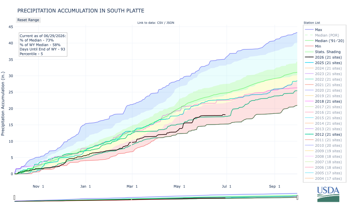
Below is the Precipitation Accumulation in South Platte graph from the NRCS for June 29, 2026. Precipitation is at 73% of the median (no change one week) and 58% of the water year median (up 1% one week), this morning. There are 93 days left in the water year.
There is a slight chance for showers and thunderstorms Sunday in the central mountains, otherwise breezy and warm. There is a slight chance for showers and thunderstorms Sunday in the northern mountains, otherwise breezy and warm. There is a slight chance for showers and thunderstorms Sunday down here, about 101 miles from Leadville, near the Willow Fire. From the Summit Daily: “A wildfire that grew to more than 1,000 acres in a matter of hours near Leadville in the evening Sunday, June 28, sent smoke rolling into Summit County and led emergency officials to ask residents not to call 911 unless they detect a distinct column of smoke or flames. Summit County’s emergency alert system notified residents shortly before 6 p.m. that smoke from what has been dubbed the Willow Fire had entered the county and may remain visible through the evening and coming days…The Willow Fire ignited Sunday afternoon around 3:30 p.m. on U.S. Forest Service land near Twin Mounds below Mount Massive — about two miles northwest of the Leadville National Fish Hatchery, according to the fire detection app Watch Duty and the Lake County Office of Emergency Management. Initial estimates placed the fire at three to five acres, but by around 4:38, incident commanders estimated it had nearly quadrupled in size, according to Watch Duty. Around 5 p.m., firefighters shifted focus toward evacuating residents near Turquoise Lake and the hatchery ahead of the advancing fire. By Sunday evening around 6:50 p.m., Watch Duty and Egp.Wildfire.gov estimates the Willow Fire has grown to 1,066 acres.”
Here’s a look at the 7-Day Colorado precipitation map through June 28, 2026 from the High Plains Regional Climate Center. Precipitation in the South Platte Basin along the Continental Divide of the Americas ranged from 0.00” to 2.00”.

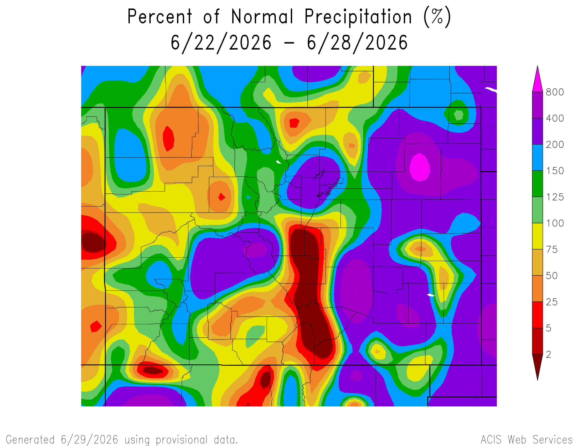
Here’s the 7-Day percent of normal precipitation map through June 28, 2026 from the High Plains Regional Climate Center. Precipitation in the South Platte River Basin along the Continental Divide of the Americas ranged from 5% to 400% of normal.
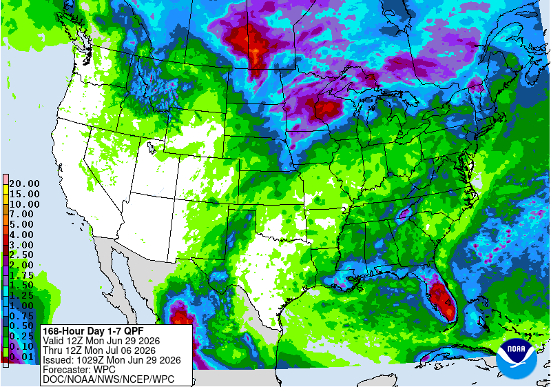
Here’s the 7-Day Quantitative Precipitation Forecast issued June 29, 2026 by NOAA. Precipitation is anticipated for the mountains of the South Platte River Basin and may total 0.01”.
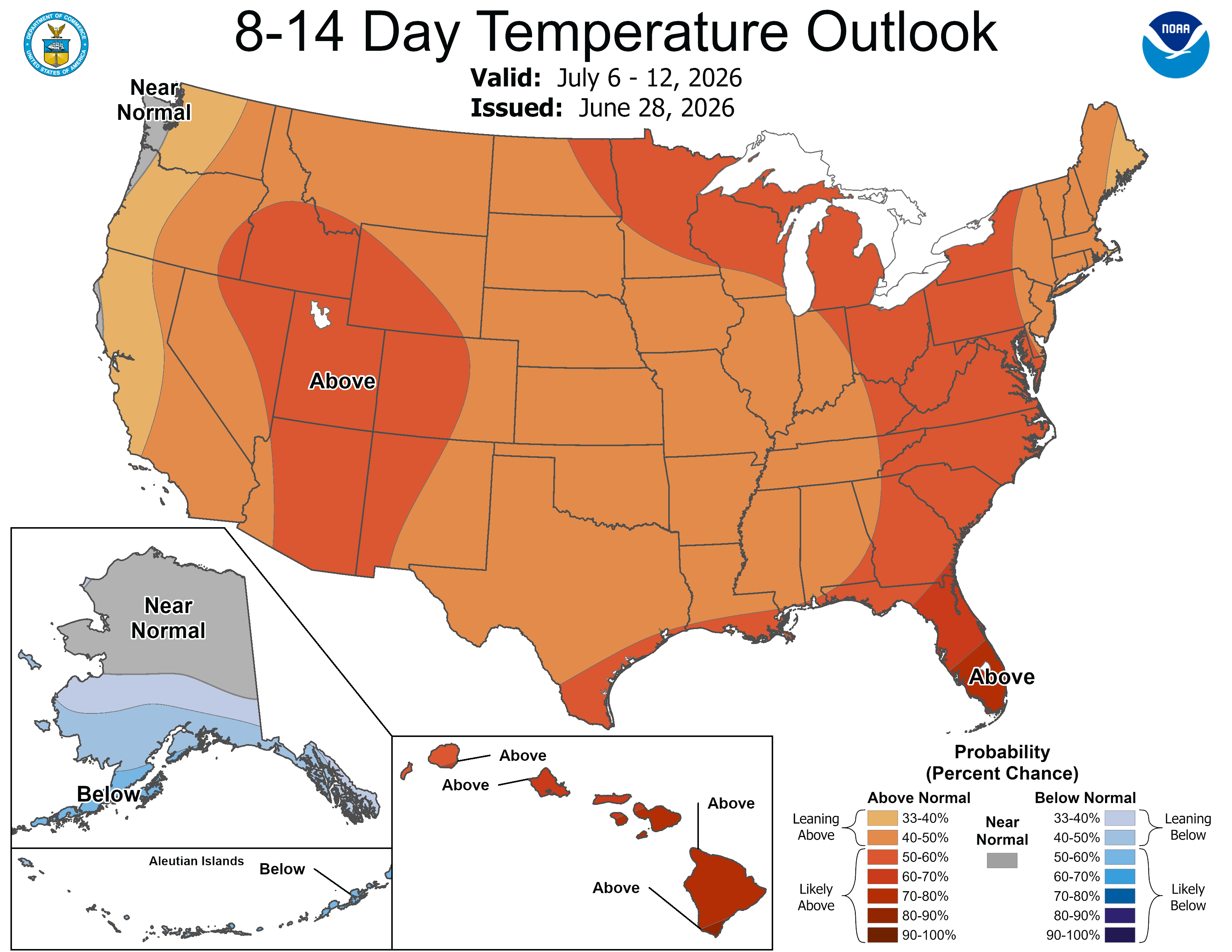
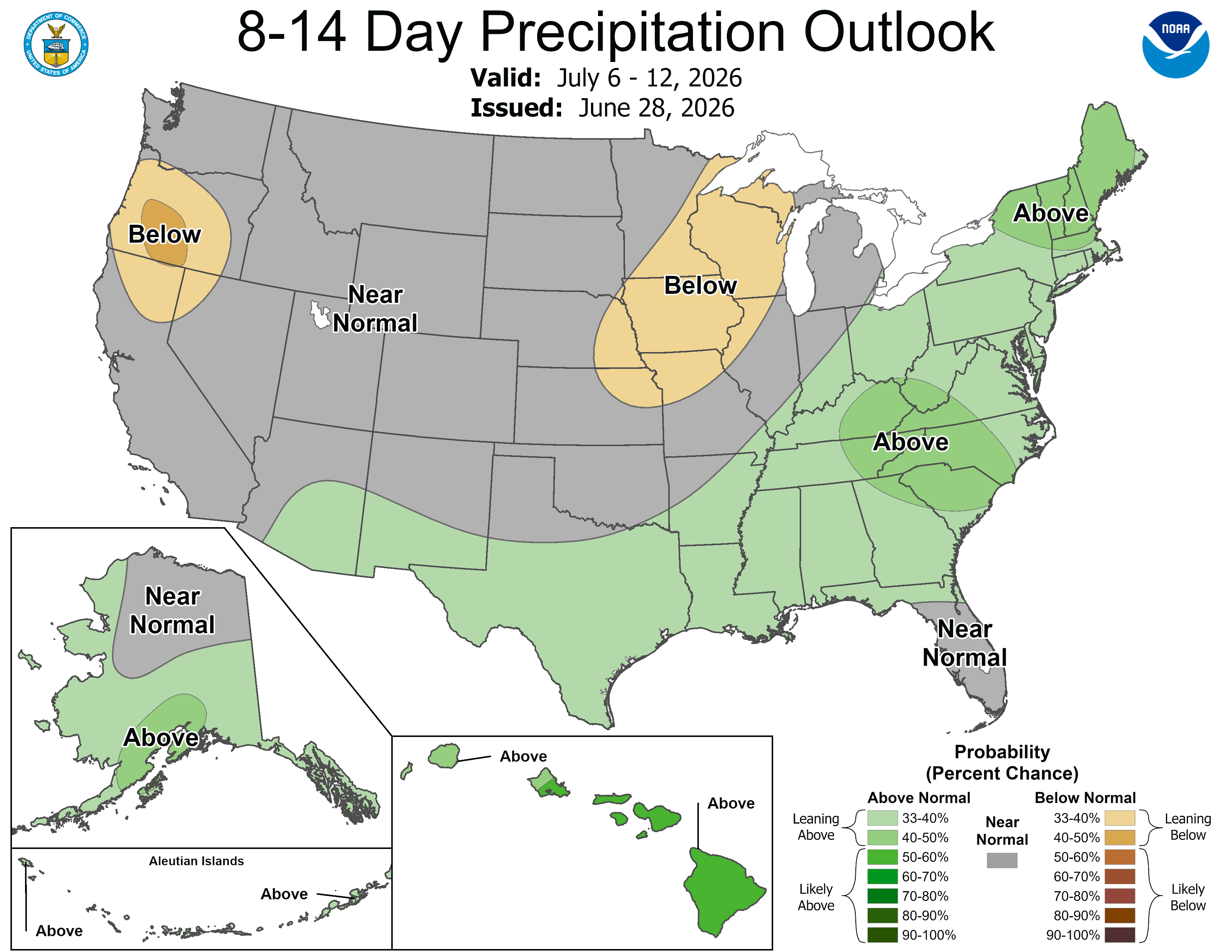
Below are the 8-14 day outlooks from the Climate Prediction Center, issued June 28, 2026, for temperature and precipitation, for the week starting July 6, 2026. The CPC expects above normal temperatures and near normal precipitation for the mountains of the South Platte River Basin.
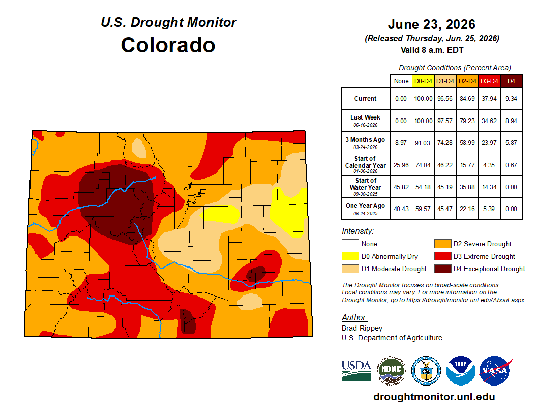
Below is the Colorado Drought Monitor map from June 23, 2026. There were one class degradations in Larimer, Weld, Jefferson, Clear Creek, and Park counties. Drought and abnormal dryness covers 100% of Colorado. The South Platte Basin is experiencing Abnormally Dry, Moderate, Severe, Extreme, and Exceptional drought conditions.
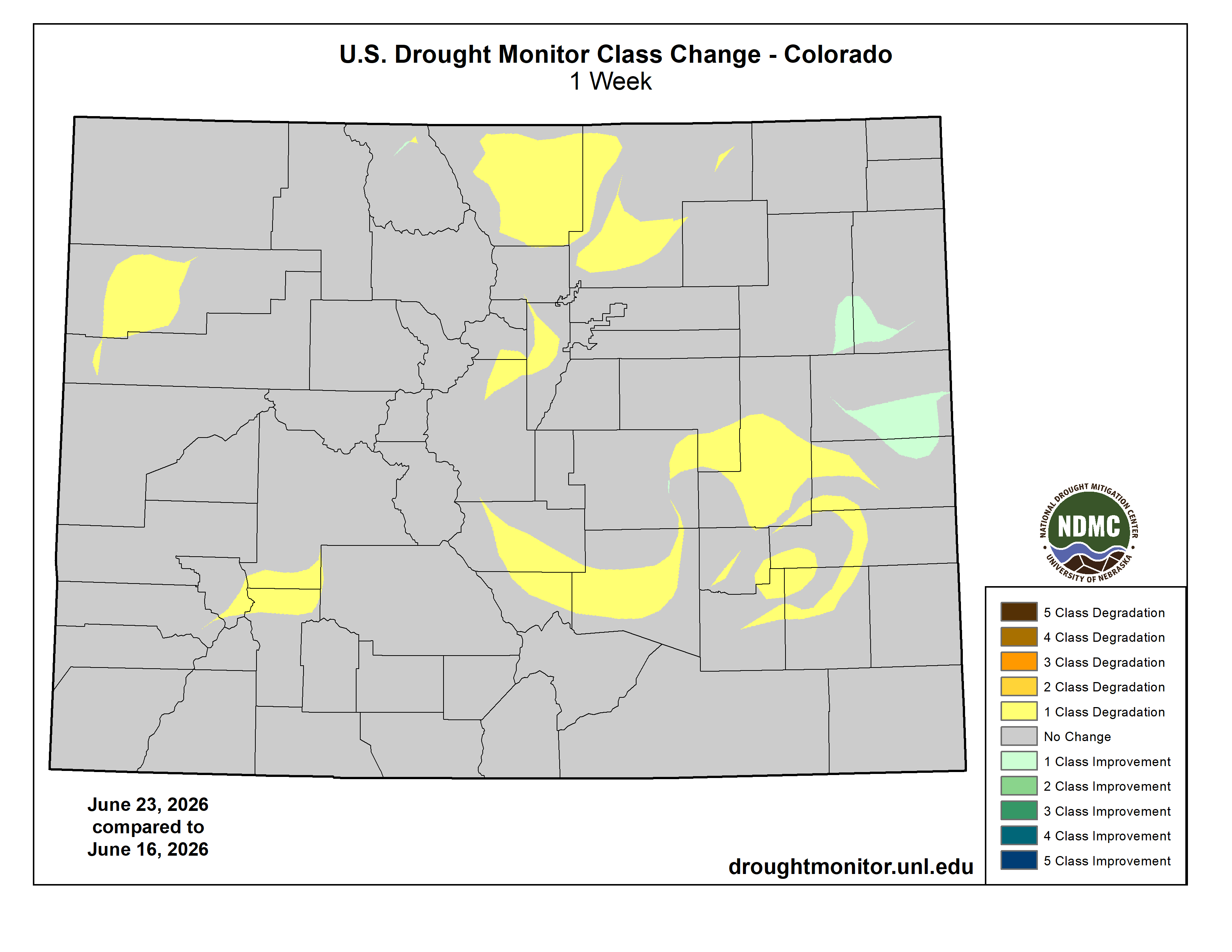
Below is the Colorado Drought Monitor one week change map ending June 23, 2026.
Here’s the US Drought Monitor Map from last week along with the one week U.S. change map.


Finally, since the Colorado River is a supply for many in the South Platte Basin, here’s an in-depth look, “The Colorado River states are deadlocked and the river is crashing. will a ‘grand bargain’ finally get its day?“, at solving the supply crisis in the basin from Matt Jenkins, writing for the Water Education Foundation:
For roughly 80 years after the Compact was signed, the prospect of a Compact call was purely theoretical. Then the Millennium Drought set in. By 2005, the two flagship reservoirs on the Colorado River — Lakes Mead and Powell — were half empty.
The drought was pushing the river’s flows closer to a Compact violation trigger, making the risk of a call by the Lower Basin a growing probability. The Lower Basin, particularly Arizona, was insisting on guaranteed releases of water from Lake Powell. And because Colorado has the biggest share of the river within the Upper Basin and uses a greater portion of its apportionment than the other upstream states, it is most at risk. It began searching for a way to slip out of the legal noose of a Compact call.
In September 2005, the seven states’ top negotiators met in Albuquerque, New Mexico. During a lunch break, Colorado’s team made its pitch. The state’s negotiators proposed that the Lower Basin waive its right to force a downstream delivery through a Compact call. In exchange, the Upper Basin states would limit their water use to less than what’s strictly apportioned in the Compact, thereby reducing potential demand in the headwaters of Colorado and Wyoming that supply nearly the entirety of the river’s flow.
Also, permanent acquisition of Ag rights in the Colorado River Basin is a hot topic lately. Here’s an article from Heather Sackett and Aspen Journalism, “Colorado River experts say agriculture must make permanent cuts to water use: Water managers say drying up farmland is not the solution.”:
But in the midst of a climate change-fueled megadrought that has already robbed the river of at least 20% of its flows, experts say temporary measures no longer cut it. Water managers are reckoning with the reality that the river will probably never again deliver what was promised a century ago by the Colorado River Compact. The demand for water now far outstrips the dwindling supply.
“Are we going to continue to spend hundreds of millions of dollars a year and not have a permanent solution?” said author and Colorado River expert Eric Kuhn. “I think, at some point, it just makes economic sense to go ahead and say, ‘Let’s buy out the existing demand.’”
