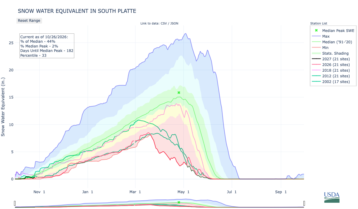
Below is the Snow Water Equivalent in South Platte graph from the NRCS for October 26, 2026. Snowpack is 44% of the median (down 92% one week, wild swings this time of the accumulation season) and 4% of the median peak (up 1% one week). There are 181 days until the median peak. I’ve added the lines for 2026, 2018, 2012, and 2002 since the statewide drought is still very pronounced.
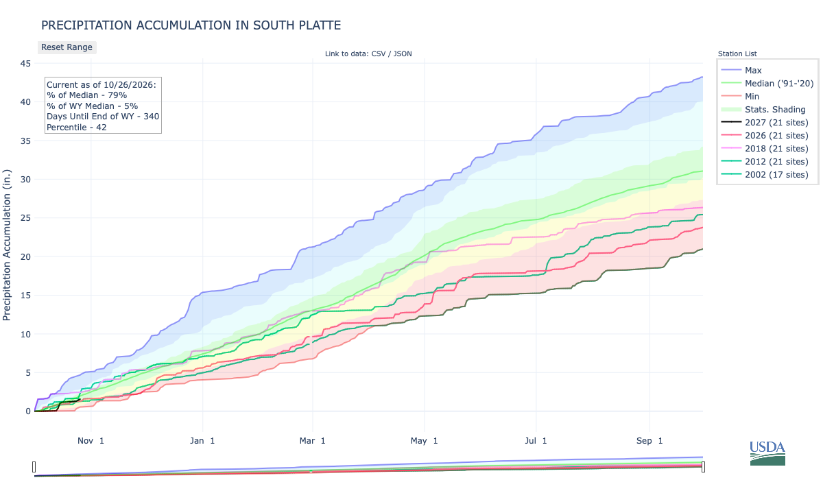
Below is the Precipitation Accumulation in South Platte graph from the NRCS for October 26, 2026. This morning precipitation, at the SNOTEL stations, is at 79% of the median (down 15% one week), and 5% of the water year median (up 1% one week), There are 340 days left in the water year. I’ve added the lines for 2026, 2018, 2012, and 2002 since the statewide drought is still very pronounced.
There is a slight chance for snow showers Saturday and a chance for rain and snow showers Sunday in the central mountains. There is a slight chance for showers Saturday and a chance for showers Sunday in the northern mountains. There is a chance for showers Saturday and Sunday, down here, about 439 miles from the Four Corners National Monument near where the San Juan River is raging out of its banks flooding the Navajo Nation downstream to Lake Powell which has risen 10 feet from all the water. From Wikipedia:
The Four Corners Monument marks the quadripoint in the Southwestern United States where the states of Arizona, Colorado, New Mexico, and Utah meet. It is the only point in the United States shared by four states, leading to the area being named the Four Corners region. The monument also marks the boundary between two sovereign Native American governments, the Navajo Nation, which maintains the monument as a tourist attraction, and the Ute Mountain Ute Tribe Reservation. The origins of the state boundaries marked by the monument occurred just prior to, and during, the American Civil War, when the United States Congress acted to form governments in the area to combat the spread of slavery to the region.

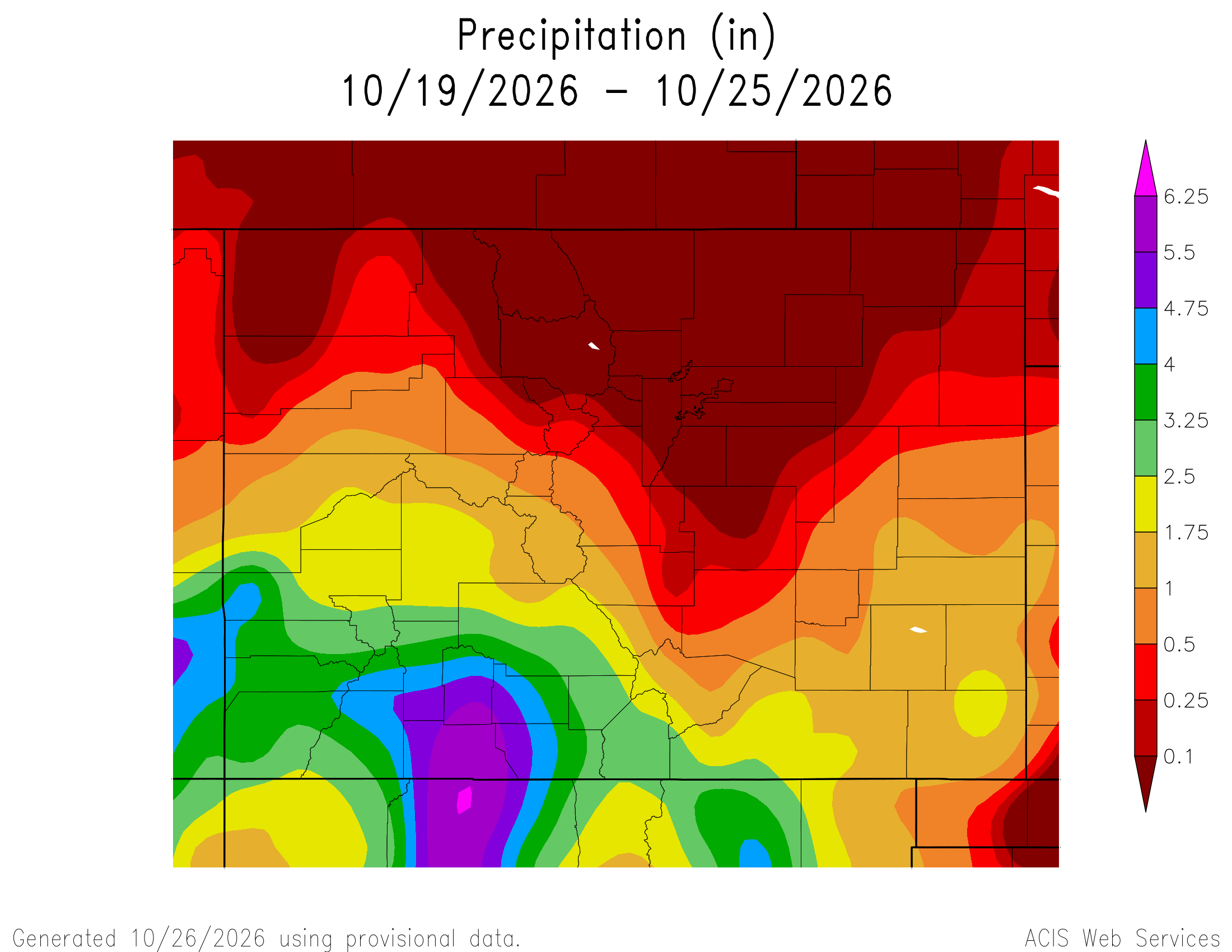
Here’s a look at the Colorado 7-Day precipitation map through October 25, 2026 from the High Plains Regional Climate Center. Precipitation in the South Platte Basin along the Continental Divide of the Americas ranged from 0.00” to 1.75″.
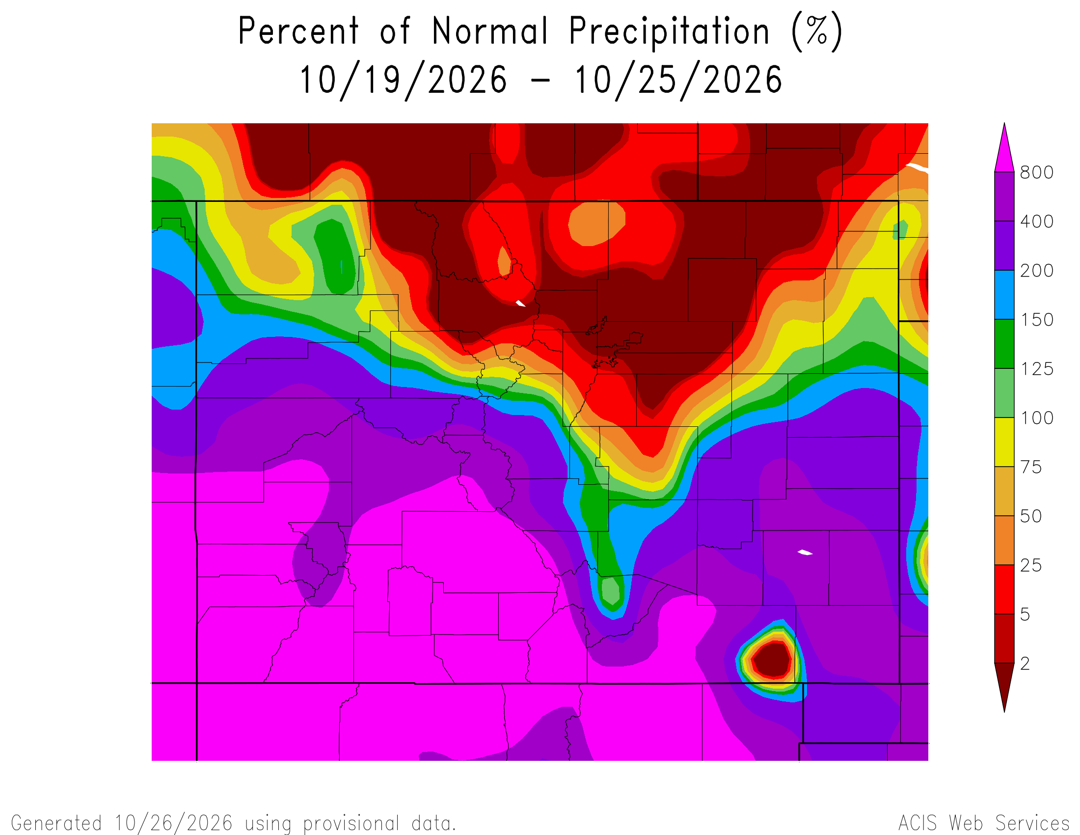
Here’s the Colorado 7-Day percent of normal precipitation map through October 25, 2026 from the High Plains Regional Climate Center. Precipitation in the South Platte River Basin along the Continental Divide of the Americas ranged from 0% to 800% of normal.
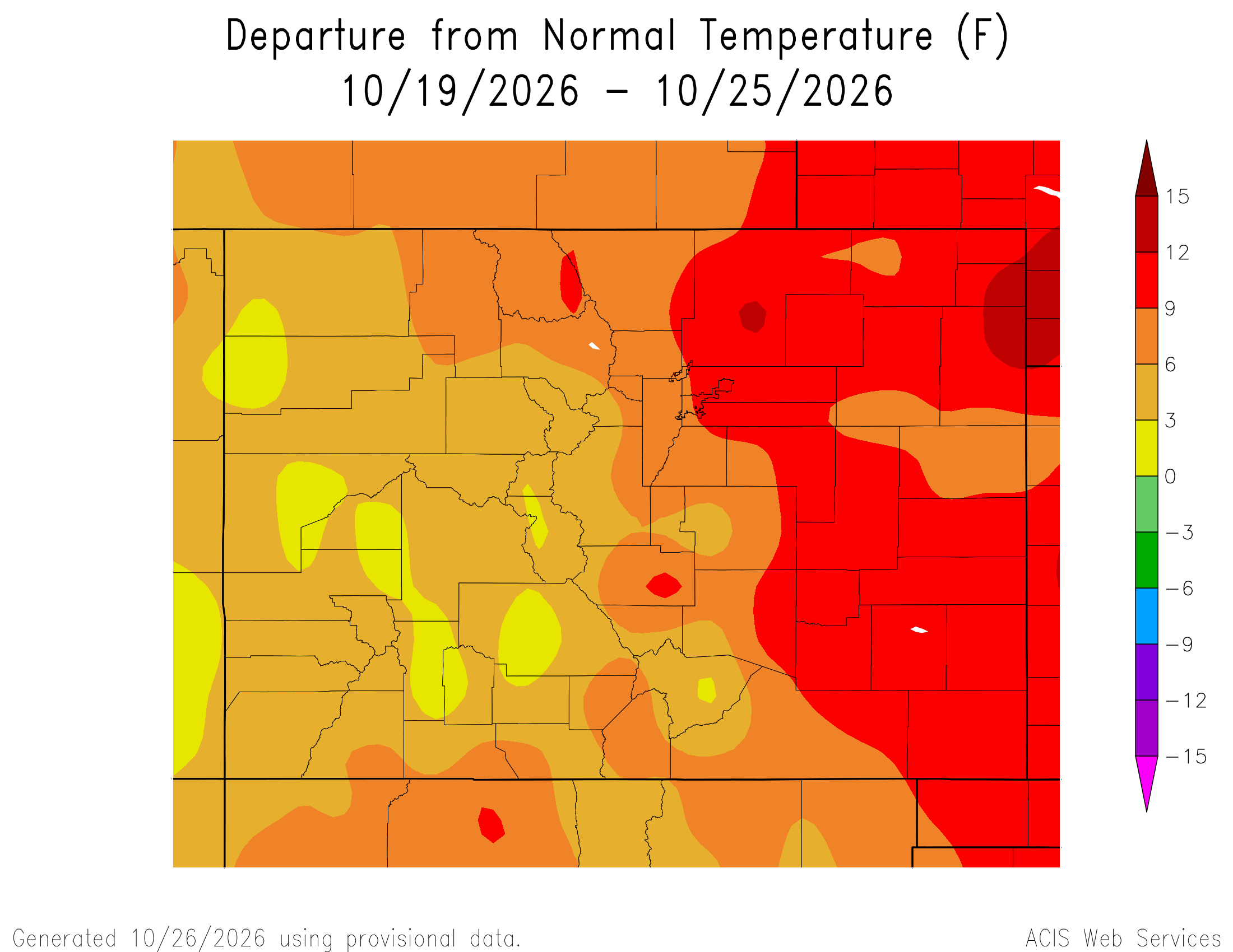
Here’s the most recent 7-Day Departure from Normal Temperature (F) for Colorado through October 25, 2026 from the High Plains Regional Climate Center.
Below is the 7-day Quantitative Precipitation Forecast for the week of October 26, 2026. Precipitation is anticipated for the mountains of the South Platte River Basin and may total up to 0.10″

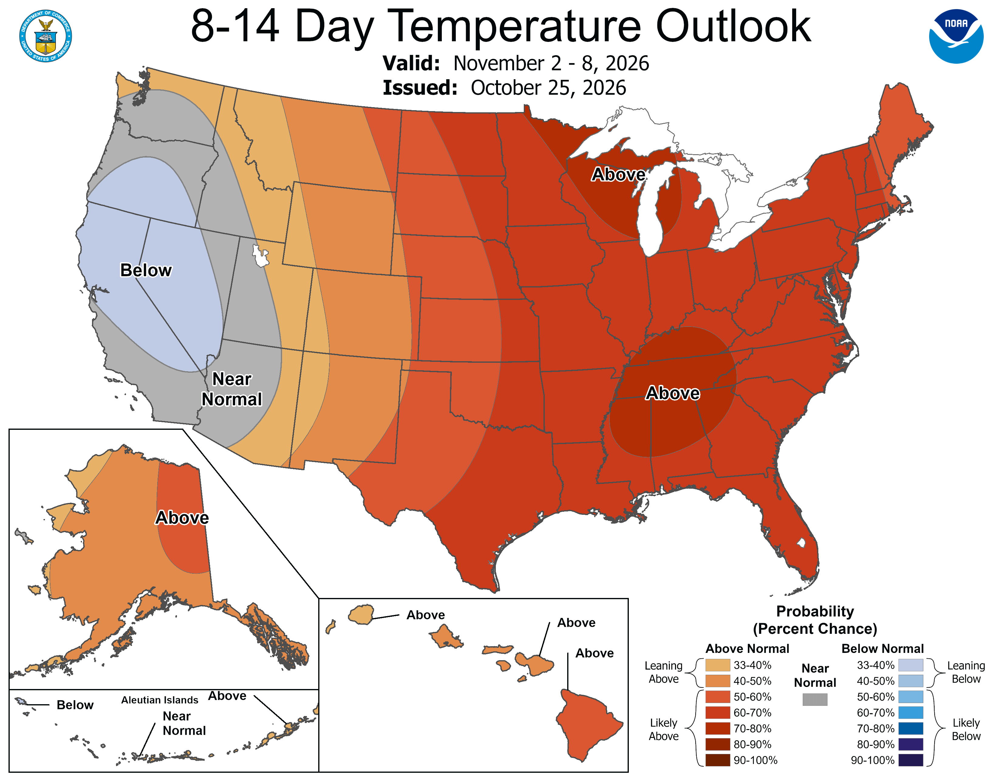
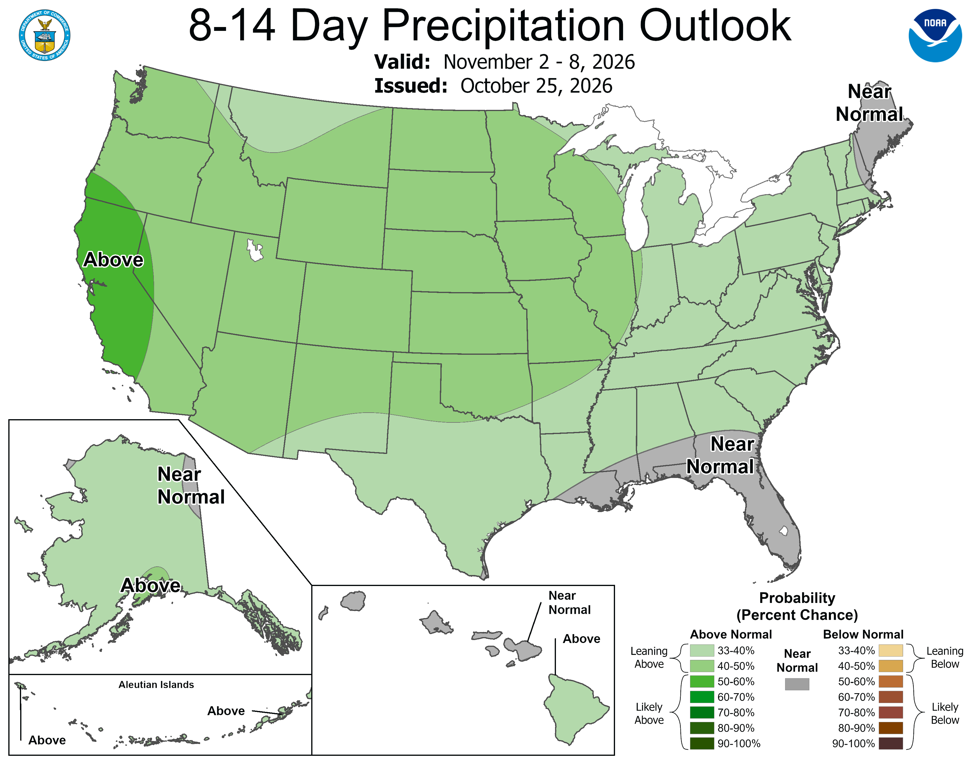
Below are the 8-14 day outlooks from the Climate Prediction Center, issued October 25, 2026, for temperature and precipitation, for the week starting November 2, 2026. The CPC expects above normal temperatures and above normal precipitation for the mountains of the South Platte River Basin.
Below is the Colorado Drought Monitor map from October 20, 2026. There were one category improvments in Larimer, Weld, Boulder, Broomfiled, and Adams counties in the South Platte River Basin. There were one category degradations in Morgan County in the basin. Drought and abnormal dryness covers 83.50% of Colorado. The South Platte Basin is experiencing Abnormally Dry, Moderate, Severe, Extreme, and Exceptional drought conditions.
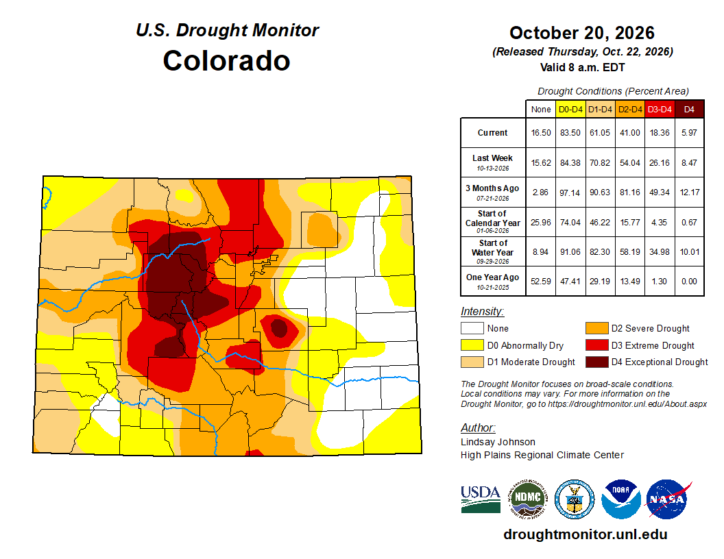
Below is the Colorado Drought Monitor one week change map ending October 20, 2026.

Here’s the US Drought Monitor Map from last week along with the one week U.S. change map.
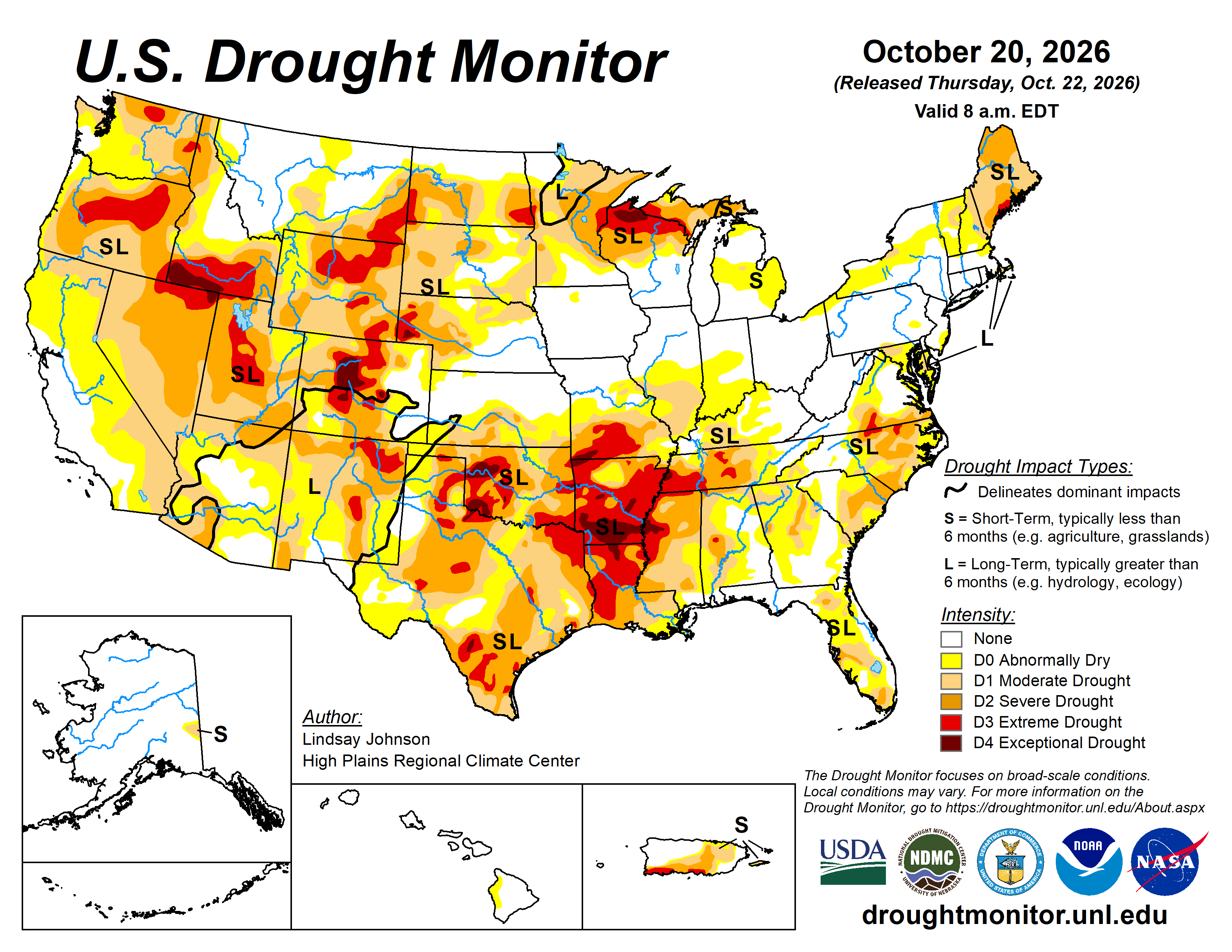

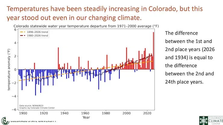
Finally, Allen Best reports on the An astonishing year for heat in Colorado: Heat across state surpassed old record set in 1934 by two degrees. And, of course, snowpack was worst ever, too at Big Pivots:
“Holy crap,” said one of my acquaintances in Colorado when I passed along the news that Colorado, during the last water year, had an average temperature of 2 degrees Fahrenheit above the previous record year of 1934. For me, it wasn’t a great surprise. I remember all too well trying to write stories in 95 degree heat during summer in my former home/office. But it was a sucker punch nonetheless…This, many have said, is clear evidence that the current warming is just part of a phase. But this new report from Colorado State University researchers speaks to just how extraordinary these times are. The report comes after the conclusion of the 2025-26 water year, which starts in October and ends in September.
“Water year 2026 was one for the record books in Colorado,” the report says. “It was our warmest on record by a substantial margin, and it was also one of our driest.”
The mountain snowpack, the lowest ever, had implications across many sectors, from agriculture and wildfire to human health and recreation, the report continues. Once again, the temperatures continue to amaze. Colorado had four months — December and January, March and August — that were warmest ever. But 11 of the 12 months ranked among the top-15 warmest of those months on record. The researchers found that, statewide, temperatures were 4.5 degrees Fahrenheit above the averages seen between 1991-2020.