A recent photo of the water behind the Lincoln Gulch Diversion Dam on Lincoln Creek that forms Grizzly Reservoir. Repairs to the outlet gate were completed on Oct. 6 without having to drain the standing water at the bottom of the reservoir.
Nine weeks after the Twin Lakes Reservoir and Canal Co. drained Grizzly Reservoir in early August due to the failure of an outlet gate in the dam across Lincoln Creek, repairs have been made and reservoir operations are returning to normal.
But the usually obscure company is now also facing questions in state water court about its diversions through its larger system, which moves about 40,600 acre-feet of water a year from the headwaters of the Roaring Fork River east to Aurora, Colorado Springs, Pueblo and Pueblo West.
On Tuesday, a new seal was installed on the bottom of the dam’s outlet gate, according to Scott Campell, general manager of the Twin Lakes Reservoir and Canal Co.
The installation of the relatively simple rubber seal was done underwater by crews standing in knee-deep water, reaching down to tighten the bolts on new steel straps holding the seal in place.
By working this way, they didn’t have to release the remaining dirty water at the bottom of the reservoir, as was done Aug. 10, when 10 to 20 acre-feet of muddy, yellowish water was released from the bottom of the reservoir and sent down Lincoln Creek and the Roaring Fork River.
After the release of water in August, the flow in the Roaring Fork near Aspen jumped up from fewer than 70 cubic feet per second to more than 160 cfs in a few hours and alarmed residents notified local public officials about the color of their local river.
Subsequent testing Aug. 13 by Lotic Hydrological for the city of Aspen found “elevated levels of several dissolved metals including aluminum, copper, iron, manganese and zinc” in Lincoln Creek and the Roaring Fork River because sediment in the bottom of Grizzly Reservoir includes material washed down from the historic Ruby Mining District and the naturally acidic upper Lincoln Creek Valley, according to a report provided by the city of Aspen.
The levels of aluminum and iron exceeded state standards, but no fish kills were reported. The city is awaiting results of recent testing for insect health on the river, according to April Long, Aspen’s stormwater manager.
With the repairs in place, water is now backing up again behind the dam on Lincoln Creek, and the reservoir, which normally holds 570 acre-feet of water, is expected to contain 300 acre-feet by Oct. 20, Campbell said.
The small reservoir primarily acts as a forebay to Tunnel No. 1, which allows for as much as 625 cfs to be moved from Grizzly Reservoir under the Continental Divide and into to the south fork of Lake Creek and down to Twin Lakes Reservoir.
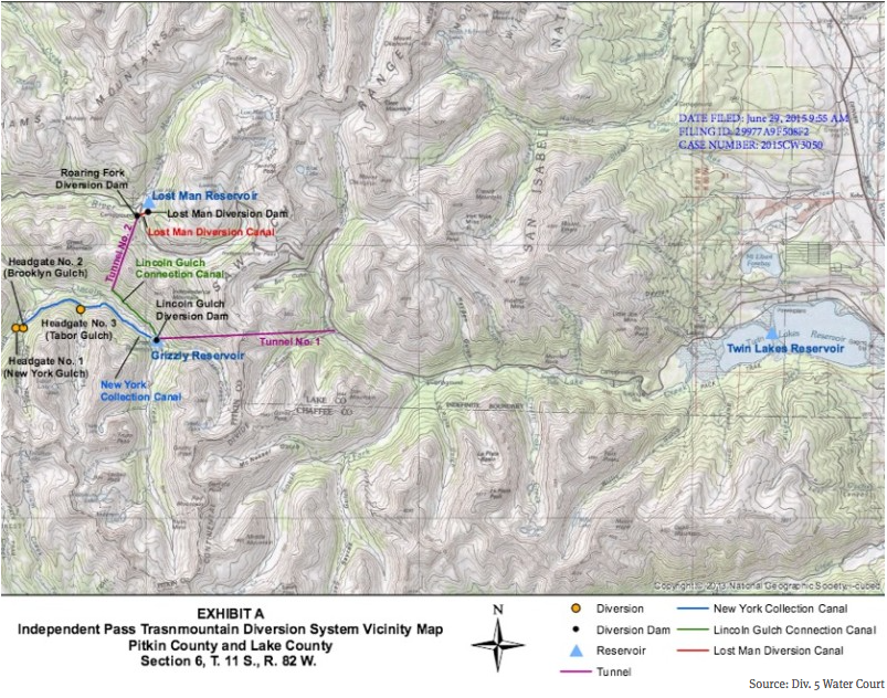
Tunnel No. 1 and Grizzly Reservoir are the central components of the larger Independence Pass Transmountain Diversion System, which is owned by the Twin Lakes Reservoir and Canal Co. and diverts water from the Roaring Fork River and Lincoln, Grizzly, New York, Brooklyn, Tabor and Lost Man creeks through a series of dams, ditches and tunnels.
The water rights for the Independence Pass system have a priority date of 1930 and a court-issued decree from 1936. The water originally was diverted to grow crops in the lower Arkansas River Valley, but cities gradually bought the rights to the water.
On May 29, Twin Lakes filed an application in Division 5 Water Court in Glenwood Springs to make 21.33 cfs of its conditional water rights, as specified in its 1936 decree, “absolute.”
It offered evidence to the court that it has now physically diverted an additional 21.33 cfs of water through the Lost Man Canal, which today can carry as many as 272.33 cfs of water from Lost Man Creek to Grizzly Reservoir.
The Stillwater Ranch subdivision is on the Roaring Fork River east of Aspen, and the Caines own a home on Wildwood Drive west of Independence Pass.
Craig Corona, a water attorney in Aspen representing Stillwater Ranch and the Caines, said the application from Twin Lakes raises questions “as to Twin Lakes’ accounting of its diversions and administration by the state.”
Corona specifically points to a 1976 decree, which includes limits and conditions on Twin Lakes’ right to divert water.
“Twin Lakes must show that they diverted water in accordance with their water court decrees, including the restrictions the court included in the 1976 decree from Case W-1901 regarding storage in Twin Lakes Reservoir and the amount of water available to the Colorado Canal,” Corona said.
The decree, for example, states that if there is enough water in the Arkansas River to provide a certain amount of water to the Colorado Canal, then Twin Lakes does not have the right to divert water for that purpose.
Laura Makar, an assistant Pitkin County attorney specializing in water cases, said the county filed its statement of opposition to ensure that Twin Lakes was held to “strict proof” regarding its historical diversions.
“This involves transbasin diversions, and the county always wants to know what is going on if there is water leaving the basin,” Makar said. “We want to make sure all diversions have been in accordance with all prior relevant decrees.”
The resulting water court process could shed more light on the operations of the Independence Pass system and could do so just as a new level of communications has been established between Twin Lakes and various officials.
A map of the Independence Pass Transmountain Diversion System, as submitted to Div. 5 Water Court by Twin Lakes Reservoir and Canal Co.
Rush of water
In early August, when Scott Campbell realized that Twin Lakes had lost the ability to store water in Grizzly Reservoir behind a damaged and leaking outlet gate, he made the rare call to drain the reservoir.
But in his rush to prevent a catastrophic release of water, he had failed to inform local and state officials of the pending release of muddy water from the bottom of the reservoir on Aug. 10, an oversight he has since acknowledged and regrets.
Over the past two months, Campbell has been working to repair both the seal on the outlet gate in the dam and his relationships with various officials.
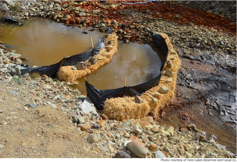
In a sign of progress on both fronts, Campbell sent out a notice Friday that the repairs were complete and that by Tuesday, the reservoir would begin releasing about 1 cfs of water and do so through a sediment-trapping system below the reservoir.
Through a prearranged notification system, Campbell sent his update on Friday to the Pitkin County dispatch center, which in turn sent it out to various officials.
“We’re doing things that we’ve never even contemplated before,” Campbell said Friday, referring to the sending of updates to various officials. “But we’ve learned from this. We’ve made changes. And our intent is to operate as a good neighbor.”
When asked about the water court case, Campbell referred questions to Kevin Lusk, president of the Twin Lakes Reservoir and Canal Co.
A sediment filtering system has been set up below the outflow gate on the dam at Grizzly Reservoir. The silt fencing and straw bales has been an effective way to trap sediment coming out of the reservoir, according to Scott Campbell, the general manager of Twin Lakes Reservoir and Canal Co.
A modest proposal
Lusk is also a principal senior engineer with Colorado Springs Utilities, which owns 55 percent of the shares in Twin Lakes.
The Pueblo Board of Water Works owns 23 percent of the shares in Twin Lakes, while the Pueblo West Metro District owns 12 percent and the city of Aurora owns 5 percent.
Lusk characterized the water court application from Twin Lakes as modest.
“Our case itself is one to just make a little bit more of a certain portion of the system absolute,” Lusk said. “It does not change the amount of water that we can bring to the East Slope in any way.”
Lusk also said the city of Aspen’s opposition to its application was routine.
“This is what we in the business typically call a smiley-faced objection, Lusk said. “It really is just a way to be more involved in the court case.”
He also said that Phil Overeynder, a senior utilities engineer for the city of Aspen, had called him in advance about the city’s filing of a statement of opposition.
“Phil assured me this is not an indication of any change in our cooperative relationship,” Lusk said.
The city is working with Twin Lakes on the management of other water rights that may allow more water to remain in the Roaring Fork River for environmental reasons, city officials have said recently.
But it remains to be seen how hard Pitkin County and the parties represented by Corona, the Aspen water attorney, will push on the issue of whether Twin Lakes has strictly adhered to the requirements of the 1976 decree.
Editor’s note: Aspen Journalism is collaborating with The Aspen Times and the Glenwood Springs Post Independent on coverage of rivers and water. The Times published this story on Sunday, Oct. 11, 2015 and the Post Independent published it on Monday, Oct 12, 2015.
Click here to listen to the podcast. Here’s an excerpt from the Water Values website:
Recently retired from the Colorado Supreme Court, Justice Greg Hobbs joins The Water Values Podcast to share his knowledge of western water law, specifically the doctrine of prior appropriation and its impact on how the West developed. Justice Hobbs uses his deep and broad knowledge of water law to explain how the doctrine of prior appropriation developed, stretching his explanation of water in the West all the way back to the reservoirs the inhabitants of Mesa Verde used and up through the Spanish and Mexican influences in the West. He provides an eye-opening analysis of water law and contrasts differing versions of prior appropriation (Colorado with California; court adjudicated rights versus administratively granted rights). Finally, Justice Hobbs discusses his involvement with the Colorado Foundation for Water Education and its many programs.
When State Engineer Dick Wolfe turned in a set of proposed groundwater rules and regulations to the division water court on Sept. 23, he channeled Yogi Berra.
“When you come to the fork in the road, take it,” he said, quoting the Hall of Fame Yankees catcher who passed away the day before.
But for nearly four decades, the San Luis Valley’s water users avoided any path that involved giving the state engineer the authority to shut down or limit pumping by the valley’s roughly 4,500 irrigation wells.
Two aquifers supply the water for those wells and help farmers irrigate valley staples such as potatoes, barley and alfalfa.
The shallower of the two, the unconfined aquifer, is fed by streams, seepage from irrigation canals and return flows from fields, and some upward leakage from a deeper aquifer.
The deeper aquifer, known as the confined aquifer, is fed by streams at the rim of the valley and is under artesian pressure.
Both aquifers are hydrologically connected to the valley’s surface streams to varying degrees, a fact that underlies complaints from surface-water users that their rights are injured by groundwater pumping.
Wolfe’s predecessor had proposed rules in 1975 only to see them shelved as the valley’s water users looked for another way to mitigate the impacts of well pumping on surfacewater users. And while this version still will have to gain approval from water court, enough had changed in the intervening decades to prompt a second stab at rules and regulations.
To begin, the federal Closed Basin Project, which pumps groundwater from the eastern edge of the valley for delivery to the Rio Grande, has been ineffective.
The valley’s water user groups signed an agreement in 1985 that divvied up how the project’s water would apply toward Colorado’s obligations to the Rio Grande Compact.
The move was regarded as an olive branch to surface-water users on the Conejos and Rio Grande rivers, since they alone carried the burden of complying with compact obligations.
Without the policing powers rules could give the state engineer, groundwater users faced no such burden.
The pact, commonly known as the 60-40 Agreement, also included a provision that kept valley surface-water users from going to court to shut down groundwater wells.
But since 2000, the amount of water produced by the project has never exceeded 20,000 acre-feet — far below envisioned amounts of up to 100,000 acre-feet when it was authorized by Congress in 1972.
Another change since the last rule proposals involved a pair of unsuccessful efforts in the 1990s to ship large amounts of the valley’s groundwater to the Front Range.
The proposals from American Water Development and later the Stockmen’s Water Company put all of the valley’s water users in the same boat, said Ralph Curtis, who managed the Rio Grande Water Conservation District for 25 years.
“We kind of just grew and grew together to realize we are neighbors,” he said.
Moreover, less was known in the 1970s about the two major groundwater bodies that sit beneath the valley floor. When the 1975 rules were proposed, a monitoring network that could measure levels in the unconfined aquifer in the north-central part of the valley still was a year away.
Exactly how much was pumped from the aquifers was not known either until 2006 when the engineer’s office implemented well-metering requirements.
Mac McFadden, who was the division engineer for the valley in 1975, and Steve Vandiver, who later would serve 24 years in the same post, both pointed to the development of the state’s groundwater computer model as an important advancement.
While that model could be a point of contention in court hearings for the current version of rules, it provides the basis for estimating how much instream losses are caused from well pumping Lastly, both Curtis and Vandiver point to the drought that began in 2002 as a pivotal point in the valley’s water politics and one that would pave the way to a new version of state rules.
“The drought of 2002 just tipped over the bucket of worms,” Vandiver said. “It was obvious then what the impacts of wells were on the (Rio Grande) — river just went away.”
The lowest flows ever recorded on the Conejos and the Rio Grande rivers where they enter the valley floor came in 2002.
And much of those meager flows were lost to aquifers that were being drawn on heavily by irrigators that had no surface supplies.
The division engineer’s annual report for that year estimated stream losses on the Rio Grande were as high as 40 percent at times, while on the Conejos they peaked as high as 60 percent.
“That provided the impetus for the surface-water users to say we’ve had enough,” Vandiver said.
Vandiver credited Manassa rancher Kelly Sowards and other surface-water users for creating the subsequent push to regulate wells.
Two years later, state lawmakers would pass a bill that created the framework for the current version of the rules and groundwater management subdistricts.
The first such subdistrict, which buys water to return to the Rio Grande and also pays ditch companies for losses caused by pumping, went into operation four years ago in the north-central part of the valley.
Kansas has concerns that the effects of a large dam on Fountain Creek are not adequately modeled in a study of flood control and water rights that is nearing completion.
But comments from Kevin Salter of the Kansas Division of Water Resources indicate the modeling done by the Fountain Creek Watershed Flood Control and Greenway District is “reasonable” when it comes to side-detention ponds.
Kansas is an important player because its 1985 federal lawsuit over the Arkansas River Compact raised storage issues along with wells. The Supreme Court ruled in Colorado’s favor on the storage questions, but new dams would be untested waters.
“The methodology in this draft report appears reasonable to protect water rights below the confluence of Fountain Creek and the Arkansas River for the scenario involving side-detention facilities,” Salter said.
“As for the scenario to construct a multipurpose reservoir on Fountain Creek; Kansas is concerned.”
In an email to a committee looking at engineer Duane Helton’s draft report, Salter said more study is needed to look at the full impact of a 52,700 acre-foot reservoir that would include a 25,700 acre-foot pool for recreation and water supply and 27,000 acre-feet for temporary flood storage.
“Should the actual implementation of detained flood flows on Fountain Creek impact compact conservation storage Kansas would fully expect that those flows be restored,” Salter said.
Larry Small, executive director of the Fountain Creek district, said a more complete evaluation would be made of water rights if a large reservoir is pursued.
“The district will complete a full evaluation of alternatives and a feasibility study of the preferred alternative in the future before any decision is made on flood control facilities, to include multipurpose facilities,” Small said in an email reply.
Helton’s study shows there would be little impacts on water rights if flood control structures allowed a flow of 10,000 cubic feet per second to flow through Pueblo during large floods. Water would be released as quickly as possible following the peak flow.
The study discounted extremely high flows, such as the 1999 or 1965 floods, saying there would be little damage to water rights because the high volume would fill John Martin Reservoir, creating a free river.
Division Engineer Steve Witte said Kansas concerns must be treated carefully, so a new round of litigation isn’t triggered.
Witte would like the 2015 flooding to be studied. Flows on Fountain Creek exceeded the 10,000 cfs mark on three occasions during six weeks of elevated flows. John Martin Reservoir did not fill, so it would be an ideal opportunity to explore how flood storage could be administered, he said.
“I think we need to be careful in any scenario to make sure there isn’t some material depletion,” Witte said.
After the 1999 flood, when Kansas and Colorado were in litigation over the Arkansas River Compact, Kansas raised questions about how such large flows should be divided. Those issues have not been resolved, Witte said.
Another downstream party, Tri-State Generation and Transmission Association which owns half of the Amity Canal in Prowers County, said more study is needed to determine the damage if water is detained at lower flows and how water would be allocated after a flood.
The committee looking at the report, which includes some downstream farmers, Kansas, Colorado Springs Utilities, Tri-State and others, will meet again at 10 a.m. Oct. 14 at the Southeastern Colorado Water Conservancy District offices.
A Grand County rancher has become the first person in Colorado to use a 2013 state law to intentionally leave water in a stream without fear of diminishing his water right. Working with the Colorado Water Trust , Witt Caruthers developed a plan to curtail diversions from Willow Creek when its flows drop to critical levels.
The additional flows will benefit half a mile of Willow Creek and then four and a half miles of the upper Colorado River before encountering the next downstream diversion, where another water user could potentially take the water. This stretch of the Colorado River has been heavily impacted for decades by upstream diversions across the Continental Divide to Front Range cities and farms.
The 2013 law, Senate Bill 13-019, allows some Western Slope water right holders to reduce their water use in up to five out of any consecutive ten years without having the use reductions count against them in water court calculations of “historic consumptive use.” This reduces the “use it or lose it” disincentive for conservation in Colorado water law.
The law applies only to water users in Colorado Division of Water Resources Divisions 4 (Gunnison River Basin), 5 (Colorado River Basin) and 6 (Yampa, White and North Platte River Basins). In order to qualify for the law’s protections, the water use reductions must be the result of enrolling land in a federal land conservation program or participating in an officially-sanctioned water conservation or banking program.
Jim Pokrandt of the Colorado River District, which approved Caruthers’s conservation program, told the Sky Hi Daily News that “we’re glad to be in the vanguard and helping the agricultural community protect their water rights when they want to lend the water rights to environmental purposes.” The same article quotes Caruthers as saying that he and his partners sought to “one, preserve our water rights but also to contribute to the overall maintenance of the ecosystem there by leaving water in the stream when it wasn’t needed.”
The Colorado Water Trust has also pioneered the use of other voluntary and market-based tools for landowners to share water with streams without diminishing their water rights. These include a 2003 law that created a streamlined process for water users to make short-term leases of water to the state for environmental purposes. The Trust first used this tool in 2012 by brokering a deal to support flows in the Yampa River. It has since been used in several other places.
Support and funding for such innovative water conservation efforts is rising as Colorado and the other states and cities that share the Colorado River are seeking ways to prop up water levels in Lakes Powell and Mead in the face of long-term drought.
Shoshone Hydroelectric Plant back in the days before I-70 via Aspen Journalism
Shoshone Falls hydroelectric generation station via USGenWeb
Shoshone hydroelectric generation plant Glenwood Canyon via the Colorado River District
From email from the Middle Colorado Watershed Council:
Come join the Middle Colorado Watershed Council for a tour of the Shoshone Hydroelectric Power Plant east of Glenwood Springs. The Plant plays a pivotal role in western water not because of the power it generates, but because it holds the one of the oldest, largest water rights on the river. The senior right to 1,250 CFS means that water must flow down the Colorado, and it’s a non-consumptive use, so that water is flowing right back into the river for later use. We will learn about the Plant’s legacy over the past century, and what the water right means to us on the Western Slope. Registration is only open through October 12, and all participants must submit a facility waiver form at registration.
Location: Shoshone Power Station, Glenwood Canyon, CO
Date: October 26, 2015
Registration Deadline: October 12, 5:00pm
Time: 9:00am – 12:00pm
Cost: Free
Registration: Online through Eventbrite
Contact: For more information, contact Dan at info@midcowatershed.org
Two-thirds of the water that originates in the Colorado mountains must go to downstream states and Mexico, recently retired State Supreme Court Justice Gregory Hobbs noted at the Water 101 seminar on Sept. 25 at the Pine River Library in Bayfield.
This includes Kansas, Nebraska, and New Mecico as well as Arizona, Utah, Nevada, and California.
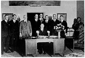
Herbert Hoover presides over the signing of the Colorado River Compact in November 1922. (Courtesy U.S. Department of Interior, Bureau of Reclamation)
“The legal doctrine is equitable sharing of interstate waters,” Hobbs said. This is governed by an assortment of interstate compacts, starting with the 1922 compact with three upper basin (Western Colorado and parts of Wyoming and New Mexico) and four lower basin states. Compacts are between states, but they become federal law when approved by Congress.
The 1922 compact dictates that 75 million acre feet, averaged over 10 years, must be delivered to the lower basin states. That’s measured at Lee’s Ferry in the Grand Canyon below Glen Canyon dam and Lake Powell. Seventy percent of that water comes from Colorado, Hobbs said.
There are nine interstate compacts governing Colorado water, he said…
Colorado transmountain diversions via the State Engineer’s office
Within Colorado, the hot issue for many years, at least on the Western Slope, has been trans-mountain water diversions to the Front Range. “We are one Colorado. Isn’t that the problem?” Hobbs asked. Before his 19 years on the State Supreme Court, he represented the Northern Colorado Water Conservancy District (northern Front Range) for 17 years.
“The water in these rivers is available to Colorado. There’s an overlay of federal supremacy,” he said. There are trans-basin diversions within the Colorado River Basin and around 24 diversions that go from Colorado headwaters to the east, he said.
Colorado water law is based on prior appropriation (first in time, first in right) and putting the water to beneficial use. A water right is conditional until it’s put to beneficial use.
The problem is, “If you can’t get your structure permitted by the Corps (of Engineers) or permits to cross federal land, you can’t put the water to beneficial use,” he said. “Getting the right is one thing; getting the permit to build the project is something else.”
Hobbs also listed a progression of federal laws – the 1862 Homestead Act to promote Western settlement, the 1866 Mining Law that severed water from federal lands and turned it over to states, and the 1902 Reclamation Act that opened the way for Western dam construction projects.
Colorado became a territory in 1861, he said. That year the territoriaal legislature created the right for settlers to build ditches to get water to their land that wasn’t next to the stream. It prevented corporations, railroads and land barons from buying up the river banks to control the water. In 1864, the legislature made prior appropriation the basis for water diversion and use.
San Luis People’s Ditch via The Pueblo Chieftain
The earliest ditch right was the 1852 People’s Ditch near San Luis. Ute water rights date to 1868, the basis for constructing the Animas/La Plata Project.
“Our (state) constitution from 1876 says the public owns the water. You get a right to use it by prior appropriation,” Hobbs said. “The most valuable rights in the state are water and ditch rights.”
He showed pictures of several historical hand drawn maps of rivers in the mountain region. One from 1841 showed a big blank space of unknown land. The land was considered vacant, at least to settlers coming from back East, he said, noting that Native Americans already lived “from sea to shining sea.”
Farview Reservoir Mesa Verde NP
Before all those maps, Hobbs showed a picture of Far View Village on Chapin Mesa at Mesa Verde and a nearby structure that he said was a water reservoir. There are four reservoirs at Mesa Verde and one at Hovenweep, Hobbs said. Paleohydrology is one of his interests. “I can’t teach about water law without talking about history, culture, governance. There are enduring problems that go way back,” he said.
“Everywhere across this country there are water features, because water is the basis of life,” he added
Hobbs was just appointed as Jurist in Residence at Denver University. He also serves on the Colorado Foundation for Water Education that publishes the quarterly Headwaters magazine and the Citizens’ Guide to Colorado Water Law.
A legislative committee Tuesday approved drafting a bill that would legalize rain barrels. Colorado is the only state where they are illegal.
The Water Resources Review Committee won’t officially vote on whether to introduce the measure as a committee until October. If the committee approves the bill, then it would be introduced at the start of the next session in January. There’s also the option for a lawmaker to carry the measure separate from the committee, or run a completely separate bill.
While the legislation signals that the issue is far from dried-up, certain caveats in the measure could cause an outcry. For one, the bill would require users to register their barrels with the state. Another provision would require water providers to replace water taken from rooftops.
Rain-barrel supporters worry that the current proposal is burdensome to water providers, and that would result in failing to approve barrel collection. They point out that rain barrels help with conservation, and that 97 percent of water falling on residential property never ends up in a river or stream.
But it may be their best shot after a similar effort drowned during the previous legislative session. That legislation was stalled in committee after concerns from Sen. Jerry Sonnenberg, R-Sterling, over water rights. Had the bill received a floor vote, it likely would have passed thanks to support from Republican Sen. Ellen Roberts of Durango.
Just when it looked like the bill had a chance to receive a late floor vote in the Senate, sponsors and legislative leaders agreed to let the bill die so that discussions could continue for future compromise legislation. Enter Sonnenberg’s current proposal.
“This is more about process,” Sonnenberg said Tuesday during the committee hearing. “This is more about honoring the prior appropriations system and saying, ‘If we’re going to have rain barrels, the right thing to do is to figure out how we replace that water.’”[…]
Under Sonnenberg’s proposal, Coloradans would be allowed to use up to two containers with a maximum capacity of 55 gallons each. A consumer’s residence would need to contain four or fewer residential units.
Rain-barrel supporters say legislation should make it easy.
“Numerous studies have consistently shown that rain barrels have no impact on downstream users,” said Pete Maysmith, executive director of Conservation Colorado. “Any proposals to put additional red tape and bureaucracy on a rain-barrel program disregard these studies and will only serve to dissuade and burden Coloradans.”
“If you have a rain barrel, that’s less that’s going to run into the street,” said Senator Jerry Sonnenberg (R-Sterling).
And he believes, less water for farmers and ranchers – which is why Sonneberg opposed the rain barrel bill when it last came up and made sure it was defeated. He’s now floating a new measure that would allow rain barrels, if people register them. Then it would be up to water providers to determine how to replace the lost water.
“We’re going to bring a bill that does it right and honors the prior appropriation system and Colorado water law,” said Sonnenberg. “We need a simple and fair process on how that water should be replaced.”
But during a recent hearing at the state capitol, academic water experts from Colorado State University testified that there would be no need for a bill like Sonnenberg’s.
“This water doesn’t run off any way, and we capture a little of it and we put it on our gardens or we put it on our roses or something,” said Dr. Larry Roesner, a civil and environmental engineering professor at CSU.
“It would take a lot of water before it made a significant impact,” said Roesner.
Two other CSU experts, along with Roesner, testified before the Water Resources Review committee, which is meeting in the interim to discuss water policy.
“When you have scientists come in and give you the facts I think it’s important to incorporate that into your thought process,” said Senator Ellen Roberts (R-Durango).
As the chair of the committee, Roberts was frustrated when the previous rain barrel bill didn’t pass. She wanted to come back to the topic in between sessions – especially since next session will be during an election year.
“I’m struggling myself to explain to people on the street why this is so controversial. In my district in southwest Colorado, those who want to use rain barrels, use rain barrels today, and a lot of people across party lines were appalled that the legislature was struggling so much with this,” said Roberts.
For Drew Beckwith with Western Resource Advocates the measure is mostly about educating the public about water. He said too many people fail to understand where their water comes from, and he said water providers in other states where it is legal say rain barrels help connect people to water policy.
From Western Resource Advocates (Rob Harris/Joan Clayburgh):
Yesterday afternoon the Colorado Water Conservation Board rendered a unanimous decision to seek a water right on the Dolores River to protect fish and wildlife, securing up to 900 cfs of water during spring peak flows, as well as essential winter base flows, on one reach in western Colorado’s Red Rock Country. This will help prevent three native fish in the Dolores River from becoming threatened or endangered species. The reach slated for the largest instream flow protection on the river to date is near the Unaweep-Tabeguache Scenic and Historic Byway between Gateway and Uravan Colorado…
The Board heard testimony opposing this water right that asked for water for unspecified future urban or agricultural water demands. The Board determined these requests for withholding water from this instream flow water right were speculative and unfounded. Now the Board will approach the state water court to secure the water right and it appears at this time that it should be a straightforward process.
Mired in drought and torched by one of the hottest years ever measured, the seven states of the Colorado River Basin are acutely aware of how a desert can bully water supplies. They are not alone. In this cauldron of collaboration and competing interests is a collection of players who are just as significant for managing and responding to water scarcity but attract much less attention: the basin’s 29 federally recognized Indian tribes.
With the oldest claims to water, the tribes command a considerable role in directing the region’s future. Combined, they hold rights to a substantial portion of the Colorado River’s flow: roughly 20 percent, or 2.9 million acre-feet, which is more water than Arizona’s allocation from the river. The tribal share, moreover, will increase, perhaps by as much as hundreds of thousands of acre-feet as the 13 tribes without confirmed rights settle their claims with federal and state governments.
Years of careful negotiations, spurred by a desire to avoid long-running court battles, produced legal settlements that provide water for tribes, cities, and industries. Beneficial to all sides, the settlements were a catalyst for urban development and a tool for funding Indian water systems. Perhaps more importantly, the settlements are the foundation of a partnership, an inescapable union, between tribes and their neighbors, a union that will grow in importance as water becomes scarcer in the warming and drying American West.
“We’ve developed tremendous and valuable relationships with each other from being in the same room for years,” Kathryn Sorensen, director of the Phoenix water department, told Circle of Blue. “Water is always important and contentious in Arizona. But having relationships helps you have conversations when you want new solutions.”
John Schweizer has spent most of his life raising corn, alfalfa and other crops and about 200 cattle in Otero County, along southeastern Colorado’s Lower Arkansas River. It’s never been easy, but the last 15 years have been particularly tough on the nearly 81-year-old Schweizer and his neighbors. Their corner of the state is drier now than it was during the Dust Bowl. Meanwhile, growing Front Range cities are buying out farms and shifting their irrigation water to residential use — a process called “buy and dry.”
Cities have siphoned more than 100,000 acre-feet of ag water — enough for about 200,000 Colorado homes — from the Arkansas River Basin alone since the 1970s. In neighboring Crowley County, farming has vanished, school-class sizes are half what they were 50 years ago, and tumbleweeds from dried-up fields pile up along fences and block roads. “That’s what they’re stuck with, because there’s no more water,” Schweizer says. “It’s gone forever.”
Schweizer is president of the 35-mile-long Catlin Canal, which irrigates about 18,000 acres of farms. He’s hoping that the trial run of something called the Arkansas Valley Super Ditch will save the basin’s remaining communities and farms. The initiative is not actually a big ditch, but rather a scheme that allows six of the valley’s irrigation canals to pool their water rights and temporarily lease them to cities. Starting in March, five Catlin irrigators “leased” a total of 500 acre-feet of water, which would normally supply their fields, to nearby Fowler and the cities of Fountain and Security, 80 miles away. Under the agreement, communities can use the farm water to supply homes and recharge wells for up to three years out of every decade. During those years, the irrigators will have to fallow, or rest, some fields, yet will still be able to earn money from the water itself and farm the rest of their land.
More Arkansas Valley Super Ditch coverage here and here.
Greg Hobbs at the 2015 Martz Summer Conference (of course there is a projected image of a map — this one was the division of Colorado into water divisions heeding the advice of John Wesley Powell to organize by watershed)
@CoyoteGulch how to avoid privatization of public resource a la Kern County water bank is necessary regulatory wrinkle to iron out
(If the Tweet above does not display correctly use your browser refresh button. There are timing problems with content between WordPress and Twitter at times.)
In Colorado we have prior appropriation, the anti-speculation doctrine, and a long-lived and active water market, that have managed to keep the wolf at bay. Maximizing shareholder value is the wrong goal for the public’s water. Most water in Colorado is provided by local government entities.
Municipal use is a small part of the overall pie but large amounts of water are necessary for agriculture and the environment. You don’t want to squeeze either one too much. We’re not that good at forecasting the consequences of our engineering.
I asked Brad Udall if he thought the Colorado River Basin was in collapse. He said no, even in the worst case we should have 80% yield from the system. He said we have to use the water more wisely.
That is the definition of collapse: There is not enough water to stay status quo in the basin. This is at the same time that the environment requires that we undo some of our damage and share some water.
Click here to read my notes (Tweets) from the conference. (Scroll down to the bottom and read up from there. Tweets are published in reverse-chronological order.)
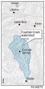
Pueblo County is angling to become the owner of the most senior water rights on Fountain Creek.
The purchase would be aided by the Fountain Creek Watershed Flood Control and Greenway District, which voted Friday to line up financing for the deal, which is expected to complete by the end of the year.
“I see this as a fascinating project. This meets all the charges the district has: flood control, recreation, restoration and conservation,” Commissioner Terry Hart said. “I love history. I’m thrilled with it.”
The Greenview Trust property, located 8 miles north of Pueblo along Overton Road, is about 360 acres with water rights dating back to 1862. Like other farms on Fountain Creek, it has faced erosion issues for years, and the owners sued the city of Colorado Springs after the 1999 flood over the growth that increased the base flows in the waterway.
Negotiations are still underway for the purchase of the property and details cannot be discussed publicly, Hart said.
“We still have some due diligence issues,” Hart said.
The county has some other water rights, but the Fountain Creek purchase would give it more legal standing on water rights issues as projects develop along Fountain Creek.
The Fountain Creek district board voted 9-0 to line up some of the financing for the possibly $3.72 million project in open session Friday, since public grants and loans are involved.
Collateral for the $1 million loan from the CWCB would be the upcoming payments by Colorado Springs Utilities to the Fountain Creek district under the 1041 permit with Pueblo County. The first payment would come due in early 2017, if the Southern Delivery System goes online by 2016, as expected.
The property could be used for wetlands or for detention facilities that would aid flood control.
Pueblo County intends to put a conservation easement on the property as well because of its historic significance, Hart said.
“This is exactly what we want to be doing as a district,” said Richard Skorman, who sits on the Fountain Creek board.
“The Lower Ark is obviously excited about this,” said Melissa Esquibel, a Lower Ark board member who sits on the Fountain Creek board.
Board member Jane Rhodes, a Fountain Creek landowner, is related to the family which is selling the property.
From the Associated Press via the Fort Collins Coloradan:
The bill allows homeowners to collect up to 110 gallons in rain barrels.
Colorado’s rain-barrel ban is little known and widely flouted, with rain barrels for sale at many home-gardening stores and commonly used by home gardeners.
But the barrels technically violate Colorado water law, which says that people don’t own the water that runs on or through their property. They can use the water, but they can’t keep it.
Colorado’s law banning rain barrels was amended in 2009 to allow use by people with their own wells. But the change didn’t apply to municipal water users.
The measure addresses what some believe to be an antiquated prohibition on collecting and storing rainwater from roofs in Colorado.
“Colorado is the only state where it is illegal to collect and use rainwater,” said Rep. Daneya Esgar, D-Pueblo, who co-sponsored the bill. “I’m glad to see so much bipartisan support for this common-sense bill.”
The measure was amended to allow individuals to keep rain from their roof in up to two 55-gallon rain barrels for use in their garden or on their lawn. The bill started at two rain barrels with a combined storage of 100 gallons, but lawmakers decided to slightly raise the number.
Sponsors pointed out that an estimated 97 percent of water that falls on residential property never ends up in a river or stream system.
But critics say the measure would steal water rights from downstream users. They say water does not belong to someone simply because it fell on a roof. Instead, the water is return flow that someone downstream has a right to, especially if that water is being stored, say critics.
Republican Reps. Don Coram of Montrose and J. Paul Brown of Ignacio both voted against the measure. Coram said the bill serves as a literal slippery slope, suggesting that what starts as roof collection could end in allowing Coloradans to collect rainwater off their entire property.
“We keep nibbling away on the prior appropriation doctrine, and you know you eat an elephant one bite at a time,” Coram said, referring to the system in Colorado in which water rights are granted to the first person to take water from an aquifer or river, despite residential proximity.
“I object more to changing the process,” Coram added.
The bill would also set standards for rain barrels, including mandating screens to filter out debris and insects.
Sponsors estimated that with two 55-gallon barrels, residents cold capture more than 600 gallons of water each year.
Environmental groups praised the bill as another step towards conservation.
“While the amount of water saved is modest, having rain barrels in yards around the state will serve as an important tool to increase Coloradans’ knowledge of our limited rainfall and water supply,” said Pete Maysmith, executive director of Conservation Colorado. “This common-sense step should help people understand the need for smart water conservation policies.”
In the 1894 hit song “Playmate, Come Out and Play With Me,” the rain barrel is forever lodged in our collective consciousness right between the apple tree and cellar door.
But Colorado has waited 121 years since then for the use of rain barrels to become legal.
On Monday, the state House took the first step toward legal rain collection with the passage of HB1259, which would allow collection of up to 110 gallons in two 55-gallon drums. The bill passed 45-20 and now heads to the state Senate.
“Colorado is the only state where it is illegal to collect and use rainwater,” said state Rep. Daneya Esgar, who co-sponsored the legislation. “I’m glad to see so much bipartisan support for this common-sense bill.”
She sponsored the bill after hearing people talk about rainwater collection.
“It makes more sense to collect the water and use it when it’s needed,” Esgar said. “Really, the purpose is to get people to talk about water use and to be conscious of it.”
Colorado’s ban on rain barrels can be traced back to the state constitution and subsequent court cases that prohibit any sort of detention of water upstream from a senior right. It’s the same concept that poses a dilemma when considering flood detention structures.
Has the rain-barrel ban been rigorously enforced?
“Not that I can recall,” said Division 2 Engineer Steve Witte. “I would say it’s been rarely enforced. If people ask, there is a policy on (the Division of Water Resources) website.”
A 2009 state law (SB80) authorized the use of rain barrels in connection with other water rights. Another 2009 bill (HB1129) authorized pilot projects for rainwater harvesting. So far, the proposed Sterling Ranch development in Douglas County has been the only applicant.
HB1259 would allow any single-family residence or multifamily residences with four or fewer units to collect rainwater. Rainwater could only be used on lawns or in gardens, and would not be allowed as drinking water or for any other indoor uses. Barrels also would be required to have a sealable lid.
Opponents of the bill said it opened the door to other forms of capturing water before it reaches downstream users. Supporters argued that 97 percent of the water on residential lots never makes it into the stream system anyway.
If the rain-barrel law passes, homeowners will have a new source of water for that apple tree, while keeping rain from sliding down the cellar door.
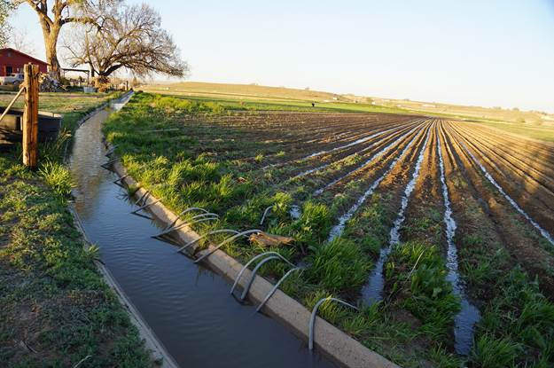
Flood irrigation — photo via the CSU Water Center FromThe Grand Junction Daily Sentinel (Charles Ashby):
he Colorado Senate gave final approval Tuesday to a water bill that made some Western Slope lawmakers a bit uneasy.
The measure, [SB15-183], requires water court judges, when considering changes in water uses, to decide based on actual historical use of that water, rather than uses not approved by a prior water decree.
Several Western Slope lawmakers from both parties questioned why such a bill would be necessary, saying it allows water rights owners who use water for unapproved purposes to get away with that illegal use.
“We have water courts for a reason,” said Sen. Ellen Roberts, R-Durango. “Water courts are highly trained to deal with technical issues. This bill basically is skipping over the water courts system and coming here to the Legislature to try and get a legislative result, as compared to having it well considered in the court system that, again, is trained to deal with these kinds of things.”
Supporters of the measure said the bill is designed to give direction to water court judges based on a recent Colorado Supreme Court decision in a case between Dick Wolfe, the state’s water engineer, and the Sedalia Water and Sanitation District over the district’s historical use of water.
Rep. Jerry Sonnenberg, R-Sterling and a sponsor of the bill, said it’s the Legislature’s job to give direction to the courts when there is undefined law on an issue.
“The question here is, do we want a consistent use of water, a consistent means of determining what the volume or quantity of that water is, as the Supreme Court did in the Sedalia case?” Sonnenberg said. “That’s what we’re trying to do, is clarify what they have asked us (about) what should and should not be used in quantifying a water right in a change of use.”
Sen. Kerry Donovan, D-Vail, said the bill rewards water users who use that water for unapproved uses.
The bill has support from virtually every water group in the state except the Colorado River Water Conservation District.
In the end, only eight senators voted against the bill, including Donovan, Roberts and Sens. Ray Scott, R-Grand Junction, and Randy Baumgardner, a Hot Sulphur Springs Republican whose district includes Garfield County. It now heads to the House for more hearings.
In a related matter, the House approved a water bill Tuesday that allows the Colorado Water Conservation Board to acquire water rights for up to 12 pilot projects to measure efficiency savings for instream flow use.
The pilot projects would take at least 10 years to complete.
Greg Hobbs at the Colorado Water Congress January 2012
Colorado Columbine photo via Greg Hobbs
Hobbs’ family hike
Flood irrigation in the Arkansas Valley via Greg Hobbs
David Robbins and J.C. Ulrich (Greg Hobbs) at the 2013 Colorado Water Congress Annual Convention
Dick Bratton, Greg Hobbs, im Pokrandt
Peter McBride and Greg Hobbs at CFWE Colorado Water 2012 event
Greg Hobbs, Diane Hoppe
Greg Hobbs and Coyote Gulch at Colorado College State of the Rockies Speaker Series 2011
Bents Fort photo via Greg Hobbs
Will Hobbs, Greg Hobbs, Dan Hobbs, and a string of fish for dinner, Mary Alice Lake, Weminuche Wilderness, 1986 via Greg Hobbs
Justice Hobbs is a friend of Coyote Gulch. Over the years I’ve published a small portion of his poems including photo poems that he’s written in the recent past. On the occasions where I’ve had an opportunity to talk with him at some length I’ve learned the depth of his life experience — he has travelled, written, and learned about the world around him due to his curious nature and love of knowledge. His love of family also shows up in conversations.
One of my favorite Hobbs’ poems :
Coloradans
To each of us
The land, the air, the water,
Mountain, canyon, mesa, plain,
Lightning bolts, clear days with no rain,
At the source of all thirst,
At the source of all thirst-quenching hope,
At the root and core of time and no-time,
The Great Divide Community
Stands astride the backbone of the continent,
Gathering, draining, reflecting, sending forth
A flow so powerful it seeps rhythmically
From within,
Alive to each of us,
To drink, to swim, to grow corn ears
To listen to our children float the streams
Of their own magnificence,
Out of their seeping dreams,
Out of their useful silliness,
Out of their source-mouths
High and pure,
The Great Divide,
You and I, all that lives
And floats and flies and passes through
All we know of why.
Reprinted, with permission, from Colorado Mother of Rivers, Water Poems by Justice Greg Hobbs
Another poem that Greg sent in the wee hours of the morning after we all learned of Ed Quillen’s passing:
Hurrah for Quillen!
This incomparable
Curmudgeon Wit gloried in the
great First Amendment.
Reprinted, with permission.
Here’s an article about his retirement from Mark Harden writing for the Denver Business Journal:
Gregory J. Hobbs Jr., a Colorado Supreme Court justice known as an expert on water and environmental law, will retire Aug. 31 after more than 19 years on the high court, the court announced Thursday.
Greg Hobbs was appointed to the court in April 1996 by Gov. Roy Romer and has twice been retained for 10-year terms by the state’s voters.
He previously practiced law for 23 years, focusing on water, environment, land use and transportation.
In 2007, Hobbs was named by then-Supreme Court Chief Justice Mary Mullarkey to lead a committee to review the state’s water-court system.
In 1997, Hobbs wrote a key Supreme Court ruling in a case over the way in which Denver Water figured its rates, brought by suburban water districts. The decision said Denver Water has the authority to set rates however it likes, but warned that the utility can’t “abuse its authority” to “reap monopoly profits.”
Hobbs is a former senior partner with Hobbs, Trout & Raley PC, and partner with Davis Graham & Stubbs LLP. He also previously served as first assistant Colorado attorney general with the Natural Resources Section and as an enforcement attorney with the U.S. Environmental Protection Agency.
Hobbs — a native of Gainesville, Florida — also has written poetry, collected in the 2005 book “Colorado, Mother of Rivers: Water Poems”; formerly taught environmental law at the University of Denver; and once was a sixth-grade teacher in New York City.
Thanks for your friendship Greg and good luck to you in retirement.
More Coyote Gulch posts that reference the Justice here and here
On Apr. 10, the DU Water Law Review Annual Symposium will honor the career and contributions of Justice Greg… http://t.co/jY4YFgwnbF
A bill that would allow residential rainwater collection sailed through a committee hearing Monday, making headway in Colorado’s decades-old water rights battle.
House Bill 1259 passed the Agriculture, Livestock & Natural Resources Committee 8-5 and now advances to the full House.
“We’re simply wanting to allow people to collect the rain that falls off of their rooftops … to put back into the earth,” said the bill’s sponsor, Rep. Daneya Esgar, D-Pueblo.
The proposal would limit total barrel size to 100 gallons per residence. Proponents say that the average homeowner could collect about 600 gallons of water annually to water their lawns or gardens.
That amount of water could sustain a vegetable garden or a flower bed, according to Drew Beckwith, water policy manager for Western Resource Advocates, who testified for the legislation.
“One of the most important things this bill accomplishes is putting urban and suburban water users in the mind frame of conservation,” said co-sponsor Rep. Jessie Danielson, D-Wheat Ridge.
Esgar said people already use rain barrels and were shocked to find out it’s illegal. Beckwith said Colorado is the only state to prohibit residential collection of rain.
Colorado’s water rights system — known as “first in time, first in right” — emerged during the mining booms of the 19th century. Using that rhetoric, people argue that collecting rainwater prevents it from reaching rivers, violating the rights of downstream users.
“It’s a violation of the doctrine of prior appropriations,” said Pat Ratliff of the South Metro Water Authority. “It’s not their water (to use). It’s a return flow that somebody downstream has a senior right to.”
Lawmakers are working to change a decades-old law that prohibits Coloradans from collecting rainwater.
It’s currently against the law — in almost all cases — to put a bucket by a downspout and catch the rain because that water is the property of people downstream. But a bill changes water rights, allowing homeowners to store up to 100 gallons of rain at a time.
It’s been illegal to collect rain in Colorado for more than a century. It can be directed by changing gutters or grading, but it can’t be collected.
“Many people I’ve spoken to think I’m joking when I tell them that the collecting of the rain off of your roof is illegal,” said Rep. Daneya Esgar, D-Pueblo.
Esgar and Rep. Jessie Danielson, D-Wheat Ridge, say it’s time the law changed. A recent study found 97 percent of rain doesn’t even make it to a stream because it’s absorbed by vegetation or evaporates.
Esgar and Danielson say homeowners ought to be able to collect and use the water where they need it most, as long as they put it back into the ground.
“Water collected through this bill will not even be enough to water the average blue grass lawn in Colorado even once,” Esgar said.
“Anytime that you manipulate that system — any — it affects somebody,” rancher Jim Yahn said.
Yahn says the study looked at only a small natural area in Douglas County, not municipal runoff. He says even a little water makes a big difference.
“There are people waiting in line for that water, and if they don’t get that little influx from a rainfall event, then they don’t get that water that they are going to put on their crops, that they’re going to use to offset their well pumping,” Yahn said.
Supporters insist the bill will result in more water for everyone by encouraging conservation.
“Perhaps when they see how little water 100 gallons really is, they’ll think twice about how much water they’re using when they turn that faucet on and it comes pouring out to water their lawns,” Danielson said.
Under the bill Coloradans can only use the rain collected outside — on flowers for example.
The state is in the middle of a 10-year study of rain harvesting in both urban and rural areas. Opponents say lawmakers should wait until that’s done.
The bill passed committee Monday and is headed to the full House.
A showdown over how transmountain diversions are calculated is brewing in the Colorado Supreme Court.
At issue is last year’s ruling on a change of use case filed by Aurora in water court in Pueblo.
Division 2 Water Judge Larry C. Schwartz ruled that Aurora is entitled to export an average of 2,416 acre-feet (787 million gallons) annually, even though Aurora waited more than 20 years to change the use of the water from agriculture to municipal.
Aurora shares Busk-Ivanhoe with the Pueblo Board of Water Works on the system that formerly was operated by the High Line Canal. It brings water into Busk Creek above Turquoise Lake from Ivanhoe Lake through the Carleton Tunnel, which once was a train passage and later an automobile route across the Continental Divide.
Pueblo Water has a 1993 decree changing its water rights from its 1971 purchase of its half of Busk-Ivanhoe. Aurora purchased the other half from High Line shareholders beginning in 1986, but did not file for a change of use until 2009.
Western Slope groups and the state Division of Water Resources are arguing that Aurora’s claim to water should be reduced by 27 percent because the city misused the water after purchasing its share of the Busk-Ivanhoe system.
They claim that Schwartz should have counted the 22-year period as zeros when calculating the historic use of water from the Busk-Ivanhoe system. Schwartz determined that the years where the water was used improperly should not count in the calculation, but said the amount of Aurora’s diversion should be recalculated separately from the amount awarded to Pueblo in 1993.
Aurora’s share is slightly less than Pueblo Water’s (2,634 acre-feet average annually) as a result.
Supporting Schwartz’s decision are the state’s largest municipal water providers, including Denver Water, Colorado Springs, Pueblo Water, Northern Water and the Southeastern Colorado Water Conservancy District, all of which bring water across the Continental Divide.
They argue that water courts serve to prevent injury to other water users, not penalize inappropriate historic uses.
“It’s not very likely to have a direct impact on any of our existing rights,” said Alan Ward, Pueblo Water’s resource manager. “We appreciate the court did not see a need to be punitive. That could be an issue with other water rights in the future.”
The Lower Arkansas Valley Water Conservancy District also supports Schwartz’s position because of its own pending change case on the Larkspur Ditch, which it purchased from the Catlin Canal and uses to bring water over from the Gunnison River basin.
Schwartz ruled in favor of Aurora in the case (09CW142) in May, and it was appealed by multiple Western Slope groups in October. Reply briefs in the case are due March 21, after which the court could hear oral arguments.
FromAspen Journalism (Brent Gardner-Smith) via the Glenwood Springs Post Independent:
A water court case in Pueblo over the size of water rights from the upper Fryingpan River delivered through the Busk-Ivanhoe tunnel to the East Slope has now blossomed into a Colorado Supreme Court case full of powerful interests opposing each other across the Continental Divide.
A bevy of West Slope entities, including Pitkin, Eagle and Grand counties, the Colorado River District and the Grand Valley Water Users, Association are arguing against a May 2014 water court decision that gave Aurora the right to use 2,416 acre-feet of water from the Fryingpan for municipal purposes in Aurora instead of for irrigation purposes in the Arkansas River valley.
The new decree gives Aurora the right to divert up to 144,960 acre-feet of water over a 60-year period.
The other West Slope entities in the case are the Orchard Mesa Irrigation District, the Ute Water Conservancy District and the Basalt Water Conservancy District.
On other side, a list of the most powerful water entities on the East Slope have filed legal briefs supporting Aurora’s positions, including Denver Water, Colorado Springs, the Pueblo Board of Water Works, the Northern Water Conservancy District and the Southeastern Water Conservancy District.
Pitkin County is specifically arguing that the water court judge should have counted Aurora’s 22 years of undecreed use of the water for municipal purposes — between 1987 and 2009 — when determining the historic lawful use of the water right, and thus, the size of the right’s “transferable yield” from irrigation to municipal use.
Instead, the judge set 1928 to 1986 as the representative sampling of years and excluded the 22 years of Aurora’s admittedly undecreed use.
Expert testimony in the case indicated that if Aurora’s years of undecreed, or “zero,” use were averaged in, the size of the transferable water right would be reduced by 27 percent — which is what Pitkin County believes should happen.
“When water rights have been used unlawfully for more than a quarter of their period of record, a pattern of use derived solely from the other three-quarters of the period of record will not most accurately represent the historical use of the rights at issue,” attorneys for Pitkin County told the Supreme Court.
The Colorado state water engineer and division engineers in water divisions 1, 2 and 5 are also arguing alongside Pitkin County that the judge should have included the 22 years of “zero” use in a representative sampling of years.
“This court should remand the case with instructions to determine the average annual historical use between 1928 and 2009, including zeros for years when Aurora diverted water through the Ivanhoe Tunnel solely for undecreed uses,” attorneys for the state and division engineers wrote.
The various East Slope entities are arguing in the case that the judge did the right thing by not counting Aurora’s 22 years of undecreed municipal use.
“The water court’s quantification of the Busk-Ivanhoe rights followed all of the rules for a change case — it was based on a representative period of lawful decreed use, it was not based upon undecreed use, and it employed several other factors endorsed by this court to determine a representative period,” Aurora’s attorney’s wrote. “The water court correctly determined it need not go any further, rejecting the appellants’ novel legal theory and finding it unnecessary to prevent injury.”
UNDECREED STORAGE
Meanwhile, other West Slope entities, including the River District and Eagle County, are arguing that Judge Larry C. Schwartz erred in his opinion regarding the right to store water on the East Slope without a specific decree to do so.
“The water court misinterpreted the law and erroneously looked beyond the record in the original adjudication to conclude that no storage decree was necessary and then included water stored and water traded to others within the amount of the changed right,” attorneys for the West Slope entities wrote.
But the East Slope entities support the judge’s conclusion regarding storage.
“The water court correctly interpreted prior case law and ruled East Slope storage was within the ‘wide latitude’ accorded importers of transmountain water provided such storage did not result in an expansion of the Busk-Ivanhoe water rights,” attorneys for Aurora wrote.
Attorneys for Denver Water also told the court that “it does not matter whether a decree specifically identifies storage in the basin of use of the imported foreign water” because “once imported, the foreign water can be stored wherever.”
Built between the early 1920s and 1936, the Busk-Ivanhoe water system now diverts about 5,000 acre-feet of water a year from Ivanhoe, Pan, Lyle and Hidden Lake creeks, all tributaries of the upper Fryingpan River.
The system gathers water from the high country creeks and stores it briefly in Ivanhoe Reservoir, which sits at 10,900 feet. It then sends the water through a 1.3 mile-long tunnel under the Continental Divide to Busk Creek and on into Turquoise Reservoir near Leadville.
From there, the water can either end up in the lower Arkansas River basin, or via pumps, end up in the South Platte River basin, where Aurora is located, just east of Denver.
The Pueblo Board of Water Works owns half of the Busk-Ivanhoe water rights, which have a primary 1928 decree date. In 1990, Pueblo received a decree to use its half of the water for municipal purposes, and that decision is not at issue in this case.
Aurora bought 95 percent of its half of the Busk-Ivanhoe water rights in 1986, and by 2001 had purchased 100 percent of the right, paying at least $11.25 million, according to testimony in the case.
INTO WATER COURT
Aurora came in from the cold in 2009 and applied in water court to change its half of the Busk-Ivanhoe water to municipal uses.
And it also applied for specific water storage rights, including in a new reservoir to be built on the flanks of Mount Elbert called Box Creek Reservoir.
After a five-day trial in Div. 2 Water Court in Pueblo in July 2013, which resulted in 1,075 pages of transcripts and 6,286 pages of exhibits, Schwartz ruled in May 2014 in Aurora’s favor.
West Slope entities filed appeals in October with the Colorado Supreme Court, which directly hears appeals from the state’s water courts.
Opening briefs in the case were filed by West Slope entities in December, and a round of “answer briefs” and “friend of the court” briefs were filed last week by various entities.
The West Slope entities now have until March 21 to file reply briefs in the case.
Once the case is set, oral arguments will be heard before the Supreme Court justices in Denver.
Editor’s note: Aspen Journalism is covering rivers and water in collaboration with The Aspen Times and the Glenwood Springs Post Independent. More at http://www.aspenjournalism.org.
FromThe Grand Junction Daily Sentinel (Charles Ashby):
A 2009 pilot program designed to encourage the use of capturing rooftop rainwater in new developments to augment water supplies has never quite gotten off the ground.
As a result, a House panel Wednesday approved a bill designed to increase incentives for more such projects, to see if it is a good way to use non-potable water for such things as landscaping, and conserve water that is meant for actual drinking.
The measure, HB1016 [Promote Precipitation Harvesting Pilot Projects], lessens some of the requirements to qualify to be a pilot. To date, only one project has been approved, that in a small development on Denver’s south side.
The measure heads to the House Appropriations Committee for more debate.
The state House moved forward Tuesday with a bill [HB15-1038] intended to make Colorado’s water markets more flexible.
The measure would make it easier for some farmers and ranchers to transfer part of their water rights to other uses. If they found ways to conserve water in their agricultural operations, they’d be able to sell the excess to cities or other users.
“Currently you have to use your entire water right or you stand a chance of losing it. So there’s no incentive to conserve,” said Democratic Representative Jeni Arndt of Fort Collins.
Arndt said the goal is to find new ways to address the state’s growing need to for water.
The bill would limit the number of flexible water rights available statewide. The House approved it with bipartisan support. Western slope lawmakers, though, are concerned about its potential impact on water markets.
The measure now heads to the state Senate, which rejected a similar proposal last year.
FromThe Colorado Springs Gazette (Ryan Maye Handy):
The towns of Palmer Lake and Monument are in a gridlock over 21.8 million gallons of water, a bitter debate that could pit the towns against each other in court.
Palmer Lake residents, desperate to use the water to save their dry lake, thronged Monument’s Tuesday evening board of trustees meeting to plead for water.
Palmer Lake has been grappling with the state and other southern Colorado water districts since December 2013, when it asked to convert an old railroad water right into something that could save the lake.
The railroad water right has gone unused since the late 1950s, when Colorado’s railroads stopped running steam engines.
For the Town of Monument, losing 67 acre feet of water – an acre foot of water is enough to cover a football field in a foot of water – could have a serious impact on Monument Lake. The towns are working on a negotiation, but without a settlement their dispute will be take to court on Feb. 3.
Monument carefully monitors the lake, and even when it is down 1/100th, town administrators know, said Tom Tharnish, director of public works. Sixty-seven acre feet, or 21.8 million gallons a year, is about a month’s worth of drinking water for Monument.
“If you take 67 acre feet, there’s going to be an effect on Monument Lake,” he said.
While others have steadily dropped from the case, Monument has remained staunch about protecting the town’s water. But Tuesday’s meeting brought together residents from both towns, many of whom pleaded with the board of trustees to let Palmer Lake take the water.
Most argued that the towns are one community and should be invested in each other’s prosperity. Jodie Bliss, a Monument business owner, was one of a few Monument residents who spoke in favor of using the water right to fill the lake.
“I support filling Palmer Lake,” she told the trustees. “My point of view has to a lot to do with the fact that we are one community.”
Residents like Bliss packed the town hall and filled the parking lot. One man in the audience spoke out against Monument turning the water rights over to Palmer Lake. Other audience members joked that the famed “tri-lakes region” has only two lakes.
Jeff Hulsmann of Awake Palmer Lake, a group founded to help resuscitate the lake, was the last to speak on Tuesday. He echoed earlier pleas to encourage cooperation between the two closely connected towns.
“It’s incredible to me how many people came up here and said, ‘Well, I live in Palmer Lake but I used to live in Monument’,” he said. “I implore you, do something that works for all of us.”
FromThe Colorado Springs Gazette (Ryan Maye Handy):
When Palmer Lake resident Cynthia Graff took her seat in front of the Monument board of trustees last week, she was one in a long line of area residents who came to plead for a timeless Western right – water.
Water, specifically in Palmer Lake, is part of what drew Graff and others to the Tri-Lakes region. Even after development cut off the flow of runoff into the natural lake, Palmer Lake residents have fought for six decades to keep the iconic lake full. But now the town is fighting for the water against close competitors, the town of Monument and its lake, pitting the survival of one lake against another.
For some locals, the fight over an old railroad water right has one resolution – to fill Palmer Lake, which has been dry since 2012 and began losing water a decade ago.
“We just think this is our water,” Graff said at Tuesday’s meeting. “We deserve to have it back in our lake so we can deserve to be the Tri-Lakes area again.”
Although the meeting was thronged with Monument business owners, Palmer Lake residents and combinations of both advocating to fill the lake, the towns’ lawyers have yet to agree on the fate of 21.8 million gallons of water.
Palmer Lake has been unofficially tapping into the water, once used to fill steam engines on the Denver & Rio Grande Railroad, since the engines were pulled from the tracks in the late 1950s. But when the town filed in December 2013 to make that water use official, it met with state and local resistance – common in a state where water rights have always been carefully protected.
The town asked for 67 acre feet of water to fill the lake each year – an acre foot is enough to cover a football field in a foot of water.
One by one, objectors to Palmer Lake’s plan to fill the lake settled with the town, all except Monument. Using the water to fill Palmer Lake would lower levels in Monument Lake, which has been declining because of evaporation, said Tom Tharnish, Monument’s director of public works.
“If you take 67 acre feet, there’s going to be an effect on Monument Lake,” Tharnish said.
Unless the towns can settle on the fate of the water, the fight is headed to court Feb. 3. Jeff Hulsmann of Awake Palmer Lake, a nonprofit created to help restore the lake, believes the town stands a good chance to secure the water it needs.
“We have an awful lot of confidence that we will win in court,” he said.
Hulsmann has a complicated relationship with both towns – as do many people who live in one town but own a business in the other. Hulsmann knows that ultimately helping Palmer Lake could mean harming Monument Lake.
“I lose on both ends of this deal,” he said.
A rare body of water
As legend has it, when General William Jackson Palmer scouted southern Colorado for railroad routes, he believed Palmer Lake – the only natural lake for miles around – to be truly unique.
“He apparently said, ‘It was the only open body of water between Denver and El Paso, Texas,'” said Tom VanWormer, of the Palmer Lake Historical Society.
Palmer Lake became an essential part of southern Colorado life, supporting a resort town and providing water for steam engines and ice for refrigeration. Palmer wasn’t the first to discover it, however – Ute Indians lived nearby long before William Finley Thompson plotted the area in the 1880s and christened “Loch Katrine.”
Although Palmer eventually gave his name to the lake, it remained a contested source of water and recreational spot for railroads passing through, VanWormer said. Palmer’s Denver & Rio Grande railway later competed with the Atchison, Topeka and Santa Fe Railway for use of the lake’s water and shores.
“It was a great place to come and picnic, to row boats around,” VanWormer said. But to keep the rival railroad’s passengers from venturing to the lake, Palmer had an “8-foot tall barbed wire fence” built on the AT&SF side, VanWormer said.
Later, reservoirs and dams would add Monument and Woodmoor lakes – giving the Tri-Lakes region its name. None of lakes were used for drinking water. Instead, the towns relied on reservoirs and wells to put water in their taps and used creeks to fill their lakes. But when railroads retired steam engines, water in the Tri-Lakes area took on a new significance – supporting increasing populations and keeping the lakes, diminished without runoff, full.
‘It’s an emotional issue’
Thanks to a lease from the railroad, Palmer Lake had tacitly used the old railroad water right to fill its lake for half a century. But in 2002, a severe drought year, publicity about the lake’s ability to stay full brought scrutiny to that agreement, Hulsmann said.
“In 2002, the state comes down and says, ‘Hey, what are you guys doing?'” Hulsmann recalled. “So essentially the state says you can’t use the water right (because) it’s an industrial water right.” [ed. emphasis mine]
Palmer Lake purchased the leased water right in the 1980s, but in state records, the right was still marked for industrial use. According to Colorado’s water laws, it could not be used to fill the town’s lake. In December 2013, Palmer Lake filed to have the right declared a municipal one, fair game for lake-filling. But nothing is that simple in water court.
“So basically everybody downstream objects, and we expected that. If you don’t object then you get no information,” Hulsmann said.
To prove its right to use some of the water abandoned by the railroad, Palmer Lake hired expert witnesses to delve into decades of data on the railroad’s water use. Calculating the number of engines that passed by the lake per day between 1871 and 1955 – 20 to 30 – and factoring in tank size, the study determined that Palmer Lake could use 112 acre feet a year to fill the lake. The town settled for 67 acre feet, Hulsmann said.
The objectors – among them the Colorado Water Conservation Board and the city of Colorado Springs – eventually settled with Palmer Lake, but the town of Monument remained the sole objector, claiming that Palmer Lake abandoned the water and had no right to champion for its official use to fill the lake. Monument officials believe that Palmer Lake has yet to exhaust all ways to get water – for instance digging wells or purchasing another water right. Nonetheless, administrators from both towns say an agreement is in the works.
“There are still negotiations going on,” said Gary Shupp, the lawyer for the town of Monument. “Whether this case goes to trial or not still remains to be seen.”
Palmer’s days of railroad wars are long over, but the subject of water clearly remains a deeply personal one when it comes to Palmer Lake’s survival. At Tuesday’s trustees meeting, residents claimed all chairs and standing room. All but one person spoke up and asked the board to drop Monument’s objection to Palmer Lake’s water use request. Ultimately, Monument Mayor Rafael Dominguez had the last word.
“If we could all get together and try to figure this out without getting attorneys involved, I’m all for it,” he said. “We don’t want to harm Palmer Lake at all. But it’s a water rights issue. And water rights are a big issue in the state of Colorado.”
The residents absorbed his comments and then, one by one, got up and left the room.
A state engineer’s review of a plan to lease water from the Catlin Canal to upstream cities will move to the Colorado Water Conservation Board later next week. The state board is scheduled to review the plan on Jan. 26, the first day of its two-day meeting in Denver.
The plan is the first pilot project under 2013 legislation, HB1248, that allows the CWCB to review projects that lease water from farms to cities on a long-term, temporary basis. In order to provide the water, agricultural land must be dried up during the lease. No more than 30 percent of any given farm may be fallowed during the 10-year lease period.
Seven farms with 1,128 acres on the Catlin Canal will be dried up on a rotational basis to provide up to 500 acre-feet (163 million gallons) per year to three municipal water users: Fowler in Otero County, and Fountain and the Security Water and Sanitation District in El Paso County. If approved, the lease would begin this year.
The CWCB accepted the project in September, but will look at the details in the upcoming review. The state engineer’s office reviewed the plans in a way similar to a water court application or substitute water supply plan.
Bill Tyner, assistant Water Division 2 engineer, told the Southeastern Colorado Water Conservancy District Thursday that a review of the application has been completed and will go to the CWCB next week with a recommendation to proceed.
The review included concerns about impacts on other water rights from Southeastern and other groups in the Arkansas Valley.
“It’s an important time in the Arkansas River basin for those who have tired to get a lease-fallowing program going. It’s finally going to occur,” Tyner said.
The program is supported by the Arkansas Valley Super Ditch, a corporation that includes members from several ditches, as well as the Lower Arkansas Valley Water Conservancy District.
More HB13-1248 coverage here. More Arkansas River Basin coverage here.
Screen shot from Peter McBride’s video arguing that the Crystal River should be left as is FromAspen Journalism (Brent Gardner-Smith) via The Aspen Times:
The Pitkin County Healthy Rivers and Streams Board unanimously agreed Thursday to approve a $45,000 grant to help the East Mesa Water Co. repair an irrigation ditch on the Crystal River as long as the ditch company agrees to talk with the county about ways to leave more water in the river.
The grant comes with the condition “that the shareholders of the East Mesa Ditch agree to engage with the river board and consider working with Pitkin County on matters of irrigation efficiency and measures to protect instream flows and the free-flowing nature of the Crystal River.”
The condition was left broad, as there are no routine ways in Colorado to improve an irrigation system and then leave any saved water in a river despite the fact that 86 percent of the water diverted from Colorado’s rivers is for agriculture.
On Friday, Dennis Davidson, a consultant helping East Mesa secure funding for the ditch-repair project, said the 12 shareholders in the ditch company would likely accept the county’s condition.
“I don’t see why they wouldn’t,” said Davidson, who had not conferred with the shareholders yet. “There is no reason for them not to talk with them.”
After presenting to the river board Nov. 20, Marty Nieslanik, president of East Mesa Water Co., said, “I think all of us we want to see the river healthy, too. I mean, it’s not like we’re trying to hog all the water; it just takes water to do what we do.
“We need the water to maintain our lifestyle, but if there is any way that we can make that water more efficient, then maybe there is some way that we can leave some of it the river.”
The East Mesa Ditch repair project includes shoring up a collapsing tunnel and installing 1,200 feet of new pipe. The project is still being engineered, and the projected cost is now $700,000.
East Mesa has raised $410,000 for the project from state and federal sources so far. That does not include the river board’s $45,000 grant, which still must be approved by the Pitkin County commissioners, who are set to review it Jan. 6.
The repairs to the ditch are not expected to result in more water for the river, but other improvements, such as piping or lining more sections, installing high-tech control gates and using sprinklers in fields, could likely save water.
The 8.5-mile-long ditch irrigates 740 acres of land southeast of Carbondale. Of the 740 acres, 180 acres are under a conservation easement either through Pitkin County Open Space and Trails or the Aspen Valley Land Trust.
East Mesa is the second-largest diversion on the Crystal River, which in summer can run well under the environmental minimum set by the state of 100 cubic feet per second.
The ditch has two water rights that allow it divert as much as 42 cfs of water. One right is from 1904 and is for 32 cfs. The second is from 1952 and is for 10 cfs.
Pitkin County’s river board, created in 2008, is funded with a 0.1 percent sales tax, which is expected to generate $850,000 in 2015. The board has budgeted $150,000 for grants next year.
The board is charged with “improving water quality and quantity” in the Roaring Fork River watershed and “working to secure, create and augment minimum stream flows” in conjunction with nonprofits and government agencies. The board also can improve and construct “capital facilities.”
While the vote to award East Mesa the grant was unanimous, some board members questioned whether fixing an irrigation ditch was consistent with the board’s mission.
“Our job isn’t supporting ag and open space,” said Andre Wille, the chairman of the board. “Agriculture and healthy rivers are two different things.”
But board member Bill Jochems supported the grant, saying it could increase support among irrigators for federal protection of the upper Crystal River.
And board member Dave Nixa suggested that East Mesa talk to the nonprofit Colorado Water Trust, which works with water-rights owners to find ways to leave water in rivers.
“There are a lot of good tools out there that could create informal and formal benefits,” said Amy Beatie, the executive director of the water trust, who was pleased Friday with the river board’s decision.
Rick Lofaro, the executive director of the Roaring Fork Conservancy, is working with irrigators in the Crystal River Valley as part of developing a management plan for the river.
“The goodwill and the momentum this could create could really be precedent-setting,” Lofaro told the river board Thursday.
Aspen Journalism and The Aspen Times are collaborating on coverage of rivers and water. More at http://www.aspenjournalism.org.
Meanwhile, he East Mesa Water Company is asking Pitkin County’s Healthy Rivers and Streams Board for dough to pipe the ditch, according to this article from Brent Gardner-Smith writing for Aspen Journalism:
The East Mesa Water Company is asking Pitkin County’s Healthy Rivers and Streams Board for a $45,000 grant to help cover the $550,000 cost of installing 1,450 feet of new pipe in the 8.5-mile-long East Mesa Ditch.
The irrigation ditch can divert up to 42 cubic feet per second of water out of the Crystal River 9 miles above Carbondale, but it typically diverts about 32 cfs.
The proposed East Mesa Ditch project entails installing 48-inch plastic pipe on a failing section of the irrigation ditch that includes an 80-year-old, 650-foot-long tunnel and a hillside that often sheds rock and mud down toward the ditch.
The work will keep the ditch functioning but won’t result in more water being left in the Crystal River, which is a goal of the county river board.
“As a board, with our mission, we’d like to keep as much water in the river as we can,” Andre Wille, the chair of the county river board, said Nov. 20 during the review of the East Mesa application. “If we can improve the efficiency of that ditch, and leave the rest in the river, that would be in our interest.”
Dennis Davidson, a consultant for East Mesa Water Co. with more than 40 years experience at the Natural Resource Conservation Service, said there would be “minimal” water added to the river from the repair project, as it only included adding 1,450 feet of pipe to a 8.5-mile-long ditch.
But, he noted, if the ditch were fully piped, which he said would cost $20 million, there would be water savings.
“If we lined the East Mesa Ditch from beginning to end, we would probably get by diverting 50 percent of the water that we divert,” Davidson told the river board.
The ditch “loses as much as 35 percent of the water in the ditch due to seepage through the course and rocky soil,” according to a feasibility study from East Mesa submitted to the Colorado Water Conservation Board in a funding application.
The East Mesa Ditch typically runs the first two weeks of May until about mid-October. It sends water to 740 acres of land between 1 and 5 miles south of Carbondale, most if it with big views of Mount Sopris and some of it protected with conservation easements.
The water is used for cattle ranching, and growing nursery trees, forage crops and hay.
On paper, the East Mesa Ditch is the second biggest diversion on the lower Crystal.
The largest diversion on the river is the Sweet Jessup Canal, which can divert 75 cfs. It is located about a mile-and-a-half upstream from the East Mesa diversion structure.
When the Sweet Jessup, the East Mesa and the Lowline Ditch, which is just downstream of East Mesa, are all diverting, water levels in the Crystal River often drop well below the environmental minimum of 100 cfs set by the state.
According to a study done by consultant Seth Mason in 2012, the river below the diversions dropped to 4 cfs Sept. 4 and to 1 cfs Sept. 22, 2012.
“Near complete dewatering of the stream channel was observed through much of September at Thomas Road and near the Garfield/Pitkin County line,” Mason, with Lotic Hydrological, LLC, said in his 2012 report.
Need to divert all the water?
The East Mesa Ditch has a senior water right for 32 cfs that dates back to 1894 and a second water right for 10 cfs from 1942.
Davidson told the river board that in his experience in the Roaring Fork River Valley, 20 cfs is usually enough to irrigate 800 acres of land.
As the East Mesa Ditch typically diverts 32 cfs to irrigate 740 acres, does that mean there is as much as 12 cfs of water that could potentially be left in the river and still allow for adequate irrigation?
No, according to Marty Nieslanik, president of the East Mesa Water Co.
He said the full 32 cfs of water needs to be diverted today to act as “push water” to convey water to the end of the long irrigation ditch.
“We figure we lose two feet of water from our head gate to the last person who takes it out,” Nieslanik said.
He also said that some of the diverted water also returns to the river.
“After it dumps out at our ranch, it comes down the draw and drops in right below the fish hatchery,” Nieslanik said. “So that’s why you see the big difference as you drive down the Crystal, it’s almost dry and then all of a sudden there is a lot of water there.”
Nieslanik told the river board that the company was “trying to make our water go further.”
“If we can get that whole mesa irrigated with 25 feet of water, we may let six or eight of water go by to help the river maintain its levels,” he said.
“It would be good to understand the benefits,” river board member Lisa Tasker told Nieslanik about the project. “We are very interested in the natural hydrograph and trying to mimic that as best as possible.
“Speaking for myself, I would love to leave a little bit of water coming down the river to help the river out, if we could somehow make that happen,” Neislanik said after the meeting. “We need the water to maintain our lifestyle, but if there is any way that we can make that water more efficient, then maybe there is some way that we can leave some of it the river.”
Money for water
The East Mesa Water Company is on track to raise $410,000 toward its ditch-repair project, whether or not the county’s Healthy Rivers and Streams Board agrees to a grant.
The company will receive a $300,000 grant from the federal Natural Resource Conservation Service when the work is complete.
It has secured a $60,000 grant from the Colorado River Basin Roundtable and a $25,000 grant from the Colorado River District. And it has requested a $25,000 grant from the Colorado Soil Conservation Board.
The company also has obtained a $375,000 loan from the Colorado Water Conservation Board, which is to serve as a bridge loan until the project is complete and grant funds come in, Davidson said.
There are 12 shareholders in the East Mesa Water Co., and 1,003 shares have been issued to them, based on the size of their land holdings. Owners are assessed an annual fee of $15 a share, which brings in $15,000 a year. The company has no debt.
“The East Mesa Water Co. operates on assessments of the water users,” according to the feasibility study given to the Colorado Water Conservation Board. “For many years, the ditch company has kept the assessments as low as possible as many of the users are just getting by.”
The largest shareholders in the company include Paul Nieslanik, who owns 200 shares, John Nieslanik, who owns 185 shares, Tom Bailey, whose Iron Rose Ranch owns 185 shares and Richard McIntrye, who owns 168 shares.
Marty Nieslanik told the county the hay grown with water from the East Mesa ditch was worth about $500,000 a year under a calculation of four tons of hay per acre, on 740 acres, at $170 per ton.
At the end of Nieslanik’s presentation, the members of the Healthy Rivers and Stream Board agreed to meet in December to continue to review East Mesa’s application.
The Healthy Rivers and Streams Board will next consider the East Mesa application Thursday at 4 p.m. in Pitkin County’s Plaza 1 meeting room.
Aspen Journalism and The Aspen Times are collaborating on coverage of rivers and water. More at http://www.aspenjournalism.org.
Another piece of the Colorado River shortage puzzle has been put in place with the completion of a Blue Mesa Reservoir water bank study. The study was a joint effort by the Arkansas Basin Roundtable, Gunnison Basin Roundtable and Colorado Water Conservation Board. It looked at whether water could be stored in Blue Mesa Reservoir near Gunnison to be released during a drought when Colorado might owe water to downstream states.
“There are benefits to the environment during low-flow periods,” said Mark McCloskey, of CDM-Smith, consultants for the study, as he explained the study to the Arkansas Basin Roundtable this week.
Under the 1922 Colorado River Compact, upper basin states (Colorado, New Mexico, Utah and Wyoming) are required to deliver 75 million acre-feet to Lake Powell under a 10-year rolling average. If that fails to happen, downstream states (Arizona, California and Nevada) could issue a call on the river. Colorado’s share is 51.25 percent of the deficit.
Another 1.5 million acre-feet annually must be delivered to Mexico.
While there has never been a shortfall of deliveries, there are indications from tree-ring studies that decades-long dry spells are possible.
The study used the worst-case scenarios from the Bureau of Reclamation’s Colorado River Basin study — high demand in very dry years — to develop models of optimum timing and levels of storage in a water bank in Blue Mesa. It projected water that would be needed if levels fell to 80-98 percent of minimum levels. The study also determined how much water would be lost to evaporation or to stream banks along the way to Lake Powell.
Replacement water likely would be purchased by Front Range or statewide interests from ranchers, and it’s not known how those purchases would affect high-altitude hay meadows, McCloskey acknowledged.
It’s important to the Front Range, because a call on the Colorado River could mean curtailment of diversions across the Continental Divide.
A curtailment could mean less water for Pueblo, the Fryingpan- Arkansas Project, Colorado Springs, Denver, Aurora and the Colorado-Big Thompson Project.
All of those have water rights that were established after the 1922 compact.
The study showed the optimum time to store water would begin when deliveries fell to 85 million acre-feet in a 10-year period. The optimum amount to keep in storage would be about 300,000 acre-feet. Some benefit was also seen in deficit irrigation below Blue Mesa in dry years to preserve river flows.
The compact was drawn up by the states and approved by Congress because downstream development was already occurring in Arizona and California. While it was known that drought impacts the basin, most thought the average flows in the 1920s could be used as a yardstick.
The flows at that time actually were higher than they have been in the ensuing decades. Record low flows were recorded during the 2000s.
I have been reporting on Western water issues – specifically the Colorado River Basin – since 2009. Over the past five years, the question of how to meet current and future water needs in the iconic watershed has taken on new urgency as a long drought and steady water consumption sap both reservoirs and aquifers. Typically the debate is one of bridging the gap between expected demand and a shortfall in supply.
But a refreshingly direct statement was released this week from a new university research group that is dedicated to Colorado River issues. In the second paragraph of the group’s first policy paper, the message about limits hits with force and clarity:
“Water users consume too much water from the river and, moving forward, must strive to use less, not more. Any conversation about the river that does not explicitly acknowledge this reality is not helpful in shaping sound public policy.”
Such sentiments are a sharp turn from a history of increasing consumption, a pattern that no longer seems tenable. As the researchers point out with graphs of shrinking water supply and rising demand, the river’s ability to drive more growth in the future cannot be hitched to the same tactics that led to economic prosperity in the 20th century. Those tactics depleted the river to the point that it no longer touches the sea. (Note: The Colorado River did reach the ocean this spring as part of an experiment to restore the river’s delta. The flush of water was part of a November 2012 agreement between Mexico and the United States.)
“It’s such a simple message,” Doug Kenney, director of the Colorado River Research Group, told me, referring to the principle of using less. “It’s not like we’re getting veteran researchers together and coming up with something completely new. It’s an obvious problem and an obvious solution. We just need people to say it.”
From Constraints Come Creative Solutions
The research group is a pet project that Kenney, the director of the Western Water Policy Program at the University of Colorado, Boulder, has been pondering for two years.
A grant from the Walton Family Foundation – no relation to me – gave life to the vision, and this fall Kenney began handpicking his research dream team. Each of the 10 members that he selected is a respected scholar with decades of experience studying the Colorado River. Their expertise strikes at all angles – public policy, law, hydrology, water management.
Kenney’s inspiration came from another arid river basin, Australia’s Murray-Darling, a watershed that crashed during the horrendous Millennium Drought of the first decade of this century. In those bleak years, the Wentworth Group, a collection of scientists – “esteemed people with clout,” as Kenney put it – came together to guide political leaders through the crisis.
“It looked like they helped steer the conversation in a productive way,” Kenney explained.
For Kenney’s group, the conversation begins with the idea of limits. Going by the long-term historical record (1896-2013), water use in the Colorado River Basin began outstripping the average supply in the late 1990s or early 2000s. The Basin has since endured the driest 14-year period on record by depleting its two huge reservoirs, Lake Mead and Lake Powell. With both lakes less than half full and with the knowledge that river flows will likely decrease even more as the planet warms, a continuation of past water-development policies seems absurd.
Yet the group’s goal of redirecting water policy in the Southwest will be a formidable challenge.
Obstacles
Earlier this year, I spoke with officials in each of the four Upper Basin states: Colorado, New Mexico, Utah, and Wyoming. According to legal tradition, the Basin is divided in two, and each half is granted by treaty the use of 7.5 million acre-feet of water from the river.
The Lower Basin – the states of Arizona, California, and Nevada – is already using its full allocation.
The Upper Basin – Colorado, New Mexico, Utah, and Wyoming – is using roughly 60 percent of its share, but all four states are planning to pull more water from the river, to use for irrigation or urban growth, energy development or water rights settlements with Indian tribes.
“We have mapped out how the remainder of our allocation can be used,” Eric Millis, director of the Utah Division of Water Resources, told me in June. “It’s going to happen sooner rather than later. We have a place for every drop.”
All of the water officials that I have interviewed recently about this issue told me that they were thinking about the risks involved but that the existence of risk alone would not cause them to shy away from a project.
As more water is used, the potential for a shortage increases, but each state will determine its own acceptable level of risk. It is this lack of Basin-wide perspective that Kenney says is missing in these debates about new withdrawals. Each project is analyzed individually, but the accumulation of such diversions will – drop by drop – magnify the risks for everyone. [ed. emphasis mine]
If not more diversions, where does new water come from? Kenney is careful to point out that the principle of less use does not mean a grounding of the region’s economy. Embracing a less-is-more frugality has a way of generating creative responses to increase efficiency and wring out the waste from the system – an idea that any college student on a budget would understand.
To that end, Kenney said his group will be publishing short policy briefs every couple of months that will address the benefits of these water-saving adaptations – measures such as transfers of water between farms and cities, fallowing farmland, and irrigating with less water. Beyond the policy briefs, Kenney is not sure where the group’s path leads.
“We’re still evolving,” he said.
I will be following Kenney and his group in the coming months. What other groups are doing interesting work on the Colorado River? Contact me via email at brett@circleofblue.org…
Colorado River Research Group Members
Robert Adler, University of Utah (Professor of Law and Dean)
Bonnie Colby, University of Arizona (Professor of Ag. and Resource Economics)
Karl Flessa, University of Arizona (Professor of Geosciences)
Doug Kenney, University of Colorado (Director of Western Water Policy Program)
Dennis Lettenmaier, UCLA (Professor of Geography)
Larry MacDonnell, University of Colorado (Adjunct Professor of Law)
Jonathan Overpeck, University of Arizona (Professor of Geosciences)
Jack Schmidt, Utah State University (Professor of Stream Geomorphology)
Brad Udall, Colorado State University (Senior Water and Climate Research Scientist)
Reagan Waskom, Colorado State University (Director of Colorado Water Institute)
Ice Lake’s calm waters have been a Buena Vista fixture for generations. Records of the man-made lake go back almost as far as Buena Vista itself. Farmers used its ice to chill lettuce and other crops before the invention of refrigerated transportation. Migratory birds flock to the lake, whose waters provide much-needed riparian habitat in times of drought. An entire community has been built around Ice Lake to appreciate its beauty.
Now, Ice Lake’s very existence is being threatened. Two nearby lakes, Yale Lake and Harvard Lake, face a similar dilemma.
The problem is water rights. The lakes are using water in a quantity and manner not covered by legal decrees. As a result, Yale Lake and Harvard Lake will begin to dry up this spring. It is unclear when, or if, they will be refilled. Ice Lake will also begin to shrink, state officials say.
Legal issue arises between decreed and actual water use
The problems with Yale Lakes Estates’ water usage went unnoticed until water commissioner Brian Sutton began investigating issues with the Upper Arkansas Water Conservancy District’s water rights on the Thompson Ditch.
UAWCD can’t use the water rights for augmentation without drying up land once watered by the Thompson Ditch, a problem since the land still appears to be irrigated.
Sutton’s search for the land’s water source prompted him to look into the decrees related to the Thompson Ditch, including those for Yale Lake and Harvard Lake, where he found inconsistencies between the decreed water use and actual water use.
Once Sutton noticed problems at Yale Lake and Harvard Lake, he checked on decrees for nearby ponds and Ice Lake as well. Sure enough, there were discrepancies between the water rights and the water usage.
Ice Lake was especially problematic. Though the man-made lake has been there since the late 1800s, the water rights weren’t adjudicated until 1942. Water rights in the Upper Arkansas River Valley date back to the mid-1800s, so Ice Lake’s late decree date meant its rights were rarely “in priority.”
As a result, it was seldom within its rights to retain water from its source, the Franklin Spring.
Just how seldom?
According to a July 30 Division of Water Resources letter to homeowners, “The last time the Franklin rights were in priority was in 1999 and then only for about 6 weeks.”
The 30-acre pond wasn’t just retaining water it didn’t have the rights to, it was evaporating that water into the air. A lake of that size evaporates about 30 million gallons into the air each year, according to Sutton’s estimates.
“It’s very significant,” Sutton said.
Together, Ice Lake, Harvard Lake, Yale Lake and nearby ponds lose roughly 140 acre-feet per year through evaporation, Sutton said. That amounts to 46 million gallons vanished into thin air.
“It belongs in the creek to satisfy downstream water rights, and there’s an injury to those downstream water rights,” Sutton said.
Lakeside Estates must come up with a plan to offset those depletions. Like Yale Lake and Harvard Lake, Ice Lake must stop diverting water beginning in April, a move that will shrink the lake as it loses water through seepage and evaporation.
Division 2 engineer Steve Witte says possible options for Ice Lake include draining it, shrinking it or acquiring augmentation rights to keep the lake at its current size. Some water rights may be available for augmentation, but “it’s doubtful that would be enough to enable Ice Lake to maintain its current size,” Witte said.
Lisa Riegel, whose father developed Lakeside Estates, says the subdivision is looking for ways to keep Ice Lake intact. The homeowners’ association has hired a water attorney and is seeking help from environmental groups that may be interested in preserving the lake’s ecological value, Riegel said.
“We’re all very concerned about it, but I think we have some people that will be helping us that have come up with some ideas that will possibly work,” Riegel said.
Decree worked on paper, not in reality
The problems with Yale and Harvard lakes started with a water court decree issued 38 years ago.
Before Yale Lakes Estates was built, it was agricultural land irrigated by water diverted from Cottonwood Creek into the Thompson Ditch. When the 50-lot subdivision was created, the water rights had to be adjusted to reflect that water would now be pumped into homes through wells, not spread over fields from the ditch. The decree allowed the subdivision to operate wells during the summer by reducing the amount of water diverted into the ditch, essentially leaving water in Cottonwood Creek to offset water pumped out of the aquifer by the residential wells. A small amount of water, just 0.2 cubic feet per second, was supposed to be diverted into the ditch to fill Yale Lake and Harvard Lake. The water was also allowed for a third lake that was never filled. Those lakes were supposed to serve a practical purpose: offsetting winter well water consumption by emptying water into Cottonwood Creek during the non-irrigation season. The problem with the decree, signed in 1976, was that it worked better on paper than it did in reality.
“We’re frustrated because this decree should have never gone through. It’s ridiculous to say you can run 0.2 cfs for a half-mile in a ditch and then fill up three lakes. It’s impossible,” said Reed Dils, who owns a home on Yale Lake. “The state engineer at the time should have known that, and the judge that decreed the case should have understood that.”
When Dils says it’s “impossible” to fill Yale Lake on the 0.2 cfs allocated under the decree, he’s not exaggerating. When the ditch was recently cut down to the allotted amount, the weak flow couldn’t reach the lake.
“The water didn’t make it more than a couple hundred yards before it soaked right into the ditch,” Dils said.
It’s physically impossible for the ditch to fill up Yale and Harvard lakes without exceeding the water allocated by the decree. While the amount of water allowed into the ditch to fill Yale and Harvard lakes was a scant 0.2 cfs, Sutton found the amount of water actually being used to fill Yale Lake was 1.2 cfs, several times the decreed amount.
The water source for Harvard Lake isn’t clear, as it’s not being directly fed by Yale Lake. It may be filling from seepage from Yale Lake, but it also may be filling up with groundwater.
In addition, the lakes weren’t releasing water during the winter to offset well usage, putting them further outside the parameters of the decree. Broadly speaking, the subdivision was using far more water than it was allowed to fill up Yale Lake and not properly compensating for winter water consumption. The problems extend to Harvard Lake. Now, decades after the decree was issued and an entire neighborhood has been built around Yale Lake and Harvard Lake, the glaring errors in the decree have come to light, and solving them could be painful.
Concerns over wells, wildlife and greenery
While Lakeside Estates is figuring out a way to salvage its property values, Yale Lakes Estates is focused on keeping water flowing from residential taps. The augmentation plan that allows homes to operate wells has failed. Yale Lake Estates must reach a permanent agreement with the UAWCD to allow residential wells to continue operating.
A temporary agreement was recently approved by the UAWCD allowing wells to operate, but the terms require the subdivision’s namesake lake to go dry for at least 2 years, Dils said. In the long term, the subdivision may be able to restore the lake by installing a pipe in the ditch and lining the lake to prevent water losses.
Harvard Lake is also set to go dry this spring.
The dry-up’s ramifications could extend beyond the lake. Because Yale Lake leaks so badly, it has likely been functioning as a sub-ground irrigation system, providing moisture to willows, cottonwood trees and a meadow. With the lake set to go dry next spring, Yale Lakes Estates’ greenery may die off for lack of water.
“We’re going to have the same problem with that meadow as we did with the Hill Ranch dry-up, where you’re going to go from a lush meadow to a weed-infested desert over time,” Dils said.
There is a chance the vegetation is being fed by other sources, such as a shallow aquifer, so the dry-up isn’t certain. The UAWCD will monitor groundwater in the area to help identify the source of water that is irrigating land that is supposed to be dried up.
The dry-up also has ramifications for wildlife, as the lakes have provided habitat to bald eagles, pelicans, avocets and the white-faced ibis.
“I’m very concerned about the wildlife out there,” said Bill Lockett, who owns some property near Harvard Lake.
The loss of the lakes means loss of habitat for migratory birds, including species that are already being threatened by habitat destruction.
Lockett hopes Harvard Lake, like Yale Lake, can eventually be restored as a reservoir, possibly for Buena Vista. “The town is in desperate need of water storage,” Lockett said. “We have a vessel that’s already there, and it would benefit the town … I am hopeful we can come to some solution that’s beneficial for everyone.”
FromThe Grand Junction Daily Sentinel (Gary Harmon):
Aurora should be penalized for storing and using West Slope water without having the appropriate water rights, several West Slope water agencies contend in a case before the Colorado Supreme Court.
The West Slope agencies, including the Grand Valley Water Users’ Association, Orchard Mesa Irrigation District and Ute Water Conservancy District, appealed a ruling in which a Pueblo water court upheld the transmountain diversion of 2,416 acre feet of water from the headwaters of the Fryingpan River to Aurora via an irrigation diversion.
The Western Slope agencies don’t object to the diversion per se, but contend that Aurora should not benefit from using what was billed as irrigation water by using the water for municipal purposes.
The distinction is important because water that diverted across the Continental Divide is considered to be a 100-percent consumptive use. That’s because there is no return flow back to the West Slope.
Aurora sought a change of use for the water in 2009, but had been diverting it since 1987. The irrigation decree also didn’t allow storage of the water.
West Slope agencies said Aurora’s years of municipal use that were inconsistent with the irrigation decree should be included as zeroes in the calculation of the average historical consumptive use. That would reduce the amount of water that Aurora could divert through the Busk-Ivanhoe system, which has a 1928 water right for irrigation in the lower Arkansas River valley.
The Grand Valley water agencies are appealing the ruling from the water court in Pueblo that upheld Aurora’s storage of the water in East Slope reservoirs, and others, including the Colorado River Water Conservation District, also are asking the Supreme Court to reconsider the way the court calculated the amount of water that could be diverted for Aurora’s municipal use.
“We are not opposing the change, just the calculation,” river district spokesman Chris Treese said. “We feel that if the court ignores this sort of negligence of the change-of-use laws, that it would encourage similar extra-legal uses of water whether it involves transmountain water or in-basin uses.”
Pond on the Garcia Ranch via Rio Grande Headwaters Land Trust
Rio Grande and Pecos River basins. Map credit: By Kmusser – Own work, Elevation data from SRTM, drainage basin from GTOPO [1], U.S. stream from the National Atlas [2], all other features from Vector Map., CC BY-SA 3.0, https://commons.wikimedia.org/w/index.php?curid=11218868
Early winter along the Rio Grande on the Gilmore Ranch via the Rio Grande Initiative
Rio Grande River near South Fork via Division of Water Resources
Rio Grande River Basin via the Colorado Geologic Survey
It’s not a broken record; the needle’s just stuck. Sounding like a broken record, for several years the Colorado Division of Water Resources has warned well users that rules would be coming soon. Several years’ worth of advisory committee meetings and groundwater model runs later, it appears the well regulations are finally close to completion.
“We anticipate one more advisory committee meeting ,” Division of Water Resources Division Engineer for Division 3 Craig Cotten told attendees of the Rio Grande Water Conservation District meeting on Tuesday.
“We are fairly close on the rules, just some last minute tweaks.”
He said the peer review team working on the groundwater model that is providing crucial data for the regulations will be meeting again on Friday in Denver. He said he hoped everyone would come to a consensus on the model and go forward.
“We are fairly close to having that model done,” Cotten said.
Once groundwater rules are in place, well users will have to either be covered by a sub-district of the Rio Grande Water Conservation District or their own augmentation plan, which must be approved by the water court. Well users’ other option would be to shut down.
Subsequent sub-districts after the first one are going with an opt-in policy where only those who are interested in being included in the subdistrict are part of it. RGWCD staff stressed on Tuesday, however, that well owners opting out of any of the subdistricts would either have to come up with their own augmentation plan to comply with the new groundwater rules or quit pumping.
“If you want to continue to use water from your well you need to be thinking about how you are going to participate in a sub-district or create an augmentation plan,” said RGWCD Program Manager Cleave Simpson. “It’s that simple.”
RGWCD Attorney David Robbins added, “If you don’t do a sub-district or augmentation plan, Craig’s guys will come out and red tag the well. They have done it in the Arkansas Valley ” People have choices to make.”
Cotten said, “One thing’s very important for people to realize these rules aren’t going to be only for irrigation wells. It will be for large capacity wells and even some small subdivision wells in South Fork ” commercial wells ” municipal wells. It’s not just irrigation wells.”
He said his office is trying to get that word out to folks and has held a meeting in South Fork already to alert folks to the pending well rules and how they would affect them.
RGWCD staff has also been meeting with water users around the Rio Grande Basin (San Luis Valley) regarding their options in light of imminent groundwater rules. They are trying to work with municipalities and agencies not otherwise qualifying for sub-district inclusion so they can contract with subdistricts to comply with the new rules requiring replacement of injurious depletions to surface water rights. The water district’s first sub-district is already in operation, and four or five others are in the works. Subdistrict #1 is replacing 1,784 acre feet to remedy its injurious depletions this year, with 61 percent of that through forbearance agreements with ditches and canals, RGWCD Program Manager Rob Phillips told the water district board on Tuesday. He said a larger percentage of the sub-district’s replacement water would come through forbearance agreements in the future.
RGWCD General Manager Steve Vandiver said forbearance agreements have worked well, especially since there is “not enough water in the right places at the right time to offset depletions.”
He said the sub-district has forbearance agreements with six of the major ditches this year.
Phillips said the Conservation Reserve Enhancement Program (CREP) was successful this year with 3,400 acres in CREP 1,800 acres in temporary fallowing contracts and 1,600 in permanent retirement.
Simpson updated the group on the status and size of future sub-districts . The first sub-district encompasses more than 3,000 wells involving more than 300 well owners. A legal challenge to the sub-district’s 2012 annual replacement plan is still pending with the Colorado Supreme Court, which heard arguments on September 30 and could announce a decision sometime between the end of next month and the first of the year, according to Robbins.
Statistics on the other proposed sub-districts include:
• #2, Rio Grande alluvium; unconfined aquifer; encompassing about 300 wells, half of which are active and are owned by about 60 individual well owners, with 10 non-irrigation wells in that area including Colorado State Veterans Center, City of Monte Vista, City of Del Norte and school districts; ready for the petition drive; unlike the first sub-district will go with an opt-in approach where only those wanting to be in the subdistrict will be in it; meeting next week will kick off the petition drive; hope to have petitions collected by January 31; next meeting of the work group is 3 p.m. on Oct. 30 in the basement of the Methodist Church in Monte Vista
• #3, Conejos response area; confined aquifer; about 200 wells, 117 of which are active; 50-55 well owners ; private wells including towns of Manassa, Sanford and La Jara; biggest delay is clarity on sustainability; work session set next week to finalize conceptual plan of water management
• #4, Alamosa/La Jara response area; confined aquifer wells; 600 wells with 300-400 of them active owned by about 200 individual well owners; more than 40 nonirrigation wells such as the City of Alamosa and wells owned by U.S. Fish and Wildlife and Colorado Parks & Wildlife; conceptual plan essentially completed; community meeting Thursday, Oct. 23, in Carson Auditorium at 6 p.m.
• #5, Saguache Creek; RGWCD stopped working with this group due to lack of progress but on Tuesday resumed district support after seeing renewed interest in moving forward; working on developing conceptual plan; meeting at 7 p.m. Nov. 6 at the Saguache County Road & Bridge building
• #6 San Luis Creek; 157 wells, about half active; about 35 individual well owners ; next meeting at 6:30 p.m. on Nov. 5 in Moffat
Robbins said there is also a way legally to form a subdistrict of well owners within Costilla County but there has not been much interest from Costilla County well owners to do that at this point.
Colorado River Basin including out of basin demands — Graphic/USBR
Allen Best is doing some great writing over at the Mountain Town News. Here’s his report about the current state of the river according to Eric Kuhn (Click through for the photographs):
What gives on the Colorado River? A recent study in Colorado, which provides half of the water in the river, found no trend in precipitation. Yet reservoirs on the river and its tributaries, especially the giant impoundments of Mead and Powell, have been declining such that water agencies from Denver to Los Angeles have formulated emergency measures.
Eric Kuhn suspects that rising temperatures—such as are predicted by climate change models—may explain at least part of this discrepancy. In other words, we’re seeing the future happen before our eyes as water levels in the reservoirs drop.
“We are seeing a declining long-term average inflow, and that is where I don’t think there has been any research,” said Kuhn, general manager of the Colorado River Water Conservation District, in an interview. [ed. emphasis mine]
Kuhn would like to see statistical studies that examine the link between rising temperatures in recent decades, increased evaporation and transpiration, and reduce flows of rivers in the Colorado River Basin.
Conducting this research would not be easy, he said, as determining natural flows of rivers is a “tough calculation,” due to the many diversions.
Also in play may be the dust-on-snow phenomenon. Research during the last decade in Colorado’s San Juan Mountains has revealed the impact of wind-borne dust on snow. With the dust from winter and spring storms on the snow, it melts more rapidly. The snow is more vulnerable to evaporation through a process called sublimation and more water is also lost through transpiration. See National Snow & Ice Data Center story.
Studies by Tom Painter and others (and assisted by the Center for Snow & Avalanche Studies) has suggested that dust on snow may be causing the loss of 5 percent of water in the Colorado River to evaporation/sublimation and transpiration. A study by Janice Brahney, formerly of the University of Colorado and now of the University of British Columbia, further documented increased dust-on-snow depositions since the 1990s. The dust is believed to be the result of more intense use of lands in the desert Southwest.
Why does this matter? In a recent presentation in Ouray before the Colorado Association of Ski Towns, Kuhn sketched out the big picture of the Colorado River. It is literally a river with nothing left over.
The average flow of the Colorado River is 15 million acre-feet. This compares with 16.5 million acre-feet for the Hudson River, 164 million for the Columbia, and 520 million for the Mississippi River. All except the Colorado routinely flow almost entirely into the oceans.
Since 1998, none of the Colorado made it into the Pacific Ocean—until last year. But the feat required special circumstances. Kuhn doesn’t expect it to happen often—if ever.
“What we don’t know is whether that will happen just once, or whether it will happen again,” he said.
Too, Kuhn sees a zero-sum situation. “When somebody uses more, somebody else will use less,” he observes
Agriculture currently uses a majority of water, but Kuhn sees a reduction in coming decades. Currently, the Colorado River Basin and adjoining areas—including Denver, Cheyenne, Salt Lake City, Albuquerque and Los Angeles—have 35 million people who depend, at least in part, on water from the basin. That will grow to 80 million.
The Colorado River currently irrigates 4.6 million acres, which is likely to decrease by 15 percent in coming decades. Much of that will be due to new houses and other municipal development on existing agriculture lands. This is particularly prominent in Arizona. However, there will also be continued purchase of farms for their water rights, what is called buy-and-dry.
The most dynamic growth will occur not in the Colorado River Basin, but in adjacent areas.
This will include Colorado. The Western Slope—which is drained by the Colorado River—currently has 500,000 people and is projected o grow at a 7 percent clip. The Front Range of Colorado is projected to grow more slowly, at around 5 percent, but from a much larger base of 4.3 million people. As such, most of Colorado’s growth will be outside of the Colorado River Basin—but dependent upon water from the basin.
Much of that future population growth will be accomplished by reallocating existing water diversions. That transition is well underway. For example, the Colorado-Big Thompson project diverts water from Grand Lake to the Fort Collins-Boulder-Greeley area. When constructed in the 1950, 85 percent of that water was used for agriculture purposes and 15 percent for urban uses. Today, only a third goes to agriculture, with two-thirds used for municipal and industrial purposes. In northern Colorado, as elsewhere, most of the municipal water is devoted to irrigation of landscaping turf.
This same transfer has occurred within the context of mountain valleys. In the Roaring Fork Valley from Aspen to Glenwood Springs, today there are a few ranches tied up in conservation easements and a whole lot of golf courses.”
In coming decades, water uses will continue to be transferred. Within agriculture, for example, remaining water may be used for more high-value crops, such as vegetables, as compared to low-value crops, such as hay for livestock.
A more advanced market mechanism might help expedite the transfer of water uses. “Many people don’t want to see a market solution,” he observed. [ed. emphasis mine]
Republican River Basin by District FromThe Kearney Hub:
An agreement approved Wednesday by the Republican River Compact Administration gives Nebraska 100 percent credit for groundwater that natural resources districts are using to augment river flows for compact compliance. It also ensures that water stored in Harlan County Reservoir for compliance won’t go to waste, according to a press release from Upper Republican NRD officials in Imperial.
They said it is hoped the agreement will lead to a similar deal for 2015 and to a new, positive working relationship between Kansas and Nebraska that benefits water users in both states.
“The resolution approved by the RRCA allows water now being held in Harlan County Reservoir to be released to Kansas during the 2015 irrigation season when it can be beneficially used, without compromising Nebraska’s ability to maintain compact compliance,” Nebraska Department of Natural Resources Deputy Director Jim Schneider said. He chaired the meeting in Denver. “The ability of the states to work together in resolving these issues is a significant step forward.”
There are two augmentation projects: Rock Creek Augmentation Project in Dundy County operated by the URNRD and Nebraska Cooperative Republican Platte Enhancement project in Lincoln County operated by the Upper, Middle and Lower Republican NRDs, along with the Twin Platte NRD.
Combined, the projects will add about 63,500 acre-feet of water to the Republican River system for 2014. Without the agreement, Nebraska’s credit would have been 37,000 a-f.
Nebraska officials have said that without the augmentation projects to ensure adequate flows into Kansas for compact compliance an alternative could be shutting down irrigation on more than 300,000 crop acres in Nebraska.
URNRD General Manager Jasper Fanning said Wednesday’s agreement “should provide Nebraskans assurance that water being added to streams in 2014 effectively prevented a shutdown of more than 300,000 irrigated acres in the basin this year and that we aren’t being required to do more than what we should under the agreement.”
He said it benefits water users in both Kansas and Nebraska…
The agreement approved by representatives of the compact states, Colorado, Nebraska and Kansas, means Kansas water users could get 20,000-25,000 a-f next year and the balance could be used by Nebraska Bostwick Irrigation District irrigators downstream from Harlan County Dam.
The agreement follows last week’s oral arguments before the U.S. Supreme Court on a special master’s recommendation on penalties for Nebraska’s overuse of compact water in 2005 and 2006…
A final decision by the court is expected by the end of June.
The court heard oral arguments Tuesday in the latest twist of the 1943 Republican River Compact signed by Kansas, Nebraska and Colorado. The case pits Nebraska against Kansas — not only over the amount of money Nebraska owes, but also to set the ground rules for what are sure to be future battles over the use of a critical but stressed resource.
Justices had sharp questions for both sides. They expressed skepticism about Kansas’ claim for higher damages as well as Nebraska’s desire to rewrite the formula used to calculate water usage.
As is typical in such interstate disputes, a special master earlier had reviewed the case for the court. He found that Nebraska owes $5.5 million — $3.7 million in basic damages with an additional $1.8 million attributed to the gains made by Nebraska farmers as a result of the violations. Nebraska is challenging the extra $1.8 million penalty.
Kansas Solicitor General Stephen McAllister, however, urged the justices to go significantly higher in penalizing Nebraska, contending that Nebraska’s actual gains were much larger than $3.7 million, or even $5.5 million. If Nebraska winds up with more in benefits than it is penalized for the excess water, he said, it will have no incentive to work hard at compliance in a future drought.
Justice Antonin Scalia focused on the extra penalty that Kansas is seeking.
“You want more than damages,” Scalia told McAllister. “You want to say, ‘I not only want to receive what it cost me, what your violation cost me, but I want in addition to receive any benefits that you got from the violation.’ … That’s not a normal contract remedy.”
Justice Samuel Alito pointed out that Nebraska’s violations of the compact had been ruled unintentional. But McAllister said Nebraska knew it was exposing Kansas to risk and described it as “more than negligent” on Nebraska’s part.
“These were massive violations on Nebraska’s part, knowing they were in trouble and just really not taking any kind of adequate steps,” McAllister said.
Nebraska Chief Deputy Attorney General David Cookson defended Nebraska’s efforts to stay in compliance
with the compact and to mitigate the situation once the problems were revealed. Still, he faced questions from Justices Elena Kagan and Ruth Bader Ginsburg, both of whom cited the special master’s findings that while Nebraska’s violations were not an intentional breach, the state should have seen what was coming.
“The special master also said essentially … that you were a conscious wrongdoer, that you failed to act, refused to act in the face of a known risk,” Kagan said to Cookson. She said the special master found that “unless there was some very lucky fortuitous thing that happened, the quite foreseeable effect of your actions was going to be that Kansas didn’t have enough water.”
Cookson said Nebraska does not agree with the findings about what Nebraska should have known or the idea that it took no action.
“Nebraska seized control of its consumptive use in 2002 while it was still negotiating the compact, and through 2006 reduced its pumping (by 35 percent),” Cookson said. “At the same time, however, Nebraska could not reasonably foresee that its allocations were going to fall even below the historical low period of record in this basin, which was the Dust Bowl.”
Nebraska also has asked the court to go along with the special master’s finding that the formula for calculating water usage should be reworked because it is unfair. Chief Justice John Roberts expressed skepticism about taking such a step, however.
“The idea of a special master or this court changing the nature of that agreement is a pretty radical one,” Roberts said.
The court is expected to rule before the end of the year.
After the arguments, Cookson told The World-Herald that it’s impossible to gather from the court’s questions which way the justices are leaning. They often play devil’s advocate and push harder on the side they ultimately agree with in order to sharpen the arguments in their favor.
“The court was very engaged,” Cookson said. “They asked questions that pushed the boundaries of both sides’ arguments.”
The city of Aspen and Front Range water interests have reached a compromise 20 years in the making that allows more water to be sent east when the spring runoff is plentiful, in exchange for bolstering flows when the Roaring Fork River is running low in the fall. The deal is between the Twin Lakes Reservoir and Canal Co., which operates transbasin diversion tunnels underneath Independence Pass, and the city of Aspen and the Colorado River District, which works to protect water rights on the Western Slope.
The deal, which has its roots in a 1994 water court application from Twin Lakes that sought to increase diversions during the runoff in high-snowpack years. It will leave 40 acre-feet of water in Grizzly Reservoir when Twin Lakes exercises its rights under the 1994 proposal. That water will be stored in the 500-acre-foot reservoir and released into the Roaring Fork for about three weeks in late summer, when seasonal flows are at their lowest. The water must be called for and released in the same year it was stored.
Grizzly Reservoir, located about 8 miles up Lincoln Creek Road near the Continental Divide, is a component of the transbasin-diversion system. A tunnel underneath the reservoir channels water underneath the mountain to the south fork of Lake Creek in the Arkansas River basin, on the other side of the pass.
Additionally, under the deal, the River District will have the right to store 200 acre-feet of water in Grizzly Reservoir and can call for up to 150 acre feet of that water in a year. Importantly, that 200 acre-feet can be stored long-term in the reservoir until it is called for by the River District, which manages water rights across the Western Slope.
Another 600 acre-feet will be provided to the River District for seasonal storage in Twin Lakes Reservoir, also on the east side of Independence Pass. The district will then trade and exchange that water with various entities, which could lead to more water staying on the Western Slope that would otherwise be diverted through other transbasin tunnels.
Twin Lakes diverts an average of 46,000 acre-feet a year from the headwaters of the Roaring Fork and sends it to Colorado Springs and other Front Range cities. The city of Colorado Springs owns 55 percent of the shares in the Twin Lakes Reservoir and Canal Co., entities in Pueblo own 23 percent, entities in Pueblo West own 12 percent, and Aurora owns 5 percent.
Aspen and the River District intend to cooperatively use the stored water in Grizzly Reservoir to boost late-summer flows in the Roaring Fork as it winds through Aspen proper.
Water already flowing
The stretch of the Roaring Fork River below the Salvation Ditch on Stillwater Drive typically runs below environmentally sound flows each year for about eight weeks, according to city officials. And given that this spring saw a high run-off, the three parties to the agreement managed some water this year as if the deal was already signed.
“At the close of the current water year (which ended the last day of September), Twin Lakes started making releases of some of the water stored for the River District, followed by release of the 40 acre-feet, as directed by Aspen and the River District,” Phil Overeynder, a special projects engineer for the city, wrote in an Oct. 3 memo to city council. “These releases had the effect of increasing flows in the Roaring Fork through the Aspen reach by approximately 20 percent and will last for approximately a three-week period at the end of the lowest flow conditions of the year.”
Overeynder added that “both Aspen and the River District believe that this agreement, while not perfect, is of real and meaningful benefit to the Roaring Fork.”
Aspen City Council approved the agreement on its consent calendar during a regular council meeting on Monday. The agreement is on the River District’s Tuesday meeting agenda, and Twin Lakes approved it last month.
The deal still needs to be accepted by Pitkin County and the Salvation Ditch Co. in order to satisfy all of the details of the water court’s 2001 approval of the 1994 water rights application.
Junior and senior rights
In addition to its junior 1994 water right, Twin Lakes also holds a senior 1936 water right that allows it to divert up to 68,000 acre-feet in a single year and up to 570,000 acre-feet in a 10-year period.
Originally, the water diverted by Twin Lakes was used to grow sugar beets to make sugar, but it is now primarily used to meet the needs of people living on the Front Range.
The 1936 water right still has some lingering restrictions in high-water years, according to Kevin Lusk, an engineer with Colorado Springs Utilities who serves as the president of the board of the private Twin Lakes Reservoir and Canal Co. Under its 1936 right, when there is plenty of water in the Arkansas River and the Twin Lakes Reservoir is full, Twin Lakes is not allowed to divert water, even though it is physically there to divert, Lusk explained. So in 1994 it filed in water court for a new water right without the same restrictions so it could divert more water to the east. It was dubbed the “Twin Junior,” water right.
The city of Aspen and the River District objected in court to the “Twin Junior” and the agreement approved Monday is a long-delayed outcome of the case.
Aspen claimed that if Twin Lakes diverted more water in big-water years, the Roaring Fork wouldn’t enjoy the benefits of the high water, including flooding the Stillwater section and replenishing groundwater supplies. That process, the city argued, helps the river in dry times.
“We don’t necessarily agree with the theory behind it,” Lusk said of the city’s claim, but added that Twin Lakes agreed to the deal as part of settlement negotiations.
And since 2014 turned out to be a high-water year, Twin Lakes exercised its right to divert water under its 1994 Twin Junior right, and worked cooperatively with Aspen and the River District to release 40-acre feet of “mitigation water” as described in the pending deal.
The new agreement between the city, Twin Lakes and the River District is in addition to another working arrangement between Twin Lakes and Aspen related to the Fryingpan-Arkansas diversion project, which diverts water from the headwaters of the Fryingpan River.
That agreement provides 3,000 acre-feet of water each year to be released by Twin Lakes into the main stem of the Roaring Fork beneath a dam near Lost Man Campground, normally at a rate of 3 to 4 cubic feet per second.
The question of how flood control projects on Fountain Creek can be built without harming water rights will be taken up next month in the heart of farm country.
The Fountain Creek Watershed Flood Control and Greenway District will host the first of a series of meetings to discuss the issue during the winter water meeting set for Oct. 17 at Otero Junior College in La Junta.
The winter water meeting will be hosted by the Southeastern Colorado Water Conservancy District and will bring together some of the largest ditch companies east of Pueblo.
The group determines how a court-decreed program that allows farmers to store water in Lake Pueblo or ditch company reservoirs outside the growing season will operate.
That’s similar to the issue at hand on Fountain Creek, where flood control dams have been proposed, primarily to protect property in Pueblo.
At the July meeting of the Arkansas Basin Roundtable, a grant that proposed to look at the feasibility of Fountain Creek dams was rejected out of hand because several farmers objected to altering water rights to accommodate the dams.
They argued that junior water rights would be injured by such storage.
The timed release of water at more useful times in programs such as the winter water program could actually enhance water rights, however. Some have said this is possible with flood control dams.
In fact, the Denver Urban Drainage District is attempting to work through the same issue, Executive Director Larry Small told the board.
“We need to make it clear we have no intention of harming anyone’s water rights,” Pueblo County Commissioner Terry Hart said.
Several other meetings are planned by the Fountain Creek district to determine if flood control can be done in a way that keeps junior rights whole.
Meanwhile, the district is starting to prioritize spending prior to Colorado Springs’ $50 million payment as part of the Southern Delivery System. Here’s a report from Chris Woodka writing for The Pueblo Chieftain:
A district formed to improve Fountain Creek wants to start planning how it will use $50 million in funding that will begin arriving when the Southern Delivery System pipeline comes on line.
“We have to get an idea of what our priorities are before a dime arrives,” said Pueblo County Commissioner Terry Hart, a member of the Fountain Creek Watershed Flood Control and Greenway District board.
The $50 million will be paid to the district over five years by Colorado Springs Utilities as part of its 1041 agreement with Pueblo County. The money is for building flood control projects that primarily benefit Pueblo, such as a dam or series of dams.
SDS is projected to be fully permitted and online as soon as 2016, so the checks could begin coming in early 2017.
The district does not want to be put in a position of having to directly spend the money, but wants to use it to leverage funding from other sources.
“The projects identified so far exceed $100 million,” Hart said. “There could be even more as we branch out of the core area. We need to find the best ways to leverage other grants.”
Hart asked the board to form a committee specifically to look at how the money would be spent. It would include representatives from Pueblo County, the district and Utilities.
That conversation comes even as the district watches the progress of a stormwater vote in El Paso County this November and sets its budget for next year.
The vote will determine whether Colorado Springs and its neighbors will agree to fund stormwater improvements to the tune of $39 million annually beginning in 2016. That would satisfy other requirements of the 1041 agreement.
The district also is looking at whether its own budget could be paid with advance interest payments from Colorado Springs Utilities or if it’s time to pass the hat again among member governments.
At the meeting, Hart noted that the district is relying heavily on voluntary contributions and must start looking at its real operating costs if it is to become sustainable.
Finally, water quality is a concern and responsibility on Fountain Creek as well. Here’s a report from Chris Woodka writing for The Pueblo Chieftain:
While the focus lately has been on reining in water on Fountain Creek, the quality of that water is important too.
“We have a statutory duty to clean up the Fountain Creek watershed,” said Pueblo County Commissioner Terry Hart Friday at the meeting of the Fountain Creek Watershed Flood Control and Greenway District. “There are significant problems that we still don’t know enough about.”
So the board caught up on the science of water quality from Del Nimmo and Scott Herrmann, who have spent years studying water quality on Fountain Creek, the Arkansas River and Lake Pueblo.
The three are interconnected, Nimmo explained.
“We have tremendous resources and they are all connected,” Nimmo said. “They are tied to the reservoir.”
Lesson 1: Invasive species in Lake Pueblo will have more opportunity to spread to Fountain Creek and reservoirs in Pueblo County when the Southern Delivery System pipeline is completed, Herrmann explained.
Lesson 2: Mercury has accumulated in the water and fish in the headwater areas of Fountain Creek and Monument Creek, where the scientists did not expect to find it. Nimmo’s theory is that emissions from power plants or from former smelters in both Pueblo and El Paso counties contributed to this, but that’s not been proved. He suggested the district think in terms of an “airshed” as well as a watershed.
Lesson 3: The researchers have baseline data about water quality prior to the large, destructive Waldo Canyon and Black Forest fires. They also collected samples of the charcoal-laden water after the first big rainfall following the Waldo Canyon Fire in 2012.
“This study needs to be repeated about now, in the next year, to see what effect the fire had,” Herrmann said.
Nimmo and Herrmann have headed up numerous Fountain Creek studies at Colorado State University-Pueblo over the past decade. Herrmann has studied aquatic life in Lake Pueblo since its construction in the early 1970s. Nimmo was involved in other studies on the Upper Arkansas River near Leadville as well.
“We need to continue this type of study,” Hart said. “It should be a district project.”
The Colorado River District held its annual seminar on Friday [September 18] at Two Rivers Convention Center to discuss water issues concerning the Colorado River Basin.
Each year, there is a certain topic of discussion at the seminar involving development plans or water-allocation. This year, District leaders and speakers focused on agriculture efficiency and conservation when it comes to water. Some of the challenges that are facing agriculture water users include climate change and drought.
The Colorado River District encourages the public and representatives to voice their opinions and get involved with them. They say it’s important to talk about the water in the Colorado River Basin and its use, priorities, and development.
From the Glenwood Springs Post Independent (Amy Hadden Marsh):
What would the Colorado River and Roaring Fork valleys look like without the ranches and farms? That question has been haunting me ever since I attended the Colorado River District’s water seminar in Grand Junction last week. Close to 300 people listened to speakers Brad Udall, of the Colorado Water Institute, Jeff Lukas, lead author of a report about how climate change could effect water management in the state, CSU’s Perry Cabot, Aaron Citron of the Environmental Defense Fund (EDF), Mark Harris of the Grand Valley Water Users Association and author Kevin Fedarko.
Agriculture is a large part of life on the West Slope. But, it’s not just about bucolic landscapes; it’s also about what goes on behind the scenery – the rural lifestyle and economy that depend on agriculture to survive as well as a healthy, natural environment that supports animals, plants, and humans.
So, what could make West Slope farms and ranches disappear? No water. Or, at least, not enough water, which is what experts from all sectors agree could very well be Colorado’s future.
Here’s the numbers part. The Colorado River serves about 40 million people right now. But, that won’t always be the case. Two years ago, the Bureau of Reclamation issued the Colorado River Basin Water Supply and Demand Study, which predicted a population increase anywhere from 9.3 million to 36.5 million people within the Colorado River Basin. That means the amount of people living in the seven basin states could almost double within the next four decades. As a result, says the study, we could be short 3.2 million acre-feet of water…
…does that mean farmers and ranchers have to give up their livelihoods and thereby cause a domino effect around the rural West in order to satisfy Front Range urban needs?[…]
Basically, the answer was “no” but, according to most of the speakers, that doesn’t mean ag folks and Front Range municipal water users should stand on their respective ends of the tug ‘o war rope, arms akimbo, refusing to budge. “Efficiency” and “conservation” were the buzzwords of the day, meaning everyone basically needs to use less water. That’s sort of a no-brainer but the real conundrum is getting everyone to agree on what that looks like.
EDF’s Aaron Citron writes a sort of ag blog for the organization’s website and he said he thought people would laugh at the idea. When I asked him why, he said that in the West, environmentalists are seen as anti-agriculture or anti-growth. But, he added, that is changing. And, it’s all because of water.
“As we talk about the future of water in the West,” he said, “there really is an important alignment between agriculture who want to keep water in place and tend to be some of the best stewards of the land and environmentalists and conservationists who also want to see the protection of open space and who want to keep water in place.”
In other words, environmentalists and ranchers can be friends. And, in terms of the West’s water future, they have to be…
Solutions at this point are experimental and include new irrigation techniques and incentives to use them, and efficiency technology like smart ditches and soil monitoring. But, what it comes down to is education, open-mindedness (particularly about climate change), agreement, and respect.
More Colorado River Water Conservancy District coverage here.
The Colorado Water Conservation Board last week approved a pilot project that will provide the town of Fowler water from several farms on the Catlin Canal over the next 10 years. The project is the first to be attempted under 2013 legislation, HB1248, that authorized demonstration projects that determine if lease-fallowing projects are a viable alternative to permanent dry-up of farms. It is also the first test of the viability of the Arkansas Valley Super Ditch.
Participating farms would be dried up no more than three years of the next 10 in order to supply 500 acre-feet (163 million gallons) annually to Fowler. Seven farms with 1,128 acres will be dried up on a rotational basis to provide the water under a plan filed by the Lower Arkansas Valley Water Conservancy District and the Arkansas Valley Super Ditch.
The CWCB reviewed comments on the project expressing concern from Aurora, the Lower Arkansas Water Management Association, Tri-State Generation and Transmission Association, the Southeastern Colorado Water Conservancy District and Colorado Beef, a Lamar feed lot. The comments were similar to filings made in the past in water court cases that sought to permanently change water rights. Most expressed concern that their water rights would not be injured by the program and sought to assure that measurements in the program are accurate. Some were supportive of the program and all wanted to be notified of progress or changes in the program.
“We’re trying to see if a lease-fallowing program is viable,” said Jay Winner, general manager of the Lower Arkansas Valley Water Conservancy District. “We’re trying to keep the water in the Arkansas basin. That’s what it’s all about.”
The state will spend $175,000 to study the amount of water returning to the Arkansas River from fields on the Fort Lyon Canal. That will be matched with $50,000 from the Lower Arkansas Valley Water Conservancy District. The Colorado Water Conservation Board approved the grant last week as a way to address contentions from farmers that the amount of tailwater return to the Arkansas River has been overestimated. The outcome could affect the formulas used by the Colorado Division of Water Resources in administering the Arkansas River Compact and rules that govern wells or surface irrigation. It could also make more water available to farmers to lease under the Super Ditch or other rotational lease-fallow programs.
The grant was approved in July by the Arkansas Basin Roundtable.
The state now recognizes a 10 percent return of water from fields, or tailwater, that are flood irrigated. That water must be replaced under state rules adopted during the 24-year Kansas v. Colorado court case.
The Fort Lyon Canal is 100 miles long and irrigates 94,000 acres, so farmers contend water soaks into the ground and never makes it to the river. It is anticipated that the collection and analysis of data will take about two years to complete, at which time further work could be contemplated.
Leaky ponds are good news for farmers in the Lower Arkansas Valley. The second year of a pond study in a normal water year is showing similar results as last year, when drought gripped the region.
“We’re not seeing a significant difference,” said Brian Lauritsen, a consultant on the study being funded through the Lower Arkansas Valley Water Conservancy District and the Colorado Water Conservation Board.
Water leakage on more than 20 ponds averaged about 20 percent this year, compared with 18 percent last year. Most are on the Fort Lyon Canal. It had been thought the numbers would be higher when the ground was drier.
“Usually, you don’t want to see ponds leaking,” said Jack Goble, engineer for the Lower Ark district.
But in this case, there is a chance the state will adjust its formula used to determine how much water irrigators owe for return flows that are reduced through more efficient irrigation techniques such as sprinklers. More leakage means less water owed to the river.
The Lower Ark also has built two ponds on the Catlin Canal designed specifically to leak. Called recharge ponds, they are designed to return water to the Arkansas River over time, the way that water flows through the aquifer in farming operations. One pond fills part of the need for Rule 10 surface irrigation plans, while the other is credited to Rule 14 well plans. One pond contributed 135 acre-feet (44 million gallons) in a month, while the other leaked 120 acre-feet (40 million gallons) in 21 days.
“I hope we’re able to get more of these ponds, especially in the lower part of the basin,” said Jay Winner, general manager of the Lower Ark District.
More HB13-1248 coverage here. More Lower Arkansas Valley Water Conservancy District coverage here.
A discussion about water rights, the first step to looking at building dams or detention ponds on Fountain Creek, is moving ahead. The project is being coordinated by the Fountain Creek Watershed Flood Control and Greenway District, and would fit in with a larger study looking at flood control on Fountain Creek.
It’s a hot-button issue with farmers in the Lower Arkansas Valley, who see the capture of flood flows on Fountain Creek as a threat to junior water rights. At an Arkansas Basin Roundtable meeting last month, the need for a water rights study killed a proposal to look at the feasibility of building dams.
A $58,000 program by the Fountain Creek district will look at just the water rights issue. It will be funded by Colorado Springs Utilities, Pueblo West, Security, Fountain, the Pueblo Board of Water Works and the Southeastern Colorado Water Conservancy District, with in-kind support from Utilities and the Fountain Creek district. The process will bring together downstream water rights holders and state officials in a series of meetings to identify how water rights could be harmed by projects meant to provide public safety and what action could be taken to mitigate the damage.
All of the questions about how water moves throughout the Arkansas River basin would not be answered, but some ways to provide water through releases from Lake Pueblo or by timing releases from Fountain Creek structures would be explored, said Mark Shea, Fountain Creek point man for Utilities.
“There could be other beneficial uses, providing waterfowl or fish habitat, and allowing flood flows to be exchanged up Fountain Creek,” Shea said.
Melissa Esquibel, Pueblo board member of the Lower Arkansas Valley Water Conservancy District, said the Lower Ark also should be involved in the project.
“There is a lot mistrust and misinformation, so we need to take the right path,” she said. “There are legitimate concerns that arise from past issues.”
Pueblo County Commissioner Terry Hart agreed.
“If we are perceived as an 800-pound gorilla, we’ll get nowhere,” Hart said. “We’re talking about people and their livelihoods.”
Pueblo City Councilwoman Eva Montoya, who chairs the Fountain Creek board, said the dialogue is an opportunity to balance public safety and the need to protect water rights.
Shoshone Hydroelectric Plant back in the days before I-70 via Aspen Journalism
Shoshone Falls hydroelectric generation station via USGenWeb
Shoshone hydroelectric generation plant Glenwood Canyon via the Colorado River District
FromThe Grand Junction Daily Sentinel (Dennis Webb):
A Glenwood Canyon hydroelectric power plant with a controlling historic water right on the Colorado River is not for sale, a top executive with the Colorado subsidiary of Xcel Energy said Monday. Speaking at a meeting of the Colorado Basin Roundtable water-planning group, Jerome Davis, regional vice president of Xcel’s Public Service Company of Colorado, called the plant “extremely important” to Public Service.
The roundtable group is providing input on the state water plan and is hoping that plan takes note of the plant’s importance to western Colorado because of its 1905 water right. The right requires delivery of 1,250 cubic feet per second to the plant and is senior to rights including those of Front Range municipal transmountain diverters. The water continues downstream of the plant because of its nonconsumptive nature.
Western Slope entities have feared that Xcel might sell the small, 15-megawatt plant to a Front Range entity interested in abandoning the water right, which would significantly decrease Colorado River flows certain times of year. There also is Western Slope interest in having an opportunity to buy the plant should it be available for sale, to protect those historic flows.
But Davis on Monday said Xcel isn’t interested in selling the plant. He noted that the company has invested about $21 million there since 2007 repairing a ruptured penstock, doing dam work and a spillway replacement, and undertaking other projects.
“It’s an important plant for us when you talk about system reliability and system stability,” Davis said.
“… It also plays an important role in our renewable portfolio. … Those reasons really drive that in terms of where we view that long-term necessity of that plant.”
He said system reliability and rate competitiveness are Xcel’s top priorities as a utility, and while small, Shoshone adds to that reliability.
The plant doesn’t count as renewable energy in terms of Xcel meeting what’s required of it in that regard in Colorado, but Xcel officials said Monday it’s still viewed as an important renewable source within the company.
Asked whether Xcel would be willing to grant the Western Slope the right of first refusal should it ever decide to sell the plant, Davis declined to make any such commitment. But he did say the company took away that right from Denver in a franchise agreement between the city and Xcel for providing power there.
“We really see no change in terms of our operations” going forward with the plant, Davis reiterated, but he said the company makes a point to listen to all stakeholders and “ensure that all vested interests are listened to and addressed” in whatever it does.
“You’re hearing me say Shoshone is not for sale. I do have a pretty good feel in terms of the importance of it to the entire state,” Davis said.
As part of a 2007 franchise agreement with Denver, Xcel agreed to relax Shoshone’s water call under certain conditions, beginning with a projection that Denver water storage wouldn’t reach 80 percent during spring runoff. He said Xcel worked to involve others in the discussions to reach a balanced agreement that worked for the Western Slope and the river, and Denver proved to be “tremendous partner.”
“There’s this understanding that we work these things out with all stakeholders, as one unit,” Davis said.
A subsequent, far-reaching agreement between the utility Denver Water and dozens of Western Slope entities includes a protocol for generally continuing flows during plant outages, and even if the plant is no longer operational. Under it, the utility also would support possible purchase of a plant by a Western Slope entity. Under that agreement, the Colorado River Water Conservation District has initiated a process to study how best to preserve Shoshone flows, whether through a plant purchase or other means.
Among the concerns for some Western Slope interests is whether Xcel might someday change its mind about selling Shoshone, and the fact that the Denver Water deal doesn’t extend to other Front Range utilities.
Grand County Manager Lurline Underbrink-Curran told Davis Monday that should a time come when the plant is put up for sale, it’s the water right the Western Slope cares about, not Shoshone’s power capability.
“To remove that water right from the West Slope will upset the balance of the state more than you can ever realize,” she said.
Said basin roundtable member Chuck Ogilby, “I just think the Western Slope wants to know that that water right’s going to be there and protect our minimum-flow regime that we have as an assurance today.”
Officials with the river district have indicated they would be a likely interested party should the opportunity to acquire the plant ever arise. But Eric Kuhn, the district’s general manager, said Xcel is the most qualified entity to operate and maintain the aging facility, and that the district’s interest in the plant stems from river flows, not power generation.
“If it were for sale we would have to have somebody who knew the power business as our major partner because we couldn’t do that. We’re not in that business,” he said.
Building dams to slow down the pace of floodwater could save lives and reduce the destruction of property. But, it might also deprive a farmer of irrigation water or even deliver more to neighbors with more senior water rights. It could cause conflicts with neighboring states that have entered into compacts with Colorado.
Dams, detention ponds and even debris basins meant to trap sediment while allowing water to flow freely in areas ravaged by wildfire could be subject to state water rights administration. That’s the opinion of officials at the Colorado Division of Water Resources.
“I think we’ve clearly articulated how we view the law and there are not any gaps from an administrative standpoint,” said State Engineer Dick Wolfe.
But districts formed to control stormwater are discussing whether state water law could block efforts to stem the worst effects of floods. And they’re looking at changing the law to give more weight to arguments to detain water.
The Urban Drainage and Flood Control District, which was formed to assist Denver metro area counties with stormwater protection, has asked the state to clarify its position on whether flood control would have priority in any instance. Meanwhile, the Fountain Creek Flood Control and Greenway District is preparing a series of conversations with water rights holders on the same topic.
“If we as a district are going to be successful, we have to become involved,” Executive Director Larry Small told the Fountain Creek board at its August meeting.
The state’s position is that detaining water in a regional project could injure junior water rights.
In 2011, the state explained that its policy of allowing 72-hour detention of floodwater applies only to single-site projects, rather than regional detention ponds, said Kevin Rein, deputy state engineer. The rule has often been invoked in flood control discussions and usually misinterpreted. The Fountain Creek district found out about this firsthand when it constructed a demonstration project along Fountain Creek in Pueblo behind the North Side Walmart. It was required to file a substitute water supply plan.
But there are no hard and fast rules governing flood detention.
“We do not find a legal basis to make an absolute finding that diversions of stormwater into regional water quality detention are allowable, nor do we find a basis to determine that such diversions would cause no injury,” Rein concluded in his letter to the Urban Drainage district.
Even the debris basins built by Colorado Springs after the Waldo Canyon Fire have the potential to run afoul of state water law, said Steve Witte, Division 2 engineer. “If they encounter groundwater, they have to be augmented with a SWSP,” Witte said. “If it’s in a normally dry stream, it may qualify as an erosion control dam, which if it holds less than 2 acre-feet of water is statutorily exempt.”
So far, the state has looked at about 30 of those structures in the Colorado Springs area.
Flood control is not impossible. One of the stated benefits of Pueblo Dam under the Fryingpan-Arkansas Project is to provide protection from floods. The operating rules of the dam allow holding back water if the Arkansas River is above 6,000 cubic feet per second at the Avondale gauge — a level that satisfies most water rights downstream.
However, Fountain Creek officials know they could have a tough time trying to unravel the water rights questions that will accompany any dam or detention pond project.
“It’s going to be a tough fight, but the best way is to confront it,” said Pueblo County Commissioner Terry Hart. “We have to put an effort together to try to negotiate it up front. The only way to identify the issues is to speak to those who might be hurt downstream.”
The Fryingpan-Arkansas Project diverted about 80,200 acre-feet of water under the Continental Divide to the Front Range this year, according to Kara Lamb, spokeswoman for the U.S. Bureau of Reclamation, which operates the system.
That is about 67 percent higher than the average diversion of 48,000 acre-feet over the 52-year lifetime of the system, she said. More water was diverted this year because of a higher-than-average snowpack and lots of rain starting in mid-July, according to Lamb.
Nevertheless, river and stream water levels have dropped to the point where diversions must be stopped to maintain minimum stream flows.
“This week and next week, we are shutting down the diversion system,” she said Friday. “We can’t dry up the creeks.”
Ruedi Reservoir is about 93 percent full right now. That’s slightly above average, according to the Reclamation Bureau’s records. The amount of water currently being released from Ruedi Dam is 267 cubic feet per second, about average for Sept. 1.
Water is still being diverted from the headwaters of the Roaring Fork River east of Aspen. The Independence Pass Transmountain Diversion System has diverted an estimated 59,400 acre-feet thus far this water year, which started in October 2013, according to water data on the Colorado Division of Water Resources website. Kevin Lusk, a water-supply engineer with Colorado Springs Utilities helped The Aspen Times interpret the data on the state’s website.
The average annual diversion over the past 79 years has been 42,000 acre-feet. This year’s diversion is already 17,400 acre-feet above average, or 41 percent higher.
The diversion system operated by the Twin Lakes Reservoir and Canal Co. taps a 45-square-mile area at the headwaters of the Roaring Fork River. The system diverts water from the Roaring Fork River near Lost Man Campground. In addition, it diverts some of the water in Lost Man Creek, Lincoln Creek, Brooklyn Creek, Tabor Creek, New York Creek and Grizzly Creek, according to a description on the website of Roaring Fork Conservancy, a Basalt-based nonprofit that monitors water quantity and quality issues.
The conservancy’s weekly watershed river report, released each Thursday, showed that Twin Lakes Tunnel was diverting water at a rate of 80 cubic feet per second on Aug. 28 from the Roaring Fork River headwaters. Meanwhile, the river was flowing at only 49 cfs in Aspen that same day.
The Roaring Fork River is dammed near Lost Man Campground. The river below the dam runs at a trickle. It’s replenished to some degree by various creeks before it reaches Aspen.
Without the diversion, the Roaring Fork River flow would be 129 cubic feet per second in Aspen, or about 2.5 times what it is running now. Superior water rights allow the Twin Lakes Reservoir and Canal Co. to divert an amount greater than the river flow.
FromAspen Journalism (Brent Gardner-Smith) via the Aspen Daily News:
Colorado gubernatorial candidate Bob Beauprez told the Colorado Water Congress Friday that as governor he would be the “lead cheerleader” for new water storage projects in the state. He also drew a distinction between himself and Gov. Hickenlooper on the potential of a major new dam and reservoir project being built in the state.
The governor answered a question on Thursday at the Water Congress meeting in Snowmass Village by saying it was “unlikely” that public opinion in the state had shifted in favor of building a major new water storage project.
“I submit to you that’s not leadership,” said Beauprez. “I think we need a governor that stands up and says we’ve got to build new storage and I’m going to lead the way to make sure it happens. I’ll promote worthy projects. I’ll be your lead cheerleader on that.”
The Water Congress is an advocacy organization whose mission includes the “protection of water rights” and “infrastructure investment.”
Beauprez said he would seek to streamline the approval process for new water projects by asking Congress to pass a resolution exempting Colorado projects from NEPA, which often requires producing an extensive environmental impact statement.
“I’ll seek NEPA waivers for any project that meets the stringent Colorado standards, with the help of our Congressional delegation,” said Beauprez [ed. emphasis mine], a Republican who represented Colorado’s 7th District on the Front Range from 2003 to 2007.
Beauprez also told the Water Congress crowd that he supported approval of the Northern Integrated Supply Project, or NISP. The project’s proponent, the Northern Colorado Water Conservancy District, is seeking federal approval for two new reservoirs near Fort Collins.
The water for NISP will come from the Poudre and South Platte rivers on Colorado’s East Slope, but Northern Water’s existing system also uses water diverted from the Colorado River basin on the West Slope, and some of that water could be used in a system expanded by NISP. The Army Corps of Engineers has been leading the review of the project since 2004 and expects to release a decision document in 2016.
“Frankly, you’ve got a governor who can’t seem to decide if he’s for it [or] against it,” Beauprez said about NISP. “I’m for it. And I’ll do everything to make sure it gets approved and built.”
Given his enthusiasm for new reservoirs, Beauprez was asked by an audience member if he was proposing new transmountain diversions to augment the Front Range’s water supply.
“No,” Beauprez said emphatically.
“Where are you going to get the water from?” the questioner asked, noting that 80 percent of water in Colorado is on the Western Slope.
“What I’m proposing is the same kind of thing that NISP is doing — taking advantage of the opportunity to store East Slope water on the East Slope. I think until we’ve demonstrated that we’ve stored all the water we possibly can on the East Slope, transbasin diversions shouldn’t even be on the table.
“We know we can move water,” Beauprez continued. “And sometimes we’ve moved it because it’s been convenient, or because there’s the money, or because there’s the votes, or because of whatever. But the West Slope of Colorado is Colorado, too. And I understand that. And I want to protect that. And I know that you’ve got a whole lot of people downstream from you on the West Slope that covet that water as well.”
Beauprez, who grew up on a dairy farm in Lafayette and now diverts water to grow alfalfa and raise buffalo in Jackson County, said he has a keen appreciation for Colorado water law and will defend the state’s priority system, which is based on “first in time, first in right.”
“I know what Colorado’s time-honored water laws are for,” he said “I know that our prior appropriations doctrine has worked, and worked very, very well. And I know that there’s a lot of people that would like to gnaw away, erode, and destroy that. I’m not one of them. Our prior appropriations doctrine, our water law, and our right to own and utilize our water needs to be protected every day at all costs.”
Like a bolt of lightning, climate change clearly divides candidates in the Third Congressional District.U.S. Rep. Scott Tipton, a Republican, and his Democratic challenger from Pueblo, Abel Tapia were asked about it at the Colorado Water Congress summer convention.
“We all agree that climate will change,” Tipton said, quickly launching into campaign talking points on all-of-the-above energy policy.
But Tipton criticized the way some have politicized the issue and complained of governmental overreach by the Environmental Protection Agency and other federal departments.
“Anyone who doesn’t believe in climate change is fooling themselves,” Tapia said later in the day. “When you look at the forest fires and floods we have experienced, something has added to that.”
Tapia said the country has the ability and obligation to discover ways to overcome the effects of climate change to keep the county and world secure.
Tipton also stressed his record in Congress on water issues, citing his efforts to stop the National Forest Service from tying up water rights in federal contracts for ski areas and ranch land.
He said the EPA’s Waters of the [U.S.] policies are dangerous to agriculture.
“If the EPA can come in and tell us how to use water, we’re going to be stripping our farmers of their ability to make a living,” he said. “We need common sense in federal regulations.”
Tapia said his own life experiences as an engineer, school board member and state lawmaker give him a unique perspective that would serve the state in Congress.
“I’m a problem solver,” he told the Water Congress. “I know that when you need to know something you go to the experts. You are the experts on water.”
More 2014 Colorado November election coverage here.
Tweets from the conference were tagged with the hash tag #COWaterRally.
The soothing sound of the Colorado River as it meanders its way across Colorado’s Western Slope is the sound of a thriving economy, a fragile environment and also an impending crisis.
The state of water supplies in the arid West is volatile and forecasts are grim. Lake Powell and Lake Mead are at alarmingly low levels, while populations across the West are swelling past the capacities of current water supplies.
The Colorado River Basin is facing a battle of sorts as Colorado creates a statewide water plan. It’s a battle against time and against competing water needs, both here in Colorado and in lower basin states like Nevada and California.
Regionally, some view it as an Eastern Slope vs. Western Slope battle, although water officials are carefully shaping the public relations message as one of unity and collaboration. There’s a very real fear that exists west of the Continental Divide, though, that Colorado’s growing Front Range population is going to suck the Colorado River Basin dry. Some even say that has already happened…
“Population is still growing and there’s a need to find more water for municipal uses,” said Jim Pokrandt, chair of the Colorado Basin Roundtable and spokesman for the Colorado River Water Conservation District. “We don’t want to demonize the Front Range.”[…]
…the state’s water planning has really been going on for over a decade, said Brad Udall, a research faculty member at the University of Colorado’s Getches-Wilkinson Center for Natural Resources, Energy and Environment and former director of the Western Water Assessment.
Udall has written extensively about climate change issues as they relate to water resources but his passion for Western water began outside of books and classrooms. His mother took him down the Colorado River through the Grand Canyon in the early 1970s, paving the way for Udall’s future in guiding Grand Canyon river trips. After getting into environmental engineering at Stanford University and developing a passion for water issues, he also began working on climate change issues. That’s when he realized that climate change means water change. They’re one in the same, he said…
…none of the states want to go back and draft new laws based on the realistic flows, except for maybe California, [Glenn Porzak] said.
“If you go back and say, ‘We made a mistake when we negotiated, we thought there was 17 million acre feet.’ If you renegotiate, (Colorado’s) going to lose,” he said. “All water is political.”[…]
The major concern at Lake Powell is that it’s getting down to such a level that it will no longer be able to generate power, said Glenn Porzak, a water attorney based in Boulder who represents water entities and municipalities in both Summit and Eagle counties, as well as Vail Resorts.
“The cost of power is going to quadruple,” Porzak said of Lake Powell, should it drop below power generating levels. “Almost all of the Western Slope’s power comes from the power grid that’s generated off Colorado River storage projects. That hits the ski industry and every other industry if the cost of power goes up four times.”
It also hits the average citizen, who has been enjoying relatively cheap water at home, Udall said.
“You hear we’re running out of water and we gotta get more, but we’re running out of cheap water,” he said. “Water that people are putting on lawns, that shouldn’t just be free, it should come with significant costs. … One of the lessons here is that water is going to get more expensive in the municipal sector, and a little bit more in the (agriculture) sector.”
When prices are low, people over-use water, but when they’re high, conservation becomes a lot easier and more attractive. And conservation is a big theme in the first draft of the Colorado Basin Implementation Plan, which came out last month and will undergo several more revisions before it’s sent to the state later this year for incorporation into the state water plan.
From the Glenwood Springs Post Independent (Lauren Glendenning):
Nathan Fey’s passion for kayaking led him to a career in river conservation and water quality issues. As the Colorado stewardship director for the nonprofit American Whitewater, he’s watching carefully as the state progresses through its water planning process.
The state must address some major conflicts as it creates the Colorado Water Plan, he said.
“Sure, our population is focused on the Front Range, but the reason we all live here is because recreation is a way of life for us,” Fey said. “I think there’s a big disconnect for people in our urban areas about where their water comes from. They don’t understand that if they grow green grass, there’s less water in the river when they’re fishing.”[…]
Recreation along the Colorado River and its tributaries is a $9.6 billion industry, and that’s just within the state of Colorado. According to a 2012 study for Protect The Flows, done by the consulting firm Southwick Associates, which specializes in recreation economics, the Colorado River would rank as the 19th-largest employer on the 2011 Fortune 500 list based on the jobs it generates.
“People moved here for the environment — it underpins the economy,” said Jim Pokrandt, chair of the Colorado Basin Roundtable and the communications and education director for the Colorado River Water Conservation District. “Water in the streams is an economic driver in and of itself.”
The recreation-based economies in mountain resort towns depend on healthy streams for more than just the water-based activities. Indirectly, hikers, campers and mountain bikers, to name a few, also depend on healthy streams.
“That’s the value we’re hoping Colorado embraces, so the desire to push for another transmountain diversion is deferred for a long time, if not forever, in favor of using the water we already have to its highest and most efficient use,” Pokrandt said…
Pokrandt likens the process to economizing, just like any business would do during tough times. You look at internal expenses, in this case water uses, and you cut back…
With the Colorado Water Plan’s deadline more than a year away, the Colorado Basin Roundtable is polishing its plan to make sure it gets the point across that more transmountain diversions would be detrimental to tourism economies, the environment and agriculture…
In the mountains, many of the major water providers such as the town of Breckenridge, the Upper Eagle Regional Water Authority and the Eagle River Water and Sanitation District, have senior, or pre-compact, water rights. The same goes for the Grand Valley and Grand Junction areas, said water attorney Glenn Porzak, who represents those entities as well as Vail Resorts and other local municipalities.
“The water rights really affected the most (under a compact curtailment) are all of the transmountain diversions,” Porzak said. “Fifty percent of Denver’s supply comes from the Dillon and Moffat systems and are post-compact. All of the Northern Colorado Conservancy District comes from the Thompson project, also junior. All of Colorado Springs and Aurora diversions are junior to the compact.”
When 75 percent of the Front Range supply comes from junior diversions, Porzak said it’s clear what municipalities will do: They’ll buy up more senior agriculture rights for the Western Slope.
More Front Range municipalities buying Western Slope agriculture water rights depletes rivers. When the water is diverted over the Continental Divide, it never returns to the basin. That affects flows, which affect water quality, stream health and the economic powerhouse that is recreation-based tourism…
The ski industry is the pulse of Summit, Eagle and Pitkin counties during winter months. Water is the source of winter-based recreation, but the fact that it doesn’t always fall from the sky at the right times or in the right quantities means water must be taken from elsewhere.
Aspen Skiing Co. and Vail Resorts have bought and maintained important water rights since the beginning of each company’s existence…
Predictability like a start date for the season — something the company typically announces during the previous ski season — is crucial to lock in season pass sales. Without important water rights and water supplies, Hensler said opening for Thanksgiving might be impossible, and Christmas would even be a challenge…
Hensler points out that snowmaking is only about 20 percent consumptive.
“About 80 percent of the water we put on the mountain as snow melts and flows back into the streams — it’s a very sustainable use,” Hensler said.
City of Glenwood Springs proposed whitewater parks via Aspen Journalism
Click through for the graphics. FromAspen Journalism (Brent Gardner-Smith):
American Whitewater and Western Resource Advocates have joined a long list of other parties in state water court now scrutinizing an application from Glenwood Springs to create water rights for three new whitewater parks on the Colorado River.
The two conservation groups were allowed on June 6 by water court judge James Boyd to intervene in the case, even though they had missed the original deadline to do so.
Glenwood Springs applied for a new water right on Dec. 31, 2013. The 60-day deadline to file a “statement of opposition” in the case was Feb. 28.
The court received 13 such statements, which despite their name, also can be a way for other parties to conveniently monitor a case or actually be in support of an application.
Both American Whitewater and Western Resource Advocates support Glenwood’s application, which would secure a right to a “recreational in-channel diversion,” or RICD, in which river water is diverted through concrete structures embedded in a river channel, but otherwise not diverted or consumed.
The conservation groups said they should be allowed to join the case because they were concerned, in part, about Glenwood’s resolve in water court “to pursue a full suite of flows” after seeing statements of opposition come in from Aurora, Colorado Springs and other powerful water interests.
“We were a little surprised by how much opposition there was, especially from some of the heavy hitters on the Front Range,” said Rob Harris, a staff attorney with Colorado Resource Advocates who was the lead attorney for both his organization and American Whitewater. “We just wanted to make sure that the city had some allies and that voices in support of recreation were heard.”
Three parks, six waves
Each of the three whitewater parks Glenwood Springs is proposing to build on the Colorado River would have two concrete control structures embedded into the river to create ridable waves — as well as clear passage — for everything from commercial rafts to pool toys.
The uppermost park on the river would be at the No Name rest stop on I-70, at exit 121. The rest stop area includes both CDOT property and private land along the river.
The next spot downstream is at Horseshoe Bend, where I-70 goes into a short tunnel. The location can be accessed off of exit 118 at No Name, or from the bike path that runs along the river.
“The city of Glenwood Springs owns the land along both banks of, and under, the river where the RICD control structures would be constructed,” says a report by S2o Design & Engineering about the Horseshoe Bend site. “Immediately upstream, the Bureau of Land Management manages the property and has developed a covered picnic area and boulder weir to produce a large river eddy.”
Expressions of concern
The concerns of the parties in the case that had filed statements of opposition were shared in a case management conference in late April. The water court referee, Holly Kirsner Strablizky, filed minutes from the conference call with the court on April 24.
The attorney for the Homestake Steering Committee, which is an entity jointly controlled by the Front Range cities of Aurora and Colorado Springs, “stated that it is an upstream water rights owner,” according to Strablizky’s minutes. “It is [involved in case] to ensure that there are appropriate terms and conditions to address impacts on compact and compact carve-outs.”
Such “carve-outs” allow for flexibility in the face of a “compact call” or a demand from downriver states for more water, while another type of “carve-out” allows for some future level of new water development by upstream parties outside of any new restrictions created by a proposed RICD. Such carve-outs were agreed to in the decrees for recently completed RICDs in Basalt, Carbondale and Grand County.
“It was an approach to settle those cases short of litigation,” said Chris Thorne, an attorney with Holland and Hart, which is representing Glenwood Springs in the water court application and also represented Carbondale in its RICD case. “The carve-outs preserve the ability for some reasonable additional water development upstream of the proposed boating parks. And to address concerns of upstream municipal water suppliers about protection of future water supply.”
Thorne added that he wasn’t suggesting that such a carve-out would be necessary or appropriate in the case of the Glenwood RICD.
On April 30, American Whitewater and Western Resource advocates filed a joint statement of opposition and a motion to intervene.
The two nonprofits, referring to themselves as “the conservation groups,” told the court they “should be afforded the opportunity to defend this important proposed RICD.”
Under state law, only certain governmental entities, such as cities and counties, can apply for a RICD, which means that conservation groups cannot do so on their own.
The two groups told the court they “cannot rely on the city of Glenwood Springs to adequately represent their interests in this litigation” and that it “is feasible that changes in policy or administration may cause the city of Glenwood Springs to shift away from a zealous defense of the full suite of flows.”
Harris, the attorney for the conservation groups, said it was important in the motion to draw a distinction between the interests of the city and the conservation groups, but that he currently doesn’t doubt Glenwood’s resolve in the case.
All the other parties in the case consented to the effort by American Whitewater and Western Resource Advocates to join the case. However, in consenting, Aurora and Colorado Springs also went on record stating legal reasons why the motion to intervene should be denied.
The two Front Range cities said the conservation groups role in the case should be “limited accordingly” and that they would “monitor the participation” of the conservation groups to make sure they didn’t “take over” the case.
Over 1,250 cfs
Denver Water, another powerful Front Range water entity, also consented to the groups joining the case, but it did so without formal comment.
At the April 24 case management conference, an attorney for Denver Water “stated that it is OK with 1,250 cubic feet per second (cfs) and it is not sure about the larger flow claims,” the referee wrote in her minutes.
The reference to 1,250 cfs is a reference to the proposed base flow of the three whitewater parks, and, not coincidentally, also to the 1,250 cfs water right that has been exercised by the Shoshone hydropower plant, six miles up river of the proposed parks, since 1907.
A base-level instream flow right of 1,250 cfs is proposed for all three of the whitewater parks, and that flow would be in effect from April 1 to Sept. 30.
A secondary flow right of 2,500 cfs would be in place for 46 days, between April 30 and July 23. And a flow of 4,000 cfs would be in place for five days between May 11 and July 6.
“Based upon interviews with the boating community, the response was a desire to maintain a flow of 2,500 cfs as long as possible and to have a late season event around the Fourth of July when other whitewater parks do not have reliable flows,” says a report from Wright Water Engineers.
The proposed 183-day water-right season includes 46 days at levels above the base flow of 1,250 cfs, and it’s not clear if that will be acceptable to Denver Water, which agreed to the 1,250 cfs level for a new Glenwood RICD in the recently signed Colorado River Cooperative Agreement, but not to new water rights above that level.
No threat to water developers
The report also concluded that “there are numerous existing transmountain diversion projects upstream of the Glenwood Spring’s RICD that are senior to 2013. Ongoing efforts to firm up the yield of these projects would not be adversely affected by the city’s RCID claims.”
And it concluded that the RICD “has no effect on the ability to develop additional water supplies on the lower Colorado River, including the Roaring Fork River, the White River, the Yampa River, or the Gunnison River.”
In the April 24 case management conference, an attorney for CDOT said “it needs to ensure that proper channels are pursued in obtaining right to access,” according to the water referee.
An updated report on the design and engineering of the parks, submitted to the court by S2o Design & Engineering on May 30, noted that “a collaborative process with CDOT has been initiated to identify cooperative management opportunities at the rest area to provide for parking, access and site facilities use.”
There is another agency that is concerned about the Horseshoe Bend proposal.
An attorney representing the Bureau of Land Management said “it is [involved in] the case to ensure that the applicant obtains access properly,” according to the water referee.
The location of the third whitewater park is at the upper end of Two Rivers Park, just above the confluence with the Roaring Fork River, which flows into the Colorado a few blocks west of downtown Glenwood.
In all, the three parks are located across 3.25 miles of the Colorado River. The “Glenwood wave,” an existing whitewater park in West Glenwood, is downstream of the three proposed parks.
The parties in the water court case now have until Sept. 12 to provide comments to Glenwood Springs on the new reports about the proposed parks. The Colorado Water Conservation Board has been granted until Feb. 2015 to submit its required findings on the city’s application.
And, perhaps optimistically, the water referee’s April 24 minutes state that “all parties believe the case can remain in front of the referee” and not require the involvement of James Boyd, the water court judge in Division 5.
“We’re optimistic that when folks sit down at the table, they can see that they can protect their own interests with little impact on the application,” said Harris of Western Resource Advocates. “And we’re certainly open to hearing any good faith concerns the opposers might have.”
Colorado River Basin including out of basin demands — Graphic/USBR
After a winter of happy news about the generous snowpack in Colorado’s mountains, summer brought reminders that our regional water situation is dire – or, at least, poised on the edge of direness.
Just as the ink was drying on mid-July headlines announcing that Lake Mead had dropped to its lowest level since filling 80 years ago, a new study found that groundwater loss in the Colorado River Basin has been even more dramatic. The study used satellite data to track changes in the amount of water in the basin from 2004 to 2013, and found that 75 percent of the nearly 53 million acre feet lost during that period was from groundwater depletions.
While it is easy to measure how much water is in reservoirs, it is much less clear how much groundwater remains in the region’s aquifers. Western Colorado doesn’t rely much on groundwater, but other states in the basin do.
Then, in early August, researchers at CU-Boulder released an updated report on Climate Change in Colorado. The report notes that higher temperatures are likely to put further pressure on the state’s water supplies, even if we get a bit more rain and snow, because plants will need more and more will evaporate.
An historic 14-year drought plus increasing demands are pushing the Colorado River system ever closer to the point where it could no longer be able to provide the services people rely on. And groundwater appears to be disappearing too fast to be much of a safety net.
The City of Las Vegas, Central Arizona farmers and power generation at Glen Canyon Dam are among the first in line to take a hit if water levels in Lakes Powell and Mead continue to drop.
However, disaster is not inevitable. The multi-state, bi-national agreement to send water back to the Colorado River Delta last spring, for the first time in 30 years, demonstrates that those who manage the river are capable of improbable feats.
Many of the same minds that negotiated the deal that provided water for the delta are working intensely to find ways to keep Mead and Powell functioning and to keep the region’s cities, farms and environment intact. There seems to be both a growing sense of urgency and an increasingly cooperative spirit to these efforts.
Not long ago, when I heard Colorado officials and water managers discuss the overuse of water in the Colorado River Basin, they made it clear that this was mostly a problem for California, Arizona and Nevada — and that Colorado was still intent on developing its full legal share. That tune hasn’t exactly changed, but more cooperative efforts have moved into the foreground.
Most recently, the Central Arizona Project, Denver Water, The Metropolitan Water District of Southern California and Southern Nevada Water Authority announced that they will team up with the U.S. Bureau of Reclamation to provide $11 million for pilot conservation projects to boost levels in Powell and Mead.
Cooperation is crossing constituencies as well as Upper – Lower basin divisions. The Grand Junction Daily Sentinel recently reported that Denver Water, the Colorado River District, the Colorado Cattlemen’s Association, the Colorado Farm Bureau, the Southwestern Water Conservation District, the Nature Conservancy and Trout Unlimited are working together to explore ways to use some of that $11 million to test “temporary, voluntary and fully compensated” conservation strategies.
Even within Colorado, some of the conflict between West Slopers and Front Rangers over additional transmountain diversions could be softening. A recent “conceptual agreement” released by Colorado’s Inter-basin Compact Committee, which includes representatives from all the state’s river basins, outlines how additional Colorado River water could be sent East “under the right circumstances.” Central to the draft agreement is the recognition by East Slope entities that a new transmountain diversion may not be able to deliver water every year and must be used along with non-West Slope sources of water.
These shifts in tone seem to indicate a coming-to-terms with the fact that Colorado River Basin water supplies are limited, and that everyone who relies on them has a stake in finding ways for all to live within those limits. What remains to be seen is whether we can adapt quickly enough to keep ahead of crisis. Don’t stop praying for snow just yet.
Western water expert Brad Udall, a senior fellow at the University of Colorado Law School, believes it will take a “full-out” crisis to bring meaningful reforms, but that such a crisis may well be at hand.
The surface elevation of Lake Mead reached the historic low of 1,081.75 feet above sea level during the week of July 7, according to the Bureau of Reclamation, and is projected to fall to 1,080 by November. On July 31, it was projected at 1080.61.
However, should it fall to 1,075 feet it would trigger a declared shortage on the river, at which point water deliveries could be impacted. The lake has dropped 128 feet since 2000.
But, Udall told Rocky Mountain PBS I-News, water providers are looking at solutions to avoid a shortage declaration.
“There’s a plan underway right now that involves Denver water, involves three of the lower basin water providers, one in each state, plus the Bureau of Reclamation, to put $11 million dollars on the table next year to start buying these water rights from voluntary agriculture users and have them not exercise those rights in order to keep the two reservoirs – Lake Mead and upstream Lake Powell – keep them higher than they might otherwise be.”
To effectively meet the challenges of this century, the basic premise underpinning the Law of the River – first in time, first in right – will have to be rethought.
“The other way to look at this is that the glass is half full,” Udall said. “We still have 80 percent of the river, still a lot of water. But we’ve got to use it correctly, and that means a healthy agriculture industry that doesn’t use 70 percent. It could be a system in which agriculture is paid handsomely not to plant in very dry years. We need to do better in using water wisely.”
While all eyes have been on Lake Mead’s bathtub ring, Lake Powell is forecast to rise by nearly 1.4 million acre feet by the end of September. But Mead’s 2 million acre foot drop will more than offset the increase, leaving us with the lowest end-of-year total storage in the two reservoirs combined since 1967, when they were first filling Lake Powell.
WildEarth Guardians have not backed off from seeking more water from Colorado to keep fish afloat in New Mexico. This week the environmental group wrote to U.S. Department of the Interior Deputy Secretary Mike Connor asking the department to become more actively involved in management of the Rio Grande to protect endangered species like the silvery minnow and provide water for wild and scenic river and recreational uses as well as bolstering bosque and wildlife refuge areas in New Mexico. The group specifically asked, for example, that the department “engage” the states of Colorado and New Mexico “in order to find a way to ensure the Rio Grande receives its fair share of water.”
The Rio Grande Water Conservation District (RGWCD) is watching the WildEarth actions closely since they could ultimately affect water use in Colorado. The group maintains that downstream states are already receiving their “fair share of water” through Rio Grande Compact requirements that have been in place for decades.
RGWCD Attorney David Robbins told the water district’s board of WildEarth’s latest move this week and said although the environmental group acknowledges the compact, it does not agree with it.
“There is no panacea that will right the wrongs of the past century on behalf of the Rio Grande,” said Jen Pelz, Wild Rivers program director at WildEarth Guardians . “The fate of the river, however, depends on the willingness and leadership of state and federal agencies to create a water right that belongs to the Rio Grande ” The wild west approach to managing water in the Rio Grande Basin cannot continue without further serious consequences for flows in the river. Interior is in a unique position to implement and navigate new strategies and to reform the archaic system of water management under which it currently operates.”
WildEarth in its letter to the Department of Interior recommended: 1) expanding “the scope of the solutions” by engaging the states of Colorado and New Mexico in order to find a way to ensure the Rio Grande receives its fair share of water, 2) providing funding so the Bureau of Land Management can determine the flows necessary in the Rio Grande Wild and Scenic River to preserve recreational , scenic and other values of the designated reach in central New Mexico, and 3) investigating and planning to remove or modify the dams and reservoirs that segment the Rio Grande to reconnect isolated habitat.
Robbins said the water district needs to keep track of this situation.
“We are going to have to pay more attention. We are going to have to be more involved. We are going to have to be sure the state of Colorado protects compact apportioned waters for beneficial use within Colorado.”
Robbins said it was ironic that within a few days of Gary Boyce’s video presentation on the internet proposing to take San Luis Valley Water north WildEarth Guardians sent a letter to the Department of Interior proposing to send more water south.
“We are going to end up having to deal with a proposal to take water north for the metro area, Front Range and demands that federal agencies take an active role trying to force more water out of the Valley going south,” Robbins said.
He said there have been efforts by people in New Mexico to buy senior water rights in Colorado to try to send more water downstream, but the compact that governs how much water goes downstream is between states, not individuals. If someone were to buy water rights in Colorado and retire them in hopes of sending more water downstream, it would just mean that the next water right in line would get to use the water, and it would not affect the total volume sent to downstream states.
RGWCD Board Member Cory Off said it is interesting the WildEarth group wants to improve the bosque in New Mexico but does not seem to care about Colorado’s scenic areas. Robbins said the cooperation the Valley and Colorado have experienced in protecting riparian areas in this state does not exist in the same manner in New Mexico, but Colorado should not have to “disassemble what’s good in Colorado because they would like to see that happen in New Mexico.”
For more than four decades, Colorado has followed the letter of the law that dictates how flows on the Rio Grande are divvied up with downstream neighbors New Mexico and Texas.
But a New Mexico environmental group concerned with the survival of an endangered fish says that is not enough. WildEarth Guardians told Colorado officials in January it intended to sue the state over its management of the Rio Grande, claiming that the miserly flows that cross the state line in May and June of dry years were not enough to preserve the Rio Grande silvery minnow. Last week, the group wrote to the U.S. Department of the Interior, which has the responsibility of preserving the fish and also plays a large role in managing the river in New Mexico, asking that it exert more influence over Colorado.
“We just see the federal government playing some role in making the conversation more broad,” said Jen Pelz, an attorney for the guardians who specializes in water issues.
Pelz said she has not gotten a formal response from the state regarding the January notice.
But David Robbins, an attorney for the Alamosa-based Rio Grande Water Conservation District, was clear in his review of the letter to the Interior with the district’s board.
“It’s wrong and it deserves to be resisted strenuously,” he said.
Water users in the valley have lived up to the compact’s obligations and aren’t required to go beyond it, he said.
“We don’t have to let the water go downstream,” Robbins said. “We’re entitled to use it in our state and we always want to remember that.”
Colorado has complied with the 1939 Rio Grande Compact for more than four decades after settling a lawsuit brought by New Mexico and Texas. Following the 1968 settlement, Colorado’s state engineer initiated the practice of curtailing surface water rights — even those that predate the compact — to ensure that enough water made it downstream to satisfy compact requirements.
The delivery requirements vary from year to year, depending on the size of Colorado’s water supply. When the Rio Grande has a wet year, more water must be sent downstream. In dry years, water users in the San Luis Valley keep a bigger share.
But there are no requirements that dictate what time of year the water has to be delivered. When the irrigation season begins April 1 in the valley, irrigators divert water for nearly 600,000 acres of potatoes, barley, alfalfa and pasture. Moreover, what the plants don’t soak up in late spring and early summer, often percolates down to the unconfined aquifer, which many water users then tap to finish their crops after the stream flows have dwindled.
But for Pelz, the compact, with its emphasis on the role of the states, is not enough to solve the river’s problems.
“No one really looks at it as a whole river,” she said.
The timing of Colorado’s diversions are a problem, WildEarth Guardians argued, because in dry years the compact allows Colorado water users to take nearly all of the river’s flows. The group’s letter to interior officials noted that on May 18 of last year, the Rio Grande reached its peak flow and Colorado was diverting 98 percent of the river before it crossed the state line. That leaves an insufficient amount of water left over when the minnow enters breeding season in May and reduces the chances of the fish’s survival, the group said.
And the dry years in which this scenario occurs are likely to become the norm as climate change advances, the group said in the letter.
Pelz estimated that shutting down irrigators for three days would produce the flows needed to clean out sediment and produce the habitat needed for the minnow.
“It doesn’t take shutting down the San Luis Valley for two weeks,” she said.
But Robbins pointed to a host of problems in New Mexico that could be solved before asking Colorado to send additional water downstream.
For example, New Mexico has five dams that hinder the minnow and Colorado has nothing to do with their operations.
Moreover, Robbins said that as early as 1916, the minnow was effectively healthy despite the fact that Colorado already had reached its peak use along the Rio Grande.
And the conservation district has undertaken its own plan to preserve habitat for the southwestern willow flycatcher, a federally endangered species that also is of concern to WildEarth Guardians.
The demands from the south for more water out of the valley also come just as valley rancher Gary Boyce has developed a new proposal to export water to the Front Range.
The timing of the two developments was not lost on Robbins.
“If everybody in the room and all of your neighbors are starting to feel a little bit pulled asunder or under threat of being drawn and quartered, you’re probably awake and your senses are working,” he said.
Don’t run out and buy a rain barrel. Even if you’re lucky enough to catch a downpour, it is illegal to collect rainwater from rooftops in Colorado in most cases.
The Pueblo Chieftain ran an article in its Real Estate section Friday that suggested rain barrels could be used to meet water needs. That may be true in other parts of the United States, but collecting water in rain barrels in Colorado is allowed only under certain circumstances.
Two bills passed by the Legislature and signed by the governor in 2009 allow for rainwater collection:
SB80 allows residential well owners to collect water from the roof of primary homes only, if no other water supply is available from a city or water district. The collection has to be part of the well permit for the property.
HB1129 provided for developers to build in rainwater collection if the development is approved as one of 10 statewide pilot projects.
Otherwise, rainwater collection is illegal.
The Colorado Division of Water Resources considers rainwater to be part of the property of the people of the state as defined by the Colorado Constitution.
“As a result, in much of the state, it is illegal to divert rainwater falling on your property expressly for a certain use unless you have a very old water right or during occasional periods when there is a surplus of water in the river system,” the division states on its website.
“This is especially true in the urban, suburban and rural areas along the Front Range.
“This system of water allocation plays an important role in protecting the owners of senior water rights that are entitled to appropriate the full amount of their decreed water right, particularly when there is not enough to satisfy them and parties whose water right is junior to them.”
Would a dam on Fountain Creek make a difference in a situation such as last week’s drainage along the Arkansas River?
“It is something we need to talk about,” Water Division 2 Engineer Steve Witte said Monday, looking back at a wild ride of a week on the river. “It’s a discussion that needs to take place. It seems to me at some point there will be a balance between water rights and property rights.”
The Arkansas Basin Roundtable earlier this month turned away a grant request from the Fountain Creek Flood Control and Greenway District to study the practical effects of building a dam or system of detention ponds on Fountain Creek.
Chief among objections: the damage to junior water rights. By changing the peak flow on Fountain Creek floods — delaying the time it takes water to reach points downstream — junior water rights might not come into priority.
On the other hand, the peak flows that came crashing off the prairie into already full canals caused three of them to blow out after storms early last week.
“We already have an example, Pueblo Dam, of how we can reduce flood damage,” Witte said. “On the South Platte, they already are using upstream, out-of-priority storage. They use the water where it exists and determines who gets it later.”
Answering the basic question of whether those types of programs might work on Fountain Creek — the largest single tributary to the Arkansas River in Colorado — needs to be explored. Otherwise the only option to catch floodwater below Lake Pueblo is John Martin Reservoir, Witte said.
“I hope they’ll come back with a revised request,” he said.
One of the problems with last week’s storms is that much of the water was flowing in from unmeasured creeks and gullies. There are no gauges on Chico Creek or Kramer Creek, both a few miles east of Pueblo. Chico Creek boosts flows past the Avondale gauge, but no one can be sure just how much is being contributed to the river. The break in the Colorado Canal was caused by heavy flows on Kramer Creek near Nepesta.
“We were just flying blind,” said Witte, who witnessed the flooding at Nepesta.
The water from several tributaries hit the Arkansas River at the same time, creating “waves” that peaked quickly and then subsided. Some falsely high readings caused unnecessary worries downstream, where no major flooding occurred.
While the system of satellite river gauges has grown in the past 25 years, and provide easy access to information on the Internet, some malfunctioned during last week’s storms. Division of Water Resources staff scrambled to find out what was happening.
“I think we’ve improved, but there is still an element of human judgment,” Witte said. “We need to have people on the ground to verify if our gauges are accurate.”