Lower Ark joins Fountain Creek lawsuit — The Pueblo Chieftain

Heavy rains inundate Sand Creek. Photo via the City of Colorado Springs and the Colorado Springs Independent.

From The Pueblo Chieftain (Anthony A. Mestas):

During their monthly meeting…Lower Arkansas board members voted unanimously to join a lawsuit filed last week against Colorado Springs for discharging pollutants into Fountain Creek and the Arkansas River.

Members also said they have asked Pueblo City Council and the Pueblo County commissioners to join the lawsuit, as well.

“I can’t see where Pueblo County and the city cannot step up and do the same thing,” said Anthony Nunez, a former Pueblo County commissioner who sits on the Lower Ark board…

Peter Nichols, an attorney and a Lower Ark director, told board members that intervening in the lawsuit would give them a seat at the table in any sort of trial or negotiated settlement that might occur…

Nunez said Colorado Springs needs to be held accountable and, in the nearly six years he has been on the board, he’s heard the same thing from Colorado Springs over and over again.

“We’ve met with the (Colorado Springs) City Council. I guess to put it in better terms, we meet with half of the City Council because they are always waiting for the next city council,” Nunez said.

“We have talked and talked, and I think it is time that actions be taken.”

[…]

“As long as they can keep giving us the stiff arm — put us off, put us off, put us off — they don’t feel like they have any obligation because, quite frankly, if they have a violation, they pay a small fine and that fine is far less than rectifying the entire problem,” [Melissa Esquibel] said.

@EPA sues the Springs — #Colorado Springs Independent

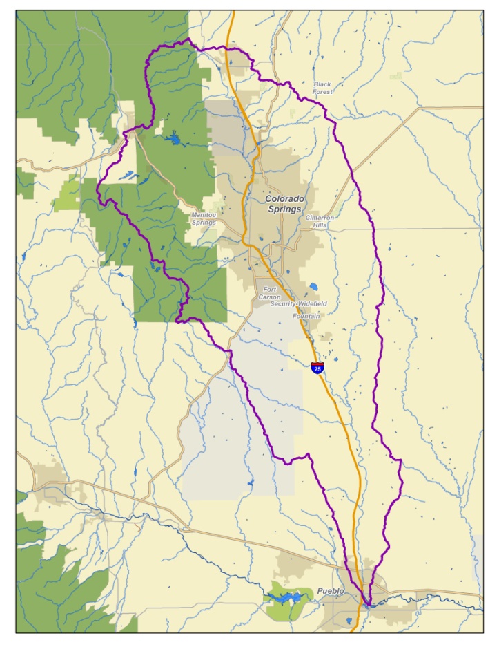
The Fountain Creek Watershed is located along the central front range of Colorado. It is a 927-square mile watershed that drains south into the Arkansas River at Pueblo. The watershed is bordered by the Palmer Divide to the north, Pikes Peak to the west, and a minor divide 20 miles east of Colorado Springs. Map via the Fountain Creek Watershed Flood Control and Greenway District.

From The Colorado Springs Independent (Pam Zubeck):

Not surprisingly, the federal government sued the city of Colorado Springs on Nov. 9 over the city’s repeated violations of the Clean Water Act and the Colorado Water Quality Control Act. The allegations arise from the city’s failure to deal with drainage and failure to comply with its permit to discharge stormwater into the municipal storm sewer system, which ultimately flows into the Arkansas River.

The suit comes despite Mayor John Suthers orchestrating a deal with Pueblo County earlier this year to fix the city’s storm drainage system, costing taxpayers and Colorado Springs Utilities ratepayers $460 million in the next 20 years.

Suthers took office in June 2015, following years of violations in controlling stormwater. Suthers lamented to other media the City Council’s move to abolish the city’s Stormwater Enterprise in 2009. But Council did so after voters approved Issue 300 that fall, which aimed to dismantle the enterprise. (At the time, the city attorney’s office felt the language in Issue 300 failed to force the shutdown of the enterprise, but City Council defunded it anyway, citing voter intent.)

The EPA, however, cites the city’s soft treatment of developers — along with its lack of a stormwater program — for the violations. In early 2013, the EPA issued a scathing report outlining violations and followed up in August 2015 with an equally critical report.

Specifically, the lawsuit notes the city backed off of requiring detention ponds and other flood-control measures in Cottonwood Creek that would have cost $11.4 million, and instead reduced developers’ fees. But that violates the city’s discharge permit, the lawsuit states. It also notes drainage violations at First & Main adjacent to Powers Boulevard and Flying Horse Pond Filing 26 on the city’s far north side. In addition, the city allowed seven residential developments to be built without requiring stormwater controls, in violation of its discharge permit and its own requirements, the lawsuit says. Moreover, the city didn’t enforce its rules when developers violated the city’s stormwater requirements, according to the suit.

“Unless enjoined, the city’s violations will continue,” the lawsuit states, noting it is seeking unspecified civil penalties.

“On Wednesday, the city was served with a broad and unspecific filing from the EPA, citing Colorado Springs for deficiencies in its stormwater system since the dissolution of the stormwater enterprise in 2009,” Suthers said in a statement. “While we recognize that stormwater was underfunded during that time, this was extremely frustrating, considering the commitment the mayor and city council have already made to massive stormwater improvements over the next 20 years.”

Suthers also noted it makes more sense to use city money to fix the problem than pay to litigate the lawsuit or remit fines. “We will ask the federal judge to look at our efforts and our commitments toward real progress and hope that a more constructive resolution can be reached,” he said.

Lower Ark District letter triggers Fountain Creek lawsuit

The confluence of Fountain Creek and the Arkansas River in Pueblo County -- photo via the Colorado Springs Business Journal
The confluence of Fountain Creek and the Arkansas River in Pueblo County — photo via the Colorado Springs Business Journal

From The Pueblo Chieftain (Robert Boczkiewicz):

The district says the lawsuit, filed by the federal and state governments, followed on the heels of a letter of concern the district sent Oct. 28 to the U.S. Environmental Protection Agency.

The lawsuit was filed Wednesday in U.S. District Court in Denver by the EPA and the Colorado Department of Public Health and Environment against the city of Colorado Springs.

The lawsuit alleges that discharges into the creek from the city’s stormwater sewage system violate the federal Clean Water Act and the state Water Quality Control Act.

“It’s time Colorado Springs be held accountable for its continued violations of discharge limits into Fountain Creek,” said Jay Winner, general manager of the Lower Arkansas district. Its mission is to protect water resources of the Lower Arkansas River Valley.

“We’ve been trying to get the Springs to recognize their responsibility to Pueblo and the Lower Arkansas Valley for the past 12 years, but there has been close to zero progress when it comes to cleaning up the mess on Fountain Creek,” Winner said.

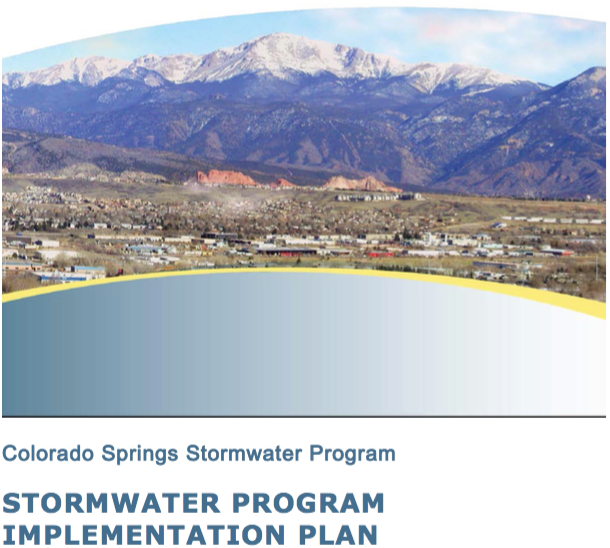
He said the Oct. 28 letter expressed concerns with Colorado Springs’ 2016 Stormwater Program Implementation Plan. The letter was part of the district’s long-standing complaints about the city’s discharges into the creek.

The lawsuit seeks:

  • A court order requiring Colorado Springs “to take all steps necessary to redress or mitigate the impact of its violations.”
  • A court order requiring the city “to develop, implement and enforce” its stormwater management program, as required by permits the government has issued. The federal and state laws invoked by the lawsuit regulate the discharges.
  • Imposition of monetary penalties on Colorado Springs for the violations.

“This is an historic day for Pueblo, which has been waiting decades for Colorado Springs to clean up Fountain Creek,” Anthony Nunez, a former Pueblo County commissioner who sits on the Lower Ark board, said in a statement issued by the district.

Melissa Esquibel, another Pueblo County member of the district’s board, said the board intends to discuss the lawsuit at its Wednesday meeting in Rocky Ford. The district encompasses Bent, Crowley, Otero, Prowers and Pueblo counties.

The Gazette newspaper in Colorado Springs reported Thursday that the city’s mayor, John Suthers, expressed frustration that the EPA and state environmental agency filed the lawsuit rather than recognize recent strides the city has made to deal with its storm sewer discharges.

“They know they have a mayor and City Council that recognize the problem, understand the problem and are intent on fixing the problem,” the mayor said. “Rather than working with us to get this done, they file a lawsuit.

“Every single dime going to litigate this thing and pay fines should be going into fixing the problem,” Suthers said.

The district sees it differently.

“They’ve dumped on Pueblo in the past, and it looks like they’ll keep on dumping,” Winner said. “We’ve seen nothing to convince us they have changed their attitude that Fountain Creek can be used as an open sewer.”

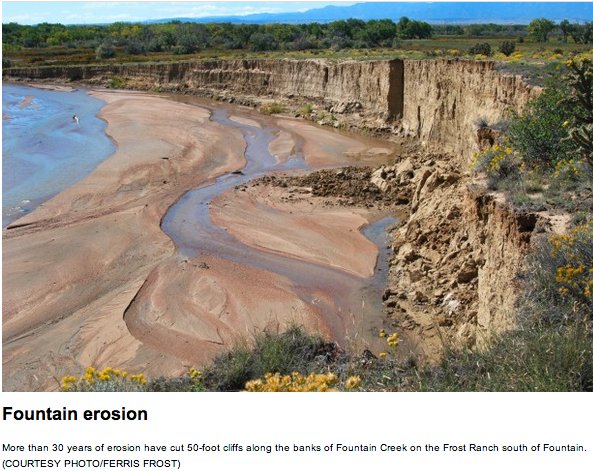
Fountain Creek erosion via The Pueblo Chieftain

From The Pueblo Chieftain (Robert Boczkiewicz):

The lawsuit seeks a court order requiring Colorado Springs “to take all steps necessary to redress or mitigate the impact of its violations.”

Colorado Springs’ discharge from its storm sewer system of toxic pollutants into Fountain Creek has long been a cause of distrust and bad relations between Pueblo and its upstream neighbor.

The lawsuit was filed Wednesday in U.S. District Court in Denver.

The U.S. Department of Justice filed the lawsuit at the request of the Environmental Protection Agency. The Colorado Attorney General’s office filed the lawsuit at the request of the Colorado Department of Public Health and Environment.

The lawsuit claims that polluted discharges from Colorado Springs’ stormwater system violate the federal Clean Water Act and the state Water Quality Control Act.

The 51-page lawsuit states that the discharges flow into Monument Creek, Camp Creek, Cheyenne Creek and Shooks Run, as well as into Fountain Creek.

The lawsuit also seeks a court order to require Colorado Springs “to develop, implement and enforce” its stormwater management program, as required by permits the government has issued. The federal and state laws invoked by the lawsuit regulate the discharges.

The lawsuit also asks a judge to impose monetary penalties on Colorado Springs for the violations.

Water runoff from streets, parking lots and other surfaces picks up pollutants that drain into the stormwater sewage system, which discharges it into the creeks.

Pollutants include accumulated debris, chemicals and sediment. They “can adversely affect water quality, erode stream banks, destroy needed habitat for fish and other aquatic life, and make it more difficult and expensive for downstream users to effectively use the water,” the lawsuit states.

Under federal courts rules, the city is required to respond to the lawsuit after it is served on a city official. In their responses filed at the court, defendants typically state their position on the allegations and claims against them.

Report: Remediation Scenarios for Attenuating Peak Flows and Reducing Sediment Transport in Fountain Creek, Colorado, 2013

@EPA, @CDPHE lawsuit zeroes in on #Colorado Springs stormwater violations

The Fountain Creek Watershed is located along the central front range of Colorado. It is a 927-square mile watershed that drains south into the Arkansas River at Pueblo. The watershed is bordered by the Palmer Divide to the north, Pikes Peak to the west, and a minor divide 20 miles east of Colorado Springs. Map via the Fountain Creek Watershed Flood Control and Greenway District.

From The Colorado Springs Gazette (Billie Stanton Anleu):

The U.S. Environmental Protection Agency and the state health department filed a lawsuit Wednesday against the City of Colorado Springs over water quality violations and stormwater program shortfalls dating to 2009.

Mayor John Suthers, who began building a new stormwater program immediately after taking office in June 2015, expressed frustration over the decision by the EPA and the Colorado Department of Public Health and Environment to file legal action rather than recognize recent strides the city has made.

The federal and state agencies are seeking civil penalties that Suthers said could amount to “millions and millions of dollars.”

“What’s frustrating is: They know they have a mayor and City Council that recognize the problem, understand the problem and are intent on fixing the problem,” the mayor said. “Rather than working with us to get this done, they file a lawsuit.

“This is the kind of lawsuit that gives the EPA a reputation for being over-reaching. Every single dime going to litigate this thing and pay fines should be going into fixing the problem.”

Over the past 18 months, the city has:

◘ Negotiated and signed a $460 million, 20-year intergovernmental agreement with Pueblo County to build 71 major stormwater projects. The work is designed to eliminate sedimentation, detain excessive flows and improve water quality in Fountain Creek for local and downstream communities. That pact is backed by Colorado Springs Utilities, which will appropriate needed funds should the city experience a shortfall.

◘ Recruited professional engineer Richard Mulledy to manage the stormwater division and beef up the staff of stormwater inspectors and engineers from 28 to 49 full-time employees, with a total of 66 to be on board within the next several months.

◘ Increased spending on stormwater from $5 million in 2015 to $19 million a year, including $9.2 million for capital projects, $3 million from Utilities and $7.1 million to $7.8 million, when fully staffed, for the city’s Municipal Separate Storm Sewer System, known as an MS4 federal permit, which allows Fountain Creek to flow into the Arkansas River, to the Mississippi River and into the Gulf of Mexico.

◘ Started building a $3 million detention pond on Sand Creek; spending $2 million to rehabilitate wash-out areas, remedy sediment-transport issues and improve water quality since 2013 flooding, and retrofitting a King Street detention pond so it not only controls flood waters but also manages flow to mimic natural discharge.

When Suthers took office, he lamented a former City Council’s decision in 2009 to eliminate the city’s Stormwater Enterprise Fund, which had collected $15 million to $16 million a year in fees from property owners to spend on stormwater projects.

“Fountain Creek is one of the most unstable, flashy creeks in all the nation. It’s a unique animal,” engineer Mulledy told The Gazette in March.

The base flow of 120 cubic feet per second can reach 20,000 cfs during a 25-year event, swelling the creek to 100 feet wide and 10 feet deep, he said. “On top of that, the material along that creek is an alluvial field. It’s sand. So it’s kind of the perfect storm,” Mulledy said.

The mayor recognized that city voters repeatedly voted down stormwater measures, so he and the council agreed to address the need directly from the general fund. In order to do so, he froze employee salaries and vacancies, squeezed the police and fire departments, and shelved several planned capital projects this year.

But the EPA and state point to average annual stormwater expenditures of $1.6 million from 2011 through 2014, when only nine full-time employees worked in stormwater. So surface runoff, streambed degradation, widening and erosion led to sedimentation and unacceptable water quality.

The suit cites a 2000 planning study for the Cottonwood Creek Drainage Basin that eliminated six detention basins and structural measures originally planned, reducing costs by $11.4 million, but notes that the plan now is being updated and revised.

A 2013 EPA audit identified water-quality control structures at two developments that didn’t treat stormwater before discharging it into state waters; seven residential developments without stormwater controls or waivers for such; failure to submit development, inspection and maintenance plans to Engineering Development Review before grading permits were issued, and other failures since 2013 to ensure that policies protecting water quality were followed.

Larry Small, executive director of the Fountain Creek Watershed, Flood Control and Greenway District, has long despaired of the city’s years of neglect toward Fountain Creek and stormwater issues.

But that’s in the past, Small said.

“John (Suthers) put in that $460 million plan, he’s increased the stormwater department significantly in staffing, he’s put processes in place, and he’s started at least three significant projects in the last year to deal with it,” Small said. “He’s got an agreement with Pueblo County that we haven’t had in years on managing and monitoring stormwater and to review progress annually and adjust the priorities. As far as John’s performance, he’s done a great job in the last year and a half.

“From the time the city discontinued its stormwater enterprise until John put planning in place, we had a large number of years with a huge deficiency. But I don’t see how a lawsuit is going to correct the problem,” he said. “The only thing a lawsuit is going to do is bring in money for the federal government in fines, and what good does that do for the city or the problem?

“A better solution would have been to sit down with monitoring and performance guidelines and allow the city to use that money to make improvements instead of pay fines with it. This is just another example of the federal government using a local issue to raise money.”

#Colorado Springs to invest heavily in stormwater improvements, hoping to stave off EPA action — The Colorado Springs Gazette

Heavy rains inundate Sand Creek. Photo via the City of Colorado Springs and the Colorado Springs Independent.

From The Colorado Springs Gazette (Billie Stanton Anleu):

The EPA threatened to sue after it audited the city stormwater system in August 2015 – two months after Mayor John Suthers took office – and found no improvement since a dismal state audit in February 2013.

“We have not yet resolved the issues (with the EPA),” Suthers said in an interview Wednesday. “Our emphasis of course is looking forward: Let’s make things right. We think any kind of large fine would be unproductive. We feel we’ve done a really good job at addressing all the deficiencies.”

A new Stormwater Program Implementation Plan released Wednesday outlines how the division staff will more than double, from 28 to 66 full-time employees, all dedicated to stormwater, with 49 already on board.

The annual city budget for MS4 permit compliance climbs from about $3 million to about $7.1 million this year. That Municipal Separate Storm Sewer System permit allows the flow into interstate waters, from Fountain Creek into the Arkansas River to the Mississippi River and into the Gulf of Mexico.

The $7.1 million devoted to MS4 comes in addition to $9.2 million a year being spent on capital projects, plus $3 million from Colorado Springs Utilities, for a total of more than $19 million a year.

In order to protect water quality, strict enforcement will be launched at construction and industrial sites and with private developers who don’t comply.

In all, 71 projects will be completed over the next 20 years, with channel improvements consuming the most funds. In order to speed such improvements, though, the city might use outside contractors on capital projects until all additional staff members are on board.

Suthers had a message for the community. “We have to face the fact that Colorado Springs has underfunded its stormwater program for a number of years. And we have a lot of work to do.”

Unlike most every other city in America, he said, “We don’t have a dedicated fund for stormwater.”

The City Council could create a stormwater fund unilaterally if it chose to do so. But the mayor wants more information first, so members of public works, finance and the city attorney’s office are researching how other cities’ stormwater programs are structured…

But without a stormwater fund, how will the city pay its $16 million annual obligation?

“We’re going to get it from the general fund until we can get it from another fund. If the city falls short in any five-year period with the intergovernmental agreement (with Pueblo County), Utilities makes up the difference,” he said.

“I’m not worried about that. What I’m worried about rather is the consequences to the city if this doesn’t get funded. I would hope the average Joe would want the city of Colorado Springs to be compliant. The EPA does have jurisdiction over stormwater.”

This strong push to “make things right” comes after nearly a decade of essentially ignoring stormwater concerns. The recession started in 2008, and voters in 2009 backed Issue 300, which weakened city use of enterprise funds. The then-City Council promptly eliminated the city’s Stormwater Enterprise Fund, which levied fees based mostly on a property’s impervious surface area.

The loss of that $15 million to $16 million a year infuriated officials in Pueblo County, who threatened to withdraw the vital 1041 permit for the Southern Delivery System, an $825 million project that was 20 years in the making. Pueblo County, after all, was receiving heavy sedimentation in flows from Fountain Creek.

Suthers soon found himself surfing dual waves of stormy waters – negotiating with Pueblo County to save the delivery system, and conferring with the EPA on how best to meet requirements of the MS4 permit.

Months of frustrating negotiations with Pueblo County finally resulted in April in the 20-year agreement for the city to complete 71 capital projects, spending more than $460 million over 20 years.

The money will be spent in five-year increments, at a rate of $100 million the first five years followed by $110 million, $120 million and $130 million. Any developers’ projects or other efforts would be in addition to the promised amounts.

If the projects aren’t done in time, the accord will be extended five years. And if Colorado Springs can’t come up with the money required, the city-owned Utilities will have to do so.

But while negotiations with Pueblo County were tough, efforts to satisfy the EPA evidently have proven even more difficult. A decision from the federal agency is expected “relatively quickly,” Suthers said.

Whatever the EPA decides, Suthers long has insisted that the city’s stormwater shortcomings must be fixed.

“I mean this very sincerely,” he told The Gazette last April. “It’s the right thing to do. And it’s something we should do.”

@EPA Awarding $1.3 Million to Revitalize America’s Urban Waters and Surrounding Communities

E.coli Bacterium
E.coli Bacterium

Here’s the release from the Environmental Protection Agency (Tricia Lynn):

The U.S. Environmental Protection Agency (EPA) is awarding $1.3 million to 22 organizations in 18 states to help protect and restore urban waters and to support community revitalization and other local priorities.

“Often underserved communities in our nation’s cities face disproportionate impacts from pollution, and too often they lack the resources to do something about it,” said Joel Beauvais, EPA Deputy Assistant Administrator for Water. “EPA provides support to empower these communities to improve the quality of their waterways and to help reconnect people and businesses with the water they depend on.”

Many urban waterways have been polluted for years by sewage, runoff from city streets, and contamination from abandoned industrial facilities. Healthy and accessible urban waters can enhance economic, educational, recreational, and social opportunities in surrounding communities.

This year’s Urban Waters grantees will inform and engage residents in stormwater management and pursue community-based plans to address pollution in waterways. To accomplish these goals, many projects will address trash in waterways; test rivers, streams and lakes for pollutants; and prepare the next generation of environmental stewards for careers in the green economy. The 22 organizations receiving EPA grant funding are as follows:

Mystic River Watershed Association, Massachusetts ($60,000) will partner with towns and cities near Boston to create a multimedia education program to increase awareness of stormwater pollution for a regional coalition of municipalities.

Pioneer Valley Planning Commission, Massachusetts ($60,000) will develop a green infrastructure plan for Day Brook in Holyoke to reduce stormwater flow into the brook and resulting combined sewer overflow discharges into the Connecticut River.

NY/NJ Baykeeper, New Jersey ($48,150) will expand its plastic pollution reduction project by identifying, reducing, and preventing plastic transported via stormwater from reaching the lower Passaic River watershed and Newark Bay complex.

Sarah Lawrence College, New York ($60,000) will work with community scientists to investigate the severity and local sources of water pollution while increasing community engagement and stewardship in four underserved urban watersheds in the Lower Hudson River region.

Anacostia Watershed Society Inc., Maryland ($50,000) will educate and train middle-school students from low-income communities in Washington, DC on the problems associated with stormwater runoff and mitigation strategies through a variety of activities.

Virginia Commonwealth University, Virginia ($59,773) will develop a community greening and green infrastructure plan for its two urban campuses and the Richmond Arts District.

The Conservation Fund, Georgia ($60,000) will expand community engagement in planning for two future green infrastructure projects aimed at reducing stormwater runoff located in the headwaters of Proctor Creek in Atlanta.

University of Tennessee, Tennessee ($59,995) will, through a community-driven effort, collect nutrient data across the Baker Creek watershed, which will help the City of Knoxville and Tennessee Department of Environment and Conservation develop a watershed restoration strategy.

Openlands, Illinois ($60,000) will, in partnership with the Healthy Schools Campaign, manage the Space to Grow program which transforms schoolyards into vibrant places that benefit students, communities, and the environment.

The University of Toledo, Ohio ($59,988) will, in collaboration with North Toledo community members, Vistula Management, United North, and the Toledo-Lucas County Sustainability Commission, develop a plan to incorporate green stormwater infrastructure (GSI) at low income, multi-family housing sites in Toledo, Ohio.

Lake Pontchartrain Basin Foundation, Lousiana ($60,000) will partner with several New Orleans-based underserved schools to assess neighborhood stormwater runoff. The data from which will be used to improve local pollution mitigation practices.

Amigos Bravos, New Mexico ($55,508) will work with an underserved community located in Alburquerque’s South Valley to address chronic flooding due to poor stormwater management.

Saint Louis University, Missouri ($58,793) will evaluate whether the use of brine pretreatment as an alternative to chloride used as road salt will help reduce local chloride water pollution.
University of Nebraska-Lincoln, Nebraska ($59,935) will improve stormwater and green infrastructure training and assistance for Omaha’s workforce, students, and residents.

City and County of Denver, Colorado ($60,000) will develop the Heron Pond Regional Open Space Master Plan to consolidate and restore into open space approximately 80 acres of land surrounding Heron Pond, with an ultimate goal of reducing urban runoff pollution, improving wildlife habitat, and creating recreation opportunities for the highly urbanized, industrial, and underserved Globeville neighborhood.

Groundwork Denver Inc., Colorado ($60,000) will work with local high school students from Sheridan, Colorado, an underserved community located at the mouth of Bear Creek, and Metropolitan State University, to determine the sources of E. coli feeding into the creek.

South Dakota School of Mines & Technology, South Dakota ($58,996) will develop and promote a stormwater and green infrastructure educational program for K-12 and college students and the broader community, culminating in a community design charrette for the planning of low-impact development and green infrastructure practices for the proposed Rural America Initiatives development.

Arizona State University, Arizona ($58,227) will work with students and Girl Scouts Troops to monitor water quality in local waterways and recreational fisheries to develop recommendations for community- based solutions.

Constitutional Rights Foundation, California ($59,673) will, in partnership with Los Angeles Waterkeeper and UCLA, expand its teaching curriculum for local undeserved high school students on community stormwater assessments to include enhanced STEM education, and will conduct local civic-minded community environmental projects.

Heal the Bay, California ($59,998) will partner with Los Angeles Trade Technical College and local high schools to monitor bacterial water pollution in the Los Angeles River, which will be used to make recommendations to local government agencies and watershed stakeholders for improving water quality and protecting public health.

Lummi Indian Business Council, Washington ($56,433) will teach third- through fifth-grade students at the Lummi National Schools about how a watershed works, water quality parameters, sources of impairments, and how this impacts the salmon and shellfish that the Lummi Nation depends on for subsistence, economic, and cultural needs.

The Lands Council, Washington ($45,250) will offer green job training and career pathways through the Green Sleeves Program at the Geiger Correctional Center in Spokane and will work with local high school teachers to develop and teach a year-long environmental science curriculum focusing on stormwater pollution and low-impact remediation.

The Urban Waters Small Grants are competed and awarded every two years. Since its inception in 2012, the program has awarded approximately $6.6 million in Urban Waters Small Grants to 114 organizations across the country and Puerto Rico, with individual award amounts of up to $60,000.

To learn more about the funded projects, visit https://www.epa.gov/urbanwaters/urban-waters-small-grants

Information on EPA’s Urban Waters program: https://www.epa.gov/urbanwaters

#AnimasRiver: Superfund project manager known for community outreach — The Durango Herald

On April 7,  2016, the Environmental Protection Agency proposed adding the “Bonita Peak Mining District” to the National Priorities List, making it eligible for Superfund. Forty-eight mine portals and tailings piles are “under consideration” to be included. The Gold King Mine will almost certainly be on the final list, as will the nearby American Tunnel. The Mayflower Mill #4 tailings repository, just outside Silverton, is another likely candidate, given that it appears to be leaching large quantities of metals into the Animas River. What Superfund will entail for the area beyond that, and when the actual cleanup will begin, remains unclear. Eric Baker
On April 7, 2016, the Environmental Protection Agency proposed adding the “Bonita Peak Mining District” to the National Priorities List, making it eligible for Superfund. Forty-eight mine portals and tailings piles are “under consideration” to be included. The Gold King Mine will almost certainly be on the final list, as will the nearby American Tunnel. The Mayflower Mill #4 tailings repository, just outside Silverton, is another likely candidate, given that it appears to be leaching large quantities of metals into the Animas River. What Superfund will entail for the area beyond that, and when the actual cleanup will begin, remains unclear.
Eric Baker

From The Durango Herald (Jonathan Romeo):

“If you have Rebecca, you are extremely lucky,” said Tony Berget, a former Lincoln County Commissioner in Libby, Montana, home to one of the largest and longest running asbestos cleanup sites in the United States.

“At times, the (Superfund process) went really well, and at other times, I’ve been very disappointed. But Rebecca, especially, was really willing to listen. She was one of the bright stars of my experience with the EPA.”

Last month, the EPA formally listed 48-mining sites responsible for degrading water quality in the Animas River Basin as a Superfund site, with Thomas, based in Denver, as project manager for the Bonita Peak Mining District Superfund program.

The announcement came just a year after the Gold King Mine blowout, in which an EPA crew triggered a massive release of mine wastewater, reigniting the longstanding issue of metal loading into the watershed.

Yet the blowout also reversed stubborn resistance from the small, historic mining town of Silverton, home to a fluctuating population of about 600, not so keen on parting ways with its legacy of mining.

It’s a situation Thomas, throughout her career, has stepped into with ease, as evidenced by major projects in Libby, Montana, and Leadville.

Leadville
By the mid-1990s, tensions between the once-thriving community of Leadville and the EPA surrounding the cleanup of 16-square-miles of mining sites had escalated into a vitriolic, hostile environment.

“They came in and said: ‘We are the EPA, and you will do this,’” said resident and environmental consultant Mike Conlin. “One day everyone that lived in the Superfund boundary got a brown paper envelope saying: ‘Congratulations. You’re a potentially responsible party and may be responsible for the cost of cleanup.’”

In Gillian Klucas’s 2004 book detailing the bitter confrontation – Leadville: The Struggle To Revive an American Town – effigies of EPA personnel were dragged through town, cars bore “EPA: GO TO HELL” bumper stickers and one state senator even championed a public hanging.

“My suggestion is to simply hang one (EPA staffer) at each end of town,” state senator Ken Chlouber, a Leadville native, told a national Republican Party in 1994. “In my community, that is the voice of moderation.”

Relationships between the two entities had deteriorated so badly that EPA replaced its fledging personnel with two new project managers: Mike Holmes and Thomas.

“That was very much the turning point,” said Howard Tritz, an ex-miner and county assessor at the time. “They were decent. They explained things to people, and they were not belligerent.”

Indeed, Klucas’s book said local newspapers proclaimed “a new era of cooperation” in 1998 after the arrival of Holmes and Thomas, which eventually led to one of the most complicated but also successful cleanups in the EPA’s history. The Arkansas River, for instance, once referred to as an “industrial sewer,” now boasts a Gold Metal fishery, and is one of the most popular rivers to fish in the state of Colorado.

“They (Holmes and Thomas) were able to direct the energy of the community to the issues rather than personalities,” Conlin added. “They had more of a tendency to say: How can we work together to make something with long-term benefits to the community?’”

[…]

Silverton
Now, Thomas, 53, is entering her 24th year in the EPA’s Superfund program, and is turning her attention to the highly mineralized and complicated network of mines surrounding Silverton.

Early on, town and county officials, as well as residents, demanded a seat at the table in EPA’s decision-making process, even delaying a vote to pursue Superfund designation until that assurance was met.

Already, it seems like EPA is living up to that promise.

“Rebecca is genuinely concerned and has excellent communication with the community,” said Silverton Town Administrator Bill Gardner. “We were promised a seat at the table, and that’s exactly what’s happening.”

Thomas, for her part, said she was taken aback by the amount of investment from groups such as the Animas River Stakeholders Group, which has carried on nearly two decades of remediation projects in the basin.

She said this winter local, state and federal agencies will review a swath of data taken over the past year, and start to formulate a strategy to tackle what is one of the worst metal-loading districts in the American West.

“We need to work with all affected communities and establish what we want this cleanup to do,” Thomas said. “And I think Superfund does bring the resources to a project of this size and complexity that would be hard for a group of individuals to fully address.”

EPA probes toxic Colorado mine tunnels, investigates possible harm to human health — The Denver Post

On April 7,  2016, the Environmental Protection Agency proposed adding the “Bonita Peak Mining District” to the National Priorities List, making it eligible for Superfund. Forty-eight mine portals and tailings piles are “under consideration” to be included. The Gold King Mine will almost certainly be on the final list, as will the nearby American Tunnel. The Mayflower Mill #4 tailings repository, just outside Silverton, is another likely candidate, given that it appears to be leaching large quantities of metals into the Animas River. What Superfund will entail for the area beyond that, and when the actual cleanup will begin, remains unclear. Eric Baker
On April 7, 2016, the Environmental Protection Agency proposed adding the “Bonita Peak Mining District” to the National Priorities List, making it eligible for Superfund. Forty-eight mine portals and tailings piles are “under consideration” to be included. The Gold King Mine will almost certainly be on the final list, as will the nearby American Tunnel. The Mayflower Mill #4 tailings repository, just outside Silverton, is another likely candidate, given that it appears to be leaching large quantities of metals into the Animas River. What Superfund will entail for the area beyond that, and when the actual cleanup will begin, remains unclear.
Eric Baker

From The Denver Post (Bruce Finley):

Crews are debating whether to try to contain toxic mine drainage or funnel it out and clean it perpetually at huge expense

Colorado and federal authorities want to resolve the issue as soon as possible because today’s untreated flow into Animas headwaters — averaging 3,750 gallons a minute — may be hurting not only the environment but human health, officials said recently.

All it would take inside this abandoned Red and Bonita Mine tunnel is a turn of the blue screw on that bulkhead plug to stop hundreds of gallons of the [acid mine drainage] from leaking. But if the EPA crew does turn that screw, shutting a valve, the blockage could cause new toxic blowouts from other mountainside tunnels, veins, faults and fissures.

So, for now, the feds are letting Animas River mines drain, tolerating the massive toxic discharge that equates to more than a dozen Gold King disasters every week.

“We don’t want to discount the Gold King spill, but it is good to keep it in perspective,” said EPA project chief Rebecca Thomas, who’s managing cleanup at the now-stabilized Gold King Mine and 47 other mining sites above Silverton.

“Think about the millions of gallons draining each day. It’s something we should be paying attention to as a society – because of the impact on water quality,” Thomas said.

The environmental damage from contaminants such as zinc and aluminum (measured at levels up to tens of thousands of parts per billion) already has been documented: fish in Animas headwaters cannot reproduce. But questions remain about harm caused by lead in water at exceptionally elevated levels up to 1,800 parts per billion, cadmium at up to 200 ppb, arsenic at up to 1,800 ppb and other heavy metals.

The EPA this month intensified an investigation of possible effects on people at 15 U.S. Forest Service campgrounds, American Indians whose traditions take them to high valleys, and vehicle riders who churn dust along roads.

Lead contamination at the Kittimack Tailings, a popular 8-acre course for off-road riding, has been measured at 3,800 parts per million, which is 7.6 times higher than the federal health limit. EPA scientists, collecting water and dirt samples this month, planned to interview campground hosts, all-terrain vehicle tour guides and southern Ute tribe members — assessing possible exposures.

If people inhale or ingest contaminants around any of the 48 mine sites, cleanup at that site would be prioritized, EPA officials said.

The federal Superfund cleanup of toxic mines across 80 square miles in southwestern Colorado is shaping up as one of the EPA’s largest mining legacy projects, contingent on Congress and agency chiefs lining up funds. EPA restoration work here is expected to set the standard for dealing with a wide western problem involving tens of thousands of toxic mines contaminating streams and rivers, for which total cleanup costs have been estimated at more than $20 billion.

In the past, cleanup work at toxic mines in Colorado stalled because of technical difficulty, lack of will and scarce funds. No work has been done for years at the collapsing Nelson Tunnel above Creede, where millions of gallons of some of the West’s worst unchecked acid mine drainage contaminates headwaters of the Rio Grande River, despite a 2008 federal designation as a Superfund environmental disaster.

But EPA officials are pushing for this post-Gold King cleanup including 48 Animas sites, concentrated around Bonita Peak above Silverton, because an EPA-led team in August 2015 accidentally triggered a blowout — setting off a 3 million-gallon spill that turned the river mustard-yellow in three states and sent contaminants nearly as far as the Grand Canyon.

This month, EPA project leaders, bracing for winter snowfall that limits what they can do until summer, anticipated a mix of different solutions at the various sites — each unique with different conditions. They’re considering construction of water treatment plants, like the temporary plant set up to neutralize and filter drainage from the Gold King Mine.

That plant has cleaned 273 million gallons of water over the past year before discharging it into Cement Creek, one of three main headwaters creeks flowing into the Animas River. Meanwhile, six surrounding toxic mines along Cement Creek drain an untreated sulfuric acid flow measured at 1,476 gallons per minute to 7,590 gallons.

A water treatment plant can cost up to $100 million with annual operational costs as high as $1 million.

EPA officials said they’ll combine installation of water treatment systems with bulkhead plugs to hold acid muck inside mountains. And the feds also are exploring use of “bio-treatment” systems using plants and plastic devices to filter and remove contaminants.

The overall cleanup is expected to take years.

“Ideally, we would come up with a way to take care of the water that did not involve a lot of very expensive, in-perpetuity water treatment,” Thomas said.

There are questions dogging hydrologists and toxicologists as they embark on remediation studies.They want to know how mining tunnels, dozens of natural fissures and faults, and mineral veins are connected.

“That is a big puzzle piece,” Thomas said, because subsurface links will determine whether bulkhead plugs safely can be used to contain toxic muck without raising water tables and triggering new blowouts.

They want to know how much acid water is backed up in major tunnels, including the American Tunnel and the Terry Tunnel, and in the Sunnyside Mine. The Sunnyside was the largest mine in the area and the last to close in 1991. EPA officials said natural faults or fissures may connect acid water backed-up Sunnyside water in the American Tunnel, where bulkheads have been installed, with the Gold King Mine.

Canada-based Kinross Corp., which owns Sunnyside, is considered a potentially responsible party, along with Gold King owner Todd Hennis, liable for a share of cleanup costs.

And EPA officials say they are monitoring underground changes that may be affecting flows from at least 27 draining tunnels — called adits — that contribute to contamination of Animas headwaters. The state-backed installation of plugs over the past decade may have triggered the rising groundwater levels that documents show the EPA and state agencies have known about for years.

For example, orange sludge oozed from a grate at the Natalie Occidental Mine — one of the worst sources of untreated mine waste — north of the Silverton Mountain ski area.

EPA on-scene coordinator Joyel Dhieux inspected it this month, hiking beneath snow-dusted mountain peaks. The backed-up sludge obscured a culvert installed years ago by state mining regulators. A huge tailings heap, leaching contaminants into a creek, suggested significant underground tunnels.

“The sludge could create a blockage in the mine that could increase the risk of a blowout. … This will require thoughtful planning,” Dhieux said. “Kittimack could be easy. You go in and remove the mine tailings. This one, it could be a more complex solution because of the risk. … This is an ‘unknown unknown.’ I honestly don’t know what the mine works look like behind this grate.”

And then there’s the problem inside that Red and Bonita Mine tunnel where a bulkhead plug is installed but not closed. Dhieux and her crew determined the plug, installed in 2015, 15 feet thick and framed in steel, appears solid.

If the EPA closes the bulkhead, she and other EPA officials said, it will be done very slowly. They’re considering a partial closure, as a test, next summer. The plan is for dozens of researchers to fan out across green mountain valleys, while contractors inside the tunnel turn the screw, watching for sudden orange spurts.

Lyons residents on flood recovery process: ‘We’re just starting to get it together’ — The Boulder Daily Camera

Bohn Park was flooded by the St. Vrain River in Lyons, CO September 18, 2013 via Getty Images

From The Boulder Daily Camera (Amelia Arvesen):

As Lyons entered its fourth year of reconstruction following the devastating September 2013 flood, the FBI and U.S. Department of Housing and Urban Development stopped by to seize documents and computers to probe the handling of federal flood-recovery funding.

Communities savaged by the rushing waters have been receiving fund allocations, totaling millions of dollars from several federal sources, such as HUD and the Federal Emergency Management Agency.

Late Friday, Mayor Connie Sullivan released a statement on behalf of the town’s Board of Trustees, stating that the FBI had concluded its portion of the investigation and would not be proceeding with a case.

Also posted to the town’s website was a copy of a subpoena from the U.S. Department of Housing and Urban Development, stating that a focus of its investigation was documents relating to negotiations and grant services contracts between Lyons and Longmont-based Front Range Land Solutions.

Grand Valley Drainage District looking to loans to accelerate project construction

Bicycling the Colorado National Monument, Grand Valley in the distance via Colorado.com

From The Grand Junction Daily Sentinel (Gary Harmon):

The district board this week directed staff to look into seeking low-interest loans from a state agency as it contemplates spending about $5 million for the Buthorn drainage system and prepares for improvements in the Appleton area to accommodate new development.

“We need to investigate indebtedness” as one way to pay for the projects to be funded by the district’s stormwater fee, Chairman Mark Harris said.

The Colorado Water Conservation Board will lend up to $10 million per project at an interest rate of 2.3 percent for up to 30 years, and officials with the agency have already opined that district projects such as improving the Buthorn drain could qualify for the loan program.

Looking further into such a loan is a “piece of due diligence we probably should do,” Harris said.

Diverting 40 percent of stormwater revenues, or about $1 million a year, to paying off debt could allow the district to tackle urgent projects, such as those required by road-repair projects, as well as those that rank high on the district’s priority list, General Manager Tim Ryan said.

A project planned by the Colorado Department of Transportation could require $150,000 that’s not included in the district’s budget, but which could be otherwise accommodated under a borrowing program, Ryan said.

The district has collected $2.2 million of the $2.7 million for which it sent out bills within its 90-square-mile area this year. The district board could consider turning over unpaid bills to a state collection agency as early as next month.

Mesa County and the Grand Junction Area Chamber of Commerce haven’t paid their bills and have sued the district to prevent it from collecting them.

A Mesa County District Court judge, however, rejected their request for a preliminary injunction this summer and the case is set for trial in June, though the district is asking that a judge rule without a trial.

The county and chamber contend the charge is a tax that is being levied outside the requirements of the Colorado Constitution, while the district says it’s a fee.

The court ruled it was “in the nature of a fee” in denying the preliminary injunction.

The district’s stormwater charge is $3 per month for most residences and $3 per month for every 2,500 square feet of impervious surface, such as roofs, parking lots and driveways owned by businesses, local governments and nonprofits.

Pueblo County: $6 million Fountain Creek levee dough before commissioners tonight

The Fountain Creek Watershed is located along the central front range of Colorado. It is a 927-square mile watershed that drains south into the Arkansas River at Pueblo. The watershed is bordered by the Palmer Divide to the north, Pikes Peak to the west, and a minor divide 20 miles east of Colorado Springs. Map via the Fountain Creek Watershed Flood Control and Greenway District.

Update: The commissioners approved the project according to Anthony A. Mestas writing for The Pueblo Chieftain:

The deal is one piece of an intergovernmental agreement between Pueblo County, the city of Colorado Springs and Colorado Springs Utilities.

Utilities agreed to provide up to $3 million as matching funds to repair or improve the levee system within Pueblo.

On Monday, the commissioners released funds previously obtained by Pueblo County under the Southern Delivery System 1041 permit to use the monies toward meeting the funding match and the $6 million total.

The commissioners passed the resolution 2-0. Commissioner Sal Pace was excused from the meeting Monday.

“We are pretty thrilled with it. The IGA allowed us to leverage an additional $3 million from Colorado Springs to match $3 million coming from Pueblo to go into this project,” said Commissioner Terry Hart.

Hart said The Lower Arkansas Valley Conservancy District also stepped up to help with debris removal from the creek in the amount of $100,000. The county previously paid $100,000 for the debris removal.

The county is offsetting the city’s three-year obligation of $3 million with $1.6 million, Hart said.

“The city’s obligation over three years is basically the remaining $1.2 million. They (city) stepped to the plate Monday (at a council meeting) and said this will work,” Hart said.

“All of this is designed to see if we can get working as quickly as possible right now that the water is down for the year,” Hart said.

Hart said the project should start within the next few weeks.

“We are hoping to get it done as quickly as possible to protect our town as quickly as possible and then go on to all the other things we are supposed to be doing under the intergovernmental agreement under the 1041 permit,” Hart said.

Hart said the work needs to happen for the safety of citizens and businesses in the event of flooding.

“We all saw the effect when you have a problem with a levee system when it came to (Hurricane) Katrina and what happened in New Orleans,” Hart said.

From The Pueblo Chieftain (Anthony A. Mestas):

The Pueblo County commissioners are scheduled to vote Monday on an agreement with the city of Pueblo and its Stormwater Utility Enterprise that will provide up to $6 million to fund a high-priority project to maintain the integrity of the Fountain Creek levee system.

County officials said as part of an intergovernmental agreement negotiated between Pueblo County, Colorado Springs and Colorado Springs Utilities, it was agreed upon by Utilities to provide up to $3 million as matching funds to repair or improve the levee system within Pueblo.

The agreement under consideration by the commissioners today would release funds previously obtained by Pueblo County under the Southern Delivery System 1041 Permit and use the monies toward meeting the funding match and the $6 million total.

Three years after the great floods of 2013, much work remains to be done in Colorado — The Denver Post

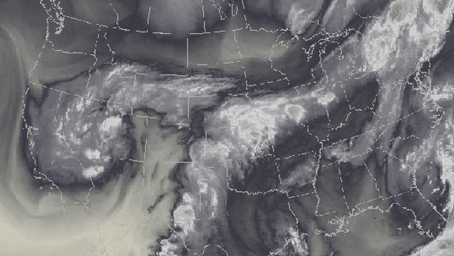
Plume of subtropical moisture streaming into Colorado September 2013 via Weather5280

From The Denver Post (John Aguilar):

The yellow-striped chunks of asphalt that cascaded into Coal Creek in the waning days of the summer of 2013 are long gone, while the yawning gap in the road created by rushing floodwaters has once again been spanned.

Still, motorists wait for County Road in Louisville to open to traffic more than three years after it was destroyed in Colorado’s costliest natural disaster.

The reconstruction project just south of the city’s historic downtown, scheduled to wrap up Oct. 15, aptly illustrates the lasting impact the flood of 2013 had — and continues to have — on communities that found themselves in the path of the epic five-day deluge. Last week marked the third anniversary of the deadly storm, which killed 10 people and displaced 18,000 more, destroyed more than 1,800 homes and 200 businesses and racked up costs of nearly $4 billion.

Though the flood has long slipped to the rearview mirrors of most folks, the recovery effort remains strong, said Molly Urbina, executive director of the Colorado Resiliency and Recovery Office.

“The summer of 2016 was a very busy season in flood recovery, as we saw many projects coming out of the ground with a lot of construction activity with housing, roads, bridges and watersheds,” she said. “We saw activity begin to peak this year and will continue through 2017 as the process for various projects continues through engineering, environmental reviews and permitting at the local level.”

Besides the bridge in Louisville, there are two other flood-damaged bridges still out of commission in Boulder County, a road wiped out in Larimer County, a park closed in Evans and tens of millions of dollars worth of permanent repairs needed on miles of roads that thus far have only seen a temporary fix.

Of the $353 million the Federal Emergency Management Agency has given to the state for distribution to local communities tackling major infrastructure repairs, $137 million has been disbursed. The remainder, Urbina said, will be paid out “after completion of eligible activities and submittal of required documentation.”

Which means the mopping up of the mopping up is still several years out.

“The one thing that surprised me is how long this process takes,” said Roy Rudisill, director of emergency management for Weld County.

While all roads in the county are passable, there are at least two major repairs on a bridge and road near Kersey still to go, he said. Work on everything related to the 2013 flood, including reimbursement checks from the government, probably won’t close out until 2018, Rudisill said.

So far, Weld County has been reimbursed $7.5 million of the $10.2 million in expenses it submitted to both FEMA and the Federal Highway Administration (FHWA).

For the small city of Evans, reimbursements from a variety of federal agencies have added up to $3.4 million so far. Spokeswoman Kristan Williams said the city has spent more than $5.7 million recovering from the flood, which sent the South Platte River rushing over its banks and into the city’s neighborhoods.

The biggest impact to Evans residents from the flood was the destruction of Riverside Park, Williams said. A small portion of the park has been refurbished and has reopened, but the bulk of the 100-acre facility is not yet usable. It won’t be until 2018, she said.

“This park has been the venue for baseball tournaments and festivals and is deeply missed in our community,” Williams said. “Thousands of hours have been spent by the city to plan, design and work with federal and state agencies to be able to reopen. It is extremely complex and challenging to convey that it isn’t a matter of putting on gloves and picking up trash to be able to reopen it.”

At least $2 million is needed to get Riverside Park back in order, Williams said, but securing funds from a variety of state and federal agencies is no easy task.

“There is a process you follow to make sure you get reimbursed,” she said.

“The process was lengthy”

That process can be painstaking. Longmont, which is eligible for $55 million in FEMA reimbursements for damage to its bridges, roads, wastewater treatment plant and the St. Vrain River itself, has assigned half a dozen city staffers to gather receipts and put together expense reports for FEMA to vet.

Peter Gibbons was hired by Longmont in March to head up the city’s recovery division.

“It doesn’t work as, like, you get this big blank check,” he told the Longmont Times-Call this month. “You get a $55 million obligation, which means, ‘We’re going to give you $55 million as long as you do all the things you said you’re going to do.’ ”

That process is a big reason Louisville’s County Road bridge took so long to rebuild. City Manager Malcolm Fleming said the bridge was not as high a priority as were some other critical flood recovery efforts in Boulder County, but the $3.2 million project was also subject to federal and state procedures and review guidelines.

“The process was lengthy, and residents have expressed frustration with how long project has taken,” Fleming said. “However, to get the FHWA funding, we had to operate within the FHWA’s constraints on the design, bidding and construction process, which took time.”

The new bridge couldn’t come any sooner for Myra Chapman, a seven-year Louisville resident enjoying a late morning at Community Park last week. She said the rush-hour backups on State Highway 42 from cars trying to take a left onto Pine Street are getting old. Restoring the County Road link to downtown is vital.

“You have to wait three light cycles before you can turn,” she said. “It’s been a very long time.”

A very long time is something many Boulder County residents, especially those living in the foothills, know a lot about. Roadways paralleling rivers in steep, narrow canyons took the biggest hit, as torrents of water barreled through the narrow passages desperately seeking lower elevation in as little time as possible.

Giant machines moved dirt and rock last week along Lefthand Canyon Drive, just east of where Lee Hill Drive intersects with the mountainous road. Boulder County Transportation spokesman Andy Barth said the work is part of $30 million to $40 million worth of road reconstruction projects expected to be completed in the county in 2017 alone.

“We’ve estimated that we could be in construction until 2019, 2020,” he said.

Boulder County’s roads and bridges took a $150 million hit from the 2013 flood. Barth said $57 million has been spent so far on repairs, with $24.1 million of that total having come back to the county in the form of reimbursements from FEMA or FWHA. There is still nearly $93 million worth of flood-related work to do.

“It wasn’t like the asphalt was just broken — it was scoured down to bedrock,” he said. “This stuff takes a long time.”

It will also take a long time for the resurrection of U.S. 34 west of Loveland, where a 3-mile section of the highway will be closed in both directions to all but canyon residents starting Oct. 17 so that major repairs can be performed.

“The canyon section sustained widespread, massive damage,” according to a description of the coming project on the Colorado Department of Transportation website. “Major sections of roadway were washed away completely, along with access bridges and retaining walls. In the narrows, much of the roadway and grade were undermined, washing out the pavement from below and exposing the wall support structures.”

The closure, between Drake and Cedar Cove, will last until Memorial Day weekend.

Signs of progress

While challenges remain plentiful three years after the skies opened to tragic effect, many communities are successfully putting the flood of 2013 behind them one fix at a time.

In Larimer County, the gigantic task of putting County Road 43 back together again — at a cost of $49 million — has come to an end. The months of escorted traffic through multiple blasts zones as crews resuscitated a road swept away by manic waves of water are no more.

The website that for more than a year informed motorists of nearly constant delays on the route between Estes Park and Drake bears a happy, if short-lived, message.

“Because this project is now substantially complete, this website will be taken down in mid-September,” it reads.

Todd Juergens, road and bridge director for Larimer County, said after spending nearly $46 million on flood repairs through the end of August, the county projects it has nearly $55 million left of repairs to do. That includes reconnecting County Road 22H to County Road 29 over the Big Thompson River west of Loveland, a task he thinks will be completed by the end of the year.

“This is what we do,” Juergens said matter-of-factly of the work in front of him.

The residents of hard-hit Jamestown did what they had to do to come back from nearly total destruction. For months after the storm, dozens of residents were unable to return because of flood damage to their houses — if their houses were standing at all.

Tara Schoedinger, Jamestown’s mayor, said even with up to $20 million in damage and a population of about 20 fewer people than there were preflood, her town has emerged as a “strong and more resilient community” three years after the deluge.

The final home to be rebuilt on a once-sodden ground will be unveiled in the spring. And Jamestown proudly shows off its newly built bridge with burly retaining walls on the west end of town.

Urbina, the head of Colorado’s recovery office, said other postflood accomplishments are worth noting.

More than 100 affordable housing units in flood-impacted communities have been built, many of which are available for residents displaced by the flood. One hundred sixty-nine businesses and farms in Colorado have received money through the Community Development Block Grant program. Also, 74 watershed restoration projects in the state will be implemented through the U.S. Department of Agriculture’s Emergency Watershed Protection Program.

“The strength shown by the disaster survivors and the leaders at the local level continues to inspire us, and the state will remain a partner working side by side with them until this recovery is complete,” Urbina said.

2013 Flood recovery by the numbers

  • FEMA public assistance (infrastructure): $355 million
  • FEMA individual assistance: $62 million
  • FEMA reimbursements distributed via the state: $137 million
  • Total damage from storm: $3.9 billion
  • Killed: 10
  • Evacuated: 18,000
  • Homes destroyed: 1,852
  • Businesses destroyed: 203
  • Estes Park: Fish Creek restoration project

    Fish Creek Road after September 2013 floods via YouTube.
    Fish Creek Road after September 2013 floods via YouTube.

    From the Estes Park Trail-Gazette (T.A. Rustin):

    Students from Estes Park High School teamed up with ecology experts from the Estes Valley Watershed Coalition on Wednesday to help rebuild the ecosystem along lower Fish Creek. That area was devastated by the flood in 2013, washing away vegetation, eroding the banks, destroying the utility infrastructure, and damaging homes.

    The Coalition has been working for the last year to restore areas damaged by the flood. They selected this area of Fish Creek as their first project, according to Molly Mills, Coordinator of the Coalition. Nearly a year ago, she met with Chuck Scott, principal of the high school, and asked if the Coalition could work on restoring the river banks adjoining school property.

    “I asked him for permission to work on school property,” she recalled, “and he said, ‘Only if you involve the kids and make this a learning experience,'” said Mills.

    Mills agreed at once to the plan, and she took the responsibility for securing grant funding and obtaining legal permission to work on the river banks. That required several months, since there are numerous overlapping jurisdictions involved in the Fish Creek watershed.

    With guidance from teacher Alex Harris, the high school’s Environmental Club began planning and recruiting their classmates for this event. Mills did some training with the students, teaching them about riverine ecology, and the proper techniques for planting trees. The students in the club then created training materials for the student volunteers.

    “This has been a student-run project the whole way,” said Mills. “I brought the idea to them, and the funding; they organized the volunteers, mapped it out, and got the logistical support.”

    […]

    Beginning early in the morning on Wednesday, students transported plants and supplies in pickup trucks to three areas along Fish Creek. More than 300 students arrived and split into teams to get to work on the riverbank. They began by pulling and bagging noxious weeks that have proliferated since the flood. They also cleared the banks of accumulated flood debris and trash.

    The Coalition brought in 3,000 trees, provided by the Colorado State Forest Service. The specific species had been selected by Mills in consultation with ecology experts. They included river birch, alder, chokecherry, and cottonwood. Mills’s ecology consultants marked the locations for each tree. Working in teams, the students dug holes, planted the trees, and carried buckets of water from Fish Creek to water them.

    Nearly the entire student body has been involved in this project, including the Culinary Arts class, which planned and prepared lunch for the students, teachers and volunteers. Students in the Film Studies are making a documentary to tell the story of the project. The faculty and administrators also supported the project…

    Randy Mandel, representing the Colorado Water Conservation Board, walked among the groups of students. A water and ecology specialist, Mandel explained to the students how their efforts would improve the watershed. Mandel noticed a student struggling with the root ball of a tree. He bent down and guided her in the proper technique.

    Gary Miller, President of the Coalition, said that the flood impacted Fish Creek more severely than any other area in the Estes Valley, and therefore was chosen as the first project.

    “The Coalition was formed to bring together organizations interested in sustainable restoration of the flood damaged areas,” he said. The Estes Valley has seen three 500 year floods since 1979, and Miler predicted that we should expect more in the future. “We need to be prepared for the next huge event,” he said. He pointed out that this project has served to educate the students about the broader problem of environmental disasters.

    Mills said that this is the first phase of the revegetation of the Fish Creek watershed. The next phase will be putting up fencing around the young trees to encourage the elk and deer to browse elsewhere.

    “Otherwise,” she said, “they will eat everything we’ve planted.”

    In the next few months, the Coalition will be mulching the area and broadcasting native grass seeds to improve the ground cover.

    New FEMA floodplain maps bring changes to Morgan County — The Fort Morgan Times

    Proposed Changes to Effective Floodplain in Morgan County, Colorado. (Red = increase, Green = decrease, blue = no change.)
    Proposed Changes to Effective Floodplain in Morgan County, Colorado. (Red = increase, Green = decrease, blue = no change.)

    From The Fort Morgan Times (Stephanie Alderton):

    If the Federal Emergency Management Agency’s latest floodplain maps go into effect in 2017, Morgan County’s flood risks will look a little different.

    As a part of the National Flood Insurance Program, Morgan County’s highest flood risk areas are shown on maps created by FEMA, which help determine property values and insurance rates. For the first time in about 35 years, FEMA has released a new preliminary floodplain map for the county. It introduces several changes to the old map, making the floodplain smaller in some areas and bigger in others.

    The map labels areas that are at low, moderate and high risk from flooding, based on the flow rates of nearby rivers. Properties in high-risk areas have higher flood insurance rates and more building restrictions. The last update to Morgan County’s floodplain map was in 1989, while the maps for specific towns like Brush haven’t been updated since 1981.

    For some parts of Morgan County, the new flood map isn’t big news. The city of Fort Morgan has always been too elevated to be greatly affected by the floodplain, and Bradley Curtis, the Engineering and Public Works director, said that hasn’t changed.

    “It has minimal effects,” he said. “Not a whole lot of developments are affected apart from Riverview Park and the area down by Maverick’s, which we knew about already.”

    Parts of Fort Morgan were flooded during the summer, but that was due to heavy rainfall rather than an overflowing river. The FEMA maps only take overflow from nearby rivers into account when predicting flood risks.

    For other towns, the re-mapping is a bonus. Much of the town of Wiggins was in the floodplain under the old map, but now it’s considered a low-risk area. Trustee JoAnne Rohn-Cook said she’s delighted by the new map.

    “Since the last survey was done, a dike was built west of the town, so I think that helped,” she said.

    From The Brush News-Tribune:

    For more information about updates to local FEMA floodplain maps, go to http://www.fema.gov/local-official-survey-findings-flood-risk, call the Morgan County Planning and Zoning office at 970-542-3526, or visit the following sites:

    Wiggins – http://www.wigginsco.com (click on the link at the bottom left of the homepage).

    Brush – http://www.brushcolo.com (click on the “floodplain updates” link).

    Morgan County – http://www.co.morgan.co.us (click on the links under “Important Public Announcements”).

    Questions remain on use of rain barrels — The #Colorado Springs Gazette #coleg

    Photo via the Colorado Independent
    Photo via the Colorado Independent

    From The Colorado Springs Gazette (Jim Flynn):

    At the heart of this [water law] system, and protected by a section of the Colorado Constitution, is a concept called “prior appropriation.” The way this works is that some water users have priority over other water users, with the effect that, in times of scarcity, holders of senior water rights receive their water and holders of junior water rights do not. The seniority of water rights is generally based on a first-to-use-wins concept, meaning the most senior (and therefore the most valuable) water rights go back to the 1800s.

    Any upstream activity even remotely threatening to downstream water rights holders is cause for great alarm. This came to light in the 2016 session of the Colorado Legislature when a bill (House Bill 16-1005) was introduced intended to regulate the collection of rainwater in barrels.

    What finally emerged, after heated debate, is a new law allowing rainwater running off the rooftop of a residential property containing no more than four dwelling units to be collected in no more than two barrels having a combined storage capacity of no more than 110 gallons. These barrels must have a sealable lid; the water from the barrels can only be used at the property where the water is collected; and it can only be used for outdoor purposes “including irrigation of lawns and gardens.” The water “shall not be used for drinking water or indoor household purposes.” (Whether the water could be used for bathing activities if conducted outdoors is not clear.)

    The state engineer, “to the extent practicable within existing resources,” is instructed to provide information on his agency’s website about the permitted and prohibited uses of rain barrels and water collected therein. The state engineer is also given authority to curtail rain barrel usage in situations where it might impair the rights of downstream water users. And the state engineer is required to diligently study whether rain barrel usage is causing injury to holders of downstream water rights and to report back to the Legislature on this issue by no later than March 1, 2019.

    The Colorado Department of Public Health and Environment also gets into the act. That agency is instructed, “to the extent practicable within existing resources,” to develop “best practices” intended to address nonpotable usage of collected rainwater and issues relating to disease and pest control. When and if such best practices are developed, they are to be posted on the department’s website and on the state engineer’s website. Alternatively, the state engineer’s website can provide a link back to the department’s website.

    Finally, knowing the penchant of homeowners living in common-interest ownership communities to fight over almost everything, the Legislature added language to the new law addressing rain barrel usage in these communities. An owners association in a common-interest ownership community cannot prohibit rooftop water collection using rain barrels. The association can, however, “impose reasonable aesthetic requirements that govern the placement or external appearance of a rain barrel.” So, for any of you who have the misfortune of serving on your neighborhood architectural control committee, it’s time to develop design guidelines for rain barrels.

    9/12/2013: Phenomenal rain reports coming in from all over Boulder County — Coyote Gulch

    Storm pattern over Colorado September 2013 -- Graphic/NWS via USA Today
    Storm pattern over Colorado September 2013 — Graphic/NWS via USA Today

    I made the mistake of checking my Twitter feed overnight on the 12th. Couldn’t get back to sleep. What a set of storms. Aurora got almost as much rain as Boulder County. Lots of flooding.

    @OmahaUSACE: Public meetings scheduled to discuss Cherry Creek Dam studies

    Cherry Creek Dam looking south
    Cherry Creek Dam looking south

    Here’s the release from the US Army Corps of Engineers (Eileen Williamson):

    Three public meetings to provide an update on the status of two studies taking place at Cherry Creek Dam are scheduled for the week of September 20.

    The U.S. Army Corps of Engineers will host meetings to provide a status update on alternatives under consideration to address risks from extreme storm events associated with Cherry Creek Dam including a study to modify the dam’s water control plan.
    The meetings will be held at the following times and locations:

  • Tuesday, Sept. 20 from 6 – 8 p.m.
    Cherry Creek Presbyterian Church
    Rooms 112/113 (Main Building)
    10150 E. Belleview Avenue
    Englewood, CO 80111
  • Wednesday, Sept. 21 from 5:30 – 7:30 p.m.
    Virginia Village Library
    1500 S. Dahlia Street
    Denver, CO 80222
  • Thursday, Sept. 22 from 5:30 – 7:30 p.m.
    Aurora Municipal Center
    City Café
    15151 E. Alameda Parkway
    Aurora, CO 80012
  • The public meetings will include a presentation and an open house to provide the public an opportunity to ask questions about Cherry Creek Dam and the alternatives being presented and considered as part of the Dam Safety Modification Study and Water Control Plan Modification Study.

    Meeting materials will be made available online following the meetings at http://go.usa.gov/cQ7hP.

    Background: Cherry Creek Dam and Reservoir is located in the southeast Denver metropolitan area on Cherry Creek, 11.4 miles upstream of its confluence with the South Platte River.

    In 2005, (post-Katrina) USACE began screening its dams (approximately 700 across the U.S.) to determine each dam’s risk level. Cherry Creek Dam received an elevated risk rating primarily because of the large downstream population and the potential for overtopping during an extremely rare precipitation event.

    A dam safety modification study began in 2013 and is being conducted in accordance with USACE policy as described in Engineering Regulation 1110-2-1156 “Safety of Dams – Policy and Procedures.” An Environmental Impact Statement is also being prepared pursuant to the National Environmental Policy Act of 1969, as amended.

    Fountain Creek stormwater mitigation update

    The Fountain Creek Watershed is located along the central front range of Colorado. It is a 927-square mile watershed that drains south into the Arkansas River at Pueblo. The watershed is bordered by the Palmer Divide to the north, Pikes Peak to the west, and a minor divide 20 miles east of Colorado Springs. Map via the Fountain Creek Watershed Flood Control and Greenway District.
    The Fountain Creek Watershed is located along the central front range of Colorado. It is a 927-square mile watershed that drains south into the Arkansas River at Pueblo. The watershed is bordered by the Palmer Divide to the north, Pikes Peak to the west, and a minor divide 20 miles east of Colorado Springs. Map via the Fountain Creek Watershed Flood Control and Greenway District.

    From The Colorado Springs Independent (Pam Zubeck):

    While the [Fountain Creek Watershed Drainage, Flood Control and Greenway District] has limped along for seven years with more hopes than funding, now it’s flexing some muscle after an injection of $10 million from Colorado Springs Utilities. It was the first of five such payments through 2020 that are part of the city’s deal with Pueblo County for the city’s Southern Delivery System pipeline from Pueblo Reservoir, completed in April.

    But so much needs to be done that the money quickly will be absorbed into a long list of projects, leaving the district, again, penniless.

    “What we’re going to find out is that $50 million is much less than what we need for that project list,” says district executive director Larry Small, former Springs vice mayor.

    The district has conducted a host of studies over the years and done a few projects, including sediment reduction near the confluence of Fountain Creek and the Arkansas River east of downtown Pueblo. Thus far, its projects have been largely funded through grants from such agencies as the Colorado Water Conservation Board.

    Now, with the Utilities money, it wants to take on the herculean task of trying to reshape the creek.

    First up is a bank restoration project along the Masciantonio Trust farm just south of the El Paso County-Pueblo County line where, over the years, the creek’s rushing waters have carved away a massive amount of land, leaving sand bars behind and sending tons of sediment down the creek every year.

    “The creek has seriously eroded the bank there,” Small says. “It’s taken 12 acres of farm land.”

    The project’s engineering study was launched in July, and a construction contract will be awarded next year, he says, with a budget of $2.5 million.

    It’s unclear if the project actually will restore those 12 acres, because that would require a huge amount of fill material, Small says.

    “We are looking at an option to restore the creek to the 1955 channel,” he says, “but we have to figure out how to deal with the hole that would leave behind the wall we would have to build.”

    The problem, he adds, is that Young’s Hollow flows into the creek at that point and can carry a water flow of up to 6,000 cubic feet per second during heavy storms, so the creek has to be equipped to handle that volume.

    “This is a challenge,” he says.

    Two more projects for the farm also are planned, he says, noting, “That whole 4-mile stretch is seriously eroded.”

    Another project will assess stability and sediment along the entire 51 miles of the creek from Colorado Springs to its confluence with the Arkansas.

    “That’s going to generate a project list where we need to do bank restoration,” Small says. Started in May this year, the study will wind up in March and be followed by an evaluation of flood control alternatives, which includes a dam.

    That study, also started in May, will address how much land would be required, how a dam would function, what property the district would need to acquire and what permitting processes would be necessary, among other things.

    This month, the district began compiling a drainage criteria manual, which will enable the board to evaluate development that takes place within the district and recommend requirements to the jurisdictions at issue, such as city of Fountain, city of Colorado Springs, Pueblo County or El Paso County.

    So as Small says, the district has quickly picked up the pace this year.

    “As I told some people recently, on May 31, I had one project, and on June 1, I had five projects,” he says.

    The biggest single project undertaken by the district so far is dredging the levees east of Pueblo at a total cost of $5.25 million. Funded with additional money from Springs Utilities, Pueblo County and Pueblo’s stormwater enterprise fund, the project will be overseen by the Fountain Creek district, which also will loan $1.25 million to Pueblo to be repaid in 2018, Small says.

    The project will begin this year — the district hopes to let the contract this fall — and be finished next year, if all parties sign off on the plan, which is expected, he says. The dredging will start at 18th Street and extend to the creek’s confluence with the river. The job will include removing vegetation and two railroad piers that act as debris traps.

    The source of money for projects when the $50 million from Springs Utilities runs out isn’t clear. Small says the board, in coming years, will start researching a ballot measure for a property tax to fund the district. Even after all the projects are built, money will be needed for maintenance, he says.

    The district covers all of El Paso and Pueblo counties. One mill would generate roughly $6.85 million from El Paso County taxpayers and $1.6 million from Pueblo County taxpayers, for a total of about $8.5 million a year. (Assessed value of property in El Paso County totals $6.85 billion, and in Pueblo County, $1.66 billion.)

    About $8 million a year is a lot for a district that’s never spent more than $480,000 in any single year so far and relied on grants from various agencies and member contributions from Green Mountain Falls, Palmer Lake, Manitou Springs, Fountain, Colorado Springs, Pueblo, El Paso County and Pueblo County.

    Any infusion of cash, though, is subject to revenue limits imposed by the Taxpayer’s Bill of Rights, so in early 2015 the district created a companion agency, the Fountain Creek Watershed Water Activity Enterprise. The enterprise is exempt from TABOR revenue caps, Small says, as long as less than 10 percent of its funding comes from state and local grants. The $10 million annual payments for five years from Utilities are not considered grants, he says.

    But the Utilities’ payments, while large, won’t fix all the creek’s problems, says Greg Lauer, Fountain city councilor and district board member.

    “When you look at the substantial need for projects and maintenance, these numbers barely scratch the surface,” he says. Lauer predicts the board will begin discussing a tax measure next year, though it’s unlikely it would appear on the 2017 ballot.

    For one thing, he notes, the board needs “legal clarification.” For example, would a tax measure approved by voters in El Paso County but not in Pueblo County result in the tax being applied only in El Paso County, or would it be considered defeated? Would a tax approved by a majority of voters, regardless of their place of residency, result in it being added to the tax rolls in both counties?

    Regardless, Lauer says it’s hard to argue against ongoing funding when the board is reminded regularly by landowners along the creek about flood damage.

    For now, though, the board is eager to get long-awaited projects underway with the money it has.

    “We are so beyond excited,” Lauer says. “It’s been a long time coming.”

    Agricultural drain replacement project a top priority for the Grand Valley Drainage District

    Bicycling the Colorado National Monument, Grand Valley in the distance via Colorado.com
    Bicycling the Colorado National Monument, Grand Valley in the distance via Colorado.com

    From The Grand Junction Daily Sentinel (Gary Harmon):

    It’s when storms break uphill that the Buthorn Drain becomes overwhelmed and the network of pipes turns from a pastoral conveyance to a pressurized system for which it was never designed.

    “I’ve seen that manhole cover blow two feet off the ground,” said Bruce Palmer, who has lived for 51 years near the manhole cover on Walnut Court, through which the running water can be heard. “I’ve stood here in 9-inch engineer-type boots and the water was running over the top of those boots.”

    The Buthorn Drain runs beneath the property of 50 or 60 residences, through a mobile-home park, beneath businesses and streets, and below — and through — a park.

    It runs below Westlake Park downhill from West Middle School and then flows above and below a hill steep enough that concrete piles, or baffles, have been built in its path to slow floodwaters. Those same waters have dug beneath the baffles, reducing their ability to slow the floods.

    The Grand Valley Drainage District made the Buthorn Drain its top priority and is expecting to spend $5 million on repairs and improvements to it, beginning with a close look at the system by Eric Krch of the engineering firm Souder Miller & Associates.

    The first step in his study is to make sure that the drain still can handle its main job, then move into the question of whether it could handle a [1% probability flood].

    It almost surely will not. Work already done has shown the system to be “severely undersized” for the 922-acre watershed served by the Buthorn Drain.

    From there, Krch will draw up one or more solutions he’ll propose to the drainage district…

    Businesses, local governments and other property owners, including churches and nonprofits, are charged $3 a month for every 2,500 square feet of impervious surface — those roofs, driveways, parking lots and so on. The district also has a $500 per 2,500 feet of impervious surface fee on new construction.

    In all, the charges are expected to generate $2.7 million this year.

    The fees, however, have earned the ire of Mesa County and the Grand Junction Area Chamber of Commerce, which have challenged them in Mesa County District Court, contending that they amount to a tax that was imposed without a vote as required by the Colorado Constitution.

    A judge, however, has ruled in denying a preliminary injunction that the charges are fees and not subject to the voter-approval requirement of the Taxpayer’s Bill of Rights.

    A full hearing on the matter remains to be scheduled — attorneys next week are to set a schedule — even as the district is moving ahead with the Buthorn Drain by hiring Souder Miller & Associates.

    County and chamber officials say they don’t question the need for improvements such as those contemplated for the Buthorn Drain, but say they prefer to tackle drainage issues — and there are plenty — on a larger scale, using the 5-2-1 Drainage Authority.

    The authority encompasses an area 10 times larger than that of the district. It takes in lands north of the river that are outside the boundaries of the drainage district, as well as land south of the river.

    The county also questions the leadership of the drainage district, characterizing the three-member board as self-perpetuating.

    The election of Cody Davis to the drainage district board this year was the first contest in decades.

    All of those issues are beside the point for Ryan, who contends that the drainage district board is dealing properly with issues inside district boundaries, which happen to include much of the most heavily populated parts of the county, as well as much of its commercial and industrial base.

    Dealing with the Buthorn Drain means dealing with “a major public health hazard,” Krch said.

    When the drain is overfilled by stormwater, Krch said, “People have suffered significant damages to their possessions, there has been loss of property and I don’t know how many accidents occurred on flooded streets.”

    Colorado Springs completes first stormwater project promised under new commitment — KRDO.com

    The Fountain Creek Watershed is located along the central front range of Colorado. It is a 927-square mile watershed that drains south into the Arkansas River at Pueblo. The watershed is bordered by the Palmer Divide to the north, Pikes Peak to the west, and a minor divide 20 miles east of Colorado Springs. Map via the Fountain Creek Watershed Flood Control and Greenway District.
    The Fountain Creek Watershed is located along the central front range of Colorado. It is a 927-square mile watershed that drains south into the Arkansas River at Pueblo. The watershed is bordered by the Palmer Divide to the north, Pikes Peak to the west, and a minor divide 20 miles east of Colorado Springs. Map via the Fountain Creek Watershed Flood Control and Greenway District.

    From KRDO.com (Chris Loveless):

    The City of Colorado Springs says it has finished building a detention and water quality basin on the city’s northeast side as part of a new commitment to stormwater projects.

    The city has committed to spending $19 million a year on stormwater projects.

    The new detention basin at Woodmen Road and Sand Creek cost $3 million and is designed to reduce the velocity of flows in Sand Creek and to prevent downstream erosion while creating a more natural environment.

    The city says 71 projects were selected based on negotiations with Pueblo County to identify and prioritize stormwater projects that would benefit both Colorado Springs and downstream communities…

    All of the projects are designed to reduce flooding, provide improved water detention, and reduce flows, sediment and other pollutants entering drainages and going downstream.

    NOAA launches America’s first national water forecast model

    Flooded confluence of Cherry Creek and the South Platte River June 2015 photo via Andy Cross, Getty Images and The Denver Post
    Flooded confluence of Cherry Creek and the South Platte River June 2015 photo via Andy Cross, Getty Images and The Denver Post

    Here’s the release from NOAA (Susan Buchanan):

    New tool hailed as a game changer for predicting floods, informing water-related decisions

    August 16, 2016 NOAA and its partners have developed a new forecasting tool to simulate how water moves throughout the nation’s rivers and streams, paving the way for the biggest improvement in flood forecasting the country has ever seen.

    Launched today and run on NOAA’s powerful new Cray XC40 supercomputer, the National Water Model uses data from more than 8,000 U.S. Geological Survey gauges to simulate conditions for 2.7 million locations in the contiguous United States. The model generates hourly forecasts for the entire river network. Previously, NOAA was only able to forecast streamflow for 4,000 locations every few hours.

    The model also improves NOAA’s ability to meet the needs of its stakeholders — such as emergency managers, reservoir operators, first responders, recreationists, farmers, barge operators, and ecosystem and floodplain managers — with more accurate, detailed, frequent and expanded water information.

    The nation has experienced a number of disastrous floods in recent years, including the ongoing flooding this week in Louisiana, accentuating the importance of more detailed water forecasts to help people prepare.

    “With a changing climate, we’re experiencing more prolonged droughts and a greater frequency of record-breaking floods across the country, underscoring the nation’s need for expanded water information,” said Louis Uccellini, Ph.D., director of the National Weather Service. “The National Water Model will improve resiliency to water extremes in American communities. And as our forecasts get better, so will our planning and protection of life and property when there’s either too much water, too little, or poor water quality.”

    Today’s announcement fulfills a commitment President Obama made to the American public on World Water Day in March. In a White House statement, he called for “cross-cutting, creative solutions to solving the water problems of today, as well as innovative strategies that will catalyze change in how we use, conserve, protect and think about water in the years to come.”
    Initially, the model will benefit flash flood forecasts in headwater areas and provide water forecast information for many areas that currently aren’t covered. As the model evolves, it will provide “zoomed-in,” street-level forecasts and inundation maps to improve flood warnings, and will expand to include water quality forecasts.

    “Through our partnership with the research, academic and federal water community, NOAA is bringing the state-of-the-science in water forecasting and prediction to bear operationally,” said Thomas Graziano, Ph.D., director of NOAA’s new Office of Water Prediction at the National Weather Service. “Over the past 50 years, our capabilities have been limited to forecasting river flow at a relatively limited number of locations. This model expands our forecast locations 700 times and generates several additional water variables, such as soil moisture, runoff, stream velocity, and other parameters to produce a more comprehensive picture of water behavior across the country.”

    The underlying technology for the model was developed by the National Center for Atmospheric Research (NCAR). NOAA developed and implemented the model along with NCAR, the Consortium of Universities for the Advancement of Hydrologic Sciences, the National Science Foundation, and federal Integrated Water Resources Science and Services Consortium partners. Continuing to leverage partnerships with the research community will prepare NOAA for new collaborations and even greater innovation in the future.

    #Colorado Springs: Erosion eats away property near Sand Creek — KRDO.com

    Heavy rains inundate Sand Creek (2013). Photo via the City of Colorado Springs and the Colorado Springs Independent.
    Heavy rains inundate Sand Creek (2013). Photo via the City of Colorado Springs and the Colorado Springs Independent.

    From KRDO.com:

    A 15-foot ledge is inching its way closer to several homes in southwest Colorado Springs.

    The city’s storm water manager says the fix is a priority, but can it wait?

    The city admits that Sand Creek isn’t maintained. Due to recent rains and July’s huge hailstorm the channel is growing wider and washing away the land.

    Homes are now just feet away from a 15-foot drop-off…

    Kelley says his team is ready to take action.

    “This area is a top priority. I say that because it’s actually going into construction in 2016,” said Kelley.

    The city of Colorado Springs is using $1.3 million of FEMA money to secure the channel.

    “We are anticipating construction to begin in November after the monsoon,” said Kelley.

    Funding problems for Fountain Creek flood control project

    The Fountain Creek Watershed is located along the central front range of Colorado. It is a 927-square mile watershed that drains south into the Arkansas River at Pueblo. The watershed is bordered by the Palmer Divide to the north, Pikes Peak to the west, and a minor divide 20 miles east of Colorado Springs. Map via the Fountain Creek Watershed Flood Control and Greenway District.
    The Fountain Creek Watershed is located along the central front range of Colorado. It is a 927-square mile watershed that drains south into the Arkansas River at Pueblo. The watershed is bordered by the Palmer Divide to the north, Pikes Peak to the west, and a minor divide 20 miles east of Colorado Springs. Map via the Fountain Creek Watershed Flood Control and Greenway District.

    From The Colorado Springs Gazette (Matt Steiner):

    DOLA had awarded the county $945,000 in Community Development Block Grant money in late 2015 for a much-needed project along Fountain Creek near U.S. Highway 85/87 south of Colorado Springs, but in June, the county got some bad news:

    The award would be much smaller than expected.

    Federal guidelines cap at $250,000 the money that can be given out for projects that involve the Army Corps of Engineers – which is administering the work near 85/87 and Maxwell Street.

    The project, necessary after torrential floods badly damaged the banks of the creek in September 2013, would shore up a 1,000-foot section of the creek, keep the highway safe and prevent eroded river banks from approaching a mobile home park during the next large flood event.

    “Now we have a fear of losing this project,” Brian Olson of the county’s budget division said Friday. “If we don’t have the funding on this, they’ll take that money and use it somewhere else.”

    The total cost of the work is estimated at more than $2.5 million, according to a May 2015 project overview. The Army Corps of Engineers will pick up three quarters of that tab, and the rest was expected to come from the money awarded to El Paso County, but the cap leaves the county short.

    “We’re still trying to figure how we can fill that gap,” county Commissioner Sallie Clark said.

    Olson said the project is doing feasibility analysis, a study that will cost the county $180,000. If the Army decides the project isn’t worth the cost, no grant money will be available at all, Olson said. The actual cost the county must pay will be determined after the feasibility study is complete.

    While the county still has at least two months before the feasibility study is complete and the Army Corps’ determination on the value of the project is made, the county has shown urgency about finding alternate sources of money. They hope to receive some assistance in solving that problem.

    “The state has got a lot on their plate,” Olson said. “They made an error on this. I’m hoping they’ll help us get through this thing.”

    Teens help with river restoration project as part of North Fork flood recovery By Pamela Johnson — the Loveland Reporter-Herald

    The Big Thompson River September 14, 2013 via The Denver Post
    The Big Thompson River September 14, 2013 via The Denver Post

    From The Loveland Reporter-Herald (Pamela Johnson):

    The project, spearheaded by Wildlands Restoration Volunteers, is wrapping up, and a crew of teens attending a fly-fishing camp this week planted trees, shrubs and grass on a section of the river about 2 miles above Drake as part of the final touches…

    The Big Thompson River and the North Fork suffered severe damage during the September 2013 flood. Torrents of water wiped out homes, sheds, trees, boulders and anything else in their path and left behind destruction that, in many places, resembled a barren moonscape…

    During the aftermath of the flood, Wildland Restoration Volunteers began reaching out to find ways to help restore trails, wildlands and sections of the river.

    They connected with Chenoweth and other landowners and applied for state grants to redesign and rehabilitate a 2.5-mile section of the North Fork to be studied and used as an example for future projects. Most of the land in the project is owned by the Chenoweth family and Colorado Parks and Wildlife.

    With $360,000 in grants and $140,000 worth of donated time and supplies, crews and volunteers have realigned and regraded the river channel to make the river and surrounding habitat healthy and more able to survive a future flood.

    This included specifically designing the depth of pools in the river, carefully placing rocks to create ripples in the water and to stabilize the bank and creating areas along the river that will allow water to slow down and spread out in the event of another flood.

    The next step was to plant vegetation along the river to enhance habitat and to protect the banks from erosion.

    The teens from the Rocky Mountain Flycasters Fly Fishing Conservation Camp worked on the planting this week, putting in willows, cottonwoods, dogwoods, chokecherry trees and native grasses.

    Luke McNally, who works for Wildland Restoration Volunteers, pointed out to the teens the trees that survived the flood as well as grasses that have returned since. But, he noted, the amount of plant life is nothing compared with what was there before the flood…

    The goal of the camp, which is in its seventh year, is for the teens to learn about fishing as well as ecology and conservation and to stir in them a love of the outdoors and a desire to protect the lands, noted Dennis Cook, camp director and a member of Rocky Mountain Flycasters.

    Storm pattern over Colorado September 2013 -- Graphic/NWS via USA Today
    Storm pattern over Colorado September 2013 — Graphic/NWS via USA Today

    #RioGrandeRiver: “It looked like taking samples from a mud puddle” — Ashley Rust

    West Fork Fire June 20, 2013 photo the Pike Hot Shots Wildfire Today
    West Fork Fire June 20, 2013 photo the Pike Hot Shots Wildfire Today

    From The Pueblo Chieftain (Matt Hildner):

    When the Papoose and West Fork fires burned 88,000 acres in the upper Rio Grande basin in 2013, water and wildlife officials feared the worst.

    With 53,000 acres of the burn scars classified as moderate or severe, they feared rainstorms would wash dirt and ash into streams, suffocating fish and even clogging irrigation works on the San Luis Valley floor.

    Those concerns have been squelched, if not by laymen’s observations, then by the work of a researcher at the Colorado School of Mines who’s spent the last three years studying water quality below the burn scars.

    With some exceptions on the river’s tributaries, the Rio Grande’s water quality and its fish have survived fine.

    “Nothing really changed on the Rio Grande,” said Ashley Rust, a doctoral student in hydrological science. “Everything looks great and still continues to look great.”

    Rust, whose work was partially funded by the Rio Grande Watershed Emergency Action Coordination Team, installed six water-quality probes on the main stem of the Rio Grande and another four on tributaries that run through the burn scar.

    There were no metals that exceeded water quality standards. There was initial concern that abandoned mines were burned and held the potential to leak pollutants…

    Nor were there any increases in the amount of nutrients, such as phosphates, nitrates and nitrites, that sometimes happen after fire.

    But measurements for suspended solids, an indicator of how much dirt is in the water, and turbidity, or water cloudiness, have spiked on the Rio Grande’s tributaries during rainstorms.

    Problem areas, such as Trout Creek southwest of Creede, have either especially steep slopes or severely burned soils.

    Those areas have had turbidity measurements that reach 50 nephelometric turbidity units — roughly the point at which trout begin to die from suffocation. Some measurements reached as high as 3,000.

    Perhaps the biggest fish kill tied to the burn scars came on Trout Creek at the beginning of August 2014, when a hillside gave way following a rainstorm.

    Rust heard of the fish kill and went to take samples.

    “It looked like taking samples from a mud puddle,” she said.

    She returned to the stream last year and found newborn fish downstream from the debris flow and fouryear- olds above it, leading her to conclude that the population will come back without stocking.

    Rust’s findings coincide with what anglers have found, especially on the Rio Grande.

    Fountain Creek damage in 2015 pegged at $76 million — The Pueblo Chieftain

    Overton Road flood damage photo via KOAA.com.
    Overton Road flood damage photo via KOAA.com.

    From The Pueblo Chieftain (Chris Woodka):

    More than one-quarter of the banks along Fountain Creek were severely damaged by last year’s continual high water that would cost $76 million to fully repair.

    Mostly in Pueblo County.

    That assessment was given Friday to the Fountain Creek Watershed Flood Control and Greenway District by Executive Director Larry Small…

    That’s significant because it shows the prolonged flows from increased water in Fountain Creek are more destructive than the one-time spikes in volume typical of flash flooding. It also shows there was more damage than the high visibility impacts, such as the washout of Overton Road, the exposure of buried cables and utility lines, the threat to operational railroad tracks and damage to individual property owners.

    The results came after an aerial survey that is part of collecting data for an upcoming needs assessment study. Both sides of Fountain Creek between Colorado Springs and Pueblo were studied, about 102 miles of river bank.

    Severe damage — altering the shape of the bank or the course of the stream — was found along sections totaling 28 miles. The damaged areas are not in one place but spread throughout the 50 miles along Fountain Creek, Small explained.

    Small estimated the damage at $76 million based on the average cost of restoration to stream banks at $500 per foot.

    The district does not have money to make repairs on that scale. Right now, it is embarking on a $2.5 million project to repair about 1,500 feet of bank on the Masciantonio property in Pueblo County, about 10 miles north of Pueblo.

    A demonstration project on the Frost property in El Paso County had been completed but washed out in the 2015 flooding because of the high volume of water over a six-week period.

    Small said assessments of how to proceed will be determined with more on-the-ground inspections.

    Fountain Creek Watershed district is asking Colorado Springs-area to pony up some operating dough

    The Fountain Creek Watershed is located along the central front range of Colorado. It is a 927-square mile watershed that drains south into the Arkansas River at Pueblo. The watershed is bordered by the Palmer Divide to the north, Pikes Peak to the west, and a minor divide 20 miles east of Colorado Springs. Map via the Fountain Creek Watershed Flood Control and Greenway District.
    The Fountain Creek Watershed is located along the central front range of Colorado. It is a 927-square mile watershed that drains south into the Arkansas River at Pueblo. The watershed is bordered by the Palmer Divide to the north, Pikes Peak to the west, and a minor divide 20 miles east of Colorado Springs. Map via the Fountain Creek Watershed Flood Control and Greenway District.

    From The Colorado Springs Gazette (Matt Steiner):

    The executive director of the Fountain Creek Watershed Flood Control and Greenway District visited officials in Pueblo County on Monday and stopped by meetings of El Paso County, Colorado Springs and Fountain leadership on Tuesday.

    [Larry] Small’s travels aren’t to say “Hello.” He is asking municipalities from Palmer Lake south to the Arkansas River to include money in their 2017 budgets to help his ever-growing organization.

    “Our workload has gone up significantly,” Small said.

    In 2013 the district had two projects. He expects at least six to be underway in 2017.

    At the El Paso County commissioners’ meeting Tuesday, Small brought a letter requesting almost $50,000 from the county. He asked for just more than $100,000 from Colorado Springs and almost $40,000 from Pueblo County and the city of Pueblo combined. Small said his organization will need $200,000 from local municipalities to help take care of administrative fees and grant-matching funds for upcoming projects.

    “We can ask, but there is no obligation,” he said.

    The Fountain Creek Watershed and Greenway District is wrapping up its seventh year since Gov. Bill Ritter signed a bill creating the legal entity in April 2009.

    Small’s group is part of the Regional Resiliency Collaborative, formerly known as the Waldo Canyon Fire Regional Recovery Group. The district has played an integral role in helping acquire grant money and managing projects during the post-fire recovery and flash-flood mitigation along Fountain and Monument creeks.

    The district had a budget of more than $1.1 million in 2016, up from about $786,000 the year before, Small said. He expects his 2017 budget to be “pretty close” to this year’s. Most of the district expenses are covered by matching funds and grants from organizations like the Colorado Water Conservation Board and the Community Development Block Grant Program, and other state and federal sources.

    Small said the district has not asked local municipalities for monetary help since 2013. He will continue his 2016 tour next week, soliciting funds from smaller towns and cities like Monument, Palmer Lake, Green Mountain Falls and Manitou Springs.

    “That money will go a long way,” he said.

    #Stormwater: Colorado Springs businesses closed amid flood cleanup — KOAA.com

    Colorado Springs City Hall back in the day via the City of Colorado Springs.
    Colorado Springs City Hall back in the day via the City of Colorado Springs.

    From KOAA.com (Lena Howland):

    Thursday night’s wild weather left behind a trail of damage, causing problems for businesses as they went in to open up shop on Friday morning.

    A handful of businesses had so much damage, they had to close down for the day…

    After a hail storm wiped through the area, debris started to clog up a nearby drain, forcing water to rush through the doors of surrounding businesses.

    Here’s a photo gallery from KRDO.com.

    1976 Big Thompson Flood

    Jason Pohl hits a home run with his 40th anniversary story about the July 31, 1976 Big Thompson Flood. Click through and read the whole article. Here’s an excerpt:

    But Jerry Shaffer has learned to close his eyes and breathe deeply when memories surface of flailing through the milky, murky torrent of the Big Thompson Canyon. He can’t shake the mental scars of dodging missiles disguised as spewing propane tanks, crunched homes, and the bodies lifeless men, women, and children that overtook a popular tourist route to Estes Park the night of July 31, 1976.

    And he’ll never forget holding a loved one’s body in his arms before the water whooshed him away, too.

    All told, Colorado’s deadliest natural disaster claimed 144 lives, injured scores of others, and permanently altered memories and landscapes alike. It prompted new talks about living in flood country and became the “where were you” moment for a generation, ranking alongside Dec. 7, 1941, and Sept. 11, 2001.

    It started about 9 p.m. Saturday night, on the eve of Colorado’s 100th birthday.

    Drew in a Canoe: Rainwater Harvesting — Western Resource Advocates

    #ColoradoRiver: The Grand River Ditch — Greg Hobbs #COriver

    The Grand River Ditch

    A State Engineer Map of 1907-8 shows the Grand River Ditch diverting from Water District 51, upper Colorado River drainage, across the Continental Divide into Water District 3 in the upper Poudre River drainage (shown in red middle left hand side); also showing Chambers Lake (upper left hand side of map)

    seomap1907grandriverditch

    July 20 inspection of Grand River Ditch led by Dennis Harmon, General Manager, Water Supply and Storage Company. From left to right Randy Gustafson (Water Rights Operation Manager, City of Greeley), Dennis Harmon, and Michael Welsh (Historian, University of Northern Colorado).

    dennisharmonrandygustafsonmichaelwelsh07202016greghobbs

    The Grand River Ditch has an appropriation date of 1890 for 524.6 c.f.s of water diverted from the Colorado River Basin to irrigate 40,000 acres of land in the Poudre Basin through the Larimer County Ditch. The water flow of the ditch is continuously measured at this gauging station on La Poudre Pass.

    grandriverditchgagingstationlapoudrepassgreghobbs

    West of the Divide, the Grand River Ditch contours towards and around the Never Summer Range in Rocky Mountain National Park (established in 1915 after construction of the Grand River Ditch) for 14.77 miles to Baker Gulch.

    grandriverditchwestofcontinentaldivideneversummer072016greghobbs

    A wetland at the western side La Poudre Pass,

    wetlandwestsidelapoudrepass072016greghobbs

    gives birth to the baby Colorado River.

    coloradoriverheadwaterstributary072016greghoobbs

    Discarded horse slip scrapers bolted together perhaps to armor the spillway of a small now-breached dam in the vicinity of the ditch.

    discardehorseslipscrapersgrandriverditch072016greghobbs

    The Grand River ditch is located above the Little Yellowstone Canyon with spectacular views of the Never Summer Range.

    littleyellowstonecanyonlulucitycoloradorivertrailhead072016greghobbs

    grandriverditchneversummermountains072016greghobbs

    The mining town of Lulu City was located down in the valley where, not far beyond, Lake Granby now gathers water for delivery east to Northern Colorado through the Adams Tunnel.

    lulucitylakegranbygrandriverditch072016greghobbs

    In the early 21st Century a stretch of the Grand River Ditch was washed away and repaired. Rehabilitation of the mountainside is proceeding under supervision of the National Park Service. Water Supply and Storage Company contributed $9 million in settlement of NPS claims.

    grandriverditchslidearea072016greghobbs

    grandriverditchslidearea072016greghobbs

    grandriverditchslidearea072016greghobbs

    The easement Water Supply and Storage Company owns for the Grand River Ditch also serves as a hiking path along a number of gushing creeks.

    grandriverditchroad072016greghobbs

    middledutchcreekgrandriverditch072016greghobbs

    The ditch is fitted with gates that are opened to bypass creek water after the summer season comes to a close.

    bypassstructuregrandriverditch072016grehobbs

    The water flowing through La Poudre Pass drops into Long Draw Reservoir located in the Roosevelt National Forest east of the Continental Divide.

    longdrawreservoir072016greghobbs

    Moose and deer share wetland meadows of a long summer evening.

    moosermnp072016greghobbs

    deerrmnp072016greghobbs

    Water Supply and Storage Company stores Poudre River water in Chambers Reservoir.

    chambersreservoir072016greghobbs

    Greg Hobbs and Dennis Harmon on the Continental Divide.

    greghobbsdennisharmoncontinentaldivide07202016

    Greg Hobbs, July 20, 2016.

    #Colorado Springs: “Sustainable stormwater funding and management is not optional” — John Suthers

    coloradospringsstormwaterimplementationplan072016cover

    Click here to read the plan.

    Here’s the release from the City of Colorado Springs:

    The City of Colorado Springs today released the draft Stormwater Program Improvement Plan designed to dramatically improve the city’s infrastructure and meet federal requirements.

    City Public Works Director Travis Easton provided this statement.

    “Today the City of Colorado Springs has released a draft Stormwater Improvement Plan. This is significant for our stormwater program, our citizens, and our City. The draft Stormwater Program Improvement Plan reflects strong leadership by the Mayor and City Council. We began this effort last fall and we reached a preliminary draft in January. Today’s release includes updates through July 2016.

    “The City’s Public Works Department would appreciate the public’s comments and suggestions for improvement of the plan over the next 60 days. We will take public input into account and release the Plan in final form shortly thereafter.

    “Thank you in advance for helping to shape this plan, and being a part of the process.”

    Individuals wishing to provide feedback on the plan can contact Richard Mulledy, the City’s Stormwater Division Manager at stormwater@springsgov.com or by mail to: Richard Mulledy, Stormwater Division Manager, City of Colorado Springs, 30 S. Nevada Avenue, Suite 401, Colorado Springs, CO 80901.

    The City of Colorado Springs and Colorado Springs Utilities have committed to investing a total of $460 million over 20 years, beginning this year. The commitments essentially replace the city Stormwater Enterprise that was defunded in 2009.

    “Fixing the stormwater issues that we inherited stemming from the dissolution of the stormwater enterprise has been a top priority for me and the City Council,” said Colorado Springs Mayor John Suthers. “Sustainable stormwater funding and management is not optional – it is something that we must do to protect our waterways, serve our downstream neighbors, and meet the legal requirements of a federal permit.”

    From The Pueblo Chieftain (Chris Woodka):

    Colorado Springs this week released its draft stormwater plan, which was spurred earlier this year by negotiations with Pueblo County commissioners over permits for the Southern Delivery System.

    The 305-page implementation plan mirrors the terms of an intergovernmental agreement, outlining at least $460 million in expenditures over the next 20 years and restructuring the city’s stormwater department. It was released Wednesday on the city’s website (http://coloradosprings.gov).

    It’s important to Pueblo because work within Colorado Springs is expected to reduce damage along Fountain Creek.
    Work already has started on some of the projects that are expected to benefit Pueblo County as well as Colorado Springs. A total of 61 of the 71 critical projects have downstream benefits to Pueblo and other communities, in a March assessment that included input from Wright Water Engineers, which has been hired by Pueblo County as consultant for Fountain Creek issues.

    That list can change, depending on annual reviews of which work is needed, according to the IGA.

    The plan also attempts to satisfy state and federal assessments that the existing stormwater services failed to meet minimum conditions of the city’s stormwater permits. An Environmental Protection Agency audit last year found Colorado Springs had made no progress on improving stormwater control in more than two years.

    This year, Colorado Springs formed a new stormwater division and plans on doubling the size of its stormwater staff.

    The plan includes a funding commitment of $20 million annually by the city and $3 million per year by Colorado Springs Utilities to upgrade creek crossings of utility lines.

    The plan acknowledges that Colorado Springs significantly cut staff and failed to maintain adequate staffing levels after City Council eliminated the city’s stormwater enterprise in 2009. Pueblo County suffered significant damage, including the washout of part of Overton Road and excess debris in the Fountain Creek channel through Pueblo, during prolonged flows last May.

    Other parts of the Pueblo County IGA expedited funding for flood control studies and projects by the Fountain Creek Watershed Flood Control and Greenway District, as well as providing an additional $3 million for dredging in Pueblo.

    #Colorado Springs to spend $460 million on Storm Water Improvement Plan — KRDO

    Channel erosion Colorado Springs July 2012 via The Pueblo Chieftain
    Channel erosion Colorado Springs July 2012 via The Pueblo Chieftain

    From KRDO:

    The city of Colorado Springs plans to spend around $460 million over the next 20 years on its Storm Water Improvement Plan.

    To see the plan, click here…

    The city is asking anyone in the community that has suggestions or comments regarding this plan to contact Richard Mulledy, the City’s Stormwater Division Manager at rmulledy@ springsgov.com or by mail to: Richard Mulledy, Stormwater Division Manager, City of Colorado Springs, 30 S. Nevada Avenue, Suite 401, Colorado Springs, CO 80901.

    Mesa County District Court Judge David Bottger denies injunction, stormwater fee collection to continue

    Bicycling the Colorado National Monument, Grand Valley in the distance via Colorado.com
    Bicycling the Colorado National Monument, Grand Valley in the distance via Colorado.com

    From The Grand Junction Daily Sentinel (Gary Harmon):

    A second round of invoices will go out in early August from the Grand Valley Drainage District to residents and businesses that have yet to pay their bills for the handling of stormwater — a charge that got a boost Tuesday from a court ruling.

    Mesa County District Court Judge David Bottger rejected a request by Mesa County and the Grand Junction Area Chamber of Commerce for a preliminary injunction that would have halted the district from collecting the charge, which for most residents is $36 a year.

    “Collection of the fee will allow (the drainage district) to better fulfill its statutory obligations to the businesses and residences it serves in the Grand Valley,” Bottger wrote in a 14-page opinion in a case in which the question of whether the charge is a tax or fee is central. “Thus, an injunction will more likely disserve than serve the public interest. For the same reasons, the equities weigh in favor of denying the injunction.”

    The drainage district board had approved printing and mailing bills to delinquent property owners earlier Tuesday morning, said district General Manager Tim Ryan.

    The district has an obligation to those who already have paid the fee to collect from those who haven’t, Ryan said.

    The need for the projects that the district is planning hasn’t lessened either, Ryan said.

    County and chamber officials said they were disappointed, but not deterred.

    No one disputes that the Grand Valley needs to deal with stormwater, said Mesa County Commissioner Scott McInnis.

    “We’ve taken that (the charge) was ill-timed and that the governance has to change,” McInnis said.

    There has been some improvement on the district with a contested seat having been decided by an election earlier this spring and greater interest in discussing issues around the valley, McInnis said.

    There have been “more positive conversations” recently with the drainage district, McInnis said.

    The chamber is “fully committed to moving forward,” said Diane Schwenke, president and CEO. “We still fully believe it is a tax and not a fee.”

    The charge, meanwhile, is “unfair and we firmly believe it definitely hurts the business community,” Schwenke said.

    Bottger found that the county and chamber failed to demonstrate a reasonable probability of success with their contention that the charge was a tax. [ed. emphasis mine]

    He pointed to two Colorado Supreme Court cases that stood for the proposition that a charge for storm-drainage services “is in the nature of a fee.”

    Bottger’s rejection of the preliminary injunction is a setback for the county and chamber, but doesn’t decide the actual case.

    That job will fall to another judge after Bottger’s Aug. 11 retirement.

    The drainage district is hoping to collect $2.77 million this year for projects within its 90-square-mile area, which includes the most densely populated areas north of the Colorado River.

    It has already collected $1.2 million.

    The district is charging the $3-a-month stormwater fee to most residences and for each 2,500 square feet of impervious surfaces to businesses and other property owners.

    Flood plain meeting draws huge crowd — The Brush News-Tribune

    southplattebasin062015bobberwyn

    From The Brush News-Tribune (Katie Collins):

    Tuesday night saw the Mark Arndt Events Center in Brush packed full with nearly 400 citizens who gathered to take in information regarding the newly updated floodplain map that recently changed the borders throughout Morgan County.

    The Open House format was somewhat of a surprise for the hundreds who floodedinto the Morgan County Fairgrounds for the 4 p.m. start, but there, all were able to visit booths set up by representatives of the National Flood Insurance Program, the Colorado Water Conservation Board and FEMA who converged to host the informational event.

    Local entities from the Morgan County Planning and Zoning Commission, City of Brush, Town of Wiggins, the Morgan County Board of Commissioners and even local insurance agents were also present for the packed house, answering questions, fielding comments and concerns and helping property owners plug in addresses for an in-depth look at how the new borders might affect them and their insurance requirements.

    More information on specific property placement within the new map, on the City of Brush floodplain ordinance requirements, FEMA’s floodplain resources or on the National Flood Insurance Program, can all be found online at http://www.brushcolo.com by clicking on the orange ‘FLOODPLAIN UPDATES’ box.

    The digital map program that provides a more detailed property search can also be found at http://tiny.cc/CSLF_Morgan_County.

    Red Rocks Community College offers degree in water quality management

    Photo via Red Rocks Community College.
    Photo via Red Rocks Community College.

    From The Lakewood Sentinel (Clarke Reader):

    This fall, Red Rocks Community College makes Colorado history by offering a bachelor of applied science degree in water quality management technology.

    Red Rocks is the first community college in the state to offer a BAS degree, the result oftwo years of work by college faculty.

    “The accreditation to offer a BAS will expand the learning opportunities for the students,” said Chelsea Campbell, faculty lead of the Water Quality program, in an email interview. “This accreditation gives us the ability to offer more hands-on training for students and help them become better prepared for a career in the water industry.”

    The water quality management technology program focuses on applications, regulations and technologies of water, and has been around since the 1970s, Campbell said. The campus’ water quality building contains a hard, wet lab for the two water and wastewater analytical classes, and an outdoor distribution lab. The outdoor distribution lab is a live lab where students are able to experience all of the elements seen within the distribution system. The curriculum is directed in a specific way to increase likelihood of employment in the industry.

    “The BAS allows us to be pioneers in creating educational pathways that perhaps have not yet existed in this industry,” said Linda F. Comeaux, vice president of instructional services at the college. “Our students will get, what I believe, is the best learning experience, the elevated/upper division knowledge and hands-on, applicable experience to go right into the workforce and secure in-demand jobs.”

    […]

    “I am most looking forward to the growth of opportunities for students, especially since the water industry has very few degrees that are specific to water,” Campbell wrote. “Most degrees are focused around the environment or more generic sciences. This degree provides students courses that match their specific interests. Employers can now hire graduates that match their specific needs and the graduates can get the degree they really want.”

    As with most programs at Red Rocks, Water Quality is designed to be affordable and flexible — classes are offered in a variety of modalities including online, traditional classroom and hybrid.

    “We already have Ph.D. and qualified faculty on staff that will be able to teach some of these upper division courses,” Comeaux wrote. “I am looking forward to the faculty having the opportunity to utilize additional parts of their spectrum of knowledge and do what they do best — give our students exceptional experiences.”

    Brush Town Council reviews new flood plain maps

    Brush back in the day. Photo via Vintage Paper Memories.
    Brush back in the day. Photo via Vintage Paper Memories.

    From the Brush News-Tribune (Katie Collins):

    Flood Insurance Rate Map Project (FIRM) Update

    One project in particular, the revamped area Floodplain map, topped last Monday night’s session with a presentation from Colorado Water Conservation Board Floodplain Mapping Coordinator Thuy Patton, who gave councilors and visitors an in-depth preview of the new map, its borders and insight into how it could affect insurance rates for many citizens owning property within the city limits.

    With the first of such maps being issued as far back as 1977, and the latest revised in 1981, the Federal Emergency Management Agency (FEMA) made attempts to update those into the digital age and the Colorado Water Conservation Board took over the effort in 2008 to continue to bring those maps into the 21st century and to include the many changes that the Brush area has experienced in the past 35 years.

    The new City of Brush Floodplain map will continue to be presented through the City of Brush and the public can feel free to make their voices heard on the redesigned borders during a Tuesday, July 12 public meeting, set to be held in the Morgan County Fairgrounds’ Mark Arndt Events Center, beginning at 4 p.m.

    There, officials from the City of Brush, Floodplain Mapping Coordinator Thuy Patton and National Flood Insurance Program Coordinator Stephanie DiBetitto, will be on hand to answer questions, hear concerns and provide an interactive map for folks to plug in their address to see where they land on the new floodplain portions, as well as see how their insurance may be affected. The map, though slated for a 90-day public appeal period following the meeting before possible approval, will not go into effect until June of 2017.

    More information on the Floodplain Map changes, as well as an updated map, can be found through the City of Brush online at http://www.brushcolo.com, the Colorado Water Conservation Board website at http://www.cwcb.state.co.us or inside the pages of the Brush News-Tribune and at http://www.brushnewstribune.com.

    More coverage from Katie Collins writing for The Brush News Tribune:

    Although the Federal Emergency Management Agency (FEMA) began a map modernization program in 2001, a lack of funding ended that initiative in 2008, halfway through the completion of Colorado area maps. In an effort to identify current and more accurate flood risks in the area, the Colorado Water Conservation Board signed up as a partner and in 2009 the program transitioned into the Risk Map Program, the agency took the FEMA maps and expanded them to provide in-depth and up-to-date floodplain risk awareness to community officials and citizens and to provide better assistance in flood mitigation.

    “When we began the update, it was mainly an effort to convert from paper to digital offerings for all of Morgan County,” said Thuy Patton, E.I., CFM, who works as a Floodplain Mapping Coordinator for the Colorado Water Conservation Board. “However, when we met with many communities, we found that local flood data was incorrect and the topography was bad.

    A map revision analysis was done and we incorporated that into the large scale map update, and distributed those preliminary maps to Morgan County Communities on March 16 of this year,” she continued as she spoke before the Brush City Council on Monday night.

    Patton noted that two main items had stood out from that study concerning Brush, including a change in flow rates, which found discharge had been reduced by 30 percent since the 1970s Beaver Creek study, going from 55,200 cubic feet per second to 32,400. The second big change found was that the original study hadn’t included all five structures that cross of the Beaver Creek in and around the city of Brush.

    With the newly updated maps now complete, officials from the Colorado Conservation Board are seeking public commentary on the new borders that now include 100-year floodplain limits as well as 500-year areas. Among the many changes to the borders are many surrounding Mill Street, with those north of it possibly due to experience an increase in risk, and those south somewhat of a decrease.

    More information on the changes, the map history and on insurance rates and policies that could be affected by the map update will be available to all during a public open house, set to be held on Tuesday, July 12 starting at 4 p.m. at the Morgan County Fairgrounds’ Mark Arndt Events Center in Brush.

    There, officials from the National Flood Insurance Program, the Colorado Water Conservation Board, FEMA and local officials will be on hand to help citizens understand the changes and how it may affect them. An interactive map that allows community members to plug in their address online to see where their properties lie within the new map borders will be made available there along with stations that will provide one-on-one assistance for anyone interested.

    Following the open house, officials will post two publications in the Brush News-Tribune and Fort Morgan Times, and a 90-day appeal period will follow the second publication, in which anyone concerned can submit a technically based appeal. A period of resolving those issues will follow, should any arise. A date will set in which the map will officially go into effect and during the Monday night meeting, Patton proposed that date will likely lie somewhere in June of 2017.

    More information on the updated maps, including links to the 1981 and current maps and to a video of the Monday night presentation, are posted on the City of Brush website at http://www.brushcolo.com and can be obtained by visiting City Hall at 600 Edison Street. Information from the Colorado Water Conservation Board can be found online at http://www.cwcb.state.co.us and on the National Flood Insurance Program at http://www.floodsmart.gov/floodsmart. Updates can also be found by following http://www.brushnewstribune.com.

    Fort Collins stormwater efforts

    From the Fort Collins Coloradoan (Kevin Duggan):

    Flooding is part of our city’s history back to its beginning. A flash flood on the Cache la Poudre in 1864 wiped out an Army post in Laporte. The camp was moved east to a higher point along the river and it was named Fort Collins.

    The city has seen several floods since then. In 1997, after about 14 inches of rain fell on the west side of town, little Spring Creek flash flooded. The flood killed five people and caused an estimated $200 million in damage.

    Fort Collins Utilities was recently recognized by the Federal Emergency Management Agency, FEMA, for its work in stormwater. The city received a Class 2 rating under the Community Rating System, or CRS.

    The program is intended to be an incentive for communities to pursue floodplain management efforts that exceed minimum requirements of the National Floodplain Insurance Program.

    The city was one of only five communities in the nation to receive a Class 2 rating or higher. It was the only community recognized in FEMA’s Region VIII.

    The designation means residents and businesses may receive up a 40 percent discount on flood insurance premiums for properties in floodplains mapped by FEMA.

    CRS recognizes management efforts such as planning, public outreach, floodplain mapping, high regulatory standards, drainage system maintenance, flood warning and response, and so on, according to FEMA.

    So the recognition is a big deal for the city and its professional stormwater enthusiasts. Their work was apparent during the fall 2013 flood that devastated parts of Northern Colorado but caused minimal damage in Fort Collins.

    So it’s a good thing somebody cares about stormwater, right?

    To learn more about flooding and what the city does to prepare for it, see http://www.fcgov.com/utilities.

    CFWE: 2016 Stormwater Educator Workshop — Glenwood Springs

    Glenwood Springs via Wikipedia
    Glenwood Springs via Wikipedia

    Click here to go to the CFWE website and register:

    The Water Educator Network is partnering with Earth Force and Denver Public Works to bring a flagship stormwater educator workshop to all corners of the state. This full-day professional development workshop combines training in Earth Force’s six-step Community Action and Problem Solving Process, with water quality monitoring protocols.The day will also include a storm drain hunt, hands-on use of enviroscape model, individual unit lesson-planning time, in-stream data collection, and potentially expert volunteer visits from engineers and scientists. Each participant will go home with a Colorado-specific activity guide and access to on-going assistance and resources to use with middle and high school students and adult community audiences. Continuing education credit certificates available for educators.

    When: July 7th, 2016 9:00 AM through 4:00 PM
    Location: 1521 Grand Ave, Glenwood Springs

    Massive South Platte River flood of 1965 — 9News.com

    Photo via Westword.com
    Photo via Westword.com

    From 9News.com (Erin Powell):

    On June 16, 1965, South Platte River crested after three straight days of rain, which pushed flood water into local neighborhoods.

    The flooding happened in four primary areas: north of Greeley and north and west of Sterling, the Plum Creek and Cherry Creek Basins, the Kiowa and Bijou Creek Basins and along the South Platte River from Plum Creek to North Platte, Nebraska.

    According to the Littleton Museum, there had been little interest in building a dam, and the city did not anticipate a flood. The forecast showed scattered thunderstorms. In fact, storms in other places like Castle Rock and Larkspur pushed the water level over the edge…

    More than 20 people were killed and 100 horses died at the Centennial Race Track. Twenty-six bridges and thousands of homes and businesses across Denver, Englewood and Littleton were ruined.

    The damage totaled more than $500 million.

    The Chatfield Damn (sic) was built in response to the flood, and completed in 1972.

    Click through to view their photo gallery.

    Denver: Steep hike in storm and sanitary rates

    Storm drain and open channel improvements between the East Rail Line (38th & Blake Station) and the South Platte River (Globeville Landing Outfall), Stormwater detention/conveyance between the East Rail Line (38th & Blake Station) and Colorado Blvd, (Montclair Basin) Stormwater detention/ conveyance immediately east of Colorado Blvd. (Park Hill Basin).
    Storm drain and open channel improvements between the East Rail Line (38th & Blake Station) and the South Platte River (Globeville Landing Outfall), Stormwater detention/conveyance between the East Rail Line (38th & Blake Station) and Colorado Blvd, (Montclair Basin)
    Stormwater detention/ conveyance immediately east of Colorado Blvd. (Park Hill Basin).

    From The Denver Post (Carlos Illescas):

    Storm and sewer fees will pay for the Platte to Park Hill flood control plan and other projects in the city. On average, a homeowner will see increases in fees totaling $116 over the next five years. The Platte to Park Hill project could cost up to $298 million…

    The measure passed on an 8-3 vote, with councilmen Kevin Flynn, Rafael Espinoza and Paul Kashmann voting against the measure. Councilwomen Robin Kniech and Debbie Ortega did not attend the meeting. A motion to postpone the vote until Aug. 29 failed…

    Platte to Park Hill would reduce flooding in some parts of the Lower Montclair Basin by improving storm drainage in north and northeast Denver. A detention area would be created at City Park Golf Course. That has been the project’s most contentious issue. The golf course would have to be closed for about 16 months.

    Platte to Park Hill would reduce flooding in some parts of the Lower Montclair Basin by improving storm drainage in north and northeast Denver. A detention area would be created at City Park Golf Course. That has been the project’s most contentious issue. The golf course would have to be closed for about 16 months…

    Meanwhile, a lawsuit was announced Monday against Denver’s plan, claiming that a detention pond at the golf course goes against the city’s charter and zoning codes. It was filed by former Colorado Attorney General J.D. Macfarlane…

    David Broadwell of the Denver City Attorney’s Office said he believes the city is in good standing on using the golf course for water detention.

    From The North Denver Tribune:

    For the last few years, the Colorado Department of Transportation (CDOT) has been hard at work to expand I-70 as it goes east-west across north Denver. Their plan is to not only increase the number of lanes from six to some fourteen (possibly more) but to dig out and build those fourteen lanes from Dahlia to Brighton Blvd some 40 feet below street level. This puts it about 22 feet below the Platte River where runoff water from Denver, flowing north, currently goes to meet the Platte River a short distance north of I-70.

    And for CDOT to build this multi-lane Interstate below grade highway, it must have 100-year flood protection, meaning that such a huge rainstorm happens only once in 100 years. Practically no other section of Denver has this protection. The cost to do so is simply totally prohibitive.

    This 100-year flood protection for I-70 is completely the responsibility of CDOT to do. CDOT can and, in fact, has developed its plan (called “Central 70”) to achieve the 100-year flood protection it must have.

    Yet, strangely, the City and County of Denver entered into an Intergovernmental Agreement with CDOT (signed in 2015) wherein Denver took all responsibility to provide this 100-year flood protection for I-70 in return for some 53 million dollars to be paid by CDOT for taking over this flood protection. By the way, Denver must have it in place for CDOT by the 4th quarter of 2017. Thus, the reason for the sudden urgency of the City to get the Plan approved.

    So to provide this 100 Year Flood protection to CDOT, Denver publicly announced, only late last fall, its “Platte to Park Hill: Storm Water Systems” Plan which continued to be modified as late as April 6, 2016. The cost of this project is now estimated to be some 200 million dollars, and may reach as high as 300 million dollars as the detailed plans are prepared and costs are estimated.

    But an analysis of the Plan shows that practically all of this huge expenditure of millions of taxpayer dollars does not provide any flood protection to any of Park Hill; Nada and almost no flood protection to any other neighborhoods of Denver, some of which have been waiting years for the City to do the work needed to solve their ongoing flooding problems.

    Construction will close US 34 from October 2016 to June 2017 — CDOT

    The Big Thompson River September 14, 2013 via The Denver Post
    The Big Thompson River September 14, 2013 via The Denver Post

    From the Colorado Department of Transportation via The Estes Park Trail-Gazette:

    The Colorado Department of Transportation announced today that beginning in late October and continuing through early June of 2017, travel on U.S. Highway 34 between Estes Park and Loveland will be limited to Big Thompson Canyon residents only seven days a week.

    Permitted residents will be allowed access between the hours of 6 to 8:30 a.m. and 4 to 7 p.m.

    The highway will remain open this summer to traffic in both directions, but when work begins in July, there will be short-duration lane closures for general construction activities and traffic stops for rock blasting work between Mile Points 77 and 81 (from just east of Drake to the Cedar Cove area). People driving through this area should plan for up to 20- to 30-minute delays throughout the summer.

    This fall when travel is restricted to canyon residents, only drivers displaying the requisite vehicle permit will be allowed to follow pilot cars in either the eastbound or westbound direction between Drake and Cedar Cove. With the closure area being about 3 ½ miles long, canyon residents will encounter some delays as each pilot car completes its passage through the work zone and is ready to make the return trip in the opposite direction. This phase of work, which will focus on the east end of the canyon between mile markers 77 – 80, will start in October and continue through early June 2017.

    “We took into consideration all the public comments received in several public meetings, emails and phone calls, conversations with emergency service provides, school bus drivers, city agencies and various other project partners, when we developed this traffic management plan for the first phase of work between Drake and Loveland,” said James Usher, U.S. 34 Big Thompson Canyon Project Director.

    The only access to U.S. 34 from late October through June 2017 will be canyon residents, emergency services and people doing business in the canyon (i.e. waste haulers, propane companies, package delivery, etc.) through permits. In September, CDOT will distribute detailed information on how to obtain permits and how this process will work.

    All others will need to use U.S. High 36 and Colorado Highway 66 to travel between Estes Park and Loveland.

    “We realize that while this traffic control schedule accommodates most of the concerns we heard from the community, it won’t address every concern and cater to everyone’s personal schedule. In the interest of maintaining safe access to canyon residents and completing this first phase of rock blasting work as quickly as possible, it was determined that this was the best option available,” said Usher.

    This traffic control schedule also enables most of the stringent travel restrictions to occur during the tourism “off season” to minimize the impact on area businesses. While there will be traffic impacts in subsequent summers that include sections of one-lane travel through the canyon, this summer there will only be short-term traffic stops when blasting work is done. Through travel will be maintained in the canyon this summer and all businesses will be open and accessible.

    U.S. 34 Big Thompson Canyon was heavily damaged during the 2013 floods with many homes damaged and more than 100 air-lifted evacuations performed. The canyon and its residents also suffered from flooding in 1976. As a result of these two events, CDOT has been studying the hydraulic flow of the river in the canyon and its impact on the road and bridges along its path while looking for safety improvements and resiliency solutions to prevent/protect against future flood events.

    CDOT Project Information

    For updates to this project, the public may call (720) 263-1589 or visit http://www.codot.gov/projects/floodrelatedprojects/us-34-big-thompson-canyon-1. To sign up for “CDOT Alerts” on projects in your chosen area, visit CDOT’s website http://atwww.codot.gov and choose the envelope icon at the bottom of the page. Or, to see CDOT’s lane closure reports for projects statewide, visit http://www.codot.gov/travel/scheduled-lane-closures.html. Major CDOT project updates are also available via CoTrip.org, Twitter @coloradodot or Facebook.

    Grand Valley Drainage District gets a day in court, argues against fee injunction

    Bicycling the Colorado National Monument, Grand Valley in the distance via Colorado.com
    Bicycling the Colorado National Monument, Grand Valley in the distance via Colorado.com

    From The Grand Junction Daily Sentinel (Gary Harmon):

    Mesa County, the Grand Junction Area Chamber of Commerce and several companies will suffer no irreparable harm if a judge allows a stormwater fee to go forward, the Grand Valley Drainage District said.

    If anything, the district said in court papers, it’s more likely that district residents will suffer if the fee is unnecessarily delayed.

    If the district’s $3 per month stormwater charge is a valid fee, “It is not equitable to enjoin a public improvement project needed to control flooding,” the district said in its response to the plaintiffs’ request for a preliminary injunction halting the district from collecting the fee.

    The district sent out bills to about 40,000 property owners this spring. The bills were due on Tuesday.

    Mesa County, the chamber and several companies within the district have challenged the fee, contending that it is actually a tax that was levied unconstitutionally because it was never submitted to district residents for a vote.

    The district also contends that the stormwater charge is a fee under 1983 legislation that allowed it to assess service fees for stormwater control.

    The 1983 legislation also recognizes that the district can levy its own property tax.

    District officials have said that the mill levy it receives is sufficient to manage irrigation runoff and seep, but that it needs additional funding to deal with stormwater.

    The district plans to collect abut $2.5 million this year for improvements to facilities such as the Buthorn Drain, which directs water away from businesses and residents along much of 12th Street north of North Avenue and south of the Grand Valley Canal.

    The Colorado Supreme Court already has ruled twice that charges for the maintenance, improvement and replacement of storm-drainage facilities are service fees, the district noted in its papers.

    The county and other plaintiffs have challenged the fee, saying that stormwater is better handled by a valleywide drainage authority. The drainage district covers about 90 square miles while the 521 Drainage Authority encompasses about 900 square miles.

    The district says in its filing that there is no need for a hearing on the preliminary injunction.

    Steep sewer rate hikes clear hurdle at #Denver council but still face questions — The Denver Post

    From The Denver Post (Jon Murray):

    Double-digit increases in Denver’s storm drainage and sewer fees moved a step closer to reality after the proposal on Tuesday cleared its first vote 9-3 before the full Denver City Council.

    But the measure, which would hike the storm drainage and sewer fees over five years, still faces pointed questions from council members before a final vote June 13. The council also has set an hour-long public hearing that night that is sure to draw pointed comments from critics who question the city’s approach, the largest project that would benefit from the fees and its link to the state’s Interstate 70 project through northeast Denver.

    Under the proposal, the annual combined bills for an average single-family home would increase by $116 by 2020 to pay in part for six-year project plans and some operating costs. Storm drainage rates would increase 66 percent, while sanitary sewer rates would go up 24 percent. Otherwise, both are pegged to inflation.

    “Don’t get me wrong. I’m 100 percent for a $383 million investment into our stormwater enterprise fund and our infrastructure,” Councilman Rafael Espinoza said, given the city’s extensive drainage needs.

    But as he worked his way down a list of questions he still had for officials from Denver Public Works and the Urban Drainage and Flood Control District, Espinoza was among council members who focused on whether the controversial Platte to Park Hill project should take up the lion’s share.

    Of the total storm drainage projects, $206 million raised through borrowing would go toward that project in northeast Denver, supplementing other sources to cover estimates that range between $267 million and $298 million.

    The project, which drew the ire of attendees who wore signs on their shirts saying “NO To Storm Water Fee Increases,” is aimed at improving drainage in basins that lack natural waterways. But opponents have focused on the lack of benefit for some areas while the greatest protection would be closer to I-70, which the Colorado Department of Transportation plans to lower below grade in coming years.

    Last year, the city and CDOT struck a cost-sharing agreement that includes state money for the city’s drainage projects, which would supplement the new I-70 drainage system.

    Some council members said the connection troubled them. But Robin Kniech portrayed it as the city smartly responding to CDOT’s inevitable request for a contribution to the I-70 project by offering to undertake a needed project that would benefit neighborhoods as well as the highway.

    “We have been chronically underfunding this infrastructure,” she said. Jolon Clark, also speaking in favor, noted that the fees proposal doesn’t specify any projects, and those planned by Public Works — including the bonds for the Platte to Park Hill project — will need future approval.

    Joining them in voting yes were Kendra Black, Albus Brooks, Stacie Gilmore, Chris Herndon, Mary Beth Susman, Debbie Ortega and Wayne New — the final two characterizing their votes as tentative until after the public hearing. Espinoza, Kevin Flynn and Paul Kashmann voted no, and Paul Lopez was absent.

    Storm drain and open channel improvements between the East Rail Line (38th & Blake Station) and the South Platte River (Globeville Landing Outfall), Stormwater detention/conveyance between the East Rail Line (38th & Blake Station) and Colorado Blvd, (Montclair Basin) Stormwater detention/ conveyance immediately east of Colorado Blvd. (Park Hill Basin).
    Storm drain and open channel improvements between the East Rail Line (38th & Blake Station) and the South Platte River (Globeville Landing Outfall), Stormwater detention/conveyance between the East Rail Line (38th & Blake Station) and Colorado Blvd, (Montclair Basin)
    Stormwater detention/ conveyance immediately east of Colorado Blvd. (Park Hill Basin).

    Fountain Creek cleanup projects on hold until fall

    Fountain Creek flood debris May 2014 via The Pueblo Chieftain
    Fountain Creek flood debris May 2014 via The Pueblo Chieftain

    From The Pueblo Chieftain (Chris Woodka):

    Projects to clean up Fountain Creek will resume this fall, after danger of flooding has subsided.

    At least two projects are anticipated. One would remove debris from the channel between Eighth Street and Colorado 47, while the other would reconstruct the access road and embankment on a side detention pond behind the North Side Walmart.

    “Getting debris out of the channel is the first priority,” said Jeff Bailey, Pueblo stormwater manager. “The debris that gets in there can cause havoc, and it’s the reason we lost the embankment.”

    Work will have to wait until water goes down and there’s less danger of flooding.

    “We’re in the flood season, and you don’t want to have equipment sitting in the creek if something happens,” Bailey said. “Also, in the summer, the vegetation is thick and your equipment can overheat. We’ll wait until the flows go down.”

    The city has started cleaning up debris north of the Colorado 47 bridge, in order to reduce the chances that the detention pond could be further damaged. Some of the trees obstructing the Eighth Street bridge also were removed, although sediment still is clogging portals under the bridge.

    The dredging will get a boost from a $279,000 project funded by Pueblo County, the Lower Arkansas Valley Water Conservancy District, the Fountain Creek Watershed Flood Control and Greenway District and the Colorado Water Conservation Board. Pueblo County and the Lower Ark are chipping in $100,000 each; Fountain, $74,000; and the state $5,000.

    The project is the brainchild of Jay Winner, general manager of the Lower Ark district, and is similar to a project at North La Junta on the Arkansas River. The idea is to temporarily clear the channel at relatively little cost.

    “It shouldn’t cost millions of dollars for routine maintenance,” Winner said. “What we will find, if we can get rid of the debris, is that we will pass the water through more quickly without flooding and get the water downstream to farmers.”

    Long-term projects can be more costly, such as the Army Corps of Engineers’ $750,000 project to fortify Fountain Creek at the railroad tracks near 13th Street. That project rebuilt an earlier $500,000 project that began to wash out during last year’s floods. The detention pond and a sediment collector that were installed in 2011 as demonstration projects cost $1.5 million and are not working well.

    Bailey is not sure how $3 million in payments over three years from Colorado Springs Utilities would be used. Under the April stormwater agreement between Colorado Springs and Pueblo County, the money is available if it is matched by the city of Pueblo. Pueblo can use $1.8 million previously paid to the county by Utilities for its share of the match.

    “I have a pretty good idea of the types of projects: to recertify the levee, and for removal of debris, vegetation and silt,” Bailey said. “I want to make darned sure we’re using it for the purposes it was intended for in the right way.”

    #Runoff news — West Salt Creek Slide: Pond breach gashes slide — The Grand Junction Daily Sentinel

    Grand Mesa mudslide before and after via The Denver Post
    Grand Mesa mudslide before and after via The Denver Post

    From The Grand Junction Daily Sentinel:

    Authorities remained on alert after about a third of the water in the pond at the top of the West Salt Creek landslide burst out early Friday morning, ripping a deep gorge down the middle of the 3-mile-long slide.

    About 120 acre-feet of water rushed out of the pond about 2:30 a.m. after a snowstorm brewed up suddenly, according to authorities who sent out a plane at first light to survey the pond and assess any damages…

    The pulse of water from the so-called “sag pond” ran down West Salt Creek toward Plateau Creek and then into the Colorado River several days at least before Vega Reservoir was expected to top into its spillway into Plateau Creek, authorities said.

    No shifting of the slide block accompanied the sudden rush of water, alleviating fears that a water release might trigger another landslide.

    “This is what we were hoping for, in all honesty,” said Pete Baier, Mesa County’s deputy administrator for operations…

    Rather than flow over the dam and then cut downward, it appears that the water found a pathway out of the pond well below the top, said Garrett Jackson, a dam-safety engineer for the state Division of Water Resources.

    As the water escaped, it undercut the top of the block, collapsing it and sweeping it downstream in the sudden surge.

    Photos of the rushing stream show it white as it falls steeply, only turning turbid as it slows.

    That shows, “It’s not a new landslide,” Jackson said.

    From the Summit Daily News:

    Tenmile Creek is the polar opposite of Water World.

    Down on Pecos Street in Denver, the largest water park in Colorado is gearing up for the summer season with water slides, wave pools and everything else you’d expect at a manmade water playground. There are dangers to be sure, but everything at Water World is overseen by well-trained lifeguards and managed by tons upon tons of machinery, all designed to keep guests as safe as possible. All you need is sunscreen and a decent breaststroke.

    In Summit County, the early-summer scene is entirely different. On Tenmile Creek — the waterway found just outside of Frisco on the shoulder of Interstate 70 — whitewater rafting seems just as enticing as Cowabunga Beach and Turtle Bay in suburban Denver. The river is flowing at 247 cubic feet per second, which is relatively low compared to the May 27 average of 407 cfs. In other words, Tenmile is lower and friendlier than usual, at least on paper, and experienced kayakers are anxious for the true start of a stellar whitewater season.

    West Salt Creek Slide: Snowmelt-filled pond on landslide might spill — The Grand Junction Daily Sentinel

    Grand Mesa mudslide before and after via The Denver Post
    Grand Mesa mudslide before and after via The Denver Post

    From The Grand Junction Daily Sentinel (Gary Harmon):

    Authorities are monitoring the pond atop the land that tipped in toward Grand Mesa in a major landslide two years ago, watching for signs that it could spill over as the high country snowmelt increases.

    Mesa County and other officials went to a level of heightened awareness a week ago, as what is known as the “sag pond” filled with snowmelt, said Pete Baier, the county’s deputy administrator for operations.

    “We’re entering into uncharted territory here for the next few days,” Baier said on Thursday.

    The pond is filling to the point that it is as high as it was last year, when there was concern it might spill, “and there’s still snow up there to melt,” Baier said.

    The nearly 3-mile-long landslide of 39 million cubic feet of rock and debris slid down the West Salt Creek drainage on May 25, 2014, engulfing three men — father and son Clancy and Dan Nichols and Wes Hawkins — who were working to clear an irrigation ditch in the drainage.

    The water in the sag pond passed the 20-foot depth mark and the question isn’t so much whether it grows higher, but whether it suddenly falls, Baier said.

    With that possibility in mind, the county alerted Collbran and Plateau Valley officials, as well as state and federal authorities, about the status of the pond.

    The next step — alerting residents that they should be prepared to move — will depend on a variety of factors, such as a shift in the block still clinging to the side of the mesa, a new source of water running into the pond, or a large thunderstorm headed toward the slide, Baier said.

    A shift or break could result in an evacuation of downstream residences.

    The pond holds about 400 acre-feet of water and no one knows how long it can be contained, or what might happen should it suddenly release, carrying with it tons of mud, rock and debris.

    Heavy rains two years ago soaked the soils as the snowmelt geared up, setting the stage for the slide.

    There’s no prediction of rain, but there is more snow atop the mesa than there was two years ago, Baier said.

    From The Denver Post (Jesse Paul):

    Mesa County authorities have raised the alert level at the site of the massive West Salt Creek landslide near Collbran because of increased spring runoff.

    The county said Friday it has initiated a Level Two response to its emergency preparedness action plan, advising residents in the area to be prepared to evacuate.

    A pond at the landslide area released water and cut a new drainage channel Thursday evening.

    “Mesa County Sheriff deputies are contacting people who live nearby in addition to reverse 911 notifications,” the county said in a news release. “Road and Bridge equipment is being staged in Collbran as well as thousands of sand bags in the event flooding becomes an issue.”

    The 2.8-mile-long West Salt Creek landslide on the Grand Mesa on May 25, 2014, was the longest such slide in Colorado history. It killed three men.

    Worries of another catastrophe have persisted in the slide’s wake, particularly last spring, when heavy rains prompted warnings. The main risk, officials say, is in early spring as snowmelt travels down the slide area.

    Water that has collected in a depression near the top of the slide has created a “sag pond,” which continues to spark fears among geologists of another catastrophe.

    In October 2015, the Colorado Geological Survey said conditions remain at the West Salt Creek area that could prompt another disaster of comparable magnitude.

    The highest alert level for the landslide area is Level Three.

    “The alert level was raised because the pond spilled over the slump block at the head of West Salt Creek early (last Friday) morning,” said Jeffrey Coe, a research geologist with the U.S. Geological Survey who has studied the slide. “There was some local flooding near the toe of the landslide. A flood watch was issued for areas downstream. But from everything that I have heard so far, the impact to downstream areas has been minimal.”

    Coe’s research showed the initial deadly slide was caused by a rainstorm over melting snowpack in the area, triggering a series of events that led to the disaster.

    The county said Friday that an initial water surge made it through Collbran without overflowing the banks of Plateau Creek. There have been no signs of land movement.

    “Right now the landslide is doing what we want and expect it to do,” the county said. “However, if Mother Nature decides to take more land down, we want residents to be ready to evacuate.”

    Officials say they have a team flying over the area that will monitor the conditions.

    Farmers express concerns about a Fountain Creek dam — La Junta Tribune-Democrat

    Report: Remediation Scenarios for Attenuating Peak Flows and Reducing Sediment Transport in Fountain Creek, Colorado, 2013
    Report: Remediation Scenarios for Attenuating Peak Flows and Reducing Sediment Transport in Fountain Creek, Colorado, 2013

    From the Lower Arkansas Valley Water Conservancy District (Norman Kincaide) via The La Junta Tribune-Democrat:

    At a work session held Wednesday, May 18, 2016, the Lower Arkansas Valley Water Conservancy District (LAVWCD) board members listened to farmers’ concerns about the possibility of a dam to be built on Fountain Creek. All board members were in attendance except Melissa Esquibel. First on the agenda was Cindy Lair, Colorado Department of Agriculture. Lair reported on salinity and nutrient pollution in the Arkansas River, stating that agricultural users are not big polluters compared to municipalities. Regardless of historically high levels of salinity in the Arkansas it is likely that the salinity issue will have to be addressed in the future. This means that agricultural users will have to address the issue along with municipalities. How and by what means salinity in the Arkansas will be remediated remains to be seen but funding for remediation may come from NRCS or the Colorado Water Quality Control Department. Regardless of the means and funding, Kansas wants to see Colorado users moving in the right direction by 2022.

    Following Lair’s report, Alan Frantz of Rocky Ford, gave a short slide presentation: Fountain Creek vs. Individual Water Rights. Slides showed graphs and data on Fountain Creek that from 1921 to 1965 (44 years) that there were 21 flows with less than 10,000 cfs and 10 flows higher with 13 years of data missing. From 1966 to 2014 (48 years) there were 36 flows less than 10,000 cfs and 7 flows higher with 5 years of data missing. This data came from the Fountain Creek Flood Control Study of Oct. 14, 2015. Frantz raised the question of: Is there really a problem? Speaking for ditch directors and shareholders of all the ditches, county commissioners, Ark Valley Ditch Association, well associations and others, they think there is not a problem with Fountain Creek and wanted some questions answered.

    These groups want an independent engineering study to evaluate possible consequences of any type of structure on Fountain Creek, (whether it be a dam or holding ponds), an in depth assessment of historical precipitation versus stream flow and assess the validity of Duane Helton’s Fountain River study. Furthermore, a professional analysis and discussion on long term effects of structures on the whole river system was also desired. What was needed from LAVWCD was expertise and technical assistance.

    Agricultural users want to form a committee consisting of 5 to 7 individuals, including farmers and ditch directors, a county commissioner or two, with Jack Gobel, District Engineer for LAVWCD, for technical support and funding from LAVWCD for completion of the study. Frantz asked if there are any valid reasons this study should not be pursued.

    Farmers are concerned about the amount of press given to a Fountain Creek dam. A Pueblo Chieftain article published Tuesday, May 17, 2016, the opinions of two researchers, Del Nimmo and Scott Hermann, indicated that a dam on Fountain Creek would decrease erosion. Without mentioning the consequences to peak flow users and prior appropriations to agricultural users, Nimmo said: “A large dam could provide better understanding of what’s happening in the watershed, and be a good recreational benefit to the entire watershed of Fountain Creek.” The main reason for supporting a dam on Fountain Creek is to reduce erosion, which is the primary cause for selenium making its way into the water. Scott Hermann said: “A large dam on Fountain Creek would give us the flood control we need, but also provide recreational opportunities that are primary, with a pool of water as well as tailwater. So we have a fishery and fishing benefits from such a structure.”

    Fountain Creek District board meeting recap

    <a href="https://pubs.er.usgs.gov/publication/sir20145019">Report</a>: Remediation Scenarios for Attenuating Peak Flows and Reducing Sediment Transport in Fountain Creek, Colorado, 2013 -- USGS.
    Report: Remediation Scenarios for Attenuating Peak Flows and Reducing Sediment Transport in Fountain Creek, Colorado, 2013 — USGS.

    From The Pueblo Chieftain (Chris Woodka):

    Two projects to improve Fountain Creek will get underway soon after contracts were approved at Friday’s meeting of the Fountain Creek Watershed Flood Control and Greenway District.

    A $67,000 contract with MWH Global was approved to evaluate flood control alternatives on Fountain Creek between Colorado Springs and Pueblo.

    It’s the next phase of a project to determine the best type and placement of flood control structures on Fountain Creek, which could include a dam or several smaller detention ponds.

    The planning started with a U.S. Geological Survey study in 2013 that identified the most effective concepts to protect Pueblo from severe floods and reduce harmful sedimentation. Last year, another study determined flood control projects could be built without harming water rights downstream.

    The new study will use $41,800 in grants from the Colorado Water Conservation Board through the roundtable process. It is expected to be complete by Jan. 31, 2017.

    A second project, totaling $60,000, was approved to continue a study of Fountain Creek stability and sediment loading by Matrix Design. The project was begun in 2010, and will identify the most critical areas for projects along Fountain Creek.

    The district obtained matching funds for the projects through the payment of $125,000 from Colorado Springs Utilities to the district under terms of a recent intergovernmental agreement with Pueblo County that allowed Southern Delivery System to be put into service.

    The district board also agreed on a formula to fund routine operation of the district among member governments in Pueblo and El Paso County. The district is looking at $200,000 in funding for next year’s budget. The funding is allocated by population, with Colorado Springs paying half; unincorporated El Paso County, 25 percent; small incorporated cities in El Paso County, 5 percent. The city of Pueblo would pay $26,000, or 13 percent; Pueblo County, $13,000, or 6.5 percent.

    Those costs are still subject to approval by each governmental entity.

    #AnimasRiver: New Mexico pushes for remedies in wake of mine waste spill — The Native Times

    On April 7, the Environmental Protection Agency proposed adding the “Bonita Peak Mining District” to the National Priorities List, making it eligible for Superfund. Forty-eight mine portals and tailings piles are “under consideration” to be included. The Gold King Mine will almost certainly be on the final list, as will the nearby American Tunnel. The Mayflower Mill #4 tailings repository, just outside Silverton, is another likely candidate, given that it appears to be leaching large quantities of metals into the Animas River. What Superfund will entail for the area beyond that, and when the actual cleanup will begin, remains unclear. Eric Baker
    On April 7, the Environmental Protection Agency proposed adding the “Bonita Peak Mining District” to the National Priorities List, making it eligible for Superfund. Forty-eight mine portals and tailings piles are “under consideration” to be included. The Gold King Mine will almost certainly be on the final list, as will the nearby American Tunnel. The Mayflower Mill #4 tailings repository, just outside Silverton, is another likely candidate, given that it appears to be leaching large quantities of metals into the Animas River. What Superfund will entail for the area beyond that, and when the actual cleanup will begin, remains unclear.
    Eric Baker

    From the Associated Press (Susan Montoya Bryan) via The Native Times:

    The federal government and Colorado have made little progress in remedying damage from the release of millions of gallons of wastewater from a southern Colorado mine last year, New Mexico’s top prosecutor charged in a pair of scathing letters sent to officials this week.

    The wastewater, which contained arsenic, copper, lead, mercury and other dangerous pollutants, rushed down a Colorado mountainside and eventually fouled rivers in three Western states, setting off a major response by government agencies and private groups.

    Attorney General Hector Balderas wrote to the head of the U.S Environmental Protection Agency and Colorado officials as New Mexico’s threat to sue the agency, the neighboring state and two mining companies remains on the table.

    Balderas said New Mexico reached out to discuss independent monitoring and remedial measures in the wake of the spill, but he’s concerned about the lack of progress.

    New Mexico’s requests have been disregarded and minimized, he said.

    “I am disappointed by the continued unwillingness to respond to the New Mexico Environment Department’s numerous attempts to resolve this matter diplomatically and outside of court,” Balderas said. “The safe and peaceful livelihood of our citizens should override any political or scientific indifferences that we face.”

    The EPA didn’t comment directly on the letter, but a spokeswoman told The Associated Press that the agency takes responsibility for the cleanup of the spill.

    Erin Lamb, a spokeswoman for Colorado Attorney General Cynthia Coffman, declined to comment because of the possible litigation.

    The EPA announced last month that it would reimburse states, tribes and local governments about $1 million for their costs after an EPA-led crew triggered the release of 3 million gallons of wastewater from the inactive Gold King Mine while doing preliminary cleanup work.

    Most of the money is for the cost of responding to the spill, but requests for another $570,000 in expenses from the immediate aftermath are still being considered.

    During the spill, water utilities briefly shut down their intake valves and farmers stopped drawing from the rivers as the bright yellow plume moved downstream.

    The EPA said the water quality quickly returned to pre-spill levels, but some continue to warn about heavy metals collecting in the sediment and being stirred up each time rain or snowmelt results in runoff.

    In his letters, Balderas said New Mexico’s agricultural landscape was severely damaged by what he described as a catastrophe. He said meeting the state’s repeated and reasonable demands for compensation and long-term monitoring would be a step toward justice.

    “Following this tragic incident, our greatest concern should be ensuring that the people and the lands we live on are free from hazardous materials,” he wrote.

    According to the EPA, $2 million has been allocated to support the states’ and tribes’ monitoring plans. Another $628,000 will help to fund a real-time alert system that will monitor water quality.

    Sampling locations also have been set up in Colorado, New Mexico, Utah and on Southern Ute, Ute Mountain Ute and Navajo tribal lands as part of the EPA’s monitoring program.

    New Mexico has developed its own monitoring plan and the city of Farmington, which taps the Animas River for drinking water, has installed sensors to detect contamination.