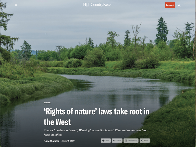
#Wyomingโ€™s #snowpack average heading into โ€˜wild cardโ€™ spring season: A โ€˜boringโ€™ winter delivered decent snowpack, which some Wyomingites embrace — Dustin Bleizeffer (WyoFile.com)

Snow blankets the mountains around Teton Pass on Jan. 12, 2025. (Angus M. Thuermer Jr./WyoFile)

Click the link to read the article on the WyoFile.net website (Dustin Bleizeffer):

March 17, 2025

If you want to know how weather is shaping life in Wyoming on any given day, just ask a Wyoming Department of Transportation employee, like Andrea Staley.

Her phone was blowing up early Friday afternoon with reports about a rash of crashes along Interstate 80 between Rawlins and Vedauwoo โ€” Wyomingโ€™s busiest roadway.

โ€œBy about 11 [a.m.], the road surface had gotten real icy,โ€ she told WyoFile. โ€œAnd with the wind, the visibility was causing issues.โ€

Staley, a WyDOT senior public relations publicist for southeast Wyoming, pines for โ€œboring winters.โ€

โ€œTheyโ€™re my favorite,โ€ she said.

This map depicts Wyomingโ€™s 2025 winter precipitation as of March 14, 2025. (Wyoming State Climate Office)

Itโ€™s been a bit of a mixed bag, according to local meteorologists. But no big surprises, and for an economy that thrives on predictable levels of snow and cold, the weather basically delivered.

Wyoming is emerging from a fairly mild winter that has been devoid of brutal, prolonged cold snaps or massive snow dumps. With a โ€œsnow water equivalentโ€ hovering around 94% of the median across the state, snowpack is โ€œlooking pretty good,โ€ according to Natural Resources Conservation Service Water Supply Specialist Jeff Coyle.

Thereโ€™s lower-than-normal snowpack in the northeast, including the southern portion of the Bighorn Mountains and some parts of the Black Hills on the South Dakota border.

โ€œWeโ€™re on course to be kind of an average year in most areas of the state,โ€ Coyle said, adding that both high elevations and basin areas appear to be meeting typical expectations. The wild card, of course, is what Mother Nature might deliver this spring โ€” a time when Wyoming can see its biggest snow dumps.

A view of the Laramie Plains from the Snowy Range in southeast Wyoming on March 1, 2025. (Mike Koshmrl/WyoFile)

Despite an early February snowstorm that helped pad winter snowpack in the southeast, areas around Cheyenne and Laramie are about a foot below average, according to Cheyenne National Weather Service Meteorologist Mike Charnick. Accumulation of the white stuff in the Snowy Range, however, is average and even a bit more in some areas there.

In terms of overall winter precipitation in the southeast, it was among the top 10 or 12 driest years, according to another Wyoming meteorologist.

Generally speaking, it was a โ€œmildโ€ winter in terms of temperature โ€” particularly in the southeast, Charnick said. โ€œWe have certainly been pretty far above average,โ€ he said. โ€œThe lowest temperature in February was minus six [degrees Fahrenheit] and minus 12 [degrees Fahrenheit] in January.โ€

Winter was warmer-than-usual in other parts of the state, too.

โ€œWestern and southwest Wyoming was in the top third of warmest years over the last 115 years, whereas the rest of the state was pretty close to normal,โ€ Riverton National Weather Service Meteorologist Lance VandenBoogart said.

Westwide SNOTEL basin-filled map March 16, 2025 via the NRCS.

What Season is it Anyway? — Peter Goble (Colorado Climate Center)

Click the link to read the article on the Colorado Climate Center website (Peter Goble):

March 14, 2025

Thursday, March 20th marks the spring equinox โ€“ the first day of spring according to most calendars. But does spring really start on March 20th? I would argue the answer is โ€œyes, no, and maybe.โ€ March and early April is possibly the most confusing, yet most important time of year for Colorado climatologically.

[Double rainbow over eastern Colorado in May. Photo credit: Allie Mazurek]

Three Ways to Define Spring

The start of spring may be defined in several ways:

Astronomical Spring uses the sunโ€™s position. The astronomical calendar divides the year using solstices and equinoxes. Our summer solstice occurs when Earthโ€™s northern hemisphereโ€™s tilt towards the sun is maximized. Our winter solstice occurs when Earthโ€™s northern hemisphereโ€™s tilt away from the sun is maximized. The spring equinox (late March) and fall equinox (late September) occur when Earthโ€™s tilt is tangential to the sun, resulting in 12 hours of daylight everywhere.

[Schematic of Earthโ€™s orbit and astronomical seasons. Source: wikipedia, public domain]

Climatological Spring is simply the three-month period of March, April, and May. This definition doesnโ€™t follow Earthโ€™s orbit but aligns better with our temperature experience. Astronomical seasons can be counterintuitive: December 19th is fall, but March 19th is winter? Yet March 19th is typically warmer than December 19th in mid-latitude locations.

Phenological Spring focuses on natural changes โ€“ new grass, blooming flowers, and leafing trees. The National Phenology Network tracks leaf-out dates using satellite data. The 30-year average for the Front Range (Fort Collins to Colorado Springs) is between April 1-15. In eastern Colorado and southwestern valleys, itโ€™s March 15-31. In the high country, it might be as late as May or early June. The phenological processes of spring vary yearly based on weather conditions.

[30-year average leaf-out date. Source: National Phenology Network]

Beyond These Definitions

These three definitions do not cover everything. Farmers might define spring by planting time โ€“ commonly late April or early May in Colorado. Others may focus on when snow stops falling. On average, the Front Range sees its last snow around the third week of April โ€“ earlier for the eastern plains and southwestern valleys, but much later for the mountains. Some areas, like the aptly named โ€œNever Summer Range,โ€ may see snow year-round. As recently as 2019, even the lowest elevations of eastern Colorado had snow as late as Mayโ€™s fourth week, disrupting graduations, weddings, and โ€œsummer breakโ€ plans.

[May 21st, 2019 west of Fort Collins, CO. Photo credit: Allie Mazurek]

Alternative Approaches

I might define spring on the northern Front Range as starting when the average minimum temperature rises above freezing and ending when the average daily maximum temperature hits 80ยฐF. PRISM data shows this works reasonably at lower elevations but less so for higher ones.

[First day of calendar year with average minimum daily temperatures above freezing. Created by Colorado Climate Center. Gridded data source: PRISM. Station data source: SCACIS]

Climatologist Brian Brettschneider suggests defining winter as days in the bottom 25% of the temperature distribution, summer as the top 25%, and spring/fall as everything between. By this measure, Denverโ€™s spring begins in Marchโ€™s third week and ends in Juneโ€™s second week. Check out his blog for more details.

The Fifth Season?

If we define spring phenologically using leaf-out dates (late March/April or later in mountains), what do we call mid-March? With sunset at 7:00 PM and warming temperatures, it doesnโ€™t feel like winter, yet springโ€™s phenological processes have not begun. Perhaps itโ€™s a fifth season โ€“ โ€œwind seasonโ€ (Coloradoโ€™s windiest time) or โ€œwater seasonโ€ (crucial for our stateโ€™s water supply).

Coloradoโ€™s Most Important Season

This transitional period is extremely important for Colorado. Most of our usable water comes from mountain snowfall that melts in spring and flows into reservoirs. April is the wettest month for much of our high country, with March close behind.

[Month of year with highest average precipitation. Created byย Colorado Climate Center. Data source:ย PRISM]

When March and April are dry, mountain snowpack suffers and snow melts early. When theyโ€™re wet, snowpack is likelier to peak at or above average, and snowmelt comes later. This shortens our high-elevation fire season and leaves more water in our reservoirs through summer and fall.

So while we debate whether itโ€™s technically spring yet, remember that March and early April โ€“ whatever we call this season โ€“ plays a crucial role in Coloradoโ€™s water security and ecological health for the entire year.

State #snowpack still underperforming with typical peak levels a month away — The #GrandJunction Daily Sentinel

Click the link to read the article on the Grand Junction Daily Sentinel website (Dennis Webb):

March 9, 2025

Statewide snowpack, which becomes spring runoff that serves agricultural and municipal needs, stood at 90% of normal as of Friday morning, according to the Natural Resources Conservation Service Colorado Snow Survey program. Accumulation amounts continue to show a distinct north-south split. Northern basins are performing better as is typical in winters such as this one that have La Niรฑa climate patterns marked by colder-than-normal surface ocean temperatures in the eastern equatorial Pacific Ocean.

Snowpack in the Colorado River Basin headwaters in Colorado stood at 101% of median as of [March 7, 2025], the Yampa-White River-Little Snake basins were at 96% of median, and the South Platte Basin was at 106% of median. Farther south, the Gunnison River Basin was at 89% of median; the Arkansas River Basin, 76%; the Upper Rio Grande Basin, 66%; and the San Miguel/Dolores/Animas/San Juan basins, 69%.

Grand Mesa continues to lag behind in snowpack levels. An NRCS measurement station at Mesa Lakes shows snowpack at 81% of normal, but the Park Reservoir and Overland Reservoir stations farther east are at just 69% and 66% of normal, respectively. The current streamflow forecast for this spring and summer at Surface Creek at Cedaredge calls for flows of just 57% of normal.

Assessing the Global Climate in February 2025: Above-average temperatures over most areas; lowest global and Arctic sea ice extent — NOAA

Click the link to read the article on the NOAA website:

March 12, 2025

February Highlights:

  • Temperatures were above average over much of the globe, particularly in the Arctic, but much below average over western Canada and the central United States.
  • Global and Arctic sea ice extent ranked lowest on record for February.
  • Twelve named storms occurred across the globe in February, which set an all-time record for the month.
Map of global selected significant climate anomalies and events in February 2025.

Temperature

The February global surface temperature was 2.27ยฐF (1.26ยฐC) above the 20th-century average of 53.8ยฐF (12.1ยฐC), making it the third-warmest February on record. According to NCEIโ€™s Global Annual Temperature Outlook, there is a 4% chance that 2025 will rank as the warmest year on record. 

Land and Ocean Temperature Percentiles for February 2025 (ยฐC). Red indicates warmer than average and blue indicates colder than average.

It was the fourth-warmest February for the global land air temperature and the second-warmest February for the global ocean surface temperature. Global temperatures have cooled in recent months as a La Niรฑa episode, the cold phase of El Niรฑo Southern Oscillation (ENSO), developed. Global temperatures tend to be cooler during periods of La Niรฑa in comparison to periods with an El Niรฑo present.

February temperatures were above average across much of the global land surface, particularly over the Arctic, central Eurasia, southern South America and central Australia. Much of western Canada, the central United States, eastern Europe, the Middle East and China were colder than average. Sea surface temperatures were above average over most areas, while much of the central and eastern tropical Pacific was below average (consistent with La Niรฑa), as were parts of the southeast Pacific, western North Atlantic and the northwestern Indian Oceans.

Surface Temperature Departure from the 1991โ€“2020 Average for February 2025 (ยฐC). Red indicates warmer than average and blue indicates colder than average.

Snow Cover

The Northern Hemisphere snow cover extent in February was slightly below average. Snow cover over North America and Greenland was below average (by 50,000 square miles), and Eurasia was also below average (by 40,000 square miles). Areas of below-average snow cover include the central United States and much of Europe.

Sea Ice

Global sea ice extent was the smallest in the 47-year record at 6.16 million square miles, which was 770,000 square miles below the 1991โ€“2020 average. Arctic sea ice extent was below average (by 430,000 square miles), ranking lowest on record, and Antarctic extent was below average (by 340,000 square miles), tied with 2022 for third lowest on record.

Map of the Arctic (left) and Antarctic (right) sea ice extent in February 2025.

Tropical Cyclones

Twelve named storms occurred across the globe in February, which set an all-time record for the month. A record five named storms occurred in the southwestern Indian Ocean. Five named storms occurred in the Australian region, as well as four in the Southwest Pacific.


For a more complete summary of climate conditions and events, see our February 2025 Global Climate Report or explore our Climate at a Glance Global Time Series.

#Snowpack news March 17, 2025

Colorado snowpack basin-filled map March 16, 2025 via the NRCS.

Westwide SNOTEL basin-filled map March 16, 2025 via the NRCS.

Latest forecast suggests #RioGrande drying through Albuquerque is possible by early June — John Fleck (InkStain.net)

USBR March 2025 Rio Grande runoff forecast.

Click the link to read the article on the InkStain.net website (John Fleck):

March 11, 2025

This weekโ€™s newest U.S. Bureau of Reclamationโ€™s Rio Grande runoff model runs have triggered a string of โ€œwait, what?โ€ conversations this afternoon at the Utton Center.

  • possible drying through Albuquerque as early as June,ย with a good chance of drying even earlier
  • we may already have passed the spring runoff peak
  • irrigation supplies, already short for Middle Rio Grande Conservancy District farmers, will be even shorter

The early March simulations, which are based on the latest snowpack and runoff forecasts, are ratcheting up the anxiety among water managers as they scramble to manage conditions unprecedented in modern Rio Grande management. Looking at the graph above, you can see what a typical year looks like, with flows rising through late may. That black-to-purple line is the most likely flow this year

Even before the new model runs, the Middle Rio Grande Conservancy District was warning valley irrigators that, with little water in storage to supplement dwindling river flows, irrigation supplies would be unreliable by summer. Based on my analysis of the new numbers (danger, Fleck doing math!) that could come a lot sooner. According to Reclamationโ€™s median forecast, we have already seen the runoff peak on the Rio Grande through Albuquerque. (Our 2025 peak so far technically was around 1,000 cfs Jan. 1, but thatโ€™s just moving last yearโ€™s water, rhetoric rather than hydrology.)

We could still have some monsoon rains that temporarily push the river up past the March 8 spring runoff peak of 600 cubic feet per second. But monsoon bursts arenโ€™t enough, in terms of volume of water, to make up for the pitiful snowpack, made more pitiful by the hot dry spring winds that have been eating it away.

The Albuquerque Bernalillo County Water Utility Authority had already been projecting that it would need to shift away from surface water, using groundwater pumps to meet municipal needs, sometime this summer. The Inkstain News Gloom Team will keep an eye on that for yโ€™all.

Westwide SNOTEL basin-filled map March 16, 2025 via the NRCS.

R.I.P. Roberta Flack “Like the trembling heart of a captive bird”

Roberta Flack in 1995. By Kingkongphoto & http://www.celebrity-photos.com from Laurel Maryland, USA – ROBERTA FLACK early ยฉ copyright 2010, CC BY-SA 2.0, https://commons.wikimedia.org/w/index.php?curid=74554521

Click the link to read the obituary on The New York Times website (Giovanni Russonello). Here’s an excerpt:

February 24, 2025

Roberta Flack, the magnetic singer and pianist whose intimate blend of soul, jazz and folk made her one of the most popular artists of the 1970s, died on Monday in Manhattan. She was 88…After spending almost 10 years as a Washington, D.C., schoolteacher and performing nights downtown, Ms. Flack zoomed to worldwide stardom in 1972, after her version ofย โ€œThe First Time Ever I Saw Your Faceโ€ย was featured in a Clint Eastwood film…The song had been released three years earlier, on her debut album for Atlantic Records, but came out as a single only after the film was released. Within weeks it was at No. 1 on the Billboard chart โ€” a perch she would reclaim two more times, with โ€œKilling Me Softly With His Songโ€ (1973) and โ€œFeel Like Makinโ€™ Loveโ€ (1974).

Ms. Flackโ€™s steady, powerful voice could convey tenderness, pride, conviction or longing, but hardly ever despair. Most of her best-known albums included at least a few funk and soul tracks, driven by a slapping backbeat and rich with observational social commentary. But her biggest hits were always something else: slow folk ballads (โ€œThe First Timeโ€) or mellifluous anthems (โ€œKilling Me Softlyโ€) or plush love songs (โ€œFeel Like Makinโ€™ Loveโ€)…Critics often struggled to describe the understated strength of her voice, and the breadth ofย her stylistic range. In its poise, its interiority and conviction, its lack of sentimentality or overstatement, her singing seemed to press the reset button on any standard expectations of a pop star. She placed equal priority on passion and clear communication โ€” like an instructor speaking to an inquisitive student, or a lover pledging devotion.

We see the climate change in #NewMexico — Laura Paskus (WritersOnTheRange.org) #ActOnClimate

Click the link to read the article on the Writers on the Range website (Laura Paskus):

March 10, 2025

Here in New Mexico, our growing season has lengthened since the 1970s, even as stream flows have decreased. Fire season starts earlier, lasts longer, and in some years, ignites the forests into record-breaking blazes, like the gargantuan Hermits Peak-Calf Canyon and Black fires in 2022.

If you look at the last century in New Mexico, stretches of higher temperatures have lengthened; heat waves are hotter and nights, consistently warmer.

Rising heat and expanding aridity harm ecosystems and wildlife and hotter days are dangerous for anyone outside, especially people without housing or access to cool spaces. Extreme heat even interacts with certain medications people need for their physical and mental health. 

It should be no surprise that weโ€™re facing another crackly-dry spring, summer, and fall. Fans watching the March 2 Oscars on Albuquerque TV saw flashing red-flag fire warnings. The next day, high winds and dust storms blasted the state; near Deming, a haboob of fast-moving dust shut down highways.

West Drought Monitor map March 11, 2025.

As of early March, 92 percent of New Mexico was experiencing drought, with almost 30 percent of the state in severe to extreme drought, according to the U.S. Drought Monitor.

Arizona is in even worse shape: 100 percent of the state is in drought, with 87 percent in severe to exceptional drought. And the interior Westโ€™s three-month outlook is for warm, dry conditions โ€” especially in Arizona and New Mexico.

Here in New Mexico, the Middle Rio Grande Conservancy Districtโ€”which supplies water for farmsโ€”is warning runoff season will be short and river flows, low. The districtโ€™s leaders are urging farmers to plan for extended periods between irrigation deliveries and say that without summertime monsoons, they will not meet everyoneโ€™s needs this year.

During the 1900sโ€”including during the infamous 1950s drought and earlier in this centuryโ€”armers could often still expect full water allocations in a dry year.

Now, when farmers donโ€™t receive waterโ€”and the Rio Grande dries for long stretchesโ€”itโ€™s not only because there isnโ€™t enough snow melting off the mountains.  Itโ€™s also because consistently dry soils suck up any moisture, making both forests and croplands thirstier.

Not only that, but decades of persistent drought and warming temperatures have desiccated reservoirs along the Rio Grande and its tributary, the Chama River.

On the Chama River, Heron Reservoir is 14 percent full; its neighbors, El Vado and Abiquiu, are at 14 percent and 51 percent respectively. Further down the watershed, on the Rio Grande in southern New Mexico, Elephant Butte Reservoir is only 13 percent full, and its neighbor, Caballo, nine percent full. 

In New Mexico, some water users, including the irrigation district, rely on water piped from the Colorado River watershed into the Chama and then the Rio Grande. This year, most of that supplemental water wonโ€™t be there.

The view upstream on both watersheds is also troubling, especially in Arizona, New Mexico and southern Utah where the snowpack is โ€œbelow to well-below median.โ€ Last month, the Colorado Riverโ€™s two largest reservoirs, Lake Powell and Lake Mead, were 34 percent full, the lowest theyโ€™d been in early February for the last 30 years of records.

Iโ€™m alarmed by many things happening right now, including the disappearance of climate data from federal websites and the gutting of federal workforces and budgets. We need wildland firefighters, scientists, and the staffers who kept our parks and public lands functioning.

But as a reporter who has covered climate change and its impacts in my state for more than two decades, I take the long view along with a local view.

We have known for decades that the planet is steadily warming and that the impacts of climate change would intensify. And we must resist focusing solely on the current chaos of the federal government. [ed. emphasis mine]

Laura Paskus. Photo credit: Writers on the Range

Thereโ€™s never been a better time to become immersed in local politics or organizing, and to hold state and local leaders accountable for action on climate.

We can collaborate on local solutions and work together to better deal with the crises we face. Really, we have no choice.

Laura Paskus is a contributor to Writers on the Range, writersontherange.org, an independent nonprofit dedicated to spurring lively conversation about Western issues She is longtime reporter based in Albuquerque and the author of At the Precipice: New Mexicoโ€™s Changing Climate and Water Bodies.

โ€˜Rights of natureโ€™ laws take root in the West: Thanks to voters in Everett, Washington, the Snohomish River watershed now has legal standing — Anna V. Smith (High Country News) #rightsofnatureย 

Click the link to read the article on the High Country News website (Anna V. Smith):

March 1, 2025

Last fall, Everett, Washington, became the first city in the Western United States to pass a ballot measure recognizing the rights of a riverโ€™s watershed โ€” that of the Snohomish River, which curves north and east around the city before emptying into Puget Sound. The municipal law protects the riverโ€™s โ€œrights to exist, regenerate and flourishโ€ and is designed to be a tool for residents seeking to prevent or repair harm to the riverโ€™s watershed. 

โ€œThese ecosystems have inherent rights. We are just acknowledging them by giving them legal standing in a court of law,โ€ said Abi Ludwig, co-founder of Standing for Washington, a political action committee that supported the initiative.

The law is the latest attempt in two decades of concerted efforts at the tribal, city and international level to codify a different legal relationship between people and their environment โ€” one in which water, wildlife and land are not just resources to be used and abused by humans. In the U.S., several similar โ€œrights of natureโ€ laws have failed legal challenges, and Everettโ€™s law could meet the same fate: In late January, a group of local developers and business owners filed suit against it. But according to Ludwig, the campaign learned from past experience, and the new ordinance is designed to survive. โ€œEven though itโ€™s this emergent strategy,โ€ she added, โ€œI think people are ready to embrace something new, and to try something new.โ€

In our current legal system, in order to sue over harm to a river or a species, a plaintiff must prove that they have โ€œstandingโ€ โ€” that theyโ€™ve been personally injured by the decline of that river or species. Rights of nature laws eliminate this requirement by giving legal standing to nonhuman entities. The strategy is relatively new, but the concept of reciprocity between ecosystems and human beings is much older and found in Indigenous knowledge, said Britt Gondolfi, rights of nature project coordinator with the nonprofit network Bioneers and a descendant of the Houma Nation.ย 

In the U.S., tribal nations including the Yurok Tribe and White Earth Nation have used their sovereignty to adopt resolutions or amend their constitutions to enact rights of nature laws. In 2021, two town councils in Colorado passed non-binding resolutions recognizing the rights of local rivers. Other initiatives have met with more pushback; a ballot measure passed in Toledo, Ohio, that recognized the legal rights of Lake Erie was struck down in 2020 by a federal court, and in 2024, the Utah Legislatureย preemptively bannedย similar laws after author Terry Tempest Williams madeย a public caseย for the legal personhood of the Great Salt Lake.ย 

Map of the Snohomish River watershed in Washington, USA with the Snohomish River highlighted. Made using USGS National Map data. Replacement for File:Snohomishrivermap.jpg. By Shannon1 – Own work, CC BY-SA 4.0, https://commons.wikimedia.org/w/index.php?curid=47085604

In Everett, organizers deliberately restricted the lawโ€™s reach to city limits, since the potential for conflicts of jurisdiction doomed Toledoโ€™s attempt to protect Lake Erie. The Snohomish River has long suffered from industrial pollution and agricultural runoff, and Everett residentsโ€™ interest in restoring the watershed helped the measure pass with 57% of the vote.

The Tulalip Tribes, whose reservation is just north of Everett, did not endorse the initiative, but Tribal Chairwoman Teri Gobin said in a statement that the tribe looks forward to seeing it translated into action: โ€œWe see value in using all tools available in the pursuit of sustainability and co-existence for the people, plants, animals, lands, and waters of our world.โ€

Under the new law, any Everett resident can bring a case, and any money from successful lawsuits will fund the cityโ€™s watershed restoration efforts. โ€œWe now think of it as a community stewardship model,โ€ Ludwig said. Despite the opposition, โ€œwe have to try,โ€ Gondolfi said. โ€œWe have to try every legal argument available to us for the preservation of what little natural world is left, in comparison to what weโ€™ve destroyed.โ€   

This story is part of High Country Newsโ€™ Conservation Beyond Boundaries project, which is supported by the BAND Foundation.

We welcome reader letters. Email High Country News at editor@hcn.org or submit a letter to the editor. See our letters to the editor policy.

This article appeared in the March 2025 print edition of the magazine with the headline โ€œโ€˜Rights of natureโ€™ laws take root in the West.โ€

#Colorado West Slope Letdown: U.S. Representative Lauren Boebert left, MAGA stuck around — Jonathan P. Thompson (LandDesk.org)

Sky with oil and gas infrastructure, Greater Chaco Region. Jonathan P. Thompson photo.

Click the link to read the article on The Land Desk website (Jonathan P. Thompson):

March 15, 2025

Data Dump: Setting baselines to monitor “energy dominance” under Trump

When Republican Jeff Hurd was elected to represent Coloradoโ€™s third congressional district, I believe I heard a bipartisan, collective sigh of relief. Democrats may have been sad that their candidate didnโ€™t win, but at least the new guy wasnโ€™t Lauren Boebert. And, many of us hoped, Hurd would represent a return of the independent and pragmatic Western politician of old to western and southern Colorado.

We were wrong.

So far, Hurdโ€™s performance in office has pretty much followed Boebertโ€™s lead, politically, albeit without the gun-slinging and other outrageous antics. When one of his aides showed up to meet with constituents in Dolores, she fled after seeing the size of the crowd assembled there. Hurd, himself, chickened out from attending a town hall in Grand Junction for similar reasons. Instead of apologizing for refusing to listen to the people he represents, he accused the crowd of being George Soros-funded activists โ€” a false and worn-out, right-wing anti-semitic trope that really needs to be retired. In fact, the folks were his constituents, including members of Indivisible and the League of Women Voters. These werenโ€™t exactly molotov cocktail hurling radicals.

And when CPRโ€™s Ryan Warner asked him about the mass federal employee firings that have hit his district especially hard, Hurd gave mealy mouthed answers, saying efficiency is good, acknowledging he had no idea how many employees had lost their jobs, and lamenting the possibility that some good people may have been terminated, too, though it was also clear that he wasnโ€™t going to do anything about it, especially if it meant questioning or, God forbid, standing up to Musk and Trump.

Hurd introduced a bill that would move the Bureau of Land Management headquarters to Grand Junction because itโ€™s better to have management staff on the ground, yet he has not pushed back on DOGEโ€™s plans to close federal offices throughout his district, including the Bureau of Reclamation and Army Corps of Engineers offices in Durango. He has teamed up with Boebert to criticize Colorado for importing โ€œforeign wolvesโ€ into the state and has parroted MAGAโ€™s anti-immigrant hysteria in regards to Denverโ€™s tolerance.

Now Hurd has introduced the Productive Public Lands Act to โ€œunlock resource development on some of our most productive lands.โ€ It would toss Biden-era Bureau of Land Management resource management plans โ€” which he claims โ€œlocked up access to viable landsโ€ โ€” and replace them with fossil fuel-friendly ones with the aim of putting โ€œus on a path to energy dominance.โ€ Talk about inefficient: Those RMPs took years to develop and are the result of extensive studies, public input, and compromise. Trashing them is a perfect example of government waste. [ed. emphasis mine]

Note to Rep. Hurd: Public lands are not locked up. Quite to the contrary. Unfortunately Hurd โ€” like his predecessor โ€” has chosen to let MAGA ideology and disinformation blind him to the facts. Still, Iโ€™ve got to try, so here I go again: The United States is producing more oil and gas โ€” much of it from public lands โ€” than it ever has before, and is the worldโ€™s leader in hydrocarbon production. Read that again. Then again. And keep doing so until it penetrates your thick skull so that you can stop wasting all of our time with your โ€œwar on energyโ€ nonsense.

While drilling has shifted away from Colorado and is now centered on the Permian Basin, it has nothing to do with BLM regulations or resource management plans. Itโ€™s because western Colorado is rich in natural gas, not so much in oil, and thereโ€™s far less money in natural gas production than there is in crude oil. Nevertheless, oil, gas, coal, and carbon dioxide production from federal lands in Colorado (much of which are on the Western Slope) generated $205 million in revenue last year. Locked up? I donโ€™t think so.

***

As long as Iโ€™m on the topic of โ€œenergy dominance,โ€ I figured it would be a good time to set out some baseline data for tracking the progress of Trumpโ€™s โ€œdrill, baby, drillโ€ agenda. As has been established, the Trumps and Hurds of the world believe that energy production from federal lands has been โ€œlocked up,โ€ and that by โ€œunleashingโ€ it โ€” i.e. rescinding environmental protections โ€” the oil and gas industry will bring in a battalion of drill rigs, send oil and gas production through the roof, and bring down prices at the pump to make it cheaper to drive those gas-guzzling behemoths that now dominate the roadways.

Itโ€™s too early in Trumpโ€™s term to determine whether thatโ€™s actually happening or not, so letโ€™s just check in on where we are and what has happened over the last four years. And weโ€™ll keep updating these graphs periodically. Land Desk readers have seen some of these before. Sorry about that.

This one shows U.S. crude oil production. It was in steady decline until about 2009, kicking back up again just as Obama took office. Is that because Obama slashed regulations on drilling? No. Itโ€™s because thatโ€™s when horizontal drilling-multistage hydraulic fracturing, i.e. fracking, came into its own and oil prices increased. Production dipped at the end of Obamaโ€™s second term because OPEC decided to wage a price war on U.S. producers, glutting the market with crude in hopes of driving some U.S. companies out of business. And it dipped again at the end of Trumpโ€™s first term because of COVID. In December, while Biden was still in office, U.S. fields produced 418 million barrels of crude, an all-time record high. Source: Energy Information Administration.

Production goes up after drilling activity increases. Drilling activity generally responds to crude oil prices. When prices are high, itโ€™s more profitable to develop new oil and gas wells, so the drilling rigs are dusted off and head out into the fields. When prices are low, they are folded up and hauled back to the storage yard.

And lest you think that maybe all of that production is coming from private or state lands since, after all, the federal land has all been โ€œlocked upโ€ by Bidenโ€™s purported war on energy, check out the revenues from federal land resource production for New Mexico and Colorado. Funny how they shot up right after Biden was elected, no?

Oil production from federal lands in New Mexico generated $4.65 billion last year, down slightly from 2022 but still significantly more than during any other time during the last two decades. Source: Office of Natural Resource Revenue.

Coloradoโ€™s energy industry has had a slightly rougher go of it, mainly because it specializes in natural gas, not crude oil, and methane prices have been low since the 2009 crash. Note to Jeff Hurd: Revenues were substantially higher under Biden than under Trump I. Just sayinโ€™. Source: ONRR

The best way to get a feel for drilling activity is to check out the weekly rig count. So here it is. But a note to all you statisticians out there: The time intervals are uneven on this graph, in part due to my own laziness. But it still gives a fairly accurate picture of drilling activity over time, so it works.

This gives a good illustration of the level of drilling activity and where itโ€™s taking place. This shows the OPEC price war dip in 2015 and 2016 and the COVID dip in 2020. Again, these are driven almost entirely by the price of crude oil, which is determined by the global market. North Dakota dominated for a while, but never recovered from the 2015 crash. Instead, activity moved to the Permian Basin in New Mexico and Texas. The rig count for Western states remained remarkably stable during the Biden administration. Source: Baker-Hughes.

The thing about production and rig counts, though, is they donโ€™t really reflect White House policy. So how about the number of drilling permits approved by the Bureau of Land Management?

On average, Bidenโ€™s BLM issued around the same number of drilling permits as Trump I. This may have something to do with policy, but it is also driven by how many firms apply for permits and how well-equipped and staffed the field offices are to process those applications. Note that during the last four months of Bidenโ€™s term, the BLM issued over 1,300 permits. So far, the Trump II administration has issued 774 permits in just over two months. Source: BLM.

Now that we have a snapshot of where weโ€™ve been and where we are in terms of oil and gas development, we can track where we might be headed under Trump 2.0. My guess? Weโ€™re going to see all of the above indicators begin falling soon. Sure, rig counts are staying steady, meaning production will continue to rise for a few more months. But after that, lower oil prices are likely to kick in, dimming companiesโ€™ enthusiasm for drilling, which will hit the rig count first and then production.

Graphic credit: The Land Desk

Oil prices are dropping โ€” they hit sub-$70/bbl this week for the first time since 2021 โ€” because OPEC decided to start pumping more crude and because the economy is struggling, which will likely dampen demand. The economy is struggling because markets are reacting unfavorably to the chaos Trump, Musk, and company are wreaking from the White House. Turns out that tariffs, trade wars, and haphazard termination of critical federal employees is bad for the economy. Gasoline prices will likely fall, too, except in places that rely on Canadian crude, where they might increase. So there is that. Of course, if you lose all your money in the plummeting stock market, it wonโ€™t really matter much, I suppose.


Speaking of tariffs, remember when I wrote about Trumpโ€™s trade wars and predicted that American whiskey and bourbon makers would be casualties? Turns out I was right. Kentucky distillers, especially the small ones, are already feeling the pain, and even large ones are smarting from Canadaโ€™s retaliatory moves. I suppose Trump will claim the Canadians started the trade war, just as heโ€™s ridiculously asserting Ukraine invaded Russia.

๐Ÿ“ธ Parting Shot ๐ŸŽž๏ธ
St. Josephโ€™s Church, San Fidel, New Mexico. Jonathan P. Thompson photo.

Death by a thousand cuts: Global threats to insect diversity — @violin4all

Yampa Valley nonprofits face uncertainty amid federal policy shifts — Steamboat Pilot & Today

Yampa River near Deer Lodge Park. Photo credit: Allen Best/Big Pivots

Click the link to read the article on the Steamboat Pilot & Today website (Julia Coccaro). Here’s an excerpt:

March 13, 2025

In the Yampa Valley, a network of dozens of nonprofits provides essential services to the community. Recent federal policy changes, however, have introduced widespread uncertainty, ultimately threatening the stability and fate of many of these organizations.ย The Office of Management and Budget on Jan. 27 issued aย memoย following an executive order by the Trump administration announcing a federal freeze on hundreds of billions of dollars in grants and loans. The order wasย blockedย by a federal judge the next day, and on Jan. 29 the memo wasย rescinded. But White House Press Secretary Karoline Leavittย statedย that only the memo was rescinded, not the order, leading to mass confusion and anxiety regarding the fate of federal funding for thousands of programs nationwide.

Larimer County Considers 1041 Permit Application — #FortCollins Utilities

From email from the City of Fort Collins:

March 14, 2025

Larimer County Considers 1041 Permit Application
As someone who is interested in the Halligan Water Supply Project, we are reaching out to inform you about an upcoming meeting.

This month, the Larimer County Board of County Commissioners is scheduled to consider the Halligan Water Supply Projectโ€™s 1041 permit application. County Commissioners will hear presentations from county staff and City of Fort Collins staff and will invite the public to comment before making a final decision. The meeting will take place on March 24 at 6:30 p.m. at the Larimer County offices at 200 W. Oak St. in Fort Collins. 

Last month, the Larimer County Planning Commission unanimously recommended the Board of County Commissioners approve the permit with 53 proposed conditions. 

To view the application, visit the county’s website by clicking this link.

If you have questions about the project, feel free to email halligan@fcgov.com or call 970-416-4296.

Happy #PiDay

Mrs. Gulch’s cherry pie creation for Coyote Gulch’s birth anniversary March 2020. She also grew the cherries.

Snow #Drought Update: Abysmal #Snowpack Defines Winter for #Arizona and #NewMexico — NOAA

Click the link to read the report on the NOAA website:

March 6, 2025

Key Points

  • Another month of extremely dry conditions plagued the Southwest (Colorado, New Mexico, Arizona, Utah, Nevada), leading to deepening snow deficits across already dry basins. Exceptional snow drought continues to persist with the peak snow water equivalent (SWE) dates past for Arizona and New Mexico.
  • Lower-elevation snow drought persisted across southern Alaska due to continued warm and dry conditions, with Anchorage Airport recording its driest February on record. Large areas in southwest Alaska and low elevations in south-central Alaskaโ€”which are typically snow coveredโ€”were (nearly) snow-free as of March 1.
  • Moderate snow drought conditions persisted in the northern and central Cascade Range of Washington due to below-average winter precipitation.
  • A recent storm cycle brought welcome moisture back to California and Nevada, improving snow drought conditions, but deficits still remain in the region.
  • The Upper San Juan, Upper Rio Grande, and Gunnison River Basins provide substantial snowmelt and runoff to the Upper Colorado River Basin, which drains into Lake Powell. Given low snowpack in these basins, monitoring snow conditions will be critical for future water supply as the basins enter the spring snowmelt season.
  • The National Weather Serviceย Climate Prediction Centerโ€™s outlooksย favor a likely colder and wetter pattern over the next month in the West, which could be favorable for snow accumulation.ย 
Snow Telemetry (SNOTEL) snow water equivalent (SWE) values for watersheds in the western U.S. as a percentage of the 1991โ€“2020 median recorded by the USDA Natural Resources Conservation Service (NRCS). Only stations with at least 20 years of data are included in the station averages. The SWE percent of median, in this figure and in the text,ย represents the current SWE at selected SNOTEL stations in or near the basin compared to the median value for those stations on the same date from 1991โ€“2020. This map is valid through the end of the day March 2, 2025. For an interactive version of this map, please visitย NRCS. Westwide SNOTEL March 13, 2025 via the NRCS.

Snow Drought Conditions Summary

This update is based on data available as of Monday, March 3, 2025 at 12:00 a.m. PT. We acknowledge that conditions are evolving.

Current Conditions

Extremely dry conditions across the West in January transitioned to a more active precipitation pattern in February improving the snowpack for much of the West, particularly in the Sierra Nevada, northern Great Basin, and northern Rocky Mountains. In contrast, much of the southern Rocky Mountains, Arizona, and New Mexico saw very little snowfall over the past month. The worst snow drought conditions continue to be in the Southwest, including southern Utah, southwestern Colorado, Arizona, and New Mexico. Snow drought conditions also persist in the northern and central Cascade Range of Washington.

Looking Ahead

The U.S. Bureau of Reclamation weekly water supply report for the Lower Colorado River Basin predicts unregulated inflows into Lake Powell will be 70% of normal in Aprilโ€“July. This is despite 92% of normal snow water equivalent (SWE) in the Upper Colorado Basin, as Colorado river tributary watersheds across central Utah (the San Juan River Basin, the Green Basin, and Gunnison Basin) saw below-normal precipitation and persistent low soil moisture conditions. Spring storms could help boost snowpack, but erasing the deep seasonal deficits across these basins is unlikely. 

Throughout Arizona and New Mexico, above-normal potential for significant wildfires persists through June, according to the National Interagency Fire Center. Wildfire season generally begins earlier and peaks later in these states compared to other areas of the West due to earlier peak SWE and a climatologically dry spring before the monsoon season begins.

Several Western U.S. Stations Have SWE Below the 30th Percentile

Snow water equivalent (SWE) percentiles for locations in the western U.S. at or below the 30th percentile as of March 2, 2025. Stations with SWE above the 30th percentile* are shown with a black โ€œxโ€. Only SNOTEL stations with at least 20 years of data were used. Stations where the median SWE value for the date is zero are not shown. Data Source: USDA Natural Resources Conservation Service.

Rocky Mountain Snow Conditions (Colorado, Idaho, Montana, Utah, Wyoming)

Northern Rockies

Snowpack has generally improved in the northern Rocky Mountains over the past month, with most hydrologic unit code (HUC) 6 basins reporting near- to above-normal snow water equivalent (SWE). However, the Marias and Upper South Saskatchewan Basins in northwestern Montana are still in snow drought, with SWE at 71% and 73% of normal, respectively. Precipitation over most of the Bighorn Mountains in north-central Wyoming was well below normal over the past month, particularly the southern part of the range. Snow drought conditions are present in the central and southern part of the Bighorn Mountains, where SNOTEL stations are reporting 48โ€“92% of normal SWE. 

Central Rockies

Snow drought conditions have persisted and, in some cases, intensified across central and southern Utah and southwestern Colorado. Thirteen SNOTEL stations scattered across south-central and southwest Utah report record-low snow water equivalent (SWE). The Lower Colorado-Lake Mead, Escalante Desert-Sevier Lake, and Upper Colorado-Dirty Devil Basins have 29%, 51%, and 56% of normal SWE, respectively. This is the lowest SWE on record for the Lower Colorado-Lake Mead Basin for this date. The Lower Green Basin, including the south slopes of the Uinta Mountains in northeastern Utah, report 79% of normal SWE.

SNOTEL stations in southwestern Colorado, including stations in the San Juan and Sangre de Cristo mountains, also report snow drought conditions, with most locations below the 20th percentile SWE. Northwestern portions of the Gunnison Basin also have well-below-normal snowpack. The Upper San Juan, Rio Grande Headwaters, and Gunnison Basins are at 56%, 62%, and 82% of normal SWE, respectively. These basins provide substantial snowmelt and runoff to the Upper Colorado River Basin, which drains into Lake Powell. It will be critical to watch snowpack in these basins heading into the spring snowmelt season. February temperatures were 4โ€“6 ยฐF above normal in much of southern Utah and western Colorado, helping drive snow drought across the region.

Low Snow Water Equivalent in Upper San Juan River Basin

USDA Natural Resources Conservation Service (NRCS) water year accumulated snow water equivalent (SWE) (inches) (black, 2024-2025; orange, 2024) for the Upper San Juan Basin, compared to the period of record maximum (blue) and minimum (red) and the 1991-2020 median (green) as of March 3, 2025. Source: USDA Natural Resources Conservation Service.

Arizona and New Mexico Snow Conditions

Snow drought conditions remain severe as much of the region is nearing or has passed the dates at which snow water equivalent (SWE) typically peaks for the year. In Arizona and parts of New Mexico, peak SWE typically occurs around March 1, much earlier than most of the mountains in the West. The trend of persistent above-normal temperatures and lack of snowfall continued in February in the mountains across the region.

All but two SNOTEL stations in Arizona and New Mexico report less than 50% of normal SWE, with no snow at some locations. In Arizona, the Verde Basin, which has a median peak SWE date of March 1, is currently at 8% of median peak SWE, and the Little Colorado Basin, which has a median peak SWE date of March 4, is currently at 17% of median peak SWE. In New Mexico, the Upper Rio Grande and Upper Canadian Basins are at 39% and 28% of normal SWE, respectively. 

Initial surges of spring snowmelt already occurred at some locations in the Upper Canadian Basin, which is several weeks earlier than normal. February temperatures were 4โ€“6 ยฐF above normal across much of the region, which contributed to increased snowmelt at lower elevations.

#Colorado lawmakers eye new task force to boost water funding — Jerd Smith (Fresh Water News)

Republican House members recite the Pledge of Allegiance as Colorado lawmakers returned to the Capitol January 8, 23025, for opening day at the General Assembly. Photo credit: Fresh Water News

Click the link to read the article on the Fresh Water News website (Jerd Smith):

March 13, 2025

Colorado lawmakers, worried that a key source of money for water projects is too easily tapped for other programs, want to create a special task force to examine ways to stabilize and boost funding for things like new water pipelines and conservation programs.

Under Senate Bill 40, a nine-member panel would examine new options to replace severance tax money that is collected on nonrenewable resources, such as oil and gas and some minerals, and is highly variable. A portion of the revenue is used to help Colorado address looming water shortages.

According to state forecasts, by 2050 those shortages could be as high as 740,000 acre-feet of water, under a worst-case planning scenario, or much lower if growth slows and climate change impacts are less than expected. One acre-foot of water equals nearly 326,000 gallons, enough water to serve at least two urban homes for one year.

Like other Western states, Colorado is racing to shore up aging water systems and make existing supplies stretch further as drought and rising temperatures shrink water supplies.

The bill comes as lawmakers wrestle with how to cut $1.2 billion from a state purse hurt by slowing growth and revenue caps. 

The measure, sponsored by Sen. Dylan Roberts, D-Frisco, Sen. Cleave Simpson, R-Alamosa, Rep. Karen McCormick, D-Longmont, and Rep. Matthew Martinez, D-Monte Vista, is stalled in the Senate appropriations committee until the legislature completes its budget work, Roberts said.

Roberts said the current budget crisis and previous fiscal storms have resulted in severance tax revenue being tapped to help resolve budget shortfalls in nonwater programs, a situation that hits hard at the stateโ€™s ongoing efforts to ensure there is enough water to go around.

โ€œThe joint budget committee has swept severance taxes in the past. Not too often, but I worry that it will become a common practice. I and my cosponsors want to get the best minds together on how we better plan for the future,โ€ he said.

Lawmakers plan a new tax force to find ways to replace the stateโ€™s reliance on severance taxes. Credit: Colorado Legislative Council

The Colorado Water Conservation Board is the stateโ€™s primary water planning agency, and helps fund an array of water projects and planning initiatives. Its revenues come from interest on loans, money from the stateโ€™s general operating fund, sports betting tax revenues, and severance tax revenues, among other sources.

Late last year, Gov. Jared Polis proposed a budget that largely shielded water programs from major cuts, but it is lawmakers who will make the final decision on how the stateโ€™s budget will be balanced this year.

The severance tax has generated $412 million for the CWCB over the past 10 years, according to Kirk Russell, the CWCBโ€™s finance section chief. Most of that goes into a revolving loan fund that helps finance such things as irrigation ditch repairs and pipelines. It isnโ€™t typically used to finance the water agencyโ€™s operating budget.

But he said the severance tax fund experiences โ€œa great deal of variabilityโ€ from year to year.

A bright spot in the funding picture, according to Roberts, is the growth in revenue collected from gambling on sports. According to the Colorado Division of Gaming, sports betting has generated $98 million in revenue since May 2020, when sports betting became legal in Colorado. The majority of that money is now used to help fund the Colorado Water Plan.

Roberts said lawmakers are open to considering a range of options to stabilize water funding, and he said there may be potential to expand the revenue generated by sports betting. In January, the program hit a new high, generating $4.4 million. The previous high occurred in January 2024, when $4.1 million was generated, according to the Division of Gaming.

If the bipartisan task force measure is approved, members would be selected this summer and a final report would be due back to lawmakers by July 15, 2026.

#Colorado Will Require Oil and Gas Companies to Increase Water Recycling for Fracking — Jake Bolster and Martha Pskowski (InsideClimateNews.org) #ActOnClimate

Directional drilling from one well site via the National Science Foundation

Click the link to read the article on the Inside Climate News website (Jake Bolster and Martha Pskowski):

March 13, 2025

Freshwater use in oil and gas drilling has come under scrutiny in Colorado as the state faces a historic drought. On Wednesday, March 12, state regulators announced new rules that will require drillers to use more recycled water in their operations and, hopefully, relieve pressure on scarce freshwater resources.

As Colorado continues to produce fossil fuels at record pace, the Centennial State has become awash in a caustic, brackish and chemically-laden fluid known as produced water, a byproduct of the drilling and fracking process. 

Diagram of Hydraulic Fracking Machinery and Process. By Emiliawilkinson – Own work, CC BY-SA 4.0, https://commons.wikimedia.org/w/index.php?curid=132536012

This water can have high levels of salts, metals and other contaminants, making it more difficult and expensive to treat for reuse than for disposal. Oil and gas companies in Colorado typically dispose of produced water by pumping it back into old, out-of-service wells and other geological formations using injection wells, permanently severing it from the hydrological cycle. Meanwhile, freshwater demand for oil and gas production in Colorado is forecasted to rise in the coming decade as the industry drills deeper vertically and farther horizontally.

The oil and gas industry, whose activity in Colorado accounts for almost 4 percent of U.S. total crude oil output, uses about 11 billion gallons of fresh water annually in Colorado, according to data collected by the Colorado Energy and Carbon Management Commission (ECMC). Thatโ€™s comparable to the amount of water stored behind a small dam, but accounts for less than one percent of all fresh water used in the state. 

โ€œThings are changing quicklyโ€ for Colorado as climate change intensifies, said Harmony Cummings, a director of the Green House Connection Center, an environmental nonprofit party to the rulemaking. โ€œHow low the reservoirs are is terrifying to me.โ€

Turning Waste Into a Resource

In 2023, the Colorado state legislature passed HB23-1242 (Water Conservation In Oil And Gas Operations: Concerning water used in oil and gas operations, and, in connection therewith, making an appropriation), which required the ECMC to adopt rules โ€œrequiring a statewide reduction in usage of fresh water and a corresponding increase in usage of recycled or reused water in oil and gas operations.โ€

The bill also created Coloradoโ€™s Produced Water Consortium, a body of 31 people including regulators, industry representatives, environmentalists and scientists. The group is studying how produced water that comes to the surface during drilling can be reused in other oil and gas operations to reduce freshwater consumption, and its reports served as the basis for its recommendations to the ECMC. 

โ€œThe consortium started out with everyone coming in with an agenda,โ€ said Hope Dalton, the consortiumโ€™s director. โ€œThen they began to learn from each other and trust each other and really work to create these data-informed recommendationsโ€ฆI think the recommendations are very solid.โ€

Produced water is a catch-all term for water that flows out of oil and gas wells after conventional drilling or hydraulic fracturing, or fracking. This liquid waste can contain drilling chemicals injected into wells, toxic hydrocarbons like benzene, a known carcinogen, and water dislodged from deep underground that carries sediments, salts, metals like barium, manganese and strontium, and Naturally Occurring Radioactive Materials (NORM).

Oil and gas evaporation pond

The Produced Water Consortium compiled data on existing water practices in Coloradoโ€™s oil and gas industry to inform the rule-making. It found that water diverted for fracking in Colorado totals about 26,000 acre feet a year, or 0.17 percent of the stateโ€™s total water use. One acre-foot is 325,851 gallons of water, meaning the oil and gas industry holds rights to about 8.5 billion gallons of freshwater annually.

Between July 2023 and March 2024, according to the consortiumโ€™s findings, operators reported to the state that they disposed of 87 percent of their produced water and recycled the remaining 13 percent. Companies reported that 93.2 percent of produced water disposal was into underground injection wells. Much smaller volumes of water are disposed of in pits or discharged into state surface water bodies. The initial data on recycling rates is self-reported by the companies and only reflects the short period of time that reporting has been required.

The Denver-Julesburg basin, or DJ Basin for short, along Coloradoโ€™s Front Range is home to a vast majority of the industryโ€™s development and water demand. It is also home to the vast majority of the stateโ€™s population, including the metro areas of Denver, Boulder and Fort Collins. From 2019 to 2024, an average of two new fracking wells were completed daily in the DJ Basin, five-and-a-half times the industryโ€™s rate in other basins in the state, according to ECMC data.

Niobrara Shale Denver Julesberg Basin

Companies in the DJ Basin account for almost three quarters of the industryโ€™s total water use, according to ECMC data from 2022. In the DJ Basin, only 0.4 percent of that water is recycled. The Western Slope, which is more rural, has fewer drilling companies but a much higher rate of recycling produced water for operations, sometimes as high as 100 percent.

Under Coloradoโ€™s new regulations, by the beginning of 2026, oil companies must use at least 4 percent recycled produced water across their operations in the state. In 2030, that requirement increases to a minimum of 10 percent. 

The ECMC will convene again in 2028 to draft new benchmarks beyond 2030. If a consensus fails to emerge, minimum averages of 20 percent recycled water in 2034 and 35 percent in 2038, as recommended by the Consortium, will become law.

If an operator is unable to meet these thresholds, they would be allowed to purchase โ€œcreditsโ€ for excess produced water recycled by other operators, but only if those credits would be used in the same basin.

โ€œIncreasing recycling doesnโ€™t necessarily equate to a decrease in freshwaterโ€ use, said Cummings. If the rate of fracking in Colorado rises faster than the produced water recycling thresholds, itโ€™s possible that produced water reuse and freshwater use could both go up, she said.

Other new rules require oil and gas companies to make quarterly reports on what freshwater is used for, the total amount of water and produced water used in each basin, and figures on emissions from truck traffic, among other statistics. Operators will also be required to report how they would meet produced water reuse thresholds. The ECMC could issue penalties to companies that donโ€™t comply with the new rules.

But Cummings worried those penalties arenโ€™t onerous enough. There are โ€œno real teethโ€ in the enforcement mechanisms, said Cummings, who spent eight years working in the oil and gas industry. If given the proper combination of regulation and incentives, she is confident companies could recycle produced water at greater rates than Colorado is requiring.

โ€œIโ€™ve seen them do incredible projects when profits are on the other side of that,โ€ she said.

Record low March 1 #snowpack in some #NewMexico watersheds — John Fleck (InkStain.net) #RioGrande #ColoradoRiver

Click the link to read the article on the InkStain.net website (John Fleck):

March 4, 2025

The preliminary March 1 runoff forecast from Karl Wetlaufer, the federal government employee at the USDAโ€™s Natural Resource Conservation Service who provides vital information to help us make informed water management decisions, isย yikes:

As Wetlaufer noted in the email discussion he distributes each month to New Mexico water managers, itโ€™s a bit tricky this year, because early precipitation last fall fell as rain, not snow. That helps the runoff by wetting soils in the high watersheds, but doesnโ€™t show up in the snowpack numbers. So yes itโ€™s bad, but not quite as bad as it appears if you only look at the snowpack.

The midpoint flow estimate for Otowi on the Rio Grande is 205,000 acre feet, 36 percent of the long term average. It could be higher or lower, depending on what happens in the next few months. But as Friend of Inkstain Rolf Schmidt-Petersen pointed out in the comments last month:

With that in mind, I give you the four-week Evaporative Drought Demand Index, which federal scientists at NOAA and the National Integrated Drought Information System provide to help us make good decisions about water management:

Screenshot

#Drought news March 13, 2025: Southwestern #Kansas and southeastern #Colorado were particularly dry during the last 90 days, receiving less than 25 percent of normal

Click on a thumbnail graphic to view a gallery of drought data from the US Drought Monitor website.

Click on a thumbnail graphic to view a gallery of drought data from the US Drought Monitor website. Here’s an excerpt:

This Week’s Drought Summary

Last week brought substantial precipitation (over 1.5 inches) to parts of western Washington, the central and southern Sierra Nevada, southwestern California, portions of the western Mississippi Valley from southern Minnesota into Louisiana and eastern Texas, a swath across the Gulf Coast and South Atlantic States, and the eastern tiers of the mid-Atlantic and Northeast. The highest totals (3 to locally 8 inches) were recorded across northern Florida and adjacent Georgia, and northwesternmost Washington. More than 3 inches also fell on scattered small patches of the Sierra Nevada, in a swath from central Mississippi through western Georgia, and central South Carolina. In contrast, only a few tenths of an inch of precipitation barely dampened most of the Ohio Valley and adjacent Appalachians, and from the central and western Plains to the Pacific Coast, although some of the higher elevations of the central Rockies recorded moderate amounts. Central and southern portions of the Florida Peninsula also recorded a few tenths of an inch at best. Meanwhile, it was an abnormally warm week across the entire northern tier of the country outside far western Washington, from the central Plains eastward through the mid-Atlantic, and across central and southern Texas. Daily maximum temperatures averaged 12 to 15 deg. F above normal for the 7-day period over the central and northern Dakotas and adjacent Minnesota. Somewhat below-normal temperatures were observed from the central Rockies westward to the Pacific Coast and southward to the Mexican Border…

High Plains

Light to moderate precipitation fell on parts of the High Plains Region last week, reducing dryness and drought severity in the middle of the Region across several patches in Wyoming, adjacent northern Colorado, part of north-central Nebraska, and a small area in northwestern Kansas and adjacent areas. Farther south, continued subnormal precipitation induced a broad area of deterioration in central and western Kansas and smaller portions of southern Colorado, but heavier amounts eased conditions in eastern Kansas. The depiction across the Dakotas did not change. During the last 90 days, less than half of normal precipitation was measured across south-central and southwestern Kansas, southeastern Colorado, and a few patches across the Dakotas. At the same time, much of Wyoming, central and northeastern Colorado, and a few swaths from northern Kansas through Nebraska and southwestern South Dakota recorded above-normal amounts. Southwestern Kansas and southeastern Colorado were particularly dry during the last 90 days, receiving less than 25 percent of normal…

Colorado Drought Monitor one week change map ending March 11, 2025.

West

Areas of moderate precipitation, with isolated heavy amounts, affected the Sierra Nevada, southwestern California, western Washington, and some of the higher elevations across Arizona, Utah, eastern Nevada, and southern Idaho. Most of the large West Region, however, recorded several tenths of an inch or less. Similar to the situation across central and western Texas, dryness and drought may be intensifying at a fairly quick clip across New Mexico, and a large part of the state deteriorated by one category this week. That includes a larger area of D3 along the southern tier of the state, with a small area of D4 introduced in the stateโ€™s southwestern interior. Farther west, no intensification was noted this week, but a broad area of D3 and D4 persists across southern California, southern Nevada, and much of Arizona. From central sections of Utah and Nevada southward to the Mexican border and southwestward through southern California, less than half of normal precipitation has fallen since mid-December. The lowest totals (just 2 to 25 percent of normal) extend across the southern Four Corners area. Conditions are considerably better north of Utah and central Nevada, with D3 restricted to a small part of western Montana, and more than half of the area free from dryness and drought.

South

Subnormal precipitation in eastern and southern Tennessee led to some expansion of D0 and D1 there, but most of the central and eastern South Region, from eastern portions of Oklahoma and Texas through Mississippi and western Tennessee, is free of dryness and drought. There are a few isolated areas of dryness across Mississippi, and abnormal dryness is also affecting extreme northwestern Arkansas. But Louisiana is one of only 2 states completely free of dryness and drought on the Drought Monitor. In contrast, some degree of dryness covers the central and western sections of Texas and Oklahoma. Rainfall along the Red River (south) led to some improvements across southern Oklahoma and adjacent Texas, but some degree of dryness remains on the map there. Other parts of Texas and Oklahoma saw little or no precipitation, leading to areas of dryness and drought intensification. The greatest drought intensity (D4, exceptional drought) covers a large part of the Big Bend as well as portions of central Texas, were patches of D4 are surrounded by a large area of D3 (extreme drought). Since mid-December, less than 5 percent of normal precipitation has fallen on the Big Bend while large sections of central, southern, and western Texas reported less than half of normal since mid-January. Generally 20 to 50 percent of normal for the 2-month period was also observed across the Oklahoma Panhandle and adjacent areas. With dry weather, seasonably increasing temperatures, and periods of high winds, conditions could deteriorate rapidly across central and northwestern Texas, reaching into parts of adjacent Oklahoma and New Mexico…

Looking Ahead

The March 13-17 period starts out unusually mild in a large part of the central and eastern U.S. while relatively cool weather stretches from the Rockies to the Pacific Coast. On March 13, temperatures may reach the upper 70โ€™s deg. F as far north as central South Dakota, central Indiana, West Virginia, and North Carolina. Portions of central and southern Texas are expected to top 90 deg. F. Itโ€™ll be a little cooler in the mid-Atlantic and Northeast, with highs in the low 60โ€™s deg. F at best, and probably not above 45 deg. F in most of New England. As the period progresses, warm air pushes south and east toward the Atlantic Ocean while a shot of cold air invades the northern Plains. Lows are expected to drop into the teens in parts of the northern Plains that are expected to top 75 deg. F just two days earlier. The cold intrusion looks to be short-lived, with the air mass moderating as it pushes east. On March 17, warmer weather is expected to again build into the Plains. Meanwhile, the western half of the CONUS remains relatively cool. Much of the Sierra Nevada, Cascades, Pacific Northwest Coast, and northern California are anticipating more than 4 inches of precipitation for the 5-day period, with 5 to locally 8 inches possible in northwestern California and adjacent Oregon. Elsewhere from the Rockies westward, fairly widespread light to moderate precipitation is forecast, with heavier totals of 1.5 to locally 4.0 inches falling on some of the higher elevations (particularly in central and northern Idaho) and parts of the central and southern California Coastline. Most lower elevations should expect lesser amounts of several tenths to an inch. Farther east, a swath of heavy rain is anticipated from the lower Ohio Valley southward into portions of the Gulf Coast States. More than 1.5 inches is forecast there, with amounts exceeding 3 inches possible in northeastern Mississippi, northern Alabama, and central Tennessee. Moderate amounts of at least 0.5 inch should fall elsewhere from the Mississippi River to the Atlantic Seaboard, with lesser totals expected over most of Maine, southern Florida, and the western Great Lakes. In the middle of the country, at least a few tenths of an inch of precipitation are forecast for the east-central and northeastern Great Plains and the Upper Mississippi Valley, with amounts approaching of slightly exceeding an inch over most of Minnesota and adjacent portions of South Dakota and Iowa. Dry weather is anticipated across the High Plains and the southern half of the Great Plains, with a few tenths of an inch falling at best.

The Climate Prediction Centerโ€™s 6-10 day outlook valid March 18-22, 2025 favors a continuation of below-normal temperatures from the Rockies westward, and warmer than normal weather over most of the central and eastern states. Odds for unusual warmth top 60 percent from the Ohio Valley and mid-Atlantic northward to the Canadian border while there is over a 70 percent chance of unusually cool conditions in the western Great Basin. Hawaii has significantly enhanced odds for above-normal temperatures (over 60 percent), and the dry areas of southern Alaska should also average warmer than normal, although with lower probabilities. Meanwhile, subnormal precipitation continues to be favored across most of Texas and Oklahoma, and there are slightly enhanced chances for drier than normal weather over part of North Dakota and along the South Atlantic Seaboard. The rest of the country should average near- or wetter-than-normal, with the best odds for surplus precipitation over and near the Pacific Northwest. Above-normal precipitation is also favored for the western half of Hawaii and for the dry areas in Alaska.

US Drought Monitor one week change map ending March 11, 2025.

Microplastics might be worse than you think. Hereโ€™s why — Karen Garvey (MSUDenver.edu)

Click the link to read the article on the Metropolitan State University of Denver website (Karen Garvey):

February 11, 2025

Antibiotic-resistant bacteria that thrive in deteriorating plastics could cause the next pandemic, an environmental researcher says.

Just when it seemed the news about microplasticsโ€™ potential for harm couldnโ€™t get worse, an environmental researcher at Metropolitan State University of Denver has found a new cause for concern: Microplastics are contributing to the global problem of antibiotic resistance.

In research published in the Journal of Environmental Chemical Engineering, Sung Hee Joo, Ph.D., director of MSU Denverโ€™s Environmental Engineering program, and colleagues describe how plastic waste, particularly in fresh water, creates a habitat that allows antibiotic-resistant bacteria and genes that promote antibiotic resistance to thrive, which could lead to another pandemic.

โ€œThatโ€™s a significant concern, not just in the U.S. but globally,โ€ Joo said. โ€œWe already have microplastics detected in tap water, and water-treatment methods donโ€™t remove them all โ€” yet there is no regulation on microplastics in drinking water. So Iโ€™m very concerned about another pandemic because of plastic waste and the genetic changes we see in bacteria as a result.โ€

As plastics age and degrade, their chemical makeup changes, which creates an environment where antibiotic-resistant microorganisms can survive and reproduce, Joo and her colleagues wrote in the study. The World Health Organization has called the growing problem of antibiotic resistance one of the worldโ€™s most critical health threats.

Sung Hee Joo, Ph.D., director of MSU Denverโ€™s Environmental Engineering program, is surrounded by different types of plastic, including her polyester hat made from polyethylene terephthalate (PET). Photo by Amanda Schwengel via MSU Denver

Joo and her colleagues intend to conduct further research into the threat posed by microplastics. But her efforts on behalf of the environment donโ€™t stop there. Thanks to a $1 million grant from the U.S. Department of Energy, Joo and one of her research colleagues, Katrina Knauer of the National Renewal Energy Laboratory, are set to lead a project to put some of those thrown-away plastics to new use.

โ€œIncreased regulation and education are essential to addressing the problem,โ€ Joo said. โ€œOne thing we can do is focus on upcycling, which converts plastic waste into resources. Thatโ€™s why weโ€™re so excited for this collaboration with NREL.โ€


RELATED:ย Partnership expands pathway to careers in renewable energy


As part of the project, Joo will lead an education program, a cooperative between MSU Denver and NREL, that will examine ways to put postconsumer recycled plastics to use in new products, such as an asphalt replacement. Beginning this summer, the project will create internships for MSU Denver Environmental Engineering students and will include a community component. Interns will educate residents in low-income areas of Pueblo about the importance and benefits of recycling.

โ€œWe need to educate the public because many people donโ€™t realize how important proper recycling is,โ€ Joo said.

Joo teaches the Environmental Assessment of Plastic Particles class at MSU Denver. Photo by Amanda Schwengel via MSU Denver

If successful, the project would reduce greenhouse-gas emissions by up to 60% by developing an asphalt replacement that incorporates plastic waste while integrating bio-based additives. Using microplastics this way not only provides a new way to pave streets but reduces microplastic waste and decreases temperatures needed to create asphalt.

Joo, whose research over more than two decades has earned her numerous awards, including the Environmental Protection Agencyโ€™s Scientific and Technological Achievement Award, said finding new uses for plastic waste is one important way to combat the potentially deadly spread of antibiotic-resistant bacteria.

โ€œThe human body carries plastics, and tiny plastic particles are found in every organ, including the brain, especially in the blood-brain barrier,โ€ Joo said. โ€œStill, itโ€™s not too late to act now to protect our environment and public health.โ€

The secret double life of Americaโ€™s public lands: And why you should know about it if you drink waterโ€ฆ — ย John Zablocki (AmericanRivers.org)

Middle Fork Snoqualmie River, Washington | Monty Vanderbilt Lightroom processing

Click the link to read the article on the American Rivers website (John Zablocki):

January 21, 2025

Public lands are the birthright of every American. One of the great privileges of living in this country is the ability to access hundreds of millions of acres to enjoy the great outdoors โ€” all for free.

People care about and use public lands for many reasons. From hunters and anglers to miners and ranchers, hikers and mountain bikersโ€”there is something for almost everyone on public lands.  But what if you live in a city and never set foot on public lands?  Why care about them then?

Not everyone hunts, fishes, mines, ranches, hikes, or bikes; but everyone, truly everyone, depends on clean water. The big secret about public lands is that they are arguably the countryโ€™s single biggest clean water provider. According to the US Forest Service, National Forests are the largest source of municipal water supply in the nation, serving over 60 million people in 3,400 communities across 33 states.  Many of the countryโ€™s largest urban areas, including Los Angeles, Portland, Denver, and Atlanta receive a significant portion of their water supply from national forests.

Log Meadow, California | Maiya Greenwood

Healthy forests and grasslands perform many of the functions of traditional water infrastructure. They store water, filter pollutants, and transport clean water to downstream communities. And they do it naturally โ€” essentially for free.  When rivers are damaged from land uses on public lands, we all pay the price โ€” literally; we all pay more in taxes and utility bills to clean up the water.

What happens on the publicโ€™s land also happens to the publicโ€™s water. The importance of managing public lands for the benefit of public water is so fundamental, it has been a pillar of public lands management agenciesโ€™ missions since their inception over a century ago. For example, The Organic Act of 1897[1] that created the US Forest Service stated:

When land is degraded due to mining, clear-cutting, overgrazing, and other uses, the negative effects are carried far, far downstream, all the way to your faucet. Poor land management practices also release sediments and contaminants into public water supplies. Such pollution has major consequences, from raising water treatment costs  to potentially causing serious public health crisis. 

Poor land management is the main driver of desertification โ€” the phenomenon of lush riparian areas turning into barren plains. Desertification depletes the publicโ€™s supply of water, as well as the publicโ€™s supply of grass for livestock and big game that ranchers and hunters depend on.

Access to clean, reliable water is a need that cuts through all social and political divisions.  It is fundamental to life, literally. Land management that neglects watershed health amounts to peeing in the nationโ€™s public pool โ€” something I think we can all agree we donโ€™t want to happen to our drinking water.


[1]ย For a good chronological summary of major FS law and policies since the Organic Act of 1897, see:
https://www.fs.usda.gov/Internet/FSE_DOCUMENTS/fseprd530507.pdf

Assessing the U.S. Climate in February 2025: Winter was warm and dry for the contiguous U.S.; seasonal snowfall was below average across the Northern Plains and Upper Midwest — NOAA

Click the link to read the article on the NOAA website:

March 10, 2025

Key Points: 

  • Season-to-date snowfallย was two or more feet below average across portions of the northern Plains and Upper Midwest, and above average downwind of the Great Lakes, in portions of the West and in parts of the central Plains, Gulf Coast, Southeast and Ohio Valley.
  • Alaska had its third-warmest winter, while Hawaiโ€™i had its second-warmest and fifth-driest winter on record.
  • Temperature and precipitation across the contiguous U.S. in February ranked near average.

Other Highlights: 

Temperature

The average temperature of the contiguous U.S. in February was 34.9ยฐF, 1.0ยฐF above average, ranking in the middle third of the 131-year record. Generally, February temperatures were above average across much of the Southwest, Gulf Coast and Southeast and cooler-than-average from the Pacific Northwest to the northern and central Plains. Arizona had its second-warmest February on record.

The Alaska statewide February temperature was 11.8ยฐF, 7.0ยฐF above the long-term average, ranking in the warmest third of the 101-year period of record for the state. The Aleutian region ranked fourth warmest, with much of the state experiencing above-average temperatures. Below-average temperatures were present across the South Panhandle region.

For February, Hawaiโ€™i had an average temperature of 64.5ยฐF, 1.4ยฐF above the 1991โ€“2020 average, ranking sixth warmest in the 35-year record.

The meteorological winter (Decemberโ€“February) average temperature for the Lower 48 was 34.1ยฐF, 1.9ยฐF above average, ranking in the warmest third of the record.

The Alaska winter temperature was 13.6ยฐF, 10.0ยฐF above the long-term average, ranking third warmest in the historical record for the state.

Hawaiโ€™i had a winter temperature average of 64.9ยฐF, 1.2ยฐF above average, ranking second warmest in the historical record.

Precipitation

February precipitation for the contiguous U.S. was 2.13 inches, which is average for the month. Wetter-than-average conditions were present across much of the Northwest and from the central Mississippi Valley to the East Coast and into parts of the Northeast. Dry conditions were present from parts of the Southwest and Deep South to the Great Lakes and northern Plains, as well as in portions of the Southeast.

Alaskaโ€™s average monthly precipitation ranked ninth driest for February, with portions of southwestern and southcentral Alaska having been much drier than average.

Precipitation across Hawaiโ€™i in February averaged 1.22 inches, 3.88 inches below average, ranking third driest on record.

The U.S. winter precipitation total was 5.87 inches, 0.92 inch below average, ranking in the driest third of the Decemberโ€“February record.

For the winter season, precipitation ranked in the wettest third of the historical record for Alaska.

Winter precipitation across Hawaiโ€™i was 8.52 inches, 8.03 inches below average, ranking fifth driest on record.

US Drought Monitor map March 4, 2025.

Drought

According to the March 4 U.S. Drought Monitor report, about 44.4% of the contiguous U.S. was in drought, up about 2% from the beginning of February. Drought conditions expanded or intensified across the Pacific Northwest, portions of the Southwest, Midwest, southern Plains and Hawaiโ€™i. Drought contracted or was reduced in intensity across parts of the Tennessee Valley, Mid-Atlantic, Northern Rockies and parts of the West Coast.

Monthly Outlook

Above-average temperatures are favored to impact the Deep South and Southeast while precipitation is likely to be above average across portions of the Northwest and Great Lakes. Drought is likely to persist or expand across parts of the central and northern Plains, Southwest and Deep South. Visit the Climate Prediction Centerโ€™s Official 30-Day Forecasts and U.S. Monthly Drought Outlook website for more details.

Significant wildland fire potential for March is above normal across portions of the Southwest, Deep South and Southeast. For additional information on wildland fire potential, visit the National Interagency Fire Centerโ€™sย One-Month Wildland Fire Outlook.


For more detailed climate information, check out our comprehensive February 2025ย U.S. Climate Reportย scheduled for release on March 13, 2025. For additional information on the statistics provided here, visit theย Climate at a Glanceย andย National Mapsย webpages.

A Sagebrush Rebel returns to Interior: Karen Budd-Falen has spent her career fighting the agency; Mining Monitor; “Avalanche” comes out from behind the paywall — Jonathan P. Thompson (LandDesk.org)

Ryan Bundy speaks at the 2014 Recapture rally to protest federal land management, which took place just days after armed insurrectionists threatened federal officers who had tried to detain Cliven Bundyโ€™s cattle, which had long been grazing on public lands illegally. Karen Budd-Falen โ€” reportedly appointed to be the number three at Interior โ€” represented Bundy years before the standoff, but later condemned his response. Nevertheless, her writings and court cases provided an ideological underpinning for the Bundys and their fellow insurrectionists. Jonathan P. Thompson photo.

Click the link to read the article on The Land Desk website (Jonathan P. Thompson):

March 7, 2025

Interior Secretary Doug Burgum has given another indication of how he plans to oversee public lands with the reported appointment of Karen Budd-Falen, a Wyoming property rights lawyer and rancher, as associate deputy Interior secretary, the departmentโ€™s third in command. This will be Budd-Falenโ€™s third stint at Interior: She worked under James Watt, Ronald Reaganโ€™s notorious Interior secretary, and served as deputy Interior solicitor for wildlife and parks under the first Trump administration. Budd-Falen revealed the appointment to Cowboy State Daily this week, though the administration has yet to announce it.

Budd-Falen has spent much of her five-decade-long career fighting against federal oversight and environmental protections โ€” she has been called an โ€œarchitect of the modern Sagebrush Rebellionโ€ โ€” and is a private property rights extremist (except when they get in the way of public lands grazing).

In 2011, Budd-Falen divulged her core philosophy โ€” and her distorted view of the U.S. Constitution โ€” in a keynote speech to a meeting of Oregon and California county sheriffs, many of who adhered to the โ€œconstitutional sheriffโ€ creed. She told them that โ€œthe foundation for every single right in this country, our freedom of speech, our freedom to vote, our freedom to petition, is all based on the right of ownership of private property.โ€

While this is obviously a messed up interpretation, it is an honest reflection of her worldview, and she has often stuck with it even if it meant going after extractive interests. In the 1990s, for example, Budd-Falen represented the legendary, stalwart Republican-turned-anti-oil-and-gas activist Tweeti Blancett in her attempt to get the Bureau of Land Management to clean up the mess its industry-friendly ways had facilitated on and around her northwest New Mexico ranch. And Budd-Falenโ€™s law firm often worked with landowners to get the best possible deal from energy companies that developed their property.

But more often than not, Budd-Falenโ€™s vision of private property rights extends beyond a landownerโ€™s property lines and onto the public lands and resources โ€” at the expense of the land itself, the wildlife that live there, and the people who rely upon it for other uses.

In a telling article in the Idaho Law Review in 1993, Budd-Falen and her husband, Frank Falen, argued that grazing livestock on public lands was actually a โ€œprivate property rightโ€ protected by the Constitution. If you were to extend this flawed logic to oil and gas and other energy leases and unpatented mining claims, then corporations and individuals would have private property rights on hundreds of millions of acres of public lands. This may sound alarmist, but the fact is, the federal land management agencies often adhere to this belief. Once an oil and gas lease is issued, for example, a BLM field office is unlikely to deny a drilling permit for the lease, since doing so would be violating the companyโ€™s private property rights. Who needs public land transfers when this sort of de facto privatization is commonplace?

Many of Budd-Falenโ€™s cases relied on a similar argument: That private property rights can apply to public resources. She defended Andrew VanDenBerg, for example, who bulldozed a road across the Whitehead Gulch Wilderness Study Area in Coloradoโ€™s San Juan Mountains to access his mining claim โ€” just one of many times she wielded RS-2477, the 160-year-old statute, to try to keep roads across public lands open to motorized travel and bulldozers. She represented big landowners who felt that they had the right to kill more big game โ€” a public resource โ€” than the law allowed, because they owned more acreage.

Budd-Falen was instrumental in crafting a slew of ordinances for Catron County, New Mexico, declaring county authority over federally managed lands and, specifically, grazing allotments. While the ordinances and resolutions focused on land use, they also contained language influenced by the teachings of W. Cleon Skousen, an extreme right-wing author, Mormon theologian, and founder of the National Center for Constitutional Studies, nรฉe the Freeman Institute, known for its bestselling pocket-size versions of the US Constitution.

The ordinances were โ€œabout the legal authority of county governments and the legal rights of local citizens as regards the use of federal and state lands.โ€ They were intended to preserve the โ€œcustoms and cultureโ€ of the rural West, which apparently included livestock operations, mining, logging, and riding motorized vehicles across public lands. And the Catron County commissioners were ready to turn to violence and even civil war to stop, in the words of the ordinance, โ€œfederal and state agentsโ€ that โ€œthreaten the life, liberty, and happiness of the people of Catron County โ€ฆ and present danger to the land and livelihood of every man, woman, and child.โ€ The National Federal Lands Conference, a Utah-based organization launched in the late 1980s by Sagebrush Rebel Bert Smith, a contemporary and philosophical collaborator of Skousenโ€™s, peddled similar ordinances to other counties around the West.

Budd-Falen has been especially antagonistic toward the Endangered Species Act, often representing clients hoping to reduce the lawโ€™s scope or to water down its enforcement or applicability. In 2013, for instance, she filed an amicus brief in support of People for the Ethical Treatment of Property Ownersโ€™ claim that the ESA should not apply to Utah prairie dogs because the speciesโ€™ range was confined to one state. The property owners lost and the U.S. Supreme Court declined to hear the case.

Occasionally Budd-Falen has veered away from defending property rights, however, if it means keeping cows on public lands. After Bill Clinton designated Grand Staircase-Escalante National Monument in 1996, the Grand Canyon Trust bought out grazing allotments in the monument from willing sellers with the intention of retiring the permits for good. It was a win-win situation, one that allowed ranchers to bring in a pile of cash and maybe retire or move operations to a more cattle-appropriate area, and it protected sensitive areas from the ravages of grazing.

Nevertheless, Kane and Garfield County commissioners didnโ€™t like the deal, mostly because they didnโ€™t like the monument. So they sued to block the permit retirements, in an attempt to undercut the transactions, and Budd-Falen stepped in to represent them. She said she was trying to ensure the survival of the โ€œcowboyโ€™s Western way of life,โ€ apparently even if it was against the cowboysโ€™ own wishes. โ€œI think itโ€™s important to keep ranchers on the land,โ€ she told the Deseret News. She definitely will not do anything to reform public lands grazing during her tenure, but then thatโ€™s no different from any other administration so far, Republican or Democrat.

In the early 1990s Budd-Falen represented a number of southern Nevada ranchers โ€”including Cliven Bundy โ€” in their beef with the feds over grazing in endangered desert tortoise habitat. Budd-Falen was quick to condemn the Bundysโ€™ armed insurrection against the federal government when BLM rangers tried to remove their cows from public lands, where they had been grazing illegally for years. And she also spoke out against the Bundy-led armed takeover of the Malheur National Wildlife Refuge.

Still, one canโ€™t deny that her work and words โ€” often hostile and aimed at environmentalists and federal land agencies โ€” provide an intellectual underpinning for the Bundy worldview. She is an alumni of the Mountain West Legal Foundation, the breeding ground for the Sagebrush Rebellion and Wise Use movement that helped launch the careers of Watt and Gale Norton, the Interior secretary under W. Bush. And in 2007 Budd-Falen told High Country Newsโ€™s Ray Ring that her most important case was when she used RICO, and anti-racketeering law, to go after BLM agents who had cited her client for violating grazing regulations.

Her rhetoric outside the courtroom not only inflames, but also provides justification for those who may be inclined to take up arms against their purported oppressors. She has referred to federal land management agencies as โ€œa dictatorshipโ€ wielding its โ€œbureaucratic power โ€ฆ to take private property and private property rights.โ€ She once made the spurious claim that โ€œthe federal government pays environmental groups to sue the federal government to stop your use of your property.โ€

Seems pretty crazy to put someone like that near the top of a federal land management agency, but then, thatโ€™s par for the course for Trump and company.

The tally at Interior now includes, in addition to Budd-Falen:

  • Interior Secretary Doug Burgum, whoย has close ties to oil tycoon Harold Hamm, and whoย suggestedย using โ€œinhospitable or unoccupiedโ€ public lands to pay down the federal debt.
  • BLM director Kathleen Sgamma,ย an oil and gas industry lobbyistย who has sued the agency she is now tapped to lead.
  • Deputy Interior Secretary Katharine McGregor, who served the same position during the final year of Trumpโ€™s first term, and was most recently the VP of Environmental Services at NextEra Energy in Florida.

โ›๏ธMining Monitor โ›๏ธ

It appears that Trumpโ€™s executive orders are beginning to change the way regional public lands offices operate. Patrick Lohmann with Source NM reports, for example, that Cibola National Forest Service employees โ€” at least the ones that werenโ€™t fired by DOGE โ€” were ordered to prioritize โ€œmission criticalโ€ activities, including reviews of proposed uranium mines, to comply with Trumpโ€™s energy orders.

There are currently two proposed uranium mines on the forest, which includes Mount Taylor and surrounding areas near Grants, New Mexico. Energy Fuels โ€” the owner of the Pinyon Plain uranium mine and the White Mesa uranium mill โ€” is looking to develop the Roca Honda mine on about 183 acres. And Laramide Resources wants to build the La Jara Mesa mine. Both projects would be underground, not surface mines, and were originally proposed over a decade ago, but stalled out when uranium prices crashed. Now that prices have increased, the firms have expressed renewed interest.

The dots show abandoned uranium mining and milling sites.

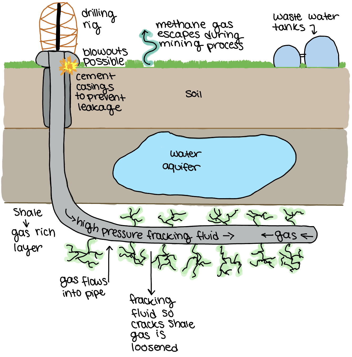
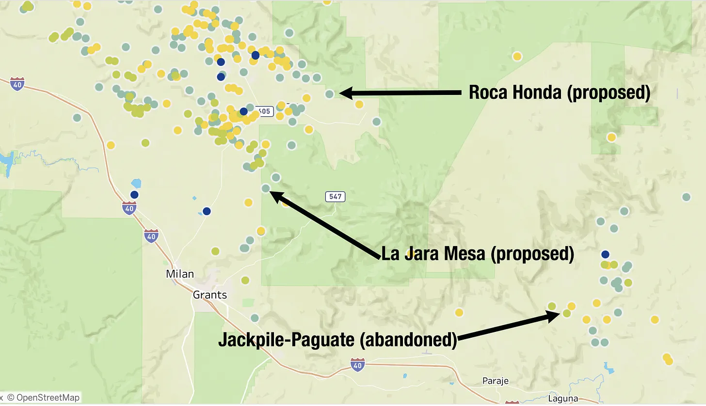
The Grants and Mount Taylor area was ravaged by Cold War-era uranium mining and the wounds from the previous boom continue to fester. That include the remnants of Anaconda Minerals Companyโ€™s Jackpile-Paguate Mine on Laguna Pueblo land, which was once the worldโ€™s largest open-pit uranium mine, producing some 24 million tons of ore.

Miners were exposed to radioactive and toxic heavy metals daily, even spending their lunch breaks sitting on piles of uranium ore. Blasting sent tremors through the puebloโ€™s adobe homes, and a cloud of poisonous dust drifted into the village of Paguate, just 2,000 feet from the mine, coating fruit trees, gardens, corn, and meat that was set out to dry. A toxic plume continued to spread through groundwater aquifers, and the Rio Paguate, a Rio Grande tributary, remains contaminated more than a decade after the facility became a Superfund site, despite millions of dollars in cleanup work. Laguna residents and former mine workers still suffer lingering health problems โ€” cancer, respiratory illnesses and kidney disease โ€” from the mine and its pollution.

Now the feds are saying approving new uranium mines in the same area is โ€œmission critical.โ€

***

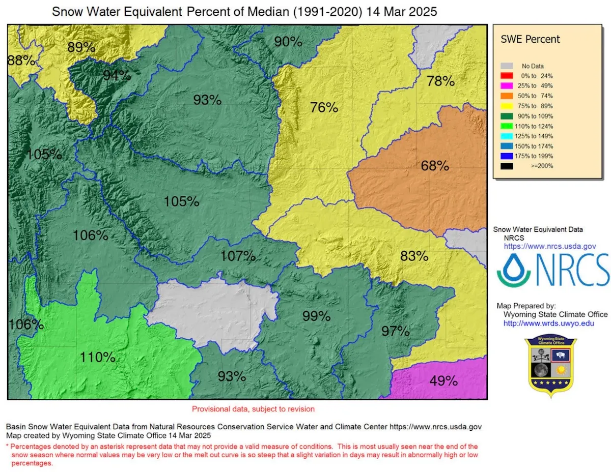
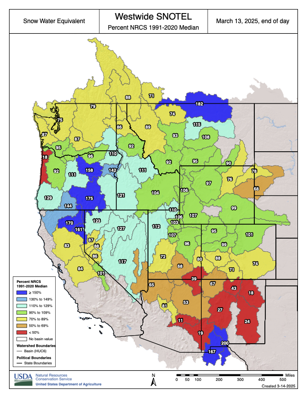
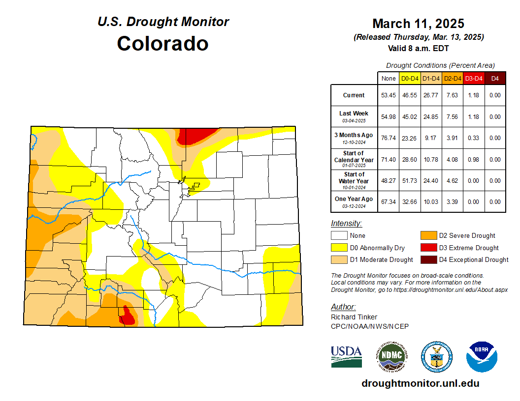
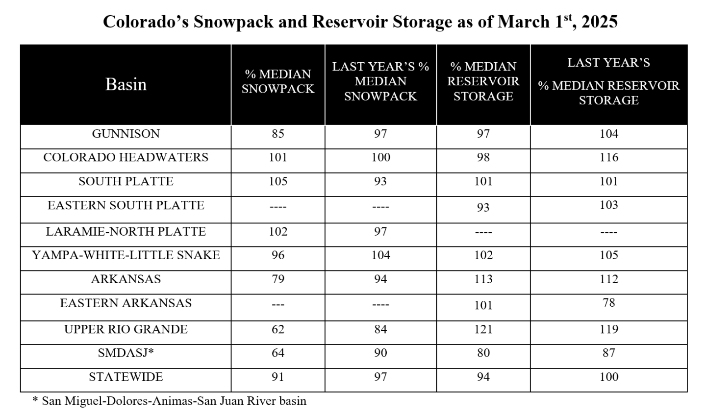
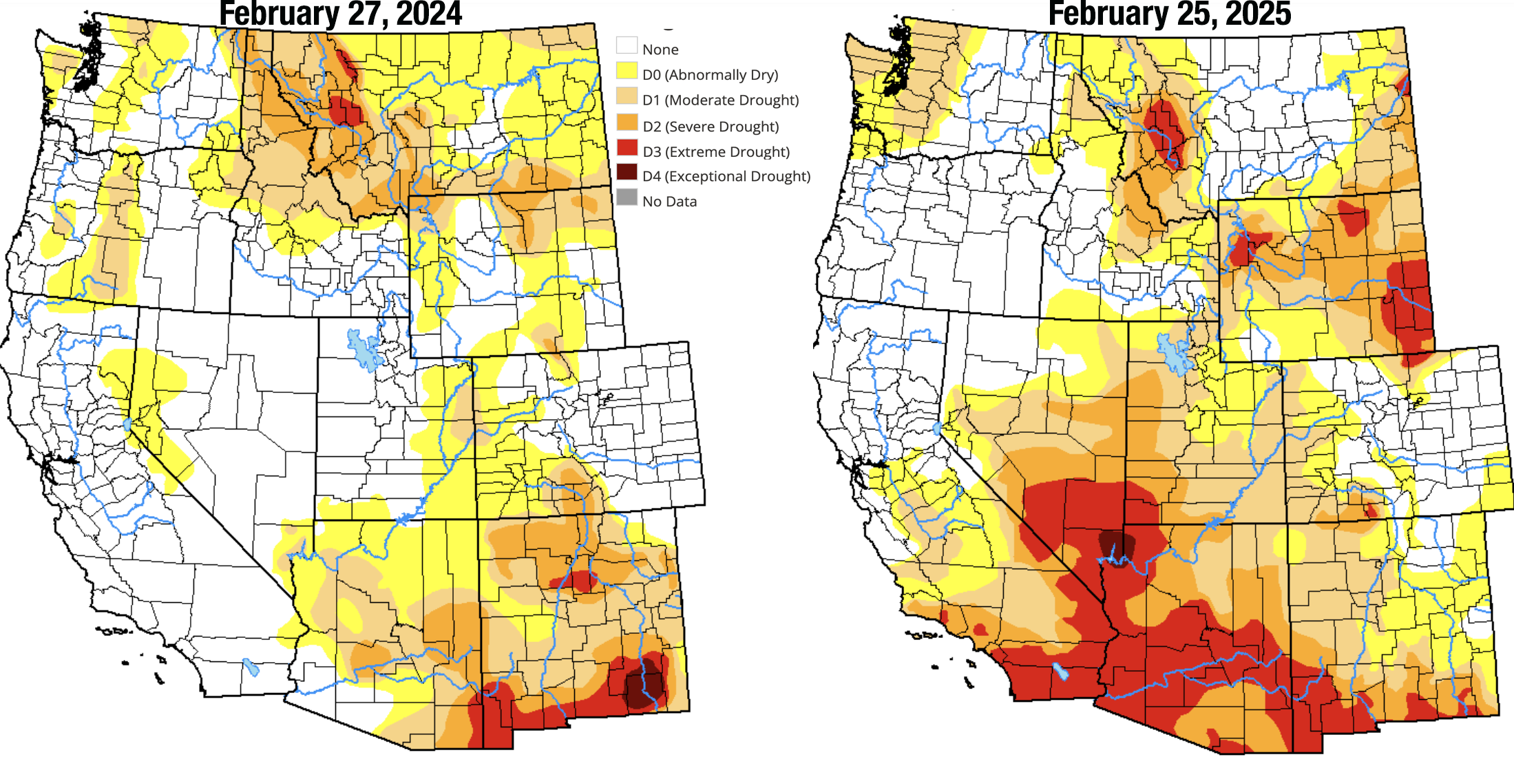
In December, the Biden administration began the process of halting new mining claims and mineral leasing for the next 20 years on 165,000 acres in the upper Pecos River watershed west of Santa Fe, New Mexico. This included holding meetings to gather public input on the plan. But the BLM canceled the first such meeting, scheduled for late February, and has not announced a new date, sparking fears that the new administration may be withdrawing plans for a mineral withdrawal.

Rio Grande and Pecos River basins. Map credit: By Kmusser – Own work, Elevation data from SRTM, drainage basin from GTOPO [1], U.S. stream from the National Atlas [2], all other features from Vector Map., CC BY-SA 3.0, https://commons.wikimedia.org/w/index.php?curid=11218868

Included within the acreage are more than 200 active mining claims held by Comexico LLC, a subsidiary of Australia-based New World Resources. For the past several years, Comexico has been working its way through the permitting process to do exploratory drilling at what it calls its Tererro mining project. It has met with stiff resistance from locals and regional advocacy groups, partly because mining has a dark history in the Pecos River watershed. In 1991, a big spring runoff washed contaminated mine and mill waste from a long-defunct mine into the upper Pecos River, killing as many as 100,000 trout. That prompted a multi-year cleanup of various mining sites.

***

๐Ÿ“ธ Parting Shot ๐ŸŽž๏ธ

And now for a special treat, or maybe torture, but either way it might help take your mind off the dismantling of Democracy for a few moments. Itโ€™s my blow-by-blow analysis of the 1978 movie Avalanche, starring Rock Hudson and Mia Farrow. Normally this would be behind a paywall, like all of the other Land Desk archives. But Iโ€™m opening up to everyone for a limited time only in honor of the snowslide-triggering storm that is pounding the San Juans as I write. Enjoy. And, while youโ€™re at it, check out our interactive map of long-lost ski hills in southwest Colorado.

AVALANCHE: A blow-by-blow analysis of the 1978 disaster flick — Jonathan P. Thompson, February 9, 2022

I was drawn in by the close-up winter aerial shots of ridges and peaks of the San Juan Mountainsโ€”Look, thereโ€™s Vestal! I yelled to my non-existent viewing companions as Rock Hudsonโ€™s name flashed on the screen. And Arrow! And Mount Garfield! I kept watching the lost-to-obscurity 1978 disaster film,

Read full story

State Engineer Declares #WhiteRiver Basin Above Taylor Draw Reservoir as Over-Appropriated in Northwest #Colorado — Michael Elizabeth Sakas (dnr.colorado.gov)

Click the link to read the release on the Colorado Department of Natural Resources website (Michael Elizabeth Sakas):

March 7, 2025 โ€” The Colorado State Engineer officially designated the White River Basin above the Taylor Draw Power Conduit at Taylor Draw Reservoir, in northwest Colorado, as over-appropriated. A stream system is considered over-appropriated when at some or all times of the year, there isnโ€™t enough water available to satisfy all the water rights within the system. The change will be effective May 1, 2025.

Water rights owners in the White River, which is part of the Colorado River basin and flows through Division 6 (Yampa, White, Green, and North Platte River Basins), have expressed in multiple years that they were not receiving their decreed amount and requested that the Colorado Division of Water Resources (DWR) staff to curtail water usage, which is known as a โ€œcall.โ€ In December 2022, there was a call on the White River upstream of Taylor Draw Power Conduit, and another in July 2023. These events led Erin Light, DWR Division 6 Engineer, along with her team, to evaluate the situation and formally recommend that the Colorado State Engineer and Director of the Colorado Division of Water Resources designate the basin as over-appropriated.

โ€œCalls in the past few years have made it clear to me that the White River does not supply enough water to meet demands during part of the year, leading me to request this designation that will protect senior appropriators from future unreplaced well depletions,” said Light.

This designation means new, non-exempt well permits above the Taylor Draw Power Conduit will require an augmentation plan. An augmentation plan is a court-approved plan that would allow the water user to pump groundwater by replacing that water with an equivalent amount from another source.

โ€œThis designation is part of the unfortunate story weโ€™re seeing play out across the Upper Colorado River Basin,โ€ said Jason Ullmann, Colorado State Engineer and Director of the Colorado Division of Water Resources. โ€œExtended drought and hotter temperatures, made worse by climate change, means thereโ€™s less water to go around. Even very senior water rights holders arenโ€™t getting their full supply. Designating the White River as over-appropriated will help ensure senior water rights are protected and not harmed by additional groundwater pumping, which can impact surface water supplies.โ€

As the basin continues to develop, future water rights holders will develop water with an understanding that those rights will be administered in many or most years, depending on hydrology.

A link to the memo can be found here(opens in new window). The map below shows the newly designated areas as over-appropriated in yellow:

Shaping #Coloradoโ€™s Water Future: How Audubon Rockies will protect birds, watersheds, and communities in Colorado in 2025 — Abby Burk (RockieAudubon.org)

Great Blue Heron. Photo: Michael Rodock/Audubon Photography Awards.

Click the link to read the article on the Audubon Rockies website (Abby Burk):

February 24, 2025

Audubon Rockies is committed to advocating for smart, science-driven, and collaborative water policies that sustain healthy rivers and resilient ecosystemsโ€”because protecting water means protecting the birds, communities, and economies that depend on it. As the 2025 legislative session unfolds, water remains a foundational topic. By collaborating with both Republicans and Democrats, we have successfully driven meaningful change over the years.  

Key decisions at the Colorado State Capitol shape how we manage this vital resource in the face of climate change-influenced supplies and changing demands. From securing funding for water conservation efforts to advancing nature-based solutions and ensuring equitable water management, this yearโ€™s legislative discussions will have ripple effects across our landscapes, wildlife, and people. Stay tuned as we break down the important areas of water legislation work moving through the State Capitol this session. 

Funding for Water 

Coloradoโ€™s budget plays a critical role in protecting and sustaining our water resources, yet ongoing fiscal challenges, a deficit of more than one-billion dollars, and federal funding fluctuations put pressure on funding water, habitat conservation, and more. Colorado is facing a budget crisis due to a combination of factors, including declining tax revenues, rising costs, and constitutional constraints like the Taxpayerโ€™s Bill of Rights (TABOR), which limits the state’s ability to generate and allocate funds. Increased demands on essential services such as education, healthcare, transportation, and water infrastructure, coupled with inflation and economic uncertainty, have strained available resources. As demands on our water supply grow and climate change intensifies pressures on our rivers, wetlands, and watersheds, it is essential to advocate for sustainable financial solutions that support Coloradoโ€™s long-term resilience. Audubon is working to ensure that state water funding remains strong and dedicated to conservation, restoration, and resilience-building efforts.  

Healthy mountain meadows and wetlands are characteristic of healthy headwater systems and provide a variety of ecosystem services, or benefits that humans, wildlife, rivers and surrounding ecosystems rely on. The complex of wetlands and connected floodplains found in intact headwater systems can slow runoff and attenuate flood flows, creating better downstream conditions, trapping sediment to improve downstream water quality, and allowing groundwater recharge. These systems can also serve as a fire break and refuge during wildfire, can sequester carbon in the floodplain, and provide essential habitat for wildlife. Graphic by Restoration Design Group, courtesy of American Rivers

Wetlands Rulemaking  

In 2025, Audubon Rockies remains actively engaged in the HB24-1379 rulemaking process. In collaboration with state agencies and conservation partners, Audubon is advocating for science-based policies to ensure that permitting prioritizes avoiding and minimizing impacts to vital ephemeral streams and wetlands, and that any key ecological functions lost due to permitted activities in these waters are compensated for through restoration activities. These objectives align with the legislative intent of HB24-1379 and are vital to protecting the fragile wetland ecosystems birds rely on. By providing expert input, supporting transparent decision-making, and championing nature-based solutions, Audubon works to secure strong, practicable, lasting protections for freshwater habitats and the birds and communities that depend on them. 

Protecting Land and Rivers 

Audubon works closely with the State of Colorado to ensure that public lands and healthy watersheds are protected and sustainably managed for both people and wildlife through federal administration changes. Through outreach, collaboration, and on-the-ground conservation efforts, Audubon supports management and policies that enhance watershed resilience, improve habitat connectivity, and safeguard the vital water resources that flow through our public lands.  

As Colorado River negotiations continue, Audubon remains committed to supporting collaborative, science-based solutions that balance the needs of people, wildlife, and ecosystems. With increasing pressures from drought, climate change, and growing water demands, finding equitable and lasting agreements among basin states is critical. Audubon advocates for water management strategies across the Colorado River basin that prioritize healthy ecosystems and sustainable water use while ensuring that birds and communities reliant on the Colorado River have a secure future. By working with policymakers, water leaders, and conservation partners, Audubon advocates for consensus-based solutions that promote the riverโ€™s ecological integrity and support a sustainable water future for all. 

The March 1, 2025 #Colorado Water Supply Outlook Report is hot off the presses from the NRCS

Click the link to read the report on the NRCS website. Here’s an excerpt:

Snowstorms paint ‘bullseye’ on #Denver Water collection area: February snowstorms drop 4-5 feet of snow in a week, boosting mountain #snowpack

Colorado SNOTEL basin-filled map March 9, 2025.

Click the link to read the article on the Denver Water website (Jay Adams):

February 24, 2025

Mid-Februaryโ€™s weeklong series of storms that dropped 4-to-5 feet of snow in areas of Denver Waterโ€™s collection area could be termed a โ€œSweetheart Surprise,โ€ followed by a dumping of โ€œPresidents Day Powderโ€ that just kept going.

โ€œIt was an impressive week of snow with a bullseye right on our collection area,โ€ said Nathan Elder, Denver Waterโ€™s manager of water supply. โ€œAfter a couple dry weeks to start out the year, it was nice to see stormy winter weather return to the mountains.โ€

Elder said mountain snowpack in the parts of the South Platte and Colorado River basins where Denver Water collects its water jumped significantly due to the storms. 

From Feb. 14-21, snowpack in the Upper South Platte River Basin climbed from 84% of normal up to 108%. During the same time period in the Upper Colorado River Basin, the snowpack jumped from 105% of normal up to 120%.

Snow piles up along the banks of Tenmile Creek near Copper Mountain in Summit County on Feb. 19. The creek is one of the main tributaries of Denver Waterโ€™s Dillon Reservoir. Photo credit: Denver Water.

However you look at it, all the snow in the second half of February has been great news for our water supply. And thereโ€™s an interesting trend happening during the 2024-25 snow season in Colorado: The major storms keep hitting on the holidays.

The February storm cycle started just in time for Valentineโ€™s Day, Feb. 14, continued dumping through Presidents Day, Feb. 17, and then another storm delivered a bonus round of snow Feb. 20-21. 

The snow is good news for Denver Water, which relies on mountain snow to supply water to 1.5 million people in the metro area.

Just take a look at the snow totals from the weeklong series of storms that spanned Feb. 14-21, as reported by the ski resorts located in Denver Waterโ€™s collection area:

  • Arapahoe Basin: 43โ€
  • Breckenridge: 47โ€
  • Copper Mountain: 45โ€
  • Keystone: 47โ€
  • Winter Park: 62โ€
A snowboarder enjoys fresh powder at Winter Park in Grand County. The ski resort reported 62โ€ of snow between Feb. 14-21. Photo credit: Winter Park Ski Resort.

Itโ€™s been a great winter so far at Winter Park and Copper Mountain, which have seen 257โ€ and 255โ€ of snow respectively as of Feb. 21, making them the two snowiest ski resorts in the state. 

Snowpack is a measurement of the amount of water in the snow if it were to melt. In general, about 10 inches of snow melts down to around 1 inch of water here in Colorado.

Elder said whatโ€™s been interesting this year is that the majority of snow has fallen right around holidays starting after Halloween, then before Thanksgiving, between Christmas and New Years, and now between Valentineโ€™s Day and Presidents Day.

โ€œWe can see the snowpack looks like steps on our charts around all these holidays,โ€ Elder said. โ€œWith the recent storms, we saw basically an entire monthโ€™s worth of snow in seven days.โ€

Elder said that having the snowpack above 100% heading into March is a good sign for our water supply in the coming year.

The Fraser River at the bottom of Berthoud Pass is covered in snow. The river is part of the Colorado River Basin where Denver Water captures snow for its water supply. Photo credit: Denver Water.

โ€œMarch and April are typically our snowiest months of the year in Colorado. Those two months usually provide about one-third of our annual snowpack. Thatโ€™s because the snow that falls in those months has a higher water content than snow that falls in the beginning and middle of winter,โ€ he said.

Denver Waterโ€™s total reservoir supply stands at 82% full as of Feb. 21, which is about average for this time of year. Remember that reservoir levels fall over the winter and then go back up in the spring when the snow melts.

As for what to expect for the rest of the ski season, maybe consider heading to the hills on St. Patrickโ€™s Day or Easter, and who knows possibly even Motherโ€™s Day in May!

Westwide SNOTEL basin-filled map March 9, 2025.

#Snowpack Conditions Reflect Typical La Niรฑa Patterns — NRCS

Photo credit: NRCS

Click the link to read the release on the NRCS website:

March 7, 2025

Northern basins have received more moisture than the south. Early season storms bolstered water year to date precipitation in southern basins but a drier mid-winter has tempered forecasts. Higher latitude basins continue to benefit, with streamflow projections near or above median.ย 

As of March 1st statewide snow water equivalent (SWE) is at 91 percent of median, relatively consistent from February 1st. Northern water systems continue to trend near or above median, particularly: the South Platte (105%), Laramie and North Platte (102%), the Colorado Headwaters (100%) and combined Yampa-White-Little Snake (96%). The southern half of the state remains below normal with the largest decrease observed in the Arkansas (79%). The Gunnison basin is at 86 percent of median, reflective of its central geographical location on the western slope. While the Gunnison basin follows the broader north south trend, its position further north compared to other southern basins has helped mitigate more extreme deficits. In contrast, the Upper Rio Grande (63%) and the combined San Miguel-Dolores-Animas-San Juan (SMDASJ) (64%) remain drier, with some of the lowest snowpack levels recorded at this point in the season.  

February storms provided some relief, with the Valentines Day storm delivering up to 3.2 inches of SWE in the La Plata Mountains, offering a much needed boost for the SMDASJ basin. “That said, February’s inconsistent storm cycle has not been game changer. While northern basins benefitted the most, that mid-month surge helped slow the freefall in the southern half of the state but wasnโ€™t quite enough to significantly impact overall snowpack conditions,” noted Nagam Gill, NRCS Hydrologist.  

Recent precipitation trends over the past 90 days highlight similar disparities. The Upper Rio Grande and SMDASJ are at just 44 percent of their period of record median precipitation. Northern basins, on the other hand, are sitting in a much better position heading into the peak snowmelt period. The past 30 days show precipitation at 66 percent for the Arkansas basin and 84 percent for the Gunnison basin. Winter precipitation contributes to both snowpack and overall water year precipitation. Snowpack acts as a natural reservoir, storing water at high elevations until melt out, which directly influence streamflow forecasts. While additional precipitation is expected during the summer months, particularly in southern basins during monsoon season the odds of winter driven streamflow fully catching up remain low. 

Statewide reservoir storage sits at 94 percent of median, down slightly from 100 percent this time last year. With spring runoff yet to begin, storage levels are mostly unchanged from last month. Higher capacity reservoirs are generally near historical medians. While McPhee Reservoir is lower at 76 percent of median and at 55 percent capacity most major reservoirs are near to above normal and positioned to potentially further exceed medians during primary runoff. Blue Mesa Reservoir is at 96 percent of median and at 61 percent capacity. Pueblo Reservoir is at 114 percent of median and at 72 percent capacity. Lake Granby is at 101 percent of median and Dillon reservoir is at 91 percent of median. 

Credit: NRCS

Streamflow forecasts for March 1st closely reflect recent precipitation and snowpack trends. Statewide, the 50% exceedance streamflow remains largely unchanged from last month, currently at 88 percent of median. Of the 86 forecasts points, nearly half are projected to perform at or above 85% of median streamflow. Northern basins, which have benefited from stronger storms, continue to see near median or above median streamflow projections at the 50% exceedance probability. Meanwhile, southern basins, particularly the Upper Rio Grande and combined SMDASJ, remain well below normal. “A critical consideration when reviewing these forecasts is the full range of exceedance probabilities. In regions already experiencing sustained dry conditions, the drier exceedance forecasts (70%, 90% or 95%) may be more likely to materialize if current trends persist. Likewise, if the latter part of the season trends wetter, higher probabilities (30%, 10% or 5%) should be taken into account,” notes Gill. The variability of forecasted volumes means that relying solely on the 50% exceedance forecast may not fully capture the uncertainty inherent in these projections.  

In the Upper Rio Grande, one of the highest output forecast points, Rio Grande near Del Norte, is forecasted at 380 KAF for the primary period April โ€“ September (50% exceedance probability). This is below the median of 480 KAF. If drier conditions continue, the 70% exceedance probability is 320 KAF, highlighting the potential if snowpack conditions persist or in the event of earlier melt out dates.  

Following suit in the Arkansas, 50% forecasts have decreased from last month to 92 percent of median. While the 50% probability is slightly below normal there is a potential for streamflow to perform near or below minimum forecasts. Recent discussions suggest that actual streamflow’s in the Arkansas Basin may underperform relative to the NRCS forecast probability suite. NRCS streamflow forecasts are constrained by internal modeling thresholds and do not extend below 95% exceedance probability, meaning that exceptionally dry conditions may not be fully captured within the published forecast range. 

Between March 1-7, storms have been delivering snowfall to much of the state with the southwest corner observing up to 2.5 inches of SWE at Red Mountain Pass. NOAAโ€™s 6-10 day forecast outlook suggests increased chances for precipitation statewide, with the western slope showing slightly higher probabilities and the southwest corner expected to receive higher amounts. Temperature trends indicate cooler than average conditions on the western slope, while the central to eastern regions are projected to remain near normal, with the far eastern plains trending slightly warmer. This pattern would help extend snowpack longevity in the northern and central mountains while also offering a potential boost to moisture starved southern basins. Statewide, peak SWE is typically around April 8, meaning we still have a few weeks left to accumulate more snow.

Credit: NRCS

To put 2025โ€™s snowpack in perspective, the above graph compares March 1 snow water equivalent (SWE) percentages to similar La Niรฑa years, including 1999, 2000, 2006 and 2018. Historically, La niรฑa conditions favor increased snowfall in northern Colorado while the southern basins often experience drier conditions. This trend holds in 2025, with the Upper Rio Grande and SMDASJ tracking close to 2018 levels, a year that observed similar dry patterns. Meanwhile, statewide SWE trends resemble 2000.

Credit: NRCS

For more details see the March 1stย Water Supply Outlook Report.

American Farmers Brace for Harm From President Trump’s Retaliatory Tariffs — The New York Times

(Gov. Polis in Phillips County touring Vision Angus family farm). Photo credit: Governor Polis’ office

Click the link to read the article on The New York Times website (Danielle Kaye). Here’s an excerpt:

March 4, 2025

Trade wars during President Trumpโ€™s first term slashed billions of dollars in U.S. agricultural exports. Farmers and trade groups expect an even bigger hit this time.

On Tuesday, Chinaโ€™s Ministry of Finance said it would add tariffs of as much as 15 percent on a wide range of agricultural imports from the United States, including chicken, wheat, corn and cotton. Beijingโ€™s retaliation for escalating American tariffs on Chinese-made products also includes 10 percent tariffs on imports of sorghum, soybeans, pork, beef, aquatic products, fruits, vegetables and dairy products. Without specifying which products, Canada said on Tuesday that it would impose retaliatory tariffs of 25 percent on $20.5 billion worth of American goods, and Mexico promised to outline its response on Sunday. President Trump imposed 25 percent tariffs on products from both countries on Tuesday. Farms are a target because agricultural products account for a large portion of U.S. exports, said Lynn Kennedy, a professor of agricultural economics at Louisiana State University. Politics are probably a factor, too…As they did during the first Trump administration, the retaliatory tariffs could mean that American exports and prices paid for crops fall โ€” as importers from China, Canada or Mexico look to Brazil or other large agricultural producers for alternatives…

China accounted for 14 percent โ€” roughly $24.7 billion โ€” of all agricultural goods exported from the United States in 2024, according toย dataย from the Department of Agriculture. Mexico and Canada imported even more: about $30.3 billion worth of goods for Mexico and $28.4 billion for Canada. Mark Legan, a livestock and crop farmer in Putnam County, Ind., said Mexico was his top export market for pork and China his biggest for soybeans, which he sells to Cargill and Archer Daniels Midland plants in his area…When China started to buy more soybeans from Brazil during Mr. Trumpโ€™s first term, Mr. Leganโ€™s income โ€œsignificantly decreased,โ€ he said. His pork exports to China also fell. This time, heโ€™s again worried about the fallout โ€” especially since Mexico is poised to retaliate, too.

โ€œWe are fighting an uphill battle against the tariffs, to get both soybeans and pork into those markets,โ€ Mr. Legan said. โ€œIn agriculture, we deal with uncertainty all the time, whether itโ€™s the weather or the health of our animals. But this adds another level of uncertainty that weโ€™re trying to deal with the best we can.โ€

New Northern #Colorado reservoirs moving ahead after settlement of #NISP lawsuit — Alex Hager (KUNC.org) #PoudreRiver #SouthPlatteRiver

An artist’s rendering shows what Glade Reservoir, a key component of the Northern Integrated Supply Project would look like after construction. The project is going ahead after Northern Water agreed to settle a lawsuit by Save the Poudre for $100 million.

Click the link to read the article on the KUNC website (Alex Hager):

March 5, 2025

This story is part of ongoing coverage of water in the West, produced by KUNC in Colorado and supported by the Walton Family Foundation. KUNC is solely responsible for its editorial coverage.

A massive new reservoir project in Northern Colorado is closer to reality after its architects settled a lawsuit with an environmental group seeking to block construction. The Northern Integrated Supply Project, or NISP, will go ahead sooner than expected after a lawsuit settlement. Northern Water will pay $100 million into a trust after Save the Poudre, a nonprofit, agreed to drop its lawsuit. That money will fund river improvement projects.

The controversial water project, which will cost around $2 billion to build, has been tied up in planning and permitting for more than two decades. Advocates for the new reservoirs say it’s an important way to make sure fast-growing communities in Larimer and Weld counties have enough water for new homes and residents. Opponents worry it will take water out of a Cache la Poudre River that is already taxed by diversions for cities and farms.

…the settlement money will go into a new โ€œPoudre River Improvement Fund.โ€

[…]

The fund can be used for โ€œecological, habitat, and recreational improvements,โ€ including the potential creation of a โ€œPoudre River Water Trailโ€ from Gateway Park in Poudre Canyon to Eastman Park in Windsor. The fund will be managed by a six-person committee, three of whom will be appointed by Save the Poudre, and three by the NISP enterprise…

Proponents of the Northern Integrated Supply Project say it will help fast-growing communities along the northern Front Range keep pace with the volume of new residents. (From Northern Water project pages)

NISP would supply 15 different water providers along the northern Front Range through two reservoirs and a system of pipelines and pumps. Northern Water, the agency that would build and operate NISP, projects that it will provide water to nearly 500,000 people by 2050.

Water from the system would flow to a diverse group of towns and cities north of Denver. Small, fast-growing towns such as Erie and Windsor stand to receive some of the largest water allocations from NISP. The list also includes the Fort Collins Loveland Water District, the Left Hand Water District, which is just north of Boulder, and Fort Morgan on the eastern plains.

โ€œThese are communities that have identified the need for housing as something that will increase the quality of life,โ€ said Jeff Stahla, a spokesman for Northern Water. โ€œSo this is an important time for us as residents to realize that we can help to solve some of the problems and some of the the challenges that we’re seeing out there on the horizon as more people choose to live here.โ€

Stahla said construction is expected to take off in 2026, with some pipes being laid in the summer and fall of this year. If Save the Poudreโ€™s lawsuit was still in place, he said, construction would have begun in โ€œ2027 or even beyond.โ€ Glade Reservoir, the centerpiece of NISPโ€™s water storage system, would flood a valley northwest of Fort Collins that is currently home to a stretch of U.S. Highway 287 connecting Fort Collins and Laramie, Wyo. That section of road would be rebuilt further East.

Kids play in the Poudre River Whitewater Park near downtown Fort Collins on Oct. 20, 2023. The Cache la Poudre is often referred to as a “working river” because it carries a large volume of water from manmade reservoirs to cities and farms far from its banks. Photo credit: Alex Hager/KUNC

Stahla said Northern Waterโ€™s permit includes requirements to mitigate environmental impacts caused by the new reservoirs. He alluded to the fact that the river is already connected to a number of large reservoirs and its water is piped and pumped far away from its original course.

โ€œThe Poudre River has really been a working river for 150 years now,โ€ he said. โ€œWhat NISP is planning to do certainly is not the only impacts to the river that have been occurring or will occur.โ€

…Stahla…suggested work on diversion structures, which redirect the riverโ€™s water towards farms and water treatment plants. Stahla suggested they could be modernized… and moved further downstream to allow more water to flow through certain sections of the river.

The South Platte River Basin is shaded in yellow. Source: Tom Cech, One World One Water Center, Metropolitan State University of Denver.

Monte Vista Crane Festival March 7, 2025 #SanLuisValley

Short video from near Road 8S and CO-15 during the Monte Vista Crane Festival March 7, 2025.
Short video from near Road 8S during the Monte Vista Crane Festival March 7, 2025.

โ€œWe get to determine what kind of apocalypse weโ€™d like to have.โ€ — John Fleck (InkStain.net)

Rio Grande, looking south near Cole Park. The Alamosa Riverfront Project is among several that received funding last week under the 2022 Inflation Reduction Act. Credit: The Citizen

Click the liink to read the article on the InkStain.net website (John Fleck):

Iโ€™m obsessed with this quote from the poet and essayist Hanif Abdurraqib in a New Yorker piece last month. He somehow packed doom, hope, and obligation into those twelve words.

Abdurraqib is riffing on Octavia Butlerโ€™s Parable of the Sower, which eerily presaged this yearโ€™s L.A. fires, and the deep reality of owning our fates:

I used the quote as a repeated riff in a talk I gave a few weeks ago in Las Cruces about how people have to engage in the small-d democratic work to decide, together, what we want our communities to look like as we adapt to climate change. I meant to just use the quote once, but the scrap of paper on which Iโ€™d written it poked up above the rest of my notes, and I kept returning to it, a preacherโ€™s call.

Weโ€™ve long ago moved past the option of not having to adapt to climate change, of not facing a village, town, city, farm, or river that has less water than we would prefer. Itโ€™s on us now to make good choices, or less bad choices, and doing that requires finding ways to come together in community to wrestle our way through the competing and conflicting values.

This is hard.

This is at the heart of water management even without climate change, and we can do it well or poorly, in ways that respect shared values or trample them. The book Bob Berrens and I are writing (have written? book time is weird) about Albuquerqueโ€™ relationship with the Rio Grande is really an attempt to untangle the history of precisely this, a century of messy community conversations about how we want our river and our community to look, to interact with one another. Before we had to wrestle with apocalypse we had to wrestle with what kind of community we wanted to have. The results were messy, but in the process we built the sort of institutional framework we must now call on to help us with the next step.

By โ€œinstitutional frameworkโ€ I am not talking about government agencies, or not only talking about government agencies. Iโ€™m talking about a way of being in the world.

Iโ€™ve had reason of late to return to some intellectual roots, John Deweyโ€™s 1927 The Public and Its Problems. I read Dewey as a youngster, assimilated the basic pragmatist framework, and charged out in the world to use it. Philosophy! Now Iโ€™m back 45 years later to reflect on how that went.

Deweyโ€™s 1927 book lays out an argument that I find appealing in this fraught moment: that what we mean by โ€œdemocracyโ€ is not a structure of government, with voting and stuff, but rather a way of being in community:

A decade later, in a talk entitled โ€œCreative Democracyโ€”The Task Before Us,โ€ Dewey said this:

This seems like pretty weighty stuff when I just want better regulations around domestic groundwater wells, or the simplification of the regulatory hurdles faced by water agencies that want to do aquifer storage and recovery, or a way to meet our Rio Grande Compact obligations to those folks down in Las Cruces I was talking to last month. But Deweyโ€™s point is that we canโ€™t just hand off the governing thing to a handful of elected officials in Santa Fe or Washington, D.C., and expect them to manage the apocalypse for us.

Itโ€™s on us to engage in the big, messy conversations about what we want that apocalypse to look like.

Going back to look at Abdurraqibโ€™s essay as I put together a talk for this weekโ€™s Land and Water Summit in Albuquerque, I realized that the version Iโ€™d been using for my glossy pull quote elides something really important.

Iโ€™m the optimist, right! Itโ€™s why yโ€™all bought that book (and thanks for reading!). I love the Land and Water Summit crowd, people with the sort of care for engagement with their community in search of a better future, the kind of action Dewey was talking about.

But hereโ€™s the full quote, with emphasis added:

Interior Dept. may be withdrawing from the West, not moving to it: Will a DOGE plan to shutter federal offices affect the BLM’s potential HQ move? — Jonathan P. Thompson (LandDesk.org) #snowpack

Look at all of that snow โ€ฆ Psyche! This is just a wishful thinking shot, taken two years ago at the Durango Nordic Center. The center just closed for the season, citing a lack of snow. Jonathan P. Thompson photo.

Click the link to read the article on The Land Desk website (Jonathan P. Thompson):

March 4, 2025

Ever since Trump was elected, Iโ€™ve been anxiously waiting for the administration to announce that it would relocate the Bureau of Land Managementโ€™s headquarters to Grand Junction once again. After all, the chapter of Project 2025 penned by William Perry Pendley, Trumpโ€™s BLM acting director last time, advocates for the move. And so far, the administration has followed the far-rightโ€™s โ€œplaybookโ€ to a T.

While Rep. Jeff Hurd, the Colorado Republican who represents most of western Colorado, has introduced legislation that would make the move, the administration has remained quiet on the issue. And last week, the Government Services Administration announced it planned to shutter about 2 million square feet of office space occupied by the Interior Department around the nation. (More details below).

This seems to throw a potential BLM move โ€” which would require a new lease โ€” into doubt.

I suppose a lot of you are sighing with relief at that news. Not me. I wasnโ€™t going to rail against the move. In fact, though I know Iโ€™m at odds with a majority of my readers here, I was planning on arguing in favor of it โ€” if done correctly.

This isnโ€™t a new position for me:ย I did the sameย last time Trump was elected. And I stand by my previous position: If carried out in a thoughtful and well-intentioned manner, the benefits of basing the agency in the West offset the negatives, even in a place like Grand Junction. Iโ€™m not going to rehash all of my arguments, especially since they may be moot, but basically I argued:

  • The relocation would give local and regional advocacy groups who canโ€™t afford to travel to D.C. more access to top agency officials;
  • It would allow agency leadership to live among the public lands they administer and to see, firsthand, the consequences of policies. It would make it more likely that they would, say, witness a wild horse and burro roundup; see the way a herd of cattle can decimate a swath of public land; see what a 200 MW solar installation looks like; or witness the impacts of oil and gas leases or land withdrawals;
  • It would bring up to 300 senior employees to Grand Junction, boosting the economy (and making it less reliant on extractive industries)
  • If youโ€™re interested you canย read the opinion piece here.

Admittedly, this stance came back and bit me in the butt last time I took it, when the transfer was badly, and intentionally, botched. Trump and his minions used the move as an underhanded way to eviscerate the agency and get rid of senior, knowledgeable staff. After promising to stock the Grand Junction office with about 300 senior employees, only about 30 ended up there. And the top brass werenโ€™t even there full-time: They commuted back and forth to Washington, D.C.

Oh, and also, the agency ended up sharing an office building with Chevron, Laramie Resources, and the Colorado Oil & Gas Association, thereby realizing opponentsโ€™ worst fears: That basing the agency in western Colorado would give industry more access and influence over its senior staff. I also wrote about all of these failures here.

This time around, Trump doesnโ€™t need to move BLM HQ to gut the agency or push out long-time staff, heโ€™s got the oligarch-led DOGE to do that. Nor would the relocation open more access to the oil and gas industry, since they already have a direct portal via presumed BLM director Kathleen Sgamma, herself a petroleum lobbyist.

Instead of beefing up the federal presence in the West, however, the administration seems intent on withdrawing it. Thereโ€™s all of the federal agency firings, of course, which are ongoing. And now the GSA terminating leases and, in an apparent spasm of spite, is also at least considering shutting down all or some of the electric vehicle chargers at federal facilities.

A sampling of offices that would close under the GSAโ€™s plan:

  • National Parks Service offices or buildings in: Fairbanks, Alaska; Camp Verde, Flagstaff, and Phoenix, Arizona; Arcata and Ventura, California; Fort Collins, Colorado; Lapwai, Idaho; Mountainair and Grants, New Mexico; Salt Lake City, Moab, and Monticello, Utah; and Seattle, Washington.
  • Bureau of Indian Affairs offices or buildings in: Show Low, Fredonia, and Phoenix, Arizona; Redding, California; Towaoc, Colorado; Pablo and Poplar, Montana; Zuni, New Mexico; Elko, Nevada; and Toppenish, Washington.
  • U.S. Geological Survey offices or buildings in: Anchorage, Alaska; Boulder and Golden, Colorado; Bozeman, Montana; Klamath Falls and Corvallis, Oregon; Moab, Utah; Spokane, Washington; and Cheyenne, Wyoming.
  • U.S. Fish & Wildlife Service offices or buildings in: Tucson, Arizona; Arcata, California; Fort Collins, Littleton, and Grand Junction, Colorado; Bozeman and Great Falls, Montana; West Valley City, Utah; and Lander, Wyoming.
  • Bureau of Reclamation offices in: Durango, Colorado; Bend, Oregon; and Boise, Idaho.
  • Bureau of Minerals Management Service and Bureau of Trust Fund Administration offices in: Camarillo, California, and Farmington, New Mexico.
  • Bureau of Land Management offices in: Ukiah, California, and Baker City, Oregon.
  • The full list can be found here

As is often the case with the Trump administration, the plan appears to have been made in haste and without forethought, targeting facilities where the leases are up for renewal in coming months. Itโ€™s not clear what will happen to the employees that work in those spaces or whether the services they provide will continue or be terminated as well. But it will deliver another blow to the communities that will lose the offices, many of which have already seen federal employees get the axe.

***

Speaking of the economic impacts of federal lands and agencies, I did a piece for High Country News on outdoor recreation, mostly on public lands, and how it affects local and state economies. I argue that Page, Arizona, has weathered the closure of Navajo Generating Station better than expected because it already had a recreation-based economy in place. It also has a bunch of graphs on national parks visitation, visitor spending, and so forth, put together by Hannah Agosta and Marissa Garcia. Read it here.

Source: High Country News.

***

After I finished the above piece, I came across a cool dashboard showing economic impacts of each national forest. Go here and type in your forest to see how itโ€™s contributing.

***

A group of national park rangers are working to tally up all of the firings of their colleagues, park by park. You can check out their spreadsheet and see that Arches NP lost three employees, Carlsbad Caverns lost 14, Chaco lost one, Death Valley lost six, Grand Canyon lost 10, Joshua Tree lost six, Lake Mead 13, Zion lost 11, and the list goes on. It could be a rough summer in a lot of these places. 

***

๐Ÿฅต Aridification Watch ๐Ÿซ

Itโ€™s the beginning of the month, and time for another episode of the snowpack update. And, once again, itโ€™s a mixed bag, depending on where you are. In Colorado, the line seems to be drawn around McClure Pass: Areas north of that have an average to above average snowpack, while most places south of there are below normal. The situation is downright dire down in Arizona and much of New Mexico.

March is usually the snowiest month in most of the Westโ€™s mountains, and another storm is on its way. Thereโ€™s even a chance for rain down in severely parched Phoenix and Tucson, though forecasts arenโ€™t calling for more than a trace. In 2023 the snow was abundant for most of the winter, but really started coming down after March 10, turning a good year into a blockbuster.

Still, the chances for a full snowpack recovery in the San Juan Mountains and southward are looking dimmer with each passing day. Spring snowfall is often accompanied by dust, which hastens melting. February was unusually warm, with monthly high-temperature records broken across the Southwest; a continuation of the trend would exacerbate drought in the lowlands and decimate the snowpack up high.

Grand Junctionโ€™s average maximum temperature in February was 55ยฐ F, nearly nine degrees warmer than the 1991-2020 normal. Phoenix recorded its hottest February on record, and the high reached 90ยฐ F on Feb. 24 (the earliest on record was on Feb. 17, 2016). Phoenix has received just .02โ€ of precipitation since Aug. 22.

The watersheds feeding Lake Powell arenโ€™t looking so hot, snowpack wise. In fact, they are on a par with 2021, the last really crappy year, when Lake Powell reached record low levels.
And the San Juan Mountains in southwestern Colorado are generally in poor shape. Folks hoping to run the Dolores can forget it. That said, notice how snowfall in 2023 โ€” the big, big year for the region โ€” really took off in mid-March.
Things are looking a bit better on the northern side of the San Juans โ€” and they continue to improve as one continues to travel north.
And when you move southward, the snowpack deteriorates. Hereโ€™s Columbus Basin in the La Plata range. Itโ€™s only mildly better than 2021, which led to low spring runoff and a lot of irrigators going without water in their ditches.

#Drought news March 6, 2025: In western #Colorado, moderate and severe drought expanded in coverage due to very low #snowpack and growing precipitation deficits.

Click on a thumbnail graphic to view a gallery of drought data from the US Drought Monitor website.

Click the link to go to the US Drought Monitor website. Here’s an excerpt:

This Week’s Drought Summary

In the last week, a few swaths of precipitation occurred across the country, including the Sierra Nevada, northwest California and western portions of Washington and Oregon. Some high elevation areas of the West received precipitation as well, mostly outside of the desert Southwest. Some areas of the Upper Midwest and Northeast received a quarter of an inch of precipitation to locally over an inch. At the end of the current drought monitoring period (Tuesday morning), a powerful storm system was emerging into the Great Plains, delivering thunderstorms, high winds and wind-driven snow to parts of the Great Plains and Midwest. While some of this precipitation fell overnight Monday into early Tuesday morning, most of this precipitation will not be accounted for until next weekโ€™s U.S. Drought Monitor (USDM) update. Temperatures generally ranged from 5-15 degrees warmer than normal in the Great Plains, with locally warmer readings in the Dakotas and eastern Montana. With some exceptions, temperatures were mostly within 5 degrees of normal across the rest of the Contiguous U.S.

The Southeast U.S. had a mostly dry week, which led to degradations to short- and long-term drought conditions across parts of the Carolinas, Georgia, Alabama and Florida. Mostly dry weather in the lower Midwest and southern Great Plains led to expansion of ongoing abnormal dryness and drought. Drought coverage and severity also increased in the Southwest and in Hawaii, while short-term abnormal dryness developed in south-central Alaska. Improvements to snowpack in parts of Idaho, western Wyoming and southwest Montana led to some improvements to conditions there…

Colorado snowpack March 5, 2025 via the NRCS.

High Plains

Temperatures across most of the High Plains were above normal, with most locations east of the Rocky Mountains finishing the week between 9 and 15 degrees warmer than normal. Some precipitation fell in mountainous areas of Colorado and Wyoming, and snow occurred Monday night into Tuesday morning in parts of the northeast Colorado plains into western and central Nebraska. Most of the High Plains region east of the Rocky Mountains did not see any changes to ongoing drought or abnormal dryness, except for southern Kansas, where abnormal dryness expanded in response to unusually dry weather in the last few months. In western Colorado, moderate and severe drought expanded in coverage due to very low snowpack and growing precipitation deficits. Recent precipitation in west-central Wyoming led to localized improvements to drought conditions there…

Colorado Drought Monitor one week change map ending March 4, 2025.

West

Precipitation fell across higher elevations of California, northern Idaho and western areas of Oregon and Washington this week. For the most part, drier weather occurred elsewhere. Temperatures were warmer than normal in most of the West, with the warmest conditions of 9-15 degrees above normal occurring in the central and eastern plains of Montana. Recent improvements to snowpack in northeast Nevada, Idaho and southwest Montana led to localized improvements to drought conditions. Meanwhile, to the south across Utah, Arizona and New Mexico, this weekโ€™s continued dry weather led to widespread drought degradation as short- and long-term precipitation deficits grew amid soil moisture, streamflow and groundwater deficits. Drought conditions are especially bad from Phoenix westward to far southeast California, where exceptional drought developed this week…

South

Temperatures across the South this week were mostly warmer than normal, with much of Texas and Oklahoma finishing the week 6-10 degrees above normal. A line of thunderstorms associated with this weekโ€™s powerful low-pressure systems produced widespread rain of 0.5-1 inches in central and western Oklahoma and central north Texas, though areas east of there did not receive precipitation from this storm system until after the Tuesday morning data cutoff. Scattered drought degradations occurred in the western halves of Texas and Oklahoma, due to increasing precipitation deficits and locally decreasing streamflow and soil moisture. Groundwater and reservoir levels continued to drop in central Texas in the San Antonio area amid very large precipitation deficits, leading to the development of a small area of exceptional drought. Similar conditions in southwest Texas led to the expansion of exceptional drought along the Rio Grande to the El Paso area…

Looking Ahead

Through the evening of Monday, March 10, the National Weather Service Weather Prediction Center is forecasting parts of coastal and high elevation California, along with portions of the high elevation West to receive 0.75 or more inches of precipitation, though this is mostly expected to miss New Mexico, Montana, northern Idaho, Washington and Oregon. A few other corridors of at least a half inch of precipitation are forecast across northern Nebraska, from southeast Oklahoma to South Carolina and the Florida Panhandle, and in New England. Some areas of the Southeast may receive at least 1 inch of rainfall.

Looking ahead to March 11-15, the National Weather Service Climate Prediction Center forecast favors above-normal precipitation in the northern Contiguous U.S. and strongly favors above-normal precipitation in the western, and especially southwestern, U.S. Below-normal precipitation is favored in most of Texas, especially in far southern reaches of the state. Colder-than-normal temperatures are favored across the West, while warmer-than-normal weather is favored across most of the central and eastern Contiguous U.S.

US Drought Monitor one week change map ending March 4, 2025.

Just for grins here’s a slideshow of early March US Drought Maps for the last several years.

#Colorado Basin River Forecast Center: Water Supply Forecast Discussion March 1, 2025 — NOAA

Click the link to read the discussion on the Colorado Basin River Forecast Center website:

The Colorado Basin River Forecast Center (CBRFC) geographic forecast area includes the Upper Colorado River Basin (UCRB), Lower Colorado River Basin (LCRB), and Eastern Great Basin (GB). Water Supply Forecasts

March 1 water supply forecasts across the CRB and GB are generally below to well below normal and summarized in the figure and table below. Snowpack, soil moisture, and future weather are the primary hydrologic conditions that impact the water supply outlook.

March 1, 2025 seasonal water supply forecast summary. Map | List

February Weather
The beginning of February featured an atmospheric river regime, which funneled anomalously warm and
moist Pacific air into the Rockies. This resulted in a stretch of heavy precipitation for the northern reaches of the GB and UCRB. Precipitation fell mostly as snow over the critical runoff areas, but given the oceanic origins of the air mass, snow levels became quite high (over 8,000 feet at times). Unfortunately, these atmospheric river events missed the Lower Basin and southern portions of the GB (Sevier) and UCRB (San Juan, Dolores) entirely.

After a relatively brief dry spell, active weather returned to the CBRFC area in the middle of the month. The low pressure system that moved in marked the first truly basin-wide precipitation event of the winter. A wet pattern continued over the northern parts of the GB and UCRB in the subsequent days, before drier weather consumed the region toward the end of the month.

Although accumulations from the large mid-month system were beneficial, totals in the LCRB and adjacent areas of the GB and UCRB were a far cry from what is needed to change the trajectory of this season. Numerous SNOTEL sites in AZ, NM, southern UT, and southwest CO observed their driest meteorological winter (Decemberโ€“February) on record. Overall, February presented above normal (>150% of average) precipitation for northern reaches of the GB and UCRB, with below normal precipitation elsewhere. See the figure and table below for details.

Snowpack Conditions
UCRB March 1 snow water equivalent (SWE) conditions range between 55-115% of normal and are most favorable across northern areas including the Upper Green, White/Yampa, and Colorado River headwaters. SWE is below to well below normal elsewhere across the UCRB, with the least favorable conditions in the San Juan River Basin. March 1 observed SWE is below the 10th percentile and ranked in the driest 5 at several SNOTEL stations in the Duchesne, Gunnison, Dolores, and San Juan basins. UCRB March 1 snow covered area is around 52% of the 2001-2024 median, which is down from its winter-to date high of 85% on February 18.<superscript>1</superscript>

LCRB March 1 SWE conditions are at or near record low across southwest UT, central AZ, and west-central NM as a result of near record dry winter weather. GB March 1 SWE conditions range between 40-105% of normal and generally improve from south to north. SWE is near to slightly below normal across most of the GB, with the least favorable snowpack conditions in the Sevier River Basin, where March 1 SWE is generally below the 10th percentile and ranked in the driest five on record. UT snow covered area reached its season-to-date high on February 18 at 77% of normal, with March 1 snow covered area across UT at around 55% of the 2001-2024 median.<superscript>1</superscript> SWE conditions are summarized in the figure and table below.

Left: March 1, 2025 SWE – NRCS SNOTEL observed (squares) and CBRFC hydrologic model. Right: CBRFC hydrologic model SWE conditions summary

Soil Moisture
CBRFC hydrologic model fall (antecedent) soil moisture conditions impact water supply forecasts and the efficiency of spring runoff. Basins with above average soil moisture conditions can be expected to experience more efficient runoff from rainfall or snowmelt while basins with below average soil moisture conditions can be expected to have lower runoff efficiency until soil moisture deficits are fulfilled. The timing and magnitude of spring runoff is impacted by snowpack conditions, spring weather, and soil moisture conditions.

A very dry June-October 2024 across southwest WY and UT resulted in soil moisture conditions that are below normal and worse compared to a year ago. NW CO soil moisture conditions are near to below normal and similar compared to a year ago. SW CO soil moisture conditions are closer to average and improved from a year ago due to a wetter than normal monsoon (mid-June through September). Monsoon precipitation was near/below normal across the LCRB, where soil moisture conditions are below average and similar compared to last year. CBRFC hydrologic model soil moisture conditions are shown in the figures below.

November 2024 CBRFC hydrologic model soil moisture conditions – as a percent of the 1991-2020 average (left) and compared to November 2023 (right).

Upcoming Weather
The outlook for the first half of March is quite promising. Multiple basin-wide precipitation events are possible, which is especially good news for the parched LCRB and nearby portions of the GB and UCRB. The 7-day precipitation forecast includes totals of 1โ€“3 inches for the high elevations of the CBRFC area, while the CPC outlook shows wetter and cooler than normal conditions favored into the middle of the month. See the figures below for details.

7-day precipitation forecast for March 5โ€“11, 2025.
Climate Prediction Center temperature and precipitation probability forecasts for March 13โ€“19, 2025.

Editorial: President Trumpโ€™s funding freeze puts Western states at risk of drying up — The Las Vegas Sun #ColoradoRiver #COriver #aridification

Map of the Colorado River drainage basin, created using USGS data. By Shannon1 Creative Commons Attribution-Share Alike 4.0

Click the link to read the editorial on the Las Vegas Sun website. Here’s an excerpt:

February 28, 2025

The Colorado River is drying up, and now, thanks to President Donald Trumpโ€™s unprecedented freeze on federal funding, efforts to save it are drying up too. On his first day back in office, Trump signed an executive order halting the disbursement of funds from the Inflation Reduction Act (IRA). Trump claimed the order was intended to attack far-left โ€œGreen New Dealโ€ initiatives โ€” an inexplicable claim given that almost no Green New Deal policies have ever been implemented at the federal level. In reality, the order gutted nearly all federal environmental initiatives and anything the president simply didnโ€™t like or considered too โ€œwokeโ€ โ€” a term Trump has refused to define.

Among Trumpโ€™s victims was $4 billion earmarked to protect the flow of the Colorado River. Those funds were set aside to pay farmers to use less water, increase the efficiency of Western water usage and upgrade critical infrastructure and water capture technology. Now, with the West already parched by a historic megadrought, Trumpโ€™s freeze is making a dire situation even worse…The IRA funding was designed to prevent catastrophe. Much of the money was being used to pay farmers and Native American tribes to leave more water in the river, helping to stabilize reservoir levels while putting money in the pockets of rural Americans. In Californiaโ€™s Palo Verde Irrigation District alone, landowners received $40 million to cut back on water use. Without those funds, conservation efforts will grind to a halt. Farmers want to be part of the solution, but they canโ€™t afford to reduce water use and thus reduce crop yield, or move to crops that arenโ€™t as water intensive, without compensation. This freeze leaves them in limbo just as they plan for the next growing season.

The funding freeze also jeopardizes projects meant to support new water-sharing agreements. Arizona lawmakers spent the past 16 months securing $86 million in Bureau of Reclamation funding to build a recycled water plant in Tucson, Ariz., allowing the city to rely less on the Colorado River. But with federal funds in limbo, those plans, and others like them, may be dead in the water. According to Pima County Wastewater Reclamation, the Tucson project alone would have saved an estimated 56,000 acre-feet of Colorado River water over the next 10 years. Thatโ€™s roughly equivalent to the combined annual water usage for 100,000 homes…Other projects that are now in jeopardy include local conservation projects designed to restore watershed habitat that helps store and filter water that flows to the river and to underground aquifers. These are projects that ensure clean and reliable long-term water supplies in the West…Here in Nevada, lawmakers have been working to retire overdrawn water rights, allowing groundwater to replenish โ€” but those projects rely on federal funding. Similarly, in Arizona and California, farmers depend on federal funds to balance their water budgets. Without these programs, aquifers will continue to shrink, wells will go dry and agricultural output will decline even further. That means higher food prices nationwide and economic devastation for rural communities. If Trump refuses to be a president for all Americans, he should at least recognize that many of his own supporters are among those who stand to lose the most…

Beyond the immediate impact on water supplies, Trumpโ€™s funding freeze threatens delicate negotiations over the future of the Colorado River. The current Colorado River Compact expires in 2026. Seven states, 30 Native American tribes and representatives of both the U.S. and Mexican federal governments have spent years locked in tense negotiations over how to allocate the riverโ€™s dwindling supply.

President Trump’s administration pauses $50 million Biden-era investment in #GreatSaltLake — Kyle Dunphey (UtahNewsDispatch.com)

The shores of the Great Salt Lake near Syracuse are pictured on Tuesday, May 21, 2024. (Photo by Spenser Heaps for Utah News Dispatch)

Click the link to read the article on the Utah News Dispatch website (Kyle Dunphey):

February 27, 2025

In December, the U.S. Bureau of Reclamation announced the largest ever federal investment in the Great Salt Lake, awarding Utah $50 million to go toward habitat restoration and securing more water to flow to the lake. 

It was widely celebrated among Utahโ€™s leaders. But state officials now say that funding has been paused. 

โ€œWeโ€™re still working with our partners in the U.S. Bureau of Reclamation, and trying to figure things out from a federal level on what goes, what stops. Right now, as they figure that out, weโ€™re on a temporary pause,โ€ said Brian Steed, the stateโ€™s Great Salt Lake commissioner. 

Steed is confident that the state will see that money eventually โ€” he doesnโ€™t think the funding is in jeopardy. 

โ€œThis too shall pass and weโ€™ll get the money out the door as soon as we can,โ€ he said. 

When those funds will be unlocked is unclear. Officials with the U.S. Bureau of Reclamation declined to comment on Thursday.

When asked about the pause on Thursday, House Speaker Mike Schultz, R-Hooper, said the state will continue to make its case for why it needs the $50 million.

โ€œI think they paused pretty much everything. So it wasnโ€™t just specific to that,โ€ he said. โ€œI think thatโ€™s fair, right? โ€ฆ The new administration comes in, and pushes pause on it.โ€

The Trump administration has slashed budgets for a number of federal programs and agencies, while announcing widespread layoffs of federal workers. Whether the pause in that $50 million investment was part of a larger federal directive was not immediately clear on Thursday. 

The bureau manages federal water systems and infrastructure in the West, including the Colorado River, the Glen Canyon Dam and Flaming Gorge Reservoir. Trump has yet to announce his pick for commissioner. 

Utah Department of Natural Resources Director Joel Ferry (left) and U.S. Bureau of Reclamation Commissioner Camille Calimlim Touton (right) watch as Great Salt Lake Commissioner Brian Steed speaks to reporters about new federal funds coming to Utah to help the Great Salt Lake, at the Utah State Capitol Building on Monday, Dec. 2, 2024. (Kyle Dunphey/Utah News Dispatch)

The agencyโ€™s commissioner and Biden appointee Camille Calimlim Touton stood alongside Steed and other state officials on Dec. 2 to announce the $50 million package, which stems from the Inflation Reduction Act. The law passed along party lines in 2022 and included hundreds of billions of dollars for various reforms, program expansions, subsidies and more โ€” Affordable Care Act subsidies, expanding the Internal Revenue Service, investments in green energy and drought infrastructure are included in the bill.

The state often gets help from federal agencies for conservation projects around the lake and its tributaries โ€” but except for a $3 million investment from Reclamation and the U.S. Geological Survey in November, federal funds to help the Great Salt Lake are rare. 

The funding is intended to be split two ways. Most is intended for ecosystem restoration along the lake, helping agencies like the Utah Division of Water Resources, the Utah Division of Wildlife Resources, or the Utah Division of Forestry, Fire and State Lands fight invasive plants, and improve the wetlands and waterfowl management areas. 

The rest will be used to secure seasonal water rights leases from farmers, business and other water rights holders in the Great Salt Lake Basin.

โ€œIn truth, itโ€™s given us some time to figure out how to best approach this,โ€ Steed said about the pause. โ€œWeโ€™ve put the time to good use.โ€ 

The Great Salt Lake hit a historic low in November 2022. Itโ€™s rebounded since then, with two above-average winters, but itโ€™s still below what the state considers healthy. On Thursday, the south arm of the lake was at 4,193 feet, while the north arm was at about 4,192 feet.ย 

Exposed shoreline of the Great Salt Lake in Utah (USA). The lakeโ€™s level has dropped 14 feet (4.2 meters) over the past three decades, creating an enormous public health threat from windblown dust, placing global seafood production at risk, and disrupting a continental migratory flyway. Photo by Brian Richter

Lawsuit settlement clears the way for #NISP construction — Northern Water #PoudreRiver #SouthPlatteRiver

The Northern Integrated Supply Project, currently estimated at $2 billion, would create two new reservoirs and a system of pipelines to capture more drinking water for 15 community water suppliers. Credit: Northern Water

Here’s the release from email from Jeff Stahla at Northern Water:

February 28, 2025

BERTHOUD, Colorado โ€“ Northern Water, on behalf of the Northern Integrated Supply Project (NISP) Water Activity Enterprise, and the nonprofit group Save the Poudre have reached a settlement to the lawsuit challenging the federal permit issued for NISP, clearing the way for the construction of the vital water supply project in Northeastern Colorado. 

The agreement, signed late on Friday, Feb. 28, by the Northern Water Board of Directors, outlines the creation of a new and long-term funding source for additional investments to benefit the reach of the Poudre River from the mouth of the Poudre Canyon to the riverโ€™s confluence with the South Platte River near Greeley. Throughout the next two decades, $100 million will be contributed by project participants to create a fund likely at the NoCo Foundation, or similar type foundation, with the intention of the money to be made available for projects and initiatives that improve the river for recreational uses, wildlife, water quality and more. 

The agreement includes dismissal of the legal challenge to the federal Section 404 Clean Water Act permit issued by the U.S. Army Corps of Engineers in January 2023. Northern Water received the permit after two decades of work showing the need for the project. The mitigation requirements in the permit will remain, with the settlement funding adding projects beyond those outlined in the various permit documents issued for the project.  

โ€œThis is a milestone day for the communities participating in the project,โ€ said Northern Water General Manager Brad Wind. โ€œThe settlement agreement will close the permitting process for the project, open the door to constructing a project that will deliver much-needed water supplies to vibrant communities, and allow for dozens of large-scale riverine investments in and along the Poudre River.โ€ 

NISPโ€™s Program Manager, Carl Brouwer, added, โ€œThis added investment to the river will complement the mitigation and enhancements identified by the involved permitting agencies.โ€  

When complete, the project will include Glade Reservoir northwest of Fort Collins, a forebay and pump plant below the Glade Reservoir dam, Galeton Reservoir northeast of Greeley, 50 miles of buried pipelines to convey water to project participants, four additional pump plants, improved diversions on the Poudre River to allow fish passage and a requirement to convey 30 percent of the NISP water downstream for added benefit to the Poudre River. A section of U.S. Highway 287 will be rerouted around Glade Reservoir at the expense of project participants. Engineers estimate the project will cost $2 billion, with full buildout producing an annual yield of 40,000 acre-feet. 

Construction of a fish passage at Watson Lake northwest of Fort Collins and a wetlands area at Eastman Park in Windsor has already occurred. Work on the remaining pipeline segments, the relocation of U.S. Highway 287 and the Glade Reservoir dam is projected to begin in 2026, with construction at Galeton Reservoir occurring after the completion of Glade Reservoir. 

NISP includes participating communities and water providers large and small. The 15 participants include Fort Collins-Loveland Water District, Erie, Fort Morgan, Left Hand Water District, Central Weld County Water District, Windsor, Frederick, Lafayette, Morgan County Quality Water District, Firestone, Dacono, Evans, Fort Lupton, Severance and Eaton. 

Water storage such as NISP is identified in the Colorado Water Plan as a necessary component for Coloradoโ€™s long-term water future. It joins water conservation, land use planning and other solutions to meet future water needs in Colorado. 


About Northern Water

Northern Water, a public agency created in 1937, provides water for food production and municipal, domestic and industrial uses for more than 1 million people in Northeastern Colorado via the Colorado-Big Thompson Project, Pleasant Valley Pipeline and Southern Water Supply Project. Northern Water also generates hydropower at two sites and provides water quality services throughout the region. Its Municipal Subdistrict delivers water through the Windy Gap Project.  

Through the building of two new reservoirs in Northern Colorado, the Northern Integrated Supply Project will supply 15 Northern Front Range water providers with 40,000 acre-feet of new, reliable water supplies. Aside from needed water storage, the project will incorporate an array of environmental and wildlife mitigation aspects and bring additional recreation opportunities to the region. Learn more atโ€ฏwww.NISPwater.org

Federal funding pause includes 17 water projects on Western Slope: Projects aimed at drought, environment funded with IRA money — Heather Sackett (AspenJournalism.org)

Palisade Town Manager Janet Hawkinson points out the aerators in the townโ€™s wastewater lagoons. The Town plans to pipe its wastewater to Cliftonโ€™s treatment plant and reclaim the nine-acre area as wetlands using a $3 million federal grant โ€” funding which has now been paused by the Trump administration. Credit: HEATHER SACKETT/Aspen Journalism

Click the link to read the article on the Aspen Journalism website (Heather Sackett):

March 2, 2025

In the Grand Valley south of Highway 50, Orchard Mesa Canal No. 1 winds through 18 miles of rural agricultural farmland and residential backyards. 

In January, the Orchard Mesa Irrigation District was promised $10.5 million from the U.S. Bureau of Reclamation to pipe the open canal โ€” which has crumbling chunks of concrete and rebar poking out along its sides โ€” and install more-efficient valves instead of headgates. In addition to delivering water more easily to the 6,700 users in the district, a goal of the project is to improve the irrigation systemโ€™s efficiency so more water could be left for endangered fish in a critical 15-mile stretch of the Colorado River. 

But the future of the project is uncertain because about $151 million in funding for projects aimed at conservation and drought resilience on the Western Slope has been frozen by the Trump administration.

โ€œWe are on hold ourselves because we donโ€™t have the revenue to move forward,โ€ said Jackie Fisher, manager of the Orchard Mesa Irrigation District. 

On Jan. 17, during the final days of the Biden administration, the U.S. Bureau of Reclamation announced it had awarded $388 million in funding through the Inflation Reduction Act for projects throughout the Colorado Riverโ€™s Upper Basin (Colorado, New Mexico, Utah and Wyoming). The money was allocated through what the bureau called โ€œBucket 2, Environmental Drought Mitigation,โ€ or B2E, which is earmarked for projects that provide environmental benefits and address issues caused by drought.

But just three days later, the Trump administration issued an executive order, โ€œUnleashing American Energy,โ€ which said โ€œall agencies shall immediately pause the disbursement of funds appropriated through the Inflation Reduction Act of 2022.โ€

Water managers say they are waiting on information from the bureau and have not heard anything about the status of funding since the Jan. 17 announcement. Most are operating under the assumption funding is still paused and, with it, their projects. The Trump administration has yet to appoint a new Bureau of Reclamation commissioner. 

โ€œOfficially, from Reclamation we have not heard a thing,โ€ said Steve Wolff, general manager of the Durango-based Southwestern Water Conservation District, which was awarded $26 million for drought mitigation. โ€œWeโ€™re very happy we were successful, but now we are in a no-manโ€™s land.โ€

Officials from the bureau did not respond to questions from Aspen Journalism about the status of the funding.

Seventeen of the 42 Upper Basin projects are in western Colorado and include things such as almost $3 million for dam removal and wetlands restoration at Fruita Reservoir; $1.9 million for studying the effectiveness of beaver dam analogs in the headwaters of the Roaring Fork River; and $4.6 million for drought resiliency on conserved lands. The funding pause also affects six tribal water projects in the Upper Basin, including $16 million for the Southern Ute Indian Tribe for drought mitigation on the Pine River.

Abby Burk, a senior manager with Audubon Rockiesโ€™ Western Rivers Program, said everyone awarded the funding is in limbo now. Burk is involved with two of the projects awarded B2E money in the Grand Valley: the Fruita Reservoir dam removal and restoration, and a project in Palisade that would convert wastewater lagoons into wetlands.

โ€œWeโ€™ve got some great projects that are just hanging in the air waiting for a decision,โ€ Burk said. โ€œWe in the environmental community are trying to support our project partners; we are just at a momentary loss. Thereโ€™s just quite a bit of uncertainty.โ€

Manager of the Orchard Mesa Irrigation District Jackie Fisher points out the crumbling concrete in the lining of the districtโ€™s canal No. 1. OMID was awarded a $10.5 million federal grant for infrastructure upgrades, but that funding has been paused by the Trump administration. Credit: HEATHER SACKETT/Aspen Journalism

The uncertainty surrounding B2E funding comes at a crucial time for the Colorado River basin, which has been plagued by drought and dwindling streamflows due to climate change for more than the past two decades. Representatives from the seven Colorado River basin states (California, Arizona and Nevada, which comprise the Lower Basin) are in the midst of tense negotiations about how the nationโ€™s two largest reservoirs โ€” Lake Powell and Lake Mead โ€” will be operated and how water-supply shortages will be shared in the future. 

Some water managers said that without this once-in-a-lifetime federal funding they were promised, many of these projects probably wonโ€™t happen. Southwestern Water Conservation District was awarded the grant, but the district plans to distribute the money to smaller local entities for a variety of projects, including invasive plant control through the Mancos Conservation District; to the Ute Mountain Ute Tribe for erosion control and restoration; and to Mountain Studies Institute for restoration of fens.

โ€œFor these projects to happen, we absolutely need this funding,โ€ Wolff said. โ€œI certainly hope it does shake loose.โ€

The $10.5 million awarded to the Orchard Mesa Irrigation District would cover the entire cost of the canal piping project, and without federal money, the district would struggle to pay for it, Fisher said. 

โ€œWe already run on a shoestring budget, so a $10.5 million project is nearly impossible,โ€ Fisher said. โ€œWeโ€™re pinching pennies all the way around.โ€

The Glenwood Springs-based Colorado River Water Conservation District is the recipient of the biggest B2E award in Colorado: $40 million toward the purchase of the Shoshone water rights. The River District is in the midst of a campaign to buy the water rights associated with Xcel Energyโ€™s hydropower plant in Glenwood Canyon for $99 million. These water rights are some of the oldest nonconsumptive rights on the Western Slope and help keep water flowing to downstream ecosystems, cities, agricultural and recreational water users. 

In a prepared statement, the River Districtโ€™s general manager, Andy Mueller, struck a slightly more optimistic tone.

โ€œWhile the timing of federal funding to secure the Shoshone water rights remains uncertain, the River District is encouraged by key appointments within the Department of the Interior,โ€ Mueller said. โ€œWe are prepared to work closely with the next Bureau of Reclamation commissioner to advance this critical effort and other essential water projects that protect agriculture and the communities that rely on it โ€” both in Colorado and across the basin.โ€

Baby, itโ€™s warm outside: February gave #Alamosa the warmest winter day on record in a series of 60-degree days — AlamosaCitizen.com #RioGrande

Picnic at Cole Park with Beth Wehe and children. Credit: The Citizen

Click the link to read the article on the Alamosa Citizen website:

February 28, 2025

ebruary delivered a series of 60-degree weather days โ€“ seven in all, or a quarter of the month in temperatures more common in May and early June. As such, winter never really took hold.

Now with March in sight, the San Luis Valley and its Rio Grande and Conejos River systems need a bounce in precipitation to avoid heavy curtailment this summer in its agricultural fields and to keep the dust down in general. The Rio Grande at Del Norte was measuring 44 percent of whatโ€™s normal for the end of February, while the Conejos was in better shape at 84 percent of normal flows, according to the latest measurements at Del Norte and Mogote.

The high of 67 on Feb. 3 was the warmest winter day on record at Alamosa, and records were broken throughout western and southern Colorado during that time period, said Russ Schumacher, director of the Colorado Climate Center at CSU-Fort Collins.

Alamosa also has never had a February with as many 60 degree days as 2025. Feb. 2, Feb. 3, Feb. 4, Feb. 6, Feb. 7, Feb. 24 and Feb. 25 all reached 60 or above. New record high temperatures were established for Feb. 2 (63 degrees), Feb. 3 (67 degrees), Feb. 4 (64 degrees) and Feb. 25 (64 degrees). The high of 59 on Feb. 24 also established a new record high, giving the month five days with new daily high temperatures.

โ€œWhen thereโ€™s no snow on the ground like this month, then it gets (and stays) much warmer. This effect is true everywhere, but it is especially important in the Valley because of the high elevation and generally cooler air overall,โ€ Schumacher said.

The warm February lent itself to an early arrival of sandhill cranes and a month of bicycle riding rather than snowboarding. March arrives similar to February, with unseasonably warm temperatures and low odds for moisture.

Even should snow materialize, February was too warm with its 60 degree days for any snowpack conditions to exist. Instead, whatever falls from the skies in March will get soaked up by the thirsty ground and work only to give a brief recharge to the rivers and the natural surface water that flows from the mountains into the Valley floor.

On DOGE and Keystone XL and lost jobs — Jonathan P. Thompson

Photo credit: Jonathan P. Thompson/The Land Desk

Click the link to read the article on The Land Desk website (Jonathan P. Thompson):

February 28, 2025

๐Ÿคฏ Crazytown Chronicle ๐Ÿคก

The last thing I want to do is devote every dispatch to the madness and inanity flooding out of the White House. Seriously. Nevertheless, today I feel the need to devote some words to responding to Land Desk reader and frequent commenter Dennis Pierceโ€™s comment on Tuesdayโ€™s dispatch, which read:

Iโ€™m glad Pierce brought that up, because I think itโ€™s an important and valid point and one worthy of discussion โ€” especially considering that Trump recently announced that he wants Keystone XLย built โ€œNOW!โ€ย Pierceโ€™s comment was similar โ€” though more accurate than โ€” a post widely shared on Facebook that said:

Iโ€™ll get to the factual problems here in a minute, but first letโ€™s just clarify what these folks are trying to say, which is a little bit of what-about-ism, but also: If youโ€™re so worried about jobs, how could you celebrate the Keystone XLโ€™s cancellation or, for that matter, the closure of a coal power plant or mine? After all, that hurts real people, too.

Itโ€™s a valid point.

But DOGEโ€™s rampage is very, very different than Bidenโ€™s Keystone XL cancellation.

First off, Biden didnโ€™t fire anyone. He cancelled a permit for the Keystone XL pipeline, which led the developer, TC Energy, to abandon the project and lay off about 1,000 temporary construction workers. While DOGE is slashing jobs as an end in itself, Biden cancelled the permit because:

  • When the Trump administration approved the permit in 2019, it was defying aย court orderย to take a โ€œhard lookโ€ at the pipeline and the effects of current oil prices (they were super low at that point), potential increases in greenhouse gas emissions (the oil carried by the pipeline would emit 178 million tons of carbon dioxide annually when burned), new data on oil spills (the XLโ€™s sister pipeline, the Keystone, had already experienced nearly 1,500 spills during its first seven years of operation), and potential effects on cultural resources (the diluted bitumen carried by the pipe is harder to clean up than conventional crude).
  • The line would cross huge swaths of tribal and private lands. Many of those tribal nations and landowners didnโ€™t want the line on their lands, and Indigenous advocates and the Rosebud Sioux Tribe and the Fort Belknap Indian Community had sued the administration to stop the line.
  • The line would have cut through sage grouse habitat and the 378 miles of new power lines needed to run pumping stations would have crossed whooping crane habitat, thereby imperiling the endangered birds.
  • The line was being built by a Canadian company to carry Canadian crude from the tar sands to U.S. refineries. That oil wasnโ€™t needed โ€” the market was glutted in early 2021 โ€” and it would have competed against U.S. producers, damaging the oilfield-reliant economies in the Permian Basin and elsewhere.

Had TC Energy gone forward with the project, it would have created about 6,000 jobs over the three-year development phase. Those jobs, of course, never came to be. While thatโ€™s a lot, its nothing near the 14,000 that social media posters are throwing around. Nor is it even close to the job toll DOGE has racked up so far. The Keystone jobs were temporary; after the three years they would all go away, leaving just 20 to 35 permanent, full-time workers to operate the line. So comparing the Keystone cancellation to the current chainsaw-butchering of the federal workforce is way off.

But the larger point stands: When Biden cancelled Keystone XL, he also put a lot of folks out of well-paying jobs that, even though they were only temporary, could not easily be replaced. That hurt real people. And it was naive, even a bit callous, for Keystone XL opponents to suggest that the laid off workers could get jobs in the clean energy industry, or that fossil fuel workers in general could simply learn to code โ€” as Biden said in 2019. A few years before, Hillary Clinton was skewered for telling an Ohio audience that โ€œweโ€™re going to put a lot of coal miners and coal companies out of business.โ€

Itโ€™s almost as bad as Musk. Right? Not quite. Clinton followed up that statement with this: “We’re going to make it clear that we don’t want to forget those people. Those people labored in those mines for generations, losing their health, often losing their lives to turn on our lights and power our factories. Now we’ve got to move away from coal and all the other fossil fuels, but I don’t want to move away from the people who did the best they could to produce the energy that we relied on.โ€

Policies aimed at reducing fossil fuel use and cutting climate-altering and human health-harming pollutants will and do have an economic impact. Closing a coal mine or power plant can be devastating, both economically and culturally, for the communities that rely on them, even if it does improve the lives of people who live nearby by cleaning up the air and water.

While some environmental groups and the politicians that support them donโ€™t care about those job losses โ€” their goal is to protect the environment, human costs be damned โ€” these days most green groups not only care, but fight just as forcibly for a just transition as they have to make facilities clean up their acts. For example:

  • After the Mohave coal plant and its associated mine on Black Mesa shut down at the end of 2005, the Grand Canyon Trust helpedย spearhead the creation of a Just Transition Coalitionย that then pushed regulators to require Southern California Edison to invest revenues from the sale of sulfur credits into economic and clean energy development benefitting the Navajo Nation and Hopi Tribe. The plant had sullied the air for years, and the coal mine was rapidly depleting the Navajo aquifer by using huge volumes of water to slurry the coal across Arizona to the plant.
  • Tรณ Nizhรณnรญ รnรญย is leading the effort to push Arizona utilities to help fund a just transition for the communities most affected by the December 2019 closure of the Navajo Generating Station and the Kayenta coal mine on Black Mesa, as well as the imminent shutdown of the Four Corners power plant.
  • When Public Service Company of New Mexico announced it would shut down the San Juan Generating Station in 2022, environmental groups and Democratic state lawmakers passed the Energy Transition Act, which allows PNM to issue bonds to fund the power plantโ€™s abandonment, which included about $40 million for local economic development and displaced worker assistance and another $30 million for coal mine reclamation, which kept some workers employed. The Act also required PNM to build some of the replacement power facilities in the same area. The San Juan solar installation employed hundreds of workers during its construction and helped replace property tax revenues for the Central Consolidated School District.

And while Biden may have been a little oblivious about the ease of switching careers, he not only showed empathy toward those who are losing their jobs in the energy transition (he never brandished a chainsaw or insulted the folks who lost their jobs), but also pushed through legislation โ€” i.e. the Infrastructure and Jobs and the Inflation Reduction acts โ€” which poured billions of dollars into clean energy development and manufacturing andย abandoned mine and oil and gas well cleanup programs, creating hundreds of thousands of jobs in the process.

The new New Deal is a pretty good dealJonathan P. Thompson November 24, 2021 Read full story

Thatโ€™s in contrast to the Trump administration, which is not only slashing jobs at a frenzied rate, but has also frozen and even tried to claw back funding from those job-creating laws, which is not only illegal, but also jeopardizes thousands of jobs in the private sector.

I suppose Trump believes that if he can convince some company to come back and build Keystone XL, perhaps by promising them a blank check to tear up the environment and private and tribal lands, then it will replace a fraction of those lost jobs. At least for a little while.

That may be a little more difficult than he thinks, however. The pipelineโ€™s original developer is no longer interested in the project. And anyone else looking to build it would run up against another one of Trumpโ€™s harebrained policies. On the same day that he posted about reviving Keystone XL, Trump also announced that he was going ahead with tariffs against imports from Mexico and Canada, including on the oil that a future Keystone XL would carry. That diminishes if not destroys the economic case for anyone who might be considering building the pipeline. Itโ€™s typically oblivious behavior from the oligarchs running our country.

***

When reports started coming in that the Trump administration was unfreezing its hold on seasonal National Park Service employees or rehiring some federal workers it had fired only days earlier, I began to think โ€” or at least hope โ€” that the bloodshed was almost over. Mmmm โ€ฆ nope. Two days ago Russel Vought, the Director of the Office of Management and Budget, sent a memo to all federal agencies ordering them to โ€œpromptly undertake preparations to initiate large-scale reductions in force.โ€

Hereโ€™s the way he introduced the memo:

Which is a long way of saying that Russell Vought is an a&%hole. Heโ€™s also an architect of Project 2025. Itโ€™s funny, because I remember a few months ago when a certain commenter chiding me for predicting that Trump would follow Project 2025 if elected. Well, guess what: The Trump administration is following Project 2025 to the letter. That includes eviscerating public agencies, like the National Oceanic and Atmospheric Administration, where 800 employees were fired yesterday and more may lose their jobs today. This is bad. Very bad.

***

If youโ€™re in the Durango area and youโ€™d like to support public employees, youโ€™ve got options! On March 3, at 3 p.m., there will be a peaceful demonstration to support public lands employees, many of whom were illegally fired under the Trump administrationโ€™s cuts to federal agencies, outside the San Juan National Forest Headquarters at 15 Burnett Ct in Durango. There will be concurrent events in Bayfield and Dolores (see flier below). Attendees are invited to bring thank-you cards and small gifts for remaining staff and participate in sign-waving to show solidarity. This event will support both the San Juan National Forest Headquarters and the local Bureau of Land Management (BLM) office, which have each lost employees in these cuts.

And beer! Ska Brewing in Durango is rolling out a special stout today to support forest service workers โ€” or help them drown their sorrows (20% alcohol โ€ฆ holy cow). Check out the logo:

End-of-February #snowpack check-in: ok in the north, bleak in the south (plus, a message about our federal government partners) — Russ Schumacher (ClimateColorado.colostate.edu)

Click the link to read the article on the Colorado Climate Center website (Russ Schumacher):

February 28, 2025

By the time March rolls around, we have a lot of information about how the snowpack accumulation in Coloradoโ€™s mountains is going to turn out. For those familiar with statistics, the correlation between statewide snowpack on February 28 and the peak value (usually in early April) is 0.86. For the Upper Colorado River basin, the end-of-February correlation is even higher: about 0.91. This means that, even though March and April can still bring a lot of snow to the mountains, itโ€™s difficult for the spring to turn the tide from a bad season to a good one, or vice versa.

And why do we care so much about snowpack? The water that serves tens of millions of people originates as snow in Coloradoโ€™s mountains. Thus, when we talk about โ€œsnowpackโ€, what weโ€™re usually looking at is the โ€œsnow water equivalentโ€ (SWE): how much water is stored in that snow, a large portion of which will run off into streams, rivers, and reservoirs in the spring and summer to be used by people, farms, and ecosystems.

Where does this winterโ€™s snowpack stand at the end of February?

Looking at the current map that shows the percent of median SWE across Colorado, thereโ€™s a clear north-south divide. The mountains that will see their water run off into Coloradoโ€™s northern river basins like the Yampa, White, and North and South Platte, are looking pretty decent. They were sitting near to a little below average as of early February, but the huge storm cycle in the middle of the month has brought them to right around average, or even a bit above in the South Platte basin.

SNOTEL percent of median snow water equivalent as of the end of the day February 27, 2025. Obtained from the NRCS interactive map.

Farther south, itโ€™s a very different story. Back in November, these areas had way above average snowpack from major early-season storms. But then the snow largely shut off through December and January. Although the San Juan and Sangre de Cristo mountains and the Grand Mesa did get a good shot of snow in mid-February, it wasnโ€™t nearly as much as farther north. And the warm, dry pattern of the last week (at a time of year when we expect regular snowstorms) has left them well below normal. Snowpack in the combined San Miguel-Dolores-Animas-San Juan basin sits at just 66% of average, and the upper Rio Grande at 67% of average.

Zooming in on the southern mountains, and plotting the snowpack percentile over the period of record, we see some very low numbers, especially in the southern San Juans. (Here, if you see a value of 10, that means that 90% of years would have more SWE on this date.) For many stations in Coloradoโ€™s southern mountains, the snowpack is the lowest itโ€™s been at this time of the winter since the brutal drought of 2018. (Other seasons that were even worse include 1990, 2002, and 2006.) This weekโ€™s US Drought Monitor now shows D3 (extreme drought) in parts of Conejos, Archuleta, and Rio Grande Counties. In contrast, conditions farther north look much better, especially around the ski areas in Pitkin, Eagle, and Summit Counties. The divide of snowier to the north and less-snowy to the south is what often happens in La Niรฑa winters like this one.

Zoom-in on southwestern Colorado to show the period-of-record SWE percentile at SNOTEL stations as of February 27, 2025. A value of 10 means that 90% of years would have more SWE on this date; a value of 50 means this year is right in the middle of the historical distribution. From the NRCS interactive map.
Snow water equivalent in the combined San Miguel-Dolores-Animas-San Juan basins through February 27, 2025. The current year is shown in black, the average is in green, and 2018 shown in purple. Obtained from NRCS.

Consistent with the snowpack numbers, the outlook for spring and summer water supply looks decent for Coloradoโ€™s northern rivers, but pretty bleak for the southern streams, and for the Upper Colorado River basin as a whole. The Colorado Basin River Forecast Centerโ€™s mid-February outlook, which largely included the snowpack boost from the mid-month storm, shows near-average April through July streamflows in the Colorado River headwaters, but only 63% of average along the Dolores River, and 70% of average into Lake Powell. Assuming these outlooks end up being roughly correct, there will be a lot less water available in southwestern Colorado (and farther downstream) than in a typical year.ย CBRFCย will host a webinar on March 7 to discuss their updated early-March forecast.

Mid-February 2025 water supply outlook from NOAAโ€™s Colorado Basin River Forecast Center, showing the percent of average flows in various rivers across the basin. From https://www.cbrfc.noaa.gov/wsup/pub2/discussion/current.pdf

What comes next?

There are 5-8 weeks left in the typical mountain snow accumulation season, depending on exactly where youโ€™re located. March doesnโ€™t always have the consistent mountain snowfall that we expect in the heart of winter, but often delivers a big snowstorm or two. The last week of February has been extremely warm across Colorado, with little to no snowfall, and the first couple days of March will be more of the same. But then the pattern looks to shift to become more active. One storm is on the way for March 3-4, with the possibility of another behind it on March 6-7. But it looks like this may continue to amplify the north-south divide, as current forecasts show the most precipitation hitting the northern mountains and eastern plains, with not as much to the south.

(left) 7-day precipitation forecast from NOAAโ€™s Weather Prediction Center, for the period from February 28 to March 6, 2025; (right) departure from average precipitation over this same period. Graphic from https://climate.colostate.edu/drought/#outlook

The outlook for March as a whole doesnโ€™t show a very strong signal across Colorado, with only a slight tilt toward below-average precipitation across the southern part of the state. The outlook for the full spring season (March-April-May) shows increased odds of dry conditions across all of Colorado, with the highest chances of dry conditions in the southwest. Overall, in light of the current snowpack and the outlook, for northern Colorado thereโ€™s some reason for cautious optimism about the snow and water situation through the spring, but cause for real concern about worsening drought in the south and west.

Monthly precipitation outlook from the NOAA Climate Prediction Center for March 2025. From https://www.cpc.ncep.noaa.gov

A note about our federal government partners

If youโ€™ve read this far, youโ€™ve seen a lot of data, and hopefully recognized what it can tell us about the water and drought situation here in Colorado. Every bit of data in this blog post originated from the federal government, either from the Natural Resources Conservation Service (part of the Department of Agriculture), or from the National Oceanic and Atmospheric Administration (NOAA). This information is collected, maintained, and disseminated by dedicated public servants, and is always freely available to all. We work closely with the National Weather Service offices and other NOAA entities that serve Colorado, and their workforce is in the process of being devastated. Those fired include the bright minds of people just starting their careers, as well as experienced professionals who chose to serve the country. We couldnโ€™t do what we do without our federal partners, we stand with them in these challenging times, and want to emphasize that investments in NOAA and other federal agencies support public safety, the economy, and US leadership in science.

Charting mountain #snowpack: Remote snow-monitoring sites provide critical data about our water supply — Jay Adams (DenverWater.org)

Westwide SNOTEL basin-filled map February 28, 2025.

Click the link to read the article on the DenverWater.org website (Jay Adams):

February 21, 2025

Chances are when youโ€™ve watched your favorite weather person on the local news you may have seen them put up a map of Colorado that shows the statewide snowpack.

If youโ€™re a curious person you may wonder: Why do they show the map? What is snowpack? And where do they get all that information?

Weโ€™re here to help answer these questions. 

First off, snowpack is the amount of water stored in the snow that blankets the mountains across our state. Itโ€™s important to measure the snowpack because the snow is where Colorado gets about 80% of its water supply for household and agricultural uses.

So now to answer the final question: Where does information about the snowpack come from? The data comes from SNOTELs. 

OK, so whatโ€™s a SNOTEL?

Well, SNOTEL is short for โ€œsnow telemetry.โ€ Think of it as just a fancy way of describing an automated weather station in a remote location that beams information back to a database.

9News meteorologist Cory Reppenhagen talks about the statewide snowpack during an evening weathercast. Image credit: 9News.

โ€œIn Colorado, we have 117 SNOTEL sites, and there are over 900 sites across 13 western states,โ€ said Brian Domonkos, a hydrologist with the U.S. Department of Agricultureโ€™s Natural Resources Conservation Service. โ€œThese sites have been around since the late 1970s and provide critical information about the amount of water in the snowpack.โ€

SNOTELs use โ€œsnow pillowsโ€ to measure the water content. 

Snow pillows are rubber bladders on the ground that are filled with water and ethanol (to prevent the water from freezing). The pillow then weighs the snow, like when you stand on a scale to get your weight.

This SNOTEL site is located on the top of Berthoud Pass in Grand County. The snow pillow is covered in snow in front of the shed. Photo credit: Denver Water.

The pressure on the pillow pushes an equal amount of the antifreeze liquid into a measurement tube, which converts the weight of the water contained in the snow into inches of water content. This measurement is the snowpack, which is technically called the Snow Water Equivalent, and also known as SWE. 

A sensor reads the SWE from the tube and sends the data to the NRCSโ€™s central database.

The same SNOTEL site at Berthoud Pass in the summer shows the gray snow pillows located in front of the shed. Photo credit: Natural Resources Conservation Service.

โ€œGenerally speaking, here in Colorado, 10 inches of snow melted down equals roughly about 1 inch of water,โ€ Domonkos said. โ€œThe data is used to predict how much water will flow into rivers and streams when the snow melts in the spring.โ€ 

The information from the SNOTELs is used by farmers, ranchers, water utilities, environmental groups and recreationists. Communities also use the information to be aware of the potential for flooding during the spring runoff. 

There are 16 SNOTELs in Denver Waterโ€™s collection area that are viewed daily by the utilityโ€™s water planning team. 

โ€œThe SNOTEL network is the most important source of information we have to manage our water supply, and I honestly canโ€™t image how weโ€™d get by without them,โ€ said Nathan Elder, Denver Waterโ€™s manager of water supply.

This chart uses SNOTEL data to determine the Snow Water Equivalent in the area of the Colorado River Basin where Denver Water collects its water. Note the left side that shows the inches of water content in the basin. Image credit: Denver Water.
This map shows the 16 SNOTEL sites located in areas where Denver Water collects water for 1.5 million people in the metro area. Image credit: Natural Resources Conservation Service.

Elderโ€™s team uses the data to make informed decisions about reservoir management and whether any water restrictions for Denver Water customers may be needed in addition to the regular summer watering rules

Denver Water also monitors 115 SNOTEL sites upstream of Lake Powell to keep an eye on conditions in the Upper Colorado River Basin. Denver Water collects half of its water supply from rivers and streams that feed into the Colorado River.

โ€œWe use the SNOTEL data to provide insight into potential water rights calls that may impact our operations,โ€ Elder said. โ€œThe earlier we have information, the better decisions we can make with our water supply.โ€

Denver Water also relies on manual snowpack readings collected on snow courses and from data collected in the spring from an Airborne Snow Observatory. Learn about these methods in this TAP story.

This map shows snowpack information collected from SNOTEL sites in river basins across the western U.S. Image credit: National Resources Conservation Service.

Domonkos said the SNOTELs are also critical in monitoring long-term weather trends across the western U.S. 

โ€œWhen youโ€™re watching the news, youโ€™ll see the various river basins showing a certain percent of the normal amount of snowpack for that date,โ€ Domonkos said. โ€œWe always like to see the snowpack in the 100% to 120% range so itโ€™s not too high that could lead to flooding and not too low that could lead to water shortages.โ€

Along with measuring the snowpack, the SNOTEL sites also measure all other forms of precipitation like rain, hail and ice. They also measure air temperature, soil moisture and soil temperature.

Brian Domonkos checks out weather data at the Berthoud Pass SNOTEL site in Grand County. Photo credit: Denver Water.

โ€œThese sites are very important for not only day-to-day weather information, but also for comparing snowpack year to year so we can keep track of any emerging trends,โ€ Domonkos said.

All of the information is available for free on the NRCS website, which has a variety of data from each SNOTEL site. The information can be found on the NRCS website.

Denver Water’s entire collection system. Image credit: Denver Water.

With #Utah water deal in place, Navajo Nation urges Congress to pass #Arizona deal — AZCentral.com #ColoradoRiver #COriver #aridification

Click the link to read the article on the AZCentral.com website (Arlyssa D. Becenti). Here’s an excerpt:

February 29.. 2025

Key Points

  • Navajo Nation officials met with Utah leaders to sign a final decree in their long-awaited Colorado River water settlement.
  • The Utah agreement will deliver clean running water to thousands of people in southeastern Utah, where many homes lack such basic services.
  • Arizona’s agreement with the Navajo Nation was sent last year to Congress, where it failed to receive a vote. Leaders are working to reintroduce it in the new Congress.

Navajo Nation Delegate Shaandiin Parrish said that after Utah signed the decree formalizing the Navajo Utah Water Rights Settlement โ€” allocating 81,500 acre-feet of water per year to the Navajo Nation in Utah โ€” work can begin on delivering clean running water to thousands of people who have long needed it…Navajo officials now turn their attention to Congress, where their Colorado River settlement with Arizona awaits action. The agreement was left behind last year.

Joel Ferry, executive director of the Utah Deparment of Natural Resources, Utah Lt. Gov. Deidre Henderson , Navajo Nation Delegate Shaandin Parrish and Navajo Chief Legislative Counsel Michelle Espino, after Utah and Navajo Nation signed a water agreement. Provided by the Navajo Nation Council

The Southeastern Colorado River General Adjudication, which affirmed the Navajo Nationโ€™s water rights in Utah, began in 1988. Negotiations for the Navajo Utah Water Rights Settlement Act between the Navajo Nation and Utah started in 2003 and were finalized in 2015, two years after the Interior secretary appointed a federal negotiation team to join the discussions…In 2022, the Navajo Nation, Utah and the federal government officially signed the agreement, after which Utah moved forward with adjudication, ultimately leading to the issuance of the decree.

“The adjudication is a key component of theย Utah-Navajo Nation Water Rights Settlement, which secures the Nationโ€™s rights to both surface and groundwater from the Colorado River withinย Utah,” according to the Navajo Nation Council. “The settlement also includes significant funding provisions for water infrastructure development, theย Navajoย Water Development Trust Fund, and theย Navajoย Operation, Maintenance, and Replacement Trust Fund.”

[…]

Within the Navajo Utah Water Rights Settlement, $210.4 million was authorized for water infrastructure development:

  • $11.1 million for the Navajo Operation, Maintenance and Replacement Trust Fund
  • $1 million for implementing the act
  • $198.3 million for the Navajo Water Development Trust Fund

The Pagosa Area Water and Sanitation District sets fees for 2025 — The #PagosaSprings Sun

The water treatment process

Click the link to read the article on the Pagosa Springs Sun website (Josh Pike). Here’s an excerpt:

February 26, 2025

At its Feb. 13 meeting, the Pagosa Area Water and Sanitation District (PAWSD) Board of Directors approved increases in rates and other fees for 2025. The increases include a 3 percent increase on water rates and fill station charges and a 10 percent increase on wastewater rates, with wastewater availability of service and wastewater hauler charges rising by 30 percent.

The monthly service charge for water increased from $32.38 to $33.35 with the volume charge per 1,000 gallons growing from $5.81 to $5.98 for 2,001 to 8,000 gallons of usage, from $11.63 to $11.98 for 8,001 to 20,000 gallons of usage and from $14.60 to $15.04 for more than 20,001 gallons of usage. Water fill station charges per 1,000 gallons rose from $12.55 to $12.93, and water availability of service fees increased from $14.73 to $15.17.

Monthly service charges for wastewater increased from $42.64 per equivalent unit (EU) to $46.90 per EU while the short-term rental monthly service charge rose from $59.70 to $65.66. Wastewater availability of service fees increased from $16.25 to $21.13 per month, and wastewater hauler charges per 100 gallons of waste rose from $17.26 to $22.44. Water and wastewater capital investment fees also increased by 3 percent, taking the water capital investment fee from $8,958 to $9,227 and the wastewater capital investment fee from $15,697 to $16,168…Although not noted by Burns, the fee changes also include an increase of water equity buy-in fees from $4,323 to $4,706 and a decrease in wastewater equity buy-in fees from $3,425 to $3,372.

Wastewater Treatment Process

How good have models been at predicting #ENSO in the 21st century? — NOAA

Click the link to read the article on the NOAA website (Tom Di Liberto):

February 27, 2025

…weโ€™ve discussedย ad nauseumย how complicated El Niรฑo and La Niรฑa are, and how difficult it is to forecast all of the ENSO nuances. Heck, I even wrote aย threepartย seriesย 75 years ago that evaluated all of our seasonal forecasts (ok, it was 2014-2015 but it still feels that long ago).ย In a new paper,ย Azhar Ehsan, friend of the blog and a member of NOAAโ€™s ENSO forecast team, and colleagues analyzed over 20 yearsโ€™ worth of climate model forecasts of ENSO and found some interesting results.

Why is this paper unique? Well, most seasonal forecasting evaluations focus on model hindcasts, which are forecasts run using past observational data as the start (or initial) condition. For example, if the models are provided the initial conditions on July 1st, 1983, what forecast would it have made? The nice thing about running on past data is that you already know what occurred and can immediately see how well the forecast did. The downside is that sometimes the model development itself can be influenced by this past data. The purest test for models is how well they do in the future, on data that the model has never ever seen. This type of evaluation on โ€œreal-time forecastsโ€ is much rarer, and is exactly what Azhar and his co-authors did.

ENSO Terms and conditions

La Niรฑa and El Niรฑo make up the El Niรฑo/Southern Oscillation, or ENSO. La Niรฑa is characterized by cooler-than-average sea surface temperatures across the central and eastern tropical Pacific Ocean. El Niรฑo is the opposite phase, with warmer-than-average water present across the tropical Pacific Ocean. These changes in sea surface temperature across the Pacific jumble up the atmosphere above which can lead to global impacts on climate patterns. Seems pretty important, right? And unlike most other climate phenomena, the state of ENSO can be forecast months in advance, giving communities time to prepare.

Tell me about that sweet, sweet data

Let me paint you a picture. Itโ€™s February 2002. Crossroads starring Britney Spears has just come out, while Ja Rule and Nickelback are burning up the music charts. At Columbia Universityโ€™s International Research Institute for Climate and Society (IRI), a plucky group of scientists has begun issuing ENSO forecasts. That effort has now become the worldโ€™s longest archive of real-time monthly ENSO forecasts from modeling groups across the globe. The list of forecast contributors has continued to grow since 2002, and the tally of the treasure trove of climate model data currently stands at 28 different climate models.

Why so many? No single model forecast is ever going to be exactly correct all the time. To get a sense of the range of potential outcomes, itโ€™s important to not only have a bunch of forecasts using the same climate model due to the chaos of climate but also forecasts from a bunch of different models due to the idiosyncrasies of each individual (we call these combined bunches multi-model ensembles). A well-constructed forecast ensemble wonโ€™t tell you precisely what outcome to expect, but it will tell you how much the odds are tilted toward one outcome or the other (i.e., probabilities).

The model forecasts can be split into two types, dynamical and statistical. Dynamical models refer to models which take observational data to simulate earthโ€™s future climate by using equations that represent our best understanding of the laws of physics (e.g., like the computer climate models that make up theย North American Multi-Model Ensemble, or NMME, that are frequently featured in this blog). Statistical models, on the other hand, use the historical relationships between ENSO and other climate variables from the observational record and then use these relationships to make predictions for the current situation.

A stacked graph showing the correlation coefficient, or the match between the forecast and observations, of climate model forecasts for nine consecutive three-month periods starting from the month the forecast was issued. One means a perfect match, and zero is the complete opposite. Red lines refer to dynamical models while black dotted lines are statistical models. Each of the four graphs represents forecasts made during months in different seasons. The darkness of the line represents which month the forecast is from, with the darkest lines being the last month in the marked season. In winter, statistical model skill falls rapidly by the spring, while dynamical models don’t exhibit nearly as much decline in skill. Forecasts made in spring and summer show similar skill between statistical and dynamical models. Climate.gov image adapted from Ehsan et al., 2024.

How did the models do?

By analyzing all model forecasts of the seasonal (three-month) Niรฑo-3.4 index from 2002 through 2023, Azhar and his co-authors discovered some interesting patterns. First, it was clear that there was a decent amount of variation in how well both the dynamical and statistical models performed given both when the forecast was made and what season was targeted. From past ENSO blog posts (herehere, and here), we know that the model skill for forecasts made during the spring predictability barrierโ€”a time where models do particularly poorly in forecasting the fall/winter state of ENSOโ€”is not great. But even then, the skill of statistical model forecasts issued just before and during the spring fell off a cliff for target months in early summer and beyond, much more so than dynamical models. However, the skill of statistical and dynamical model forecasts issued in summer and fall were comparable for all times in the future.

The mean bias of climate model forecasts averaged over El Nino (red) and La Nina (blue) events for each lead time, which refers to the three-month period forecasted. Solid lines are dynamical model forecasts, and dotted lines are statistical models. Overall, models have less bias when predicting El Nino than La Nina. And dynamical models have less bias in general compared to statistical models. Climate.gov image adapted from Ehsan et al., 2024.

Second, there were differences in model performance for predicting El Niรฑo versus predicting La Niรฑa. Overall, models had greater skill in predicting El Niรฑo, compared to La Niรฑa, no matter when the forecast was made, whether it was one month or nine months prior. Dynamical models also outperformed the statistical models in forecasting El Niรฑo at all lead times, and for La Niรฑa for short time horizons. For forecasts of La Niรฑa made five or more seasons out, both statistical and dynamical models performed comparably (and not very well).

How often (percent) real-time climate model forecasts correctly predict the onset of El Nino (3-month average Nino3.4 values less than or equal to -0.5C) at increasingly far-off lead times. Solid lines represent the multi-model mean of dynamical models. Dotted lines are the multi-model mean of the statistical models. After the first three forecasted seasons, accuracy plummets below 20% in dynamical models. Statistical model accuracy is 0 for most leads except leads 6 and 8. This does not imply that statistical models have more “skill” at these leads as, given the variability in ENSO events and in model forecasts, it is probabilistically likely that models will occasionally correctly predict the onset by chance. Climate.gov image adapted from Ehsan et al., 2024.

Can someone tell me when this El Niรฑo or La Niรฑa turns on?

Itโ€™s one thing to predict the strength of an El Niรฑo or La Niรฑa event when its already at its peak and mature, and quite another challenge to correctly predict when an event begins. And one rather interesting finding falls right in line with what weโ€™ve observed so far during the current La Niรฑa.

How often (percent) real-time climate model forecasts correctly predict the onset of El Nino (3-month average Nino3.4 values greater than or equal to 0.5C) at increasingly far-off lead times. Solid lines are the multi-model mean of dynamical model forecasts. Dotted lines are the multi-model mean of statistical model forecasts. Dynamical models have excellent accuracy at predicting the onset through the first three seasonal lead times before dropping to 30-40% accuracy from lead-4 onwards. Statistical models show less accuracy overall. Climate.gov image adapted from Ehsan et al., 2024.

Azhar and his team found that dynamical models are excellent at predicting the start of El Niรฑo events up to a three-month lead (they are accurate more than ~60% of the time). But for La Niรฑa, yikes. Dynamical models are ok for onset predictions two seasons in the future (40-60% accurate), but after that the accuracy drops to 20% and then to 0 (Footnote 1). Meanwhile, the less I say about statistical models predicting the onset of El Niรฑo and La Niรฑa, the better. Suffice to say, theyโ€™re not great.

Remember this analysis did not include 2024. So, the incredibly delayed start to the current La Niรฑa, one that many models missed, was not in this analysis.

Caveats

When it comes to science, usually itโ€™s easier to find the patterns then to determine exactly why those patterns exist. Azhar and his fellow authors shared some potential explanations but solid conclusions will need additional research.

Why is there a difference in skill between dynamical and statistical models? Dynamical models have seen a rapid evolution from 2002 to now. Advancements in computer resources, better observations, and a more complete understanding of our atmosphere and ocean have not just improved existing models but have led to an increase in the number of dynamical models over time. The number of statistical models has remained roughly the same. Though, over the last couple of years, the numbers have been increasing (Footnote 2).

So, why bother including statistical models? For one, statistical models serve as a valuable benchmark to measure more complicated models against. Two, they are much cheaper and thus faster to run. And three, unlike dynamical models where the factors that are driving a certain ENSO forecast may be too mixed together and unclear, statistical models with their simplicity can sometimes allow forecasters to unpack what factors are driving the forecast.

Of course, one major caveat here is that this analysis only looks at a small amount of ENSO events. Nevertheless, some conclusions are clear. Predicting the onset of an El Niรฑo and La Niรฑa event is hard. To which THIS ENSO forecaster (me) says โ€œTell me about it!โ€

Footnotes

1) Accuracy here is defined as the ratio of correctly forecasted ENSO onset times to the number of total episodes. A forecast is a โ€œhitโ€ if the forecasted Niรฑo-3.4 index meets or exceeds the threshold for El Niรฑo (+0.5ยฐC) or La Niรฑa events (-0.5ยฐC) at the event onset. A 0% accuracy for a given lead time means that no model correctly forecast the onset of the event at that lead time.

2) There are new types of promising statistical models popping up that incorporate artificial intelligence and machine learning which have been added into the plume. Model evolution is not strictly the domain of dynamical models! Hopefully, additional statistical models can be incorporated into the IRI plume to potentially offer better real-time ENSO forecasts.

Governor Polis, The Department of Natural Resources, #Colorado Strategic Wildfire Action Program Invests $8.4 Million in 19 New Wildfire Mitigation Projects

Photo credit: Colorado Department of Natural Resources

Click the link to read the release on the DNR website:

February 27, 2025

(DENVER) โ€“ Today, Governor Polis and the Colorado Department of Natural Resources (DNR) announced today $8.4 million through the Colorado Strategic Wildfire Action Program (COSWAP), which accelerates forest restoration and wildfire risk reduction through targeted projects that protect communities, watersheds and critical infrastructure.

This round includes 14 Workforce Development Grants to treat 1,045 acres of forested land and train over 150 wildfire mitigation individuals, and five Landscape Resilience Investments in partnership with the Colorado Water Conservation Boardโ€™s Wildfire Ready Watersheds(opens in new window) program to strategically support wildfire risk reduction and critical water infrastructure protection in high priority watersheds in targeted counties including in Garfield, Grand, Boulder, Jackson and Montezuma.

โ€œHere in Colorado, no matter what happens in Washington DC, we are aggressively expanding fire prevention strategies that work, and that includes the Colorado Strategic Wildfire Action Program. This critical funding supports wildfire mitigation efforts across the state and helps Coloradans gain skills, and earn hands-on experience to become the next generation of well-equipped Colorado foresters,โ€ said Governor Polis.

โ€œThis year, I am pleased we are able to provide significant new funding for on the ground hand crews and training and significant landscape scale projects to a wider range of Colorado communities for forest mitigation and watershed protection work,โ€ said Dan Gibbs, Executive Director, Colorado Department of Natural Resources. Dan Gibbs. โ€œOur COSWAP program rose up out of the devastating 2020 wildfire season and I am proud of the growth and innovation the program has shown. It provides essential on the ground funding to help protect lives, property and critical infrastructure while helping our communities become more resilient in the face of larger, more complex wildfires.โ€

COSWAPโ€™s Workforce Development Grant is designed to reduce wildfire risk through entry-level training opportunities and hands-on experience. The mission of this program is strengthened by COSWAPโ€™s partners at the Colorado Youth Corps Association (CYCA) and Department of Correctionsโ€™ State Wildland Inmate Fire Teams (DOC SWIFT) who offer the next generation of land stewards the skills, experience and career exposure to succeed in wildfire mitigation and forestry. Lt. Governor Dianne Primavera has been a leader in securing investments for CYCA and creating avenues so AmeriCorps members can gain skills to help better lead mitigation efforts in Colorado.

In this round of Workforce Development Grants, CYCA crews including Larimer County Conservation Corps, Rocky Mountain Youth Corps, Mile High Youth Corps and Southwest Conservation Corps received awards to complete six wildfire mitigation projects. Similarly, the DOC SWIFT crews will work on three projects. The remaining five workforce development awards will go towards training individuals in basic wildland firefighting and chainsaw operations.

โ€œCOSWAP is a transformational program in Colorado. Not only does it protect the lives and livelihoods of millions of Coloradans, it also unites people through service to their communities. This investment will develop the next generation of wildland firefighters, provide a pathway to the next chapter of service for the women and men of the National Guard, and bring a sense of purpose and accomplishment to conservation corps members. It represents the best of government, allocating resources to proven, impactful solutions,โ€ said Scott Segerstrom, Executive Director, Colorado Youth Corps Association.

โ€œThe Pueblo Fire Department has obtained this grant funding every year since 2022, and it has had a significant positive effect on the spread of fire in those areas. The City of Pueblo cannot express how much we appreciate being awarded this grant for three years in a row continuing into 2025 and how much it increases the safety of our citizens,โ€ said Deputy Fire Chief Kieth Novak from the City of Pueblo Fire Department. โ€œThe COSWAP grant has benefited the City of Pueblo, working with the Pueblo Fire Department and the City of Pueblo Parks Department, to mitigate wildland fire risks along the north Fountain River as well as multiple areas of the Arkansas River through the City of Pueblo by clearing areas along the rivers of underbrush, trees and other plants to make the area more accessible when there is a fire, as well as decreasing the possibility of fire spread by creating fire breaks and ground clearing. The work these crews do has significantly decreased the hazard risk associated with fire spread to homes around the rivers.โ€

This year, the Colorado Strategic Wildfire Action Program is proud to support Serve Colorado and Colorado National Guard in their pilot project working with the Rocky Mountain Youth Corps in the Medicine Bow-Routt National Forest. Although this project is located outside of COSWAPโ€™s Strategic Focus Areas(opens in new window), it was a unique opportunity to leverage two service-oriented entities that provide workforce development for their members as well as wildfire mitigation benefits for the community.

“Members of the Colorado National Guard make up a population that are dedicated to serving their state and nation. By partnering with AmeriCorps to develop workforce pathways for National Guard personnel into the public sector, we as a nation receive substantial returns on our investments from multiple levels of government. Through this program, our part-time service members receive financial stability – building our military readiness-, our communities benefit from the military training those service members have already received, and our military forces benefit from well rounded service members who are able to bring the skills they’ve gained in AmeriCorps to the warfight.

This partnership is a perfect example of government efficiency and maximizes the return on investment for American tax dollars, all while ensuring our local communities and service members are more prepared for whatever the future throws at them,” said Major General Laura Clellan.

COSWAPโ€™s Landscape Resilience Investments focus on large-scale, cross-boundary fuels reduction projects. This year, COSWAP launched a special release of this funding opportunity in partnership with the Colorado Water Conservation Boardโ€™s Wildfire Ready Watersheds program.

Through this special release, awardees will implement wildfire risk reduction projects that protect critical water infrastructure within high priority watersheds. COSWAP distributed $4,850,000 between the City of Boulder, City of Fort Collins, City of Glenwood Springs, Grand Fire Protection District and Mancos Conservation District to treat a combined 1,313 acres over the next three years.

All five recipients of the Landscape Resilience Investment are also developing a Wildfire Ready Action Plan to assess the potential impacts of wildfire on community infrastructure, and advance a framework for their community to plan and implement mitigation strategies to minimize these impacts before wildfires occur.

โ€œThe Wildfire Ready Watersheds program is designed to help communities understand and mitigate the risks that post-wildfire hazards, e.g. floods and debris flows, pose to their lives, property, water supplies, and other infrastructure. By integrating this work with COSWAPโ€™s Landscape Resilience Investments, weโ€™re ensuring that wildfire mitigation efforts not only protect homes and infrastructure but also safeguard the watersheds that sustain our communities,โ€ said Chris Sturm, Watershed Program Director, Colorado Water Conservation Board. โ€œThese grants set our partners up for success by combining strategic planning with on-the-ground action, helping Colorado build more resilient landscapes and water systems before the next wildfire strikes.โ€

COSWAPโ€™s special release leverages a vital partnership to integrate both forest and watershed health. For example, the City of Glenwood Springs and Grand Fire Protection District projects are both located in high wildfire risk areas as well as high priority watersheds that drain into the Colorado River. Ultimately, supporting projects that integrate forest and watershed health will promote long-term ecological resilience.

Through Senate Bill 21-258, COSWAP has invested $25.4 million into its Landscape Resilience Investment program, as well as $13.8 million towards its Workforce Development program. COSWAP releases Workforce Development Grant opportunities every year, while Landscape Resilience Investments are typically every other year, with about $5 million available annually.

To see a full list of Workforce Development and Landscape Resilience Investment grants please see the Colorado Strategic Wildfire Action Program website.

#Wyoming delegation scrambles to restore millions for irrigatorsโ€™ water #conservation: — Angus M. Thuermer Jr. (WyoFile.com)

A locked irrigation headgate on a canal in the Upper Green River Basin. (Angus M. Thuermer Jr./Wyofile)

Click the link to read the article on the WyoFile.com website

February 21, 2025

Congress ended a program that offered $8.3 million, mostly to ranchers, to conserve water in 2023. Wyoming wants it renewed.

Wyomingโ€™s federal delegation has filed legislation to restore millions of dollars to pay state irrigators in the Colorado River Basin for conserving water.

Bills filed in the U.S. Senate and House would restore the System Conservation Pilot Program that Congress ended in December. The program contracted to pay $8.3 million in 2023 to 21 entities in Wyoming,

The conservation effort aims to supply more water to downstream states without harming Wyoming water users. Headwater upper-basin states of Wyoming, Colorado, Utah and New Mexico favor voluntary paid-for conservation over uncompensated reductions proposed by California, Nevada and Arizona.

The seven Colorado River Compact states propose competing programs to share dwindling flows in a river system that supports some 40 million people in the southwest and Mexico.

Itโ€™s uncertain whether the bills might enable the conservation program this year, according to members of the Upper Colorado River Commission who met Tuesday.

โ€œWith that uncertainty,โ€ said Wyoming State Engineer Brandon Gebhart, โ€œthe four of us as [upper-basin] commissioners havenโ€™t had sufficient time to figure out what a program would be.โ€

He made his remarks to fellow commissioners Becky Mitchell, Gene Shawcroft and Estevan Lopez representing Colorado, Utah and New Mexico respectively.

The federal representative on the commission, Anne Castle, resigned on Jan. 28 as requested by the Trump administration, according to her resignation letter obtained by journalist John Fleck. She stated she was worried that the administrationโ€™s policies are creating โ€œa more disordered and chaotic Colorado River system.โ€

Bills moving

The pilot program contracted with 21 entities to conserve 15,571 acre feet of โ€œconsumptive useโ€ in 2023, according to the latest report posted on the commissionโ€™s website published in June 2024. Eighteen of the contracts offered ranchers up to $611 an acre foot for water left in the stream.

(A report on the 2024 program has not been posted on the commissionโ€™s website, but could be available this summer if the previous publication schedule is followed.)

The four states and federal government had hoped to continue the program in 2025, but it expired in December when the U.S. House failed to reauthorize it.

โ€œLast year, the Commission was hopeful that the SCPP would be reauthorized and could be used as a potential tool,โ€ Mitchell, the chair of the Upper Colorado group said at the meeting. โ€œHowever, that federal package that we saw [at] the end of last year did not include much in the way of natural resources legislation.โ€

Maps of ranch land along South Piney Creek show how low flows in 2022 resulted in curtailment of irrigation compared to the flush water year of 2023. The images were presented to the Upper Colorado River Basin Commission in February 2025. (Screengrab/UCRBC)

Although bills to resurrect the program have been filed, โ€œthe future of SCPP legislation remains unclear, as does federal funding,โ€ she said. In 2023, the multi-state program administered by the Bureau of Reclamation received $125 million through the Biden administrationโ€™s Inflation Reduction Act.

The Colorado River Basin System Conservation Extension Act would extend the program through 2026, at which time stopgap rules governing drought allocations expire. U.S. Sen. John Hickenlooper, a Colorado Democrat, sponsored the Senate version with U.S. Sens. John Barrasso and Cynthia Lummis, Wyoming Republicans. U.S. Rep. Harriet Hageman, also a Republican, has offered a version in the U.S. House.

โ€œOur bipartisan legislation extends these important programs to help address drought issues across our states.โ€ Barrasso said in a statement. Lummis called the program โ€œforward-thinking.โ€

Hageman said the pilot program to pay ranchers allows irrigators and water managers a chance to explore alternatives to โ€œsevere water regulation during droughts.โ€

Both bills have begun to advance in their respective chambers.

Yampa River Basin via Wikimedia.

Piney creeks, Little Snake River

The 2023 program saw significant contracts awarded in the Little Snake River drainage in Carbon County and also around Big Piney in Sublette County.

The largest single contract was for $2.6 million in the Little Snake. Irrigators along North, Middle and South Piney creeks collectively signed up for $3.4 million.

By the end of the 2023 summer, a consultant estimated the program conserved 8,477 acre feet of water or about 55% of the 15,507 acre-foot contracted goal for Wyoming, according to calculations made from the 2023 Upper Basin report.

In the Piney creeks area, the program saved about 55% of the stated goal, in the Little Snake about 42%.

โ€œIn all cases, the participant completed the required conservation activities,โ€ the 2023 report states. โ€œVariation in average estimated [conserved consumptive use] and actual [conserved consumptive use] is to be expectedโ€ due to annual variations in temperature and precipitation, the report said.

In theory, the water that ranchers โ€” plus one municipal and one industrial entity โ€” did not use would flow on to Lake Powell. That would help prevent lower basin states from demanding their share โ€” allowed under laws, compacts and agreements โ€” and forcing reductions in upper basin usage.

Myriad factors complicate that concept, however, including whether conserved water actually makes it to the reservoir, how and whether upper basin states are credited for conserved water, what toll evaporation takes and more.

Green River Basin

Whatโ€™s not complicated is the impact of diminishing river flows to the economy of Wyomingโ€™s Green River and Little Snake River basins and Cheyenne, which uses Colorado River Basin water diverted across the Continental Divide.

โ€œHydraulic shortages, the increased variability and the changed timing of the available water supply increases the uncertainty to all of our water-use sectors,โ€ Gebhart told fellow commission. โ€œIf our farmers and ranchers are forced to reduce or eliminate the herd size because they donโ€™t have the water to grow the food, it can take many years to recover and regrow these herds.โ€

There are larger implications, he said.

โ€œThese shortages also impact the fish, wildlife, wetlands, the riparian areas, and that has an impact on our tourism [and] recreation sectors,โ€ Gephart said. โ€œNot only do [lower flows] negatively impact our economy, but they impact our culture, and it impacts the relationships that have evolved and exist between all of our water use sectors. This can create conflict.โ€

Map of the Colorado River drainage basin, created using USGS data. By Shannon1 Creative Commons Attribution-Share Alike 4.0

President Trump’s funding freeze muddies water outlook on the drought-stricken #ColoradoRiver — AZCentral.com #COriver #aridification

Hoover Dam from the U.S.-93 bridge over the Colorado River December 3, 2024.

Click the link to read the article on the AZCentral website (Brandon Loomis):

February 27, 2025

Key Points

  • Congress and the Biden administration committed $4 billion to Western drought relief, including money for users who agree to leave water in Lake Mead.
  • The money is apparently caught in a freeze of federal funds ordered by President Donald Trump, though questions remain without a Reclamation commissioner.
  • Lawmakers and Arizona’s top water official fear that without the funding, the Colorado River could be pushed deeper into drought, leading to more cutbacks in Arizona.

Facing a dwindling supply thatย provoked emergency actionsย to keep the river flowing pastย Hoover Dam,ย Congress directed $4 billion to Western drought relief, most of it aimed at shoring up Colorado River water storage. The U.S. Bureau of Reclamation signed deals with irrigators, tribes and other rights holders to forgo deliveries and save 1.5 million acre-feet of water over three years through 2025, with some extensions beyond this year. A second round of funds, which members of Congress say is also frozen, is intended to make long-term efficiency improvements, such as lining canals to stop losses when water is delivered to farms. Without the water or the agreements, some officials fear the ongoing negotiations among the seven river states could fall apart…

Officials with the Bureau of Reclamation did not respond to requests for comment or to confirm the freeze or how long it is intended to last. The administration has frozen various congressionally appropriated funds as cost-cutting aide Elon Musk’s team searches for fraud and savings. The president has not yet appointed a commissioner for the Reclamation Bureau, which manages the dams on the Colorado…

Projections for likely reservoir storage by the end of next year put Mead dangerously close to 1,050 feet above sea level, or the trigger that would cause Arizona to lose another 80,000 acre-feet, Arizona Water Resources Director Tom Buschatzke said this week…Failure to save ย water with the contractual deals that Reclamation made for 2025 could tip the region into that next shortage tier, he said, because the projections already assume that the water will have been saved.

โ€œI have advocated strongly to my Arizona (congressional) delegation โ€” the entire delegation โ€” that that money in both the upper and lower basins that was committed needs to be spent,โ€ Buschatzke said. โ€œThose projects are critical to stabilizing the system as we continue to work toward a post-2026 world.โ€

The Biden administration inked three-year deals with about two dozen water users, including the cities of Phoenix, Tucson, Scottsdale and others, at a rate of $400 per acre-foot. California’s Imperial Irrigation District got a sweeter deal, at $777 for a one-year contract in 2023, but also has among the river’s safest rights against reductions when reservoir levels fall. Most of the water users who signed on were in Arizona, though the biggest deal, a four-year pact to leave 351,000 acre-feet in Mead, was with the Metropolitan Water District of Southern California and Paloverde Irrigation District of California. Arizonaโ€™s largest deal was with the Gila River Indian Community, for 341,000 acre-feet, according to a chart provided by Stantonโ€™s staff. The contracts in the Lower Basin states โ€” those downstream of Glen Canyon Dam โ€” ย totaled nearly $664 million…A second batch of federal conservation funds, also reportedly frozen, is intended to make lasting water savings by, for instance, putting $87 million toward an advanced water purification plant in Tucson that will enable 56,000 acre-feet to stay in Lake Mead over a decade. A $107 million investment in the Gila River Indian Community, south of Phoenix, is projected to save 73,000 acre-feet over 10 years.

Udall/Overpeck 4-panel Figure Colorado River temperature/precipitation/natural flows with trend. Lake Mead and Lake Powell storage. Updated through Water Year 2024. Credit: Brad Udall