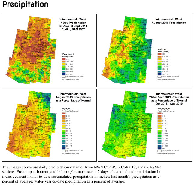
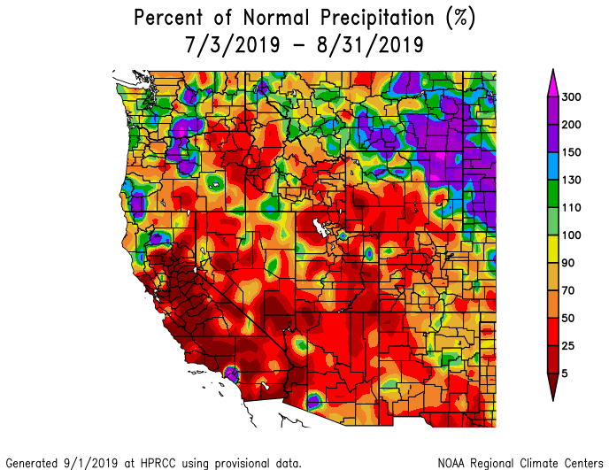
#Drought news: In #CO and #Wy (and much of the SW) the #monsoon has been rather disappointing. 2- and 3-month SPIs are negative (dry), and precipitation shortages are common

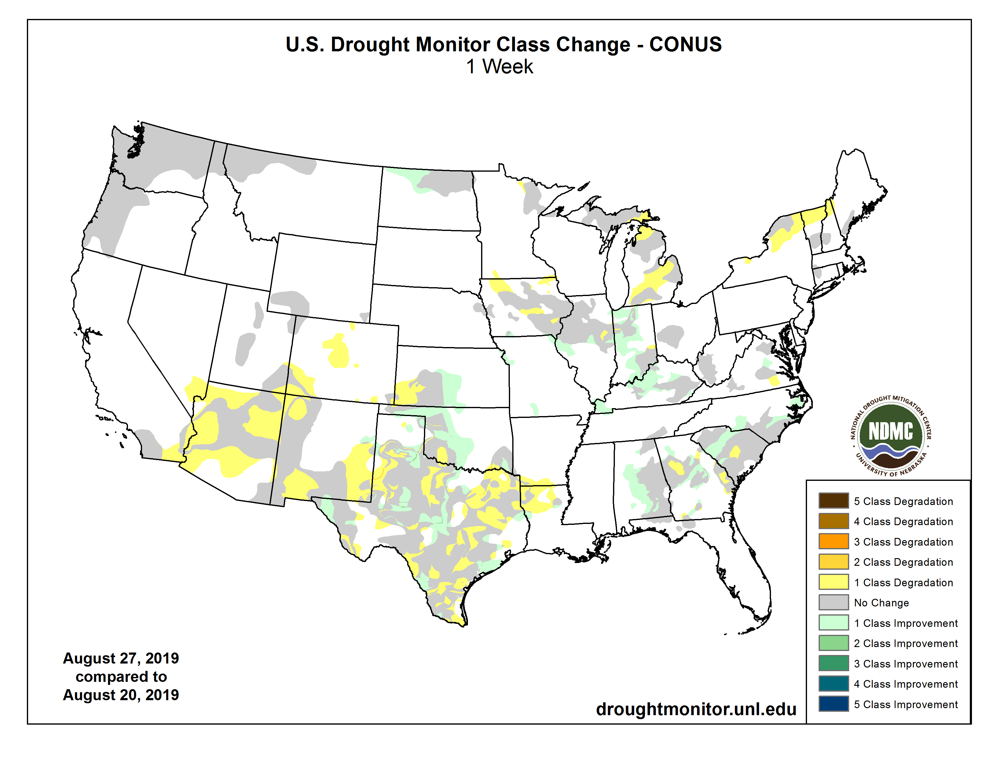
Click on a thumbnail graphic below to view a gallery of drought data from the US Drought Monitor.

Click here to go to the US Drought Monitor website. Here’s an excerpt for the areas around and including Colorado:

This Week’s Drought Summary

The highlight of the week was intense and destructive Hurricane Dorian, with sustained winds of 185 mph and a central pressure as low as 911 mbs. Fortunately for the U.S. (as of Sep. 4), Dorian never made landfall along the Southeastern coast; however, while a Category 5 hurricane, it stalled over the northern Bahamas, devastating the islands of Great Abaco and Grand Bahama. For the most part, Florida dodged a Dorian disaster as the hurricane remained stalled over the northern Bahamas, slowly weakened, and finally drifted northward by the period’s end. Some rain bands from Dorian dropped 1-4 inches along Florida’s east coast. Puerto Rico also missed a direct hit from Dorian as it was strengthening into a hurricane to its east, although scattered convection did bring the island some welcome rain. Elsewhere, a series of cold fronts dropped southeastward out of Canada, bringing subnormal temperatures to most of the Nation east of the Rockies, and helping to prevent Hurricane Dorian from tracking westward and making landfall in Florida. The fronts brought light to moderate rain to the northern Plains, upper Midwest, Great Lakes region, and Northeast, while clusters of storms dumped occasionally moderate to heavy (2-6 inches) rains on parts of the south-central Great Plains, lower Missouri Valley, and Southeast. The Southwest monsoon made a partial comeback, bringing light showers to portions of southern Arizona, most of New Mexico, and southwestern Texas, but overall has been a disappointment. The Far West, with high pressure in control, was mostly dry and warm. Light to moderate showers fell along southern coastal Alaska, but it was not enough for any improvement. Meanwhile, increased rainfall across southern sections of the Big Island aided vegetative growth and diminished deficits, thus improvement was shown…

High Plains

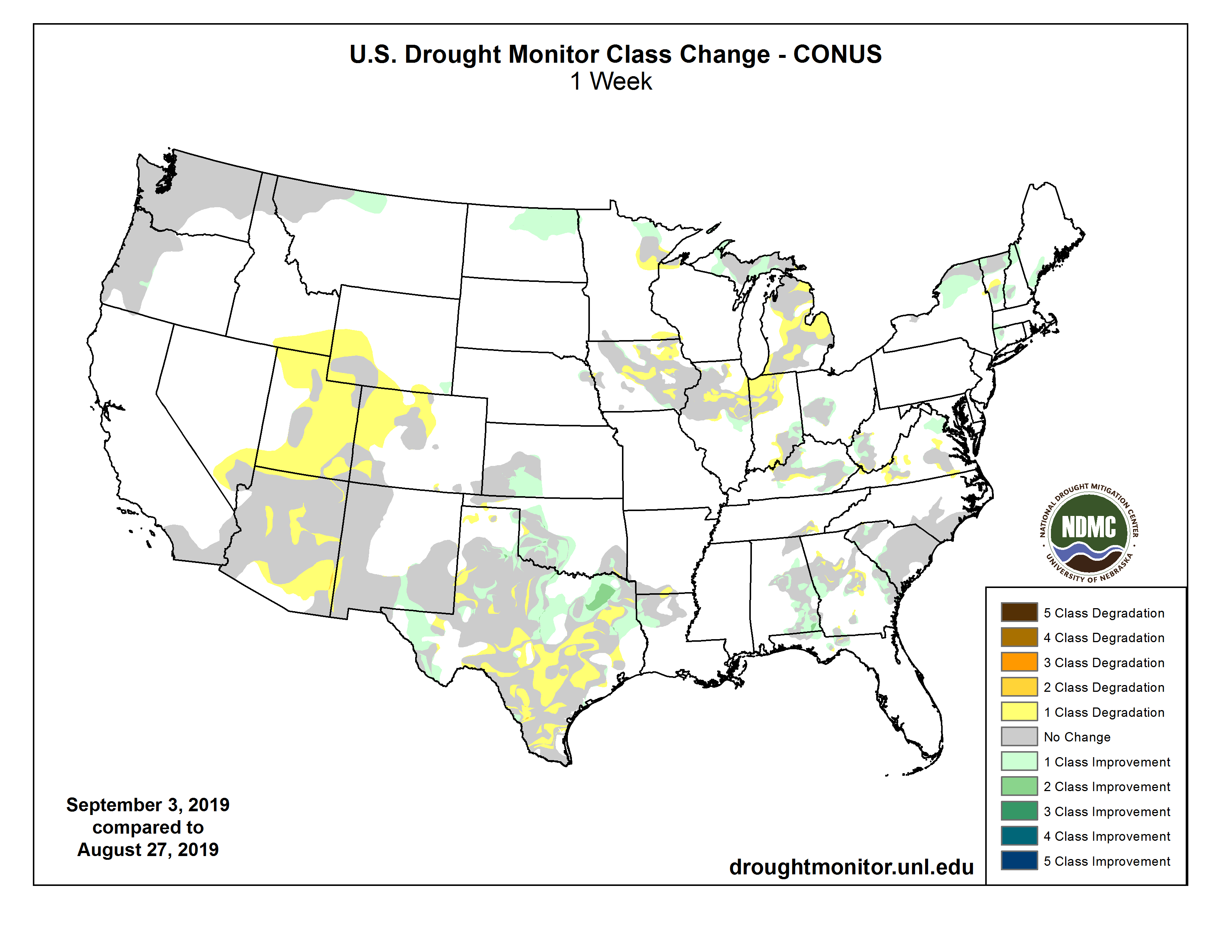
Most of the High Plains experienced relatively dry and cool weather, but fortunately the few areas with dryness or drought (northern North Dakota and southwestern Kansas) received well-placed light to moderate rains. In North Dakota, a thunderstorm complex moved across the northern and eastern portions of the state on Day7, dropping 1-3 inches of rain over the D0-D2 area and effectively reducing dryness and drought by 1-category. 60- and 90-day precipitation anomalies were now close to zero, with only longer-term (6-months) deficits still lingering. In southwestern Kansas, 1-2.5 inches of rain fell across the eastern half of the D0-D1 areas, greatly reducing its coverage. In north-central Montana, although precipitation was light (<0.25”) this week, the past several weeks brought light to moderate amounts, and after reassessing conditions at 60- and 90-days, D0 was removed as most indices were normal or moist. In Colorado and Wyoming (and much of the Southwest), after a wet and cold winter and spring, the summer monsoon has been rather disappointing. 2- and 3-month SPIs are negative (dry), and precipitation shortages are common. With this week’s unseasonable warmth, D0(Abnormally Dry) was added across a large portion of the Southwest (see below) to depict the poor summer rains…

West

In the Southwest, the gradual winding down of the southwest monsoon usually occurs in late September. So far, the 2019 southwest monsoon has been mostly disappointing, with parts of Arizona and the Four Corners region experiencing their driest summer on record mostly due to the notable lack of monsoon rainfall. Hot and dry weather occurred this week, although some rains (0.5-2 inches) fell on southeastern Arizona and most of New Mexico. Across most of the region, SPIs are less than -1 at the 30-, 60-, and 90-day time scales. While the longer-term SPIs show better numbers, the short-term stresses are outweighing the long-term values. Evaporative demand has been greater than normal, and even though water supplies are still in good shape, reservoir levels are dropping quicker than usual for this time of year, and stream flows have declined. Therefore, with August SPEIs less than -1.5, 3-month (JJA) precipitation in the lower tenth percentile, little or no rain this week, and 1-week EDDI at D2 or worse, a large area of D0 was added to reflect this short-term dryness. In southwest Colorado and southeast Utah, D1 was added to depict areas that have reported record low JJA rainfall. In Arizona, D0 was expanded across southeastern sections while D1 slightly increased in central areas in response to low SPIs and increased 90-day deficits. For example, Flagstaff, AZ has only received 1.15” of rain since June 15 (driest on record) when 6.10” should have fallen by now, and several nearby stations (Prescott, Heber, Payson, Winslow) have also measured near-record low monsoon totals…

South

While northeastern, southwestern, and southeastern Texas, most of Oklahoma, and northwestern Louisiana received widespread light to moderate rains (1 to 3 inches, locally to 6 inches), little or no rain fell on the Oklahoma Panhandle, southern and central Texas, northeastern Louisiana, and most of Arkansas, Mississippi, and Tennessee. Accordingly, a 1-category short-term deterioration was made in southern and central Texas, but improvement occurred in portions of central Oklahoma and northeastern Texas, including a 2-category improvement (D1 to nothing) where 3-6 inches of rain fell in the latter area. 7-day averaged USGS stream flows dipped below the tenth percentile (much below normal) in south-central Texas where D2 and D3 expanded. Although it was dry in Arkansas, Mississippi, and Tennessee, prior surplus rainfall has left the soil moisture in good shape for now. An exception was in extreme southeastern Tennessee where D0 and D1 increased…

Looking Ahead

During the next 5 days (September 5-9, 2019), Hurricane Dorian will turn north, then northeastward and make a close pass (or landfall) along the Carolina coasts before accelerating quickly off the Northeast coast and into the northern Atlantic Ocean. Heavy rains, gusty winds, and high waves will pound the Carolina coasts, possibly dropping up to 15 inches of rain on coastal sections of South and North Carolina. Elsewhere, an active Southwest monsoon should drop scattered showers across the Four Corners region, while an active northern jet stream should bring light to moderate precipitation to the Pacific Northwest, northern Rockies and Plains, western Corn Belt, and upper Midwest. Little or no rain is expected in California and southern Nevada, the southern half of the Plains, lower Mississippi, Tennessee, and eastern Ohio Valleys, eastern Great Lakes region, and central Appalachians. Temperatures should average above-normal across the southern two-thirds of the Nation and Northwest, and subnormal from the northern Plains eastward to the Northeast.

The CPC 6-10 day outlook (September 10-14, 2019) favors above-normal odds for precipitation in the Southwest, across the northern third of the U.S., and most of Alaska, with diminished rain chances in the Southeast. Above-normal temperatures are expected east of the Rockies, except for subnormal readings favored in New England. West of the Rockies, below normal temperatures are likely in the Intermountain West. Alaska should continue to experience above-normal temperatures.

US Drought Monitor one week change map ending September 3, 2019.

@ColoradoClimate: Weekly #Climate, Water and #Drought Assessment of the Intermountain West

Click here to read the current assessment. Click here to go to the NIDIS website hosted by the Colorado Climate Center.

Seven. Freaking. Hours: CNN bodyslammed America with climate coverage last night. Here’s what happened — Heated #ActOnClimate

Click here to read the inaugural issue of Emily Atkin’s new newsletter, Heated. Here’s an excerpt:

If you’ve followed my work at all for the last six years, you know that I frequently complain about the lack of climate coverage on major television news networks.

So it’d be natural to assume I’d be happy today, the morning after CNN’s epic 7-hour Climate Crisis Town Hall, during which reporters and citizens probed the top 10 Democratic presidential candidates about the potential collapse of human civilization.

Well guess what.

I’m not happy.

I’m…

HEATED! AWWWW YEAAAH THAT’S RIGHT!!! WELCOME TO THE FIRST ISSUE!! *airhorn sounds* (I am so sorry).

Welcome to HEATED, a newsletter for people who are pissed off about the climate crisis. This is a special pre-launch issue for all you wonderful nerds who signed up early. I can hardly believe it, but there are more than 8,000 of us already! Who says people don’t care about climate change??

Daily, Monday through Thursday coverage begins officially on September 9th. If you like it, please forward it a friend—it would mean the world to me…

Now let’s get to it!

It was not so bad, actually.

Maybe this is because I’m a cynical jerk, but I really thought CNN would mess this up.

I’m old enough to remember when the network’s president Jeff Zucker said he intentionally avoided climate coverage because of the public’s “lack of interest” in the subject. And when CNN did cover climate change, it invited deniers on so often that Media Matters deemed the network a “national platform for false balance” on climate. Two years later, Media Matters also reported that CNN aired advertisements for the fossil fuel industry five times more often than climate-related news. And in 2018, there was one week where three separate CNN guests claimed that climate change was a vast conspiracy to enrich climate scientists.

So I was shocked at how productive Wednesday night’s town hall was. The moderator’s questions, for the most part, were tough and in line with the science. The outside questioners the network brought in were youthful, diverse and engaging. Both moderators and candidates called out the fossil fuel industry repeatedly for delaying climate action and spreading misinformation.

And most importantly…

It was a climate accountability bonanza.

On Wednesday night, every single Democratic presidential candidate was asked at least one question that attempted to hold them accountable for controversial decisions they’ve made, or questionable positions they’ve taken regarding the most existential threat of our time.

Click through and sign up for the newsletter.

@OmahaUSACE: Public meeting scheduled for flood risk management study in Longmont, Colorado, September 18, 2019

Click to view the August 18, 2019 slides from the USACE.

Here’s the release from the U.S. Army Corps of Engineers — Omaha District:

The U.S. Army Corps of Engineers, in cooperation with the City of Longmont, Colorado will hold a flood risk management study open house Sept. 18, from 4:00 to 6:30 p.m. at the Longmont Museum, 400 Quail Road.

There will be a brief, formal presentation at 4:30 p.m. on information contained in the recently released draft feasibility study report, followed by an open house.

The draft report provides information on the need for the project, current conditions of the project area, identification of opportunities to reduce flood risk, development of various alternatives to reduce flood impacts to life safety and property along St. Vrain Creek, and selection of the proposed plan.

The recommended plan includes a levee on the south side of the Izaak Walton Pond Nature Area, channel widening and benching to contain the 1% Annual Chance Exceedance (ACE) event, replacement of the Boston Avenue Bridge, and a grade control downstream of Sunset Street Bridge.

The draft feasibility report may be downloaded at https://www.nwo.usace.army.mil/Missions/Civil-Works/Planning/Planning-Projects/LongmontCO/.

Email your comments on the report to cenwo-planning@usace.army.mil or mail to: U.S. Army Corps of Engineers, Omaha District, CENWO-PMA-A, ATTN: Tim Goode, 1616 Capitol Avenue, Omaha, NE 68102-4901. Comments must be postmarked or received by Oct. 4, 2019.

This flood risk management study builds on Resilient St. Vrain, Longmont’s extensive, multi-year undertaking to fully restore the St. Vrain Greenway and increase resiliency of the St. Vrain Creek channel to reduce future flood risk to the community. The Resilient St. Vrain project was developed by the City of Longmont in response to the catastrophic flooding in September 2013.

Contact
USACE Omaha District Public Affairs
402-995-2418
omaha.usace-pa@usace.army.mil
1616 Capitol Ave. Omaha, Neb. 68102

#ColoradoRiver District Annual Seminar, September 18, 2019, “Uncertainty, you can count on it” #COriver #aridification

Click here to register.

System Conservation Pilot, water markets, and demand management #ColoradoRiver #COriver #aridification

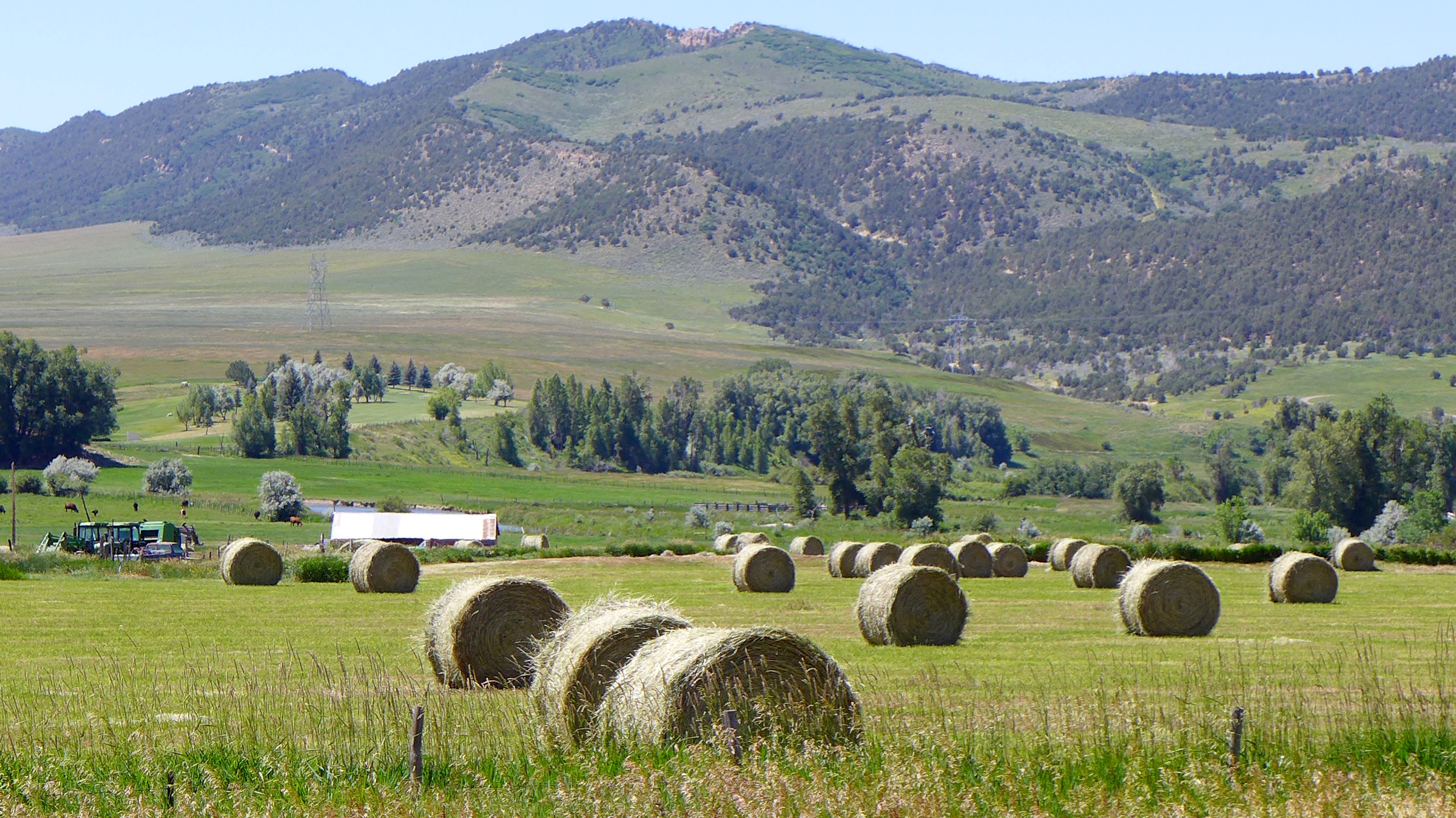
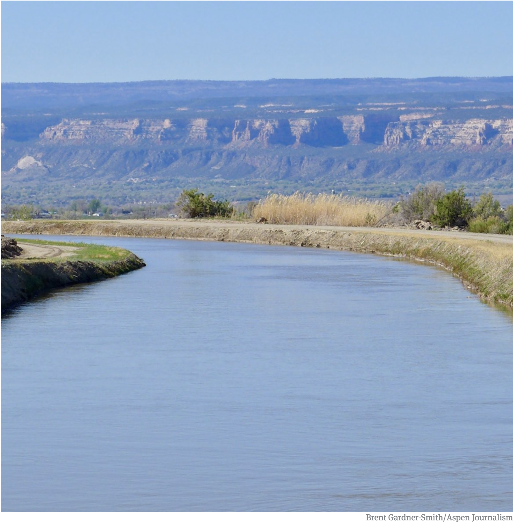
Hay fields under Meeker Ditch 2. Photo credit: Brent Gardner-Smith/Aspen Journalism

From Time (Lucas Isakowitz):

…scarcity is the mother of invention, and western states are coming up with innovative ways to save water. One was a pilot program which ran from 2015 to 2018 and paid farmers—including [Paul] Kehmeier—about $200 for every acre-foot of water that they had the right to but did not use…

Over the course of four years, the pilot program sponsored 64 projects, conserving an estimated 46,000 acre-feet of water. There was so much interest in some districts that participants had to be selected via a lottery system. Participating farmers closed off some of their irrigation canals, allowing water that would normally go to their fields to flow downstream; at the same time, water administrative agencies and environmental groups like The Nature Conservancy and Trout Unlimited helped monitor flow rates.

The pilot cost about $8.5 million, with funding coming almost entirely from the major municipalities that rely on the Colorado River, including Denver, Las Vegas and Los Angeles. Now the states in the upper Colorado River basin are exploring how to scale it up. Colorado has formed a series of working groups, set to meet for the first time in September, which will tackle questions like who will foot the bill for a large-scale program (which could run in the hundreds of millions of dollars), how to ensure participating farmers are legally allowed to lease out their water rights, and what sort of mechanisms can safeguard conserved water as it makes its way to reservoirs…

Not everyone is thrilled about the possibility of a water market in the upper Colorado River. “Let’s be honest about what it is that we’re doing here: paying farmers not to farm, and drying up land to buy water,” says David Harold, a sweet-corn farmer from Olathe, Colorado, who participated in the pilot program for one year. “This is ‘buy-and-dry’ with another name,” he says, referring to the practice of cities buying land purely for the water rights tied to them, leaving rural communities parched and jobless…

Harold isn’t the only skeptic. “Every single person I interviewed mentioned ‘buy-and-dry,’” says Kelsea MacIlroy, a PhD student at Colorado State University who interviewed 34 irrigators and water experts in western Colorado to understand local perceptions of a demand management program, which is a technical name for a water market where farmers can lease out their water. “People said ‘maybe it’s not exactly the same thing, but we’re afraid that demand management could lead to ‘buy and dry.’’’

[…]

Some, like Harold, see a water market as putting their counties on the road towards becoming another Crowley. But others view a demand management program as a way to avoid the fate of Crowley County. As the pressure mounts along the Colorado River, something’s got to give, and a water market—in which farmers choose to lease their water out for a set period, regaining it again when the program times out—is a more palatable option than selling their water entitlements outright. “Demand management is different than ‘buy and dry’ because it leaves the water in the hands of the farmer,” says Kehmeier…

For a demand management program to significantly reduce water security risks along the Colorado River, it will need to attract a lot of farmers and funding. Policymakers are envisioning a scaled-up version of the pilot that could lease out as much as half a million acre-feet of water by 2026, costing around $100 million. But even that won’t keep the Colorado River from over allocation. That’s why, MacIlroy says, some of the irrigators she spoke with felt demand management “was a Band-Aid and that there’s no point in continuing that conversation unless there are efforts being made to address the larger issues in the Colorado River.”

How Has #ClimateChange Affected Hurricane #Dorian? — The New York Times #ActOnClimate

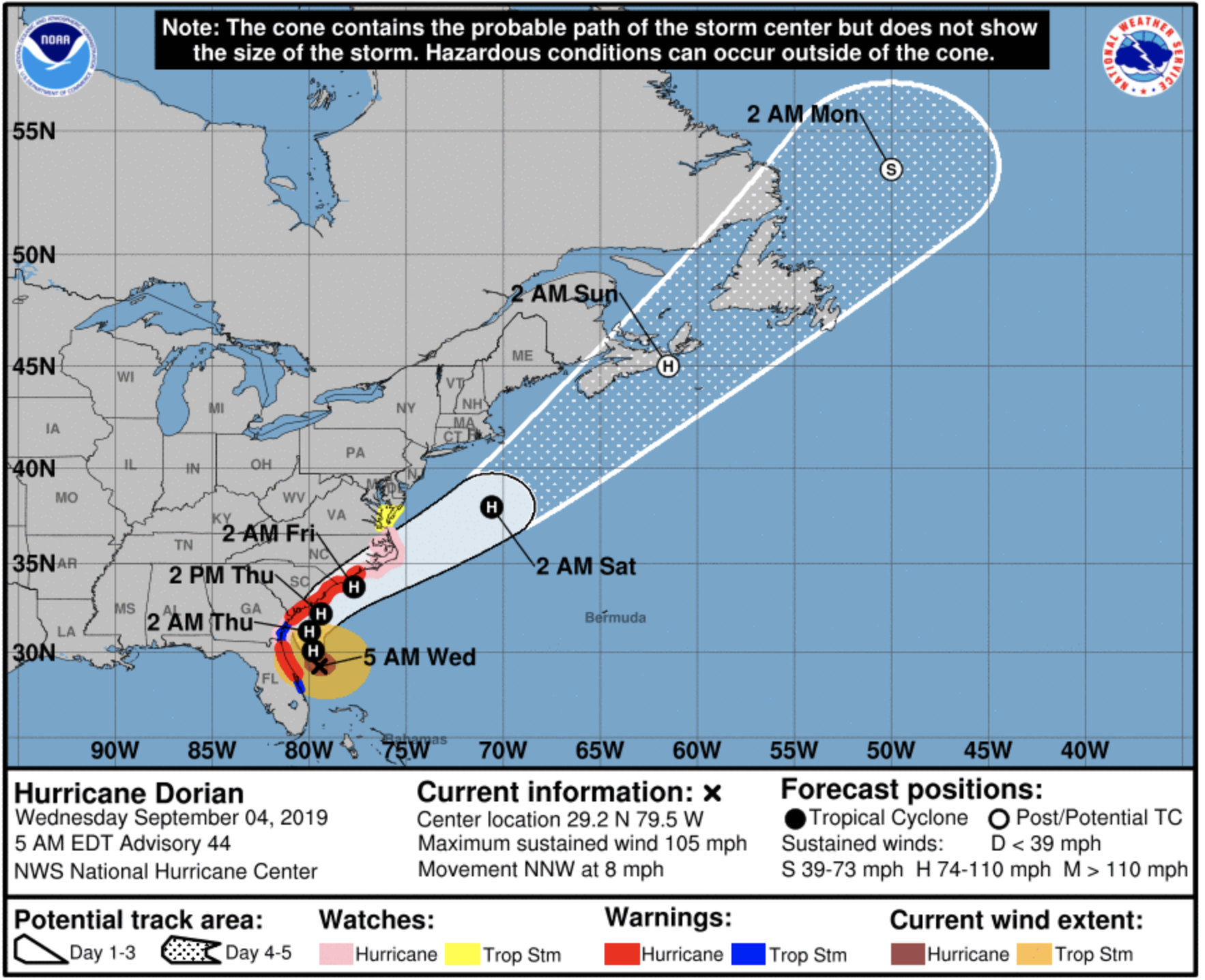
Screen shot of Dorian Cone of Uncertainty September 4, 2019 4:00 AM EDT via the National Hurricane Center

Here’s an in-depth report about Climate Change effects on hurricane Dorian from John Schwartz writing for The New York Times. Click through and read the whole article. Here’s an excerpt:

Tropical storms draw their energy from ocean heat — and more than 90 percent of the heat trapped by greenhouse gas emissions is being stored in the ocean. Storms that survive the cradle of formation can intensify quickly and become immensely powerful.

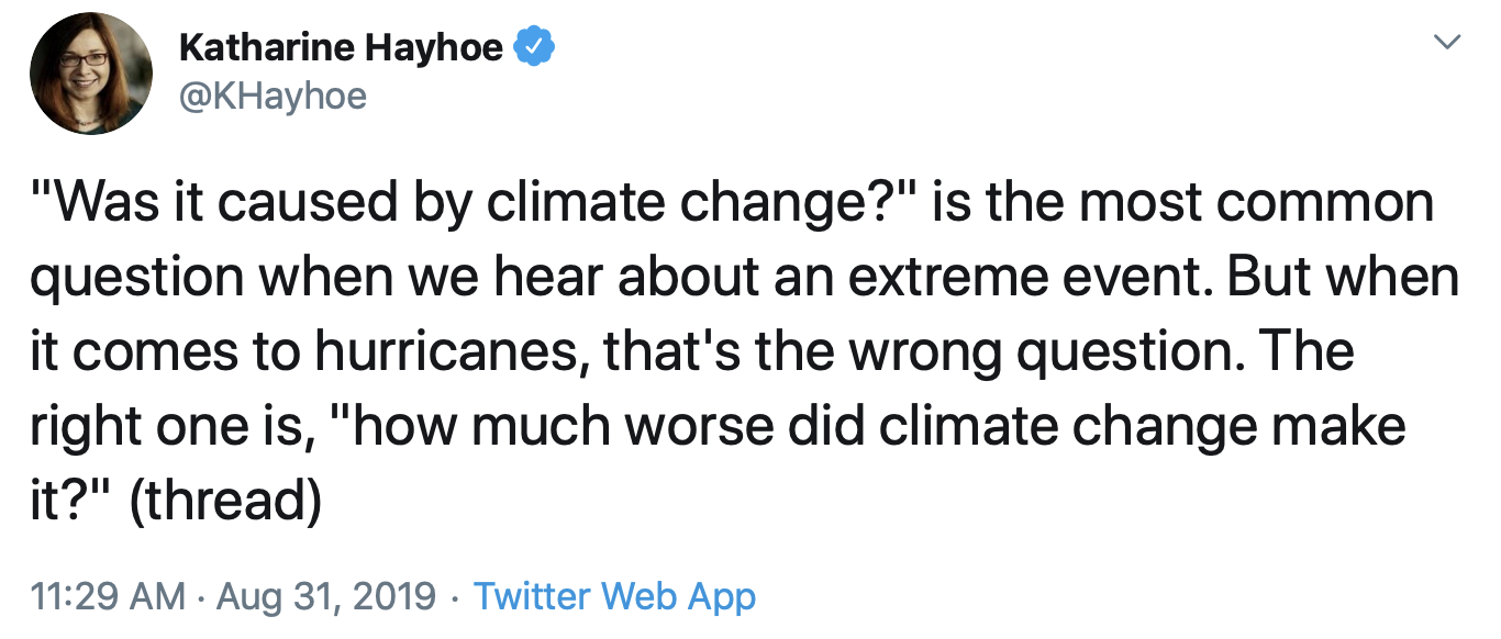
While it’s common to hear the question, “Was it caused by climate change?” scientists argue that this is an unhelpful way to look at the issue. As Katharine Hayhoe (@khayhoe), a climate scientist at Texas Tech University, put it recently on Twitter, “that’s the wrong question. The right one is, ‘how much worse did climate change make it?’”

Now, as that same storm slowly moves away from the Bahamas — which experienced a nightmare scenario of a Category 5 storm stalling over it for 24 hours — it begins its slow roll toward the East Coast of the United States.

A number of recent storms have stopped in one place for extended periods of time, including Harvey, which sat over Houston for days in 2017 and caused unprecedented flooding.

Recent research suggests that climate change has made stalled Atlantic storms more common since the mid-20th century, and that they are more dangerous because they stay in one place for a longer period of time, potentially concentrating their destruction.

Jennifer Francis, a scientist with the Woods Hole Research Center, said, “This is yet another example of the kind of slow-moving tropical systems that we expect to see more often as a response to climate change. Upper-level steering winds are slowing over the continents during summer, so stalling weather systems are more likely.”

Hurricanes are steered in part by high-atmosphere winds not directly related to the storm. Dorian slowed to a crawl — about one mile an hour — because the tropical winds that were pushing it westward over the Bahamas weakened, said Joel Cline, a meteorologist with the National Oceanic and Atmospheric Administration in Silver Spring, Md.

Climate change is making hurricanes more destructive in many ways.

Andrew Dessler, a climate scientist at Texas A&M University, said that some of the links between hurricanes and climate change are still being worked out. But, he said, some attributes of storms, particularly the increasing amount of rainfall associated with many of them, has reached a very strong consensus.

A similarly solid consensus has developed about storms getting stronger. There is somewhat less consensus, he said, around the idea that storms are likelier to stall.

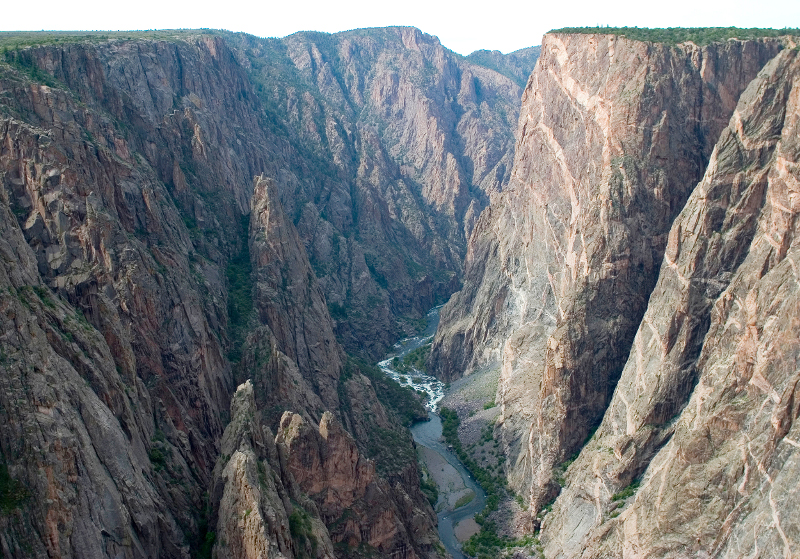
Aspinall Unit Operations update: Streamflow in the Black Canyon ~515 cfs

From email from the Bureau of Reclamation (Ryan Christianson):

Releases from the Aspinall Unit will be decreased by 100 cfs at approximately 10am on Tuesday, September 3rd. Pursuant to the Aspinall Unit Operations Record of Decision (ROD), the baseflow target in the lower Gunnison River, as measured at the Whitewater gage, is 1050 cfs for September. This release decrease will allow for the recovery of storage in Crystal Reservoir that was utilized in response to upstream facility outages.

Currently, diversions into the Gunnison Tunnel are approximately 1200 cfs and flows in the Gunnison River through the Black Canyon are around 615 cfs. After this release change, the Gunnison Tunnel diversions will remain near 1200 cfs and flows in the Gunnison River through the Black Canyon will be around 515 cfs. Current flow information is obtained from provisional data that may undergo revision subsequent to review.

Looking downstream from Chasm View, Painted Wall on right. Photo credit: NPS\Lisa Lynch

Monsoonal rains blocked in Southwest #Colorado — The Cortez Journal

From The Cortez Journal (Jim Mimiaga):

Monsoonal rains did not materialize much this summer in the Four Corners, and the El Niño weather phenomenon that favors a wetter than normal winter is also over.

“A more persistent high-pressure ridge than expected over the Four Corners is blocking the southerly monsoonal flows,” said Jim Andrus, a Cortez weather observer for the National Weather Service. “The dry spell will continue into next week.”

July and August were both below normal for precipitation for Cortez, he said.

July saw just .45 inches of rain, or 35 percent of the normal average of 1.28 inches. So far, August has seen just .57 inches of rain, or 39 percent of the normal 1.48 inches.

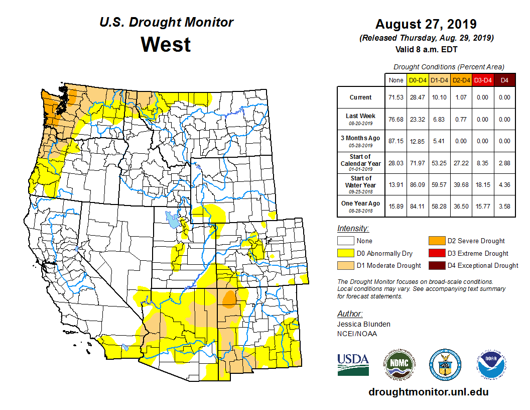
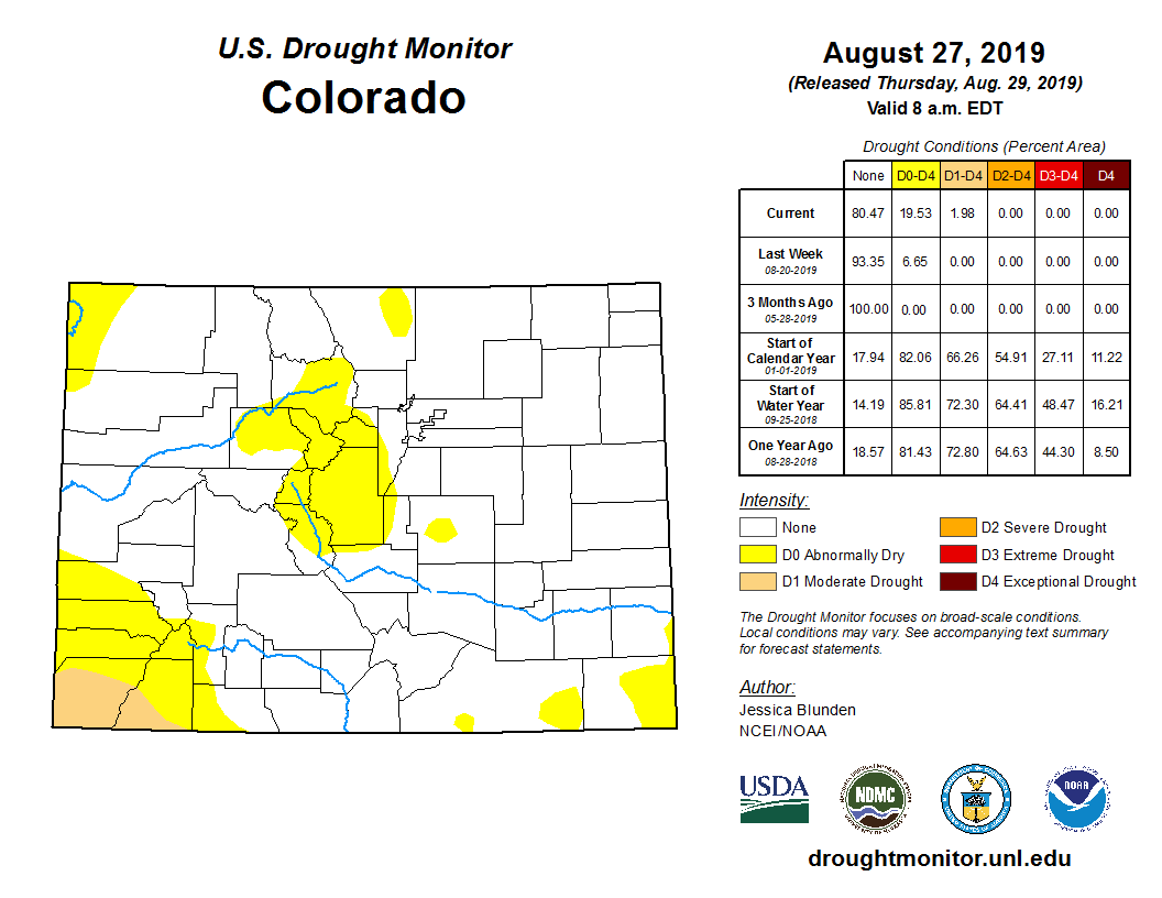
The lack of moisture has put southwest Colorado into the “abnormally dry” category on the U.S. Drought Monitor, the least severe of five drought levels.

West Drought Monitor August 27, 2019.

Year-to-date precipitation in Cortez is at 11.2 inches, or 144 percent of average, thanks to the above-average snowfall in late winter. But the high percentage continues to drop as the dry spell continues.

There is still a chance the Four Corners could get a shot of late season monsoon rains, Andrus said, if the high pressure ridge shifts to the east.

The September forecast hints at a chance for slightly above-average precipitation, said Jeff Colton, a meteorologist with the National Weather Services, as the early winter northwesterly storms drop our way.

Meanwhile, the National Oceanic and Atmospheric Administration announced last week that the El Niño weather pattern — a warming of the equatorial Pacific Ocean that contributed to the extra snowy Southwest winter — has ended.

It’s in a neutral pattern that is neither El Niño, or its opposite, La Niña, which is characterized by cooler Pacific temperatures with an atmospheric tendency to push winter storms toward the Northwest.

According to NOAA’s Climate Prediction Center, there is a 55 percent chance the neutral pattern will continue through the winter, a 30 percent chance El Niño will return, and a 15 percent chance La Niña will form.

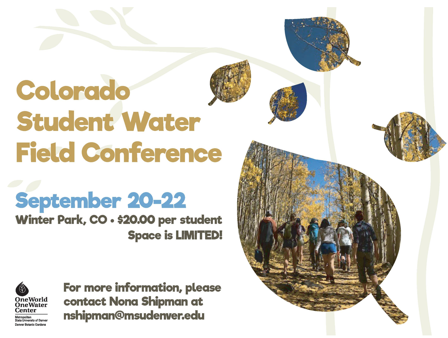
One World One Water Center: #Colorado Student Water Field Conference, September 20-22, 2019 @OWOW_MSUDenver

Big Thompson Watershed Coalition fundraiser, September 22, 2019

Big Thompson River near RMNP

From The Loveland Reporter-Herald (Pamela Johnson):

Coalition shifting focus to the future

Since the 2013 floods, the Big Thompson Watershed coalition has been leveraging grant money to rebuild and improve the river corridor, making it healthier and more resilient.

Now, the nonprofit is shifting its focus to resiliency for the future, to improvements that will prepare the community for future flood and fire impacts and to ensure long-term river health.

As part of that effort, the coalition is reaching out into the community to make new connections, holding a fundraiser with a goal of $50,000 and has a community bio-blitz planned…

Fundraiser

The Big Thompson Watershed Coalition is a nonprofit that has been operating for five years on grant money and disaster-recovery funds available after the 2013 floods. Two full-time employees handle all the community outreach, grant searches and more behind the scenes for the grant-funded projects.

To help keep a staff of two going into the future and to meet the organization’s operations needs, the coalition has a fundraiser planned for Sunday, Sept. 22, at Sweetheart Winery.

The event, which costs $60 per ticket, will feature dinner, a live cellist, fly-fishing demonstrators, tours of an adjacent watershed project, an art auction and time to soak up the river…

The theme centers on “inspirations and aspirations” of the river, and the event gives people a first-hand look at one of the completed river projects. Speakers also will talk about watershed issues…

Tickets are available by making a donation online at bigthompson.co/donate or by contacting courtney.gutman@bigthompson.co…

New connections

A major project for the watershed forum in the coming year is to create a plan for the Big Thompson River for 15 miles through Loveland with a $180,000 grant from the Colorado Water Conservation Board. The coalition will lead a team looking at river health as well as the community’s needs and wants surrounding both recreation as well as responsible development along Colo. 402.

The coalition has launched an advisory committee that includes Loveland and Larimer County officials and likely will include ditch companies as well as members of the coalition board. They plan to reach out into the community for input on needs and desires and to consider a balance between those and river health.

The goal is to create a clear understanding of the river corridor and its many demands and to end with a prioritized list of specific projects that are feasible, could be funded with grants and achieve that balance, Gutman explained…

Community bio-blitz

The coalition is looking for 10 to 30 community members to participate in a bio-blitz, which is where groups fan out over different sections of the river at the same time and collect data on water quality, plants and bugs. The idea is to have a “flash understanding” of the ecosystem that morning, Sept. 28.

The Big Thompson Watershed Coalition will not be only agency participating. In fact, volunteers will be collecting data over three different watersheds in the region and then meet in Lyons to share ideas and to have a celebration.

The hope is that those residents, once taught to collect data, would be willing to volunteer with another piece of the coalition’s long-term goal — monitoring the success of completed projects…

Volunteers can sign up at bigthompson.co or by emailing courtney.gutman@bigthompson.co…

Big Thompson Watershed Coalition

Fundraiser: 4 p.m. Sunday, Sept. 22, at Sweetheart Winery, including music, art auction, tours of a project site, speakers, dinner and drinks. $60 per ticket, available by making a donation online at bigthompson.co/donate or by contacting courtney.gutman@bigthompson.co

Bio-blitz: 9 a.m. Saturday, Sept. 28, different locations on the Big Thompson River. Volunteers can sign up at bigthompson.co or by emailing courtney.gutman@bigthompson.co

#Climate#hange: Ireland plans to plant 440m trees by 2040 — The Irish Times #ActOnClimate

From The Irish Times (Brian Hutton):

Farm land to be used for some of the 8,000 hectares of new forestry every year

Twenty-two million trees are to be planted every year in Ireland over the next two decades as part of a plan to tackle climate change, the Government has said.

While the Government’s climate action plan, published in June, proposed 8,000 hectares – or 19,768 acres – of new forestry every year in a bid to capture carbon emissions, it did not specify the number of trees involved.

In its latest calculations, it suggests this will involve 2,500 conifers or 3,300 broad-leaf trees for every hectare planted.

The target is for 70 per cent conifers and 30 per cent broad leaves.

“The climate action plan commits to delivering an expansion of forestry planting and soil management to ensure that carbon abatement from land-use is delivered over the period 2021 to 2030 and in the years beyond,” a Department of Communications Climate Action and Environment spokeswoman said.

“The plan sets out key actions to be taken by the Department of Agriculture.

“The target for new forestation is approximately 22 million trees per year. Over the next 20 years, the target is to plant 440 million.”

The ambitious plan would mean a significant shift in the use of farming land in Ireland.

The climate action report acknowledges a lack of enthusiasm among the farming community for forestry.

A key part of the plan will be to persuade farmers to designate some of their holdings for tree-planting in the future.
Government-organised town-hall-style meetings are being held throughout the country to encourage communities to support the targets.

Also proposed under the plan, is a massive increase of electric vehicles (EVs), up by an average of 100,000 annually over the next decade, to reach almost one million EVs by 2030.

Some 50,000 homes will need to undergo deep retrofits each year to meet the the plan’s targets.

The latest newsletter from the Central #Colorado Water Conservancy District is hot off the presses @CentralCOWater

Click here to read the newsletter. Here’s an excerpt:

CCWCD Fall Bus Tour

WE are offering a FREE bus tour on Friday, November 8, 2019 to anyone interested in learning more about the districts operations. The tour will begin at Island Grove Regional Park’s east parking lot and will return around 4:00 pm. We will visit the completed Geisert Reservoir, Pioneer Reservoir, Northern Water’s Galeton Reservoir, and our new Walker Project site near Wiggins. Breakfast snacks and lunch will be provided. Dress appropriately for the weather!

Click here to register

Photo by Havey Productions via TheDenverChannel.com

@CWCB_DNR Water Availability Task Force: Central #Colorado creeping back into #drought — @colo_politics

From ColoradoPolitics.com (Marianne Goodland) via The Colorado Springs Gazette:

The Colorado Water Availability Task Force, which meets monthly, took a look this week at reservoir levels, precipitation and the all-important drought forecast.

Last week, the U.S. Drought Monitor reported low-level drought in a sliver of southeastern Colorado, the northwestern corner of the state, and a bigger chunk of southwestern Colorado.

Reservoirs in southeastern and south-central Colorado were draining quickly because of dry conditions.

Average capacity for the seven reservoirs in the upper Rio Grande basin, which serves the San Luis Valley, was down to 40%.

The basin’s largest reservoir, Sanchez, near the town of San Luis, is well below 25% of capacity.

In the Lower Arkansas basin, reservoirs also have been drained; John Martin, where the 115 temperature was reported and the area’s largest reservoir, was just above 20% of capacity. Pueblo Reservoir was just above 60% of capacity.

This week, the central mountains were added to the list of areas headed back into drought, and the southwestern region went from the lowest-level drought to a slightly worse condition.

Colorado Drought Monitor August 27, 2019.

Russ Schumacher of the Colorado Climate Center at Colorado State University reported that precipitation in July was below normal for much of the state, save the Front Range, northeastern Colorado and small pockets around the state.

The typical monsoons expected in July and August have been something of a letdown except for some “very rainy spots on the plains,” the report said.

For August, however, temperatures are creeping up above normal for much of the Front Range, all the way to the New Mexico state line. Pueblo County has seen the brunt of that a heat, with a six-day run in August when the temperature exceeded 99 degrees every day.

The Climate Center is investigating a temperature of 115 degrees, recorded at John Martin Reservoir in Bent County. If it bears out, it would be the highest recorded temperature in state history. It could take a month to verify the reading, the center’s Noah Newman said.

The late start to summer is taking a toll on crops.

“Some agricultural producers are reporting that corn is behind schedule due to a late start to the season. They are optimistic that frost will not occur before the crops reach maturity,” the water task force reported…

There’s good news amid the dry summer: Most state reservoirs remain at or near capacity thanks to a heavy winter snowpack.

Don’t lose sight of what is happening across the western U.S. and particularly in the Colorado River Basin.

West Drought Monitor August 27, 2019.

After nearly 30 years with the River District, Chris Treese set to retire on September 13, 2019 #ColoradoRiver #COriver

From The Glenwood Springs Post Independent (Thomas Phippen):

After 28 years with the River District, Treese is set to retire Sept. 13.

“Time really does fly, and the issues persist,” Treese said in an interview at his Glenwood Springs office, located across the street from Two Rivers Park, right beside the river that provides water to states in the Western U.S. and Mexico.

For the last third of the River District’s 82-year history, Treese has been the organization’s external affairs director, managing communication of the district’s mission to the public; to other nongovernmental organizations; and to local, state and the U.S. government.

And during that timeframe, change has been a consistent.

Water demands — and the way water is conserved — has changed somewhat.

As the Western Slope has grown, the meaning of conservation evolved, placing more value on environmental priorities and recreational use of the rivers. Conservation has come to mean something different and the advent of climate change has forced the River District to think in different ways.

“The conservation in our title, historically, meant building a dam to conserve spring runoff for later use, year-round allocation,” Treese said. “We have grown as the term has grown.”

[…]

Treese joined the River District as director of external affairs in 1991. He started as a one-man external affairs department, and now has four people working with him.

The River District is funded by a relatively small property tax, and is tasked with ensuring that water is conserved and managed to accommodate the many uses — from agriculture and oil extraction to providing cities with water and making sure there’s enough water in the river for recreation and the people downstream.

During the past 20 years, growing populations, shifting priorities and increased demand for water has needed many creative solutions, some of which Treese has been a part.

For example, Treese remembers the development of instream flow policies, which started out as a creative solution and is now precedent across the western states.

The instream flow doctrine is not a particularly recognized term but it was critical during the creation of the Dominguez Canyon Wilderness area around 2009.

“One of the core values in the West is protecting and maintaining the states water rights,” Treese said.

But with the creation of a wilderness area, the federal government naturally exerts control over the water. The Dominguez area, however, was downstream from non-wilderness streams, setting up a struggle between holders of water rights and the feds.

“We came up with an approach to the federal interest in water that implicitly relies on Colorado’s instream flow law,” Treese said.

WATER SCARCITY AND CLIMATE CHANGE

Treese has two degrees in economics, a bachelor’s from Colorado College and a masters from Denver University. He likes to joke his degrees “are largely irrelevant to my current field.”

But economics at its most fundamental level studies the allocation of scarce resources, and in the West, water qualifies — especially in a warming and unpredictable climate. Water consumption plus the demand for water in the rivers for fishing and recreation have placed strains on the system.

On top of that, “You have a supply that by almost all scientific accounts is diminishing,” Treese said. “The last two decades certainly point to it.”

“We have grown in the west where demand exceeds supply,” Treese said.

Still, it’s critical to plan for the uncertainty.

“Climate change is in every conversation,” Treese said. “It’s part of every future forecast. It’s a large part of what we’re doing now.”

[…]

Gov. Jared Polis appointed Treese this year to the Water and Power Development Authority, which implements federal funds for water treatment systems. Treese serves on the Water Education Colorado Foundation, and Garfield County asked him to facilitate a water forum for local governments and utilities. He also will stay on the Club 20 board for Garfield County, and on Glenwood Springs’ streams and rivers committee.

Treese’s experience in the world of water issues taught him a helpful lesson that could be expanded to a number of occupations.

“There is no guidebook, no textbook, there is no lesson plan,” he said. “It’s getting out there, finding good people and working with them.”

Click here and here to view posts from Coyote Gulch that mention Chris. [ed. I misspelled his name many times over the years]

Chris Treese, Katie Melander, Coyote Gulch, Colorado Water Congress, January 2014

Mountain Town News: Why is climate change frying the Colorado Plateau?

Map of the greater Colorado River Basin which encompasses the Colorado Plateau. Credit: GotBooks.MiraCosta.edu

From ParkRecord.com (Allen Best):

Colorado Plateau stands out on global warming map

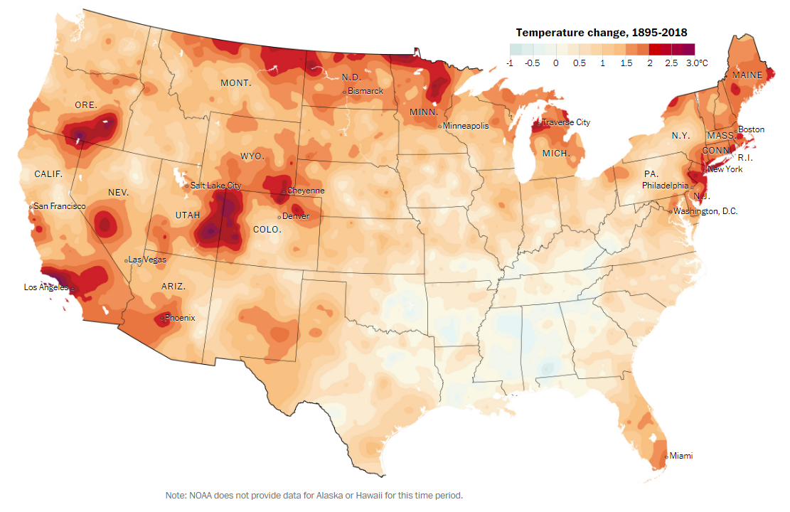
Graphic credit: The Washington Post (Note: NOAA does not provide data for Alaska or Hawaii for this time period.)

Climbers gather each January in the canyon shadows of the San Juan Mountains to test their skills on giant columns of ice. The towers in the Ouray Ice Park are created by feeding water to the canyon walls, but the cold is natural.

It’s not as cold in Ouray County as it used to be, though. A data set assembled by The Washington Post shows Ouray as one of the places with the most rapid rise in temperatures in the lower 48 states since the late 19th century. Average temperatures have increased 2.3 degrees Celsius, or 4.4 degrees Fahrenheit.

Other counties in western Colorado and eastern Utah have warmed significantly. Utah’s Grand County, where Moab is located, increased 2.5 degrees C. Colorado’s San Miguel County, home to Telluride — a short distance from Ouray — had a 2.2-degree C rise.

The Washington Post drew on statistics from the National Oceanic and Atmospheric Administration’s Climate Division Database between the years 1895 and 1918. It found uneven warming across the United States, with some areas of the South actually cooling a bit. Rhode Island and New Jersey stand out for their heating, as did Los Angeles.

The biggest blob of red and burgundy on the Washington Post’s map was in the mountains and deserts of the Colorado Plateau. The newspaper noted that the area altogether has exceeded the 2-degree C threshold that policymakers, based on the advice of scientists, have identified as critical threshold for global warming.

The newspaper’s work echoes that of a 2014 report, “Climate Change in Colorado,” which also called out spiking warming in western Colorado through 2012. Every year since then with the exception of 2013 has been much warmer than the 20th century average.

Russ Schumacher, Colorado’s state climatologist, says he’s not sure why that portion of Colorado has been warming disproportionately. “We could definitely quibble about some of the details on their maps, but the overall picture is nicely represented,” he says.

The cause of rising temperatures globally has long been understood: the sharp increase in greenhouse gases, which traps heat near the Earth’s surface. The regional variations sometimes remain puzzling…

Directly linking greenhouse gases and changes in a mountain valley remains complicated. “Certainly a substantial fraction is connected to global warming, but in complex terrain areas, and with changes in land use over the last century, those factors can also be important,” he told Mountain Town News.

Broadly speaking, the higher latitudes will warm (and are warming) more than the tropics. Alaska has had outsized warming streak, but Costa Rica, not so much.

“But elevation effects are still an area of active research, in part because we don’t have a lot of reliable data at high elevations (say, above 10,000 feet) nor do models represent the terrain of Colorado particularly well.”

Several teams of scientists in recent years have issued studies that identified rising temperatures as playing a large role in declining flows of the Colorado River. About 92% of the river’s flows originate upstream of the Grand Canyon, much of it in western Colorado. Flows since 2000 have declined 19% from the 20th-century average.

Brad Udall, a scientist with the Colorado Water Institute, told a U.S. House of Representatives subcommittee in February that 2018 was the hottest and driest year in the Four Corners region since records were first kept in 1895.

Udall said that a study that he and two other researchers published in 2018 found 50% of flow reductions in the first 14 years of the century were due to higher temperatures. The other half were due to shifting precipitation patterns.

“It is clear the Colorado River, and the entire Southwest, has shifted to a new hotter and drier climate, and, equally important, will continue to shift to a hotter and drier climate for several decades after we stop emitting greenhouse gases,” he said.

@ASU water policy expert addresses new #drought plan: State will take less water from the #ColoradoRiver under a new contingency plan #DCP #COriver #aridification

Lake Mead, behind Hoover Dam, shows the effects of nearly two decades of drought. (Image: Bureau of Reclamation)

Here’s the release from Arizona State University (Marshall Terrill):

The Southwest’s long-standing drought has left the state staring down a historic and first-ever Colorado River water cutback in 2020.

Starting Jan. 1, Arizona will see a 6.9% reduction of Colorado River water under the Lower Basin Drought Contingency Plan, which was finalized in May with California, Nevada and the federal government. Mexico will give up 3% of its allotment under a separate agreement.

The cuts are part of a plan to keep Lake Mead, a reservoir at the Arizona-Nevada boundary, functional. Water levels for both Lake Mead and Lake Powell have precipitously dropped as a result of historic over-allocation and a drought that started in 2000.

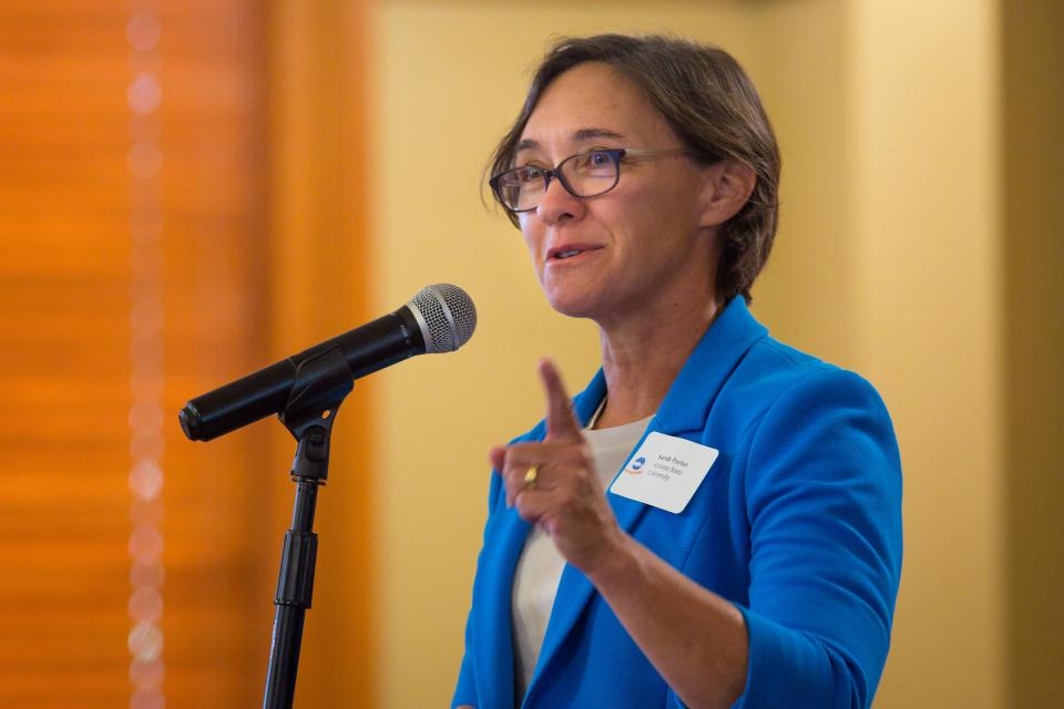
ASU Now spoke to Sarah Porter, director of the Kyl Center for Water Policy at ASU’s Morrison Institute for Public Policy, about the cutbacks and what they will mean for Arizona’s agriculture and the state’s roughly 7 million residents.

Sarah Porter, director of the Kyl Center for Water Policy at ASU’s Morrison Institute for Public Policy. Photo credit: Arizona State University

Question: Are these cuts a move that has been anticipated for some time, and should Arizona residents be worried?

Answer: Yes, the cuts have been anticipated and were agreed to by the parties to the Drought Contingency Plan or DCP. In fact, until a few months ago, we expected deeper cuts, but good mountain snowpack last winter and aggressive conservation efforts shored Lake Mead up a bit. The cuts are part of a larger plan to safeguard the Colorado River system. The plan was negotiated for several years and finalized this spring.

The Lower Basin DCP incentivizes conserving water in Lake Mead while also imposing bigger and bigger cuts should lake levels fall to certain levels. Water users on the Central Arizona Project, which brings Colorado River water to central and southern Arizona, are in line to take largest cuts because they are the lowest priority users.

The 2020 cuts won’t really be felt by Arizona water users because the state has never built out demand for all of its Colorado River supplies. For years, Arizona water managers have used “extra” Colorado River water for aquifer recharge and other purposes. Annually starting in 2015, Arizona has voluntarily conserved in Lake Mead the equivalent amount of this year’s cut.

Rather than worry, Arizona residents should continue to find ways to permanently use water more efficiently. Statewide, Arizona uses the same amount of water today as it did in the mid-1950s, though we now have seven or eight times the population and a much larger economy. There are still lots of opportunities to stretch our water supplies through conservation and efficiency measures.

Q: Who will be the first group of people to feel the sting of cuts in Colorado River supplies?

A: If Lake Mead falls below 1,075-feet elevation, Arizona will take additional cuts and farmers in Pinal County will be the first to feel the impacts. They plan to turn to groundwater (that is, water pumped from wells) to make up for some of those cuts.

Cities are in a different situation. Municipal providers that use CAP supplies tend to have high priority rights, so they would be among the last CAP users to experience cuts. Many cities in the Phoenix and Tucson areas have diverse water portfolios, including groundwater, reclaimed water and other surface water, which gives them a measure of resilience against cuts in Colorado River supplies. And since passage of the 1980 Groundwater Management Act, growth has been tied to long-term water supplies in the state’s most populous areas, so water providers must plan well in advance for foreseeable supply reductions.

Q: So if agricultural is the first to take a hit, will this mean the cost of fruits and vegetables will likely go up — and by how much?

A: That’s a question for an economist, but I will note that Arizona’s agriculture industry is not monolithic when it comes to water supplies. Right now, only Pinal County farmers are facing cuts — other Arizona farmers have higher priority Colorado River rights or get their water from other sources. Two-thirds of Pinal County’s agricultural revenues come from cattle and dairy. That production will not be directly affected by cuts in CAP deliveries. The county’s main irrigated crops are cotton and hay.

Q: What’s the effect going to be on individual households and what should consumers be mindful of, or start practicing?

A: For some households, water rates may increase as their water providers take additional steps to ensure water deliveries in the event of decreased Colorado River supplies. In addition, some households in newer developments in Maricopa, Pinal and Pima Counties depend on groundwater and are required to pay into a fund to purchase water supplies to replenish the groundwater withdrawn for their use. This amount shows up as an assessment on county property-tax bills. As fewer supplies become available, the costs of water to meet the replenishment obligation may also increase.

We should always treat water as the precious resource it is here in Arizona. The single best way for an individual household to help is to permanently reduce the amount of water used for outside landscaping.

Q: Is this going to be the new normal or a sign of things to come?

A: We should think of this as the new normal. Lake Mead is over-allocated. The prolonged drought has exacerbated the problem because it results in less extra water in the system. There are signs that the region is aridifying, meaning that average flows in the Colorado River may decrease.

We shouldn’t overlook the conservation efforts that are critical to keeping the Colorado River system functional. The Drought Contingency Plan includes important ground rules for conserving water in Lake Mead, and Arizona’s Colorado River Indian Tribes and the Gila River Indian Community, along with CAP, will be conserving and storing significant quantities of water in the lake.

Changing nature of Colorado River droughts, Udall/Overpeck 2017.

Colorado River: The West’s precious, but limited resource — Brenda Burman

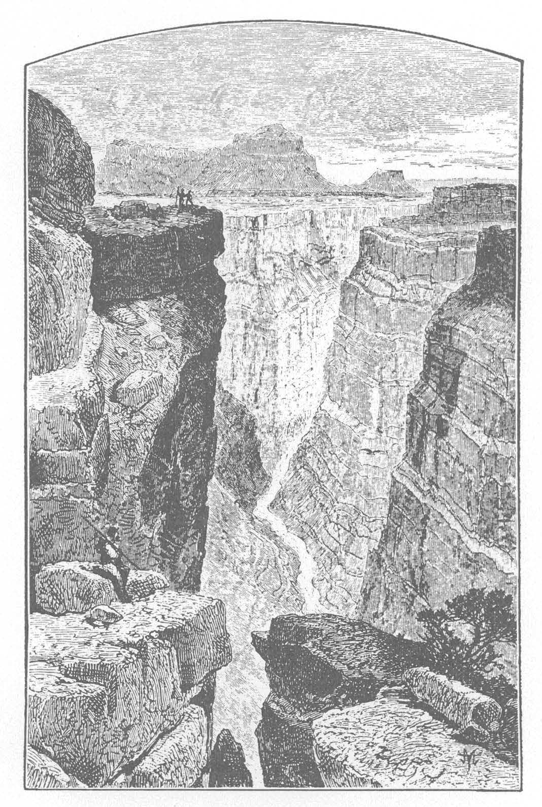
THE GRAND CANON,
​​​​​​​LOOKING EAST FROM TO-RO-WEAP
From “Exploration of the Colorado River of the West and Its Tributaries” By J. W . Powell, 1875

Here’s a guest column from USBR Commissioner Brenda Burman that’s running in The Hill:

One hundred fifty years ago, John Wesley Powell and his small band of courageous explorers captured the nation’s imagination as they completed their first expedition down the Colorado River. Powell and his team faced the unknown, and they came through the river’s canyons with a hard-earned appreciation for the Colorado River as a precious, but limited resource. His vision of diverting water for agriculture contributed to the Reclamation Act of 1902 and the birth of the Bureau of Reclamation.

Powell’s descriptions of Western water scarcity helped inspire American investment in water storage and conveyance infrastructure up and down the Colorado River — forward-thinking investment that built facilities like Glen Canyon Dam with his namesake reservoir, Lake Powell; Hoover Dam with Lake Mead; and other important reservoirs.

Today, that system of reservoirs can store four times the average annual inflow of the Colorado River Basin — absolutely critical storage for the life and livelihood of 40 million people across the West. In fact, without Lake Powell, Lake Mead and other key storage reservoirs along the Colorado River, the basin would have already faced an overwhelming water crisis many years ago.

The century and a half since Powell’s expedition brought many challenges and innovative solutions for the Colorado River. A year ago, the basin was suffering its fifth driest year in over a century; another abysmal datapoint in one of the driest 20-year periods of the last 1,200 years. In contrast, as recently as 2000, both Lake Powell and Lake Mead were nearly full. The water stored in those massive reservoirs blunted the effects of prolonged drought and protected cities, farms and families across the basin from devastating water shortage impacts.

In fact, Colorado River reservoirs helped ensure water deliveries each year during the current 20-year drought — enabling certainty and predictability for water users while avoiding the need for shortage declarations. That’s the value of water storage reservoirs and the lasting legacy of past water leaders like John Wesley Powell.

Unfortunately, not all Western river basins are positioned to withstand the effects of prolonged drought. For example, water storage infrastructure in California’s Sacramento River Basin stores less than one year’s average flow — that’s not enough to sustain ever-increasing demand. As water scarcity in the West becomes more challenging, stretching existing supplies while expanding and improving water storage infrastructure is even more important. We must strengthen our ability to capture, store and deliver limited water supplies while maximizing efficiency to enhance conservation.

While our Colorado River reservoirs have performed very well through prolonged severe drought, we cannot simply maintain the status quo. In January 2019, the combined storage of Lakes Powell and Mead fell to just 38 percent of capacity. That’s what brought the seven Colorado River basin states, the Republic of Mexico, the U.S. government, Native American Tribes, conservation interests and other non-governmental organizations together earlier this year to complete historic drought contingency plans.

Water users in the Colorado River Basin have survived the drought through a combination of water storage infrastructure and voluntary actions to protect reservoir storage and water supply. Adoption of drought contingency plans this summer, developed over years of collaborative negotiation, takes the next step by implementing mandatory action to reduce risk and protect limited water supplies.

I agree with others who believe John Wesley Powell would be happy with the level and success of collaboration in the Colorado River Basin; collaboration that helps focus governance on community and local needs along the river.

On Aug.15 the Bureau of Reclamation released its 2020 operational plans for Lake Mead and Lake Powell. Looking ahead, we are pleased that the basin will avoid deep water delivery reductions or face rapidly-declining reservoirs next year. That’s welcome news and reflects the impact of 2019’s excellent snowpack and runoff into Lake Powell and Lake Mead. That above-average runoff pushed today’s total system storage to 55 percent of capacity. But, one good year can’t undo nearly two decades of drought. We must remain focused on infrastructure improvement, conservation and other efforts to protect the Colorado River’s precious limited water.

John Wesley Powell’s courage and vision introduced America to the treasure that is the Colorado River. Our courage and vision must equal his as we confront challenges like ongoing drought and growing demand throughout the basin. Like we’ve done for the 150 years since Powell first explored those awe-inspiring canyons, we must continue to collaborate and cooperate to find innovative water management solutions for today and future generations. That’s our mandate and, if recent drought contingency plans are an indication, we are up to the task.

Brenda Burman is the commissioner of the U.S. Bureau of Reclamation. The Bureau of Reclamation is a contemporary water management agency and the largest wholesale provider of water in the country. It brings water to more than 31 million people and provides one out of five Western farmers with irrigation water for farmland that produces much of the nation’s produce. It is also the second largest producer of hydroelectric power in the country.

Colorado’s drought-free streak is over: Here’s where it’s the driest — KOAA.com

West Drought Monitor August 27, 2019.

From KOAA.com (Ryan Osborne):

A sliver of Montezuma and La Plata counties in the far southwestern corner of the state were under “moderate” drought conditions, or “D1,” according to the U.S. Drought Monitor . About 36,000 people live in the drought area.

D1 is the lowest drought level, followed by severe, extreme and exceptional conditions. A larger area of southwest Colorado is what the drought monitor considers “abnormally dry” but not quite to the level of drought conditions. Areas of central Colorado and corners in the southeast and northwest part of the state are also abnormally dry. (See the map on the tweet below).

The state became 100% drought-free in late May, marking first time in nearly 20 years of monitoring that no drought conditions were in Colorado…

The drought here in Colorado is part of a larger area of dry conditions across New Mexico, Arizona and parts of Utah, as some areas have experience one of their driest monsoon seasons on record…

In Colorado, many areas are above normal precipitation levels for the year but have been below normal over the last two months, according to the Colorado Climate Center.

Denver, for example, is at 12.58 inches of rain for the year, about 1.25 inches above normal, according to the National Weather Service. In the short term, only a little more than a half-inch has fallen this month, down by more than an inch of normal.

In Cortez, the closest precipitation station to the drought area, rain levels this year are at 9.78 inches, about 1.40 inches above normal. But since June 1, only 1.30 inches have fallen, nearly two inches below normal.

The Climate Center highlighted one of these variations this week, pointing out the rain levels in Walsh, in southeast Colorado. After a good rain on July 2, the area was more than 10.3 inches above normal for the year. Since then, Walsh has been more than four inches drier than normal.

Are Denver’s best practices for outdoor watering unique? — News on TAP

Take a look at some of the advice given by water utilities from California to Florida. The post Are Denver’s best practices for outdoor watering unique? appeared first on News on TAP.

via Are Denver’s best practices for outdoor watering unique? — News on TAP

Prepping next-gen engineers for careers beyond the classroom — News on TAP

CU Boulder students present their take on a major Denver Water project. The post Prepping next-gen engineers for careers beyond the classroom appeared first on News on TAP.

via Prepping next-gen engineers for careers beyond the classroom — News on TAP

@CWCB_DNR: August 2019 #Drought Update

Click here to read the update (Ben Wade, Tracy Kosloff):

August has been warmer than average across the majority of the state and each basin, except for the Republican basin, has experienced below average precipitation. The North American monsoon season has been disappointing in Colorado and other parts of the Southwestern U.S. The monsoon season sometimes results in beneficial moisture for south central Colorado and the eastern half of the state. Despite not receiving monsoon moisture, statewide precipitation for the Water Year, at mountain SNOTEL sites, is at 114% of average. After being the last state to experience a drought free U.S. Drought Monitor Map, which lasted eight weeks from late May through mid July, D0 has been introduced in various parts of the state (see map below). A portion of southwestern Colorado was downgraded to D1, moderate drought conditions. Reservoir storage across the state continues to be a bright spot at 116% of average.

Colorado Drought Monitor August 27, 2019.
  • According to the U.S. Drought Monitor, released August 29, D0, abnormally dry has been introduced in the central mountains and has expanded in the southwest part of the state. D0 has shown up in pockets in Las Animas, El Paso & Larimer counties. D1, moderate drought, has been introduced back in La Plata & Montezuma counties.
  • The weak El Niño has officially ended in favor of neutral conditions. The long term ENSO forecasts are trending toward neutral conditions remaining through the winter.
  • Statewide monthly precipitation as of August 26 at mountain SNOTEL sites has been 56% of average. For the Water Year, statewide precipitation is 114% of average. The Climate Prediction Center’s one month outlook is predicting above average precipitation and temperature for most of the state for September.
  • Reservoir storage across the state (as of the end of July) is 116% of average and 78% of capacity. At this time last year, statewide reservoir storage was at 86% of average. The Gunnison basin has seen significant recovery after storage was depleted last year. The South Platte basin reservoirs are in the best shape since the late 1990s.
  • Water providers in attendance report their systems are in decent shape but water demand has increased due to above average temperatures in the past several weeks.
  • Some agricultural producers are reporting that corn is behind schedule due to a late start to the season. They are hopeful that frost will not occur before the crops reach maturity.
  • @USBR awards $3.4 million to 19 tribes for technical assistance in water development

    Photo credit: USBR

    Here’s the release from the Bureau of Reclamation (Peter Soeth):

    The Bureau of Reclamation is awarding $3.4 million to 19 tribes across the western United States for technical assistance as they develop, manage, and protect their water and related resources. The funding is being made available through Reclamation’s Native American Affairs Technical Assistance to Tribes Program.

    “This funding provides the opportunity for Reclamation and the tribes to collaborate in finding the most effective and efficient ways to improve water reliability for these tribal communities,” said Reclamation Commissioner Brenda Burman.

    The funding will be provided to the tribes as grants or cooperative agreements. The nineteen projects selected are:

    Arizona

  • Hopi Tribe, develop georeferenced base maps of community water systems, $200,000
  • Quechan Indian Tribe, Tonawanda Lateral Structure Replacement, $171,346
  • Yavapai-Apache Tribe, domestic water system infrastructure and repair, $200,000
  • California

  • Bear River Band of the Rohnerville Rancheria, Singley Hill well production and treatment facilities, $200,000
  • Big Valley Band of Pomo Indians, water supply well completion, $98,746
  • Cahto Tribe of the Laytonville Rancheria, baseline stream monitoring and planning, $200,000
  • Calusa Community Council, community water system improvements, $200,000
  • La Jolla Band of Luiseno Indians, drinking water supply improvements, $65,299
  • Hoopa Valley Indian Tribe, assess threats to drinking water supply, $181,980
  • Pinoleville Pomo Nation, Ackerman Creek environmental streamflow conservation projects, $194,303
  • Quartz Valley Indian Community, water resource management model, $159,022
  • Round Valley Indian Tribes, groundwater model for basin-wide groundwater management plan, $200,000
  • Idaho

  • Coeur D’Alene Tribe, water quality monitoring and assessment of Lake Coeur D’Alene, $195,979
  • Shoshone-Bannock Tribes of the Fort Hall Indian Reservation, irrigation project surface water management program, $200,000
  • Oklahoma

  • Choctaw Nation of Oklahoma, process improvements for failing water treatment plants in Choctaw Territory, $197,637
  • Osage Nation, water system assessment project, $199,973
  • Oregon

  • Klamath Tribes, Sprague River watershed nutrient assessment, $96,168
  • Washington

  • Snoqualmie Indian Tribe, Upper Snoqualmie River resilient water corridor management plan, $199,995
  • Stillaquamish Tribe of Indians of Washington, water resources program development, $200,000
  • The Native American and International Affairs Office in the Commissioner’s Office serves as the central coordination point for the Native American Affairs Program and lead for policy guidance for Native American issues in Reclamation. To learn more, please visit http://www.usbr.gov/native.

    High temperatures, excess nutrients, and standing, stagnant water provide an optimal environment for blue-green algae to reproduce

    Blue-Green algae bloom

    From Colorado Public Radio (Hayley Sanchez):

    The blooms — they look like thick pea soup or bright green paint on top of the water — usually pop up in July with higher temperatures and in stagnant or slow-moving water. They eventually die off around September as the weather cools down.

    Health officials and municipalities have reported they’re monitoring at least a dozen lakes in Colorado with dangerous or potentially dangerous algae. Health effects vary depending on the kind of bacteria in the algae, but symptoms are pretty nasty and include skin irritation, rashes, blisters around the mouth and nose and other problems.

    “The blooms happen when the ecosystem gets out of balance,” said Sara Erickson with Colorado’s Department of Public Health and Environment. “So when we have high temperatures, excess nutrients, and standing, stagnant water, this provides an optimal environment for the blue-green algae to reproduce.”

    Tracking toxic algae is difficult because no single agency is tasked with testing waters for high levels of bacteria in lakes with blue-green algae, called cyanobacteria. The process gets even more complicated because a lake can have high levels of the bacteria at one time but levels can return to acceptable limits later on.

    That was the case with Windsor Lake in Windsor. CDPHE said it examined samples of the water and found toxic algae in July, but the lake reopened a week later when levels were back to acceptable limits.

    CDPHE said it tested and confirmed three other lakes with dangerous algae blooms. Prospect Lake in Colorado Springs, Barr Lake in Brighton and a pond in east El Paso County all have harmful algal blooms, according to CDPHE.

    The pond at Homestead Ranch Regional Park near Peyton tested positive for toxic levels of blue-green algae on Friday. Fishing is still permitted but anglers should clean their fish thoroughly. People should not let their pets in the water. Boating and swimming are already not allowed in the pond.

    Pikeview Reservoir, a popular spot for anglers off Garden of The Gods Road in Colorado Springs, also tested positive for blue-green algae. The reservoir is part of the Colorado Springs Utilities’ water system but has since been removed as a source of drinking water…

    The city of Lakewood has two lakes with high levels of toxic algae — Kountze Lake at Belmar Park and Horseshoe Pond in the Bear Creek Greenbelt. A city spokeswoman said people and pets should stay out of the water.

    Sloan’s Lake in Denver tested positive for blue-green algae in July. It’s being monitored and signs have been posted warning people to keep pets out of the water. Denver’s Department of Public Health and Environment said it has tested three other lakes for cyanotoxins and tests came back negative, but that could change.

    Quincy Reservoir in Aurora had elevated levels of toxic algae earlier this month. Greg Baker with Aurora Water said the city applied an algaecide or non-toxic pesticide to kill the algae but wouldn’t impact the fish. He said toxicity levels have reduced dramatically in the past week and officials want to reopen the reservoir in the next couple of weeks. The reservoir is not used for drinking water so Aurora’s water system wasn’t impacted.

    Faversham Lake in Westminster was tested last week for toxic algae. Erin Stewart, an aquatic biologist with SOLitude Lake Management, the agency overseeing the lake, said rain helped clear the algae since the samples were collected. Even when test results come back, they’ll reflect what was in the lake a week ago and not its current condition…

    The only sure way to know if there is toxic algae in a lake is for it to be tested.

    Blooms are more likely in lower elevations with warmer air temperature and urban areas, where there is more nutrient runoff.

    CDPHE recommends people contact the agency that monitors the waterbody for testing if they’re concerned about harmful algae…

    Keep your pets away and don’t ingest the water

    It’s best for you, your pets and livestock to stay out of water if it looks questionable. Do not drink the water. Avoid boating where the algae is and clean fish caught in the water thoroughly. Ingesting the water can be deadly for animals.

    #Mexico water supply shortages loom

    Map via WorldAtlas.com

    From AZBigMedia.com (Victoria Harker):

    Mexico is one of a growing list of countries deemed most at risk of hitting “Day Zero” when they no longer have enough water to meet citizen needs, according to a new report by global research organization, World Resources Institute (WRI).

    The nonprofit institute categorized countries into five different levels according to their relative risk of consuming all of their water resources, ranging from “Low Baseline Water Stress” to “Extremely High Baseline Water Stress.”

    Mexico is one of 44 countries – representing one-third of the world’s population – that fall into the second-highest category, “High Baseline Water Stress,” meaning that the nation consumes between 40 and 80 percent of the water supply available in a year.

    Fifteen states in the northern and central part of Mexico fall within the “Extremely High” category, meaning they are withdrawing more than 80 percent of their available supply.Among them are some of Arizona’s closest neighbors: Sonora, Chihuahua, Baja California Sur.

    Arizona impacted by Mexican water woes

    That’s of concern to Arizona. If trends continue, this suggests that one of the world’s biggest water crises could happen at the state’s southern door.

    “Along the U.S.-Mexico border, there are significant issues with water use and they involve, particularly in Mexico, aging water infrastructure that is delivering water or treating wastewater,” said John Shepard, senior director of programs for the nonprofit Sonoran Institute in Tucson that raises funding and leads projects to protect fresh water and treat wastewater in border communities and in the massive Colorado River Delta.

    The Sonoran Institute has raised funding and support to revive former wetlands through projects like the Las Arenitas Wastewater Treatment Plant in border town, Mexicali, Mexico, where new wetlands have been established adjacent the plant and act as a natural bio filter to improve the quality of wastewater.

    That wastewater also is being used to revive rivers like the Santa Cruz and Hardy, a tributary of the Colorado RIver.

    Nogales wastewater pipeline next on list to fix

    Another goal is to raise funding to replace the 8.5-mile sewer pipeline that spills sewage from Mexico into Arizona. At one point the stink caused Arizona Gov. Doug Ducey to declare a brief state of emergency.

    The pipeline, called the International Outfall Interceptor, takes sewage from the small Arizona city of Nogales and the adjacent manufacturing city of Nogales in Sonora, Mexico, to the Nogales International Wastewater Treatment Plant in Rio Rico, Arizona. Millions of gallons flow to the plant each day that are discharged into the Santa Cruz river.

    Leaking like a sieve

    In Mexico, many water problems are the result of decaying water and wastewater infrastructure.

    Mexico City, whose severe water issues come from being built in a valley that has no above water resources. The vast majority of water is stored in an underground aquifer. Leaks and breaks in the water and wastewater systems are causing a massive water loss, including an estimated 40 percent of drinking water.

    Video: The Colorado-Big Thompson Project — @Northern_Water

    First water through the Adams Tunnel. Photo credit Northern Water.

    #Drought news: D1 (Moderate Drought) expands in Four Corners, D0(Abnormally Dry) expands in SW, SE #Colorado and the along the central Great Divide

    Click on a thumbnail graphic to view a gallery of drought data from the US Drought Monitor.

    Click here to go to the US Drought Monitor website. Here’s an excerpt:

    This Week’s Drought Summary

    Summer thunderstorms brought heavy rainfall to the Central Plains into parts of the Northeast, with showers and thunderstorms also occurring across parts of the Northwest, Southern Rockies, and Central Gulf Coast. Below-average temperatures accompanied the heavy precipitation for the most part. The Southwest saw little to no rain and record to near-record heat, while heat and humidity continued to the east. The above-average temperatures and dry conditions brought elevated fire risk over the Great Basin and portions of the northern Intermountain West. South central Alaska remained dry and fires continued to burn, with smoke warnings in effect. Heavy rains, flash flooding, and severe weather occurred as a front stretched from the Southern Mid-Atlantic into the Southern Plains…

    High Plains

    In the Northern High Plains, normal conditions returned along the western to central North Dakota/Canadian border. Precipitation has been adequate and soil moisture conditions have improved. In the Southern High Plains, rainfall has been below average over the last couple of months – including the past week – in eastern Colorado while temperatures have been above average. Several areas of abnormal dryness were introduced this week, including in the central Colorado Mountains over the higher elevations, eastern Larimer and western Weld Counties and Colorado springs, and in Las Animas. With the heat, evaporative demand has been high for many of these locations. Reports from water providers indicate that there has been peak demand in the last week with lawn irrigation. Peak demand usually occurs in July. Southwestern Kansas has also seen a dearth of precipitation, and both D0 and D1 expanded westward in this area. The rest of the state, on the other hand has seen plentiful rainfall and D0 contracted westward in the central and south central region…

    West

    With respect to precipitation, 2019 to-date is a year of extremes in parts of the West. As monsoon rains continue to fail and heat continues to build, impacts, including wildfire risk, are growing in the Southwest. After emerging from nearly a decade of drought conditions on June 11, moderate drought (D1) returned to both the eastern and western parts of Arizona this week, and abnormally dry (D0) conditions spread across much of the rest of the state, save for part of the south. Locally, many areas are experiencing one of their 10 driest monsoon seasons on record. Phoenix is also on track to have its third or fourth hottest June-August period on record and Tucson its second hottest. The D1 that spread to eastern Arizona also spread over the remainder of northwestern New Mexico into southwestern Colorado and southeastern Utah at the Four Corners. In New Mexico, D1 in the south expanded eastward from Sierra County to the D1 area at the Texas border. Abnormally dry conditions also spread outward across the southwestern states, including across Imperial County, California, to join with the long-lasting D0 area in San Diego, Orange, and Riverside Counties…

    South

    Texas, Oklahoma, Arkansas, and Louisiana saw sharp gradients and some complicated rainfall patterns, with heavy precipitation in some places and little to none in others, and so many areas saw improvement in short-term dryness and drought while many others saw degradation. Conditions improved across part of the Oklahoma Panhandle into northern Texas and also in in the central region and southeast, but there was also a degradation to extreme drought (D3) along the Texas border, encompassing parts of Kiowa, Comanche, Cotton, and Tillman Counties (and northern Wichita and northeastern Wilbarger County in Texas) where rain was scarce. This is the first occurence of D3 in Oklahoma since September 2018. Temperatures here were in the 105-109 degree F range. In Texas, the D3 area to the west expanded, as did the D3 area in the extreme south, with a new small spot as well. Primary impacts across the state include wildfires, dry stock tanks, supplemental feeding, and impacts to late-season crops, namely cotton. Moderate drought spread from east Texas into southwestern Arkansas and northwestern Louisiana. Abnormal dryness also spread eastward to south central Arkansas and central to northeastern Louisiana…

    Looking Ahead

    Over the week beginning Tuesday, August 27, according to NOAA’s Climate Prediction Center, dry conditions are expected to continue across southern Texas and much of the western third of the continental U.S., while light to heavy rainfall may occur across the remainder of the country. Parts of Kansas may receive up to about 4 inches, with isolated higher amounts. Hurricane Dorian will bring heavy rain and potential flooding to Puerto Rico and Florida, where 4-8 inches of rain are expected from the storm, with locally higher amounts. Looking further ahead to September 2-6, below-normal temperatures are favored across Maine and parts of the Northern Plains and Midwest, nosediving into Oklahoma and northern Arkansas, while above-normal temperatures are forecast forAlaska, the western third of the CONUS, across most of Texas, and into the Southeast and Mid-Atlantic states. Much of the Southwest and Alaska are both favored to have some badly needed above-average precipitation, as is the Southeast and the northern tier of the CONUS. There are enhanced probabilities of below-normal precipitation for the Southern and Central Plains into parts of the Midwest. Please note the forecast confidence for this period is above average, according to CPC.

    US Drought Monitor one week change map ending August 27. 2019.

    Summer is almost over, but the fun has just begun — News on TAP

    Denver Water’s Youth Education Program uses fun to focus on developing future water citizens. The post Summer is almost over, but the fun has just begun appeared first on News on TAP.

    via Summer is almost over, but the fun has just begun — News on TAP

    We’ll be there, even on Labor Day — News on TAP

    A behind-the-scenes look at what it takes to keep the water flowing 24/7/365. The post We’ll be there, even on Labor Day appeared first on News on TAP.

    via We’ll be there, even on Labor Day — News on TAP

    Now that’s what we call quality — News on TAP

    National Water Quality Month reminds us all just how important it is to protect our drinking water. The post Now that’s what we call quality appeared first on News on TAP.

    via Now that’s what we call quality — News on TAP

    Wheels rollin’ keeps the water flowin’ — News on TAP

    Check out Denver Water’s new maintenance shop and meet the mechanics who maintain a $42 million fleet. The post Wheels rollin’ keeps the water flowin’ appeared first on News on TAP.

    via Wheels rollin’ keeps the water flowin’ — News on TAP

    Funding Available for Projects Addressing Forest Health, Wildfire Risk — Colorado State Forest Service

    Here’s the release from the Colorado State Forest Service:

    Wildfires are both natural and inevitable – including in wildland-urban interface settings where millions of Coloradans live. These fires can be particularly destructive in areas where forests are unhealthy, unmanaged and unnaturally dense.

    The grant program is designed to reduce risk to people and property in the wildland-urban interface (WUI). Photo credit: Colorado State Forest Service

    For those interested in taking action, but who have lacked the means, funding is now available to help address this risk.

    The Colorado State Forest Service announced today that it is accepting proposals from Colorado HOAs, community groups, local governments, utilities and nonprofit organizations seeking funding to restore forested areas, improve forest health, and reduce wildfire risk on non-federal land in the state.

    Approximately $1 million in total funding is available.

    The Forest Restoration and Wildfire Risk Mitigation Grant Program helps fund projects that strategically reduce the potential wildfire risk to property, infrastructure and water supplies and that promote forest health through scientifically based forestry practices.

    Reduction of hazardous fuels

    The competitive grant program is designed to reduce risk to people and property in the wildland-urban interface (WUI) and support long-term ecological restoration. Applications must not only promote forest health and address the reduction of hazardous fuels that could fuel a wildfire – such as trees and brush near homes – but also utilize wood products derived from forest management efforts.

    Long-term ecological restoration and the protection of water supplies are among the goals of the grant program. Photo credit: Colorado State Forest Service

    The state can fund up to half the cost of each awarded project; grant recipients are required to match at least 50 percent of the total project cost through cash or in-kind contributions. Projects can be located on private, state, county or municipal forestlands.

    Program funds also are allowable to fund the purchase of equipment that directly supports and expands on-the-ground opportunities to reduce hazardous fuels.

    Applicants must coordinate proposed projects with relevant county officials to ensure consistency with county-level wildfire risk reduction planning. Follow-up monitoring also is a necessary component of this grant program, to help demonstrate the relative efficacy of various treatments and the utility of grant resources.

    The CSFS will work with successful project applicants to conduct project monitoring and conduct site visits to assess effectiveness and completion of projects.

    Additional emphasis will be given to projects that:

  • Are identified through a community-based collaborative process, such as a Community Wildfire Protection Plan (CWPP)
  • Are implemented strategically across land ownership boundaries; are conducted within a priority area identified in the Colorado State Forest Action Plan
  • Utilize the labor of an accredited Colorado Youth or Veterans Corps organization
  • Include forest treatments that result in the protection of water supplies
  • Applications must be submitted electronically to local CSFS Field Offices by 5 p.m. MST on Oct. 23, 2019. A technical advisory panel convened by the CSFS will review project applications and make funding recommendations. The CSFS will then notify successful applicants next spring.

    Applications and additional information about the Forest Restoration and Wildfire Risk Mitigation Grant Program are available at CSFS Field Offices and online on the CSFS Grants & Funding Assistance webpage.

    UW team traces Powell’s historic journey, eyes the future — Wyofile.com #ColoradoRiver #COriver #aridification

    Looking down on camp at Big Pine, Red Canyon.
    The photo shows the SCREE Powell 150 expdition camp at Big Pine Campground in Red Canyon of the Green River, Utah. The large green tarp was set up to keep the kitchen area and campers dry. Two very large ponderosa pines are in the center of camp, and surely were witness to the 1869 Powell expedition. Photo credit SCREE via the USGS.

    Here’s a report from Katie Klingsporn writing for Wyofile.com. Click through to read the whole article and for the photos. Here’s an excerpt:

    May 24, 2019 was 150 years to the day after a scraggly and ill-prepared outfit led by a one-armed Army major gathered in Green River Station, beside the outpost’s namesake watercourse, and embarked on one of the most significant river expeditions America has ever seen.

    On the sesquicentennial anniversary of John Wesley Powell’s historic launch, a new band of river explorers assembled at the site to begin a bold journey down the artery of the American West — the Green and Colorado Rivers.

    This time, things looked starkly different. The crew, made up of academics, scientists, educators and artists from the University of Wyoming, was a far cry from the rag-tag band led by Powell. In place of the gallingly ill-suited wooden boats of Powell’s expedition, state-of-the-art 18-foot rubber rafts lined the bank. And, perhaps most notably, this crew came equipped with the tools of modern adventure such as maps, streamflow forecasts and satellite phones. These travelers were, in other words, prepared — not something Powell’s expedition had going for it as the men ventured into what was then a little-understood blank spot on the American map.

    Meet UW’s Sesquicentennial Colorado River Exploring Expedition, which set out on that May 2019 day to follow Powell’s arduous journey. Over 70 days and some 1,000 river miles this summer, its members retraced Powell’s route and mimicked other key aspects of his expedition — like collecting scientific data. But theirs was not to be a simple journey into the past. Instead the team set out with an eye toward the future and solutions for the river system’s modern-day problems. In this way, the expedition conducted a study not only of the geology or hydrology of the Colorado River Basin, but of Western economies, policies, climate, public lands and ideologies as they relate to the overtaxed river system…

    The inspiration

    A century and a half is a mere blip in the life of the Colorado River, but much has changed in its basin since Powell’s expedition. Cities have bloomed in the desert, diversions and pipelines have been built and a complex web of regulations has been written to divvy the water to its 40 million users. What once was a large swath of unknown today encompasses five states, two basin districts, more than a dozen dams and 15 special-management areas. Add to that ever-increasing agricultural and energy development, a nearly two-decade-long drought and wild swings brought by climate change, and the picture of the Colorado River Basin is one of a riverway so overburdened it no longer reaches the sea.

    It’s the river’s predicaments that prompted the SCREE trip, Minckley said. A paleo-ecologist, Minckley specializes in Western ecologies and long periods of drought. A few years ago, with the anniversary of Powell’s expedition on the horizon and the quandary of the basin’s water management fresh in his mind, he said, he began thinking about how Powell was one of the first people who took the concern of water in the West seriously…

    The takeaways

    Spring gave way to summer as the crew wended its way south and west, plunging deeper into the Earth as rock layers climbed above. There were guests aplenty, too many campfires to count, breathtaking vistas and a couple mishaps — a raft flipped in Cataract Canyon, an engine broke down during the slog across Lake Powell.

    When the crew arrived at its final destination, the approximate confluence of the Virgin and Colorado rivers (now under Lake Mead) on Aug. 1, it had amassed hours of recorded conversations, pages of notes and drawings, hundreds of scientific samples, many ideas for classroom curriculum and a pile of memories from an unforgettable experience.

    One thing the team did not have? The hard-and-fast answer to the Colorado Basin’s perplexing water puzzle. But, Minckley said, they’ve got a good starting place. The next step is to begin analyzing and digesting the information they gathered, while thinking about the most effective ways to move key findings into the public conversation.

    Support the High Line Canal and Rally for the Canal-ly, September 14, 2019 @COHighLineCanal

    Here’s the release from the Highline Canal Conservancy:

    Join the Rally for the Canal-ly on Saturday, September 14 from 9:30 a.m. to noon. This free event will celebrate community partnerships and launch a new initiative to revitalize all 71 miles of the High Line Canal. Rally for the Canal-ly is free and family-friendly – hosted by the High Line Canal Conservancy and supported by Schomp Subaru and Arapahoe County Open Spaces.

    Meet up near the High Line Canal’s mile 51 at Schomp Subaru, 580 S. Havana St. in Aurora (public parking available at Expo Park). Community leaders, neighbors and High Line Heroes will enjoy a picnic-style lunch and Canal cleanup. As a memento, attendees will be among the first to receive a free copy of the new High Line Canal map.

    The High Line Canal’s upcoming improvement initiative is being launched with a $56,000 donation from Subaru Share the Love – money dedicated to and donated by community members through Schomp Subaru on Havana in Aurora. The initiative is the next stage in the High Line Canal Conservancy’s work to bring new life and a bright future to the Canal. It will focus on:

    • Stormwater and maintenance
    • Landscape management and tree care
    • Access and signage
    • Safety and crossing enhancements
    • Education and stewardship
    • Local neighborhood improvements

    “The High Line Canal is being transformed from a 71-mile irrigation canal, a landmark of our agricultural heritage, into one of the region’s premier green spaces that connects neighborhoods and people with nature. The community had a vision to honor, enhance and repurpose the Canal. We’re excited for these upcoming improvements and protections that will help bring that vision to life,” said High Line Canal Conservancy Executive Director, Harriet LaMair.

    “Schomp Subaru is so happy we can help realize the High Line Canal’s important and ambitious purpose,” said Schomp Subaru owner Aaron Wallace. “We are delighted that our customers chose to support the project through the Subaru Share the Love drive. It’s a natural for Schomp and a great example of how Subaru Shares the Love.”

  • Who: Community members and leaders, High Line Canal Conservancy, Schomp Subaru, Arapahoe County Open Spaces, Denver Water and many others.
  • What: Rally for the Canal-ly – Free community clean-up event and picnic-style lunch following a brief news conference featuring community leaders. Enjoy complimentary local fare (while supplies last) and family activities. Help clean up trash along the Canal while learning about how trash impacts the community and environment.
  • When: Saturday, September 14, 2019, 9:30 a.m. until noon.
    9:30 a.m.: Project Launch with Partners and Subaru Share the Love
    10:30 a.m. – noon: Family-Friendly Cleanup and Lunch
  • Where: Near Mile 51 of the High Line Canal at Schomp Subaru, 580 S. Havana, Aurora. Check in behind Schomp Subaru and pick up trash bags and cleanup supplies provided by the City of Aurora, Denver Water and the High Line Canal Conservancy. Public parking available on the southwest side of Expo Park, 10955 E Exposition Ave, Aurora.
  • Why: To celebrate progress to preserve and enhance the 71-mile High Line Canal and to kick off the next chapter in the journey to turn the Canal into the region’s premier green space and environmental jewel. In addition, don’t miss this opportunity to pick up your free copy of the new map of the 71-mile Canal.
  • Claim Your Canal Guide and Map: Rally for the Canal-ly attendees will receive the new High Line Canal Map, recently published by the High Line Canal Conservancy. This new Guide and Map of the High Line Canal is an indispensable tool for discovering the wonders of the historic High Line Canal. It breaks down the 71-mile linear park into 27 walkable, bike- and equestrian-friendly trails and adventures, along with navigational tips and highlights of the Canal’s history and natural wonders, highlighting access points, landmarks and adjacent trails. Additional copies will be available for purchase or as a gift with High Line Hero membership.

    Contact: Connie Brown, 720-530-5446/connie@highlinecanal.org
    Suzanna Jones, 720-767-2452/suzanna@highlinecanal.org

    @ColoradoClimate: Weekly #Climate, Water and #Drought Assessment of the Intermountain West

    Click here to read the current assessment. Click here to go to the NIDIS website hosted by the Colorado Climate Center>

    @COWaterCongress Annual Summer Conference recap #cwcsc2019

    The headwaters of the Yampa River. Photo: Brent Gardner-Smith/Aspen Journalism

    From The Steamboat Pilot (Eleanor C. Hasenbeck):

    Water leaders from across the state converged on Steamboat Springs this week as part of the Colorado Water Congress Summer Conference.

    The Colorado Water Congress is a group of people who work and live in water, explained Routt County Commissioner Doug Monger…

    In a legislative update, attendees heard about three proposals that could change water management in the state. Reps. Dylan Roberts, Jeni Arndt and Donald Valdez and Sens. Kerry Donovan, Jerry Sonnenberg and Don Coram sat on the panel.

    “As somebody who represents Routt County and other Western Slope counties, we know what a dry year looks like,” Roberts said. “We just had one last year, and we’re fortunate to have a wet year this year, but we have to continuously plan for those dry years and look at any legislation that helps us to preserve and conserve as much water as possible, prevent forest fires and protect agriculture, because they’re the ones that really lose out when we have dry years.”

    Changes to a program that increases river flow in dry years

    The instream flow program allows the Colorado Water Conservation Board to designate water rights to preserve or improve the natural environment of a stream.

    In the Yampa River, this program has been used to release reservoir water to boost flows through Steamboat in dry summers.

    Under the current law, the program allows people who hold water rights to temporarily loan reservoir water to the state to boost flows in a stream three times over the course of a 10-year period. The Colorado Water Conservation Board has already used loaned water for an instream flow in the Upper Yampa River three times in 2012, 2013 and 2017.

    Though reservoir water has been released in other years, including last summer, it was under a different legal mechanism.

    Roberts, a Democrat who represents Routt and Eagle counties, introduced a bill that would allow for more instream flow releases.

    “Once the 10-year period is done, you’re done forever, and you can never do it again,” Roberts explained. “So while city of Steamboat and the Yampa River has taken advantage of that program, they’ve started their 10-year clock. Once we hit 10 years in 2022, they won’t be able to use it again, so if we have a really low water year on the Yampa in 2023 or 2024, we won’t be able to use the instream flow to keep the Yampa running through town.”

    The bill, as currently proposed, would allow these loans for five of every 10 years and allow it to be renewed twice once those 10-year periods end.

    This would improve stream habitat, Roberts said, as well as limit economic impacts due to river closures placed during low flows that impact tubing outfitters, fishing shops and the businesses that benefit from recreation in the area.

    Monger, who sits on the board of the Upper Yampa Conservancy District, said the program has “been a great thing.” The district operates Stagecoach Reservoir.

    “(The district’s) actually been fortunate enough to have some available wet water that we can send down through to the city of Steamboat Springs, and it helps with water quality as well as water temperature,” he said. “It’s been a great thing, and the upper Yampa sells a little bit of water for its revenue sources to be able to take care of the water, so that’s a good thing.”

    It would also expand the program by allowing more water to be released to create more habitat for aquatic species, whereas currently, these releases are smaller releases designated only to preserve the existing natural environment…

    Ballot measure to legalize sports betting with tax revenue funding water projects

    Earlier this year, the legislature passed a measure that will ask voters to legalize sports betting with tax revenue from the practice funding the implementation of the Colorado Water Plan.

    If approved by voters, Colorado would allow some casinos to offer a sports book, essentially a room with a betting board and “every game known to man” on television screens, as Donovan put it. Casinos could also contract with online sports betting companies, such as DraftKings and FanDuel, to operate web-based sports betting. People could bet on college, professional and Olympic games.

    While sports betting has taken place in the state, it’s currently illegal.

    “This is a chance to legalize an action that we know is happening on the ground and to provide regulation protection under that act if people choose to bet on sports betting,” Donovan said.

    A 10% tax on each wager would be paid by casinos, with the bulk of the revenue funding the Colorado Water Plan. Some revenue would be directed to administrative costs, a hold harmless fund and a gambling crisis hotline.

    The Colorado Water Plan outlines a number of actions such as conserving more water used by cities and industry, storing more water, establishing plans to protect critical watersheds and increasing public awareness of water issues. The Yampa-White-Green River Basin Roundtable would implement the plan locally.

    Earlier this year, Gov. Jared Polis requested $30 million to fund the plan and statewide drought planning. The legislature granted $8.3 million to fund the water plan and $1.7 million for drought planning…

    Using new technology to trade water rights in real-time

    Another law, passed earlier this year, establishes an advisory group to study possible uses of blockchain technology within agriculture.

    Blockchain is a way to track transactions, and it uses the same record-keeping technology as bitcoin. Each transaction within the network, whether the blockchain network is trading water or money, is recorded in a block and includes data about transactions under a unique signature, sort of like a username. Each transaction is verified by the network of computers in the blockchain.

    Evan Thomas, director of the Mortensen Center in Global Engineering at the University of Colorado Boulder, presented on possible applications of blockchain in the world of water rights. Blockchain could create a system to trade water by using sensors that track how much water is used or conserved to create “water credits.”

    “(Those water credits are) entered into the blockchain,” Thomas said. “Somebody requests a transaction. They say ‘I need to buy more water this month, so I want to buy somebody else’s water credits.’ You enter in that transactionm, and they buy and sell points. The sensor identifies water use and water consumption, (and) turns that into a blockchain node.”

    Thomas said this is a worthwhile tool to study in its applications for water rights, but that it is one part of a “suite of tools” that should be examined to update how water is traded.

    Water equity a concern for Western Slope water users — @AspenJournalism #cwcsc2019 #DCP #ColoradoRiver #COriver #aridification

    Pitkin County is using this irrigation system to grow potatoes for vodka on county open space land. The state is exploring how a voluntary, temporary and compensated water-use reduction plan, known as demand management, could incentivize irrigators to leave more water in the river. Photo credit: Brent Gardner-Smith/Aspen Journalism

    From Aspen Journalism (Heather Sackett):

    Colorado’s agricultural-water users have concerns about how exactly the state would fairly implement a voluntary water-use reduction plan known as demand management.

    That was the takeaway from some of the first meetings organized by the Colorado Water Conservation Board as part of its investigation into how a demand-management program might work in the state. Water managers discussed the issue of equity at the first meeting of the agricultural-impacts workgroup in Delta in early August and again at Colorado Water Congress in Steamboat Springs on Thursday.

    If Western Slope agricultural-water users don’t see cuts being taken by water users in municipalities, on the east slope and in the lower Colorado River basin, they won’t want to participate in a demand-management program, said Ken Curtis, chief of engineering and construction for the Dolores Water Conservancy District.

    “If (Western Slope users) don’t see that question of fairness, they don’t even want to open the conversation,” he said at the meeting in Delta.

    A large irrigation canal in the Grand Valley, which relies on water from the Colorado River to irrigate fields. The state is exploring how a voluntary, temporary and compensated water-use reduction plan, known as demand management, might work. Photo credit: Brent Gardner-Smith/Aspen Journalism

    Social and cultural perceptions

    This sentiment is not surprising to Colorado State University doctoral candidate Kelsea Macilroy, who spent last spring interviewing about 40 irrigators and water managers on the Western Slope. At CWC on Thursday, she unveiled her Nature Conservancy-funded research on the social and cultural perceptions of demand management.

    There are three key conclusions of the report: Awareness and understanding of demand management vary greatly, defining what demand management is and how it will work is not straightforward, and conversations about demand management are connected to other tensions that create a general sense of vulnerability and fear.

    “People don’t see this as a discussion about feasibility,” she told Thursday’s audience. “It feels like something that’s going to happen.”

    The CWCB has formed nine workgroups, each tasked with helping to identify and solve one of the following issues: agricultural impacts, law and policy, water-rights administration, environmental considerations, economic considerations and local government, funding; education and outreach, monitoring and verification, and tribal interests. The workgroups began meeting this summer.

    At the heart of a demand-management plan is a reduction in water use by agriculture on a voluntary, temporary and compensated basis, all in an effort to send up to 500,000 acre-feet of water downstream to Lake Powell to meet Colorado River Compact obligations. Under pilot programs, the state could pay ranchers and farmers to leave more water in the river.

    But the description “voluntary, temporary and compensated” also is the crux of the problem for many water users.

    “Compensation is one of the stickiest and hardest to define,” Macilroy said. “It’s not just a number; it’s an idea and a value. Is it even truly possible to compensate for reductions in water use? Water is more than just a commodity.”

    Water and agriculture on the Western Slope are tied to Colorado’s rural identity, culture and landscapes. Demand management provokes an emotional response for some who fear that without irrigated, green fields, a community’s way of life is threatened.

    Some said they feared that demand management is a back door to “buy and dry.” Several people invoked the tough lesson of Crowley County, a formerly agricultural hub on Colorado’s southeastern plains. Many of the county’s agricultural-water users sold off their water rights to Front Range municipalities. As irrigated farmland dried up, so did the county’s economic base.

    “I’ve been worried about this because these communities are smaller and ag-dominated,” Cindy Lair, program manager for the State Conservation Board of the Colorado Department of Agriculture, said at the Delta meeting. “They don’t have the resiliency for decreased water. They don’t have the buffering capacity.”

    Macilroy’s results also revealed a complicated relationship between “voluntary” and “parity.” Water managers want to ensure that a demand-management program would spread the burden across different user groups and basins in the name of fairness. But that conflicts with the requirement that participation in any program be voluntary.

    “A voluntary program appeals to people,” Macilroy said. “It also has some major weaknesses. Because it is voluntary, it serves as a direct challenge to implementing parity. You can’t have voluntary and parity at the same time.”

    Brent Newman, head of CWCB’s section on Colorado River issues, said the research findings were not surprising. Helping people understand demand management is a key part of the program, he said.

    “I think that’s a question all the workgroups have identified as one of the key threshold questions: How do you have a voluntary program but also disincentivize negative proportionate impacts to basins?” he said. “We are just starting to wrap our heads around that.”

    Editor’s note: Aspen Journalism is collaborating with the Aspen Times on coverage of water and rivers.

    The August “#GunnisonRiver Basin News” is hot off the presses

    Click here to read the newsletter from the Gunnison Basin Roundtable. Here’s an excerpt:

    August in the Basin: High and Dry!

    Bountiful snowmelt and increased soil moisture conditions, resulted in “boomer” inflows, boosting basin reservoirs levels and causing an amazing recovery from last year’s low levels – this included Blue Mesa, Colorado’s largest reservoir – with over 160 percent of average inflow volume. Although most of the snow has melted, the Upper Basin rivers are still flowing at higher than average rates, even in the face of drying conditions (July and August precipitation has been generally below average).

    Also, very importantly Lake Powell – the Upper Basin’s largest water storage and management facility received an inflow volume of 145% of average.

    Current conditions and Aspinall Unit operations

    Aspinall Unit dams

    Noah’s Nebraska Flood Story — @USDA_NRCS

    From the NRCS (Joanna Pope):

    While there was no time to build an ark to prepare for the “bomb cyclone” that hit Nebraska and other areas of the Midwest this spring, farmer Noah Seim said one of his fields successfully braved the storm because he had established a healthy stand of rye as a cover crop.

    Noah has been planting cover crops on his cropland for over 10 years. He recently enrolled in the Nebraska Soil Health Initiative, a partnership effort between the Natural Resources Conservation Service and the University of Nebraska at Lincoln, to gain a better understanding of the science behind planting cover crops and the impact on soil health.

    Photo credit: NRCS

    Cover Crops

    It turns out that the cover crop he planted served as sort of an “ark” for Noah’s bean field following the severe weather Nebraska had this past March.

    “The storm went through here and it just rained and rained and rained,” Noah said. “Our ground was frozen, it could not take barely anything in at all. The creek came out of its banks and out of 75 farmable acres, 70 of them were underwater. The rye survived, and the field came out of it. I cannot imagine what that field would have looked like if the rye had not been there.”

    Aaron Hird, soil health specialist with NRCS, said cover crops can provide many benefits to cropland. While not typically planted to prevent damage from flooding, he’s noted several Nebraska crop fields that would have fared far worse after March’s severe weather if not for having a cover crop established.

    “Cover crops protect the soil with living plant vegetation above and below ground,” Aaron explained. “That protects the soil from heat, wind, rain – and in the case of Noah’s field – flooding.”

    “Crop residue, such as corn stalks, left after harvest can provide the soil some protection from erosion. But during the recent flooding, farmers noticed that crop residue would wash or float away. Since cover crops are growing in the soil, they don’t wash away, and their roots hold the soil,” Aaron said.

    Nebraska Flooding

    That was the scenario that played out on Noah’s cropland. Noah added, “The rye held everything in place. The soil stayed put and only the soybean residue had been washed around.”

    Aaron works with farmers across Nebraska and knows that not all flooded acres were able to be planted this year. Instead of leaving those acres exposed and vulnerable to further damaged from wind, heat and water, Aaron encouraged producers to plant a cover crop.

    Aaron added, “For Nebraska’s cropland that suffered significant damage, planting a cover crop can be a great way to help protect fields and help restore productivity.”

    “That flooded field will go into commercial corn this year,” concluded Noah. “We will interseed a mix of six pounds of cereal rye and four pounds of red clover and will plant it at the V-4 stage. We are looking forward to seeing how things go this year and are so thankful for that rye crop.”

    New judge for Fountain Creek degradation case — The Pueblo Chieftain

    The Fountain Creek Watershed is located along the central front range of Colorado. It is a 927-square mile watershed that drains south into the Arkansas River at Pueblo. The watershed is bordered by the Palmer Divide to the north, Pikes Peak to the west, and a minor divide 20 miles east of Colorado Springs. Map via the Fountain Creek Watershed Flood Control and Greenway District.

    From The Pueblo Chieftain (Robert Boczkiewicz):

    A different judge is presiding over the 2½-year-old environmental lawsuit against Colorado Springs for degrading Fountain Creek.

    Senior Judge John L. Kane Jr. of the U.S. District Court for Colorado has replaced Senior Judge Richard P. Matsch, who died in May.

    “This is a very, very important case,” Kane said last week when he held his first proceeding, a status conference, on the case. He has been on the bench for 41 years.

    “Taking over a case (from another judge) is not very pleasant” because a lot of catching up is required, he told the attorneys. Thousands of pages of documents have been filed for the litigation.

    The federal and state environmental protection agencies filed the lawsuit in 2016, and were joined by the Pueblo County commissioners and the Lower Arkansas Valley Water Conservancy District…

    After a trial last year, Matsch decided Colorado Springs had violated its permit which regulates discharges of the city’s storm water sewer system into the creek.

    The next step would be another trial for Kane to determine what Colorado Springs must do to remedy the violations.

    However, The Pueblo Chieftain reported July 30 that all sides notified the judge that they have been meeting “regularly and intensively” all year to try to agree on terms to settle the dispute, instead of going to trial again.

    At their request, Kane put the case on hold until Nov. 22 to give them more time for that purpose.

    At last week’s court conference, a federal attorney told the judge that the violations “are ongoing.”

    The Science of Soil Health: Cycle, Re-cycle, Repeat — @USDA_NRCS #CarbonCycle #ActOnClimate

    Movement of carbon between land, atmosphere, and ocean in billions of tons per year. Yellow numbers are natural fluxes, red are human contributions, white are stored carbon. The effects of volcanic and tectonic activity are not included. By Diagram adapted from U.S. DOE, Biological and Environmental Research Information System. – http://earthobservatory.nasa.gov/Features/CarbonCycle/, Public Domain, https://commons.wikimedia.org/w/index.php?curid=19434238

    Carbon’s journey through the soil powers life as we know it

    As global temperatures rise, there’s growing interest in getting carbon dioxide (a greenhouse gas) out of the atmosphere and getting carbon into the soil.

    But what form does that carbon take and how, exactly, does the cycling process work? In the first episode of season three’s The Science of Soil Health, Dr. Will Brinton provides a brief, yet holistic explanation about this living and life-giving process. After you watch this four-minute video, you’ll never think of the soil carbon cycle the same way again.

    Rich history of gold mining left problems for #ColoradoSprings — The Colorado Springs Gazette

    Golden Cycle Mill, Old Colorado City, 1947, Pikes Peak Library District digital collection. By Source, Fair use, https://en.wikipedia.org/w/index.php?curid=53993963

    From The Colorado Springs Gazette (Conrad Swanson):

    Undeniably, prosperity flowed from the gold mines of Cripple Creek into the streets of Colorado Springs.

    But so, too, flowed the chemical-laden byproducts of the mining process, which still remain on the city’s west side, eliciting concerns and questions from residents and experts alike.

    The lucrative connection among Cripple Creek, Colorado City and Colorado Springs was drawn, in part, by the latter two cities’ access to water and coal, said Matt Mayberry, a local historian and director of the Colorado Springs Pioneers Museum. Both resources were needed to refine the gold ore mined in the mountains.

    “You either had to haul those things that Cripple Creek didn’t have up the hill, or put ore on trains and take (it) down the hill,” Mayberry said. “So they used gravity.”

    Colorado City — an industrial hamlet that Colorado Springs would later annex into its west side — grew as the epicenter of local gold refineries, Mayberry said. And money flowed between the communities.

    “Cripple Creek got the glory, but Colorado Springs got the gold,” he said.

    Much of that gold passed through the Golden Cycle Mill, the largest such facility in the country, able to process 800 tons of ore each day, according to Gazette archives.

    Certainly the mill loomed large over the others on the city’s west side from the early 1900s to its closure in 1949, Mayberry said. Crews there roasted and crushed the ore day and night…

    Those crews used cyanide, among other chemicals, in a wet process that separated the precious metals from the roasted and crushed rock, Mayberry said. The gold was kept and the wealth spread across the state. Gold from the ore even covered the state Capitol dome.

    The slurry left over — called tailings or slimes — collected onsite, however. And as they built up, mill workers built a dam to hold the slimes, creating what some call a decant pond.

    In the end, that dam rose 12 stories high and held about 14 million tons of tailings from which more than 483,441 pounds of gold had been refined, according to Gazette archives.

    The old pond reaches 130 feet deep in places, estimates engineering geologist Jonathan Lovekin of the Colorado Geological Survey.

    And it’s atop the old pond that developers built hundreds of homes, with hundreds more planned…

    For decades, many wondered whether the tailings could be reprocessed and additional gold extracted, Mayberry said…

    Some questioned if the land could serve as the last major residential infill project on Colorado Springs’ coveted west side. And in the late 1990s, Gold Hill Mesa Partners bought the 210-acre plot.

    Over the years, even as development came under consideration, poisonous compounds — including arsenic and lead — were repeatedly found at the site…

    Instability is a chief concern for geological experts and engineers when it comes to mine tailings like those beneath the development, Lovekin said.

    “There’s liquid in it,” he said. “In other parts of the waste pile you’re not going to have any fluid. So what you have is basically a deposit with different characteristics.”

    When homes or businesses are built on top of tailings with uneven characteristics, the ground can consolidate or settle at different rates, said Karen Berry, a state geologist with the CGS…

    But additional testing and research were never commissioned, newer documents from the Geological Survey indicate. Instead, city officials relied on existing, more optimistic projections from engineering firms hired by developers.

    “From a geotechnical viewpoint, there is nothing remarkable about construction of a residential project on this site that cannot be adequately addressed during the normal course of construction,” William Hoffmann, senior principal engineer and vice president of CTL Thompson, wrote in 2004.

    Construction began around 2007, guided by a state-approved plan to mitigate contaminants in the soil. That plan requires developers and home builders to top the tailings with at least two feet of mixed soil and 2 feet of clean soil. They must also install a plastic barrier to prevent residents and others from digging into the tailings.

    But that plan does not address any structural concerns previously raised, nor does it give the state regulatory power. Instead, it leaves developers to check their own compliance.

    “The voluntary cleanup statute is exactly that, voluntary,” said Doug Jamison, who leads the Superfund and Brownfield division of the Colorado Department of Public Health and Environment. “We have no authority … we have no enforcement authority to come in and say, ‘No, sorry, you have to do this.’”

    The plan also prevents federal agencies from examining the property further, Jamison acknowledged.

    The old mine tailings site was once considered for Superfund designation by the U.S. Environmental Protection Agency, the highest hazard designation in the country. The agency determined in 1994 that no further action was needed at the site, spokesman Rich Mylott said.

    #DavidKoch and the winters of #Aspen: The man who warmed the planet wanted to celebrate winter in Aspen — The Mountain Town News @MountainTownNew #ActOnClimate #GoodRiddance

    Graphic credit: The Washington Post (Note: NOAA does not provide data for Alaska or Hawaii for this time period.)

    From The Mountain Town News (Allen Best):

    Of the dozens of billionaires who have homes in Aspen and its suburbs, perhaps none have had such a large national presence as David Koch.

    The death last week of Koch at the age of 79 and with a wealth estimated by Forbes of $50.5 billion was given front-page attention by the New York Times: “Mogul Whose Fortune Steered American Politics to the Right.” In a two-page interior spread, the newspaper also pointed to Koch’s steady philanthropy, especially for the arts.

    The Wall Street Journal had the news on page 2, but the editorial page, a reliable supporter of all things capitalistic, heralded his life. “Certainly he used his money to support causes he deemed worthy, and this included promoting liberty-loving think tanks and political groups,” the Journal said.

    “But the bulk of the $1.295 billon he gave away went to medicine and the arts.” The defining aspect of Koch’s life,” the editorial went on to say, “is that he was a businessman…He helped his company make money, and he left the country richer and freer because he did.”

    “Good riddance,” was the theme of progressives in the echo chamber of Facebook when I posed the question about Koch’s interplay with Aspen. None were from Aspen, although I do count two ex-Aspen mayors among my Facebook acquaintances. But at least one Trump supporter from the Vail area had equally wilting words: “One down, one to go.”

    David Koch and his brother Charles were painted with acidy strokes by Jane Mayer in her 2016 book: “Dark Money: The Hidden History of the Billionaires Behind the Rise of the Radical Right.” In this view, the Kochs embraced libertarian views to further their chemical and fossil fuel businesses. “Lowering taxes and rolling back regulations, slashing the welfare state and obliterating the limits on campaign spending might or might not have helped others, but they most certainly strengthened the hand of extreme donors with extreme wealth,” she wrote.

    The Times noted that the influence of the Koch brothers peaked in 2015 when multiple Republicans presidential candidates flew to Los Angeles to seek support from the two men at a luxury hotel. They did not include Donald Trump, who jumped on the dark view of government but whose efforts to sharply reduce immigration and diminish free trade were antithetical to those of Koch Industries. They did not support Trump’s candidacy.

    David Koch lived primarily in New York City but had a house in Aspen that, according to The Aspen Times, he purchased in 1989 for $1.9 million. The property is now worth $16.1 million, according to county tax records, and has 8,100 square feet. He also owned an adjoining house worth $7.4 million.

    Both homes overlook Aspen Meadows, home of the Aspen Institute, which holds a conference each June called the Ideas Festival. It’s a direct descendant of a conference held in 1949 in honor of the 200th birthday of the humanist Goethe. Albert Schweitzer journeyed from his humanitarian work in Africa to speak at the conference. Many sessions of this conference occur in the David H. Koch Building.

    Even a skimpy Google search reveals that Koch and his wife, Julia, donated more than $1 million to the institute in just a few years in the late 1990s. The Aspen Institute lists the couple as being in the Paepcke Society, which “honors philanthropic leaders who have made exceptional, long-term contributions in support of the Aspen Institute’s mission.”

    Koch sat during an assembly several years ago at the Ideas Festival, the 6-foot-5 frame that made him a basketball star at the Massachusetts Institute of Technology (with a scoring record that stood for 46 years) taking up a couple seats, as Valerie Jarrett, the advisor to President Barack Obama, and Paul Ryan, then the speaker of the House, spoke. Earlier, he had been in the front row when another billionaire, Tom Steyer (this year a candidate for the Democratic presidential nomination), spoke about the risks of climate change.

    The Aspen Times also detailed Koch’s community engagement in Aspen. John Bennett, the mayor for much of the 1990s, said that Koch “clearly cared about this community and wanted to support local nonprofits he believed in.”

    Among his projects was an ice rink that he wanted to install seasonally in Aspen’s largest park. The city council nixed the idea for logistical reasons, but Bennett said he was fascinated by it.

    Many accused Koch of wanting to kill winter, because of his efforts to block government efforts to address the root cause of global warming, the combustion of fossil fuels.

    “Koch Industries realized early on that it would be a financial disaster for the firm if the American government regulated carbon emission or made companies pay a price for releasing carbon into the air,” wrote Christopher Leonard, author of “Kochland: The Secret History of Koch Industries and Corporate Power in America,” in an essay published by the New York Times on Sunday. With billions and potentially trillions of dollars at stake, the Koch brothers “built a political influence machine that is arguably unrivaled by any in corporate America,” Leonard wrote under a headline: “The Ultimate Climate Change Denier.”

    While warming the planet, David Koch wanted to celebrate winter in Aspen.

    About Allen Best
    Allen Best is a Colorado-based journalist. He publishes a subscription-based e-zine called Mountain Town News, portions of which are published on the website of the same name, and also writes for a variety of newspapers and magazines.

    Middle #Colorado Watershed Council “Watershed by Bike Tour” #ColoradoRiver #COriver #aridification

    A feverish stream, a legion of volunteers, a $1.7 million grant. Is it enough to help the Yampa River keep its cool? — @WaterEdCO

    The headwaters of the Yampa River. Photo: Brent Gardner-Smith/Aspen Journalism

    Here’s a report Water Education Colorado (Jerd Smith). Click through for the photos and the graphics:

    Could something as simple and natural as a ragged corridor of expansive, towering shade trees help a river arm itself against a world in which temperatures are rising?

    In northwestern Colorado’s Yampa River Basin, a 300-person-strong army of volunteers is banking on it.

    The Yampa River historically has produced so much abundant, clear, cool water that its fish, kayakers, and the farmers along its banks were rarely left wanting.

    But climate change is altering that dynamic. Last summer the river’s flows shrank sharply, and its formerly cool waters became dangerously warm, threatening the fish. Its high fever prompted the City of Steamboat Springs to close the popular stretch through town to fisherman and boaters on multiple occasions to avoid further stressing the mountain white fish, which is found in few other Colorado regions.

    The shut-down was a huge blow to the city and to local rafting and tubing companies who rely on the river for their livelihoods.

    The disturbing heat added urgency to a small program that has been gaining supporters and clout in the Yampa River Basin. The Yampa Sustainability Council (YSC), aided by $175,000 from local donors and some state grants, has ramped up a broad-based tree planting program along the river’s banks known as ReTree. Additional funding from a new $1.7 million Nature Conservancy water fund will add even more muscle to the effort.

    On a hot Friday afternoon in late June, Sarah Jones, executive director of the YSC, parks at a trailhead just east of town, slathers herself in sunscreen, and loads a white plastic bucket with small calipers, a measuring stick, a GPS device and wooden stakes to take down to the river’s edge. These are the tools she and others will use to carefully locate and measure the progress of trees planted in recent years.

    The reforesting work is conducted with a careful, slow precision. Each tree that is planted along the banks, and there are hundreds, is assessed, measured and located each season, even as more are placed in the ground.

    The trend of warming rivers is creating a need for new science and reams of field data. “This is a new, not well-understood problem,” Jones said.

    She and her partners, including the Colorado State Forest Service and the City of Steamboat, are taking the long view, carefully evaluating each year what has worked, discarding practices that have failed, and boosting those that have succeeded.

    They once used elaborate planting protocols for placing the young saplings in the ground, but the trees respond much better when their small root balls are poked into the side of the bank, almost casually, supported by simple twigs. The starter trees also like being planted in the fall, they’ve learned, not the spring.

    The Yampa River, in some ways, is a blessed stream, with more water than most Western rivers, and a community of hard-working, often wealthy, advocates.

    This year The Nature Conservancy announced it had raised $1.7 million in a long-term water fund to restore and protect the Yampa River. The goal is to raise another $4.3 million to protect the watershed.

    It is an unheard-of sum in this remote, northwestern corner of the state.

    But those who know the Yampa understand the significance of protecting it, not just for the sake of this region, but for the state of Colorado and even for the greater American Southwest.

    The river sits near the headwaters of the drought-stressed Colorado River system and is one of its last, mostly free-flowing tributaries. Because it is relatively unhindered, with only a few small reservoirs high on its mainstem, it serves as a kind of benchmark for scientists seeking to understand natural river dynamics and mimic them elsewhere.

    Keeping the Yampa healthy also helps a much broader effort in the West to bring the Colorado River system back from the edge of a crisis precipitated by population growth, a nearly 20-year drought, and rising temperatures.

    Jones and her colleague Caroline Manriquez, assistant district forester with the Colorado State Forest Service, walk slowly along a public stretch of the river. Each of them notes the young trees planted two or three years ago that are outgrowing the metal cages put in place to protect them from beavers, who are both a curse and a blessing on the river.

    “On the one hand we want them,” said Manriquez, because their work on the river creates natural dams and habitats. “But on the other hand, they’re cutting the trees we want to preserve.”

    Each tree that outgrows its anti-beaver cage will need to be visited, its protective metal enclosure cut off and a bigger one put in place.

    The re-treeing effort anticipates a Johnny-Appleseed kind of longevity, with some 200 shade trees planted annually over the next 20 years.

    “This is a huge project, and we are planting very small trees,” Manriquez said. “But given the water issues climate change is creating, we decided we had better start now.”

    Like other river basins around the state, the Yampa Basin has developed a state-funded management plan for the river. Some of that funding went toward several years of studies and planning to develop the science to support the reforestation effort, said Kelly Romero-Heaney, water resources manager for Steamboat Springs.

    “We’ve done a tremendous amount of modeling to look at what this river will look like in the future,” Romero-Heaney said.

    Just downstream of the work zone, on the opposite bank from the workers, is a nursery which houses hundreds of delicate, young willow, cottonwood, and box elder trees. These varieties are known for growing tall and spreading a generous shade canopy.
    The young seedlings have been sprouted in a nursery in Fort Collins, then transferred up to the Steamboat nursery early in the summer, all in preparation for the fall planting season.

    These seedlings will be planted in the public stretches of the river, but reforesting there alone won’t be enough.

    Jones and Manriquez know that the key to success for the project will be to bring the private landowners who control most of the land on the river’s banks into the program.

    And that’s not easy. Western ranchers are notoriously government-averse, skittish about letting federal and state environmental officials onto their property, they said.

    Rancher Steve Williams is an exception. He owns 200 acres of land along a critical reach of the Yampa east of Steamboat Springs, one that has been degraded by heavy cattle grazing, its cottonwood canopy gone, its streambed wide and much shallower than it once was.
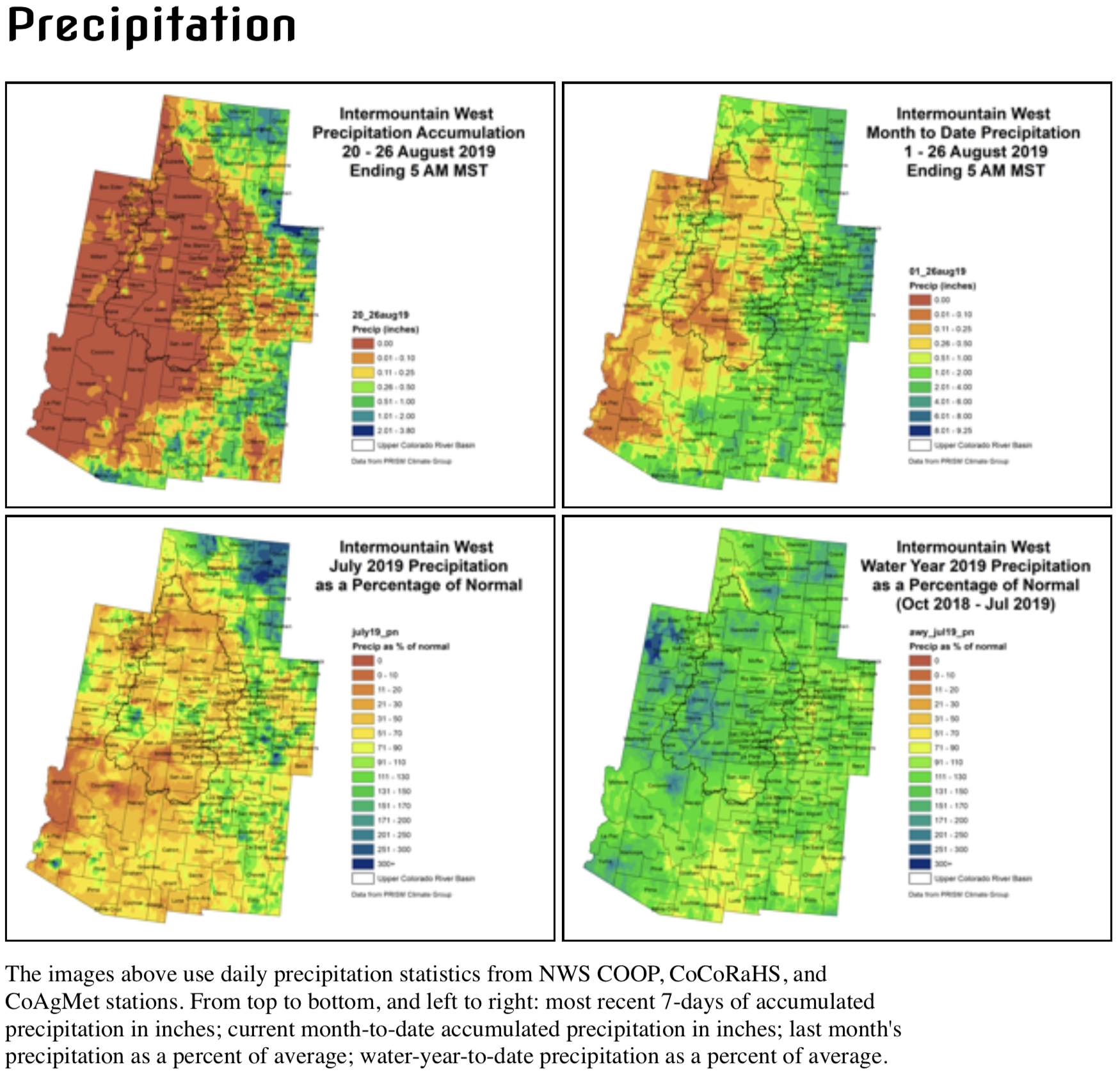
    As a result the water temperature here each summer threatens to exceed the state’s standard for the stream. If Williams can cool down his reach of the river, it will help everyone farther down and closer to Steamboat Springs.
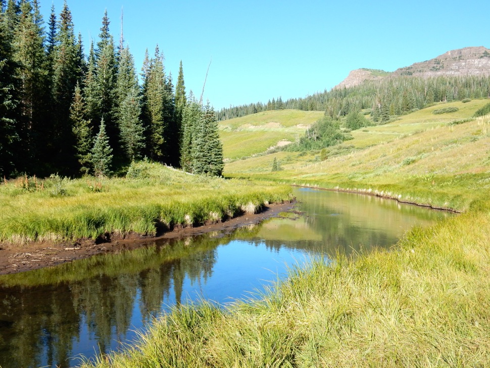
    To achieve this, he has partnered with federal agencies to shore up the river’s banks, deepening it as it curves, snakelike, through the wetlands and pastures above Lake Catamount.

    This land hasn’t been grazed in 10 years, Williams said, and he’s hopeful the bank restoration work, as well as the re-treeing effort, will give this stretch of the river the assistance it needs to heal.

    Williams understands the magnitude of the work that lies ahead and the challenges, the discrepancy in scale between young trees and a sprawling Western river, and the global dilemma of warming. “We will see how this goes,” Williams said. “It is a Band-aid, but it’s one I think will last at least through my lifetime.”

    Romero-Heaney and other river advocates know that they will likely never see the final results of this reforestation effort, but based on the preliminary studies, they see it as an important tool for helping this playful, powerhouse of a river flourish in a very different world than it has inhabited up until now.

    “I have to believe that if any river can persist through climate change, it will be the Yampa,” Romero-Heaney said.

    This story is made possible, in part, by The Water Desk, an initiative of the University of Colorado’s Center for Environmental Journalism.

    Jerd Smith is editor of Fresh Water News. She can be reached at 720-398-6474, via email at jerd@wateredco.org or @jerd_smith.

    Rio Grande cutthroat trout restoration project cancelled for this year — CPW

    Here’s the release from Colorado Parks and Wildlife (Joe Lewandowski):

    A project to restore native Rio Grande cutthroat trout in the Great Sand Dunes National Park and Preserve has been postponed and will not occur this year, Colorado Parks and Wildlife has announced.

    Due to the long winter and cool temperatures, biological conditions in the creek and lakes were not suitable to conduct the chemical treatment operation that was planned for the week of Aug. 26. The project will be rescheduled for next summer.

    The project was planned for Upper Sand Creek Lake, Lower Sand Creek Lake and Sand Creek.

    All regular fishing regulations for that area will resume again on Aug. 26. In preparation for the project, CPW had removed all bag and possession limits in late July.

    Colorado Parks and Wildlife, the National Park Service and Trout Unlimited are working cooperatively on the plan to bring the native Rio Grande cutthroat back to its original habitat.

    Kevin Terry, a project coordinator for Colorado Trout Unlimited, holds up a Rio Grande cutthroat trout at Upper Sand Creek Lake.

    West wrestles with #ColoradoRiver “grand bargain” as changing climate depletes water governed by 1922 compact — The Denver Post

    In 1922, Federal and State representatives met for the Colorado River Compact Commission in Santa Fe, New Mexico. Among the attendees were Arthur P. Davis, Director of Reclamation Service, and Herbert Hoover, who at the time, was the Secretary of Commerce. Photo taken November 24, 1922. USBR photo.

    Here’s an in-depth look at governance in the Colorado River Basin in the coming years from Bruce Finley writing for The Denver Post. Click through and read the whole article. Here’s an excerpt:

    The grand bargain concept arose from increasing anxiety in booming Colorado and the other upper-basin states — New Mexico, Utah and Wyoming — about their plight of being legally roped into sending more water downriver, even if dry winters, new population growth and development made that impossible without shutting faucets…

    Total water is decreasing in the 1,450-mile river, which trickles from high mountain snow northwest of Denver and carves canyons up to a mile deep. Over the last 15 years, amid a climate shift toward aridity, warming has reduced the river’s flows by at least 6%, according to research based on federal hydrology and temperature data.

    Yet the Colorado River remains the primary water source for an expanding population of 40 million people and 90% of the nation’s winter vegetable production — one of the most over-allocated rivers in the world, with water taken out each year exceeding natural flows from rain and snow.

    The grand bargain would remove the legal right to “call,” or demand, more water during dry times that was established by the 1922 Colorado River Compact.

    Colorado farmers and Front Range cities no longer would face the threat of downriver states legally mandating that more water be left in the river, forcing shut-offs. In return, lower-basin states would be guaranteed a set amount, possibly less than what they’re currently using, and gain time to stop their steady draw-down of the Lake Mead reservoir, which remains less than half full even after a wet winter. The upriver Lake Powell reservoir, also less than half full, would serve as storage to help lower states adjust to living on less water…

    California officials this week indicated an interest in exploring new ways to address climate warming impacts. But Chris Harris, director of the Colorado River Board of California, told The Denver Post his state is not ready to discuss any specific bargain that would require giving up a legal right to “call” for more water. And John Entsminger, manager of the Southern Nevada Water Authority manager and his state’s chief negotiator, questioned how the bargain would help the lower states.

    The serious behind-the-scenes contemplation of this bargain “reflects the current conditions on the river — the extended drought we’ve been through, the speed at which the system has gone down, the reality of a warming climate and what that is going to mean for flows,” said Jim Lochhead, the manager of Denver Water who previously served as Colorado’s director of natural resources and represented the state in river negotiations with other western states.

    While Lochhead discussed the bargain in an interview with the Post, he said he hasn’t taken a formal position supporting any specific proposal.

    “What we need is some kind of arrangement that gives the lower basin time to manage demands and solve their structural deficit problems” — overuse — “and also provide some assurance, in exchange for that time, to the upper basin that we are not going to be facing a legal crisis in the form of a compact ‘call’ or some type of curtailment,” Lochhead said.

    “From a Colorado perspective, my interest would be that Western Slope irrigated agriculture and the economy on the Western Slope be protected, and, obviously, that Front Range municipalities that rely on the Colorado River be protected in our water supplies. … That would be our starting point,” he said.

    “Given the status of the reservoirs. … the speed at which Powell and Mead have dropped, we don’t have the luxury to take a lot of time and deal around the edges of the problems. We need to think about some bigger, and different, solution to resolve the deficit that is staring us all in the face.”

    Fish ladders and boat chutes part of a massive dam rebuild on the #ArkansasRiver — @ColoradoSun

    Homestake Arkansas River Diversion. Photo credit: Colorado Springs Utilities

    From Colorado Springs Utilities:

    Project Overview / Background

    The Homestake Project is a trans-mountain raw water collection, storage, and delivery system co-owned and operated by the cities of Colorado Springs and Aurora, Colo.

    The Homestake Arkansas River Diversion (ARD), between Granite and Buena Vista, Colo., was constructed in 1964 as the original intake for the Otero Pump Station. Water is now primarily withdrawn from Twin Lakes, however the ARD remains an alternate point of diversion. The ARD has deteriorated and requires repair. The ARD was not originally designed as a navigable facility.

    Colorado Parks and Wildlife (CPW) manages the Arkansas Headwaters Recreation Area (AHRA) which includes the site of the ARD. CPW expressed interest in partnering with Springs Utilities on a rehabilitation project to include a boat chute for downstream navigation as this location is currently considered the only non-navigable reach of the Arkansas River between Leadville and Canon City, Colo.

    The Upper Arkansas River is both one of the most heavily used rivers in the United States for whitewater recreation and is a Gold Medal Trout Fishery. The river is managed to support multiple objectives including water supply and delivery and outdoor recreation.

    The cities of Aurora and Colorado Springs are constructing a rehabilitation project that will replace the intake and diversion, provide a boat chute for downstream navigation, and provide upstream fish passage for spawning of brown and rainbow trout. The project also included improving river safety for recreational users and providing whitewater boat portage. User safety was an extremely important design consideration.

    A physical model was constructed to test and refine hydraulic elements to optimize performance, maximize user safety and meet design guidelines for recreational whitewater for all three components: boat chute, fish passage and the new intake structure.

    The $9 million construction cost of the project is being jointly funded by the cities of Aurora and Colorado Springs. $1.2 million in grants is coming from Colorado Parks and Wildlife and the Colorado Water Conservation Board through grant funding to support the Colorado Water Plan (Water Supply and Demand Gap and Environmental and Recreation Grant Programs). The Pueblo Board of Waterworks is donating the easements necessary to construct and maintain the diversion.

    Here’s a report from Jason Blevins writing for The Colorado Sun:

    But just below the former riverside mining camp of Granite, where a dilapidated dam built in 1964 has long blemished the Arkansas River’s beauty, rebar jutted from concrete blocks, preventing raft passage and spawning trout battled the steep wall of blasted rocks to reach upstream pools.

    “Not a lot of thought went into recreation or fish when this dam was built,” said Ronald Sanchez, an engineer with Colorado Springs Utilities.

    A lot of thought is going into fish and recreation now, as water managers in Colorado Springs and Aurora join the Colorado Water Conservation Board, the Pueblo Board of Water Works, Colorado Parks and Wildlife and the Arkansas Headwaters Recreation Area in rebuilding the diversion that directs water to the Front Range.

    The $9.1 million project will make the entire river from Leadville to Cañon City navigable for rafts for the first time in at least 55 years.

    It’s part of the vast Colorado Springs- and Aurora-owned Homestake Project that brings Eagle River Basin water from the Holy Cross Wilderness to the Arkansas River Basin, through the Homestake, Turquoise and Twin Lakes reservoirs for delivery to the Front Range cities.

    The cities started construction of the Arkansas River diversion in July 2018, creating three distinct channels below a rebuilt intake that serves as a backup water diversion to the Otero Pump station downstream of Twin Lakes Dam. Before the Twin Lakes Dam was built in the late 1970s, the diversion was the original intake that collected and directed water to the Otero Pump station for delivery to Aurora and Colorado Springs.

    One channel is a fish ladder for spawning brown and rainbow trout. Another channel is a spillway to accommodate flood-level flows like the ones that swelled the Arkansas River this spring. And a third is a series of six drops allowing rafts safe passage.

    The project marks a new era of collaboration between the diverse interests on the Arkansas River between Leadville and Cañon City, one of the most recreated stretches of river in the U.S.

    “For me the coolest thing about it is that you have these large water utilities in Colorado going above and beyond to do the right thing for the next 50 years,” said Salida-based whitewater park engineer Mike Harvey.

    Ten years ago, Harvey helped the Arkansas Headwaters Recreation Area craft a report urging Aurora and Colorado Springs to consider recreation and fish when it came time to rebuild the Granite Dam diversion…

    The Arkansas River accounts for more than $74 million of the $177 million in economic impact created by commercial rafting in Colorado. The 102 miles of river in the Upper Arkansas River Valley also ranks among the 322 miles of Colorado waterways that qualify as Gold Medal Fisheries that can yield a dozen large trout per acre. It also supplies a large percentage of water to Colorado Springs and Aurora via the 66-inch pipeline that runs from the Otero Pump Station.

    Rebecca Mitchell, the executive director of the Colorado Water Conservation Board, said the project exemplifies the collaboration of the Colorado Water Plan, which gathered perspectives from all types of water users in the state to create a policy roadmap for future water planning across the state.

    Colorado Parks and Wildlife and the conservation board provided $1.2 million in funding through Colorado Water Plan grant programs.