Volunteers gathered at Confluence Park to remove pounds of trash as part of a monthly cleanup of the river, hosted by Environment Colorado, Colorado Public Interest Group and Patagonia. The groups host the cleanups in the warmer months and focus on advocacy indoors during winter. of trash from the river.”]
Kristine Oblock, of Environment America, said the groups collected about 460 pounds of trash Sunday. Last month, 30 volunteers collected more than 180 pounds of trash from the river.
Environment Colorado organizers also encouraged attendees to participate in a social media campaign where they take pictures of themselves holding up signs about why water matters to post online. Participants were encouraged to tag Denver Councilwoman Kendra Black who is working with other council members on a proposal to ban plastic bags in Denver.
Top 10 sources of plastic pollution in our oceans.
Gering-Ft. Laramie-Goshen canal. Photo credit: Wyoming Farm Bureau Federation
Here’s the release from Governor Gordon’s office:
Governor Mark Gordon expressed his gratitude to Wyoming and Nebraska’s congressional delegations, Nebraska Governor Pete Ricketts and State of Nebraska agencies, and especially to State of Wyoming agencies for their collaborative efforts to address the ongoing needs of farmers impacted by the July 17 Goshen/Ft. Laramie irrigation tunnel collapse. These efforts contributed to today’s announcement by the United States Department of Agriculture’s Risk Management Agency that crop losses and prevented planting due to the collapse will constitute an insurable event.
“We wouldn’t be here today if it weren’t for the diligent work of the Wyoming Office of Homeland Security, Wyoming State Geological Survey, Wyoming State Engineer’s Office and the Wyoming Department of Agriculture, alongside our counterparts in Nebraska, to help provide the necessary information to open the doors for crop insurance coverage for producers in the affected area,” said Governor Gordon. “The State of Wyoming will continue our ongoing efforts to obtain additional assistance for farmers impacted by this event. Many thanks to the numerous federal, state and local elected officials for bringing their resources to the table as well.”
The July 17, 2019 irrigation tunnel collapse and subsequent breach of a canal wall cut off irrigation to more than 100,000 acres of farmland in Wyoming and Nebraska. Work to repair the irrigation tunnel and stabilize a sinkhole that formed above the tunnel’s roof is continuing.
“The Wyoming Office of Homeland Security, our other sister agencies and Goshen Irrigation District have provided much-appreciated leadership since the collapse,” added Doug Miyamoto, Director of the Wyoming Department of Agriculture. “We need to continue this collaboration to ensure that the irrigation system is restored as quickly as possible. It is vital that we exhaust all avenues of potential assistance to our producers in the aftermath of this disaster.”
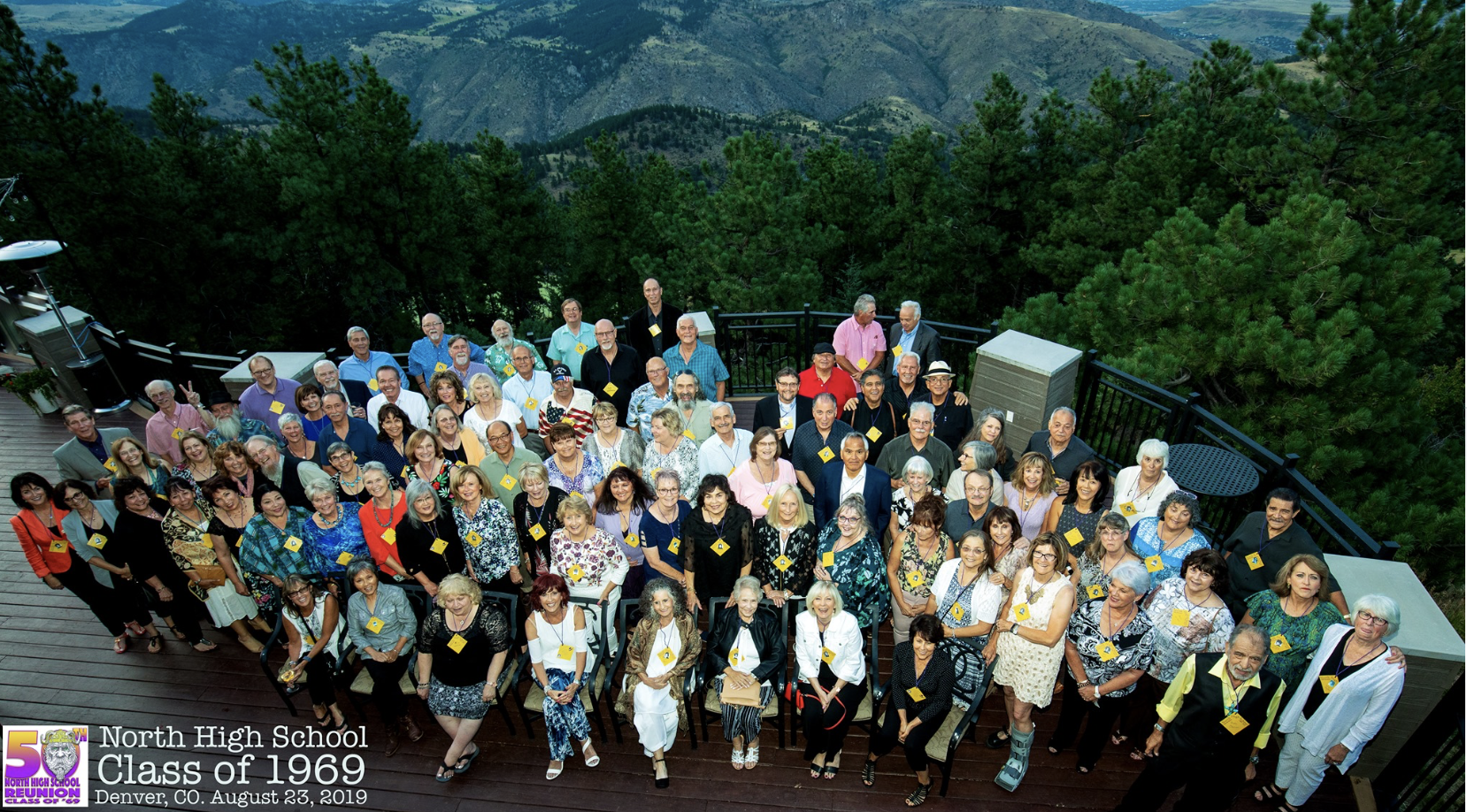
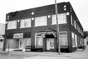
Denver North High School class of 1969 50th Reunion at the Mount Vernon Canyon Club August 23, 2019. Photo credit: Allen Jimenez
I had a great time at my 50th high school reunion this weekend at Mount Vernon Canyon Club and at Denver North High School. It was amazing to see so many classmates. When I couldn’t remember someone I told them it was because I was always ditching school back then so I mainly knew my fellow juvenile delinquents.
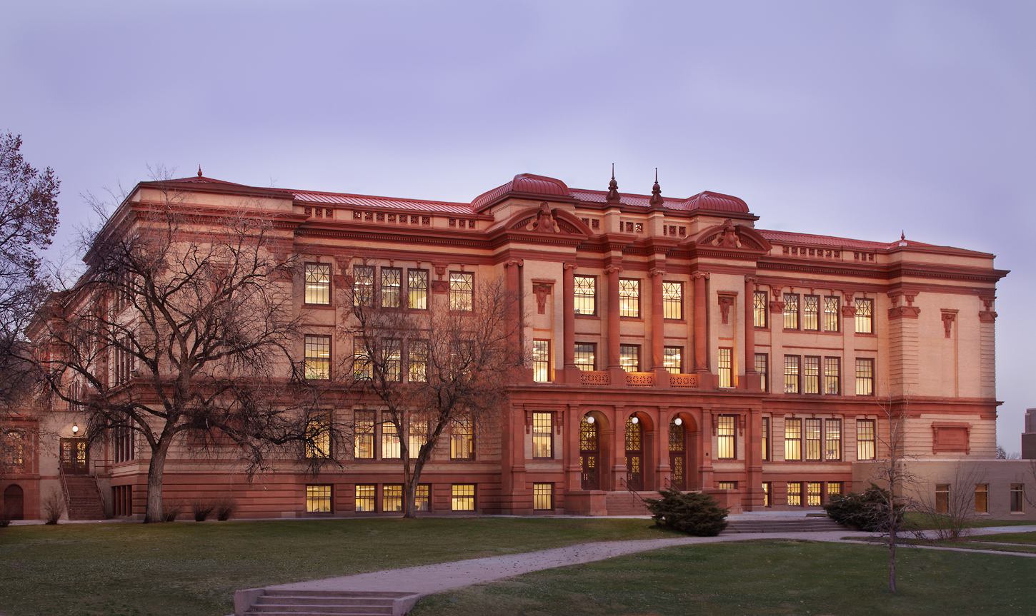
Denver North High School at dusk. Photo credit: Humphries Poli ArchitectsFrom a hallway at Denver North High School August 24, 2019.Wood carving of a Viking ship from the Denver North High Alumni Center August 24, 2019.
Air Force officials released the results of a 2018-2019 Site Inspection at the U.S. Air Force Academy that assessed the potential for Perfluorooctane sulfonate (PFOS) and Perfluorooctanoic acid (PFOA) presence in ground water, surface water, soil and sediment samples stemming from past firefighting activities.
The Air Force Civil Engineer Center confirmed that groundwater samples from several areas on the Academy were found to be above the Environmental Protection Agency (EPA) Lifetime Health Advisory (LHA) levels of 70 parts per trillion for PFOS and PFOA.
PFOS and PFOA are part of a family of synthetic fluorinated chemicals called per-and polyfluoroalkyl substances, used for many years in industrial and consumer products that resist heat, stains, grease and water, as well as in commercial industry and military firefighting foam.
Colorado Springs Utilities supplies the drinking water to the Air Force Academy and has not detected these compounds at its water treatment facilities above the method reporting limit of 10 ppt, including its most recent voluntary sampling conducted in the 1st quarter 2019.
However, because levels above the LHA were found in groundwater on the Academy, drinking water wells south of the base could be impacted.
The Air Force will conduct an Expanded Site Inspection in the coming months to assess potential risk to private wells south of the Academy, primarily in the Woodmen Valley area
“We share community concerns about the possible impacts past use of these chemicals may have on human drinking water sources,” said Col. Brian Hartless, 10th Air Base Wing commander. “We will work closely with AFCEC to protect human health and conduct a thorough inspection to ensure safe drinking water.”
Where Air Force operations are found to have contributed to PFOS and PFOA levels in drinking water above the EPA LHA, the Air Force will take immediate action to ensure residents whose private drinking water wells are impacted have access to safe drinking water.
The EPA established a LHA level of 70 parts per trillion for PFOS and PFOA in drinking water in 2016. The Air Force Academy is one of 203 installations the Air Force identified as a potential Aqueous Film Forming Foam (AFFF) release location.
Air Force Academy firefighter training a quarter century ago released a torrent of toxic perfluorinated chemicals that seeped into groundwater and flowed into Monument Creek, a 15,000-page Air Force report released Friday shows.
A series of tests by Air Force researchers showed groundwater had 1,000 times the level of perfluorinated compounds considered safe by state and federal regulators. Records on the training that used firefighting foam loaded with the chemicals are spotty to non-existent at the academy, the report said, but hazy recollections of the training, which ran from the late 1980s to the early 1990s at the pit, less than 100 yards from the creek, led to the recent tests.
Colorado’s health department on Friday recommended that anyone who uses groundwater south of the academy who hasn’t had their well tested should switch to bottled water. The same holds true for anyone whose wells exceed the EPA’s health advisory of 70 parts per trillion after testing.
About 30 domestic or household wells exist within one mile downstream of the Air Force Academy, according to the Colorado Department of Public Health and Environment.
The Air Force plans to go door-to-door in the affected area to determine if private wells are being used for drinking water, the agency said. In the process, the Air Force plans to take up to 125 drinking water samples from potentially affected private or municipal drinking water wells.
“Our focus is on ensuring no one is drinking water above the EPA’s (advisory level),” the academy said in an email. “In the event any human drinking water sources (are) believed impacted … the Air Force will take immediate measures to provide bottled water or other alternative sources until more permanent mitigation can be installed.”
Colorado Springs Utilities says the chemicals from the academy won’t impact drinking water in the city.
The utility said its wells on and near the Air Force Academy have hardly — if ever — been used. The utility has traditionally relied solely on surface water to supply people on its system. The last time the utility used any wells in its system was around 2002 or 2003, during a significant drought, said Steve Berry, a utilities spokesman. That use was “very limited,” Berry said, though he was unsure whether wells near the academy were used at that time.
FromThe Colorado Springs Gazette (Ellie Mulder, Jakob Rodgers):
Plans are underway to begin testing drinking water wells south of the academy in the Woodmen Valley area after unsafe levels of the chemicals were found at four locations on base, the academy said Thursday.
It was unclear Thursday evening how many people and wells could be impacted.
The discovery of perfluorinated compounds at the academy opened a new front in the region’s battle against chemicals that have fouled an aquifer serving more than 64,000 people just 20 miles to the south, outside Peterson Air Force Base.
And it threatened to push the price tag to remove the chemicals from drinking water here ever higher, beyond the $50 million spent by the Air Force…
Air Force officials stressed that drinking water at the academy wasn’t affected — the base is supplied by Colorado Springs Utilities, which has not detected the chemicals in its water.
Utilities customers south of the academy should not have detectible exposure to the chemicals, said Dave Padgett, the utility’s chief environmental officer.
Unclear, however, is whether residents in that area are using private wells for drinking water and if the wells are contaminated.
Lt. Col. Tracy Bunko, an academy spokeswoman, pledged relief for anyone affected.
“Bottom line, we will do everything we can immediately to ensure people have safe drinking water,” including providing bottled water, Bunko said.
Four sites on the academy were found to have chemical levels higher than an Environmental Protection Agency lifetime health advisory of 70 parts per trillion, said Michael Kucharek, another academy spokesman. He declined to name the location of those sites.
An August 2018 Air Force report, however, suggested four possible test sites during such an inspection:
• the academy’s fire training area;
• a fire station and a spray test area;
• an airfield spray test area;
• the academy’s water treatment plant and nonpotable reservoir.
The Washington County Water Conservancy District can generate sufficient revenue to repay the cost of the Lake Powell Pipeline Project over the coming decades through a series of rate and fee increases, according to a state audit released earlier this week.
However, the audit, released by the Office of the Legislative Auditor General, also notes that much of the water district’s repayment model for the 140-mile pipeline – estimated to run between $1.2 and $1.8 billion – is largely predicated on continuing future growth. It also points out other concerns, such as the impact of possible future recessions and a reduction in water use due to increased water rates.
“It’s nice to have an independent party look at what we’re doing and confirm that the finance plan we have will produce enough revenue to pay for this project,” Ron Thompson, the water district general manager, told St. George News Friday.
However, in response to some of the concerns raised in the audit released Wednesday, Thompson said, “We can’t have a ‘the sky is falling’ attitude in the water community or we’ll completely jeopardize the economy of this county.”
Being in the middle of a desert, Thompson has previously and repeatedly stated water use is one of the foundations of Washington County’s economy and its ability to grow, which underlines the need for the pipeline.
The water district plans to repay the state for the pipeline through increases in impact fees, water rates and property taxes over the coming years and decades.
“The finance model is designed to let growth pay for a significant portion of the project,” Thompson said.
Impact fees are slated to cover 70% of project costs.
As a part of the plan to have impact fees cover the costs, the water district is adding $1,000 annually to its impact fees through 2026. The water district’s impact fees for new construction were set at $7,417 in 2017 and will ultimately rise to $15,448.
Washington County’s impact fees are already among the highest in the state, according to the audit.
Reliance on impact fees is contingent on continuing growth as well, which the audit said, along with other factors, the water district has no control over. If there is a population slowdown, that could also impact the water district’s ability to repay the state.
However, Karry Rathje, public information manager for the water district, said there isn’t so much a worry about the county’s rise in population slowing down as much as it outpacing state projections, which it has on a routine basis.
“While that is a potential risk, we consider the greater and more likely risk to be growing faster than projected – as we have done for the past 50 years – and having an inadequate water supply to support our population and economy,” Thompson wrote in the water district’s official response to the audit. “Growing at a faster rate would increase planned revenue, which is not stated in the audit.”
Wholesale water rates, which the water district has been adding ten cents to annually since 2016 per 1,000 gallons, will eventually rise to $3.84 per 1,000 gallons by 2045. From the original wholesale cost of $0.80 in 2016, the eventual cost will hike water rates an estimated 357%.
Though the audit states Washington County currently has low water rates when compared to other cities in other states, it also states increasing water rates will likely cause consumers to use less, which can impact the amount of revenue the water district anticipates collecting from this source…
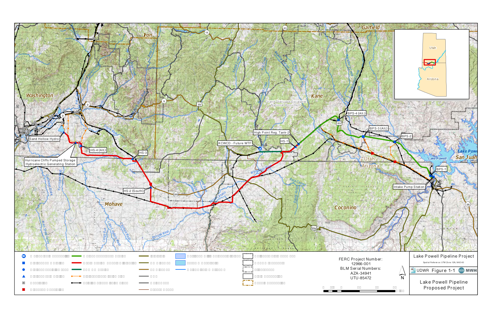
The 140-mile, 70-inch diameter Lake Powell Pipeline will run from Lake Powell to the Sand Hollow Reservoir with a projected route that will snake across the Utah and Arizona border over public and private land, carrying around 77 million gallons a day to 13 communities in Kane and Washington counties.
Local water and elected officials have repeatedly stated the needs for a pipeline due to continuing growth, as well as the economic benefit it is expected to generate in the long run.
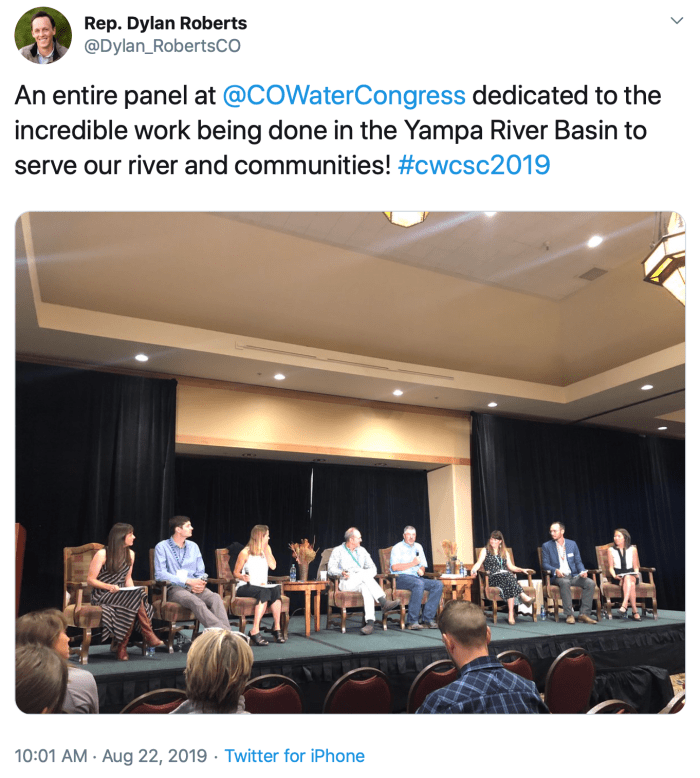
Click here to view the Twitter fest around hash tag #cwcsc2019. I had a great time reading everyone’s Tweets. It is interesting to see what each person takes away from a session and what they feel is important to point out.
Pictured: Jackie Brown, Nancy Smith, Kevin McBride, Mickey O’Hara, Kelly Romero-Heaney, Mike Camblin, Jojo La, Hunter Causey. (Not in order.)
The legislature’s Interim Water Resources Committee met after the conference. Here’s a report from Marianne Goodland that’s running in The Colorado Springs Gazette. Here’s an excerpt:
The Colorado Legislature’s interim water resources review committee, a bipartisan group of 10 lawmakers, began its summer work by relaunching efforts to change the state’s instream flow program.
During the 2019 session, the committee sponsored two bills that would have made some fairly big changes to the state’s instream flow (program, though neither bill made it out of Senate committee…
Instream flow is the water that flows through a stream, river or creek. Programs that manage instream flows do so to protect fish habitats and for recreational purposes.
Colorado’s instream flow program, according to Colorado Water Conservation Board’s Linda Bassi, is intended to “preserve the natural environment to a reasonable degree.”
As the years have gone on, the board has also received permission to improve instream flows within the program.
Bassi explained to the interim water committee at Wednesday’s session, held during the Colorado Water Congress summer conference in Steamboat Springs, that the program was established in 1973 to allow state control over Colorado water and under Colorado’s water rights and prior appropriation system.
The original legislation was also intended to block ballot measures (one was already in the works) that would have allowed for private instream flow programs.
Over the years, the Colorado Water Conservation Board has acquired water rights, often donated, to protect streams, now to the tune of 756 stream miles, Bassi explained, and for 1,700 stream segments around the state.
Some of those water rights are new ones, others are existing and donated, although that doesn’t happen very often, she added.
One of the program’s provisions allows for for temporary water “loans” for three years out of a 10-year period; they can be used on any segment of a stream decreed as part of the instream flow program.
It’s a one-and-done situation; once the three years are up, that water cannot be diverted into the stream by the water provider, nor can the contract be renewed.
Bassi told lawmakers only eight temporary leases have been developed since 2012.
Click on a thumbnail graphic below to view a gallery of drought data from the US Drought Monitor.
US Drought Monitor August 20, 2019.
West Drought Monitor August 20, 2019.
Colorado Drought Monitor August 20, 2019.
Click here to go to the US Drought Monitor website. Here’s an excerpt:
This Week’s Drought Summary
The United States is in the thralls of summer, and with that can come heat, flash droughts, and occasional, if not frequent, thunderstorm activity. Several areas of the U.S. experienced extreme heat this past week, particularly notable across much of the South and in the East. Parts of western Texas and eastern New Mexico were 6-10 degrees F above their typical averages, with little rainfall to speak of in much of the region. On the other hand much of the northern tier of the U.S. into the Upper Midwest was cool for this time of year, although precipitation amounts there were a mixed bag. In the Southwest, the North American monsoon continues to fail, worsening conditions in areas that had received more than ample precipitation over the winter and spring. To the north, south central Alaska continues to see record or near-record heat and dryness, and conditions are deteriorating quickly there, with severe impacts…
Eastern Nebraska was fairly dry over the past week where the D0 is present. With little rainfall over the past month and a half, the D0 area was extended slightly north into Thurston and eastern Wayne counties. To the north, some beneficial rains fell across North Dakota over the last week; however, considering local crop impact reports, only the D0 area in the west central region was improved to normal. Unfortunately, the rains were not adequate enough for improvement across the northern tier of the state…
Far into the monsoon season, the rains continue to fail in the Southwest. Only the abundant precipitation that fell last winter is keeping substantial impacts at bay so far this summer. Even so, declining topsoil moisture and poor rangeland conditions through Mohave County, Arizona, are now being reported. Abnormally dry conditions (D0) were expanded nearby in central and north central Arizona through all of Yavapai County and most of Coconino County. It was also expanded southwestward into Riverside and Imperial Counties in California. Moderate drought (D1) was extended farther south in western New Mexico, and a small area was introduced to the south central part of the state at the Texas border. Abnormally dry conditions and moderate drought also crept into the far southeastern corner this week…
Aside from isolated and scattered rains, most of the area was very hot and dry, with daytime temperatures climbing to near or above 100 degrees F over portions of the region. Nighttime temperatures did not help alleviate the heat stress in places. Along the northern Gulf Coast, Galveston, Texas — which had never observed a minimum temperature above 85°F since its records began in 1874 — has recorded three to date this month: on August 8th, 12th, and again on the 18th. Overall, there was some drought relief in a few spots in the South, but mostly there was drought expansion across the area where changes were made this week. There is a flash drought in north central and northeast Texas, with some stations that are 10 inches above normal for the year, but 8 inches below normal for just the past two months. In eastern Texas, abnormally dry conditions (D0) were expanded across much of the area. Reported rainfall in areas was only 20 percent of normal. The D0 in far east Texas expanded eastward into extreme southwestern Arkansas where there have been reports of a sharp drop off in the green up along the interstate across southern Miller County, with some exposed areas browning quickly, and in northwestern Louisiana where reported precipitation at some stations has been just 50-70% of normal over the past two months. In Oklahoma, much of the southwest has seen less than 25% of its normal precipitation over the past two months, and less than 50% over the past three. Severe and moderate drought were expanded here and a couple of pockets of extreme drought (D3) were introduced to the west in the Texas Panhandle. In southeastern Tennessee near Chattanooga, abnormally dry conditions and moderate drought (D1) were each extended farther to the northeast. Over the past month there have been several periods of high temperatures leading to stress on vegetation and livestock…
Looking Ahead
Over the week beginning Tuesday, August 20, according to NOAA’s Climate Prediction Center, dry conditions are expected to continue across much of the western half of the continental U.S. Some heavy rain may fall over parts of the Midwest and Southeast, with as much as five inches in areas of southern Iowa, northern Mississippi, eastern Nebraska, and parts of the Carolinas. Southern Louisiana may see up to seven inches. Looking further ahead to August 25-29, below-normal temperatures are favored across parts of eastern Montana, the Dakotas, Nebraska, Kansas, Minnesota, Iowa, and Missouri, while above-normal temperatures are forecast for parts of the Southern Plains and the Southwest. There are enhanced probabilities of above-normal temperatures for most southern coastal locations of Alaska due to above-normal sea surface temperatures. Near to below-normal precipitation is possible for the west, although parts of Southern California may see above-average rainfall. Rainfall may be above normal across the central and eastern U.S., except for parts of the Northeast. Above-normal precipitation is favored across northern and eastern Alaska, but may be below-normal across southwestern mainland Alaska and the Aleutians, where drought conditions prevail. Please note the forecast confidence for this period is average, according to CPC.
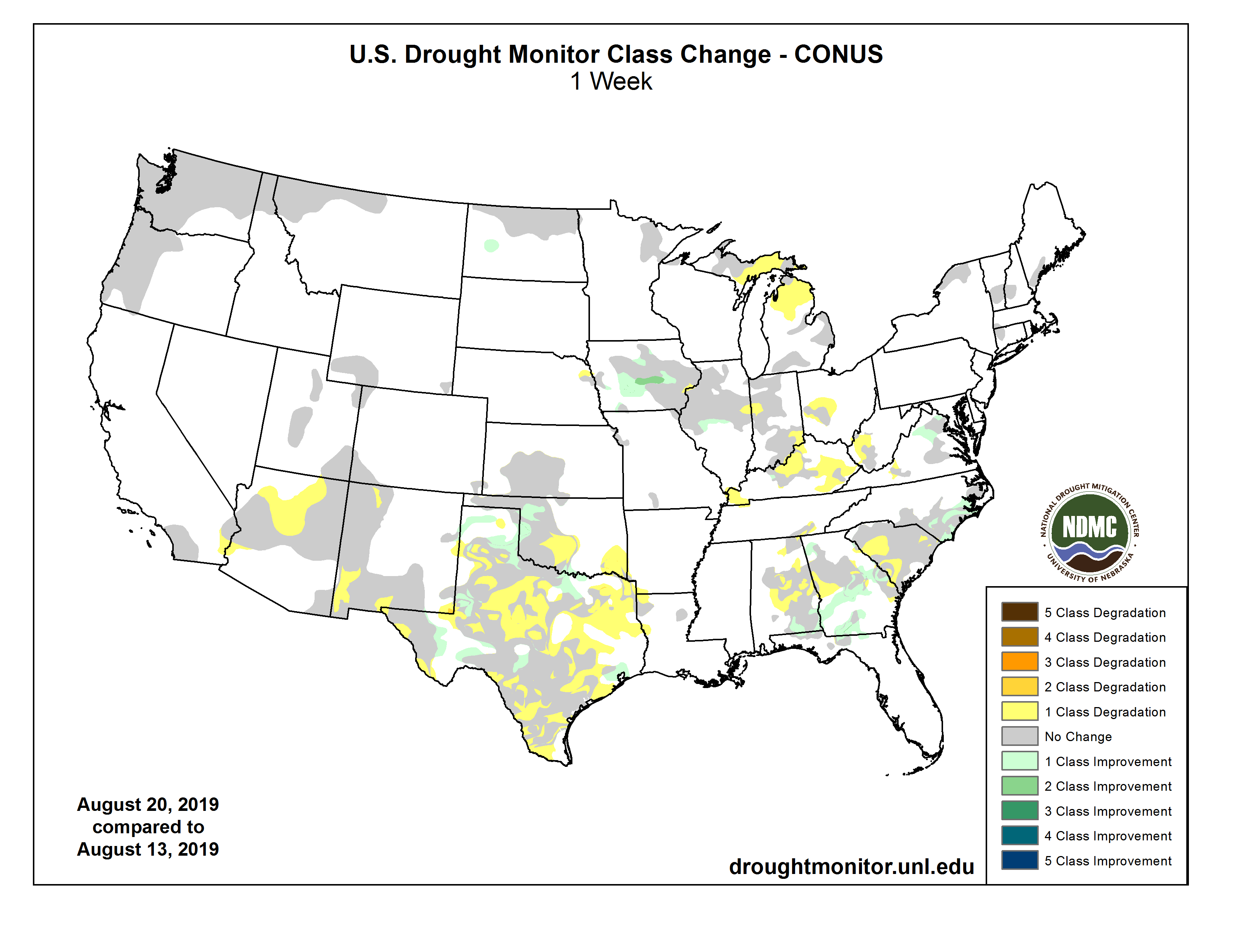
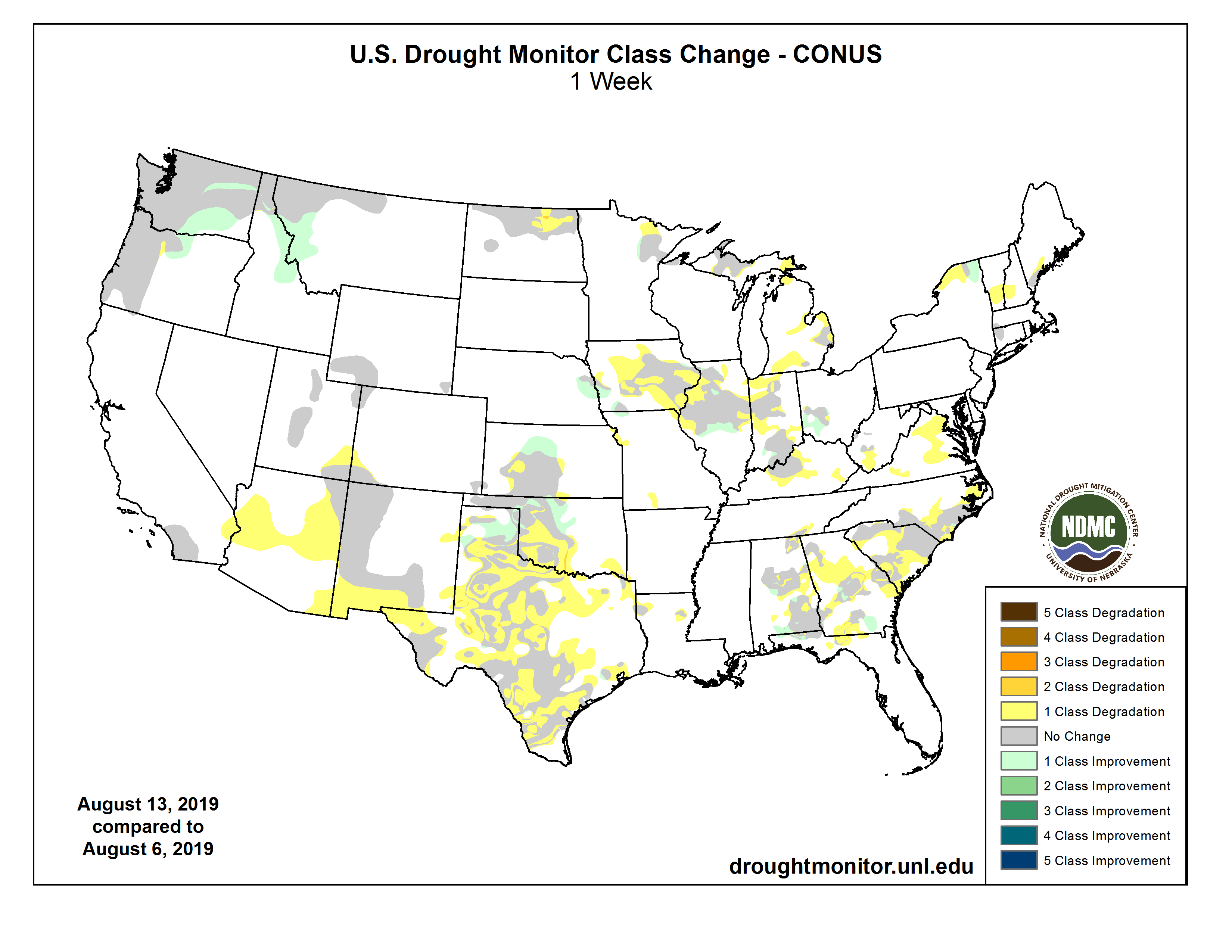
US Drought Monitor one week change map ending August 20, 2019.
I was Bob’s colleague at Davis, Graham & Stubbs and Hobbs Trout & Raley from 1979 to 1996. Bob is one of our finest Coloradans.
When I joined the Colorado Supreme Court in 1996 and became the Justice assigned to the Civil Rules Committee, I recommended Bob’s appointment to the committee. The best of the best trial lawyers served on this committee. They knew Civil Procedure thoroughly – engaging in prolonged, detailed, scholarly and practical debates every time they considered recommending or not recommending an amendment to the Civil Rules. At that time there was no Water Court Committee. So, Bob, the only water attorney on the Civil Rules Committee – and since water court practice also involves the Rules of Evidence and Civil Procedure – through his active and intelligent participation crucially served everyone connected with water court practice and trial practice in general. I mean he held forth with the best of the civil practice attorneys, plaintiff and defense, corporate, the gamut!
I knew Bob would serve well on Civil Rules, for I had experienced his consummate skills as a trial attorney in the federal reserved water rights case involving the forest claims in Water Division No. 1, followed by the very complicated Thornton/Bijou case in which Bob carried a heavy load on behalf of the water users. Bob’s integrity, his calmness under fire (how did he do that!), his meticulous preparation of the facts and expert testimony for trial, and his excellent presentation to the courts both as a trial attorney and an appellate attorney — he exemplified for younger attorneys the traits of a master officer of the court.
Bob was kind, humble, straightforward, true and dedicated to his family. What a fine father to his son and daughter and husband to Jill. For the seventeen years we practiced together, I clearly saw that everyone who came in contact with him relied on his good judgement and his ability to draft all kinds of legal instruments – solving client problems practically with a great deal of equanimity. What a stellar person in all ways with staff, clients, attorneys, engineers, civic organizations and members of the public!
There’s a reason why Bennett and I coaxed Bob to accept the Managing Partner role when we established Hobbs, Trout & Raley in 1992. Competence! We became Hobbs & Trout soon thereafter when Senator Hank Brown asked Bennett to withdraw from the firm and go to Washington D.C. to help the Senator bring about the 1993 Colorado Wilderness Act. When Bennett returned, we became Hobbs, Trout & Raley once again. The firm became Trout & Raley when I joined the Supreme Court in May of 1996. The Northern District’s legal business never skipped a beat! The Board was very confident with Bob as its Principal Counsel. So much so, the District honored his energy and light by naming the hydropower plant on the southern water supply delivery pipeline below Carter Lake’s dam and spillway after him. Very few attorneys are ever honored by such a client in such a way.
When we look to Long’s Peak. When we see the Colorado Big-Thompson pipeline traversing the Great Divide from Long’s Peak to Carter Lake’s dam and spillway – delivering sterling water to the people, farms and businesses stretched out on the plains – we see Bob’s hand at work.
Photo credit: Ute Camp in Garden of the Gods – Library of Congress FromThe Durango Herald (Shannon Mullane):
The Southern Ute Indian Tribe Utilities Division will raise water and wastewater rates by more than 90% and 50%, respectively, starting Oct. 1.
The Southern Ute Utilities Division, administered by the Southern Ute Growth Fund, provides both treated drinking water and wastewater treatment for the tribal campus, local tribal members living near Ignacio and the town of Ignacio. Discussions of rates have caused a rift between the town and the tribe, said Mark Garcia, interim town manager. While the town and the tribe analyze their agreement, ratepayers are stuck paying ever-increasing water and wastewater utility rates.
“Wastewater and water rates are based on usage, and they’re going up,” Garcia said. Utility customers will be hit with the increase at different times, based on their level of use for water and/or wastewater. But for overall water and wastewater rates, “all levels of users will see probably an increase in their rates starting in 2020,” he said.
Starting Oct. 1, ratepayers will pay higher base rates for fewer correlating gallons of water. Water rates will increase from $32.80 per 8,000 gallons to $47.80 per 6,000 gallons, a 94% increase. The rates will jump again Oct. 1, 2020, to $62.80 per 6,000 gallons, a 156% increase over current rates, according to a July letter to Garcia from the tribe.
The town charges customers additional fees for billing, repairs and collections. Garcia said the town’s water fees will increase from $24.60 to $26.48 a month starting Jan. 1, 2020, a 6.4% increase.
Wastewater rates will also increase. Service users currently pay $72.09 per ERT, or Equivalent Residential Tap, per month. One ERT allows for 7,500 gallons of usage.
That billing system will change. The tribal utility will charge the town based on winter usage, not ERT. This shift will also make ratepayers pay more for fewer gallons. On Oct. 1, the rate will increase to $87.09 per 6,000 gallons, a 51% increase over current rates. Wastewater rates will jump again in 2020. Users will be charged $102.09 per 6,000 gallons, a 77% increase over current rates.
The town charges an additional $9.88 base rate to users for billing, repairs and collections.
According to Garcia, the average town customer uses 4,000 gallons of wastewater per month, so ratepayers are paying for more wastewater than they are using.
“With the new rates and winter flow basis, the rates that the tribe charges the town as a bulk customer will actually go down from the current bulk rate charged,” the tribe wrote in a June news release.
Urban water broker builds $22 million reservoir to boost development and agricultural land
The desire to expand housing, commerce and other development around metro Denver and on arid high plains once deemed inhospitable has driven an innovative urban water broker to build a $22 million reservoir on a ranch 70 miles east of the city along the South Platte River.
Water siphoned from the river through a pipeline this summer has filled about a third of this 5,500-acre-foot — or 1.8-billion-gallon — 70 Ranch Reservoir. It’s the latest new storage in an expanding network of reservoirs that United Water and Sanitation District president and ranch owner Bob Lembke is installing to meet rising demands from Front Range suburbs hooked on dwindling groundwater.
Bob Lembke. Photo credit: United Water
The reservoir that Lembke built near his private 13,000-acre 70 Ranch, purchased in 2003, took three years to complete, the largest synthetically lined reservoir west of the Mississippi River. It reflects growing impatience with constraints that could limit development along Colorado’s booming Front Range.
Others in northeastern Colorado also are planning, and seeking funds, to build much larger reservoirs that, like this one, would capture South Platte water otherwise bound for Nebraska. Lembke has been able to avoid red tape — and has left critics asking questions — by working with wealthy water-poor suburbs, building on land he owns and using former gravel pits off the main channel of the river.
“We’d like to try to enhance the economic development. I’m a native. I grew up in Arapahoe County. As a native Coloradan, jobs for my kids, and eventually my grandkids, are important,” Lembke said in a recent interview in his headquarters suite at the Denver Tech Center.
“If you look at Denver, they’ve done a wonderful job planning for their water. But outside of the Denver service area? There’s a lot of challenges in how to get water and economic growth in these areas not served,” Lembke said…
“We have tens of thousands of acre-feet of water that, without storage, will leave the state — to no economic value here in Colorado. We can accommodate a great deal of quality growth. … I am a problem solver. I like to tackle difficult problems. Providing water increases the value of land that otherwise did not have water,” he said…
“Whether on the South Platte River, the Colorado River or the Yampa River, we’re not in favor of converting agricultural water use to municipal use,” said Andy Mueller, manager of the Colorado River District, which represents western Colorado communities.
The new 70 Ranch Reservoir northeast of Denver “brings up questions,” Mueller said. “Is it water to support new growth? Or is it water to support the existing population that is dependent on groundwater?”
The hedge fund investors purchasing land and water rights in western Colorado typically seek double-digit returns, Mueller said. “They believe there’s monetary value there for their investors. We’d say that’s speculation. How do we make sure there is not emerging speculation by outside investors who may not have community values? How do we help farmers and ranchers stay in business?”
Colorado leaders for decades have declined to regulate population growth and development. But the growing private interests in water, perhaps reviving the role private financiers played developing water systems in the 19th and early 20th centuries, has piqued concerns.
“Because traditionally in the West we have the mind-set that water is the property of the people, we are concerned when water is being controlled and distributed by a private corporation that may have very different interests from the collective group of people who are affected by the use of that water,” said Anne Castle, formerly the top federal water official in the Obama administration, now a senior fellow at the University of Colorado Law School’s Getches-Wilkinson Center for Natural Resources, Energy and the Environment.
For an urban water broker to buy agricultural land and install a reservoir “is all perfectly legal and allowable,” Castle said. “But it does make us nervous because we tend to think governmental entities will have some accountability to the people to recognize the different kinds of values people put on water. We just don’t have that assurance with a private corporation.”
Lembke in his role as president of United Water and Sanitation also serves as president of the Weld Adams Water Development Authority, which owns and operates the 70 Ranch Reservoir. He pointed out that these so-called special-use districts are governmental groups…
SIEP Project location map via United Water and Sanitation
Denver-based water attorney David Robbins called Lembke “a very smart man. He is an entrepreneur. He is filling a niche.”
The 70 Ranch site also is used for experiments in drip irrigation, aimed at using water more efficiently to grow plants where otherwise vegetation might not survive…
Lembke now is installing other reservoirs — including two that he would own privately — as part of a network that when completed would store about 30,000 acre-feet for supplying water to suburbs, agriculture, industry and other development along Colorado’s Front Range.
He has built, or is in the process of building, four reservoirs upriver from the 70 Ranch at high-growth locations along the South Platte: in Milliken (12,000 acre-feet), between Commerce City and Brighton (3,500 acre-feet), east of Lochbuie (4,000 acre-feet) and in Fort Lupton (5,000 acre-feet).
These will supply businesses and housing developers in each booming area “to help them achieve their goals for economic growth and development” using surface water from the river rather than by pumping from over-tapped underground aquifers, Lembke said.
“Everything has got a finite limit,” he said. “But if we use water intelligently, we have the potential for long-term growth in this region.”
70 Randh Reservoir: Partnering with the Platte River Water Development Authority, this facility will be used to store water for the support of 70 Ranch’s cattle and farming operations as well as provide storage for local agricultural and municipal water providers. Photo credit: 70 Ranch
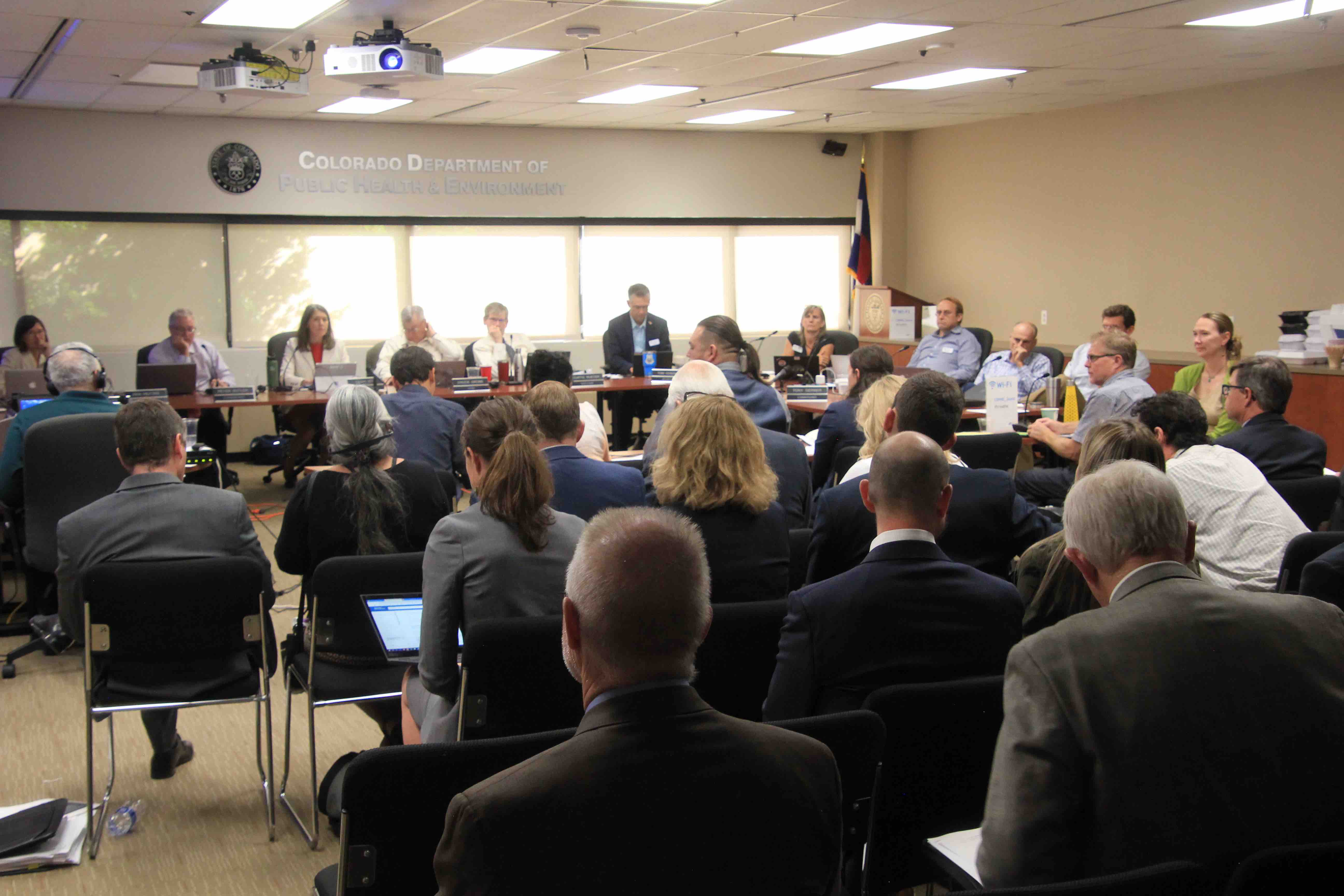
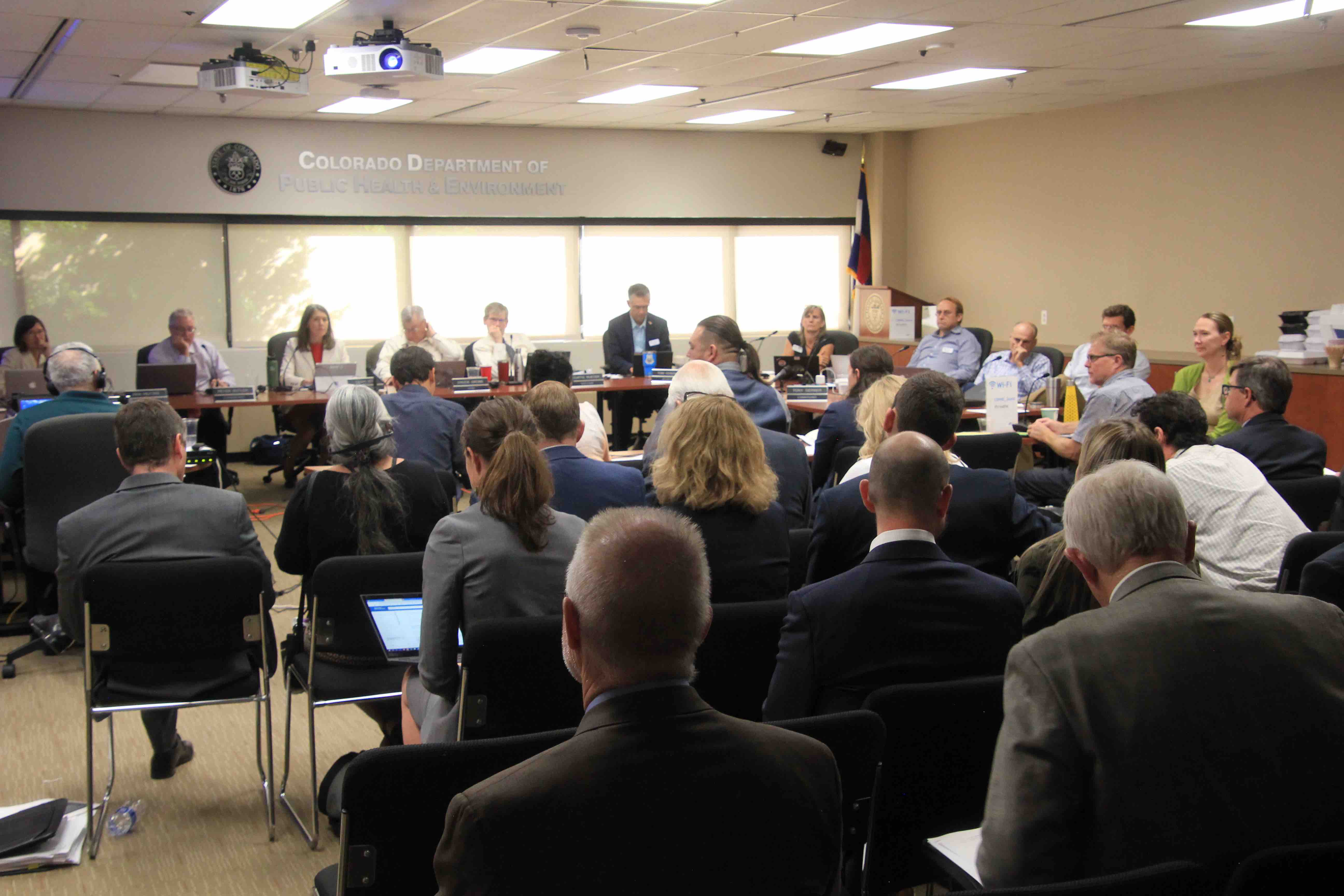
Victims testified left and right at the Colorado Air Quality Control Commission hearing on Wednesday.
Gov. Jared Polis directed the commission to consider adopting provisions of the California zero emission vehicle standard. This would require vehicle manufacturers to increase the number of electric vehicles delivered to Colorado for sale beginning in 2023. With more variety, according to the thinking, consumers will be more likely to purchase electric vehicles.
Why electric vehicles? Two good reasons.
One is to reduce greenhouse gas emissions. Colorado has adopted aggressive goals of GHG reduction. The second reason is to reduce precursors of the ground-level ozone that blankets the northern Front Range from Denver to Fort Collins and Greeley on hot summer days. This area is out of attainment with federal standards.
The standards are based on adverse health impacts. A new study has found that air pollution— especially ozone—can accelerate the progression of emphysema of the lung. Researchers found that bad air pollution can have as much impact as smoking a pack of cigarettes a day.
The Denver-based Regional Air Quality Council testified why electric cars will help the metropolitan area to improve air quality. What the agency calls “on-road mobile sources” contribute 31% of nitrogen oxides and 16% of volatile organic compounds, two contributors to ozone pollution.
Local government groups—including representatives of both Eagle County and Aspen—as well as environmental advocacy groups testified why they supported the ZEV standard.
Then, as the afternoon wore on, two groups with very different opinions took turns at the microphones. First was a collection of groups collectively called the Environmental Justice Coalition. Several identified themselves as being from along Interstate 70 as it passes through Globeville and other communities north of downtown Denver, east of Interstate 25. One woman, speaking in Spanish, which was interpreted, told about the injustice of sending her children to an elementary school there, near the intersection of the two interstate highways, and the pollution from the vehicles that caused harmful health effects such as asthma.
They opposed the widening of I-70, what one speaker, Drew Dutcher, called a 20th century solution to a 21st century problem. They lost that battle. But Dutcher suggested that electric vehicles will reduce the pollution to low-income areas such as his.
Ean Tafoya, from the Colorado Latino Forum, broadened that thought to include those who live along all busy highways. He said that Polis had visited poorer Latino communities and said that prioritizing public health was a high priority. “That’s what makes this an environmental justice issue,” he said.
Then came a group called Freedom to Drive Coalition. It includes Mesa County, Associated Governments of Northwest Colorado, Colorado Motor Carriers Association, Colorado Wheat Growers, Colorado Petroleum Association, and others.
They reject mandates and argued that electric vehicles will be subsidized by purchasers of internal combustion engines, a cost one speaker said would amount to $500 per vehicle. They argued that upper- and middle-class residents of metropolitan Denver as well as places like Aspen would be burdening Colorado’s rural residents.
Elise Jones, a Boulder County commissioner who is also on the Air Quality Control Commission, asked the wheat industry representative if wheat farmers were worried about the effects of climate change. They were worried, he replied, but that was a long-term threat, whereas earning a profit on next year’s crop was an immediate concern. Wheat growers only make money in one out of five years, he said.
The testimony went on and on, and as the afternoon grew long, John Medved, talked. “I have never had anyone tell me they are going on a mountain adventure with an electric car except maybe in the summer,” he said.
Medved also shared this detail: He makes only $400 when sale of a car. All of his significant profits come from other arms of his car dealerships.
It’s perhaps useful to note here that electric vehicles have a reputation of requiring much less maintenance than internal combustion engines, because they have few or no moving parts. As such, they don’t need to be returned to a dealer or some other mechanic for servicing.
What was hard to digest was the argument that rural Colorado would be forced to subsidize urban Colorado. “Simple economics,” one of the Freedom to Drive Coalition. He tried to explain, but the explanation was completely lost on me. Those simple economics also overlook the projections that electric vehicles will reach price parity with internal-combustion engines by 2024-2027.
The Freedom folks also testified that accelerating the adoption of electric vehicles in Colorado will simultaneously raise the price of electricity and raise the price of diesel. Perhaps cause dandruff and bad breath, too?
As I write this, late Thursday afternoon, more than two days after testimony began, the testimony and the questions continue. By the time you read this, a decision will probably have been rendered by the Air Quality Control Commission.
The new standard will provide Coloradans with more vehicle choices
DENVER: The Air Quality Control Commission adopted a zero-emission vehicle standard for Colorado early today in an 8-1 decision. The move is directly aligned with the commission’s mission to achieve the cleanest air practical in every part of the state.
The Colorado Department of Public Health and Environment is pursuing aggressive strategies to reduce ozone pollution as quickly as possible, as the state continues to work to meet the federal ozone pollution standard. Fossil-fuel vehicles are a major source of ozone pollution, along with the oil and gas industry. Ozone pollution can cause asthma and other adverse symptoms. Fossil-fuel vehicles also emit greenhouse gases, which contribute to climate change.
“We are charged up and ready to roll,” said Jill Hunsaker Ryan, the department’s executive director. “The adoption of the zero-emission vehicle standard is a clear demonstration of our unrelenting commitment to making sure every Coloradan has clean air to breathe.”
John Putnam, environmental programs director at the department, said, “We are committed to a state where Coloradans can zip up into the mountains in a zero-emitting vehicle and go for a hike without coughing and wheezing from ozone. It’s what Coloradans rightfully expect and deserve. We’ve made a lot of progress on cleaning up our air over the past several years, but the standards are getting more stringent. We have to rise to the challenge.”
The new zero-emission standard requires automakers to sell more than 5 percent zero-emission vehicles by 2023 and more than 6 percent zero-emission vehicles by 2025. The standard is based on a matrix of credits given for each electric vehicle sold, depending on the vehicle’s zero-emission range.
The new requirement does not mandate consumers to purchase electric vehicles, but experts say it will result in manufacturers selling a wider range of models in Colorado, including SUVs and light trucks.
“The zero-emission standard does not compel anyone to buy an electric vehicle, said Garry Kaufman, director of the Air Pollution Control Division at the department. “It only requires manufacturers to increase ZEV sales from 2.6 percent to 6.23 percent. It’s a modest proposal in the face of a critical threat. Where the federal government refuses to act, states must lead. Time is of the essence.”
The Air Quality Control Commission prioritizes stakeholder engagement and public input.
The commission invited public comment at various hours of the day and evening, and also invited remote testimony by telephone to make it easier for those who could not travel to the Front Range. The commission’s decision came after a robust public comment period, as well as significant written and oral testimony from parties providing information on all aspects of the standard.
“The commission was impressed by the overwhelming amount of public support for electric vehicles from urban and rural areas throughout the state,” said Trisha Oeth, the department’s director of environmental boards and commissions. “They noted that the public want these vehicles, want them more quickly, and want more choices.”
Bicycling the Colorado National Monument, Grand Valley in the distance via Colorado.com
FromThe Grand Junction Daily Sentinel (Dennis Webb):
Last winter’s big snowpack has helped ease the impacts that long-term drought has had on water storage in the Colorado River watershed, but reservoir storage levels are still low enough that provisions of a new drought contingency plan in Lower Basin states already are kicking in.
Some water officials and conservationists say the triggering of plan components reflects the fact that a single bountiful water year is far from enough for storage to recover from a mostly dry period dating back to 2000, and recently adopted drought planning measures are needed to prepare for the very real possibility that drier years will return. Those measures involve Upper Basin states including Colorado.
The reductions that the Lower Basin drought contingency plan already is requiring show that in its first year, the plan “is already working,” Chuck Cullom, Colorado River programs manager for Arizona’s Central Arizona Project, wrote in a blog on that entity’s website.
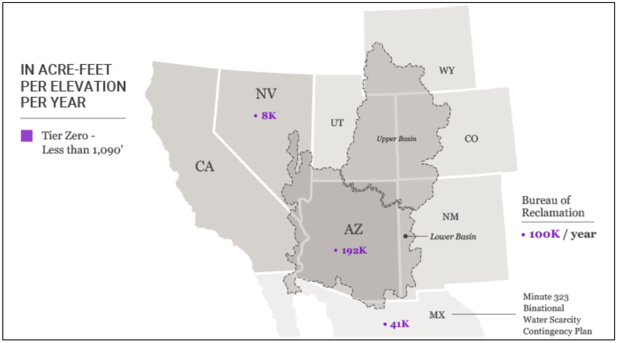
The Central Arizona Project is a water provider that will see its supplies reduced by 192,000 acre-feet next year under the plan’s provisions. That is the entire part of the state of Arizona’s Colorado River water allocation that the state instead will leave in Lake Mead under the plan, as a result of projected water levels in that reservoir at the start of next year. Nevada and Mexico also will leave smaller amounts of their allocation in Lake Mead under the plan and a separate agreement involving Mexico.
The actions are required based on a Colorado River Basin report released Thursday by the U.S. Bureau of Reclamation. It projects that Lake Mead will begin next year with water at an elevation of 1,089.4 feet. That’s less than a foot under a 1,090-foot threshold set by the Lower Basin drought contingency plan, below which the mandatory austerity measures begin. California will have to start leaving a portion of its allocation in the reservoir should surface levels go below 1,045 feet.
Lake Mead and Lake Powell upstream of it serve as the two largest storage pools in the Colorado River Basin. The Bureau of Reclamation reported that thanks to above-average snowpack, runoff from the Upper Basin into Lake Powell was 145 percent of average from April through July, raising Powell’s elevation by more than 50 feet. But it is projected to remain 81 feet below full as of the start of next year.
The Bureau of Reclamation says that total Colorado River system storage today is at 55% of capacity, up from 49% a year ago…
“One wet year doesn’t change the fact that we have a lot left to do,” said Bart Miller with the Western Resource Advocates conservation group.
He said the big snowpack provides some breathing room in dealing with the longer-term drought. Both Mead and Powell were full in 2000, before the river basin began experiencing a trend of far more dry years than wet ones, he said. The drought contingency planning is an effort to get out ahead of the problem and prevent larger-scale shortages, Miller said…
Drought contingency plans involving the Lower and Upper Basin states and the federal government took effect with their passage by Congress earlier this year. The Upper Basin plan includes provisions to operate reservoirs above Powell as needed to try to keep Powell’s water high enough to continue generating power at Glen Canyon Dam. But another part of the Upper Basin plan involves investigating the use of demand management if needed in the event of a worsening drought, to avoid a forced curtailment of Upper Basin water uses to satisfy water obligations to Lower Basin states under a 1922 compact.
In Colorado, water officials are looking into the possibility of voluntary, compensated, temporary demand management approaches as a means of staving off mandatory, unpaid curtailments under the compact. It’s expected that many demand management approaches would involve Western Slope agricultural operations.
Pokrandt said the milestone of the Lower Basin drought contingency provisions kicking in “certainly highlights the need” to determine if a demand management program is feasible. The Colorado Water Conservation Board recently created nine workgroups that have begun exploring the feasibility of such an approach, and entities including the river district and Grand Valley Water Users Association also are investigating the concept, Pokrandt said.
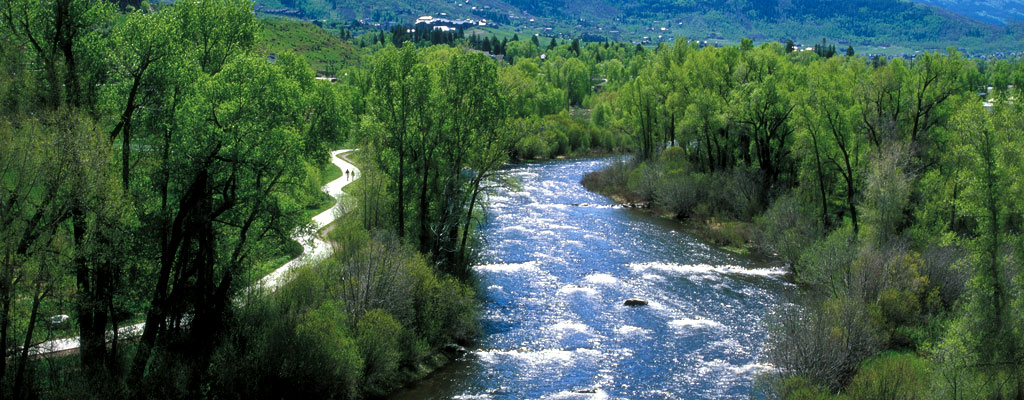
The Yampa River Core Trail runs right through downtown Steamboat. Photo credit City of Steamboat Springs.
Posting to Coyote Gulch is likely to be impacted by the events this week in Steamboat Springs including the horrible bicycle commute each morning and evening between my campsite on the west edge of town and the conference location at the Steamboat Grand Hotel.
Here’s the release from the Metropolitan Water District of Southern California (Rebecca Kimitch/Maritza Fairfield):
Jeffrey Kightlinger, general manager of the Metropolitan Water District of Southern California, issues the following statement on the Bureau of Reclamation’s latest 24-month study on Colorado River system reservoir conditions:
“We’re certainly grateful that nature provided some relief to the critical conditions in the Colorado River Basin. But the Southwest wouldn’t be in this encouraging position without also the successful collaboration of the Colorado River Basin states to develop the Drought Contingency Plan. The DCP wasn’t just about sharing the pain of potential water cutbacks; one of its primary benefits was to incentivize storage in Lake Mead. It creates new storage opportunities for California, Arizona and Nevada and increases the flexibility to access stored water.
“Today is evidence the DCP is working as we hoped. By the end of the year, the Lower Basin states and Mexico together anticipate storing an additional 700,000 acre-feet of conserved water in Lake Mead in 2019 – a record amount that will boost the lake’s elevation by nearly
9 feet. Metropolitan alone will store 400,000 acre-feet this year, bringing our total stored in the lake to nearly 1 million acre-feet, another record.
“While all that storage helps keep Lake Mead out of shortage, it also helps prepare Southern California for our state’s next drought. Being able to store water when it is available for use in times when it is not is the key to ensuring the region has reliable water in the future. We got some reprieve from drought conditions on the Colorado River this year, but Lake Mead is still less than half full. And climate change is likely to lead to drier conditions in our future. As we begin work to resolve the water supply imbalance on the river, we’re pleased the DCP helped address the immediate concerns.”
All American Canal Construction circa. 1938 via the Imperial Irrigation District
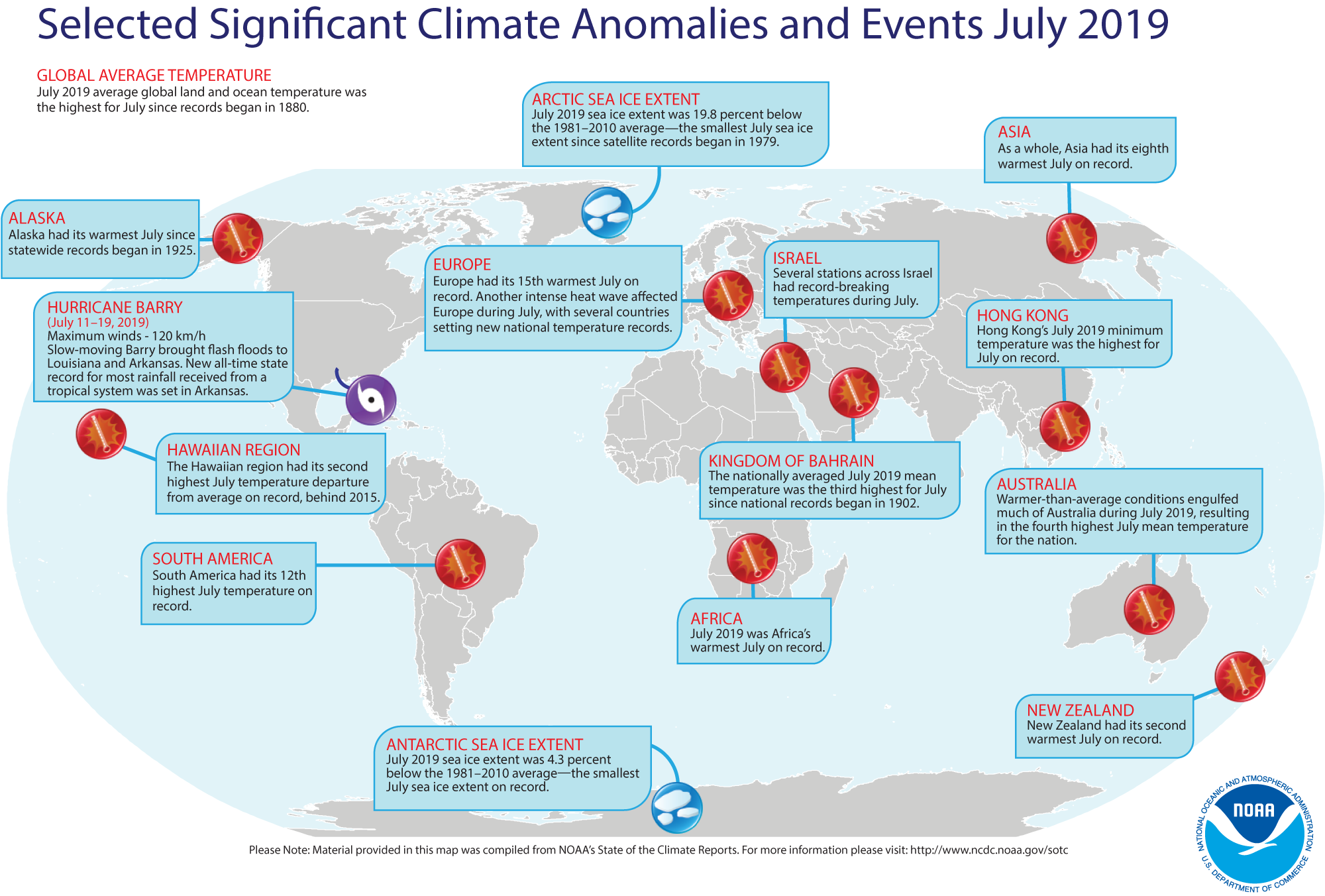
The global land and ocean surface temperature departure from average for July 2019 was the highest for the month of July, making it the warmest month overall in the 140-year NOAA global temperature dataset record, which dates back to 1880. The year-to-date temperature for 2019 tied with 2017 as the second warmest January–July on record.
This monthly summary, developed by scientists at NOAA National Centers for Environmental Information, is part of the suite of climate services NOAA provides to government, business, academia, and the public to support informed decision-making.
July 2019 Temperature
The July temperature across global land and ocean surfaces was 1.71°F above the 20th century average of 60.4°F and was the highest for July in the 1880–2019 record. July 2019 bested the previous record—set in 2016—by 0.05°F.
Nine of the 10 warmest Julys have occurred since 2005, with the last five years (2015–2019) being the five warmest Julys on record. July 1998 is the only value from the previous century among the 10 warmest Julys on record.
Climatologically, July is the globe’s warmest month of the year. With July 2019 being the warmest July on record, at least nominally, this resulted in the warmest month on record for the globe.
Record warm July temperatures were present across parts of North America, southern Asia, southern Africa, the northern Indian Ocean, and the Atlantic Ocean, as well as across the western and northern parts of the Pacific Ocean. No land or ocean areas had record cold July temperatures.
The July globally averaged land surface temperature was 2.21°F above the 20th century average of 57.8°F and the second-highest July land temperature in the 140-year record. July 2017 holds the record for the highest July global land temperature departure from average at 2.23°F.
The most notable warm temperature departures from average were present across Alaska, central Europe, northern and southwestern parts of Asia, and parts of Africa and Australia, where temperatures were at least 2.7°F above the 1981–2010 average or higher. The most notable cooler-than-average temperatures were present across parts of Scandinavia and western and eastern Russia, where temperatures were at least 2.7°F below average or cooler.
Regionally, North America, Africa, Asia, Oceania, the Hawaiian region, the Caribbean region, and the Gulf of Mexico had a July temperature departure from average that ranked among the 10 warmest Julys on record. Of note, Africa had its warmest July at 2.97°F, besting the previous record set in 2015 by 0.32°F.
The July globally averaged sea surface temperature was 1.51°F above the 20th century monthly average of 61.5°F and the highest global sea surface temperature for July on record. Compared to all months, this value tied with September 2015 as the sixth highest monthly global ocean temperature departure from average among all months (1,675 months) on record. The 10 highest global ocean monthly temperature departures from average have all occurred since September 2015.
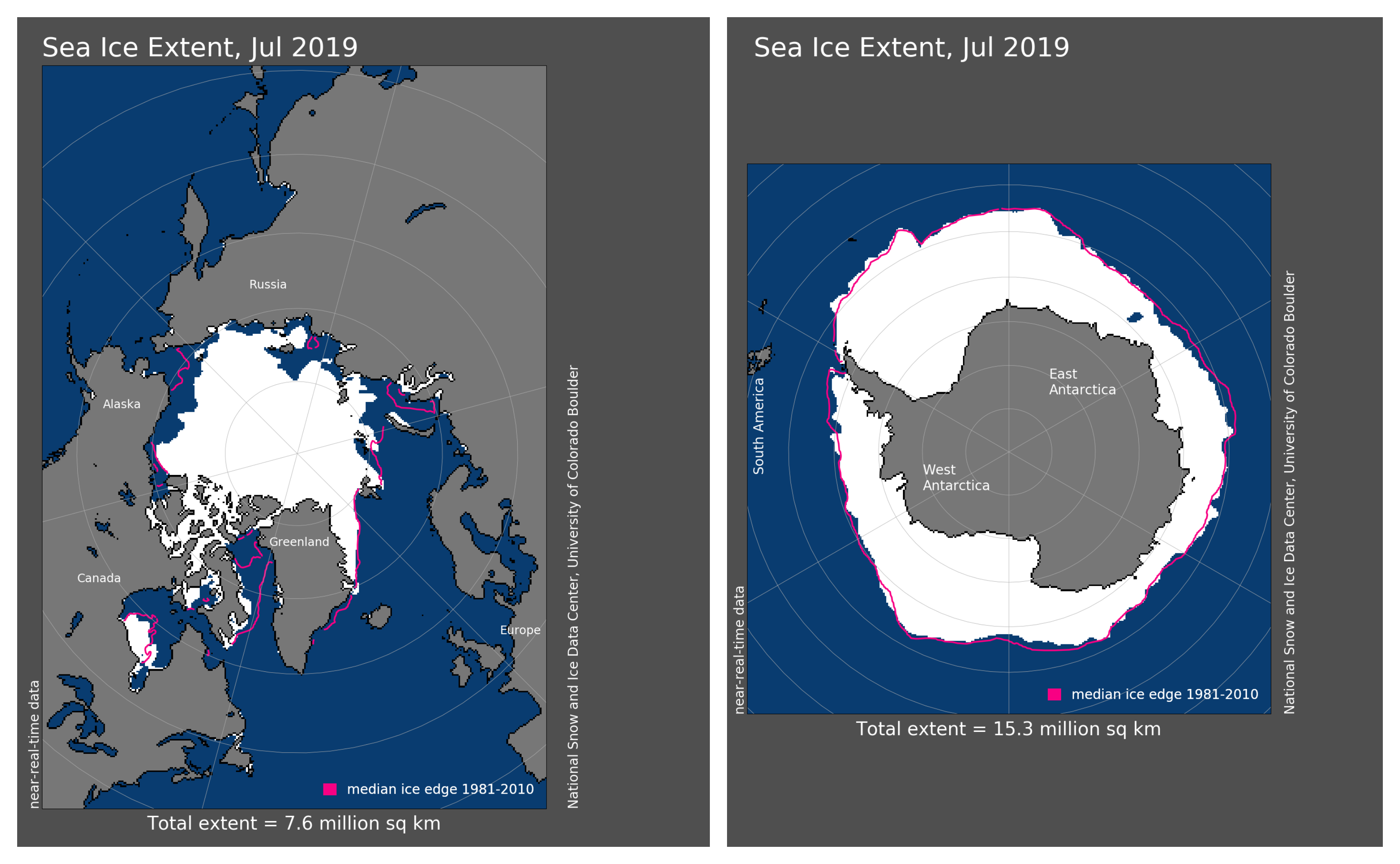
The Arctic sea ice extent set a record low for July at 726,000 square miles (19.8%) below the 1981–2010 average and 30,900 square miles below the now second-lowest July sea ice extent set in 2012, according to an analysis by the National Snow and Ice Data Center using data from NOAA and NASA. During July 2019, sea ice loss occurred at an average rate of 40,800 square miles per day, surpassing the 1981–2010 average of 33,500 square miles. Only seven other years (1990, 1991, 2007, 2009, 2013, 2015, and 2018) had a daily rate of sea ice loss exceeding 38,600 square miles.
The July 2019 Antarctic sea ice extent was 260,000 square miles (4.3%) below the 1981–2010 average and was the smallest July extent in the 41-year record. This value is slightly below the previous record set in 2017 (250,000 square miles).
Year-to-date (January–July 2019)
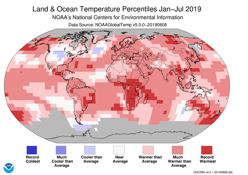
The year-to-date temperature across global land and ocean surfaces was 1.71°F above the 20th century average of 56.9°F — tying with 2017 as the second highest for January–July in the 140-year record. Only January–July 2016 (+1.96°F) was warmer.
The most notable warm temperature departures from average were present across parts of the Northern Hemisphere, specifically Alaska, western Canada, and central Russia, where temperature departures from average were at least +3.6°F or higher. Meanwhile, the most notable cool temperature departures from average were present across much of the contiguous United States and southern Canada, where temperatures were at least 1.8°F below average or cooler.
Record warm January–July temperatures were present across the southern half of Africa and parts of North America, South America, Asia, Australia, New Zealand and its surrounding ocean, as well as parts of the western Pacific Ocean, Atlantic Ocean, and western Indian Ocean. No land or ocean areas had record cold temperatures during January–July 2019.
Regionally, South America, Europe, Africa, Asia, and Oceania had a January–July temperature that ranked among the five highest such periods on record, with South America and Oceania having their second warmest year-to-date on record.
The year-to-date globally averaged land surface temperature was 2.63°F above the 20th century average of 46.8°F. This value was the third highest for January–July on record, behind 2016 (+3.20°F) and 2017 (+2.74°F).
The year-to-date globally averaged sea surface temperature was the second highest for January–July in the 1880–2019 record at 1.37°F above the 20th century average of 61.0°F. Only July 2016 (+1.49°F) was warmer.
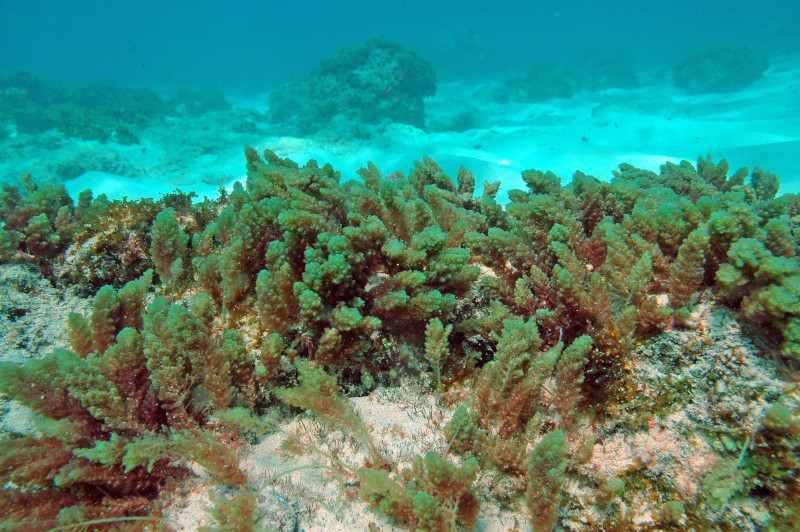
Asparagopsis taxiformis, (limu kohu) formerly A. sanfordiana, is a species of red algae, with cosmopolitan distribution in tropical to warm temperate waters By Jean-Pascal Quod – The uploader on Wikimedia Commons received this from the author/copyright holder., CC BY-SA 3.0, https://commons.wikimedia.org/w/index.php?curid=33353890
A puffy pink seaweed that can stop cows from burping out methane is being primed for mass farming by Australian researchers.
The particular seaweed species, called Asparagopsis, grows prolifically off the Queensland Coast, and was the only seaweed found to have the effect in a study five years ago led by CSIRO. Even a small amount of the seaweed in a cow’s diet was shown to reduce the animal’s gases by 99%.
Associate Professor Nick Paul, who is the leader of the Seaweed Research Group at the University of the Sunshine Coast (USC), said that if Australia could grow enough of the seaweed for every cow in the nation, the country could cut its greenhouse gas emissions by 10%.
“Seaweed is something that cows are known to eat. They will actually wander down to the beach and have a bit of a nibble,” Dr. Paul said.
“When added to cow feed at less than 2% of the dry matter, this particular seaweed completely knocks out methane production. It contains chemicals that reduce the microbes in the cows’ stomachs that cause them to burp when they eat grass.”
The USC team is working at the Bribie Island Research Centre in Moreton Bay to learn more about how to grow the seaweed species, with the goal of informing a scale-up of production that could supplement cow feed on a national—and even global scale.
“This seaweed has caused a lot of global interest and people around the world are working to make sure the cows are healthy, the beef and the milk are good quality,” Dr. Paul said.
“That’s all happening right now. But the one missing step, the big thing that is going to make sure this works at a global scale, is to make sure we can produce the seaweed sustainably.
Family photos push an important message to work safely each and every day. The post Putting safety on the shelf … literally appeared first on News on TAP.
For the first time in history, low water levels on the Colorado River have forced Arizona, Nevada, and Mexico to cut back the amount of water they use. It’s the latest example of climate change affecting daily life, but also an encouraging sign that people can handle a world with less: These orderly cutbacks are only happening because seven U.S. states and Mexico had agreed to abide by conservation rules when flows subside, rather than fight for the last drops.
“It is a new era of limits,” said Kevin Moran, who directs the Environmental Defense Fund’s Colorado River efforts…
A Bureau of Reclamation study of Colorado River levels, released Thursday, triggered the cutbacks. The Rocky Mountains finally turned white with heavy snow last winter, but despite a galloping spring runoff, drought persists and bathtub-ringed reservoirs in the Grand Canyon are low. In its study, the Bureau highlighted the unique circumstances: “This 20-year period is also one of the driest in the 1,200-year paleo record.”
Rising temperatures brought on by rising carbon emissions are partly to blame. “Approximately one‐third of the [Colorado River] flow loss is due to high temperatures now common in the basin, a result of human caused climate change,” wrote scientists Brad Udall and Jonathan Overpeck in a study published in 2017 that anticipated water will only become scarcer in the future.
But these water-use reductions are also an example of people binding themselves to rules to deal with scarce resources, rather than going to court, or war. The cutbacks come from an agreement hammered out by the Southwestern states and Mexico to impose limits on themselves.
“It’s not necessarily well known or talked about, but this collaboration between the states and Mexico is one of the most successful cross-border water management stories in the world,” Moran said.
From the Associated Press (Felicia Fonseca) via The Las Vegas Sun:
Arizona and Nevada are faced with the first-ever cuts to their Colorado River water supply in 2020.
But the cuts aren’t expected to be overly burdensome for either state because they’ve been conserving and storing water for years…
Arizona will leave 7% of its allocation in Lake Mead under a drought plan approved earlier this year by several states that rely on the river. Nevada will leave 3%.
Mexico also gives up 3% under a separate accord.
The states and Mexico can recover the water if Lake Mead rises to a certain level.
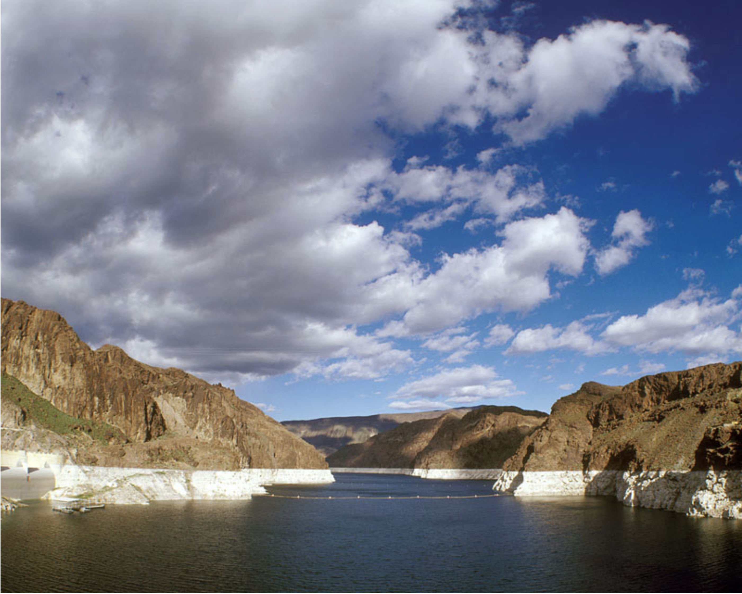
Lake Mead, behind Hoover Dam, shows the effects of nearly two decades of drought. (Image: Bureau of Reclamation)
The decision to implement those cuts came on Thursday after federal water managers released a study that serves as a key benchmark for Southwest states. That forecast predicted that Lake Mead would start 2020 at 1089.4 feet above sea level, below the 1090-foot trigger for the cuts.
By forgoing water in dry years, the states store more water in Lake Mead, a reservoir that has decreased over the past two decades because of overuse, drought and climate change. If the reservoir drops further, states would be required to take more cuts to their allotment. When reservoir levels rise, the states are allowed to access the stored water for future use.
In practice, the cuts will have no effect on Nevada’s short-term water security or water management. The Southern Nevada Water Authority is expected to voluntarily conserve about nine times more water this year than the required cuts under the drought plan in 2020. Since 2003, Nevada has used less water than what the state is allowed to take under the river’s interstate compact.
In 2017, the state used about 80 percent of its allotment, largely in part because of indoor water recycling and conservation programs that incentivize removing grass. This year the water authority is on track to use even less. That means Nevada is likely to leave substantially more water in the reservoir this year — as much as 75,000 acre-feet — than what is required by the cuts — about 8,000 acre-feet — next year. (An acre-foot is an agricultural term for the amount of water that can fill an acre to a depth of one foot. Nevada’s allocation is 300,000 acre-feet).
Bronson Mack, a water authority spokesman, said that the agency has cut its Colorado River water use by 25 percent since 2002, even as Las Vegas’ population has grown by 40 percent…
But the cuts are still significant, said John Fleck, a University of New Mexico professor who has a forthcoming book, “Science Be Dammed,” that looks at the history, politics and hydrology of the river. They mark the first time the states have been required to use less than their allocation…
It is also a recognition of a future where there is expected to be less — not more — water to go around. Even though above-average levels of snow fell across much of the West this year, the long-term trend in the Colorado River is toward declining streamflow. Research has found that high temperatures have made runoff less efficient. Scientists say that climate change could further reduce the river’s flow and make managing it more difficult, even as demands grow.
Heavy precipitation made a difference this year. When the U.S. Bureau of Reclamation released its 2019 forecast last year, the study predicted an official shortage in 2020. Water users avoided that declaration, although the federal water agency warned that they are not out of the clear.
Changes in the northeastern reaches of Lake Powell are documented in this series of natural-color images taken by the Landsat series of satellites between 1999 and 2017. The Colorado River flows in from the east around Mile Crag Bend and is swallowed by the lake. At the west end of Narrow Canyon, the Dirty Devil River joins the lake from the north. (At normal water levels, both rivers are essentially part of the reservoir.) At the beginning of the series in 1999, water levels in Lake Powell were relatively high, and the water was a clear, dark blue. The sediment-filled Colorado River appeared green-brown. To see the complete series go to: earthobservatory.nasa.gov/WorldOfChange/LakePowell. Photos via NASA
“This is a big deal for everybody on the Colorado River system,” said Jim Pokrandt, the head of community affairs for the Glenwood Springs-based Colorado River Water District.
The study won’t have much of an impact on Colorado, where the Upper Basin Drought Contingency Plan has water users hammering out the details of “demand management.” Those details include asking for temporary, voluntary and compensated curtailment of water rights to build a bank of Colorado water in Lake Powell before mandatory cuts are imposed by the federal government.
Pokrandt said the dawning of mandatory cuts in the Lower Basin increases the urgency of demand-management talks in Colorado. Without a demand-management plan encouraging water users to volunteer their water rights in Colorado, the state could see mandatory cuts, where “nobody gets paid,” he said.
“The news from the Lower Basin is a reminder that 2019’s snowpack cannot give us a false sense of security,” Pokrandt said, recalling that Colorado’s super-snowy 2011 was followed by an exceptionally dry 2012. “This is a reminder of the importance of what the Upper Basin states have to do for their own Drought Contingency Plan.”
[…]
hat’s called demand management. Across Colorado, water districts and water users are studying whether demand management will work.
“Nobody knows if it will be feasible,” said Pokrandt, whose 15-county district spans the Western Slope, noting that the Colorado Water Conservation Board just launched its Demand Management Workshop to educate the state’s water users on the idea of temporarily suspending water rights for cash in order to build a bank of Colorado water in Lake Powell. “Determining feasibility will be a long process.”
Lake Powell will enter 2020 in the “Intentionally Created Surplus Condition,” which allows for the release of the usual 8.23 million acre-feet of water in 2020 to fill Lake Mead. It also means the Upper Basin states will increase their own banked storage in the reservoir, enabling them to better weather low-snow years with a protected cache of extra water.
Total storage in both reservoirs is 55% of capacity, compared with 49% at this time last year.
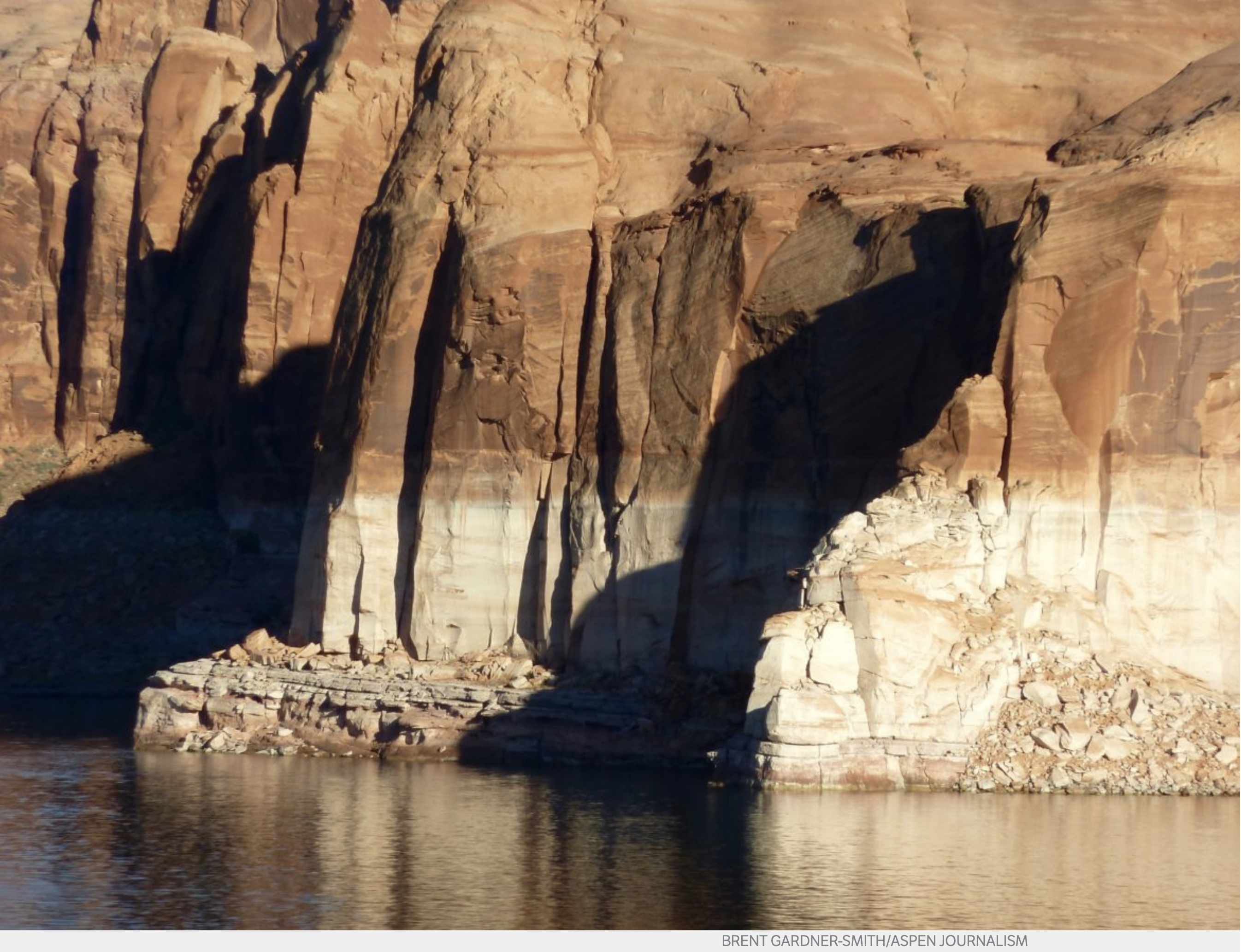
The bathtub ring in Lake Powell in October 2014. Today, the reservoir is under 40 percent full and water managers in Colorado, Utah, Wyoming and New Mexico are working on demand management programs that would reduce water use and send more water to the big reservoir that sits on the mainstem of the Colorado River. Photo credit: Brent Gardner-Smith/Aspen Journalism
Boulder residents are advised to keep their children and animals out of Wonderland Lake in north Boulder and a similar warning was issued for Quincy Reservoir in Aurora.
Sloan’s Lake is the only body of water in Denver that has tested positive for the algae. Signs are posted there warning people not to swim or wade in the lake, though health officials said they haven’t heard of anyone getting sick from it.
Thunderbird Lake in southeast Boulder also has reports of blue-green algae. Swimming and wading are not allowed there.
Blue-green algae is a bacteria found in non-flowing freshwater that can be fatal to animals if ingested. The algae naturally occurs in aquatic ecosystems and can appear rapidly – especially during the summer with hot weather and in slow-moving water bodies, such as lakes, according to the Colorado Department of Public Health and Environment…
According to the Colorado Department of Public Health and Environment, harmful algae blooms often have the following characteristics:
May look like thick pea soup or spilled paint on the water’s surface.
Can create a thick mat of foam along the shoreline.
Usually are green or blue-green, although they can be brown, purple or white.
Sometimes are made up of small specks or blobs floating just at or below the water’s surface
Denver Water documentary, ‘Written in Water,’ wins regional award for best historical documentary. The post Yes, your water utility is an Emmy-award winner! appeared first on News on TAP.
Vandals caused an estimated $1 million worth of damage to the City of Northglenn’s collection system on top of Berthoud Pass earlier this month, shutting the system down for several days. As the Grand County Sheriff investigates, Northglenn water officials say they fear the damage is the work of eco-vandals, upset over ongoing diversions from the drought-stressed upper Colorado River to the Front Range.
For years, the City of Northglenn has captured water on top of Berthoud Pass and delivered it down to its customers north of Denver.
But on Aug. 2, when water should have been flowing freely, the reading on the measuring gauge on what’s known as the Berthoud Pass Ditch fell to zero. On investigation, the city found the system had been vandalized, with diversion structures torn apart and locks cut, allowing millions of gallons of water to flow back into the Fraser River, a tributary to the upper Colorado River, instead of Northglenn’s ditch.
“It seemed very intentional,” said Tamara Moon, Northglenn’s manager of water resources. “They did a doozy on us.”
Roughly $100,000 worth of damage was done to the diversion system, with another $900,000 in water lost, according to the Grand County Sheriff’s office.
Lesser damage to the structure, part of which can be accessed off a hiking trail near the old Berthoud Pass ski area, occurred in March, Moon said.
But she believes now that both efforts are linked to the political tension over transmountain diversions from the water-stressed upper Colorado River to the Front Range.
Two major expansion projects, including an effort by Denver Water to bring more water from the Fraser River and one by Northern Water to bring over more from the upper Colorado River near Granby, have sparked major lawsuits by several environmental groups, including Save The Colorado, WildEarth Guardians and the Sierra Club, among others. The lawsuits are pending in court…
Though Northglenn isn’t involved in either project, Moon said the fact that her city’s diversion system is pulling from the same watershed has likely exposed it to the frustration over the diversions.
The week the system was disabled, Northglenn was delivering water to the City of Golden, one of its customers on the system.
Golden lost several days’ worth of water as a result of the incident, but because its system, like most, has benefited from an abundance of water this year, the temporary cut-off didn’t affect the city’s ability to provide water to its own customers.
“It really hasn’t had an impact on us,” said Anne Beierle, Golden’s deputy director of public works. “From our perspective though, it’s a little disconcerting and it’s disappointing. If it turns out to be [eco-vandalism], it is unfortunate.”
The Grand County Sheriff’s office is still investigating the incident.
Grand County, home to Winter Park and Granby, is also one of the most heavily diverted counties in Colorado, with millions of gallons of water from the upper Colorado and Fraser rivers being diverted to the Front Range to serve dozens of communities.
“This was a purposeful, deliberate act,” said Lieutenant Dan Mayer, the Grand County Sheriff’s public information officer.
The four diversion gates that were broken were roughly one-half mile apart, Mayer said. “Somebody wanted to break these gates. You had to [hike in to] find them.
“We have a lot of water agencies running [water] out of here. But we haven’t seen any incidents like this at other systems. It makes it seem as if it could very well be some kind of eco-terrorism, and we would very much like to find out who did it.”
Mayer said the charges any suspect would face include felony theft, felony criminal mischief, and first degree criminal tampering and trespass, all of which could result in significant jail time and fines.
In addition to installing new diversion gates and locks, Northglenn’s Moon said the city is installing remote cameras in an effort to better monitor the site and to be able to identify the culprits should they return.
“We don’t even have power up there,” she said. “There’s not a lot more we can do.”
Jerd Smith is editor of Fresh Water News. She can be reached at 720-398-6474, via email at jerd@wateredco.org or @jerd_smith.
View down Clear Creek from the Empire Trail 1873 via the USGS
The U.S. Department of Agriculture’s (USDA) Risk Management Agency (RMA) today announced it will defer accrual of interest for all agricultural producers’ spring 2019 crop year insurance premiums to help the wide swath of farmers and ranchers affected by extreme weather in 2019. Specifically, USDA will defer the accrual of interest on spring 2019 crop year insurance premiums to the earlier of the applicable termination date or for two months, until November 30, for all policies with a premium billing date of August 15, 2019. For any premium that is not paid by one of those new deadlines, interest will accrue consistent with the terms of the policy.
“USDA recognizes that farmers and ranchers have been severely affected by the extreme weather challenges this year,” said U.S. Secretary of Agriculture Sonny Perdue. “I often brag about the resiliency of farmers but after a lifetime in the business, I have to say that this year is one for the record books. To help ease the burden on these folks, we are continuing to extend flexibility for producers with today’s announcement.”
RMA Administrator Martin Barbre added, “This administrative flexibility is not unprecedented but is a move RMA takes seriously and only under special circumstances like we’re experiencing today. Growers typically have some crop harvested and cash flow to make their billing date, but with so many late planted crops, this year will be an anomaly.”
America’s farmers and ranchers have been especially challenged throughout the 2019 crop year, struggling through severe flooding and excessive moisture conditions across the grain belt and in many other rural communities, with some areas also dealing with extreme heat and drought. Such weather conditions are expected to take a serious toll on acres planted, crop yields, and crop quality as harvest begins. One of the largest operating costs for producers is crop insurance premiums paid to their Approved Insurance Provider. Many spring crop insurance premiums are due to be paid before October 1.
Without the interest deferral, policies with an August 15 premium billing date would have interest attach starting October 1 if premiums were not paid by September 30. Now, under the change, policies that do not have the premium paid by November 30 will have interest attach on December 1, calculated from the date of the premium billing notice.
USDA announced Monday that U.S. farmers filed prevented planting claims on more than 19 million acres during the 2019 crop year. Earlier this summer, USDA announced a series of flexibilities to reduce stress on producers affected by weather, including: providing more time for cover crop haying and grazing by moving the start date from November 1 to September 1, 2019; allowing producers who filed prevented planting claims then planted a cover crop with a potential for harvest to receive a $15 per acre Market Facilitation Program payment; holding signups in select states for producers to receive assistance in planting cover crops; and extending the crop reporting deadline in select states. USDA also will provide producers with prevented planting acreage additional assistance, which will be announced in the coming weeks, through the Additional Supplemental Appropriations for Disaster Relief Act of 2019.
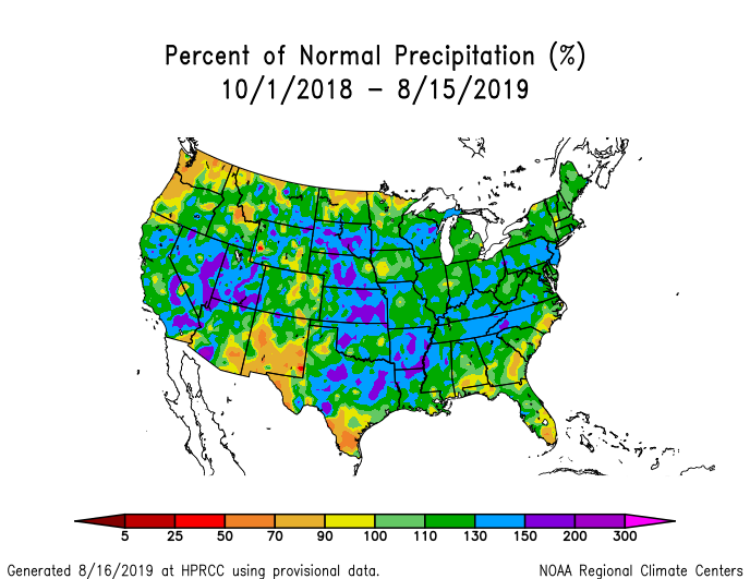
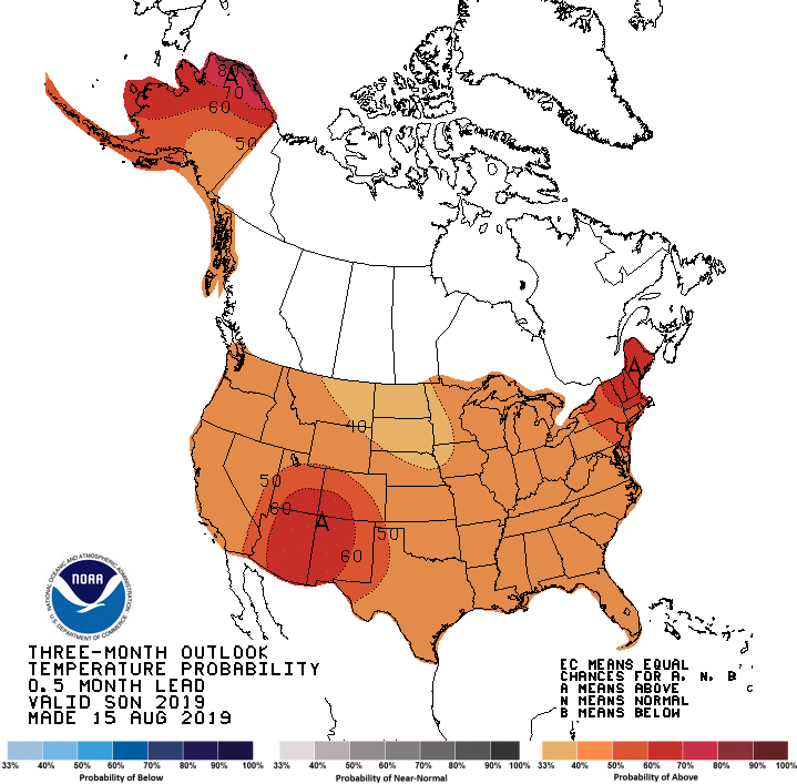
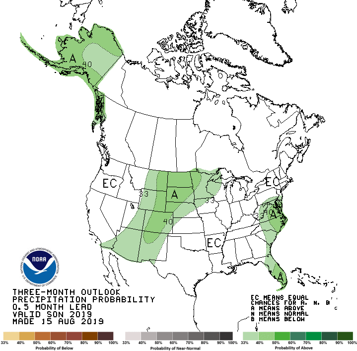
Seasonal temperature outlook through November 30, 2019 via the Climate Prediction Center.Seasonal precipitation outlook through November 30, 2019 via the Climate Prediction Center.Seasonal drought outlook through November 30, 2019 via the Climate Prediction Center.
Here’s the release from the Bureau of Reclamation (Patti Aron/Marlon Duke):
The Bureau of Reclamation today released its Colorado River Basin August 2019 24-Month Study, which sets the annual operations for Lake Mead and Lake Powell in 2020. Based on projections in the 24-Month Study, Lake Mead will operate in the Normal or ICS Surplus Condition in Calendar Year 2020 and Lake Powell will operate in the Upper Elevation Balancing Tier in Water Year 2020 (October 1, 2019 through September 30, 2020).
The Upper Basin experienced above average snowpack, and runoff was 145% of average this past spring, raising Lake Powell’s elevation by more than 50 feet since early April. Total Colorado River system storage today is 55% of capacity, up from 49% at this time last year. In addition, critical drought contingency plans adopted by the seven Basin States, federal government and Mexico earlier this year are now in place to reduce risks to the system.
“While we appreciate this year’s above average snowpack, one good year doesn’t mean the drought is over. We must remain vigilant,” said Commissioner Brenda Burman. “I applaud everyone who came together this year to get the drought contingency plans done. The additional actions under the contingency plans will help ensure the reliability of the Colorado River system for the 40 million people dependent upon it.”
The August 2019 24-Month Study projects Lake Mead’s January 1, 2020, elevation to be 1,089.4 feet, about 14 feet above the Lower Basin shortage determination trigger of 1,075 feet. Lake Powell’s January 1, 2020, elevation is projected to be 3,618.6 feet — 81 feet below full. Because Lake Mead is projected to begin the year below the drought contingency plans threshold of 1,090 feet, Arizona, Nevada and Mexico will make water savings contributions to Lake Mead in 2020.
Despite the above average 2019 snowpack, the Colorado River Basin continues to experience its worst 20-year drought on record, dating back to 2000. This 20-year period is also one of the driest in the 1,200-year paleo record. The August 2019 24-Month Study can be found at https://www.usbr.gov/lc/region/g4000/24mo.pdf
Today, the U.S. Bureau of Reclamation issued its August 24-Month Study Report, a two-year outlook projecting water supply and operating conditions in the Lower Colorado River Basin..
The August Report defines, among other things, the operating conditions for Lake Mead for 2020, and includes the recently enacted Lower Basin Drought Contingency Plan (DCP). At the end of 2019, the projected Lake Mead elevation – the measuring stick for whether there is a shortage declaration on the river for 2020 – is just shy of 1090’. And, for the first time, the Lower Colorado River Basin will formally implement reductions outlined in the DCP at the new Tier Zero beginning January 2020.
What does this mean?
In short, it shows that in its first year, DCP is already working.
While the Basin experienced a stellar snowpack year and subsequent phenomenal run-off, because Lake Mead is projected to end 2019 below elevation 1090’, the Lower Basin States (Arizona, California and Nevada) will be in a DCP Tier Zero shortage condition next year. Under Tier Zero, Arizona’s Colorado River supplies will be reduced by 192,000 acre-feet; Nevada’s will be reduced by 8,000 acre-feet; and California takes no reductions. In addition, Mexico will reduce its water use by 41,000 acre-feet, due to Minute 323, an agreement under the 1944 Treaty for water users in both countries. [ed. emphasis mine] Because of Arizona’s Colorado River priority system and agreements amongst water users, the Central Arizona Project (CAP) will take 100% of Arizona’s reductions under Tier Zero. CAP’s supplies will be reduced by 192,000 acre-feet, representing 12% of its normal annual Colorado River water supply. For CAP customers, this means eliminating the water that would have been available for underground storage, banking and replenishment. Water going toward CAP agricultural uses will be reduced by about 15%.
The Tier Zero reduction to CAP, while significant, is largely equivalent to the amount of Colorado River water CAP has been leaving voluntarily in Lake Mead since 2015 as part of our Lake Mead Conservation Program. In essence, CAP and its water users have been planning and preparing for Tier Zero reductions for the past five years. The difference is that those previous contributions were voluntary – now, under DCP, these contributions are mandatory.
Through the DCP, Arizona continues to prepare for a drier future. This year, CAP, along with the Gila River Indian Community and the Colorado River Indian Tribes, is contributing and storing 236,000 acre-feet in Lake Mead. Next year, even with the Tier Zero reductions, these same water users, along with the Mohave Valley Irrigation and Drainage District, will continue to conserve and store additional water in Lake Mead. These efforts are part of Arizona’s plan to implement DCP developed collaboratively by the Arizona water community and legislative leaders. The plan balances the impacts of DCP amongst water users and provides additional protection to the Colorado River system, giving us a road map to follow for the next several years.
Tier zero cuts. Graphic credit: Central Arizona Project
Arizona, Nevada and Mexico will be required to take less water from the Colorado River for the first time next year under a set of agreements that aim to keep enough water in Lake Mead to reduce the risk of a crash.
The federal Bureau of Reclamation activated the mandatory reductions in water deliveries on Thursday when it released projections showing that as of Jan. 1, the level of Lake Mead will sit just below a threshold that triggers the cuts.
Arizona and Nevada agreed to leave a portion of their water allotments in the reservoir under a landmark deal with California called the Lower Basin Drought Contingency Plan, which the states’ representatives signed at Hoover Dam in May.
California agreed to contribute water at a lower trigger point if the reservoir continues to fall. And Mexico agreed under a separate accord to start contributing to help prop up Lake Mead, which is now 39 percent full…
Reservoirs were approaching levels last year that would have triggered a shortage and required deeper cuts, but heavy snow across much of the Rocky Mountains this winter boosted runoff and raised reservoir levels. The river’s reservoirs are now at 55% of total capacity, up from 49% at the same time last year.
But Lake Mead is still projected to be just below the threshold of 1,090 feet above sea level at the beginning of next year. That will put the reservoir in a zone called “Tier Zero,” at which the first cuts take effect.
“While we appreciate this year’s above-average snowpack, one good year doesn’t mean the drought is over. We must remain vigilant,” federal Reclamation Commissioner Brenda Burman said in a statement. She applauded the seven states that depend on the river for coming together to finish the set of drought-contingency plans. Burman said the actions laid out under those agreements “will help ensure the reliability of the Colorado River system for the 40 million people dependent upon it.”
Arizona will see a cut of 192,000 acre-feet in water deliveries next year, or 6.9% of its total allotment of 2.8 million acre-feet. Nevada’s share will be reduced by 8,000 acre-feet, while Mexico’s will take 41,000 acre-feet less. That water will remain in Lake Mead, and will only be recovered once the reservoir rises above an elevation of 1,100 feet.
The cuts under the Drought Contingency Plan, or DCP, represent 12% of the total water supply for the Central Arizona Project, which delivers water by canal to Phoenix, Tucson and other areas. Chuck Cullom, manager of Colorado River programs for CAP, said this reduction will mean “eliminating the water that would have been available for underground storage, banking and replenishment,” and cutting CAP deliveries to agriculture by about 15%.
Click on a thumbnail graphic to view a gallery of drought data from the US Drought Monitor.
US Drought Monitor August 13, 2019.
West Drought Monitor August 13, 2019.
Colorado Drought Monitor August 13, 2019.
Click here to go to the US Drought Monitor website. Here’s an excerpt:
This Week’s Drought Summary
Rainfall this week was highly variable across the eastern two-thirds of the country, which is not unusual during summer. Heavy rain was common in the High Plains, and from the Texas Panhandle and central Oklahoma northward in the Great Plains. Generally 2 to locally 5 inches of rain soaked the Plains from northern and eastern Kansas northward into the central Dakotas, and similar totals were spottier in central Montana, in the middle Mississippi Valley, across northern Minnesota, from the central Ohio Valley through the central Appalachians, over northern New England, and from the Florida Peninsula into southeastern Georgia. Scattered to isolated amounts of 2 to 3 inches were observed from the western half of Tennessee southward to the central Gulf Coast. Farther east, despite isolated moderate rains, only a few tenths of an inch fell on most of the upper Southeast, southern Appalachians, Carolinas, and middle Atlantic region. Several patches from northern California through the Pacific Northwest and northern Idaho recorded 0.5 to locally 2 inches, but most sites received light rain at best. The central and southern Sections of the Rockies and Intermountain West also observed generally light precipitation while no measurable rainfall was almost universal from the Red River to the Rio Grande in Texas, and in central and southern sections of California. The total area enduring abnormal dryness and drought increased, most noticeably in the Ohio Valley, the Midwest, and Texas. Widespread improvement was limited to a broad swath of Alaska from interior northeastern sections to near the Aleutians…
Several inches of rain doused a broad area from eastern Kansas northwestward through South Dakota, western North Dakota, and the northern High Plains. Dryness and drought were confined to central and southern Kansas, east-central Nebraska, and northern North Dakota, where a small area of severe drought was introduced. In contrast to areas farther north, central and south-central Kansas recorded only 0.5 to locally 2.0 inches of rain since mid-July…
Periodic light to moderate rain has fallen for a few weeks now from central and southern Washington eastward through southwestern Montana, prompting improvement in some former D0 to D1 regions there, and in adjacent Oregon. Farther south, abnormal dryness persisted in several areas from southwestern Wyoming through Utah and western Colorado; D0 expanded northward a bit into areas north of the Four Corners near the Colorado/Utah border. Across the southern Rockies and southwestern deserts, deficient monsoon rains continued, and increasing moisture deficits prompted a broad expansion of abnormal dryness from southeasternmost California through eastern Arizona, and farther south from southeastern Arizona across southern New Mexico.
No measurable rain fell on a large area from the Red River Valley southward through Texas east of the Big Bend, extending eastward into southwestern Arkansas and central Louisiana. In contrast, most of northeastern Oklahoma and northern Arkansas were doused by 2 to locally 6 inches of rain. Less remarkable rainfall amounts exceeding one-half inch were recorded in the Texas Panhandle, central and northern Oklahoma, southwestern Tennessee, and Mississippi, with heavy rains approaching 4 inches reported in a few scattered areas. Dryness and drought expanded and intensified, with some degree of dryness now covering northeastern Texas, part of northern Louisiana, central and western Oklahoma, and roughly the western two-thirds of Texas from the upper reaches of Deep South Texas northward to the central Panhandle and the Big Bend. Severe drought was noted in parts of southern Texas, west-central Texas, and in a strip from southwestern Oklahoma westward along the southern fringes of the Texas Panhandle. Parts of these D2 areas received 3 to 6 inches less rainfall than normal over the past 60 days, including most of southwestern Oklahoma and adjacent Texas. Dating back to mid-July, most of Oklahoma (outside the northeastern quarter) and Texas were at least an inch short of normal rainfall; 30-day rainfall totals below 0.5 inch fell on southwestern Oklahoma and a broad swath of central and southern Texas from the Red River and lower Panhandle southward to the lower Rio Grande Valley…
Looking Ahead
During the next 5 days (August 15 – 20, 2019) should bring heavy rains of at least 1.5 inches across the central Great Plains and much of the Midwest, with 3 to 5 inches forecast from northwestern Missouri and adjacent areas northward through central and eastern Iowa. Amounts exceeding 1.5 inches are also forecast for the Mississippi Delta and along the immediate Gulf and southern Atlantic Coasts. A few patches along the Atlantic Coast from southeastern Georgia through North Carolina should receive 3 to 4 inches. Moderate rains of 0.5 inch or more are anticipated in parts of upstate New York, northern New England, and inland areas near the central Gulf and southern Atlantic Coasts. Similar amounts are expected in most of the western Great Lakes, Midwest, Great Plains from Kansas into the central Dakotas, and upper Mississippi Valley. A few tenths of an inch should fall on the middle Atlantic region, the rest of the central and northern Great Plains and Mississippi Valley, and parts of central and northern Texas and adjacent Oklahoma. Little or no rain is expected in the rest of the 48 contiguous states, including the interior Southeast, the Ohio Valley, southern Texas, and most areas from the Rockies westward. Daytime high temperatures should average 3°F to 6°F below normal in the northern one-third of the Plains, and near 3°F below normal in north-central Florida. In contrast, daily highs are forecast to average around 3°F above normal in the middle Atlantic region, and 3°F to locally 9°F above normal from the southern half of the Great Plains westward through most of the Rockies, the Intermountain West, the Great Basin, and California away from the immediate coast.
The CPC 6-10 day outlook (August 21 -25, 2019) favors above-normal precipitation in the Alaskan Panhandle, parts of the Pacific Northwest, the northern Great Plains, the Mississippi Valley, southeast Texas, the Ohio Valley, the Southeast, and the middle Atlantic region. Meanwhile, enhanced chances for subnormal precipitation cover most of Alaska, although no tilt of the odds in either direction is indicated from the Kenai Peninsula westward through the Borough of Dillingham. Below normal precipitation chances are also elevated in upstate New York, most of New England, the central and southern Great Plains from central Texas through southwestern South Dakota, most of the High Plains, and the central Rockies. Neither precipitation extreme is favored elsewhere. Above-normal temperatures are favored across most of the country, with elevated chances for subnormal temperatures restricted to northwestern Montana, most of central and eastern Alaska, and the northern Alaska Peninsula. Neither positive nor negative temperature anomalies are favored in parts of the northern Rockies and in the lower Mississippi Valley.
US Drought Monitor one week change map ending August 13, 2019.
Carbon sequestration is a term used to describe processes by which carbon dioxide (CO2) is either removed from the atmosphere or captured and diverted from an emissions source for long-term storage. There are two primary kinds of carbon sequestration: biological carbon sequestration (also referred to as terrestrial) and carbon capture and sequestration (CCS).
The U.S. Department of Agriculture’s (USDA) Natural Resources Conservation Service (NRCS) today announced $1.9 million in funding for 15 Soil Science Collaborative Research projects focused on soil science and soil survey research.
The information gained from the collaborative research will advance NRCS’ ability to provide scientifically based soil and ecosystem information to help address important natural resources issues facing our nation.
“NRCS is investing in universities across the country to leverage their scientific knowledge and expertise to support our conservation mission.,” said NRCS Chief Matthew Lohr. “By engaging a diverse group of scholars through research, we can identify innovative solutions and technological advancements that will increase our contributions to both science and society.”
Now in its 12th year, the current Soil Science Collaborative Research projects were selected from among 32 applications. Projects were selected based on nationally identified needs in communities and landscapes.
Universities selected to receive funding for research projects include:
Alcorn State University
Brooklyn College of the City University of New York
The information accumulated from these annual projects has helped NRCS develop integrated technical tools and information to assist planners and land managers in predicting and assessing soil health, ecosystem and landscape sustainability and the implementation of sustainable management systems.
“NRCS is a world leader in soil research,” said Dave Hoover, director of the NRCS National Soil Survey Center. “This prioritized investment in science-based tools will develop innovative data sharing and information delivery tools and products to reach multiple stakeholders around the world from underserved audiences to the most technically advanced.”
NRCS accepts proposals once a year. Interested researchers can learn more on the Soils Research Page.
Changes in the northeastern reaches of Lake Powell are documented in this series of natural-color images taken by the Landsat series of satellites between 1999 and 2017. The Colorado River flows in from the east around Mile Crag Bend and is swallowed by the lake. At the west end of Narrow Canyon, the Dirty Devil River joins the lake from the north. (At normal water levels, both rivers are essentially part of the reservoir.) At the beginning of the series in 1999, water levels in Lake Powell were relatively high, and the water was a clear, dark blue. The sediment-filled Colorado River appeared green-brown. To see the complete series go to: earthobservatory.nasa.gov/WorldOfChange/LakePowell. Photos via NASA
Time and water are alike in a lot of important ways. Both are finite resources that we can take for granted, or that we can manage carefully for great benefit.
On Thursday, as the Bureau of Reclamation (BOR) issues its official projections for water levels at Lake Powell and Lake Mead, it’s important to think about where we were a year ago — following two extremely dry years; where we are today, after an extraordinarily wet winter; and, most importantly, where we want to be in another year — or ten years.
In the year since the last BOR report, water security in the West took a huge step forward with the signing of the drought contingency plans (DCPs) — landmark agreements that update how the Colorado River is used, shared and managed across seven states and two countries. These DCPs combined with proactive conservation measures and a year of major snowfall mean that we’ve been able to avert dangerously low water levels at Lake Mead. So it can be tempting to relax a bit — but we have to ask ourselves, “how will we use this moment to prepare for the future?” We have to be smart about using the time and water we have right now.
Common sense tells us that one wet winter does not alter or solve the fundamental challenges facing the water supply across the Colorado River Basin. As a reminder, 2011 was also a wet year in the Colorado River Basin, but it was immediately followed by 2012 and 2013 — the driest two-year period on record — causing rapid drops in water levels at Lake Powell and Lake Mead, which are the two main water supplies for the Colorado River.
As an additional reminder, approximately one in eight Americans rely on the Colorado River. The stakes only go higher as the water levels go lower. As water usage in the West continues to outpace the supply, we have to continue making bold, structural improvements to our water management strategies and systems.
In Colorado, as well as in Wyoming, New Mexico, and Utah, a key component of the DCPs is for the states to explore whether, and how to, develop and implement a demand management program. That means that each state needs to thoughtfully agree on how best to conserve while ensuring that there’s enough water to keep communities, farmers, and businesses thriving — now and for future generations. It’s not an easy task.
Still, there are reasons to be hopeful. First, as we saw with the DCPs, it is in our reach to do big, important things. In order to make those agreements possible, leaders from seven states, tribes, cities, advocacy groups, businesses, farmers and others across the Colorado River Basin had to partner with federal leaders from the U.S. and Mexico during some of the most politically divisive times in generations. And even with all of that, they were able to find ways to take care of their own needs while still recognizing the needs of their neighbors.
Looking ahead to demand management planning, that same spirit of innovation, collaboration, and shared mission will continue to serve the people of the Colorado River Basin well.
Demand management programs are being investigated in the Upper Basin. These types of programs involve temporary, voluntary and compensated reductions in water use. The water that would be conserved by demand management is water that otherwise would have been used — but is instead conserved and saved. So, for example, demand management means that farmers could opt to fallow some of their fields in the off season in order to conserve additional water (without losing their water rights).
Demand management can offer multiple benefits: it can ensure that there’s enough water in the river to keep the system healthy, it can safeguard the water supply for communities who depend on it, and it can protect our vibrant agricultural communities.
For several years, people all across the Colorado River Basin have been working together to begin testing water conservation projects and their workability. These pilot projects are critically important, as they allow us to learn about the benefits and shortcomings of how a demand management program may work. We cannot wait until all of the theoretical questions have answers. In short, we need to continue to learn by doing.
We are in a moment right now where we have saved enough time and water to buy ourselves the opportunity to make meaningful change. We know that this moment, this time, and our water will not last indefinitely. We have to act fast and together for a more secure water future — our communities and environments depend on it.
Ted Kowalski is the senior program officer for the Walton Family Foundation’s Colorado River Initiative.
Shirley Hotel Haxtun, Colorado via History Colorado
From the Republican River Water Conservation District (Deb Daniel) via The Julesberg Advocate:
The Board of Directors of the Republican River Water Conservation District will be holding its regular quarterly meeting in Haxtun, Colorado. The date, time, and location of the meeting and a summary of the agenda for the meeting are provided below.
Regular Meeting of the RRWCD Board Date: Tuesday August 20, 2019 Time: 10:00AM to 4:15PM
Agenda: Consider and potentially approve minutes of previous meetings; Board President’s report, General Manager’s report and consider and potentially approve quarterly financial report and expenditures. Report from the Compact Compliance Pipeline operator; receive report from chairmen of all RRWCD committees; receive program updates and reports from the RRWCD’s engineer, federal and state lobbyists reports, legal counsel reports. Public Comment will be at 1:00PM rrwcd Report by State Engineer’s Office and Attorney General’s Office, Consider grants applications from Groundwater Management Districts, consider various Resolutions including, RRWCD meeting date changes, increasing area of EQIP program to include acres from boundary change, approve edits in RRWCD By-laws, and consider edits made to Board Manual, and consider water use fee on acres brought into the RRWCD boundary due to HB19-1029. Consider contract with well owners who have augmentation plan to the Lower South Platte If necessary, the RRWCD Board of Directors will hold an executive session to receive legal advice on legal questions and litigation concerning South Fork water rights; to discuss and determine positions, develop strategies, and instrauct negotiators concerning the purchase or lease of water rights; determine positions and instruct negotiators concerning water supply acquisition, receive legal advice on legal questions related to such agreements, contracts and easements, discuss program applications; Compact Compliance and discussions with Kansas (to the extent subject to privilege), and the Compact Compliance Pipeline and Bonny Reservoir
Location: Haxtun Community Center
145 South Colorado
Haxtun, CO 80731
For further information concerning the details of this meeting, please contact:
Deb Daniel, General Manager
Republican River Water Conservation District
Phone 970-332-3552 Email deb.daniel@rrwcd.com
RRWCD Website http://www.republicanriver.com
Here’s the release from Colorado Springs Utilities:
There is an increasing occurrence of toxic blue-green algae in reservoirs across the United States this year, forcing the limitation of recreational access to the bodies of water for public safety.
In a recent test at Pikeview Reservoir, a popular fishing lake in central Colorado Springs and part of our water system, the bacteria was identified.
While the reservoir is still safe for fishing, as a precautionary meaure, humans and pets are prohibited from entering the water until further notice. Anglers are directed to thoroughly clean fish and discard guts.
We have removed Pikeview as a source for drinking water until the reservoir is determined to be clear of the algae. There are no concerns about this affecting water supply for our community.
Presumptive testing has indicated levels of less than 5 mcg/L.
Sickness including nausea, vomiting, rash, irritated eyes, seizures and breathing problems could occur following exposure to the blue-green algae in the water. Anyone suspicious of exposure with onset of symptoms should contact their doctor or veterinarian. For questions regarding health impacts of exposure, contact the El Paso County Health Department or Colorado Department of Public Health and Environment.
Warming temperatures have contributed to the growth of the bacteria.
The popular fishing lake that lies just south of Garden of the Gods Road tested above acceptable limits for the bacteria the news release read. The water is still safe to fish in, but humans and pets are not allowed. Anglers are asked to clean the fish thoroughly and remove guts, according to the news release.
The reservoir has been removed as a drinking water source, Utilities stated, however there are no concerns about the tainted water affecting the community.
A “rooster tail” is formed by the water descending the Granby Dam spillway on July 19, 2019. Photo credit: Northern Water
Wolford Mountain Reservoir. An aerial view of Wolford Reservoir, formed by Ritschard Dam. The Colorado Water Plan outlines many different types of projects, including reservoirs and dams, that need funding.
FromThe Grand Junction Daily Sentinel (Dennis Webb):
Some rejiggering of reservoir operations in the upper Colorado River watershed is taking the heat off trout in Grand County through the early release of water that had been set aside for endangered fish in Mesa County.
The approach is being made possible by storing water elsewhere so it can be released for the endangered fish when they need it later.
Under the agreement involving the U.S. Fish and Wildlife Service, the U.S. Bureau of Reclamation and Colorado River District, an additional 35 cubic feet per second of water started being released last week from Lake Granby, also known as Granby Reservoir, in the Colorado River headwaters. That nearly doubled Colorado River flows immediately downstream.
The increased flows help reduce daytime temperatures in the river, which had begun topping 60 degrees and threatening the health of trout. The releases involve water normally stored in Granby for use in boosting flows in the river near Grand Junction for endangered fish such as the humpback chub and razorback sucker.
The endangered fish still will get water under the deal, however. In exchange for the additional water coming out of Granby, the river district is withholding 35 cfs of water from Wolford Mountain Reservoir, which sits above Kremmling on Muddy Creek, a Colorado River tributary. That’s below the problem stretch of the Colorado River, thanks to inflows to the river coming from Muddy Creek and other tributaries, so the Wolford water that’s being withheld doesn’t hold the importance to the trout that the released Granby water does.
“There’s plenty of water in the river except for in that stretch below Granby,” said Jim Pokrandt, a river district spokesman.
Pokrandt said the Colorado River is currently a “free river” right now in Colorado. There are no calls on it to meet the needs of senior water rights holders when flows are more limited. But the upper stretch in Grand County in the Hot Sulphur Springs area is depleted due to transmountain diversions to the Front Range.
Withholding the Wolford water means it will be available for the endangered fish during lower-flow periods on the Colorado River in Mesa County, in lieu of the water that is being released from Granby.
Ken Sleight remembers the stunning beauty of Glen Canyon before it was flooded by a massive dam in the 1960s. Taylor Graham’s film “Seldom Seen Sleight” – winner of the Yale Environment 360 Video Contest – shows the magnificent landscape lost and offers hope it might someday be restored.
When Ken Sleight first floated through Utah’s Glen Canyon in 1955, he fell in love with its majestic landscape of red rock ravines and lush green Colorado River riverbed. He became a rafting guide, leading trips through a place where, he says, “You were in heaven, actually.”
But even then, the mammoth Glen Canyon Dam was being built downstream in Arizona, and when the dam was completed in 1963, the canyon was flooded. Sleight, now 88, watched as the water quickly rose up the cliff walls, obliterating the riverbanks and side canyons.
Taylor Graham’s film “Seldom Seen Sleight” — the winner of the 2019 Yale Environment 360 Video Contest – focuses on Sleight, now 89, as he describes the Glen Canyon he knew before it was flooded. Using never-before-seen archival footage, the film provides a poignant view of the pre-dam canyon and what has been lost.
Sleight — who was the inspiration for the character Seldom Seen Smith in Edward Abbey’s The Monkey Wrench Gang — voices support for a campaign, now gaining interest, to take down the Glen Canyon Dam and restore that stretch of the Colorado River. “I seldom go down there anymore,” he says. “I have it in mind what it all was. We lost most of it. But you keep praying for something to happen, and it’s happening, I think. I just wish they would hurry it up a little.”
About the Filmmaker: Taylor Graham is a multimedia storyteller and National Geographic Explorer interested in water sustainability issues and protecting the world’s free-flowing rivers. Graham recently spent a year in India as a Fulbright-Nehru Research Scholar, where he produced a series of documentary shorts about India’s diverse water challenges. He is currently completing work on a National Geographic Society-funded documentary film, Glen Canyon Rediscovered, for which he and his team completed a 350-mile through-paddle of the Colorado River and Lake Powell.
About the Contest: The Yale Environment 360 Video Contest honors the year’s best environmental films, with the aim of recognizing work that has not previously been widely seen. Entries for 2019 were received from six continents, with a prize of $2,000 going to the first-place winner.
Here’s a Coyote Gulch post which about Ken Sleight and his views about de-commissioning Lake Powell (Lake Foul).
From the Walton Family Foundation (Morgan Snyder):
Native American tribes are seeking a greater voice as stewards of a river that’s been home for millennia
Water is life. Water is the giver and sustainer of life.
For Daryl Vigil, a member of the Jicarilla Apache Tribe in northern New Mexico, these words hold deep cultural, spiritual and personal meaning.
They are drawn from a vision statement that Daryl and leaders of the Ten Tribes Partnership, a coalition of tribes in the Colorado River basin, wrote five years ago to guide them in efforts to gain a greater voice for Native Americans in how the river’s water is used and conserved.
Daryl Vigil. Photo credit: Lincoln Institute for Land Policy
“As Native Americans, our traditional interaction with rivers has always been one of reverence,” Daryl says. “We have understood this is the only Earth we have and that water is sacred. So we took what we needed and we made sure that if we took too much, we gave back what we didn’t need.”
It’s an ethos every water user in the basin would do well to embrace. The Colorado provides water for nearly 40 million people and is key to the economic and environmental health of seven U.S. states and two states in Mexico.
It also the lifeblood of 26 federally recognized tribes living on 29 Indian reservations within the basin’s 244,000-square-mile territory.
For millennia, the river has shaped the culture and lifestyle of native peoples.
But as the West was settled and developed – and as demands on the river increased – tribes were left out of water management decisions and have not seen the benefits derived from laws governing water use in the West.
Daryl’s mission is to change that. As water administrator for the Jicarilla tribe, temporary executive director for the Ten Tribes Partnership, and co-facilitator of the Water & Tribes Initiative, he is leading efforts to develop a process for Colorado River water use decisions that is more inclusive of tribes. He is also helping tribes build capacity to develop their own water rights.
Collectively, Native American tribes in the basin have 2.9 million acre feet of quantifiable water rights – roughly 20% of the system’s water – with many water claims still unresolved.
Tribal water rights are also among the most senior in the basin, giving tribes the potential to play a major role in balancing supply and demand for water as well as restoring the river’s environmental health.
In a policy brief, the Water & Tribes Initiative described the exclusion of tribes from decisions about the river’s management as a “socio-economic and environmental injustice.”
“Almost across the board, everyone is now saying tribes need to be at the table,” Daryl says. “If any other entity had (rights to) that volume of water, they’d be at the head of the table.”
Tribes face myriad challenges constraining their ability to develop economic benefit from the river. A lack of water infrastructure – such as dams, reservoirs, conveyance and irrigation – means many are underutilizing their rights on the river, essentially allowing other users to access tribal water for free.
For some tribes, such as the Navajo Nation, one of the Ten Tribes members, it’s a struggle just to provide their own residents with a safe, secure water supply.
“They have to haul water on a daily basis,” says Daryl. “Their development of water rights is really about providing water to their people.”
At the other end of the spectrum, Gila River Indian Community has demonstrated the value tribes can bring to water management decisions. The community played a major role in successful water conservation negotiations for the new Drought Contingency Plan.
Several tribes are actively exploring the potential for developing water markets to share, or lease, water to other river users.
“Our strategy is to help tribes build capacity,” says Daryl.
The intent of the initiative, which is co-facilitated by Daryl and Matthew McKinney, is to enhance the capacity of tribes to advance their needs and interests with respect to water and advance sustainable water management through collaborative decision-making. This work includes helping the Ten Tribes Partnership write their first strategic plan.
The foundation wants to ensure that the oldest water rights in the basin are well-represented and respected in future basin-wide policy discussions and decisions.
In everything that the Ten Tribes Partnership and the Water & Tribes Initiative is doing, Daryl says they are mindful of their vision as stewards of the river.
It calls on them to “lead from a spiritual mandate to ensure that this sacred water will always be protected and be available” and carry out their “responsibility of protecting the delicate, beautiful, balance of Mother Earth for the benefit of all living creatures” on the river.
“That holds us to account about who we are going to be in this process, as native human beings,” Daryl says.
“We want to make sure the river is available for our children and those who come after us. I think that’s our personal responsibility as human beings, to ensure we protect what it is that gives us life.”
Graphic credit: The Washington Post (Note: NOAA does not provide data for Alaska or Hawaii for this time period.)
Here’s an in-depth report from The Washington Post ( Steven Mufson, Chris Mooney, Juliet Eilperin and John Muyskens. Photography by Salwan Georges). Click through and read the whole article and to enjoy the photographs. Here’s an excerpt:
America’s hot spots
Nationwide, trends are clear. Starting in the late 1800s, U.S. temperatures began to rise and continued slowly up through the 1930s. The nation then cooled slightly for several decades. But starting around 1970, temperatures rose steeply.
At the county level, the data reveals isolated 2-degree Celsius clusters: high-altitude deserts in Oregon; stretches of the western Rocky Mountains that feed the Colorado River; a clutch of counties along the northeastern shore of Lake Michigan — home to the famed Sleeping Bear Dunes National Lakeshore near Traverse City.
Along the Canadian border, a string of counties from eastern Montana to Minnesota are quickly heating up.
The topography of warming varies. It is intense at some high elevations, such as in Utah and Colorado, and along some highly populated coasts: Temperatures have risen by 2C in Los Angeles and three neighboring counties. New York City is also warming rapidly, and so are the very different areas around it, such as the beach resorts in the Hamptons and leafy Westchester County.
The smaller the area, the more difficult it is to pinpoint the cause of warming. Urban heat effects, changing air pollution levels, ocean currents, events like the Dust Bowl, and natural climate wobbles such as El Niño could all be playing some role, experts say.
The one U.S. region that has not warmed since 1895: the South, where data in some cases even shows a modest cooling.
The only part of the United States that has not warmed significantly since the late 1800s is the South, especially Mississippi and Alabama, where data in some cases shows modest cooling. Scientists have attributed this “warming hole” to atmospheric cycles driven by the Pacific and Atlantic oceans, along with particles of soot from smokestacks and tailpipes, which have damaging health effects but can block some of the sun’s intensity. Those types of pollutants were curtailed by environmental policies, while carbon dioxide remained unregulated for decades.
Since the 1960s, however, the region’s temperatures have been increasing along with the rest of the country’s.
A CPW staffer measures a fish last month at the Ridgway State Park Bass Tournament. Anglers caught more than 1,400 fish during the month-long tournament. Photo credit: Colorado Parks and Wildlife
Here’s the release from Colorado Parks and Wildlife (Joe Lewandnowski):
Anglers who participated in the 2019 smallmouth bass tournament at Ridgway State Park, again, helped Colorado Parks and Wildlife on its mission to preserve native fish species.
For the fifth year in a row, licensed anglers caught hundreds of smallmouth bass that are a threat to Colorado’s native fish that live downstream in the Gunnison and Colorado rivers. A total of 79 registered anglers removed 1,498 smallmouth bass in the month-long tournament that ended July 27. Smallmouth bass are non-native and were introduced illegally to Ridgway Reservoir about 10 years ago. They are predators and could wipe out populations of native fish downstream.
“In the five years of the tournament we have reduced the population of smallmouth bass in the reservoir by 79 percent,” said Eric Gardunio, aquatic biologist for CPW in Montrose and the organizer of the tournament. “It is truly amazing what these anglers can do. They are participating directly in wildlife management in Colorado.”
Before the first tournament in 2015, Gardunio estimated there were 3,632 adult smallmouth bass in the reservoir. Adult fish measure six inches in length or more. Now it is estimated that only 763 adult fish live in the reservoir.
“We are making substantial headway in suppressing the population of smallmouth that were introduced illegally to Ridgway Reservoir,” Gardunio said.
The Ridgway tournament targets smallmouth bass because they could escape from the reservoir and migrate downstream to a section of the Gunnison River that is considered “critical habitat” for native fish.
“The work by CPW staff along with the help of anglers shows that through targeted management techniques we can enhance survival of rare aquatic species,” said John Alves, senior aquatic biologist for the Southwest Region for Colorado Parks and Wildlife.
With assistance from the Colorado Water Conservation Board, CPW was able to offer $12,000 in prize money to tournament participants.
Chase Nicholson of Ouray was the big winner this year, catching 571 smallmouth and the top prize of $5,000 for most fish caught. He also won $500 for smallest fish caught – 3.3 inches. Nicholson tied with Tyler Deuschle of Delta for biggest fish caught, 17.2 inches they split the $500 prize. Second place for most fish caught went to Lawrence Cieslewicz of Montrose, who caught 283. He also won the grand-prize raffle for an additional $2,500. Chris Cady from Delta turned in 128 fish and placed third for most fish caught.
Using Pacific sea surface conditions to forecast winter weather for Denver and the eastern plains is tricky. The great distance between our state and the ocean means that storms will change dramatically as they traverse the mountains and California, the vast dry region of Arizona, Nevada and Utah and our Colorado mountains. By the time a potent Pacific storm finally gets to Denver and the Front Range, there is often not much moisture left.
There have been a few memorable winter storms in the Denver area during an El Niño. The Christmas Eve blizzard of 1982 was in an El Niño year, as was the October 1997 storm and the blizzard of March 2003. But, we have also had many heavy snows during non-El Niño winters.
The opposite of El Niño is La Niña, which is a large area of cooler sea surface conditions. La Niña winters tend to be drier in much of Colorado, especially the central and southwestern mountains and often have more stronger winds. The jet stream favors a northwest-to-southeast pattern across the nation. This position of the jet stream favors the northern mountain areas, such as Steamboat and Winter Park.
In the Denver area, La Niña winters see more frequent lighter snow storms and a few good cold outbreaks. There tends to be more Chinook wind events as well, so temperatures can fluctuate quite a bit along the Front Range.
A neutral pattern (not El Niño or La Niña) means that we will not see either of these forcing mechanisms play a major role in our upcoming cold season. There are other factors that come into play though, including changes in warm and cold water positions in the Atlantic Ocean – less famous than El Niño or La Niña, but also important.
At present, while we are still weeks away from the leaves changing color and the average high temperature is still near 90 degrees, we have only a basic outlook for the winter ahead. Here’s what it looks like so far:
Slightly warmer than average with near to above average snowfall for the northern mountains
Near to slightly below average snowfall for the central mountains
Likely a drier than average snow season for the southwest mountains
Denver and the Eastern Plains are harder to predict, but as of now: Near average precipitation, fewer big snowfalls, more light to moderate snow
Temperatures in Denver should stay a little warmer than average with a few good, bracing cold snaps. Frequent strong wind events are expected in January and February.
This U.S. Department of Agriculture station outside Greeley and other sites across the Southwest are experimenting with drones, specialized cameras and other technology to squeeze the most out of every drop of water in the Colorado River — a vital but beleaguered waterway that serves an estimated 40 million people.
Remote sensors measure soil moisture and relay the readings by Wi-Fi. Cellphone apps collect data from agricultural weather stations and calculate how much water different crops are consuming. Researchers deliberately cut back on water for some crops, trying to get the best harvest with the least amount of moisture — a practice called deficit irrigation.
In the future, tiny needles attached to plants could directly measure how much water they contain and signal irrigation systems to automatically switch on or off…
Researchers and farmers are running similar experiments in arid regions around the world. The need is especially pressing in seven U.S. states that rely on the Colorado River: Arizona, California, Colorado, Nevada, New Mexico, Utah and Wyoming.
The river has plenty of water this summer after an unusually snowy winter in the mountains of the U.S. West. But climatologists warn the river’s long-term outlook is uncertain at best and dire at worst, and competition for water will only intensify as the population grows and the climate changes.
The World Resources Institute says the seven Colorado River states have some of the highest levels of water stress in the nation, based on the percentage of available supplies they use in a year. New Mexico was the only state in the nation under extremely high water stress.
The federal government will release a closely watched projection Thursday on whether the Colorado River system has enough water to meet all the demands of downstream states in future years…
The researchers’ goal is understanding crops, soil and weather so completely that farmers know exactly when and how much to irrigate.
“We call it precision agriculture, precision irrigation,” said Huihui Zhang, a Department of Agriculture engineer who conducts experiments at the Greeley research farm. “Right amount at the right time at the right location.”
The Palo Verde Irrigation District in Southern California is trying deficit irrigation on alfalfa, the most widely grown crop in the Colorado River Basin…
Sensors placed over the test plots indirectly measure how much water the plants are using, and the harvested crop is weighed to determine the yield.
“The question then becomes, what’s the economic value of the lost crop versus the economic value of the saved water?” said Bart Fisher, a third-generation farmer and a member of the irrigation district board.
Blaine Carian, who grows grapes, lemons and dates in Coachella, California, already uses deficit irrigation. He said withholding water at key times improves the flavor of his grapes by speeding up the production of sugar…
He also uses on-farm weather stations and soil moisture monitors, keeping track of the data on his cellphone. His drip and micro-spray irrigation systems deliver water directly to the base of a plant or its roots instead of saturating an entire field.
For Carian and many other farmers, the appeal of technology is as much about economics as saving water.
“The conservation’s just a byproduct. We’re getting better crops, and we are, in general, saving money,” he said.
But researchers say water-saving technology could determine whether some farms can stay in business at all, especially in Arizona, which faces cuts in its portion of Colorado River water under a drought contingency plan the seven states hammered out this year.
Drone-mounted cameras and yield monitors — which measure the density of crops like corn and wheat as they pass through harvesting equipment — can show a farmer which land is productive and which is not, said Ed Martin, a professor and extension specialist at the University of Arizona.
“If we’re going to take stuff out of production because we don’t have enough water, I think these technologies could help identify which ones you should be taking out,” Martin said.
Each technology has benefits and limits, said Kendall DeJonge, another Agriculture Department engineer who does research at the Greeley farm.
Soil moisture monitors measure a single point, but a farm has a range of conditions and soil types. Infrared images can spot thirsty crops, but only after they need water. Agricultural weather stations provide a wealth of data on the recent past, but they can’t predict the future.
Pilot Dan Hesseliusl with drone aircraft. Photo credit the University of Colorado.
The Colorado legislature has had an extraordinarily productive year so far, passing a stunning array of climate and clean energy bills covering everything from clean electricity to utilities, energy efficiency, and a just transition. The list is really pretty amazing…
It got me thinking: Just how big a role are EVs going to play in decarbonization? How should policymakers be prioritizing them relative to, say, renewable energy? Obviously, every state and country is going to need to do both eventually — fully electrify transportation and fully decarbonize electricity — but it would still be helpful to better understand their relative impacts.
Nerds to the rescue!
A new bit of research commissioned by Community Energy (a renewable energy project developer) casts light on this question. It models the carbon and financial impacts of large-scale vehicle electrification in Colorado and comes to two main conclusions.
First, electrifying vehicles would reduce carbon more than completely decarbonizing the state electricity sector, pushing state emissions down 42 percent from 2018 levels by 2040 — not enough to hit the targets on its own, but a huge chunk. Second, electrifying vehicles saves consumers money by reducing the cost of transportation almost $600 a year on average.
Rapid electrification is a win-win for Colorado, a driver of decarbonization and a transfer of wealth from oil companies to consumers — but only if charging is managed intelligently.
EVs bring carbon and consumer benefits
First, the headline: Electrifying EVs…reduces emissions a lot.
In the EV-grid scenario, electricity sector emissions fall 46 percent — the number is lower because about a third of the additional electricity demand from EVs is satisfied by natural gas — but overall state emissions drop 42 percent, more than two and a half times as much, representing 37 million metric tons of carbon dioxide. That’s thanks to an 80 percent drop in transportation emissions…
As I said, that in itself is not enough to meet the state’s emissions target. The state will have to force some additional cleaning of the electricity sector (and deal with other sectors) to do that, as this year’s package of legislation reflects. (I asked Clack if Vibrant ran a scenario without any new natural gas. Yes, he said. “It was $1 billion per year more expensive [around 1¢/kWh, or 15.9 percent more] and decreased emissions by an additional 14.8 metric tons per year.”)
But the drop in transportation emissions in the EV-grid scenario is sufficient to reduce more overall emissions than the entire Colorado electricity sector produces. EVs are a vital piece of the decarbonization puzzle.
The effect of all the new EVs on electricity generation is pretty simple: There will be more of it…
As you can see, in the cleaner-grid scenario, lost coal generation is replaced by a mix of natural gas, wind, and solar. In the EV-grid scenario, it’s roughly the same mix, just a little more of each — the addition of EVs raises total electricity demand by about 20 percent.
Bonus result: “The increase in generation capacity increases employment in Colorado’s electricity sector by approximately 68 percent by 2040.”
[…]
And now, here are the fun parts.
Shifting from internal combustion engine vehicles (ICEV) to EVs would save Colorado consumers a whole boatload of money, for the simple reason that electricity is a cheaper fuel than gasoline. Here are the average savings for a Coloradan that switches from ICEV to EV between 2018 and 2040…
So the average Coloradan will save between $590 and $645 a year — nothing to sneeze at. “The total savings between 2018 and 2040 are estimated to be $16 billion,” Vibrant says, “which equates to a savings of almost $700 million per year.”
You might think, with all the new EV demand added to the grid, electricity rates would go up. In fact, relative to the cleaner-grid scenario, the EV-grid scenario has an extremely small impact on rates (0.7 percent difference at the extreme)…
EVs are a climate triple threat
What this modeling makes clear is that when it comes to clean energy policy, EVs are a triple threat for Colorado (and, obviously, for other states, though the impacts will vary with weather and electricity mix).
For the electricity sector, as long as their charging is properly managed, EVs can provide much-needed new tools to help manage the influx of renewable energy…
For the transportation sector, EVs can radically reduce carbon emissions and local pollution. (Yes, EVs reduce carbon emissions even in areas with lots of coal on the grid.)
And for consumers, EVs save money, not only because the fuel is cheaper (and getting cheaper all the time) but because EVs are much simpler machines, with fewer moving parts and much lower maintenance costs.
Especially in states with electricity sector emissions that are already low or falling, transportation is the next big place to look for emission reductions, and EVs are one of the few options that can reduce emissions at the necessary scale and speed. Colorado is right to encourage them.
Lake Mead, behind Hoover Dam, shows the effects of nearly two decades of drought. (Image: Bureau of Reclamation)
From the Public Policy Institute of California (Lori Pottinger):
The Colorado River has experienced decades of over-allocation of its waters, making it harder to address the added challenges that climate change is bringing. The recently adopted Drought Contingency Plan (DCP) was an important step toward addressing the basin’s chronic water shortages, but more work is needed to prepare for a hotter, drier future. We talked to Doug Kenney—director of the Western Water Policy Program at the University of Colorado and a member of the PPIC Water Policy Center research network―about managing the basin for long-term water sustainability. Kenney organized a conference in June that covered these issues in depth.
Douglas Kenney. Photo credit: University of Colorado Boulder
PPIC: Talk about the basin’s over-allocation problem.
Doug Kenney: The current problem with the river’s water budget is in the lower basin. For much of this century, California, Arizona, Nevada, and Mexico have consistently pulled about 1.2 million acre-feet more water out of Lake Mead than enters it each year. That’s basically five years of water supply for Las Vegas. You can get away with that much overuse by drawing down reservoir storage—which is what we’ve been doing—but that’s not sustainable. So we need to accelerate efforts to scale back consumption. That’s what the DCP was designed to do—it’s mandated belt tightening.
In the upper basin states it’s a very different situation—water use in Colorado, New Mexico, Utah, and Wyoming is currently at a stable and reasonable level. But future use is expected to increase, while natural inflows are declining as the region continues to warm from climate change. The upper basin states can legally develop more water supplies, but the reality is that water isn’t likely to be reliably available. There’s a disconnect between how much water the upper basin states were promised and how much actually exists.
PPIC: What is needed to achieve sustainable management in the basin?
DK: The primary emphasis has to be on using less water. Given that most water in the basin is used for agriculture, that sector has the greatest potential to save water. Paying farmers to fallow some fields is probably the most appealing option. However, there are legal, financial, and cultural issues to deal with.
In most of the west, efforts to incentivize agricultural demand management have been pretty primitive—with the exception of Southern California, which has had major success trimming farm water use in the Imperial and Palo Verde water districts. Those programs aren’t perfect, but they are happening at a sufficiently large scale to make a significant contribution to addressing the regional water budget problem. In most other places in the basin, these types of programs are much smaller, and there’s a lot of skepticism about scaling these efforts up. The politics are very delicate, as these mechanisms would reallocate water from farms to cities. But you can’t ignore the math or the economics. Some sort of agricultural demand management will have to be a core element of any sustainable water use plan in the basin. The challenge is to do it in a way that is fair and protects the socioeconomic fabric of rural areas.
PPIC: What’s next for the basin’s water planning?
DK: The next steps are big ones. The operation of Powell and Mead is governed by interim guidelines that expire after 2026. Some key arrangements between Mexico and the US also expire then. The states are required to begin negotiating new rules to replace the expiring arrangements no later than 2020. This figures to be a really complex and very politically difficult negotiation, so there’s real interest in setting up the right process to get it done. That’s where many of us are focused right now—identifying the process that gives the negotiations the best chance for success.
PPIC: The DCP didn’t address ecological and health problems at California’s troubled Salton Sea. What’s next for the sea?
DK: At this point it’s about figuring out how to pay for what everyone knows has to be done. I’m convinced we’ve reached a turning point on the Salton Sea. There’s momentum within and outside of California to find a solution. It was disappointing that the DCP didn’t address the issues, but it wasn’t due to a lack of concern or effort—essentially, folks ran out of time. But I hear a consistent message from every sector and state: we need a solution for the sea. There’s an old maxim in this basin: anything is possible if all seven states can agree to it. I’m hopeful that this can apply to the Salton Sea crisis.
Salton Sea shoreline screen shot of drone video June 11, 2016. Credit Palm Springs Desert Sun.
Satellite imagery of a toxic algal bloom on Lake Erie in 2011. The image is gorgeous, but microcystis aeruginosa, the green algae pictured here, is toxic to mammals. NASA Earth Observatory via Popular Science.
In early July, Bangladesh became the first country to grant all of its rivers the same legal status as humans. From now on, its rivers will be treated as living entities in a court of law. The landmark ruling by the Bangladeshi Supreme Court is meant to protect the world’s largest delta from further degradation from pollution, illegal dredging and human intrusion…
Following the ruling, anyone accused of harming the rivers can be taken to court by the new, government-appointed National River Conservation Commission. They may be tried and delivered a verdict as if they had harmed their own mother, Matin says.
“The river is now considered by law, by code, a living entity, so you’ll have to face the consequence by law if you do anything that kills the river,” [Mohammad Abdul Matin] says.
What is environmental personhood?
Bangladesh follows a handful of countries that have subscribed to an idea known as environmental personhood. It was first highlighted in essays by University of Southern California law professor Christopher D. Stone, collected into a 1974 book titled Should Trees Have Standing? Toward Legal Rights for Natural Objects. Stone argued that if an environmental entity is given “legal personality,” it cannot be owned and has the right to appear in court.
“That means … an owner has the right to modify their features, their natural features, or to destroy them all at will,” Aguirre says.
The idea of environmental personhood turns that paradigm on its head by recognizing that nature has rights and that those rights should be enforced by a court of law. It’s a philosophical idea, says Aguirre, with indigenous communities leading the charge…
In 2008, Ecuador became the first country to enshrine the legal rights of nature in its constitution. Bolivia passed a similar law in 2011. Meanwhile, New Zealand in 2017 became the first country to grant a specific river legal rights, followed by the Indian state of Uttarakhand. This year, the city of Toledo, Ohio, passed what is known as the Lake Erie Bill of Rights to protect its shores, making it one of several U.S. communities to have passed legislation recognizing the rights of nature…
In a 2018 study co-authored with Julia Talbot-Jones, O’Donnell shows that the onus of enforcement will fall on whoever is deemed the guardian of the waterway. And that can be anyone from a court-appointed body to the government itself — which may have chosen not to participate in environmentally friendly practices in the past — to nongovernmental organizations.
But when the construction company didn’t comply with the court’s ruling, “the NGO could not afford to run a second case,” says O’Donnell.
What’s more, the trans-boundary nature of rivers makes enforcement inherently difficult. This issue has come up in India, where the high court in Uttarakhand state in 2017 recognized the Ganges and Yamuna rivers as legal persons because of their “sacred and revered” status. The court named the state government as their guardians.
Soon after, the state government appealed to the Indian Supreme Court, arguing “that their responsibilities as guardians of the rivers were unclear because the rivers extended well beyond the border of Uttarakhand,” says O’Donnell…
The ordinance’s constitutionality was immediately challenged by a farm in a federal lawsuit. The farm argued the ordinance made it vulnerable “to massive liability” when it fertilizes its fields “because it can never guarantee that all runoff will be prevented from entering the Lake Erie watershed.” Then the state of Ohio joined that lawsuit, arguing it — not the citizens of Toledo — has the “legal responsibility” for environmental regulatory programs.
“What’s interesting is the state of Ohio intervening on behalf of the polluter, not on behalf of the people who passed the law,” says Tish O’Dell, the Ohio community organizer for the Community Environmental Legal Defense Fund.
The lawsuit is ongoing, though O’Dell predicts the ordinance will ultimately be overturned.
“But what I would say to people is it doesn’t matter what happens in the courts in Toledo with this case, because the genie has been let out of the bottle. And as hard as they want to try to put it back in, the people shouldn’t let them,” O’Dell says. “I mean, we have to change our environmental protection in this country and across the world, because obviously what we’re doing isn’t working.”
Multiple species — including Colorado’s state fish — could be impacted by changes to the Endangered Species Act. The Trump administration plans to unveil the new rules in detail later this week. They will, among other things, allow the government to put an economic cost on saving a species and limit the consideration of climate change on a species survival…
Hailey Hawkins with the Endangered Species Coalition agrees changes are needed, but she says the changes proposed by the Trump administration will make things worse.
“In the long run, if our species don’t receive full protections immediately, that’s going to create more backlog and more red tape down the road,” Hawkins said.
Hawkins is especially concerned that economics may be used to determine whether a species receives protection.
“Life is priceless. You can not put a price tag on a species. Extinction is forever. It’s something that will never ever go away and the price of that and the price to our heritage and our culture is too big to sacrifice,” she said.
There are numerous species of fish and wildlife in Colorado that have federal protection, including the Greenback Cutthroat Trout, Colorado’s state fish. While all of the species have state protections as well, Hawkins says the state lacks the resources to recover those species. The new rules also limit the consideration of climate change on a species survival by restricting potential impacts to the foreseeable future…
Gov. Jared Polis shared the following statement with CBS4 about the possible Endangered Species Act changes.
“This rollback of the landmark Endangered Species Act is just awful. The Endangered Species Act is a huge success and has successfully brought so many species back from the brink of extinction like the bald eagle and grizzly bear. 34 of the more than 1,400 species protected under the Endangered Species Act call Colorado home and are a critical piece of the natural beauty of this state. When species become extinct it disrupts previously healthy ecosystems which could, in turn, ruin the outdoor experience for anglers, hunters and Colorado’s thriving outdoor industry and economy. Colorado’s ecological diversity is part of our strength.”
From email from the Northern Colorado Water Association:
The Northern Colorado Water Association (NCWA), a Colorado non-profit corporation, which provides potable water service to approximately 1,500 rural customers in northern Larimer County, is seeking a General Manager. NCWA provides domestic water to the rural area roughly between Fort Collins and the Wyoming border; and between the foothills and the Interstate 25 corridor. Existing sources of water supply include wells and connections to area water districts. The current General Manager is retiring at the end of 2019 and it is anticipated that the replacement would start around December 1, 2019.
If you are qualified and interested in applying for this position, please email your resume and a letter of interest identifying your unique qualifications to perform the required duties to rich.ncwa@cowisp.net by September 1, 2019.
Duties of the General Manager include the following:
Provides overall company management, subject to review and approval by the Board of Directors.
Provides overall company management, subject to review and approval by the Board of Directors.
Responsible for all aspects of financial management including:
Budgeting
Billing
Revenue
Expenditures
Payroll
Cash flow
Banking
Investments
Insurance
Taxes
Coordination with outside accountants/auditors
Preparation of monthly reports of financial activities for the Board of Directors
Performs continual monitoring, assessment, and identification of the water system’s capability to provide reliable water service to existing and future customers including:
Evaluation of water system supply capability
Determination of ability to serve new taps
Identification of needed capital improvements
Assessing maintenance needs
Evaluation of raw water supplies
Long range strategic planning
Coordination with outside consultants/jurisdictional agencies
Participates in extensive communication and coordination with the Water System Operator relative to field activities and system operation
Responsible for human resource activities including;
Hiring employees
Compensation
Performance evaluation
Acquiring and administering employee benefits
Filing periodic government reports
Addresses customer questions and/or complaints
Attends Board of Directors meetings, prepares agendas, takes minutes, and advises the Board of the company’s activities, status, etc.
Organizes the annual Membership meeting, provides legal notice, secures proxies, and provides a report of the company’s activities during the previous year to the attendees
Administers the acquisition and maintenance of office equipment and software
Acquires and coordinates legal counsel when appropriate.
Organizes and maintains company records
Other activities that may arise or be directed by the Board
Photo credit: Melissa Wiseheart via the Northern Colorado Water Association
2019 Nebraska flooding. Photo Credit: University of Nebraska Lincoln Crop Watch
Here’s the release from the Department of Agriculture:
Agricultural producers reported they were not able to plant crops on more than 19.4 million acres in 2019, according to a new report released by the U.S. Department of Agriculture (USDA). This marks the most prevented plant acres reported since USDA’s Farm Service Agency (FSA) began releasing the report in 2007 and 17.49 million acres more than reported at this time last year.
Of those prevented plant acres, more than 73 percent were in 12 Midwestern states, where heavy rainfall and flooding this year has prevented many producers from planting mostly corn, soybeans and wheat.
“Agricultural producers across the country are facing significant challenges and tough decisions on their farms and ranches,” USDA Under Secretary for Farm Production and Conservation Bill Northey said. “We know these are challenging times for farmers, and we have worked to improve flexibility of our programs to assist producers prevented from planting.”
Cover Crops
USDA supported planting of cover crops on fields where farmers were not able to plant because of their benefits in preventing soil erosion, protecting water quality and boosting soil health. The report showed where producers planted 2.71 million acres of cover crops so far in 2019, compared with 2.14 million acres at this time in 2018 and 1.88 million at this time in 2017.
To help make cover crops a more viable option, USDA’s Risk Management Agency (RMA) adjusted the haying and grazing date of cover crops, and USDA’s Natural Resources Conservation Service held signups in select states that offered producers assistance in planting cover crops. Meanwhile, USDA added other flexibilities to help impacted producers, including adjusting the deadline to file acreage reports in select states.
About the Report
This data report aggregates information from crop acreage reports as of August 1, 2019, which producers file with FSA to maintain program eligibility and to calculate losses for various disaster assistance programs. The crop acreage data report outlines the number of acres planted, prevented from planting, and failed by crop, county and state. To find more information, view the Aug. 12 report.
Because some producers have not completed their filing and data are still being processed, FSA will make available subsequent data reports in September, October, November, December and January. You can find reports from 2007 to the present on FSA’s Crop Acreage Data webpage.
To receive FSA program benefits, producers are required to submit crop acreage reports annually regarding all cropland uses on their farm. This report includes data for producers who had already filed for all deadlines in 2019, including the mid-July deadlines, which are for spring-seeded crops in many locations.
Other Prevented Planting Indicators
In addition to acreage reports filed with FSA, producers with crop insurance coverage for prevented planting file claims with their insurance providers. These claims are provided to RMA and may differ from the prevented planted acres reported to FSA. More information on prevented plant coverage is available on the RMA website.
Official USDA estimates of total acres planted, harvested and to be harvested, yield, and production are available from USDA’s National Agricultural Statistics Service at http://nass.usda.gov.
The Ella Ditch, in the Crystal River Valley, placed a call for the first time ever during the drought-stricken summer of 2018. That meant the Town of Carbondale had to borrow water from the East Mesa Ditch under an emergency water supply plan.
“This report sort of drove the message home that (climate change) is here and it’s no longer a conceptual discussion — it’s a pragmatic discussion,” Carbondale Mayor Dan Richardson said. “It was sobering from that perspective.”
According to the report, the average temperature since 2000 has been 2.2 degrees warmer than the 20th-century average. Water year 2018 was more than 4 degrees higher than the 20th-century average and was the warmest recorded in the past 120 years.
Warmer temperatures are bad news for the watershed because they have an overall drying effect, even if precipitation remains constant. According to the report, Roaring Fork River streamflows since 2000 have been about 13% lower than the 20th-century average, due, in part, to warmer temperatures. By 2050, a typical year in the Roaring Fork Valley is projected to be warmer than the hottest years of the 20th century, which means mild drought conditions even during years with average precipitation.
“Just the warming temperatures alone are enough to tell us drought will be a concern in the future and drought conditions are likely to persist for longer,” said WWA managing director Benét Duncan. “What does that mean for the water supply?”
The Town of Carbondale treats water at its facility on Nettle Creek, a tributary of the Crystal River. The town nearly had to shut the plant down during the summer of 2018 because of a senior call on the downstream Ella Ditch. Photo credit: Town of Carbondale
Drought illustrates vulnerability
The summer of 2018’s historic drought illustrated a vulnerability in Carbondale’s water supply that surprised local officials. Senior water-rights holder Ella Ditch, which serves agriculture lands south of Carbondale, placed a call for the first time Aug. 8.
This meant that because there wasn’t enough water in the Crystal for Ella Ditch to divert the amount to which it was legally entitled, junior water-rights holders, including Carbondale, had to reduce their water use — threatening the domestic water supply to roughly 40 homes on the Nettle Creek pipeline.
“We had a situation last summer where we were inches away from having to shut down our water-treatment plant at Nettle Creek because there was a more senior call on the river,” Richardson said. “When you look at the water rights we have on paper, most municipalities feel confident their water portfolio is resilient and can stand the test of time, but that was paper water. And when it comes to wet water, we were pretty vulnerable.”
Carbondale applied for and received an emergency substitute water-supply plan from the state engineer. The emergency plan allowed for a temporary change in water right — from agricultural use to municipal use — so that another irrigation ditch could provide water to the town.
The East Mesa Ditch Co., whose water right is senior to Ella Ditch’s, agreed to loan the town 1 cubic foot per second of water from Sept. 7 to Dec. 7 under the agreement. However, Carbondale had to borrow the water only until Sept. 28, when the call was lifted on Ella Ditch. East Mesa Ditch is located upstream from Ella Ditch. Both are used to irrigate lands farther downstream on the east side of the Crystal River.
The town didn’t pay East Mesa Ditch for the water but paid the company about $5,000 in legal and engineering fees to draw up the water loan agreement, according to Town Manager Jay Harrington.
A wake-up call
Although Carbondale has other sources it can turn to for municipal use, including wells on the Roaring Fork, the summer of 2018 and the VCAPS report were a wake-up call.
“Nettle Creek is a pretty senior right, and we didn’t anticipate it to be called like it was,” Harrington said.
Potential solutions to another Ella Creek call outlined in the report include moving away from Crystal water sources to Roaring Fork sources and providing upstream pumps to the homes on the Nettle Creek pipeline.
“I think (the report) gives one of the clearest pictures of where we are heading and what we need to look at as a municipality as the climate changes,” Harrington said.
Editor’s note: Aspen Journalism is collaborating with the Aspen Times and Glenwood Springs Post-Independent on coverage of water and rivers.
Sorry, I missed National Farmers Market Week (August 4-11, 2019). Here’ a report Candace Krebs that’s running in The Ag Journal:
Farmers markets play an essential role in providing farmers with direct access to consumers while allowing them to earn retail prices for what they produce.
With seasonal markets now brimming with produce, it’s an ideal time to celebrate Colorado Farmers Market Week, which was designated by Governor Jared Polis to coincide with National Farmers Market Week during the first full week in August.
“We’re very excited to have the support of the governor’s office to highlight farmers markets across Colorado,” said Rosalind May, executive director of the Colorado Farmers Market Association.
Since the U.S. Department of Agriculture introduced the snappy catchphrase “Know Your Food, Know Your Farmer” back in 2012, weekly visits to seasonal outdoor markets have become a routine part of life for many shoppers.
“Farmers markets serve as small business incubators for farmers and value-added producers,” May said. “We’re at a time when people really want to know where their food comes from. People are really looking for that connection.”
The markets also play an important public health role by creating access to fresh, local food in their communities. Many of them accept Supplemental Nutrition Assistance Program (SNAP) vouchers and use double-up food bucks to stretch those funds even further.
“We can provide better access to fresh fruits and vegetables for recipients while supporting local farmers at same time,” May said.
Countless farms have used the markets to get started, expand, diversify or bring the next generation into their operations.
Jeni Nagle, sales director for Ela Family Farms of Poania, has been bringing fresh fruit and prepared items like applesauce, jams and fruit butters to the Boulder Farmers Market since 2006.
“We are actually able to grow new farmers because of this market,” she said on a recent Saturday morning as shoppers streamed by.
In addition to being among the largest in the state, the Boulder market consistently ranks among the top ten farmers markets nationwide, attracting an estimated 70,000 visitors a year. It is so popular that getting a space to sell there can take years on a waiting list.
Nagle said a number of factors contribute to the success of the market, starting with the fact that it is organized as a nonprofit run by the farmer vendors.
“They keep the fees low,” she said.
Farmers markets do best when they prioritize the needs of the growers, May confirmed, adding that many of the markets charge lower fees to farmers than to other vendors and give them more stall space.
They also rally around them when crops are lost to hail or other natural disasters, making it a point to educate customers about the risks inherent in farming.
In short, community support is vital.
“Support from cities and local businesses adds to the strength of the markets and makes them vastly easier for the market managers to run,” she said. “Some of the markets are even run by the cities, and that can make a huge difference.”
As an example, she cited the Greeley market, which is run by a city employee and housed under a special shade structure the city built.
The surrounding farms are what give many Colorado communities their character, but loss of water rights, lack of labor and cheaper foreign imports are chipping away at that legacy.
Nagle said small orchards are dying out all over Colorado simply because it’s just not economically feasible to sustain them.
“The only way we can keep going is with direct marketing,” she said. “Without being able to charge retail prices, all of the Ela apple trees would be gone. That’s why our direct customers are so important to us.”
Ela Family Farms is an organic operation that relies on 11 farmers markets in the Denver area to help pay the bills.
Ironically, it was here in Boulder where Steve Ela’s family first got into fruit production. Ela’s grandfather planted his first orchard in the Boulder area before the family eventually migrated west to Paonia, where their farm is located now.
As old family orchards die out, a renewed interest in old apple varieties is being rekindled. At the University of Colorado-Boulder, researchers started the Boulder Apple Tree Project in 2017 to seek out and map old orchards and graft heirloom varieties onto hardier rootstock so they wouldn’t be lost for good.
“I’m in awe that those might be the same apples my grandfather tended,” Ela said during a cider-tasting workshop held in Denver in mid-July.
Ela grows 32 different apple varieties, including some that are considered worthy of protecting due to their rarity and unique flavor.
Farmers markets have helped rejuvenate demand for novelty products, enhancing biodiversity and keeping things interesting for growers as well as shoppers.
At the Boulder market, fourth generation Kersey farmer Kyle Monroe was beaming about a recent interview he did with National Public Road in which he shared the story of what he calls the “Greeley wonder cantaloupe.”
“My great grandfather saved the seeds from it, and now we are bringing it back out of extinction,” he said with obvious satisfaction. “We even sent some of the seed to Svalbard, in Norway, to be put in the seed vault there.”
Monroe said the one-of-a-kind melons can weigh almost 20 pounds by harvest.
Despite his enthusiasm, Monroe was also candid about the challenges market growers face.
That morning he and three other workers scrambled to pick 250 bushels of produce before heading out to the markets.
Labor shortages and water skirmishes are taking a toll, he said.
He credited the burgeoning hemp movement as a factor making it more difficult than ever to hire and retain good help.
In fact, Monroe is planning to try the government’s H-2A program for the first time next year, even though many growers complain that it’s expensive, inflexible and often unreliable.
The program is costly because it requires employers to provide transportation and housing for foreign workers and sets a pay level based on salaries in the area. But a big positive in Monroe’s mind is that it also limits foreign workers to working only for the farm that brings them in.
The U.S. Department of Agriculture recently announced that it is proposing some changes to the H-2A program, evoking praise from the Colorado Fruit and Vegetable Growers Association, Western Growers and other industry groups.
The proposed rules are intended to streamline and simplify the process. Suggested provisions include electronic filing of job orders and applications, some flexibility for post-certification modifications, staggered entry of H-2A workers, updates to how the “adverse effect wage rate” is calculated and other changes intended to add flexibility and make the paperwork less burdensome.
Back in May, Agriculture Secretary Sonny Perdue visited with Colorado produce growers at Sakata Farms in Brighton to discuss ways to make the program easier to use.
Like Robert Sakata, who heads up the fruit and vegetable growers association, Monroe has stopped growing sweet corn, even though it is a popular summer staple. There’s just too much hassle involved in harvesting it and not enough labor to go around, Monroe said.
On top of that, many customers now prefer to buy their corn already shucked, he said.
Highlands Square farmers market in Denver. Photo credit: Colorado.com
From the Water Education Foundation (Gary Pitzer):
Western Water Spotlight: a Colorado partnership is engaged in a river restoration effort to aid farms and fish habitat that could serve as a model across the west
Strategic placement of rocks promotes a more natural streamflow that benefits ranchers and fish. (Source: Paul Bruchez)
“What used to be a very large river that inundated the land has really become a trickle,” said Mely Whiting, Colorado counsel for Trout Unlimited. “We estimate that 70 percent of the flow on an annual average goes across the Continental Divide and never comes back.”
Ranchers on the river who once relied on floodwater from the Colorado River to irrigate their hayfields now must pump from the river to irrigate. The river is shallow, sandy and warm in spots. Irrigation ditches have sloughed. The stretch of the river near Kremmling has not been working well for ranchers or the environment.
Now, a partnership of state, local and conservation groups, including Trout Unlimited, is engaged in a restoration effort that could serve as a template for similar regions across the West. Centered around the high plateau near Kremmling, a town of about 1,400 people in northern Colorado about 100 miles west of Denver, the partnership aims to make the river function better for people and the environment.
Rancher and fly fishing guide Paul Bruchez (Source: Russell Schnitzer, used with permission)
Paul Bruchez, a fifth-generation rancher of 6,000 acres near Kremmling who also runs fly fishing expeditions for tourists, sees the river’s challenges from both perspectives.
“Some of us involved with fly fishing care deeply about the environmental conditions within the river corridor,” said Bruchez. “Other landowners are more focused on the agricultural sustainability. But the one thing we agreed about is that things were collapsing.”
Restoring a Healthier River
The partnership, known as the Irrigators of the Lands in the Vicinity of Kremmling (ILVK), obtained grant funding in 2015 to start the process of assessing the river’s conditions and identifying possible pilot projects, such as stabilizing riverbanks and reviving irrigation channels across a meandering 12-mile stretch of the Colorado River. As projects are identified, ILVK members attempt to prioritize them and apply for grants with the project costs evenly divided between grantors and landowners, Bruchez said.
River improvements often have immediate benefits for irrigation infrastructure.
“Many of our irrigation laterals had washed into the river system and there was no large-scale look at the system as a whole and how it connects,” Bruchez said. “A lot of these simple bank stabilization projects not only create habitat but are literally safeguarding some of our irrigation laterals that we all rely on to deliver the water to our crops.”
The key, he said, is realizing that less can be more in re-establishing a proper flow regime. “You set the stage for the river then you let the river do the work itself instead of getting in there and manipulating everything,” he said.
Story continues below slideshow.
This slideshow requires JavaScript.
Trout Unlimited is a full partner in the project. It applied for all the funding and is the fiscal agent and manager of the grants. Whiting and Bruchez consult on project management, retention of consultants and scope of work.
“It’s a complete win for everybody. It’s just a question of money,” Whiting said. “It’s been so successful and such a good story and so far, we have been able to draw quite a bit of funding and turn that into impressive improvements for the river and the ranchers.”
The partnership has obtained $2.6 million in grants from funders such as the Colorado Water Conservation Board ($500,000), the U.S. Department of Agriculture’s Natural Resources Conservation Service ($2 million) and the Gates Family Foundation ($120,000).
Four miles downstream from Bruchez, the Colorado River becomes a smaller river with warmer temperatures that have spurred algae growth. “The minimum stream level of the Colorado River at Kremmling is 150 cubic feet per second,” said rancher Bill Thompson. “That’s not much.”
Thompson, who ranches about 400 acres, moved to Kremmling in 1959. He said he’s spent about $200,000 to match grant funding for two grade-control projects that have raised the river channel 18 inches near his property. While helping him get the water he needs, the structures also help create fish habitat.
“I speed the water up, I’ve got them [fish] more oxygen and I’ve cooled [the water] down,” he said. “It’s a healthier river now because of it.”
River projects are undertaken to be cost-effective. “We are trying to do this in a capacity where it is more affordable,” Bruchez said. “These are not people that live on limitless budgets that are doing this for building Disneyland fish habitat. These are multigeneration ag producers that just want to be able to irrigate.”
Overcoming Skeptical Landowners
Moving water great distances helps meet Colorado’s water supply demand. The Continental Divide spans the length of the state, with watersheds on the west side flowing toward the Pacific Ocean and those on the east feeding the Atlantic Ocean. The more rural Western Slope of the Rockies gets most of Colorado’s precipitation, about 80 percent, and a vast network of storage and conveyance infrastructure moves water to major cities like Denver, Boulder and Aurora.
That diversion has come at the expense of the Colorado River in the area near Kremmling. “Where you had a very large river there is now a very small river,” Whiting with Trout Unlimited said. “It doesn’t have enough water; it is overly wide and shallow, and it gets really hot.”
Prior to the diversions, the Colorado River’s floodwaters washed over the land and helped prepare it for planting.
“You didn’t even need a water right,” said Thompson, the longtime rancher. “All you had to do was take your rake out there and scrape off the logs and the willows and start haying.”
Getting to a place where landowners agreed to commit themselves to projects took time. “It’s fair to say most landowners were pretty skeptical,” Bruchez said. “These are people that like private lives. They don’t like public dollars; they don’t like meetings and they don’t like talking about stuff. They like doing their thing.”
Eventually a cost-sharing structure emerged that focused on improving the condition of the river, with grant funding helping to cover the gap beyond out-of-pocket expenses for traditional repairs. River fixes run the gamut, from rebuilding lost banks to altering the channel with rock that makes the current meander, ebb and flow. This, in turn, stimulates the production of insects that fish feast on. Bruchez said anglers tell him the results are “off the charts.”
Calming Suspicions
A restored Colorado River means good things for the ranchers near Kremmling and the trout that thrive in its waters. How much further work happens and at what scale remains to be seen, but it’s clear that the merits have been demonstrated. For her part, Whiting said the next challenge and hard conversation will entail finding ways to leave more water in the river.
Beyond the physical improvements to the river, the interaction between stakeholders has also worked well, Bruchez said, especially with trans-mountain diverters such as Denver Water. “We all view it now as a one-river thing, and when we all work together and are able to talk about the issues, we can solve problems,” he said. “If we all go to our corners and put up our fists, it doesn’t work so well.”
The Upper Colorado River meanders through the high plateau around Kremmling, Colorado. (Source: Russell Schnitzer, used with permission)
Whiting said partnerships between landowners and outside agencies work best when people like Bruchez are there to serve as a bridge.
“They can go in and say, ‘These guys are not coming to take your water, they are not here to take your land,’” she said. “All these suspicions can be calmed when you have a trusted source who walks stakeholders through it.”
As 2019 moves toward 2020, more bank and river channel work is scheduled. Centered at the swirl of activity, Bruchez said he wants to keep things in perspective.
“We’ve got a lot of work to do and we are trying to not get too big for our britches,” he said. “We also recognize there are river-system challenges all over the country, especially in the Southwest, and we are hoping as a collective group that this project is enough of a success that we can really try and demonstrate to others how people can come together and accomplish a successful project, especially by reasonably affordable techniques of installation.”
Reach Gary Pitzer: gpitzer@watereducation.org, Twitter: @gary_wef Know someone else who wants to stay connected with water in the West? Encourage them to sign up for Western Water, and follow us on Facebook and Twitter.
Click here to read Coyote Gulch posts about Paul Bruchez’s influence.