Restoring forests means less fuel for wildfire and more storage for carbon — EurekaAlert! @ESA_org #ActOnClimate

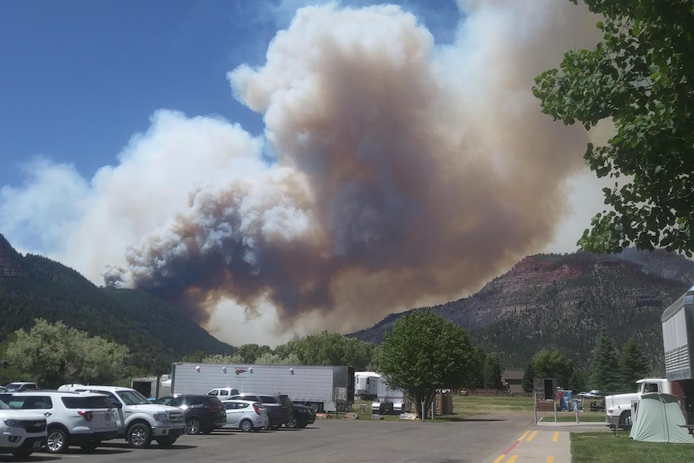
In areas that experience low-severity burns, fire events can serve to eliminate vegetative competition, rejuvenate its growth and improve watershed conditions. But, in landscapes subjected to high or even moderate burn severity, the post-fire threats to public safety and natural resources can be extreme. Photo credit: Colorado State Forest Service

From the Ecological Society of America (Zoe Gentes):

When wildfires burn up forests, they don’t just damage the trees. They destroy a key part of the global carbon cycle. Restoring those trees as quickly as possible could tip the scale in favor of mitigating severe climate change.

Lisa A. McCauley, a spatial analyst at The Nature Conservancy, explains how quick action to thin out vegetation will actually increase carbon storage in forests by the end of this century. Her new paper is published in the Ecological Society of America’s journal Ecological Applications, and she will present the findings this August at ESA’s 2019 Annual Meeting in Louisville, KY.

“With predictions of widespread mortality of western U.S. forests under climate change,” McCauley states, “our study addresses how large-scale restoration of overly-dense, fire-adapted forests is one of the few tools available to managers that could minimize the adverse effects of climate change and maintain forest cover.”

Forests are a vital carbon sink – a natural sponge that pulls carbon out of the atmosphere through plant photosynthesis. Because carbon dioxide (CO2) emissions from human activities are a major cause of climate change, forests do humanity a huge service by disposing of much of its gaseous waste.

Unfortunately, wildfires are more common than they used to be. Higher tree density, more dry wood for fuel, and a warmer, drier climate have caused an increase in the frequency, size, and severity of wildfires in western U.S. forests. Restoring forests in a timely manner is critical in making subsequent wildfires are less likely. The U.S. Forest Service states that rehabilitation and restoration takes many years, and includes planting trees, reestablishing native species, restoring habitats, and treating for invasive plants. There is an urgent need for such restoration in the southwest U.S. to balance out the carbon cycle.

Enter, the Four Forest Restoration Initiative (4FRI). The U.S. Forest Service began the 4FRI in 2010 to restore 2.4 million acres (3750 square miles) of national forests in Arizona. The goals of the 4FRI are to restore the structure, pattern, composition, and health of fire-adapted (dependent on occasional fires for their lifecycle) ponderosa pine ecosystems; reduce fuels and the risk of unnaturally severe wildfires; and provide for wildlife and plant diversity. Doing so involves a full suite of restoration projects that are carried out by US Forest Service personnel, partners and volunteers, and contractors. Managers of the four forests – the Kaibab, Coconino, Apache-Sitgreaves, and Tonto – are engaged in a huge, collaborative initiative to with a diverse group of stakeholders to explore the best methods for restoring the ponderosa pine forests in the region.

One such exploration is a study in which researchers, including McCauley, use computer simulations to see how the carbon cycle and wildfire severity between the years 2010-2099 would be influenced by different rates of restoration of about 1500 square miles of forest.

A potential drawback to a very rapid restoration plan is that it includes the thinning out (harvesting) of dense, dry trees — possibly by controlled burns — to get rid of plants that could act as potential wildfire fuel. Reduction in overall vegetation could mean that the overall carbon uptake and storage of these forests would drop.

“The conventional wisdom has been that forest restoration in the western U.S. does not benefit carbon stocks,” McCauley says. “However, with wildfire size, frequency and severity increasing, we believe that additional research is needed across more forests so that we can better understand the fate of carbon and forest cover, particularly for fire-adapted forests where tree densities exceed historical norms and the risks of climate-induced forest loss are increasing.”

Interestingly, the simulations show that despite early decreases in the ecosystem’s stored carbon, a rapid restoration plan increases total carbon storage by 11-20%, which is about 8-14 million metric tons of carbon by the end of the century. This is equal to the removal of carbon emissions from 67,000-123,000 passenger vehicles per year until 2100.

“By minimizing high-severity fires,” McCauley explains, “accelerated forest thinning can stabilize forest carbon stocks and buy time – decades – to better adapt to the effects of climate change on forest cover.”

Restored forests provide other benefits than just increased carbon storage in the next century. A restored fire-adapted forest would be less dense, with fewer trees but more diversity, allowing more sunlight to penetrate the canopy, increasing cover of grass and encouraging a more diverse understory. The wildfires that do occur would burn at lower severity as ground fires that consume grasses rather than torching canopies that kills trees.

McCauley says this study is unique because it is a large, landscape-scale study that uses data from a real-world restoration project–the largest restoration being implemented in the U.S. The results are indeed promising, indicating that restoration is likely to stabilize carbon and the benefits are greater when the pace of restoration is faster.

Wildfire mitigation projects help reduce damage from the #LakeChristineFire burn scar

From The Aspen Times (Scott Condon):

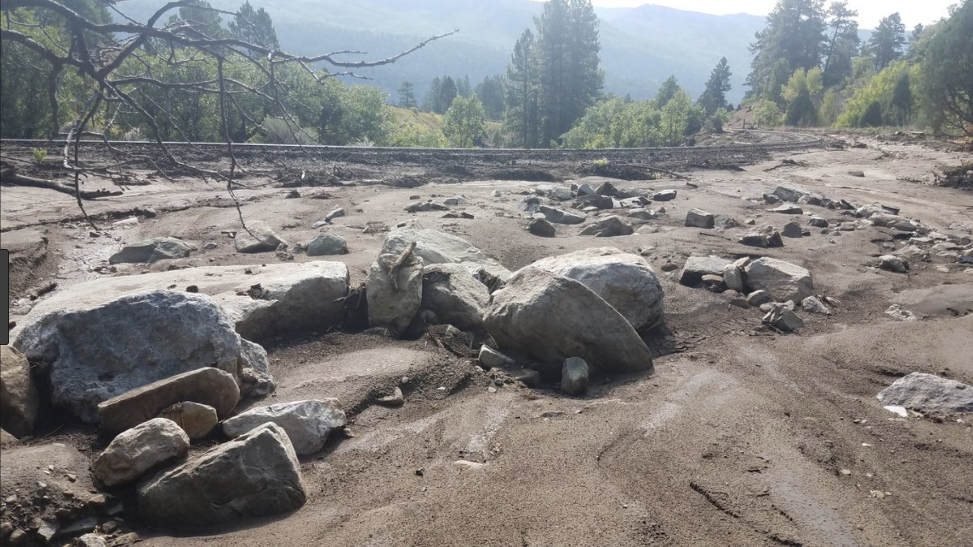
A large catch basin that Eagle County sculpted into the mountainside above Basalt in recent weeks prevented significantly more water, mud and debris from swamping part of the Hill District during [the August 4, 2019] flash flood, officials said Thursday.

Eagle County Road and Bridge Department used heavy equipment to dig out a settlement pond and then used the dirt removed to regrade the hillside above the Basberg Townhouses. Boulders were placed in two drainage channels that led the water to the settlement pond. While water topped the pond during Sunday’s downpour, a lot of it was captured. Thick, sludge-like water was still in the pond Thursday.

This summer, the town of Basalt also created berms, added curb and gutter and installed a swale to direct water, all just uphill from the Basbergs…

The work was part of a $1.35 million Emergency Watershed Protection Program project. The federal government supplied a $1.23 million grant through the Natural Resources Conservation Service. The state of Colorado contributed $153,359. Basalt, Eagle County and Colorado Parks and Wildlife are undertaking in-kind projects valued at $153,359, or 12.5%, to cover a local match.

The grant was administered by Basalt. Projects were identified by the Natural Resources Conservation Service. Engineering was provided by SGM, a consultant for Basalt town government.

Basalt Town Manager Ryan Mahoney said about 20% of the work has been completed. Additional projects have been identified above Basalt, on the hillside overlooking Ace Lane’s Tree Farm property in El Jebel and on Basalt Mountain where it drops steeply to Upper Cattle Creek where several historic cabins are located.

Mahoney said he felt work performed at and around a culvert at the intersection of Pinon and Cedar drives in the Hill District also softened the blow of the flash flood.

The town widened the area around the entrance to the culvert but it was still overwhelmed by the amount of water roaring down from a usually dry gulch on the mountain.

“We’ve got some river pigs — big concrete blocks — at the bottom of the drainage,” he said. “Those are to hold debris back.”

[…]

Governments teamed to install three rain gauges on Basalt Mountain so the risk of flash flooding can be better assessed in the future. Those rain gauges were calibrated this week to ensure accurate readings.

In addition, National Weather Service meteorologists visited Basalt Mountain with local emergency responders this week to get a better feel for the lay of the land. Thompson said Sunday’s storm demonstrated that different sections of Basalt Mountain can experience vastly different weather.

The projects funded through the Emergency Watershed Protection Program will continue through the summer and into fall. All told, work will be undertaken in nine drainages, Mahoney said.

@CWCB_DNR’s August Confluence Newsletter is hot off the presses

Click here to read the newsletter. Here’s an excerpt:

Nominate A Local Water Hero

Vote for your local basin water hero! Do you know someone that deserves to be recognized for their water industry service, outstanding contributions, or innovative thinking? Anyone is eligible. Anyone can vote. Winners will be recognized at the C-9 Statewide Summit of Colorado’s 9 Basin Roundtable in September. Vote here today!

‘Warning flag’: IPCC finds rapid land warming threatens food security — Sydney Morning Herald #ActOnClimate #aridification

From The Sydney Morning Herald (Peter Hannam):

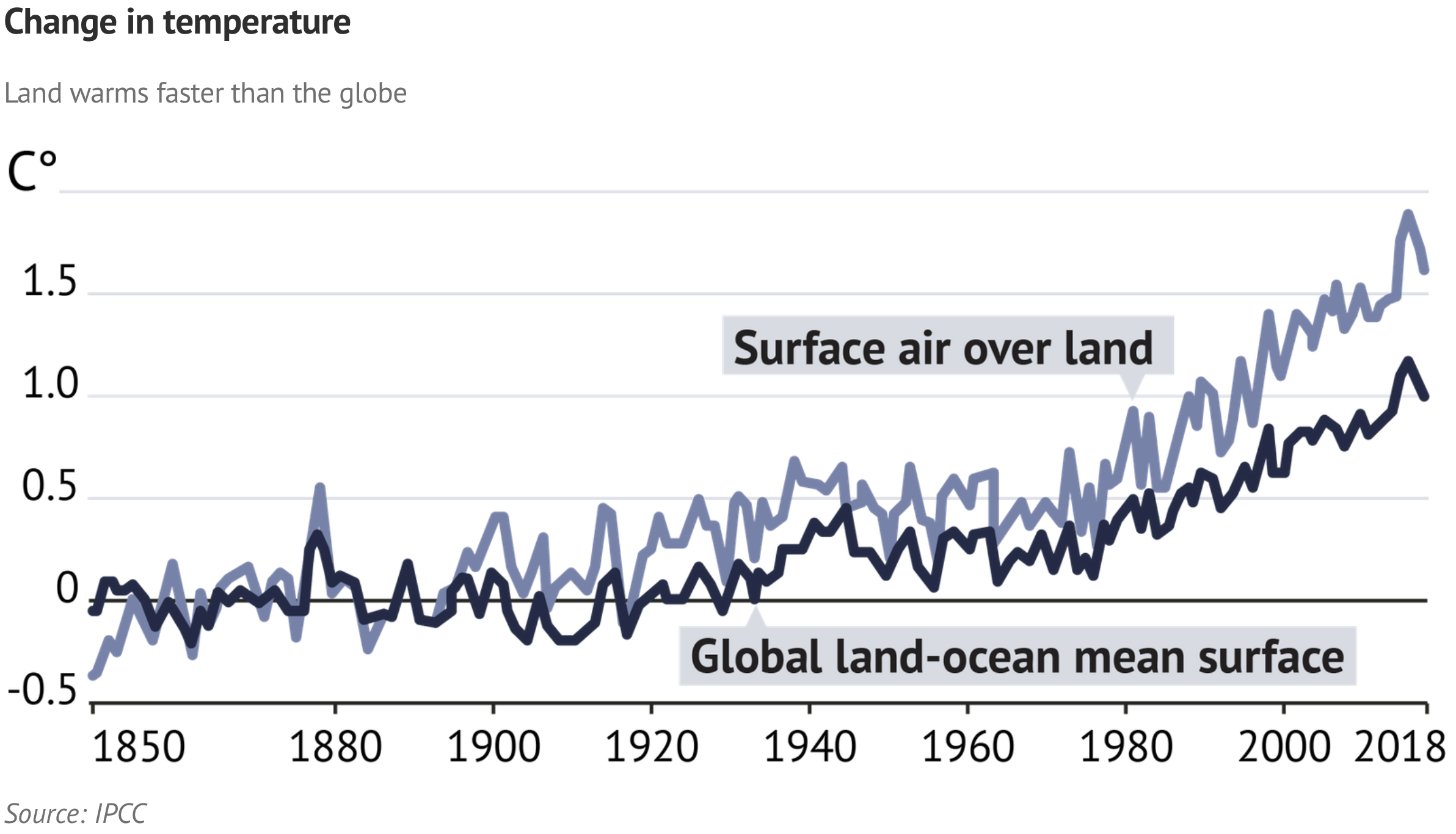
Temperatures over the world’s land areas are warming at about twice the global rate, expanding deserts in Australia, Africa and Asia, and hitting food security hard, a new UN report finds.

The Intergovernmental Panel on Climate Change (IPCC) found that surface air temperatures between 2006 and 2015 were 1.53 degrees warmer than the pre-industrial average of 1850-1900. By contrast, the combined warming of land and oceans was 0.87 degrees, the IPCC’s special report on land said.

Compared with current conditions, though, land areas have warmed by about 1.8 degrees, and global mean temperatures by 1.1 degrees, said Stefan Rahmstorf from the Potsdam Institute for Climate Impact Research.

“Climate change, including increases in frequency and intensity of extremes, has adversely impacted food security and terrestrial ecosystems, as well as contributed to desertification and land degradation in many regions,” the report’s Summary for Policymakers said.

The report, compiled by 107 authors from 52 nations and released in Geneva on Thursday, noted humans typically relied on land for their homes and the great bulk of their food, fibre and feed for animals.

Mark Howden, director of the Climate Change Institute at the Australian National University and an IPCC vice-chair, said the report was “a warning flag” about the threats and “how hard we need to go” to cut greenhouse gas emissions.

Land’s effect on climate

About a quarter of the earth’s ice-free land was already subject to human-caused degradation, with soil losses as much as 100 times higher than soil formation, the report said.

Australia, sub-Saharan Africa and parts of east and central Asia were singled out as regions where rising evapotranspiration (caused by hotter temperatures and reduced rainfall) were causing deserts to expand.

Climate change would “ramp up” existing degradation, such as through erosion caused by more intense rainfall events, Professor Howden said.

But land would also affect the climate because land-clearing, methane from livestock, fertiliser, and other emissions related to farming and forestry are major sources of greenhouse gases.

“Just under a third of our emissions come from our food systems, globally,” he said.

On the flip side, reducing land clearing and increasing soil carbon sequestration would help reduce the damaging trends, as would consumers switching to more plant-based diets rather than meat-based ones, the report said.

Here’s the link to the IPCC report Climate Change and Land: Summary for Policy Makers:

This Special Report on Climate Change and Land responds to the Panel decision in 2016 to prepare three Special Reports during the Sixth Assessment cycle, taking account of proposals from governments and observer organizations. This report addresses greenhouse gas (GHG) fluxes in land-based ecosystems , land use and sustainable land management in relation to climate change adaptation and mitigation, desertification, land degradation6 and food security. This report follows the publication of other recent reports, including the IPCC Special Report on Global Warming of 1.5°C (SR15), the thematic assessment of the Intergovernmental Science Policy Platform on Biodiversity and Ecosystem Services (IPBES) on Land Degradation and Restoration, the IPBES Global Assessment Report on Biodiversity and Ecosystem Services, and the Global Land Outlook of the UN Convention to Combat Desertification (UNCCD). This report provides an updated assessment of the current state of knowledge8 while striving for coherence and complementarity with other recent reports.

Farmington, #NewMexico: San Juan Water Commission meeting recap

From Farmington Daily Times (Hannah Grover):

The lower basin states of Arizona, Nevada and California have created a drought contingency plan while the upper basin states including New Mexico, Colorado, Utah and Wyoming have a different drought contingency plan.

These two plans fall under a companion agreement between the upper and lower basin states as well as federal legislation signed into law earlier this year.

The key component of these agreements is to keep water levels in Lake Powell from dropping below 3,525 feet in elevation and to keep water levels in Lake Mead above 1,090 feet in elevation.

The upper basin states will be responsible for maintaining the levels in Lake Powell.

The San Juan Water Commission learned about the drought contingency plan during a meeting on Aug. 7 in Farmington.

Here are three things New Mexico residents should know about the Drought Contingency Plan:

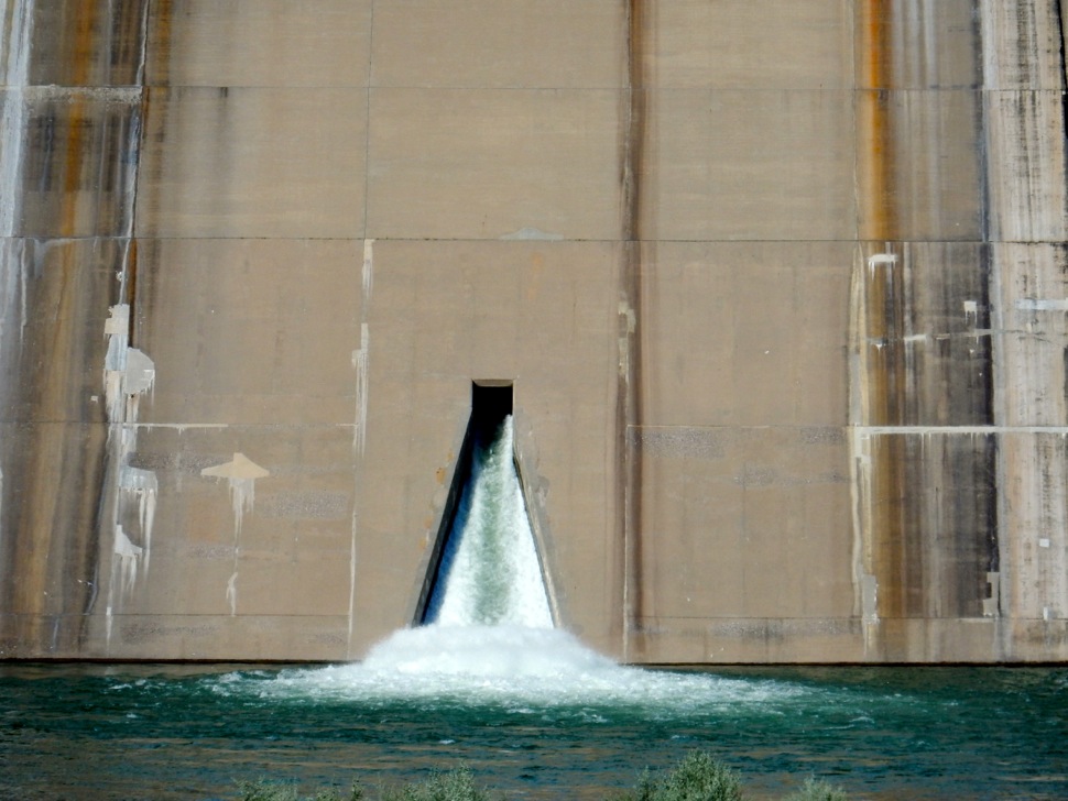
The outflow at the bottom of Navajo Reservoir in New Mexico. Photo: Brent Gardner-Smith/Aspen Journalism

1. Navajo Lake is a key component

…New Mexico Interstate Stream Commission Lawyer Dominique Work said the first step will be to look at operations at Lake Powell to determine if less water could be released. If that does not work, the response plan will look at different storage reservoirs — Flaming Gorge, Aspinall and Navajo Lake.

All three reservoirs can release water into rivers that eventually flow into Lake Powell.

One of those three storage reservoirs could be chosen to release water to keep the levels at Lake Powell above 3,525 feet…

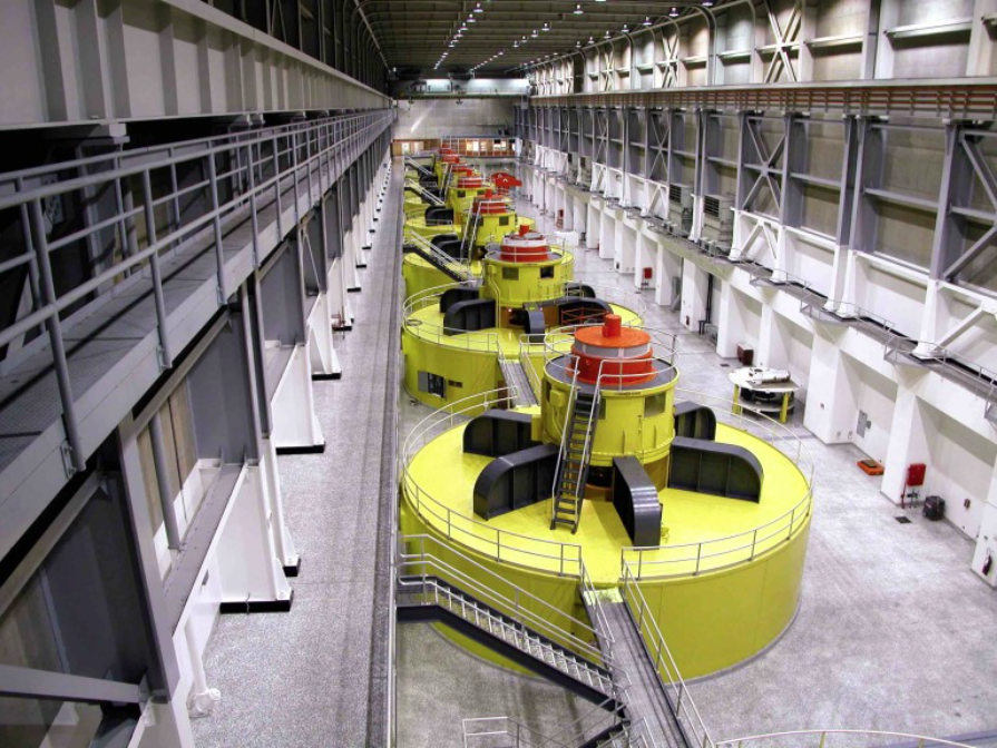
How much electricity the turbines in the bowels of Glen Canyon Dam can generate depends upon how much water is delivered from the Wind River Range of Wyoming and the high mountains of Colorado into Lake Powell. Photo/Bureau of Reclamation.

2. The 3,525 feet water level was chosen for hydropower generation

Lake Powell produces hydropower that provides electricity to utilities in Wyoming, Utah, Colorado, New Mexico, Arizona, Nevada and Nebraska. According to the U.S. Bureau of Reclamation, the hydropower plant at Glen Canyon Dam produces about five billion kilowatt hours of power each year.

Electric utilities in Farmington and Aztec both receive power from Lake Powell.

If the lake levels drop below 3,490 feet, the hydropower plant cannot work…

Hay fields under Meeker Ditch 2. Photo credit: Brent Gardner-Smith/Aspen Journalism

3. Plan also allows upper basin states to place water in storage

Another key aspect of the plan is it allows the upper basin states to develop a plan to store up to 500,000 acre-feet of additional water in Navajo Lake, Flaming Gorge and Aspinall. This water would be released if needed to fulfill Colorado River Compact requirements…

However, the 500,000 acre-feet of water must come from water rights that would otherwise have been used if it had not been put into storage. For example, a farmer could choose to put an acre-foot of water into storage and let their field go fallow.

The upper basin states must develop a demand management program before they can begin putting water in storage in the reservoirs.

@USBR: The next Aspinall Operations meeting will be held on Thursday, August 15th, at the Elk Creek Visitor Center at Blue Mesa Reservoir. Start time is 1:00 PM

What a drier and hotter future means for the arid #Southwest — Yale Climate Connections #ActOnClimate

Colorado River “Beginnings”. Photo: Brent Gardner-Smith/Aspen Journalism

From Yale Climate Connections (Daisy Simmons):

Water shortages, wildfires, and algal blooms to become more common.

“It’s a dry heat” is usually considered a positive expression, a relief on high-temperature days, and salve for the reality that the southwestern U.S. has never been what you’d call water-rich. But now human-caused climate change is adding new credence to the region’s bone-dry reputation – and not in a good way.

For starters, that’s because regional temperatures are on the rise, according to a late 2018 federal government assessment report. Between 1901 and 2016, temperatures increased across the Southwest, with the greatest upturns in California and Colorado. This warming trend – together with its diminished snowfall – have intensified recent droughts.

Meanwhile, growing population, aging infrastructure, and groundwater depletion are also compounding long-standing water scarcity issues in the region.

These mounting pressures have a bevvy of potential implications, from human health and ecological function, to food and energy supply. Consider:

  • Food production is deeply affected by drought, and recent years have seen crops and livelihoods across the region, ruined.
  • Recent droughts have dried out forests, altering habitats and making them more susceptible to fire.
  • Indigenous tribes across the region are experiencing adverse effects of drought, such as declines in traditional staple foods like acorns and corn.
  • Less snowpack means less water available for hydropower. In states like California, at times, when hydropower supply goes down, carbon emissions go up.
  • And that’s just the nutshell. To really understand the potential effects of climate change on water supply, it’s useful first to crack into the basic history of water in the American West.

    The Southwest’s history with water

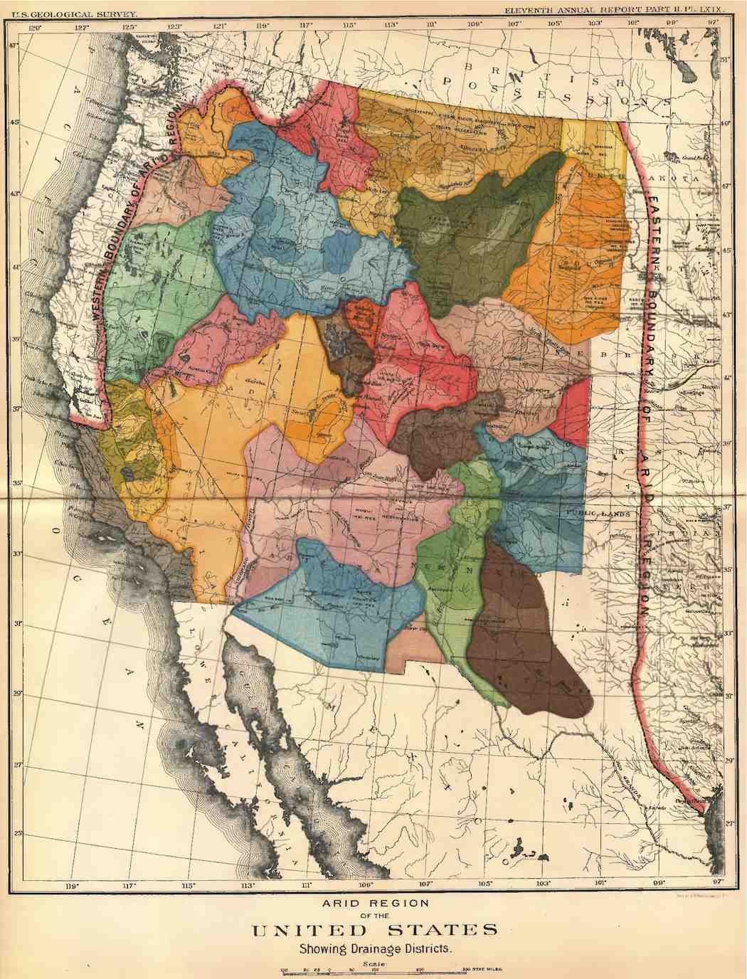
    Aridity long has been a defining characteristic of the region, from 19th-century maps that labeled it the “Great American Desert,” to those of its states consumed by the Dust Bowl of the 1930s. Cities in the region have grown undeterred by this thirstiness, with 32 percent growth in the last quarter of the 20th century alone. In fact, western states comprise nine of the top 10 slots in population growth over the past century, based on Census records from 1917-2017.

    Humans, of course, could not build cities without access to water, so massive efforts have been made all along the way to connect drier areas with wetter ones. Diversions from the Colorado River, as a prime example, have redirected its flow hundreds of miles away, to major cities like Los Angeles and Phoenix, using dams and aqueducts to divvy up the river’s waters (ultimately weakening the river, but that’s a story for another day).

    Today, the American West is home to more people than ever – along with their fundamental thirst for water. And the region’s hard-won water supply doesn’t just support the locals, either. It also affects the millions of people across the country and around the globe who eat food grown in agriculture hubs like California, home to an estimated two-thirds of all the country’s fruits and nuts.

    The trouble is, climate change is already making water harder to come by in these parts. According to the Fourth National Climate Assessment cited above, human-caused climate change is making the West hotter, with greater temperature increases there than in any other region, and drier; and with “chronic” deficits of precipitation expected in the future, particularly in the Southwest.

    What ‘drier, hotter’ means for water across the West

    Roughly three-quarters of the country’s water supply comes from surface water, that is, rivers, streams and lakes, which are replenished naturally by rain or snow. The rest comes from groundwater, also replenished by precipitation.

    But under the drier and hotter conditions of climate change in the western U.S., there’s less precipitation falling to fully replenish what’s being consumed.

    Consider these additional key conditions increasingly affecting water supply in the Southwest:

    1. Warmer winters are reducing snowpack across the West.

    In the high mountains of the West, winter snowpack is a critical piece of the water supply picture. As these “frozen reservoirs” melt through spring and summer, they keep mountain-fed rivers and streams flowing fast all season long, filling up reservoirs to contribute to regional water supply all year long.

    California, for example, receives 75 percent of its rain and snow in the watersheds north of Sacramento. As snow from the Sierra Nevada mountain range melts to fill reservoirs in the spring and summer, it provides roughly 30 percent of the state’s water supply throughout the year.

    But the region’s snowpack has been declining dramatically for decades. A new study of long-term snowfall in the western U.S. found declines, one-third of them “significant,” in snowpack at more than 90 percent of monitored sites.

    Why? Because the long-term trend toward warmer winters is causing more winter precipitation to fall as rain. And what snow has fallen is often melting earlier, flooding riverbeds and overwhelming reservoirs in spring, then leaving drier conditions behind as the summer months tick on.

    Complicating matters further is the fact that warmer air temperatures in summer also mean more water is lost to evaporation.

    2. Western states have always endured drought, but it’s getting worse.

    Droughts have historically plagued the Southwest, but the region is now considered “one of the more sensitive regions in the world” for heightened risk of drought sparked by climate change. For example, the California drought that stretched from 2011 to 2017 is now considered one of most extreme in the state’s history.

    One reason drought is becoming more intense and frequent? Warmer temperatures also leads to higher evaporation rates and plant transpiration, increasing water loss in soil and plants.

    It’s important to note here that increasing drought doesn’t mean precipitation is off the table. Climate change is also associated with more extreme weather in the region, including, at times, periods of heavy precipitation followed by possible flash flooding, causing what’s been called “precipitation whiplash.”

    In addition to implications for water supply, drought is also a major cost sink. Since tracking began in 1980, drought is the second most economically costly of U.S. weather and climate disasters, costing a net $247 billion as of 2019.

    3. Warming weather can lead to harmful algal blooms.

    Warmer air temperatures and less snow-fed water can contribute to warmer water, a potential boon to algae growth. Although naturally occurring, algae can sometimes grow out of proportion to its ecosystem and create harmful, even toxic, water conditions.

    Algal blooms can also be compounded by excess nutrient pollution that pours in during the severe weather events increasingly associated with climate change. More than just creating murky water, these blooms can produce toxins that can infiltrate a city’s drinking water supply, as recently evidenced in Oregon.

    More research is needed to understand the direct links between algal bloom and climate change, but some of the worst blooms on record have occurred within the past decade or so.

    So what solutions may lie ahead?

    Rising temperatures and more frequent and severe droughts are expected to ramp up competition for water across the western U.S., whether for civic use, agriculture, or hydropower production. So what can be done?

    There are a few ways communities are working to protect water supply into the future.

    Phoenix, Arizona, for example, has been preparing for increasing drought in several key ways. For starters, it’s been banking water since 1996, to save for a non-rainy day. The fast-growing city also recycles wastewater, uses gray water in agriculture, and is working on “toilet-to-tap” technology. Private citizens are increasingly answering the call: In 2000, roughly 80 percent of city buildings were surrounded by lawns; now it’s estimated at just 14 percent. Plus Arizona, along with other states in the Colorado River basin, recently signed onto an interstate Drought Contingency Plan, which aims to reduce the risk of declining water levels.

    Cities can also modernize aging infrastructure to help keep water from being lost to old, leaky pipes and unprotected channels, which are prone to evaporation. In Los Angeles for example, one-fifth of the city’s water pipes were built in 1931 – and are considered the culprits behind nearly half the city’s water loss.

    Landscape restoration is another way forward. In the West, restoration efforts could include increasing natural water storage by restoring prairies and meadows around headlands, which soak up melting snow and hold it for later release.

    These and other actions will be needed to sustain water supply for the West’s booming populations. But experts agree that the most powerful, long-term fix for this problem must include addressing the underlying threat: climate change.

    “#Colorado is the #Southwest’s water cooler” — Michael Cox #ColoradoRiver #COriver #aridification

    Here’s a guest column from the Michael Cox via The Montrose Press:

    All hell needs is water.

    That iconic declaration could have been uttered by any number of famous writers, government officials and even men and women of the cloth. In fact, it was the observation of an undertaker from Prescott, Arizona. Budge Ruffner was forced to become a mortician when his father won the funeral home in a card game on Whiskey Row. Budge was a better philosopher/writer than he was an embalmer. He was a student of the history of this corner of the nation. And so, one of his books, published by the University of Arizona, carried this astute observation as the title.

    For much of the great Southwest, from El Centro to Amarillo, and from Idaho to the Mexico border, one of the only things that ever really stood in the way of progress or economic stability was the availability of a dependable water supply. Sunny and dry with, in many cases, fertile soil, the desert only needed moisture, as is testified to whenever it rains in the desert and a profusion of flowers burst forth.

    The Uncompahgre River Valley is technically high desert, even though a river runs through it. Early, it seemed like a nice place to live and the river valley soil proved rich. But the water came and went — it went more often than it came. Farming was a gamble at best. Often the summer months would see the river reduced to a trickle.

    The solution came when one of those early farmers, Frank Lauzon, put forth the idea of a tunnel bringing water from the much bigger, and more consistent, Gunnison River to the Montrose valley. The longest irrigation tunnel in the world turned Montrose into a fertile place to grow everything from beans to a sweet corn variety that is now in demand worldwide.

    But that is not the happy ending to the story. The prince is still a frog. And frogs need more water. What happens with water in Montrose and on the Western Slope of Colorado eventually affects places like Phoenix, Tucson, El Paso, Las Vegas, Denver and Omaha. Yes Omaha. That’s where the South Platte River, born in Colorado, joins the Missouri River. Omaha depends on the South Platte and the Missouri. Over here on the Western Slope we are the watershed that produces one of the most embattled, highly regulated and now overused rivers in the U.S., The Rio Colorado and its tributaries.

    The Colorado River itself is born in the Rockies and flows in multiple iterations to the Gulf of California. It has not been a wild river for a very long time. It is damned at Glen Canyon, Boulder Canyon, Parker, Davis Camp, Imperial and Morales. On the way, 1 million acre feet (AF) go to Las Vegas, 1.5 million to the Central Arizona Project, half-a-million to California’s Coachella Valley, 4.4 million to the Imperial Valley, plus more to other municipalities, a dozen Indian tribes and other entities. At Morales Dam on the Mexican border it gives the last of itself, a guaranteed 1.5 million acre feet to the Mexican farm lands and Mexicali, Baja, California. The river itself never reaches the ocean anymore.

    Colorado is the Southwest’s water cooler.

    Here is the bottom line, when it comes to water in the Southwestern U.S.: We have it, they want it. It has always been that way. Colorado has always been the water cooler for the rest of the southwest. Without it, lettuce doesn’t grow in the Imperial Valley. Palm Springs doesn’t water golf courses. Phoenix or Tucson don’t keep growing. Believe it or not, they all care how much water Montrose and Delta farms take out of the rivers. Which isn’t all that much.

    Agriculture on the Western Slope uses about 1.4 million acre-feet per year. The cities and towns use about 77,000 acre feet per year. There are about 80,000 acres under cultivation, primarily in Delta and Montrose counties. Those farms and ranches are a major part of the economy here. But, there are folks in Phoenix (and Denver) who would sooner those farms went fallow. That’s what causes concern for people like Steve Anderson, the General Manager of the Uncompahgre Valley Water Users Association (UVWUA).

    How much water is kept and used in the Uncompahgre River Valley depends on a staggering number of factors, the most important of which are the water rights connected to the land.

    “We are somewhat insulated in that the water rights are connected to the land,” Anderson explained. “Those senior rights are federal, connected to the agreements made when the Bureau of Reclamation facilitated the Gunnison tunnel. The rights will always been connected to the land.”

    That is important because under that arrangement, a landowner cannot simply sell his water rights to, say, a downstream entity.

    The UVWUA, which has 3,500 shareholders (landowners), gets a constant 1,000 cubic-feet per second (CFS) flow from the tunnel, 24/7, April through October. To be sure, there are folks both on the Front Range and downstream who think that is more water than is really needed in the Montrose and Delta Valleys.

    “There will always be pressure on areas like the Western Slope to cede water to the populated areas,” says Anderson. “When push comes to shove, the votes are there to change the rules.”

    It is no secret that, while there is a big mountain between Denver and Montrose, there are those who would see water moved over the mountains to satisfy the needs of the growing Denver/Colorado Springs corridor. That is in fact already being done. There was a series of clandestine, closed door meetings involving those who control those diversions in which they deeply explored the idea of mandatory, non compensated curtailing of certain Western Slope water rights, to the point of creating a scenario that would bankrupt Montrose farmers and communities. Those secret meetings were outed by the Colorado River District, a public policy agency chartered to provide planning and policy guidance regarding the Colorado River Basin. State Rep. Marc Catlin is a member of the river district board. He is also a former manager of the UVWUA and a farmer. “My life’s equity is water. It is a big deal to me,” he has been quoted as saying.

    There has always been the pervasive attitude among the urban entities who use the Colorado River, that cities are more important than agriculture, recreation and environment. It is interesting to note that water lifted over the mountains to the Eastern Slope may not necessarily wind up coming from taps in Denver. It could end up going into the South Platte system to satisfy guarantees to the downstream users in Nebraska.

    But why is everybody worried about water and river flows, we just ended a drought? The Colorado snowpack reached a record level…The upstream reservoirs, like Blue Mesa, are at 90-plus percent capacity. Lake Powell, the master pool for all downstream withdrawals, is up almost 20 feet from last year (although it is still down almost 80 feet from a full pool).

    The rest of the Lake Powell numbers give us a clue. The releases from the dam, with two months to go in the water year (October to September), are already at 100 percent of minimum withdrawal. According to the Colorado River District figures, the compacts that govern downstream releases call for a 7.5 million acre feet minimum draw down of Powell. The fact is, the lake has had a rolling average release of more than 9 million acre feet per year over the past ten years, several of which had well below average input from upstream. The sum is that only 4.5 million acre feet per year went into the lake over the past ten years and 9.1 million was released. The current wet year not withstanding, the river is very much overused, now and for the foreseeable future.

    Coloradans cannot be complacent.

    Insulated by senior rights, or not, the Uncompahgre Valley has vultures circling and they are thirsty. Big money and many times more votes make laws and rules change. According to Catlin, Anderson and anyone else involved, like agriculture water users and growing small cities like Montrose, have to be part of the fight to make sure the local economies remain viable with enough water for all uses.

    Catlin campaigned on water as his main issue last year.

    “It’s the biggest issue on the Western Slope,” he said. “We are in a drought, the Colorado River’s in a drought, and the Front Range and Southern California are wanting us to stop farming our land so that they’ll have water. I’m really not in favor of that because it seems to me that we are asking one segment of our society to change how they live so that other people can continue in the same way they always have.”

    Catlin’s remarks last winter came ahead of the current improved condition. Even, so the issue remains.

    The Colorado Farm Bureau ranks water as its top issue. Montrose County Farm Bureau director Hugh Sanburg said last month that dealing with losing more and more water downstream is a major issue for the bureau. Sanburg is a cattle rancher in the Eckert area at the foot of the Grand Mesa.

    But, put agriculture aside, there is another facet that Catlin and Anderson both talk about.

    “We are not talking about just water rights for farmers, we also are talking about recreation based on water,” Anderson said. “We keep shipping all the water to the cities and when those folks come out here to fish and paddle their kayaks, there won’t be any water.”

    Is there an answer?

    To quote MacBeth, “maybe, maybe not.” The problem is not unique to the Uncompahgre River Valley and the tributaries of the Colorado River. Water has always been an issue, everywhere. Range wars have been fought over it. Millions of hours and dollars have gone in long court cases. Predictions have been horribly wrong.

    Anderson says a new water plan for Colorado is needed.

    “It is going to cost a lot of money, as much as 100 million dollars,” he said.

    What do we get for $100 million?

    “We get storage, infrastructure, education and management,” Anderson declared.

    The Colorado Water Conservation Board, on which Anderson serves, has taken on the task. The draft of Colorado’s Water Plan is now public. The primary thrust of the plan is conservation. The funding for the project comes from a wide assortment of organizations from the Colorado Water Trust to the Gates Family Foundation. In all, there are 21 entities that have signed on for the project. In some cases there is reason to believe that some of those 21 have competing goals for water use.

    Next week: The Water Plan and what it means for the Western Slope.

    Michael A Cox is a Montrose-based content developer and author. He may be reached at mcox@burrocreekpictures.com

    #ColoradoSprings: Detention ponds helping to improve safety — The Colorado Springs Gazette

    From The Colorado Springs Gazette (Patrick Nelson):

    Water left behind by severe weather in northeast Colorado Springs has some neighbors are concerned about rising water in ponding basins near their homes.

    Taxpayers agreed to pay more money for improvements to the stormwater system in the Colorado Springs area and while some folks in Wolf Ranch were concerned about a detention pond filling up, the experts say it’s evidence the stormwater system is doing its job.

    On the surface it’s calm, but the stormwater system below this detention pond in Wolf Ranch is moving thousands of gallons of water down stream. Seeing this normally dry basin full of water had some neighbors on edge. Even some of the wildlife came in for a closer look, but stormwater expert Richard Mulledy says the system is performing at a high level.

    “You’ve got to give it an “A”,” said the Colorado Springs Stormwater Enterprise Manager. “I mean, it really took a hard hit and we didn’t see anything major.”

    Just down the road near Research Parkway and Black Forest Road, work is going on to build another detention pond to help mitigate flooding during severe weather.

    “Our stormwater infrastructure is enormous. we’re 195 square miles we’re actually the largest landwise city in the state,” said Mulledy.

    It’s become a requirement for new neighborhoods because if there isn’t somewhere for the water to go it could cause major problems.

    “If this facility wasn’t here you would’ve seen that giant flash flood come down erode the banks, flow over the top of roads, that’s when you see people’s backyards caving in. things like that,” said Mulledy.

    The water in this Wolf Ranch detention pond will completely drain into Cottonwood Creek within 72-hours. Across the city, ponds like this are used to control the water flow making areas near waterways safer downstream all the way to Pueblo.

    Colorado Springs with the Front Range in background. Photo credit Wikipedia.

    #ColoradoSprings closes Prospect Lake in Memorial Park due to positive blue-green algae testing — Colorado Springs Gazette

    From The Colorado Springs Gazette (Liz Henderson):

    Prospect Lake in Memorial Park has been closed indefinitely after a test found toxic blue-green algae in the water, Colorado Springs officials said Friday.

    A “precautionary water sample,” taken from the lake Friday morning by the Colorado Department of Public Health and Environment, tested positive for mycrocystin toxin, also known as blue-green algae.

    The lake’s swim beach was roped off and closure signs were posted. Fishing areas remain open, but anglers are encouraged to clean the fish and remove guts. Rentals are not available, and pets are not allowed.

    “Given today’s positive test for mycrocystin toxin, we have closed Prospect Lake for usage,” said Erik Rodriguez of the city’s Parks, Recreation and Cultural Services in a statement. “CDPHE will continue to test weekly until the bacteria clears up.”

    In the meantime, the city has banned swimming, bathing, paddleboarding, motorized and nonmotorized boats even with permits, tubing and water skiing.

    Prospect Lake in Memorial Park. By Beverly & Pack – Colorado Ballon Classic 2009, Labor Day Weekend, Prospect Lake in Memorial Park in Colorado Springs, CO. Uploaded by Tomer T, CC BY 2.0, https://commons.wikimedia.org/w/index.php?curid=19191608

    @EPA and the shame of this @POTUS administration: “They’re gutting science across the agencies, across the departments, across the government” — Christine Todd Whitman

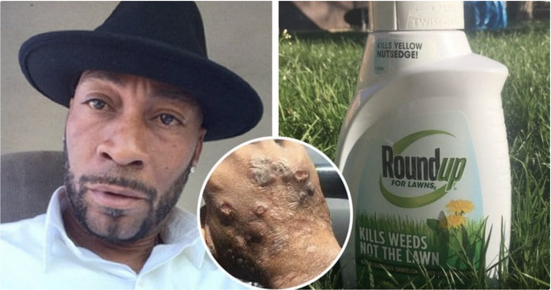
    In a historic win of the common man against a powerful corporate, chemical giant Monsanto was ordered to pay $289m damages to a man who claimed he got cancer after being directly exposed to the company’s glyphosate-based weedkillers, including the widely used Roundup. Screenshot from meaww.com

    From the Associated Press via the The Aurora Sentinel:

    EPA won’t approve warning labels for Roundup chemical

    The Trump administration has instructed companies not to warn customers about products that contain glyphosate, a move aimed at California as it fights one of the world’s largest agriculture companies about the potentially cancer-causing chemical.

    The U.S. Environmental Protection Agency says it will no longer approve labels warning glyphosate is known to cause cancer. The chemical is marketed as a weed killer by Monsanto under the brand Roundup.

    California requires warning labels on glyphosate products because the International Agency for Research on Cancer has said it is “probably carcinogenic.”

    The EPA disagrees, saying its research shows the chemical poses no risks to public health.

    “It is irresponsible to require labels on products that are inaccurate when EPA knows the product does not pose a cancer risk,” EPA Administrator Andrew Wheeler said in a statement. “We will not allow California’s flawed program to dictate federal policy.”

    California’s Safe Drinking Water and Toxic Enforcement Act, approved by voters in 1986, requires the government to publish a list of chemicals known to cause cancer, as determined by a variety of outside groups that include the EPA and IARC. The law also requires companies to warn customers about those chemicals.

    California regulators have twice concluded glyphosate did not pose a cancer risk for drinking water. But in 2015, the IARC classified the chemical as “probably carcinogenic,” triggering a warning label under California law. Monsanto sued, and last year a federal judge blocked California from enforcing the warning label until the lawsuit is resolved.

    Federal law regulates how pesticides are used and how they are labeled. States are often allowed to impose their own requirements, but they can’t be weaker than the federal law, according to Brett Hartl, government affairs director for the Center for Biological Diversity.

    Hartl said it is unusual for the EPA to tell a state it can’t go beyond the federal requirements.

    “It’s a little bit sad the EPA is the biggest cheerleader and defender of glyphosate,” Hartl said. “It’s the Environmental Protection Agency, not the pesticide protection agency.”

    In a letter to companies explaining its decision, Michael L. Goodis, director of EPA’s registration division in its Office of Pesticide Programs, said the agency considers labels warning glyphosate to cause cancer to “constitute a false and misleading statement,” which is prohibited by federal law.

    From CNN New via NBC4i.com:

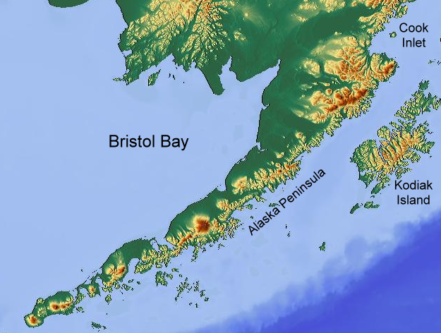
    Bristol Bay. By own work – maps-for-free.com, CC BY-SA 3.0, https://commons.wikimedia.org/w/index.php?curid=3709948

    EPA scientists ordered to allow Alaska mine to move forward; could endanger wildlife

    In a major environmental reversal, EPA scientists have been ordered to get out of the way of a massive, controversial copper and gold mine slated for a highly sensitive area in Alaska.

    The order may have originated from the President himself.

    The meeting took place on the tarmac during an Air Force One stopover June 26. Alaska Gov. Mike Dunleavy, a pro-mining, pro-business, anti-EPA governor, met with Donald Trump for nearly a half-hour.

    Dunleavy has been pushing for approval of a massive gold and copper mine known as the Pebble Mine, planned for Alaska’s Bristol Bay watershed, home to the breeding grounds for one fo the world’s largest and most pristine sockeye salmon fisheries.

    After his meeting on Air Force One, Dunleavy said, “He (Trump) really believes in the opportunities here in Alaska and he’s doing everything he can to help us on our mining concerns.”

    Inside EPA sources now tell CNN the very next day, June 27, top EPA officials in Washington held an internal video conference with Seattle, and told staff the EPA was removing a special protection for Bristol Bay, and, in essence, clearing the way for what could be one fo the largest open-pit mines in the world.

    That internal announcement was a “total shock” to top EPA scientists, sources told CNN, because their environmental concerns were overruled by Trump political appointees at EPA headquarters in Washington.

    Bristol Bay and its tributaries are regarded as one of the world’s most important salmon fisheries, roughly half the world’s sockeye salmon come from there.

    It’s been protected since 2014, when after three years of study, the Obama-era EPA used a rare provision of the Clean Water Act — to basically veto any mining that could pose a threat.

    “EPA scientists writing a mine ‘would result in complete loss of fish habitat’ that was ‘irreversible.’ It’s mindboggling that it’s still being considered at all,” said Christine Todd Whitman, former EPA administrator.

    Todd Whitman is a Republican, former New Jersey governor, and under President George W. Bush, ran the EPA. She has joined several other former EPA chiefs to publically oppose the mine.

    “The potential damage is overwhelming,” she said. “The opposition to it up there is amazing and everywhere. I mean, this was a huge, the potential of over 80 miles of streams, thousands of acres, could be damaged from this project.”

    This is the second time during the Trump administration the political appointees at the EPA have decided to remove special protections for Bristol Bay to pave the way for this huge mine.

    In 2017, President Trump’s first EPA administrator, scandal-plagued Scott Pruitt, canceled the protections after a private meeting with the mine company’s CEO.

    After a report exposed the meeting and the lack of scientific debate behind the reversal, Pruitt backed down and put the protections back in place.

    Now, another private meeting, this time with the president himself, has led to yet another win for the mine, and the removal of environmental protections for this pristine watershed.

    “One of the most troubling things about this administration, I mean there are a lot of things that trouble me, but on the environmental side is this disregard of science,” Todd Whitman said. “They’re gutting science across the agencies, across the departments, across the government.”

    If the order is followed through with, Todd Whitman sees a number of lawsuits possibly being filed.

    “Environmental groups, native Alaskans, you’ll have a host of lawsuits, I’m convinced,” she said…

    At EPA headquarters, Andrew Wheeler, the former coal company lobbyist who now runs the agency, has a tie to Pebble Mine, too. He has recused himself from decision making on the project because his former law firm represents the mine.

    EPA scientists said political and business favors are driving decision making.

    One top EPA official said, “We were told to get out of the way and just make it happen.”

    The EPA said the Obama-era protections were outdated and the mine still has to go through the approval process.

    When asked about the internal EPA meeting on June 27, at first, the EPA denied it happened, but when presented with evidence, they admitted the meeting took place.

    Sources said the meeting is when officials told scientists the decision had been made and their work was not needed.

    There are advantages to commuting by bicycle #Denver #Colorado

    Coyote Gulch on the Clear Creek Trail near Little Dry Creek Lake in the industrial area of S. Adams County August 9, 2019.
    Clear Creek Trail near Little Dry Creek Lake in the industrial area of S. Adams County August 9, 2019.

    Jennifer Gimbel named to @Northern_Water Board

    Jennifer Gimbel. Photo credit: Northern Water

    Here’s the release from Northern Water (Jeff Stahla):

    Jennifer Gimbel of Loveland has been chosen to serve on the Northern Water Board of Directors and Municipal Subdistrict Board of Directors.

    She will represent Larimer County and replaces Bill Fischer, who passed away May 7. By state law, directors are chosen by the chief judge of the district court.

    Gimbel has an extensive background in state and federal water policy.

    She currently is the senior water policy scholar for the Colorado Water Center, based at Colorado State University. In this position she teaches a graduate seminar on water issues and develops policy strategy papers on issues facing the Colorado River and the Upper Basin states, of which Colorado is one.

    Before that, she served as the principal deputy assistant secretary for water and science in the Department of the Interior and was deputy commissioner for external and intergovernmental affairs for the Bureau of Reclamation.

    From 2008 to 2013, Gimbel was the director of the Colorado Water Conservation Board, a group within the Department of Natural Resources that works to protect and develop the state’s water resources.

    “Water is such an important part of our lives and our future,” she said. “It is an honor to be appointed to the Northern board, which has been and continues to be important in water supply and policy not only in Northern Colorado but also in all of the state.”

    Gimbel enjoys hiking and reading. She has two adult children and two grandchildren.

    Jack Holmes: One solution to numerous water projects — The Vail Daily “Valley Voices”

    Eagle River Basin

    Here’s a guest column about water projects for the upper Eagle River Valley, from Jack Holmes, that’s running in theThe Vail Daily:

    There are at least five water-related project proposals being considered for the Upper Eagle River Valley from Dowd Junction to the top of Tennessee Pass in the next 50 years. These include several tributaries of the Eagle River.

    One combined project could take care of all major stakeholders and turn the area into a model for the future. The alternative will be five decades of litigation and a patchwork of projects that will be costly to all communities.

    It is not about who will get the water. That is settled by Colorado Water Law and the 1989 Memorandum of Understanding. It is about whether the parties involved will work together, which happened during the drought of the early 2000s, or go in separate directions, which was the case during the middle 1950s.

    The common project would be an Upper Eagle Pipeline and Storage Co. from Dowd Junction to Tennessee Pass. Storage, if needed, could be at Bolts Lake and Camp Hale. The 20-mile-long pipeline would follow the route of the Eagle River, the Railroad, the U.S. 24 highway or some combination thereof depending on what works and preserves the existing scenic corridor between Dowd Junction and Tennessee Pass.

    That is the lowest continental divide pass in the Central Rockies. Those wanting to move or store water would need to pay accordingly. A trench and bury pipeline approach would seem to a good approach.

    This proposal would give all major parties what they need at a reasonable cost. Memorandum of Understanding obligations could be met. To be sure, this would require some compromise. Camp Hale restoration might need to shift from some limited and expensive wetland restorations to a series of small reservoirs but probably would get more visitors to honor the 10th Mountain Division. Extensive wetlands are a few miles away on Homestake Creek in the original Camp Hale boundaries.

    Building the one project pipeline and reservoirs would require funding, but it should cost less than tunnels, which are problematic to begin with because of potential seismic activity that would destroy the tunnels. In fact, the concept could be sold as a demonstration project worthy of grant funding.

    While moving of water is not attractive to environmentalists, the concentration of project impacts in a well-established corridor makes sense. To be sure, the rail corridor would need to be preserved for possible future use, but an adjoining pipeline could be helpful in this regard.

    If Front Range communities are more willing to pay for initial construction than Western Slope entities, the first phase of the project could start at the junction of Fall Creek and the Eagle River.

    A major environmental question is how much effort should be spent to erase existing environmental impacts in the Eagle River and its Homestake Creek tributary basins above their lower Red Cliff junction. Such actions could merely shift impacts to the other basin at great public and environmental expense.

    Anybody familiar with these issues knows that this proposal is a simplified summary. However, it also is known that 50 years in court and countless engineering and field hours can be curtailed by working together. The public has every right to insist that every attempt be made to arrive at a unified approach. While there are some good studies of limited areas, consideration of the larger area is missing at this point.

    Jack Holmes is Professor Emeritus of Political Science at Hope College in Holland, Mich., and vice-chair of the Holy Cross Wilderness Defense Fund. He has backpacked in the Holy Cross Wilderness since 1959 and is a summer resident on Homestake Creek above Red Cliff. For many years, he taught a summer course on wilderness politics.

    Minturn councillors say no to water project

    Mountains reflect off of Bolts Lake, back in the day, as seen from US 24 S in Colorado. Photo via
    LessBeatenPaths.com.

    From The Vail Daily (Edward Stoner):

    Minturn turned down a proposal Wednesday that would have provided enough water for substantial growth within the town, including the Battle Mountain developer’s proposal to build up to 712 homes near Maloit Park and Tigiwon Road.

    The Minturn Town Council voted 7-0 to deny the proposed deal between Minturn, the Eagle River Water and Sanitation District and the Battle Mountain developer.

    Most residents who spoke at the meeting opposed the deal.

    “We need to control our water,” said Minturn resident Woody Woodruff. “We can’t turn over that control to somebody else, because water is going to set the future of this town.”

    The developer had asked for a decision to approve or deny the deal Wednesday.

    Earle Bidez, mayor pro tem, cited continued concerns on the part of Minturn with the agreement — as well as an increasingly “negative” tone from the developer.

    “We have not been able to reach a deal with the district,” he said. “We didn’t get far enough with Battle Mountain to know what we would have ended up with. But I don’t think we can get there from listening to (residents) for the last few months. The negotiation would have to change very much to get there.”

    Minturn currently provides its own water from Cross Creek, separate from the rest of the valley’s supply. But the water from Cross Creek is limited — more water is needed if the town wants to grow significantly.

    Under the proposal, the developer would have paid for a $5.6 million water pipe, or “interconnect,” that would have connected the Eagle River Water and Sanitation District’s water supply to Minturn’s, providing more water for growth and a redundant supply in case of emergency. The developer also offered more than $3 million in other infrastructure improvements for Minturn, whose aging water system is in need of significant repairs.

    The deal also would have allowed the Eagle River Water and Sanitation District to build a $48 million reservoir at Bolts Lake, which is now dry.

    It would have been contingent upon the developer receiving the approvals it needs to build the 712 homes.

    Cross Creek Trail. By Photo credit: Kim Fenske, CC BY-SA 3.0, https://commons.wikimedia.org/w/index.php?curid=12597269

    Gross Reservoir Expansion Project hits new milestone — News on TAP

    Denver Water hires Kiewit Barnard to help finish design work on the $464 million project. The post Gross Reservoir Expansion Project hits new milestone appeared first on News on TAP.

    via Gross Reservoir Expansion Project hits new milestone — News on TAP

    The latest #ENSO diagnostic discussion is hot off the presses, adiós #ElNino — Climate Prediction Center

    Click here to read the discussion. Here’s an excerpt:

    EL NIÑO/SOUTHERN OSCILLATION (ENSO) DIAGNOSTIC DISCUSSION
    issued by
    CLIMATE PREDICTION CENTER/NCEP/NWS
    and the International Research Institute for Climate and Society 8 August 2019
    ENSO Alert System Status: Final El Niño Advisory

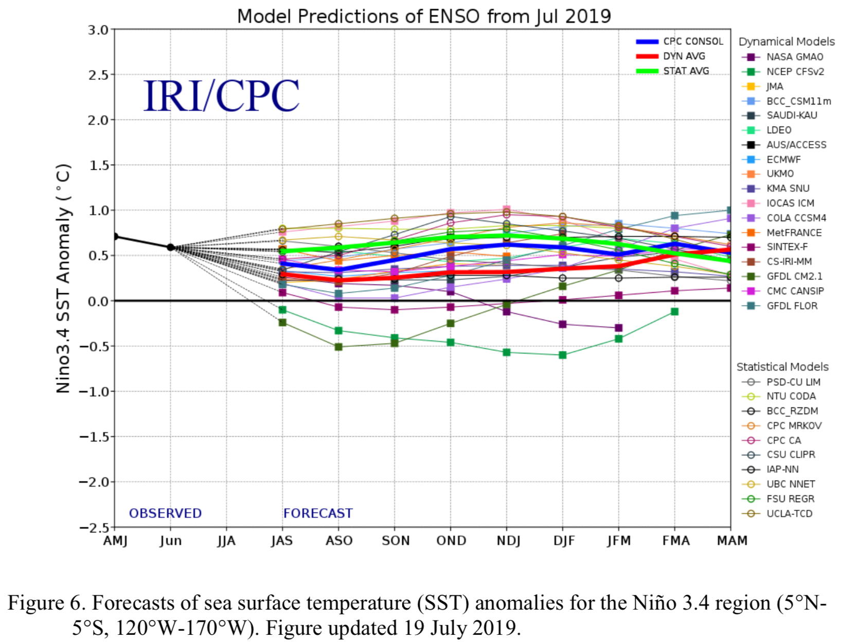
    Synopsis: El Niño has transitioned to ENSO-neutral, which is most likely to continue through Northern Hemisphere winter 2019-20 (50-55% chance).

    During July, ENSO-neutral conditions were reflected by the combination of below-average sea surface temperatures (SSTs) in the eastern equatorial Pacific Ocean and above-average SSTs in the central Pacific. The latest weekly ENSO indices were +1.0°C, +0.5°C, -0.2°C and -0.5°C in the Niño-4, Niño-3.4, Niño-3 and Niño-1+2 regions, respectively. Upper-ocean subsurface temperatures (averaged across 180°-100°W) were near average throughout the month, as anomalously cool waters prevailed in the eastern Pacific and anomalously warm waters continued in the central Pacific. Suppressed tropical convection continued over Indonesia, while near-average convection was observed near the Date Line. Low-level wind anomalies were near average over the tropical Pacific Ocean, and upper-level winds were easterly over the east-central Pacific. The traditional and equatorial Southern Oscillation Indices remained slightly negative. Overall, oceanic and atmospheric conditions were consistent with a transition to ENSO-neutral.

    The latest IRI/CPC plume of forecasts of the Niño-3.4 index favors ENSO-neutral (Niño- 3.4 index between -0.5°C and +0.5°C), with index values greater than zero from late Northern Hemisphere summer into fall, warming closer to the El Niño threshold (+0.5°C) by winter. Atypically, dynamical models forecast weaker positive SST anomalies than statistical models throughout most of the forecast period. As a result, while forecasters favor ENSO-neutral conditions, the odds of El Niño (~30%) are roughly twice that of La Niña for next winter. In summary, El Niño has transitioned to ENSO- neutral, which is most likely to continue through Northern Hemisphere winter 2019-20 (50-55% chance; click CPC/IRI consensus forecast for the chance of each outcome for each 3-month period).

    The Tribal Water Law Conference returns to Scottsdale on September 26 and 27, 2019 #ColoradoRiver #COriver #aridification

    From email from the Tribal Law Institute (Mark Rackley):

    The Tribal Water Law Conference returns to Scottsdale on September 26 and 27, now in a convenient new location: Hilton Resort & Villas.

    Scottsdale, Arizona. Photo credit: Air Care Cooling and Heating, LLC

    Visit the conference website

    Download the brochure

    Register online now

    Imagine yourself in Scottsdale in September, gaining diverse perspectives on Tribal Water Law and connecting with your colleagues from around the country in luxurious surroundings.

    The AAA 4-diamond Hilton Resort & Villas is set on 20 scenic acres, with breathtaking views of Camelback Mountain and a complimentary shuttle within a two-mile radius, including Old Town. Take advantage of specially discounted room rates, exclusively for Conference participants.

    In Old Town Scottsdale, you’ll find cultural influences of the area’s first Native American residents along with hip new venues. Beyond Old Town, escape to the stirring beauty and serenity of the Sonoran Desert for exploration and adventure.

    Expand your knowledge, broaden your network, and enjoy Scottsdale!

    Register online now.

    We look forward to seeing you there.

    Sincerely,

    Mark Rackley, CEO
    CLE International

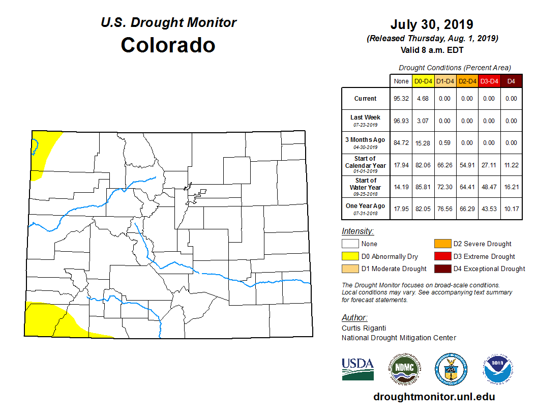
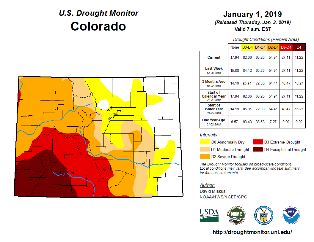
    #Drought news: D0 (Abnormally Dry) introduced in Baca County, wetness in the forecast

    Click on a thumbnail graphic below to view a gallery of drought data from the US Drought Monitor.

    Click here to go to the US Drought Monitor website. Here’s an excerpt:

    This Week’s Drought Summary

    Heavy rain fell on large parts of Alaska this past week, bringing significant short-term relief, including an end to large fire development and expansion, at least for the time being. In contrast, dryness and drought expanded across broad sections of the contiguous 48 states, with relief restricted to parts of the Southeast. Most notably, hot and dry weather brought significant D0 expansion in the southern half of the Great Plains and across the Midwest and lower Ohio Valley. In the Northeast Climate Region, a few abnormally dry areas were introduced; this is only the fourth week since mid-January that dryness existed in any part of the Region. Meanwhile, heavy rain in eastern Puerto Rico improved conditions over eastern parts of the Commonwealth…

    High Plains

    It was a dry week in and near existing areas of dryness and drought. Broad expansion of abnormal dryness occurred across central and southern Kansas, where conditions have deteriorated quickly as in Oklahoma and Texas. Much of central and south-central Kansas received 0.5 inch or less of rainfall over the last 30 days. In the rest of the region, D0 and D1 conditions generally persisted, with very limited expansion brought into parts of northern North Dakota, east-central Nebraska, and southeastern Colorado…

    West

    Severe drought persisted in portions of northwestern Washington where only 40 to 75 percent of normal precipitation fell during the past six months. Light to locally moderate rain fell this week from central Arizona through central New Mexico, and across portions of southern and eastern Montana. Other areas recorded very little or none. Increasing moisture deficits induced moderate drought expansion into northwestern New Mexico while D0 expanded in southeastern Washington and across northern Montana. Conditions were unchanged in other areas. The past 60 days brought only 25 to 50 percent of normal rainfall to the new moderate drought area in northwestern New Mexico…

    South

    Another drier-than-normal week affected central and eastern sections of Texas and Oklahoma as well as the northern tier of Louisiana, where little or no rain was reported. Recent hot and dry weather there has spawned broad development of D0 and D1 conditions in the south-central Plains, with severe drought introduced in southwestern Oklahoma and adjacent Texas. Broad swaths of central and western Oklahoma, the Texas Panhandle, and southwestern Texas recorded only a few tenths of an inch of rain at best over the last 30 days, and about 25 to 60 percent of normal since early June…

    US Drought Monitor one week change map ending August 8, 2019.

    Looking Ahead

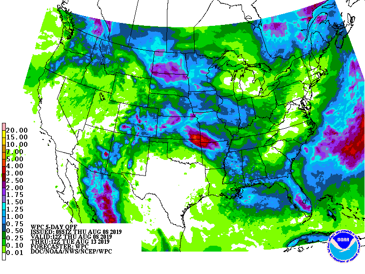
    During the next 5 days (August 8 – 13, 2019) should bring heavy rains of 1 to locally 4 inches to portions of western New Mexico, a swath through the central Plains, and many locations across upstate New York and southern Maine. Most of the area from northern Idaho eastward through northern Montana are expecting 1 to 2 inches, as are most of the Dakotas and scattered patches across the Pacific Northwest. Other areas of dryness across the contiguous 48 states should get lesser amounts. Locally up to an inch is expected in the Southeast and southern New England, and little or none is anticipated in most of the new D0 area in the southern Plains from central Kansas through Oklahoma and Texas. Temperatures are forecast to be a few degrees above normal in the southern Plains and the Southeast while subnormal temperatures should extend from the northern half of the Plains to the Pacific Ocean.

    The CPC 6-10 day outlook (August 14 -18, 2019) favors above-normal precipitation in east-central Alaska, the Pacific Northwest, the central and northern Plains, the lower Mississippi Valley, and the Southeast. Meanwhile, subnormal precipitation is expected in southern and southeast Alaska, the eastern Great Basin, the Four Corners States, most of Texas, and the Northeast. Temperatures should average below normal from the Intermountain West eastward through the Midwest and Northeast, and across east-central Alaska. Farther south, southern and southeastern Alaska have enhanced chances of warmer than normal weather, along with the Pacific Coast and a large swath from the Great Basin through the Four Corners States, central and southern High Plains, lower Mississippi Valley, and Southeast. The highest likelihood for hotter than normal weather are across most of Texas and the lower Southeast.

    Governor Polis Appoints CWCB Director Rebecca Mitchell (@cwcbbecky) to Upper #ColoradoRiver Commission, she replaces James Eklund (@EklundCO) #COriver #aridification @CWCB_DNR

    Here’s the release from the Colorado Department of Natural Resources (Chris Arendt):

    Governor Jared Polis appointed Rebecca Mitchell as the Colorado Commissioner to the Upper Colorado River Commission today. The Upper Colorado River Commission is an interstate water agency consisting of the Upper Colorado River Basin States of Wyoming, Colorado, Utah and New Mexico.

    “The Colorado River is the lifeblood of the American West and is critically important for Colorado’s economy, agriculture, outdoor recreation and our way of life,” said Governor Polis. “Rebecca Mitchell will bring experience, leadership and a thorough knowledge of Colorado River issues and will enhance the shared mission of the Upper basin states of comity and collaboration as the Colorado River Commissioner.”

    The Upper Colorado River Commission’s function is to ensure compact compliance with the 1922 Colorado River Compact. The Commission was established so states work together and in partnership to meet their obligations to the lower basin states while safeguarding the Upper basin states’ Colorado River water rights and allocations. The Commission is comprised of one representative appointed by the Governor of each Upper basin state and one member appointed by the President to represent the United States.

    “The Colorado River faces unique future challenges with increased population, persistent drought, and impacts of climate change,” said Dan Gibbs, Executive Director, Colorado Department of Natural Resources. “We appreciate the service of outgoing Commissioner James Eklund, and Becky is ready to take the reins. She has been an incredible leader at the Colorado Water Conservation Board and her experience is needed now more than ever as the Upper basin states’ enact their provisions of the Colorado River drought contingency plans signed earlier this year.”

    “It’s an honor to serve as the Colorado Commissioner for the Upper Colorado River Commission,” said Rebecca Mitchell, Director, Colorado Water Conservation Board. “There is no more important river than the Colorado both here and across the American West. In Colorado we have built a strong culture of collaboration, innovation, and smart policy to drive future water planning and I plan on bringing the same cooperative spirit and leadership to the Upper Colorado River Commission.”

    “I am so proud to have represented Colorado in achieving interstate and international solutions for the Colorado River,” said outgoing Commissioner James Eklund. “The innovative tools we created and put in place are ready for implementation to the benefit of the entire basin. Colorado is now well-positioned to continue its legacy of leadership under the Polis Administration collaboratively and inclusively.”

    Rebecca Mitchell (Becky) serves as the Director of the Colorado Water Conservation Board (CWCB). She is an accomplished water leader with over 17 years experience in the Colorado water sector and highly knowledgeable in the water laws of the State. Mitchell played a significant part in working with the State’s Basin Roundtables, the Interbasin Compact Committee, the public at large and CWCB staff in producing Colorado’s Water Plan. Becky has worked in the public and private sector as a consulting engineer; she received both her B.S. and M.S. from the Colorado School of Mines.

    Governor Polis also appointed John McClow, General Counsel for the Upper Gunnison River Water Conservancy District and David Robbins, Hill & Robbins, P.C. to serve as alternate commissioners.

    From The Grand Junction Daily Sentinel (Dennis Webb):

    Gov. Jared Polis on Wednesday named Rebecca Mitchell as Colorado’s representative to the Upper Colorado River Commission, replacing Mesa County native James Eklund.

    Mitchell also is director of the Colorado Water Conservation Board.

    The Upper Colorado River Commission works to ensure compact compliance with the 1922 Colorado River Compact, the Colorado Department of Natural Resources said in a new release. Wyoming, Colorado, Utah and New Mexico are represented on the commission, with the goal of partnering to meet obligations to Lower Basin states while safeguarding Colorado River water rights and allocations in Upper Basin states.

    Eklund, who has deep family roots in the Plateau Valley, is a former CWCB director who in that position led the effort to create Colorado’s first water plan.

    He stepped down as director in 2017 to take a job as an attorney at a law firm, but remained as Colorado’s representative on the Upper Colorado River Commission, serving without compensation.

    Both Eklund and Mitchell played roles in Colorado reaching agreements with other basin states for drought contingency planning…

    Mitchell got her bachelor’s and master’s degrees from the Colorado School of Mines, has worked as a consulting engineer, and has more than 17 years of experience in Colorado’s water sector. She also played a significant part in the development of Colorado’s water plan.

    @AWRA-CO Annual Tour – Upper #ArkansasRiver Basin, August 27, 2019

    Join AWRA Colorado for its annual tour on August 27th! This year’s program will focus on the Upper Arkansas River basin, where we will be learning about water use, creative partnerships, and other unique aspects of the Upper Arkansas Basin. The day will include an overview of the Homestake Project and Aurora Waters’ system along with tours of the Otero Pump Station, Homestake Arkansas River Diversion project, Rocky Mountain Fen Research Project, and the Leadville Fish Hatchery.

    Cost is $65 and includes transportation and lunch. All tour proceeds benefit AWRA Colorado’s Richard Herbert Memorial Scholarship fund.

    Register for the tour HERE.

    Upper Arkansas River Basin tour agenda:

    7:30 am — Meet at Wooly Mammoth Park & Ride, Golden
    9:00 am — Alternative meeting location at Hayden Meadows Reservoir, Leadville
    10:00 am — Morning Presentations and Tour of Otero Pump Station
    11:00 am — Tour of the Arkansas River Diversion Project
    12:00 pm –Lunch at Twin Lakes Reservoir
    1:00 pm — Tour of the Rocky Mountain Fen Research Project
    2:00 pm — Tour of the Leadville Fish Hatchery
    3:30 pm — Drop off at Hayden Meadows Reservoir
    5:15 pm — Return to Wooly Mammoth Park & Ride

    Due to site access restrictions, please plan to ride with AWRA to/from the tour. Two group meeting locations are available:

    Wooly Mammoth Park & Ride, Golden (7:30 am)
    Hayden Meadows Reservoir, Leadville (9:00 am)

    Register for the tour HERE.

    Scientists reveal key insights into emerging water purification technology — @ColoradoStateU

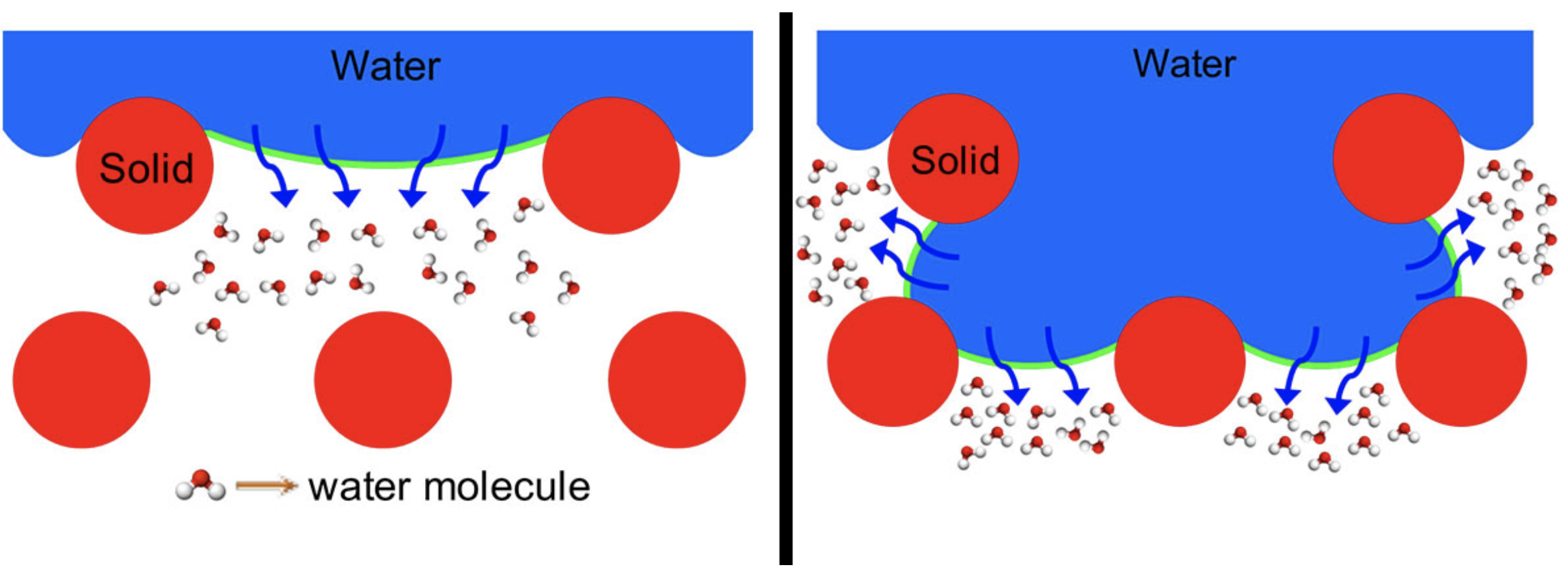
    Left represents an omniphobic membrane, and right represents a conventional hydrophobic membrane with increased water-air interfacial areas (green lines). Credit: Kota lab

    Here’s the release from Colorado State University (Anne Manning):

    With water scarcity a critical challenge across the globe, scientists and engineers are pursuing new ways to harvest purified water from unconventional sources, like seawater or even wastewater.

    One of those researchers is Tiezheng Tong, an assistant professor in the Department of Civil and Environmental Engineering, whose lab is studying an emerging technology called membrane distillation.

    Membrane distillation involves a thin, water-repellant membrane that exploits vapor pressure differences between hotter impure liquid, called “feedwater,” and colder purified water, called “permeate.” During the process, water vapor passes through the membrane and is separated from the salty or dirty feedwater. According to Tong, membrane distillation works better than other technologies like reverse osmosis, which can’t treat extremely salty water such as desalination brines or produced water from hydraulic fracturing.

    While it holds promise, membrane distillation doesn’t work perfectly. A key challenge is designing membranes to purify water efficiently while ensuring zero contamination of the clean water.

    Tong and materials scientist Arun Kota in the Department of Mechanical Engineering joined forces to get at the fundamental science behind designing that perfect membrane. In new experiments they describe in Nature Communications, the CSU engineers offer new information into why certain membrane designs used in membrane distillation work better than others.

    “The fundamental knowledge from our paper improves mechanistic understanding on the water-vapor transport within microporous substrates and has the potential to guide the future design of membranes used in membrane distillation,” Tong said.

    How it works

    In membrane distillation, the feedwater is heated, separating the pure and impure components by differences in volatility. The micro-porous membrane is a key component to the setup because it allows water vapor through, but not the entire impure liquid. Typically, the membrane is made of a “hydrophobic,” or water-repellant, material in order to let only the water vapor pass through but maintain a barrier for the feedwater.

    However, these hydrophobic membranes can fail, because the feedwater, such as shale oil-produced water, can have low surface tension. This low surface tension allows the feedwater to leak through the membrane pores, contaminating the pure water on the other side – a phenomenon called membrane wetting.

    Previous research had unveiled that using “omniphobic” membranes – membranes that repel all liquids, including water and low surface tension liquids – keep the vapor/water separation intact. But, omniphobic membranes typically slow down the rate and amount of water vapor passing through the membrane, dramatically reducing the efficiency of the entire process.

    The CSU researchers set out to discover why this tradeoff between hydrophobic vs. omniphobic membranes exists. Through systematic experiments in the lab led by postdoctoral researchers Wei Wang in Kota’s lab, and Tong’s graduate student Xuewei Du, they found that conventional hydrophobic membranes create a larger liquid-vapor interfacial area. This increases the amount of evaporation taking place. With the omniphobic membranes, they saw a much smaller liquid-vapor interface. This explains the difference between the membranes’ performances.

    The omniphobic membranes used in the experiments were made without depositing extra particles. Thus the researchers were able to determine that their observations weren’t the result of structural changes to the membranes.

    Cross-sectional view of a conventional hydrophobic membrane used in membrane distillation. The blue represents water. Credit: Tong and Kota labs

    Solving the tradeoff problem

    While they didn’t offer a solution to the tradeoff, their insights reveal the core challenge around making membrane distillation a successful technology. “If you understand the problem thoroughly, then there is scope for solving it,” Kota said. “We have identified the mechanism; now we have to solve the tradeoff problem.”

    For example, smart membranes with exceptional omniphobicity and simultaneously large liquid-vapor interfacial area can render membrane distillation a robust and cost-effective process for water purification. More collaborative research has been initiated by the team to design such smart membranes, with the goal of increasing efficiency of membrane distillation.

    Tong added that the research happened at the interface of two disciplines: surface science and membrane technology.

    “Arun and I utilized our complementary expertise to systematically conduct this work,” Tong said. “It is an example of good interdisciplinary collaboration across campus.”

    Graduate students Hamed Vahabi in mechanical engineering and Yiming Yin in civil and environmental engineering also contributed to this work.

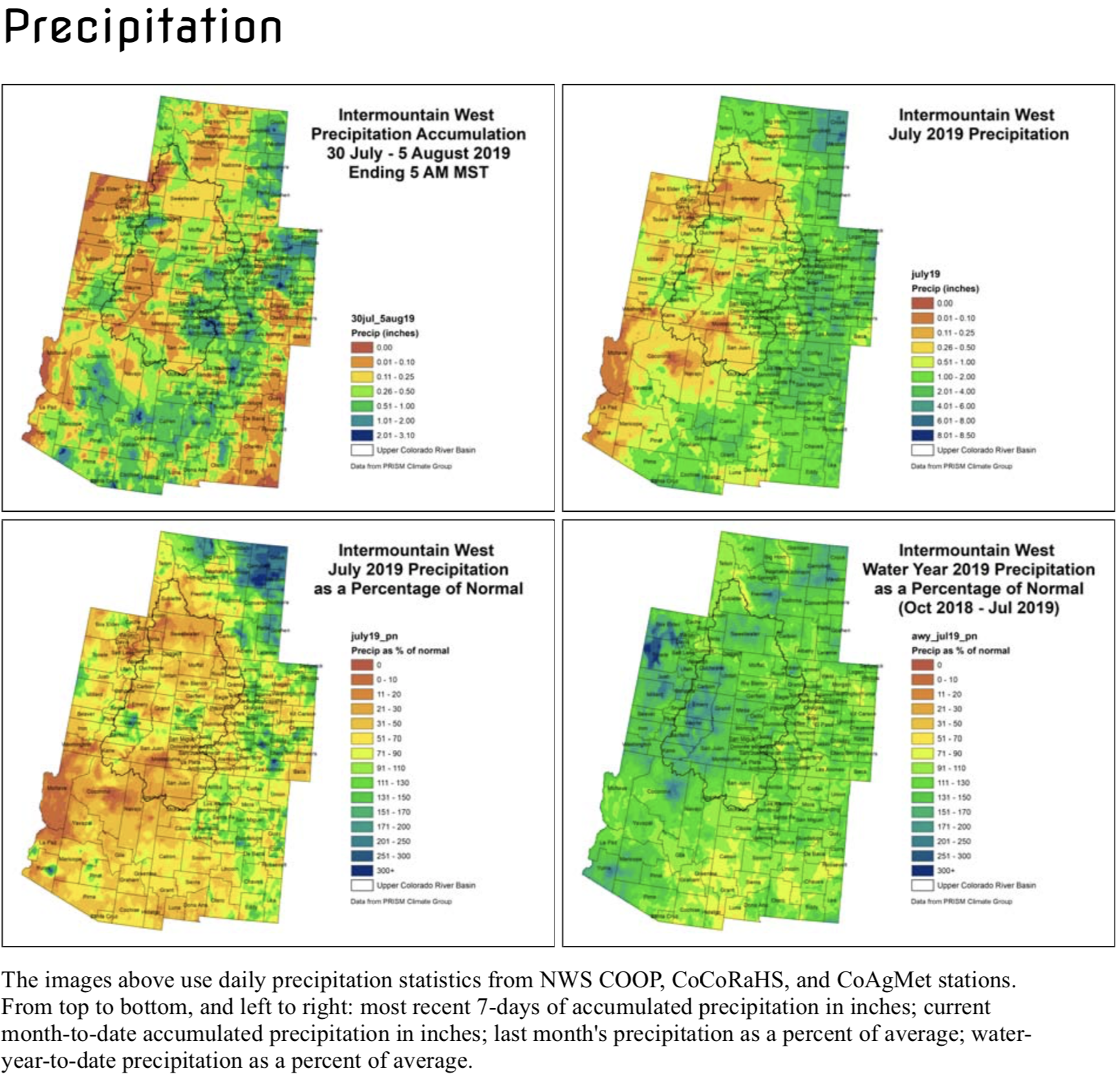
    @ColoradoClimate: Weekly #Climate, #Water and #Drought Assessment of the Intermountain West


    Click here to read the current assessment. Click here to go to the NIDIS website hosted by the Colorado Climate Center.

    After a wildfire, a Colorado town’s residents reluctantly sue a historic railway — The Los Angeles Times

    The 416 Fire near Durango, Colorado, ignited on June 1, 2018. By June 21, the wildfire covered more than 34,000 acres and was 37 percent contained. Photo credit USFS via The High Country News

    Here’s a report about the lawsuit against the Durango & Silverton Narrow Gauge Railroad from David Kelly that’s running in The Los Angeles Times. Click through and read the whole thing. Here’s an excerpt:

    …the federal government and others are pointing the finger at a local icon — the Durango & Silverton Narrow Gauge Railroad, which carries hundreds of thousands of passengers a year through the San Juan Mountains.

    Claiming cinders from the coal-fired, steam locomotive ignited brush along the tracks during a time of heightened fire restrictions, the U.S. attorney’s office filed a suit against the train’s owners last month seeking $25 million to cover the cost of putting out the fire. Another two dozen or so citizens and businesses are also suing for damage to their properties.

    Nobody wants the train to go out of business, but many fear the suits could eventually drive the railroad into bankruptcy, destroying a historic landmark and badly damaging the local economy…

    “The responsible decision of train management would have been to not run the train in those super-dry conditions,” said Thomas Henderson, a Denver lawyer whose firm is representing individuals and businesses suing the train. “The train has started fires for years that the feds have had to put out. They should not get a free pass simply because they are big player in town. That’s not how democracy works.”

    […]

    Few businesses are as tied to the railroad as the historic Strater Hotel, built in 1887. Roderick Barker’s family has owned it for 93 years, and he figures at least 50 to 60% of his guests ride the train.

    “The train is the lifeblood of this whole town,” he said. “If it were to fail it would certainly be one of the most significant things to happen in the history of Durango.”

    He believes the train caused the fire and needs to change its operations. But given its contribution to the economy, he questions why any local business would sue the railroad…

    Bobby Duthie, an attorney, grew up on 33rd Street in Durango. The train whistle woke him each morning. He’s ridden it more than 50 times. Now he’s working with Henderson in representing those suing the train.

    “I was initially reluctant to get involved because I love the train. But I also know that their decision to run it that day was reckless,” he said, sitting in his downtown office. “They had started fires on the tracks the month before and it was just a matter of time until it got out of control.”

    According to the federal lawsuit, the wildfire, dubbed the 416 fire, began on Shalona Hill where the grade is steep. As the train climbed, it cast off sparks and cinders. A metal screen on the smokestack caught many but not all.

    “I talked to eyewitnesses,” Duthie said. “I know the train started the fire. I’m sad they chose to run it on June 1, 2018.”

    Debris flow from 416 Fire. Photo credit: Twitter #416Fire hash tag

    Kristi Nelson’s home escaped the fire but suffered major damage in the mudslides.

    “They took 23 dump-truck loads of mud from my property,” she said. “It was devastating. I still have a mortgage on top of $116,000 worth of damages. Let’s say I don’t want to do this work. Can I sell it?”

    She said people have urged her not to ruin the train. That stings for the former vice president of sales and marketing for the railroad.

    “It is with a heavy heart that I entered into this lawsuit because I love the train,” she said. “But if I crashed my car into the train depot they would expect my insurance to pay. The train’s insurance should do the same.”

    Aspen scores $186,356 from @CWCB_DNR for alternative water rights transfer methods

    A view of the Wheeler Ditch headgate, looking upriver on the Roaring Fork River. Smith / Aspen Journalism

    From The Aspen Daily News (Alycin Bektesh):

    On Monday, the city announced that it is the recipient of $186,356, which will go toward establishing “alternative transfer methods” with area farmers. ATMs allow water-right holders to share a portion of their claims without giving them up entirely. The state has a goal to assist in 50,000 acre feet of water transfers through the use of ATMs by 2030.

    The program allows creative solutions to water sharing in a way that was not previously accessible, according to Margaret Medellin, city of Aspen’s utilities portfolio manager.

    “Traditionally in Colorado water law, if you don’t use your water right you’ll eventually lose it,” Medellin said, “so before this ATM concept came about you would want to use your water rights as much as you can at all times.”

    This tactic is counterintuitive to what the state needs from its water holders, though. Colorado’s population growth projections show that the demand for water will increasingly outmatch the supply. By 2050, the state’s population is estimated to reach 10 million — double 2008’s figure — creating a water shortage for about 2.5 million families.

    In attempting to preserve its own water rights on Castle and Maroon Creeks, the city found itself headed to state water court with 10 separate opponents last year. It was during those pretrial negotiations that the city decided to partner with two plaintiffs to explore the ATM solution locally.

    “This project is one of a few good things that came out of that effort,” Medellin said. “It really is just us as different advocates for different parts of the community coming together to try and get creative.”

    Wilderness Workshop and Western Resource Advocates have assisted the city in seeking out partners who would be willing to forfeit claims on diversions at different times. Over the last year, the city has held stakeholder meetings and consulted with experts, but they realized they would need assistance in identifying good partnerships.

    “The thing we realized is that there was no clear project up here,” Medellin said.

    The state grant allows the city to hire outside consultants who can continue the work of finding water-rights holders who would be willing to temporarily divert their claims to the city in exchange for fees.

    Todd Doherty is the president of Western Water Partnership, the consultant who helped the city with the grant application and will continue to work on securing ATM agreements. He has identified 2,800 irrigated acres that use water diverted at or above the city. His team will be reaching out to farmers to explain the program and gauge interest.

    2019 #COleg: SB19-181 — Protect Public Welfare Oil And Gas Operations #ActOnClimate #KeepItInTheGround

    Here’s an in-depth report Mark Jaffe that’s running in The Colorado Sun. Click through and read the whole thing. Here’s an excerpt:

    Colorado is quickly becoming a patchwork of oil and gas rules after a major law change — The #Colorado Sun: Boulder County wants to enact tougher regulations. Weld County wants to make it easier to drill. And the state is scrambling to keep up.

    [Senate Bill 19-181: Protect Public Welfare Oil And Gas Operations] requires a host of new rules at the state level for things such as air emissions and assessing cumulative impacts of oil and gas projects, and at the same time local governments are moving ahead with their own rules…

    The Colorado Oil and Gas Conservation Commission on July 31 adopted the first of these new rules, putting limits on the use of “forced pooling,” the ability of drillers to consolidate mineral rights even if the owners object. It did not come, however, without noisy demands from protesters to halt all permitting until the new rules are made.

    On the local level, Boulder and Weld counties may be at the extremes. Boulder is looking to tighten already tough regulations while Weld is setting up its own oil and gas department to expedite permitting. But other counties and municipalities in the middle are also wrestling with the issue.

    “Home rule is defined in law and case law,” said Kevin Bommer, executive director of the Colorado Municipal League. “Local control is an amorphous thing and wildly inconsistent.”

    Until passage of the new law, the state, through the COGCC, held primacy in all key areas of oil and gas regulation, including siting.

    The new law emphasizes that local government has the land use authority to regulate and site oil and gas locations to minimize adverse impacts to public safety, health, welfare and the environment.

    Local governments also gain the ability to regulate impacts, including the ability to inspect facilities, issue fines for leaks, spills and emissions and impose fees to fund oversight.

    It remains to be seen how these powers will be used, but the fact that two counties and six municipalities have enacted moratoriums on oil and gas permits while they review local controls has spawned worst-case-scenario fears among critics and the industry…

    The COGCC is, however, at the beginning of developing new rules that could impact local decisionmaking, including a cumulative impact assessment, which could account for environmental impacts, and alternative site analysis, calling for operators to consider sites away from urban areas, for any drilling application…

    Jeff Robbins, the COGGC executive director, said that the state working with local governments is the way to resolve these issues as they emerge.

    “I want to be partners with local government,” Robbins said. “There are a lot of jurisdictions; we are all trying to make rulemakings.”

    Robbins said he has met with Weld County staff and with Boulder County, as well with Adams County and other local governments.

    Rain wreaks havoc on Lake Christine burn scar — The Aspen Daily News #stormwater

    From The Aspen Daily News (Madeleine Osberger):

    A storm that unleashed its power over the Lake Christine burn area beginning late Sunday afternoon triggered multiple debris flows and water on Frying Pan Road that temporarily trapped 20 different vehicles, but resulted in no known injuries, according to Scott Thompson, chief of Roaring Fork Fire Rescue…

    A Pitkin Alert evacuation notice went out at 5:31 p.m. aimed at those who lived in the area of Pinon Road and Cedar Drive imploring them to “please take all necessary precautions,”which included seeking higher ground. “Do not enter flowing water or debris,” was among the initial warnings.

    Frying Pan Road was closed intermittently Sunday from Riverside Drive to about 2 1/2 miles up the road, according to deputy chief Cleve Williams. The intersection of Cedar Drive and Two Rivers Road was reopened by 10 p.m. on Sunday…

    According to the National Weather Service in Grand Junction, an inch of rain fell over the first hour, beginning at 5 p.m. There were reports of heavy rain after the first 30 minutes and flooding started on the south end of the Lake Christine burn scar. By 8:30 p.m. the rain had subsided and, according to Chief Thompson, was expected to let up before midnight.

    From The Aspen Times (Rick Carroll) via The Glenwood Springs Post Independent (Click through to view the photo gallery):

    One of the trigger points for the floods was at Pinon Drive and Cedar Drive, an area above Basalt from where the initial 911 calls were placed at approximately 5:30 p.m. Sunday…

    All of the roads, including Frying Pan Road — where 10 vehicles had been stuck Sunday and later removed — had re-opened to traffic by Monday. Pinon and Cedar drives, as well as Two Rivers Road, also had been closed. Two Rivers Road opened late Sunday; Pinon and Cedar opened Monday morning.

    Crews also on Monday determined the floods had not damaged the integrity of roads and bridges, said Birch Barron, Eagle County emergency manager.

    Structural damage to the residences in the affected area appeared to be limited, according to Barron.

    “We believe there were less than 10 private residences with debris in or around structures, and for the majority of those structures, the debris was in nonresidential spaces — garages and basement and property surrounding that,” he said.

    The county had not received any reports of residences being uninhabitable, Barron noted.

    The evacuation zone impacted about 30 residences; however, a number of individuals couldn’t evacuate because of dangerous road conditions, Barron said.

    Sunday’s response was a collaborative effort among Eagle and Pitkin counties, the town of Basalt, area law enforcement and emergency response teams, as well as state and federal agencies, Barron said.

    The flow out of Ruedi Reservoir was increased Monday by 50 cubic feet per second to help clear up the Fryingpan River, which had taken on a muddy hue from the flood’s debris and sediment.

    “This should be a big help toward protecting fish and river health,” said Kris Widlak, Eagle County’s director of communications.

    Screenshot from the Glenwood Springs Post Independent. Photo credit: Anna Stonehouse via The Aspen times

    #AnimasRiver: #GoldKingMine update

    From The Albuquerque Journal (Therasa Davis) via The Farmington Daily Times:

    [After the August 5, 2015 spill]…The EPA paid state and tribal governments for emergency water tests, but initially denied 79 economic damage claims.

    In August 2017, EPA administrator Scott Pruitt – who resigned in July 2018 – visited the spill site and said the agency would reconsider the claims. The New Mexico Environment Department said Friday that it was unaware whether any of those payments have been made.

    Animas River at the New Mexico/Colorado State line August, 2015.

    NMED chief scientist Dennis McQuillan said there is ongoing monitoring to determine long-term effects of the spill.

    “Dozens of mines are leaking acid mine water into the watershed,” McQuillan said. “Gold King was just one of those.”

    Under new administrator Andrew Wheeler, the federal agency, its contractors and mining companies asked for dismissal of the lawsuits, arguing the EPA had immunity and was already working on cleanup.

    Environment Department general counsel Jennifer Howard said a federal judge in Albuquerque rejected that argument in March, so the lawsuits “should definitely start proceeding at a faster pace.”

    A November 2018 EPA report showed fish had elevated metal levels in the weeks after the spill, but returned to pre-spill levels by spring 2016.

    Gold King Mine Entrance after blow out on August 5, 2015. Photo via EPA.

    Research by the New Mexico Bureau of Geology and Mineral Resources, New Mexico Game and Fish, Mountain Studies Institute, San Juan Basin Public Health and Colorado Parks and Wildlife echo that claim.

    “The farming industry is still hurting,” McQuillan said. “I’ve talked to farmers who said their sales are down 25% from before the spill because people say they won’t buy food grown on the San Juan. But our agriculture products are safe. The fish are safe to eat. The river is safe for irrigation.”

    McQuillan said the federal WIIN Act (Water Infrastructure Improvements for the Nation) will provide money for the Navajo Nation to test fish in the spill area and start outreach to address the misconception that the river water is unsafe.

    In 2016, the EPA designated the area around the spill site as the Bonita Peak Mining District Superfund site, which opens up money for cleanup and places the site on a priority action list. Howard and McQuillan agreed that was a positive development, but Superfund cleanup is a slow process.

    “It was a significant issue four years ago and remains a significant issue,” Howard said. “The motivation for our lawsuit is to have EPA step up to the plate and address the economic impact this (spill) had on agriculture and tourism for our state.”

    The “Bonita Peak Mining District” superfund site. Map via the Environmental Protection Agency

    Crop insurance and the tunnel collapse: Unanswered questions remain for farmers in Goshen, Gering-Fort Laramie crop areas

    Gering-Ft. Laramie-Goshen canal. Photo credit: Wyoming Farm Bureau Federation

    From The University of Nebraska Lincoln< (Jessica Groskopf/Cory Walters):

    As repairs continue on the tunnel that collapsed on the Goshen/Gering-Fort Laramie Canal, unanswered questions remain about whether crop insurance will cover crop losses stemming from the loss of irrigation water.

    Crop Insurance provides protection against “unavoidable, naturally occurring events.” Due to the complexity of the Goshen/Gering-Fort Laramie situation, it is unknown if crop insurance will cover crop loss.

    Three tunnels are used to deliver water from the Whalen Dam on the North Platte River to the Goshen/Gering-Fort Laramie Canal. The second tunnel, south of Fort Laramie, Wyo., collapsed on July 17. Water has been shut off at the Whalen Dam since the incident occurred in order to inspect and repair the tunnel. This has left 107,000 acres of cropland in Nebraska and Wyoming without irrigation water during a critical time in the growing season.

    Several factors may have contributed to the tunnel collapse. According to a report by the National Weather Service in Cheyenne “precipitation has been upwards of 200-300% above normal for the past water year (1 Oct. 2018 to present).” However, the tunnel in question was built in 1917 by the Bureau of Reclamation, which owns the structure. The Goshen Irrigation District and Gering-Fort Laramie Irrigation District were responsible for operating and maintenance of the tunnel.

    Crop insurance is a federal program administered by the USDA Risk Management Agency. All crop insurance policies, regardless of the crop insurance agent, are subject to the same provisions. Thus if it is determined that the tunnel collapse was not from an “unavoidable, naturally occurring event,” all crop insurance policy holders on the Goshen/Gering-Fort Laramie Canal would not receive an indemnity payment for their crop loss.

    Farmers in the affected area need to continue to manage their crop as if water will return to the canal and they will covered by their crop insurance policy. Failure to do so may negate individual crop insurance coverage. Producers must receive written permission from the insurance company to replant, abandon or destroy a crop.

    This information is designed to support and help clarify existing crop insurance policy provisions and procedures. For more detailed information and options you may have, please consult a crop insurance agent.

    Wyoming rivers map via Geology.com

    Meet your local anti-government extremist groups — @HighCountryNews

    From The High Country News (Tay Wiles, September 27, 2017):

    Since the election of President Donald Trump, a steady stream of right-wing street rallies have brought together an array of extremist groups — from white supremacists to self-styled militias that espouse anti-government ideologies.

    Meanwhile, investigations continue into the Trump team’s potential collusion with Russia during his presidential campaign, raising the prospect of impeachment or indictments. Roger Stone, a former adviser and longtime confidant to Trump, recently told a reporter with TMZ that an impeachment of the president would cause “a spasm of violence in this country, an insurrection like you’ve never seen.” Stone also supported Trump’s recent pardon of former Arizona sheriff Joe Arpaio, who was convicted in federal court for criminal contempt. Stone is now urging a pardon for Nevada rancher Cliven Bundy, who is about to go on trial for leading an armed confrontation with federal employees. Given Stone’s insurrection statement, the push for presidential pardons in spite of federal court orders, and a spike in hate or bias incidents following the election, it’s worth understanding some of the key players of anti-federal ideology, hate and extremism in the West today.

    Oath Keepers

    The Oath Keepers are one of two of the most well known of the country’s 165 or so militia groups. They are named for the oath that members of the military or police take to defend the Constitution from enemies foreign and domestic. You might see the oft-armed Oath Keepers in camouflage battle dress uniforms posturing as peacekeepers or security at “free speech” rallies.

    Oath Keepers were among the militia groups that showed up to support Nevada rancher Cliven Bundy during the 2014 armed standoff with the Bureau of Land Management and National Park Service. They also spent weeks in the fray in Burns, Oregon, during the 2016 armed occupation of the Malheur National Wildlife Refuge.

    You might also see them doing community service, running security for your local Republican, Libertarian or Tea Party events, or in the mix at a variety of emergency situations from the 2015 riots in Ferguson, Missouri, following the killing of Michael Brown, or the aftermath of hurricanes Harvey and Irma.

    The Oath Keepers are fixated on apocalyptic scenarios. The Southern Poverty Law Center, a progressive organization that tracks extremist groups, calls the Oath Keepers’ core tenets “a set of baseless conspiracy theories about the federal government working to destroy the liberties of Americans.” For instance, they are committed to “NOT obey any order to blockade American cities, thus turning them into giant concentration camps.”

    Yale Law School graduate Stewart Rhodes founded the Oath Keepers in 2009. The group now claims 30,000 members and specifically recruits current and former members of the military and law enforcement.

    In recent months they have tried to distance themselves from the white supremacist and nationalist movements emboldened since Trump’s election. For instance, Oath Keepers nixed their plans to attend a right-wing rally in San Francisco in August because the organizing group, Patriot Prayer, couldn’t promise white nationalists wouldn’t show up. Similarly, the Three Percent leadership told its members to “stand down” after anti-racist activist Heather Heyer was killed during protests organized by white supremacists in Charlottesville, Virginia, in August.

    Danny Vanderschelden, the grounds keeper for the Sugar Pine Mine group. He says he makes a living mining up in the mountains. Oath Keepers, a group of current and formerly serving military, police, and first responders, who pledge to fulfill the oath all military and police take to “defend the Constitution against all enemies, foreign and domestic” in Josephine County, Oregon stood up at the Sugar Pine Mines in April to defend miners’ rights to due process.

    Three Percent

    Like the Oath Keepers, the Three Percent are Second Amendment activists and one of the most well known militia groups today. Their network is less centralized than the Oath Keepers’, with individuals using the name to create loosely affiliated local groups across the country.

    In 2008 Michael Vanderboegh of Alabama, who died last year, founded the Three Percent. The group takes its name from the unsubstantiated claim that only three percent of American colonists took up arms against the British. Vanderboegh was a fierce critic of gun control laws, the SPLC reports: “In the wake of the 2012 Newtown, Connecticut, school massacre, he warned in emails sent to more than 1,000 employees of the Connecticut State Police that they risked ‘initiating hostilities’ if they tried to enforce the state’s tough new gun control law.”

    Three Percent members participated in the 2014 Bunkerville standoff, in support of the Bundys. Vanderboegh said after the incident: “It is impossible to overstate the importance of the victory won in the desert today. The feds were routed.” Eric Parker, a defendant who will appear alongside Cliven Bundy in court for the standoff in October, is a former vice president for the Three Percent of Idaho. “The militia were shopping for a cause,” when the Bunkerville standoff happened, says J.J. MacNab, an anti-government extremism expert.

    A Three Percenter spokesman Chris McIntire distanced the group from the Malheur occupation, at the time saying, “We didn’t make any calls to arms nor plan or advocate any form of armed uprising.” But like the Oath Keepers, they lingered in the nearby town of Burns, Oregon, during the occupation, posturing as peace-keepers or even mediators between law enforcement and the occupiers.

    Three Percent and Oath Keepers are just two of the most well-known of 623 far-right anti-government groups operating nationwide today. That number is down from 1,360 in 2012, according to the SPLC. Yet as of last year, multiple armed groups were active in every Western state, from the Washington Light Foot Militia to the Arizona State Militia.

    Constitutional Sheriffs and Peace Officers Association

    In 2011 former Arizona sheriff Richard Mack created CSPOA, which asserts that county sheriffs represent the supreme law of the land, superseding federal law enforcement. As of last year, the group claimed 4,500 members, including 200 sheriffs. The constitutional sheriffs movement has been particularly strong in Western states, where local and county officers can have tense relationships with federal land agencies.

    Two prominent CSPOA sheriffs recently made national headlines for their ties to Trump. Last month Trump used his presidential authority to pardon former sheriff Joe Arpaio, who helped found the CSPOA. “Trump does seem to buy into the idea that sheriffs are the highest law enforcement of the land,” MacNab says, “which signals to the anti-government extremist movement that he’s one of them, though I don’t know if he’s one or not.”

    Another CSPOA member, former sheriff David Clarke, of Milwaukee County, Wisconsin, was rumored to be in the running for a position at the White House last month. Clarke was a vocal supporter of Trump during the campaign last year. He has since taken a position with the pro-Trump America First Action PAC.

    According to Politico, Michael Barkun, an expert on political extremism, calls the CSPOA philosophy “radical localism” because “it valorizes and exploits subnational sources of power. In theory, that kind of localism could be a vehicle for many kinds of politics, but in practice constitutional sheriffs and their followers tend to occupy the edges of anti-government conservatism.”

    Border militias

    Independent militia groups have sporadically patrolled the U.S.-Mexico border for many years, aiming to stop drug smugglers, human traffickers and undocumented immigrants from entering the country, where they say federal border patrol agents aren’t doing their job. The movement dwindled in the late-2000s. One of the most well-known groups, the Minutemen, which once claimed 12,000 members, is now defunct. But other groups around the country still operate in the area, as Mother Jones chronicled through undercover reporting with the Three Percent United Patriots last year. Another organization, Arizona Border Recon, founded in 2011, may now be “the only vigilante group with a continuous presence on the Arizona-Mexico border,” Arizona Republic reports.

    While militia members describe positive relationships with the federal government and see themselves as the eyes and ears of U.S. border patrol, there have been many reports of paramilitary groups getting in the way of the feds and local officers. According to the Arizona Republic, Santa Cruz County Sheriff Tony Estrada “is a vocal critic of Arizona Border Recon, saying such groups can do more harm than good to local law enforcement’s efforts ability to police their jurisdictions.”

    Sovereign citizens

    This movement emerged in the 1980s, based on a mix of anti-Semitic and anti-government beliefs. Sovereign citizens see government institutions as illegitimate and are known for evading taxes and resisting judicial authority by filing unnecessary court motions with fringe legal theories, or putting liens on judges to ruin their credit ratings as a form of protest. (A sovereign citizen appears to have recently filed a lien for $1.5 million against U.S. District Court of Nevada judge Gloria Navarro, for her dealings with the federal case against the Bundys.) In 2011, experts estimated about 100,000 hard-core sovereign citizens existed nationwide. “In the late 2000s and early 2010s, most new recruits to the sovereign citizens’ movement are people who have found themselves in a desperate situation, often due to the economy or foreclosures, and are searching for a quick fix,” the SPLC reports. “Others are intrigued by the notions of easy money and living a lawless life, free from unpleasant consequences.” While sovereign citizens represent a distinct movement, there is some overlap with other so-called “Patriot” groups, which include militias and a variety of other far-right organizations.

    Hate groups

    Aside from these typical Patriot groups, the West is home to a large number and wide variety of hate groups. According to the SPLC, the number of hate groups grew from 784 to 917 between 2014 and 2016; within that, anti-Muslim groups rose sharply, from 34 to 101. Hate groups can be found in every Western state, ranging from the white nationalist American Vanguard in Utah, Arizona, California and Washington, to the anti-Muslim Treasure Valley Refugee Watch in Meridian, Idaho, and the anti-LGBT Family Watch International in Gilbert, Arizona.

    Many of these groups have existed in the West for a long time, and it remains unclear how they will grow or change now that a candidate many of them supported is in the White House.

    Jeff Rieker named Area Manager for @USBR’s Eastern Colorado Area Office

    Horsetooth Reservoir

    Here’s the release from the Bureau of Reclamation (Tyler Johnson):

    Great Plains Regional Director Mike Black announced today that Jeff Rieker will succeed Signe Snortland as Eastern Colorado Area Office manager September 15, 2019. Rieker will serve as the Eastern Colorado Area Manager after serving as the Operations Manager for the Central Valley Operations Office where he oversaw the day-to-day water and power operations of Reclamation’s Central Valley Project (CVP), one of the largest water storage and transport systems in the world. The CVP is comprised of 20 dams and reservoirs, 11 power plants and more than 500 miles of canals and aqueducts within California’s Central Valley.

    “Jeff brings a history of technical ability and collaboration with regional, local and international parties on a variety of issues that will benefit Reclamation and the numerous stakeholders,” said Black. “Jeff is a great asset to our leadership team and I am confident he will serve the people of Colorado well.”

    Rieker joined Reclamation in 1999 as a student hydraulic engineer in Reclamation’s Technical Service Center. Over his Reclamation career, he has served in a variety of positions including Special Studies Division Manager for the Lahontan Basin Area Office, Special Assistant for the Mid-Pacific’s Office of the Regional Director, and the Mid-Pacific Region’s Liaison Officer in Washington, D.C.

    Rieker holds a bachelor’s degree in civil engineering from the Missouri University of Science and Technology, a master’s degree in civil engineering with an emphasis in water resources planning and management from Colorado State University, and a Ph.D. in the same subject from Colorado State University.

    #Drought news: D0 (Abnormally Dry) in Moffat, Rio Blanco, Dolores, Montezuma, La Plata and Archuleta counties

    From The Kiowa County Press (Chris Sorensen):

    Colorado was free from drought and abnormally dry conditions for eight consecutive weeks – something that hasn’t happened for even a single week in records going back to January 2000 – however dry conditions have been making their way back into the state over the past two reports.

    Two weeks ago, abnormally dry conditions returned to Dolores, Montezuma, La Plata and Archuleta counties. In the latest report from the National Drought Mitigation Center, western portions of Moffat and Rio Blanco counties are also seeing a return of abnormally dry areas.

    Colorado Drought Monitor July 30, 3019.

    More than 95 percent of the state remains drought-free, thanks to heavy, late-season snow storms, particularly in the southern mountains and Colorado’s western slope. A cool spring also helped slow snowmelt in the mountains.

    On January 1, less than 18 percent of the state was free from drought, and 27 percent – mainly in the southwest – was in extreme and exceptional drought, the two worst categories. In late September last year, half the state was in extreme and exceptional drought.

    Colorado Drought Monitor January 1, 2019.

    As recently as June, the United States Department of Agriculture and Small Business Administration were designating more than half of Colorado’s counties as disaster areas, making producers and businesses eligible for federal assistance and loans.

    While northeast Colorado benefitted from rain over the past week, much of the state has been dry, with warmer than normal temperatures – occasionally reaching the low 100s.

    @USBR uses #RioGrande high streamflow this year to expand Silvery minnow habitat

    Rio Grande Silvery Minnow via Wikipedia

    From The Albuquerque Journal (Theresa Davis):

    This year, the U.S. Bureau of Reclamation decided to take advantage of high water levels from a strong spring runoff and create more habitat for the fish on the Middle Rio Grande.

    Doris Rhodes owns 629 acres near San Antonio in Socorro County, and for years she has been advocating for her property to host a Reclamation silvery minnow project. Earlier this year, her work paid off.

    Rhodes’ land is nestled on the Rio Grande near Bosque del Apache National Wildlife Refuge, making it an ideal location for restoration and conservation, according to Reclamation project manager Ashlee Rudolph.

    Reclamation crews worked from January to March of this year to lower and widen the riverbank on the southern end of the property. They excavated 46,000 cubic yards of dirt to create water channels where minnows could escape the fast-moving river.

    “What makes this project great is that it is a partnership between a private landowner who wanted to create habitat on her land and the federal and state agencies,” Rudolph said. “It is so rare to have that partnership.”

    Slowing the river flow

    Reclamation worked with the private non-profit Save Our Bosque Task Force, the U.S. Department of Agriculture’s New Mexico Natural Resources Conservation Service and the U.S. Bureau of Land Management to excavate zigzag patterns on nearly a mile of the river.

    The Rhodes property is one of few remaining historic wetlands in the San Acacia Reach of the Rio Grande, a primary habitat for silvery minnow.

    The property has no levees on the east side of the river, which has helped in the restoration of the area’s natural floodplain, according to Reclamation Albuquerque Area public affairs specialist Mary Carlson.

    Chris Torres, who oversees river maintenance operations on the Middle Rio Grande for the Reclamation Albuquerque Area Office, said the slow-moving side channels are critical for minnow-spawning.

    “Minnows like that edge habitat. It’s worked perfectly,” Torres said. “The water is backing the way it’s supposed to, and we can see fish moving down through there. As the water drops, everything returns back to the main river like it’s supposed to.”

    Rudolph said that since 2016, there have been at least eight silvery minnow habitats constructed in the San Acacia Reach of the river. Reclamation is joined by the Interstate Stream Commission to create these sites and monitor the fish populations.

    The new channels don’t just provide habitat for the small fish, which was listed on the federal endangered species list in 1994. Birds, deer and other wildlife are also drawn to the lowered riverbank…

    Torres said the crews left native cottonwoods intact and planted New Mexico olive trees. Crews also completed the project quickly so as not to disturb the federally-endangered Southwestern willow flycatcher.

    Side channels were excavated by the Bureau of Reclamation along the Rio Grande where it passes through the Rhodes’ property to provide habitat for the endangered silvery minnow. (Dustin Armstrong/U.S. Bureau Of Reclamation)

    “Normally we would go through and just clear-cut everything for excavation purposes, but for this project we elected to leave the islands and leave as much of the native vegetation as we could,” Torres said…

    The property has flooded at least four times since 2006 – which Rhodes says is a good thing.

    “The Rhodes Property is a release valve,” she said. “When the river’s running high, water will come on to the property. It protects farmers to the north and south and also protects Bosque del Apache.”

    She said that, after the minnow project is complete, her next step will likely be more removal of the invasive salt cedar and planting of native plant species.

    “The more conservation that happens down here,” Rhodes said, “the more I’m convinced that this property is on the right path.”

    Interview: To Commemorate Powell’s Colorado River Expedition, Research Team Retraces His Steps — KUNC #GreenRiver #ColoradoRiver #COriver

    John Wesley Powell’s recommendation for political boundaries in the west by watershed

    From KUNC (Luke Runyon):

    One hundred and fifty years ago, a group of explorers led by Civil War veteran John Wesley Powell set out to document the canyons of the Green and Colorado Rivers. It was the first trip of its kind. To commemorate the journey, a group of scientists, artists and graduate students from the University of Wyoming called the Sesquicentennial Colorado River Exploring Expedition has been retracing his steps this summer.

    Minckley’s group launched in late May in the same spot and on the same day John Wesley Powell and his crew of nine men launched in 1869. Along the way, more than 60 people — including fellow scientists, environmentalists, tribal leaders and water managers — joined Minckley’s crew.

    “We’ve been rowing and most recently motoring down the same route he took looking at the conditions of the river, talking to people about the future of the West, water supplies, natural resources,” Minckley said, in between the sounds of passing motorboats on Lake Powell. “(We’re) trying to examine the system in a similar way that John Wesley Powell did through a systematic look at how it’s being used.”

    In the time since Powell’s journey, vast infrastructure projects fundamentally changed how the Green and Colorado Rivers function, and what they look like. Unlike Powell, Minckley’s group had to portage around large dams, like Flaming Gorge in Utah and Glen Canyon Dam in Arizona. Part of Powell’s legacy, he says, is that he warned lawmakers in Washington D.C. not to overuse the river, and to plan for scarcity.

    But, Minckley says, even as Powell remains as an oracle-like figure in the West’s mythology, much of what’s been built in the basin is well within his vision for the region…

    On John Wesley Powell

    “Powell was the first European to row down the Green and Colorado Rivers and through the Grand Canyon. He coined the term The Great Unknown as parts of that system were known from mountain man days, but there were parts that had never been seen by European eyes. He connected the upper river to what was known down in the area that is now Lake Mead… He was a Civil War hero who lost his arm in battle and he went on to become one of the United States’ great explorer heroes. One of the last great explorations of the lower 48 states was Powell’s trip down the Green and Colorado rivers. He was instrumental in developing the West and opening up the West to settlement and largely also envisioning some of the infrastructure we depend on for our water supplies and power supplies.”

    Adams County is eyeing increased oil and gas facility setback limits #ActOnClimate #KeepItInTheGround

    Drilling rig and production pad near Erie school via WaterDefense.org

    From The Denver Post (John Aguilar):

    County to consider 1,000-foot standard for all new oil and gas wells

    Adams County could become the first community in Colorado to require a larger separation between new wells and occupied buildings than the state mandates, as leaders at both the state and local level wrestle with how to implement a historic oil and gas reform law passed this year.

    The Denver Post got an early look at a draft of the county’s oil and gas regulations, which the commissioners will likely vote on at the end of the month. They call for a 1,000-foot buffer between wells and homes, schools and day care centers — doubling the distance the state presently requires.

    The issue of well setbacks became the topic de jour during the 2018 election, when voters were asked to increase the distance between new wells and homes and schools to 2,500 feet statewide. The ballot issue, Proposition 112, was soundly defeated.

    But after the passage of Senate Bill 181 in April, which ended state preemption over energy extraction matters and tasked state regulators with putting health and safety ahead of industry expansion, local governments now have the opportunity to increase setbacks on their own.

    Adams County in March put a six-month moratorium on any new drilling so that it could rewrite its rules for the industry. There are hundreds of pending permits for wells in the county…

    It’s likely communities that have taken an even firmer stance against oil and gas activity in the past, such as Boulder and Larimer counties, may put in place even larger setbacks than what Adams County is proposing…

    Just two years ago, when the state did have total authority over setbacks, Thornton was successfully sued by oil and gas industry groups when the city attempted to enlarge setbacks by 250 feet over the state’s minimum.

    The judge, in casting aside Thornton’s rules, found that municipalities “cannot authorize what state law forbids or forbid what state law allows.” That has all changed in the wake of SB 181 becoming law.

    The state is just embarking on what is expected to be a months-long process to write rules to implement the new oil and gas law. The Colorado Oil and Gas Conservation Commission held two days of public hearings last week, which were marked with repeated disruptions from fracking opponents in the audience.

    Meanwhile, communities continue crafting or revamping their own rules.

    “A fundamental obligation of local governments is to mitigate incompatible land uses,” Adams County Commissioner Steve O’Dorisio said. “Large-scale oil and gas facilities are often intense industrial uses, which can be incompatible with residential neighborhoods.”

    But O’Dorisio said the 1,000-foot buffer being considered is not a “hardline” threshold, as there is language in the proposed rules that would allow oil and gas operators to apply on a case-by-case basis for a waiver to drill closer.

    Matt Samelson, an attorney with Western Environmental Law Partners, said Adams County’s proposed setback shouldn’t come as a shock to many of the energy companies that operate in the congested and mineral-rich north suburban corridor.

    Many communities, like Commerce City, Brighton and Broomfield, have already gotten drillers to agree to setbacks greater than 500 feet as part of voluntary operator agreements that the municipalities have hammered out with the industry over the past few years.

    Conservation easement enables former ranch manager to purchase former Pearce ranch on White River — @GreatOutdoorsCO

    Lex Collins purchased the Pearce Ranch, now known as the E Lazy S Ranch, with the help of a conservation easement. The easement permanently protects the ranch’s unique habitat and wildlife. Courtesy photo via the Rio Blanco Herald Times.

    From Great Outdoors Colorado via The Rio Blanco Herald-Times:

    Anyone who has talked to Lex Collins knows how much the E Lazy S Ranch means to him. For years Collins stewarded its landscape with former landowners, Tom and Ruth Pearce, and their daughter Denise. The ranch’s productive hayfields combined with spectacular scenery and a mile of White River frontage make it easy to see why Collins cares so deeply about this landscape. As of July 25, 2019, with leadership from Collins and in partnership with Hal and Christine Pearce and multiple conservation organizations, the E Lazy S Ranch was permanently conserved, ensuring that it will remain undeveloped forever.

    Sandwiched among three existing conserved ranches, the E Lazy S Ranch was one of the largest remaining unprotected properties along the White River in an area known as Agency Park. Conservation of the ranch conserved 562 additional acres and tied together a 4,492-acre block of conserved land in the heart of the valley. The landscape is highly visible from County Road 8, also known as the Flat Tops Trail Scenic Byway, and makes up a portion of the view shed for travelers on State Highway 13.

    The ranch’s meadows and forests provide crucial habitat for local elk and mule deer herds for which northwest Colorado is renowned, as well as coyote, bald eagle, greater sandhill crane and numerous small mammals. The riparian areas along the property contain a box elder-narrowleaf cottonwood/red osier dogwood forest—a forest type unique to the Yampa and White River basins of northwest Colorado.

    While the E Lazy S boasts spectacular conservation values, its story of ownership and generational transfer make it unique. Formerly known as the Pearce Ranch, the E Lazy S Ranch was owned by Tom and Ruth Pearce who purchased the ranch in 1961. Tom and Ruth ran a successful agricultural operation and were honored as the commercial breeders of the year by the Colorado Hereford Association in 1987. For many years, Lex Collins managed the ranch with Tom, Ruth and their daughter Denise. In 2014, after both Tom and Ruth had passed, the ranch was left to their three children: Denise, Hal, and Christine. Tragically, Denise passed away in 2015, but not before leaving her share of the ranch to Collins. It was the goal of Hal and Christine to honor the legacy of their family by keeping the ranch intact as an agricultural entity, and they were able to work together with Collins to develop a plan to allow him to become the sole owner of the ranch, using a conservation easement as the primary mechanism to generate revenue.

    “I’m trying to carry on what Denise Pearce invested her life in: the Pearce Ranch. The conservation easement is the only way that is possible. I thank everyone involved for enabling this ranch to continue forward with its true heritage,” Collins said when asked about the conservation project. Now that the E Lazy S ranch is conserved, he plans to continue to raise cattle and hay on the property, and eventually his daughter, Macy, plans to take over the agricultural operation.

    “GOCO is proud to partner in this project, helping to conserve forever a ranch that contributes to a large block of conserved ranchland in the area, which is important wildlife habitat, and which also protects amazing, wide open views for those traveling along the Flat Tops Trail Scenic Byway, and State Highway 13,” said GOCO Executive Director Chris Castilian. “Our sincere thanks to all who made it possible, especially Lex Collins and the Pearce family.”

    Conservation of the ranch was also supported by the Natural Resource Conservation Service (NRCS). “Conserving working agricultural lands is one of the NRCS’s highest priorities,” said Clint Evans, NRCS Colorado State Conservationist. “The Agency’s Agricultural Conservation Easement Program provides the much needed opportunities to forge and maintain valuable partnerships between organizations and landowners that make it easier for NRCS to help people help the land.” The Nature Conservancy and Trout Unlimited were also important partners for the project, providing funding to help offset the transaction costs.

    “Few people have the opportunity to leave a perpetual legacy,” said CCALT’s Molly Fales, “but that is what Mr. Collins has done here. By conserving the E Lazy S Ranch, he has ensured that the Pearce family’s ranching legacy will remain, and he has cemented his own conservation legacy in the valley.”

    Hal Pearce echoed these sentiments saying: “It may no longer have the Pearce name attached to it, but it’s still home. In the end it’s about the land and is really bigger than any of us.”

    More GOCO news:

    Pearce Ranch Conservation Legacy, $420,000 grant to Colorado Cattlemen’s Agricultural Land Trust

    GOCO will help CCALT acquire a conservation easement on the two parcels making up the Pearce Ranch, totaling 620 acres. Proceeds from the easement will enable the ranch’s long-time manager to purchase the property. Conserving the property will continue its ranching legacy, in addition to protecting wildlife habitat and water rights benefiting all of the properties in the Highland Ditch system.

    The latest E-Newsletter is hot off the presses from the Hutchins Water Center

    A chart from the Colorado River District’s Phase III risk study, showing average annual depletions from the Western Slope, including transmountain diversions, tied to both pre and post compact rights. Graphic credit: Colorado River District via Aspen Journalism

    Click here to read the newsletter. Here’s an excerpt:

    RISK STUDY RESULTS
    Phase III of the Colorado River Risk Study spearheaded by Colorado’s Colorado River District and Southwestern Water Conservation District has yielded some modeling results on the risks of Lake Powell dropping to critical levels, as well as how various curtailment scenarios could impact Colorado River uses from different sub-basins in Colorado. The final report won’t be out until the end of the summer, but a slide show was presented at the Four West Slope Basin Roundtable meeting on June 20 in Grand Junction, and it is posted here.

    The 2019 Grass Tour — Five Dimensions of Ranching: Landscape, Animals, Forage Resource, Time and The Unexpected, August 15-16, 2019

    Click here for all the inside skinny:

    The objective of this years Grass Tour is to learn about the Five Dimensions of Ranching: Landscape, Animals, Forage Resource, Time and The Unexpected. We will cover topics ranging from the effects of Co2 on biodiversity, differences in plant phtosynthetic cycles (C3 vs C4 vs CAM), the effects of Mycorrhizal fungi, soil health, reclamation and much more! We have invited several panelists to discuss these subjects, we will get out in the field for some hands on learning, we will have workshops, food and drink, hiking, and for those interested in spending more time with the land we invite you to our camp out/ pow-wow which we will be hosting in Grover.

    Can #Colorado help in the #climatecrisis? Congressional committee comes to state seeking guidance — The Denver Post

    Screen shot from the House Select Committee on the Climate Crisis August 3, 2019.

    From The Denver Post (Bruce Finley):

    he U.S. Congress Climate Crisis Committee came to Colorado this week seeking guidance for a new national push to reduce the heat-trapping air pollution that worsens global warming — boosting the state’s position as a center for innovative action.

    Members of this select committee and staffers explored energy research labs for two days. They quizzed scientists at work on accelerating a shift off fossil fuels to lower-cost wind and solar electricity.

    And on Thursday the lawmakers held their first formal field hearing in a jam-packed courtroom at the University of Colorado law school, repeatedly asking state and city leaders how best the federal government could weigh in…

    Gov. Jared Polis testified first, telling the lawmakers climate change poses “the existential threat” that in Colorado is affecting water supply, food production and a recreation industry that needs healthy forests. State agencies are girding for “a hotter, drier, more erratic future,” Polis said, and summarized work “to accelerate the retirement of costly coal assets” that pump out heat-trapping carbon dioxide.

    Bold federal action “is more than just a moral imperative,” Polis said. “We also have an economic imperative to lead the global clean energy revolution.”

    Colorado still relies on coal as the source for 52% of the electricity people use. However, gradual phasing out of coal-fired power plants, initiated by voters 15 years ago, has begun to reduce carbon dioxide…

    Persuading the rest of Congress, under a Trump administration that frowns on utterances of the words “climate change,” looms as a political challenge.

    Photo gallery: Pics of the month: Fires on land, fires in the sky — and snow in July? — KSL.com

    Screenshot of KSL.com July 31, 2019. Photo credit: Carol Dyer

    Click here to view the gallery.

    Swan River Restoration Project – Midsummer Update — Summit County Open Space & Trails Department

    From the Summit County Open Spack & Trails Department (Jason Lederer):

    And all of a sudden it’s mid-summer! If you spent much time in Summit County this spring, you are well aware of the wet, cool spring we had with accumulating snow until the end of June. All of this weather resulted in a slow start to many constructions projects around the County and, hence, a delay in gravel removal activities from the Reach B site. However, with the winter of 2019 behind us, things are back in full swing. There is even some new signage at the site explaining the work that is happening.

    Summit County’s gravel removal contractor, Schofield Excavation, has removed gravel nearly to the Reach B eastern property boundary. Once they reach the property limit, they will begin working their way out of the site, establishing final rough grades along the way.

    With the Reach B gravel removal “light at the end of the tunnel” coming into focus, we are gearing up to complete the final restoration work as soon as possible once the removal work is complete. This summer, in coordination with the County’s ecological engineering consultant, Ecological Resource Consultants (ERC), we are working to optimize the conceptual restoration design by taking into account new groundwater information, post-gravel removal surface grades, opportunities for onsite wetlands creation, and other factors.

    This year’s historic snow pack and runoff cycle really tested the integrity of the constructed channel and floodplain in Reach A. Two and half years following the completion of major construction, we are happy to report that the new stream fared quite well with riffles, pools, banks, and other features functioning as intended. In fact, we are even starting to see new habitat features, such as sandy point bars, form naturally.

    Swan River restoration Reach A gravel removal. Photo credit: Summit County

    The Reach A site did experience some erosion at the temporary overflow channel where seasonal runoff passes beneath Rock Island Road. However, in coordination with Schofield Excavation, we were able to quickly stabilize the location utilizing large boulders and gravels from the Reach B site. This temporary overflow channel was designed solely to convey spring runoff and will be abandoned when the future upstream Reach B channel is permanently connected with Reach A.

    This year’s moisture has also helped riparian and upland vegetation flourish, with natural recruitment of several native plant species including rushes, grasses, sage, and others species native to the valley.

    Stay tuned for more exciting announcements about the Swan River Restoration Project site later this year.

    Additional information about Swan River Restoration Project is available at http://RestoreTheSwanRiver.com as well as on the Open Space and Trails Special Projects web page. If you have additional questions about the restoration project, you can contact Summit County Open Space and Trails Director Brian Lorch, or Open Space and Trails Resource Specialist Jason Lederer, or call 970.668.4060.

    Greenland Ice Sheet Beats All-Time 1-Day Melt Record — EOS #ActOnClimate

    Greenland Ice Sheet melting August 2019. Photo credit: PBS

    From EOS (Jenessa Duncombe):

    More ice melted from the ice sheet on 1 August 2019 than any other day on record.

    The Greenland ice sheet broke records on 1 August 2019 by losing more water volume in 1 day than on than any other day since records began in 1950, shedding 12.5 billion tons of water into the sea.

    The record-breaking day came during a weeklong extreme melt event hitting Greenland due to soaring temperatures and low snow accumulation over the winter. The warmer temperatures are part of a heat wave that scorched Europe in late July, setting records in several countries including Germany, France, and the Netherlands.

    Air temperatures rose to 10°C above average in places in Greenland this week and peaked above the freezing point for hours at a time at the ice sheet’s summit more than 3,200 meters above sea level. The months of April, May, June, and July also had higher than average temperatures in Greenland.

    The volume of water melted per day on the ice sheet this week has increased as temperatures have climbed. The extreme melting on 1 August liquified enough ice to fill 5 million Olympic-sized swimming pools with water, accounting for 12.5 gigatons of water. The latest findings come from observations and model calculations from the National Snow and Ice Data Center (NSIDC) at the University of Colorado.

    “Any ice that we’re losing from the ice sheet is being put into the ocean and adding to sea level,” research scientist Twila Moon of NSIDC told Eos.

    Greenland is a major contributor to global sea level rise and is projected to contribute 5–33 centimeters of sea level rise globally by 2100, according to a June 2019 study in Science Advances. The University of Colorado estimated that this week’s melt will contribute 0.11 millimeter of sea level rise to global oceans.

    The last extreme ice melt event in Greenland occurred in 2012, when 98% of the ice sheet’s area experienced melting. The 2019 event is smaller by area, with an estimate of about 60% on 31 July. Scientists do not believe that the melt extent will surpass that of 2012 but speculate that the surface mass balance lost, which includes both melting and snow accumulation, could rival it. “There’s no doubt that this is a direct consequence of human-caused climate change,” Moon said, noting that humans are “active players” in determining how much ice melts around the globe.

    However, “the beautiful thing is that there are many things that any individual can do,” Moon said. Reaching out to elected representatives, business leaders, and utility companies about lowering greenhouse gas emissions are three ways to get involved, she said.

    From The Huffington Post (Lydia O’Connor):

    The semi-autonomous Danish territory, which has 82% of its surface covered in ice, lost 197 billion metric tons of ice in July, Ruth Mottram, a climate scientist with the Danish Meteorological Institute (DMI), tweeted Friday.

    That’s about four times the 60-70 billion metric tons the DMI would normally expect to lose in July, Mottram added.

    The melt comes as the record-setting heat wave in Europe moved over the Arctic island, forming a dome of warmth over the world’s second-largest ice sheet.

    Martin Stendel, another DMI researcher, noted that the melt from just the last two days of July amounts to the equivalent of nearly 5 inches of water covering the entire state of Florida.

    Mark Serreze, the director of the Snow and Ice Data Center in Boulder, Colorado, told The Associated Press that this year marks the island’s second-biggest melt area since 1981, when researchers started keeping such records. 2012 still has the record with nearly 90% of the island’s ice affected, but there’s still a month left in Greenland’s 2019 melt season.

    Petteri Taalas, the secretary-general of the World Meteorological Organization issued a firm statement about this melt’s significance.

    “This is not science fiction,” he said. “It is the reality of climate change. It is happening now and it will worsen in the future without urgent climate action.”

    From The Monthly (Joëlle Gergis):

    The terrible truth of climate change: The latest science is alarming, even for climate scientists

    As one of the dozen or so Australian lead authors on the United Nations Intergovernmental Panel on Climate Change’s (IPCC) sixth assessment report, currently underway, I have a deep appreciation of the speed and severity of climate change unfolding across the planet. Last year I was also appointed as one of the scientific advisers to the Climate Council, Australia’s leading independent body providing expert advice to the public on climate science and policy. In short, I am in the confronting position of being one of the few Australians who sees the terrifying reality of the climate crisis.

    Preparing for this talk I experienced something gut-wrenching. It was the realisation that there is now nowhere to hide from the terrible truth…

    The results coming out of the climate science community at the moment are, even for experts, similarly alarming.

    One common metric used to investigate the effects of global warming is known as “equilibrium climate sensitivity”, defined as the full amount of global surface warming that will eventually occur in response to a doubling of atmospheric CO2 concentrations compared to pre-industrial times. It’s sometimes referred to as the holy grail of climate science because it helps quantify the specific risks posed to human society as the planet continues to warm.

    We know that CO2 concentrations have risen from pre-industrial levels of 280 parts per million (ppm) to approximately 410 ppm today, the highest recorded in at least three million years. Without major mitigation efforts, we are likely to reach 560 ppm by around 2060.

    When the IPCC’s fifth assessment report was published in 2013, it estimated that such a doubling of CO2 was likely to produce warming within the range of 1.5 to 4.5°C as the Earth reaches a new equilibrium. However, preliminary estimates calculated from the latest global climate models (being used in the current IPCC assessment, due out in 2021) are far higher than with the previous generation of models. Early reports are predicting that a doubling of CO2 may in fact produce between 2.8 and 5.8°C of warming. Incredibly, at least eight of the latest models produced by leading research centres in the United States, the United Kingdom, Canada and France are showing climate sensitivity of 5°C or warmer.

    When these results were first released at a climate modelling workshop in March this year, a flurry of panicked emails from my IPCC colleagues flooded my inbox. What if the models are right? Has the Earth already crossed some kind of tipping point? Are we experiencing abrupt climate change right now?

    The model runs aren’t all available yet, but when many of the most advanced models in the world are independently reproducing the same disturbing results, it’s hard not to worry.

    When the UN’s Paris Agreement was adopted in December 2015, it defined a specific goal: to keep global warming to well below 2°C and as close as possible to 1.5°C above pre-industrial levels (defined as the climate conditions experienced during the 1850–1900 period). While admirable in intent, the agreement did not impose legally binding limits on signatory nations and contained no enforcement mechanisms. Instead, each country committed to publicly disclosed Nationally Determined Contributions (NDCs) to reduce emissions. In essence, it is up to each nation to act in the public interest.

    Even achieving the most ambitious goal of 1.5°C will see the further destruction of between 70 and 90 per cent of reef-building corals compared to today, according to the IPCC’s “Special Report on Global Warming of 1.5°C”, released last October. With 2°C of warming, a staggering 99 per cent of tropical coral reefs disappear. An entire component of the Earth’s biosphere – our planetary life support system – would be eliminated. The knock-on effects on the 25 per cent of all marine life that depends on coral reefs would be profound and immeasurable.

    So how is the Paris Agreement actually panning out?

    In 2017, we reached 1°C of warming above global pre-industrial conditions. According to the UN Environment Programme’s “Emissions Gap Report”, released in November 2018, current unconditional NDCs will see global average temperature rise by 2.9 to 3.4°C above pre-industrial levels by the end of this century.

    To restrict warming to 2°C above pre-industrial levels, the world needs to triple its current emission reduction pledges. If that’s not bad enough, to restrict global warming to 1.5°C, global ambition needs to increase fivefold.

    “This is an example of #climatechange in our own backyard. The reasons there are more algal blooms is because the temperatures are slightly warmer every year” — Ed Hall #ActOnClimate

    Cyanobacteria. By NASA – http://microbes.arc.nasa.gov/images/content/gallery/lightms/publication/unicells.jpg, Public Domain, https://commons.wikimedia.org/w/index.php?curid=5084332

    From 9News.com (Marc Sallinger):
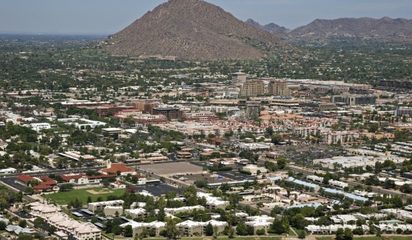
    The City of Greeley said algae is to blame for bad-tasting drinking water in the city.

    Recent hot weather caused algae blooms in two lakes where Greeley gets its water.

    Lake Loveland and Boyd Lake provide more than 20 million gallons of drinking water to the City of Greeley every day. The algae bloom left that water tasting like dirt and metal.

    “People don’t like water that tastes dirty,” said Ed Hall, Assistant Professor Department of Ecosystem Science and Sustainability at Colorado State University.
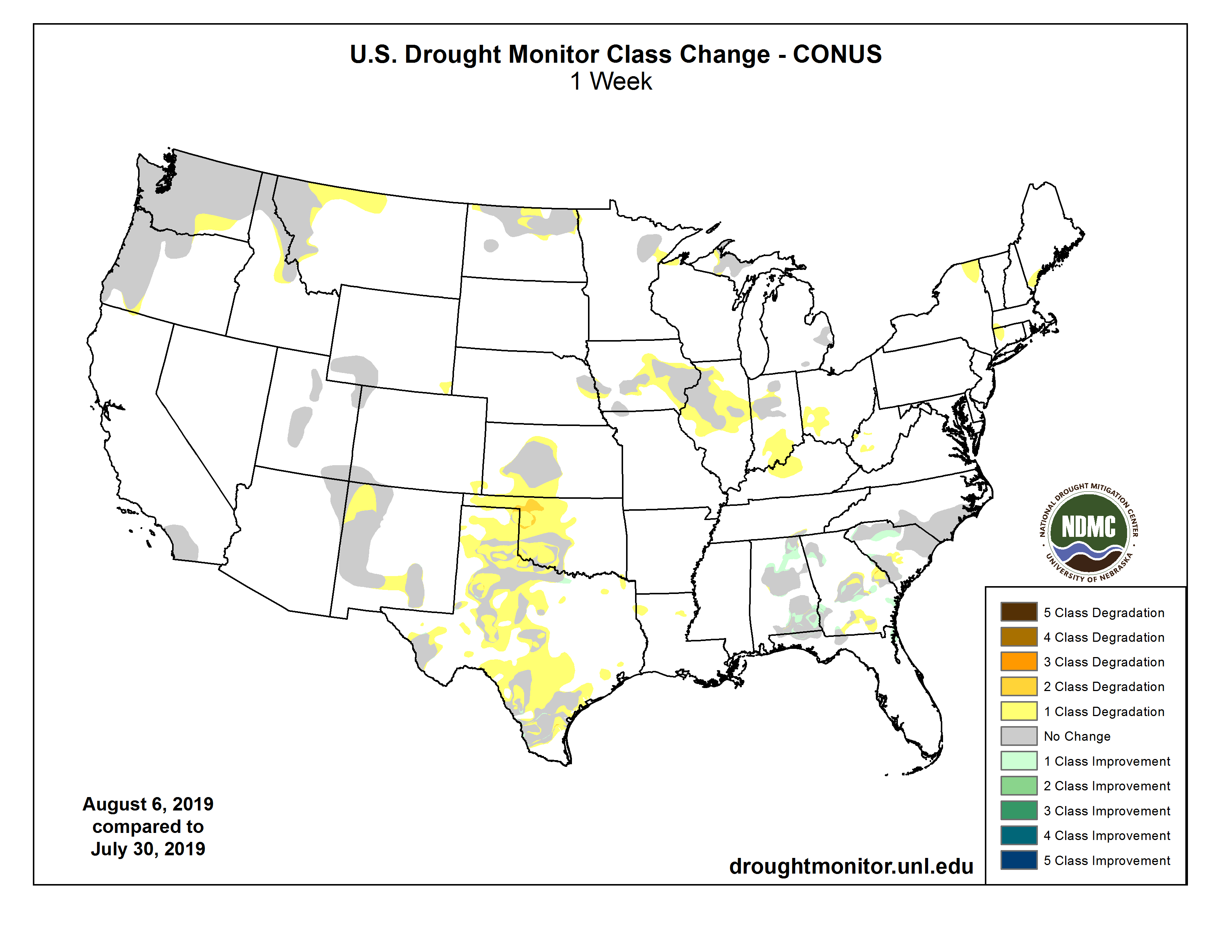
    The blooms happen when there are nutrients in the water, hot days and not much wind…

    Algae releases byproducts that cause the water to taste and smell strange. Right now, Greeley’s water department said the byproducts released from the algae are 250 times stronger than usual.

    “This is an example of climate change in our own backyard. The reasons there are more algal blooms is because the temperatures are slightly warmer every year,” said Hall. “This isn’t going to go away. We really need to start thinking about how to protect ourselves and live with these as the earth becomes warmer every year.”

    […]

    The city said they are now treating the water to try and get all the taste and smell from the algae out of the water. They said it should be almost back to normal by the time it gets to your sink.

    From The Greeley Tribune (Cuyler Meade):

    When the roughly 40 million gallons per day of potable — or drinkable — water consumed by Greeley residents started tasting and smelling noticeably different last week, the Water Department didn’t wait long to react. The department believes its swift response last weekend has effectively solved the problem, and Greeley water should now taste better.

    The problem: Concurrent algae blooms in both Boyd Lake and Lake Loveland, the major peak-months water sources from which the department draws and treats the water delivered to Greeley…

    That meant, Chambers said, that the option of turning off sourcing from one of Boyd Lake or Lake Loveland — from which much of the area’s water is drawn during the “peak” summer months — was not sufficient. While the department did end up turning off its delivery from Lake Loveland, where Chambers said it was determined the algae situation was “about four times” as bad as it was in Boyd Lake, the water coming from Boyd Lake was still affected with an unappealing taste and smell…

    The solution, then: Increase the activated carbon used to treat the water at the Boyd Lake treatment plant.

    “Activated carbon is a good way to remove (the poor taste and smell),” Chambers said. “It’s also very expensive, and it’s hard to get the dosage exactly right for the amount that we’re measuring, which is in parts per billion. Tiny, tiny molecules that have a fair amount of influence on taste and odor…

    Normally, activated carbon is used to treat the water in the 25 to 27 milligrams per liter range, Chambers said. But this dual algae bloom required more.

    “Last Friday, we turned off our Lake Loveland supply, which allowed our activated carbon dosage to do a better job pulling those odor-causing molecules out,” Chambers said. “Then we upped the dosage, as well.”

    Chambers said they began treating the water with about 35 milligrams per liter, up about 40% from the normal dosage. The department is continuing to use that increased dosage for the time being.

    “Our internal sampling has led us to believe that’s perfectly adequate for removing what’s needed,” Chambers said.

    The more southerly lakes become critical sources of water in the high-usage summer months, but the “workhorse” treatment plant is actually at the Poudre River Basin in Bellvue.

    “We treat our water at those two locations near the foothills where you can grab higher-quality source water than you can find in Greeley and deliver the water to Greeley,” Chambers said. “Visionary system that was developed in the early 1900s up at Bellvue.”

    Chambers emphasized the fact that even before treatment, while the water may have tasted differently, it was at no time unsafe to drink.

    Paying it forward to the next generation of water leaders — News on TAP

    Celebration of Denver Water’s past helps develop the future through two $5,000 scholarships. The post Paying it forward to the next generation of water leaders appeared first on News on TAP.

    via Paying it forward to the next generation of water leaders — News on TAP

    Grass looking stressed? Call in the auditor! — News on TAP

    Inspecting your sprinkler system is key to helping your landscape beat the heat. The post Grass looking stressed? Call in the auditor! appeared first on News on TAP.

    via Grass looking stressed? Call in the auditor! — News on TAP

    Seeking public comment on draft Lead Reduction Program — News on TAP

    The executive summary is available online and the community is encouraged to weigh in by Aug. 7. The post Seeking public comment on draft Lead Reduction Program appeared first on News on TAP.

    via Seeking public comment on draft Lead Reduction Program — News on TAP

    It took an act of Congress to get two Colorado peaks named for renowned alpinist couple who died while climbing in Tibet — Katie Klingsporn

    During my time living in southern Colorado, the names Charlie Fowler and Christine Boskoff loomed large. The climbers died in an avalanche in Tibet in 2006, but not before leaving an indelible mark on the climbing community in Norwood, Colorado and beyond. Now, more than a decade after their death, their lives have been memorialized […]

    via It took an act of Congress to get two Colorado peaks named for renowned alpinist couple who died while climbing in Tibet — Katie Klingsporn

    @USBR/@EPA: Federal Officials Announce Priority Actions Supporting Long-Term #Drought #Resilience

    Here’s the release from the Bureau of Reclamation and Environmental Protection Agency (Theresa Eisenman and the EPA Press Office):

    Today, senior administration officials participated in the Second National Drought Forum where they announced Priority Actions Supporting Long-Term Drought Resilience. This document outlines key ways in which federal agencies support state, tribal and local efforts to protect the security of our food supply, the integrity of critical infrastructure, the resilience of our economy, and the health and safety of our people and ecosystems.

    The document was developed by the National Drought Resilience Partnership (NDRP), a federal collaborative formed to promote long-term drought resilience nationwide. While authority lies with the states to manage water resources, federal agencies play a key role in supporting states, tribes, communities, agriculture, industry, and the private sector owners and operators of critical national infrastructure to prepare for, mitigate against, respond to, and recover from drought.

    The following statements were released after today’s panel:

    “Under the leadership of President Trump, we are taking unprecedented steps at the federal level to coordinate and empower states, tribes, local communities, and water users to promote drought preparedness and resiliency and ensure reliable water supply throughout the West. The U.S. Geological Survey and Bureau of Reclamation play integral parts in this, whether it’s the science or infrastructure piece of this equation,” said U.S. Department of the Interior Assistant Secretary for Water and Science Dr. Tim Petty.

    “The Western states have experienced intense drought with the potential to severely impact agriculture, municipal water supplies and hydropower production. We’ve demonstrated that infrastructure investments, innovative approaches to conservation, and collaboration build drought resiliency and reduces risks,” said Bureau of Reclamation Commissioner Brenda Burman.

    “We know we can accomplish more when we work together, and the National Drought Resilience Partnership facilitates collaboration among federal partners to help the country respond to drought and to prepare for the future” said U.S. Department of Agriculture Under Secretary for Farm Production and Conservation Bill Northey. “These priorities are a large part of our game plan to how we can protect our food and water supply, and to build resilience on our farms and ranches and in our communities and businesses”

    “The impact of drought on public health and the environment is far reaching because it reduces both water quantity and water quality,” said U.S. Environmental Protection Agency Assistant Administrator for Water David Ross. “Through EPA initiatives, such as the National Water Reuse Action Plan, we are working to ensure a sufficient supply of clean water for the American people.”

    “Water quality and availability is a national issue and it is one that affects every American. Through this partnership, the data produced by the U.S. Geological Survey will be integrated into a comprehensive framework of information sharing that is flexible and responsive to the nation’s decision-makers, ensuring every community understands drought preparedness, mitigation, and resiliency,” said U.S. Geological Survey Director James Reilly.

    “The National Drought Resilience Partnership is essential to the continued collaboration amongst federal agencies regarding the nation’s water resources. I am committed to this partnership and will ensure the Corps’ support to other agencies as they work drought-related issues and coordinate to reduce duplicative and redundant efforts,” said U.S. Department of Army Assistant Secretary of the Army for Civil Works Ricky “R.D.” James.

    “The National Drought Resilience Partnership is inspiring action across the federal government. DOE is pleased to collaborate with other agencies to stimulate American innovation and technology solutions that address drought resilience through the Water Security Grand Challenge and other activities,” said U.S. Department of Energy Assistant Secretary for Energy Efficiency and Renewable Energy Daniel Simmons.

    The NDRP and the document released today focus on fostering a national dialogue about how federal agencies can support these entities in building a more drought-resilient nation for sufficient water quality and quantity and a vibrant economy at the local level. NDRP categorizes its drought resilience efforts along six goal areas, which provide a framework to systematically address how the federal government supports building long-term drought resilience:

  • Data Collection and Integration
  • Communicating Drought Risk to Critical Infrastructure
  • Drought Planning and Capacity Building
  • Coordination of Drought Activity
  • Market-based Approaches for Infrastructure and Efficiency
  • Innovative Water Use, Efficiency, and Technology
  • Background

    Established in 2016, the NDRP is comprised of federal agencies that work together to leverage technical and financial federal resources, strengthen communication, and foster collaboration among its members to productively support state, tribal, and local efforts to build, protect, and sustain drought resilience capacity at regional and basin scales.

    The NDRP co-chairs are the Department of Agriculture and Environmental Protection Agency. The additional interagency NDRP Member Agencies and offices include the Department of Defense; the Department of the Interior (DOI); the Department of Commerce; the Department of Energy; the Department of Homeland Security (DHS); the Office of the Assistant Secretary of the Army for Civil Works; the Office of Management and Budget; the Office of Science and Technology Policy; the National Economic Council; the Council on Environmental Quality; the National Security Council staff; and such other agencies or offices as the agencies set forth above, by consensus, deem appropriate. Currently, other offices include: the Office of Water Prediction, the National Weather Service, the National Oceanic and Atmospheric Administration, the National Integrated Drought Information System, which all are within the Department of Commerce; the Bureau of Reclamation and the United States Geological Survey, within the DOI; National Aeronautics and Space Administration; DHS Cybersecurity and Infrastructure Security Agency – National Risk Management Center; the Centers for Disease Control; and the Federal Emergency Management Agency. Member agencies collaborate to ensure successful outcomes with maximum efficiency and minimal duplication.

    Hydro-Illogical Cycle graphic via the University of Nebraska Lincoln.

    Windsor reservoir open again

    From The Fort Collins Coloradoan (Miles Blumhardt):

    Windsor Lake Reservoir reopened Thursday, nine days after being closed because of high levels of bacteria.

    Recent water samples tested by the Colorado Department of Public Health and Environment were well below harmful levels of cyanobacteria, also known as blue-green algae, which is common in lakes throughout Colorado.

    Windsor Lake Reservoir. Photo credit: The Town of Windsor

    #Colorado Proud 20th anniversary: Colorado Agriculture Is Loud and Proud Today (Yesterday)– Westword #ColoradoDay

    From Westword (Patricia Calhoun):

    Governor Jared Polis has declared August “Colorado Proud Month” in honor of the Colorado Department of Agriculture local-product program’s twentieth anniversary. Colorado Proud got its start in 1999, long before the local food movement caught fire (and some time after the Always Buy Colorado campaign disappeared into history). Initially, Colorado Proud’s membership consisted of 65 companies selling state-grown and -made products; today it has more than 2,700 members, including growers, food manufacturers, restaurants, ranchers and retailers.

    Wendy White, marketing specialist for the ag department, has been with Colorado Proud from the beginning. “I don’t know where the time went,” she says. “We’ve seen such a shift. When Colorado Proud started, I was knocking on doors and encouraging them to participate…we were local before it was hip to be local.” Now, though, it’s not only hip, but consumers are increasingly interested in knowing more about the products they’re buying and the practices of the ranches and farms that produce them.

    New businesses are jumping in all the time, too. “We’ve seen a lot of growth in microgreens,” says White. “Lavender we’re really starting to see blossom — pun intended. Hops and hemp, too. Even manufactured food products such as salsas and sauces.”

    “Colorado Proud is a national leader in championing the diverse agricultural products grown, raised or processed in our state,” says new Commissioner of Agriculture Kate Greenberg, who lists three major goals for her department: supporting the next generation of farmers and ranchers; scaling up investment in high-value agriculture and diversifying market opportunities; and promising and incentivizing soil, water and climate stewardship.

    To mark its anniversary, Colorado Proud not only got that Polis proclamation, but replaced its purple-and-gold sunrise logo with one that more closely resembles the Colorado flag (not to mention Polis’s new state logo). It’s also adopted a new outreach theme, “The Next Generation of Ag,” and will be hosting an agricultural community tour around the state this month, including stops at the Union Station Farmers’ Market on Saturday, August 3; the South Pearl Street Farmers’ Market on Sunday, August 4; and the Broomfield Farmers’ Market on Tuesday, August 6.