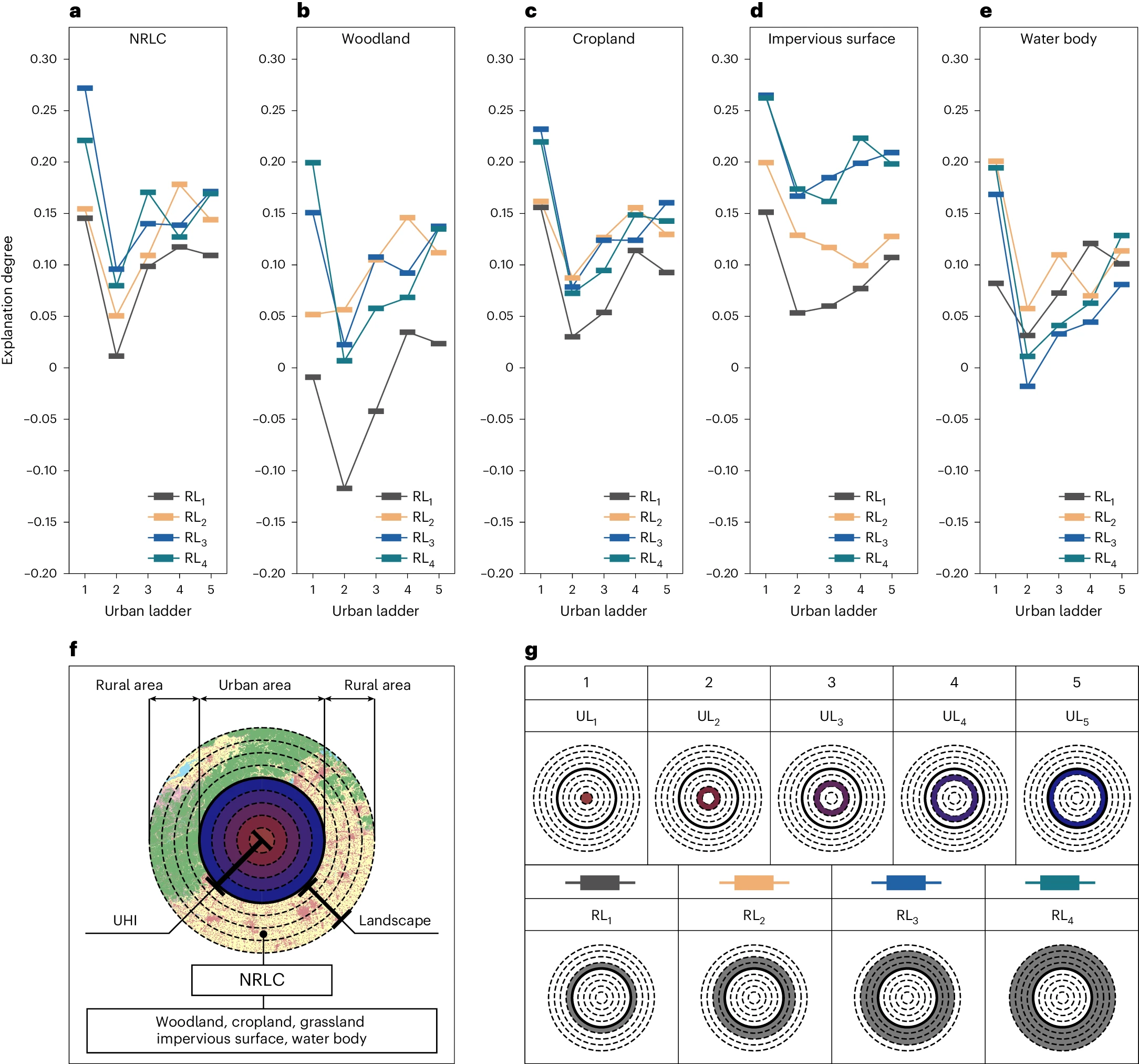
a–e, From the left to right, respectively: NRLC, woodland, cropland, impervious surface and water body. The horizontal coordinates represent the different urban ladders (ULi, i = 1–5). The vertical coordinates represent the explanation degrees (R2) of different cover types to the surface UHI. f, The schematic representation of urban regions and rural land cover (the variation of color range standing for different urban regions). g, The specific locations of various urban and rural regions. Credit:https://www.nature.com/articles/s44284-024-00091-z
Rural land surrounding urban areas could help cool cities by up to 32.9 degrees Fahrenheit, an analysis in Nature Cities suggests, hinting at a way to cool increasingly scorching urban areas. In an attempt to understand how rural land cover affects urban heat islands — a phenomenon in which cities become significantly warmer than the areas surrounding them — researchers studied data from 30 Chinese cities between 2000 and 2020. They looked at land cover surrounding the urban areas and ranked the capacity of various urban-rural configurations to cool the cities. Rural areas hold “great potential” for cooling urban heat islands, the researchers concluded, with the biggest impacts occurring within a six- to nine-mile radius of the urban boundary. Rural land in that range can reduce the urban heat island intensity by nearly 30 percent, they found.
The reason is a matter of physics, they write: Air warms in cities, leaving a low-pressure zone near the ground that then helps transport cooler air from surrounding rural areas. The rural areas then go on to absorb the heat. Different factors affect the process, including geographic features like hills and mountains, a city’s shape, and climatic zones, the researchers write.
Land use in rural areas “can make a big difference to temperatures downtown,” Shi-Jie Cao, a visiting professor at the University of Surrey’s Global Center for Clean Air Research and a co-author of the paper, said in a news release.
A selection of Colorado butterfly and bee species in the University of Colorado Museum of Natural History Entomology Collection. A collaborative study found that pollinators provide billions of dollars’ worth of services to Colorado, and they are at risk. Credit: Adrian Carper/CU Museum of Natural History
Pollinators are responsible for everything from the food we eat to the clothes we wear, and Colorado would not be so colorful without their contributions to the state’s landscape. But studies have shown that even in protected areas of Colorado, insects have declined by more than 60% over the past few decades.
A pollinator study led by Colorado State University Extension has found that native pollinators are worth billions of dollars to Colorado, and they need protection. The study has resulted in a state law that dedicates public funding to studying and conserving invertebrates and rare plants.
Legislators wasted no time in applying recommendations from the study, which was released in January. The law addresses the No. 1 priority outlined by the study: Protect imperiled native pollinating insects.
Deryn Davidson, principal investigator of the study and CSU Extension sustainable landscape state specialist, said the study and now the law recognize the importance of pollinators and called them significant steps toward invertebrate protection.
“The quick action on this bill is really fantastic because if we do nothing, the decline in not just pollinators but all invertebrates is going to be serious, and we’ll all be affected far more than people realize,” Davidson said.
Squash bees, like this Peponapis pruinosa, are among the most effective squash and melon pollinators. More than a third of the world’s crops depend on pollinators. Credit: Adrian Carper
Before the law, signed by Gov. Jared Polis on May 17, invertebrates were not included among wildlife managed by the state. The law authorizes Colorado Parks and Wildlife to make land management decisions based on pollinator conservation and establishes pollinator-related staff positions.
“The ability to specifically study pollinators and the plants that depend on them is crucial to our understanding of factors impacting native pollinators and how we can best support them,” said Adrian Carper, an entomologist with the University of Colorado Museum of Natural History and co-lead author of the study with Davidson and Steve Armstead of the Xerces Society for Invertebrate Conservation. Carper led the study’s science team, and Armstead led its land management team, while Davidson managed the project overall.
The combined team of experts spent a year synthesizing pollinator data and best management practices for large-scale pollinator conservation to present to the governor’s office at the end of 2023. The 306-page study, commissioned by the Colorado General Assembly in 2022, is the most detailed account of statewide pollinator health ever undertaken.
“This bill begins to implement the recommendations of Colorado’s Native Pollinator Study by enabling our state wildlife professionals to study and conserve all native species, including invertebrates and rare plants that serve as the foundation of healthy, functional ecosystems,” said Sen. Janice Marchman, who co-sponsored the bill in the Colorado Senate.
An orange-tipped cactus borer pollinates a curly cup gumweed; both species are native to Colorado. A collaborative study led by Colorado State University Extension is the most detailed account of statewide pollinator health ever undertaken. Credit: Adrian Carper
Protecting pollinators
The study found that pollinators are worth billions of dollars to Colorado agriculture alone. They are also essential for the plants, wildflowers and wildlife that make the Colorado outdoors so desirable for recreation – a significant economic driver for the state in addition to a quality-of-life enhancer for residents.
“Native pollinators are crucial to our crops, economy, natural areas, and overall health and wellbeing,” Carper said. “Without the pollination services they provide, our landscapes would be much less productive, diverse and sustainable.”
“They’re not just creepy-crawly annoyances,” Davidson added. “Pollinators are the unsung heroes.”
Without protection, however, the outlook for Colorado’s native pollinators is dire. Research in a protected high-altitude meadow near Crested Butte over the past 35 years found that there are about 61.5% fewer insects, due mainly to warmer temperatures and less precipitation.
Habitat loss, climate change, pesticides, inadequate land-management practices and competition from non-native species are the primary causes of pollinator decline.
Colorado has 24 species of bumblebees, and nearly one-fifth are under review for federal protection under the Endangered Species Act. Three Colorado butterflies already are listed as endangered.
“This bill takes a big step forward in making sure we’re managing and protecting the state’s wildlife holistically,” said Marchman, who represents Larimer and Boulder counties in the Senate.
Davidson said that there are simple things people can do in their own yards to help support pollinators, adding that pollinator habitat can boost the curb appeal of your home, too. For more information on how to create pollinator habitat in your own yard, view the video below.
Declining stream flows can have cascading impacts on communities, fish, and wildlife. WRA is supporting policies and agreements to put water back into the rivers that sustain the West.
Healthy rivers are the foundation of the West, but climate change and growing water demands have stretched our rivers thin. Across the region, low flows have resulted in cascading impacts to communities, fish, and wildlife. Drying streams become disconnected from the rest of the river system. Low water levels inhibit fish passage, cause harmful algal blooms, result in higher water temperatures that are dangerous to fish, and increase the spread of invasive species. Communities feel the effects of these low flows as water supplies decline and popular outdoor recreation spots close.
Fortunately, there is a solution to this problem – add water. But unfortunately, water is in short supply in the West. In many cases, much of the water flowing in our rivers is already spoken for, having been legally allocated to cities, farmers and ranchers, industry, and other water users. Under state law in Colorado, water users have long been incentivized to use their full water allotment or risk losing it – a huge deterrent for water conservation.
Thankfully this is changing, as new policies are adopted that promote conservation while protecting water rights. For example, in 2013, a law was passed that allows water users who participate in water conservation programs to leave water in rivers and streams while still maintaining their full water rights. This helped open the door to innovative water sharing agreements to boost river flows.
In 2020, WRA worked with a team of partners to compile a list of high priority streams across Colorado that could benefit from such agreements. Among these streams was Slater Creek.
Located northwest of Steamboat Springs, the picturesque Slater Creek watershed supports numerous ranches, sustains habitat for native fish, and is a popular destination for camping, hunting, and boating. But in the hot summer months, flows in Slater Creek often drop below what is needed to maintain a healthy stream for fish and wildlife.
Seeing this, WRA sprang into action and met with members of the local ranching community to discuss a water sharing project to restore Slater Creek. We built relationships within the community, listened to their concerns, and assured them that any project would be protective of their water rights, and any water sharing agreement would be voluntary, fairly compensated, and mutually beneficial to participants and the river. Through these conversations, we were introduced to a rancher who was interested in working with us. We connected with the Colorado Water Trust, an organization with expertise in water sharing agreements, to get the project off the ground.
Ditch headgate that will be closed under the agreement to leave water in Slater Creek. Photo credit: Western Resource Advocates
Under this new agreement, WRA and the Colorado Water Trust will lease water from the rancher this summer to boost flows in Slater Creek. The rancher will be paid to stop irrigating from mid-July through October, when the river needs water the most. This will benefit 32 miles of Slater Creek, including reaches with instream flow water rights, and will put up to 130 million gallons of water back into the stream. WRA will be monitoring stream health and documenting river flows over the course of the lease. State law limits such leases to five out of every ten consecutive years to preserve agricultural lands. WRA and the Colorado Water Trust plan to continue working in Slater Creek to lease water in the years when it is most needed.
The water sharing agreement in Slater Creek is a prime example of how we can work together to implement solutions that both protect rivers and benefit communities in the face of drought and climate change.
Across the West, WRA is supporting agreements and policies that put water back into the streams that sustain our communities, fish, and wildlife.
For decades, courts have deferred to federal agencies when interpreting vague statutes. What constitutes the “take” or killing of an animal? What does it mean to maintain a wildlife population’s viability? What does “multiple use” mean when it comes to managing Forest Service or Bureau of Land Management lands?
But a recent ruling by the U.S. Supreme Court, Loper Bright Enterprises v. Raimondo, has shifted the authority to make these decisions from the executive branch to the federal judiciary. The 6-3 decision, split along ideological lines and written by Chief Justice John Roberts, did away with what’s known as the Chevron precedent, which instructed courts to defer to agency expertise regarding ambiguous laws, as long as those readings were reasonable.
The Chevron doctrine was one of the most-cited administrative law cases ever. In striking it down, the Supreme Court made an untold number of statutes vulnerable to legal challenges, while curtailing the ability of federal regulators to interpret and enforce existing laws.
“I think the bottom line is it will undoubtedly be disruptive,” said Martin Nie, a professor of natural resource policy at the University of Montana.
High Country News has compiled a list of some of the issues and topics in our core coverage areas that are likely to be impacted by Chevron’s repeal.
Lands, water and wildlife
Multi-use mandates: Several of the agencies that oversee land, water and natural resources are governed by multiple use mandates. Enacted in the 1960s and 1970s, these instruct agencies like the Bureau of Land Management and the Forest Service to promote a variety of outcomes, including recreation, sustained yield of natural resources and conservation.
“The statutes governing the Forest Service and the BLM are famously vague and discretionary,” Nie said.
This is especially true of the Federal Land Policy Management Act, which has directed public land regulation since 1976. The law has been flexible enough to accommodate both the Trump administration’s energy dominance agenda and the Biden administration’s recent conservation rule. The latter involved a new interpretation of FLPMA, elevating conservation to the same level of importance as energy extraction. Without the deference standard, Biden’s new rule will likely face legal challenges.
Josh Osher, public policy director at the Western Watersheds Project, thinks it’s now going to be difficult to impossible for the Fish and Wildlife Service to delist the Greater Yellowstone population of grizzly bears. Amaury Laporte/CC via Flickr
Unexpected upsides: For the nonprofit organizations that watchdog the federal government’s wildlife and natural resource agencies, the ruling may actually offer some benefits.
“The agency deference that has been part of the Chevron decision has worked against us in many cases,” said Josh Osher, public policy director at the Western Watersheds Project.
The nonprofit regularly challenges agency rulemaking and any other decisions that its staff believe do not follow the law. With Chevron’s agency deference gone, Osher thinks it’s now going to be difficult to impossible for the Fish and Wildlife Service to delist the Greater Yellowstone or Northern Continental Divide population of grizzly bears.
Nie believes that environmental laws, like the Endangered Species Act, that are relatively prescriptive as written and may potentially be less impacted by Chevron’s absence. The same legal specificity may help uphold decisions pertaining to national wildlife refuges — given that the U.S. Fish and Wildlife Service has a mandate to protect biological integrity, diversity and environmental health — and the Wilderness Act, which specifically prohibits “trammeling” protected areas.
This optimism is not universal, of course – especially given the uncertainty inherent in undoing 40 years of legal precedent.
“It reduces the effectiveness of our federal agencies that have the expertise on staff because it is up to the judges to interpret technical and scientific aspects of implementing the law, rather than the professional scientists within agencies,” wrote Rebecca Turner, chief policy and partnerships officer at American Forests, in an email to HCN.
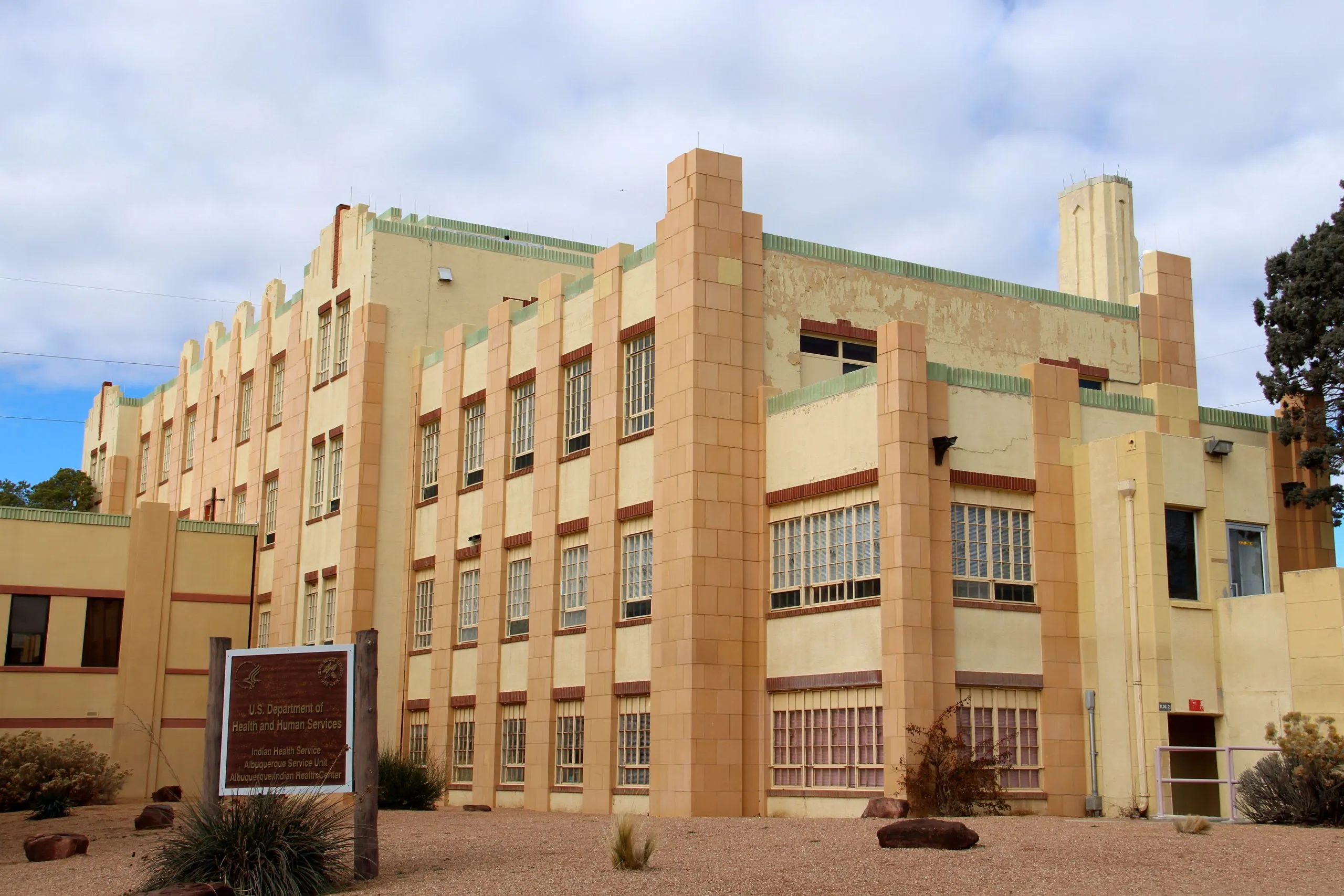
The Albuquerque Indian Health Center, in New Mexico, run by the Indian Health Service. C Hanchey/CC via Flickr
Tribal law
Bureau of Indian Affairs: Legal experts say that the repeal of the Chevron precedent will have broad implications for Indian Country.
James Meggesto, an Onondaga citizen who leads the Native American law team at Holland & Knight, said that, on the one hand, the Supreme Court’s decision levels the playing field for tribes that wish to challenge federal regulations that “negatively impact Indian Country.”
“Not every decision of, say, the Bureau of Indian Affairs or the Indian Health Service when they were interpreting statutes necessarily benefited tribal interests,” he said.
But this cuts both ways. Meggesto mentioned two recent Biden administration rules that could now be vulnerable to lawsuits: a move to ease the process of transferring land into trusts to be held for the benefit of a tribe and a revision of regulations governing gaming compacts.
”This (ruling) is going to encourage anti-tribal interests to potentially challenge those in court,” he said. “And so tribes are going to be in a position of wanting to assist the government in defending those positive regulations.”
Meggesto said the recent ruling doesn’t affect the key tenets of Indian law, as expressed in the Canons of Construction of 1832. Those principles, he said, are “that treaties are to be construed as the Indians would have understood them, and federal laws, if they’re ambiguous, should be construed in a manner most favorable to the tribal interest.”
The Bonneville Shoreline Trail winds along the hills above Salt Lake City. Michlaovic/Wikimedia Commons
Climate and clean air
Tailpipe emissions: One of President Biden’s signature climate policies — an Environmental Protection Agency rule that uses the Clean Air Act to limit tailpipe emissions from cars sold in the U.S. — was under threat before Chevron’s repeal. The attorneys general of more than two dozen states, including Idaho, Montana, Utah and Alaska, sued the EPA in April, shortly after it released a final rule that aims to dramatically reduce nationwide carbon emissions by pushing automakers to sell greater proportions of hybrid and electric vehicles.
Existing laws are not explicit regarding whether regulators can take action against mobile sources of greenhouse gases — such as cars — as opposed to stationary sources like an industrial plant, according to Reuters.
The U.S. Court of Appeals for the District of Columbia Circuit will decide whether the rule will stand, without the leeway for agency interpretation that Chevron allowed.
Power plant emissions: Released in April, the EPA’s new carbon rule is ripe for legal challenges in a post-Chevron landscape. The regulation relies on the Clean Air Act, Clean Water Act and Resource Conservation and Recovery Act to limit pollution from power plants, including coal and natural gas plants, effectively pushing them to retire or install carbon capture technology to cut 90% of their greenhouse gas emissions by 2032 — a move hailed by climate advocates. Many states, however, argue that the drastic limits are unreasonable and vastly exceed the EPA’s authority under written law.
The Crossing Trails Wind Farm between Kit Carson and Seibert, about 150 miles east of Denver, has an installed capacity of 104 megawatts, which goes to Tri-State Generation and Transmission. Photo/Allen Best
Clean energy
IRA tax credits: In 2022, Congress passed the Inflation Reduction Act, a sweeping piece of legislation that included numerous tax incentives to spur the clean energy transition.
While the law itself remains intact, in a future without Chevron, legal experts are concerned that agencies will struggle to implement it. Some lawmakers disagreed, for instance, on whether sourcing electric vehicle components from certain foreign countries should be allowed; others have protested a Treasury Department rule that blocks nuclear plants from receiving funding for clean hydrogen projects.
Without the Chevron precedent, legal challenges to agency rules meant to implement the IRA could significantly stall the nation’s progress toward rapid decarbonization.
Wind turbines and utility lines in central Idaho, amid smoke from wildfires in 2021. Simon Foot/CC via Flickr
Transmission lines: To bring more decentralized solar and wind farms onto the power grid, developers need more transmission lines. The long wait times to get them approved have become a bottleneck, endangering the nation’s climate goals.
That’s why, in May, the Federal Energy Regulatory Commission released Order 1920, a regulation that forces transmission operators to be more proactive in their planning process, with the aim of easing connections to the grid. It’s already received partisan pushback from Republican states and state utility commissions, who say that the rule is too prescriptive and limits their legal role in the planning process.
FERC’s sole Republican Commissioner, Mark Christie, is already arguing that Chevron’s repeal will likely nullify Order 1920.
“The most important legal lifeline that Order No.1920 needed was pulled away today,” Christie wrote on the day of Chevron’s repeal, “and the final rule’s chances of surviving court challenges just shrank to slim to none.”
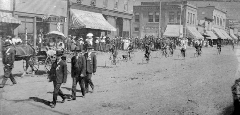
Labor Day Parade on Silverton’s Greene Street, once a strong Union town photo via The Denver Public Library.
Labor
The Fair Labor Standards Act, passed in 1938, mandated a national minimum wage, ended child labor and established overtime pay rules. But the law is at times ambiguous regarding which workers benefit from these standards. Historically, the U.S. Department of Labor issues rules clarifying issues like safety regulations, unemployment standards and union-organizing protections.
Without Chevron, decades of these interpretations are now subject to legal scrutiny. A blog post by Littler Mendelson P.C., a well-known law firm that often represents employers in union and labor litigation, predicts that federal labor regulators will issue fewer and more narrow regulations.
A Texas judge has already ruled to block the Department of Labor’s new overtime rule from going into effect. Devon Ombres, an attorney for the Center for American Progress, a progressive think tank, said that “labor law is so dependent on Chevron deference that virtually any type of progressive regulation that protects workers is going to be challenged under this new paradigm.”
The biggest water trials facing the Rio Grande Water Conservation District and local farmers are set for 2026.
Peter Ampe, attorney for the Rio Grande Water Conservation District, told board members Tuesday that three major water cases are set for trial in 2026. The cases are:
The fourth Plan of Water Management for Subdistrict 1 scheduled for six weeks starting Jan. 2, 2026
Sustainable Water Augmentation Group and its proposed alternative augmentation plan for a group of irrigators in Subdistrict 1 set for a six-week trail starting June 29, 2026
The city of Alamosa and its confined aquifer case set for a three-week trial starting on Oct. 19, 2026
Each of the cases is subject to settlement ahead of any trial. Ampe said the city of Alamosa’s case to guarantee itself more water for future expansion has the best chance of agreement before a trial would begin.
The fourth Plan of Water Management for Subdistrict 1 is a key document that outlines future strategies to recover the unconfined aquifer of the Upper Rio Grande Basin. Farmers in the subdistrict, which covers parts of Alamosa County around Mosca-Hooper and Rio Grande County, are under pressure from state water managers to restore the aquifer.
The subdistrict’s updated water management plan has been approved by the state engineer and needs approval from the District 3 Water Court to go into effect.
The alternative augmentation plan proposed by the Sustainable Water Augmentation Group had the start of a water trial in 2023 only to have the trial come to a sudden end when the group withdrew its application. The application withdrawal came after the town of Del Norte terminated an agreement to lease water to the SWAG farmers as a replacement source for groundwater pumping by SWAG members.
Greg Higel, board chair of Rio Grande Water Conservation District, said the board will have to prioritize spending on attorney fees in its annual budgets. MORE: Alamosa Citizen maintains an extensive archive of water stories.
Dolores River near the confluence with the San Miguel River. Photo credit: Jonathan P. Thompson
Click the link to read the guest column on The Durango Herald website (Regina Lopez-Whiteskunk). Here’s an excerpt:
The Dolores River Canyons represent a significant portion of the cultural heritage for the Ute People that serve as a place of spiritual connection, a place to connect with our ancestors’ stories and traditional practices. These lands are not merely scenery; they are the very foundation of the Ute Mountain Ute identity. Increased mining would not just disrupt the delicate balance of the ecosystem, it would sever the cultural ties that bind my people to part of our ancestral home.
The future of the Ute Mountain Ute Tribe, and Indigenous communities across the country, lies in the enduring strength of our cultural heritage. Protecting the Dolores River Canyons is not just about safeguarding the environment; it’s about ensuring that future generations of Indigenous youth can grow up connected to their land, steeped in the traditions of their ancestors. Imagine the richness of a future where Ute children learn about their history by exploring the canyons, not by reading about the environmental devastation wrought by a bygone mining industry.
Let us choose the path that honors the past, protects the present and secures a brighter future for generations to come. Let us choose to leave a legacy of respect and cultural preservation, not one of environmental destruction and broken promises.
Click the link to read the article on The Denver Post website (Elise Schmelzer). Here’s an excerpt:
July 18, 2024
An invasive species capable of wiping out entire aquatic ecosystems and causing millions of dollars in damage to infrastructure has been found for the first time in the Colorado River, the most important river in the American Southwest. Colorado Parks and Wildlife officials on Tuesday announced the discovery of zebra mussel larvae in the river east of Grand Junction. The mussels are nearly impossible to remove and pose an extreme risk to the critical river, its wildlife and its infrastructure, experts and state officials said. The discovery of the mussels so far upstream on the 1,450-mile river means the species could easily spread downstream and take over large swaths of the Colorado, said Reuben Keller, a professor who studies aquatic invasive species in the School of Environmental Sustainability at Loyola University Chicago. There is no effective way to remove the mussels from a river once they are established, he said…
The Government Highline Canal, near Grand Junction, delivers water from the Colorado River, and is managed by the Grand Valley Water Users Association. Prompted by concerns about outside investors speculating on Grand Valley water, the state convened a work group to study the issue. CREDIT: BRENT GARDNER-SMITH/ASPEN JOURNALISM
Colorado Parks and Wildlife found the first zebra mussel larva — called a veliger — on July 1 during routine testing in the Government Highline Canal, which is diverted from the Colorado River just east of Grand Junction. On July 8, CPW staff collected samples from two locations upstream of the canal diversion. They found a single veliger in each sample. CPW staff have not yet found adult mussels, but they plan to conduct increased sampling. Slower sections of water, like pools and eddies, are more susceptible to mussel infestation, according to the agency. Anyone who uses the river or surrounding waters needs to clean, drain and dry any watercraft or equipment, CPW spokesman Rachael Gonzales said.
“We’re looking at what’s next,” she said. “It’s going to be very difficult — if not impossible — to remove and eradicate them in a system as large and complex as the Colorado River.”
While the zebra mussel is new to the river, the closely related and equally pernicious quagga mussel has established a population further downstream. Large infestations have taken root in the system’s largest reservoirs — Lake Mead and Lake Powell — and caused millions of dollars in damage to dam infrastructure.
In June, the Supreme Court of the United States issued a decision inLoper Bright v. Raimondo on the deference courts must give to federal agencies interpreting and implementing through regulations the laws they administer—a doctrine informally known as “Chevron deference.” This decision will impact how critically-important environmental laws that Audubon cares about – such as the Endangered Species Act, National Environmental Policy Act, Clean Water Act, and Clean Air Act – will be implemented moving forward.
What is Chevron deference?
Chevron deference was a result of a unanimous 1984 Supreme Court decision in the case of Chevron v. Natural Resources Defense Council. Under Chevron, when an agency adopts regulations implementing a statute, if an agency’s interpretation of a statute was challenged in court, the court must answer two questions before the challenge can prevail. First, it must assess whether the United States Congress has spoken directly to the question at issue. If Congress had, the agency’s action must align with the law. However, if Congress had not provided clear guidance on a question, the statute is ambiguous, and the court must assess whether the agency’s action is based on a reasonable interpretation of the law. If the agency had remained within the bounds of what can be reasonably construed to be Congress’s intent in passing the underlying law, the court must defer to the federal agency.
What did the Supreme Court decide?
Under Loper, the Supreme Court held that under the Administrative Procedures Act, courts may not defer to a federal agency’s interpretation of the law when the statute is ambiguous. The decision held that a court reviewing agency actions must “decide all relevant questions of law.” Under Loper, judges may be required to determine technical aspects of science or other detailed aspects related to how agencies should implement or enforce laws. Although the agencies’ interpretation will be given “the most respectful consideration,” the agencies’ interpretation cannot replace the courts’ judgment.
What are the possible impacts to conservation policies important to Audubon?
In practice, Chevron deference allowed Congress to write laws to protect the environment while allowing Executive Branch agencies to implement the intent of the law using their technical expertise in complicated environmental matters. Under the Chevron doctrine, Congress could choose when to utilize the expertise of agency staff and when to weigh in explicitly. For 40 years, the Chevron deference was foundational to the courts’ upholding regulations protecting the environment. With the deference, it provided enhanced certainty to agencies implementing broad laws passed by Congress.
The implications of the decision are likely to present challenges to conservation efforts supported by agency regulations and cause increased litigation and forum shopping. By removing the deference, we may be unable to take full advantage of the scientific expertise and practical experience of federal agencies. The likely increase in litigation also will slow the successful implementation of laws designed to address climate and biodiversity challenges that protect birds and communities.
To minimize these impacts, Congress should consider providing additional guidance on implementation when passing laws, avoid ambiguity, and enshrine aspects of agency authority where necessary to ensure effective policy implementation.
On the other hand, environmentalists may find “wins” when challenging regulations that are incompatible with our goals, such as anti-environmental regulations. In this instance, Congress’s passing detailed laws could ensure that sound environmental policies are advanced regardless of any administration’s position on these issues.
What are the next steps?
Policies informed by science and expertise are urgently needed to ensure that birds and people are protected. North America has lost 3 billion birds in the past 50 years, and Audubon’s science shows that two-thirds of North American bird species are at risk of extinction from climate change.
Audubon will closely monitor how the Supreme Court’s decision affects important environmental laws in the United States. Our commitment to advancing policy to protect bird habitats and address climate change remains unchanged. We will continue to work in partnership with federal, state, local, and tribal governments to ensure a future where birds and people thrive.
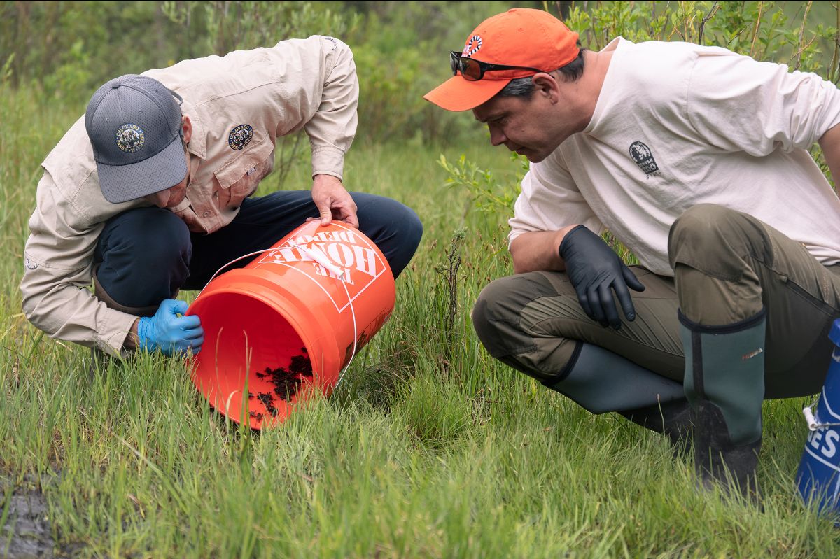
CPW’s Daniel Cammack, left, works alongside staff from the Denver Zoo Conservation Alliance to stock boreal toad tadpoles on June 20, 2024. Photo courtesy of Denver Zoo Conservation Alliance.
On June 20, 2024, teams from DZCA and CPW trekked wetlands near Creede to introduce more than 2,200 boreal toad tadpoles that officials hope could eventually host an established population of rare amphibians. This was the second successful breeding and release, including the reintroduction of more than 600 tadpoles in the Gunnison National Forest in 2022.
“This successful breeding and release effort was the result of a tremendous amount of hard work and planning by our Animal Care and Field Conservation teams and our partners at Colorado Parks and Wildlife,” said Brian Aucone, chief conservation officer at Denver Zoo Conservation Alliance. “We’re committed to continuing this effort with CPW for many years to come and doing our part to make sure this important species remains part of Colorado’s ecosystem for future generations.”
Once common in montane habitats between 7,000-12,000 feet in the Southern Rocky Mountains, the boreal toad has experienced dramatic population declines over the past two decades. The decline appears to be related to habitat loss and primarily infection by the chytrid fungus, which can infect most of the world’s 7,000 amphibian species and is linked to major population declines and extinctions globally. Officials estimate there may be as few as 800 wild adult toads left in Colorado.
“It was a very special day to join our partners from Denver Zoo to release boreal toad tadpoles that the Zoo produced at their facility,” said Daniel Cammack, Southwest Region Native Aquatic Species Biologist with CPW. “Consistent propagation of boreal toads in captivity has been the major missing link in our conservation efforts. In the past, we relied solely on collecting fertilized eggs from wild populations to grow into tadpoles at the hatchery and stock at translocation sites. Thanks to the Zoo’s expertise and hard work, we are able to increase our capacity and get more toads out at more locations. This is a critical partnership that we hope will translate to an increase in populations of this unique amphibian across our state.”
Denver Zoo Conservation Alliance has been conserving endangered and critically endangered amphibian species for more than 18 years. In 2018, DZCA became the first zoo in the Northern Hemisphere to successfully breed critically endangered Lake Titicaca frogs, and has since provided more than 250 healthy frogs to zoos and aquariums in the U.S. and Europe. In 2021, the organization successfully bred critically endangered Panamanian golden frogs as part of the Association of Zoos and Aquarium’s Species Survival Plan. In 2022, DZCA and CPW released the first brood – more than 600 tadpoles – from the joint initiative to support boreal toads in a remote wetland in Gunnison National Forest.
CPW has devoted significant resources for more than 30 years toward boreal toad research and continues to explore ways to recover the species. Specifically, CPW researchers focus on developing methodologies for reintroducing toads in historically occupied habitats, detecting chytrid fungus in the wild, marking and identifying individual toads and improving breeding success at the Native Aquatic Species Restoration Facility, which plays a critical role in the state’s efforts to restore populations of boreal toads.
Officials from DZCA and CPW estimate that it will take many years to bring the species back to a level where it is secure in the Southern Rocky Mountains and expect the collaboration to be a multi-year program. Additionally, as part of the wild release program, DZCA launched a community science project where volunteers monitor the species’ high-country habitat to help officials understand the health of current wild populations and determine suitable locations for future reintroduction of toads bred at DZCA’s campus in Denver. For more information, visit DenverZoo.org.
Boreal Toad Release June 20, 2024. Photo credit: Colorado Parks & Wildlife
The orange plume flows through the Animas across the Colorado/New Mexico state line the afternoon of Aug. 7, 2015. (Photo by Melissa May, San Juan Soil and Conservation District)
As the CEO of Northern New Mexico Indigenous Farmers, I see firsthand the struggles our farmers face every day. Our community, inherently connected to our land and rich in agricultural traditions, has been hit hard by an unreliable water system that makes it tough to keep our crops healthy and our livelihoods secure. The Hogback pump station, which should be a dependable source of water, often breaks down, causing us to lose crops and hope. Today, I want to share why securing Energy Transition Act funding for a new pump station is so crucial and how this project will bring much-needed hope to our community.
This image was taken during the peak outflow from the Gold King Mine spill at 10:57 a.m. Aug. 5, 2015. The waste-rock dump can be seen eroding on the right. Federal investigators placed blame for the blowout squarely on engineering errors made by the Environmental Protection Agency’s-contracted company in a 132-page report released Thursday [October 22, 2015]
Our organization was born out of the Gold King Mine spill, a disaster that laid bare the lack of support for our farmers. The spill made our existing problems worse, showing that without quick action, our farming future was at risk. One of the biggest issues we face is our broken-down irrigation system, specifically the Hogback pump station. Its frequent failures leave us with no reliable water supply for our crops, creating a constant state of anxiety for our farmers and resulting in fallow land. This situation can’t go on if we want our community to thrive. That’s why we applied for the ETA grant from New Mexico’s Economic Development Department, and I’m thrilled to announce we were awarded $3.6 million in funding to replace our failing pump station. This isn’t just a fix for our water problems; it’s a lifeline for our entire community. The new pump station, complete with its own solar power, will make sure our farms get a steady and reliable supply of water, leading to healthier crops and more stable incomes for our farmers. But the benefits of this project go beyond water. A reliable pump station will help us rebuild our agricultural sector, providing jobs and boosting local businesses that rely on farming. It will also help us keep our cultural traditions alive, as farming is more than just work for us — it’s a way of life that connects us to our heritage and our land. This project will also bring our community together. Alongside the new pump station, we plan to offer training for our farmers on modern irrigation techniques and sustainable land management. This training will give our farmers the tools they need to use water more efficiently and improve their yields. By learning and growing together, our community will become stronger and more united.
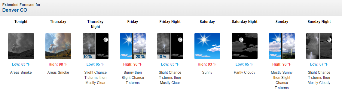
Colorado is currently in the throes of yet another heat wave. Many daily temperature records and some monthly temperature records will be threatened this week across northern and central Colorado. We will see temperatures flirting with the triple digits up and down the Front Range and Urban Corridor. The image below of the National Weather Service 5-day forecast for Denver shows persistent mid-to-upper 90s.
Just earlier this month we saw a heat wave that threatened all-time high temperature records across the state (July 12th – July 14th). The details of the last heat wave can be found in our last blog. For this blog I thought it would be fun to explore heat waves in a bit more detail. First, we’ll examine some of the record heat from around the state. Then we will explore all the factors that need to come together to produce record heat.
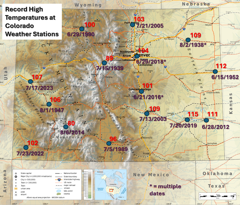
Records Around the State
Most of the population centers in Colorado have all-time high temperature records between 100 °F and 110 °F. Records on the Urban Corridor from Fort Collins down to Colorado Springs range from 101 °F to 104 °F. Pueblo gets a bit hotter, with a record of 109 °F. The terrain in western Colorado is extremely complex, and so are the high temperature records. Areas in the valleys such as Grand Junction and Montrose have seen temperatures max out at values a little bit above the Front Range (107 °F and 106 °F respectively). The hottest temperatures ever recorded in Colorado have occurred on the Eastern Plains, with records from 109 °F to 115 °F in Las Animas; this is our state record. People travel from far and wide to enjoy our Colorado mountains in the summertime, and one of the biggest reasons is the thinner, cooler, drier air. Record high temperatures in the mountains are much cooler. Dillon, CO in Summit County has famously never experienced a 90-degree day. Maximum temperature records only get cooler as one travels higher in elevation. The figure below shows record high temperatures across the state. For the sake of comparison, I have also included the maximum temperature record of 80 °F at Slumgullion Pass, which sits at 11,300 feet elevation.
We see in the figure above an obvious relationship between the maximum temperature record observed at a station and elevation. It is much more difficult to see extremely high temperatures in the thin mountain air than in the relatively think air over the eastern plains. This probably feels somewhat intuitive, but can we explain why this is using physics? Why can’t the mountains get as warm as the plains? Why are some summers hotter than others, and why are some heat waves worse than others? The remainder of this blog is devoted to examining the anatomy of a heat wave in detail, and understanding what weather forecasters might be looking for when forecasting in the heat of summer.
Anatomy of Hot Temperatures – What causes the hottest weather on record, or even the hottest weather of the year, and how can forecasters see it coming? To produce the highest possible temperatures, we need several factors to come together: we need the right time of day, the right season, the right large scale atmospheric pattern, stable enough air, and the right microscale conditions. Let’s explore all of these factors!
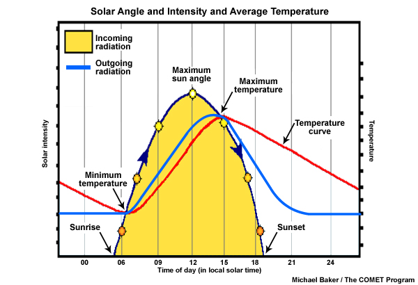
Time of day: Of course our hottest temperatures occur during the daytime when the sun is out, but how come the heat of the day occurs in the mid-to-late afternoon when the sun is shining most directly on us at noon? Whether or not the surface temperature is increasing or decreasing is determined by whether the earth’s surface is gaining more energy than it is losing. The energy input from the sun will be greatest at noon, but energy inputs continue to be greater than outputs throughout the afternoon, so the temperature continues to rise. This effect is shown in the figure below, which comes from a University Center for Atmospheric Research COMET module. The yellow curve shows the intensity of the sunshine throughout the day. The blue curve shows outgoing radiation, or how much energy is trying to escape from the earth’s surface out to space. As temperatures rise, this number goes up. You can think about it as the earth is “trying” to cool down. The red curve shows temperature throughout a typical day. If the yellow curve is above the blue curve, the temperature increases. If the blue curve is above the yellow curve, the temperature decreases. The maximum and minimum daily temperatures occur at overlapping points.
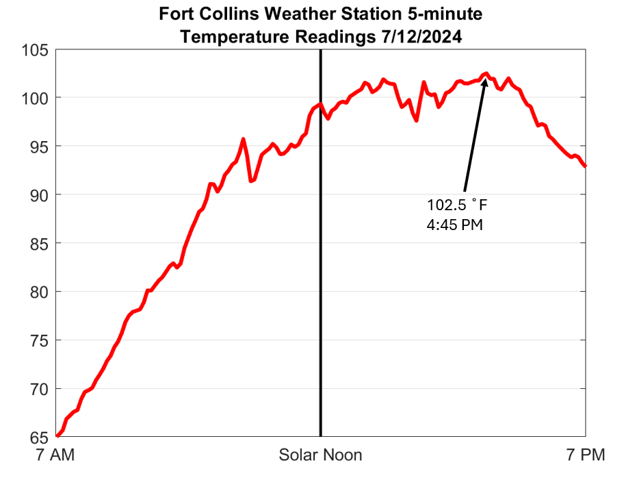
If you live in Colorado, summer temperatures will probably top out some time between 3:30 and 5:00 PM in summertime. This is 2:30-4:00 in standard time, or approximately 2.5-4 hours after solar noon. We can see a good example of this using the Fort Collins weather station from our last heat wave on July 12th, 2024. The temperature climbed rapidly throughout the morning, becoming close to 100 °F by 1:00 PM MDT (12:00 PM MST, solar noon), and then slowly continuing to creep upward (with small fluctuations) for the next several hours. As late afternoon approached, the energy input from the sun could not keep up with the energy output from the earth’s surface and the temperature began to fall.
Season: We all know summer is the hottest time of year, and most of us intuitively understand why: the days are longer and the sun shines more directly on the land surface during the day. We can put a little bit of math behind this intuition. When the sun shines from directly overhead, it sends 1366 Watts/meter squared of radiative energy though the top of the atmosphere. Some of this energy will be reflected or absorbed before hitting the earth’s surface, but on a clear sky day most of it will be absorbed by the land surface, and in turn, rapidly heat up the near surface atmosphere. The sun’s energy is not truly “constant,” it fluctuates based on sunspot cycles. For the moment, let’s just call maximum output from the sun 100%, and the amount of energy we get from the sun at night 0%.
The fraction of the sun’s energy that reaches the earth’s surface is a function of angle: how high is the sun in the sky? When the sun is directly overhead it is intense and beats directly down on the land surface. When it is on the horizon the energy is diffuse, hitting with a glancing blow. The earth’s tilt is 23.5 degrees, so in the northern hemisphere, we tilt a maximum of 23.5 degrees toward the sun in the summer and 23.5 degrees away from the sun in the winter. This means if you live in Boulder, Colorado, which sits right on the 40th, parallel, the sun will be 40 degrees south of directly overhead at midday on the spring and fall equinoxes, but 63.5 degrees from directly overhead on the winter solstice, and only 16.5 degrees from directly overhead on the summer solstice. We can take the cosine of these angles to see that the sun provides 77% of its maximum energy in Boulder at noon on either equinox, only 45% on the winter solstice, and 96% of its maximum energy on the summer solstice.
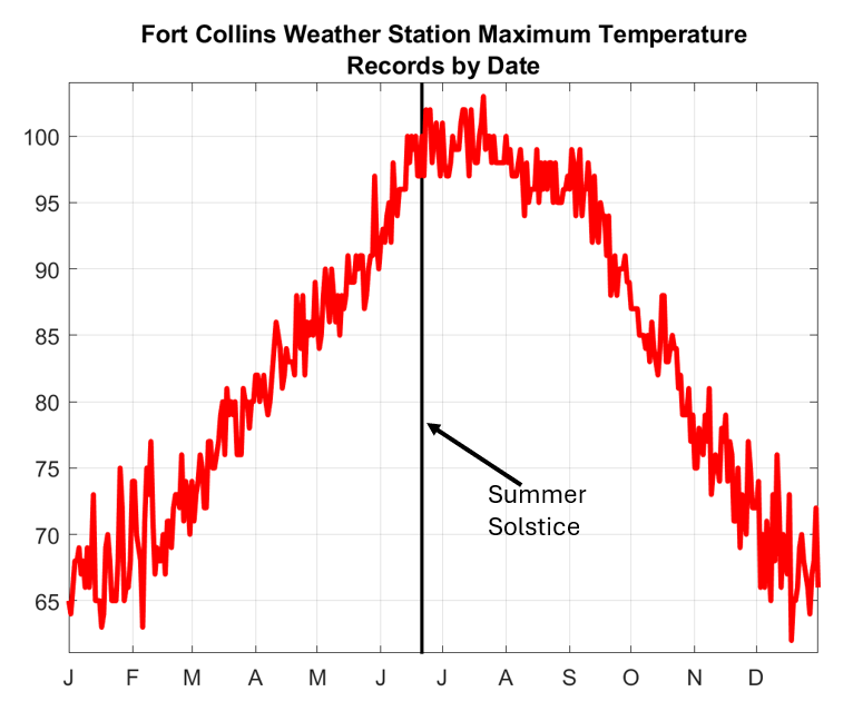
Many of our most extreme heat waves across Colorado, and the country, do occur right around the summer solstice (late June), but may also occur throughout July and August. However, our heat waves are certainly not evenly distributed around the summer solstice. There are far fewer in late May and early June even though we receive more direct sunlight than we do in late July and early August. Why? Much as there is a lag between noon and the hottest time of day, a small lag exists between the longest, brightest days and the peak window for heat waves. It takes the atmosphere several weeks to fully equilibrate, or “catch up” to the increase in sunlight during late spring, making it easier to build “heat domes” later in the summer (more on this below). Furthermore, the land surface also tends to dry out as the summer wears on, meaning a greater fraction of the sun’s energy goes into directly heating the land, and a smaller fraction (on average) goes into evaporating water. All things considered, we end up with the largest threats for triple digit heat, in Colorado, in late June and July. The image below shows the official maximum daily temperature records for the Fort Collins weather station for every day of the calendar year. Our earliest 100-degree day on record is June 14th, and our latest is August 1st.
We now know that the potential for record hot surface temperatures peaks in the mid-to-late afternoon in late June through late July, but can we explain why some days are hotter than others? Yes. The simple answer is we need the right weather conditions. Let’s explore the anatomy of a heat wave from a meteorological standpoint.
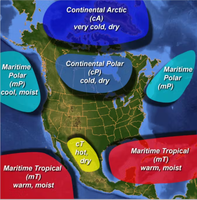
Large-scale weather pattern: What large scale weather pattern is needed to produce heat waves? The short answer is dry air and high pressure, but we think about this in greater detail. We can think of earth’s atmosphere as being made of up airmasses and the boundaries between them. Air masses are large-scale high pressure systems that can be described as warm and dry (continental tropical, cT), warm and moist (maritime tropical, mT), cool and dry (continental polar, cP), or cool and (relatively) moist (maritime polar mP). Low pressure systems and stormy weather occur in the spaces between, where air masses collide with one another. The figure below shows different types of air masses, and where they tend to occur from Canada’s weather glossary.
To obtain the hottest possible surface temperature we need a hot, dry, high pressure airmass to preside over Colorado. The air needs to be dry because moisture in the air can condense, forming clouds and blocking sunlight. If the near surface layer of air is too moist, thunderstorms will form when the air is heated, cooling conditions back down substantially. High pressure is ideal because air expands outward from high pressure centers, which leads to sinking air. Sinking air draws the driest air down from the upper atmosphere to the surface. Why is sinking air important?
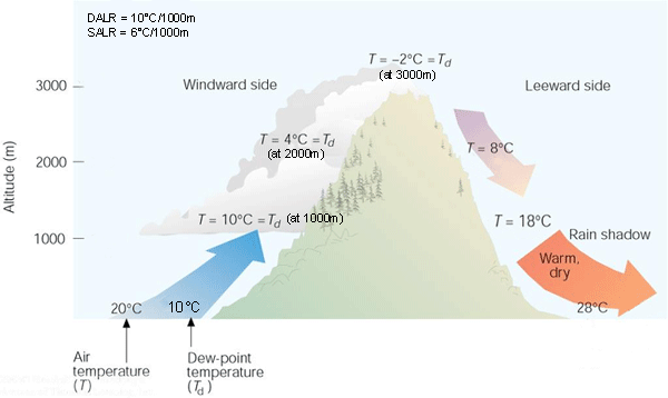
Stability: Have you heard the saying “heat rises?” If this is true, how are such high temperatures possible at the earth’s surface? Heat does indeed rise because hot air is less dense than cool air. However, as hot air rises it expands to equilibrate to the lower pressure at higher altitudes. There is an energy cost to air expanding, and because of this, air cools as it expands. When we measure this cooling, we see that rising air cools at a rate of 9.8 °C/kilometer of elevation gain (about 5.5 °F/thousand feet). The air aloft is usually cooler than the air at the surface, but so long as it is not more than 5.5 °F cooler per thousand feet of rise, the hot air at the surface will remain in place. This is why having relatively warm air aloft, and not just at the surface, is so important. If warm air is in place aloft, the air at the surface will have to be even warmer to rise.
Stability is a big part of the reason high pressure atmospheric conditions are ideal for heat. As mentioned above, high pressure forces air aloft to sink. This air is compressed and warmed as it sinks, also at a rate of 5.5 °F/1000 feet. Hotter and drier than normal air above the surface, which is sometimes called a “heat dome,” suppresses the development of clouds and thunderstorms, forces air down from above that warms as it sinks, and lets the surface air bake to its maximum possible temperature under the hot summer sunshine.
Stability is also why it is nearly impossible to generate triple-digit heat at high elevations. The thin air above our mountain valleys is so reliably cool. In the absence of a “heat dome,” the hot air generated at elevation usually rises and escapes, often triggering thunderstorms. Even record hot air near sea level is surprisingly cool if lifted to the elevations of our Rocky Mountains. For instance, suppose it is hot enough to produce a blistering 132 °F temperature at Furnace Creek in Death Valley. If that air was lifted to 2000 ft elevation, it would be 120 °F. As it happens, 2000 ft is the elevation of Las Vegas, and 120 °F is the all-time record high temperature in Las Vegas. Lift it another 3000 ft and you’re at the elevation of Fort Collins. That same air is now 103 °F. Hey, that is the record high temperature for Fort Collins! As it continues to rise, we hit a mark of 81 °F at 9000 ft (think Summit County) and 53 °F by the time we reach the elevation of Mt. Elbert, nearly 70 °F for just under three miles of vertical displacement.
Thunderstorms can play a surprising role in producing heat waves. If there is too much moisture in the atmosphere, then heating up the land surface will generate thunderstorms, and kill any chance of developing record heat. However, thunderstorms that occurred earlier somewhere upstream can be a key ingredient for creating the perfect heat wave. Air in thunderstorm clouds is saturated, and as this air rises, it cools at a rate much lower than 5.5 °F/1000 feet. When saturated air rises the water vapor is condensed into liquid or even ice. This phase change of water from a gas to a liquid or solid releases latent heat of condensation, counteracting the cooling impact of air expanding as it rises. The image below shows an example of how moist air can return to the surface warmer than it started after releasing latent heat.
The amount of latent, or “hidden” heat in moist air is enormous. If a saturated mass of air in the deep tropics was lifted high enough to condense all water vapor out of the air, and then forced all the way back down to sea level, it could be as hot as 200 °F. We never see air this hot because after moist tropical air is lifted, its density will be far too low to force all the way back to the surface. This air will have to cool for weeks if not months before returning to sea level. However, moist air that is lifted and releases its latent heat of condensation, and then is forced by high pressure to sink at least part way to the surface days later, can create a highly effective heat dome. This is what happened in the June 2021 heat wave over the Pacific Northwest. Storm activity over the Pacific Ocean lifted moisture-laden air into the upper atmosphere, releasing its latent heat. The now dry upper-level air traveled eastward until reaching the western United States. A high pressure airmass over British Columbia forced this air back down, creating a brutal heat dome over Washington and Oregon.
Microscale weather pattern: The record high temperature for Denver is 104 °F, but have you ever driven by an area bank sign, or seen a car thermometer, that says 110 °F? Was that reading wrong? Not necessarily. If the sun is shining directly on the thermometer, then yes, it is wrong. Official temperature readings are taken in thermometer shelters, which are ventilated, but shaded (example below).
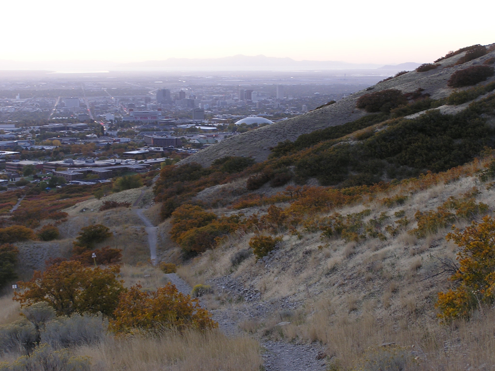
If the thermometer is sited in a place with large amounts of asphalt/concrete/steel (e.g. downtown in a large city/Walmart parking lot) it may indeed be that hot! Long-term weather stations are supposed to be sited in more open spaces surrounded by native vegetation. If the temperature was 100 °F at a close by weather station maybe it was 109 °F where you parked your car. This is a well-known concern in large cities. All the concrete and steel and lack of green area traps heat, creating an “urban heat island.” The added heat in structure-dense cities is a major health and human safety concern in many metro areas around the country.
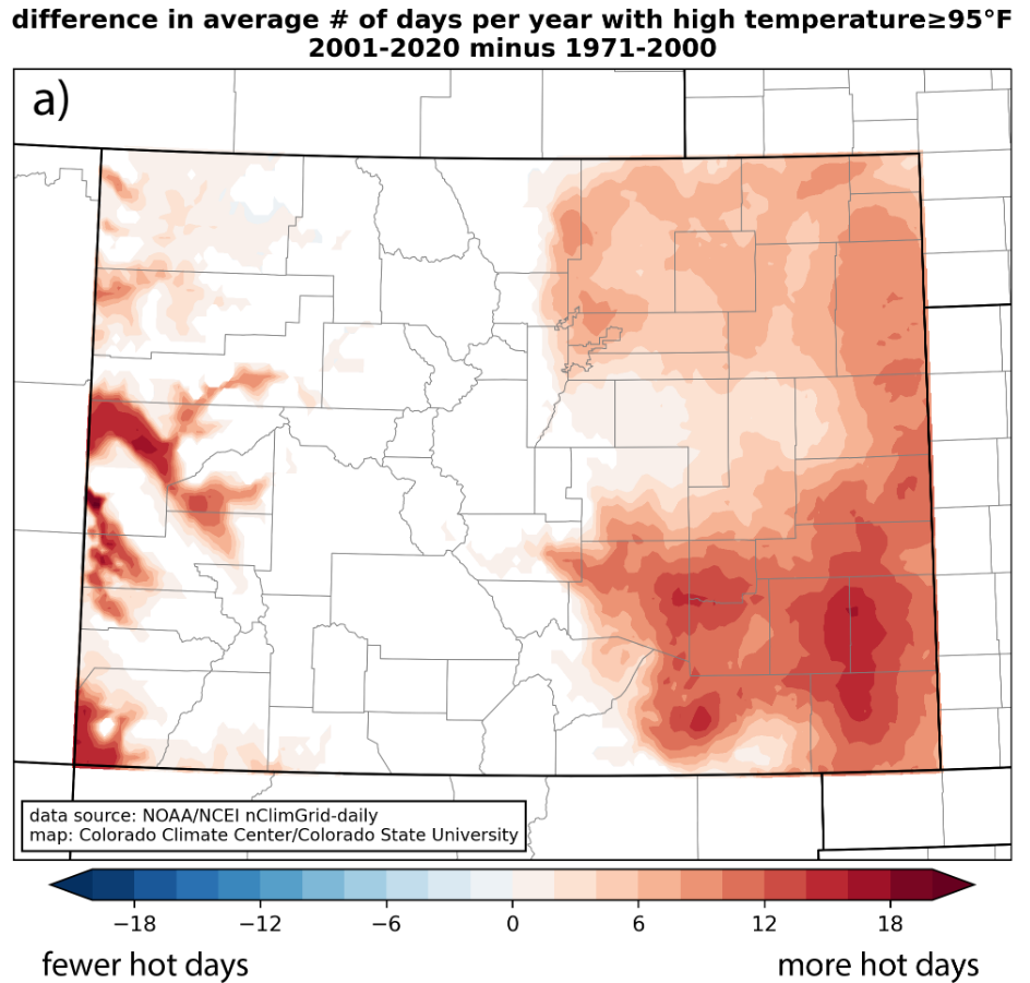
Climate change: To quote a recent article on heat waves by Dr. Andrew Dressler “a rising tide floats all boats.” More heat in the atmosphere means a higher upper bound on how hot temperatures can get. That said, while we are seeing significant increases in the number of hot days (figure below) we are not seeing such obvious movement in record high temperatures.
Conclusion: All things considered, when will you see record heat, and why? 1. Record heat will likely occur in the mid-to-late afternoon immediately after the day’s peak heating hours. 2. Record heat will probably occur in late June or July. August is hot, but the days are already getting shorter, and the intensity of the midday sun has already begun to wane. 3. The air and land will be dry. In Colorado, it is almost impossible to heat humid air to triple digits without clouds forming, and possibly thunderstorms. 4. The surface pressure will be high, which draws dry, compressed air down from the upper atmosphere at seals in warmer conditions. 5. The air above the surface can likely be traced back to thunderstorm activity somewhere else. The latent heat release from these storms is contributing to the heat dome over your head. 6. If a new record occurred at your local long term weather station, it was probably even hotter downtown and on the roadways.
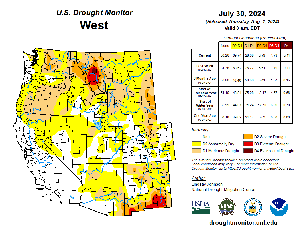
Heat continued to be the dominating feature in the Southwest and Plains. Temperatures were 2 to 6 degrees above normal, with isolated areas seeing temperatures of 6 to 8 degrees above normal. The Southwest reached near record temperatures once again, with the highest 1-day maximum temperature for the week reaching 120 degrees in Death Valley and 110 degrees in surrounding areas. The West and Plains missed out on much of the precipitation that fell this week. These hot and dry conditions have leant themselves to increased fire potential and wildfires. The southern Plains, missing out on the precipitation and experienced above-normal temperature, leading to more drying and degradation. Similar degradations occurred along the western border of the High Plains due to the lack of precipitation, poor soil moisture, and declining streamflows. The Southeast on the other hand received substantial precipitation, vastly improving lingering dryness in the area. The northern Appalachian region saw 1-category degradations where streamflows in north-central West Virginia are critically low…
The High Plains received trace amounts of precipitation, leading to already dry conditions in the western and southern High Plains to further deteriorate. Poor soil moisture in much of Kansas brought about widespread 1-category degradations. In eastern Kansas, along the Missouri border there have been reports dryness and heat stress. Central Kansas has also seen reports of dry ponds and fear of total crop failures. Some of these drier conditions spilled northward into southern Nebraska, which also saw areas of the northeast and western Panhandle deteriorate because of an extended period of dry conditions, dry vegetation, and low streamflow values. Similar conditions were seen across western South and North Dakota and Wyoming. Colorado saw deterioration in the northern Front Range, where extreme temperatures and low humidity made for perfect conditions for wildfires. Two fires were reported on Monday July 29: the Alexander Mountain Fire west of Loveland, the Stone Mountain Fire southeast of Estes Park…
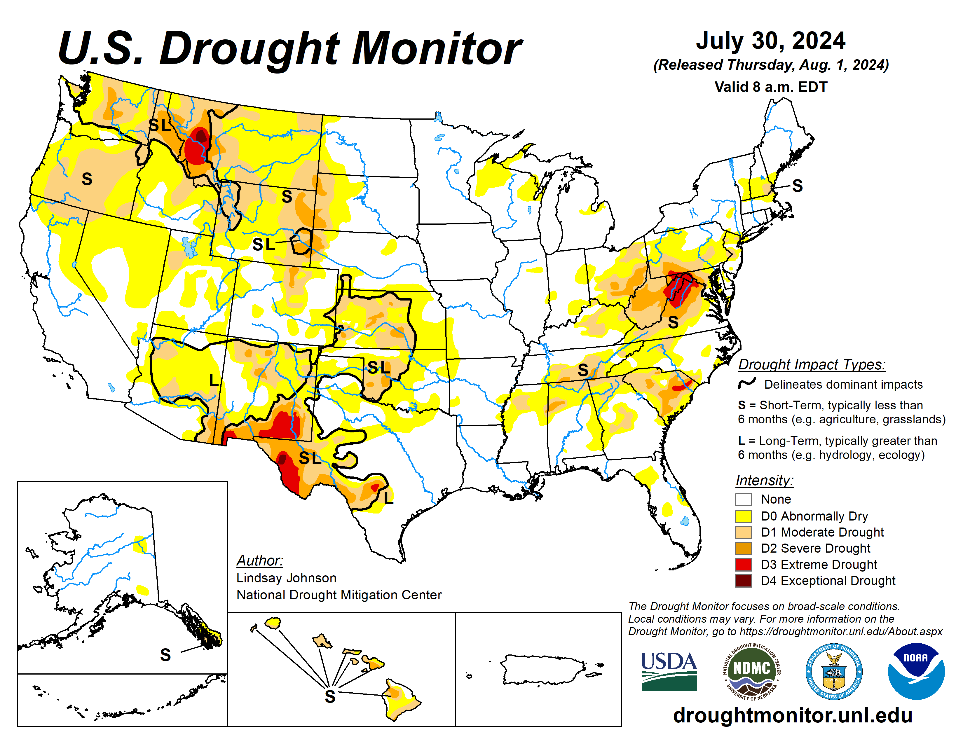
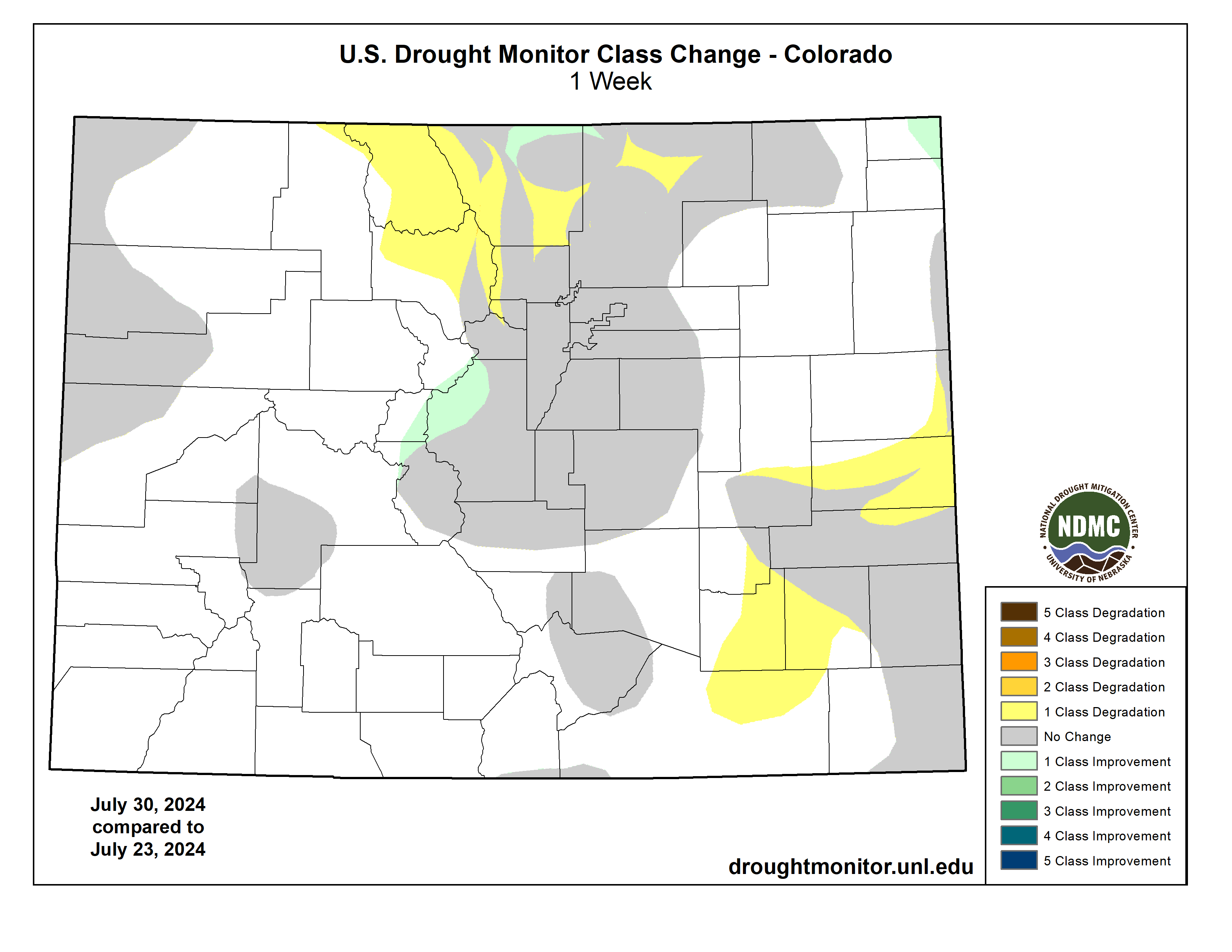
Colorado Drought Monitor one week change map ending July 30, 2024.
The Northwest saw some relief from the extreme heat this week, with temperatures in Nevada, California, Oregon, and Washington being 2 to 6 degrees below normal. Conversely, the Southwest saw more extreme heat. Southern California, the southern tip of Nevada, and western Arizona saw temperatures of over 90 degrees this week with the highest 1-day maximum temperature reaching over 110 degrees. In the northern West, Montana saw slight improvements in the far north where temperatures were slightly below normal but saw similar conditions as North and South Dakota conditions in the central and eastern parts of the state. Central Utah saw minor expansion of abnormal dryness as streamflow began to drop and vegetation is looking dry…
Eastern portions South saw much of the heavy precipitation seen in the Southeast. Southeastern Texas into western Louisiana recorded areas of over 8 inches of rain falling this week. There was a sharp line of where the precipitation fell and did not. West of south-central Texas, northeastward to central Arkansas saw trace amounts of rain. Temperatures were also between 1 and 4 degrees below normal, with eastern Texas and western Louisiana having temperatures of 6 to 8 degrees below normal. Except for north-central Texas and parts of Oklahoma, and western Arkansas, 1-categoy improvements were made. Oklahoma saw a mixture of above- and below-normal temperatures, with hot temperatures heating up at the end of the week (July 23 to 30). Reports of “cover crops being cooked” and “no soil moisture for native grasses to draw from and large pastures have lost much green color and have shrunk considerably” in central Oklahoma’s Logan County…
Looking Ahead
Over the next five days (August 1-6), the Midwest, Northeast, and eastern Southeast are expected to see 1 to 2 inches of rain with heavier amounts predicted in the eastern Midwest and southern Florida. The rest of the Southeast will see more modest amounts of precipitation, deviating from their previous weeks of heavy precipitation. There is currently an Atlantic Disturbance that the National Hurricane Center show a greater than 60 percent chance of developing into a tropical cyclone within the next two days (August 1-2) which could bring heavy rainfall along the Atlantic Coast in the coming week. Isolated areas from Wisconsin, Minnesota, and Iowa to Kansas and higher elevations of Colorado, New Mexico, and Arizona are expected to receive around 1 inch of precipitation. Otherwise, precipitation will be light and spotty leading to much of the West, Texas, southern Oklahoma and Arkansas missing out on the precipitation.
The National Weather Service Climate Prediction Center’s 6-10 day outlook heavily favors above-normal temperatures from the Pacific Northwest across to the Southeast with conditions becoming near normal across the central U.S. and leaning to below normal temperatures further north toward Canada. Much of Alaska is expected to be above normal with below-normal temperatures possible to the southwest. Similarly, Hawaii is leaning towards above-normal temperatures. Many of the lower 48 states are leaning towards above-normal precipitation, centering around Wyoming and Colorado, along with the Atlantic Coast, which could see remnants of the Tropical Disturbance currently in the Caribbean. Alaska’s border with Canada is seeing up to a 70 percent chance of below normal precipitation, with the probability increasing in the west and southwest. Hawaii probability of seeing below-normal precipitation is 33 to 40 percent.
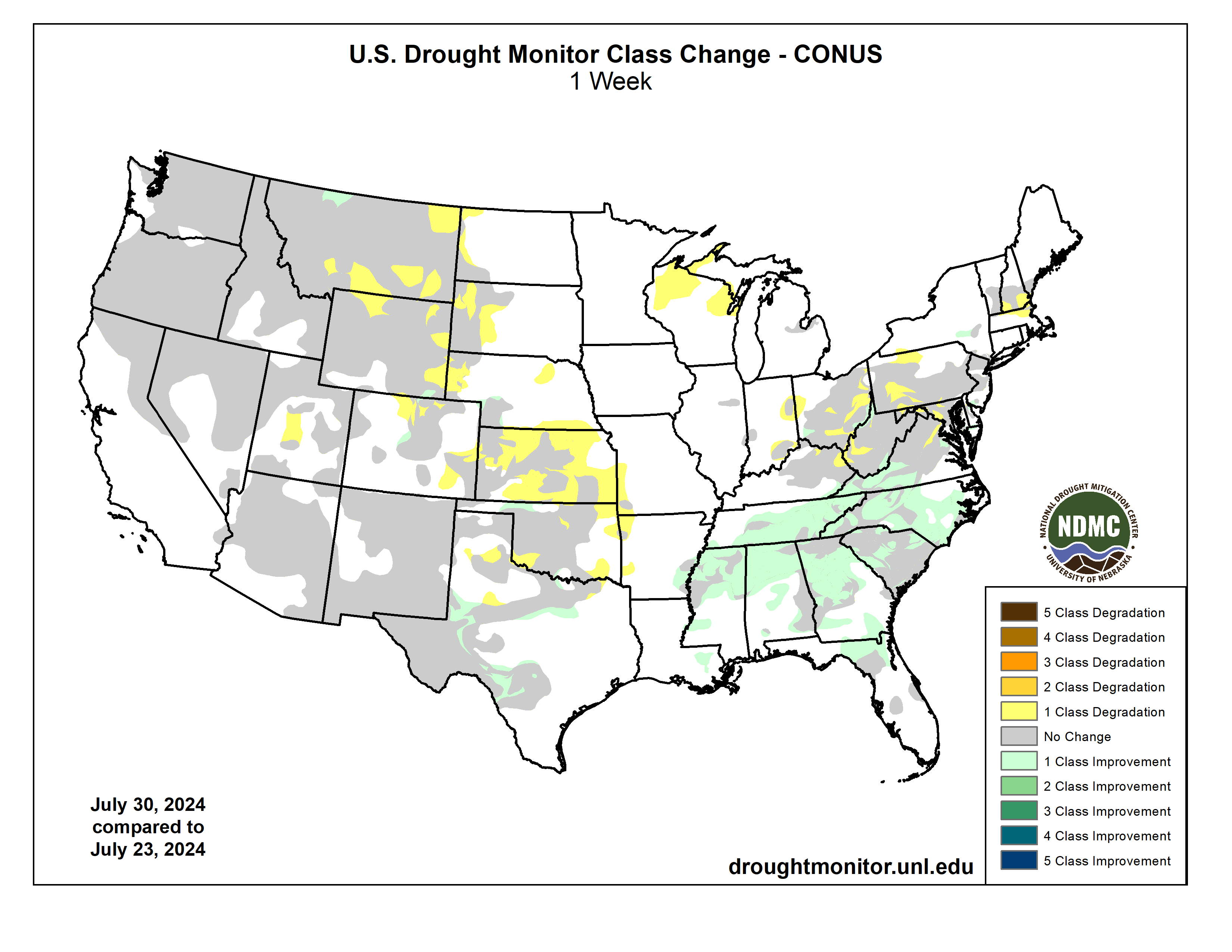
US Drought Monitor one week change map ending July 30, 2024.
More than 350 prominent climate advocates on Tuesday endorsed Vice President Harris for president, a sign that environmental leaders believe hercampaign will energize like-mindedvoters in a way that President Biden could not. In a letter shared first with The Washington Post, big names in the environmental movement — including former U.S. climate envoy John F. Kerry, former secretary of state Hillary Clinton and Washington Gov. Jay Inslee (D)— wrote that Harris has long prioritized climate action and would continue to do so as president.
“We know that protecting our planet for ourselves and future generations requires the kind of bold leadership that Kamala Harris has demonstrated her whole life,” they wrote. “We are proud to support her and be in the fight against climate change with her.”
Inslee, whose ambitious climate proposals during his 2020 presidential campaign influenced Biden’s climate policies, said Harris could help mobilize young voters, a crucial Democratic constituency. Polls show that climate change is a top concern for young people, who are more likely than older generations to face raging wildfires, rising seas and stronger storms in their lifetimes.
“Her candidacy instantly lit an electric spark under young people across the country,” Inslee said. “That’s going to bode well for our fortunes.”
Kerry, who left the Biden administration in March, said in an interview that Harris was a “terrific ally” on climate policy. He noted that she was an early advocate of the United States reaching net-zero emissions by mid-century, and she delivered a forceful speech at the U.N. Climate Change Conference in Dubai last fall.
The News:Western Colorado’s Mesa and Montrose counties propose a 30,000-acre national conservation area for the Lower Dolores River corridor as an alternative to the proposed 400,000-acre national monument. While this may look like a peace offering or compromise of sorts from counties that have opposed protections of any kind, it is just as likely an attempt to block any sort of designation and will probably only further fan the flames of controversy. It’s the latest volley in a half-century-long battle over the fate of the beleaguered river.
The Context:The current controversy over the Dolores River takes me back to when I was a youngster in the early ‘80s. McPhee Dam was under construction on the Dolores River, its proponents having vanquished a movement that sought to block the dam and keep the river free. My parents had been on the losing side of the fight, and I can distinctly remember my father blaming the defeat, at least in part, on outsider environmentalists — including Ed Abbey — deriding the pro-dam contingent as a bunch of “local yokels.
I’m sure my dad took it personally. He was a fourth-generation rural Coloradan, had graduated from Dolores High School, and his mom and sisters still lived in Dolores — apparently making him a “yokel,” even though he opposed the dam. But also he saw it as a major strategic misstep. Not only were these people insulting locals, but they were falling into the pro-dam contingent’s trap, bolstering the dam-building effort in the process.
More often than not, these land protection fights are framed as well-heeled elitist outsiders and Washington D.C. bureaucrats imposing their values on and wrecking the livelihoods of rural, salt-of-the-earth local ranchers and miners. And in almost every case it is a gross oversimplification, at best, and at worst is an inaccurate portrayal and a cynical attempt to disempower locals — and anyone else — who favor land protection. So when those anti-dam folks caricatured the pro-dam contingent as local yokels, they were not only alienating locals who may have been on their side, but also validating the false depiction of the situation.
Fresh snow on Bears Ears. Photo credit: Jonathan P. Thompson/The Land Desk
We saw this play out in the battle over the Bears Ears National Monument designation and Trump’s shrinkage of it in a gross way. The anti-monument contingent insisted that all “locals” were opposed to the monument — and the media largely bought into it — never mind the fact that effort to establish a monument in the first place was driven by local Navajo Nation and Ute Mountain Ute citizens, and was taken up by tribal nations who have inhabited the landscape in question since time immemorial. Never mind that the anti-monument “locals” were backed by mining corporations, right-wing think tanks, and conservative politicians from all over (including a Manhattan real estate magnate and reality TV personality who became President). Utah’s congressional delegation even had the gaul to attempt to disenfranchise and silence the voices of tribal leaders because they happened to be based on the other side of a state or county line that was arbitrarily drawn based on arbitrary grids by dudes in Washington D.C.
The movement to protect the Dolores River has been portrayed in much the same way over the last several decades. It has its roots in 1968, when U.S. Rep. Wayne Aspinall, a Democrat from Colorado’s Western Slope, pushed through the Colorado River Basin Project Act, authorizing the construction of five Western water projects. One of them was the Animas-La Plata Project, a byzantine tangle of dams — including one on the Animas River above Silverton — along with canals, tunnels, and even power plants. Another was the Dolores Project, which included building McPhee Dam several miles downstream of the town of Dolores, which would impound water to lengthen the irrigation season for the Montezuma Valley and allow water to be sent, via canal, to the dryland bean farmers around Dove Creek.
The Dolores River, below Slickrock, and above Bedrock. The Dolores River Canyon is included in a proposed National Conservation Area. Photo: Brent Gardner-Smith/Aspen Journalism.
The prospect of another river being stilled by another giant monolith sparked a movement to block the dam and to designate the Lower Dolores River corridor as a Wild and Scenic River, which would have prohibited mining and oil and gas leasing, while also ensuring enough water would be left in the stream to keep the river “wild and scenic,” which is to say a lot more water than zero, which was the lower river’s flow from mid-summer into fall due to irrigation diversions.
Local farmers were generally in favor of the dam — and against Wild & Scenic designation, since it would likely deprive them of some irrigation water during dry times. But their cause was also backed by powerful agricultural interests on the state level, the pugnacious Durango attorney Sam Maynes, Sen. Gary Hart, the Colorado Democrat, and, probably most importantly, the Ute Mountain Ute Tribe, which would receive a portion of the vast amounts of water to which they were entitled from the Dolores Project. The project was ultimately authorized (though I doubt the local yokel comment had all that much to do with it, really). Construction of McPhee Dam began in 1979 and the reservoir began filling in 1983.
La Plata Mountains from the Great Sage Plain with historical Montezuma County apple orchard in the foreground.
No matter how one feels about dams, you have to admit it had some benefits. In 1978 the federally funded Dolores Archaeological Program was launched to survey, excavate, and study the rich cultural sites that were spread out across the area to be inundated by the reservoir. It was a huge project that brought a slew of researchers to the area, significantly advanced scientific knowledge of the Ancestral Puebloan people who inhabited the region for centuries, and provided the seeds for future archaeological work and organizations, including the Crow Canyon Archaeological Center.
And, contrary to opponents’ fears, the dam didn’t kill the river. Rather it was like putting the river’s manic-depressive flows on lithium. The massive spring runoffs were tempered, but water managers released enough water in most years to scour beaches and preserve Snaggletooth’s whitewater snarl. And for the first time in a century the lower Dolores didn’t run dry in July. In fact, the year-round flows were enough to build and sustain a cold-water fishery for trout in the first dozen or so miles below the dam and a habitat for native fish below that. The Ute Mountain Ute Tribe got both drinking water from the project as well as enough to irrigate a major agricultural enterprise near the toe of Ute Mountain, providing much needed economic development. The Town of Dove Creek receives water from the project as do the formerly dryland farmers, allowing them to diversify their crops. The dam’s completion happened to coincide with the demise of the domestic uranium mining industry, meaning that threat mostly went away as well, along with the need for added protections.
The Dolores River at its confluence with the San Miguel River. Jonathan P. Thompson photo.
Unfortunately, drier times set in and the current megadrought, now going on a quarter century, has depleted the river’s flows and reservoir levels. In order to keep the irrigation ditches flowing as deep into the summer as possible, dam managers have released almost no water during 14 of the last 24 years, essentially desiccating the stream bed below the dam and throwing the riparian ecology out of whack. In the midst of it all the uranium industry made a short-lived comeback between 2006 and 2012. Now it seems to be emerging from its zombified state once again and is targeting numerous sites along the Dolores River. The river runs through the Paradox Formation, as well, meaning it could be targeted by lithium and potash miners. Meanwhile, visitation to the Lower Dolores River has ramped up — along with the impacts — as social media posts reveal the canyons to more people and as the Moab crowd seeks new places to play.
Dolores River watershed
All of that spawned new Wild & Scenic campaigns for the Lower Dolores, but after it became clear they couldn’t get past political hurdles, stakeholders came together to work on a compromise, resulting in a proposal to create a national conservation area on 60 miles of river corridor below the dam, which would withdraw the land from new mining claims and oil and gas leases, bring more attention to the plight of this sorrowful and spectacular river, and possibly more funding to river restoration efforts. But it would leave another 100 miles of the Lower Dolores unprotected, in part because Mesa and Montrose Counties withdrew their support for the plan. Thus the proposal for President Biden to designate 400,000 acres as a national monument.
That proposal, perhaps predictably, has sparked a backlash and an anti-national monument campaign partly fueled by disinformation. And, just as predictably, it’s being falsely framed as a fight pitting locals vs. outsiders. It’s true that a survey commissioned by Mesa County of about 1,200 registered voters in Mesa, Montrose, and San Miguel Counties found that 57% of respondents oppose the national monument proposal. That shows that more locals oppose it, but that quite a few support the initiative, as well. And Center for Western Priorities director Aaron Weiss found that the survey may be biased since its creators consulted with national monument opponents, but not proponents, about which questions to ask and how to word them. And it shows.
For example, the survey precedes one set of questions with: “Currently, uranium mining in the Dolores River Canyon area in the west end of Montrose County impacts the local economy by providing tax dollars and jobs. The current national monument proposal would allow some but not all existing permit holders to continue to operate, but it has not been decided if the proposal would allow new permits or permit renewals in the future.” But this is misleading, because the uranium mining industry remains virtually dead, so the economic impact is zero to negligible. Furthermore, a national monument grandfathers in all existing valid mining claims and has no effect on patented (private) claims. So even if there were operating mines, a monument wouldn’t hamper operations. [ed. emphasis mine] Other questions were similarly misleading by implying that a national monument designation would remove management from the BLM or Forest Service.
Tellingly, the survey also found that 72% of respondents support existing national monument designations “such as Browns Canyon, Chimney Rock, and Colorado National Monument.” Why? Because they value conservation and they’ve seen that national monuments don’t hurt the economy or agriculture or significantly restrict access. That they are less sure about a new national monument might have something to do with the opponents’ simplistic and unfounded argument against it, which is that it could “impose severe economic hardships,” without explaining how.
Nevertheless, Mesa County used the survey to justify a resolution opposing the national monument and supporting its proposal for a vastly scaled down national conservation area. Again, this tactic is an echo of ones used by Bears Ears National Monument opponents. National Conservation Areas don’t inherently offer more or less protections or restrictions than national monuments, but they do need to be passed by Congress. Given how dysfunctional our Congress is, that could take years or even decades.
Yet the Lower Dolores River needs help now. No, a national monument won’t solve all its problems; it may not help the river, itself, at all. Already the fight over the proposal has shone a spotlight on a remote, largely unknown area, which will surely draw more visitors and more damage. A national monument designation at least would provide the possibility of protection against future development and burgeoning crowds.
The Dolores River between Rico and Dolores in southwestern Colorado on Memorial Day 2009. Photo credit: Allen Best/Big Pivots
Sources/Usage: Public Domain. View Media Details
The Dolores River, CO. (Olivia Miller, USGS).The historic flume hanging from a cliff above the Dolores River in western Colorado. This stretch would likely be included in a proposed national monument. Jonathan P. Thompson photo.Dolores River skeleton plant (Lygodesmia doloresensis). Photo by Peggy Lyon via Colorado Natural Heritage ProgramNathan Fey, seen here paddling the Lower Dolores River. The lower Dolores River depends on a deep snowpack for boating releases from McPhee Reservoir. (Photo courtesy Nathan Fey)A view of the Dolores River below Slickrock.The Dolores River in southwestern Colorado on Memorial Day in 2009. Photo/Allen BestPonderosa Gorge, Dolores River. Boating is popular on the Lower Dolores River, which is being considered as a National Conservation Area. Photo credit RiverSearch.com.St Louis Tunnel Ponds June 29, 2010 – view south towards Rico. Photo via the EPA.The Dolores River shows us what’s at stake in the fight to protect the American West — Conservation ColoradoPhoto via the Sheep Mountain AllianceLone Cone from the Dolores RiverDolores River south of Lizard Head PassDolores River above DoloresWestern San Juans with McPhee Reservoir in the foregroundDolores RiverDolores River near BedrockDolores River Canyon near Paradox
“What do you think about this?” My friend, Sonya Daw, had called out to me from where she was standing at the edge of Beaver Creek. I joined her. I had just scrambled over a massive log and was grateful for an excuse to catch my breath.
“Hmm,” I said, still breathing hard. In front of us, water burbled over some branches that had fallen across the creek. Had they fallen, though? Or had they possibly been placed there by beavers?
As one of 11 teams taking part in a “beaver scavenger hunt” across the Cascade-Siskiyou National Monument in southwest Oregon, we were looking for any sign of beavers — willow stumps, sticks with “corn-on-the-cob”-style teeth marks, or even scent mounds, which beavers use to mark territories. What we and the other teams discovered would help the nonprofit Project Beaver focus their beaver-restoration efforts.
My team included Sonya, who writes for the National Park Service, her husband Charlie Schelz, the former monument ecologist, and Barb Settles, a spry 78-year-old and avid naturalist.
Photo: Juliet Grable
Charlie joined us, and we contemplated the creek. “I don’t think that’s anything,” he said. “But look how the sediment is piling up behind the branches; how cool is that?”
It was June 1 — not just a beautiful time to be hiking through the forest but the ideal window for beaver activity. Beaver moms have their babies in late spring and then send their older offspring packing. These dispersing youngsters are on the move, exploring new creeks and sampling the buffet of plants.
We took our time in flatter areas, especially where willows or red osier dogwood — beaver “dessert plants” — grew in clumps near the banks. We weren’t likely to find beavers along this steep stretch, but it was still fun to look and marvel at the enormous sugar pines, Douglas firs, and incense cedars that had escaped loggers’ chainsaws last century.
Wanted: Ecosystem Engineers
The Cascade-Siskiyou National Monument encompasses 114,000 acres, mostly in southwest Oregon. The Klamath and Cascade Mountains converge here, creating a patchwork of oak woodlands, forests, grasslands, and wetlands support a dazzling array of butterflies, bees, birds, and plants, including many that are found nowhere else.
President Bill Clinton designated the monument in 2000, not for its stunning canyons or breathtaking vistas but its “outstanding biological diversity.” In 2017 President Barack Obama expanded the monument by another 48,000 acres.
Beavers undoubtedly once populated the many streams and meadows, but by the time the monument was designated, they had been all but eradicated — the case all over Oregon. Now there is only one known established beaver family in the entire monument, says Jakob Shockey, executive director at Project Beaver. There could be others; Shockey says he’s seen evidence of random individuals on several creeks.
The Bureau of Land Management manages the monument but has partnered with the nonprofit to help bring beavers back. The task has become more urgent in the face of recent drought, which has left its mark in swaths of dead conifers. This part of southwest Oregon is dry and hot in summer, and getting more so. Beaver dams could help hold more moisture on the landscape, attracting more birds in the process. Wet meadows engineered by beavers could even serve as a firebreak, helping tame the spread of catastrophic wildfires.
Friends of the Cascade-Siskiyou National Monument, the group that hosted the scavenger hunt, is a key player in the project.
“We see our role as letting people know what makes the monument special and what’s needed to support the ecological integrity of this special place,” says Friends’ executive director Collette Streight.
Friends has hosted several “bio-blitz” events, where volunteers fan out in search of butterflies or reptiles. Streight wanted to create an event with the “juicy” energy of a bio-blitz that produced data with practical applications. After talking with Schelz, Shockey, and others, she honed in on beavers.
Photo: Friends of Cascade-Siskiyou National Monument
Pond of Dreams
Ultimately, the key to attracting beavers — and more importantly, convincing them to stay and set up shop — is restoring habitat. This “build it and they will come” approach can attract beavers from miles away.
“One of the first steps is to get information: Where are the beavers, and what are they doing right now?” says Streight.
Last summer, they beta-tested the scavenger hunt with a “Hike and Learn” led by Shockey.
“We need to know this information, and it really will impact future restoration work,” says Shockey. “What I don’t have is the ability to walk a bunch of creeks by myself.”
We didn’t find any evidence of beavers on our steep stretch of creek, but after clambering back to the car, we had just enough time to check out a meadow on the upper portion of Beaver Creek, where last fall Project Beaver installed a series of post-assisted log structures, or PALS.
The broad, flat meadow was a totally different landscape from where we’d been searching. Our boots squished as we wandered through clumps of sodden grass. Soon Sonya and I were reaching for our binoculars. Birdsong filled the meadow: Lazuli buntings called from the willows; robins chortled from a massive pine at the meadow’s edge. I broke out the Merlin bird-identification app to sort through the confounding songs of warblers.
Charlie pointed out one of the PALS — several small posts pounded into the creek bottom, with willows woven between them. Water had pooled behind the structure, creating a shallow, murky pond full of bugs.
Photo: Juliet Grable
“This is great to see,” he said, as he bent low to admire butterflies dancing across the surface and examine willow stakes that had been planted there. They were starting to leaf out. It wasn’t difficult to imagine a beaver setting up shop here, and not just for the scenery.
“Beavers like to surround themselves with water; it helps keep them from being eaten,” Charlie told us. Without that buffer, beavers are an easy (and meaty) target for a host of predators, including cougars, bobcats, bears, coyotes, wolves, and of course, humans.
A Rebranding Campaign
Beavers, once pilloried as pests, have undergone an image makeover in the Beaver State, thanks in part to legislative champions. Last year Oregon’s governor signed the “Beaver Believer” bill, which recognizes the rodent’s potential role in mitigating climate change. Beavers, whom the state had perplexingly classified as predators (they’re vegetarians), have now been rebranded as furbearers. As of this July, private landowners must obtain a permit before they can trap or kill so-called “nuisance” beavers. For the first time, the Oregon Department of Fish and Wildlife will also begin collecting data on all beavers killed in Oregon.
Some conservationists have been lobbying the Biden administration to ban hunting and trapping of beavers on federal lands. More locally, advocates have pushed for a trapping ban within the monument’s borders. They hoped it would be included in a new draft “Resource Management Plan” released by the BLM this year, but it was nixed.
Shockey has mixed feelings about such a proposal.
“Traditionally, trapping bans have been used as a wedge issue between those who hunt and those who don’t,” says Shockey. Increasingly, anglers and hunters are coming to appreciate beavers’ good work in streams and meadows — the places they fish and hunt.
And, as Shockey points out, a trapping ban won’t matter if beavers are shot out of spite. Having more beaver advocates actively monitoring in the monument might be the most effective way to protect the animals. Events like the scavenger hunt help by elevating their profile, making more people aware of their presence and importance.
“Beavers are so interesting in the way that people relate them,” says Shockey. “They’re kind of a charismatic animal and they’re easy to find compared to a lot of wildlife that people care about, yet they’re still pretty invisible.”
Setting the Stage
Late in the afternoon, after the scavenger hunt had run its course, 50 or so tired but happy citizen scientists reconvened at the local elementary school to share their findings. A few teams had discovered fresh sign, including along one stretch of creek where Shockey had never detected beavers before. Teams that found no fresh beaver signs shared other sightings — a snake skin, a junco nest, blooming lilies, chewed willow stumps from years past.
Shockey was pleased. “The data are going to directly inform where we’re going to do restoration,” he said, after he’d thanked the volunteers.
“I’m incredibly proud about what we accomplished,” says Streight. From the fundraising campaign to last-minute scrambling when two team leaders cancelled, the scavenger hunt had required a huge amount of effort. Best of all, no one had twisted an ankle or succumbed to heatstroke.
She hopes to capitalize on the scavenger hunt’s momentum. “We feel we could have volunteers at the ready” to help Shockey’s crew monitor sites or plant willow stakes, she says. “They are really jazzed.”
Project Beaver and the BLM have secured $227,000 for beaver restoration, which is enough to support an eight-person crew for three years. Each spring and fall, they will spend two weeks building and repairing structures in creeks, with the ultimate goal of enticing beavers back. They hope to allow beavers to find the habitat on their own and start breeding.
“Can we increase the amount of beaver activity through our restoration work? That’s how we’re going to measure success,” says Shockey.