
Click on a thumbnail graphic to view a gallery of drought data from the US Drought Monitor website.
Click the link to go to the US Drought Monitor website. Here’s an excerpt:
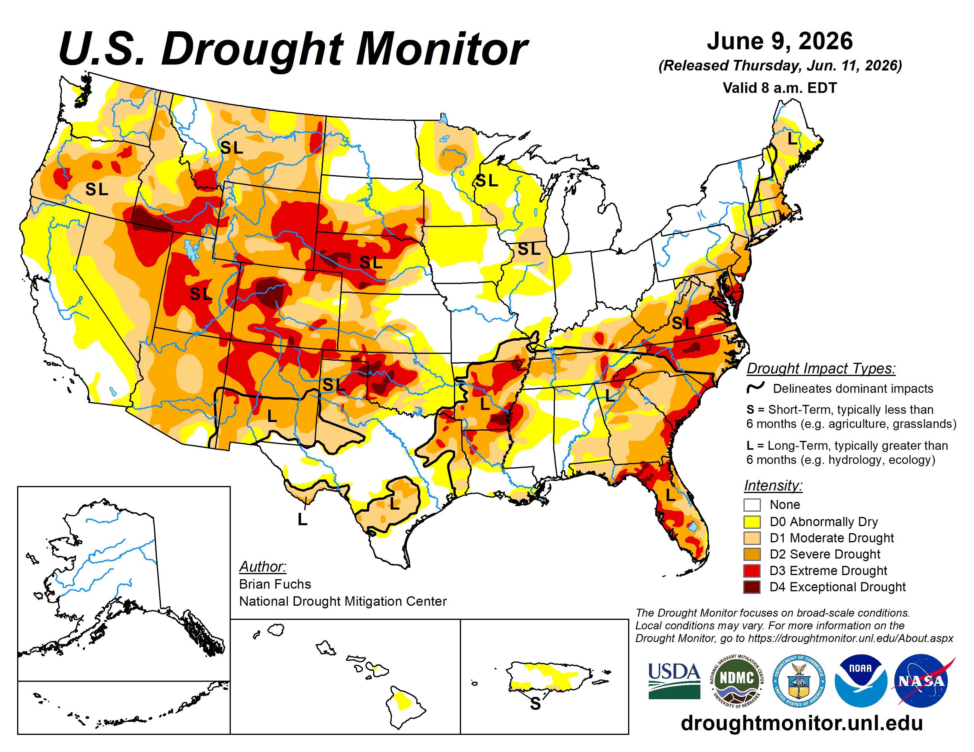
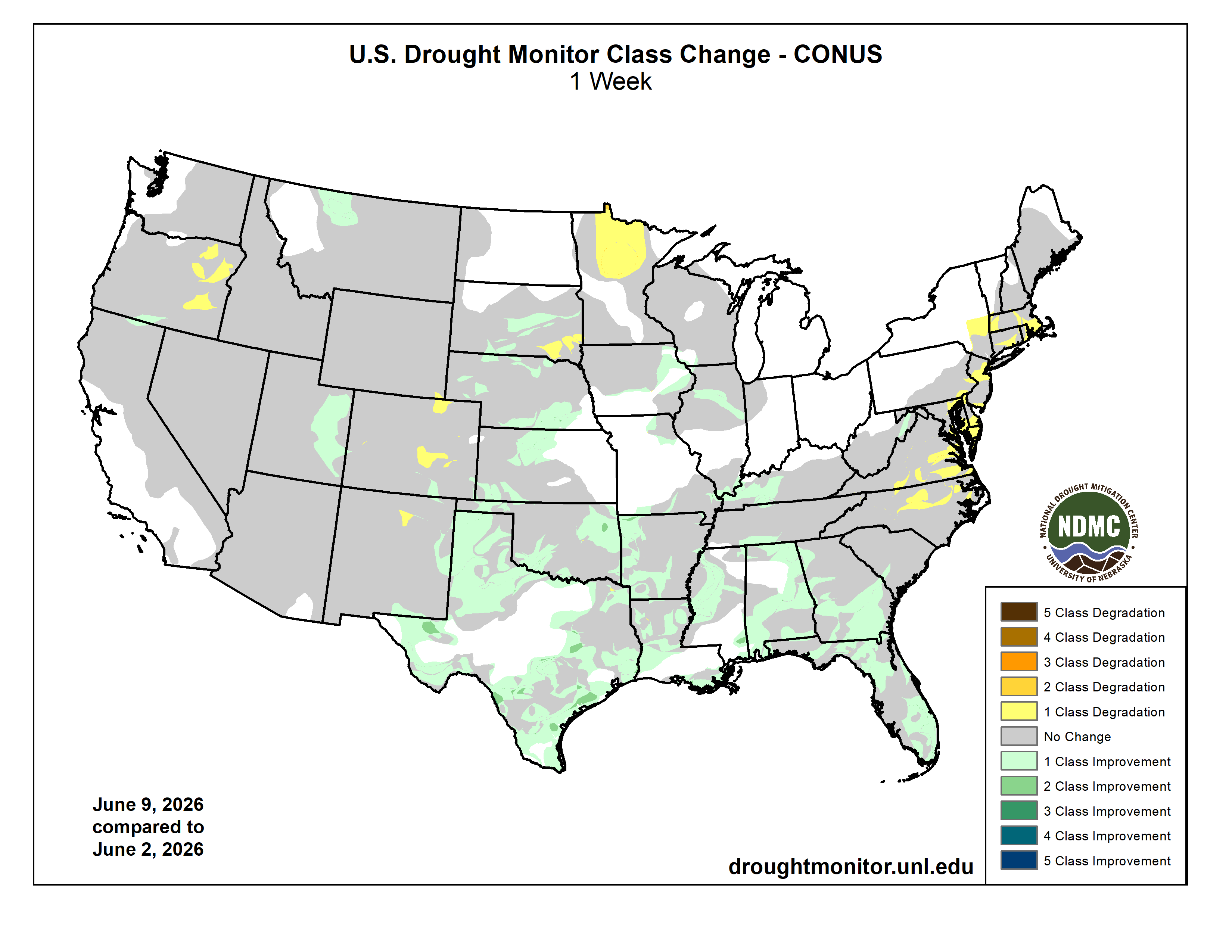
This Week’s Drought Summary
Summer thunderstorms, with their hit-or-miss nature, dominated precipitation patterns across the U.S. this week. The greatest departures from normal precipitation occurred across portions of the central and southern Plains, West Texas, New Mexico, and the Midwest. Areas of southern Louisiana, northern Alabama, and western Kentucky also recorded well-above-normal precipitation. The East Coast remained dry, with the exception of Florida’s Atlantic coast. Much of the West also remained dry, with only portions of the Pacific Northwest and southern California recording near- to above-normal precipitation.
Temperatures for the week were below normal across the Southeast, with parts of Georgia, Florida, and South Carolina averaging 3–6 degrees below normal. Portions of West Texas, southeast New Mexico, and the Pacific Northwest were also below normal. The greatest temperature departures occurred in the central and northern Plains, where portions of Nebraska, South Dakota, North Dakota, and Minnesota experienced temperatures 9–12 degrees above normal.
Drought signals across much of the southern U.S. remain mixed, with wetter short-term conditions developing while long-term deficits persist despite the recent pattern change. In the Plains, impacts have primarily affected winter wheat and forage production, and areas that have remained dry continue to experience elevated fire danger. In the Southeast, water supply concerns and fire danger remain significant, particularly in Florida…
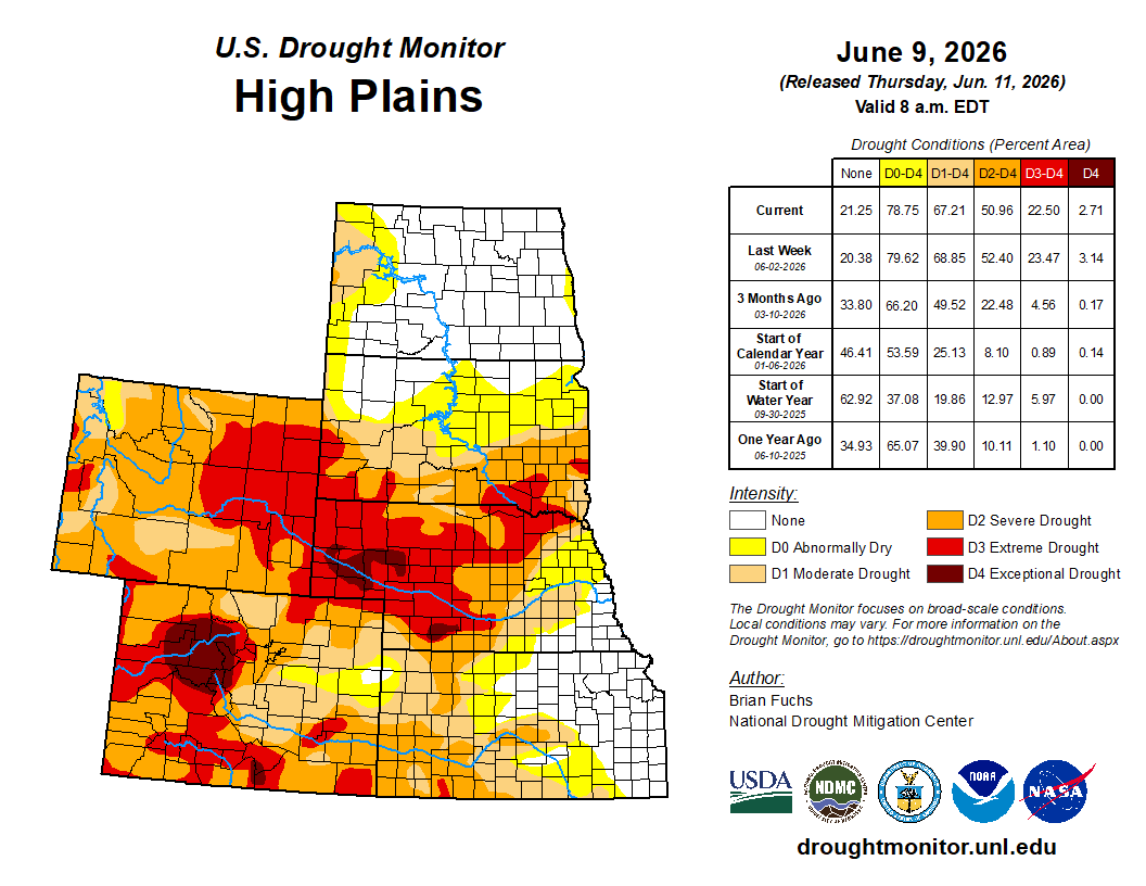
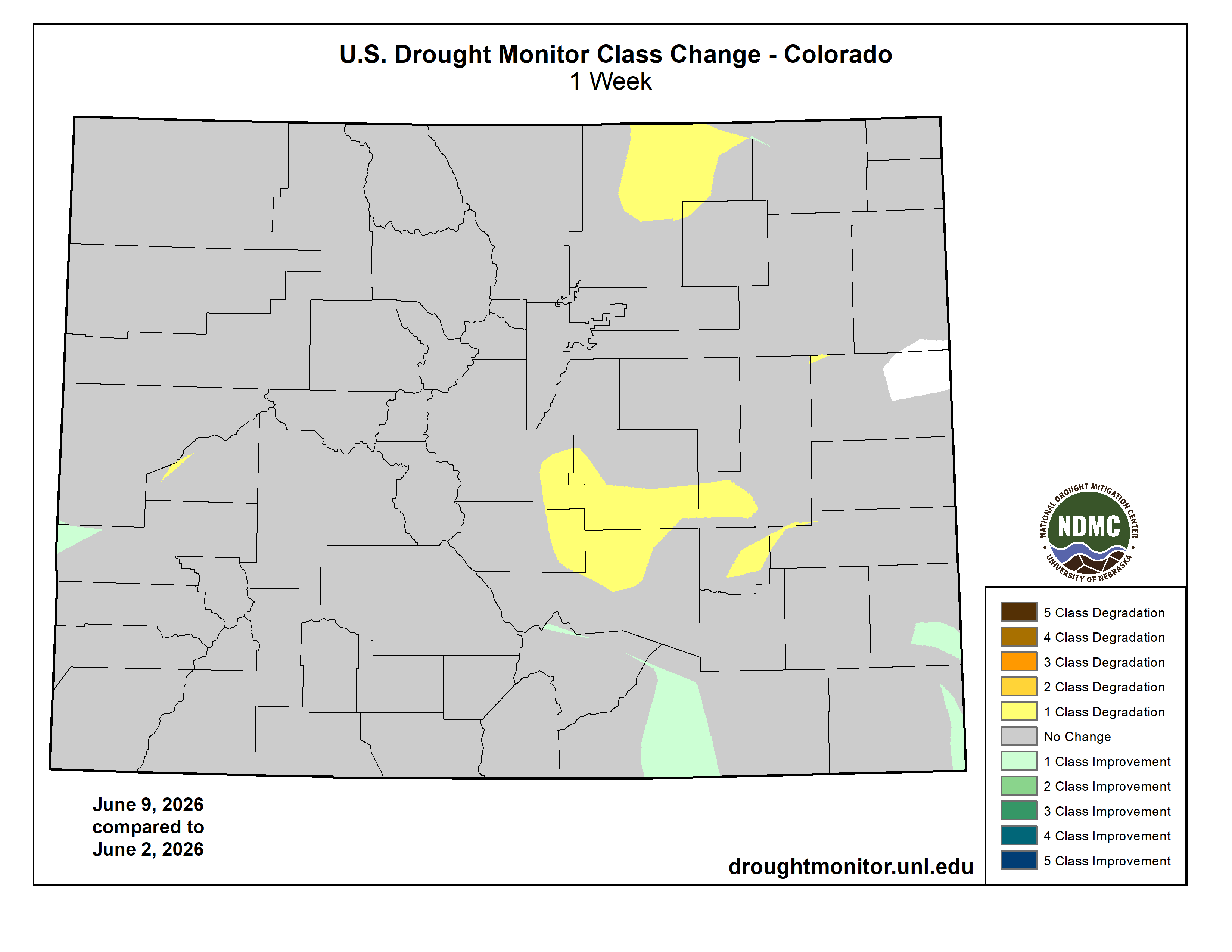
High Plains
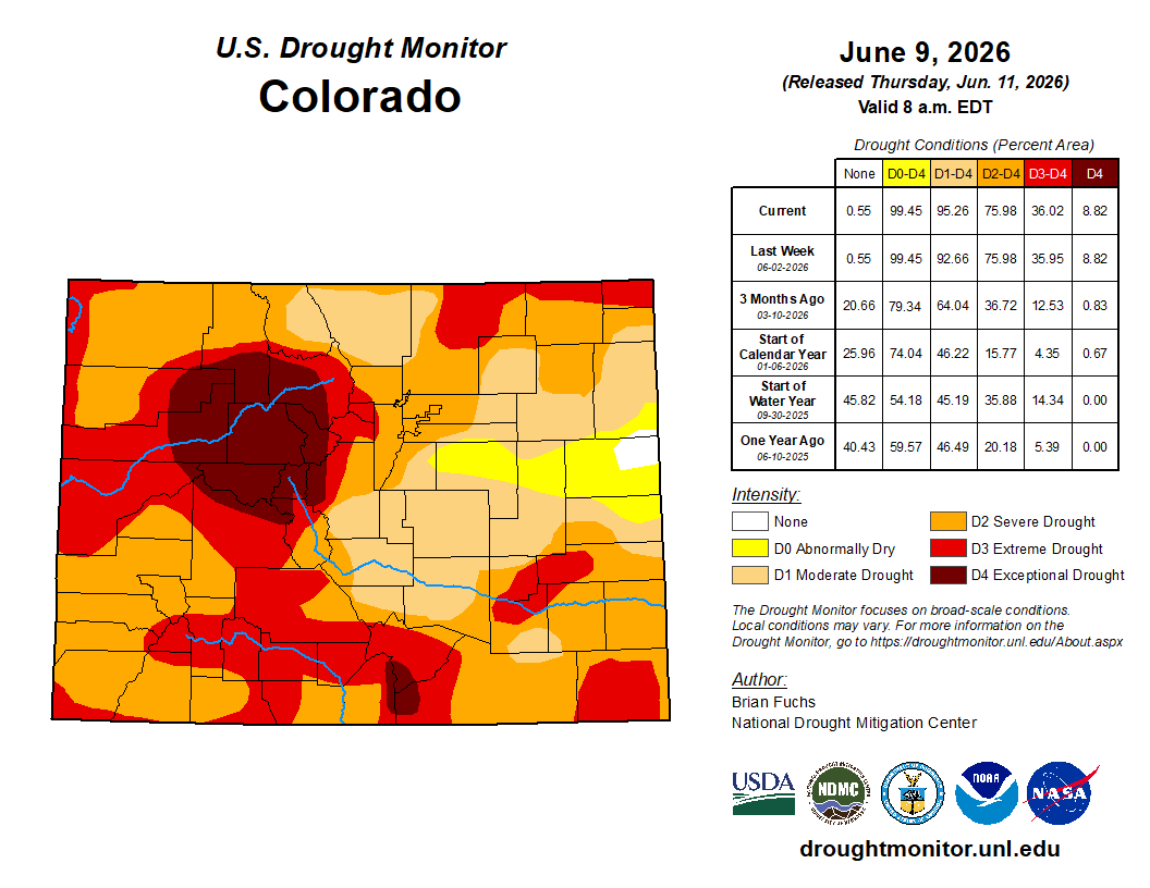
Temperatures were generally warmer than normal across the region, with portions of the Dakotas and western Nebraska averaging 9–12 degrees above normal. Above-normal precipitation occurred in southern Nebraska, northern Kansas, northern Nebraska into southern and central South Dakota, and across much of northern North Dakota. Areas along the foothills of the Rocky Mountains from Montana through Colorado remained largely dry.
Drought intensity eased where the heaviest rains fell in Nebraska, Kansas and South Dakota, and drought was eliminated in portions of northern Kansas and southeast Nebraska. Southeast South Dakota continued to miss significant rainfall, and the combination of short- and long-term dryness allowed moderate and severe drought to expand. Degradation also occurred in eastern Colorado, where extreme drought expanded in the north and moderate drought expanded across east-central portions of the state. Extreme drought was reduced slightly in southern Colorado following recent rainfall…
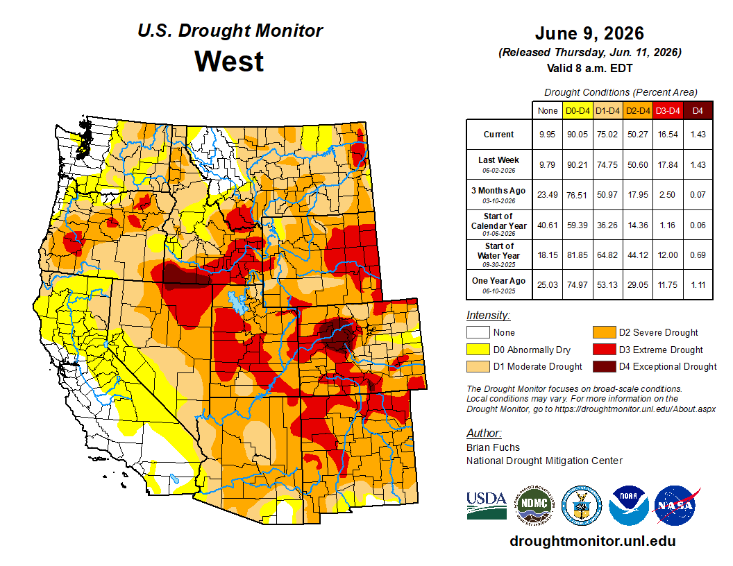
West
Above-normal precipitation was limited to a few locations, primarily along the Pacific Northwest coast and across southern and eastern New Mexico. Temperatures were above normal across much of the region, with departures of 6–9 degrees above normal across Nevada, Utah and western Colorado. Cooler-than-normal temperatures occurred in the Pacific Northwest and eastern New Mexico, where departures averaged 3–4 degrees below normal.
Although some areas have recently received additional precipitation, a winter characterized by above-normal temperatures and below-normal snowpack continues to affect the region and will likely influence conditions through the summer. Conditions deteriorated in Oregon, where moderate, severe and extreme drought expanded across much of the eastern portion of the state, although southern Oregon experienced localized improvements to moderate drought.
Elsewhere, western Montana benefited from recent rainfall, allowing severe and extreme drought to improve. Extreme drought also improved across much of eastern Utah, while southern and eastern New Mexico saw additional improvements following precipitation totals exceeding 200% of normal…
South
Temperatures were mixed, with Oklahoma and Arkansas averaging 2–4 degrees above normal. Meanwhile, much of West, south and east Texas, along with eastern Mississippi and Tennessee, averaged 2–4 degrees below normal.
Most of the region received some precipitation, although eastern Arkansas, northern Mississippi, southern Texas, and southwest Oklahoma were the driest locations. The continuing wetter pattern resulted in additional improvements, with drought eliminated across more of central Texas and eastern Oklahoma. Drought also eased across much of the Texas and Oklahoma panhandles, although widespread severe and extreme drought persisted.
Long-term dryness in far south Texas continues to improve, and improving local conditions combined with short-term data supported the removal of remaining abnormally dry designations. Improvements also occurred in Arkansas, Mississippi, Louisiana, and Tennessee, where recent wet conditions are beginning to offset longer-term drought indicators…
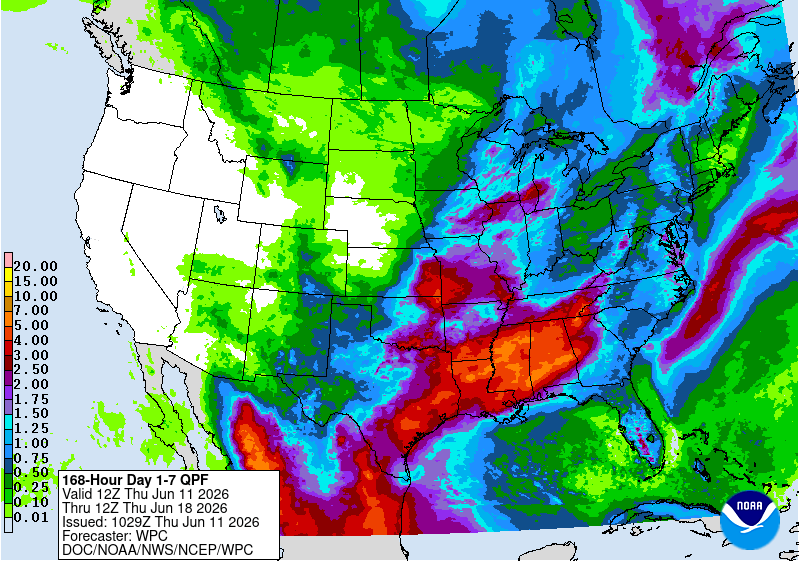
Looking Ahead
During the next 5–7 days, the West is expected to remain quite dry, [ed. emphasis mine] while the southern U.S. and portions of the Midwest have the greatest potential for above-normal precipitation. The northern Plains and Southwest are forecast to receive less than 1 inch of precipitation.
Temperatures are expected to remain warmer than normal across the West, with departures exceeding 10 degrees above normal in Nevada and portions of the Pacific Northwest. Most of the remainder of the country is expected to experience near- to slightly below-normal temperatures.
The 6–10 day outlook shows the best chances for above-normal temperatures will be across the West and Southeast, especially in areas centered on Nevada and much of South Florida. Above-normal chances for below-normal temperatures will be centered on the Great Lakes and Midwest, with the highest probabilities over Michigan.
Above-normal chances for below-normal precipitation will be over much of the northern Plains and Upper Midwest, as well as northern areas of California, Nevada, and into Oregon. Above-normal chances for above-normal precipitation will be mainly in the southern and eastern U.S., with the highest probabilities in South Texas and into the lower Mississippi River Valley.
One thought on “#Drought news June 11, 2026: Areas along the foothills of the Rocky Mountains from #Montana through #Colorado remained largely dry. Temperatures were above normal across much of the west, with departures of 6–9 degrees above normal across #Nevada, #Utah and western Colorado”