
Click the link to read the article on the Colorado State University website (Russ Schumacher):
June 18, 2026
After the worst year for mountain snowpack since snowpack has been measured, we are now starting to see the extremely low river flows that were expected as a result. Some areas have received beneficial rains over the last couple months, but June has now started off very warm and dry. The monsoon season will be starting soon, and we have the potential for a “Super El Niño” later this year. What do all of these mean for Colorado’s drought and how it might evolve through the rest of 2026?
How this water year’s drought has unfolded
As you hopefully read in our monthly summary, May was pretty “normal” for Colorado, which may have felt unusual because we hadn’t had weather close to normal in quite some time. In some parts of the state like northern Colorado, precipitation in April and May brought some short-term drought relief, but the overall precipitation deficits across Colorado for the water year are very large. Taking a glance at our “water year at a glance” figure, we can see that May kept the statewide water year precipitation deficits from getting larger, but didn’t reduce them in any substantial way. And with the first half of June being warm and dry, those deficits are growing again.
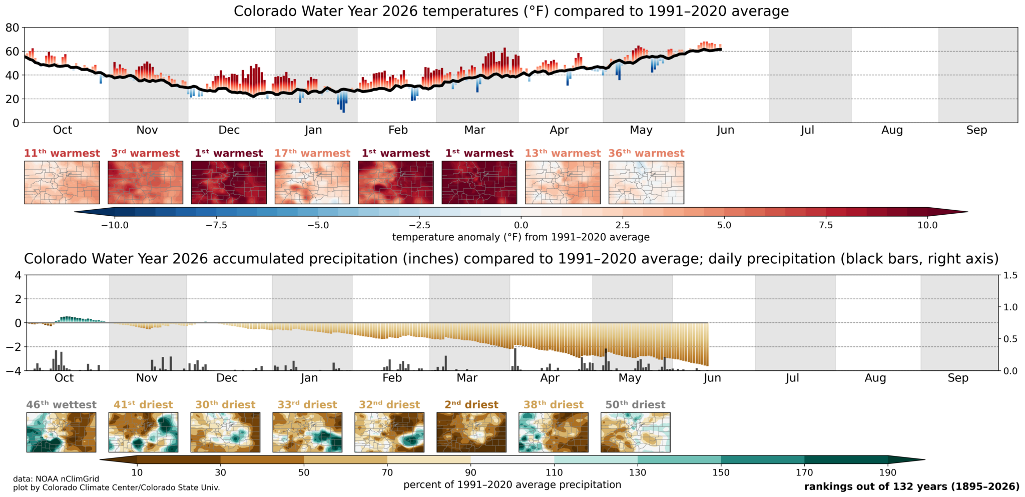
Nearly the entire state is in drought on the June 16 US Drought Monitor, and nearly 80% of the state is in D2 (severe) drought or worse. As has been very widely discussed, the mountain snowpack this year was awful. Because the snowpack is the source of a majority of the water that flows into the river systems that originate in Colorado and flow in all directions, it was clear that streamflows were going to be extremely low this year. That expectation is now coming to pass.
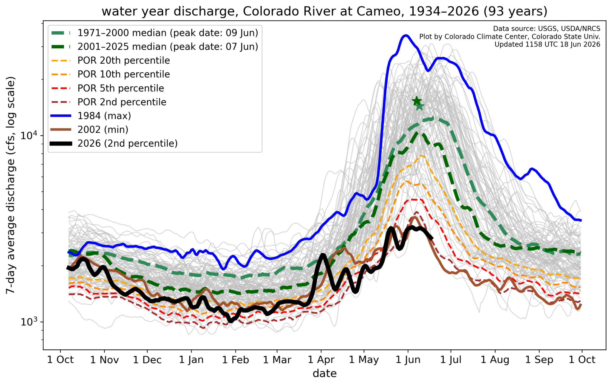
Looking at hydrographs from a couple of the major river systems, we see that the Arkansas River is likely to end up with its lowest water-year cumulative streamflow—even worse than the previous record low in 2002—while the Colorado River is tracking pretty closely with the 2002 record.

Some rivers (such as the White River in northwest Colorado) are going to break the previous record low flow by a large margin, others (like the Rio Grande) are relative bright spots and won’t approach historic lows, but there’s not any stream in the state where flows will be “good” this year. (These interactive maps from the USGS show current conditions, and all the exclamation points really drive home the message about how concerning the flows are!)
The situation in 2002 is a good point of comparison, because it was probably the worst statewide drought Colorado has ever had. Precipitation in water year 2002 through May was quite a bit lower than even this year, but this water year has been much, much warmer. On the “quadrant chart” of temperature and precipitation for Colorado as a whole, those two water years are the farthest separated from any others in the historical record: 2002 for its extreme lack of precipitation, 2026 for its record-smashing warmth.

This illustrates the influence that temperature has had on drought and water availability this year: even though precipitation has “only” been in the bottom-10 of water years historically, the record warmth depleted the snowpack and increased evaporative demand such that this year will rival 2002 for the worst year for river flows across Colorado.
Reservoir storage is a mixed bag around the state. Some of the large reservoirs, like Lake Granby in northern Colorado, are storing just slightly less water than usual going into the summer, but others like Blue Mesa on the Gunnison River are at much lower levels. And the big reservoirs downstream on the Colorado River, Lake Powell and Lake Mead, are approaching all-time record lows.
Where are we headed?
Have you heard that there’s going to be a Super El Niño? Surely you have – at every talk I’ve given in the last few months, no matter the audience, someone has asked about this. And it isn’t all hype: El Niño conditions have officially emerged this month, and all indications are that it will be a strong one, meaning that waters in the Pacific Ocean off the coast of South America will be much warmer than average. But El Niño has its biggest influences on weather in North America during the fall through spring — before then, we have the North American Monsoon season, which in Colorado typically gets started in July and goes through September, and can bring regular thunderstorm rainfall to especially western and southern Colorado. As this nice explainer from the University of Arizona discusses, connections between El Niño and the monsoon are not all that strong. So before we get to El Niño, let’s look at what’s expected for the monsoon season.
All indications have been pointing to an active monsoon season, with odds tilted toward above-average precipitation across the southwest. The latest seasonal outlooks from NOAA’s Climate Prediction Center, just released this week, continue this message.
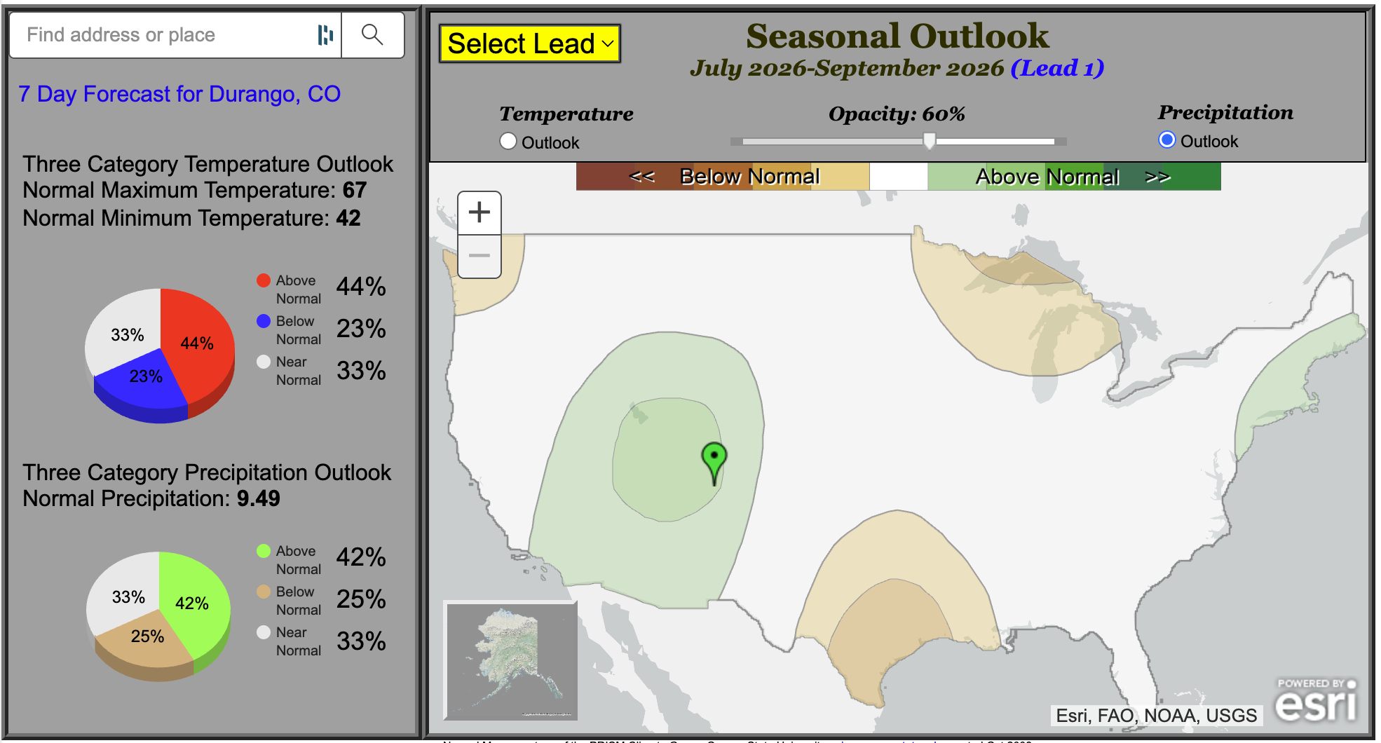
For the main monsoon season of July, August, and September, the outlook shows increased odds of above-average precipitation across western Colorado. Note though that it’s not a *huge* tilt in the odds — the pie chart shows that at Durango, it only increases the probability of a wet monsoon season from the 33% that you’d get by throwing darts at a dartboard, to 42%. Even so, considering the long-term drought, having an active monsoon season would help to reduce wildfire risk, and reduce demand for water, even if it wouldn’t have much influence on water supply and extremely low river flows. There isn’t much signal in the outlook east of the Continental Divide, with “equal chances” of above, below, and near-normal precipitation there.
OK, now back to El Niño and what it might mean for later in the year. The graph below shows that by late fall/early winter, El Niño conditions are guaranteed, and there’s a greater than 60% chance that it will be very strong (aka “Super”).
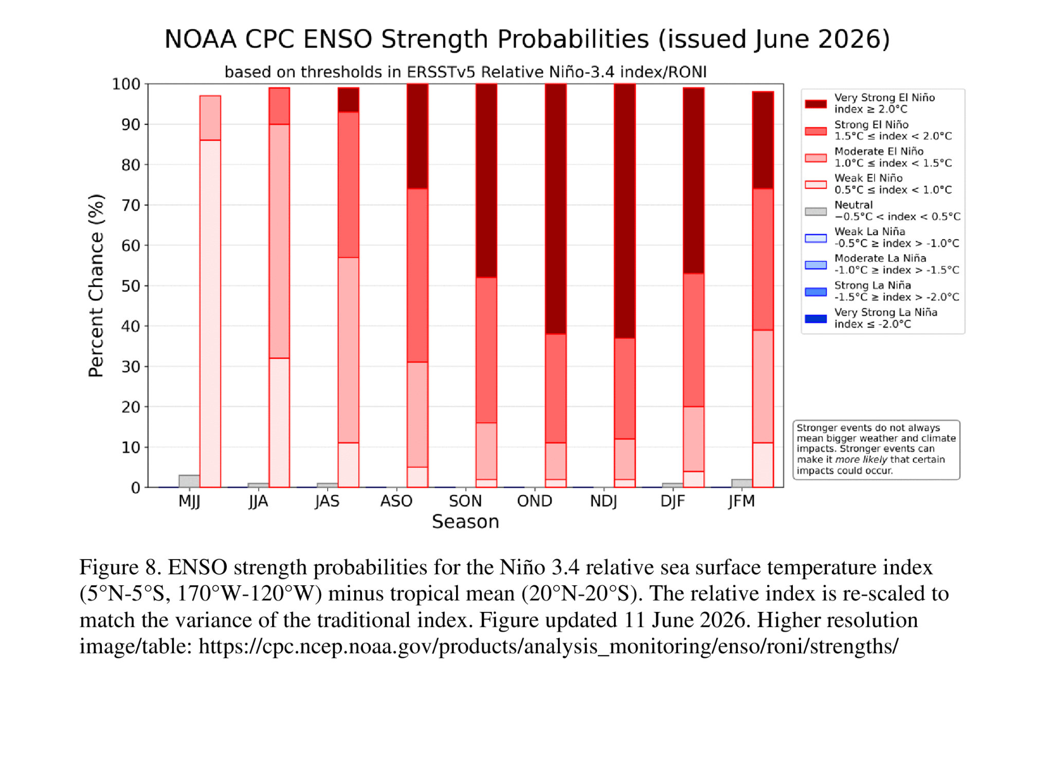
What does El Niño typically mean for Colorado? In general, it tilts conditions away from drought and toward wetter patterns. Particularly in the fall, most of the state has had wet conditions during El Niños in the past, and during the few “Super El Niños” that have happened before, all of them have had above-average fall precipitation. This gives some reason for optimism that there could be drought relief in the coming months, even though conditions are in very bad shape right now.
Correlation between the the Relative Oceanic Niño Index and Colorado precipitation, using data from 1950-2025. Areas in green are wetter during El Niño, areas in blue are wetter during La Niña in the seasons shown. Only areas with 95% statistical significance in the relationship are shown. Figure courtesy of Peter Goble, Colorado Climate Center
NOAA’s outlook gives a message consistent with these historical correlations, with the entire state under increased probabilities of wetter-than-average conditions in the fall. However, with El Niño in Colorado, it’s important to keep in mind that nothing is guaranteed. The influences of ENSO on our weather are not as strong as they are in regions to our north and south, and there have only been a few instances of Super El Niños in the past to compare to, so we’ll have to see what the atmosphere throws at us. Still, there’s reason to be hopeful that there won’t be months and months more of worsening drought.

State drought tour: support Colorado businesses!
In the first week of June, I went on the drought tour organized by the Colorado Water Conservation Board, around Grand County. We saw low reservoirs and rivers, and heard from local ag producers and owners of outdoor recreation companies. There were two key messages: first, that the drought is having significant impacts on their operations, whether from the lack of snow in the winter or the lack of available water in the summer. But second, Colorado businesses are still open and operating, and now is a more important time than ever to support those businesses by buying Colorado products and getting outside for recreation!