Driving down Highway 133 from the craggy wilds of the West Elk Mountains in central Colorado, one of the first signs of civilization is a mile-long coal train on a siding, along with the rusting steel framework of a canyon-spanning loading station that still dumps the black rock into trains at the rate of 50 cars per hour.
This nearly relict fossil fuel infrastructure is an improbable gateway to the orchards and vineyards of North Fork Valley. The few miles between the mine and Paonia mark a transition from the fossil fuel era into an uncertain post-carbon age, defined by climate change.
In Paonia, the air around Big B’s fruit stand is scented sweet-sour from the harvest of ripe apples. There are four types of cider on tap and nearly all the food on the menu is grown within a few miles of the local gathering spot.
The Mountain Harvest Festival is underway, and the place is buzzing, as community catalyzer Pete Kolbenschlag starts explaining how Paonia is building a sustainable future.
This community once relied heavily on coal mining jobs. Now it is developing a path toward a sustainable local economy based partly on organic agriculture and local renewable energy. It also must find ways to navigate challenges like global warming—and the growing threat of new fossil fuel development.
About eight years ago, the federal government proposed major oil and gas drilling in the North Fork Valley, and the plan roared to life this past summer, just as the organic food industry was really starting to take off. New drilling would take up land and threaten to bring more air pollution and potentially groundwater contamination that could put organic crops in jeopardy, while also contributing to climate change.
That’s not a mix that can work, said Kolbenschlag, who’s been working on community sustainability in the North Fork Valley for 20 years.
Many proposed drilling areas are right next to organic farms or ranches, and even directly on top of community drinking water springs, according to the Western Environmental Law Center, which is supporting the community’s legal challenges to fracking. Leaks from drilling could threaten local and regional water supplies. Industrial emissions and dust from increased traffic could taint fruits and vegetables, and energy infrastructure could harm wildlife habitat and diminish the area’s tourism appeal, along with the direct climate-harming impacts of more fossil fuel development.
“Leases were proposed in a ring around my house for 2 miles in every direction,” Kolbenschlag said. “We were able to stop that lease sale twice because the underlying land plan was outdated. There’s millions of dollars of agriculture on the line, even in a small area like this.”
Oil and gas drilling has been delayed above Paonia, Colorado because agencies didn’t adequately analyze climate and wildlife impacts. Courtesy of EcoFlight via The High Country News.
Sean Cronin and John McClow at the 2014 CFWE President’s Award Reception
Click here to read the newsletter. Here’s an excerpt:
Here are a few of the reasons 2019 was a year to
CELEBRATE in the Gunnison River Basin
Year of plenty with full reservoirs & ditches!
The Gunnison Basin Roundtable had another successful year in their continued support of water users, water education and through management of grants for important projects from headwaters to mouth.
Completion of significant water use efficiency improvements within the Lower Gunnison Basin Project.
Blue Mesa played a huge role in meeting flow targets in the critical reaches while providing full supply to irrigators; Taylor Park, Paonia, Crawford & Ridgway Reservoirs met both human & environmental needs. as well.
Major agreements were signed benefiting not only our basin but all of the much larger Colorado River Basin as evidenced by the Drought Contingency Plan, approved by all seven basin states & Congress helping to ensure that we keep our eye on the prize – healthy Lake Powell & Lake Mead levels to maintain vital hydropower generation & compact compliance for all.
And one more of the many reasons to celebrate, one of our own,- John McClow was named Aspinall Water Leader of the Year.
Releases from the Aspinall Unit will be increased to 1600 cfs on Monday, December 9th. Blue Mesa Reservoir elevation remains above the winter icing target level. Releases will be maintained at this level with the goal of lowering the reservoir to the icing target elevation of 7490 feet by December 31st. Flows in the lower Gunnison River are currently above the baseflow target of 1050 cfs. River flows are expected to stay above the baseflow target for the foreseeable future.
Pursuant to the Aspinall Unit Operations Record of Decision (ROD), the baseflow target in the lower Gunnison River, as measured at the Whitewater gage, is 1050 cfs for September through December.
Currently, there are no diversions into the Gunnison Tunnel and flows in the Gunnison River through the Black Canyon are around 1000 cfs. After this release change Gunnison Tunnel diversions will still be at zero and flows in the Gunnison River through the Black Canyon will be around 1600 cfs. Current flow information is obtained from provisional data that may undergo revision subsequent to review.
The Next Generation Water Observing System provides high-fidelity, real-time data on water quantity, quality, and use to support modern water prediction and decision-support systems that are necessary for informing water operations on a daily basis and decision-making during water emergencies. The headwaters of the Colorado and Gunnison River Basin provide an opportunity to implement the NGWOS in a snowmelt-dominated system in the mountain west.
The USGS Next Generation Water Observing System (NGWOS) is generating integrated data on streamflow, groundwater, evapotranspiration, snowpack, soil moisture, water quality, and water use. When fully implemented, the NGWOS will intensively monitor at least 10 medium-sized watersheds (10,000-20,000 square miles) and underlying aquifers that represent larger regions across the Nation.
The USGS will be installing new monitoring equipment and enhancing existing streamgages in the headwaters of the Colorado and Gunnison River Basin (Upper Colorado River Basin) beginning in 2020, subject to availability of funding. Credit: USGS
The USGS has selected the headwaters of the Colorado and Gunnison River Basin (Upper Colorado River Basin) in central Colorado as its second NGWOS basin. This decision was based on rigorous quantitative ranking of western basins, input from USGS regions and science centers, and feedback from targeted external stakeholders in the west.
The Upper Colorado River Basin is important because nearly all flow in the Colorado River originates in the upper basin states and runoff from the Upper Colorado River Basin is nearly three times that of other basins in the area. Thus, the Upper Colorado River Basin is particularly critical for downstream users.
Long-term drought conditions facing the Upper Colorado region, interstate ramifications of the drought, water-quality issues, stakeholder support, and alignment with Department of Interior and USGS priorities make the Upper Colorado an ideal basin to implement the USGS’s integrated approach to observing, delivering, assessing, predicting, and informing water resource conditions and decisions now and into the future. Of note, a newly released (October 2019) Federal Action Plan for Improving Forecasts of Water Availability includes a milestone to pilot long-range water prediction in the Upper Colorado River Basin, an activity that will greatly benefit from the newly selected USGS NGWOS basin.
An integrated data-to-modeling approach in the Upper Colorado River Basin will help improve regional water prediction in other snowmelt dominated systems in the Rockies and beyond. The approach is useful for addressing issues of both water availability and water quality and for evaluating the effects of both short-term climate perturbation (for example, fire, insect mortality, drought) and long-term climate change.
Water Resources Challenges in the Colorado River Basin
The Colorado River supplies water for more than 40 million people and nearly 5.5 million acres of farmland across the western United States and Mexico. The Colorado River and its main tributaries originate in the mountains of western Wyoming, central Colorado, and northeastern Utah. The large amount of snowmelt that feeds the Upper Colorado is central to water availability throughout the Basin. In 2019, urgent action was required to prevent previously developed rules from potentially reducing Colorado River water allocations to Arizona, Nevada and Mexico due to declining water levels in the two largest reservoirs within the Colorado River Basin—Lake Powell and Lake Mead. A Colorado Drought Contingency Plan was signed in April 2019.
NGWOS Characteristics
State-of-the-art measurements
Dense array of sensors at selected sites
Increased spatial and temporal data coverage of all primary components of the hydrologic cycle
New monitoring technology testing and implementation
Click here to read the newsletter. Here’s an excerpt:
Chavez to Take the Lead at UGRWCD
Sonja Chavez has been selected to serve as the General Manager of the Upper Gunnison River Water Conservancy District. When asked about her new role, Ms. Chavez said, “I look forward to working with my local community and our Upper Gunnison Board of Directors and staff to continue to ensure that all water needs within the Upper Gunnison basin are being addressed, with other regional water users to speak with one voice on water resource issues affecting west slope communities, and with other state and federal entities to make informed decisions and have respectful dialogue around our current and future water use.”
As a native Coloradan, Sonja’s passion for water and agriculture is deeply rooted in her family’s ranching heritage. She grew up in a small community in southwestern Colorado along the banks of the Purgatoire River.
Ms. Chavez received a BA in Environmental Biology and an MA in Limnology (study of freshwater systems) from the University of Colorado. Her areas of expertise are in water quality, water resources management, funding acquisition, environmental and natural resource sciences, and policy and planning.
Early in her career Sonja worked in both the private and public sectors in Colorado (Water Quality Control Division, Department of Transportation and Summit County Government). In 2002, she moved to the Gunnison community and started her own consulting firm, assisting west slope water providers and water users planning and implementation of over $38 million dollars of water-quality and agricultural efficiency improvement and hydro-electric projects.
In 2015, she left the consulting world to join the Colorado River Water Conservation District as a Water Resource Specialist where her responsibilities included the management of off- and on-farm agricultural efficiency, system optimization and water-quality improvement projects, environmental compliance, funding acquisition, and grant management, and drought contingency planning and demand management including the evaluation of water banking.
The city council voted unanimously Tuesday to hire Wright Water Engineers out of Durango $50,000 to design a data collection system.
The city is required to collect continuous temperature data on the Uncompahgre River upstream from the treatment plant found north of town, said City of Montrose utilities manager David Bries. This is needed as part of the National Pollutant Discharge Elimination System permit — which was provided by the EPA — that the city recently received, he added.
Bries said that as part of a review, staffers discovered a lack of good, low-measurement near or at the river, as well as the treatment plant discharge location…
With this design in place, it’ll be the first time the city will collect data of the river flow and temperature of the discharge of the treatment plant, Bries said.
He also said this process will “capture that data” so decisions can be made for the river.
“We felt it was very valuable and imperative to have both flow relationships and temperature relationships,” Bries said. “We can make sure we are doing what is environmentally the right thing to do.”
Ken Nordstrom, the environmental health director for the Delta County Health Department, looks at a physical version of the map. Photo credit: University of Colorado at Boulder
Prior to this study, there was no data on private drinking water quality in this six-county area, and the findings have proven to be relevant to many residents. Of the 457 wells analyzed in the survey, 11% have arsenic concentrations exceeding the Colorado primary drinking water standard maximum contaminant level. Additionally, 15% of the well water that was tested exceeded at least one primary drinking water contaminant standard from the state.
Residents can explore results through an interactive online map created by Holly Miller as part of her recently completed master’s degree in the Environmental Engineering Program at CU Boulder. The site shows locations for all the tested wells, provides links to request free testing kits and houses detailed water-quality information.
Samples for the survey came from volunteers in those communities. Miller’s work was done under Professor Joe Ryan, who said the database was an important step toward public awareness. That is because water quality is an important factor in overall health, but privately owned wells are unregulated and mostly untested for things like arsenic. Putting the survey results online gives residents, many of whom rely on well water, information about their home’s water quality and that of their neighbors so they can make informed health decisions.
Arsenic in groundwater can occur naturally, or it can come from human sources like agriculture, where it was used as a pesticide, or mining operations. Ingestion can have short-term effects, including nausea and fatigue, as well as long-term effects like skin thickening and discoloration. Ryan said that more testing was needed, but the source of the higher levels in this case was likely geologic. He added that better understanding of that aspect would be valuable when making decisions about new wells and development needs in those communities.
Ken Nordstrom, the environmental health director for the Delta County Health Department, said that without a healthy drinking water source, you cannot have a healthy community.
“CU Boulder has helped us develop this resource for individual homeowners to ensure that they have a healthy drinking water supply,” he said.
Holly Miller. Photo credit University of Colorado at Boulder
“Collaborating with Delta County has been a great asset for my professional career. I gained valuable research and outreach skills, which ultimately created the foundation for my current position where I work as the project manager for my program’s geographical information systems database used to map information about abandoned mine-land sites across the state,” she said.
The project is nearing completion, and sample kits have now been sent to approximately 1,000 volunteers. From that group, results have been returned to over 750 of them. Miller said the plan is to update the interactive map by the end of the year, and the Delta County Environmental Health Department staff is planning to survey residents in the counties to identify the impacts this project has had on helping private well owners keep their water safe.
Ryan said this type of work was just as important for students in his lab starting their careers as it is to the communities they are serving.
“This type of work is important because I can bring students into it – but it isn’t just having them take samples and analyzing them. It’s a good case where we are getting them into a mode where they are trying to find out the client’s problem and the best way to address it,” he said. “This kind of work provides extra opportunities for students and real benefits to communities we work with.”
This map shows estimates of how many private domestic well users in each county may be drinking water with high levels of arsenic. An estimated 2.1 million people throughout the U.S. may be drinking domestic well water high in arsenic
The Delta County Health Department (DCHD) paired up with the University of Colorado to study water quality in private wells. They said they got definitive data that shows not everyone can trust the water they are drinking.
DCHD oversees six counties: Delta, Gunnison, Hinsdale, Montrose, Ouray and San Miguel.
Approximately 36,000 people, or 60% of the population, in this area drink water from private wells that aren’t regulated because they’re privately owned, according to the department’s director, Ken Nordstrom.
Nordstrom said there are around 10,000 private drinking water wells in the six-county region his department oversees and that until this point there was no information readily available to the public about the quality of water in those wells…
So with the help of a Centers for Disease Control and Prevention (CDC) grant, the DCHD started taking a closer look at gathering data and CU Boulder joined in 2016.
Here’s the release from the Bureau of Reclamation (Justyn Liff, Lesley McWhirter):
The Bureau of Reclamation is reducing salinity and improving water quality in the Colorado River Basin by reducing salt loading into the river from the Crawford Clipper Center Lateral in Delta County and the Gould Canal in Delta and Montrose Counties. Naturally-occurring salts in the sediment along the canals are picked up by water leaching from the earthen ditches and entering the Colorado River system. The resulting reduction in water quality creates a negative economic impact to downstream infrastructure and crops. The purpose of the projects is to prevent seepage and reduce salinity loading in the Colorado River Basin.
The Crawford Clipper Center Lateral Pipeline Project will replace approximately 4.3 miles of open irrigation ditch with buried pipe. The Gould Canal Improvement Project will convert 12.4 miles of the canal to pipeline and geomembrane lining. These improvements will reduce seepage along the canals, enhancing water supply and improving water quality by preventing approximately 8,303 tons of salt per year from entering the Colorado River.
“Reducing salt along the Clipper Center Lateral and the Gould Canal will help improve the water quality, crop production and wildlife habitat in the Colorado River Basin,” said Ed Warner, area manager for Reclamation’s Western Colorado Area Office.
Click here to read the newsletter. Here’s an excerpt:
Funding opportunities in the Gunnison River Basin
Funding opportunities for water projects that help improve and conserve water and land resources can be found on http://gunnisonriverbasin.org, including:
US Department of Agriculture federal grants and loans
Colorado Water Conservation Board state grants and loans
Additional Grant Funding Opportunities
Click here to view a table of grand funding opportunities.
Upper Gunnison watershed May 2019. Photo credit: Greg Hobbs
Photo credit from report “A Preliminary Evaluation of Seasonal Water Levels Necessary to Sustain Mount Emmons Fen: Grand Mesa, Uncompahgre and Gunnison National Forests,” David J. Cooper, Ph.D, December 2003. From Western State University via The Crested Butte News:
Monitoring and protecting an important part of the local ecosystem
by Tobias Nickel, Nick Catmur, Christopher Kittle, Heather Reineking and Justin Sanchez—graduate students in the Master in Environmental Management program at Western Colorado University
In front of us, Bureau of Land Management (BLM) hydrologist Andrew Breibart slogs across what from afar might be mistaken for an alpine meadow full of sedges, willow and spruce saplings. A closer look reveals that our group of Western Colorado University (WCU) students stands on neither solid ground nor water, but something in-between. The ground moves under our feet, and with every step we sink deeper into a thick, mucky substance. Protected by rubber boots, we follow Breibart across the Butterfly Fen, located 30 miles southwest of Gunnison in the San Juan Mountains near the mountain community of Arrowhead.
“I have been visiting this special place since 2015,” says Breibart, “when I first learned about the threats and impacts to this unique ecosystem.”
After a short trudge across the fen, we unload our field equipment and get to work. With direction from our professor, Dr. Jennie DeMarco, we lay out transects, fixed paths along which we take vegetation measurements and collect soil samples.
“The goal of our research is to better understand the ability of fen ecosystems to store carbon and retain soil moisture,” explains Master in Environmental Management (MEM) student Heather Reineking.
Breibart adds, “Carbon sequestration and maintenance of soil moisture are key issues in building resilience to a changing climate.”
But what are fens and why do they matter?
Fens are ancient wetlands found in different parts of the world. In the Rocky Mountains, fens started to form after the last ice age around 12,000 years ago. What distinguishes fens from other wetlands is their strong connection to groundwater as well as a thick layer (16-plus inches) of peat. Peat is an accumulation of dead and decomposing plant matter that forms over hundreds, even thousands, of years, in permanently saturated, nearly oxygen-free soils. Peat is also what lends fens their spongy characteristic, so if you have ever experienced that wet and springy sensation under your feet while hiking across the alpine, you yourself have likely stood atop a fen.
Because peat is primarily composed of plant matter, it typically has a carbon content of over 50 percent. The slow but constant accumulation of peat makes fens globally important as carbon sinks. In fact, despite covering only 3 percent of the Earth’s surface, fens and other peatlands are second only to oceans in carbon storage. However, when a fen is dried out, the peat is exposed to air and the carbon is released in the form of CO2, making them powerful greenhouse gas emitters.
While it can take thousands of years for peat to build up in fens, degradation of these ancient ecosystems can reverse this sequestration in only a few years.
Beyond their role in the global carbon cycle, fens support biodiversity and provide an ecological refuge for rare plant species. Additionally, fens are important habitat for elk, moose, amphibians and migratory birds.
Fens provide other critical ecological functions as well, including filtering large volumes of water and maintaining base flows to streams year-round.
Breibart explains, “With climate change and prolonged droughts, fens play an increasingly vital role for maintaining flows in our headwater streams and the Colorado River Basin. Fens in the San Juan Mountains and closer to home at the Iron Fen outside of Crested Butte maintain a high water table during drought years such as the ones in 2002, 2012 and 2018.”
Considering the numerous societal and ecological benefits of fens, the BLM strives to protect and restore these little-known ecosystems on the lands that the agency has been entrusted with. Threats to fens include trailing by domestic and wild ungulates (cows and elk), logging operations, water diversions, road building and climate change.
In the face of these threats, the need to study these often-overlooked ecosystems to inform their restoration is critical. This is the reason why our group of students is measuring vegetation and collecting soil cores at the Butterfly Fen. “We are collecting baseline data so that we can compare current conditions to future conditions and learn if restoration measures are effective in maintaining or even improving the ecological function of the fen,” explains MEM student Justin Sanchez.
Meanwhile, the sounds of drills and chainsaws can be heard nearby as a youth crew from the Western Colorado Conservation Corps (WCCC) is hard at work constructing a buck and pole fence to prevent cattle from trailing through the fen.
“These lands are managed for multiple uses,” says Breibart. “We have a timber sale for spruce bark beetle, livestock grazing, hunting and snowmobiling, but we also need to take into consideration the impacts on these sensitive ecosystems.”
The BLM is seeking a win-win solution by fencing off the delicate fen area and creating an alternative water source, so that livestock can still graze the surrounding meadows.
Furthermore, in partnering with students at WCU, the BLM is using the best available science to inform fen restoration measures. MEM student Chris Kittle says, “We hope that our research will support the BLM in protecting these rare ecosystems, so that the benefits fens bring to natural and human communities do not dry up.”
Breibart is elated, saying, “After four years, the BLM Gunnison Field Office finally has the resources to protect and preserve the Butterfly Fen, and I look forward to more collaborative fen restoration projects in the future.”
Here’s the release from the Environmental Protection Agency (Lisa McClain-Vanderpool):
EPA and the state partner with the agriculture industry to restore watersheds
The U.S. Environmental Protection Agency (EPA) has awarded $1,170,000 to the Colorado Department of Public Health and Environment (CDPHE) to improve water quality in streams, rivers and lakes. The funding comes through a Nonpoint Source Program Clean Water Act (Section 319) grant, which is given to states to implement programs that address various sources of pollution in surface and groundwater to meet and maintain water quality standards.
“EPA is partnering with CDPHE to restore water quality in two critical river basins, the Lower Arkansas and the Lower Gunnison,” said EPA Regional Administrator Gregory Sopkin. “These rivers are important environmental, economic and recreational resources for the state of Colorado. By working together to reduce pollutants, we will continue to improve these beautiful, natural resources well into the future.”
These watershed projects will result in a significant reduction of pollutants such as selenium, metals and nutrients. CDPHE will use the grant money to support the Lower Arkansas Valley Water Conservancy District to implement agricultural best management practices that improve water quality in the Arkansas River. In addition, work on the Lower Aspen Canal pipeline and interconnect will be carried out in partnership with the Crawford Water Conservancy District to address water quality issues in the Gunnison River basin. The grant will also fund outreach, education and planning.
Funding for this project is one part of EPA’s overall effort to ensure that America’s waters are clean and safe. This year, EPA is distributing more than $165 million in section 319 grants to states, territories, and tribes to reduce nonpoint runoff in urban and rural settings, including efforts to reduce excess nutrients that can enter our waters and cause public health and environmental challenges. Over the last two years, states restored over 80 waters and reduced over 17 million pounds of nitrogen, nearly 4 million pounds of phosphorus, and 3.5 million tons of excess sediment through section 319 projects. This 319 grant received by Colorado complements the $12.7 million Clean Water State Revolving Fund grant Colorado received this year.
The Crawford Water Conservancy District provides supplemental irrigation water supplies for approximately 8,200 acres and full water supplies for 1,423 acres in Delta and Montrose counties, according to its website.
It has operated the Smith Fork Project for the Bureau of Reclamation, which includes the Aspen Canal, since 1964.
The Smith Fork Project utilizes flows from the Smith Fork, Iron, Muddy, and Alkali Creeks…
Over the last two years, states restored more than 80 waters and reduced more than 17 million pounds of nitrogen, nearly 4 million pounds of phosphorus, and 3.5 million tons of excess sediment through section 319 projects, according to the EPA.
Click here to read the newsletter. Here’s an excerpt:
The Fire Mountain Canal Improvement Project (“Segment 47”; 22,400 feet or 4.2 miles, large diameter pipe; including new Leroux Creek siphon; Total Cost Estimated at $4.6MM). Phase 1 of this two-year piping project is completed and is delivering irrigation water. The project is cooperatively funded by the Fire Mountain Canal and Reservoir Company (approximately $200K), RCPP Watershed Authority ($1.15M – managed by the River District), Reclamation Salinity Control ($2.95M), and Colorado Water Conservation Board ($191K).
The RCPP portion, with fiscal management by the Colorado River District, involves piping a total of approximately 2 miles of the Lower Fire Mountain Canal ‘extension’. Approximately 80% of this RCPP-funded project component was installed from November 2018 to April 2019. The balance of the two-mile segment along with the salinity-funded large diameter pipe and siphon is scheduled to be completed in time for the 2020 irrigation season. It was designed by the Applegate Group and constructed by Telluride Gravel.
The Minnie Lynch Mine, near Bonanza, left this drainage due to contaminated soils and water. Photo credit. Trout Unlimited
Restored drainage near the Minnie Lynch mine. Photo credit: Trout Unlimited
The Akron Mine cleanup near the headwaters of Tomichi Creek moved 8 acres of mine waste before restoration. Photo credit: Trout Unlimited
The Akron Mine cleanup near the headwaters of Tomichi Creek after restoration. Photo credit: Trout Unlimited
From Trout Unlimited (Jason Willis) via The Chaffee County Times:
The exclamation I hear most often from the general public, industry or federal/state partner organizations is “I didn’t know Trout Unlimited did that.”
That refers to abandoned mine land clean-up projects. TU has had an AML program for over 10 years, I’ve been part of it for the last 7.
The scope, complexity and budget of our projects have grown a lot in the past 4-5 years.
A cleanup will commonly consist of targeting an abandoned hardrock mine, 23,000 of which exist in Colorado, that has acidic, heavy metal-laden water, waste-rock or tailings (processed ore) on site.
Our staff will then characterize a site through water or soil chemistry testing to attain baseline metal concentration levels. This data can then be used in a reclamation design/plan that best suits a certain location.
The characterization part of the work is important. There is no one-size-fits-all type solution at many of these sites due variations in contamination, elevation, aspect, water and historical properties.
My program in TU has taken on a larger cradle-to-grave project management role in the recent past since we have the expertise to do most of this characterization and design ourselves.
This helps cut down on costs that ultimately can go into the ground to accomplish more work at a site.
The work most commonly focuses on revegetating barren and discolored waste rock or tailings areas, as well as managing water around those areas to keep it clean. I’m simplifying these techniques quite a bit. The pictures tell the story best.
The first two photos were taken from a project TU completed in partnership with the U.S. Forest Service near Bonanza. Previous activity in the Bonanza Mining District at the Minnie Lynch Mine left this drainage dead due to contaminated soils and water.
Our work focused on confining the flow of Minnie Lynch Gulch into a sustainable stream channel while also incorporating soil amendments into the barren floodplain to establish native vegetation.
The two photos were taken 1 year apart showing impressive results. The native vegetation has continued to thrive 3 years after implementation with local cattle even being observed enjoying the fruits of our labor.
Another local project TU completed in partnership with USFS was the Akron Mine cleanup, which is in the headwaters of Tomichi Creek near the town of Whitepine.
This nationally award-winning project moved over 120,000 cubic yards of mine wastes out of the floodplain and into two large on-site repositories.
The wastes exhibited high levels of lead and zinc, making ecological and human health a priority for clean-up actions. By moving the wastes, a 60-foot wide floodplain was established along an 1,100-foot section of Tomichi Creek. The entire 8-acre footprint was revegetated using native seed. A large culvert was also removed that was acting as a fish barrier to local brown and brook trout populations.
These are just two example projects of the “I didn’t know TU did that” category of work. Over the past 3-4 years, the TU Colorado AML program has spent $500,000 to $1.2 million annually on construction towards these types of projects that protect the state’s water quality.
That is no small task given the increased scrutiny from federal agencies, legal hurdles, lack of funding and varied site complexities.
Fortunately, federal agencies have been recently motivated to facilitate these types of clean-ups with existing Good Samaritan protections while also exploring legislative fixes that will help protect third party organizations like TU from potential legal ramifications.
With over 25 projects under the program’s belt over the last 7 years in Colorado, TU looks to continue to build capacity and chip away at our state’s water quality issues stemming from abandoned mines.
With increased climate variability, overallocation and increased population influx in Colorado, this type of work will become more significant when it comes to protecting our water resources.
Now that you know more of what TU does, I can end with the assurance that our membership and staff will continue to protect our Nation’s Coldwater Resources across Colorado and the U.S.
For more information about Collegiate Peaks Chapter our events and projects visit our website http://collegiatepeaksTU.org
Jason Willis is a former board director for the Collegiate Peaks Chapter and is currently abandoned Mine Program manager for NTU.
Releases from the Aspinall Unit will be increased by 200 cfs, today, September 30th. Releases will be decreased by 200 cfs late Friday, October 4th. Flows in the lower Gunnison River are currently above the baseflow target of 1050 cfs. River flows are expected to stay above the baseflow target for the foreseeable future.
Pursuant to the Aspinall Unit Operations Record of Decision (ROD), the baseflow target in the lower Gunnison River, as measured at the Whitewater gage, is 1050 cfs for September through December.
Currently, diversions into the Gunnison Tunnel are 1040 cfs and flows in the Gunnison River through the Black Canyon will increase to 800 cfs today. At the end of this week Gunnison Tunnel diversions will still be 1040 cfs and flows in the Gunnison River through the Black Canyon will return to 600 cfs. Current flow information is obtained from provisional data that may undergo revision subsequent to review.
Grand opening of the Gunnison Tunnel in Colorado 1909. Photo credit USBR.
From email from Reclamation (Erik Knight):
Releases from the Aspinall Unit will be increased by 100 cfs, today, September 9th. Reservoir contents at Morrow Pt and Crystal have sufficiently recovered to allow for higher releases. Flows in the lower Gunnison River are currently above the baseflow target of 1050 cfs. River flows are expected to stay above the baseflow target for the foreseeable future.
Pursuant to the Aspinall Unit Operations Record of Decision (ROD), the baseflow target in the lower Gunnison River, as measured at the Whitewater gage, is 1050 cfs for September through December.
Currently, diversions into the Gunnison Tunnel are 1030 cfs and flows in the Gunnison River through the Black Canyon are around 500 cfs. After this release change Gunnison Tunnel diversions will still be 1030 cfs and flows in the Gunnison River through the Black Canyon will be around 600 cfs. Current flow information is obtained from provisional data that may undergo revision subsequent to review.
From email from the Bureau of Reclamation (Ryan Christianson):
Releases from the Aspinall Unit will be decreased by 100 cfs at approximately 10am on Tuesday, September 3rd. Pursuant to the Aspinall Unit Operations Record of Decision (ROD), the baseflow target in the lower Gunnison River, as measured at the Whitewater gage, is 1050 cfs for September. This release decrease will allow for the recovery of storage in Crystal Reservoir that was utilized in response to upstream facility outages.
Currently, diversions into the Gunnison Tunnel are approximately 1200 cfs and flows in the Gunnison River through the Black Canyon are around 615 cfs. After this release change, the Gunnison Tunnel diversions will remain near 1200 cfs and flows in the Gunnison River through the Black Canyon will be around 515 cfs. Current flow information is obtained from provisional data that may undergo revision subsequent to review.
Looking downstream from Chasm View, Painted Wall on right. Photo credit: NPS\Lisa Lynch
Click here to read the newsletter from the Gunnison Basin Roundtable. Here’s an excerpt:
August in the Basin: High and Dry!
Bountiful snowmelt and increased soil moisture conditions, resulted in “boomer” inflows, boosting basin reservoirs levels and causing an amazing recovery from last year’s low levels – this included Blue Mesa, Colorado’s largest reservoir – with over 160 percent of average inflow volume. Although most of the snow has melted, the Upper Basin rivers are still flowing at higher than average rates, even in the face of drying conditions (July and August precipitation has been generally below average).
Also, very importantly Lake Powell – the Upper Basin’s largest water storage and management facility received an inflow volume of 145% of average.
A CPW staffer measures a fish last month at the Ridgway State Park Bass Tournament. Anglers caught more than 1,400 fish during the month-long tournament. Photo credit: Colorado Parks and Wildlife
Here’s the release from Colorado Parks and Wildlife (Joe Lewandnowski):
Anglers who participated in the 2019 smallmouth bass tournament at Ridgway State Park, again, helped Colorado Parks and Wildlife on its mission to preserve native fish species.
For the fifth year in a row, licensed anglers caught hundreds of smallmouth bass that are a threat to Colorado’s native fish that live downstream in the Gunnison and Colorado rivers. A total of 79 registered anglers removed 1,498 smallmouth bass in the month-long tournament that ended July 27. Smallmouth bass are non-native and were introduced illegally to Ridgway Reservoir about 10 years ago. They are predators and could wipe out populations of native fish downstream.
“In the five years of the tournament we have reduced the population of smallmouth bass in the reservoir by 79 percent,” said Eric Gardunio, aquatic biologist for CPW in Montrose and the organizer of the tournament. “It is truly amazing what these anglers can do. They are participating directly in wildlife management in Colorado.”
Before the first tournament in 2015, Gardunio estimated there were 3,632 adult smallmouth bass in the reservoir. Adult fish measure six inches in length or more. Now it is estimated that only 763 adult fish live in the reservoir.
“We are making substantial headway in suppressing the population of smallmouth that were introduced illegally to Ridgway Reservoir,” Gardunio said.
The Ridgway tournament targets smallmouth bass because they could escape from the reservoir and migrate downstream to a section of the Gunnison River that is considered “critical habitat” for native fish.
“The work by CPW staff along with the help of anglers shows that through targeted management techniques we can enhance survival of rare aquatic species,” said John Alves, senior aquatic biologist for the Southwest Region for Colorado Parks and Wildlife.
With assistance from the Colorado Water Conservation Board, CPW was able to offer $12,000 in prize money to tournament participants.
Chase Nicholson of Ouray was the big winner this year, catching 571 smallmouth and the top prize of $5,000 for most fish caught. He also won $500 for smallest fish caught – 3.3 inches. Nicholson tied with Tyler Deuschle of Delta for biggest fish caught, 17.2 inches they split the $500 prize. Second place for most fish caught went to Lawrence Cieslewicz of Montrose, who caught 283. He also won the grand-prize raffle for an additional $2,500. Chris Cady from Delta turned in 128 fish and placed third for most fish caught.
Here’s a guest column from the Michael Cox via The Montrose Press:
All hell needs is water.
That iconic declaration could have been uttered by any number of famous writers, government officials and even men and women of the cloth. In fact, it was the observation of an undertaker from Prescott, Arizona. Budge Ruffner was forced to become a mortician when his father won the funeral home in a card game on Whiskey Row. Budge was a better philosopher/writer than he was an embalmer. He was a student of the history of this corner of the nation. And so, one of his books, published by the University of Arizona, carried this astute observation as the title.
For much of the great Southwest, from El Centro to Amarillo, and from Idaho to the Mexico border, one of the only things that ever really stood in the way of progress or economic stability was the availability of a dependable water supply. Sunny and dry with, in many cases, fertile soil, the desert only needed moisture, as is testified to whenever it rains in the desert and a profusion of flowers burst forth.
The Uncompahgre River Valley is technically high desert, even though a river runs through it. Early, it seemed like a nice place to live and the river valley soil proved rich. But the water came and went — it went more often than it came. Farming was a gamble at best. Often the summer months would see the river reduced to a trickle.
The solution came when one of those early farmers, Frank Lauzon, put forth the idea of a tunnel bringing water from the much bigger, and more consistent, Gunnison River to the Montrose valley. The longest irrigation tunnel in the world turned Montrose into a fertile place to grow everything from beans to a sweet corn variety that is now in demand worldwide.
But that is not the happy ending to the story. The prince is still a frog. And frogs need more water. What happens with water in Montrose and on the Western Slope of Colorado eventually affects places like Phoenix, Tucson, El Paso, Las Vegas, Denver and Omaha. Yes Omaha. That’s where the South Platte River, born in Colorado, joins the Missouri River. Omaha depends on the South Platte and the Missouri. Over here on the Western Slope we are the watershed that produces one of the most embattled, highly regulated and now overused rivers in the U.S., The Rio Colorado and its tributaries.
The Colorado River itself is born in the Rockies and flows in multiple iterations to the Gulf of California. It has not been a wild river for a very long time. It is damned at Glen Canyon, Boulder Canyon, Parker, Davis Camp, Imperial and Morales. On the way, 1 million acre feet (AF) go to Las Vegas, 1.5 million to the Central Arizona Project, half-a-million to California’s Coachella Valley, 4.4 million to the Imperial Valley, plus more to other municipalities, a dozen Indian tribes and other entities. At Morales Dam on the Mexican border it gives the last of itself, a guaranteed 1.5 million acre feet to the Mexican farm lands and Mexicali, Baja, California. The river itself never reaches the ocean anymore.
Colorado is the Southwest’s water cooler.
Here is the bottom line, when it comes to water in the Southwestern U.S.: We have it, they want it. It has always been that way. Colorado has always been the water cooler for the rest of the southwest. Without it, lettuce doesn’t grow in the Imperial Valley. Palm Springs doesn’t water golf courses. Phoenix or Tucson don’t keep growing. Believe it or not, they all care how much water Montrose and Delta farms take out of the rivers. Which isn’t all that much.
Agriculture on the Western Slope uses about 1.4 million acre-feet per year. The cities and towns use about 77,000 acre feet per year. There are about 80,000 acres under cultivation, primarily in Delta and Montrose counties. Those farms and ranches are a major part of the economy here. But, there are folks in Phoenix (and Denver) who would sooner those farms went fallow. That’s what causes concern for people like Steve Anderson, the General Manager of the Uncompahgre Valley Water Users Association (UVWUA).
How much water is kept and used in the Uncompahgre River Valley depends on a staggering number of factors, the most important of which are the water rights connected to the land.
“We are somewhat insulated in that the water rights are connected to the land,” Anderson explained. “Those senior rights are federal, connected to the agreements made when the Bureau of Reclamation facilitated the Gunnison tunnel. The rights will always been connected to the land.”
That is important because under that arrangement, a landowner cannot simply sell his water rights to, say, a downstream entity.
The UVWUA, which has 3,500 shareholders (landowners), gets a constant 1,000 cubic-feet per second (CFS) flow from the tunnel, 24/7, April through October. To be sure, there are folks both on the Front Range and downstream who think that is more water than is really needed in the Montrose and Delta Valleys.
“There will always be pressure on areas like the Western Slope to cede water to the populated areas,” says Anderson. “When push comes to shove, the votes are there to change the rules.”
It is no secret that, while there is a big mountain between Denver and Montrose, there are those who would see water moved over the mountains to satisfy the needs of the growing Denver/Colorado Springs corridor. That is in fact already being done. There was a series of clandestine, closed door meetings involving those who control those diversions in which they deeply explored the idea of mandatory, non compensated curtailing of certain Western Slope water rights, to the point of creating a scenario that would bankrupt Montrose farmers and communities. Those secret meetings were outed by the Colorado River District, a public policy agency chartered to provide planning and policy guidance regarding the Colorado River Basin. State Rep. Marc Catlin is a member of the river district board. He is also a former manager of the UVWUA and a farmer. “My life’s equity is water. It is a big deal to me,” he has been quoted as saying.
There has always been the pervasive attitude among the urban entities who use the Colorado River, that cities are more important than agriculture, recreation and environment. It is interesting to note that water lifted over the mountains to the Eastern Slope may not necessarily wind up coming from taps in Denver. It could end up going into the South Platte system to satisfy guarantees to the downstream users in Nebraska.
But why is everybody worried about water and river flows, we just ended a drought? The Colorado snowpack reached a record level…The upstream reservoirs, like Blue Mesa, are at 90-plus percent capacity. Lake Powell, the master pool for all downstream withdrawals, is up almost 20 feet from last year (although it is still down almost 80 feet from a full pool).
The rest of the Lake Powell numbers give us a clue. The releases from the dam, with two months to go in the water year (October to September), are already at 100 percent of minimum withdrawal. According to the Colorado River District figures, the compacts that govern downstream releases call for a 7.5 million acre feet minimum draw down of Powell. The fact is, the lake has had a rolling average release of more than 9 million acre feet per year over the past ten years, several of which had well below average input from upstream. The sum is that only 4.5 million acre feet per year went into the lake over the past ten years and 9.1 million was released. The current wet year not withstanding, the river is very much overused, now and for the foreseeable future.
Coloradans cannot be complacent.
Insulated by senior rights, or not, the Uncompahgre Valley has vultures circling and they are thirsty. Big money and many times more votes make laws and rules change. According to Catlin, Anderson and anyone else involved, like agriculture water users and growing small cities like Montrose, have to be part of the fight to make sure the local economies remain viable with enough water for all uses.
Catlin campaigned on water as his main issue last year.
“It’s the biggest issue on the Western Slope,” he said. “We are in a drought, the Colorado River’s in a drought, and the Front Range and Southern California are wanting us to stop farming our land so that they’ll have water. I’m really not in favor of that because it seems to me that we are asking one segment of our society to change how they live so that other people can continue in the same way they always have.”
Catlin’s remarks last winter came ahead of the current improved condition. Even, so the issue remains.
The Colorado Farm Bureau ranks water as its top issue. Montrose County Farm Bureau director Hugh Sanburg said last month that dealing with losing more and more water downstream is a major issue for the bureau. Sanburg is a cattle rancher in the Eckert area at the foot of the Grand Mesa.
But, put agriculture aside, there is another facet that Catlin and Anderson both talk about.
“We are not talking about just water rights for farmers, we also are talking about recreation based on water,” Anderson said. “We keep shipping all the water to the cities and when those folks come out here to fish and paddle their kayaks, there won’t be any water.”
Is there an answer?
To quote MacBeth, “maybe, maybe not.” The problem is not unique to the Uncompahgre River Valley and the tributaries of the Colorado River. Water has always been an issue, everywhere. Range wars have been fought over it. Millions of hours and dollars have gone in long court cases. Predictions have been horribly wrong.
Anderson says a new water plan for Colorado is needed.
“It is going to cost a lot of money, as much as 100 million dollars,” he said.
What do we get for $100 million?
“We get storage, infrastructure, education and management,” Anderson declared.
The Colorado Water Conservation Board, on which Anderson serves, has taken on the task. The draft of Colorado’s Water Plan is now public. The primary thrust of the plan is conservation. The funding for the project comes from a wide assortment of organizations from the Colorado Water Trust to the Gates Family Foundation. In all, there are 21 entities that have signed on for the project. In some cases there is reason to believe that some of those 21 have competing goals for water use.
Next week: The Water Plan and what it means for the Western Slope.
Michael A Cox is a Montrose-based content developer and author. He may be reached at mcox@burrocreekpictures.com
River Bottom Park Uncompahgre River. Photo credit: PhilipScheetzPhoto via the City of Montrose
A view on June 2, 2014, from “Windy Point”, on Slumgullion Pass, looking west across the Lake Fork drainage at Uncompahgre Peak (14,309’) in the distance. Snowcover was confined to terrain at or above treeline on these east and south aspects. Photo via the National Snow and Ice Data Center.
Miles Harvey of Salida takes a spill off his standup paddle board into the Uncompahgre River during FUNC fest on Saturday
Uncompahgre River Valley looking south
Sheep Herders on the Uncompahgre Plateau back in the day
Uncompahgre River
Uncompahgre Plateau
Uncompahgre River watershed
Grand opening of the Gunnison Tunnel in Colorado 1909. Photo credit USBR.
Official opening of the Gunnison Tunnel by President Taft at the west portal
Releases from the Aspinall Unit were increased by 500 cfs beginning on Friday, July 26th and are scheduled to continue at that rate into the near future in order to prevent Blue Mesa Reservoir from overfilling. At the current inflow and release rate it is projected that Blue Mesa Reservoir would begin spilling, as the reservoir is now full. The current forecast for the April-July runoff volume for Blue Mesa Reservoir is 1,075,000 AF of inflow, which is 159% of average. Flows in the lower Gunnison River are currently above the baseflow target of 1500 cfs. River flows are expected to stay above the baseflow target for the foreseeable future.
Pursuant to the Aspinall Unit Operations Record of Decision (ROD), the baseflow target in the lower Gunnison River, as measured at the Whitewater gage, is 1500 cfs for July and August.
Currently, diversions into the Gunnison Tunnel are 950 cfs and flows in the Gunnison River through the Black Canyon are around 2550 cfs. Current flow information is obtained from provisional data that may undergo revision subsequent to review.
Click here to read the newsletter. Here’s an excerpt:
Snow Melt Promises to Fill Reservoirs
While it is mid-July, when you look to the mountain peaks, you will likely see snowcaps – another reminder of the extraordinary winter Colorado experienced. We saw huge storms well into spring and cooler than average weather which kept snow on the ground longer than usual. In particular, cold temperatures in April and May helped boost snowpack levels to record highs. The snow and the resulting runoff is filling the reservoirs across Colorado.
As reported on The Denver Channel.com, “The snowmelt boost couldn’t have come at a better time, according to Greg Smith, a hydrologist with the Colorado Basin River Forecast Center. There’s a big sense of relief this year that we’ve kind of rebounded.” The forecast center’s conditions map indicates above average water supply forecasts for reservoirs.
Releases from the Aspinall Unit will be increased by 650 cfs between Tuesday and Wednesday, July 9 and 10. This release increase is necessary to prevent Blue Mesa Reservoir from overfilling. At the current release rate it is projected that Blue Mesa Reservoir would spill within 2 weeks. The current forecast for the April-July runoff volume for Blue Mesa Reservoir is 1,060,000 AF of inflow, which is 157% of average. Flows in the lower Gunnison River are currently above the baseflow target of 1500 cfs. River flows are expected to stay above the baseflow target for the foreseeable future.
Pursuant to the Aspinall Unit Operations Record of Decision (ROD), the baseflow target in the lower Gunnison River, as measured at the Whitewater gage, is 1500 cfs for July and August.
Currently, diversions into the Gunnison Tunnel are 850 cfs and flows in the Gunnison River through the Black Canyon are around 1500 cfs. After this release change Gunnison Tunnel diversions will still be 850 cfs and flows in the Gunnison River through the Black Canyon will be around 2150 cfs. Current flow information is obtained from provisional data that may undergo revision subsequent to review.
The Tomichi Water Conservation Program involves regional coordination between six water users on lower Tomichi Creek to reduce consumptive use on irrigated meadows as a watershed drought management tool. The project will use water supply as a trigger for water conservation measures during one year in the three-year period. During implementation, participating water users would cease irrigation during dry months. Water not diverted will improve environmental and recreational flows through the Tomichi State Wildlife Area and be available to water users below the project area. Photo credit: Business for Water.
A representative with a “recreational” background will replace the former manager of the Upper Gunnison River Water Conservancy District (UGRWCD), who had been a board member for the last five years. Joellen Fonken will take the seat of Kathleen Curry as the Tomichi Drainage District representative.
Board members are appointed by the Gunnison District Court and judge Steven Patrick made four appointments to the board on June 20. In his order of appointment Patrick said all the applicants to the board were well qualified.
Patrick, along with 12th Judicial District judge Patti Swift, conferred and agreed on the appointments. The incumbents with no competing applicants were all reappointed and included Michelle Pierce, Rebie Hazard and Rosemary Carroll.
Curry is a rancher and was the incumbent in the Tomichi Drainage District, and was a previous manager of the UGRWCD, a former Colorado state representative and a local businesswoman.
Fonken is also a local businesswoman, as well as the director of the Gunnison River Festival and has served on several recreational boards including the Gunnison County Trails Commission.
Here’s the release from the Uncompahgre Watershed Partnership (Tanya Ishikawa):
Sweetwater revival: High water and Sugar & the Mint return to 2019 Ridgway RiverFest
Festival goers and river racers are in for a sweet time this Saturday at the 12th annual Ridgway RiverFest due to high river flows and the return of 2018 crowd-pleasing band, Sugar & the Mint. Plus, Ute cultural presenter Regina Lopez-White Skunk, the River Rat Marketplace (silent auction) with great deals, snow cones by Voyager Youth Program, beer from Colorado Boy Brewery, margaritas from The Liquor Store, and all the food and fun of past festivals will be back at Rollans Park in Ridgway.
One of the RiverFest’s highlights is the Junk of the Unc homemade watercraft race, at about 1:30 p.m. when competitors build and ride their crafts down a short stretch of Class I river with style, ingenuity and speed. Competitors will be eligible to win as long as they start and end the race on their crafts, and awards are given to fastest, most original design, best use of recycled materials, and best in youth.
The River Races from the park to the Ridgway Reservoir will be particularly exciting this year with the increased runoff from the record-breaking snowpack this year. River runners are encouraged to come compete in the hard shell, inflatable and stand-up paddleboard categories. The top team that finishes the fastest in each category will be awarded one of the coveted RiverFest trophies, with a new design this year created by Ridgway artist Joann Taplin.
“The high river flows mean less rocks to navigate around but more large rapids over the top of rocks. We won’t be allowing inner tube entries this year due to the high, swift water and the still very cold temperatures,” said RiverFest Coordinator Tanya Ishikawa. “We welcome kayaks and rafts. Canoes and SUPs are also allowed this year, but we recommend only advanced riders on those due to conditions. Wet or dry suits are also a good idea this year. You can see race rules at ridgwayriverfest.org.”
Another planned river activity is the Safety Rope Bag toss contest where a “willing victim” hangs out in the middle of the Uncompahgre as contestants attempt to toss a safety rope bag to them, practicing an important river rescue skill. This event as well as the Rubber Ducky Race may be cancelled if conditions are deemed too difficult to keep the “victim” safely in the water or to capture all ducks at the end of the race.
“The Ouray Mountain Rescue Team will be on boats in the water and on the banks, ready to assist as necessary, but we want everyone to practice safe river etiquette, so we continue our accident-free festival record,” Ishikawa added. “Parents need to watch their children at the river’s edges. Anyone getting in the river must have a PFD (personal flotation device aka life jacket) and helmets are recommended (as well as being required of racers).”
Besides the river activities, the live band performance from 3 to 6 p.m. is always a highlight of the RiverFest. The 2019 headlining band, Sugar & the Mint from Prescott, Arizona, is being brought back by popular demand. The five-piece band’s music is informed by everything from bluegrass to baroque to current pop and country. It was the first-place winner of the Band Contest at the 2017 Telluride Bluegrass Festival and were invited back to perform at the 2018 Bluegrass Festival. Since then, they have been traveling nationally and recorded a second album.
Ute Mountain Ute Regina Lopez-Whiteskunk and her father Normal Lopez will provide a cultural presentation from 12:30 to 1:30 p.m. Lopez-Whiteskunk advocated for land, air, water and animals from an early age, and has traveled extensively throughout the nation presenting and sharing the Ute culture through song, dance and presentations. Lopez, her father who will play flute, has been a student of life and carries great respect for the land, environment and Ute way of life. He learned to make flutes by his grandfather and uncles from the hearts of the cedar trees, has played the traditional style, from his heart. The birds and wind inspire his unique sounds.
Festival sponsors include Double RL Ranch at Class V and five Class IV sponsors: Alpine Bank, BEP EarthWise Foundation, Ridgway Mountain Market, Town of Ridgway, RIGS Adventure Co., and San Miguel Power Association. The radio sponsor is MBC Grand Broadcasting: 92.3 The Moose, Magic 93.1, KNZZ, 96.1 K-star, The Vault 100.7, 95.7 The Monkey, The Team Sports Radio 101FM-1340AM, and 103.9 The Planet
Here’s the release from the Bureau of Reclamation (Peter Soeth):
The drought resiliency grants will help communities in California, Colorado, Idaho, Nebraska, New Mexico, Oregon and Texas
Bureau of Reclamation Commissioner Brenda Burman announced that 18 projects will receive a total of $9 million to prepare for drought. These projects will provide more flexibility and reliability for communities while reducing the need for emergency actions during a drought. The funding provided is part of the U.S. Department of the Interior’s WaterSMART Program.
“While the water supply in the western United States improved this year, it’s important for communities to remain proactive in building long-term resiliency to drought,” Commissioner Burman said. “These projects help communities protect themselves from the next drought by increasing water supply reliability and improving operational flexibility.” There were 18 drought resiliency projects selected in California, Colorado, Idaho, Nebraska, New Mexico, Oregon and Texas to receive funding. They will be leveraged with local cost-share to fund $166.2 million in projects.
The A&B Irrigation District in Idaho will receive $250,000 to implement, in coordination with the Twin Falls Canal Company, the Mid-Snake Recharge Injection Wells Project near the cities of Paul and Murtaugh, Idaho. They will construct six deep injection wells to recharge the Eastern Snake Plain Aquifer. The project will protect against drought for groundwater and surface water users and enhance the storage availability in Reclamation’s Minidoka and Palisades projects.
The Pueblo of Zia located in Sandoval County, New Mexico, will receive $750,000 to modernize the Zia Flume over the Jemez River and install associated buried PVC pipe. The Zia Flume brings irrigation water from Zia Lake to the Pueblo’s agricultural lands. It is critical infrastructure for the Pueblo and has experienced damage in the past that was exacerbated by an extreme flood event in 2016. This project is also supported by the Pueblo’s Drought Contingency Plan.
The Santa Margarita Water District in Orange County, California, will receive $749,999 to install pipe in residential streets and easements, upgrade an existing pump station, repurpose an existing force main, and upgrade 35 existing water meters. This project will allow recycled water to be used instead of potable water for irrigation. It is supported in the district’s 2015 Urban Water Management Plan and an adaptation strategy identified in Reclamation’s Santa Ana Watershed Basin Study.
The other projects selected are:
California
Cachuma Operation and Maintenance Board, Santa Barbara ($750,000)
City of Fullerton, Orange County ($300,000)
Long Beach Water Department, Los Angeles County ($750,000)
Pala Band of Mission Indians, San Diego County ($298,380)
Rancho California Water District, Riverside County ($750,000)
San Bernardino Valley Municipal Water District, San Bernardino ($750,000)
Stanislaus Regional Water Authority, Ceres and Turlock ($750,000)
Colorado
Tri-County Water Conservancy District, Ouray County ($106,000)
[ed. emphasis mine]
Idaho
Snake River Valley Irrigation District, Basalt ($299,910)
North Unit Irrigation District, Jefferson County ($122,485)
Texas
City of Celina ($750,000)
Texas Water Development Board, Austin ($360,631)
To learn more about the projects selected, please visit Reclamation’s drought website at https://www.usbr.gov/drought.
Reclamation’s drought resiliency projects are a component of the WaterSMART Program.
Through WaterSMART, Reclamation works cooperatively with States, Tribes, and local entities as they plan for and implement actions to increase water supply reliability through investments to modernize existing infrastructure and attention to local water conflicts. Visit https://www.usbr.gov/watersmart for additional information about WaterSMART.
Here’s a report from KUNC (Luke Runyon). Click through and read the whole article. Here’s an excerpt:
One morning in mid-February, David Herz went to turn on the faucet in his farmhouse outside the small western Colorado town of Paonia, and nothing came out…
Herz is president of a small water company that purchases treated drinking water from the town for him and a few of his rural neighbors. Small outages are common enough not to raise alarm. Herz started calling around to see what was happening…
“We usually we average about one (outage) a year on the line,” he said. “Something breaks, and you have to turn the water off. So it’s not uncommon.”
He quickly found he wasn’t the only person reliant on Paonia’s water with a dry tap. What he didn’t know at that point was how long the shortage would last. From mid-February to early March most of the town’s about 1,600 water customers were issued boil notices, and eventually saw their water turned off for a combined 13 days…
“What do we want growth to look like? Do we at some point in time put up the barricades and say not here?”
Those questions led to even tougher ones like whose water use is more important? And with projections for a hotter, drier Southwest, is a town like Paonia ready for climate change?
[Ken] Knight said they don’t yet have all the answers, but he’s committed to taking steps to prepare for future shortages.
“Water is the oil of the 21st century. People don’t quite understand how difficult it is to run a water system so you have clean drinking water,” he said.
If other small towns in the West aren’t prepared to handle a combination of drought and leaky infrastructure, he said Paonia’s story is a warning of things to come.
The historic Hidden Treasure Dam above Lake City on Henson Creek will be removed to avoid a surge of debris which could impact the community of Lake City. Efforts will begin immediately. Hidden Treasures Dam owners, the Hurd Family, made the hard decision to remove the dam after it was determined it would likely not survive the high flow spring runoff. The decision was made following analysis conducted by an advisory group which included the Hurd Family as well as representatives from the Bureau of Land Management, Colorado Office of Emergency Management, Hinsdale County, Town of Lake City, Colorado Geological Survey and Colorado Division of Water Resources – Dam Safety. All available options to save this historic structure were considered. The Hidden Treasure Dam dates back to the 1890s when both the Hidden Treasure and Hard Tack mines were in operation. Photo credit: Hinsdale County
Lake City, the only town in remote Hinsdale County, is one of many rural Colorado communities working to prepare for potential flooding as the winter’s epic snowpack begins to melt. Mountain towns across the state are preparing sandbags and warning visitors about high water…
Although numerous mountain towns have prepared for high water, Lake City’s predicament was particularly dire and threatened lives before the emergency crews arrived, state officials said.
More than 60 avalanches, some more than a half-mile wide, pushed mountainsides of trees, boulders and snow to the floors of the two river valleys surrounding the town, which sits at the confluence of Henson Creek and the Lake Fork of the Gunnison River…
Authorities feared a wall of water could build if the logs jammed or blocked one of the two historic dams. If the debris jam or dam were to break, the surge of water sent downstream could send feet of water into some of the low-lying areas of town within 15 minutes.
At a town meeting Tuesday, officials estimated there was a 10 percent chance that the worst-case scenario could happen if weather conditions aligned perfectly and predicted that high water could begin as early as this weekend. Federal, state and local officials have worked in the city for a few weeks to mitigate the chance of such a surge, including partially deconstructing one of the dams…
Lake City residents knew the avalanches around their town of about 400 people this past winter were unprecedented. The avalanches in February and March caused voluntary evacuations and flattened the Hinsdale County sheriff’s house outside town.
But it wasn’t until crews in April started exploring the two mountain roads along the river valleys that the size of the avalanches became apparent. Piles of centuries-old trees, snow and boulders covered sections of roads up to a half-mile long…
Mitigation efforts have been broad. Personnel from the group of agencies built a berm along one of the rivers in town. They partially destroyed one of the historic dams so water could flow better. They also placed additional sensors along the rivers so the flows could be monitored in real time. They helped organize the filling and deployment of more than 18,000 sandbags around town to protect important buildings. Crews surrounded the most vulnerable homes near the confluence with 3,000-pound mega sandbags…
Engineers recommended that the town demolish the 129-year-old Hidden Treasure Dam because they worried that avalanche debris could block the dam and cause it to fail, sending a rush of water toward town. Contractors used a remote-controlled jackhammer suspended on a sling to chip away at the top of the dam and small explosives to blast away the bottom.
But engineers later determined the new gaps at the top and the bottom were big enough to avoid a jam…
Signs along the Rio Grande on Wednesday prohibited anybody — or any boat — from entering the raging water. Along Colorado 149, the river overtook tree trunks and washed out boat ramps, but left houses untouched. Campgrounds and some roads in the area remained closed.
Mineral and Rio Grande counties, as well as sections of Conejos and Saguache counties, remained on flood watch Thursday. Officials in Chaffee and Summit counties, as well as the towns of Silverthorne, Buena Vista, Avon and Ouray, have opened sandbag stations…
In Creede, about 50 miles southeast of Lake City, waters have taken over the floodplain but haven’t threatened any structures, said Kathleen Murphy, director of the town’s chamber of commerce. The city worked last week to widen a concrete flume that directs water through town. A road north of town washed out after avalanche debris built up, releasing a surge of water. Some lower-elevation hiking trails were flooded as well.
In Colorado, where snow still blankets the San Juan Mountains, the Durango Telegraph has proclaimed El Niño as the winner of this year’s Hardrock 100. The race was scheduled for mid-July.
Organizers canceled the 100-mile foot race among the peaks of the San Juans around Silverton owing to “unprecedented avalanche debris, unstable snow bridges and high water” that compromised 40 miles of the race course.
It was the third time in 27 years that the race had been canceled, the first being in 1995 because of too much snow and then in 2002 because of forest fires.
At the California Weather Blog, meteorologist Daniel Swain suggests a big view of weather extremes across North America: floods in Nebraska, tornadoes in Oklahoma, a massive forest fire in Canada and record heat in the Arctic. They’re all connected, he points out.
Emerging evidence suggests that such weather extremes may be occurring with greater frequency and intensity as the Arctic continues to warm faster than the rest of the planet.
“Interestingly, though, this doesn’t necessarily mean that the impacts we experienced in 2019 will be exactly the same the next time this pattern repeats,” Swain wrote on his blog. Every iteration of the “wavy jet stream” produces new patterns of warmth vs. coolness and very wet vs. very dry.
The Arkansas River keeps rising in Fremont and Pueblo Counties.
10 feet is considered flood stage in Canon City and the river reached that level at 8:30 a.m. Saturday morning. Minor flooding is expected in flatter areas, like along Raynolds Ave.
In Avondale, flood stage is considered 7 feet, which was reached around 11 p.m. Friday night…
Parks and Wildlife has closed off the river below the dam at Lake Pueblo State Park to swimmers and all non-whitewater boats, including inner tubes and kayaks.
Law enforcement in Pueblo has also closed off the river east of Pueblo Blvd. to the Otero County line because of fast-moving water.
The Bureau of Reclamation’s monthly storage model runs, based on the latest Colorado River Basin runoff forecasts, show Lake Powell ending the water year (Sept. 30) at 13.8 million acre feet. That’s an increase of more than a million feet over the May estimate, and 2.8 million acre feet above the Sept. 30, 2018 number:
From email from Reclamation (James Bishop):
Releases from Green Mountain to the Blue River will increase according to the following schedule starting at midnight [June 15, 2019] (cusp between 15 and 16 June):
12:00 a.m. Adjust release from 1100 cfs to 1200 cfs
3:00 a,m. Adjust release from 1200 cfs to 1300 cfs
6:00 a.m. Adjust release from 1300 cfs to 1400 cfs
The spring peak operation is nearing completion. The peak release period of the spring peak operation has concluded. Flows at the Whitewater gage were over 14,350 cfs for six days and a peak daily flow of 16,500 cfs occurred on June 9th.
The ramp down period has begun and releases will continue to be decreased through Thursday, June 20th. The ramp down schedule is shown below. Daily flows for the Gunnison River below the Gunnison Tunnel should be considered as approximations. Actual flows may vary from the numbers below if side inflows to Crystal Reservoir increase or decrease the spill rate beyond what is currently forecast.
Since it’s opening there has been an increase in usage, Malloy said, who has been a kayaker for over 20 years. There has also been an increase in the popularity of stand up paddle boarding and river surfing.
“Our park, in the way the waves are, is very conducive to stand up paddle boarding and surfing with a standup paddleboard,” City Parks and Special Projects Superintendent John Malloy said. “You almost see more stand up paddleboarders down there than kayakers utilizing the wave features.”
The parks department has facilitated minor tweaks to the park which mainly includes maintenance to remove sediment out of pools, remove logs, etc. Each year the city tweaks to improve the wave features and for safety, Malloy said.
Riverbottom and Cerise parks, on a sunny day, will get hundreds of visitors, Malloy said.
The process to get the park running took at least five years, and there were several groups that collaborated to make this a reality. The City of Montrose, Montrose City Council, Montrose Recreation District, Colorado Parks and Wildlife and Friends of the River Uncompahgre were all involved, Malloy said.
To bring about the Montrose Water Sports Park, the City of Montrose partnered with the Montrose Recreation District, and was awarded a $259,000 grant from Great Outdoors Colorado (GOCO). The city and MRD also pitched in other funds to cover the cost. The entire cost of the project was $1.1 million, Malloy said.
The Montrose Water Sports Park is 1,100 feet long, 4,500 tons of rock were used in the construction, and 6,000 cubic yards of material were removed from the river. Under each of the six drops created there is a concrete structure underneath, each one weighing 200,000 pounds.
Rocks were strategically placed to divert the water over the drops. There was also rock brought in for the construction of the terraced spectating area. The water sports park is accessible by ADA standards, and there are two put in and pull out spots at the park…
The diversion from the Gunnison Tunnel in the Uncompahgre lasts from March through November. When other rivers don’t have good flows or are dried up, there is still a consistent flow at the park, Malloy said.
The historic Hidden Treasure Dam above Lake City on Henson Creek will be removed to avoid a surge of debris which could impact the community of Lake City. Efforts will begin immediately. Hidden Treasures Dam owners, the Hurd Family, made the hard decision to remove the dam after it was determined it would likely not survive the high flow spring runoff. The decision was made following analysis conducted by an advisory group which included the Hurd Family as well as representatives from the Bureau of Land Management, Colorado Office of Emergency Management, Hinsdale County, Town of Lake City, Colorado Geological Survey and Colorado Division of Water Resources – Dam Safety. All available options to save this historic structure were considered. The Hidden Treasure Dam dates back to the 1890s when both the Hidden Treasure and Hard Tack mines were in operation. Photo credit: Hinsdale County FromThe Summit Daily (Allen Best):
Lake City, which got its name in 1873, during the first flash of the mining boom in the San Juans, has a population of 400 people. Its population swells during summer, when it’s a popular destination for Texans but also mountain climbers. Several 14,000-foot peaks, including Uncompahgre and Wetterhorn, are located nearby, above Henson Creek.
Henson Creek is what concerns Hinsdale County as well as state and other authorities. There were many avalanches during snow season. One left snow and ice 200 to 300 feet deep and a half-mile wide across the creek. The trees, boulders and other debris in the snow create the makings of a dam. Should the dam back up melted snow and then burst, Lake City could be flooded.
“It is a totally different animal if we’re talking about a debris field of logs and trees as opposed to clear water,” explained Michael Davis, public information officer with the Hinsdale Unified Coordination Group.
A masonry dam, called Hidden Treasure, compounds the problem. Created in 1890 to produce electricity, it lost that function long ago. It has a gaping hole in its face, the result of a breach in 1973.
But a half-dozen experts who gathered to study it this past week concluded that trees and other materials could build up behind the dam. They say complete failure of the dam is likely, which could result in a “catastrophic flood surge,” according to the Hinsdale County website. To avert that possibility, the dam is being preemptively destroyed.
High runoff normally occurs by June 10, Davis told the Crested Butte News, but because of the cool spring, that high runoff as of late May was expected to occur on or around June 18. The snow-water equivalent in the snowpack of the Gunnison River Basin, where Lake City is located, was 727 percent of normal as of June 2, according to the SNOTEL measuring sites. Farther south, in the Telluride-Durango area, the same measuring matrix reported 1,174 percent of average.
FromThe Grand Junction Daily Sentinel (Dennis Webb):
Aldis Strautins, hydrologist for the National Weather Service in Grand Junction, said so far snow has been melting off in a manageable fashion, with some minor flooding in lowland locations but nothing serious so far.
“We’re not totally out of the woods yet. It bears monitoring and keeping aware of the situation,” he said.
He said the Colorado River is coming up and may peak locally around Sunday. Andy Martsolf, emergency services director for the Mesa County Sheriff’s Office, said flows on the Colorado River at the state line are expected to peak at about 36,000 cubic feet per second this weekend. That’s up considerably from the 24,900 cfs being reported there by the U.S. Geological Survey Wednesday.
Officials expect a possible second peak later this month.
The Gunnison River already is cranking, but that’s by design, under the operational protocol for the Aspinall Unit dams on the river. Erik Knight, a hydrologist with the Bureau of Reclamation, said releases began on Saturday in an attempt to hit a target goal of flows of 14,350 cfs for 10 days on the lower Gunnison at Whitewater, to help critical habitat for endangered fish in that stretch.
He said it appears flows will fall 1,000 cfs short of that goal.
The National Weather Service has issued a flood advisory in the lower Gunnison River due to the extra water releases affecting river levels there. Strautins said it wasn’t a flood warning, but an effort to make people aware of dangers such as banks giving way due to the high water.
Knight said it doesn’t appear that flows through Delta will exceed 13,000 cfs during the 10-day release. That’s below the level at which the Bureau of Reclamation would cut back releases during the 10-day period to protect the community from flooding.
Wilma Erven, Delta’s parks, recreation and golf director, said some water is showing up in a park at the confluence of the Gunnison and Uncompahgre rivers, something that can occur in years like this one…
Strautins pointed to a mix of warmer and cooler weather in the forecast in coming days as opposed to a prolonged hot stretch that could drive water levels particularly high, with cloud cover also expected to moderate melting of snow.
Knight, who several months ago could hardly have imagined Blue Mesa Reservoir filling this year after last year’s low snowpack and drought, said it now appears almost certain to fill…
…the snowpack levels remaining in areas such as southwest Colorado are impressive, as evidenced by the mere fact that many sites that normally are dry by now still have snow.
According to one of the data sets [Brian] Domonkos uses, current snowpack levels in those combined basins and in the Gunnison basin are the second-highest on record, he said. But peak levels this year in basins in western Colorado don’t compare nearly as well to other high snowpack years, with the southwest Colorado basins ranking perhaps fourth or fifth, and other basins not coming in that high, Domonkos said.
He said one of his statistical tools indicates there are about 12.3 inches of snow water equivalent left in the Gunnison basin, which peaked at 24 inches.
“So we’re halfway through the melt of that peak snowpack,” he said.
The Colorado basin has about 11 inches of snow water equivalent left, after peaking at about 20 inches, Domonkos said.
He said snowpack normally melts at a rate of an inch a day or a little less of snow water equivalent.
“So snowpack on average probably won’t be hanging around too much longer,” he said.
While more than half of the Colorado basin’s snowpack already is melted, that snowpack was above-average, and Martsolf said the remaining snowpack is still about 71 percent of an average peak snowpack for the basin.
“We’re definitely melted off from where we would be for a seasonal peak but we still have a ways to go,” he said…
Nowhere in western Colorado is the combined threat of rising rivers and avalanche debris causing more concern than in Hinsdale County. Federal, state and county funding is paying the nearly $1 million cost for the ongoing, emergency removal of the historic, defunct Hidden Treasure Dam. While it no longer holds water, there’s concern that avalanche debris washing down Henson Creek combined with high water flows could destroy it, releasing water and debris and causing downstream flooding…
Both Henson and the Lake Fork of the Gunnison creeks pose threats to Lake City. Lyon said there’s currently no flooding occurring, but creek levels have come up considerably in recent days. Warming temperatures and possible rainstorms both could influence what ultimately occurs in coming days and weeks.
FromThe Vail Daily (Scott N. Miller) via The Aspen Times:
At the Eagle River Water & Sanitation District’s May 20 State of the River gathering, participants heard a presentation from Karl Wetlaufer, a hydrologist and assistant supervisor with the U.S. Department of Agriculture’s Natural Resources Conservation Service.
Wetlaufer talked about state and regional snowpack and provided some streamflow forecasts. The news was good on both topics.
It isn’t just the Eagle River drainage that’s had a good snow year. Across Colorado, the average “snow water equivalent” in the snowpack stands at 186 percent of the 30-year median. After the drought of 2018, that’s fantastic news.
According to Wetlaufer, Southern Colorado — the part of the state that most needed a big snow year — was the area where the snowpack is greatest. The snowpack in the San Juan, Dolores, Animas and San Juan River basins — closest to the Four Corners area — stood at 294 percent of the median on May 20.
Wetlaufer said that runoff so far has added about 200,000 acre feet of water to one of the state’s biggest reservoirs, Blue Mesa, near Gunnison. At the end of 2018, that reservoir was at its lowest level since 1984.
All the good news across the state is good news to local fishing guides and raft companies.
Sage Outdoor Adventures has a permit to raft Gore Creek through Vail. That didn’t happen last year. Cole Bangert of Sage said in an average year, the company can run raft trips through Vail for three or four weeks per season, mostly in June.
Bangert said he expects a longer season this year, due both to abundant snow and a slow melt so far.
[Bruce Becker] says with all the snow we’ve been getting, water flow in the state’s rivers could be the highest we’ve seen since 2011 or 2013…
Add to that the cool start we’ve gotten to the season and conditions are almost perfect for a long and fun season…
Whitewater rafting and kayaking outfitters across the state hope Becker is right because last year’s hot dry summer and winter really hurt business.
“Our other outfitters in southwest Colorado practically had no season. My season on Clear Creek which is my main run was cut a month short and when you only have three months, losing one month hurts.”
On Sunday, a man was in Becker’s office booking a trip for late July. With folks already booking their trips months in advance, he is optimistic this summer on the river will be a good one for everyone.
Several towns and counties in Colorado are preparing for flooding after a snowy winter and several spring snowstorms have led to the state’s best snowpack in eight years, which is now on the verge of melting into runoff…
Take the above-average snowpack, add in historic avalanches that deposited debris in Tenmile Creek, and the town of Frisco wants to be ready for potential spring flooding. That’s why they’re taking extra steps this year to prepare.
“Are we sounding the alarm at this point? No, but we’re preparing,” said Frisco’s communications director Vanessa Agee.
Aerial shots of the avalanche areas show full trees, branches, large rocks, sediment, and snow still covering the recreation path that runs along I-70 and partially in the creek. That waterway eventually flows right through downtown Frisco.
The Frisco Public Works Department is inspecting the creek’s street crossings twice a day to look out for and remove any debris built up in the creek, and the town has staged a construction backhoe along Main Street near Tenmile Creek in case any backups happen. Sandbags are also being offered to residents, as they are every year…
Summit County says they are prepared to respond to flooding if it happens. A statement from a spokesperson read in part: “In the case of a significant flooding event anywhere in Summit County, we will establish a fire-rescue and law-enforcement incident command to respond to and manage the event.”
[…]
Frisco residents can pick up sandbags at the Public Works building (102 School Road) Monday through Friday from 8 a.m. to 4 p.m. The first 100 bags per lot are free, and are 25 cents apiece beyond that.
But residents are asked to fill their own sandbags at three piles set up throughout the town: 6th Ave./Galena Street; Madison Ave./Sunset Dr. or the Public Works shop on School Road. Once residents are done using the bags, the town is asking people to return to the sand back to the piles…
Hinsdale County, in central Colorado, held community meetings earlier this week to discuss evacuation plans, with flooding expected to hit the county seat of Lake City in coming weeks.
Avalanches this winter and spring sent large amounts of trees, rocks and earth into Henson Creek and the Lake Fork River, which runs through town.
When [the log and ice jams] release it could cause extensive damage to the town and the local infrastructure,” the Mineral County Sheriff’s Office wrote on its Facebook page.
Combined with typical runoff that happens each year, the county says it expects flooding to occur as the waterways become backed up with water. Henson Creek Road and Lake Road are closed at certain points until further notice, the county said.
The May 15th forecast for the April – July unregulated inflow volume to Blue Mesa Reservoir is 990,000 acre-feet. This is 147% of the 30 year average. Snowpack in the Upper Gunnison Basin peaked at 143% of average. Blue Mesa Reservoir current content is 457,000 acre-feet which is 55% of full. Current elevation is 7473.2 ft. Maximum content at Blue Mesa Reservoir is 829,500 acre-feet at an elevation of 7519.4 ft.
Based on the May forecasts, the Black Canyon Water Right and Aspinall Unit ROD peak flow targets are listed below:
Black Canyon Water Right
The peak flow target is equal to 7,158 cfs for a duration of 24 hours.
The shoulder flow target is 966 cfs, for the period between May 1 and July 25.
Aspinall Unit Operations ROD
The year type is currently classified as Moderately Wet.
The peak flow target will be 14,350 cfs and the duration target at this flow will be 10 days.
The half bankfull target will be 8,070 cfs and the duration target at this flow will be 20 days.
(The criteria have been met for the drought rule that allows half-bankfull flows to be reduced from 40 days to 20 days.)
Pursuant to the Aspinall Unit Operations ROD, releases from the Aspinall Unit will be made in an attempt to match the peak flow of the North Fork of the Gunnison River to maximize the potential of meeting the desired peak at the Whitewater gage, while simultaneously meeting the Black Canyon Water Right peak flow amount. The latest forecast for flows on the North Fork of the Gunnison River keeps river flows below their projected peak flow level for most of the 10 day forecast period. Warmer weather and higher flows are forecast to return by the first days of June.
Therefore ramp up for the spring peak operation will begin on Wednesday, May 22nd, with the intent of timing releases with this potential higher flow period on the North Fork of the Gunnison River. Releases from Crystal Dam will be ramped up according to the guidelines specified in the EIS, with 2 release changes per day, until Crystal begins to spill. The release schedule for Crystal Dam is:
Crystal Dam will be at full powerplant and bypass release on May 26th. Crystal Reservoir will begin spilling by May 27th and the peak release from Crystal Dam should be reached on May 30th or 31st. The flows in the Gunnison River after that date will be dependent on the timing of the spill and the level of tributary flow contribution. Estimates of those numbers will be determined in the upcoming days.
The current projection for spring peak operations shows flows in the Gunnison River through the Black Canyon between 7,000 cfs and 8,000 cfs for 10 days in order to achieve the desired peak flow and duration at Whitewater. Actual flows will be dependent on the downstream contribution of the North Fork of the Gunnison River and other tributaries. Higher tributary flows will lead to lower releases from the Aspinall Unit and vice versa.
The May 1st forecast for the April – July unregulated inflow volume to Blue Mesa Reservoir is 970,000 acre-feet. This is 144% of the 30 year average. Snowpack in the Upper Gunnison Basin peaked at 143% of average. Blue Mesa Reservoir current content is 384,000 acre-feet which is 46% of full. Current elevation is 7462 ft. Maximum content at Blue Mesa Reservoir is 829,500 acre-feet at an elevation of 7519.4 ft.
Based on the May 1st forecast, the Black Canyon Water Right and Aspinall Unit ROD peak flow targets are listed below:
Black Canyon Water Right
The peak flow target is equal to 7,158 cfs for a duration of 24 hours.
The shoulder flow target is 966 cfs, for the period between May 1 and July 25.
Aspinall Unit Operations ROD
The year type is currently classified as Moderately Wet.
The peak flow target will be 14,350 cfs and the duration target at this flow will be 10 days.
The half bankfull target will be 8,070 cfs and the duration target at this flow will be 20 days.
(The criteria have been met for the drought rule that allows half-bankfull flows to be reduced from 40 days to 20 days.)
Projected Spring Operations
During spring operations, releases from the Aspinall Unit will be made in an attempt to match the peak flow of the North Fork of the Gunnison River to maximize the potential of meeting the desired peak at the Whitewater gage, while simultaneously meeting the Black Canyon Water Right peak flow amount. The magnitude of release necessary to meet the desired peak at the Whitewater gage will be dependent on the flow contribution from the North Fork of the Gunnison River and other tributaries downstream from the Aspinall Unit. Current projections for spring peak operations show that flows in the Gunnison River through the Black Canyon could be over 8,000 cfs for 10 days in order to achieve the desired peak flow and duration at Whitewater. With this runoff forecast and corresponding downstream targets, Blue Mesa Reservoir is currently projected to fill to an elevation of around 7515.5 feet with an approximate peak content of 795,000 acre-feet.
Releases from the Aspinall Unit will be increased by 130 cfs on Friday, May 3rd. This will bring flows in the Gunnison River through the Black Canyon up to shoulder flow levels, as described in the decree for the Black Canyon water right. The current forecast for the April-July runoff volume for Blue Mesa Reservoir is 970,000 AF of inflow, which is 144% of average. Flows in the lower Gunnison River are currently above the baseflow target of 1050 cfs. River flows are expected to stay above the baseflow target for the foreseeable future.
Pursuant to the Aspinall Unit Operations Record of Decision (ROD), the baseflow target in the lower Gunnison River, as measured at the Whitewater gage, is 1050 cfs for May.
Currently, diversions into the Gunnison Tunnel are 680 cfs and flows in the Gunnison River through the Black Canyon are around 830 cfs. After this release change Gunnison Tunnel diversions will still be 680 cfs and flows in the Gunnison River through the Black Canyon will be around 960 cfs. Current flow information is obtained from provisional data that may undergo revision subsequent to review.
Looking downstream from Chasm View, Painted Wall on right. Photo credit: NPS\Lisa Lynch
From email from Reclamation (Erik Knight):
Releases from the Aspinall Unit will be increased by 250 cfs on Wednesday, May 1st. This will bring flows in the Gunnison River through the Black Canyon up to shoulder flow levels, as described in the decree for the Black Canyon water right. The current forecast for the April-July runoff volume for Blue Mesa Reservoir is 860,000 AF of inflow, which is 127% of average. Flows in the lower Gunnison River are currently above the baseflow target of 1050 cfs. River flows are expected to stay above the baseflow target for the foreseeable future.
Pursuant to the Aspinall Unit Operations Record of Decision (ROD), the baseflow target in the lower Gunnison River, as measured at the Whitewater gage, is 1050 cfs for April and May.
Currently, diversions into the Gunnison Tunnel are 675 cfs and flows in the Gunnison River through the Black Canyon are around 575 cfs. After this release change Gunnison Tunnel diversions will still be 675 cfs and flows in the Gunnison River through the Black Canyon will be around 825 cfs. Current flow information is obtained from provisional data that may undergo revision subsequent to review.
The April 1 forecast for the April – July unregulated inflow volume to Blue Mesa Reservoir is 925,000 acre-feet. This is 137% of the 30 year average. Snowpack in the upper Gunnison River basin is currently 132% of average. Blue Mesa Reservoir current content is 259,000 acre-feet which is 31% of full. Current elevation is 7440 feet. Maximum content at Blue Mesa Reservoir is 829,500 acre-feet at an elevation of 7519.4 feet.
Black Canyon Water Right
The peak flow and shoulder flow components of the Black Canyon Water Right will be determined by the May 1 forecast of the April – July unregulated inflow volume to Blue Mesa Reservoir. If the May 1 forecast is equal to the current forecast of 925,000 acre-feet of runoff volume, the peak flow target will be 6,513 cfs for a duration of 24 hours. The shoulder flow target will be 915 cfs, for the period between May 1 and July 25. The point of measurement of flows to satisfy the Black Canyon Water Right is at the Gunnison River below Gunnison Tunnel streamgage at the upstream boundary of Black Canyon of the Gunnison National Park.
Aspinall Unit Operations ROD
Pursuant to the Aspinall Unit Operations Record of Decision (ROD), the peak flow and duration flow targets in the lower Gunnison River, as measured at the Whitewater gage, will be determined by the forecast of the April – July unregulated inflow volume to Blue Mesa Reservoir and the hydrologic year type. At the time of the spring operation, if the forecast is equal to the current forecast of 925,000 acre-feet of runoff volume, the hydrologic year type will be set as Moderately Wet. Under a Moderately Wet year the peak flow target will be 14,350 cfs and the duration target at this flow will be 10 days. The duration target for the half-bankfull flow of 8,070 cfs will be 20 days. The criteria have been met for the drought rule that allows half-bankfull flows to be reduced from 40 days to 20 days.
Projected Spring Operations
During spring operations, releases from the Aspinall Unit will be made in an attempt to match the peak flow of the North Fork of the Gunnison River to maximize the potential of meeting the desired peak at the Whitewater gage, while simultaneously meeting the Black Canyon Water Right peak flow amount. The magnitude of release necessary to meet the desired peak at the Whitewater gage will be dependent on the flow contribution from the North Fork of the Gunnison River and other tributaries downstream from the Aspinall Unit. Current projections for spring peak operations show that flows in the Gunnison River through the Black Canyon could be over 7,500 cfs for 10 days in order to achieve the desired peak flow and duration at Whitewater. With this runoff forecast and corresponding downstream targets, Blue Mesa Reservoir is currently projected to fill to an elevation of around 7500 feet with an approximate peak content of 660,000 acre-feet.
This story by Jonathan P. Thompson ran in the Silverton Mountain Journal in winter of 2002. Given the historic avalanche cycle, and the lengthy closure of Red Mountain Pass, it seemed like an opportune time to re-up it. Spoiler: Silverton has been shut off from the world by avalanches many times in the past. In 1932, the roads and railroad were shut down from February until the end of April. Yikes!
Eddie Imel died 10 years ago this March (editor’s note: in March 1992). Imel was a plow driver for the Colorado Department of Transportation on the Ouray side of Red Mountain Pass. Like all the plow drivers between Ouray and Cascade, Imel was part of the infantry; he was a foot soldier in the war to keep Highway 550 into Silverton open and keep the town it feeds alive. Imel was the third soldier to die in that war in 22 years and, like the other two, he was slain by the deadliest enemy of this unending conflict: the East Riverside Slide.
The winter of 1991-1992 was not an especially heavy one in these parts. In fact, after a good start–43″ of snow fell in Silverton in November–the snowfall petered out. December (15″), January (10″), and February (15″) were all unusually dry months for snow in the San Juans. Long periods of sunny days and cold, clear nights between storms served to rot out the early, scant snowpack. In other words, conditions were ripe for a serious avalanche season upon the arrival of the big, spring storms.
And arrive they did: Over 30 inches of snow fell in the San Juan Mountains and the slides were running all over the place. Highway 550 was finally closed, but by the time the gates were shut, it was too late. The CDOT truck that swept the road to make sure all motorists were out of danger dodged big slides before being blocked by a portion of the East Riverside Slide that had hit the road just north of the snowshed. Edie Imel and Danny Jaramillo were piloting a CDOT plow, attempting to clear the road so that the sweep truck and other motorists inside the snowshed could get to safety. The plow came to a stop, the two soldiers got out to adjust the chains, and, as the East Riverside is apt to do, it ran again, burying the plow and the drivers.
Everyone in the snowshed, CDOT officials, and local law enforcement reasonably assumed both victims of the slide were dead. A body recovery effort would have been too risky, so it was delayed. The motorists in the shed were escorted back to safety, the mourning began, and, 18 hours after the slide ran, a call came in from the emergency telephone in the snowshed. Danny Jaramillo had tunneled his way out of the cement-like snow. Imel’s body was recovered not long after.
The system, or rather the lack of a real system, for determining avalanche hazard and deciding when to close the road had failed one too many times. Things had to change.
Silverton’s connection with the outside world has always been vulnerable to snowslides. Before there were plow drivers risking their lives to keep the arteries and veins of San Juan civilization from being blocked, there were mail carriers. Before the railroad arrived in 1882, Silverton’s winter link to the lowlands usually consisted of no more than one man on a set of “snowshoes,” or long, wide, heavy wooden skis. Men with names like Greenhalgh, Aspaas, Bales, Mears, and Nelson skied regularly over Cunningham Pass (south of Stony Pass) with huge, 50- to 60-pound sacks on their backs or dragging sleds full of mail and supplies. It was not a job for the faint at heart — avalanche danger was ignored, at least one froze to death, and others, somehow, survived both snow and cold — but it was a necessary one. Without their efforts, Silverton would have had to shut down come winter.
Newspaper clipping from March 1906, after a huge storm resulted in a deadly St. Patrick’s Day avalanche cycle.
In 1882, the railroad finally reached the heart of the San Juans, but by no means did this signal an end to avalanche troubles. The snowshoe-riding mail carriers of old, as long as they avoided being hit by slides, could simply ski over the top of the slide debris, but the train could not. From Needleton to Silverton, the tracks pass through the depository for dozens of slides, some of significant size. Dramatic photos of the Saguache slide (probably also known as the Snowshed slide north of Elk Park) show a trench dug for the train through a 60 foot pile of snow and debris. Nearly every winter saw at least one avalanche-caused blockade during which the train could not reach Silverton. Sometimes they only lasted a few hours while tens or even hundreds of men cleared the tracks. But there were times when Silverton was cut off from the world for days, weeks, and, in one case, three months. In 1884, Silverton was without a train for 73 days. Food ran short and milk cows were killed for beef.
The winter of 1906 will long be remembered as the most tragic, avalanche-wise, in the San Juans. Big January storms pounded the region following a relatively dry November and December, and the slides came down. Five men were killed at the mouth of the tunnel of the Sunnyside Mine near Eureka when they were engulfed by a slide. Eleven avalanches were reported between Silverton and Elk Park that ranged from seven to 30 feet deep and 50 to 450 feet long; the train was kept at bay for 18 days.
All of that was minor compared to what followed in March when an enormous storm sat over the region for about a week, relentlessly pounding the San Juans. Slides swept away the Shenandoah boarding house, killing twelve men, and ravaged a number of other structures in the area, often killing their inhabitants and making that the most deadly avalanche season ever in the San Juans. Twenty-four people lost their lives to snowslides in San Juan County that winter.
Transportation in and out of Silverton came to a standstill. Two-hundred men of Japanese descent worked to clear 50-foot deep piles of debris that at least 15 slides had deposited on the tracks between Needleton and Elk Park. It took 33 days for them to break through. Local newspaper editors blamed the Railroad, not the snowslides, for the delay in opening the tracks, a sentiment that would echo throughout the years, even after the highway became the main link between Silverton and everywhere else.
Perhaps the worst winter, in terms of Silverton being cut off from the outside, was 1931-1932. By then the highways to Ouray and Durango were gaining importance as supply routes through the San Juans. That gave the newspapers someone else, the highway department, to blame for closures. After a December storm, the editor of the Silverton Standard wrote: “Now during the recent storm it was not deemed expedient for men to attempt to keep the highway open, but after the storm settled it was clearly the duty of the maintenance department of Colorado to open the roads, or at least determine that they should not be opened. What was done? Nothing. How long in our case did the situation continue? For at least one week.”
Silverton continued that year to be pummeled by storm after storm. In February, following a devastating “San Juaner,” all highways were closed, including those to Howardsville and Gladstone; a slide wrecked the Iowa-Tiger boarding house at Silver Lake; all telephone lines in and out of Silverton were down; and the train crashed near Rockwood while attempting to reach Silverton. One couple hiked out to Ouray in order to escape the confines of Baker’s Park, some snowshoed to Rockwood in order to catch the train, and a 350-pound load of butter, eggs, and meat was brought by toboggan from Ouray. In April, it was reported that the Riverside Slide had deposited a pile of snow 300 feet long and 60 feet deep. The road to Durango (which at that time traveled down avalanche-riddled Lime Creek, not over Coal Bank Pass) was opened on April 30, and the Ouray side was cleared shortly thereafter.
Only four years later Silverton was shut off again by slides for weeks, prompting a team made up of Louis Dalla, E.F. Sutherland, James Baudino, John Turner, and Carl Larson to snowshoe down the canyon to Needleton to fetch the mail.
By the time one of the biggest winters in San Juan history hit in 1951, the railroad’s importance had been diminished somewhat by the improved highways, especially to the south. But in the San Juans even good highways, which traveled through slightly less avalanche-prone areas, are liable to be shut down, and that’s exactly what happened that year. There was so much snow that people had trouble getting around town, not to mention over the passes. The Highland Mary Mill in Cunningham Gulch was wrecked by a slide, killing one. The highway to the north opened after six days, and it took several more days of around-the-clock effort, to break through the dozens of slides that covered the road to the south.
In spite of the huge winters, the series of avalanches that hit the roads with regularity, and the lack of any avalanche policy governing Highway 550 at the time, not one motorist had been killed by an avalanche on the highway by the middle of the 20th century. Nevertheless, following the huge winter of 1952, the Colorado Highway Department implemented an official policy dealing with road closures and avalanche hazard. The policy said that if avalanche danger was determined to be high, the road would be closed, control work would be done, the debris would be cleared, and the road re-opened.
At first glance, the system seems identical to the current one. In practice, however, the road was usually kept open until the slides were coming down so big, and with such frequency, that the plows were simply unable to punch through them anymore. It was a policy that, at best, was unscientific. Louie Dalla, road supervisor for the Silverton district, who was known as a man who almost always kept the roads open, described the non-policy policy in a 1963 interview with Allen Nossaman: “About the only good rule is not to go in a storm. They ask us how an accident could have been prevented in many slides. The best answer to that is — They should have stayed in bed. The study of slides is a science, and the study comes pretty close to getting the answers but not close enough.”
In other words, it was up to the motorist, not the highway department, to ultimately assess the danger and make the decision about whether to travel the road or not. It is a noble sentiment, and one from another time before liability and lawsuits were the norm. Up until 1991, the only avalanche forecasters were the plow drivers themselves, their command centers the cabs of their plows. The policy was imperfect, at best and, in 1963, its fatal flaws were first revealed.
On March 3, 1963, Reverend Marvin Hudson made his usual trip over Red Mountain Pass to preside over services at the Silverton Congregational Church. He had his daughters Amelia and Pauline in the car with him. A large storm had hit and the East Riverside Slide had already run once. His car was slip-sliding across the road as he passed under the ominous East Riverside slide, so the Reverend stopped to install his chains. That is when the Riverside ran again. It took rescuers a week to find the Reverend’s body and another to find Amelia’s. Pauline was not recovered until May 30.
The tragedy inspired a Colorado Highway Department Engineer to recommend the construction of a snowshed under the Riverside, a suggestion made by a Swiss avalanche expert two years earlier. The shed was not built, the road closure policy remained the same, and, in 1970, plow driver Robert Miller was killed by the Riverside’s infamous second release.
Angered citizens demanded the construction of a snowshed but Highway 550, which is still one of the last places to get funding from the state transportation coffers, would get no protection. Nothing was done.
It took yet another fatality, under similar circumstances, to motivate the state to finally build the snowshed. This time it was plow driver Terry Kishbaugh who was taken by the East Riverside on February 10, 1978. Seven years later, the snowshed was built. At least one expert recommended the snowshed be 1,200 feet long; others said that the absolute minimum length for it to be effective was 400 feet. When all was said and done, the snowshed only covered 180 feet of highway (as it does today), leaving cars, and plow drivers, and Eddie Imel and Danny Jaramillo exposed to the deadly torrent known as the East Riverside slide.
Those were the fatalities. Then there were the close calls. According to CDOT statistics, 68 cars were hit by slides between 1951 and 1991 between Coal Bank and Ouray. These included a Trailways bus that was knocked off Molas Pass by the Champion slide and a bus bashed by the Brooklyns filled with miners coming home to Silverton from their shift at the Idarado Mine. Injuries were relatively minor. Finally, when the San Juans had to say goodbye to a third plow driver in 22 years, things changed.
In July 1992, CDOT announced its new Highway 550 Avalanche Hazard Reduction Plan. Weather and snowpack evaluation stations would be installed under the plan; avalanche control equipment such as Howitzers would be implemented; CDOT workers would all be trained in avalanche awareness; and fixed control-gun towers would be installed. Most significantly, however, the avalanche forecasting job would go to two Colorado Avalanche Information Center professionals based in Silverton (plow drivers, however, continue to serve an important role, communicating their on the road observations to forecasters).
Silverton’s forecasters are devoted, full-time, to assessing the avalanche hazard on the passes. Even during long periods between storms, they patrol the passes and analyze the snowpack, its structure, and its stability, allowing them to know approximately how much snow, and at what density, the current snowpack can hold in the event of a storm. When a storm does hit, the forecasters are out on the highway alongside the plow drivers, constantly monitoring conditions and passing recommendations on to the local road supervisor in Durango or Ridgway. Ultimately, it is the road supervisor, not the forecaster, that makes the decision to close the road.
The days of waiting for several big slides to come down before deeming the hazard high are over, according to Silverton Avalanche Forecaster Andy Gleason. This has sometimes caused impatience in Silverton, where people still remember the old days and where mail, supplies, and commuter routes are shut down along with the roads. And, of course, when the road is closed it means the precious few winter tourists and their money are kept out, an issue that may even get more urgent when the new ski area opens. Many citizens, especially those that have been around for a while, feel that it is premature to close the roads before any slides have come down.
Gleason disagrees. “When I recommend closure I’m always asked: ‘What slides hit the road,” said Gleason. “If we were doing our job really well we would answer that nothing hit the road, but this is what is about to hit the road.” Gleason concedes that, partly because of the importance of the roads to Silverton, the road is usually not closed until smaller “indicator” slides such as the Blue Point have run. Or, he says, if two inches of snow fall in one hour or less in the Uncompahgre Gorge, then it is time to lock the gates with or without indicator slides. “It will avalanche,” said Gleason.
The ultimate goal of the avalanche reduction program, according to Gleason, is to create more avalanches of smaller size. “Our perfect avalanche control day would be if every slide ran small to the edge of the road so that there is no clean-up necessary,” said Gleason.
Although this policy may mean more frequent and earlier closures, ultimately it could result in cumulative closures of fewer hours during a winter than under the old policy. Most importantly, of course, it means that everyone — the plow drivers, the motorists, the law enforcement people patrolling the roads — are safer.
Its first decade of existence has been a successful one for the Avalanche Hazard Reduction Plan. Imel’s was the last avalanche-related fatality on Highway 550, close calls are rare, and during the past five years, long, sustained closures have been kept to a minimum. In 1998-1999 Red Mountain Pass was closed for a total of 110 hours and Molas/Coal Bank for 17 hours; in 1999-2000, the road to the north was only out of service for a total of 33 hours and Molas was closed for a paltry 6.5 hours; and last year, an average snow year, Red Mountain was down for 83 hours and Molas/Coal Bank for 30 hours. These numbers are not small, but in earlier years it was not unheard of for the road to be closed in both directions for 83 hours at one time.
Improvements during the last five years have helped the forecasters and controllers immensely. Snow measurement stakes have been placed in the starting zones of the West Lime Creek and Mother Cline slides; Howitzers have returned to their traditional place in avalanche control work, making helicopters less necessary and allowing for more efficiency and quicker control work; and the forecasters learn more about the snowpack each year.
Still, the new plan is not perfect. Gleason would like to see more forecasters here (two, Silverton-based forecasters cover Coal Bank, Molas, and Red Mountain Passes in addition to Lizard Head Pass, which is two hours away by CDOT truck); more passive control measures such as snowsheds, snow fences, and snow defense structures; better automated weather stations; and a remote avalanche detection system (one is being researched here but Gleason signed a waiver promising not to talk about it).
John Greenell (a.k.a. Greenhalgh) and his trusty pair of snowshoes was one of the mail carriers that provided Silverton a link with the outside world in its earliest winters of existence. He was known as a man that could make the trip up Cunningham Gulch, over Cunningham Pass, into the Rio Grande Country and to Del Norte and back in any type of weather.
On Monday, November 27, 1876, Greenell set out from Carr’s Cabin on the other side of the divide on the return trip (over Stony Pass this time) to Silverton. He never arrived. A group of searchers found his body a few days later, frozen to death near the top of Stony Pass, his hand rigidly clutching his mailbag.
We have changed a great deal since Greenell’s days, but the mountains are just about the same. Winters are still hard, avalanches still rush down mountainsides, and Silverton is still, occasionally, isolated from the outside world.
A heavy duty snow blower punches a hole through the snow that came down the West Riverside slide triggered yesterday, Monday, March 4, on north Red Mountain Pass, US 550. The snow shed which protects the traveling public from natural slide activity is seen in the background.
FromThe Grand Junction Daily Sentinel (Dennis Webb):
Paonia began restoring water service Monday to residents affected by an outage resulting from leaks and poor production from the springs that provide the town’s raw water supply…
The town began restoring service Monday morning but was doing so slowly to avoid pressure spikes. Knight expected that by the end of Monday most people who weren’t getting water would be seeing some water pressure, although that might not be the case for homes at higher elevations or at the end of water lines.
The town is expecting full pressure systemwide to be reached by this afternoon.
A notice to boil the water before drinking it remains in place as the service is being restored to allow time for lines to be flushed and chlorine to make its way through the system. Knight said if things go well, water samples may be able to be taken today. Still, it will take about 24 hours to get test results to the state to determine whether the notice can be lifted.
The town last week cut service first to about a third of the 1,800 people it serves, and then to about 200 more taps. That happened after it found and fixed some leaks, but its spring water supplies weren’t able to replenish the lost water in its main tank. Knight believes those springs were affected by last year’s drought.
The town continued service to what it considered essential areas, such as those serving school, urgent care center and nursing home facilities, and downtown businesses.
The town is now restoring cut-off service thanks to a number of factors. Mount Lamborn Ranch agreed to make water available from Roeber Reservoir, and state officials helped the town find additional water in the town’s springs, Knight said. Also, a few more large leaks were found.
Knight said a leak-detection crew from the city of Westminster found one of them, and the city of Montrose sent a construction crew to fix it. It’s one of numerous examples of support Paonia has gotten from state, county and local governments. Others who have helped include plumbers who have offered to check residents’ pressure relief valves on their hot water tanks in preparation for water service to be restored.
Knight said the town had been processing as little as 135 gallons a minute, but now is up to 550 gallons a minute, which far exceeds even normal usage of the system and is letting the town refill tanks. Still, its springs are producing about half of normal for this time of year, so it is continuing to encourage conservation.
The town is planning another community meeting today at 6 p.m. at the Paradise Theatre to update residents on the situation.
The problem started on Feb. 17, when Paonia’s water operators noted a loss of water in a 2 million gallon storage tank. A team went out looking for a leak, but could not locate it. As the leak continued, the town’s water system lost enough pressure that the state of Colorado imposed a boil order. In response, town officials declared a state of emergency.
A potable water tank arrived soon after, on loan from the National Park Service, which affected residents could use to fill up vessels to take water back to their homes. A team, aided by the city of Westminster, was sent out to locate the leaks. They found one in a supply pipe that was spilling into the North Fork River. After locating the leak, the town’s water delivery system came back online on Feb. 22.
Four days later, town officials discovered that its water customers were consuming more than what was being produced at its water treatment plant. A series of 22 springs at the base Mount Lamborn serves as the town’s raw water supply. Because of record-breaking dry conditions during much of 2018, the springs are running at half their normal volumes for this time of year.
To avoid seeing the town’s entire supply dip to a dangerous level, town administrator Ken Knight chose to shut down some water users to allow the system to recharge. First he denied water to 27 mostly rural providers who purchase water from the town to deliver to customers within Delta County. Then Knight turned off the majority of the town’s residential users, choosing to maintain service at Paonia’s schools, town buildings, downtown business district and other facilities deemed critical to the town’s operations.
Since then, Knight says the town has been working with a local rancher association to tap into a privately-held reservoir to fill the town’s system. That’s allowed most of Paonia’s downtown core to keep receiving water while the rest of the community has been out of water or on a boil notice.
Even when water service returns, which could come as early as Monday, the town will remain on a boil order until the town can flush its system, pull samples of the treated water, and send them to a lab for testing. If those samples show the water is safe to drink, Knight says Paonia residents could get service back without a boil order in place by Wednesday afternoon.
If samples come back positive for contaminants, that process would be delayed until the water is deemed safe.
FromThe Grand Junction Daily Sentinel (Dennis Webb):
The town of Paonia was forced Tuesday to cut off water to about a third of its users in the second phase of a water emergency that began when it issued a boil order last week due to leaks and resulting low pressure.
Although the town believes it has fixed the leak problem, it’s now struggling to build back up storage in its main, 2 million gallon tank because its spring-fed water supply was diminished by last year’s drought.
Town Administrator Ken Knight said the town’s springs are producing about a quarter of what they currently do this time of year, and the water tank had only about a foot or foot-and-a-half of water left as of Tuesday morning.
“We realized we simply were using more water than we were able to produce based on the raw water supply,” he said.
The town decided to cut off service to 27 water companies it serves, and continue to supply areas that include downtown businesses, school facilities, and an urgent care center and nursing home. The town is providing bottled water, and the National Park Service also has loaned a potable water truck from Black Canyon of the Gunnison National Park to give people drinking water. Delta County also is providing a truck that supplies raw water for uses such as flushing toilets and other nonconsumptive uses, Knight said.
The town’s water problems began early last week due to two major water leaks Knight said weren’t immediately noticeable because the leaked water ran underground to the nearby North Fork of the Gunnison River, rather than surfacing on streets as leaks typically do. Knight suspects at least one leak, which occurred in the area of a fire hydrant, was caused by the freeze-thaw cycles this time of year, but he said the cause isn’t yet known.
Due to low pressure and the potential for backwash in the system, the town had a state-mandated boil-water order in place from Monday through Friday of last week.
Service was back to normal over the weekend, but then the issue with the low spring water supply surfaced.
Knight said the problem is that last year’s low snowpack was compounded by a lack of rain later in the year, so heading into winter the springs never had the chance to recharge…
The water system serves about 1,800 people. Knight said it could be 24 to 48 hours before water service is restored to those who have been cut off, but that’s an educated guess and the town should know more this morning.
Once service is restored, a boil order will be in place for a while for those currently not getting water until tests of the restored water supply are completed. Knight said Mesa County health officials provide that testing and have been doing so in a timely manner amidst the current crisis. He credited Mesa County’s health and emergency management officials along with the Park Service, Delta County, state officials and others for their assistance to the town, and also praised town residents for their patience and understanding.
Since 1981, the Southwestern Water Conservation District has coordinated the Annual Water Seminar to bring together individuals who are passionate about water resources to hear expert speakers from around the state and region. Mark your calendars for this year’s event: Friday, April 5 in Durango…
Excited? You can reserve your seat early. Registration includes catered breakfast and lunch. Click the button below or call 970-247-1302.
A big beach on the banks of the Green River in September 2018, one of the lowest months on record for inflow into Lake Powell. Runoff is 2019 is expected to be better than 2018, but still below average due to dry soil conditions in the area drained by the Green and Colorado river systems. Photo: Brent Gardner-Smith/Aspen Journalism
The regional director of the Upper Colorado River Basin for the Bureau of Reclamation told water managers and users last week to expect below-average runoff this year, despite encouraging snowfall this winter.
Brent Rhees — who oversees the federal reservoirs in the upper basin for the Bureau of Reclamation, including Lake Powell, Flaming Gorge and Blue Mesa — said that although this winter’s snowfall, or “snow water equivalent,” in the upper basin above Lake Powell was now above average (109 percent on Feb. 7) the parched ground left in the wake of a hot, dry 2018 likely would soak up a lot of the resultant moisture in the spring.
As such, this year’s runoff is not expected to reach the average level, although storms in February and March could push it up to the 80 percent range.
“What we’re suffering from is last year’s dry year,” Rhees told the members of the Colorado Water Congress on Feb. 1. “And so, the runoff that is forecast is not that great. Last year, you all remember, it was the third-lowest on record inflow into Lake Powell. So, it’s not looking really good.”
Since Rhees’ remarks, it has been snowing a lot in Colorado, and the snowpack in the Roaring Fork River basin was at 115 percent of average on Feb. 6. But, again, Rhees was looking at future runoff over a thirsty landscape.
The inflow into Lake Powell during water year 2018 (Oct. 1 to Sept. 30) totaled about 4.5 million acre-feet, or MAF, while about 9 MAF was released from Glen Canyon Dam to run down the Colorado River and into Lake Mead, Rhees said.
“So, the math is pretty simple, isn’t it?” Rhees said. “More went out than came in. And so, we saw a significant drop in reservoir elevation.”
As of Jan. 1, the Bureau of Reclamation forecast that 6.98 MAF, or 64 percent of average, would most likely flow into Lake Powell, but releases from Lake Powell are expected to be about 8.6 MAF.
“We’re going to release a little bit more than comes in, likely this year,” Rhees said.
That means Lake Powell is expected to continue to shrink in 2019.
On Feb. 3, the elevation of the reservoir, as measured against the upstream face of Glen Canyon Dam, was 3,575 feet above sea level, or 39 percent full, and held 9.6 MAF.
A diagram showing the intake structures on the upstream face of the Glen Canyon Dam, which forms Lake Powell.
Three efforts
The first ongoing effort to bolster water levels in Lake Powell is weather modification in the form of cloud seeding.
Rhees said the federal government’s position on funding cloud seeding has moved from funding only research to funding active operations, too.
“That’s good news from my perspective,” he said.
The second effort is “drought-response operations,” which will begin if Lake Powell drops to the triggering elevation of 3,525 feet, or 35 feet above minimum power pool (which it is not yet forecasted to do in either 2019 or 2020).
But should the reservoir hit 3,525 feet, the drought-response operations will entail releasing up to 2 MAF of water from federal reservoirs in the upper basin, primarily from Flaming Gorge Reservoir on the Green River, which can hold 3.7 MAF; Blue Mesa Reservoir on the Gunnison River, which can hold 829,500 acre-feet; and Navajo Reservoir on the San Juan River, which can hold 1.69 MAF.
Rhees said Flaming Gorge is “the one that can have the biggest impact, (but) all (federal) reservoirs can participate in propping up that minimum power pool of 3,490 (feet).”
He also said the releases from the reservoirs would be “indiscernible” to river users and the water would not come down the river in a big wave of water, as some might imagine.
“You won’t know, if you are on the river, that it’s even happening,” he said.
The third effort to add more water to the river system is “demand management,” or a purposeful reduction in the amount of water diverted from rivers and put to a consumptive use, such as growing a crop or a lawn.
Voluntary demand-management programs are now being investigated in Colorado, Utah and Wyoming, and the water saved by irrigators fallowing fields — for money — is to be stored in a new regulatory pool of up to 500,000 acre-feet in Lake Powell.
Editor’s note: Aspen Journalism covers rivers and water in collaboration with The Aspen Times and other Swift Communications newspapers. The Times published this story on Thursday, Feb. 7, 2018.
Parts of the Uncompahgre River have become “unstable” and “injured” over time due to past land use practices, leaving some areas packed with landfill material like debris and rubble, City Engineer Scott Murphy said.
But now, the City of Montrose will be able to refine portions of the river, in part due to a $400,000 grant given to the city by the Colorado Water Conservation Board (CWCB). The funds come through the Colorado Watershed Restoration Program to enhance the Uncompahgre.
The grant will begin the first phase of river restoration improvements for 0.65 miles of the Uncompahgre within city limits…
Additionally, aerial images have shown the river channel has migrated around 400 feet in some places over the past 50 years, Murphy indicated.
“It’s a pretty unstable breach of the river which is bad for the habibat because once the fish habibat gets established it gets wiped out as the river moves,” he said.
City of Montrose grant coordinator Kendall Cramer also said the Uncompahgre has experienced flow modifications and encroachment, which has developed a wider channel, bank stabilization issues and a lack of aquatic and riparian habitat.
“It’s an excellent project that’s going to enhance the river corridor,” Cramer said. “It’ll invest in the Uncompahgre River, which is one of our greatest assets in terms of tourism and recreation.”
He added the project will fix those problems as well as create better aquatic environments, stabilize the river banks and give the public better access to the water.
The city is hopeful this project will be the first step in receiving a gold medal fishery designation within the Uncompahgre River, Murphy said. Once completed, this section of the river will join a section of the Gunnison River which connects to the Black Canyon of the Gunnison National Park and joins the Gunnison Gorge…
The project design is being done by Ecological Resource Consultants, which won the bid for it in 2017. The River Restoration Committee and volunteers have helped the project come to fruition and have given input on the design, Cramer said.
The city anticipates construction to begin in winter of 2019-2020. Due to the river flow, work has to be completed within a four-month timeframe of November to February, when the water is at its lowest point.
Colorado U.S. Senator Michael Bennet today applauded the groundbreaking of the Fire Mountain Canal Improvement Project in the North Fork of the Gunnison River.
“Because our parents and grandparents made necessary investments in water infrastructure, agriculture has thrived on the Western Slope,” Bennet said. “We need to make these same investments for future generations. The demands on our rivers are greater than ever as we face the challenges of climate change and a growing population. Collaborative efforts like the Fire Mountain Canal Improvement project are critical to making irrigation systems more efficient to support our agricultural economy.
“Congratulations to all of the local, state, and federal partners who collaborated to make this project a reality. Our work to secure the Critical Conservation Area designation, and federal funding through the Farm Bill, are the first of many actions we can take to invest in Colorado’s water security,” Bennet concluded.
In 2014, Bennet secured the Critical Conservation Area (CCA) designation for the Colorado River Basin, making the lower Gunnison basin eligible for federal funding. As a member of the Senate Agriculture Committee, Bennet then helped craft a new Regional Conservation Partnership Program (RCPP) in the 2014 Farm Bill, which secured $8 million for the Colorado River District project in the Lower Gunnison River Basin. In the 2018 Farm Bill, Bennet worked to reauthorize and increase funding for the RCPP and direct more funding toward water infrastructure and drought resilience across Colorado and the West.
The $4.6 million Fire Mountain Canal Improvement Project will build a buried, large-diameter pipeline along four miles of currently unlined canal. The project is part of the $50 million Lower Gunnison River Basin Project, spearheaded by the Colorado River District, with combined funding from the Natural Resources Conservation Service, the U.S. Bureau of Reclamation, the Colorado Water Conservation Board, local water conservancy and conservation districts, and local irrigation companies such as the Fire Mountain Canal and Reservoir Company.
FromThe Grand Junction Daily Sentinel (Dennis Webb):
A sweeping, multi-entity effort in the lower Gunnison River Basin to boost irrigation efficiency and help the environment is marking a milestone with the start of work on a pipeline project in the North Fork Valley.
A groundbreaking celebration Tuesday marked the beginning of the Fire Mountain Canal Improvement Project. The $4.6 million undertaking, which is expected to take two years to complete, is part of the larger, $50 million Lower Gunnison Project.
The Fire Mountain work involves converting more than four miles of open, unlined, earthen canal to a buried, large-diameter pipeline.
That will eliminate water loss along the canal route and also result in a pressurized supply reaching irrigators who can then use methods such as sprinklers or drip systems to water crops more efficiently than with flood irrigation…
Dave Kanzer, deputy chief engineer with the Colorado River District, which is managing the Lower Gunnison Project, said the Fire Mountain project will benefit some 5,000 acres of irrigated ground.
The potential benefits to the Fire Mountain system were made evident last summer when drought taxed its water supply. Kanzer said Fire Mountain is what’s called a “water-short” system.
It has a brief, limited water supply season, relying on water from Paonia Reservoir and unable to tap supplies from the Gunnison River mainstem.
Kanzer said converting to sprinklers allows for switching to minimum- or low-till agriculture, which allows for carbon capture and accumulation of organic matter in soil, as an alternative to using chemical fertilizers.
These changes in irrigation approaches also mean less concentration of salts and other chemicals in soil, less salt and selenium in waterways and improved river flows, which benefit wildlife, including endangered fish downstream.
While several projects in the lower Gunnison basin have gotten underway as part of the umbrella Lower Gunnison Project, Kanzer said the Fire Mountain project is the first large one. A $5 million pipeline project in the Uncompahgre River Valley also is going forward this year, he said.
The Lower Gunnison Project incorporates funding from the U.S. Department of Agriculture, the federal Bureau of Reclamation, the Colorado Water Conservation Board, local water conservancy and conservation districts, and irrigation companies including the Fire Mountain Canal and Reservoir Co.
The project is the product of a diverse partnership and is focusing on improving agricultural water use efficiency in areas covered by the North Fork Water Conservancy District, Bostwick Park Water Conservancy District near Montrose, the Crawford Water Conservancy District and the Uncompahgre Valley Water Users Association.

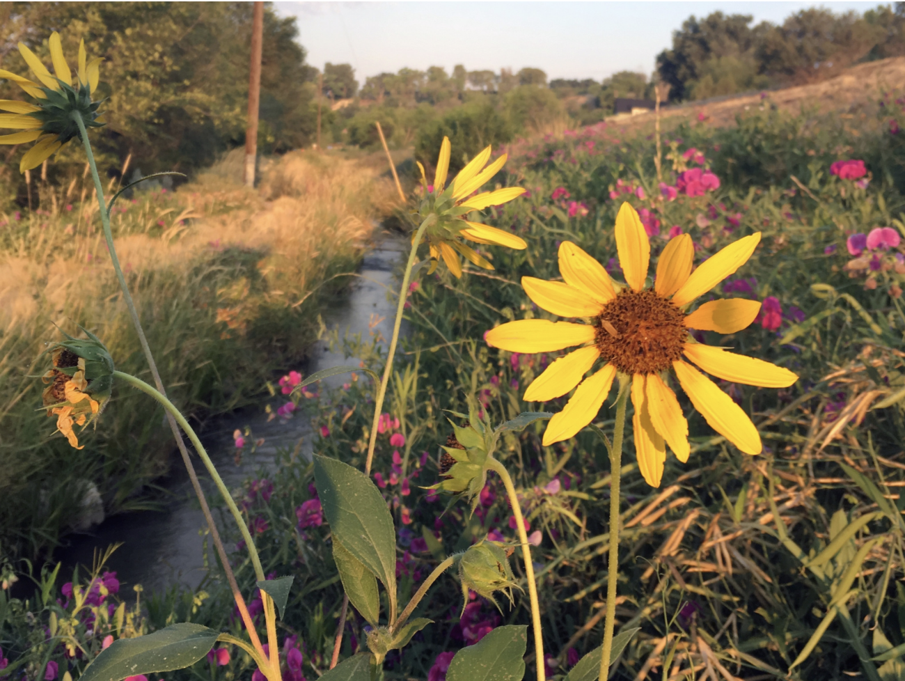
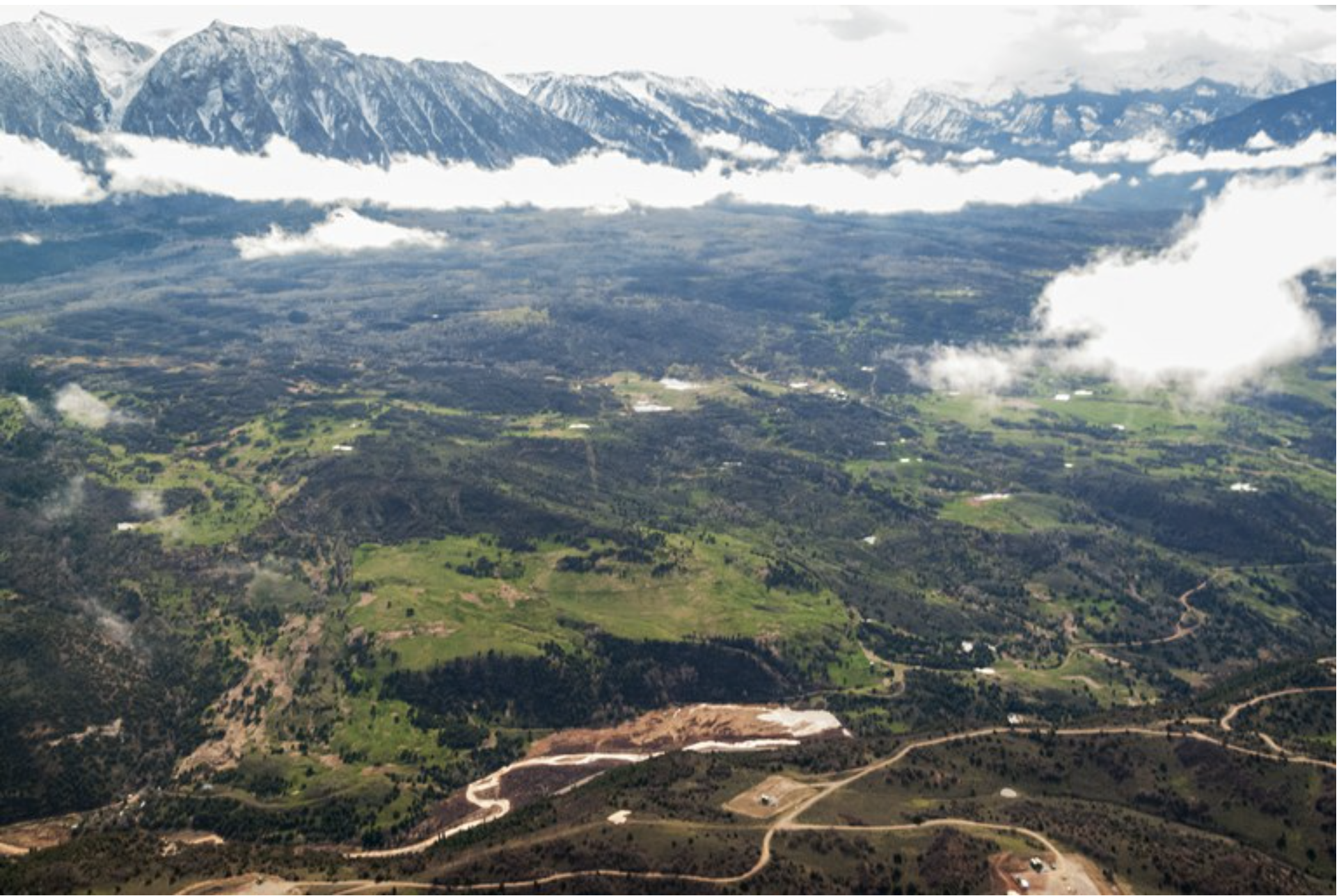


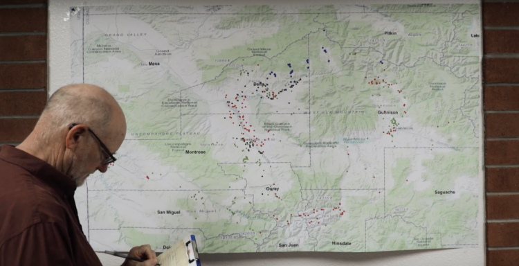

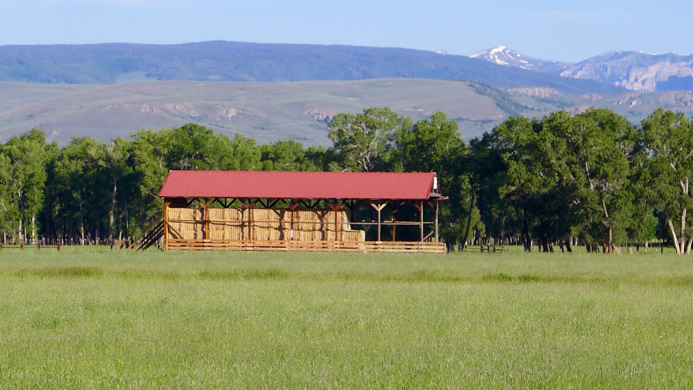

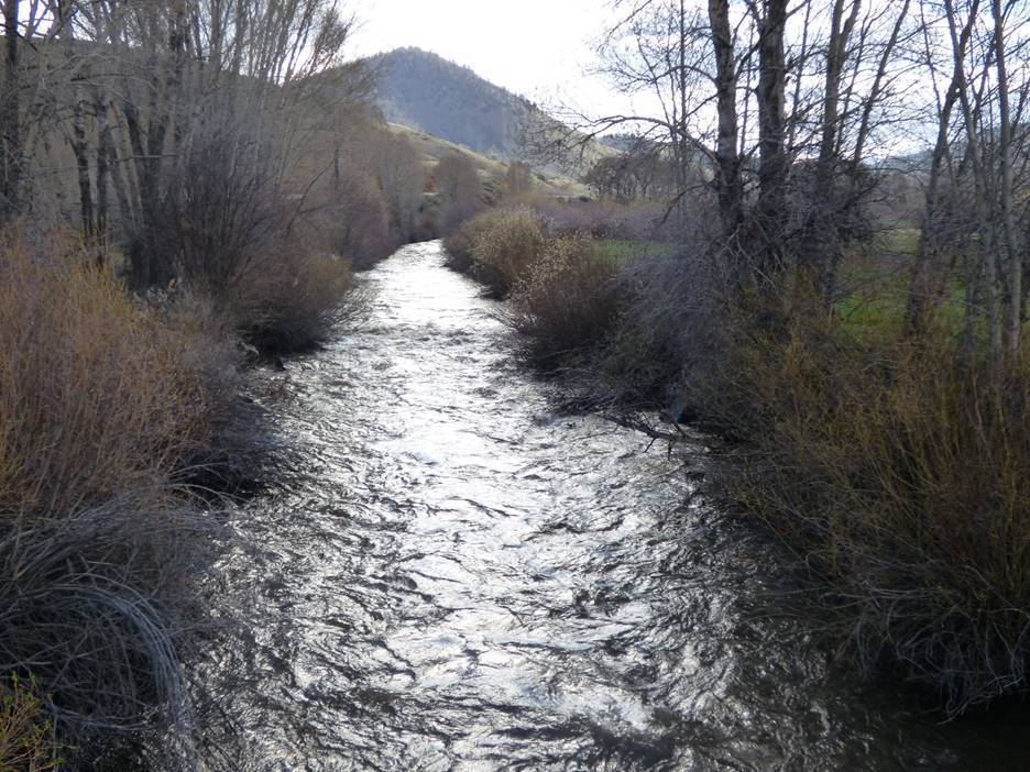


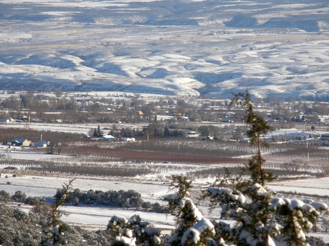


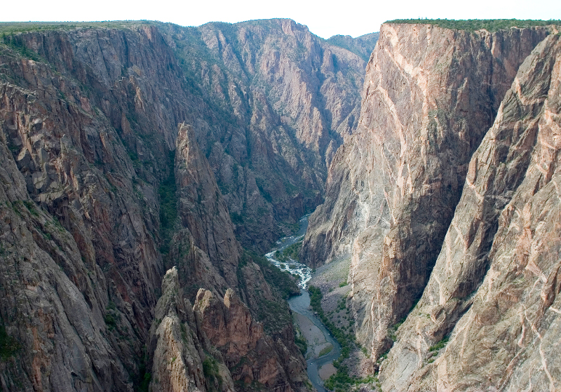

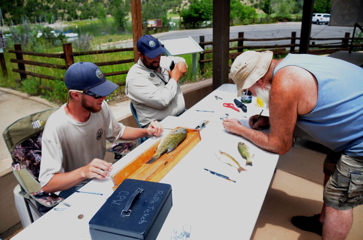


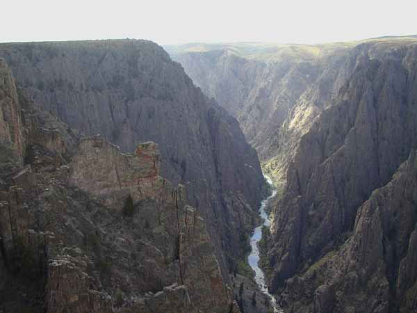
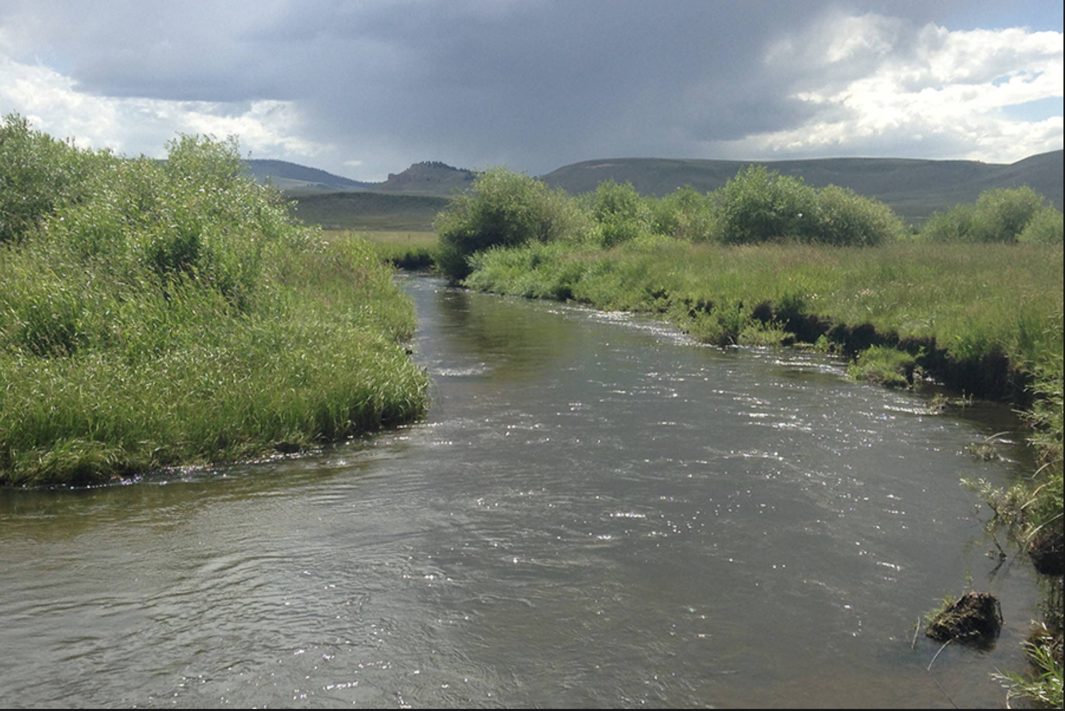

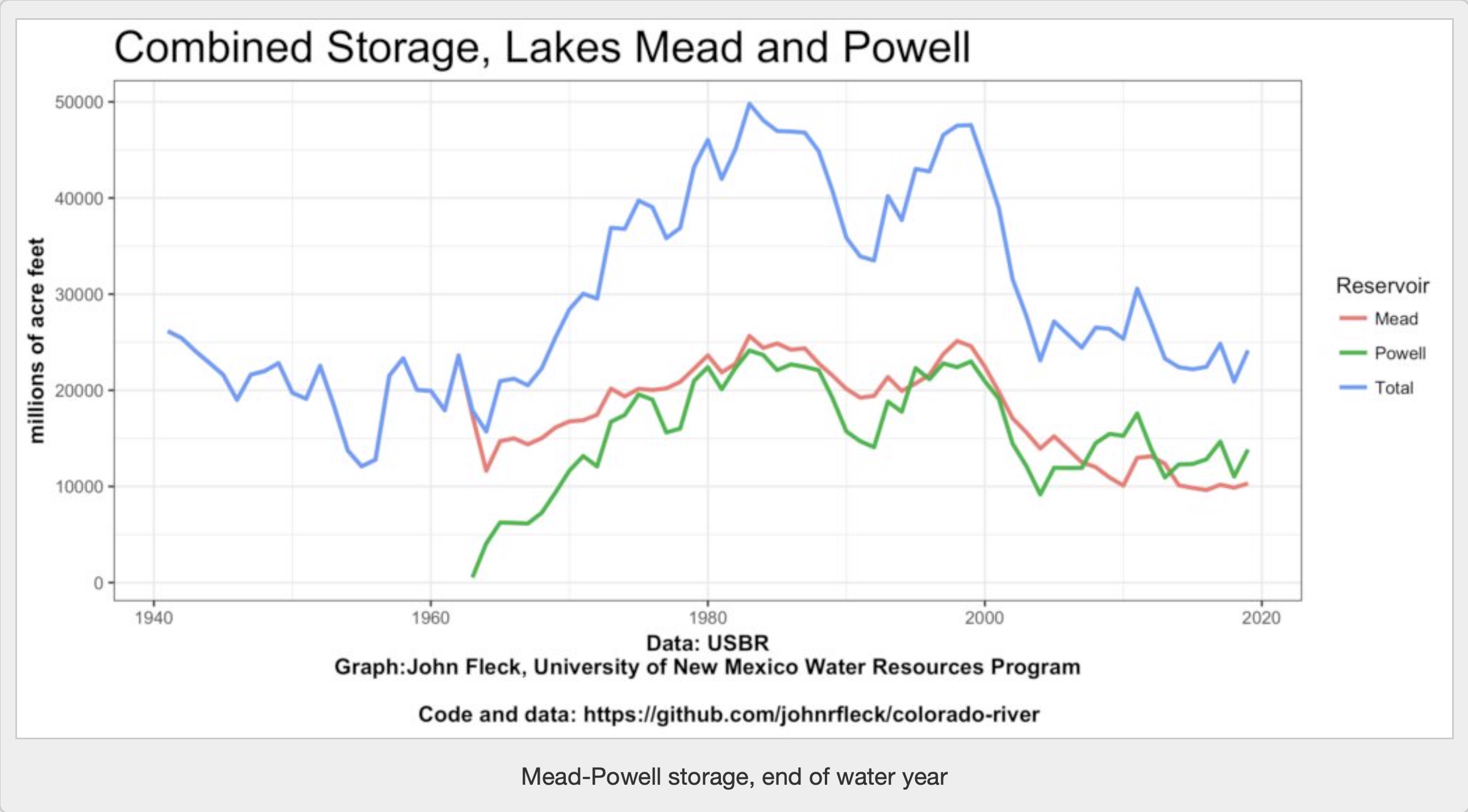
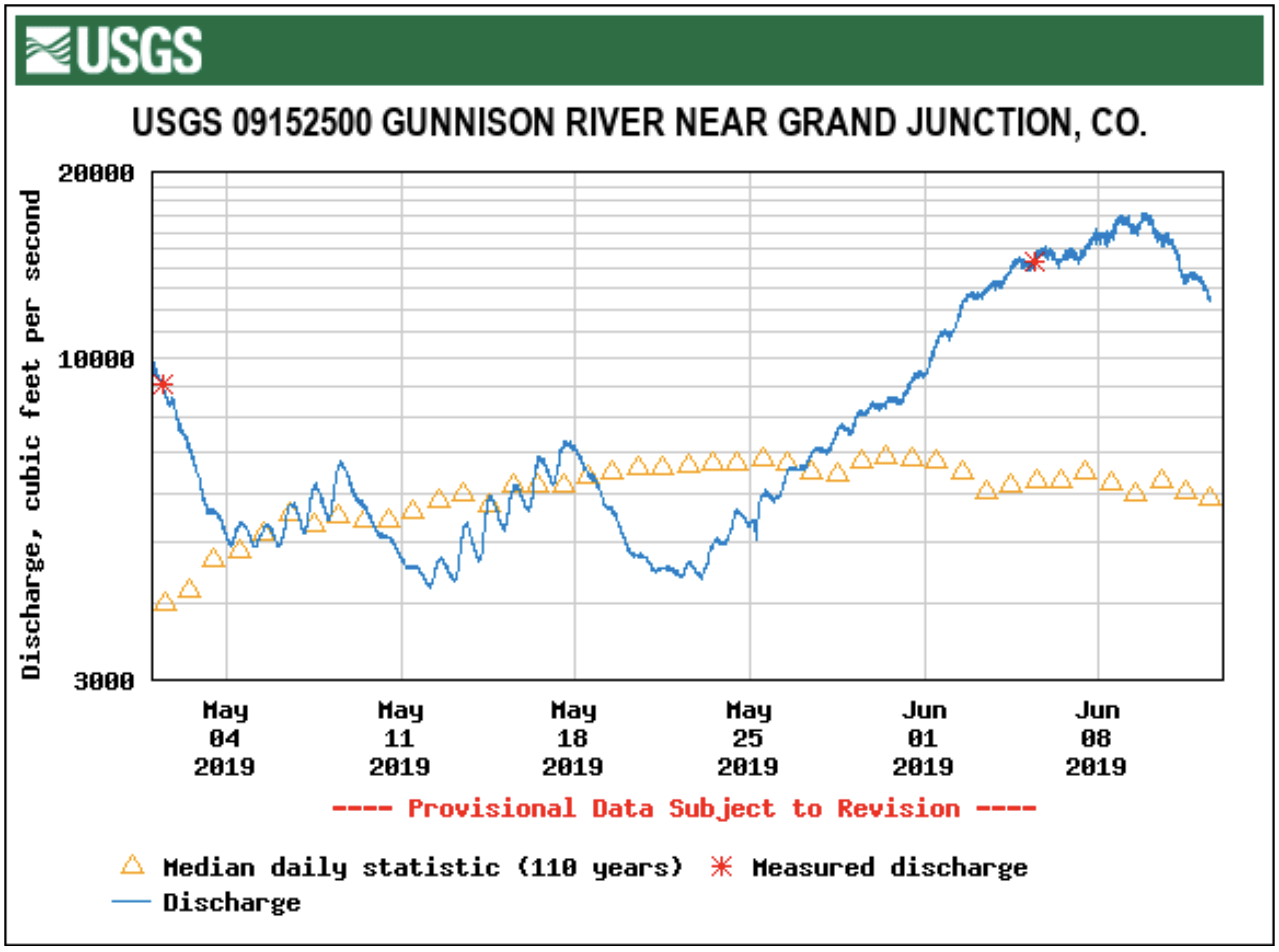
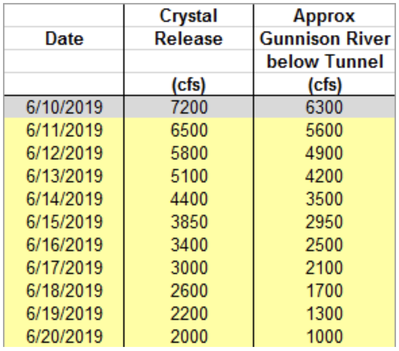


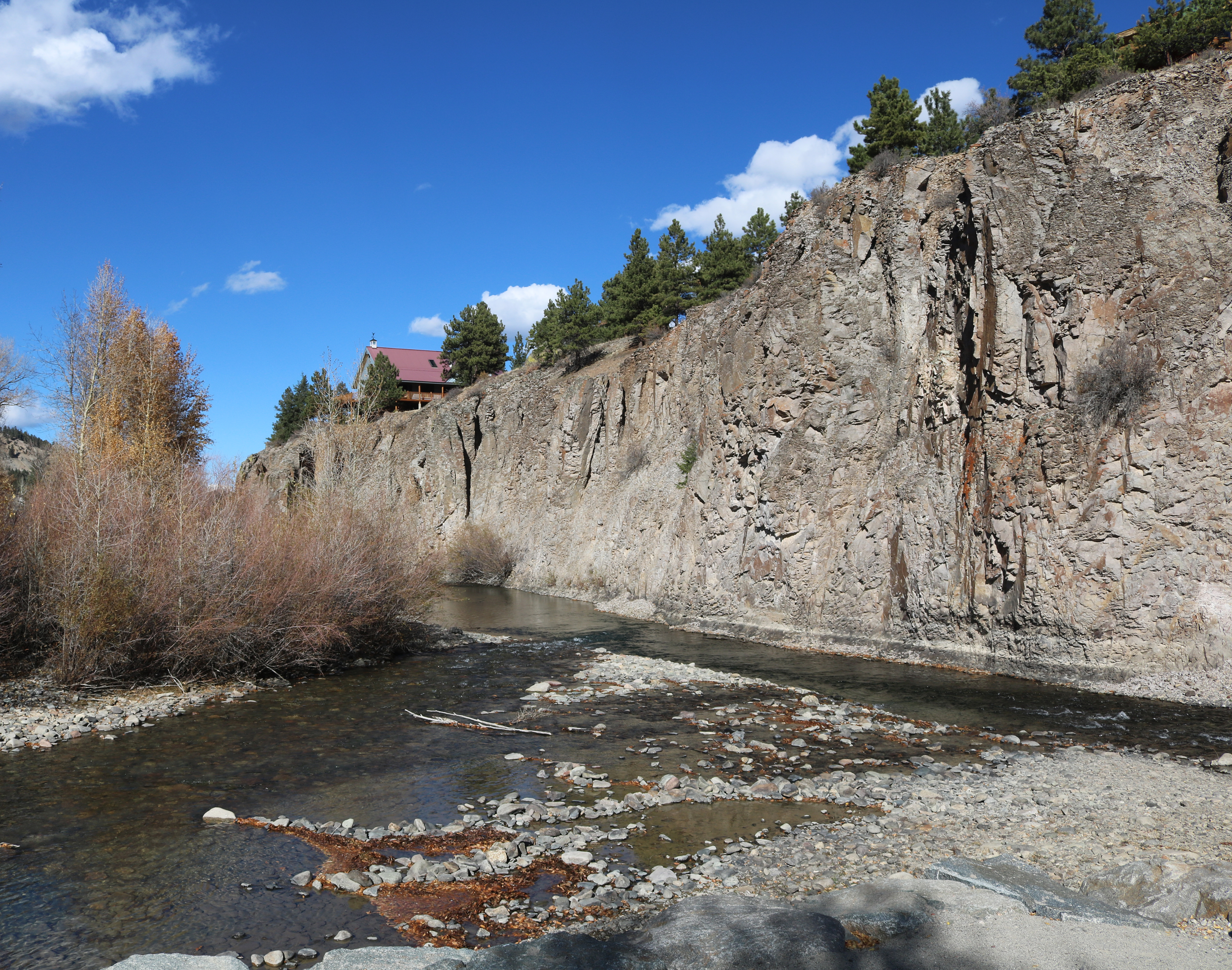
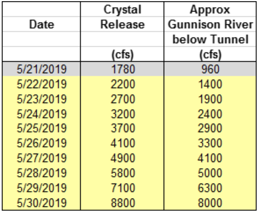
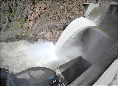


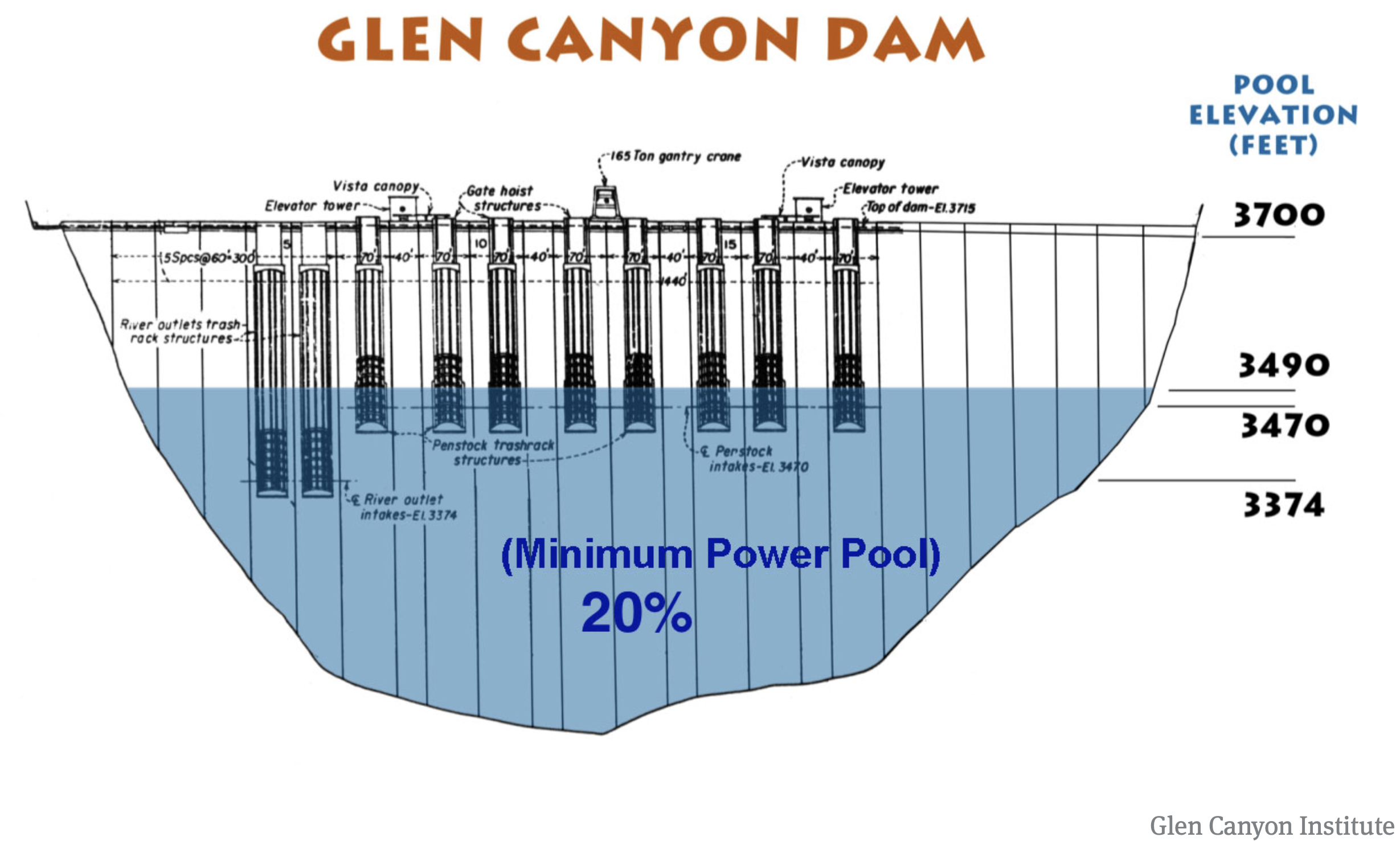
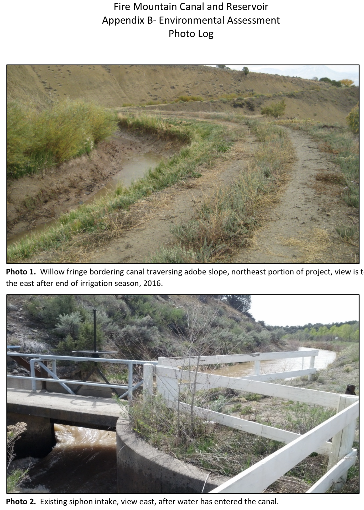
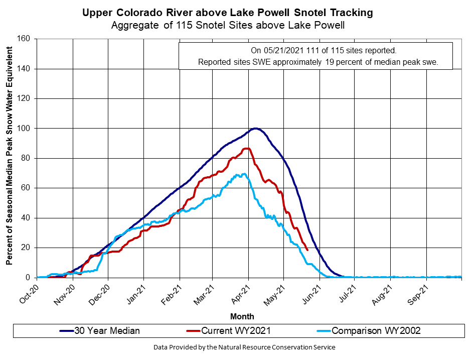