The latest briefing (April 7, 2023) is hot off the presses from Western #Water Assessment

Click the link to read the briefing on the Western Water Assessment website (scroll down):

April 7, 2023 – CO, UT, WY

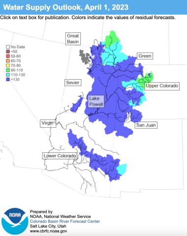
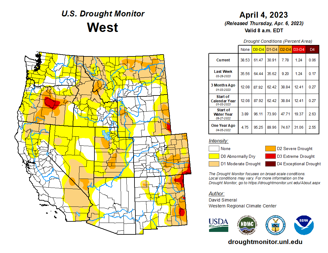
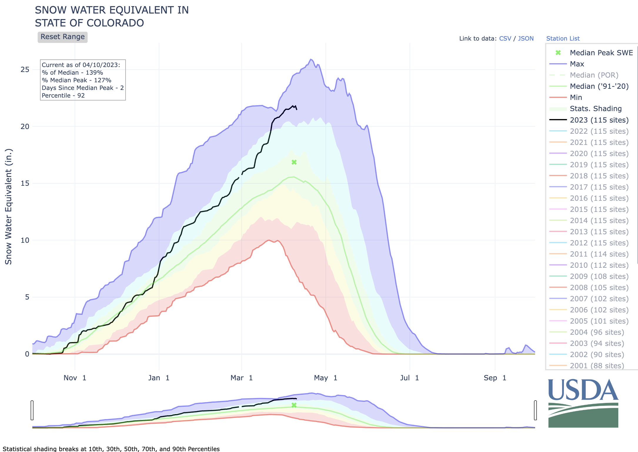
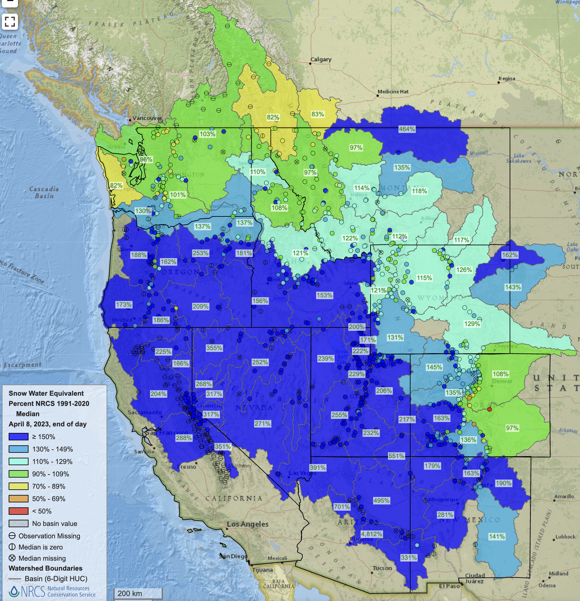
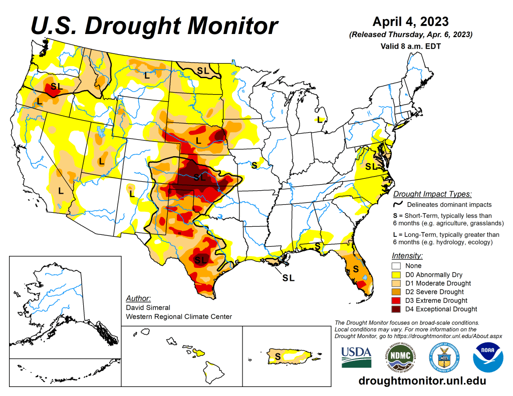
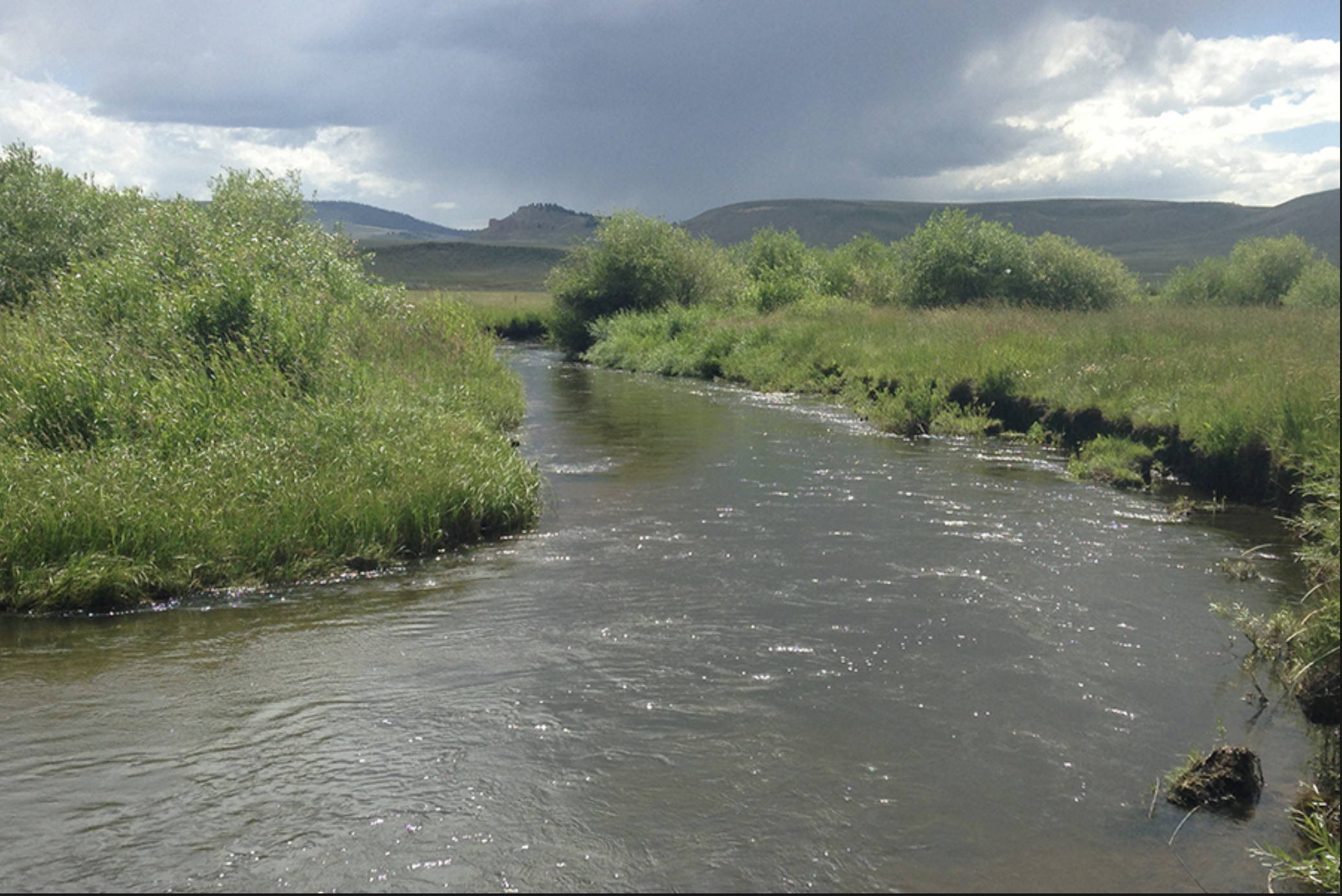
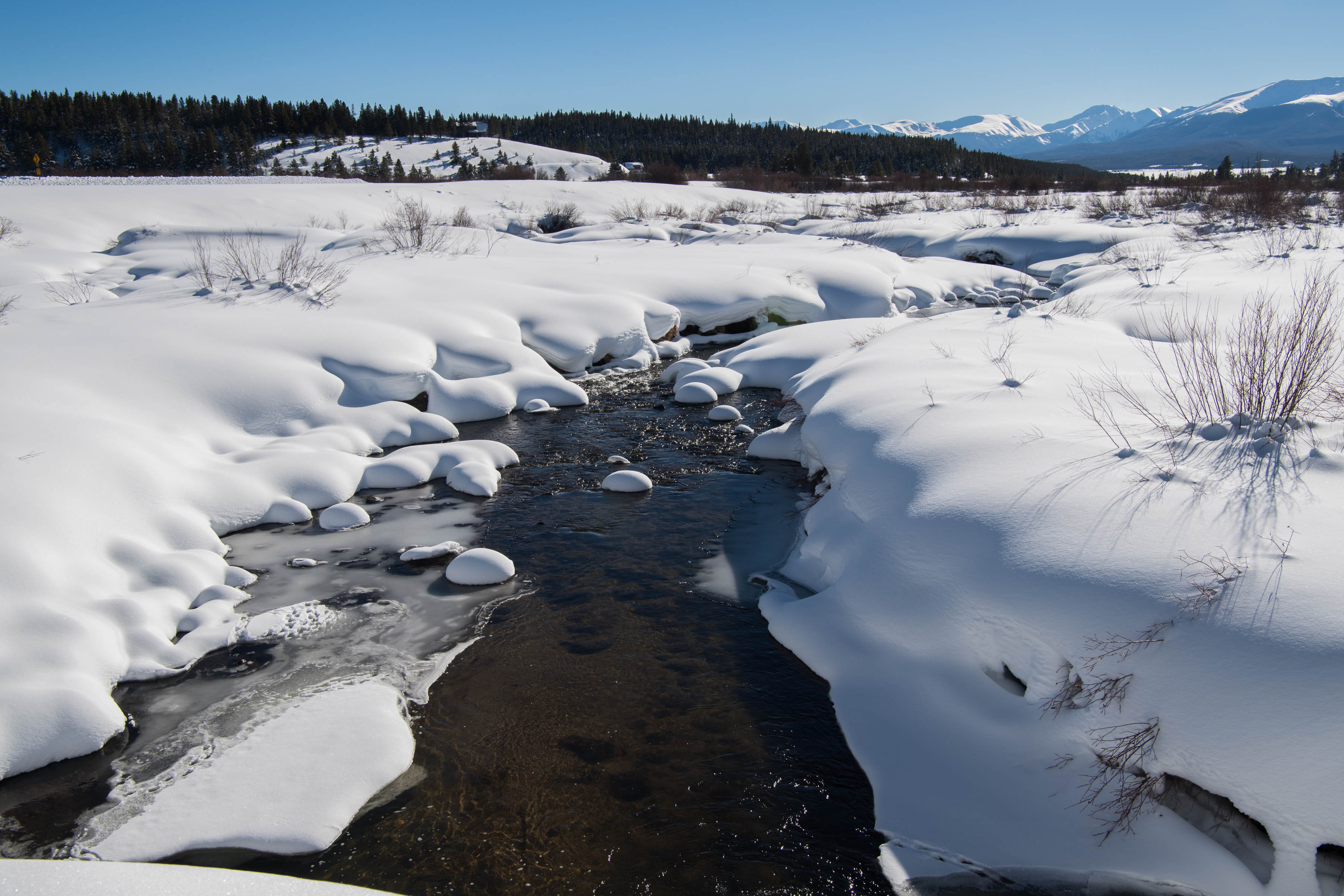
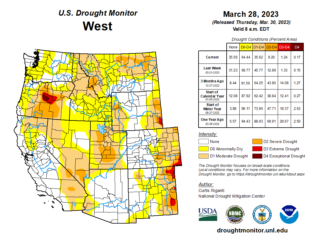
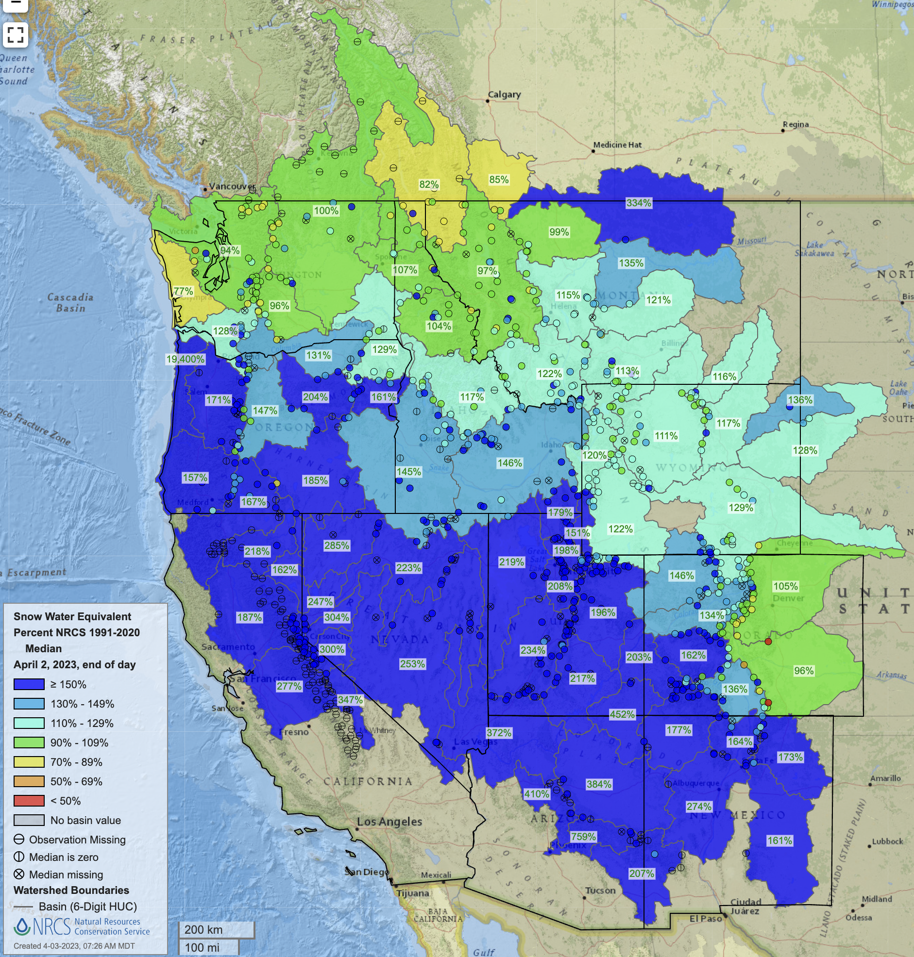
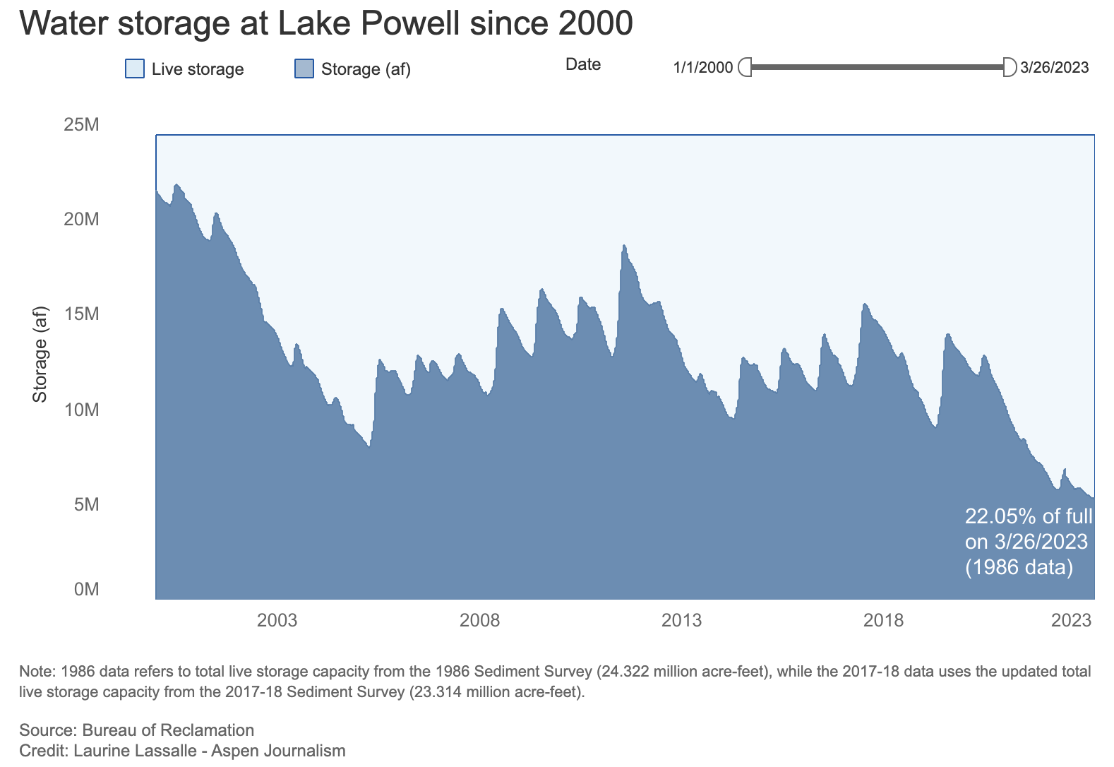
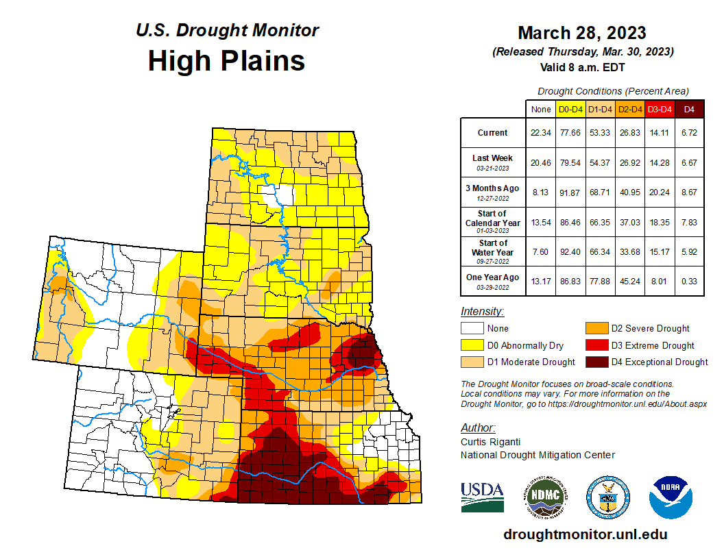
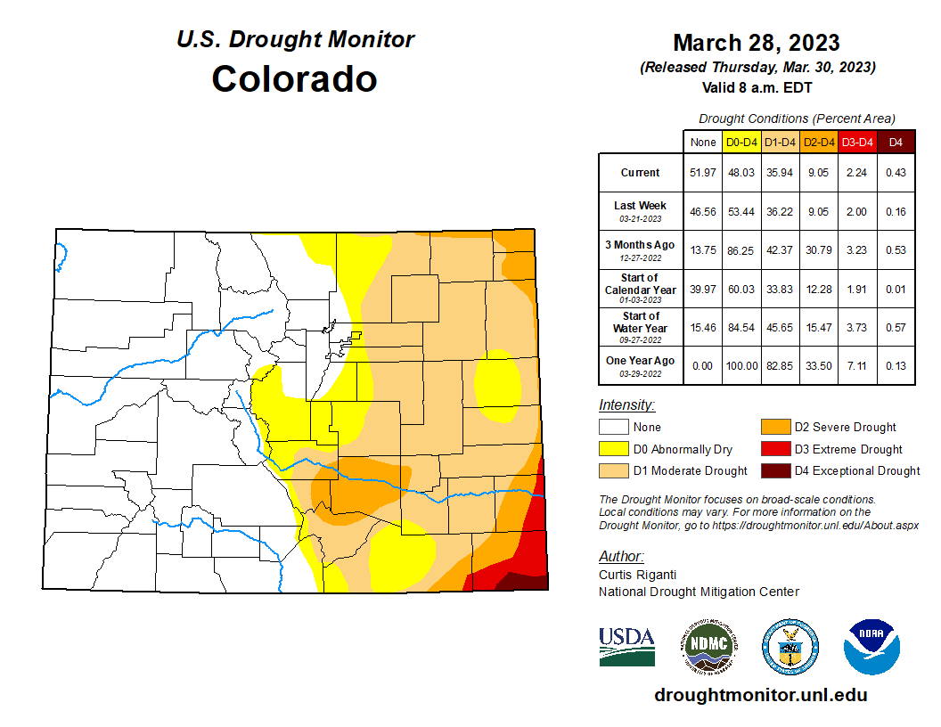
Record snowfall continued across many portions of the region during March. Record-high April 1st snow-water equivalent values were observed in Utah and western Colorado and the 2023 Utah statewide average surpassed the previous record set in 1983. Streamflow volume forecasts are above to much-above average for the Upper Colorado River and Great Basins and the inflow forecast for Lake Powell is 177% of average, providing much-needed water after record-low water levels. Regional drought conditions improved during March, especially in Utah, and 45% of the region is currently in drought. There is an increased probability of below average regional temperatures during April which would contribute to flooding risk in portions of the region with very large snowpacks. 

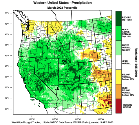
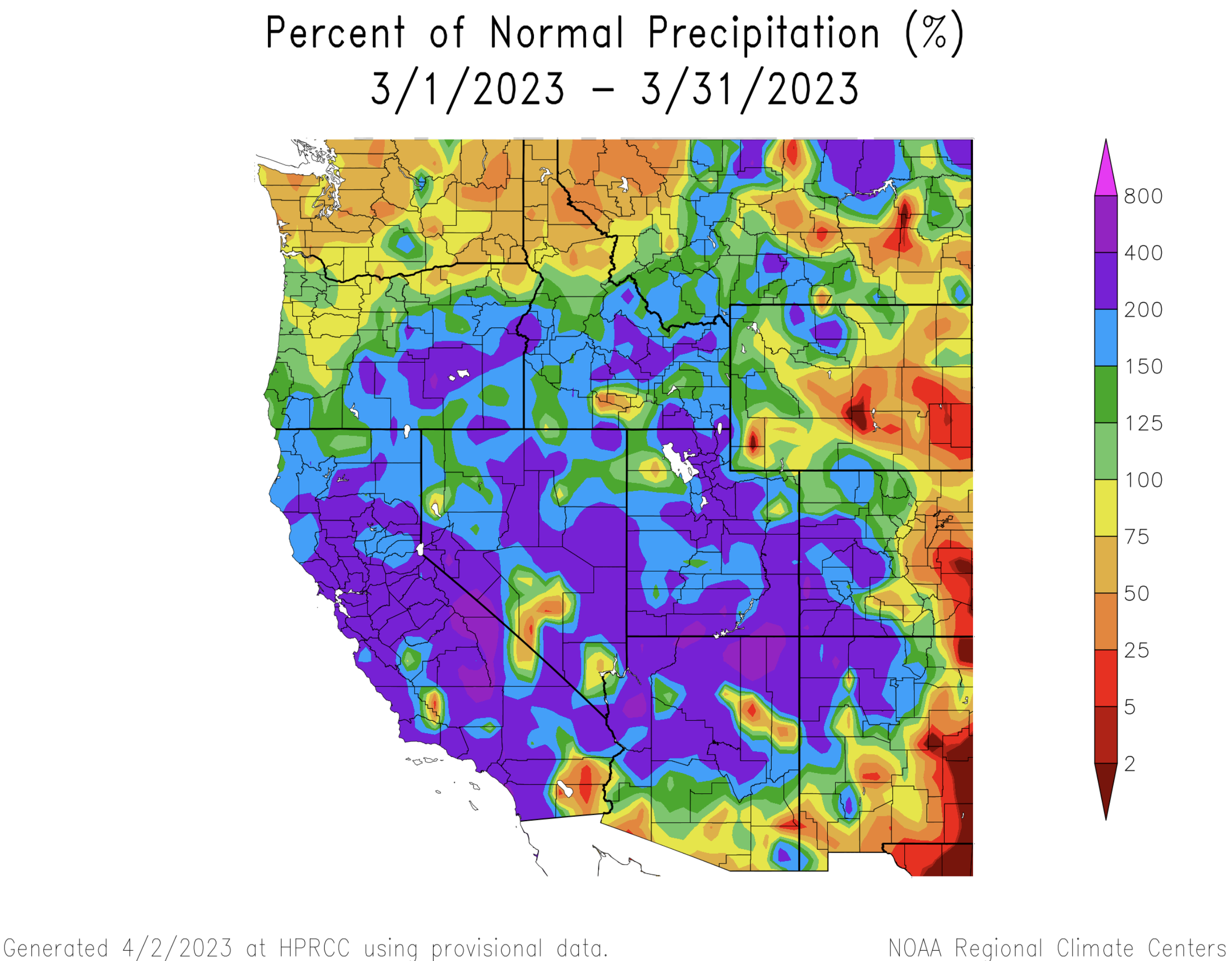
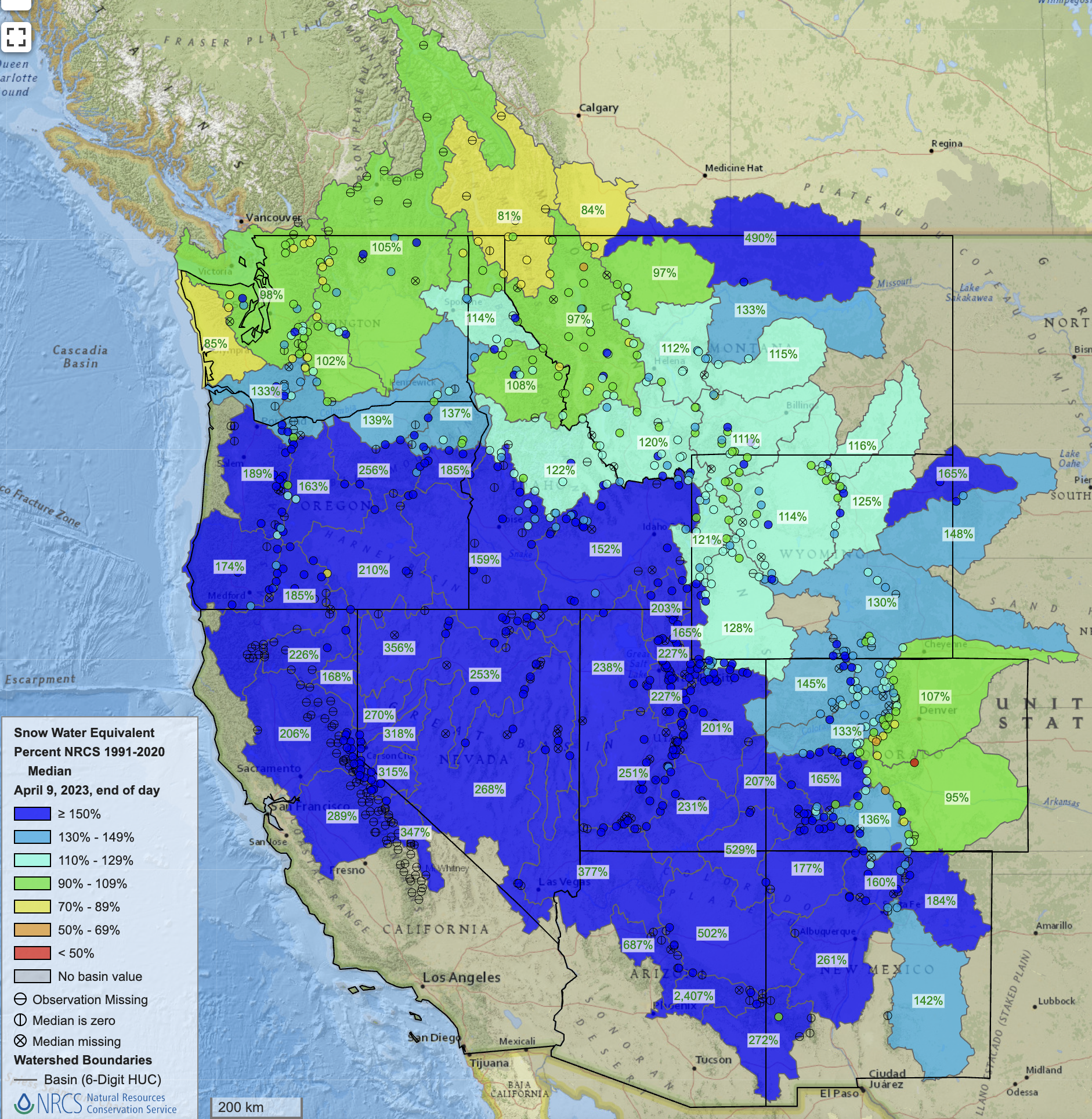
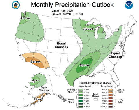
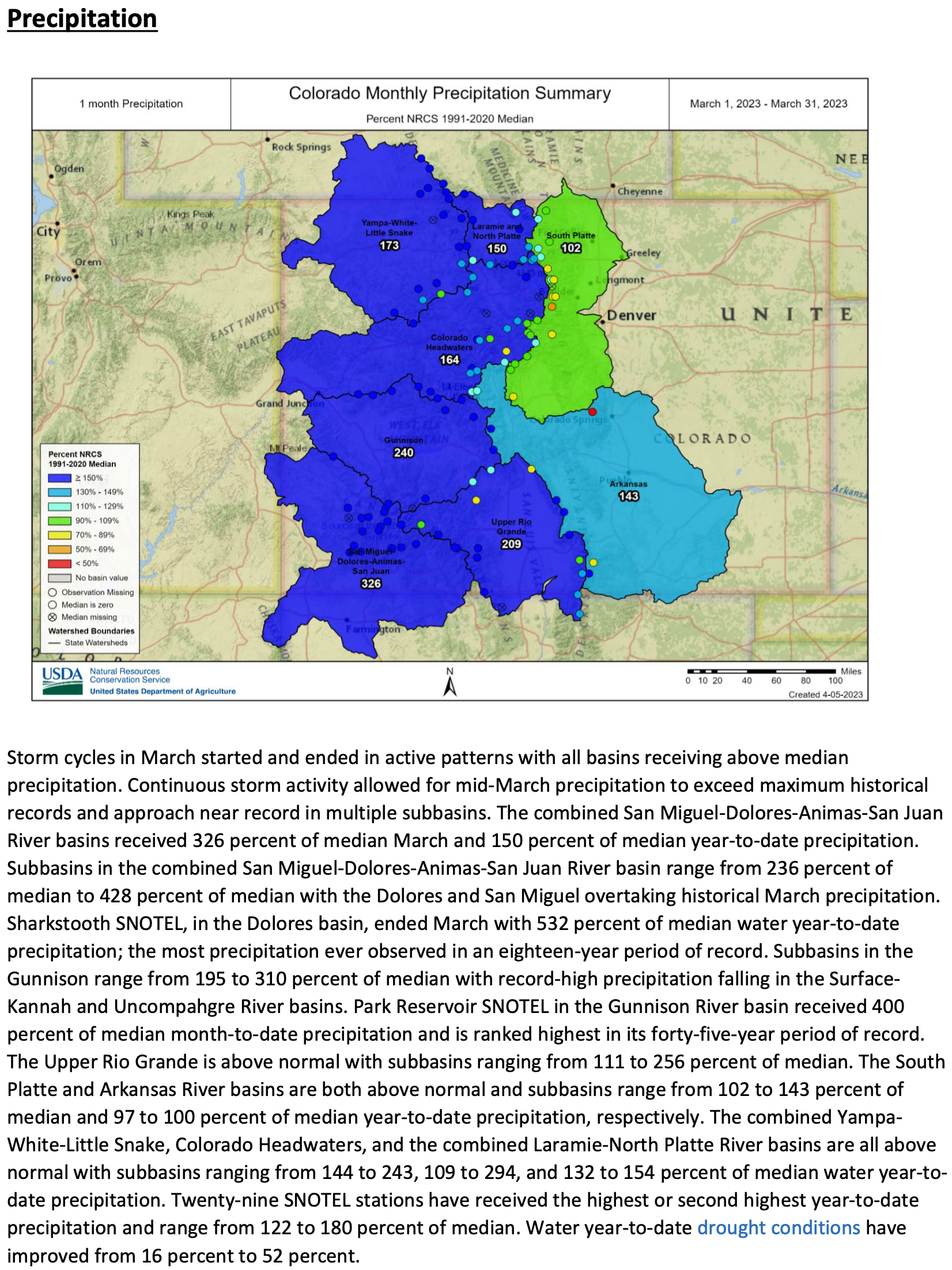
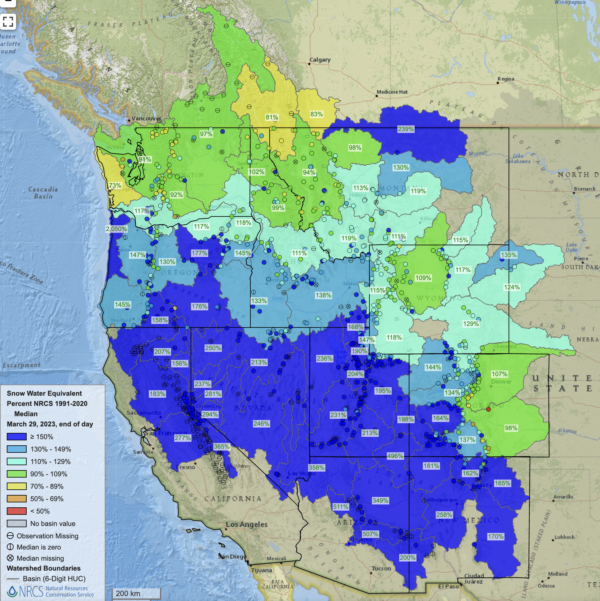
March precipitation was much-above normal in Utah and western Colorado, above normal in western Wyoming, and generally below normal in eastern Colorado and eastern Wyoming. In Utah and western Colorado, precipitation was 150-400% of normal during March; half of Utah observed 200-400% of normal March precipitation. March precipitation was 25-75% of normal for most of Colorado and Wyoming east of the Continental Divide, except for the Bighorn Mountains in northern Wyoming where March precipitation was near-normal.

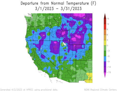
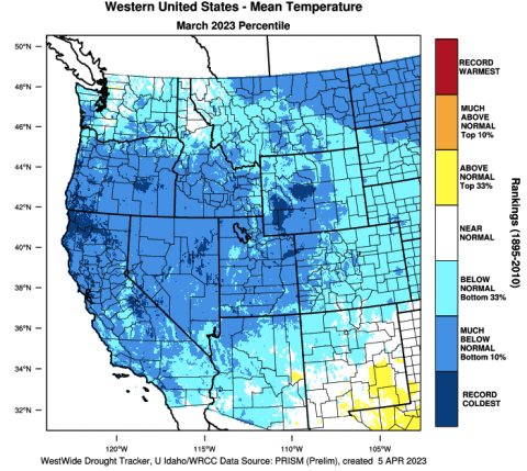
Regional temperatures were below normal during March. The coldest conditions were observed in western Wyoming where temperatures were 9-15 degrees below normal; temperatures in parts of southwestern Wyoming were the coldest on record. In Utah and northwestern Colorado, March temperatures were generally 6-12 degrees below normal and March temperatures were among the 12 coldest on record. Southeastern Colorado was the regional hot spot where temperatures were 3-6 degrees below normal.

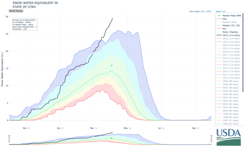
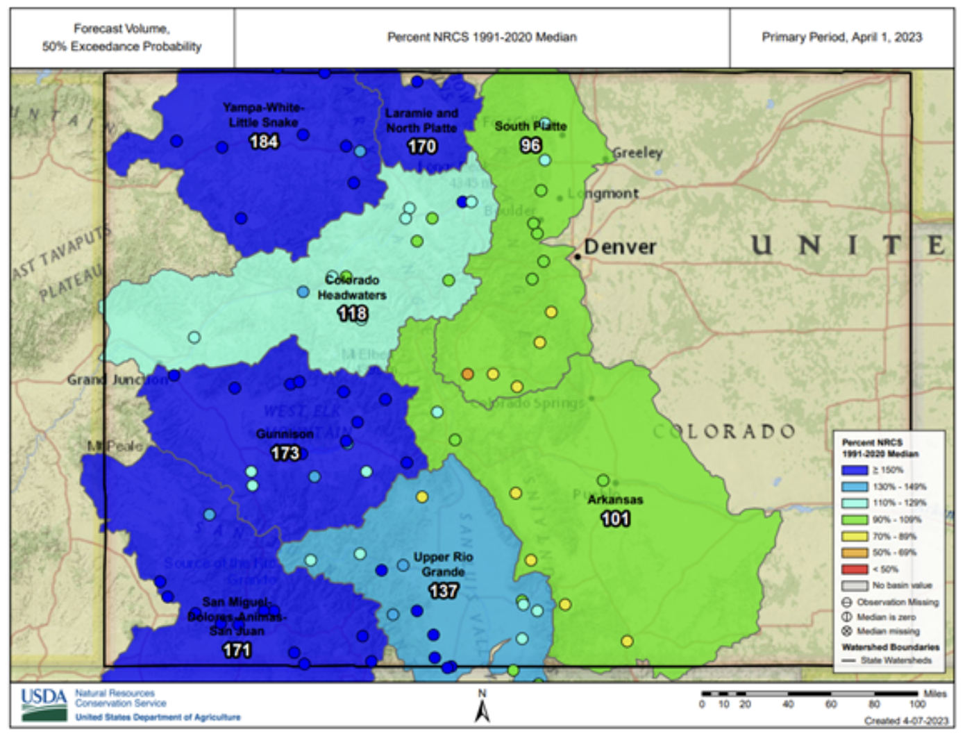
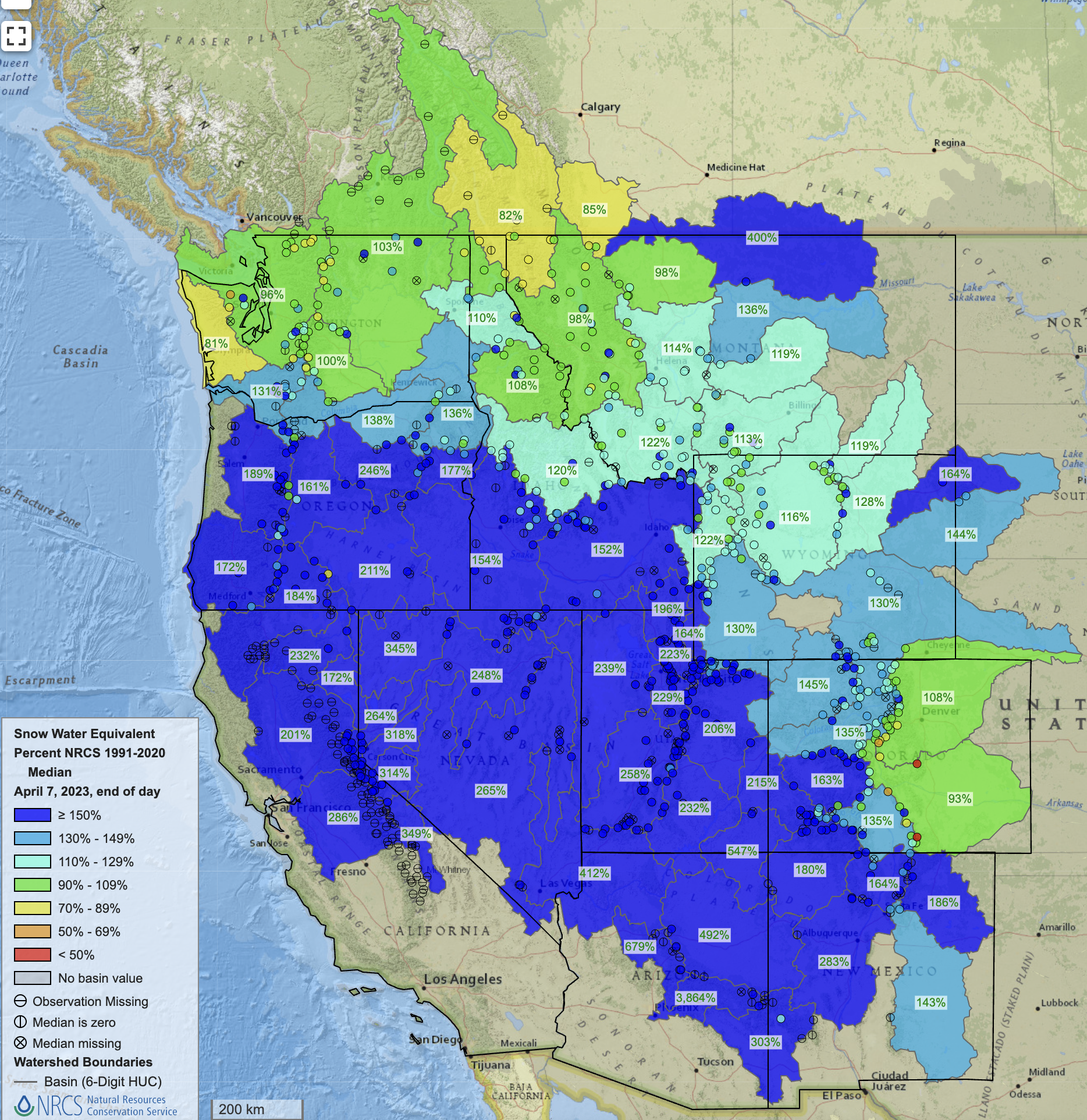
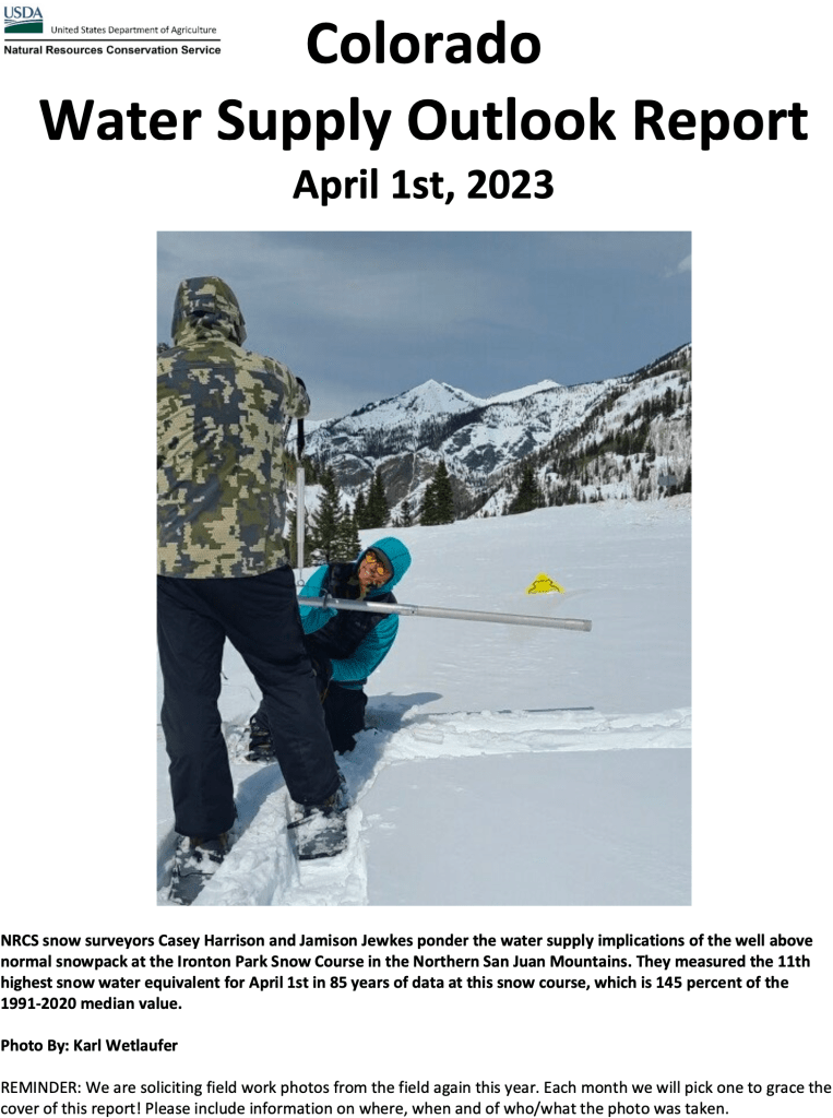
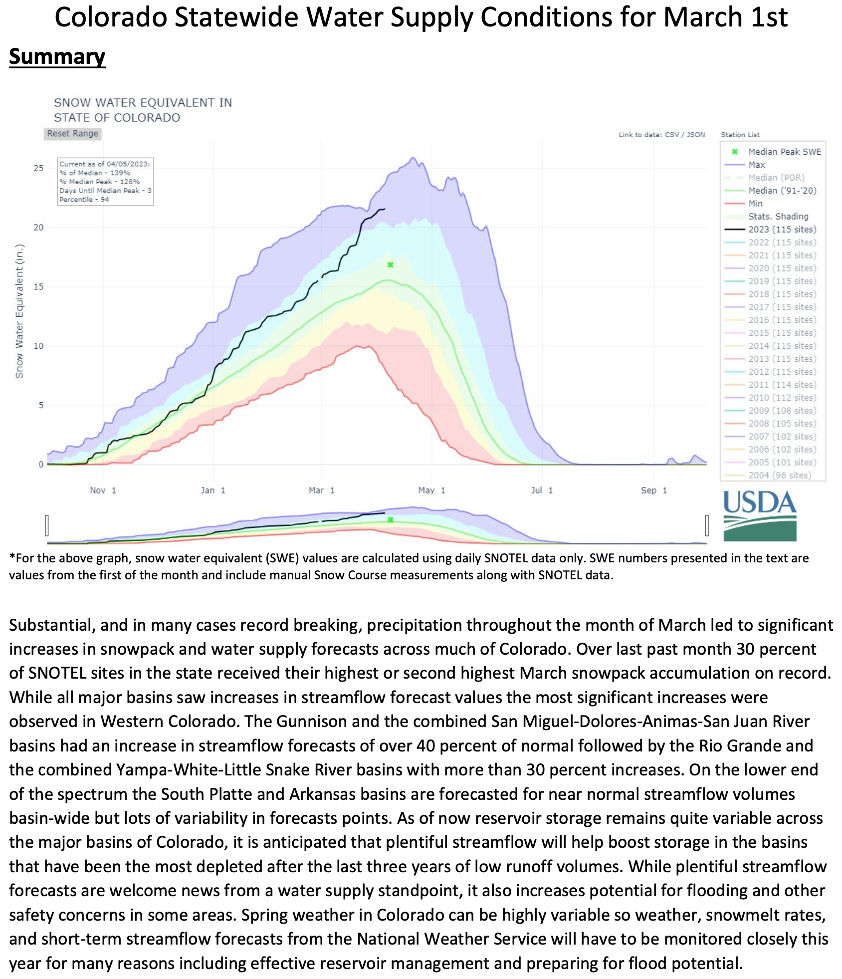
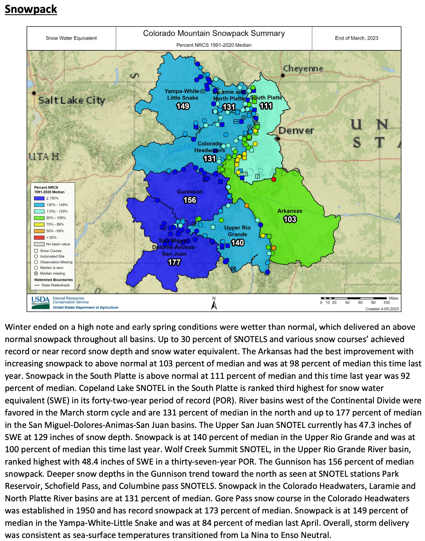
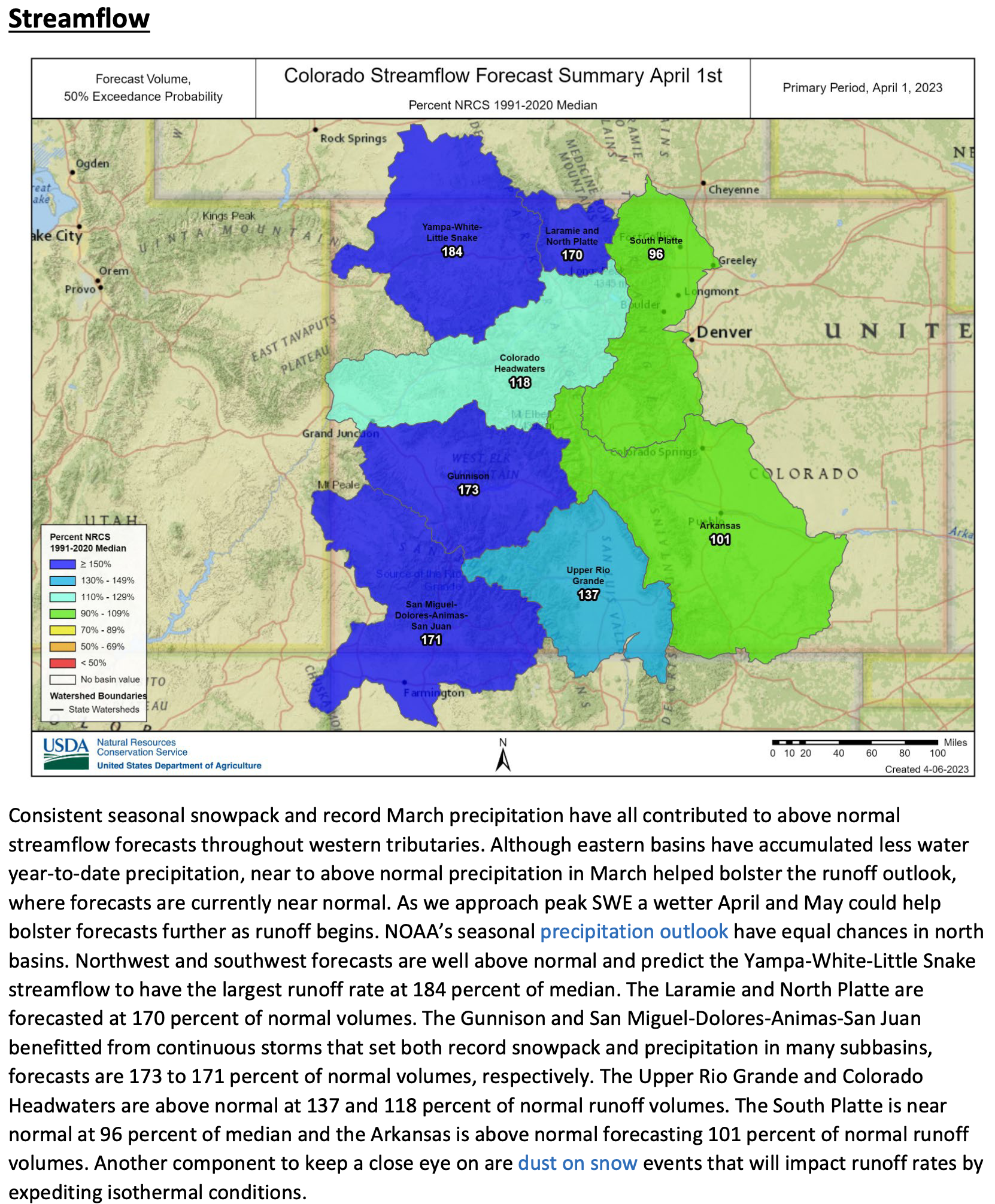
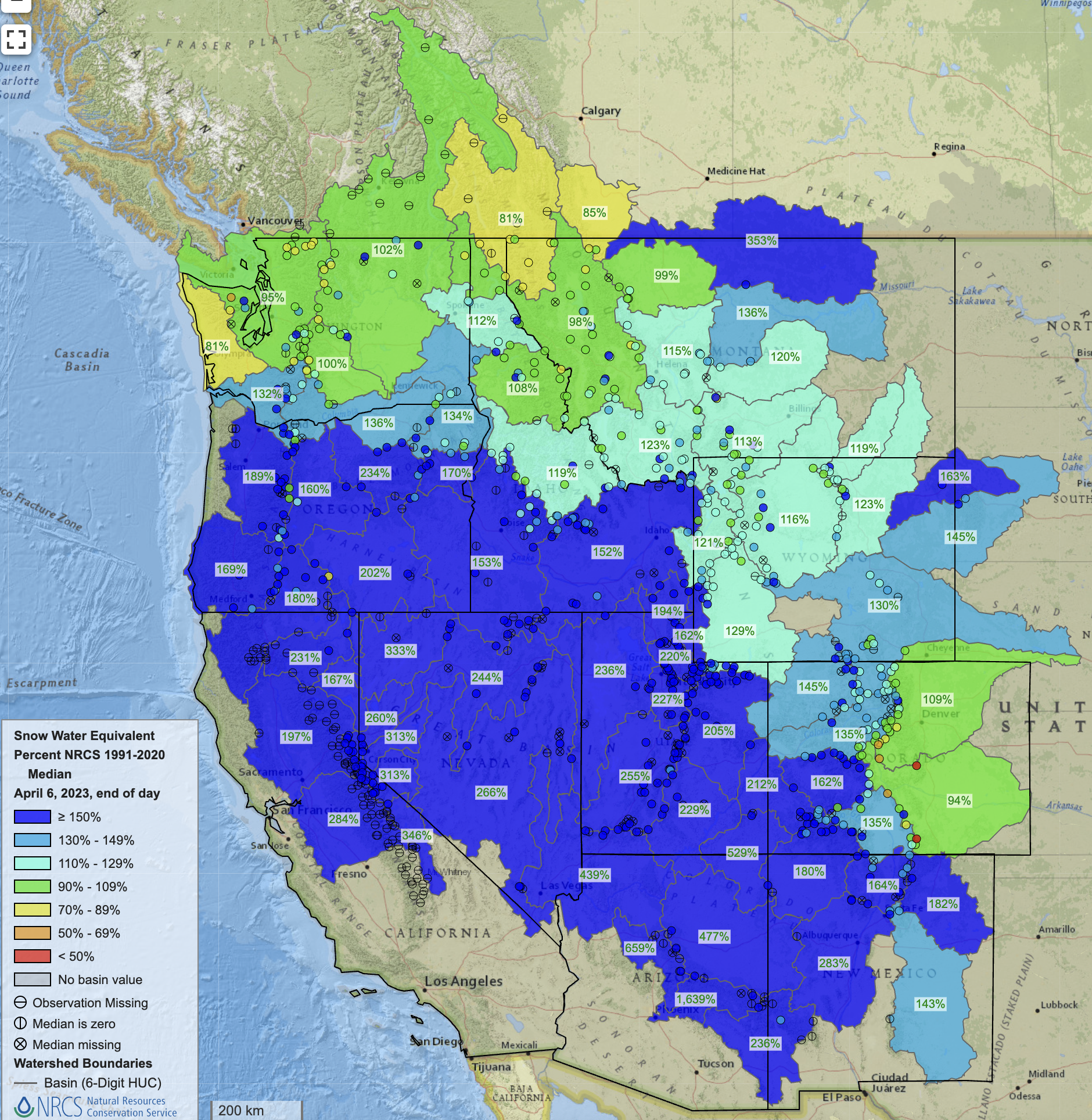
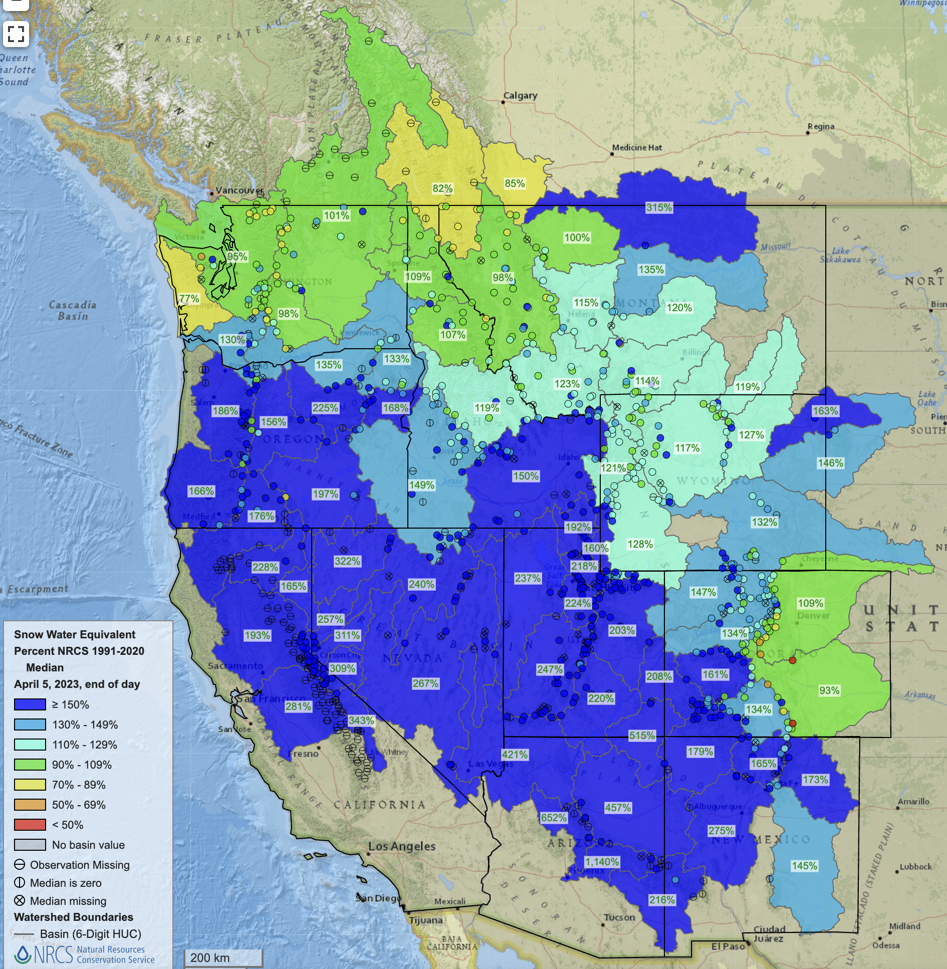
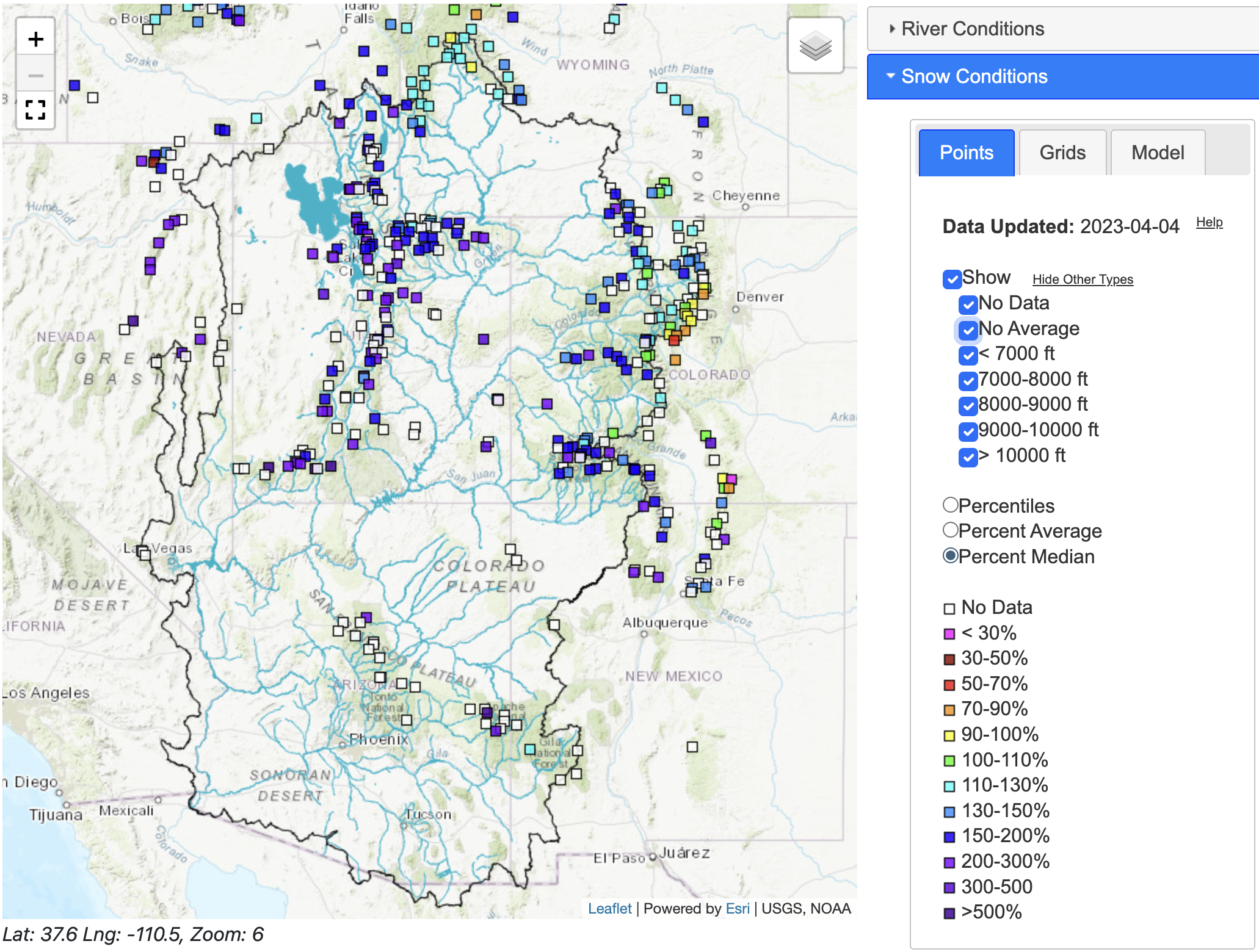
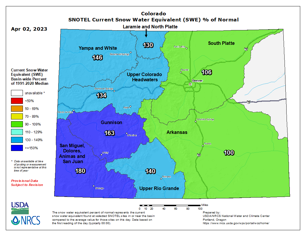
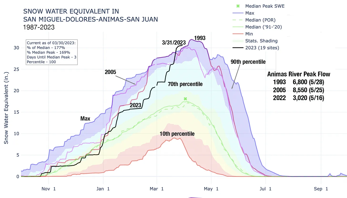
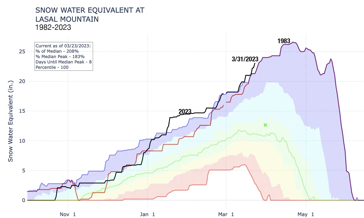
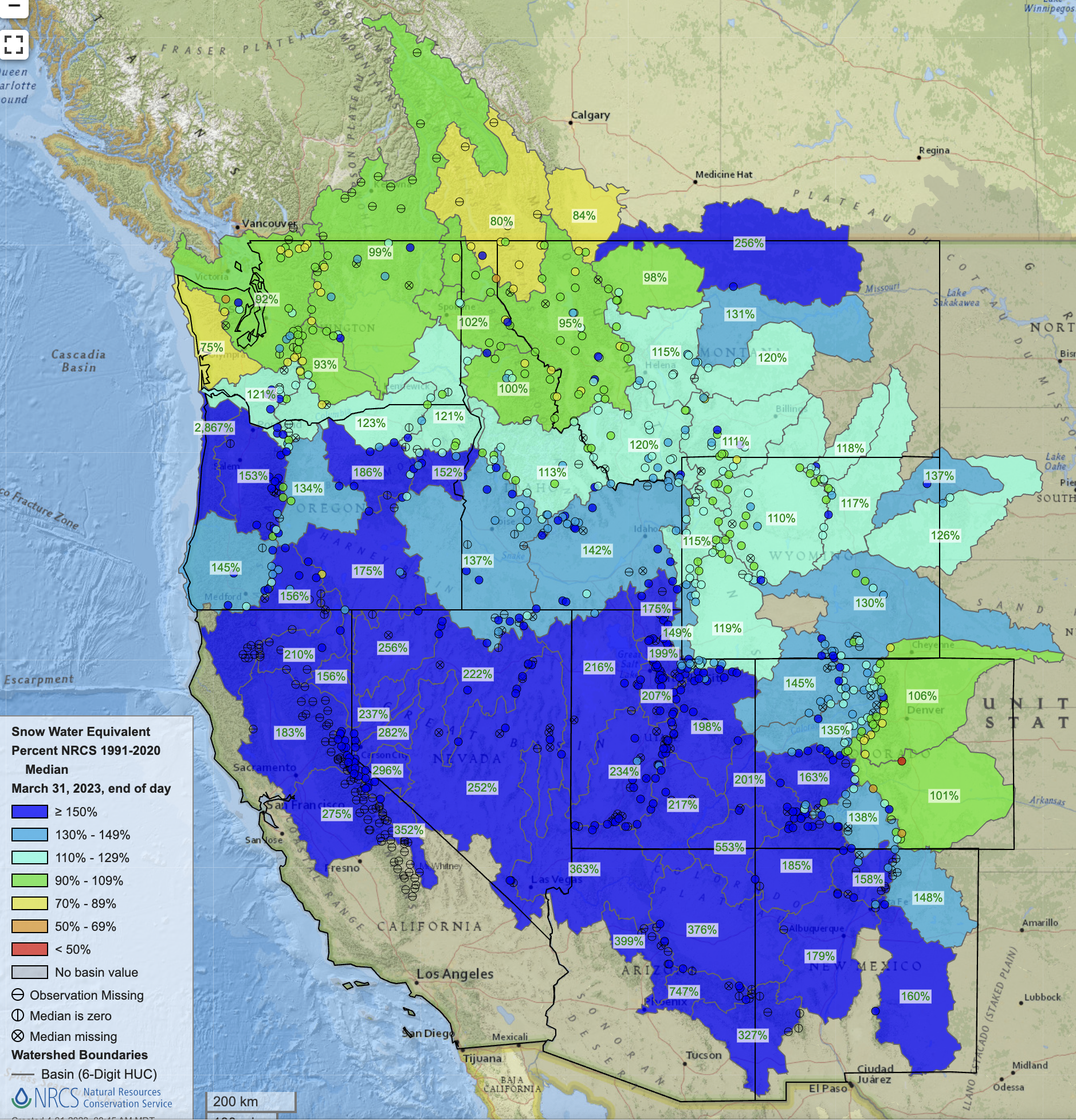
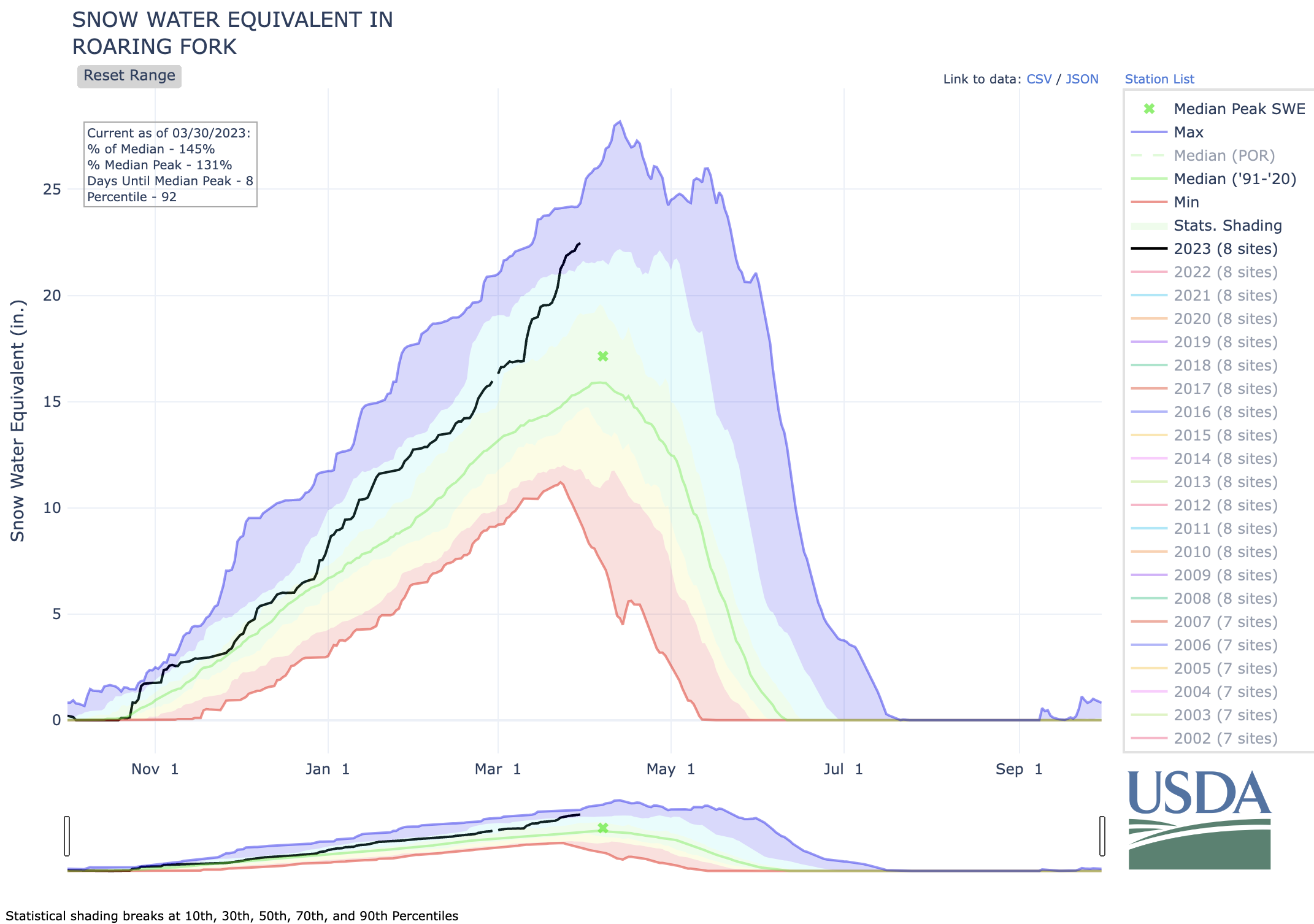
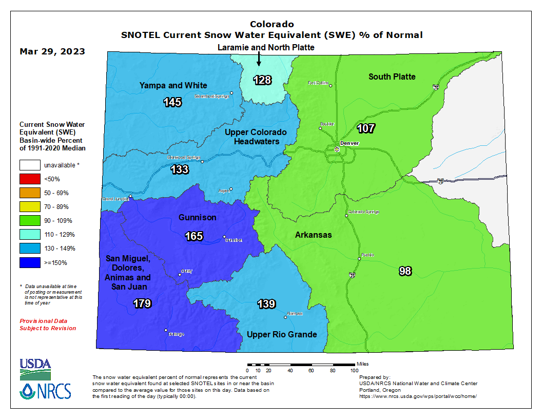
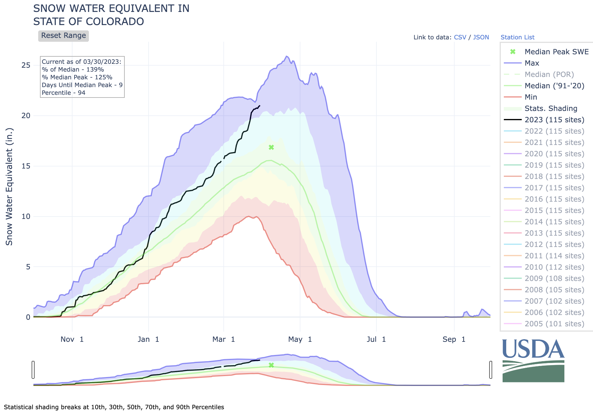
Regional snowpack is above average for the entire region except for the South Platte and Arkansas River Basins where April 1 snow-water equivalent (SWE) is near-average. For much of Utah and western Colorado, record-high SWE conditions exist. On April 1st, statewide average SWE in Utah was 197% of normal and average SWE was 28.4โ€, shattering the previous statewide SWE record of 26โ€ set in 1983. In Colorado, April 1st statewide SWE was 140% of average. Snowpack in Colorado was generally near-normal east of the Continental Divide and much-above normal west of the Divide, including the Dolores River Basin which is at a record-high 165% of average. Wyoming snowpack is above normal statewide (117% average) with near-normal April 1st SWE in the Bighorn, Upper Green, Shone [ed. Shoshone?], and Yellowstone River Basins and above average SWE conditions across the remainder of Wyoming.

West snowpack basin-filled map April 9, 2023 via the NRCS.

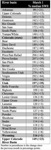
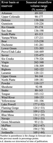
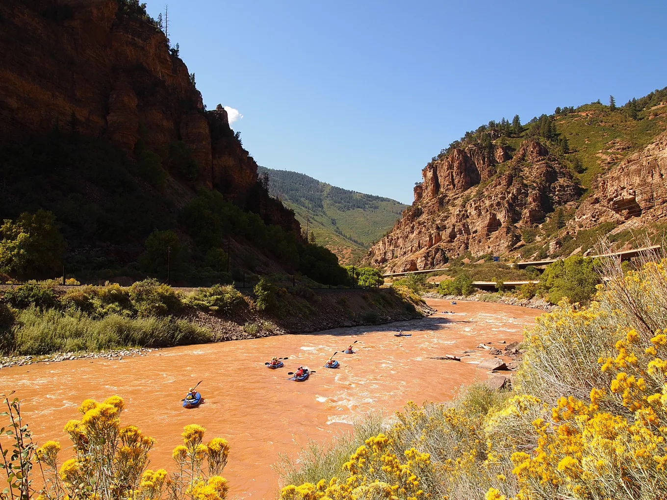
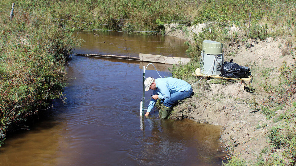
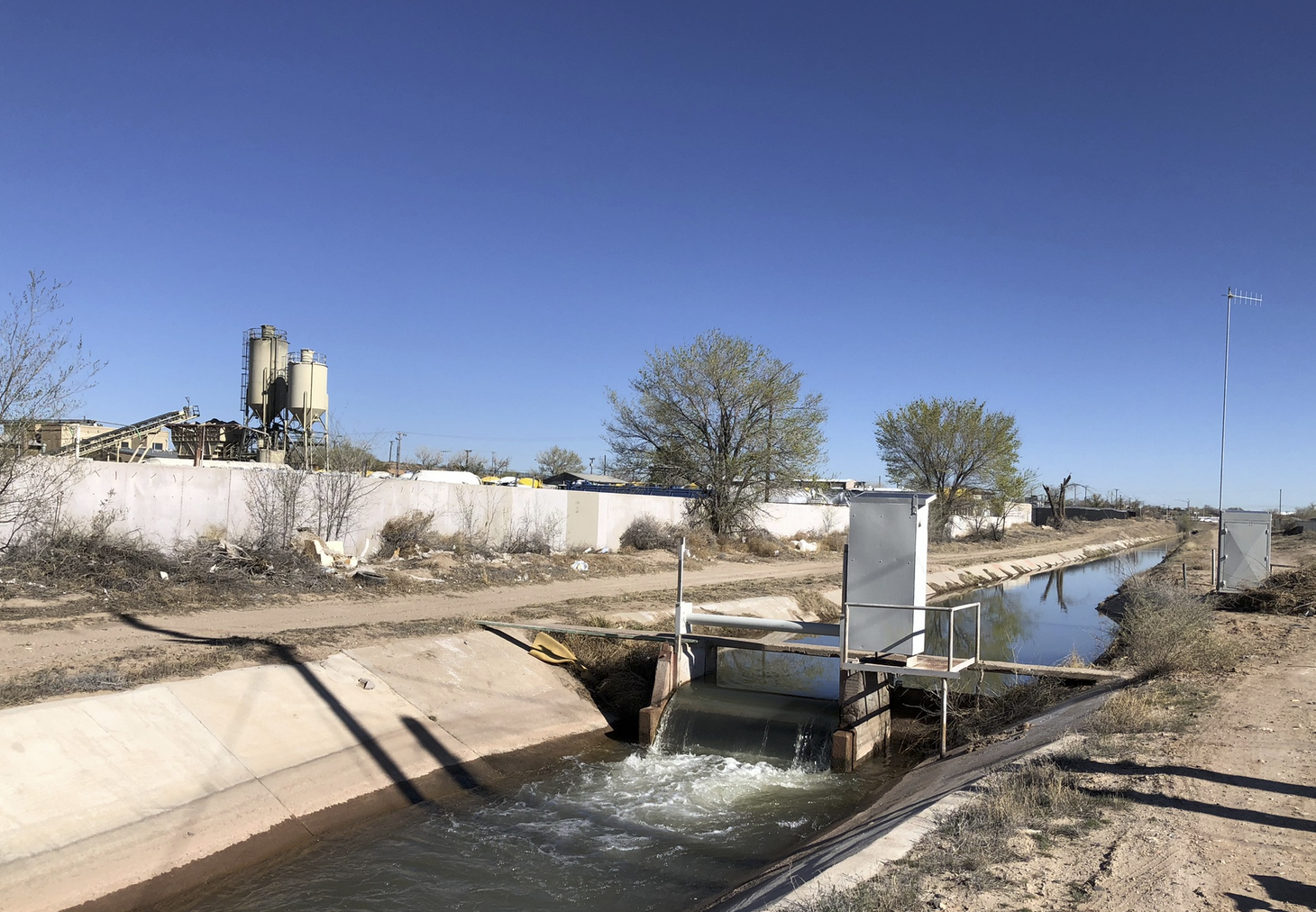
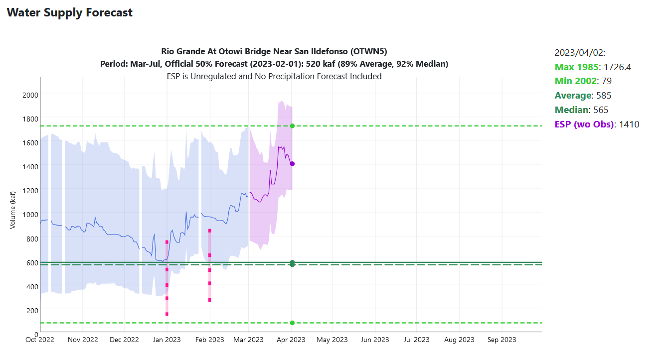
Seasonal streamflow volume forecasts are above average to much-above average for most regional river basins. Streamflow forecasts are highest for the Great Basin where forecasted volumes are 115-450% of average. Below normal (60-90%) to near-normal (90-110%) seasonal streamflow volumes are forecasted for the Arkansas, South Platte, Shoshone, Tongue, and Yellowstone Rivers. Above normal seasonal streamflow (110-130%) is forecasted for the Bighorn, Laramie, Powder, and Wind Rivers. Much-above normal seasonal streamflow (>130%) is forecasted for the remaining regional river basins, with streamflow forecasts above 300% for the Lower Green, Provo/Utah Lake, Sevier, Six Creeks, Virgin, and Weber Rivers. Seasonal streamflow forecasts for most large Upper Colorado River Basin reservoirs are much-above normal with only near-to-above normal forecasts for Green Mountain, Fontenelle, and Flaming Gorge Reservoirs. The inflow forecast for Lake Powell is 177% of normal.

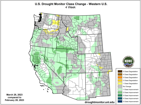
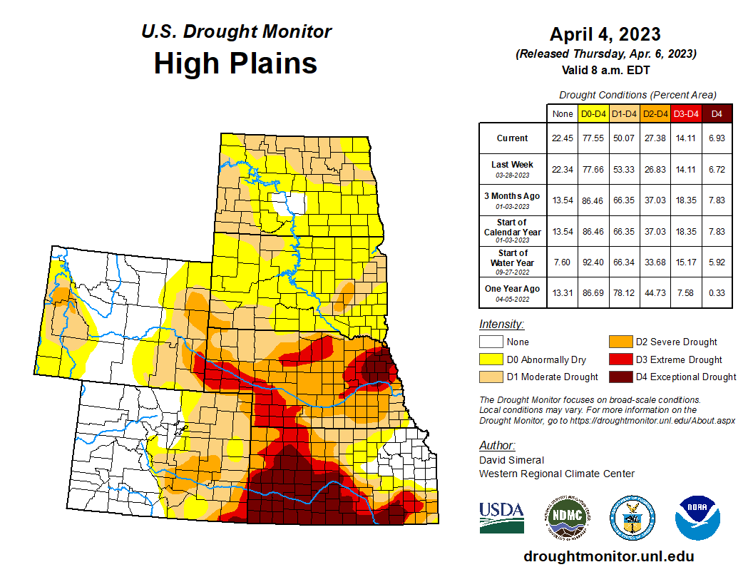
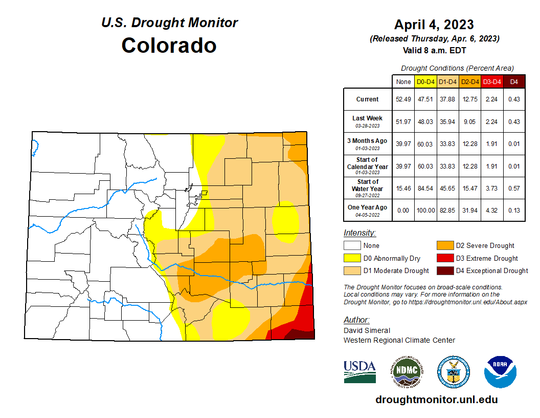
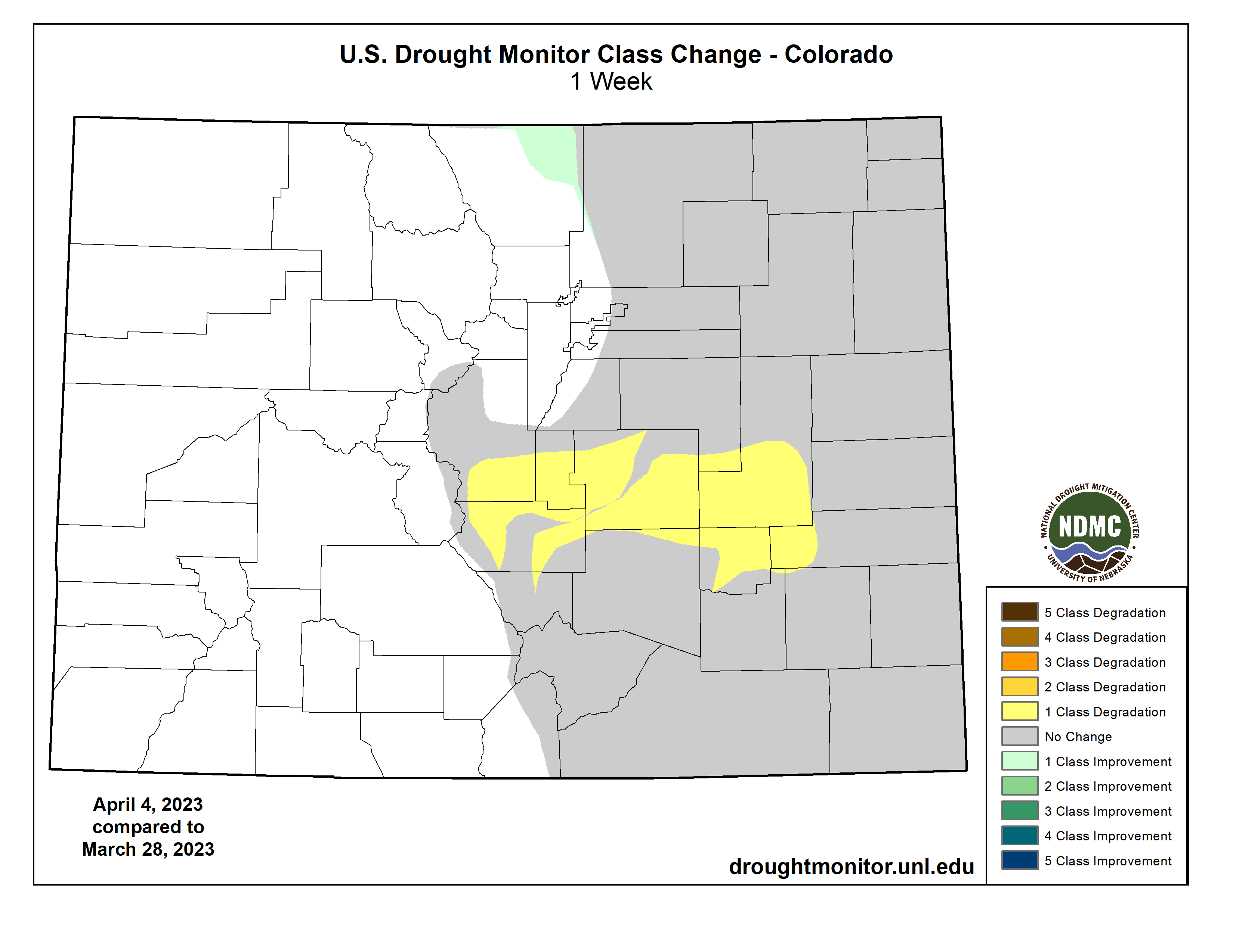
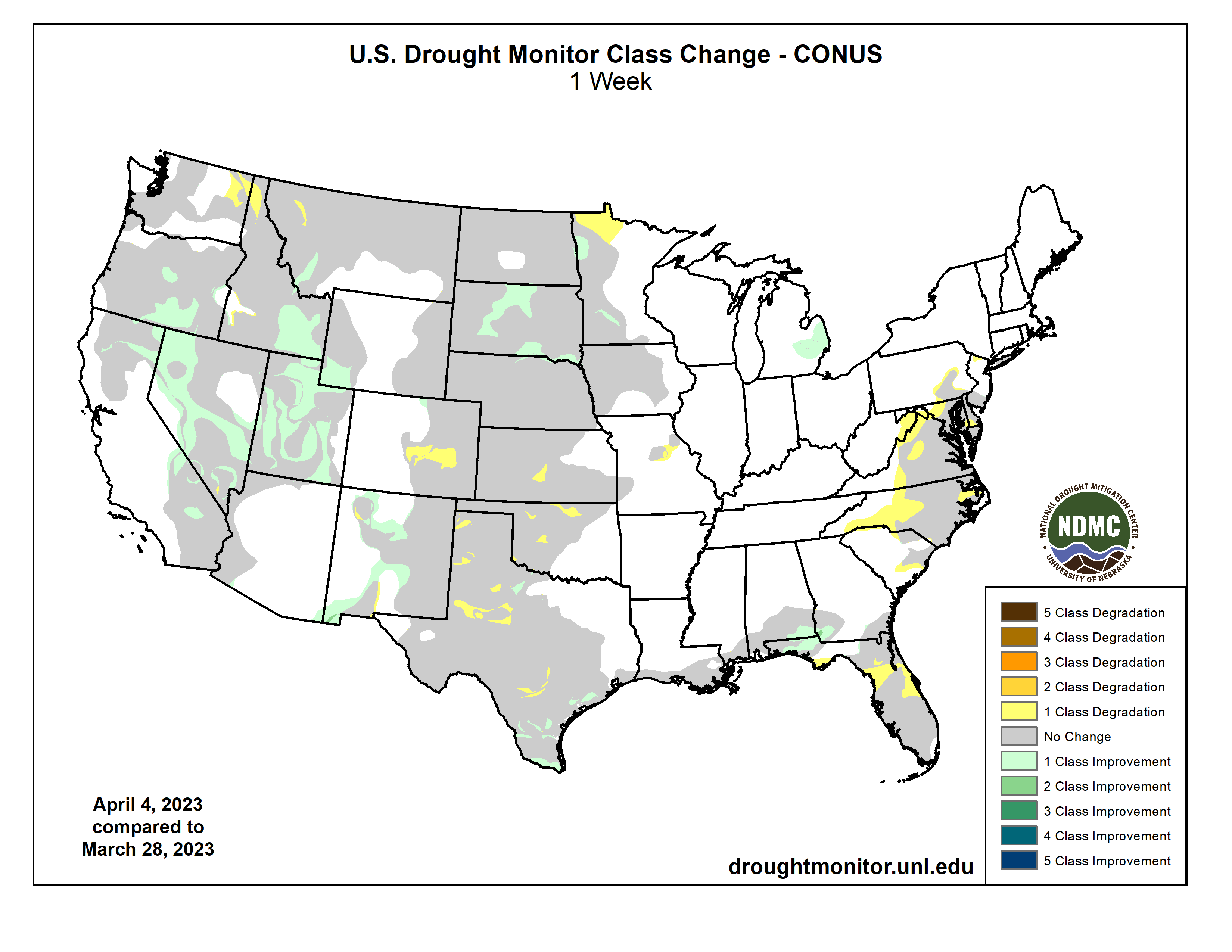
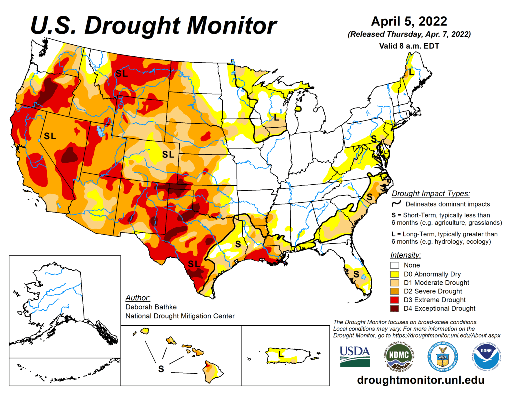
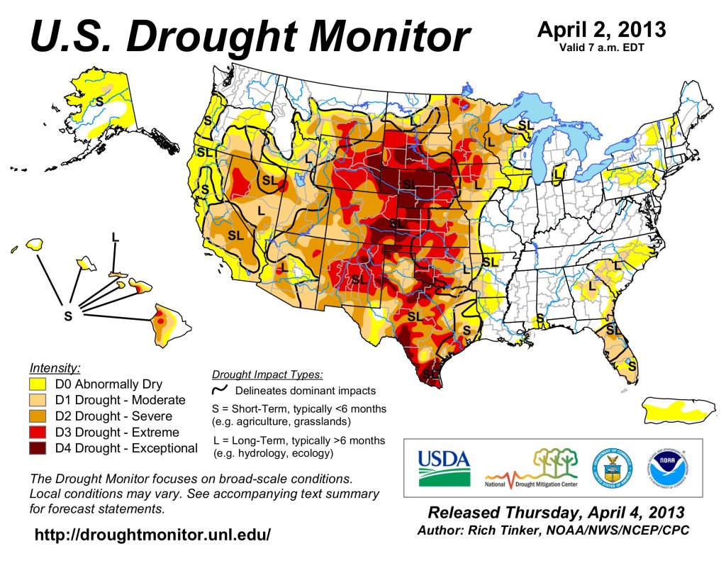
Regional drought conditions improved during March due to above to much-above average precipitation and cool temperatures. At the end of March drought covered 45% of the Intermountain West, down from 55% at the end of February. The most significant improvement in drought conditions occurred in Utah where drought conditions were entirely removed from the eastern, northern, and western portions of the state. Moderate and severe drought conditions remain present in the central portion of Utah. Drought conditions in Colorado and Wyoming changed little during March with drought conditions in the eastern portions of both states and wetter conditions in western Colorado and central Wyoming.

West Drought Monitor map April 4, 2023.

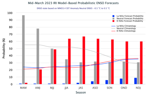
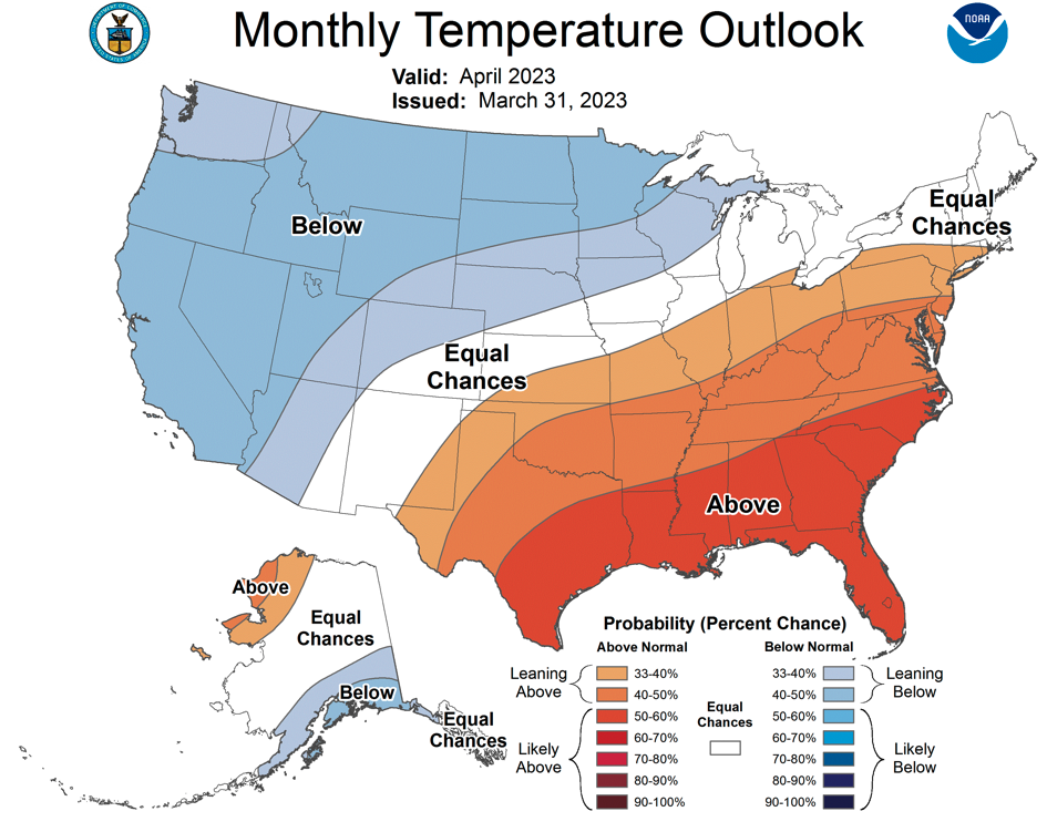
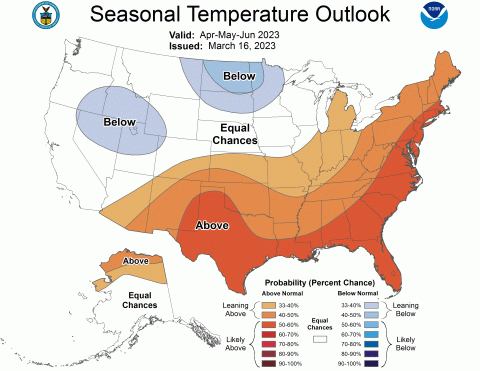
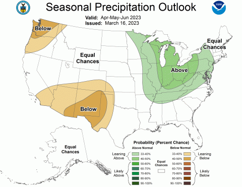
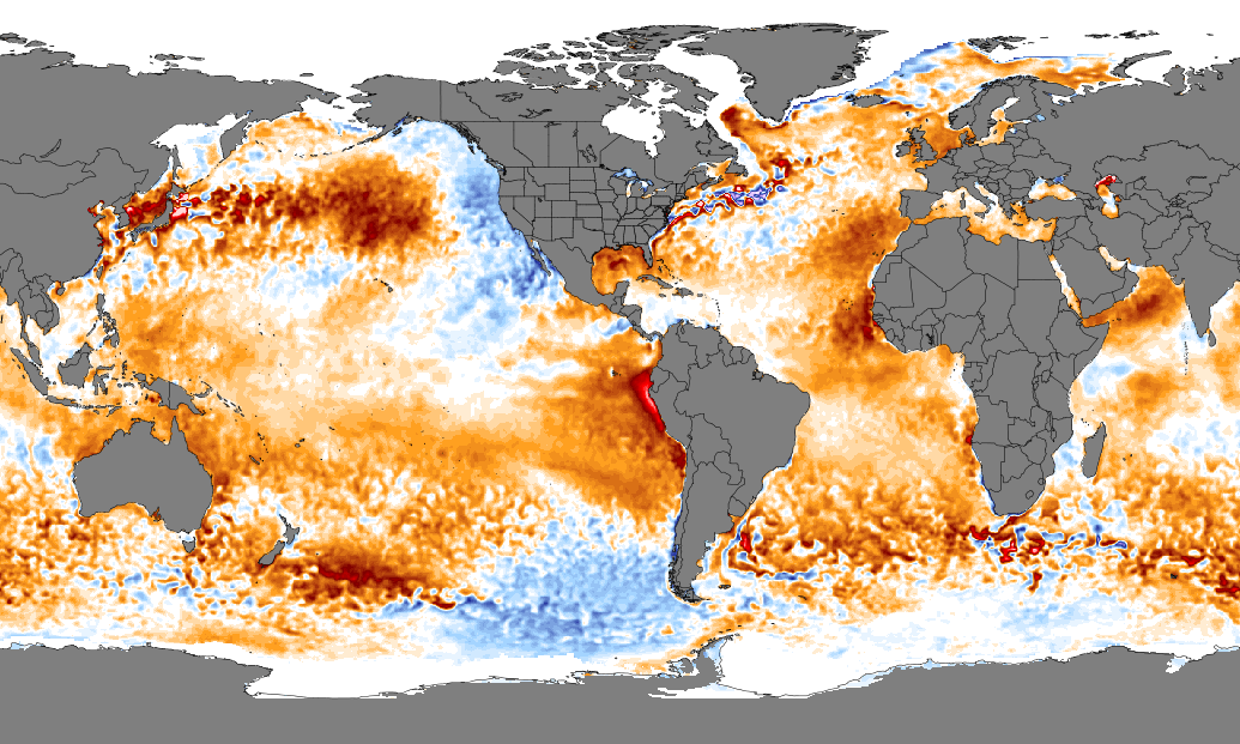
Eastern Pacific Ocean temperatures were slightly below to slightly above average during March leading to neutral ENSO conditions. There is a 60-70% probability of El Niรฑo conditions developing during late summer and persisting through the end of the forecast period in early winter. NOAA seasonal forecasts for April suggest an increased probability of below average temperatures for most of the region and an increased probability of above average precipitation for northwestern Utah. The April-June NOAA seasonal forecast predicts an increased probability for below average precipitation in southern Colorado and southern Utah, an increased probability of below average temperatures for northern Utah, and above average temperatures for southeastern Colorado.

Significant March weather event: Record Utah snowpack.ย As a scientist, skier, and general lover of snow, Iโ€™ve simply run out of superlatives to describe the 2023 winter in Utah. Snowfall and SWE records around Utah are falling, especially in northern Utah. As of April 5th, statewide average SWE is 29.5โ€ and at 209% of normal. The early 1980s, particularly 1983, were the winters of record in Utah, and 2023 has eclipsed nearly all snowfall and SWE records from those years. As of April 4th, of SNOTEL sites with at least 20 years of data, 36 sites were reporting record-high daily SWE totals, and 17 sites reported second-highest daily SWE totals. Twenty SNOTEL sites were reporting all-time record high SWE including Ben Lomond Peak, a site in northern Utah with an astounding 81.8โ€ of SWE and a snow depth of 186โ€. While I donโ€™t typically report snowfall from ski areas, the snowfall totals in the Wasatch Mountains, particularly the Cottonwood Canyons, are absurdly high. Ski areas in northern Utah have relatively long snowfall records, as long or longer than the SNOTEL network and all have broken all-time snowfall records; current (4/5/23) 2023 record snowfall totals in the Cottonwood Canyons include 874โ€ at Alta, 850โ€ at Brighton, 805โ€ at Snowbird, and 779โ€ at Solitude. Maximum snow depths in the Wasatch Mountains range from 150-250โ€. Many high elevation sites in Utah have likely not yet reached peak SWE and high elevation snowpack may continue to build. The 2023 winter has also been remarkable due to cold temperatures and very deep snowpacks at low elevations, which the SNOTEL network does not effectively capture. In Salt Lake City, winter 2022-2023 was the 6th snowiest on record (through 4/4) and the snowiest since 1993 with 87โ€ of snowfall since October 1, 2022.

2023 #COleg: Bill aims to address #water quality at mobile home parks: HB 1257 supported by Latino advocacy organizations — @AspenJournalism

Brighton Village mobile home park next to a river. Multiple trailers are intersperses with bare deciduous trees on a riverbank. Photo credit: Aqua Talk

Click the link to read the article on the Aspen Journalism website (Heather Sackett):

State legislators have introduced a bill that would create a water-testing program at mobile home parks, addressing residentsโ€™ long-standing concerns about water quality.

House Bill 1257, which is sponsored by District 57 Rep. Elizabeth Velasco, D-Garfield County, would require the Colorado Department of Public Health and Environment to create a water-testing program that covers all mobile home parks in the state by 2028. If the testing finds a water-quality issue, the park owner must come up with a remediation plan and not pass the cost of fixing the problem on to the residents. 

The testing results would be made available to park residents and the public in English, Spanish and other languages. The bill would also require park owners to identify the water source and establish a grant program to help park owners pay for remediation options such as infrastructure upgrades. 

The bill was introduced March 26, and its other sponsors are Rep. Andrew Boesenecker, D- Larimer County, and Sen. Lisa Cutter, D-Jefferson County.

Velasco, who said she lived in mobile home parks growing up, said she has heard complaints from residents about discolored water that stains clothes, smells and tastes bad, causes skin rashes, and breaks appliances. But often, those complaints go unaddressed because the water may still meet the standards of the Environmental Protection Agencyโ€™s Safe Drinking Water Act.ย 

โ€œThe odor, the taste, the color, those are secondary traits of the water, according to these regulations,โ€ Velasco said. โ€œThese issues are in low-income communities, majority people of color. These issues are not happening to wealthy families.โ€

Environmental justice issue

Water quality in mobile home parks is an environmental-justice issue for the Latino community. According to the Colorado Latino Climate Justice Policy Handbook, nearly 20% of Latino households live in mobile homes. And according to survey results in the 2022 Colorado Latino Policy Agenda, 41% of mobile home residents said they do not trust or drink the water in their homes. Eighty percent of survey respondents said they support new regulations requiring that mobile home parks provide their residents with clean drinking water. 

Beatriz Soto is executive director of Protegete, a Latino-led environmental initiative of Conservation Colorado that developed the climate justice handbook. Conservation Colorado supports the bill. Soto, who also lived in mobile home parks in the Roaring Fork valley, said for years she has heard the same complaints Velasco did about water quality, so she knew it was a top priority for the Latino community. The survey results confirmed the anecdotes.

โ€œThis is not just little things we are hearing here and there in the community; this is a bigger issue,โ€ Soto said. โ€œWhen you work two jobs and you have to drive two hours to work and you come home and have to go to a laundromat because you canโ€™t wash your clothes at your residence, thereโ€™s a real cumulative impact of living under those conditions.โ€ 

The Aspen-to-Parachute region has 55 parks, which combined have about 3,000 homes and 15,000 to 20,000 residents. Mobile home parks are some of the last neighborhoods of nonsubsidized affordable housing left in the state and provide crucial worker housing, especially in rural and resort areas.ย 

Residents have complained about the water quality in some parks for years, but agencies have lacked the regulatory authority to enforce improvements. Recently, residents in parks near Durango and in Summit County have lacked running water for weeks at a time. 

Voces Unidas de las Montanas, a Latino-led advocacy nonprofit that is based in Coloradoโ€™s central mountains and works in the Roaring Fork Valley, is one of the organizations leading Clean Water for All Colorado, a committee that helped to craft the legislation. 

โ€œMany of us who grew up in mobile home parks, myself included, have always known and normalized buying bottled water from the store, and itโ€™s because we donโ€™t trust our water,โ€ said Alex Sanchez, president and CEO of Voces Unidas. โ€œMany residents have been complaining and calling for action for decades, and no one has answered their call.โ€ 

Sanchez said the bill is his organizationโ€™s No. 1 legislative priority this session.

Rocky Mountain Home Association and Colorado Manufactured Housing Coalition oppose the bill. Tawny Peyton, executive director of the Rocky Mountain Home Association, said the mobile home park industry has been bombarded with sweeping law changes in recent years, causing confusion and additional operation and legal costs. Laws enacted in 2019, 2020 and 2022 granted extra protections to mobile home park residents.ย 

โ€œThe Rocky Mountain Home Association is concerned with the entire bill,โ€ Peyton said in an email. โ€œWhy is the mobile home park industry being singly targeted with this legislation? Industry was not made aware that mobile home park water quality was such an issue that a 23-page bill was warranted.โ€

Bill proponents acknowledge that the issue may take years to get resolved and that new regulations would be just the first step toward gathering data and assessing the problem. 

โ€œThis is just a first stab at trying to resolve this issue,โ€ Soto said. โ€œThis is establishing a framework to start testing and get all the information and documenting all the water sources for mobile home parks to determine what is the problem.โ€

House Bill 1257 is scheduled for a hearing by the Transportation, Housing and Local Government Committee on Wednesday [April 12, 2023].

This story ran in the April 8 edition of The Aspen Times, the Vail Daily, the April 9 edition of Summit Daily and the April 10 edition of the Glenwood Springs Post-Independent.

Did you know that #water rights in #Colorado are treated like private property? — @ColoradoWaterWise

Graphic credit: Colorado Water Wise

#ArkansasRiver Basin #Water Forum, April 25-26, 2023, features top water experts

Just another day on the job in 1890 – Measuring the velocity of streams in a cable-suspended, stream-gaging car on the Arkansas River in Colorado. Photo credit: USGS

Here’s the releasee from the Arkansas River Basin Water Forum (Joe Stone):

The premier water event in Coloradoโ€™s largest river basin happens Tuesday and Wednesday, April 25-26, in Colorado Springs. The 27th Arkansas River Basin Water Forum will feature discussions and presentations on โ€œFacing the Future Togetherโ€ delivered by top water experts in Colorado and the Ark Basin.

Tuesdayโ€™s keynote speaker will be Kelly Romero-Heaney, assistant director of water policy for Coloradoโ€™s Department of Natural Resources. Kelly has over 20 years of diverse experience in natural resource issues, having worked as a consultant, hydrologist, environmental specialist and wildland firefighter. In her current position she advises top executives at DNR, the Division of Water Resources and the Colorado Water Conservation Board about water policy issues and legislation.

Rachel Zancanella will deliver Wednesdayโ€™s keynote address. Rachel was promoted to Division 2 (Arkansas River Basin) engineer in December 2022 following Bill Tynerโ€™s retirement. She has held multiple positions with DWR, ranging from deputy water commissioner to water resources engineer and lead assistant division engineer. Prior to joining DWR, Rachel worked as a water resources engineer in the private sector.

Mornings at the Water Forum will feature presentations on topics like projects in El Paso County to meet future demand for water, technological advances in snow measurement, transforming landscapes to conserve water, and PFAS mitigation in drinking water supplies.

After lunch, attendees can choose from several tours and field trips. Tuesday afternoon will feature:

  • A field trip to explore aquifer recharge and water reuse in El Paso County.
  • A tour of the Mesa Garden, a demonstration garden for water-wise landscapes.
  • A tour of Fountain Creek that will highlight the importance of Plains fish conservation and visit streamgages managed by DWR and the U.S. Geological Survey.

Wednesday afternoon opportunities include:

  • A tour highlighting pioneering work in PFAS mitigation using strong base anion ion exchange resin.
  • A filed trip to Colorado Springs Utilities to see how non-potable water is being reused.
  • An Art and Ale tour that will feature murals created through the Storm Drain Art Project followed by a visit to a Fountain Creek Watershed District Brewshed Alliance brewery.

Since 1995, the Ark River Basin Water Forum has served the basin by encouraging education and dialogue about water, the stateโ€™s most valuable resource, and this yearโ€™s Forum will take place at the Doubletree by Hilton.

The Forum remains a very good value:

  • Two-day full registration, including lunches โ€“ $300.
  • One-day registration, either Tuesday or Wednesday, including lunch โ€“ $150.
  • Percolation and Runoff networking dinner โ€“ $20 (all proceeds support the ARBWF Scholarship Fund).

The real fun begins at 5 p.m. Tuesday with Percolation and Runoff, a casual networking event that raises money for the Forumโ€™s college scholarship fund. The $20 cost includes dinner, drinks and entertaining conversation.

To register for the Forum, go to arbwf.org. For more information, contact Jean Van Pelt, Forum manager, at arbwf1994@gmail.com.

A #Colorado reservoir gets ready for an epic snowmelt — Writers on the Range #snowpack #runoff (April 11, 2023)

Ken Beck at the Pine River Irrigation headquarters

Click the link to read the article on the Writers on the Range website (David Marston):

Reservoir manager Ken Beck says wryly that he has lots of water coming his way, โ€œand I need a hole to put it in.โ€

In southern Colorado, Beck is the superintendent of Pine Riverย Irrigation Districtย andย Vallecito Reservoir, which catches water from the 13,000 and 14,000-foot-high peaks of the Weminuche Wilderness. Itโ€™s a place so wild and beautiful that Teddy Roosevelt protected it in 1905 by creating the 1.8-million-acre San Juan National Forest.

Vallecito Lake via Vallecito Chamber

The name Vallecito means โ€œlittle valleyโ€ in Spanish, and the reservoir stores water for the town of Bayfield, population 2,838, as well as providing supplemental irrigation for 65,000 acres of Tribal and non-tribal land to the south.

This winter, Beck has been faced with a near-record snowpack, now expected to turn into some 320,000 acre-feet of water. His 82-year-old reservoir, however, can only hold 125,000 acre-feet. Whatโ€™s more, snow was still falling in early April.

In late March, Beck saw moisture going up dramatically. Any reservoir manager has to deal with uncertainty, but Beckโ€™s job, which he has held for seven years, has an Achilles heel.

โ€œI was told by the Bureau (of Reclamation) to manage my reservoir so I donโ€™t use my spillway,โ€ he says. โ€œWeโ€™re restricted because of the needed repairs.โ€

Spillways are critical elements of any dam. When oncoming water overwhelms the intakes for hydroelectric and outlet works, excess water flows into the river below. Beck has few options without the safety valve of a dependable spillway, yet he may be forced to use it.

Lawn Lake Flood

Beck is well aware that dams can fail. Six major dams have failed in Colorado since 1950, with the biggest disaster occurring in Larimer County, in 1981. When its Lawn Lake Dam failed, three people died and property damage amounted to $31 million.

Beck says Vallecitoโ€™s management challenges came to the fore after โ€œthe big wakeup call of 2017, when Lake Oroville fell apart in California.โ€ Californiaโ€™s tallest dam, Oroville, resembles Vallecito in being earthen built. It nearly failed when its spillways began eroding during high runoff.

Soon after, Vallecitoโ€™s dam was closely inspected, revealing leaks and erosion in its spillway. The Bureau of Reclamation, which built the dam, patched up the spillway but also put the dam โ€œunder review.โ€

By the end of March, Beck had released 15 times more water daily than during the previous month. By late April, Beck estimates, the formerly half-empty Vallecito Reservoir be just 20% full, better prepared for what could be an epic snowmelt.

In the arid West, this makes Beck a reservoir apostate. Spring is when reservoir managers follow a creed thatโ€™s been honed during periodic drought: Store as much water as possible as early as possible.

For Beck, thatโ€™s not wise. โ€œBut donโ€™t mistake my being meek as weak,โ€ he says. โ€œIโ€™ve got an Abe Lincoln style: Wrap good people around you and encourage them to say things you might not want to hear.โ€

Beck has surrounded himself with a team of straight shooters, though he relies most on Susan Behery, a Bureau of Reclamation hydrologic engineer, based in Durango. With Beheryโ€™s advice, Beck decided that Vallecitoโ€™s reservoir needed to be dramatically drawn down.

Evidence for doing that was obvious this winter as roofs sagged, driveways became mini-canyons, and snow at the nearby Purgatory ski area outside Durango reached 20 feet high in places. USDA SNOTEL sites above Vallecito Reservoir measured snowpacks at 170% and 180% of normal.

With so much big water ready to head their way, a reservoir manager might have decided to operate quietly and hope for the best. Instead, Behery says, Beck has been transparent with the public and collaborative. She admires Beck for it.

โ€œIโ€™m an engineer and nobody gets into engineering because theyโ€™re super good with people. I donโ€™t do the fluffy stuff.โ€

Beck makes a lot of information available. He holds open meetings and emails a weekly newsletter to anyone interested. โ€œA lot of people are asking why weโ€™re turning out more water,โ€ he says, โ€œbut I just met with farmers that say I havenโ€™t brought it down enough.โ€

What does Beck predict will happen to his reservoir as snowmelt barrels toward Vallecito Reservoir?

โ€œIf spring rains come it will add to the pucker factor. But the spillway will hold.โ€ Meanwhile, heโ€™s a little bit on edge.

Dave Marston is the publisher of Writers on the Range, writersontherange.org, an independent nonprofit dedicated to spurring lively conversation about the West. He lives in Durango, Colorado.

Navajo Unit Coordination Meeting April 18, 2023 #SanJuanRiver #ColoradoRiver #COriver #aridification

The Navajo Dam on the San Juan River.Photo credit Mike Robinson via the University of Washington.

From email from Reclamation (Susan Novak Behery):

BUREAU OF RECLAMATION NAVAJO UNIT COORDINATION MEETING

Sent via Email on April 10th, 2023

The next coordination meeting for the operation of the Navajo Unit is scheduled for Tuesday, April 18th, 2023, at 1:00 pm. This meeting is open to the public and will be held in an in-person/virtual hybrid format.

*Please note that due to the rapid increase in snowpack this spring, Reclamation projects it is likely that sufficient water will be available to conduct a spring release to 5,000 cfs. The current forecast and plans will be discussed at this meeting. Updates will be sent to this email list as the plan evolves. *

The following attendance options are available:

โ€ข In-Person: The physical location of the meeting will be at the Farmington Civic Center, 200 W. Arrington, Farmington, New Mexico.

โ€ข Virtual Video attendance: Microsoft Teams video option at this link. This link should open in any smartphone, tablet, or computer browser, and does not require a Microsoft account. You will be able to view and hear the presentation as it is presented, ask questions and have your comments heard by the group.

โ€ข Phone line: Alternatively, you can call-in from any phone using the following information: (202) 640-1187, Phone Conference ID 125 691 028#. You will not be able to see the presentation with this option. A copy of the presentation will be distributed to this email list and posted to our website prior to the meeting for those who wish to listen by phone. You will be able to ask questions and have your comments heard by the group.

We hope the options provided make it possible for all interested parties to participate as they are able and comfortable. Please try to log on at least 10 minutes before the meeting start time to address any technical issues. Feel free to call or email me with any questions regarding attendance, or to test your connection prior to the meeting (contact information below).

A copy of the presentation and meeting summary will be distributed to this email list and posted to our website following the meeting. If you are unable to connect to the meeting, feel free to contact me following the meeting for any comments or questions.

The meeting agenda will include a review of operations and hydrology since January, current soil and snowpack conditions, a discussion of hydrologic forecasts and planned operations for remainder of this water year, updates on maintenance activities, drought operations, and the Recovery Program on the San Juan River.

If you have any suggestions for the agenda or have questions about the meeting, please call Susan Behery at 970-385-6560, or email sbehery@usbr.gov. Visit the Navajo Dam website at https://www.usbr.gov/uc/water/crsp/cs/nvd.html for operational updates.

Aspinall unit operations update April 7, 2023 #GunnisonRiver #ColoradoRiver #COriver #aridification

#Snowpack news April 10, 2023

West snowpack basin-filled map April 9, 2023 via the NRCS.
Colorado snowpack basin-filled map April 9, 2023 via the NRCS.

The #Colorado #Drought Summit will be a 2-day event on May 31 & June 1, 2023 — Colorado Water Conservation Board

Click the link for all the inside skinny from the Colorado Water Conservation Board:

Register for the Colorado Drought Summit today!(External link)

The Colorado Drought Summit will be a 2-day event on May 31 & June 1, 2023. Space is limited – Register here(External link). The full draft agenda can be accessed in the sidebar to the right and a snapshot of the draft agenda is below.

The Colorado Water Conservation Board (CWCB) is hosting the Drought Summit to evaluate lessons-learned and adaptive solutions for addressing drought concerns. In January 2023, Governor Polis directed the CWCB to hold this event. The two-day summit will make good on that directive and demonstrate CWCB’s commitment to advancing the conversation around drought resilience in the 2023 Colorado Water Plan.

CWCB is grateful to Brown & Caldwell for being the lead sponsor and for helping to plan and staff the event.

#FortCollins OKs new oil and gas regulations, places near ban on new wells in city limits — The Fort Collins Coloradoan #ActOnClimate #KeepItInTheGround

Mammatus clouds, associated with strong convection, grace a sunset over Fort Collins, Colorado, home of the NOAA Cooperative Institute for Research in the Atmosphere at Colorado State University. Photo credit: Steve Miller/CIRA

Click the link to read the article on the Fort Collins Coloradoan website (Molly Bohannon). Here’s an excerpt:

In a 6-1 vote Tuesday [April 4, 2023] night, Fort Collins City Council approved the addition of new oil and gas regulations to the cityโ€™s land use code that effectively ban new oil facilities from being built in city limits.ย The code changes came as part of a state bill that allows municipalities to have stricter requirements than the state with regard to where oil and gas facilities can go. If a municipality doesnโ€™t have its own restrictions, applicants for facilities follow the Colorado Oil and Gas Conservation Commission rules.ย 

The approved changes to the land use code include: 

  • Adding zone restrictions to oil and gas facilities.
  • Adding development plan review procedures.
  • Requiring a 2,000-foot setback from occupiable building, and an additional 1,000-foot buffer from Natural habitat features.
  • Adding a list of prohibited facilities to development standards, including injection wells.
  • Not allowing a modification of the setback standards.
  • Adding basic development review procedures for plugging and abandoning.

[…]

When discussing the decision, council members felt it was better to adopt the proposed changes and add operational standards at a later date so that at least in the meantime there were some tighter regulations in place than the stateโ€™s.ย  Operational standards would provide local enforcement and compliance criteria in addition to what the state has in place, which many have said is not sufficient or is poorly enforced.ย Previously, city staff told the Coloradoan they expected the creation of operational standards to take a couple of city employeesย working on that for an estimated six months, along with an additional council work session on the topic.ย 

โ€˜Headed off the chartsโ€™: worldโ€™s ocean surface temperature hits record high — The Guardian #ActOnClimate #KeepItInTheGround

A global map using data from the National Oceanic and Atmospheric Administration showing areas in orange and red where temperatures have been above the long-term average. Credi: University Of Maine

Click the link to read the article on The Guardian website (Graham Readfearn). Here’s an excerpt:

Climate scientists said preliminary data from the National Oceanic and Atmospheric Administration (Noaa) showed the average temperature at the oceanโ€™s surface has been at 21.1C since the start of April โ€“ beating the previous high of 21C set in 2016.

โ€œThe current trajectory looks like itโ€™s headed off the charts, smashing previous records,โ€ said Prof Matthew England, a climate scientist at the University of New South Wales…

According to the Noaa data, the second-hottest globally averaged ocean temperatures coincided with El Niรฑo that ran from 2014 to 2016.

Credit: NOAA

Theย data is driven mostly by satellite observationsย but also verified with measurements from ships and buoys. The data does not include the polar regions. More than 90% of the extra heat caused by adding greenhouse gases to the atmosphere from burning fossil fuels and deforestation has been taken up by the ocean. Aย study last year said the amount of heat accumulating in the oceanย was accelerating and penetrating deeper, providing fuel for extreme weather.

England, a co-author of that study, said: โ€œWhat we are seeing now [with the record sea surface temperatures] is the emergence of a warming signal that more clearly reveals the footprint of our increased interference with the climate system.โ€

#Drought-ravaged #ColoradoRiver gets relief from #snowpack. But long-term #water crisis remains — The Los Angeles Times

West snowpack April 8, 2023 via the NRCS.

Click the link to read the article on The Los Angeles Times websilte (Ian James). Here’s an excerpt:

Four months ago, the outlook for the Colorado River was so dire that federal projections showed imminent risks of reservoirs dropping to dangerously low levels. But after this winterโ€™s major storms, the riverโ€™s depleted reservoirs are set to rise substantially with runoff from the largest snowpack in the watershed since 1997. The heavy snow blanketing the Rocky Mountains offers some limited relief as water managers representing seven states and the federal government continue to weigh options for cutting water use…

โ€œItโ€™s a great snowpack,โ€ said Bill Hasencamp, manager of Colorado River resources for the Metropolitan Water District of Southern California. โ€œIt gives us breathing room. It gives us a little bit of space to negotiate.โ€

Hasencamp said the runoff should eventually raise Lake Meadโ€™s level by 20 to 30 feet, which might return it toward an โ€œequilibrium level,โ€ though both major reservoirs are still expected to remain well below half-full…Theย historic snow and rain in Californiaย this winter has also allowed the district to โ€œback off on the Colorado River supplies,โ€ which will in turn help boost water levels at Lake Mead, Hasencamp said.

Coalition launches push to save 3.3 million acres of #Colorado private property from development: โ€œThese lands offer widespread benefits to the publicโ€ — The Denver Post #conservation

Pond on the Garcia Ranch via Rio Grande Headwaters Land Trust

Click the link to read the article on The Denver Post website (Bruce Finley). Here’s an excerpt:

A state-backed coalition of conservation groups is launching an unprecedented push that would pay private landowners to save 3.3 million acres of natural terrain from development. Thatโ€™s a small portion of Coloradoโ€™s total 66 million acres, which include nearly 40 million acres of private property. Robust real estate activity and new construction, bringing high-end houses and commercial buildings to once-pristine mountain valleys, has added urgency to the effort…

Saving 3.3 million acres of private land within ten years โ€” the goal Keep It Colorado announced Wednesday at the Denver Botanic Gardens โ€” would match the amount of private land protected against development since 1965, according to data in a โ€œConserving Coloradoโ€ strategy unveiled after a $300,000, 18-month planning effort. Colorado Parks and Wildlife, the Colorado Water Conservation Board and Great Outdoors Colorado provided funding. Private land conservation increasingly is seen as essential for enduring multiple threats: cascading impacts of climate warming, including droughts, heat waves, wildfires, erosion, extreme storms; degradation of ecologically sensitive areas; water scarcity; and economic challenges that threaten to drive ranchers and farmers out of agriculture.

A Nature Conservancy analysis recently identified 16 million acres of โ€œclimate-resilientโ€ private property in Colorado that is critical for wildlife survival under harsher climate conditions. Keep It Colorado members planned to prioritize land in river valleys that benefits existing human communities as well as wildlife.

Protecting natural terrain depends on landowners who prioritize the ecological health of their property and agree to conservation easements โ€” agreements that block future development. Ownership stays private. Landowners receive compensation for the value of development rights they give up through state-level property tax breaks, which Keep It Colorado leaders propose to increase, along with creating new federal tax incentives and future payments to landowners for โ€œecosystem services.โ€

#ColoradoRiver Carbon Bomb: #Utah’s Uinta Railway Project — Natural Resources Defense Council #ActOnClimate #KeepItInTheGround

Oil production on federal public lands in the Uinta Basin.Credit:WildEarth Guardians.

Click the link to read the article on the NRDC website (Josh Axelrod):

Utahโ€™s Uinta Basin has been a center of oil production in the U.S. for nearly 80 years. But, given the type of crude oil found there and its remote location, oil production had historically remained a marginal business. Now, new drilling technology, availability of new refining abilities, and demand from Gulf Coast refineries is driving a production boom in this remote corner of Utah.

Historically, production from the Uinta Basin was capped by the capacity of nearby refineries who refined the yellow and black waxy crude oil that comes out of the ground there. That meant production couldnโ€™t exceed around 85,000 barrels per day (bpd). However, with the ability to now load that crude onto Union Pacific Railway trains headed to the Gulf Coast, production has surged as high as 135,000 bpd. Because of the unique geography of the area, all that oil is currently moved out by tanker trucks.

Enter theย Uinta Basin Railway project, a proposed, brand new, 85-mile rail line that would connect the Uinta Basinโ€™s oil fields to the Union Pacific system. According to the projectโ€™s proponents, it isnโ€™t designed to take tanker trucks off local roads. Instead, the project is all about future growth. Proponentsโ€”a coalition of seven Utah countiesโ€”envision unlocking 130,000-350,000 bpd of new crude production.

Uinta Basin Railway project proposed routes. Credit: Surface Transportation Board

A Carbon Bomb in Disguise

Thatโ€™s a shocking amount of growth for an oil field that produces a highly unusual form of crude oilโ€”a hard, waxy crude that solidifies at temperatures below 110 degrees. Because of its unique chemistry, it cannot be transported via pipeline. Rather, it must be shipped either by truck or rail inside specially heated tanks, all of which has meant that Unita crude has been economically marginal for most of its history. 

But access to a larger market could change all of that.ย  And what makes it truly shocking is its cumulative greenhouse gas emissions, which could surpass theย globally controversial Willow Project. Thatโ€™s because at Willowโ€™s peak, daily production isย estimated at 180,000 bpd, while the Uinta Basin Railway proponents see their fields adding up to 350,000 bpd of new production.ย 

According to the Surface Transportation Board’s Environmental Impact Statement (EIS) for the project, the high-end production scenario unlocked by this rail line could lead to more than 53 million metric tons of annual greenhouse gas emissions from the combustion of this oil. Given the International Energy Agencyโ€™s admonition that no new crude oil supply projects should be brought online to keep global temperature rise in check, the Uinta Basin Railway provides a textbook example of a project with no future in a climate-constrained world. Any federal decisions that could lead to the projectโ€™s construction–be they permits or financial assurances–are equivalent to the green lighting of a significant, long-term increase in unneeded and risky oil production.

A Threat to Precious Western Water Supplies

If you read the EIS for the Uinta Basin Railway project, youโ€™d be deceived into believing itโ€™s just about moving crude oil 85 miles closer to the Salt Lake City area and that its impacts are limited in scope. However, nothing could be further from the truth. The surge in growth this project would unlock is all about connecting the Uinta Basin to Gulf Coast refineries, which have bought increasing volumes of this oil in recent years and have the specialized refining equipment necessary to turn this oil into usable products.

What that means on the ground is that this project is about tying into the rail systems that can be used to get the oil all the way to the Gulf Coast. That means primarily usingย Union Pacificโ€™s rail line, which runs through the Rocky Mountains alongside the headwaters of the Colorado River.

Union Pacific’s rail lines (left) hug the Glenwood Canyon walls beside the muddy Colorado River. Credit: djvass, Flickr

According to the projectโ€™s EIS, the extraordinary increase in crude-by-rail traffic facilitated by the project could lead to a derailment every year. Should that derailment be significant, there is a high probability that ruptured tank cars would leak oil into nearby waterways. In a letter from Colorado’s U.S. Senators Bennet and Hickenlooper, joined by Colorado Representative Neguse, this risk is called out specifically given how difficult a major response effort would be in the routeโ€™s rugged and remote terrain.

Equally concerning are the properties of the oil itself and what might happen should a spill take place in rapidly moving water without a near-immediate response effort. Though project proponents claim that the Uintaโ€™s waxy crudes are โ€œclean up friendly,โ€ their unique qualities should raise serious concerns. For crude oils that quickly solidify when spilled into water, long term contamination is always a serious risk should the oil adhere to the river bottom as it biodegrades. Theย extraordinary lack of scientific basis for concluding minimal spill risks within the EIS should raise alarm bellsย for anyone looking at this project. Given that this oil would move alongside one of the Westโ€™s most critical water bodies, robust consideration of spill risks and response limitations should have been paramount to the environmental analysis that was conducted.

Instead, the Surface Transportation Board has accepted the Uinta Railway Project’s voluntary commitment to prepare an emergency response plan applicable only to the 85 miles of new rail line encompassing this project. The increased risks and emergency response capacities beyond that short distance are simply ignored, as if the thousands of miles left for the oil to travel simply do not exist.

A Project with Ballooning Costs Requests Taxpayer Support

When the Uinta Basin Railway project was first proposed, its proponents assured regulators and the public that the entire thing would be funded by private interests. In the intervening years, as the projectโ€™s costs have ballooned from $1.2 billion to $2.9 billion, things have changed. Now, project proponents are seeking what are known as โ€œprivate activity bonds,โ€ which are low-interest, taxpayer funded bonds issued by the Department of Transportation (DOT). DOT has a pot of $30 billion available for issuing these bonds, with nearly $17 billion already out the door. 

Project proponents now hope to access 15% of that remaining pot, even though DOTโ€™s bonds to date have supportedย highway and rail transit projects.ย 

Indeed, the Uinta Basin Railway is a decidedly poor fit for these financial supports. Its sole purpose is moving crude oil out of the Uinta Basin. Few other commodities come from the area and project proponents have made no attempt to play up the rail lineโ€™s potential for diversifying markets for local commodities. Instead, theyโ€™ve doubled down on the assertion that the rail line will be about oil, oil, oil. Given the congressional desire that private activity bonds โ€œincrease private sector investment in U.S. transportation infrastructure,โ€ using these bonds for a project with almost no meaningful utility aside from expanding oil production represents a gross misuse of limited federal funds.

A Project with Unacceptable Risks to the Climate and Fresh Water

In the aftermath of the Willow Projectโ€™s approval, the federal government must take greater care in its management of projects designed to lock in massive quantities of future greenhouse gas emissions. The Uinta Basin Railway project is one of these. Its approval and financial support would represent an extraordinary misuse of federal funds at a time when so much federal investment and effort is going to decarbonizing the U.S. economy. Instead, the federal government should be partnering with state and local governments to diversify the economy of this region instead of locking it into another century of dependence on oil.

Colorado River Basin in Colorado via the Colorado Geological Survey

March Brought Record #Snowpack Accumulation to Many #Colorado Basins — Colorado Snow Survey

Click the link to read the article on the NRCS website:

Denver, CO โ€“ April 7th, 2023ย โ€“ The basins of Western Colorado continued to benefit from a series of storms throughout the month of March. During this time 34 SNOTEL sites in the state received the highest or second highest March snowpack accumulation amounts on record. NRCS Hydrologist Karl Wetlaufer notes โ€œThe record high monthly snowpack accumulation fell on top of an already plentiful snowpack at many sites. This brought about 25 percent of SNOTEL sites in the state to their record or second highest values for April 1st.โ€ The spatial pattern of snowpack accumulation and streamflow forecasts this winter has been a shift from the previous three years where Western Colorado has experienced well below normal snowmelt runoff volumes and basins that flow east observed more plentiful runoff. โ€œThis year should provide a welcome reprieve for water supply and depleted reservoir storage across Western Colorado after several years of low streamflowโ€ Wetlaufer continued. While forecasts are for the most plentiful volumes in the western half of the state the average of forecasts in the Arkansas and South Platte are for near normal volumes, albeit with a lot of variability point to point.

Reservoir storage across most major basins is near to slightly below normal except for the Gunnison and the combined San Miguel-Dolores-Animas-San Juan River basins of Southwest Colorado which are currently at 71 and 69 percent of normal, respectively. While several years of low streamflow have contributed to these deficits, current streamflow forecasts indicate that those values will likely be rapidly rising over the coming months. Given the plentiful snowpack and streamflow forecasts, in many areas reservoir management plans will also likely be taking flood prevention into consideration over the coming months as well.

ย After three years of below normal streamflow runoff across the state, 2023 is bringing a welcome change from a water supply standpoint to most major basins of Colorado, and arguably to some that needed it most. Hydrologist Wetlaufer notes โ€œOverall, the water supply outlook for Colorado is looking quite positive for the upcoming runoff season.โ€ While plentiful water is certainly good news in many respects, and it is worth keeping in mind that it can also come with an increased flood risk and a friendly reminder that one wet year doesnโ€™t immediately cancel out several dry years.โ€ Wetlaufer summarizes โ€œWith forecasts far above normal streamflow in much of the state residents should also be mindful of increased flood risk during peak flow. Additionally, it is important to bear in mind that in some basins, with the Colorado River being the prime example, one year of plentiful streamflow will not be enough to solve bigger picture water supply challenges in the long run.โ€

For more details see the April 1stย Water Supply Outlook Report.

West snowpack basin-filled map April 7, 2023 via the NRCS.

The April 1, 2023 #Colorado #Water Supply Outlook Report is hot off the presses from the NRCS

Click the link to read the report on the NRCS website. Here’s an excerpt:

Biden-Harris Administration Announces Up to $233 Million in #Water #Conservation Funding for #GilaRiver Indian Community #ColoradoRiver #COriver #aridification

Gila River watershed. Graphic credit: Wikimedia

Click the link to read the release on the Department of Interior website:

Following a visit to the Gila River Indian Community, Deputy Secretary of the Interior Tommy Beaudreau, Senior Advisor to the President and White House Infrastructure Implementation Coordinator Mitch Landrieu, and Deputy Bureau of Reclamation Commissioner David Palumbo announced up to $233 million in historic funding and conservation agreements to help the Gila River Indian Community and water users across the Colorado River Basin protect the stability and sustainability of the Colorado River System. They were joined by federal, state, local and Tribal leaders.

The visit is part of the Biden-Harris administrationโ€™s Investing in America tour to highlight the opportunities that the Bipartisan Infrastructure Law and Inflation Reduction Act are creating. Combined, these laws represent the largest investments inโ€ฏclimate resilience in the nationโ€™s history and provide unprecedented resources to support the Administrationโ€™s comprehensive, government-wide approach to make Western communities more resilient to drought and climate change.

โ€œThrough the Bipartisan Infrastructure Law and Inflation Reduction Act, we have historic, once-in-a-generation investments to expand access to clean drinking water for families, farmers and Tribes,โ€ said Deputy Secretary Beaudreau. โ€œIn the wake of record drought throughout the West, safeguarding Tribal access to water resources could not be more critical. These types of agreements will support Tribal communities through essential water infrastructure projects and support water conservation in the Colorado River System.โ€

โ€œWater is a sacred resource and crucial to ensuring the health, safety and empowerment of Tribal communities,โ€ said Deputy Commissioner Palumbo. โ€œThe Bureau of Reclamation is hard at work to support projects that have long awaited this kind of funding โ€” projects that are integral to protecting the Colorado River System and the communities that rely on it. By working together, we can ensure the longevity of the basin.โ€

The Gila River Indian Community will receive $50 million in funding from the Inflation Reduction Act via the Lower Colorado River Basin System Conservation and Efficiency Program, which will help finance a system conservation agreement to protect Colorado River reservoir storage volumes amid persistent climate change-driven drought conditions. This conservation initiative will result in nearly 2 feet of elevation in Lake Mead for the benefit of the Colorado River System. The agreement also includes the creation of up to 125,000 acre-feet of system conservation water in both 2024 and 2025, with an investment of an additional $50 million for each additional year. This is among the first allocations for a system conservation agreement from the Lower Colorado River Basin System Conservation and Efficiency Program.

In October 2022, the Department announced the creation of the Lower Colorado River Basin System Conservation and Efficiency Program to help increase water conservation, improve water efficiency, and prevent the Systemโ€™s reservoirs from falling to critically low elevations that would threaten water deliveries and power production.

In addition, the Department announced $83 million for the Gila River Indian Communityโ€™s Reclaimed Water Pipeline Project to expand water reuse and increase Colorado River water conservation. The project will provide a physical connection of reclaimed water to Pima-Maricopa Irrigation Project facilities. When completed, the project will provide up to 20,000 acre-feet annually for system conservation with a minimum of 78,000 acre-feet committed to remain Lake Mead. Funding for the pipeline project comes from the Bipartisan Infrastructure Law and annual appropriations.

The Bipartisan Infrastructure Law including $8.3 billion for Reclamation water infrastructure projects over five years to advance drought resilience and expand access to clean water for families, farmers and wildlife. The investment will repair aging water delivery systems, secure dams, complete rural water projects, and protect aquatic ecosystems. The Inflation Reduction Act is investing another $4.6 billion to address Western drought.

More information on the Administrationโ€™s all-of-government effort to support the Colorado River Basin is available via a White House fact sheet.

Gila River. Photo credit: Dennis O’Keefe via American Rivers

Click the link to read “Arizona tribe will receive millions in federal payouts for water conservation” on the KUNC website (Alex Hager). Here’s an excerpt:

The Gila River Indian Community will conserve 125,000 acre-feet of water and receive $50 millionย from the Inflation Reduction Actย in exchange. The tribe has the option to do so again in 2024 and 2025, receiving another $50 million in each additional year. That water will stay in Lake Mead, the nationโ€™s largest reservoir, where historically-low water levels threaten hydropower production within the Hoover Dam, and have raised concerns about the reservoirโ€™s long-term ability to provide water to millions of people in cities such as Phoenix, Las Vegas and Los Angeles. Those payments would break down to $400 per acre-foot of water…

The tribe will also receive $83 million from the Bipartisan Infrastructure Law to expand water reuse efforts. It will fund a reclaimed water pipeline that, when completed, will add up to 20,000 acre-feet annually for system conservation with a minimum of 78,000 acre-feet committed to remain Lake Mead…Sarah Porter, director of the Kyl Center for Water Policy at Arizona State University, cautioned that funding sent to the Gila River Indian Community is not necessarily indicative that the federal water conservation program is working at a broader level.

โ€œIt doesn’t say as much as we might hope,โ€ Porter said, โ€œBecause this program is competing with current commodity prices. I have asked a few growers who have the opportunity to participate if they will, and it’s clear that the high price of different agricultural commodities is getting in the way. The Gila River Indian community is in a unique position to participate.โ€

[…]

Current guidelines for the Colorado River are set to expire in 2026, and states are expected to negotiate a new set of rules for how itโ€™s shared. As climate change shrinks supplies, state and federal governments have assembled a patchwork of short-term conservation agreements to chip away at demand and prevent catastrophe before then.

Biden-Harris Administration Announces Nearly $585 Million from Bipartisan Infrastructure Law to Repair Aging #Water Infrastructure, Advance #Drought Resilience

Click the link to read the release on the Department of Interior website:

Today during a visit to the Imperial Dam, Deputy Secretary of the Interior Tommy Beaudreau, Senior Advisor to the President and White House Infrastructure Implementation Coordinator Mitch Landrieu, and Bureau of Reclamation Commissioner Camille Calimlim Touton announced a nearly $585 million investment from President Bidenโ€™s Bipartisan Infrastructure Law for infrastructure repairs on water delivery systems throughout the West. Funding will go to 83 projects in 11 states to improve water conveyance and storage, increase safety, improve hydro power generation and provide water treatment.

The visit to the Colorado River Basinโ€™s Imperial Dam โ€“ which is receiving $8.24 million in fiscal year 2023 โ€“ is part of the Biden-Harris administrationโ€™s Investing in America tour to highlight the opportunities that the Bipartisan Infrastructure Law and Inflation Reduction Act are creating.

โ€œPresident Bidenโ€™s Bipartisan Infrastructure Law is making a historic investment to provide clean, reliable water to families, farmers and Tribes,โ€ said Deputy Secretary Beaudreau. โ€œAs we work to address record drought and changing climate conditions throughout the West, these investments in our aging water infrastructure will conserve community water supplies and revitalize water delivery systems.โ€

โ€œPresident Biden is investing in America, and todayโ€™s announcement delivering much needed repairs to aging dams and other water infrastructure is part of our whole-of-government approach to making communities more resilient to drought,โ€ said Senior Advisor Landrieu.

โ€œThese projects have been identified through a rigorous process and is a testament to the Bureau of Reclamationโ€™s commitment to deliver water to future generations,โ€ said Commissioner Touton. โ€œAs we manage through changing climate, we must look to the safety of our projects to ensure that we can continue to provide clean, reliable water to communities, irrigators, and ecosystems across the west.โ€

The projects selected for funding today are found in all the major river basins and regions where Reclamation operates. Among the 83 projects selected for funding are efforts to increase canal capacity, provide water treatment for Tribes, replace equipment for hydropower production and provide necessary maintenance to aging project buildings. Projects will be funded in Arizona, California, Colorado, Idaho, Montana, Nevada, New Mexico, North Dakota, Oregon, South Dakota and Washington.

President Bidenโ€™s Investing in America agenda is delivering historic resources to communities to help advance drought resilience and strengthen local economies. The Bipartisan Infrastructure Law includes $8.3 billion for Reclamation water infrastructure projects over five years to advance drought resilience and expand access to clean water for families, farmers and wildlife. The investment will repair aging water delivery systems, secure dams, complete rural water projects, and protect aquatic ecosystems. The Inflation Reduction Act is investing another $4.6 billion to address the worsening crisis. Combined these two initiatives represent the largest investments in climate resilience in the nationโ€™s history and provide a once-in-a-generation opportunity for the work of the Interior Department.

Todayโ€™s announcement builds on $240 million allocated through the Law in fiscal year 2022. The next application period for extraordinary maintenance funds is expected in October 2023.

Detailed information on Reclamation programs and funding provided in the Bipartisan Infrastructure Law is available on Reclamationโ€™s website.

Southwestern Water Conservation Districtโ€™s 2023 annual seminar recap — The #Durango Herald #snowpack #runoff

Click the link to read the article on The Durango Herald website (Reuben Schafir). Here’s an excerpt:

The Southwestern Water Conservation District held its 39th annual seminar Friday [March 31, 2023] in Ignacio to address the topic of โ€œseeking common ground in crisis.โ€

About 300 people were in attendance, including both chairmen of the Southern Ute and Ute Mountain Ute Indian tribes, ranchers, farmers and officials from agencies involved in water conservation at the federal level all the way down to local districts. U.S. Rep. Lauren Boebert was a surprise guest…The eventโ€™s schedule included panels on reusing treated wastewater, seeking common ground in the distribution of the riverโ€™s resources, and the connection been food and water for agricultural producers on the Western Slope, Front Range, and the upper and lower Colorado River Basin…From the Front Range farmers, like panelist Robert Sakata, the owner of a 2,400-acre farm nestled in the expanding urban boundaries of Brighton, to lower basin users such as panelist Bart Fisher, a farmer and former chairman of the Colorado River Board of California, the impacts of the historic drought are top of mind. The need to reduce water use has affected what they grow as well as the quantity…

โ€œBuy-and-dryโ€ programs have become a tense topic of conversation among farmers. The concept is to reduce water consumption by paying farmers annually for water to which they have a right but do not use. Although this can be done in any number of ways, the programโ€™s epithet refers to the common method of fallowing โ€“ or intentionally not cultivating โ€“ land. Despite protections that ensure unused water rights will not be forfeited, as is historically the case, farmers are skeptical. From a financial perspective, the incentive is small. The upper basin program offers only $150 to farmers per acre-foot of water saved (an acre-foot is the amount needed to submerge an acre of land in 1 foot of water), while farmers can typically harness far more in profits from that water if they use it for irrigation.

โ€œWhen you diminish agriculture significantly by fallowing, you diminish the economic engine of the community that supports agriculture,โ€ Fisher said…

Harvesting a Thinopyrum intermedium (Kernza) breeding nursery at The Land Institute By Dehaan – Scott Bontz, CC BY 3.0, https://commons.wikimedia.org/w/index.php?curid=5181663

Simon Martinez, the general manager of Ute Mountain Ute Farm and Ranch, said he is more interested in testing out water-efficient crops…Like many farmers looking to save water, the Ute Mountain Ute Farm and Ranch is experimenting with Kernza. The wheatgrass variant can significantly reduce water consumption compared to a crop such as alfalfa…Martinez hopes to test the new grain as potential cattle feed and intends on sowing 46 acres with the seed, likely this spring. Although the concept is experimental โ€“ Martinez said the crop has not been grown in the region and its exact efficacy as a cattle feed is unclear โ€“ success could mean a significant water savings for the farm. In addition to reducing the amount of water needed to irrigate, which Martinez estimated could near 50% compared to alfalfa, grazing the farmโ€™s herd on Kernza would increase profits by enabling the farm to sell more of the alfalfa that it does produce. The perennial grain has grown in popularity as its viability as an alternative crop becomes increasingly intriguing to farmers. The outdoor brand Patagonia adopted it into the companyโ€™s line of sustainable foods and now produces pasta and beer with the grain. Martinez said he is unsure of how the experiment will go. But to test out the grain on 46 acres of the 7,700-acre farm is a small sacrifice…

West snowpack basin-filled map April 6, 2023 via the NRCS.

With future weather predictions becoming increasingly unpredictable, farmers are endorsing an array of solutions. Although this yearโ€™s ample snowfall does little to reverse the long-term impacts of the historic drought, water aficionados in the Four Corners are nonetheless grateful for the supply.

Once-in-a-century #runoff predicted for #ColoradoRiver as officials warn, โ€œDonโ€™t squander itโ€ — @WaterEdCO

Wahweap Marina on Lake Powell at low water. Lake Powell will recover some storage thanks to the spectacular runoff predicted for this year. Jonathan P. Thompson photo

Click the link to read the article on the Water Education Colorado website (Jerd Smith):

Calling this yearโ€™s forecasted Colorado River streamflows a โ€œa once-in-a-centuryโ€ event, water officials are warning decision makers not to squander the riverโ€™s surprising 2023 bounty.

The drought-strapped Lake Powell could see new supplies of more than 10 million acre-feet this year, 2 million more than had been forecast just one month ago, according to the Colorado River Basin Forecast Center.

Due to drought, and climate-driven reductions in mountain snows, Lake Powell hasnโ€™t been full in 20 years and plummeted to just 23% full last year. It holds roughly 26 million acre-feet when it reaches maximum storage capacity. One acre-foot equals 326,000 gallons.

โ€œItโ€™s a tremendous gift. Our challenge is to not squander it,โ€ said Chuck Cullom, director of the Upper Colorado River Commission, which represents the four Upper Colorado River Basin states of Colorado, New Mexico, Utah and Wyoming. Arizona, California and Nevada comprise the Lower Basin.

Cullomโ€™s comments came March 31 at a seminar by Coloradoโ€™s Southwestern Water Conservation District in Ignacio, Colorado.

Screenshot of the Colorado Basin River Forecast Center streamflow forecast April 7, 2023.

With the new streamflow forecasts, reservoirs are expected to recover dramatically. Upper Colorado River water officials say the water needs to be held in the Upper Basin to improve the health of the system and to help cope with future drought years and reduced mountain snowpacks.

Even with the unexpected surge in new water supplies, Powell is only expected to recover slightly this year. Another bad year could throw the river back into crisis, officials said.

The seven-state Colorado River basin has been mired in a drought for more than 22 years, a dry spell widely believed to be the worst in more than 1,200 years. Lake Powell and Lake Mead, the largest reservoirs in the nation, have dropped to record lows, threatening water supplies to millions of people and jeopardizing the U.S. Bureau of Reclamationโ€™s ability to generate low-cost, renewable hydropower for thousands of electric utilities across the West.

In 2019, in response to the ongoing drought and an alarming drop in storage levels at Powell and Mead, all seven states agreed to an historic set of drought contingency plans, which include cutbacks in use in the Lower Basin, as well as emergency releases from Utahโ€™s Flaming Gorge Reservoir and Coloradoโ€™s Blue Mesa in the Upper Basin, to bolster Powell.

Those emergency plans were activated in the summer of 2021. Since then roughly 600,000 acre-feet of water has been released from Flaming Gorge and Blue Mesa, with the majority coming from Flaming Gorge.

Just a few weeks ago it wasnโ€™t clear that any of the actions taken would be enough to keep Powell and Mead from dropping into crisis territory, where power generation would stop and deliveries out of Lake Mead to Lower Basin states would not be enough to satisfy demand.

But now, because of the surprising depth of mountain snows, suddenly there will be water and Reclamation has pledged to hold as much of it as it can in the Upper Basin to restore levels in Flaming Gorge and elsewhere, Cullom said.

In the coming weeks, the seven states have critical decisions to make about how the system will operate for the rest of this year, including how much water will be released from Powell and from Mead.

Andy Mueller, general manager of the Colorado River District, which oversees the river across a 15 county region in western Colorado, said he is grateful for the watery surge, but he said the Upper Basin states will push hard to limit releases from Powell and Mead this year and in years to come.

Climate stripes through 2022. Credit: Ed Hawkins

โ€œWe have to recognize that the water supply has changed underneath our feet. Yes, this year is a good year, and we appreciate that. What we have to remember is that one good year means the weather was good. It doesnโ€™t mean the climate is going to go back to what we experienced in the 1970s or before,โ€ Mueller said.

โ€œThe current guidelines have been focused on crisis management โ€ฆ We canโ€™t continue to do that if we are going to get out of this problem,โ€ he said, referring to the drought contingency plans and current guidelines for reservoir operations.

Manuel Heart is chairman of the Ute Mountain Ute Tribe in southwestern Colorado. The tribe is a major agricultural producer in the region. In 2021, the tribe received just 10% of its Colorado River water allocation due to the drought. Fields went dry and workers were laid off.

Now, along with other Colorado River farmers and ranchers, the tribe is looking for ways to adapt to a drier climate.

But this year, Heart said he is enjoying this remarkable wet season.

โ€œOur prayers got answered this year,โ€ he said.  โ€œItโ€™s good to see the mountains the way they are supposed to look. I like to see the rivers flow and our lands green.โ€

Jerd Smith is editor of Fresh Water News. She can be reached at 720-398-6474, via email at jerd@wateredco.org or @jerd_smith.

Navajo Mountain March 2023. Jonathan P. Thompson photo.

#Drought news April 6, 2023: #Snowpack SWE percentages = Lower Green 202%, Upper Colorado-Dolores 207%, and Upper Colorado-Dirty Devil 219%

Click on a thumbnail graphic to view a gallery of drought data from the US Drought Monitor website.

Click the link to go to the US Drought Monitor website. Here’s an excerpt:

This Week’s Drought Summary

This U.S. Drought Monitor (USDM) week saw continued widespread improvements on the map across areas of the western U.S. including in California, Nevada, Oregon, Idaho, and Utah. Overall, the areal extent of drought in the West dipped to 31% this week as compared to 73% at the beginning of the Water Year in early October. This weekโ€™s improvements reflected the impact of the recent storm events which continued to boost mountain snowpack levels to record, or near-record levels as observed at numerous Natural Resources Conservation Service (NRCS) SNOTEL monitoring stations across the Sierra Nevada, southern Cascades, eastern Great Basin, Wasatch, Uintas, and the southern and central Rockies. In California, the statewide snowpack was 243% of normal (April 5), with the Northern Sierra at 198%, Central Sierra at 242%, and Southern Sierra at 302%. Elsewhere in the region, the state of Utah is observing historic snowpack levels with the statewide snow water equivalent (SWE) at its highest level on record (April 5) at 211% of median, according to NRCS SNOTEL. In other regions, areas of the South (Texas) and the Southern Plains (Kansas, Oklahoma) saw further degradations on the map in response to a combination of short and long-term dry conditions, very low streamflow and reservoir levels, and reported impacts in the agricultural sector. In the High Plains, blizzard-like conditions and moderate to heavy snowfall accumulations were observed in the Dakotas during the past week as well as in areas of the Upper Midwest including northwestern Minnesota. In the Southeast, dry conditions and reports of deteriorating pasture conditions led to the expansion of severe drought areas in central Florida. Likewise, short-term precipitation deficits and increasing fire danger in areas of the Coastal Plain of North Carolina led to the expansion of areas of drought…

West snowpack basin-filled map April 5, 2023 via the NRCS.

High Plains

On this weekโ€™s map, changes were made including a slight expansion of an area of Exceptional Drought (D4) in central Kansas as well as one-category improvements in areas of Moderate Drought (D1) and Severe Drought (D2) in South Dakota in response to improving soil moisture conditions, snow cover, and above-normal precipitation during the past 30-90-day period in some areas. Currently, 50% of Kansas is depicted in the D3-D4 drought categories with 12-month precipitation deficits ranging from 4 to 16 inches. According to the latest USDA Kansas Crop Progress and Condition report (April 3), winter wheat conditions were rated 31% very poor, 26% poor, 27% fair, 14% good, and 2% excellent. In terms of topsoil moisture conditions (April 2, USDA), the percentage of topsoil moisture rated short to very short was 73% in Kansas and 56% in Nebraska. In the Northern Plains, blizzard-like conditions were observed during the past week bringing heavy snowfall to eastern Wyoming, northwestern Nebraska, and the Dakotas. According to NOAA NOHRSC, 72-hour snowfall accumulations as of April 5 ranged from 6 to 24 inches. For the week, average temperatures were well below normal with departures ranging from 5 to 25 deg. F below normal with the largest departures observed in North Dakota…

Colorado Drought Monitor one week change map ending April 4, 2023.

West

Out West, widespread improvements were made on the map including areas of California, Nevada, Oregon, Idaho, Utah, Montana, Wyoming, and New Mexico in response to excellent snowpack conditions across many of the drainage basins in the region. In California, the statewide snowpack (April 5) was 243% of normal, with the Northern Sierra at 198%, Central Sierra at 242%, and Southern Sierra at 302%. The California Department of Water Resources reported that the 2022-23 season will go down as one of the largest snowpacks on record in California. In Nevada and Utah, current SWE percentages of median for select basins are as follows: Central Lahontan 273%, Central Nevada Desert Basins 267%, Great Salt Lake 224%, Lower Green 202%, Upper Colorado-Dolores 207%, and Upper Colorado-Dirty Devil 219%, according to the NRCS SNOTEL network. In Arizona and New Mexico, snowpack levels are above normal, especially in the ranges of northern and central Arizona. In Arizona, the total reservoir system (Salt and Verde River system) is currently 100% full as compared to 72% full at the same time last year, according to the Salt River Project. For the Colorado River system, the U.S. Bureau of Reclamation is reporting (April 4) Lake Mead at 28% full and Lake Powell at 23% full…

South

In the South, a major outbreak of severe weather impacted portions of the region, including in the Mississippi and Tennessee valleys where numerous tornadoes touched down. The severe weather outbreak included strong thunderstorms with excessive rainfall, large hail, damaging winds, and violent tornadoes which impacted areas of Arkansas and Tennessee, leading to loss of lives and the destruction of homes and businesses. On the map, areas of drought intensified and expanded across areas of Texas and Oklahoma where precipitation deficits during the past 12-month period ranged from 8 to 20 inches in the most severely affected areas. According to the USDA (April 2), the percentage of topsoil moisture in Texas and Oklahoma that was rated short to very short was 72% and 63%, respectively. Moreover, numerous reservoirs in the western half of Texas were below normal levels, including the San Antonio River Basin reservoirs which are currently 5.3% full, according to Water Data for Texas. In terms of streamflow levels, areas of Oklahoma (northern and western) and Texas (Hill Country and South Texas Plains regions) observed 7-day streamflows in the <10th percentile range, according to the U.S. Geological Survey. For the week, average temperatures were above normal (1 to 8 deg. F) across the region with the greatest departures observed along the Gulf Coast and South Texas Plains…

Looking Ahead

The NWS WPC 7-Day Quantitative Precipitation Forecast (QPF) calls for moderate-to-heavy precipitation accumulations (including heavy snowfall accumulations) ranging from 2 to 7+ inches (liquid) across the Cascades of Oregon and Washington, Klamath Mountains, and Coast Ranges of northwestern California. Meanwhile, light accumulations are expected in the mountain ranges of eastern Oregon and Washington, central and northern Idaho, and across areas of the northern Rockies. Elsewhere in the conterminous U.S., heavy precipitation accumulations (2 to 5+ inches) are expected in the Gulf Coast region of Texas and the South, while the Southeast (excluding Florida) is forecasted to have light-to-moderate precipitation accumulations (2 to 4 inches). In isolated areas of the Upper Midwest and Northeast, light precipitation (<1 inch) is forecasted. The CPC 6-10-day Outlooks call for a moderate-to-high probability of above-normal temperatures across much of the conterminous U.S. with exception of areas to the west of the Continental Divide where cooler than normal temperatures are expected. Precipitation is forecasted to be above normal across Alaska, the Pacific Northwest, Intermountain West, the Plains states, and in Florida. Below-normal precipitation is forecasted across the South, Eastern Tier, and portions of the Midwest.

US Drought Monitor one week change map ending April 4, 2023.

Just for grins here’s a slideshow of US Drought Monitor maps for early April for the past few years.

Topsoil moisture percent short to very short and percent surplus for the week ending April 2, 2023 — @DroughtDenise #drought

The 2023 Secretarial #Drought Designations includes 455 primary counties and 244 contiguous counties as of March 29 — @DroughtDenise

For more info, please see the Emergency Disaster Designation and Declaration Process fact sheet at https://fsa.usda.gov/Assets/USDA-FSA-Public/usdafiles/FactSheets/emergency_disaster_designation_declaration_process-factsheet.pdf

Romancing the River: Tragicomedies of the Commons — Sibley’s Rivers #ColoradoRiver #COriver #aridification

Industrial pollution is one of the consequences of operators ignoring their effect on the shared environment. By Frank J. (Frank John) Aleksandrowicz, 1921-, Photographer (NARA record: 8452210) – U.S. National Archives and Records Administration, Public Domain, https://commons.wikimedia.org/w/index.php?curid=17100801

Click the link to read the article on the Sibley’s Rivers website (George Sibley):

In my last post, I was questioning the process of allowing the privatization of the commons through individual appropriations โ€“ in our specific instance here, privatization of the โ€˜water commons,โ€™ but also of the land, and all of its living systems and the raw resources that must feed, water, shelter not just us but all life on the planet.

Every living thing that requires food, water, air or virtually anything at all โ€˜appropriates it from the commons,โ€™ and probably in the strictest sense we all โ€˜create a propertyโ€™ in the apples we pick to eat, the water we dip out of the stream to drink, the oxygen in the air we suck into our lungs. But we have not always gone on to claim personal ownership of the tree that produced the apple, or the land the tree grows on, the stream that waters the tree. That is a relatively recent invention of modern cultures โ€“ the agricultural and the industrial societies that we created when there came to be too many of us to support ourselves as hunter-gatherers living off the scattered abundance of the commons.

A contemporary writer-thinker who has considered our conduct in the commons is Garret Hardin, a 20th century American ecologist whose main concern as a scientist was the threat of overpopulation: a species (us) in swarming mode, but clever enough to stay a step ahead of the usual โ€˜naturalโ€™ controls โ€“ famine, plague, social breakdown and the Hobbesian โ€˜war of each against all.โ€™ Hardin is best known, however, for a short excerpt, often found in high school and college texts, from a 1968 essay, โ€˜The Tragedy of the Commons.โ€™

In the popular excerpt from โ€˜Tragedy,โ€™ Hardin posed a grazing commons, used by a number of herdsmen. Being rational, Enlightenment individuals with a โ€˜naturalโ€™ desire to maximize their own self-interest through their labors, each herdsman desires to add another animal to his herd on the commons, even though he is aware that it might have a negative impact on the commons. The rational individual calculates, however, that he would get all the profit from his extra animal, while the cost to the commons would be spread among all the grazers. But with every user of the commons adding extra animals through that rational logic, the commons is over-grazed and destroyed.

One leader of the Scottish Enlightenment was Adam Smith, the father of modern economic science. By Etching created by Cadell and Davies (1811), John Horsburgh (1828) or R.C. Bell (1872).

This is the dark side of Enlightenment economist Adam Smithโ€™s theory that economic individuals are driven by rational self-interest to engage in useful pursuits that will benefit their society as well as themselves, by meeting some societal need โ€“ a thesis embraced by most economists since Smithโ€™s time (The Wealth of Nations was published in 1776).

The challenge of course is how to prevent the Enlightenmentโ€™s pursuit of individual self-interest from leading inexorably to Hardinโ€™s โ€˜tragedy of the commons.โ€™ Hardin saw the only alternatives to ecological catastrophe being either a) administration of the commons by the state or b) privatization of the commons according to the conventional wisdom of Aristotle: โ€˜Men pay most attention to what is their own; they care less for what is common.โ€™ The choice between state management of whatโ€™s left of the commons, and further privatization by individuals, remains an area of open public conflict in the American West, with at least two bills before the current Congress proposing more creation from the commons.

But other modern thinkers have thought it through further โ€“ with work grounded in research, evidence collection, and other methods of the Scientific Revolution that preceded the Enlightenment. They discovered that there were (still are) many commons that have been used consistently without the users marching inexorably into Hardinโ€™s tragedy โ€“ in some cases, in use for hundreds of years. They studied grazing commons, timber commons, fishing commons, water commons, and less tangible โ€˜commonsโ€™ like the air we breathe.

Foremost among these scientists is the late Elinor Ostrom, an American political scientist whose work in the study of commons was acknowledged in 2009 with a Nobel Prize in Economics. Her study of commons globally led her to observations about why some commons endured, even when used by individuals trying to maximize their own profit from their use, while individuals with the same motive degraded other commons.

Commons that succeeded over time, she found, were consciously managed locally by the users themselves, according to a set of rules generated, monitored and enforced uniformly bythe users. She did not find individual self-interest incompatible with successful commons management; it was only necessary for the individuals operating on a fragile commons to be able to persuade themselves and each other that even their short-term interests required the development of rules for avoiding the over-use of their commons. And if they kept the rule-making process close to home, they would be be able to build in elements of flexibility and local control sufficient to maintain the commons without losing their own sovereignty to external forces.

It became evident, to Ostrom and to other students of the commons, that this kind of commons management had to be locally generated rather than top-down from some external authority, and among people who had similar goals in living off the commons; a community with multi-generational stability, and a โ€˜belief commonsโ€™ as well would be more likely to succeed in conserving its physical commons if it chose to. Equally evident was the fact that it could never be a simple one-size-fits-all process; each commons and each community would have unique features.

The โ€˜water commonsโ€™ โ€“ the sum of our precipitation, surface waters, and groundwater โ€“ is our interest here, and the last two years bear mute testimony to its lack of predictability, which makes management of the commons difficult, no matter what system is employed.

San Luis People’s Ditch March 17, 2018. Photo credit: Greg Hobbs

The acequia system of land settlement, practiced by both the indigenous Mexican cultures and the Spanish invaders, only permitted settlement by communities of people, rather than by individuals under the โ€˜enlightenedโ€™ Euro-American model. Acequia systems essentially have โ€˜commons managementโ€™ by its users built into it. Everyone works to build and maintain the irrigation system, and the watered land under the ditch is divided as equitably as possible among parciantes, with the land above the ditch being mostly an undivided commons for grazing, โ€˜energy productionโ€™ (wood-gathering) and timber. The system is run by its users, with both surpluses and shortages shared evenly.

The โ€˜enlightenedโ€™ western American water appropriation system, on the other hand, is fundamentally antithetical to even the existence, let alone the intelligent management of a water commons. The Colorado Constitution, for example, seems to establish a public โ€˜commonsโ€™ in first declaring the โ€˜water of the streams public propertyโ€™ โ€“ but then immediately stating that this public property is only the water โ€˜not heretofore appropriatedโ€™ โ€“ and the rest of the public property is โ€˜dedicated to the use of the people of the state, subject to appropriationโ€ฆ (and) the right to divert the unappropriated waters of any natural stream to beneficial uses shall never be denied.โ€™

Once the right to use the water has been appropriated, there is not only no encouragement to share the burden of bad years, it is actually operating outside the law to do so; the law enforces the right of the senior appropriators in a system to get all of their water, even if it dries up junior appropriators to do so. This institutes a โ€˜first come, first servedโ€™ system that is more competitive than cooperative.

Theoretically, the users are only appropriating the right to use the water, not the water itself, and only for so long as they actually puts the water to use. But somehow that โ€˜right to useโ€™ has become a property that can be sold or bought just like any more tangible personal property. And a new owner of the โ€˜right to useโ€™ can file for a change of use, then move the right to use the waterย and the waterย anywhere he or she wantsย along with the seniority of the right.

Delph Carpenter’s 1922 Colorado River Basin map with Lake Mead and Lake Powell shown. The two giant reservoirs have always been part of the governance of the river.

All western states in the arid region have basically the same appropriation system, with variations mostly in administration. Thus, throughout the Colorado River region, water that was appropriated and privatized for agricultural use in one place can (after a change of use) water suburban growth a couple hundred miles away in the same state โ€“ a situation facilitated by the fact that the state boundaries bear no relation to any geographic realities like watersheds. Up to five million acre-feet of water leave the Colorado Riverโ€™s natural basin every year for agricultural and municipal uses outside the basin โ€“ 40 percent of the riverโ€™s water. This โ€˜flexibilityโ€™ of ownership, on top of its โ€˜first come, first servedโ€™ energy, makes the appropriation process a powerful engine for growth, but with not much of a sense of a water commons.

Which brings us more or less back to the present, where we are at something of an impasse over what passes for our water commons. The seven Colorado River Basin states are confronted with the need for a huge โ€˜reality adjustmentโ€™ in the way the river has been operated over the past century: essentially we must โ€“ beginning this year โ€“ abandon the magical thinking of the Early Anthropocene and cut the overall consumptive use of the river by at least two million acre-feet.

Six of the seven states have constructed a draft plan that would apportion cuts close to two million acre-feet to meet this emergency equitably among all the states โ€“ not โ€˜equally,โ€™ but equitably, cleaning up some mistakes from the past, like the Lower River states ignoring a million and a half acre-feet of annual evaporation. But the seventh state, California, is holding out for strict administration of the appropriation law, which would mean they would get most of their usual allotment, 4.4 million acre-feet (minus 400,000 they are willing to put into the kitty), and Arizona, Nevada and the four Upper River states, all with water rights mostly junior to Californiaโ€™s, would bear the rest of the burden.

Arguments can be made both ways: the importance of the primacy of the rule of law, versus an emergency situation that the law as (mis)administered cannot resolve. I am personally of the latter persuasion (in case you hadnโ€™t noticed), and believe the appropriation laws for water, as they have evolved, might be more part of the problem than part of the solution at this point.

There is a little-discussed fact about appropriation law and seniority rights as it is actually practiced in bad years down on the ground, at least here in the headwaters of the Upper River. That is the fact that agricultural users, at the local level, donโ€™t like to place โ€˜callsโ€™ on their neighbors in hard times โ€“ a โ€˜callโ€™ being a demand by a senior user that upstream juniors let the water go by until his right is completely fulfilled.

Downstream senior users will place a call when an upstream junior is being blatant in his or her disregard for priority in a time of relatively normal flows, to bring the offender in line. But inย a dry year, which is no oneโ€™s fault, farmers and ranchers who have drawn water from the same stream for years โ€“ sometimes for generations โ€“ tend to not insist on rigorous apportionment of water according to seniority, but instead sit down together and figure out how to move whatever water is available around so that everyone gets enough to avoid dead perennials and maybe get a partial crop on their best land.

The ranchers here call these โ€˜gentlemenโ€™s agreementsโ€™: ad hoc measures in which humans respond to natureโ€™s random assaults the way anthropologists show us we did for our first million or so formative years, fragile bands wandering the generally unaccommodating steppes of the Pleistocene ice ages: working it out together. Self-interest served rationally through cooperative action.

These informal agreements beyond the law seem to fit with Elinor Ostromโ€™s observed โ€˜rulesโ€™ for the long-term management of commons; โ€˜gentlemenโ€™s agreementsโ€™ only seem to work at the local level where users know each other, have transcended the abstract fear that he-she-they wantย myย water, and know that rational self-interest in living a reasonably peaceful andย productiveย life requires some neighborly accommodation to each otherโ€™s needs, whether one loves the neighbors or not (although serious neighborhood feuds can preclude a gentlemenโ€™s agreement).

Herbert Hoover presides over the signing of the Colorado River Compact in November 1922. Members of the Colorado River Commission stood together at the signing of the Colorado River Compact on November 24, 1922. The signing took place at the Palace of the Governors in Santa Fe, New Mexico, with Secretary of Commerce Herbert Hoover presiding (seated). (Courtesy U.S. Department of Interior, Bureau of Reclamation)

โ€˜Gentlemenโ€™s agreementsโ€™ have not, however, worked when โ€˜upscaledโ€™ to the state or regional level. Consider the Colorado River Compact: the seven states gathered in 1922 for the expressed purpose of dividing the consumptive use of the riverโ€™s water seven waysย beyondย the appropriation laws. Each state would continue to observe appropriation laws intrastate, but not interstate; they wanted a gentlemenโ€™s agreement that fast-growing California would not be allowed to appropriate most of the river before slower-growing states really got started, and California wanted the other states to support a big-dam project on the mainstem. But either despite their rational self-interest, or on account of it, they were unable to develop that equitable apportionment. The reason they couldnโ€™t is obvious enough from looking at the Compact meeting transcripts: the Compact commissioners were arguing from fantasies about their future development, and they would neither accept each othersโ€™ fantasies nor downsize their own, and they would have needed half again more water than even the Bureau of Reclamationโ€™s optimistic fantasies about the riverโ€™s actual flow.

But are we now at a sufficiently different place so that the riverโ€™s reality might prevail over magical thinking? We now know how much water there actually is in the river, and approximately how much less there will be as the temperatures continue to rise; we can see that the growth energy inspired by โ€˜first come, first servedโ€™ is the last thing we need in the Southwest today; we are aware what a general tangle the fantasies, omissions, ambiguous language and contradictions of the Compact and the subsequent ramshackle Law of the River have created โ€“ and we know we are only a couple really bad snow years from a โ€˜dead poolโ€™ status where no one below Hoover Dam gets any water at all. We know we have to come up with some kind of consensual agreement now, not after another decade in court.

Can the seven states come to the table, leaving all our fantasies of the future behind, face these realities, and come to a gentlemenโ€™s agreement that will get us at least through the next several years with the requisite major cuts in use? While we are trying to forge some new compact that does what the last one failed to do?

The Tomichi Water Conservation Program involves regional coordination between six water users on lower Tomichi Creek to reduce consumptive use on irrigated meadows as a watershed drought management tool. The project will use water supply as a trigger for water conservation measures during one year in the three-year period. During implementation, participating water users would cease irrigation during dry months. Water not diverted will improve environmental and recreational flows through the Tomichi State Wildlife Area and be available to water users below the project area. Photo credit: Business for Water.

If the ranchers on Tomichi Creek can do it up here in the headwatersโ€ฆ.

โ€˜The essence of dramatic tragedy is not unhappiness.
It resides in the solemnity of the remorseless working of things.โ€™

โ€“ Alfred North Whitehead

Map credit: AGU

Continued below-average precipitation reduces #groundwater levels, reportย shows — University of #Nebraska-Lincoln

Researchers with the University of Nebraska-Lincoln take groundwater samples from the Loup River in the Sandhills of Nebraska in September 2018. By sampling groundwater and determining its age, they hope to determine whether predictions for groundwater discharge rates and contamination removal in watersheds are accurate. Photo credit: Troy Gilmore

Click the link to read the article on the University of Nebraska-Lincoln website (Aaron Young):

Groundwater levels have declined in most of Nebraska following multiple years of below-average precipitation, University of Nebraskaโ€“Lincoln scientists found in a new statewide analysis. About three-quarters of the 4,787 observation wells across the state experienced groundwater level declines during 2021-22.

The Conservation and Survey Division, the natural resource survey component of the School of Natural Resources, compiled the findings in its latest groundwater level report.

For most of the observation wells, the net change in groundwater level was less than 20 feet since predevelopment times โ€” before the widespread use of groundwater for irrigation.

Nebraska still retains a relatively abundant share of the High Plains aquifer system, in contrast to the situation in areas such as western Kansas and northern Texas, where the depletion of the aquifer has been severe, with major negative consequences for local agriculture.

But the surveyโ€™s findings highlight the direct negative effects that prolonged below-average precipitation can have on groundwater levels. During the 2020-21 period, 96% of weather reporting stations in Nebraska (166 out of 172) reported below-average precipitation. During the 2021-22 period, 68% of the stations (122 of 179) reported precipitation levels below the 30-yearย average.

The below-average precipitation values, combined with increased need for irrigation water to maintain crop yields, resulted in groundwater-level declines of more than 10 feet in some parts of the state, university scientists found.

โ€œChanges in groundwater levels in Nebraska are largely dependent on annual fluctuations in precipitation,โ€ said Aaron Young, survey geologist with the School of Natural Resources. โ€œThe hotter and drier a growing season is, the less water is available for aquifer recharge, and more water is required for supplemental irrigation of crops, resulting in groundwater-level declines.โ€

In contrast, wetter years mean that less supplemental irrigation water is required and more water is available for aquifer recharge.

Nebraskaโ€™s recent groundwater-level declines are concerning, Young said, in that some wells may need to be drilled deeper if drought conditions persist.

Although Nebraska has, on average, not seen declines in groundwater levels like those seen in Kansas or Texas, the degree of groundwater level change in Nebraska since predevelopment has varied greatly among individual areas, ranging from increases of more than 120 feet to declines of about 130 feet. For most of the state, the net change in groundwater level since predevelopment times has been less than 20 feet.

Parts of Chase, Perkins, Dundy and Box Butte counties, in contrast, have experienced major, sustained declines in groundwater levels due to a combination of factors. Irrigation wells are notably dense in these counties, annual precipitation is comparatively low, and there is little or no surface-water recharge to groundwaterย there.

The Conservation and Survey Division report was authored by Young and University of Nebraskaโ€“Lincoln colleagues Mark Burbach, Susan Lackey, Matt Joeckel and Jeffrey Westrop.

A freeย PDFย of the report can be downloadedย here. Print copies can be purchased for $7 at the Nebraska Maps and More Store, 3310 Holdrege St. Phone orders are accepted atย 402-472-3471.

Nebraska Rivers Shown on the Map: Beaver Creek, Big Blue River, Calamus River, Dismal River, Elkhorn River, Frenchman Creek, Little Blue River, Lodgepole Creek, Logan Creek, Loup River, Medicine Creek, Middle Loup River, Missouri River, Niobrara River, North Fork Big Nemaha River, North Loup River, North Platte River, Platte River, Republican River, Shell Creek, South Loup River, South Platte River, White River and Wood River. Nebraska Lakes Shown on the Map: Harlan County Lake, Hugh Butler Lake, Lake McConaughy, Lewis and Clark Lake and Merritt Reservoir. Map credit: Geology.com

PacifiCorp plans to accelerate shift from coal to renewable energy — @WyoFile #KeepItInTheGround

A substation collects power from the Jim Bridger plant to connect to the electrical grid Jan. 19, 2022. (Dustin Bleizeffer/WyoFile)

Click the link to read the article on the WyoFile website (Dustin Bleizeffer):

Wyomingโ€™s largest utility will either retire or convert #coal-fired units to natural (#methane) gas, sparing only two coal-burning units in the state beyond 2030

Wyoming coal will play a shrinking role in PacifiCorpโ€™s energy supply portfolio as the utility adds more wind and solar power and either retires or converts its coal-fired power units in the state to natural gas.

Only two of the utilityโ€™s 11 coal-fired power units currently operating in the state will continue burning coal beyond 2030 โ€” Wyodak near Gillette and Unit 4 at the Dave Johnston plant in Glenrock โ€” according to the utilityโ€™s biennial Integrated Resource Plan filed on Friday. Several coal units will be spared from earlier decommissioning plans and instead be converted to natural gas โ€” Jim Bridger units 3 and 4 in 2030 and Naughton units 1 and 2 in 2026. 

Dave Johnston Unit 3 will be retired in 2027, and units 1 and 2 will be retired in 2028 rather than 2027.

All told, PacifiCorp will cut its coal-fired power generation capacity across its six-state operating region by 1,153 megawatts by 2026 and 3,000 megawatts by 2032, and replace it with wind and solar energy, battery storage, nuclear power, wholesale power purchases and energy efficiencies, according to the company, which operates as Rocky Mountain Power in Wyoming.

PacifiCorp plans a major shift from coal to solar, wind, nuclear and battery storage. (PacifiCorp)

โ€œOur Integrated Resource Plan is designed to determine the lowest-cost options for customers, adjusting for risks, future customer needs, system reliability, market projections and changing technology,โ€ said Rick Link, who serves as PacifiCorp senior vice president of resource planning, procurement and optimization.

No carbon capture for coal

One option that doesnโ€™t fit those parameters is retrofitting decades-old coal-fired power units with carbon capture, use and sequestration technologies. PacifiCorp also filed a mandatory report to the Wyoming Public Service Commission Friday to update officials on its call for bidders to possibly install CCUS facilities at its coal units in the state โ€” an action mandated by Wyoming law.

โ€œThrough 2042, the [analysis] for all CCUS variants result in higher costs than the preferred portfolio,โ€ PacifiCorp said in its 48-page report. The summary suggests it will cost Wyoming ratepayers โ€œ$514 million [to retrofit] Dave Johnston Unit 2, $857 million for Dave Johnston Unit 4, and $1.3 billion for Jim Bridger units 3 and 4.โ€

Of the 54 companies that PacifiCorp sought bids from, only 21 qualified and only three participated in mandatory site visits, PacifiCorp said. The bidding and analysis also confirmed that adding CCUS to an existing coal-fired power unit drastically reduces a facilityโ€™s generation capacity, which would require replacing that lost capacity.

PacifiCorp is still working with vendors to explore the potential for taking on CCUS retrofits, however.

Three of four coal-burning units at PacifiCorpโ€™s Dave Johnston coal-fired power plant near Glenrock will be decommissioned by 2028, according to the utilityโ€™s 2023 Integrated Resource Plan. (Dustin Bleizeffer/WyoFile)

โ€œThe company has determined that Dave Johnston Unit 4 and Jim Bridger units 3 and 4 remain potentially suitable candidates for CCUS and are being further analyzed under the companyโ€™s RFP process approved by the [Wyoming Public Service Commission] in the initial application,โ€ PacifiCorp said in its report.

CCUS retrofits remain a significant cost and power-delivery-reliability risk for Wyoming ratepayers, Powder River Basin Resource Council Chairman David Romtvedt said.

โ€œRatepayers should not be asked to cover the costs of uneconomical energy projects,โ€ Romtvedt said in a prepared statement. โ€œInstead, we support the addition of cost effective and environmentally responsible renewable energy sources to the companyโ€™s overall energy profile.โ€     

Renewable shift and potential nuclear

PacifiCorpโ€™s updated Integrated Resource Plan, which looks ahead 20 years, includes quadrupling its wind and solar resources to 20,000 megawatts by 2032, backed with an additional 7,400 megawatts of energy storage.

The utility still envisions taking ownership of TerraPowerโ€™sย Natrium nuclear energy facilityย at Kemmerer โ€” which is expected to begin operating in 2030 โ€” and possibly taking on two more small modular reactors co-located at coal plants in Utah.

Utility giant PacifiCorp hopes to achieve net-zero greenhouse gas emissions by 2050. (PacifiCorp)

The expansion of renewable and low-carbon electric generation facilities is accompanied by approximately 2,500 miles of new transmission lines, many of which will connect Wyoming renewable sources to PacifiCorp service territories in the West. All told, the power shift and transmission buildout should result โ€œin a system-wide 70% reduction of greenhouse gas emissions from 2005 levels by 2030, an 87% reduction by 2035 and a 100% reduction by 2050,โ€ PacifiCorp reported.

Paramount to those greenhouse gas emission savings is curbing the utilityโ€™s reliance on coal.

โ€œDriven in part by ongoing cost pressures on existing coal-fired facilities and dropping costs for new resource alternatives, of the 22 coal units currently serving PacifiCorp customers, the preferred portfolio includes retirement or gas conversion of 13 units by 2030 and 20 units by year-end 2032,โ€ PacifiCorp said.

Though it remains to be seen how PacifiCorpโ€™s shift away from coal and toward a lower-carbon energy portfolio will affect jobs and revenue in the state, the companyโ€™s plan acknowledges a larger energy industry shift and opportunities for the state, according to Romtvedt.ย 

โ€œGreater use of renewable energy will help us to ease the dislocation caused by the transition away from extractive resources while developing a more sustainable energy future that can support stable economies in our communities,โ€ he said.

Deadpool Diaries: In March 2023, the #RioGrande/#ColoradoRiver #snowpack went bonkers — John Fleck (InkStain) #COriver #aridification

An urban river. Arenal Canal in Albuquerqueโ€™s South Valley. Photo credit: John Fleck/InkStain

Click the link to read the article on the InkStain website (John Fleck):

The ditches were flowing across Albuquerqueโ€™s valley floor yesterday [April 2, 2023] as I criss-crossed them on a long, aimless bike ride, the first day it really felt like spring. The cycling challenge at this winter<->spring pivot point is clothing โ€“ layers for a morning start hovering just above freezing, with a pannier stuffed with the layers by the time I was down to shirtsleeves for my taco brunch.

Embudo Creek

My favorite gage at this time of year is Embudo Creek, just above its confluence with the Rio Grande in northern New Mexico. You can see the diurnal cycle of day-night melting, and the rising as the temperature warms. With the big snowpack, flows right now are well above the median. (Prof. Fleck note: The skewed nature of the data, with flows a lot higher on the high side than the lows on the low side, makes the mean โ€“ typically what we mean by โ€œaverageโ€ โ€“ less meaningful for a data like this. Hence median.)

The West Gulf River Forecast Center is forecasting Embudo Creek runoff at more than double the median this year.

The Embudo is just one little creek, but people live on it and built their lives around it. Of such creeks is the entire West built. Good to pay attention to one.

COLORADO RIVER AT THE START OF APRIL

The whole deadpool/wrecked speedboats emerging from the Lake Mead mud thing seems a bit of a quaint echo from a stranded past, as the Colorado River discourse shifts from how to protect the infrastructure from a dark cascade toward deadpool to โ€œWhich reservoirs should we refill, and by how much?โ€

The official CBRFC April 1 forecast hasnโ€™t dropped yet, but the preliminary modeled numbers are up 3.6 million acre feet from March 1.

3.6 million acre feet.

Never forget. Photo credit: John Fleck

That seems like a lot, but it is worth remembering that weโ€™ve been overusing the river by about 1.5 million acre feet per year since the turn of the century.

This likely means a release from Glen Canyon Dam to the Lower Basin of 9 million acre feet (or more?) in 2023, which might be enough to re-submerge some of the wrecked speedboats. That would be nice, but I hope we donโ€™t forget the visceral message theyโ€™ve been sending us.

Interiorโ€™s draft modeling results should emerge next week (perhaps April 10-11-12?), but the specific near term crisis they were meant to help us through โ€“ the possibility of a Glen Canyon Dam release of less than 7 million acre feet this year โ€“ is gone.

Yay.

Instead, the Basin community is wrestling with a โ€œwhat shall we do with the extra waterโ€ question: refilling Flaming Gorge and the other Upper Basin reservoirs drawn down by DROA, erasing โ€œoperational neutralityโ€ by solving the confusing mess of the relationship between how much water was held back in Powell to keep the dam from breaking, and how that affects Lower Basin shortage tier accounting. (Donโ€™t ask me hard questions, itโ€™s super confusing.)

In a really important way, the discussion has shifted from short term crisis management to long term, umm, I guess โ€œcrisis managementโ€ remains the right description? Raise your hand if you disagree.

RIO GRANDE AT THE START OF APRIL

The Rio Grande, which is getting my most focused thinking right now on account ofย the new bookย (see bike ride picture above), is in good shape. Usually at this time of year I shift from watching the snowpack to worrying about dry wind events, but this year thereโ€™s so gosh-darned much snow up there that Iโ€™m, like, โ€œMeh, whatever, bring it on, spring!โ€

Otowi runoff via WGRFC โ€“ a very good year on the Rio Grande

A lot depends on spring winds now, and the rate of warming and meltoff. But that will just be the difference between a big year and aย veryย big year.

My great hope is for overbank flows in the Middle Rio Grande, like we had in 2019. Those were super fun.

A wet winter wonโ€™t stave off the #ColoradoRiverโ€™s #water cuts — The Washington Post #COriver #aridification

Lake Powell has been about a quarter-full. The snowpack looks strong now, but itโ€™s anybodyโ€™s guess whether there will be enough runoff come April and May to substantially augment the reservoir. May 2022 photo/Allen Best

Click the link to read the article on The Washington Post website (Joshua Partlow). Here’s an excerpt:

The abundant snow in the Rocky Mountains this year has been a welcome relief but is not enough to overcome two decades of drought that has pushed major reservoirs along the Colorado River down to dangerous levels, Camille Calimlim Touton, the commissioner for the U.S. Bureau of Reclamation, said on Monday at the outset of a three-day trip along the river with a bipartisan delegation of senators to push for an agreement on how to conserve an unprecedented amount of water.

SNOTEL stations Colorado River Basin via the Colorado Basin River Forecast Center

Theย snowpackย that feeds theย Colorado Riverย โ€” which 40 million people rely on in the West โ€” is currently at 154 percent of average for this time of year, Touton said…

The trip comes as negotiations between the seven states of the Colorado River basin have stalled, with California proposing one plan for cuts and the other six states โ€” Arizona, Colorado,ย Nevada,ย New Mexico, Wyoming and Utah โ€” offering another. The Interior Department is expected to publish an environmental review later this month intended to clarify its authority to make unilateral cuts to water usage and how those could be distributed if the states donโ€™t reach an agreement…Colorado Democratic Sens. Michael F. Bennet and John Hickenlooper joined Wyoming Sen. Cynthia M. Lummis (R) for the trip, which is expected to include visits to Arizona, Nevada, and California โ€” the Lower Basin states where the most contentious decisions will need to be made to reach the scale of cuts that the federal government is calling for.

โ€œThe future of the American West is at stake,โ€ Bennet told reporters…

the states have yet to resolve their differences. In January,ย the six states agreed to an approachย that would cut 1.5 million acre-feet by attributing losses mostly to evaporation of the water as the river travels through a network of reservoirs and canals in the southern states on its way to Mexico. That method would translate to particularly large cuts for California, which uses the biggest share of the river. California has rejected that approach and said that it goes against the long-standing system of water rights that has been established over more than a century. Under laws and court rulings dating back decades, in times of shortage, Arizona wouldย lose its right to its water before California. Californiaโ€™s plan calls for more gradual initial reductions that intensify as reservoirs fall further, hittingย Arizona particularly hard.ย Arizona water authorities view the California plan as impossible for their state to stomach.

Map credit: AGU

Registration open for #ArkansasRiver Basin #Water Forum

Photo shows Tennessee Creek near the confluence of the East Fork Arkansas River in winter with snow on the Continental Divide of the Americas. Photo: Reclamation

Here’s the release from the Arkansas Rover Basin Water Forum (Joe Stone):

Registration is now open for the 2023 Arkansas River Basin Water Forum, slated for Tuesday and Wednesday, April 25-26 at the Doubletree by Hilton in Colorado Springs. Since 1995, the Forum has served Coloradoโ€™s Arkansas River Basin by encouraging education and dialogue about the stateโ€™s most precious resource โ€“ water.

The 27th Forum will feature top water experts in Colorado and the Arkansas River Basin discussing issues critical for all water users, from everyday citizens and entrepreneurs to the water managers, attorneys and engineers who work to ensure a reliable water supply for Basin cities, farms and businesses.

Speakers, presentations, panel discussions and field trips will engage attendees in seeking solutions to the many challenges that must be met in planning for a secure water future for the largest of Coloradoโ€™s river basins.

Tuesdayโ€™s plenary session will provide an Arkansas Basin perspective on Coloradoโ€™s 2023 Water Plan. Upper Ark Water Conservancy District General Manager Terry Scanga will moderate a panel discussion featuring:

  • Russ Sands, Colorado Water Conservation Board water supply planning section chief.
  • Mark Shea, Arkansas Basin Roundtable chair.
  • Anna Mauss, Colorado Water Conservation Board chief operating officer.

Wednesdayโ€™s plenary session will examine strategies for preserving agriculture and urban landscapes in a climate of increasing water scarcity. Matt Heimerich, Southeastern Colorado Water Conservancy District board member, will moderate the session. Panel members are:

  • Kelly Roesch, Colorado Springs Utilities project manager.
  • Dillon Oโ€™Hare, Palmer Land Conservancy community conservation manager.
  • Catherine Moravec, Colorado Springs Utilities senior water conservation specialist.

In addition to expert presentations and panel discussions, a variety of tours and field trips will be offered on the afternoons of both days of the Forum. More information about registering for the Forum, including afternoon field trips, is available at arbwf.org.

Registration costs for the Forum remain a very good value:

  • Two-day full registration, including lunches โ€“ $300.
  • One-day registration, either Tuesday or Wednesday, including lunch โ€“ $150.
  • Percolation and Runoff networking dinner โ€“ $20 (all proceeds support the ARBWF Scholarship Fund).

Tuesday evening features the funnest part of the Forum, the Percolation and Runoff social networking event, which raises money for the college scholarship fund. The $20 cost includes dinner, drinks and lively conversation. All proceeds from this event support the scholarship fund, enabling the Forum to help students and working professionals in their education and research in water resources, watershed studies, hydrology, natural resources management and other water-related fields.

For more information, contact Jean Van Pelt, Forum Coordinator, at arbwf1994@gmail.com.

Arkansas River Basin via The Encyclopedia of Earth

Natureโ€™s Supermarket: How Beavers Help Birds โ€” And Other Species: New research shows that these ecosystem engineers can be an โ€œally in stopping the decline of biodiversityโ€ — The Revelator

A chickadee feeding in the beaver pond. Photo: Putneypics (CC BY-NC 2.0)

Click the link to read the article on The Revelator website (Tara Lohan):

Researchers in Poland have found another reason to love beavers: They benefit wintering birds.

The rodents, once maligned as destructive pests, have been getting a lot of positive press lately. And for good reason. Beavers are ecosystem engineers. As they gather trees and dam waterways, they create wetlands, increase soil moisture, and allow more light to reach the ground. That drives the growth of herbaceous and shrubby vegetation, which benefits numerous animals.

Bats, who enjoy the buffet of insects found along beaver ponds, are among the beneficiaries. So too are butterflies who come for the diversity of flowering plants in the meadows beavers create.

Some previous research has found that this helping hand also extends to birds. For example, a 2008ย studyย in the western United States showed that the vegetation that grows along beaver-influenced streams provided needed habitat for migratory songbirds, many of whom are in decline.

A beaver dam in Bierbza Marshes, Poland. Photo: Francesco Veronesi (CC BY-SA 2.0)

The new study published in the journal Forest Ecology and Management found further evidence by focusing on birds in winter. The researchers looked at assemblages of wintering birds on 65 beaver sites and 65 reference sites in a range of temperate forest habitat across Poland. Winter can be a challenging time for birds in that environment, as they need to reduce energy expenditures in the cold weather and find habitat that has high-quality food and roosting sites.

Wintering birds, it turns out, find those qualities near beaver habitat.

The researchers found a greater abundance of birds and more species richness near areas where beavers had modified waterways. Both were highest closest to the shores of beaver ponds.

One of the reasons that birds are attracted to these areas in winter has to do with warmth: The open tree canopy caused by flooding and tree diebacks lets in more sun, and ice-free beaver ponds can release heat, previous research has found.

The changes beavers make to the landscape also provide for different kinds of birds. Standing dead wood caused by flooding is sought after by woodpeckers, and then by secondary cavity nesters that follow. The diversity of plants that grow in beaver areas produce fruits and attract insects โ€” and therefore frugivorous and insectivorous birds.

โ€œAll beaver-induced modifications of the existing habitat may have influence on bird assemblage,โ€ says Michal Ciach, a study co-author and a professor in the department of Forest Biodiversity at the University of Agriculture in Krakow, Poland. โ€œBut different bird species may rely on different habitat traits that emerge due to beaver activity. Itโ€™s like a supermarket.โ€

Just how far into the forest do beaversโ€™ benefits extend?

While the study found that the number of bird species and the number of individuals were significantly higher in the study areas closest to beaver ponds, โ€œfor some species this tendency also held in forests growing at some distance from beaver wetlands,โ€ the researchers wrote.

The Eurasian beaver. Photo: Per Harald Olsen/NTNU (CC BY 2.0)

Those instances, though, werenโ€™t statistically significant. But Ciach says beaver effects can be far-reaching in other cases. Heโ€™s the coauthor of a study published last year that found a greater number of wintering mammal species near beaver ponds, which extended nearly 200 feet from the edges of ponds.

And itโ€™s likely that whatโ€™s good for birds may be good for many other species, too.

โ€œBirds are commonly considered a good indicator of biodiversity,โ€ he says. [ed emphasis mine] โ€œIf they positively respond to beaver presence, one may expect that such patterns will be followed by other groups of organisms. At this moment we are sure it works for wintering mammals. Other groups of organisms need investigation, but Iโ€™m quite sure many other organisms will do the same.โ€

The growing research about beavers suggests a greater need to protect their habitat and understand their important role in the ecosystem.

โ€œBeaver sites should be treated as small nature reserves,โ€ says Ciach. โ€œThe beaver, like no other species, is our ally in stopping the decline of biodiversity.โ€

A beaver dam on the Gunnison River. Photo: Brent Gardner-Smith/Aspen Journalism

Californiaโ€™s #snowpack is among the deepest ever. Now get ready for the perilous โ€˜big meltโ€™ — The Los Angeles Times #runoff (April 4, 2023)

West snowpack April 3, 2023 via the NRCS.

Click the link to read the article on The Los Angeles Times website (Sean Greene and Hayley Smith). Here’s an excerpt:

The snowpack is so deep that it currently contains roughly 30 million acre-feet of water โ€” or more water than Lake Mead, the nationโ€™s largest reservoir, according to a Times analysis of snow sensor data. But though the bounty hasย eased drought conditions, experts warn that the dense Sierra Nevada snowpack will soon melt, potentially unleashing torrents of water and creating considerable concern about spring flooding in valleys, foothills and communities below…

State officials announced the record snowpack Monday at their fourthย snow survey of the seasonย at Phillips Station near South Lake Tahoe. The surveys are conducted monthly, with April 1 serving as the benchmark date when the snowpack is typically deepest. The statewide snowpack on Monday was 237% of normal for the date โ€” the deepest on record since the stateโ€™s network of snow sensors was established in the mid-1980s. The snow water equivalent โ€” or the amount of water contained in the snow โ€” was 61.1 inches. It is also deeper than previous records of 227% set in 1983 and 224% set in 1969, and tied with the record of 237% set in 1952, measured using earlier tools and baselines. Those were the only other years with April snowpack above 200%, said Sean de Guzman, manager of snow surveys for the Department of Water Resources…

Snowpack in the southern Sierra was even deeper, measuring a record 306% of normal for the date…The abundance of water allowed state and federal agencies to drastically increase allocations for water providers across the state and also prompted Gov. Gavin Newsom toย roll backย some of his drought emergency restrictions, which were issued in 2021 amid the stateโ€™sย driest three years on record.

West Drought Monitor map March 28, 2023.

But though the U.S. Drought Monitor and other indicators of dryness are significantly improved, it is possible to have too much of a good thing, experts said.

#Snowpack news April 3, 2023

West snowpack basin-filled map April 2, 2023 via the NRCS.
Colorado snowpack basin-filled map April 2, 2023 via the NRCS.

Town of #Fraser reviews #water efficiency plan — The Sky-Hi News

The Fraser River south of Winter Park on April 29, 2022. The snowpack in the areas where Denver Water captures snowmelt peaked below average for the 2021-2022 winter season. Photo credit: Denver Water.

Click the link to read the article on the Sky-Hi News website (Meg Soyars). Here’s an excerpt:

In 2022, the town enlisted Merrick and Company to draft a water efficiency plan. Merrick is a engineering,ย architecture andย surveying company. On March 15, Merrick and Company presented the draft of the plan to the Fraser Board of Trustees.

โ€œThis (plan) will help us get a grip on whatโ€™s currently happening in our water system, so we can really build forward with that data to better analyze what we need more from water supply,โ€ said Town Manager Michael Brack.

If approved by the town and the public, the plan will be put into practice for the next five years. The town is currently reviewing the plan before they submit it to the public.  

Fraserโ€™s water comes from 11 groundwater wells near the Fraser River. The water originates as snowmelt from the mountains. The snowmelt flows into the Fraser Valley and collects underground, which the wells tap into. Fraserโ€™s water rights are also some of the most senior in Colorado, offering a stable supply โ€“ albeit dependent on snowfall.

The plan addresses five key solutions to improve water sustainability:

โ€“ Meter replacement to get a better idea of water usage, with an estimated saving of 2,800,000 gallons over five years.

โ€“ Database improvements to identify service line leaks, faulty meters and more.

โ€“ Residential rate structure amendments to encourage water conservation.

โ€“ Leak reduction measures, with an estimated savings of 11,300,000 gallons over five years.

โ€“ Community outreach with the townโ€™s largest water users to potentially reengineer aging systems.

A map of Fraserโ€™s water system. Merrick and Company

Little information released on system #conservation-program proposals: The #ColoradoRiver District says itโ€™s impossible to provide meaningful review — @AspenJournalism #COriver #aridification

The main boat ramp at Wahweap Marina at Lake Powell was unusable in December 2021 due to low water. The Colorado River District says itโ€™s impossible to provide meaningful review of system conservation applications. CREDIT: HEATHER SACKETT/ASPEN JOURNALISM

Click the link to read the article on the Aspen Journalism website (Heather Sackett):

Upper Colorado River Basin water managers have released little information so far about the Colorado proposals submitted for a conservation program, raising concerns about the approval process of the program, which aims to dole out $125 million in federal taxpayer money.

The Colorado Water Conservation Board on March 22 posted on its website the heavily redacted applications for 22 projects that meet the preliminary criteria for approval in a rebooted System Conservation Program (SCP). But in addition to redacting the applicantsโ€™ personal identifying information, nearly everything else has been blacked out as well: the location of the projects, such as which streams and ditches are involved; details of the water rights involved; and how much the applicants are asking to be paid for their water. (Here is an example of one of the applications.)

The Colorado River Water Conservation District wrote a memo and discussed the issue at a board meeting Thursday. The state and the Upper Colorado River Commission, which is administering the program, had invited the River District and the public to provide input on the project proposals. But with so little information available, the River District said that is impossible.

โ€œMost, if not all, substantive details are blacked out,โ€ the memo reads. โ€œThus, it is not possible to provide meaningful analysis of the applications, including whether implementation of the individual proposals would cause injury to other West Slope water users.โ€

River District General Manager Andy Mueller said his organization, which advocates for water users across 15 Western Slope counties, has concerns about the lack of a public process.

โ€œAt this point, that program is not something the district is going to have the capacity to weigh in on in any substantive manner,โ€ he said. โ€œWe are proceeding to prepare comments from the district to the UCRC in terms of our concerns about how this process happenedโ€ฆ Itโ€™s not the way we wish it had been to say the least.โ€

Becky Mitchell, CWCB executive director and state commissioner to the UCRC, had promised that the River District and Southwestern Water Conservation District would have a say in the approval of project proposals within their boundaries. The River District then developed criteria to evaluate projects, which included who could benefit from program money and preventing too much participation in a single basin. But on March 10, Mitchell walked back her commitment, saying only the UCRC could approve projects, using its own criteria.

The SCP was restarted this year as part of the UCRCโ€™s 5-Point Plan, which is aimed at protecting critical elevations in the nationโ€™s two largest and depleted reservoirs, Lake Powell and Lake Mead. The program will be paid for with $125 million in federal funding from the Inflation Reduction Act and will pay water users in the upper basin states โ€” Colorado, Utah, New Mexico and Wyoming โ€” to cut back. The original SCP, which ran from 2015 to 2018, saved an estimated 47,000 acre-feet of water, at a cost of about $8.6 million. For the renewed program, the UCRC set a baseline price of $150 per acre-foot of water saved, but applicants can ask for more.

Paying water users to irrigate less has long been controversial on the Western Slope, with fears that these temporary and voluntary programs could lead to a permanent โ€œbuy and dryโ€ situation that would negatively impact rural farming and ranching communities.

Scott Hummer, water commissioner for District 58 in the Yampa River basin, checks out a recently installed Parshall flume on an irrigation ditch in this August 2020 photo. A handful of West Slope agricultural water users have submitted proposals to be paid to use less water as part of a rebooted system conservation program. CREDIT: HEATHER SACKETT/ASPEN JOURNALISM

Officials say more information to come

CWCB and UCRC officials say more details of the projects will be made available after they are approved and contracts are in place. The UCRC is set to consider the proposals at an April 10 meeting.

The decision to redact nearly all the information in the applications was a result of a conversation among the UCRC commissioners, said UCRC Executive Director Chuck Cullom.

โ€œThere was a discussion, and thatโ€™s what the four state commissioners were comfortable sharing at this time,โ€ Cullom said.

According to Amy Ostdiek, CWCB section chief for Interstate, Federal and Water Information, the final implementation agreements and verification plans might look different โ€” after analysis, revisions and back-and-forth with UCRC consultant Wilson Water Group and the applicant โ€” from what was initially proposed. That is part of the reason the information in the proposals is not yet public, she said.

โ€œWe, frankly, didnโ€™t want to make a bunch of personal information about our water users or their property, their water rights or how they value them public until we knew we were moving forward with the project,โ€ Ostdiek said. โ€œIf they are providing a lot of information that doesnโ€™t get incorporated,โ€ฆ we didnโ€™t want to release that personal information when it wouldnโ€™t be part of a project anyway.โ€

Ostdiek said the UCRC received more than 80 proposals for projects across the upper basin states. Thirty-six of those were in Colorado, and 22 so far have been given preliminary approval. Those 22 projects (one of which involves land in Wyoming) are estimated to involve 5,800 acres of land and save up to 9,618 acre-feet of water. Most propose halting irrigation for at least part of, if not the entire, season. Ostdiek said the state and division engineers at the Department of Water Resources are reviewing the proposals to make sure projects donโ€™t cause injury to other water users.

Ostdiek said the approval process by the UCRC would be different from that of CWCB, which was narrow and simply designated SCP as a โ€œstate-approved conservation programโ€ so that participants could be protected from Coloradoโ€™s โ€œuse it or lose itโ€ law.

โ€œ(The UCRC) will be looking at individual projects,โ€ she said. โ€œIt will be a different process than what our board did.โ€

Both Ostdiek and Cullom said more information will be publicly available after the approval process, but exactly what information that will be is unclear.

โ€œWe need to coordinate with the other three upper division states,โ€ Ostdiek said. โ€œWe are still kind of working through these issues, but I think itโ€™s fair to say more information will be available once these projects are contracted.โ€

Aspen Journalism covers water and rivers in collaboration with The Aspen Times.

Saturation Watch (4/1 #Snowpack Update): Unprecedented precipitation? Probably not, but a whopper of a winter, nonetheless — @Land_Desk #AnimasRiver #DoloresRiver #ColoradoRiver #COriver #aridification

What a difference a couple of years makes, no? This is the Animas Valley/Durango and surroundings two years ago and today. Notice how at the end of March 2021 nearly all the snow was gone from the north face of Smelter Mountain, a sign that itโ€™s almost time to plant crops outside โ€” which in times of yore often came around Motherโ€™s Day. Iโ€™m guessing there may still be snow on Smelter come early May this year. Source: Sentinel Hub

Click the link to read the article on The Land Desk website (Jonathan P. Thompson):

Thereโ€™s some crazy s$#%t going down out there. Or perhaps I should say, falling down out there, from the sky, as in precipitating. Moisture-laden storm after moisture-laden storm has pounded a good portion of the Western United States all winter long. Equally remarkable is that the snowpack-building precipitation and snowpack-preserving cold temperatures have continued up to the end of March and look like they will persist into April, at least (itโ€™s snowing in Colorado as I write this). That will extend the longevity of the snowpack and make a robust runoff more likely.

How robust will the runoff be? Thatโ€™s anyoneโ€™s guess, honestly. I had imagined I simply could find a year when snowpack levels were similar to todayโ€™s, and then look at that yearโ€™s runoff peak, and voila, Iโ€™d be able to ballpark this yearโ€™s peak date and flow. And then Iโ€™d be able to win the San Juan Citizens Allianceโ€™s โ€œPredict the Peakโ€ contest. But when I looked back on the Animas River, for example, I found that runoff peaks and April 1 snowpack levels corresponded only loosely. The timing of the snowpack peak, which determines how quickly the snow melts, also plays a big role in runoff levels. And we donโ€™t know yet when the snowpack will peak in most watersheds.

And even if we did, thereโ€™s just some strange stuff going on, as this graph from the USDA reveals. Notice how in 1993 the snowpack at its peak was far greater than in 2005, and yet the peak runoff in 1993 was significantly lower than in 2005, even though the peak date was nearly identical. So trying to use the past snowpacks to predict the peak runoff this year isnโ€™t as straightforward as I hoped. That said, Iโ€™m going to guess the Animas River will peak above 7,000 cfs in late May this year.

The snowpack in the San Juan Mountains in southwestern Colorado is currently at record levels โ€” for the last 36 years, that is. This collection of SNOTEL sites only have records going back to 1987, meaning they leave out the bountiful snow years of the early 1980s. Peak flows are measured in cubic feet per second. SOURCE: USDA NRCS.

Graphs and statistics aside, let me just assure you that there is a shยถยงt ton of snow in the Animas River watershed right now. Thatโ€™s just a personal observation, but damn โ€ฆ

Predicting the total annual inflows into Lake Powell using snowpack levels is easier, it turns out, than predicting the peak streamflow of a given river. Which makes sense, when you think about it. Hereโ€™s the chart for the watersheds that feed Lake Powell, with inflows for selected years. Keep in mind that the records donโ€™t go back to the whopper years of 1983 and 1984, when Lake Powell inflows exceeded 20 MAF:

Currently the snowpack above Lake Powell is tracking higher than on the same date in 1997, 1993, and 2011, some of the biggest years during this period of record (since 1986) for Lake Powell inflows. If snowpack is used as an indicator, then there should be at least 13 million acre-feet of water running into Lake Powell this year, and maybe as much as 16 MAF. Now consider this: Currently there is only about 5.3 million acre feet of water in Lake Powell, meaning the total content could double or more this year (assuming between 7.0 MAF and 9.0 MAF releases from Glen Canyon Dam). Sources: USDA NRCS; Lake Powell Water Data.

And, just one more chart, this one from the La Sal Mountains in southeastern Utah. I include it here because itโ€™s one of the few charts in the region that goes back before 1983, which was a huge year in the Colorado River Basin (as were 1980 and 1984). And because this SNOTEL site has had near record high snowpack levels all winter, and are now exceeding even those from 1983. This bodes well for flows in Mill Creek that runs through Moab as well as the Lower Dolores River.

Graphic credit: Jonathan P. Thompson/The Land Desk

So am I going to win this yearโ€™s predict the peak contest? Probably not. But I will predict this: If youโ€™re one of the lucky 2% who got a permit to float one of the Westโ€™s rivers this year, youโ€™re probably going to have some big, big water to contend with. So if you wanna give that permit up, I know a few folks who would gladly accept it.

Intrepid boaters in Arizona didnโ€™t even have to wait until spring runoff for some monster water: Heavy rains and snowmelt combined to swell up that stateโ€™s rivers on March 22. Some sample flows:

  • Salt River near Chrysotile: 16,700 cubic feet per second on 3/22;
  • Verde River below Tangle Creek: 99,100 cfs on 3/22;
  • Fossil Creek near Strawberry: 6,800 cfs on 3/22;
  • Oak Creek near Sedona: 17,500 cfs on 3/22.

Tribal nations’ lasting victory in the Mojave Desert: Before Avi Kwa Ame became a national monument, there was the fight for Ward Valley — @HighCountryNews

Alanna Russell, of the Colorado River Tribes, at Ward Valley in February. Nฤชa MacKnight/High Country News

Click the link to read the article on the High Country News website (Anna V. Smith):

The protestย encampment was easily visible from Highway 40 going West from Needles, California โ€” a cluster of olive-green Army tents that stood out from the low-lying creosote bushes and sagebrush that cover the expanse of Ward Valley. At its height, the camp held two kitchens (one vegetarian, one not), a security detail, bathroom facilities and a few hundred people โ€” a coalition of five tribal nations, anti-nuclear activists, veterans, environmentalists and American Indian Movement supporters. They were there to resist a public-lands trade between the federal government and the state of California that would allow U.S. Ecology, a waste disposal company, to build a 1,000-acre, unlined nuclear waste dump that threatened both desert tortoises and groundwater. โ€œIt became like a little village, a working village,โ€ recalled David Harper, a member of the Colorado River Indian Tribes who was a tribal spokesperson at the time.

The Bureau of Land Management had announced it would start evicting the protesters at midnight on Feb. 13, 1998. But that day, tribal elders decided that they would not leave. Federal officials and tribal spokespeople met to negotiate at a blockade on the highway overpass. The leaders of the standoff were committed to nonviolence, but the atmosphere felt tense and uncertain. At a press conference, elders in ribbon dresses and beadwork sat under the sun in folded chairs, backed by tall banners that read, in part, โ€œSave the Colorado River.โ€ โ€œWe can no longer stand by, as people, to allow this to continue to happen to us,โ€ said then-Fort Mojave Tribal Chairperson Nora McDowell, her black curls framing her face and her voice quavering at times.

After 113 days, the BLM rescinded the eviction order. A year later, a federal court ruling finalized the victory: There would be no dump at Ward Valley. The protest served as a nexus of the decadeโ€™s political issues in Indian Country โ€” a test of the Clinton administrationโ€™s commitment to tribal consultation and the Endangered Species Act, as well as of new federal laws and policies on environmental justice and sacred site protections. It was also a time of cultural upwelling โ€” the camp provided space for elders to share stories, knowledge and ceremony with the thoroughly intergenerational community. Children and teens took part alongside everyone else. Doelena Van Fleet was one of those kids; her father, Victor, was a key organizer. The encampment period was a kind of โ€œrestoration,โ€ she said. โ€œBecause of their actions, our voices can be heard now.โ€

Left, Doelena Van Fleet observes the crowd at the Ward Valley Spiritual Gathering. Right, Avi Kwa Ame is a sacred site and the center of creation for 10 Yuman-speaking tribes. Nฤชa MacKnight/High Country News

ON A BRIGHT, chilly Saturday in February, a hundred or so people gathered at the same spot where the tents once stood in Ward Valley. The elders of that time have passed on, while others from the camp have since become elders themselves. The small children that ran around the camp are now on tribal councils. Nora McDowell, now in her 60s and project manager for the tribeโ€™s Pipa Aha Macav Cultural Center, read a list of names in remembrance. Both Native and non-Native speakers shared memories: the sleet and hail, chasing after tents blowing away across the valley, reaffirming the power of collective action, and the importance of knowing โ€” and standing up for โ€” the place you come from. They celebrate every year, but this February was special; it marked 25 years since the encampment and ensuing victory, a mile marker of time.

Colleen Garcia, a Fort Mojave tribal council member who was at the encampment, stood at the microphone in front of the crowd. โ€œWe are Mojaves,โ€ she said to shouts of confirmation. โ€œOthers will come and go. But we people here will be here forever.โ€ 

โ€œOthers will come and go. But we people here will be here forever.โ€ 

In Garciaโ€™s comments, one can hear the echoes of the past โ€”ย decades ago, the Fort Mojave Indian Tribeโ€™s then-vice chairman, Llewellyn Barrackman, voiced the same sentiment to reporters. โ€œFor us, as Mojaves, weโ€™re born and raised here and this is our roots,โ€ he said. โ€œU.S. Ecology people come here from elsewhere, and maybe 10 years from now they get transferred. But us, weโ€™re going to be here until we die.โ€ The BLM acreage of Ward Valley, like all public lands, is ancestral tribal land, in this case of the Mojave, Quechan, Cocopah, Colorado River Indian Tribes, Chemehuevi and others. And though Ward Valley was the focus of the nuclear waste dump conflict, itโ€™s part of a broader region known as Avi Kwa Ame, which is just as important to the tribes in the region.

Community members and allies gather in February for the 25th anniversary of the Ward Valley standoff. Nฤชa MacKnight/High Country News

The landscape at Avi Kwa Ame is a reminder that rocks, in fact, move. Tilted granite shelves jut from the earthโ€™s surface, rock walls crumble to the valley floor below. Shapes of smooth rock sag and gape like melted candles, while bursts of green yucca dot the landscape. This is the origin place of 10 Yuman-speaking tribes, and considered sacred by more. In 1999, the same year that a court ruling protected Ward Valley from the nuclear waste dump, Avi Kwa Ame was placed on the National Register of Historic Places, a first step toward legal protection.ย 

In March, at the White House Conservation in Action Summit, President Joe Biden signed a declaration that officially designated Avi Kwa Ame as a national monument, with the resulting protections covering more than 500,000 acres of BLM land just north of Ward Valley. The boundaries connect wilderness lands managed by the National Park Service and BLM โ€” though, in truth, Avi Kwa Ame is boundless. The designation will do more than prohibit solar or wind development. It will also protect the core cultural traditions that were empowered in Ward Valley, with the declaration including a commitment to co-stewardship between the Interior Department and tribal nations. โ€œBecause we have the history of that work, it was really a strong argument for how this could be mutually beneficial, not just to solidify that work, but to honor and respect all of the blood, sweat and tears that have gone into protecting this landscape,โ€ said Ashley Hemmers, Fort Mojave tribal administrator.

TODAY, TRIBAL NATIONSare working with a federal government that is more receptive to tribal knowledge and co-stewardship of public lands than it was in the past. In the 1990s, in response to concerns that tribes were not thoroughly consulted, then-Interior Deputy Secretary John Garamendi told Fort Mojave tribal member and Ward Valley spokesperson Steve Lopez that โ€œthe discussions really need to happen between the state and the Department of the Interior.โ€

But not far from Ward Valley, efforts to exploit ancestral tribal land continue: Corporations want to mine gold on Conglomerate Mesa in California; lithium in Thacker Pass, Nevada; and copper in Oak Flat, Arizona, despite sustained opposition from tribes and their allies, and an administration that has prioritized tribal sovereignty. Existing laws have so far failed to provide reliable protection for these lands. Even places with designated protection from development are threatened by increased visitation; lax oversight leads to problems like the vandalism of petroglyphs. Today, โ€œthereโ€™s more knowledge about the responsibility that the federal government has for tribal consultation on projects on public lands,โ€ said Daniel Patterson, an ecologist and former BLM employee who supported the tribes at the standoff. But consultation is inconsistent across the agency. โ€œIt seems like thatโ€™s being decided more in the courts instead of where it should be decided, which is with Native nations.โ€

The success of the 1998 encampment hinged on relationship building, and on non-Native alliesโ€™ recognition of the tribesโ€™ cultural and political sovereignty. A similar spirit is evident around Avi Kwa Ame today, owing to the same tribes. Other national monuments, including Bears Ears, have faced opposition from locals and state and federal politicians. But the boundaries for Avi Kwa Ame have the support of nearby towns, their congressional representatives and all federally recognized tribes in Arizona and Nevada. โ€œWe really โ€” as a tribe โ€” learned through (Ward Valley) how to critically engage multiple stakeholders for the overall good of the landscape and environment,โ€ said Hemmers.

Or, as David Harper put it, โ€œIn Ward Valley, the peopleโ€™s culture rose.โ€  

Anna V. Smith is an associate editor for High Country News. She has placed in the Native American Journalists Associationโ€™s Native Media Awards in the category of Best Coverage of Native America three times. Email High Country News at editor@hcn.org or submit a letter to the editor. See our letters to the editor policy.

#ColoradoRiver: Better Than Hoped For Snow Season Helps #Water Supply Outlook — Weather 5280 #snowpack #COriver #aridification (April 1, 2023)

West snowpack March 31, 2023 via the NRCS.

Click the link to read the article on the Weather 5280 website (Matt Makens). Here’s an excerpt:

There’s a lot of snow in those Rocky Mountains, the Sierras, and the Cascades to help the water situation across the American West, and the snowpack is so much more impressive than we had expected. Let’s break it down closer to the river-basin level across the Western U.S.

For a video discussion,ย here, the written form follows…

Focusing on the Colorado River, there’s a lot of water upstream that’s going to flow into the reservoirs this spring and summer (yes, much will be lost to soil penetration, too, considering soils in these areas aren’t very healthy yet…How much of this is going to contribute to Lake Powell? More than last year and what’s ‘normal,’ that’s for sure.

That’s an excellent graph to see. Yet, a greater perspective reminds us that Lake Powell is desperate for a lot more water than just this one season can provide. Lake Powell’s current percent of average storage is only 38 percent, which is lower than last year and historically low.

Geothermal Technologies, Inc. apply for a Type B Geothermal Well permit: Geothermal (production or reinjection) #ActOnClimate

Deep injection well

Interesting tidbit from the Substitute Water Supply Plan Notification List (K.C. Cunillio):

Please find the attached Type B Geothermal Well permit application package and cover letter describing the applications of Geothermal Technologies, Inc. 

As part of this permit package, the Applicant is seeking a nontributary determination pursuant C.R.S. 37-90-137(4) for the Lyons Formation (approximate depth 9000โ€™).

The #GunnisonRiver Basin: Ground Zero: #Climate Emergency #ActOnClimate

Click the link to accesss the report. Here’s the synopsis:

The climate emergency poses an existential threat to our businesses, farms, and communities but there is no shortage of things we can be doing to address it. These include climate action opportunities in agriculture, land-use, electricity and power, and shifts in policy and priorities to drive these solutions. This report provides useful information on the climate crisis and its impacts on the Gunnison River Basin. It also provides examples of available actions for individuals, businesses, and governments.

Map of the Gunnison River drainage basin in Colorado, USA. Made using public domain USGS data. By Shannon1 – Own work, CC BY-SA 4.0, https://commons.wikimedia.org/w/index.php?curid=69257550

Data dashboard: #RoaringForkRiver basin #snowpack keeps rising after recent storms — @AspenJournalism #ColoradoRiver #COriver #aridification

Click the link to read the article on the Aspen Journalism website (Heather Sackett):

Local snowpack reaches 145% of normal

Note: Local snowpack readings and chart are now using the percent of median instead of percent of average.

Snowpack in the Roaring Fork basin, which is exceeding the basin-wide median seasonal snow-water equivalent peak of 17.1 inches that typically occurs in mid-April, reached an average of 21.9 inches of snow-water equivalent per site on March 26 or 145% of median according to NRCS. Snowpack gained about three inches of SWE since last week on average per site after recent snow storms.

SNOTEL sites that monitor snowfall throughout the winter measured the snowpack at Independence Pass at 106.6% of median on March 26 with a โ€œsnow water equivalentโ€ (SWE) of 16.2 inches, up from 15 inches on March 19. Last year on March 26, the SNOTEL station up the pass (located at elevation 10,600 feet) recorded an SWE of 13.2 inches.

The monitoring station at McClure Pass located at elevation 8,770 feet recorded a SWE of 27.5 inches on March 26, or 181% of median. Thatโ€™s up from a SWE of 24.1 inches on March 19. Snowpack has gained three inches of SWE since March 21. Last year, on March 26, the station measured a snowpack holding 16.6 inches of water.

On the northeast side of the Roaring Fork Basin, snowpack at Ivanhoe, which sits at an elevation of 10,400 feet, reached 16.9 inches of SWE on March 26, or 125.2% of median.

Snowpack at Schofield Pass, which boasts some of the largest SWE accumulations in the basin, reached 46 inches on March 26, which represents 160.8% of median. Snowpack at this site gained six inches of SWE last week, the largest increase of SWE among these five Roaring Fork basin stations over the past week. Schofield Pass sits at an elevation of 10,700 feet between Marble and Crested Butte.

Snowpack at that site has been exceeding its median seasonal peak of 35.1 inches since March 11, which typically doesnโ€™t come until mid April. McClure Pass, which as we reported earlier in March is seeing especially high snowpack readings this winter like other mid elevations stations, topped its median seasonal peak of 16.6 inches on Feb. 14 this year.

Snow water equivalent โ€” the metric used to track snowpack โ€” is the amount of water contained within the snowpack, which will become our future water supply running in local rivers and streams.

Hydrologist: Ruedi โ€˜in good shapeโ€™ for handling #runoff — #Aspen Daily News #FryingpanRiver #RoaringForkRiver #ColoradoRiver #COriver #aridification

Ruedi Reservoir on the Fryingpan River as seen on March 24, 2022 The reservoir was at its lowest level in nearly two decades. Reclamation is confident it will fill in 2023. CREDIT: HEATHER SACKETT/ASPEN JOURNALISM

Click the link to read the article on the Aspen Daily News website (Scott Condon). Here’s an excerpt:

Hydrologist Tim Miller said the current snowpack levels make him confident Ruedi Reservoir can be filled in the first week of July without releasing extraordinary amounts of water…The Colorado Basin River Forecast Center is forecasting runoff into Ruedi at 104% of median. In 2019, when the region was hit with an ongoing storm cycle in March that triggered numerous destructive avalanches, the forecasted runoff volume was 144% of median, he noted.

The Fryingpan Valley snowpack is currently ranging between 120% to 159% of median at three automated stations called Snotel sites operated by the U.S. Natural Resources Conservation Service. Miller said the sites provide a good gauge of snowpack at lower and middle elevation ranges. He checks the Independence Pass Snotel site east of Aspen as well. Although it is out of the Fryingpan River basin, its close proximity provides a good clue about upper elevation snowpack. The cumulative snowpack at Kiln, Ivanhoe and Independence sites is 126% of median, he said. There isnโ€™t a one-to-one relationship between snowpack levels and runoff forecasts, according to Miller. Runoff projections consider factors such as soil moisture levels, which were low coming into this winter because of drought. Drier soils capture some of the water before it reaches rivers and streams…

โ€œWe should be able to fill that without a problem,โ€ Miller said. โ€œIt generally fills the first week of July, almost always.โ€

New #PFAS guidelines โ€“ a #water quality scientist explains technology and investment needed to get forever chemicals out of US drinkingย water — The Conversation

PFAS can be found in hundreds of water systems in the U.S. d3sign/Moment via Getty Images

Joe Charbonnet, Iowa State University

Harmful chemicals known as PFAS can be found in everything from childrenโ€™s clothes to soil to drinking water, and regulating these chemicals has been a goal of public and environmental health researchers for years. On March 14, 2023, the U.S. Environmental Protection Agency proposed what would be the first set of federal guidelines regulating levels of PFAS in drinking water. The guidelines will be open to public comment for 60 days before being finalized.

Joe Charbonnet is an environmental engineer at Iowa State University who develops techniques to remove contaminants like PFAS from water. He explains what the proposed guidelines would require, how water utilities could meet these requirements and how much it might cost to get these so-called forever chemicals out of U.S. drinking water.

1. What do the new guidelines say?

PFAS are associated with a variety of health issues and have been a focus of environmental and public health researchers. There are thousands of members of this class of chemicals, and this proposed regulation would set the allowable limits in drinking water for six of them.

Two of the six chemicals โ€“ PFOA and PFOS โ€“ are no longer produced in large quantities, but they remain common in the environment because they were so widely used and break down extremely slowly. The new guidelines would allow for no more than four parts per trillion of PFOA or PFOS in drinking water.

Four other PFAS โ€“ GenX, PFBS, PFNA and PFHxS โ€“ would be regulated as well, although with higher limits. These chemicals are common replacements for PFOA and PFOS and are their close chemical cousins. Because of their similarity, they cause harm to human and environmental health in much the same way as legacy PFAS.

A few states have already established their own limits on levels of PFAS in drinking water, but these new guidelines, if enacted, would be the first legally enforceable federal limits and would affect the entire U.S.

A water droplet sitting on a piece of fabric.
Chemicals used to create water-repellent fabrics and nonstick pans often contain PFAS and leak those chemicals into the environment. Brocken Inaglory/Wikimedia Commons, CC BY-SA

2. How many utilities will need to make changes?

PFAS are harmful even at extremely low levels, and the proposed limits reflect that fact. The allowable concentrations would be comparable to a few grains of salt in an Olympic-size swimming pool. Hundreds of utilities all across the U.S. have levels of PFAS above the proposed limits in their water supplies and would need to make changes to meet these standards.

While many areas have been tested for PFAS in the past, many systems have not, so health officials donโ€™t know precisely how many water systems would be affected. A recent study used existing data to estimate that about 40% of municipal drinking water supplies may exceed the proposed concentration limits.

3. What can utilities do to meet the guidelines?

There are two major technologies that most utilities consider for removing PFAS from drinking water: activated carbon or ion exchange systems.

A membrane treatment system.
Water treatment systems can use activated carbon or ion exchange to remove PFAS from drinking water. Paola Giannoni/E+ via Getty Images

Activated carbon is a charcoal-like substance that PFAS stick to quite well and can be used to remove PFAS from water. In 2006, the town of Oakdale, Minnesota, added an activated carbon treatment step to its water system. Not only did this additional water treatment bring PFAS levels down substantially, there were significant improvements in birth weight and the number of full-term pregnancies in that community after the change.

Ion exchange systems work by flowing water over charged particles that can remove PFAS. Ion exchange systems are typically even better at lowering PFAS concentrations than activated carbon systems, but they are also more expensive.

Another option available to some cities is simply finding alternative water sources that are less contaminated. While this is a wonderful, low-cost means of lowering contamination, it points to a major disparity in environmental justice; more rural and less well-resourced utilities are unlikely to have this option.

4. Is such a major transition feasible?

By law, the EPA must consider not just human health but also the feasibility of treatment and the potential financial cost when setting maximum contaminant levels in drinking water. While the proposed limits are certainly attainable for many water utilities, the costs will be high.

The federal government has made available billions of dollars in funding for treating water. But some estimates put the total cost of meeting the proposed regulations for the entire country at around US$400 billion โ€“ much more than the available funding. Some municipalities may seek financial help for treatment from nearby polluters, while others may raise water rates to cover the costs.

5. What happens next?

The EPA has set a 60-day period for public comment on the proposed regulations, after which it can finalize the guidelines. But many experts expect the EPA to face a number of legal challenges. Time will tell what the final version of the regulations may look like.

This regulation is intended to keep the U.S. in the enviable position of having some of the highest-quality drinking water in the world. As researchers and health officials learn more about new chemical threats, it is important to ensure that every resident has access to clean and affordable tap water.

While these six PFAS certainly pose threats to health that merit regulation, there are thousands of PFAS that likely have very similar impacts on human health. Rather than playing chemical whack-a-mole by regulating one PFAS at a time, there is a growing consensus among researchers and public health officials that PFAS should be regulated as a class of chemicals.

Joe Charbonnet, Assistant Professor of Environmental Engineering, Iowa State University

This article is republished from The Conversation under a Creative Commons license. Read the original article.

#LakePowellโ€™s #water levels on the rise — @AspenJournalism #ColoradoRiver #COriver #aridification

Click the link to read the article on the Aspen Journalism website (Heather Sackett):

Lake Powellโ€˜s storage dropped to its lowest level recorded since it began filling in the 1960s as of our last post, but water levels at the reservoir began their seasonal rise in mid-March as rising temperatures boosted snowmelt. On March 26, the reservoir was 22.05% full (with a total capacity based on a 1986 sedimentation survey) or 23.01% full (based on updated 2017-18 sedimentation data). Thatโ€™s up from March 19, when the nationโ€™s second-largest reservoir was at 21.86% of capacity (1986 data) or 22.8% (based on 2017-18 data).

On July 1, the Bureau of Reclamation revised its data on the amount of water stored in Lake Powell, with a new, lower tally taking into account a 4% drop in the reservoirโ€™s total available capacity between 1986 and 2018 due to sedimentation. Aspen Journalism in July published a story explaining the that drop in storage due to sedimentation.

The reservoirโ€™s capacity has fallen since last year, when on March 26, 2022, it was 24.02% full (based on 1986 data).

#Drought news March 30, 2023: Heavier snows occurred in some of the mountainous areas of #Colorado and #Wyoming, leading to some improvements

Click on a thumbnail graphic to view a gallery of drought data from the US Drought Monitor website.

Click the link to go to the US Drought Monitor website. Here’s an excerpt:

This Week’s Drought Summary

After the wet pattern continued in parts of the West this week, building off of widespread wet and snowy weather this winter, widespread improvements were made to the drought depiction, especially in northern California, northern Nevada, southern Idaho and Utah, with scattered changes, mostly improvements, also taking place in other western states. East of the Rockies, drought and abnormally dry conditions mostly stayed the same or worsened in the Texas and Oklahoma panhandles, northwest Oklahoma, and central and southeast Texas. The western edge of heavy rains this week fell mostly along and southeast of the Interstate 44 corridor in Oklahoma and western north Texas, leading to further tightening of an already tight drought condition gradient in these areas. Farther west in northwest Oklahoma and western Kansas, extreme and exceptional drought persisted or intensified. Very dry recent weather continued in the Florida Peninsula, where severe drought expanded in coverage and extreme drought developed in response to quickly increasing fire danger. In the Mid-Atlantic, short- and long-term drought and abnormal dryness grew a bit in coverage this week. Conditions also worsened in northwest Puerto Rico and the southern Puerto Rico coast, the latter of which reported nearby forest fires. For more specific details, please refer to the regional paragraphs below…

High Plains

The High Plains region generally saw drier weather this week, with a few areas of the central and northern Great Plains seeing some precipitation. Heavier snows also occurred in some of the mountainous areas of Colorado and Wyoming, leading to some improvements to drought and abnormal dryness areas there. Colder-than-normal weather occurred over the entire region. Compared to normal, the coldest temperatures, in some cases 15 to 20 degrees below normal, occurred in North Dakota, western Wyoming and western Colorado. In southern Colorado, abnormal dryness and moderate drought lessened in coverage in the San Luis Valley and Sangre de Cristo Mountains. Recent precipitation and lessening long-term precipitation deficits, as well as deep snowpack in some areas, led to some localized improvements to ongoing drought areas in the Dakotas, western Nebraska and far northeast Colorado, while mounting precipitation deficits and low soil moisture led to localized worsening of conditions in eastern Nebraska and northeast North Dakota…

Colorado Drought Monitor one week change map ending March 28, 2023.

West

A wet pattern continued in parts of the West this week, especially western Oregon and Washington and coastal California and parts of the Sierra Nevada. Locally heavy precipitation amounts also fell in parts of Utah and central Arizona. Colder-than-normal temperatures also occurred over most of the West region this week. Temperatures generally ranged from 5 to 10 degrees below normal in the northern, western and southern parts of the region, while Nevada, Utah and southern Idaho experienced temperatures ranging from 10 to 20 degrees colder than normal. The recent snowfall in southern Colorado in the Sangre de Cristo Mountains also allowed for improvements to conditions across the border in New Mexico. Large areas of the Intermountain West saw improvements to drought conditions this week, as long-term precipitation deficits lessened, snowpack remained high or grew, soil moisture and streamflow increased or remained high and groundwater conditions improved. Extreme drought was removed from central Utah, while moderate and severe drought lessened in coverage there. Much of southern Idaho and northern Nevada saw improvements this week after hefty precipitation amounts this winter. Conditions also improved west of Las Vegas, where long-term precipitation deficits lessened and groundwater and soil moisture locally improved. Moderate drought was removed in parts of northern California as well, where long-term precipitation deficits continued to lessen. For similar reasoning, drought coverage lessened in a few parts of Montana as well. Due to recent precipitation and large snowpack and lessening long-term precipitation deficits, moderate drought and abnormal dryness lessened in coverage in western Oregon…

South

Aside from Oklahoma and southwest Texas, near-normal or warmer-than-normal temperatures were common across much of the South region, with some locations seeing temperatures 5-10 degrees warmer than normal. Parts of north-central Texas and Oklahoma (especially southeast of Interstate 44) saw moderate to heavy rain amounts from thunderstorms, exceeding an inch or two in a few spots. Over 2 inches of rain fell across large areas of Arkansas and Tennessee, while heavier rains farther south in Louisiana and Mississippi were more scattered in nature. Some of this rainfall was associated with a severe thunderstorm outbreak, which was responsible for a destructive tornado that reached a maximum intensity of EF4 in Rolling Fork, Miss. Most of the rest of Texas, and Oklahoma northwest of Interstate 44, remained mostly or completely dry. The recent dry weather, very low groundwater and streamflow and mounting long-term precipitation deficits in central Texas and parts of the Edwards Plateau led to the expansion of moderate, severe, extreme and exceptional drought in some areas. Short-term dryness and decreasing streamflow also led to expanding drought conditions farther east in Texas, except for areas that saw heavier rain amounts this week. Short- and long-term extreme and exceptional drought also increased in coverage in the Texas Panhandle, the Oklahoma Panhandle and parts of northwest Oklahoma, the latter of which has recently experienced blowing dust and sand and a struggling winter wheat crop. Along the Interstate 44 corridor, the gradient in drought conditions increased further, with areas west of Oklahoma City experiencing extreme drought, while southern suburbs of Oklahoma City are only abnormally dry now, with dryness-free conditions nearby to the southeast…

Looking Ahead

From the morning of Wednesday, March 29 through the evening of Monday, April 3, the National Weather Service Weather Prediction Center is forecasting precipitation in some of the higher elevation areas of California, with heavier amounts likely in western Oregon and Washington. Some mountainous areas of Idaho, Colorado, southwest Montana, Wyoming and Utah will likely see over 0.75 inches of precipitation, with some locally heavy amounts possible. Farther east, the southern Great Plains are likely to remain dry, while precipitation is likely from South Dakota into the Upper Great Lakes, and from the Lower Great Lakes southwest toward the Lower Mississippi Valley as a strong storm system traverses the central Great Plains and Midwest. Localized precipitation amounts at or exceeding 0.75 inches are possible for northeast New York and Vermont as well.

From April 4-8, the National Weather Service Climate Prediction Center forecast strongly favors colder-than-normal weather in the West and warmer-than-normal conditions in the Southeast, with the dividing line between warmer and colder than normal running from Chicago southwest to St. Louis southwest to the Texas Big Bend region. Northwest of this line, below-normal temperatures generally become more likely, with the opposite true southeast of this line. Below-normal temperatures are slightly favored in much of Alaska, especially in the southeast regions. Above-normal precipitation is favored across much of the contiguous U.S., excluding the Florida Panhandle, western Montana, southern Arizona, New Mexico, and the El Paso area. The highest confidence for above-normal precipitation for this time period is over South Dakota, North Dakota and Minnesota. Wetter-than-normal weather is also favored in Alaska.

US Drought Monitor one week change map ending March 28, 2023.

Itโ€™s all white: #Colorado statewide #snowpack tops 140%, though reservoirs still low — @WaterEdCO (March 30, 2023)

Ultra deep snows in Silverton, Colorado. Credit: Flickr_creative commons

Click the link to read the article on the Water Education Colorado website (Jerd Smith):

Colorado is awash in white this spring, with statewide snowpack topping 140% of average this week, well above the reading a year ago, when it stood at just 97% of normal.

โ€œConditions in the American West are way better than they were last year at this time,โ€ said state climatologist Russ Schumacher at a joint meeting Tuesday of the stateโ€™s Water Availability Task Force and the Governorโ€™s Flood Task Force. โ€œIn Colorado we went from drought covering most of the state to most of the state being out of drought.โ€

Like other western states, mountain snowpacks in Colorado are closely monitored because as they melt in the spring and summer, their runoff delivers much of the stateโ€™s water.

A drought considered to be the worst in at least 1,200 years has devastated water supplies across the West. While no one is suggesting the dry spell is over, Colorado water officials said 2023 will likely allow for a significant recovery in reservoirs and soil moisture.

Colorado snowpack basin-filled map March 29, 2023 via the NRCS.

The snow is deepest in the southwestern part of the state, where the San Juan/Dolores river basin is seeing a snowpack of 179% of average.

The Yampa Basin, in the northwest corner of Colorado, is also nearing historic highs, with snowpack registering 145% of average, according to the Natural Resources Conservation Service Snow Survey.

There is considerably less white stuff east of the Continental Divide in the Arkansas River Basin, where snowpack remains slightly below average and in the South Platte Basin, where snowpack is just above average.

The outlook for the seven-state Colorado River Basin has improved dramatically as well, with the U.S. Bureau of Reclamation, in its March 15 report, showing that Lake Powell is likely to see some 10.44 million acre-feet of new water supply by the end of September, or inflows at 109% average.

The Colorado River Basin includes seven states, with Colorado, New Mexico, Utah and Wyoming comprising the Upper Basin and Arizona, California and Nevada making up the lower basin. And it is in the mountains of the Upper Basin, especially in Colorado, where most of the water for the entire system is generated.

That Colorado is seeing such spectacular snow levels this spring, bodes well for everyone. โ€œThis is good news for the Colorado River Basin, no doubt about that,โ€ Schumacher said.

Still the drought-strapped Colorado River system will see little storage recovery this year, according to Reclamation, which is forecasting that Lake Powell will see storage at just 32% of capacity by the end of the year. It had dropped to just 23% of capacity last year, prompting ongoing emergency releases from Utahโ€™s Flaming Gorge Reservoir to help keep the system from crashing.

Within Colorado, statewide reservoir storage this month stands at 80% of average, up slightly from this time last year when it registered 75% of average.

Reservoirs within Colorado are expected to see a significant boost in storage levels. Coloradoโ€™s largest reservoir, Blue Mesa, was just 36% full earlier this month, but is projected to receive enough new water this year that it will be 71% full by the end of the year, according to Reclamation.

Flood task force officials said the deep snows, particularly in the southwestern and northwestern corners of the state, could cause flooding this spring and summer, especially if there is a series of hot, dry, windy days or major rain storms.

โ€œWe are blessed in large part because our snowpack tends to run off in a well-behaved manner,โ€ said Kevin Houck, section chief of watershed and flood protection at the Colorado Water Conservation Board. โ€œBut I will say that I am watching things more closely this year. Itโ€™s not just the presence of snow that creates our problems. It needs to have a trigger as well. The classic trigger is the late spring warmup. And what can cause even more damage is when we get rain on snow as well.โ€

Jerd Smith is editor of Fresh Water News. She can be reached at 720-398-6474, via email atย jerd@wateredco.orgย or @jerd_smith.

West snowpack basin-filled map March 29, 2023 via the NRCS

The Upper #GunnisonRiver #Water Conservancy District awards 2023 grant program

Lower Spring Creek Ditch Improvement. Photo credit: Upper Gunnison River Water Conservancy District

Click the link to read the release on the Upper Gunnison River Water Conservancy District website:

2023 GRANT FUNDS SUPPORT NUMEROUS PROJECTS THROUGHOUT UPPER GUNNISON BASINย 

The Board of Directors of the Upper Gunnison River Water Conservancy District (UGRWCD) voted at the March 27th Board meeting to award $297,170 to organizations and individuals in the Upper Gunnison River Basin.  These grant funds will be used for projects that will enhance water supply, improve stream and irrigation conditions, conserve water, provide water education benefits and restore wetlands.  There was a diverse group of project applications from all over the Upper Gunnison River. Examples include a City of Gunnison native plant xeriscape project at 11th & Quartz Street intersection with educational signage, Coal Creek Dam Construction (Lake Irwin), and irrigation demonstration projects โ€“ one utilizing a combined plastic irrigation pipe, headwall, and turnout gate for improved irrigation water management and another utilizing an IntelliDitch HDPE Liner to prevent seepage loss.

All applicants were required to provide a 50 percent cost match and their projects had to be consistent with the Districtโ€™s purpose, mission, and objectives.

UGRWCD General Manager Sonja Chavez noted during this yearโ€™s funding cycle, the District received requests for funding that totaled $370,613. 

โ€œIt was a very competitive cycle and I strongly encourage those who were not funded to reach out to us to discuss their project and how they can make it stronger for the next cycle,โ€ said Sonja.ย 

Sonja also pointed out the District Grant Funding Program is a prime example of the Districtโ€™s responsible allocation of tax revenues to directly benefit diverse water improvement projects in the basin.  โ€œI am delighted to report that during this cycle, our District grant funds were leveraged at a ratio of 1:3 with outside funding sources which just amplifies returns on District investment.

The UGRWCD Grant Program follows an annual cycle with applications due in February each year.ย  General Manager Chavez urges potential applicants or individuals, even those just wondering about a water project, to reach out to the District now so that the District can help with infrastructure assessment or engineering that can assist in ensuring that the project can be funded.ย  If you have a water project in mind, please call the District at (970) 641-6065 to schedule a consultation.

Bridge 40 Diversion. Photo credit: Upper Gunnison River Water Conservancy District
Chittendon Diversion Improvement. Photo credit: Upper Gunnison River Water Conservancy District

Why tornadoes are still hard to forecast โ€“ even though storm predictions areย improving

A series of images in this photo montage shows the evolution of a tornado. JasonWeingart via Wikimedia, CC BY-SA

Chris Nowotarski, Texas A&M University

As a deadly tornado headed toward Rolling Fork, Mississippi, on March 24, 2023, forecasters saw the storm developing on radar and issued a rare โ€œtornado emergencyโ€ warning. NOAAโ€™s Weather Prediction and Storm Prediction centers had been warning for several days about the risk of severe weather in the region. But while forecasters can see the signs of potential tornadoes in advance, forecasting when and where tornadoes will form is still extremely difficult.

We asked Chris Nowotarski, an atmospheric scientist who works on severe thunderstorm computer modeling, to explain why โ€“ and how forecast technology is improving.

Why are tornadoes still so difficult to forecast?

Meteorologists have gotten a lot better at forecasting the conditions that make tornadoes more likely. But predicting exactly which thunderstorms will produce a tornado and when is harder, and thatโ€™s where a lot of severe weather research is focused today.

Often, youโ€™ll have a line of thunderstorms in an environment that looks favorable for tornadoes, and one storm might produce a tornado but the others donโ€™t.

The differences between them could be due to small differences in meteorological variables, such as temperature. Even changes in the land surface conditions โ€“ fields, forested regions or urban environments โ€“ could affect whether a tornado forms. These small changes in the storm environment can have large impacts on the processes within storms that can make or break a tornado.

Scientists stand near a truck outfitted with measuring devices with a dramatic storm on the horizon.
One way scientists gather data for understanding tornadoes is by chasing storms. Annette Price/CIWRO, CC BY

One of the strongest predictors of whether a thunderstorm produces a tornado relates to vertical wind shear, which is how the wind changes direction or speed with height in the atmosphere.

How wind shear interacts with rain-cooled air within storms, which we call โ€œoutflow,โ€ and how much precipitation evaporates can influence whether a tornado forms. If youโ€™ve ever been in a thunderstorm, you know that right before it starts to rain, you often get a gust of cold air surging out from the storm. The characteristics of that cold air outflow are important to whether a tornado can form, because tornadoes typically form in that cooler portion of the storm.

How far in advance can you know if a tornado is likely to be large and powerful?

Itโ€™s complicated. Radar is still our biggest tool for determining when to issue a tornado warning โ€“ meaning a tornado is imminent in the area and people should seek shelter.

The vast majority of violent tornadoes form from supercells, thunderstorms with a deep rotating updraft, called a โ€œmesocyclone.โ€ Vertical wind shear can enable the midlevels of the storm to rotate, and upward suction from this mesocyclone can intensify the rotation within the stormโ€™s outflow into a tornado.

If you have a supercell and it has strong rotation above the ground, thatโ€™s often a precursor to a tornado. Some research suggests that a wider mesocyclone is more likely to create a stronger, longer-lasting tornado than other storms.

Forecasters also look at the stormโ€™s environmental conditions โ€“ temperature, humidity and wind shear. Those offer more clues that a storm is likely to produce a significant tornado. https://www.youtube.com/embed/R7CD6MpTefs?wmode=transparent&start=0 What radar showed as a tornado headed toward Rolling Fork on March 24, 2023.

The percentage of tornadoes that receive a warning has increased over recent decades, due to Doppler radar, improved modeling and better understanding of the storm environment. About 87% of deadly tornadoes from 2003 to 2017 had an advance warning.

The lead time for warnings has also improved. In general, itโ€™s about 10 to 15 minutes now. Thatโ€™s enough time to get to your basement or, if youโ€™re in a trailer park or outside, to find a safe facility. Not every storm will have that much lead time, so itโ€™s important to get to shelter fast.

What are researchers discovering today about tornadoes that can help protect lives in the future?

If you think back to the movie โ€œTwister,โ€ in the early 1990s we were starting to do more field work on tornadoes. We were taking radar out in trucks and driving vehicles with roof-mounted instruments into storms. Thatโ€™s when we really started to appreciate what we call the storm-scale processes โ€“ the conditions inside the storm itself, how variations in temperature and humidity in outflow can influence the potential for tornadoes.

Scientists canโ€™t launch a weather balloon or send instruments into every storm, though. So, we also use computers to model storms to understand whatโ€™s happening inside. Often, weโ€™ll run several models, referred to as ensembles. For instance, if nine out of 10 models produce a tornado, we know thereโ€™s a good chance the storm will produce tornadoes.

The National Severe Storms Laboratory has recently been experimenting with tornado warnings based on these models, called Warn-on-Forecast, to increase the lead time for tornado warnings.

A destroyed home with just one wall standing and furniture strewn about in Rolling Fork, Mississippi, after the tornado March 24, 2023.
An early warning can be the difference between life and death for people in homes without basements or cellars. Chandan Khanna/AFP via Getty Images

There are a lot of other areas of research. For example, to better understand how storms form, I do a lot of idealized computer modeling. For that, I use a model with a simplified storm environment and make small changes to the environment to see how that changes the physics within the storm itself.

There are also new tools in storm chasing. Thereโ€™s been an explosion in the use of drones โ€“ scientists are putting sensors into unmanned aerial vehicles and flying them close to and sometimes into the storm.

The focus of tornado research has also shifted from the Great Plains โ€“ the traditional โ€œtornado alleyโ€ โ€“ to the Southeast.

US map showing highest number of tornadoes in Mississippi, Alabama and western Tennessee.
A map of severe tornadoes from 1986 to 2015 shows a large number in the Southeast. NOAA Storm Prediction Center

Whatโ€™s different about tornadoes in the Southeast?

In the Southeast there are some different influences on storms compared with the Great Plains. The Southeast has more trees and more varied terrain, and also more moisture in the atmosphere because itโ€™s close to the Gulf of Mexico. There tend to be more fatalities in the Southeast, too, because more tornadoes form at night.

We tend to see more tornadoes in the Southeast that are in lines of thunderstorms called โ€œquasi-linear convective systems.โ€ The processes that lead to tornadoes in these storms can be different, and scientists are learning more about that.

Some research has also suggested the start of a climatological shift in tornadoes toward the Southeast. It can be difficult to disentangle an increase in storms from better technology spotting more tornadoes, though. So, more research is needed.

Chris Nowotarski, Associate Professor of Atmospheric Science, Texas A&M University

This article is republished from The Conversation under a Creative Commons license. Read the original article.

21 years of Coyote Gulch

John and Mrs. Gulch in Coyote Gulch May 2000

I missed posting about the 20th Anniversary of Coyote Gulch last year. Click the link to see the original post where I changed the name of the blog: https://radio-weblogs.com/0101170/2002/03/29.html

I apologize for the look on the linked post. I was using Radio Userland software and the company ceased operation in 2009. The former owner was able to get Automattic to host the blogs but many of the files were lost.

New projects take shape along #HighLineCanal: @DenverWater pledges $10M to long-term care of the historic canal

Click the link to read the article on the Denver Water website (Jay Adams):

When Denverโ€™s early settlers built the High Line Canal back in the 1880s, little did they know what the future would hold for the 71-mile man-made waterway that stretches from Waterton Canyon southwest of Littleton all the way to Aurora.

The High Line Canal was originally designed to deliver irrigation water to farmers on the dry plains of Denver. While Denver Water still owns and uses the canal to deliver irrigation water to customers, the canal corridor also has grown into a recreational asset and an ecological resource for the metro area. 

On the recreational side, each year around 500,000 people walk, run and ride the canalโ€™s 71-mile maintenance road that also serves as a popular trail. As an ecological resource, some sections of the canal structure itself are now being used for stormwater management.ย 

The High Line Canal is an irrigation ditch built in the 1880s. Denver Water still uses the canal to deliver irrigation water to customers when conditions allow. Photo credit: Denver Water.

The evolution of the publicโ€™s use of the canal for recreation and stormwater management, along with its original role as a water delivery method, is one of the reasons why Denver Water and regional partners, including cities, counties, park and flood districts and stormwater management entities, have partnered with the High Line Canal Conservancy. The nonprofit organizationโ€™s mission is to preserve, protect and enhance the 71-mile canal in partnership with the public. 

Denver Water plays an active role in the ongoing discussions about the canalโ€™s future as it continues to serve its High Line customers. Because the canal has a junior water right and experiences high seepage and evaporation losses over large distances, Denver Water is looking for more reliable and efficient ways to deliver water to some of the High Line customers.

The High Line Canal in operation in May 2021. The canal is an inefficient means of delivering water long distances. It can get clogged with debris and loses 60% to 80% of its water to the ground due to seepage. Photo credit: Denver Water.

โ€œAs the canalโ€™s role in the metro area evolves, Denver Water is committed to making sure it remains a beneficial asset to the community,โ€ said Jeannine Shaw, Denver Water’s former government relations manager. โ€œThatโ€™s why in 2020, the Denver Water Board of Commissioners approved an historic $10 million pledge to the High Line Canal Conservancy to invest in the long-term care and maintenance of the canal corridor.โ€

Included in the pledge is a piece of property and an office building located adjacent to the canal in Centennial for the Conservancy to use as its new headquarters.

The High Line Canal Conservancyโ€™s new headquarters is located along the canal in Centennial. Denver Water provided the building to the nonprofit as part of a financial pledge in 2021. Photo credit: Denver Water.

As part of this evolution, the Conservancy, Denver Water and canal stakeholders are creating a new management structure called the Canal Collaborative to formally connect the regional partners as they guide the future of the canal.

Representatives from the Canal Collaborative pose with supporters for a picture to celebrate their work. Photo credit: High Line Canal Conservancy.

โ€œThe collaborative helps us do more together than any one entity can do alone,โ€ said Suzanna Fry Jones, senior director of programs and partnerships for the High Line Canal Conservancy. โ€œThe collaborative management structure will ensure this treasured resource is preserved, protected and enhanced as a regional legacy for future generations.โ€

The formalized structure will benefit citizens and the environment along all 71 miles of the canal as it winds its way through Denver as well as Adams, Arapahoe and Douglas counties.

The Canal Collaborative includes the High Line Canal Conservancy, Denver Water, Arapahoe and Douglas counties, the cities of Aurora, Denver, Cherry Hills Village, Greenwood Village and Littleton, the Highlands Ranch Metro District, the Mile High Flood District, the Southeast Metro Stormwater Authority and South Suburban Parks and Recreation.


Read about the different canals that carry water through Denver Waterโ€™s complex system. 


โ€œThe collaborative is important because we need to have a group that brings together all of the jurisdictions so we can hear from each one of those entities and their communities about whatโ€™s most important to them,โ€ said Nancy Sharpe, Arapahoe County Commissioner for District 2, which includes Centennial, Greenwood Village, a portion of Aurora and unincorporated central Arapahoe County.

The Conservancy was formed in 2014 and has developed โ€œThe Plan for the High Line Canal,โ€ which lays out guidance for repurposing the corridor along with over 100 recommendations for new projects.

Hereโ€™s a look at some of the developments along the canal in recent years.

Ecological resource

Under the new Stormwater Transformation and Enhancement Program, High Line Canal partners are looking at ways to allow and move stormwater through areas of the canal to improve water quality and manage local flooding in the South Platte River Basin. This is in addition to the canalโ€™s existing irrigation delivery purposes.

Stormwater is any rain and snow that eventually flows off any impervious surface and into the canal.

Several structures have been built in or on the side of the canal to help manage the flow of stormwater through the channel. 

The new structures that are located on the side of the canal help improve drainage on city streets and collect debris and trash before water enters the canal. 

The structures being built inside the canal also help catch and stop debris and trash from flowing down the channel. They also temporarily slow down and detain water to filter out sediment. 

These structures are designed to improve water quality before the water reaches receiving streams. Moving stormwater through the canal could provide an additional 100 days that the canal could be wet in some parts of the channel, which would benefit vegetation along the corridor while also enhancing the recreational user experience.

โ€œOften times across the country, old utility and railroad corridors become degraded once their primary uses have been reduced, so weโ€™re happy to see areas of the High Line Canal being maximized and transformed into green infrastructure,โ€ Shaw said.

The City of Littleton built a stormwater management system on Windemere Street. Snow and rain drain through a grate on the street and into a pipe that flows into the High Line Canal. Photo credit: Denver Water.
The City and County of Denver built four โ€œdrive-through forebaysโ€ at the end of several streets next to the High Line Canal across from Eisenhower Park. Before the structures were built, stormwater would flow uncontrolled and unfiltered into the canal. The forebays act as pre-treatment structures that will slow water down and allow sediment and trash to settle onto the street before entering the canal. Photo credit: Denver Water.
The City and County of Denver built three concrete structures called water quality berms in the canal. This structure in the canal at Wellshire Golf Course will control the flow of water and catch trash and debris, making it easier to remove while providing cleaner water. Photo credit: Denver Water.
A new water quality berm with a headgate in the High Line Canal at Eisenhower Park in Denver. The berm temporarily detains stormwater to promote filtration of sediment before water passes through to improve water quality in the canalโ€™s receiving streams. Photo credit: High Line Canal Conservancy.
When the High Line Canal is not in operation, gates are fully opened at stream crossings. This allows stormwater thatโ€™s been filtered in the canal to go into receiving streams such as Big Dry Creek at deKoevend Park in Centennial. Big Dry Creek eventually flows into the South Platte River. Photo credit: Denver Water.

Along with Littleton and Denver, stormwater projects are also being implemented in Centennial, Douglas County and Greenwood Village with additional projects in progress. Learn more about the Stormwater Transformation and Enhancement Program in this video.

Denver Water and its regional partners also are exploring other opportunities to allow the canal structure to be used. In areas where it has adequate stormwater capacity the canal could provide additional benefits to the neighboring communities and their surrounding environment to improve water quality in the South Platte River basin.

โ€œAs we navigate the evolving future for the lands the High Line Canal irrigates, Denver Water is excited to further the work with our regional partners to find additional utility for this cherished resource,โ€ Shaw said.

The High Line Canal in September 2021, near the South Quebec Way trailhead in southeast Denver. The canal is dry most of the year when not in operation for irrigation deliveries. Moving stormwater through the channel improves water quality and could add an additional 100 days when the canal could be wet in some parts of the canal. Photo credit: Denver Water.

Tree canopy health

There are more than 23,000 mature trees along the High Line Canal, but many are at the end of their life span. The Conservancy is working with Denver Water and regional partners to remove dead trees and trim others to improve overall tree health and safety along the canalโ€™s recreational trail.

To maintain the canalโ€™s urban forest, the Conservancyโ€™s Plan recommends planting 3,500 new trees by 2030. The species of trees being planted will be more drought tolerant than many of the old cottonwood trees currently along the canal.ย 

In the fall of 2021, the Conservancy, along with the support of local volunteers and The Park People, planted 175 new, drought-tolerant trees. Photo credit: High Line Canal Conservancy.

Trail improvements

A major goal of the Conservancy and the Canal Collaborative is to make it easier, safer and more fun to walk or ride on the canalโ€™s recreational trail. The Conservancy is working with local jurisdictions to add new pedestrian bridges, trailheads, underpasses, mile markers and wayfinding signs.

A biker rides through the new underpass that goes under South Colorado Boulevard and East Hampden Avenue next to Wellshire Golf Course in south Denver. The project provides a critical connection to allow safe passage under two busy streets, resulting in easier trail access and encouraging more users. The collaborative project was funded by the City and County of Denver, Cherry Hills Village and Arapahoe County along with funds from the federal government. Photo credit: Denver Water.
A new sign along the High Line Canal trail in Aurora installed in 2021 provides a map to help trail users navigate the corridor. Photo credit: Denver Water.
Arapahoe County Open Spaces opened a new trailhead on South Quebec Way in southeast Denver. The site includes parking, a bathroom, a trash can and a trail map. Adding new trailheads is major goal of the High Line Canal Conservancy to improve access and facilities for the public. Photo credit: Denver Water.

Canal Improvement Zones

Under The Plan, the Conservancy has worked with the community and jurisdictional partners to identify nine Canal Improvement Zones. These are locations where residents asked for trail enhancements to increase physical activity, foster community connections and create access points to nature.

Many of the sites are in diverse neighborhoods where the canal corridor has been historically under-utilized and lacked investment.

Enhancements may include pedestrian bridges, improved trail access, benches, signs, gathering spots and play areas.

The first location to see new projects is the Laredo Highline neighborhood in Aurora, thanks to a $180,000 grant from the Colorado Health Foundation and an additional $180,000 from Arapahoe County.

A rendering of enhancements to the High Line Canal trail in Auroraโ€™s Laredo Highline neighborhood. The enhancements include a new pedestrian bridge to improve trail access and new play and seating areas. Image credit: High Line Canal Conservancy.

โ€œI grew up in the Laredo Highline neighborhood and the canal has always helped bring the community together,โ€ said Aurora resident Janak Garg. โ€œWeโ€™re really looking forward to the new bridge and other improvements coming to the neighborhood.โ€

Janak Garg and his family stand at the spot where a new pedestrian bridge will be built across the canal in Auroraโ€™s Laredo Highline neighborhood. Photo credit: Denver Water.

New mile markers

A very noticeable and welcome improvement to the trail is the addition of new mile markers. In the past, there were a variety of mile markers with different mileage from each jurisdiction, which made it confusing for hikers and bikers. 

Now there are new Colorado red sandstone mile markers that line the trail from start to finish, paid for through donations by the Conservancyโ€™s founding partners. 

Most of the markers have a quote or message from the founding partners, like Al Galperin who lives near the South Quebec Way Trailhead, whose message reads: โ€œBe the reason someone smiles today.โ€ 

โ€œI hope it brings a little bit of extra joy to people on the trail,โ€ Galperin said. โ€œItโ€™s nice to be able to help out and see all the new features coming to the canal.โ€

Al Galperin and his dog Brody stand next to one of the new mile markers along the High Line Canal trail. Galperin is one of the High Line Canal Conservancyโ€™s Founding Partners who made a donation to help fund the mile marker project. Photo caption: Denver Water.

โ€œItโ€™s inspiring to see all these improvements and weโ€™re excited for the future of the canal,โ€ Shaw said. โ€œThe Conservancy and all of the partners are doing a great job leading the way and working with Denver Water and the community.โ€

Denver Water crews participate with volunteers to help clean up the canal in Aurora in April 2021. Photo credit: Denver Water.

Visitย highlinecanal.orgย to sign up for monthly emails for information on events throughout the year. The website also provides information about history of the canal, new projects and volunteer opportunities.ย 

Facing hard deadlines in #water and in #climate, too — @BigPivots #RepublicanRiver #OgallalaAquifer #ActOnClimate

Republican River in Colorado January 2023 near the Nebraska border. Photo credit: Allen Best/Big Pivots

Click the link to read the article on the Big Pivots Website (Allen Best):

Climate scientists issue their latest, stern warning while farmers in Coloradoโ€™s Republican River Basin grapple with how to be sustainable

The International Panel on Climate Change this week [March 20, 2023] issued its latest report, warning of a dangerous temperature threshold that weโ€™ll breach during the next decade if we fail to dramatically reduce emissions. A Colorado legislative committee on the same day addressed water withdrawals in the Republican River Basin that must be curbed by decadeโ€™s end.

In both, problems largely created in the 20th century must now be addressed quickly to avoid the scowls of future generations.

The river basin, which lies east of Denver, sandwiched by Interstates 70 and 76, differs from nearly all others in Colorado in that it gets no annual snowmelt from the stateโ€™s mountain peaks. Even so, by tapping the Ogallala and other aquifers, farmers have made it one of the stateโ€™s most agriculturally productive areas. They grow potatoes and watermelons but especially corn and other plants fed to cattle and hogs. This is Colorado without mountains, an ocean of big skies and rolling sandhills.

Republican River farmers face two overlapping problems. One is of declining wells. Given current pumping rates, they will go dry. The only question is when. Some already have.

More immediate is how these wells have depleted flows of the Republican River and its tributaries into Nebraska and Kansas. Those states cried foul, citing a 1943 interstate compact. Colorado in 2016 agreed to pare 25,000 of its 450,000 to 500,000 irrigated acres within the basin.

Colorado has a December 2029 deadline. The Republican River Water Conservation District has been paying farmers to retire land from irrigation. Huge commodity prices discourage this, but district officials said they are confident they can achieve 10,000 acres before the end of 2024.

Rod Lenz and siblings moved to the Republican River Basin in 1974 to take advantage of new technology that allowed them to draft the then-vast stores of the Ogallala and other High Plains aquifers. Top, the main stem of the Republican River flows into Nebraska augmented by water from special wells and a pipeline constructed at a cost of $60 million. January 2023 photos/Allen Best

Last year, legislators sweetened the pot with an allocation of $30 million, and a like amount for retirement of irrigated land in the San Luis Valley, which has a similar problem. Since 2004, when it was created, the Republican River district self-encumbered $156 million in fee collections and debt for the transition.

Itโ€™s unclear that the district can achieve the 2030 goal. The bill unanimously approved by the Colorado House Agriculture, Water and Natural Resources Committee will, if it becomes law, task the Colorado Water Center at Colorado State University with documenting the economic loss to the region โ€“ and to Colorado altogether โ€“ if irrigated Republican River Basin agriculture ceases altogether. The farmers may need more help as the deadline approaches.

This all-or-nothing proposition is not academic. Kevin Rein, the state water engineer, testified that he must shut down all basin wells if compact requirements are not met. The focus is on the Republicanโ€™s South Fork, between Wray and Burlington.

Legislators were told that relying solely upon water that falls from the sky diminishes production 75 to 80 percent.

In seeking this study, the river district wants legislators to be aware of what is at stake.

Rod Lenz, who chairs the river district board, put it in human terms. His extended-familyโ€™s 5,000-acre farm amid the sandhills can support 13 families, he told me. Returned to grasslands, that same farm could support only two families.

An โ€œevolution of accountabilityโ€ is how Lenz describes the big picture in the Republican River Basin. โ€œWe all knew it was coming. But it was so far in the future. Well, the future is here now.โ€

Much of the agricultural production in the Republican River Basin supports livestock sectors, including this dairy near Holyoke. Photo/Allen Best

The district has 10 committees charged with investigating ways to sustain the basinโ€™s economy and leave its small towns thriving. Can it attract Internet technology developers? Can the remaining water be used for higher-value purposes? Can new technology irrigate more efficiently?

โ€œWe do know we must evolve,โ€ Lenz told me. The farmers began large-scale pumping with the arrival of center-pivot sprinklers, a technology invented in Colorado in 1940. Theyโ€™re remarkably efficient at extracting underground water. Aquifers created over millions of years are being depleted in a century. Now, they must figure out sustainable agriculture. Thatโ€™s a very difficult conversation.

The Republican River shares similarities with the better-known and much larger Colorado River Basin. The mid-20thย century was the time of applying human ingenuity to development of water resources. Now, along with past miscalculations, the warming climate is exacting a price, aridification of the Colorado River Basin.

Observed (1900-2020) and projected (2021-2100) warming relative to pre-industrial temperatures (1850-1900). Projections relate to very low emissions (SSP1-1.9), low emissions (SSP1-2.6), intermediate emissions (SSP2-4.5), high emissions (SSP3-7.0) and very high emissions (SSP5-8.5). Temperatures are colour-coded from the pre-industrial average (blue-grey) through to current warming of 1.1C (orange) and potentially more than 4C by 2100 (purple). Source: IPCC (2023) Figure SPM.1

Globally, the latest report from climate scientists paints an even greater challenge. To avoid really bad stuff, they say, we must halve our greenhouse gas emissions by 2030. They insist upon need for new technologies, including ways to suck carbon out of the atmosphere, that have yet to be scaled.

We need that evolution of accountability described in Coloradoโ€™s Republican River Basin. We need a revolution of accountability on the global scale. [ed. emphasis mine]

Yuma and adjoining counties routinely rank among Coloradoโ€™s top producers of corn. Photo/Allen Best