Over a century of #YellowstoneRiver streamflow measurements at Corwin Springs, #Montana — USGS

Click the link to read the release on the USGS website:

Measuring streamflow is critical for assessing the health and status of river systems. One of the longest continuous records of streamflow is just north of Yellowstone National Park, at Corwin Springs!

Sources/Usage: Public Domain. Map of SNOTEL snowpack telemetry sites (blue dots) and streamgages (red dots) in and around Yellowstone National Park.

Yellowstone Caldera Chronicles is a weekly column written by scientists and collaborators of the Yellowstone Volcano Observatory. This week’s contribution is from Blaine McCleskey, research chemist with the U.S. Geological Survey.

John Wesley Powell, the second Director of the U.S. Geological Survey (USGS) from 1881 to 1894 and explorer of the Colorado River and Grand Canyon, recognized that water availability was a significant challenge in the western United States. During Powell’s USGS tenure, systematic inventorying of streams and their flows in the USA began in earnest.

Embudo student hydrogrphers 1889. Photo credit: USGS

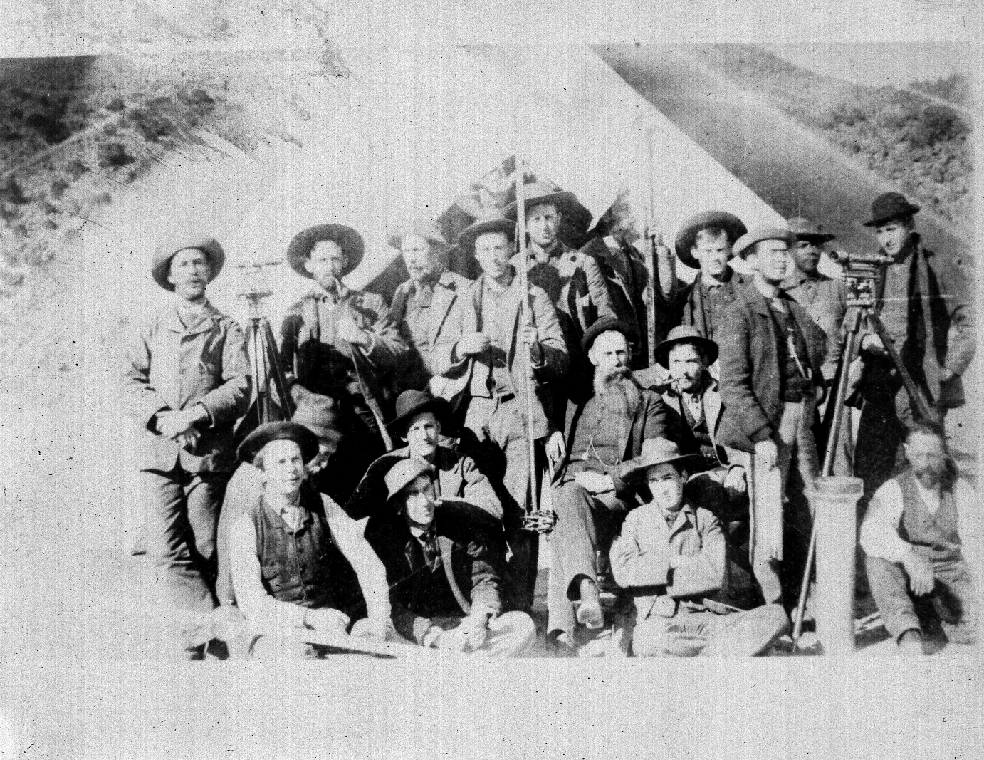
In January 1889, the first USGS streamgage was established along the Rio Grande near Embudo, New MexicoStreamgages typically contain equipment to continuously measure the rate and volume of streamflow. Streamgages in the western USA are particularly challenging to install and maintain because the river stage (or height) and flow can vary greatly between the dry months (late summer-winter) and periods of snowmelt, and in many cases the riverbeds are soft and unstable. The equipment and techniques developed at the Embudo gage site became the foundation of USGS streamgaging methods. Since the establishment of the Embudo gage site, there has been a consistent increase in the number of established gages in the United States.

Currently, the U.S. Geological Survey measures discharge at approximately 8,500 sites across the United States. Most of the streamflow data are delivered in near real-time via theĀ USGS National Water Dashboard(https://dashboard.waterdata.usgs.gov/app/nwd/en/?region=lower48&aoi=default). These flow data are used for planning, forecasting, and warning about floods and droughts; managing water rights and transboundary water issues; operating waterways for power production and navigation; monitoring environmental conditions to protect aquatic habitats; describing impacts to streamflow from changing land and water uses; assessing water quality and regulating pollutant discharges; determining if streams are safe for recreational activities; designing reservoirs, roads, bridges, drinking water and wastewater facilities; and many scientific investigations. Users of these data include water, utility, environmental, and transportation managers. More than 880 million requests for streamflow or water level information were fulfilled during the 2020 water year (which runs from October 1 to September 30 of the following year)!

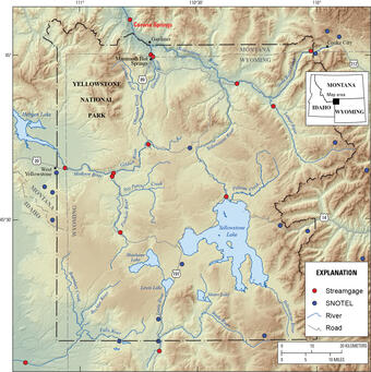
There are currently 15 streamgages in and around Yellowstone that are used to monitorĀ hydrothermal activityfrom the more than 10,000Ā thermalĀ features, manage water supplies, and that are used to prepare for and investigate the impacts ofĀ floods.

Hydrograph showing discharge in cubic feet per second for Corwin Springs streamgage site on the Yellowstone River, MT, spanning 1889-2023.Ā  The spike in 2022 is from the June floods of that year. Sources/Usage: Public Domain.

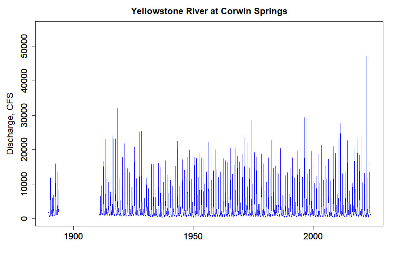
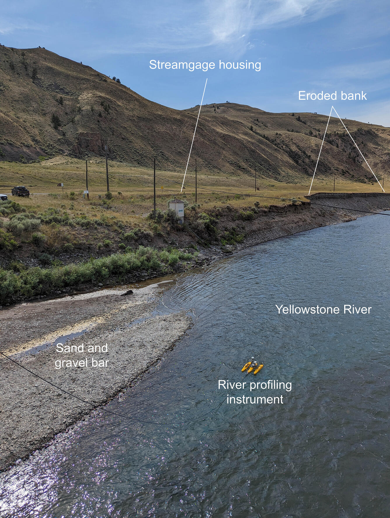
While the Embudo streamgage site in New Mexico was the first USGS gage site, the gage on the Yellowstone River at Corwin Springs, just north of the national park boundary, is nearly as old! Daily average discharge at the site was first reported on August 1, 1889 and continued through October 31, 1893. Discharge measurements started again in 1910 and continue today. The discharge record at Yellowstone River at Corwin Springs is one of the longest in the United States! The hydrograph, which plots the level of stream flow over time, from the site appears to be saw-toothed, with the peaks generally representing higher flows in the spring as a result of snowmelt.

Sources/Usage: Public Domain. Plot of specific conductance, discharge, and temperature measured at the Yellowstone River at Corwin Springs, Montana, during early-mid 2023. The anomalous spikes in temperature and specific conductance on May 23, 2023, are thought to be when a large sand and bar was deposited at the site. May 23 is also the peak flow in 2023.

The highest instantaneous discharge measured at the Corwin Springs’ gage was during the June 2022 flood, when the maximum discharge was determined to be 54,700 cubic feet per second (CFS) (1,549 cubic meters per second), compared to a median peak during snowmelt of 12,000 CFS (340 cubic meters per second). The June 2022 flood is estimated to be a 500-year flood event, meaning that an event like this is likely to occur only once in 500 years.

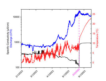
The gage house at Corwin Springs narrowly escaped serious damage from the 2022 flood, as the streambank about 164 feet (50 meters) downstream eroded away. However, the gage did not emerge completely unscathed. During the flood, monitoring equipment was washed away and the streambed changed its shape. In addition, the site continues to see changes to the bank and stream bed after the flood. During the 2023 spring high-flow runoff, a largeĀ unconsolidatedĀ sand and gravel bar migrated downstream and was deposited on top of the newly installed monitoring equipment at the gage! Approximately 2–3 feet (60–90 centimeters) of debris was deposited along the bank covering the piping that housed scientific monitoring equipment. The new gravel bar was probably deposited at the site on May 23, 2023, which corresponds to the highest flow in 2023, based on anomalous temperature and specific conductance measurements.

Streamgage site and profiling tool on the Yellowstone River at Corwin Springs, Montana.Ā  The gage house narrowly avoided damage during the June 2022 flood, which eroded the downstream bank.Ā  The river profiling instrument helps to map the river bottom to assess streamflow rates and conditions.Ā  USGS photo by Mike Poland, July 31, 2023. Sources/Usage: Public Domain.

Clearly the riverbeds and banks are still unstable as a result of the June 2022 flood! But the Corwin Spring gage keeps on measuring, continuing one of the longest continuous records of stream flow in the United States!

ā€˜Snow drought’ grips #California and western United States, despite recent storms — The Los Angeles Times #snowpack

Westwide SNOTEL basin-filled map January 8, 2024 via the NRCS.

Click the link to read the article on The Los Angeles Times website (Hayley Smith). Here’s an excerpt:

January 3, 2024

Although recent storms haveĀ thrashed the California coastlineĀ and boosted reservoir levels, the downpours have so far failed to deposit significant snowpack in the Sierra Nevada, which experts say is in the grips of a severe, early season ā€œsnow drought.ā€

[…]

ā€œIn some cases there is literally no measurable snow on the ground at all,ā€ Swain said during a briefing Tuesday. ā€œWhat this means is that right now, as of today, snowpack is at or below all-time record-low numbers for the beginning of January, and I know that’s pretty alarming.ā€

[…]

On Tuesday, state officials conducted their first snow survey of the season at Phillips Station, near South Lake Tahoe, where the ground was a patchy mixture of grass and powder. The monthly surveys in winter and spring are key to forecasting how the state’s resources will be allocated each year.  Snowpack at the location measured 7.5 inches, with a snow water content of 3 inches, said Sean de Guzman, manager of the California Department of Water Resources’ snow surveys and water supply forecasting unit. That amounts to just 30% of average for the date, and 12% of the average for April 1, when snowpack is typically at its deepest…Electronic readings from 130 stations across California indicate the snow water content statewide is just 2.5 inches, or 25% of average for the date, compared with 185% at the same time last year…

ā€œSnow drought conditions will continue to evolve throughout the winter,ā€ the NIDIS said on its website. ā€œEarly in the season, snow drought recovery can happen quickly. Recovery from snow drought in late winter and early spring, when snowpack is typically near peak, can be more difficult.ā€

Unlike a typical drought, which refers to a total lack of moisture, a snow drought refers to a deficit in the expected amount of snow, Swain said.

The Need for Smart Energy Siting in the West: Harnessing Abundant Resources while Protecting Habitats — Western Resource Advocates #ActOnClimate

Wind Turbine in Colorado. Photo credit: Western Resource Advocates

Click the link to read the article on the Western Resource Advocates website (Severiano DeSoto):

December 11, 2023

As the West pushes toward its ambitious climate goals, the delicate balance between clean energy development and land conservation has become paramount. While WRA and environmental advocates have passed legislation and won commitments that put electric utilities on track to reduce emissions, advance clean cars and trucks, electrify buildings, and decarbonize gas utilities, this requires more clean energy than ever before. To be successful in meeting these goals, we must focus on the next step in this process — where to place clean energy infrastructure through smart energy siting.

As WRA’s energy siting policy advisor, I work at the critical nexus of the climate and biodiversity crises in the Interior West. I bring a unique perspective and experience to this role, too. I joined WRA as a clean energy policy fellow, working with our Clean Energy team to identify federal funding opportunities to advance climate change solutions. Now, as a part of the Western Lands team, I pull from that experience to help craft balanced policy solutions that advance WRA’s clean energy goals while ensuring the build-out of new clean energy projects does not exacerbate habitat loss or place development on important natural and working lands.

Right now, the major focus of my work is on Colorado. Building the clean energy projects necessary to meet the state of Colorado’s ambitious climate goals will require a significant amount of land for wind and solar energy production, the largest driver of new land use change in the coming decades. To meet this need in a manner that does not exacerbate habitat loss and accelerate further loss of biodiversity requires a new approach to development planning.

WRA advocates for a smart energy siting approach that not only looks at the climate benefits of new clean energy projects but also accounts for the carbon impacts of land use change, ensures that conservation values are incorporated in the location and design of a project, and directly benefits host communities.

When done thoughtfully, new clean energy projects can provide the energy we need for a prosperous economy while minimizing the impact of these large projects on wildlife and ecosystems and provide direct economic benefits, from increased tax revenue to good paying jobs, in host communities. A smart energy siting approach assesses all these factors to maximize the benefits of new development and minimize conflicts that can often slow or stall projects.

.GIF credit: Western Resource Advocates.

WRA, as part of the Colorado Energy Siting Coalition, has been working over the last year to develop, advocate for, and implement a siting policy framework that ensures new clean energy projects in the state follow a smart siting approach to meet the states climate and conservation goals. WRA is a founding member and has been helping to coordinate the Coalition’s efforts to understand the perspectives of stakeholders across the state that are driving, or will be impacted by, the clean energy transition. We are also providing policy research and analysis to develop a policy framework that meets Colorado’s diverse needs and considerations. 

Given the state’s abundant clean energy resources, ambitious climate goals, and natural heritage, WRA believes Colorado can be a national leader in smart energy siting policy that minimizes conflicts with wildlife and accelerates the clean energy transition to address climate change. And this transition to a clean energy economy will touch all parts of the state. 

To better understand the various perspectives across the state, the Coalition held several rounds of stakeholder meetings to understand and address disparate needs. This outreach and engagement process culminated in October with a Clean Energy Siting Summit that brought together over 80 stakeholders from across the state to learn from one another and co-develop policy solutions to promote smart energy siting for Colorado.  

Participants included local and state government officials (county commissioners, state legislators, state agency directors and their staff, and the Governor’s policy advisors), renewable energy developers, electric utilities and co-ops, clean energy trade alliances, and environmental justice, conservation, agricultural, and wildlife organizations. This broad group, working altogether and in small groups, assessed policy options focused on:Ā 

  • Balancing state and local authority;Ā Ā 
  • Providing resources to local governments;Ā Ā 
  • Integrating environmental protections;Ā Ā 
  • Facilitating public engagement and establishing and defining community benefits;Ā Ā 
  • Streamlining and expediting the permitting process.Ā Ā 

Building on the momentum of the summit and the ideas and perspectives shared, the Coalition is working to synthesize this information and incorporate the various considerations of stakeholders into a policy framework proposal that WRA and the Coalition will advocate for during the 2024 legislative session.Ā Ā 

The amount of wind and solar energy needed to meet Colorado’s energy needs and reduce greenhouse gas emissions in line with science-based targets will require a significant amount of land. According to recent modeling by the Colorado Energy Office, the state will need to build approximately 12.5 gigawatts of wind and 12.5 gigawatts of solar capacity over the next two decades to meet this goal. If not properly planned for, this will cause irreparable harm to Colorado’s wildlife, natural habitats, and important agricultural lands. The good news is, according to the best available science, we can achieve both our clean energy goalsĀ andĀ protect important natural and working lands.

Accomplishing a just and equitable transition that occurs fast enough to address climate change is no small task. WRA and the Coalition recognize that to meet the moment – and this challenge – will require a thoughtful, smart approach to siting clean energy projects that incorporates conservation and community priorities. To do this we must ensure that all those driving or being impacted by the clean energy transition – including communities that have been previously left out of the decision-making process – are able to shape the transition and that the rights of nature and wildlife are protected.

Addressing the climate and biodiversity crises requires new, thoughtful approaches to meeting our energy needs, reducing emissions, and conserving and protecting the natural landscapes that make Colorado unique. During the upcoming legislative session, WRA will be challenging legislators to institute this critical balance into law.Ā Ā 

Native tribes are getting a slice of their land back — under the condition that they preserve it — The Los Angeles Times

A spring-fed pond near the existing trail on the Cottonwood Wash property. (Frazier Haney / Wildlands Conservancy)

Click the link to read the article on The Los Angeles Times website (Jack Herrera). Here’s an excerpt:

January 3, 2024

In February 2020, Dave Herrero drove into the canyon country here in southeastern Utah to visit a slice of land that was up for sale — a 320-acre ranch that stretched deep into the red-rock canyon near the small town of Bluff…In July, his California-based employer, the nonprofitĀ Wildlands Conservancy, purchased the ranch for $2.5 million from the family that owned it and began writing a deed that it hopes will become a model for working with tribes to protect wilderness in the American West from real estate developers, mining companies and oil drillers. In what would be a novel arrangement, the deed is expected to include a coalition of five tribes as co-owners and managers with Wildlands — an effort to acknowledge the history of the land, which the conservation group named Cottonwood Wash.

ā€œThere are once tribes that lived in these areas that were forcibly removed,ā€ said Davina Smith, a member of the DinĆ©, or Navajo, who has worked with different organizations to protect land in the Four Corners region. ā€œWe have to recognize that.ā€

[…]

The traditional model of conservation in the West has long followed the lead of environmentalists such as John Muir— the ā€œfather of the national parksā€ — who saw untracked wilderness as a sort of Eden that would fall to corruption under man’s influence. His model of conservation was simple: Keep people out…That school of thought feels foreign to Natives such as [Davina] Smith, 49.Ā 

ā€œYou have all these prominent writers writing about the West, but they focus on the landscape,ā€ she said. ā€œThey don’t think about the Native tribes who have always actually been living in this landscape.ā€

[…]

In 2015, a coalition of five tribes — Hopi, Navajo, Uintah and Ouray Ute, Ute Mountain Ute and Zuni — sent a letter to then-President Obama proposing the creation of the Bears Ears National Monument in Utah on land known as the Colorado Plateau. Under a novel co-management scheme, the tribes would have direct say in ecological stewardship and how to regulate economic activity and recreation…Less than a year after Obama issued a presidential proclamation creating the monument on Dec. 28, 2016,Ā then-President Trump undid itĀ at the urging of the Utah state government, which wanted to leave the land open to uranium mining, oil drilling and cattle grazing. When President Biden took office in 2021, one of his first acts was reestablishing Bears Ears…The Cottonwood Wash lies within the boundaries of the Bears Ears Monument, but because it’s private property, it wasn’t included as part of the monument. That gave Wildlands a playbook. In 2022, its leaders approached the Bears Ears Inter-Tribal Coalition, the official alliance of the five tribes, to say they were considering buying the Cottonwood Wash and were interested in joint ownership and management. As part of their push, Herrero and Haney drove to four reservations to meet with tribal leaders. Some were suspicious at first. Anthony Sanchez, the head councilman for the Pueblo of Zuni, explained that non-Native groups will sometimes use supposed ties to tribes to boost their own PR.

Bears Ears National Monument in Utah. By Bob Wick – By the Bureau of Land Management published on Flickr under a CC licence., CC BY-SA 4.0, https://en.wikipedia.org/w/index.php?curid=52982968