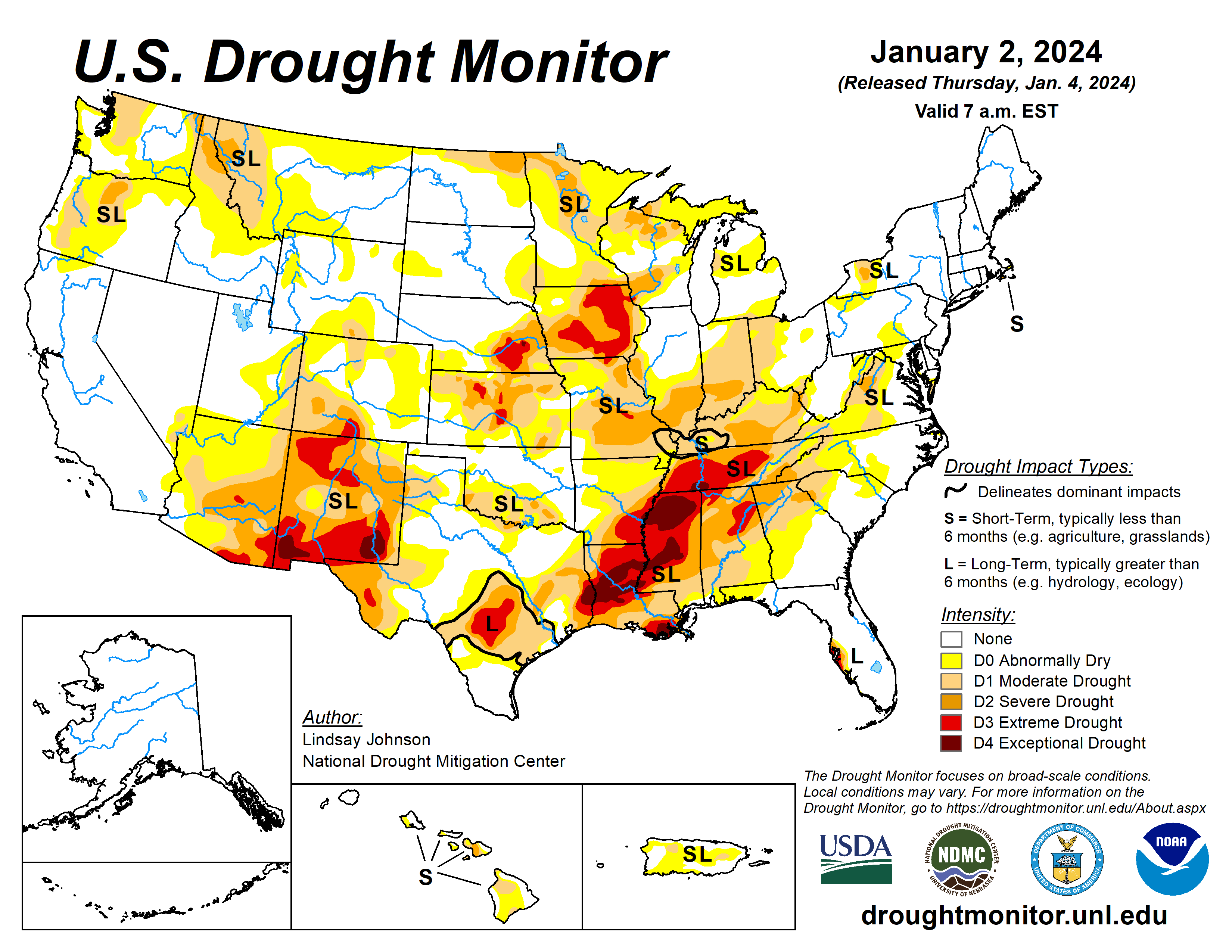
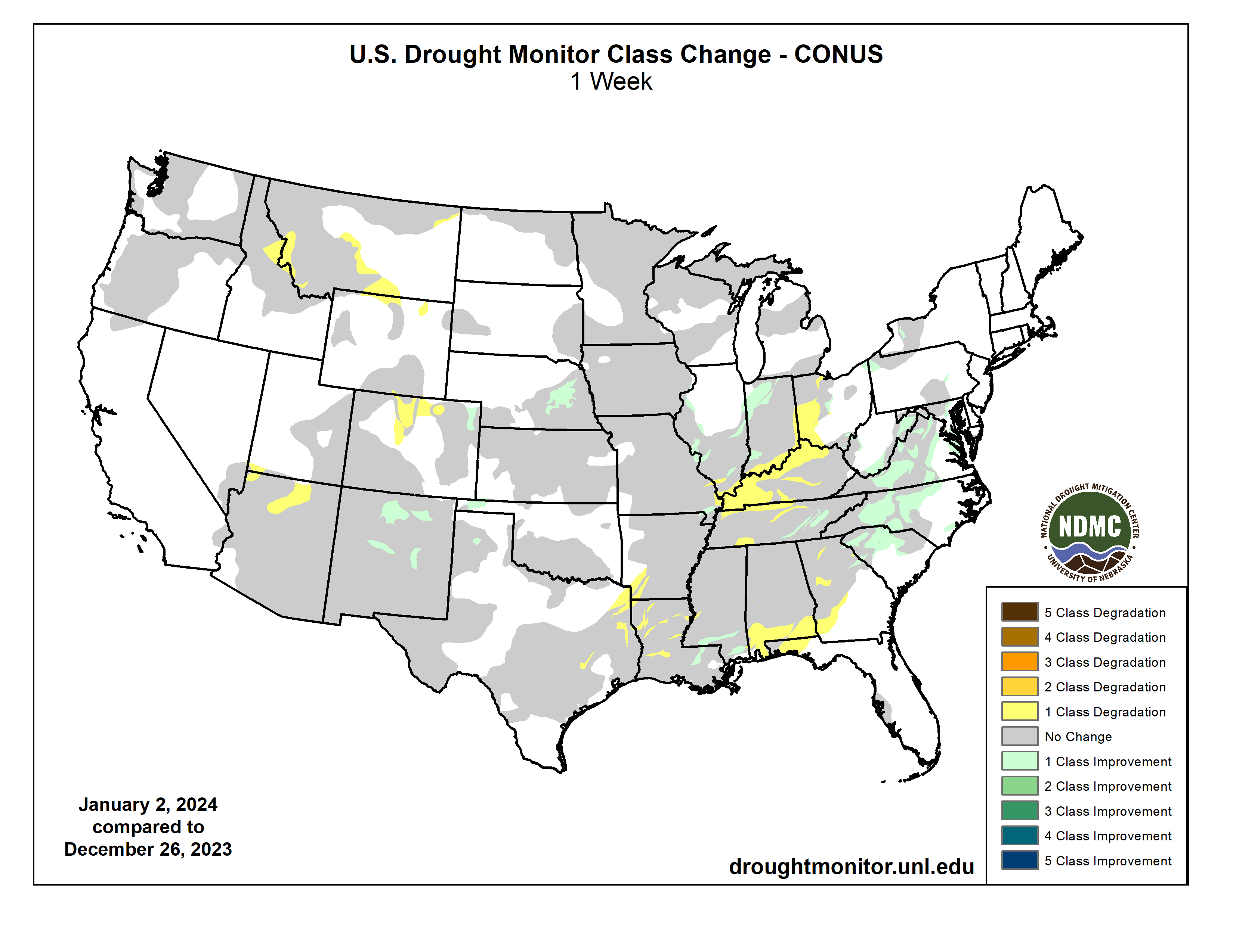
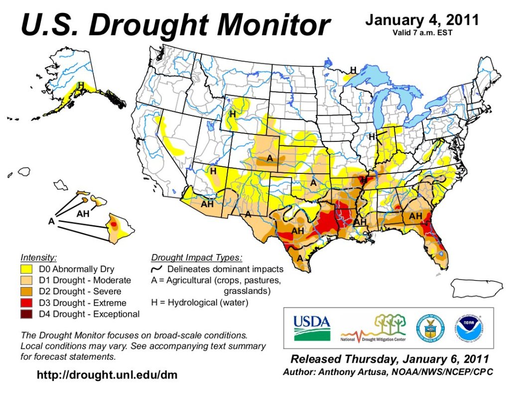
A large storm system brought rain and snow to the Pacific and Atlantic coasts along with rain and snow in the eastern High Plains and Midwest. The Northeast remained largely unchanged from last week, with minor improvements in western New York, Pennsylvania and central Maryland where precipitation was 150% to 300% of normal. Further south along the Mid-Atlantic, 150% to 300% of normal precipitation fell, bringing improvements in Virgina, North Carolina and South Carolina. The southern part of the Southeast did not benefit from any of the precipitation that fell elsewhere along the Atlantic coast, bringing further degradations to an already very dry part of the country. The South remained the same as last week, with small areas of deterioration from northeast Texas into southwestern Arkansas, and north and central Louisiana.
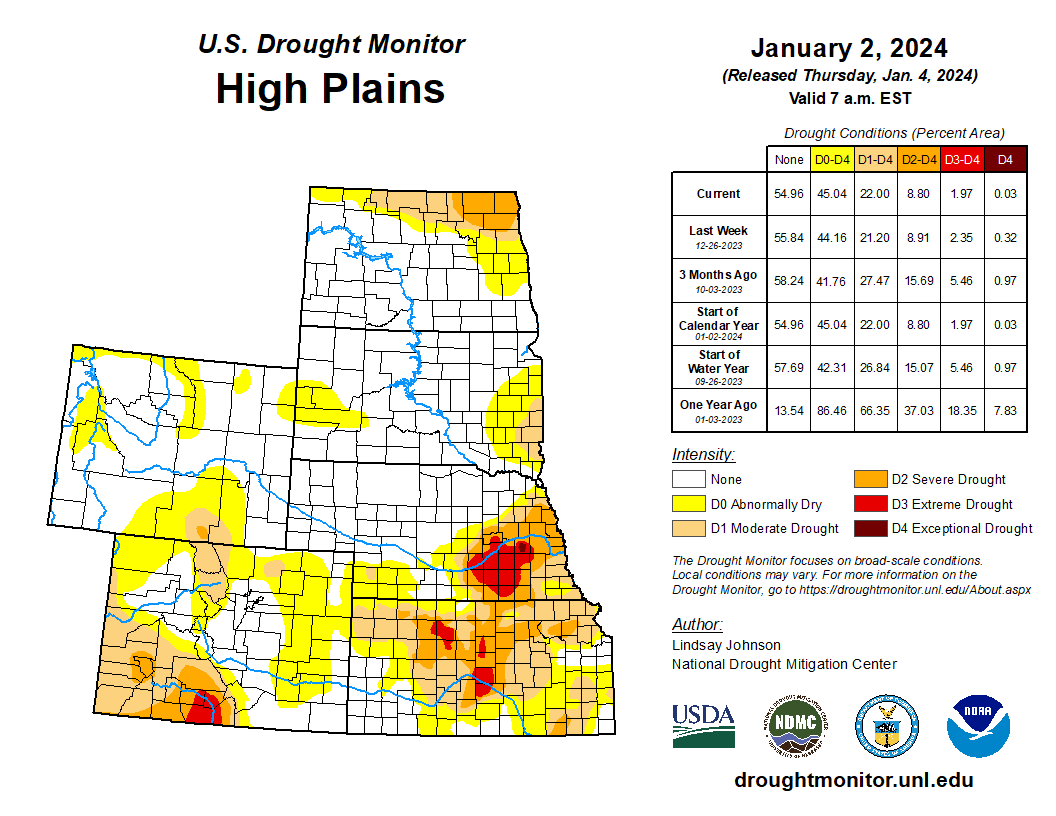
A small part of southeastern Louisiana and southern Mississippi saw minor improvements. The High Plains benefited from a rain and snow weather system that moved through the area before the new year. Northeastern Colorado into eastern Nebraska had some improvement. Northern Colorado and Wyoming experienced deterioration without the benefit of the precipitation that fell further east and low snow water equivalent (SWE). The north-central Midwest had some improvements from the same storm that benefited the High Plains. Central, eastern and southern Midwest largely missed precipitation, causing deterioration in eastern Ohio, southern Indiana and Illinois, and eastern and northern Kentucky where groundwater and streamflow remain low. The West saw few improvements, except for New Mexico. Lack of precipitation and low SWE in higher elevations have left areas of Montana and Arizona worse off than last week…
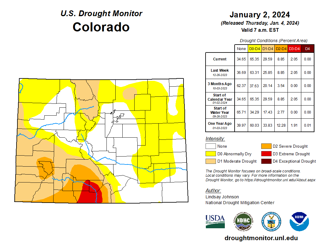
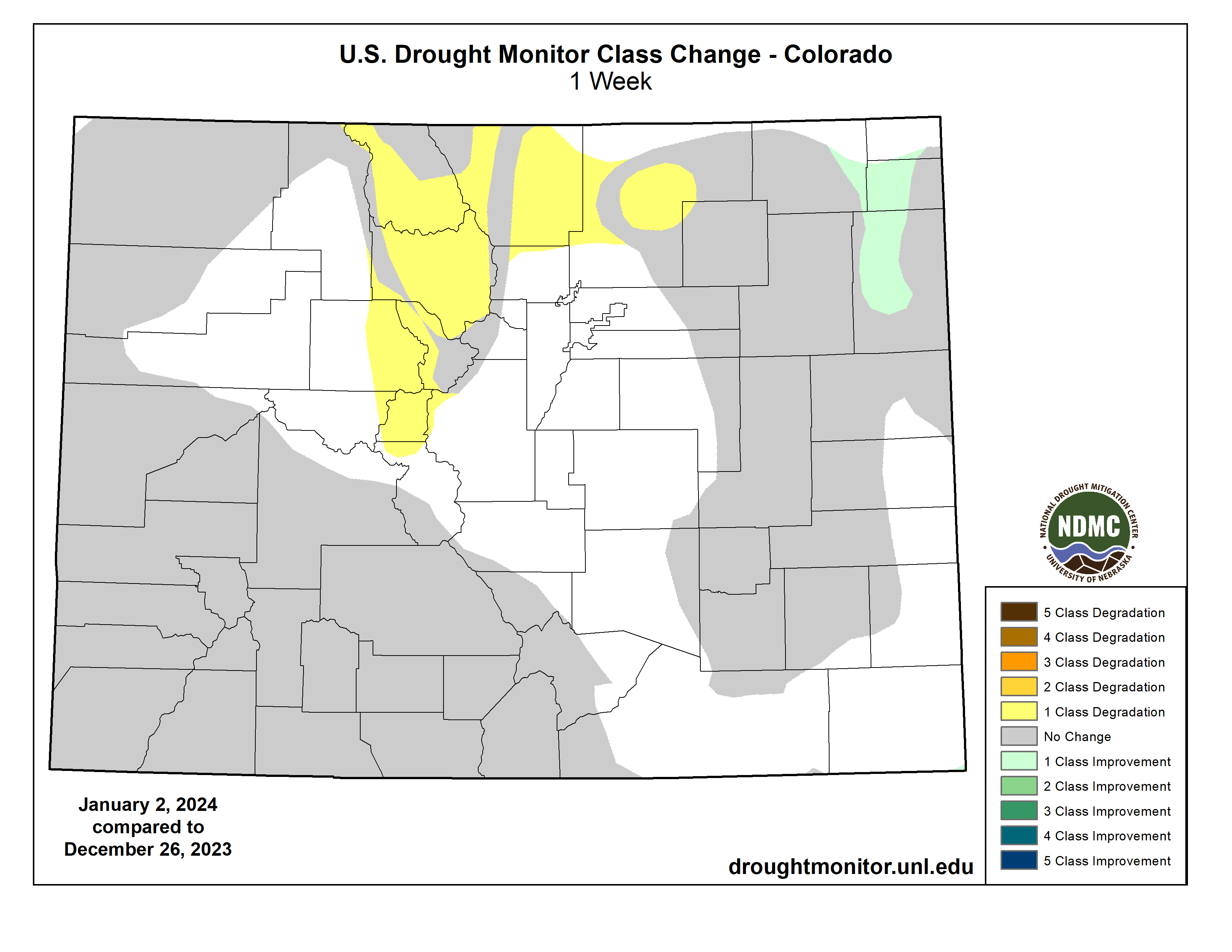
A weather system bringing rain and snow moved through the High Plains midweek last week. Central and northern states experienced up to 400% of normal precipitation. Northeastern Colorado and eastern Colorado saw improvements in Exceptional (D4), Extreme (D3), and Severe (D2) drought conditions. These improvements are a continuation of improvements seen last week. The weather system that brought improvements to much of the High Plains largely missed north-central Colorado. Conditions worsened, introducing abnormal dryness and degrading from Abnormally Dry (D0) to Moderate Drought (D1). Northern Wyoming experienced similar conditions to Montana, leading to small Abnormally Dry (D0) and Moderate Drought (D1) expansions along the northern border with Montana…
Colorado Drought Monitor one week change map ending January 2, 2024.
Much of the West remains status quo for the week. Precipitation fell across much of the Pacific coast from Vancouver southward into central California. Montana has not benefitted from the recent precipitation, causing small degradations along its border with Idaho, Wyoming and North Dakota. Precipitation continues to miss Arizona, mainly the north. Over the past few months Abnormal Dry (D0) conditions expanded northward into southern Utah. New Mexico did see improvements in Extreme (D3), Severe (D2) and Moderate (D1) drought conditions in the interior northwest…
Little reprieve occurred across much of the South, with only 5% of normal precipitation falling. Western and central Texas remained unchanged, with a small improvement of Moderate Drought (D1) to Abnormally Dry (D0) conditions in the Panhandle. Parts of southeast Louisiana and Mississippi had small improvements with streamflows slightly improving. This is not the case for much of the South where short- and now long-term conditions continue to decline. Streamflow and groundwater continue to counteract what precipitation is received. Eastern Texas into western Louisiana and southwestern Arkansas saw 1-category degradations for all drought categories. Central Louisiana had Extreme drought (D4) conditions expand northward into Catahoula, Winn, Richland and Concordia parishes. Moderate Drought (D1) in northwest Louisiana extended west into eastern Texas and southwestern Arkansas. Mississippi stayed largely unchanged aside from the slight reduction of Moderate Drought (D1) in the far south. Tennessee saw improvements in the east, with improving soil moisture and benefits from the precipitation experienced in the Mid-Atlantic region. Central and eastern Tennessee, on the other hand, saw Severe Drought (D2) expand northward into Kentucky. Exceptional Drought (D4) was introduced in the South at the tri-boundary with Mississippi and Alabama due to the continued lack of precipitation for the past few months…
Looking Ahead
During the next five days (Jan. 2-7, 2024), more heavy precipitation is expected for the central and northern Pacific coast, with some areas of higher elevation also seeing some moisture. The Gulf Coast and southern Atlantic regions are expected to see heavy precipitation. This centers around southern Louisiana, Mississippi and Alabama.
The National Weather Service Climate Prediction Center’s 6-10 day outlook (valid Jan. 3-9, 2024) favors above-normal precipitation for most of the country, with high probabilities found in the intermountain West, east of the Ohio and Mississippi River Valleys, Alaska and Hawaii. Only southern Texas is expected to have below-normal precipitation. There is an increased probability of below-normal temperatures west of the Rockies, particularly in the southwest. Following the precipitation trend, areas of probable heavy precipitation in the east also have the probability of being warmer than normal. The Northeast has the largest probability of having above-normal temperatures.
US Drought Monitor one week change map ending January 2, 2024.
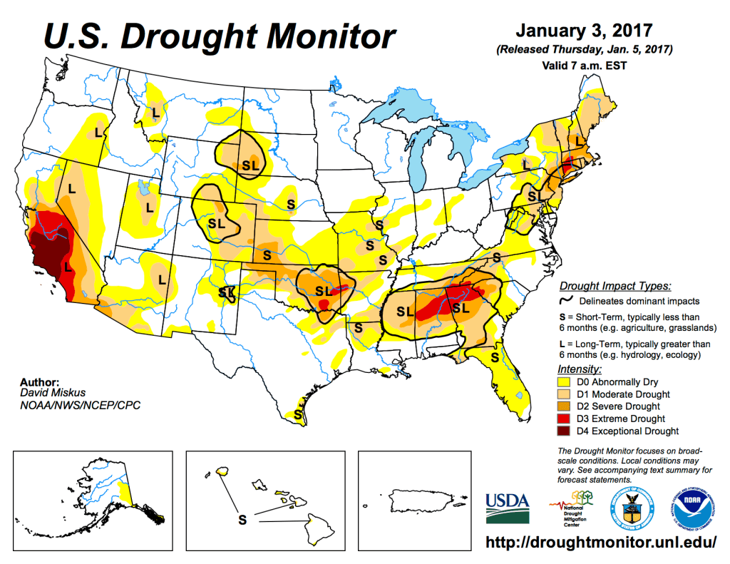
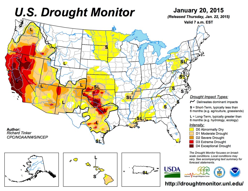
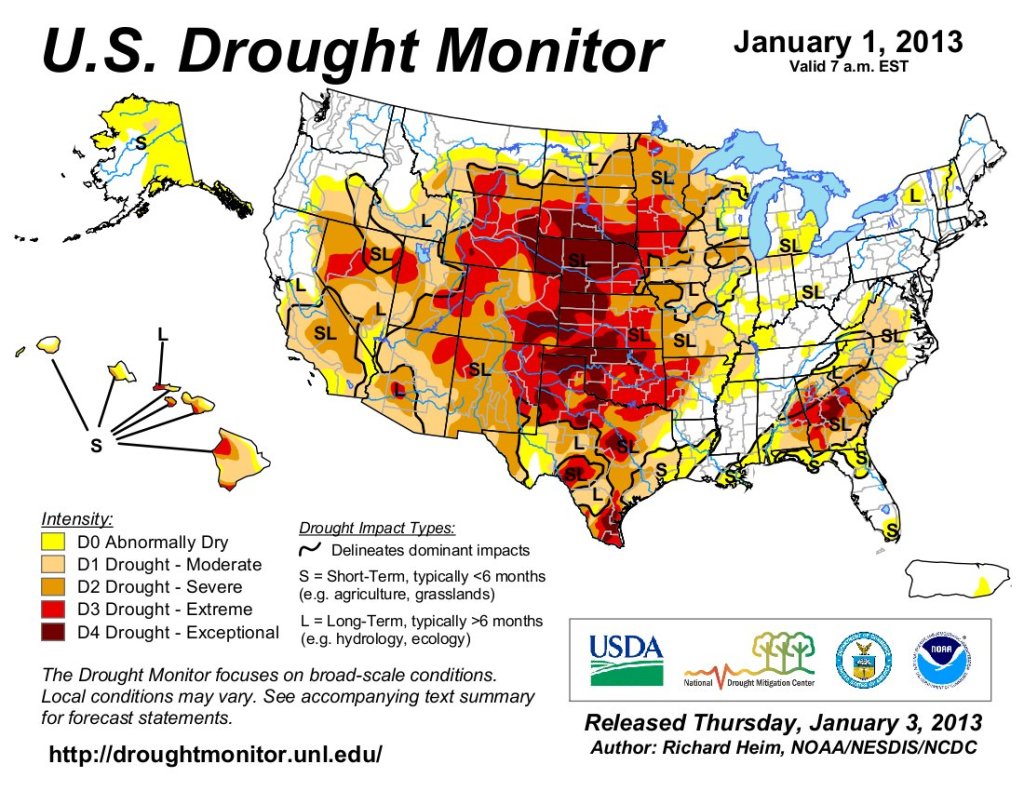
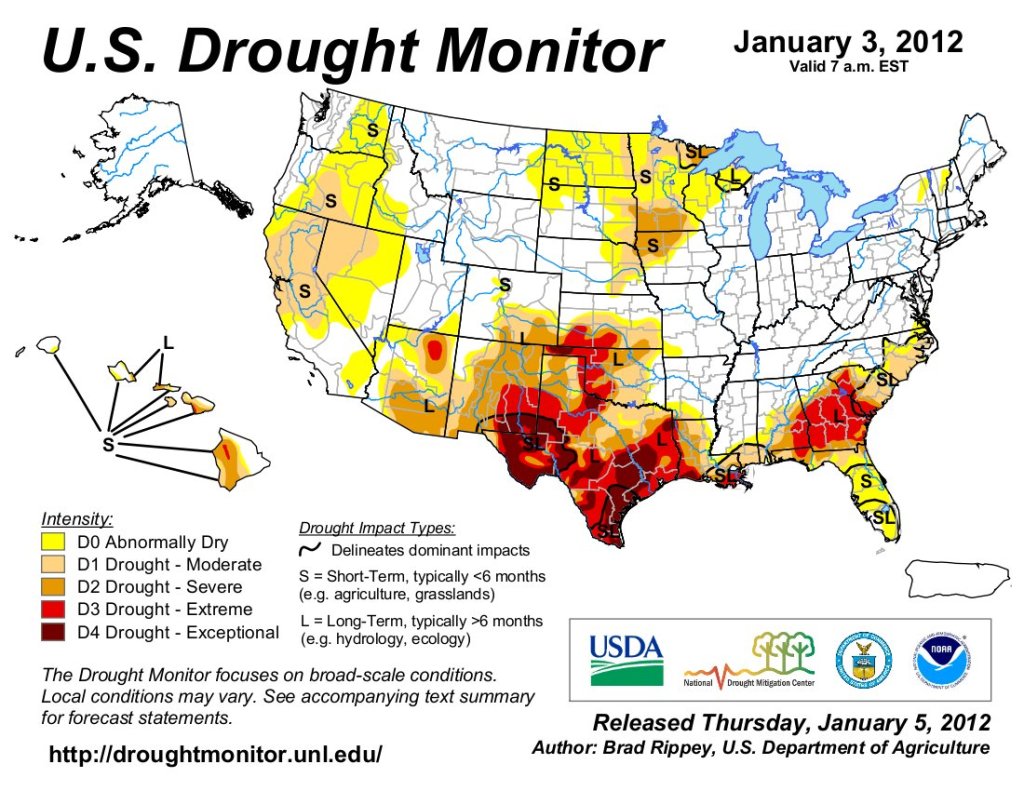
Just for grins here’s a slide show of early January US Drought Monitor maps for the past few years.
Greetings in 2024, which promises to be an interesting year, along the Colorado River and beyond it too. May we come out of it affirmed nationally in our commitment to democratic governance, and improved in our execution of it on our river.
Back in the earlier part of the last century, the great conservationist and ecologist Aldo Leopold advised us to ‘think like a mountain’ – a large entity occupied by many life forms working together, sometimes cooperatively, sometimes competitively, but keeping the whole system in a living, dynamic balance. Remove any part – the wolves, in his story – and something else would start to go out of balance (the deer) and a kind of disorder would spread through the whole system. When intruding on an ecosystem, he was saying, tread carefully and move incrementally, stop often to observe your unfolding consequences….
“New plot using the nClimGrid data, which is a better source than PRISM for long-term trends. Of course, the combined reservoir contents increase from last year, but the increase is less than 2011 and looks puny compared to the ‘hole’ in the reservoirs. The blue Loess lines subtly change. Last year those lines ended pointing downwards. This year they end flat-ish. 2023 temps were still above the 20th century average, although close. Another interesting aspect is that the 20C Mean and 21C Mean lines on the individual plots really don’t change much. Finally, the 2023 Natural Flows are almost exactly equal to 2019. (17.678 maf vs 17.672 maf). For all the hoopla about how this was record-setting year, the fact is that this year was significantly less than 2011 (20.159 maf) and no different than 2019” — Brad Udall
Were Leopold here today, as we undertake the sobering Anthropocene task of more effective management strategies for the Colorado River we’ve created from the river we found here, he might advise us to ‘think like a river’ – being careful first to be sure we are working with the river we actually have today, not the river we thought we had a century ago when we began to develop the management strategies that finally crashed at their century mark in 2022. [ed. emphasis mine]
Am I suggesting that the river actually ‘thinks,’ like we humans (supposedly) think? No. I don’t pretend to know if anything else in the universe thinks like we think (when we choose to). But it ought to be evident, here in the Anthropocene Epoch, when we are altering – consciously or unconsciously – a lot of the planet’s systems, that we could be better at thinking things through than we seem to be, and we ought to be able to learn something about thinking things through from looking closely at the systemic behavior of things that have been working much longer at the challenge of surviving, even thriving, with a measure of sustainable grace…. Like our rambunctious river, before we went to work on it.
Illustration of the Hyporheic Zone, from D. Tonina and J. M. Buffington, 2009, Hyporheic Exchange in Mountain Rivers I: Mechanics and Environmental Effects. Geography Compass 3 (2009): 10.1111/j.1749-8198.2009.00226.x
Watching a river (one of my favorite occupations), the first superficial observation might be: this is a stream of water that is leaving, flowing away from land that was not able to put it to use, so it is leaving the premises – usually carrying some of the land with it. This is an accurate perception of one of the river’s functions (without which, there would be no ‘downstream’), but that is not to say that the flowing stream is nothing but a drainage ditch. The flowing stream actually interacts with the land it is moving through as much as it can, through what hydrologists call ‘hyporheic exchange’ – either moving some of its water into the land it is flowing through, or picking up groundwater trickling into the stream. And it isn’t just purely water that gets exchanged both ways: the water is full of micro-organisms and dissolved and particulate minerals and gases, nutrients that also move into or out of the land.
A river’s boundary does not end at the channel margins. Even when not in flood, the river’s water reaches out laterally, beneath the riparian forest and floodplain, and vertically, into the substrate beneath the channel.
This underground world, where water originating in the river channel is percolating, in darkness, through the spaces between grains of gravel and sand, is called the hyporheic zone. The term Hyporheic means, literally, “beneath the river.” The distinguishing feature of this underground world is that surface water percolates down into it, moves through it for a while, and then reemerges from the streambed, becoming part of the surface water again further downstream.
This exchange of surface and subsurface water happens all along the river channel, giving the hyporheic water a character distinct from ordinary groundwater. And in the process, the surface water becomes changed as well.
One of the changes that happens when water enters the hyporheic zone is that it becomes cooler. We have all had the experience of going into the basement of an old house on a hot day, and noticing how cool the air can be down there. Temperatures below ground are cooler in the summer time, and more constant throughout the day. The streambed is no different.
The water flowing in the hyporheic zone becomes cooled, and when it reemerges, it cools the surface water as it mixes. This is one of the ways that a stream can remain cool in the sunlight, and cool off again in the shade after flowing through blistering sunlight.
Since the water flowing into the hyporheic zone carries dissolved substances from the surface water, including oxygen, carbon dioxide, and other nutrient substances that nurture growth of plants and fungi, there is life in this underground world. Each grain of gravel and sand becomes coated with a living film of microbes, a “biofilm,” that is nurtured by this flowing water and thrives in the absence of sunlight. Microscopic creatures, and even larger creatures, big enough to be seen by our eyes, such as copepods, tardigrades, insect larvae, tube worms, roundworms, and even juvenile fish enter, and live in, the hyporheic zone.
It is this biological activity that leads to another important function of the hyporheic zone: water filtration and purification. The streambed acts as a sand filter, physically straining out tiny particles of silt and organic matter, helping keep the surface water clear. The biofilm absorbs chemicals out of the water. Some of these chemicals nourish the microbes making up the biofilm. Other chemicals, including toxins from human pollution like road runoff, are absorbed by the biofilm, and in some cases broken down into harmless substances by the microbes.
Hydrologists call a stream picking up water from the land it’s moving through a gaining stream, and a stream that is giving some of its water to the land a losing stream. I think the latter ought to be called a ‘giving stream,’ but I guess we’ve got to go with the hydrologist terminology. (It’s Trumpthink to call the stream a ‘loser’ for trying to be generous with its water.) Whether a stream loses or gains water from the land it is passing through depends on the level of the water table in the groundwater in the vicinity of the stream: if the water table near the stream is higher than the surface level of water in the stream, the stream gains from groundwater that trickles in. If the stream level is higher than the water table near the stream, the stream ‘loses’ (gives) water to the surrounding land.
Another observation about how a river behaves comes from looking at the material a stream is carrying, material it has cut, ground or otherwise eroded from its mountains, and realize that a river is both a creative and destructive force creating the landscape like a sculptor. Some sculptor – maybe Michelangelo? – said that his task was to remove the excess stone from a block of marble to reveal the beautiful figure within; so does the river create our magnificent vistas of mountains, couloirs, bowls and valleys by cutting into and moving stone.
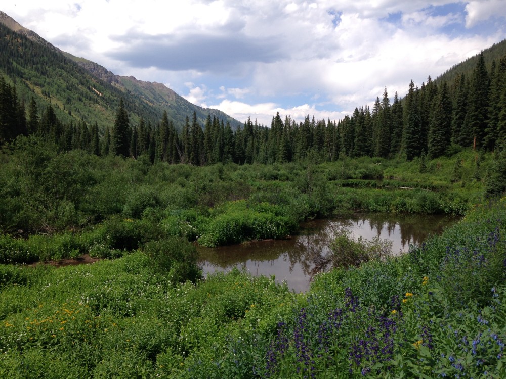
Healthy mountain meadows and wetlands are characteristic of healthy headwater systems and provide a variety of ecosystem services, or benefits that humans, wildlife, rivers and surrounding ecosystems rely on. The complex of wetlands and connected floodplains found in intact headwater systems can slow runoff and attenuate flood flows, creating better downstream conditions, trapping sediment to improve downstream water quality, and allowing groundwater recharge. These systems can also serve as a fire break and refuge during wildfire, can sequester carbon in the floodplain, and provide essential habitat for wildlife. Graphic by Restoration Design Group, courtesy of American Rivers
This reductively creative, creatively destructive process is enhanced in our river basin by the fact that most of the river’s water supply comes from a winter snowpack that melts out quickly over a couple months in what passes for spring in the mountains, and most of the river’s water goes ripping and tearing down the mountains, far too fast for more than a fraction of it to sink in as groundwater. But what does sink in is important to the river after that fast runoff; the groundwater moves at a leisurely pace through the ground – ranging from days and weeks to as much as a century – making its way down to the low places where the surface streams flow, and arriving in the post-runoff time, late summer and fall, when the stream needs the gain. The US Geological Survey has determined, through sophisticated studies of isotopes, that roughly half of the water in the Colorado River below its steeper tributaries entered the river as groundwater.
When the downhill slope gentles, even surface flows slow and the streams begin to drop the debris they have torn out and are carrying, and they move that debris around – or move around the debris themselves: so doing, they create meadows and floodplains through which they loop and meander, generating a lot of hyporheic exchange. Much of this exchange may be only into immediate riparian areas; but when streams roll into their own created floodplains, they spreads their excess bounty more broadly, raising a water table that might nurture grassy meadows, cottonwood forests – or lots of agricultural land. A good runoff makes a stream’s floodplains live up to their name, with shallow floods spreading new layers of silt and nutrients over them.
In trying to ‘think like a river,’ we do have to think about land-based life too, and the relationship of land-based life to water – which of course is existential: without water, there is no life as we know it on the planet. And land-based life depends absolutely on freshwater, which – remember from the last post here – is less than one percent of the water on the planet. And two-thirds of that modest percent is bound up in the ice sheets on Greenland and Antarctica.
All the life on the planet depends on access to the remaining tiny fraction of freshwater – which, by the time it has accumulated in streams and rivers is on its way back to the salty seas, despite their efforts to slow the process by meandering and offering their waters in hyporheic exchanges. More freshwater will come – or at least it always has – as the sun distills it again from the salty seas and precipitates it over the land, but still…. All that freshwater, essential to life, just running off to the seas where it disappears into the salt water, freshwater’s equivalent of dying….
If one wanted to let the imagination fly like an untethered kite for a moment – land-based life itself might be described as a freshwater strategy for confounding gravity’s pull back into the ocean. We – all of us, plants, animals, fungi, bacteria – are made up of highly specialized little vessels whose chief component when we are alive, is water. This is true of aquatic life that stays in the water, but it is also true of the rest of the planet’s life project that came out of the water to live on the land, a diversity of stacks and arrays and mobile units of tiny specialized cells full of a mix of minerals and gases dissolved in water. The watery cells that arrange themselves as molecular bucket brigades in trees lift water as much as three hundred feet into the atmosphere, against gravity, profligately venting most of that water back into the atmosphere to maintain that upward flow. We animals carry water everywhere, against gravity, far from the rivers. In this flight of imagination, humans, around 70 percent water, could be described as water that stood up to look around and think and dream.
Beaver ponds and meadows. Photo Credit: Sarah Marshall via American Rivers
Reeling that kite in – land-based life does interact with surface freshwater in many ways, some of which facilitate water’s willingness to carry out hyporheic exchanges with the land and the water-using organisms on the land, and some of which work against such exchanges. Beavers work to slow the flow of water through the land, pooling it up in ways that slow but don’t stop the flow, and so doing, nurture wetlands and wet-meadow ecosystems. And we humans move water out back out onto the land to irrigate it, again and again with the same water in the arid lands, using it to grow life that would never grow there at all unassisted.
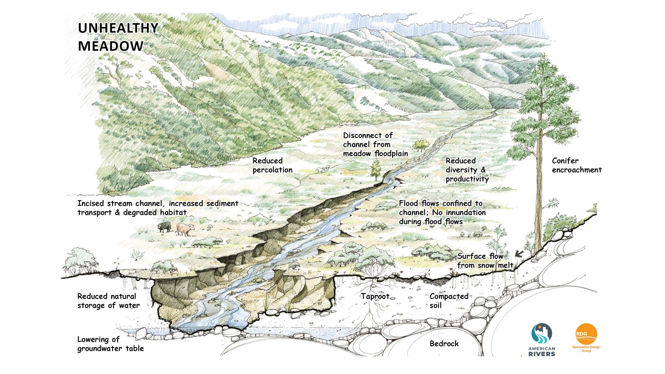
Many river stretches in Colorado have been impacted by human use. In her book “Virtual Rivers,” Ellen Wohl describes how rivers and headwater systems have been degraded over time. “As land-use changes have resulted in changes to the water and sediment entering stream channels, these channels may become unsightly, pose a hazard to human life and property because of excessive scouring or sediment filling, or no longer provide some desired function, such as fishing.”
Here we see an unhealthy system with an incised stream channel that is disconnected from its floodplain, resulting in reduced water storage, less groundwater recharge, and degraded water quality. Unlike in a wetland system, runoff and flood water flow quickly out of a degraded meadow because they cannot spread out and seep in. Increased flows cause further erosion, cutting deeper and wider channels that are less meandering and sending more sediment downstream. Graphics by Restoration Design Group, courtesy of American Rivers
We are also guilty of occasionally conspiring with the vagaries of nature to destroy the hyporheic exchange between streams and the land they run through, as when we unconsciously overgraze a wet meadow in a dry year – then a summer afternoon storm drops an inch or two of cloudburst rain on the meadow, and a raging torrent rushes down through the vulnerable sun-baked meadow, creating in an hour or so a gully that deepens in subsequent years, and draws down the water table of the former meadow, causing an ecosystemic change from a wetland ecology to a dryland ecology. Or a dam is built across the river, drowning the aquatic and riparian ecosystems above the dam and altering the ecosystems below the dam. Some of these kinds of changes are unfortunate; others are just unavoidable as we try consciously to make the planet more ‘fitting’ for human survival in ever-increasing numbers.
There are two further observations about these processes that seem almost confoundingly contradictory: the slower the flow, the more the stream or river gets to interact with the land. But at the same time, the more the water is spread out in those interactions, the more vulnerable the water is to the sun’s power. Among ourselves we say ‘use it or lose it.’ But in the bigger picture, it is ‘use it and lose it’ through increased evaporation and transpiration, as we ‘spread it out to dry.’
So given all of that – what can we say about ‘thinking like a river’ today, as we start planning for the operation and maintenance of our Colorado River in the hotter and probably drier Anthropocene? Given that it is only two-thirds the river we thought it was a century ago when we started to ‘develop’ it?
The most obvious thing from observing the river at its own work is to do what can be done to ‘slow the flow’ of water back to the sea – but to do it in ways that don’t just ‘spread it out to dry’ under the sun whose power is enhanced by our atmospheric changes.
One way to do this is to get more of the water underground but retrievable. Back in the 1930s, there was discussion about how best to bring the on-again off-again firehose of the Colorado River mainstem under a measure of control. The Bureau of Reclamation and the Army Corps of Engineers wanted big bold mainstem dams, like Hoover’s dam (already under construction), but the brand-new Soil Conservation Service favored a lot of small reservoirs and erosion-restoration projects up in the headwaters of the western rivers, followed by better farming, logging and mining methods. The idea was to raise water tables and increase the quantity of groundwater making its slow way downhill underground and out of the sun, before joining the river in its hyporheic games.
We know who won that discussion. But today, there is a growing movement to restore degraded landscapes by repairing gullied valleys and raising water tables, getting more water underground and out of the increasingly brutal sun. City utilities are cautiously exploring aquifer recharge, where over-pumping hasn’t already collapsed the aquifers. And we are moving toward consent about the fact that bypassing Glen Canyon Dam would increase the amount of water available for use by a third to half a million acre-feet, with no realistic loss of storage (put it all in Mead Reservoir). Had we given fewer resources to the Bureau of Reclamation and more to the Soil Conservation Service in the ‘30s, we would probably have more water in the river today.
I am not one of those who laments the fact that ‘the Colorado River no longer flows to the ocean,’ and don’t find that fact inconsistent with ‘thinking like a river.’ The amount of active freshwater on the planet is so relatively miniscule in the big picture that I think it would be just fine if land-based life figured out ways to put all of it to work on the care and maintenance of land-based life. That will of course never happen with a vast watershed like the Mississippi – although, given the dead zone its runoff is creating in the Gulf of Mexico, it might be better if it was all used up before New Orleans. I do realize that the lack of Colorado River water flowing into the Gulf of California has impacts on sea life there, but everything seems to involve choices, and in this one, I am inclined by nature to come down on the side of land-based life….
I think it would be nice if we could dedicate one percent of the river’s water to restoration of the beautiful old Colorado River delta – but it would be even better if we could figure out how to make the vast ‘desert delta’ we have created instead (Phoenix on the east through all the Lower Colorado ag lands to Los Angeles on the west) something we could love rather than dislike so much as we seem to…. Can we not build beautiful cities, desert ‘arcologies’ that we’d like to live in rather than ‘auto-urbs’ under a carbon-gas smog spreading out like a cow pooping on a flat rock? Or agricultural lands that aren’t rural industrial slums plagued by inequity?
Thinking like a river – water driven back to sea level by gravity (‘It’s the law!’) but doing what it can to slow its flow in places where it can give water back to the land as well as carry water off the land…. The water has systematic processes going on that we can participate in – have to, being water vessels ourselves needing constant replenishment. We’ve presumed, both consciously and unconsciously, to take charge of those systems along with a lot of other planetary systems; that’s what the Anthropocene Epoch is, and either we rise to the challenges there we’ve imposed on ourselves, or we will preside over our own slow and tedious unraveling. And maybe the first big challenge is slowing our own flow enough to begin to really think through the systems we’ve often just overrun in enthusiastic arrogance.
This year was marked by incredible progress in terms of Audubon’s priorities for water conservation in the West, and yet, we have so much more to do for the birds and people who rely on clean and reliable water. In my lifetime, North America has lost more than 3 billion birds—a catastrophe reaching a tipping point. If we act now, we can reverse this trend and protect people and birds in the arid West. And while daunting, we are making an impact.
Sometimes we hesitate to celebrate or call an achievement a “win” because the work is so massive and ongoing, with climate change and drought still present, and the threats facing the rivers, lakes, and wetlands—and the essential habitats they provide to birds—are growing. Adding more water into the Colorado River, Rio Grande or Great Salt Lake can feel tiny compared to what they need, or what they once were, or could be. But we are seeing birds respond. These victories add up and show decision-makers that new solutions can work, especially when scaled up. Thanks to our supporters and partners, we’ve directed and secured more conservation funding from federal and state governments to these iconic watersheds, we’ve changed public policies and water management where it was outdated and no longer serving today’s needs, and we continue to push for better outcomes for precious water resources in the West.
Much of the work we do is often behind the scenes because of complex technical and legal requirements (such as water transactions to benefit Great Salt Lake or modeling to determine optimal timing for bird surveys). Because of this, it can be challenging to capture the impact we’re making. On top of that, this work can be politically messy—even while we maintain great relationships with many legislators, government officials, and partners.
Despite the challenges, the momentum continues to build in our work around the West and in Washington, D.C.
Championed birds and basin-wide environmental resources in regular dialogue with Colorado River decision-makers in ongoing negotiations.
The range of Audubon’s work is vast: from implementing innovation and market-based solutions, to mobilizing science partners that address knowledge gaps for priority birds, and to thought leadership in water policies and management decisions. Here’s a high-level view of that work:
Great Salt Lake Watershed Enhancement Trust in its first year
At Great Salt Lake, Audubon, along with The Nature Conservancy, has been co-leading the Great Salt Lake Watershed Enhancement Trust (aka the Trust)—a key effort among many solutions needed in protecting and enhancing the water quantity and water quality for the lake and its wetlands. These are some of the most critical habitats for birds in North America. The Trust, working with the State of Utah’s Divisions of Forestry, Fire and State Lands and Wildlife Resources, have facilitated, provided transaction costs, and contributed funding to water transactions for more than 50,000acre-feet of water for Great Salt Lake. The bulk of this water was donated or partially donated, including what is believed to be the largest-ever permanent water donation of water to Great Salt Lakefrom the Church of Jesus Christ of Latter-day Saints.
The wetlands surrounding Great Salt Lake provide crucial habitat for millions of migratory birds, recreational opportunities, and many other public benefits including protecting water quality.
This year is just the beginning, as we’ll secure more water for Great Salt Lake in 2024 and beyond. In the face of climate change, unpredictable drought, and increasing water demands, the Trust, and many other interested parties will need to work collaboratively to bring more water to the lake.
Intermountain West Shorebird Surveys after a 30-year hiatus
Understanding how migrating shorebirds are responding to habitat changes as saline lakes face the threat of desiccation due to climate change and water diversions has been an essential driver for our work with partners in the regional Intermountain West Shorebird Surveys. Now with three seasons under our belt (Fall 2022, Spring 2023, and Fall 2023), Audubon and Point Blue Conservation Science aim to fill data gaps for at least 30 species of shorebirds and their vulnerable habitats in an area bounded on the West by the Sierra Nevada Mountains and on the East by the Rocky Mountains. Conditions have dramatically changed since the last major effort like this was undertaken over 30 years ago, and the need for updated information is more important than ever. We teamed up with the U.S. Fish and Wildlife Service, several Tribes, 11 state wildlife agencies, 35 Audubon chapters, hundreds of volunteers, private landowners, and many other non-profit organizations to count shorebirds in their peak migration windows at 200 sites across the West—and we will do so through 2025—to inform shorebird conservation.
In the time since we’ve kicked off this enormous survey effort, extremes of “weather whiplash” have made for interesting results. For instance, August 2022 was the peak of this mega-drought; Spring 2023 had record-breaking runoff; August 2023 had the West Coast’s Tropical Storm Hilary. We’ve also seen surprising statistics so far, including a record-breaking maximum count of shorebirds at the Salton Sea. The previous max count was 105,000 and the most recent survey counted over 250,000 shorebirds.
We aim to fill more data gaps, but more resources and collaborations are needed to ensure a robust understanding of these species needs. From American Avocet to Wilson’s Phalarope to Snowy Plovers, many species that rely on saline lakes throughout their lifecycle are benefitting from capable partnerships like this, increasing our shared knowledge and allowing for more focused management and protection of their unique habitat needs.
Colorado River “Beginnings”. Photo: Brent Gardner-Smith/Aspen Journalism
Colorado River at a pivotal moment to reduce water use while including the needs of birds
The lifeblood of the American West received a lifeline this year with an above average winter—but the decades-long overuse problems remain. We know that it may take a decade or more of above average winters to restore the main Colorado River reservoirs to pre-2000 levels. The overall trend is that the available water in the Colorado River is declining, even while the United States and Mexico, Tribes, state governments, cities within the basin, and farmers are doing more than ever to ensure available water supply for subsequent years.
We know that to save the Colorado River, we need to use less water. And as the U.S. Bureau of Reclamation continues long-term and short-term planning on the Colorado River, it’s important to remember that while the Colorado River is unpredictable, planning for that future can help all of us in the long run. These plans need to also consider the enormous third-party impacts of reducing water uses in the Colorado River. Thank you to the Audubon network members who sent more than 31,000 comments to the Bureau of Reclamation in 2023 in favor of better outcomes for people, birds, and the environment.
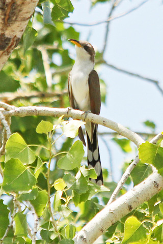
Western yellow-billed cuckoo at Montezuma Well, Arizona.
Photo Courtesy of Gary Botello via the National Park Service
Wrapping up 2023 and looking ahead to next year
We remind ourselves that birds are not only essential components to a healthy ecosystem, birds are daily reminders of our interconnections. This year, a tagged Western Yellow-billed Cuckoo, a federally threatened bird, taught us a little bit of humility and awe when it passed through at least six protected areas on its international journey south. For these riparian-dependent birds, overuse and over-allocation of water in a drought and climate stressed region has led to a precipitous decline in their population. This one migrating bird had the power to remind us that the water work we’ve prioritized and progress we are making matters.
As we move in to 2024, Audubon will continue to advocate for a more secure future for water in the West. Our livelihoods, our environment, and the well-being of future generations require that we continue this hard work now in hopes of preventing catastrophes later. And for migrating birds, keeping the water needed for the network of conserved, restored, and undeveloped habitat across the Southwest adds up today and towards long-lasting solutions. While the work is important, vast, and sometimes uncertain, we remain dedicated and even hopeful that our work and the work of our partners will result in better outcomes for people and birds.
Created by Imgur user Fejetlenfej , a geographer and GIS analyst with a ‘lifelong passion for beautiful maps,’ it highlights the massive expanse of river basins across the country – in particular, those which feed the Mississippi River, in pink.