#Colorado’s lagging #snowpack spikes following back-to-back storms, now nears 30-year average — The Summit Daily

Click the link to read the article on the Summit Daily website (Robert Tann). Here’s an excerpt:

January 17, 2024

According to data from the U.S. Department of Agriculture, Colorado’s snowpack is at 90% of the 30-year-median as of Tuesday, Jan. 16. It marks a major turnaround from the beginning of the month, when statewide snowpack hovered between 60% and 70% of the median

“It’s been pretty significant, the jump that we’ve received in the last roughly week or so,” said James Heath, division engineer for the Colorado Division of Water Resources.

Before this past week, “We were tracking alongside some of our worst years for snowpack,” such as 2002, 2012 and 2018, Heath said. But double-digit snowfall, which for some mountain areas translated to multiple feet of snow, caused snowpack levels to surge.

Some regions are trending above the state average, such as the Colorado Headwaters River Basin, which includes central and northern mountain areas. As of Tuesday, the basin was at 96% of the average…Snowpack measures the amount of water held in the snow, which is referred to as the snow water equivalent. In an average season for the Colorado Headwaters, the snow water equivalent will peak at 17.5 inches, representing the amount of water predicted to melt and become runoff in the late spring and early summer.  Within the past week, the snowpack netted roughly 2 inches of water, rising from 5.4 inches on Jan. 9 to 7.7 inches on Jan. 16. Tracking the snow water equivalent can be a critical indicator for how full reservoirs will be come summer…

Longer-range forecasts show elevated precipitation in the weeks and months ahead. According to projections from the National Oceanic and Atmospheric Administration, Colorado has a 33% to 40% chance of more precipitation than is usual for the months of January, February and March.

#Colorado Town Appoints Legal Guardians to Implement the Rights of a Creek and a Watershed — Inside #Climate News #BoulderCreek #SouthPlatteRiver #RightOfNature

Nederland, Colorado. By Kkinder, CC BY-SA 3.0, https://commons.wikimedia.org/w/index.php?curid=1314472

Click the link to read the article on the Inside Climate News website (Katie Surma):

Systemic roadblocks in the U.S. legal system have thwarted efforts to advance the rights of nature movement. The Colorado advocates are testing a new approach.

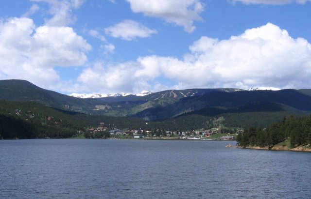
A town in Colorado has appointed two legal guardians to act on behalf of nature—in this case, a section of Boulder Creek and its watershed situated within the town of Nederland. 

Activists are hailing the move as the first time humans have been appointed to act as legal guardians for nature within the United States, where the so-called rights of nature movement has had a hard time advancing laws that recognized the rights of rivers, forests, animals and ecosystems. 

Earlier this month, the Board of Trustees in Nederland, 45 miles northwest of Denver, authorized the appointment of two guardians to represent Boulder Creek and the watershed for purposes of preparing annual reports about the ecosystems’ health and to make recommendations on improving water quality, wildlife habitats and wetlands protection. 

The board, the town’s legislative body, approved Nederland residents Alan Apt, an author and former board member, and Rich Orman, a retired lawyer, as the ecosystem’s first guardians. 

Legal guardians are regularly appointed by courts to make decisions for, and represent the interests of, children, incapacitated adults and bankrupt organizations.

Importantly, the Nederland board did not give Apt and Orman authority to sue on behalf of the watersheds or to be sued. That exception was aimed at averting pushback from opponents, according to Gary Wockner, the Colorado-based executive director and founder of Save the World’s Rivers and a rights of nature advocate. 

In Florida and Ohio, where communities have passed rights of nature laws, the agriculture industry has successfully pushed for the enactment of state-level legislation preempting the local ordinances, rendering them void. 

Rights of nature laws generally provide higher levels of protection to ecosystems and species than conventional laws, worrying some industry groups who say the laws could be used to block development. 

Overcoming such preemption legislation requires a state level law or constitutional change. Even before voters in Orange County, Florida, overwhelmingly approved a ballot referendum in 2020 recognizing the legal rights of five waterways to exist, the conservative Florida legislature passed a law prohibiting localities from enacting such measures. 

With those lessons in mind, advocates, including Wockner, are using a different tactic in Colorado, where there currently is no rights of nature preemption law on the books. 

“We chose to take a soft approach aimed at winning peoples’ hearts and minds,” Wockner said, adding that Nederland’s resolution is aimed in part at educating people about the shortcomings of existing environmental laws.

Those shortcomings, according to Wockner, include who has legal standing to go to court and enforce environmental protection laws. Typically, to meet standing requirements, plaintiffs must, among other things, show that they have been injured and that the court has the capacity to grant some sort of relief that would benefit them, which has generally required that they be human. 

Rights of nature advocates say that the system is based on the flawed premise that nature—from individual species to whole ecosystems—is merely property that humans generally have the right to destroy. Typically, mainstream legal systems only consider the wellbeing of nature indirectly. For example, if land is illegally polluted, the owner of that land could ask a court to order a remedy for his economic, health or other damages. Generally, there is no way for the court to account for harm to the land in its own right.  

That human-centered approach is criticized by advocates who argue that legal systems should be based on the reality that humans are part of nature and that, similar to humans, the natural world inherently possesses certain rights. They also point out that mainstream legal systems have long recognized that corporations, nation states and other non-human entities have legal rights and the ability, through guardians or other designated representatives, to go to court and enforce those rights. 

Nature, too, advocates say, should have legal standing to assert its rights and request relief, such as for ecosystem restoration, even when there is no immediate human interest at stake. 

In 2021, Nederland town took a step in that direction when it issued a nonbinding declaration recognizing that, within town limits, Boulder Creek and its watershed were “living” entities possessing “fundamental and inalienable rights,” such as to exist, to be restored and to provide an adequate habitat to native wildlife such as black bears, bobcats, brown trout and giant pine trees. 

A previous attempt to advance the so-called rights of nature movement in Colorado was shut down in 2017. Attorney Jason Flores-Williams filed a lawsuit in federal court on behalf of the Colorado River Ecosystem and others, and against the state of Colorado, seeking judicial recognition of the ecosystems’ rights to exist, flourish, regenerate and naturally evolve. 

Colorado’s then attorney general moved to dismiss the complaint, asserting that the suit contained various procedural deficiencies and threatened to sanction Flores-Williams, who, in response, withdrew the lawsuit. 

Colorado Rivers. Credit: Geology.com

Since then, the town of Nederland and three other Colorado municipalities have enacted nonbinding resolutions recognizing the rights of the Uncompahgre RiverGrand Lake and St. Vrain Creeks

“We’re working within the confines of the Colorado and U.S. legal systems, and nibbling away at them,” said Wockner, the Fort Collins-based advocate. “It’s absolutely a long game, but there are a lot of people who think this way.”

The Whanganui is a major river on the North Island of New Zealand. The Whanganui River is a major river in the North Island of New Zealand. It is the country’s third-longest river, and has special status owing to its importance to the region’s Māori people. In March 2017 it became the world’s second natural resource (after Te Urewera) to be given its own legal identity, with the rights, duties and liabilities of a legal person. The Whanganui Treaty settlement brought the longest-running litigation in New Zealand history to an end. Dana Zartner, CC BY-ND via The Conversation

At least six countries—Ecuador, Bolivia, Panama, Uganda, New Zealand and Spain—as well as some Native American tribes, have some form of national law recognizing the rights of nature or legal personhood for ecosystems. Many more nations have some form of court recognition or local laws recognizing the rights of ecosystems or individual species. 

Some of those laws strictly recognize that nature possesses particular rights, like the rights to exist and regenerate, while other laws recognize the legal personhood of an ecosystem, which generally implies that the ecosystem also bears duties. 

The U.S. Supreme Court has in multiple cases recognized legal personhood for non-humans, most prominently in Citizens United v. Federal Elections Commission, where it recognized the legal personhood of corporations. 

Rights of nature laws also vary in who can go to court on nature’s behalf. Some provide legal standing to any person, while others, like Nederland’s resolution, appoint specific guardians. In Colombia, where there is judicial recognition of the rights of the Atrato River, a court created a guardianship body, including members of riverine communities, to enforce the Atrato river’s rights.

The polar vortex is acting up — NOAA

Click the link to read the article on the NOAA website (Laura Ciasto and Amy Butler):

January 16, 2024

Across the United States, many are experiencing the first big blast of Arctic air of 2024. Coats and gloves are emerging from the closets, and heaters are working overtime, with temperatures dropping more than 25 degrees below normal in some parts of the country. But the question on our minds…the ever-looming question everyone asks when the cold air spreads across the country … the question that motivated this blog: Is the stratospheric polar vortex playing a role in this cold snap? Read on to find out!

Like parts of the United States, some flowers aren’t used to the cold and snow. Photo credit: Laura Ciasto.

Stratospheric shenanigans

If we had to characterize the behavior of the stratospheric polar vortex over the last week, we’d say it’s acting…squirrely. Living up to the celebrity status we bestowed upon it, the stratosphere seems to know everyone is watching and has decided to do something unexpected. 

For weeks now, we’ve talked about the warming of the temperatures and weakening of the polar vortex winds that are 19 miles above us over the Arctic. So far, this disruption of the polar vortex has been minor, falling short of the wind reversal (west-to-east → east-to-west) that defines a major sudden stratospheric warming. Our post last week explained that this major warming event has been elusive so far due to the lack of waves propagating from the troposphere below to the main level of the stratospheric polar vortex. Minor warmings themselves are not unexpected. Nor are they generally expected to be felt all the way down at the surface.

Atmospheric conditions over the last week. In the last several days (left panel), the vortex in the lower stratosphere has been pulled apart from below with two smaller lobes emerging, one of which has been hanging out well above eastern North America. It’s only in the last day or two (right panel) that this splitting of the vortex has extended up towards 10-hPa. NOAA Climate.gov image based on Global Forecast System data provided by Laura Ciasto.

But what makes the stratosphere’s current behavior unexpected and somewhat rare is that the polar vortex seems to be more disrupted at the lower levels, closer to the stratosphere-troposphere boundary. For more than a week, high pressure has been sitting in the troposphere over Greenland [footnote #1]. It’s possible that the recent minor stratosphere warming reinforced this Greenland high pressure, which then drove a wedge into the stretched-out polar vortex in the lowest part of the stratosphere, splitting it into two lobes. 

This lower stratosphere disturbance has been affecting the winds above it and looks to become just strong enough to fully reverse the winds of the polar vortex in the mid-stratosphere. A major sudden stratospheric warming is forecast to likely occur tomorrow. Normally, that’s when the excitement about whether we’ll see any surface impacts begins, as changes in the polar vortex communicate their way down to the lower stratosphere and sometimes the troposphere. But since the lower stratosphere has been perturbed for a while now, we’ve already been on the lookout for changes in the troposphere.

Teasing the troposphere

Though we will have to wait and see how much this brief but major disruption of the polar vortex may influence weather patterns over the next few weeks, it appears as though the minor warming during the first week of January and the subsequent destruction of the polar vortex in the lower stratosphere were enough to at least help set the stage for the cold air outbreak over North America this past weekend. We haven’t talked much about the surface impacts yet, but we tend to think of it in a probabilistic sense: a disrupted polar vortex increases the odds that the tropospheric jet stream will stay shifted farther south, which increases the risk for cold air outbreaks over the eastern United States and Europe. Most importantly, this “loading of the dice” for cold air can persist for up to 6 weeks after the vortex is disrupted, making these events relevant for weather timescales, but also for longer sub-seasonal forecasts (e.g., Week-2 to Monthly Outlooks).

Differences from average atmospheric thickness (standardized geopotential height anomalies) in the column of air over the Arctic from the troposphere to the stratosphere since mid November 2023. The lower stratosphere and upper troposphere have been most strongly connected for the last several days as denoted by the high thickness anomalies (orange areas, suggesting a weaker-than-average polar vortex). Based on the Global Forecast System (GFS) model, that connection may last for a few more days before weakening as indicated by the forecasted low tropospheric thickness anomalies (purple area) that do not extend into the stratosphere. NOAA Climate.gov image adapted from original by Laura Ciasto.

It’s important to note that while the polar vortex may have played a part in nudging the current jet stream south, and may help that pattern persist, there are many other factors that go into a cold air outbreak. Other climate processes like the ongoing El Niño also impact the location of the jet stream throughout the winter. And the jet stream doesn’t always need to be nudged by climate processes in the tropics or the stratosphere; it can nudge itself (what we’d call internal variability).

Lasting impressions?

Based on the recent forecast models, the full breakdown of the polar vortex into a major sudden stratospheric warming is expected to be brief. After that, the forecast average suggests the vortex will cease its shenanigans and strengthen again back to its normal speed. While the polar vortex in the mid-stratosphere tends to recover quickly after these disturbances, any effects on the tropospheric jet stream and its weather patterns could potentially stick around for a while. This doesn’t automatically mean more cold air outbreaks like we’ve seen this week, but gives us a heads up that the risk of these events is slightly higher in the weeks to come.

Observed and forecasted (NOAA GEFSv12) wind speed in the polar vortex compared to the natural range of variability (faint shading). Based on the January 15, 2024 forecast, the stratospheric polar vortex winds will decrease to zero, just reaching the threshold of a major sudden stratospheric warming, in the next day or two. This major warming status will be brief and the winds are forecast to become westerly again, strengthening to their near normal state in the next week. The vortex may even become stronger than normal, based on the average of all individual forecasts, but that outcome is uncertain due to the large range of the individual forecasts. NOAA image by Laura Ciasto.

Footnotes

  1. Sometimes a high pressure center will set up over a region (like Greenland) and sit there for multiple days. When this happens, the weather patterns that normally move from west to east are “blocked” and have to move either north or south of the high pressure center. The persisting high pressure over Greenland is not uncommon in the winter and is sometimes called a Greenland block.