
Click the link to read the article on the NOAA website (Laura Ciasto and Amy Butler):
January 16, 2024
Across the United States, many are experiencing the first big blast of Arctic air of 2024. Coats and gloves are emerging from the closets, and heaters are working overtime, with temperatures dropping more than 25 degrees below normal in some parts of the country. But the question on our minds…the ever-looming question everyone asks when the cold air spreads across the country … the question that motivated this blog: Is the stratospheric polar vortex playing a role in this cold snap? Read on to find out!
Stratospheric shenanigans
If we had to characterize the behavior of the stratospheric polar vortex over the last week, we’d say it’s acting…squirrely. Living up to the celebrity status we bestowed upon it, the stratosphere seems to know everyone is watching and has decided to do something unexpected.
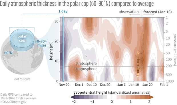
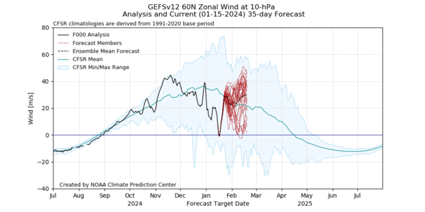
For weeks now, we’ve talked about the warming of the temperatures and weakening of the polar vortex winds that are 19 miles above us over the Arctic. So far, this disruption of the polar vortex has been minor, falling short of the wind reversal (west-to-east → east-to-west) that defines a major sudden stratospheric warming. Our post last week explained that this major warming event has been elusive so far due to the lack of waves propagating from the troposphere below to the main level of the stratospheric polar vortex. Minor warmings themselves are not unexpected. Nor are they generally expected to be felt all the way down at the surface.
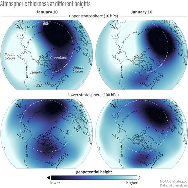
But what makes the stratosphere’s current behavior unexpected and somewhat rare is that the polar vortex seems to be more disrupted at the lower levels, closer to the stratosphere-troposphere boundary. For more than a week, high pressure has been sitting in the troposphere over Greenland [footnote #1]. It’s possible that the recent minor stratosphere warming reinforced this Greenland high pressure, which then drove a wedge into the stretched-out polar vortex in the lowest part of the stratosphere, splitting it into two lobes.
This lower stratosphere disturbance has been affecting the winds above it and looks to become just strong enough to fully reverse the winds of the polar vortex in the mid-stratosphere. A major sudden stratospheric warming is forecast to likely occur tomorrow. Normally, that’s when the excitement about whether we’ll see any surface impacts begins, as changes in the polar vortex communicate their way down to the lower stratosphere and sometimes the troposphere. But since the lower stratosphere has been perturbed for a while now, we’ve already been on the lookout for changes in the troposphere.
Teasing the troposphere
Though we will have to wait and see how much this brief but major disruption of the polar vortex may influence weather patterns over the next few weeks, it appears as though the minor warming during the first week of January and the subsequent destruction of the polar vortex in the lower stratosphere were enough to at least help set the stage for the cold air outbreak over North America this past weekend. We haven’t talked much about the surface impacts yet, but we tend to think of it in a probabilistic sense: a disrupted polar vortex increases the odds that the tropospheric jet stream will stay shifted farther south, which increases the risk for cold air outbreaks over the eastern United States and Europe. Most importantly, this “loading of the dice” for cold air can persist for up to 6 weeks after the vortex is disrupted, making these events relevant for weather timescales, but also for longer sub-seasonal forecasts (e.g., Week-2 to Monthly Outlooks).
It’s important to note that while the polar vortex may have played a part in nudging the current jet stream south, and may help that pattern persist, there are many other factors that go into a cold air outbreak. Other climate processes like the ongoing El Niño also impact the location of the jet stream throughout the winter. And the jet stream doesn’t always need to be nudged by climate processes in the tropics or the stratosphere; it can nudge itself (what we’d call internal variability).
Lasting impressions?
Based on the recent forecast models, the full breakdown of the polar vortex into a major sudden stratospheric warming is expected to be brief. After that, the forecast average suggests the vortex will cease its shenanigans and strengthen again back to its normal speed. While the polar vortex in the mid-stratosphere tends to recover quickly after these disturbances, any effects on the tropospheric jet stream and its weather patterns could potentially stick around for a while. This doesn’t automatically mean more cold air outbreaks like we’ve seen this week, but gives us a heads up that the risk of these events is slightly higher in the weeks to come.
Footnotes
- Sometimes a high pressure center will set up over a region (like Greenland) and sit there for multiple days. When this happens, the weather patterns that normally move from west to east are “blocked” and have to move either north or south of the high pressure center. The persisting high pressure over Greenland is not uncommon in the winter and is sometimes called a Greenland block.