A bipartisan group of 16 U.S. senators representing ten western states on Thursday called on the leaders of the Senate Agriculture Committee to provide more resources to address long-term drought challenges in the region. The senators drafted the letter after conversations with Senate Ag committee staff have left them “concerned that drought provisions are at risk of not being included in the farm bill, a Senate staffer informed DTN…
Western farmers and ranchers need more resources to help conserve water, improve watershed scale planning, upgrade water infrastructure and protect the land from erosion. The farmers and ranchers in western states need a farm bill that provides support to conserve water, improve watershed scale planning, upgrade water infrastructure, protect land from erosion to help create more long-term resiliency to extreme drought conditions, the senators stated.
Perkins County Canal Project Area. Credit: Nebraska Department of Natural Resources
Click the link to read the article on the KUNC website (Alex Hager). Here’s an excerpt:
January 11, 2024
Nebraska is moving forward with plans to build a canal that would redirect some South Platte River water out of Colorado. The state bought about 90 acres of land in Colorado as part of construction plans. The purchase marks an important step for the Perkins County canal project, since critics have questioned its feasibility from the start. The canal was first pitched in January 2022 by then-Governor Pete Ricketts as a way for Nebraska to protect its water supply against rapid development on Colorado’s Front Range. The plan would take advantage of a 1923 legal agreement about sharing the South Platte. The late-December land purchase is so far the only one Nebraska has made in conjunction with the canal project. The state spent about $90,000 on the parcel southeast of Julesburg. Jesse Bradley, the state’s deputy director of Natural Resources, said it could be used “in conjunction with construction activities” and may not contain the canal itself…
[Jim] Yahn detailed a few hurdles that could get in the way of the project’s completion. First, they might have trouble filling the canal with water in the first place. Some nearby Colorado reservoirs have legal priority over Nebraska water users, and because the bulk of the water would be moved during non-irrigation season, it could literally get frozen by wintertime temperatures on its way to Nebraska. Yahn, who formerly served as the Colorado Water Conservation Board’s director for the South Platte basin, also said Nebraska should be prepared to spend a lot of money in order to acquire land along the canal’s path.
The South Platte River Basin is shaded in yellow. Source: Tom Cech, One World One Water Center, Metropolitan State University of Denver.
The Colorado Climate Center’s report on the 2023 climate year and its outlook on the future of our climate and our snowpack, is full of data that shows a trend we all saw coming: the seasons are getting warmer, the melt-off is happening sooner, and most of all, the snowpack is decreasing year after year.
Colorado’s average temperature, season after season, since 1980 has increased by an average of 2.3 degrees. The winter has seen a 1.0 degree increase; spring has increased by 1.7 degrees; summer at 2.5 degrees; and autumn has seen an increase in temperature by 3.1 degrees.
“Annually,” the report says, “the greatest warming has been observed over the Southwest and San Luis Valley climate regions.”
The seven of the 10 hottest years on record have occurred since 2010. The rise in temperature means a reduced snowpack. Nothing is more of a key indicator for the health and wellness of Colorado than its snowpack.
Snowpack serves as a seasonal reservoir that stores upwards of 15 million acre-feet, on average, across the state. Colorado is a “headwaters state,” which means that four major rivers have their headwaters right here: the Colorado River, the Rio Grande, the Arkansas River and the Platte River.
Precipitation from snow is more likely to end up as runoff than precipitation from rain.
Credit: Climate Change in Colorado: A Report for the Water Conservation Board, Executive Summary
The 21st century record, which ranges from 2001 to 2022, showed an average of three percentto 23 percent lower snow water equivalent on April 1 than the 1951 to 2000 average.
Snow water equivalent (SWE) is the amount of water you get if you melted the snow down and were able to measure what was left. These measurements are more accurate than snowfall or snow depth, because those measurements don’t always account for a wide array of snow densities.
“The largest decreases occurred in the southwestern portion of the state, specifically in the San Juan and Rio Grande basins.”
Credit: Climate Change in Colorado: A Report for the Water Conservation Board, Executive Summary
Projections show a negative five percent to negative thirty percent measure of snow water equivalent by the year 2050. April 1 to May 15 is historically when true mountain runoff starts to occur with a change in temperature, but projections show that by 2050 that date will shift earlier by a few days then to a few weeks.
The 114 SNOTEL sites that give us this information are mostly situated between 8,500 feet and 11,000 feet elevation, and report data every hour. They are all monitored by the National Resource Conservation Service.
Studies showed that snowpack has decreased in many of Colorado’s major river basins; however the percentage of decline when compared to other Mountain West regions was “generally smaller” due to Colorado’s higher elevations and colder winters.
“These studies also found that warming temperatures were an important cause of the observed SWE declines, while below-normal fall and spring precipitation in the past few decades has also played a role.”
Credit: Climate Change in Colorado: A Report for the Water Conservation Board, Executive Summary
Although larger snowpacks have become less common, big snowfall years like 2019 can and will occur.
Severe droughts are projected to increase, as well. “Regardless of changes in precipitation, it is likely that warmer temperatures will contribute to more frequent and severe droughts. Warmer temperatures will also decrease the benefit of wetter years.”
“Southwestern and South-central Colorado have experienced the largest magnitude
of warming. The observed warming trend in Colorado is strongly linked to the overall human influence on climate and recent global warming.”
Over the next several decades, the report suggests, further and significant warming is expected in all parts of Colorado, in all seasons.
KEY REPORT FINDINGS
Temperature
Statewide annual average temperatures warmed by 2.3°F from 1980 to 2022.
Only one year in the 21st century has been cooler than the 1971-2000 average. 2012 remains the state’s warmest year in the 128-year record, at 48.3°F (3.2°F warmer than the 1971-2000 average).
The greatest amount of warming has occurred in the fall, with statewide temperatures increasing by 3.1°F from 1980-2022.
Southwestern and South-central Colorado have experienced the largest magnitude of warming.
The observed warming trend in Colorado is strongly linked to the overall human influence on climate and recent global warming. The observed warming over the last 20 years is comparable to what was projected by earlier climate models run in the 2000s.
Further and significant warming is expected in all parts of Colorado, in all seasons, over the next several decades.
By 2050 (the 2035-2064 period average), Colorado statewide annual temperatures are projected to warm by +2.5°F to +5.5°F compared to a 1971-2000 baseline, and +1.0°F to +4.0°F compared to today, under a medium-low emissions scenario (RCP4.5).
By 2070 (the 2055-2084 period average), Colorado statewide annual temperatures are projected to warm by +3.0°F to +6.5°F compared to the late 20th century, and +1.5°F to +5.0°F compared to today, under RCP4.5.
By 2050, the average year is likely to be as warm as the very warmest years on record through 2022. By 2070, the average year is likely to be warmer than the very warmest years through 2022.
Summer and fall are projected to warm slightly more than winter and spring.
Precipitation
Colorado has observed persistent dry conditions in the 21st century. According to water year precipitation accumulations, October 1 – September 30, four of the five driest years in the 128-year record have occurred since 2000.
Drying trends have been observed across the majority of the state during the spring, summer, and fall seasons.
Northwest Colorado summer precipitation has decreased 20% since the 1951-2000 period.
Southwest Colorado spring precipitation has decreased 22% since the 1951-2000 period.
Precipitation is slightly more favorable over the northern mountains during a La Niña winter. For most regions and the remaining seasons, wetter conditions are slightly enhanced during an El Niño.
The direction of future change in annual statewide precipitation for Colorado is much less clear than for temperature. The climate model projections for 2050 range from -7% to +7% compared to the late 20th century average, under a medium-low (RCP4.5) emissions scenario.
The model projections for precipitation change by 2070 are very similar to those for 2050.
Most climate models project an increase in winter (Dec-Feb) statewide precipitation; the model consensus is weaker for the other seasons. The models do suggest enhanced potential for large decreases (-10% to -25%) in summer precipitation.
“New plot using the nClimGrid data, which is a better source than PRISM for long-term trends. Of course, the combined reservoir contents increase from last year, but the increase is less than 2011 and looks puny compared to the ‘hole’ in the reservoirs. The blue Loess lines subtly change. Last year those lines ended pointing downwards. This year they end flat-ish. 2023 temps were still above the 20th century average, although close. Another interesting aspect is that the 20C Mean and 21C Mean lines on the individual plots really don’t change much. Finally, the 2023 Natural Flows are almost exactly equal to 2019. (17.678 maf vs 17.672 maf). For all the hoopla about how this was record-setting year, the fact is that this year was significantly less than 2011 (20.159 maf) and no different than 2019” — Brad Udall
What do you call a situation that remains a crisis, but has ever so slightly improved?
I’m asking myself this as I look at the latest water level data for Lake Powell, the reservoir in Arizona and Utah that feeds the Glen Canyon hydropower plant and is a conduit for drinking water for parts of several states.
The level on Monday was 3,568 feet above sea level, according to the Bureau of Reclamation, the federal agency that manages the reservoir and the power plant.
On the same day last year, the water was at 3,525 feet—a difference of 43 feet. That was close to the reservoir’s lowest level since it was initially being filled in the 1960s.
Both the current level and last year’s are much lower than is optimal, following years of drought and overallocation of the reservoir’s water. But officials have some breathing room thanks to last year’s wet winter, which led to an above average, and in some areas, record snowpack that helped replenish some of what had been lost.
“We’ve kind of been digging ourselves out of a hole,” said Bart Miller, the healthy rivers director at Western Resource Advocates, a conservation nonprofit based in Boulder, Colorado. “The one wet year that we had is only getting a part of the way there … We still have a lot of work to do to put our demands for water back into balance with what the river provides.”
He’s talking about the Colorado River, which passes through Lake Powell. The Colorado River Basin is a source of water and hydropower for about 40 million Americans.
The lake and its 1,320-megawatt power plant get a lot of attention because of their importance to millions of water and electricity consumers, and because the water level has gotten perilously close to shutting off the flow to the power plant.
Lake Powell key elevations. Credit: Reclamation
If the level falls to 3,490 feet—78 feet below this week’s reading—water will be too low to spin the turbines that generate electricity.
If the level falls to 3,370 feet—198 feet below this week’s reading—it would reach “dead pool” status, when the water is too low to flow downstream from the dam. The results would be catastrophic for communities south of the dam, as David Dudley explained last year in Sierra magazine.
The Bureau of Reclamation does regular forecasts to have an idea of these risks. A report issued in August projects that there is essentially a zero percent chance that the power plant will be forced offline this year, but a 3 percent chance the water level will drop enough to force a shutoff in 2028.
Lake Powell is one several prominent examples of water resources that are at risk because of drought that climate change has exacerbated and the overallocation of the Colorado River. Downriver is another example, Lake Mead, whose low water levels have led to heightened concerns about the Hoover Dam power plant, as Rhiannon Saegert wrote for the Las Vegas Sun in August.
The Biden administration is working with states that rely on the Colorado River to find ways to conserve water and maintain adequate flow through Lake Powell and Lake Mead. The administration revised the operating guidelines for the lakes in April, including measures to better give notice to operators of irrigation systems and water utilities about water delivery reductions, and giving the Bureau of Reclamation more flexibility to conserve and store water.
“Failure is not an option,” said Tommy Beaudreau, who was then deputy secretary of the Interior, in an April statement.
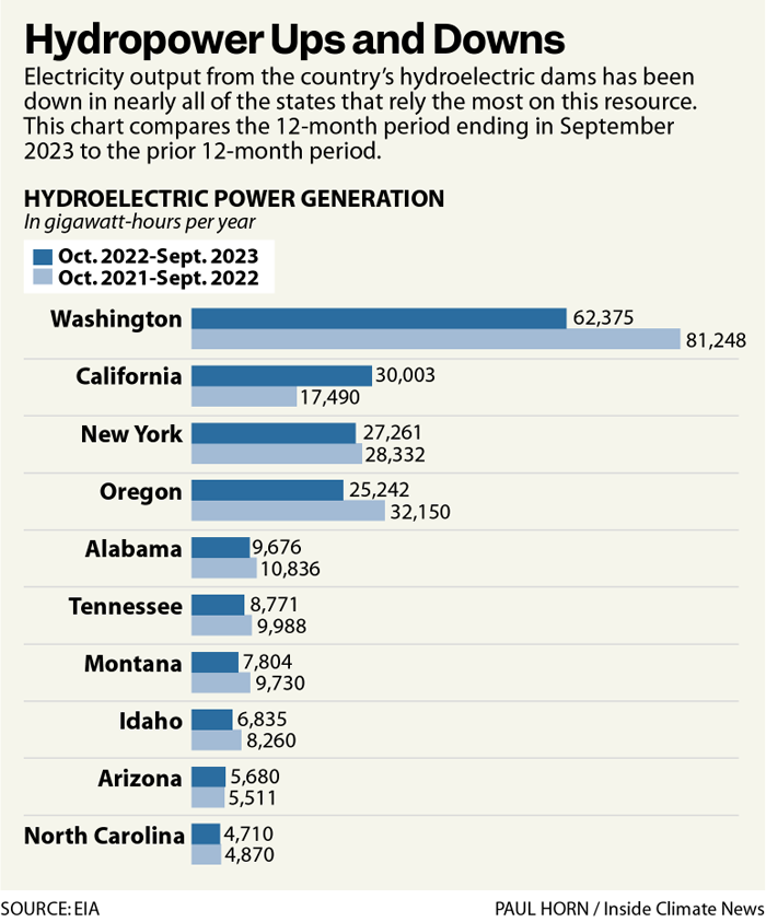
Hydroelectric Dam
Let’s take a few steps back. Hydropower plants have long been some of the most reliable sources of carbon-free electricity. The country gets 6 percent of its electricity from hydropower, which is more than any other utility-scale renewable source except for wind.
But drought and other extreme weather events are making hydropower increasingly volatile. The ups and downs show up in national figures; 2021 and 2022 were two of the three lowest years for hydropower generation since 2010, according to the Energy Information Administration. (This doesn’t include 2023, for which full-year records are not yet available.)
The shifts look ever more drastic at the state level.
From October 2022 to September 2023, hydropower generation in Washington State—the national leader in hydropower—was down 23 percent compared to the previous 12-month period.
In that same timeframe, California increased its hydropower generation by 72 percent.
Credit: Inside Climate News
The “why” comes down to local factors such as drought or recovery from drought. For grid operators, the takeaway is that hydropower isn’t as steady as it used to be.
There also is a growing view among environmental and justice advocates that hydropower has harmful effects on plants and animals, and can lead to an increase in methane emissions. And, construction of reservoirs has often displaced Indigenous communities.
Some of those advocates, with support from farmers, are saying the Colorado River should be allowed to flow freely through the area where the Glen Canyon Dam now stands in order to improve the availability of water south of the dam, among other benefits. Ian James of the Los Angeles Times wrote about this in September.
While the idea doesn’t have widespread support, it’s not being dismissed in the way it might have been a decade ago, when the problems with the dam were less apparent.
Federal officials have resources to prepare for declining water levels on Lake Powell, but they are dealing with symptoms of larger problems: climate change and a demand for water that exceeds a shrinking supply.
For now, the news is better than it was last year at this time, but Miller isn’t treating this like a victory.
“We haven’t solved the problem,” he said. “We’re still in this place where we need to do a lot of work.”
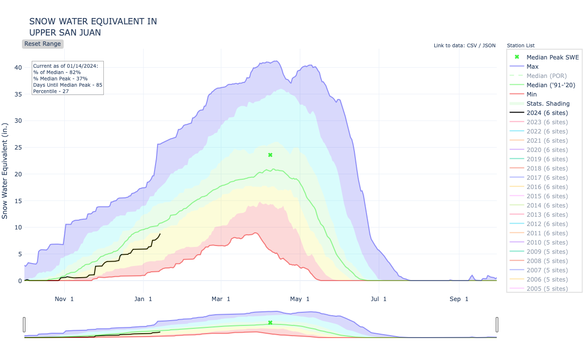
Sites in Archuleta County received more than a foot of snow from the weekend’s storm. As of Thursday, Jan. 4, Archuleta County had received around 2 inches of snow and Wolf Creek Ski Area had received 3 inches. Saturday night and Sunday brought the biggest snowstorm of the season, accumulating between 7 and 14 inches in areas of Archuleta County, according to the Community Collaborative Rain, Hail and Snow Network (CoCoRaHS) website. Wolf Creek Ski Area reported 29 inches in a report on Jan. 8…
According to snoflo.org, the Wolf Creek summit, at an elevation of 11,000 feet, had a 48-inch snowpack (84 percent of normal), up from 56 percent of normal on Jan. 3. The website reports that it is low for this time of year. According to the Natural Resources Conservation Service, on Jan. 4, the Wolf Creek summit had 28 inches of snow and 7.8 inches of snow water equivalent. As of Jan. 9, the agency reports 51 inches of snow and a snow water equivalent of 9.6 inches.