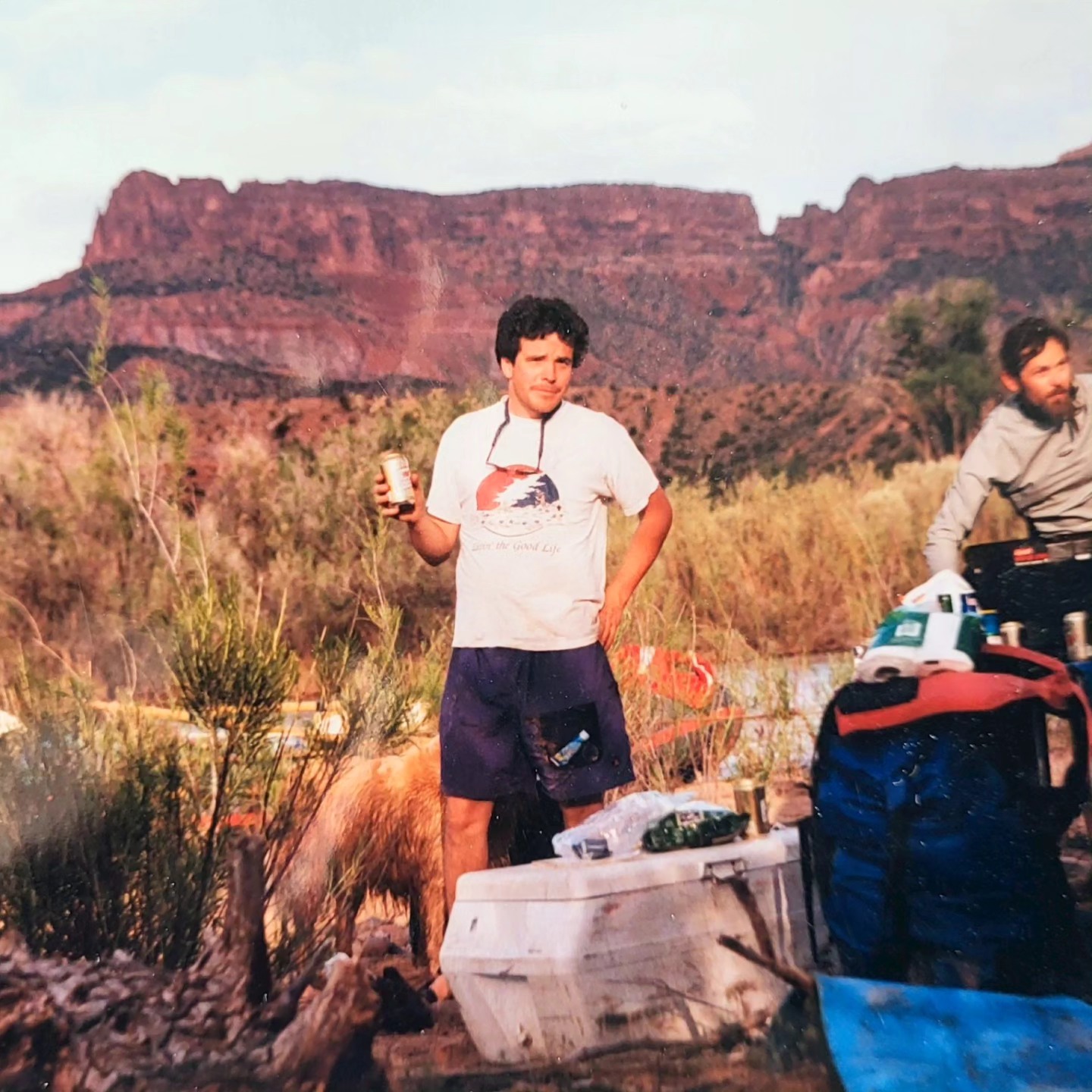
Stateline run of Dolores River around the turn of the last century. Photo credit: Pete Kolbenschlag
From email from Pete Kolbenschlag (Colorado Farm & Food Alliance):
The North Rim of the Black Canyon, in the National Park, which is accessed from Fruitland Mesa near Crawford – a remote region of ranches at the base of the West Elk Mountains – showcases an especially dramatic feature. Even among many spectacular places in western Colorado it impresses, marking where the Southern Rockies transition into the mesas, deserts and canyons of the Colorado Plateau. This cherished national treasure is also a local North Fork favorite, found on the way to Blue Mesa and the city of Gunnison.
The Colorado Farm & Food Alliance is supportive of public lands conservation, for protecting the stunning landscapes near our home-base. Set into this amazing landscape are small towns like Crawford, Paonia and Hotchkiss, and scattered between and on the mesas all around are the farms, ranches, wineries and businesses that work hard to make it here.
As we consider how we can adapt rural communities to be resilient and prosperous in a changing climate and dynamic future, we think that land conservation and watershed health are two of the most important, and effective, strategies we can pursue. That is one reason, as we look even further west, across the Uncompahgre Plateau, into the heart of Colorado’s red rock canyon country along the Dolores River, we see opportunity.
Far less visited than Moab and Monticello, Utah which lie just on the other side of the La Sal Mountains and Paradox Basin, the looming Wingate cliffs along this tributary to the Colorado River, which it joins at Dewey Bridge just over the stateline, contain an unique, fascinating, often hardscrabble history.
Back in the North Fork Valley, the Black Canyon National Park is not the only nearby designated national park service or conservation area. Just downstream is the Gunnison Gorge National Conservation Area. And above it is the Curecanti National Recreation Area which includes not only Blue Mesa reservoir, Colorado’s largest water body, but seldom visited upper reaches of the Black Canyon itself, with sweeping vistas of the San Juan Mountains and the Uncompahgre Plateau. Protected public lands are critical components of the economy in this region.
So lately as talk has percolated up from people who love the red rock Dolores River country, about securing protections to conserve what is unique and important about it, we pay attention. Sen. Bennet has long championed a bill to establish a national conservation area for part of the Dolores Canyon region. And more recently, a growing coalition of businesses, conservation groups and local elected officials are calling on President Biden to designate a national monument for a part of the region as well.
We think this could be a great opportunity to ensure what is unique there remains intact and that local businesses benefit from growing visitation to the region. Given the rich history in the West End of Montrose County, like the Hanging Flume and the town of Uravan – a critical player in the Atomic Age – it’s no wonder community leaders are wanting to protect the area.
Towns like Naturita and Nucla, with their markets and cafes, can serve as hubs that support local farms and residents, as they always have, and play host to visitors and activities, provide guides and services, and be the jumping off and provisioning point for the more adventuresome.
For places as rooted in tradition as are the rural communities of western Colorado, public land conservation and protecting the health of our lands and watersheds is a solid strategy to preserve what we care about most. And to welcome new opportunities. This is the strongest connection we see with our friends on the West End: protected public lands protect a rural way of life – and can help us better prepare for and better prosper in the future.
As 2024 opens to new possibilities, we cannot think of a better conversation than how to secure a locally-rooted, sustainable, and prosperous future for the Dolores Canyon Country and the rural, western communities of our local and nearby watersheds. As President Biden looks for legacy projects to leave with future generations, now is the time for Colorado’s leaders like Senators Hickenlooper and Bennet, and Governor Polis to speak up and urge the president to act.
A frozen Thompson Creek near its confluence with the Crystal River just south of Carbondale. A company with an interest in oil shale development in western Colorado is seeking to maintain conditional water rights for a proposed reservoir on Thompson Creek. CREDIT: HEATHER SACKETT/ASPEN JOURNALISM
Puckett Land Co.’s 23,893 acre-foot proposal dates to 1966, part of “integrated system” involving lands in Garfield and Rio Blanco counties
A company with an interest in oil shale development in western Colorado is seeking to maintain its water rights associated with a proposed reservoir on Thompson Creek that would be located within an area proposed for oil and gas lease withdrawal.
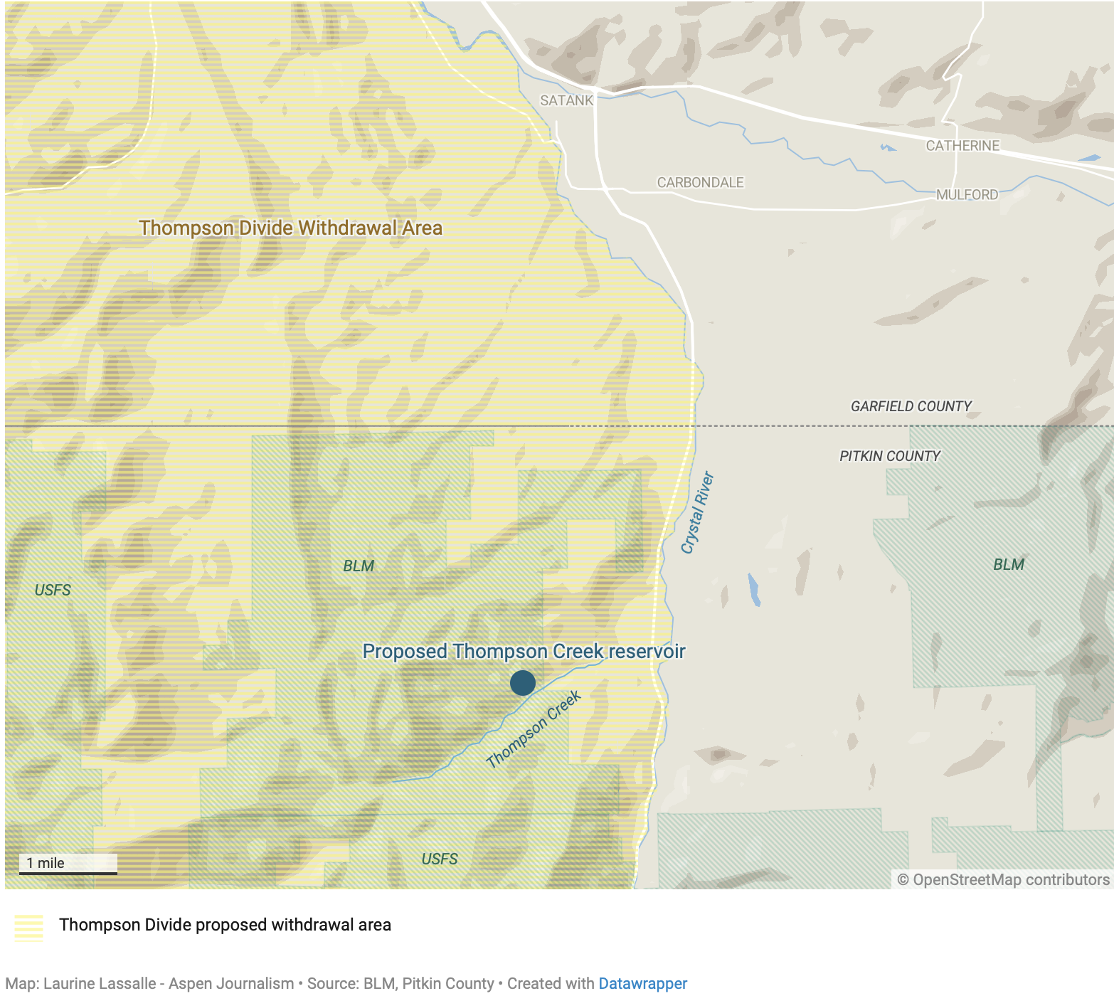
Puckett Land Co. is seeking to hold on to conditional water rights that date to 1966 for a 23,893-acre foot reservoir on Thompson Creek, a tributary of the Crystal River just south of Carbondale. It would be nearly one-fourth the size of Ruedi Reservoir, which, when full, holds just over 100,000 acre-feet. The reservoir site is located on Bureau of Land Management land in Pitkin County.
According to water court documents filed in November, Puckett says the water is needed for the “commercial development of Puckett’s oil, gas, coalbed methane and/or oil shale minerals.” The water is decreed for industrial, domestic, recreational, irrigation, power, mining and all other purposes related to shale oil production, including the maintenance of a camp and community.
Puckett Land Co., based in Greenwood Village, Colorado, holds interests in 17,500 acres of land in Garfield and Rio Blanco counties, according to the application. The Thompson Creek water rights are described as being part of an integrated system that includes conditional rights for two small reservoirs, and a pump and pipeline on Starkey Gulch, a tributary of Parachute Creek. Those Parachute Creek basin reservoirs have not been constructed.
Attorney for Puckett Land Co. Peter D. Nichols said that it would be inappropriate to respond to questions from Aspen Journalism while the application is pending in water court.
The proposed reservoir site is within the boundaries of an area that the U.S. Forest Service and BLM are proposing to withdraw from eligibility for new oil and gas leases. The proposed Thompson Divide withdrawal area is comprised of 224,713-acres in Garfield, Gunnison and Pitkin counties that generally straddles the ridge of mountains running from south of Glenwood Springs to the northern edge of the West Elk Wilderness, south of McClure Pass.
Carbondale-based conservation group Wilderness Workshop supports the withdrawal, and executive director Will Roush said a reservoir on Thompson Creek is highly problematic for many reasons, including its many harmful effects on the ecosystem.
“The local community has been working for over a decade to protect Thompson Creek and the surrounding lands; damming the creek runs counter to these efforts and deeply held community values,” Roush said in a statement. “Furthermore, the intended use of this water would be to enable oil shale and other fossil fuel production. Given our water and climate crises, utilizing precious West Slope water to increase climate pollution is simply unacceptable.”
The proposed reservoir site is just upstream from Sunfire Ranch, which is near the confluence of Thompson Creek and the Crystal River. In 2020, Pitkin County spent $10 million to put a conservation easement on the property, meaning that most of the 1,240-acre property is protected from development. Pitkin County also has its own taxpayer-funded board, Healthy Rivers, that funds programs and grant requests that focus on improving water quality and quantity.
Pitkin County Attorney John Ely said he is evaluating Puckett’s application and deciding whether the county wants to weigh in. Interested parties have until Jan. 31 to file statements of opposition in water court. As of Friday, no such statements had been filed.
Proposed Thompson Creek reservoir
Conditional water rights
The reason Puckett has been able to hold on to water rights that are nearly 60 years old without putting them to beneficial use lies in a quirk of Colorado water law that at least one scholar says needs to be reformed. Conditional water rights allow a would-be water user to reserve their place in the priority system based on when they applied for the right — not when they put water to use — while they work toward developing the water. Under the cornerstone of water law known as prior appropriation, older waters rights get first use of the river.
To maintain a conditional right, an applicant must every six years file what’s known as a diligence application with the water court, proving that they still have a need for the water, that they have taken substantial steps toward putting the water to use and that they “can and will” eventually use the water. They must essentially prove they are not speculating and hoarding water rights they won’t soon use.
But the bar for proving diligence is low. Judges are hesitant to abandon these conditional water rights, even if they have been languishing without being used for decades. Andrew Teegarden, a water fellow at the Getches-Wilkinson Center for Natural Resources, Energy and the Environment at the University of Colorado School of Law, argues this is partly because in Colorado water is treated as a property right.
“Some of the standards I think are a little lackadaisical merely because they don’t require the holders to spell out and specify all of the diligence activities that an individual took,” Teegarden said. “Most of the diligence applications that you’ll see are not filled with tons and tons of information; it’s more general statements about things like maintenance and building infrastructure. … It seems like we could require a little bit more specificity out of some of these holders.”
In Puckett’s diligence filing, the company says that in the past six years, it has spent nearly $100,000 on maintaining, repairing and upgrading its infrastructure and overall water system on its properties in the Colorado River basin; spent more than $80,000 on operational activities such as road maintenance and erosion control; spent more than $16,000 on professional services, including survey and title work; and has spent more than $80,000 on legal services to protect and develop its water rights.
The application does not specifically mention work regarding the Thompson Creek reservoir site in its list of diligence activities and says that diligence on any part of the system constitutes diligence with respect to the entire system. It is not clear how the Thompson Creek reservoir would operate with other parts of the system.
Puckett also said in its application that current economic conditions are adverse to oil shale production, but that that should not be sufficient on its own to deny its diligence claim.
Diligence filings are common and often fly under the radar. In 2017, the last time Puckett filed a diligence application for the Thompson Creek reservoir, no parties filed statements of opposition in the case. In the diligence filing prior to that, in 2010, only one party — the owners of the Crystal River Ranch — came forward as opposers. In that case, Puckett agreed to abandon conditional rights for a pipeline that would have diverted water from a point below the proposed dam.
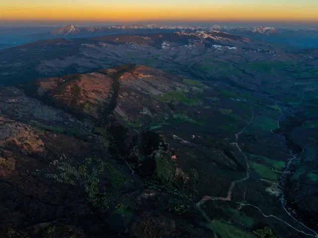
An aerial view of the Thompson Divide area, looking south along West Divide Creek, with the Bull Mountain pipeline running roughly parallel, to the left, of the creek bottom. Mount Sopris, at upper left, and Chair Mountain, upper right, frame the background. CREDIT: DAN BAYER / ECOFLIGHT
Oil shale and water use
In 2009, conservation group Western Resource Advocates produced a report called “Water on the Rocks” about oil shale water rights in western Colorado. According to the report, in anticipation of a boom, in the 1950s and ‘60s, companies with an interest in western Colorado oil shale amassed an enormous portfolio of water rights because extracting the oil from shale, a type of sedimentary rock, requires huge amounts of water. The report found that there were conditional water rights associated with oil shale development for 27 reservoirs with 736,770 acre-feet of water in the mainstem of the Colorado River basin.
If these conditional water rights were to be developed, the impacts could be felt by other water users throughout the basin. When the holders of conditional rights with older priority dates finally begin diverting water they have not used in decades, they may force junior rights holders to stop using water, something Teegarden calls “line-jumping.” The sheer volume of water tied to oil shale development, if ever used, could upend the whole system.
“As soon as some of these conditional rights begin coming online, they’re going to curtail these users that have been receiving that water in some cases for decades,” Teegarden said. “We have these users who have been making productive use of the state’s water for all this time and have been following all of the requirements of the law, but now they are the ones that might be punished for their use of the water.”
In a draft paper on the unintended consequences of conditional water rights in Colorado, Teegarden advocates for reforms to the anti-speculation and due-diligence standards. He says if users fail to put water to beneficial use within the typical 10-year abandonment period, the conditional water rights should be abandoned. With the help of the legislature, water courts could also implement a strict time limit for putting conditional rights to beneficial use and stop allowing them to exist indefinitely. For example, extensions through diligence filings could stop being granted after 50 years.
“I think that we really need to be serious about looking into and reforming these conditional rights before the time comes where we see some of these impacts to other water users across the state,” Teegarden said. “Because if we wait until that point, we won’t be able to guarantee a water-secure future, especially with the volumes of water that are associated with these conditional rights.”
Map of oil shale and tar sands in Colorado, Utah and Wyoming — via the BLM
Elephant Butte Reservoir back in the day nearly full. Photo credit: USBR
Click the link to read the article on the InkStain website (John Fleck):
January 12, 2024
New Mexico once again fell short in 2023 of the requirement set out in the Rio Grande Compact to deliver water to Elephant Butte Reservoir for use in Southern New Mexico, Texas, and Mexico, delivering ~25,000 acre feet less than the Compact requires, according to preliminary estimates presented at Monday’s meeting of the Middle Rio Grande Conservancy District.
These numbers are preliminary. The final, official numbers will be sorted out at this spring’s meeting of the Rio Grande Compact Commission. But if they hold, that would put New Mexico’s cumulative Compact debt at ~125,000 acre feet.
Really bad things don’t start happening until New Mexico’s cumulative Compact debt rises above 200,00 acre feet, but lessbad things are already happening now as a result of the debt. Under Article VI of the Compact:
Translated, that means any runoff we could actually store in upstream reservoirs in 2024 we can’t use, but rather have to hang onto to run down to Elephant Butte after the end of the irrigation season.
RUN-OF-THE RIVER AGAIN FOR MIDDLE VALLEY IRRIGATORS, AND FOR THE FISH
There’s a complex interaction here between physical storage* and rules. But the bottom line is that once again this summer, water users in New Mexico’s Middle Rio Grande Valley, the stretch of the river between Cochiti Pueblo and Elephant Butte Dam, will be entirely dependent on natural runoff available after the farmers in the San Luis Valley of Colorado take their share of the river.
I would predict, as a result, that:
People who irrigate in the Middle Valley should expect a high risk of significant stretches with no ditch water in the summer,
Water available for instream flows for the endangered Rio Grande silvery minnow will once again be extremely tight, with a high likelihood of drying in the Isleta and San Acacia reaches this summer, and
The Albuquerque Bernalillo County Water Utility Authority is likely to shut down river diversions for its drinking water plant at some point in the summer and switch over to groundwater pumping so I can keep taking showers.
* PHYSICAL STORAGE
El Vado Dam, built by the federal government and the Middle Rio Grande Conservancy District in the 1930s to store water during the spring runoff peak for irrigators to use in the late summer is under repair, a project taking way longer than expected. It’s likely that the necessary paperwork to store some water in Abiquiu Reservoir will be in place by runoff season, but the Compact Article VI debt means that water cannot be used for irrigation in 2024.