
Click the link to read the article on The Summit Daily website (Elliott Wenzler). Here’s an excerpt:
January 12, 2024
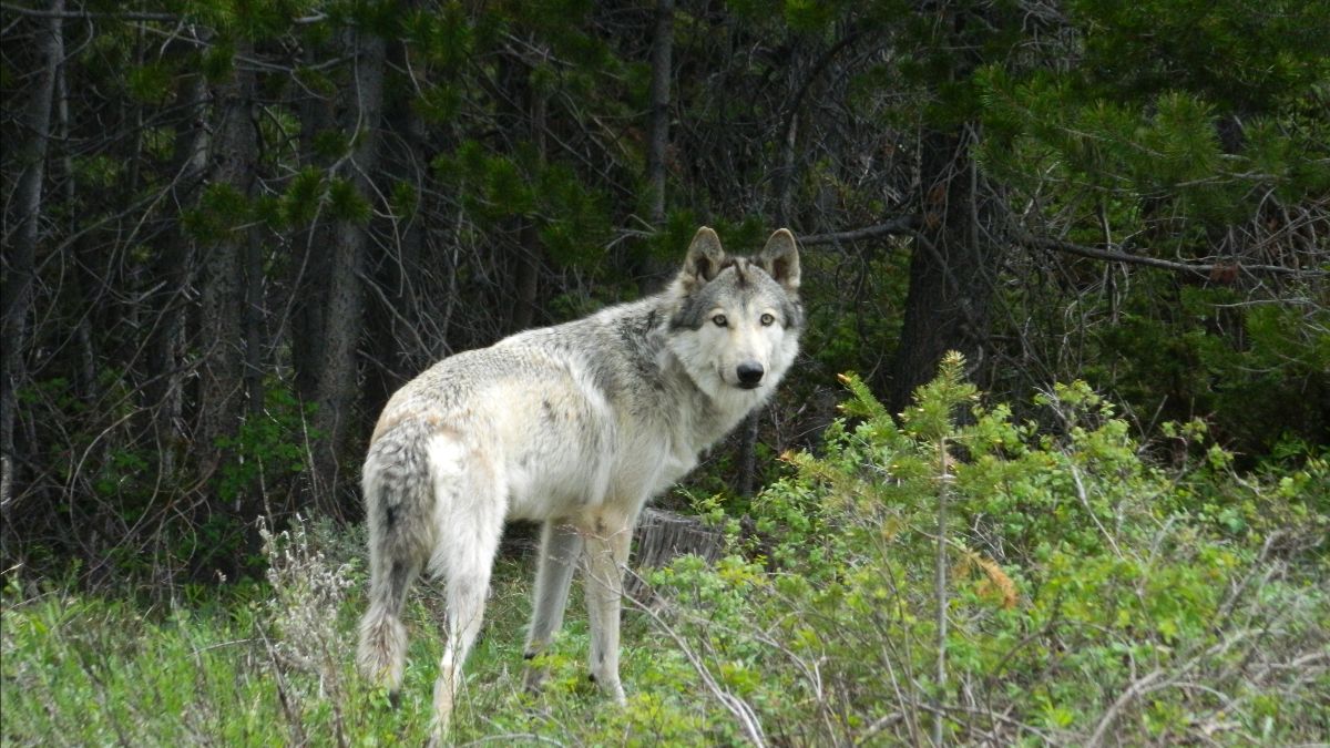
Wolves
While talking about his goals for the environment, the governor mentioned the reintroduction of gray wolves in Colorado, which began in December, as a way the state is “strengthening native biodiversity and restoring balance to our ecosystems.”
“We also need to protect that progress by continuing to invest in nonlethal conflict minimization that works to help our farmers and ranchers thrive,” he said…
Reducing fire insurance costs
Polis kicked off his speech talking about his top priority: housing. While he mostly focused on policies he hopes will help boost housing stock across the state, he also mentioned he would be supportive of legislation aimed at reducing the cost of fire insurance.
“Especially in the face of increasing climate-related disasters like the Marshall Fire,” he said.
A bill on the topic is expected to be introduced this session.
Mountain rail
Polis has also emphasized improved transit as a way to help make housing costs more affordable by allowing more density and making commutes easier. Part of that plan includes converting existing rail tracks from Winter Park to northwest Colorado into passenger rail. It’s a concept that’s been talked about for years and often thought of as an impossible “moon shot,” as Polis put it.
“I’m here to tell you it’s within reach,” Polis said…
Water
In one of his only comments on the topic, Polis said the state “remains committed to aggressively defending Colorado’s interests and rights in the Colorado River negotiations.”
[…]
Polis also said the state is on track to meet its goal of reaching 80% clean electricity by 2030 and will soon release new goals for greenhouse gas reduction. “Now we need to cut red tape that is holding back local investments and unprecedented federal resources in renewable and clean energy,” he said. Rep. Elizabeth Velasco, who represents Eagle, Garfield and Pitkin counties, said she was glad to hear the governor’s emphasis on clean air. “Those are things I see as very relevant towards our districts in rural communities in the Western Slope.”

Click the link to read the article on the National Drought Mitigation Center website (Curtis Riganti):
Drought Overview
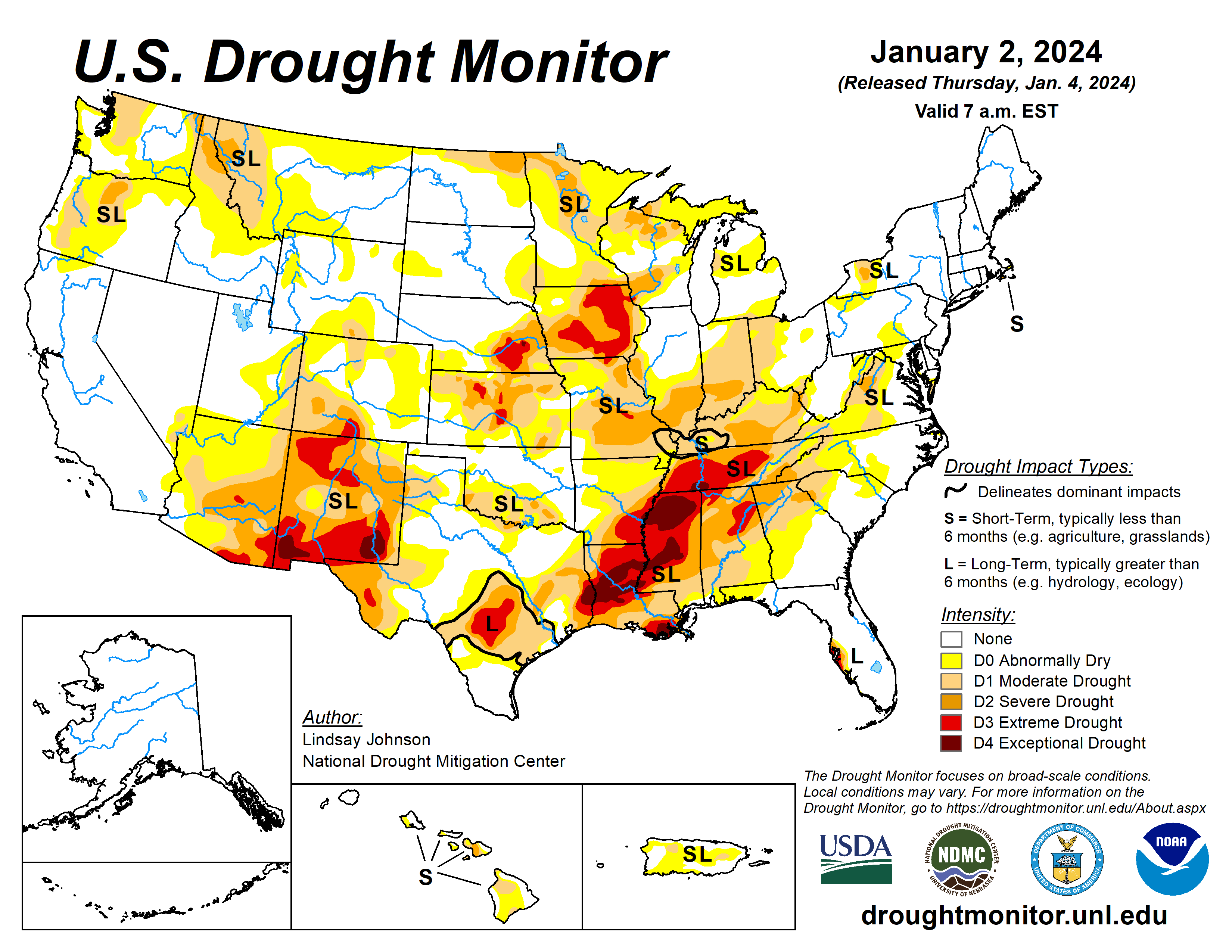
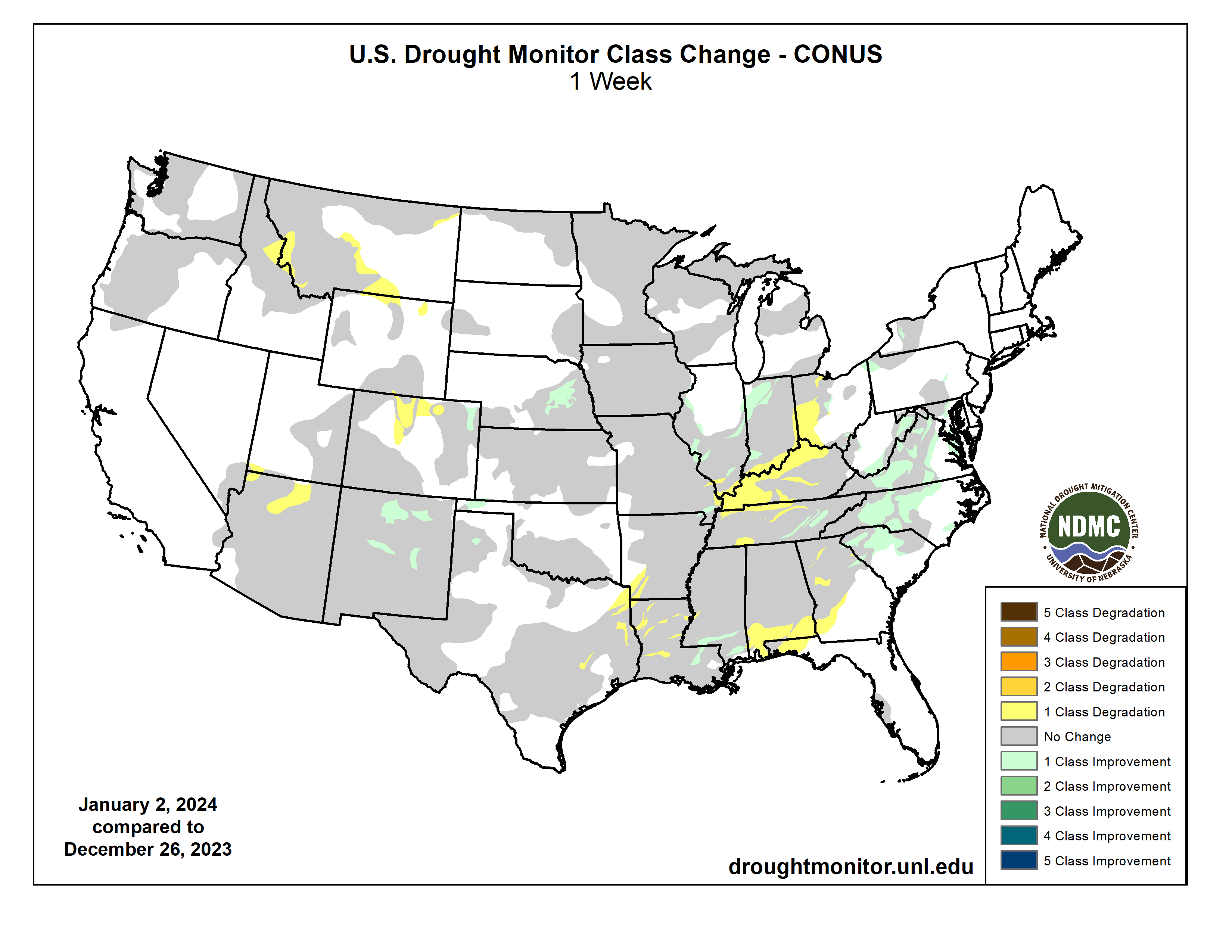
Changes to drought conditions varied widely across the U.S. during December. Improvements to ongoing drought conditions occurred in parts of the central Gulf Coast, central and southern Great Plains, Mid-Atlantic and western Carolinas, and Washington and Oregon. Degradations occurred across parts of the Ozarks, middle Mississippi and lower Ohio River valleys, northern Colorado, and southwest Montana and adjacent Idaho, among a few other areas. Outside of the contiguous U.S., some degradations to drought conditions occurred in Puerto Rico, while widespread improvements to ongoing drought occurred in Hawaii.
Nationwide, exceptional drought coverage dropped from 1.78 to 1.02%. Extreme or worse drought coverage dipped from 6.54 to 5.25%. Severe or worse drought coverage declined from 17.12 to 13.88%. Moderate or worse drought coverage decreased from 30.28 to 27.59%.
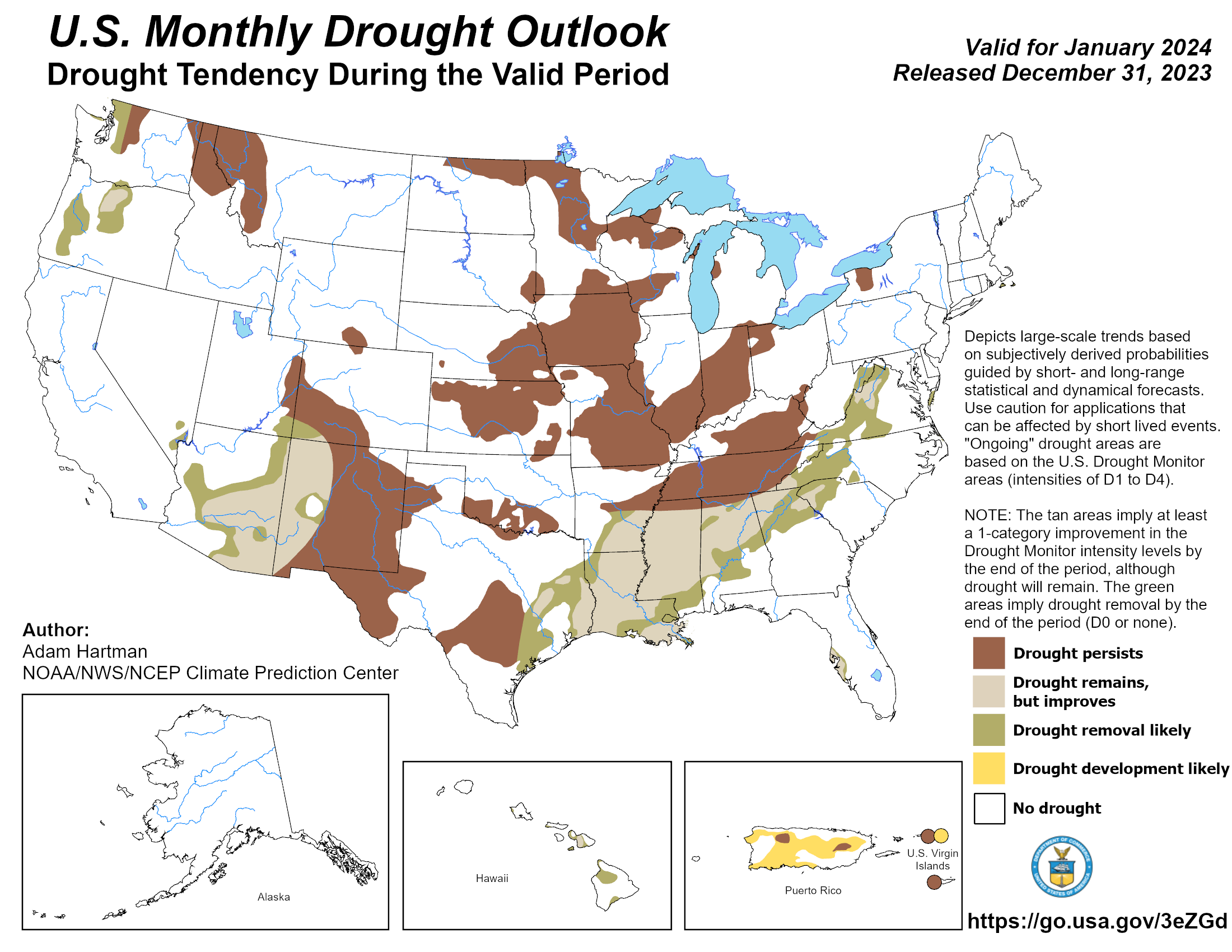
According to the January drought outlook from the National Weather Service Climate Prediction Center, drought improvement is likely in parts of the Pacific Northwest, from the Four Corners area to the U.S.-Mexico border, and from eastern Texas northeastward through the southeastern part of the Appalachian Mountains.
Within the contiguous U.S., drought is forecast to persist in areas where drought was ongoing near the end of December. Degradation is forecast across much of Puerto Rico and on the island of St. John, while improvement is likely on Maui, Kahoolawe, far western Molokai, far western Oahu and parts of the Big Island of Hawaii.
Temperature
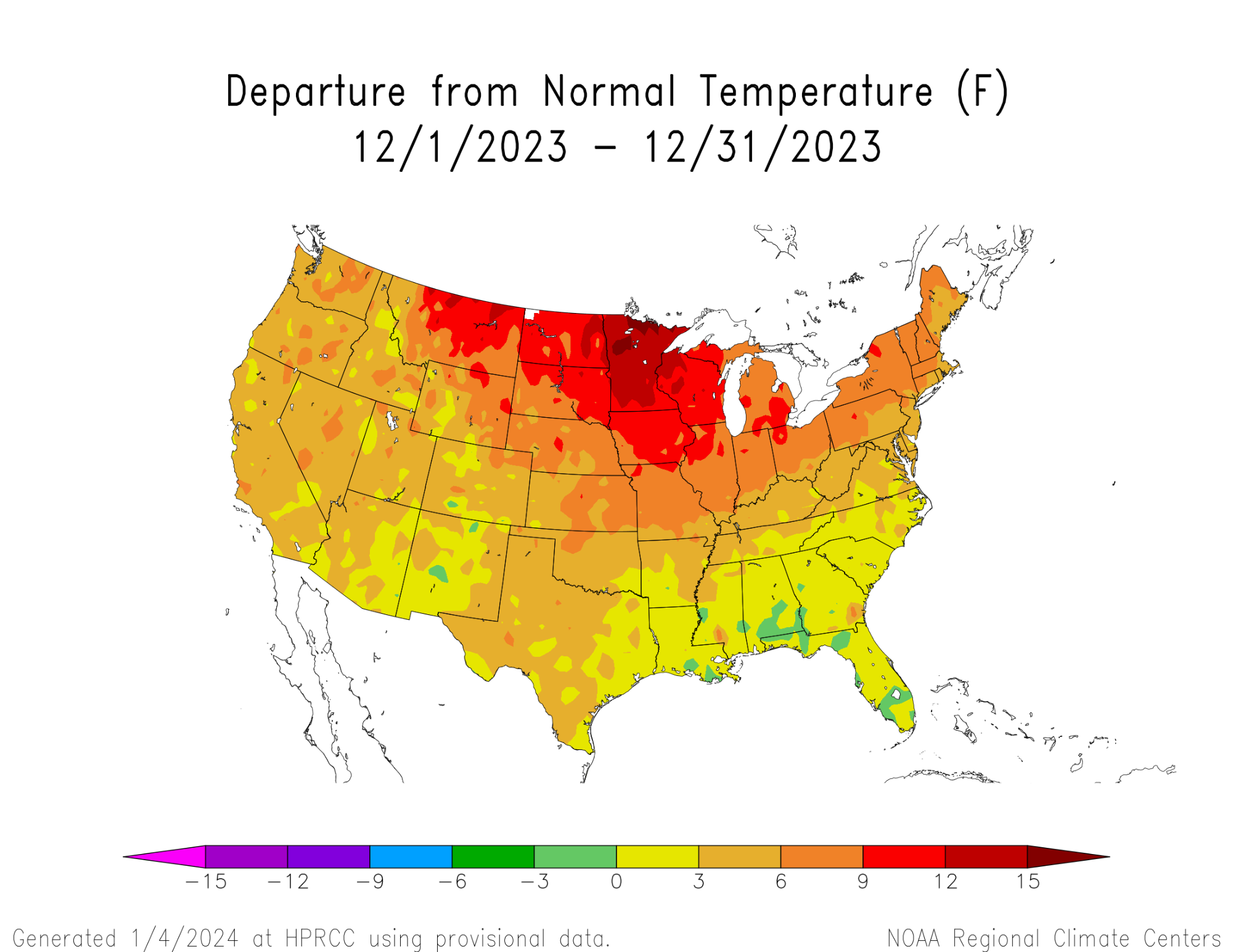
Most of the contiguous U.S. saw warmer-than-normal temperatures during December, with a few exceptions in southern parts of the Southeast region. The northern Great Plains, Upper Midwest and Great Lakes regions all had much warmer-than-normal temperatures for December, especially in Minnesota, where most sites reported temperatures at least 12 degrees above normal for the month.
Elsewhere, temperatures in the West, southern Great Plains, and Northeast were primarily 3 to 9 degrees warmer than normal, with isolated warmer values. Southeast Alaska and the North Slope regions saw temperatures range from 2 to about 8 degrees above normal, while south-central and southwest Alaska were mostly 2 to 6 degrees below normal. Temperature observations in Hawaii were within a couple degrees of normal, with the exception of an observing site in the center of the Big Island. Temperature anomalies in Puerto Rico varied from 3 degrees warmer than normal to 1 to 2 degrees cooler than normal.
Precipitation
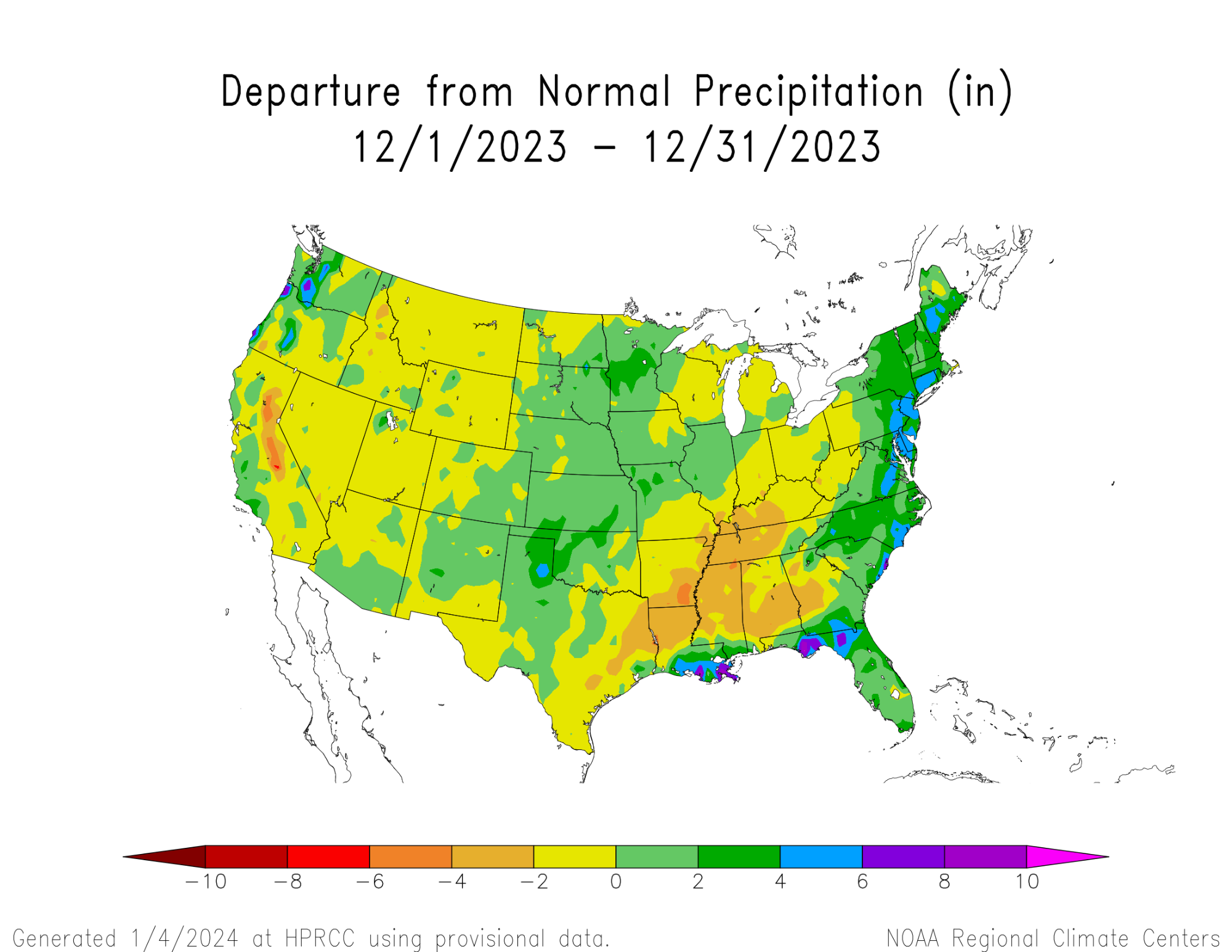
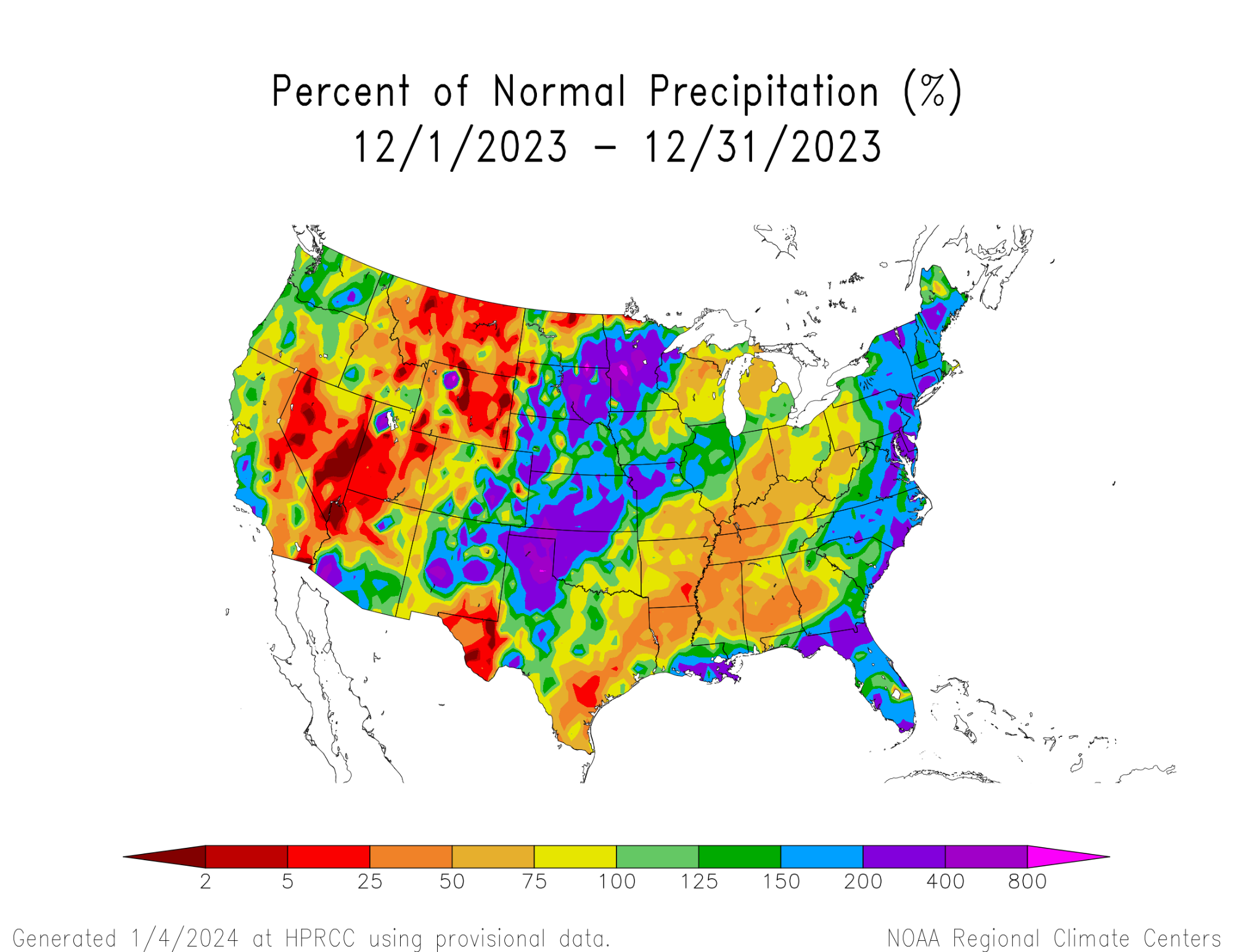
Drier-than-normal weather enveloped parts of central and western Montana, much of northern Wyoming, much of western Utah and portions of Nevada. Dry weather also occurred from northeast Texas to western Ohio, including portions of Mississippi and central Alabama.
Above-normal precipitation fell in southern Louisiana, the Florida Panhandle and along much of the Atlantic Coast. Wetter-than-normal weather also occurred in the Texas Panhandle, western Oklahoma, much of Kansas and Nebraska, and in eastern South Dakota and Minnesota.
Southeast Alaska received above-normal precipitation in December. In Hawaii, a mix of above- and below-normal rainfall occurred on Kauai and Oahu, while mostly below-normal precipitation occurred elsewhere. Well below-normal rainfall fell across northwest and parts of northeast Puerto Rico.
Regional Overviews
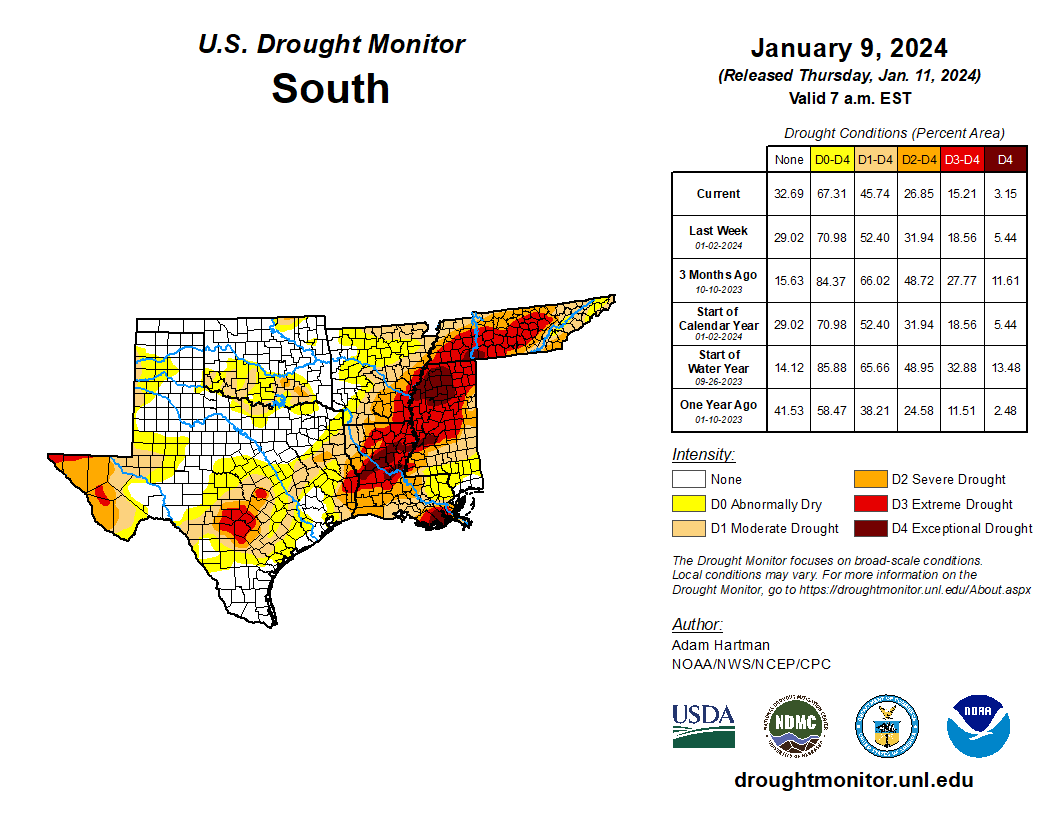
South
Warmer-than-normal temperatures were common across much of the South during December. Temperatures in Oklahoma, Texas, Arkansas, northern Mississippi and Tennessee ranged mostly from 2 to 6 degrees above normal. In a few locations in the northern reaches of Oklahoma and Arkansas, it was even warmer than that, with temperatures topping out from 6 to 8 degrees above normal.
Drier-than-normal weather enveloped parts of eastern Texas, central and northern Louisiana, southeast and northern Arkansas, much of Mississippi, and most of central and western Tennessee. A quarter or less of normal December precipitation fell near the Corpus Christi area, and less than half of normal precipitation fell at many places from northeast Texas through northern Louisiana, southern Arkansas, northern Mississippi, and central and western Tennessee.
Wetter-than-normal weather occurred in south-central and southeast Louisiana, the Texas and Oklahoma panhandles and northwest Oklahoma. Many locations in northwest Oklahoma and in the Oklahoma and Texas panhandles recorded at least double their normal December precipitation.
A mix of drought degradations and improvements occurred across the South in December. Widespread multiple-category improvements occurred in southern Louisiana and Mississippi where above-normal rain amounts fell, and conditions improved by multiple categories in a small area of eastern Tennessee. Scattered one- and two-category improvements occurred in central and western north Texas, the eastern Texas Panhandle and western Oklahoma, and parts of northeast Oklahoma.
Meanwhile, primarily one- or two-category degradations occurred in parts of northeast Texas, southern and northern Arkansas, northwest Mississippi, and central and western Tennessee.
Exceptional drought coverage decreased from 10.17 to 5.44%. Extreme or worse drought coverage declined from 21.85 to 18.56%. Severe or worse drought coverage dropped from 36.13 to 31.94%. Moderate or worse drought coverage dipped from 55.05 to 52.4%.
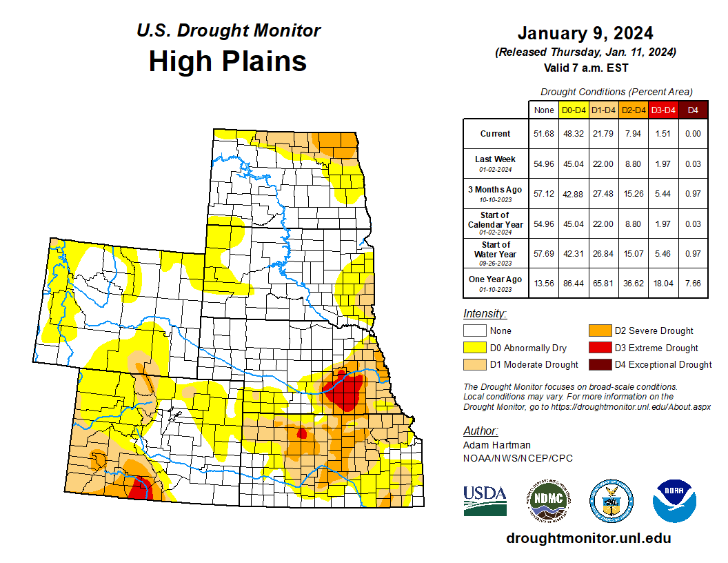
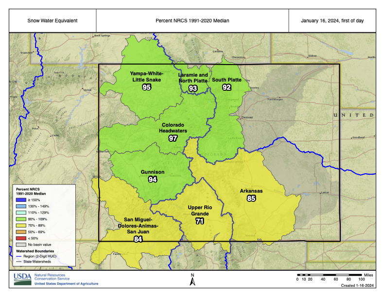
High Plains
Warm temperatures covered almost the entire High Plains region during December. The northeast half of South Dakota and most of North Dakota saw temperatures of 9–12 degrees above normal, reaching 12–15 degrees above normal in eastern North Dakota. The rest of the High Plains saw temperatures from 3 to 9 degrees warmer than normal, with a few higher readings mixed in. Above-normal precipitation fell across much of south-central and eastern Colorado, Nebraska, Kansas and the eastern Dakotas. Precipitation in Wyoming was primarily below normal, while precipitation anomalies varied in western South Dakota and western Nebraska.
Primarily drought improvements occurred in eastern Colorado, parts of Kansas, eastern Nebraska and southeast North Dakota. Degradations were common in north-central Colorado, the Black Hills, central and northern Wyoming, and eastern South Dakota. Exceptional drought coverage dipped slightly, from 0.56 to 0.03%. Extreme or worse drought coverage declined a bit, going from 3.31 to 1.97%. Severe or worse drought coverage decreased from 12.62 to 8.8%. Moderate or worse drought coverage dropped from 24.38 to 22%.
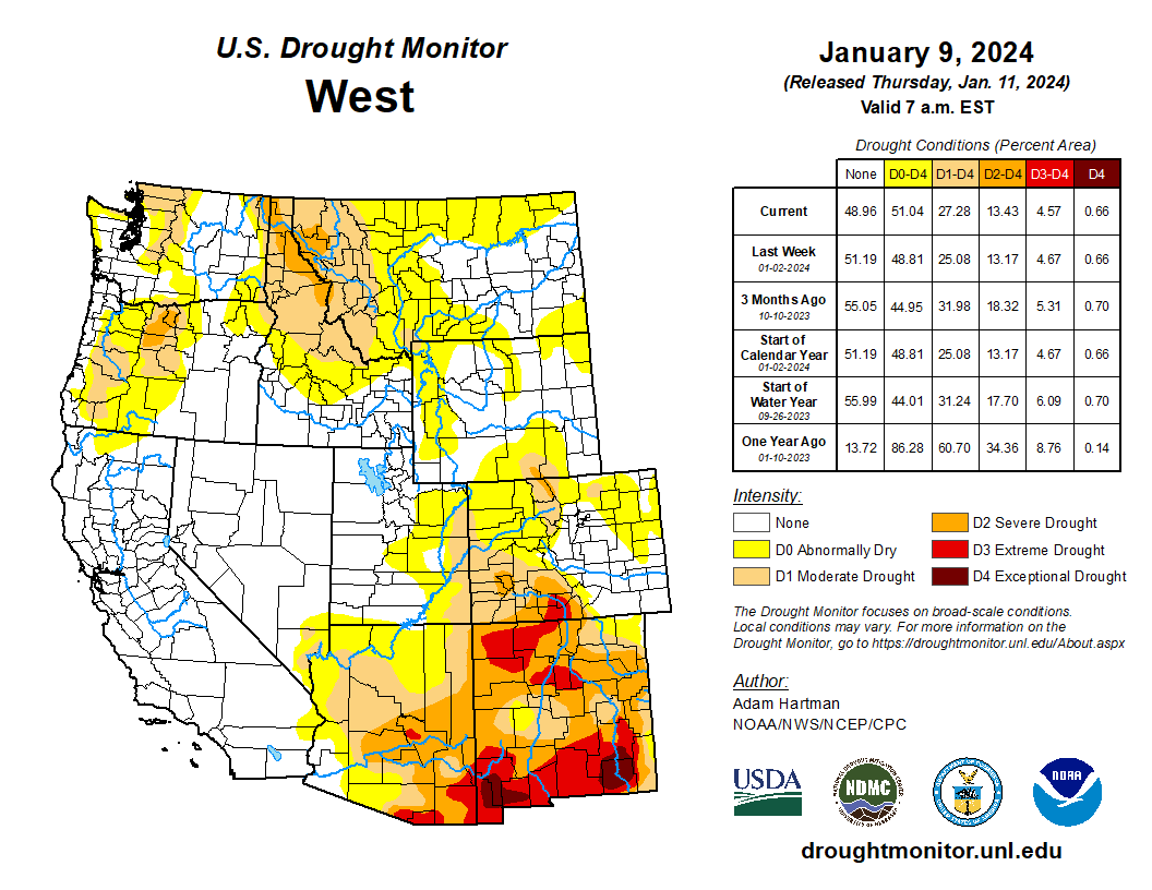
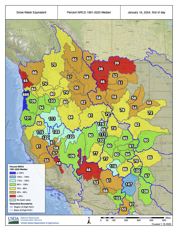
West
Warmer-than-normal temperatures covered most of the West during December. Temperatures from 3 to 9 degrees above normal were common across most locations, with central and eastern Montana reaching 9 to 15 degrees above normal. Drier-than-normal locations for December across the region included most of western Utah, much of Nevada, parts of northwest Arizona, much of Montana and parts of Idaho. Parts of eastern Washington, southern Arizona and New Mexico saw wetter-than-normal weather for December.
Improvements to drought or abnormal dryness were widespread in western Washington and Oregon, eastern Washington and northeast Oregon, the Idaho Panhandle, southwest Arizona and New Mexico. Degradations occurred in southwest Montana and adjacent parts of Idaho, as well as parts of northern Arizona and central Utah. Exceptional drought coverage was unchanged, remaining at 0.66%. Extreme or worse drought coverage declined slightly, from 5.22 to 4.67%. Severe or worse drought coverage dropped from 16.29 to 13.17%. Moderate or worse drought coverage dipped from 27.59 to 25.08%.

Click the link to read the article on the Writers on the Range website (Stephen Trimble):
January 15, 2024
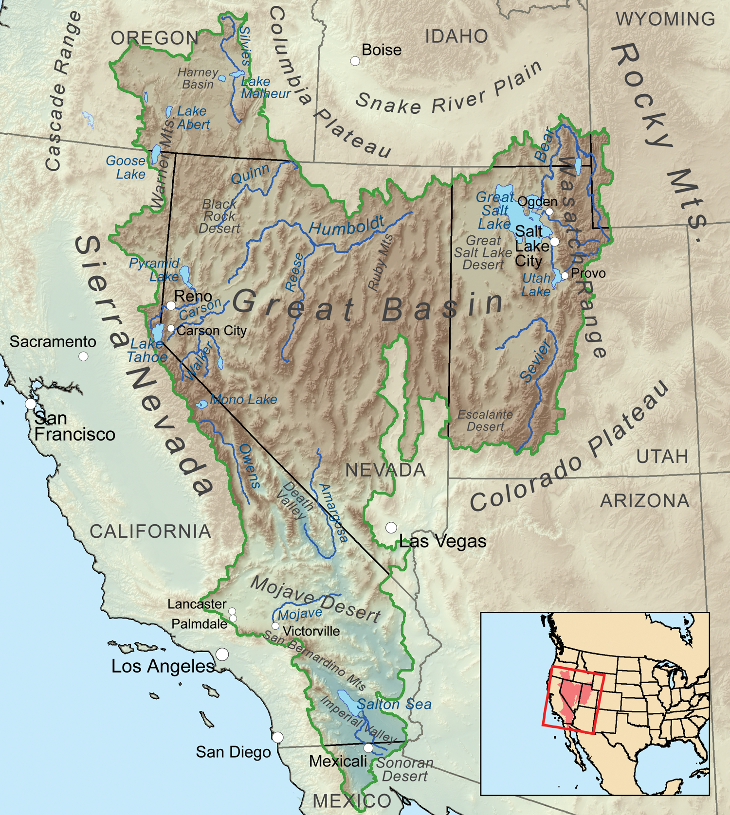
The long drive between Salt Lake City, Utah and Reno, Nevada on Interstate 80 feels endless, the landscape timeless. But these basins and ranges of the Great Basin Desert are changing dramatically.
Wildfire, climate change and aridification are transforming plant communities, while animals, including humans, try to figure out how to respond. Meanwhile, the dwindling Great Salt Lake risks becoming a toxic dust bowl.
Sagebrush now covers only half the territory it did before European settlers arrived with their livestock in the 1800s. Exotic annual grasses, including cheatgrass, have increased eightfold here since 1990, accelerating the fire cycle, outcompeting native plants and decreasing the available forage for grazers, wild and domestic.
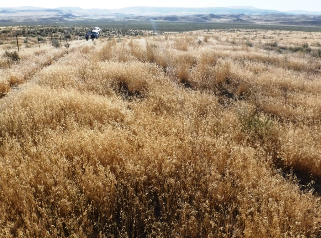
I called this place “the sagebrush ocean” when I first wrote about it in the 1980s. Now, scientists mourn the loss of 1.3 million acres of healthy sagebrush each year, threatening animals that need sagebrush, like the Greater Sage Grouse and pygmy rabbit. Recent photographs of Nevada and Utah West Desert basins document a cheatgrass sea.
Researchers and federal lands staffers chant the management mantra for sagebrush ecosystems: “identify the core, protect the core, grow the core, mitigate impacts.”
But what is this dwindling core? Think intact ecosystems with abundant sagebrush and native understory, with minimal threats from invasive grasses, encroaching conifers or modification by people. Not much land fitting that description is left.
The core that’s left is rare and vulnerable. Although the Intermountain West is no longer the exclusive domain of the livestock industry, grazing continues to affect more acres than any other human use. Large expanses of sagebrush with grasses and wildflowers eaten down to nubs by cattle do not constitute “restoration.”
That is why land managers are hard put to save threatened animals that need sagebrush, like the greater sage grouse and pygmy rabbit.
But the dilemma is this: Saving sagebrush puts the aromatic shrublands at odds with piñon-juniper woodland—a landscape just as beloved, just as vital. Range ecologists believe that growing the sagebrush core means that half of the Great Basin woodlands need “treatment”—removing younger stands of trees while retaining old growth forest. Treatment means ripping the trees from the earth with a chain stretched between bulldozers or “masticating” trees to shreds.
A spree of “treatments” approved at the end of the Trump administration in 2020 opened millions of acres of woodland in the Great Basin and Colorado Plateau to destruction. I happened upon one such project in the Kern Mountains of easternmost Nevada last summer, where a crew had been contracted to thin a dense woodland. The crew created a firebreak, but I felt I’d entered a war zone, with the scattered corpses of hundreds of trees littering newly cleared ground.
Before 1860, two-thirds of Great Basin landscapes in woodland habitat were treeless. Today, less than one-third is treeless, as trees decrease the acreage and vitality of sagebrush. But it’s unclear if sagebrush animals will repopulate cleared habitat anytime soon.
No more than half of tree treatments result in the regrowth of native grasses. Meanwhile, flocks of Pinyon Jays that depend on the trees suffer steep declines.
Here’s the rub: both sagebrush and woodland landscapes harbor incredible biodiversity. Piñon or sagebrush—which matters most? To sage grouse, pygmy rabbits and piñon mice? To backcountry recreationists, to cattlemen? To Indigenous Great Basin Washoe, Paiute and Shoshone people—citizens of what ethnobotanist Gary Nabhan calls “Piñon Nut Nation?”
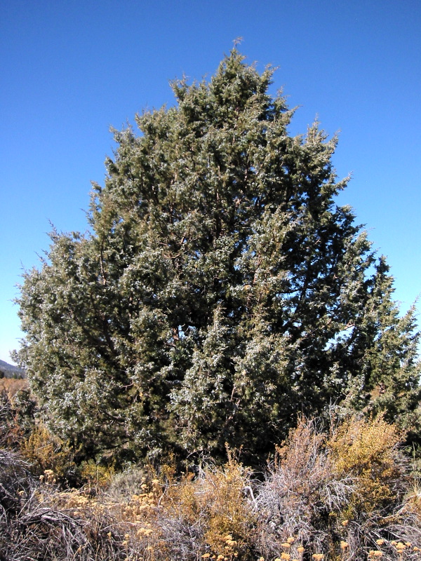
When you live in a piñon-juniper woodland, you live with the trees, not under them. “Tree” usually means tall, vertical, but these trees often are round, comforting. I have enormous affection for the “p-j,” my home territory. Yet who doesn’t love the smell of sagebrush after a rain and cherish its native wildlife?
As sweeping change comes to the Great Basin, federal managers need to address causes, not symptoms. Their challenge is huge: to confront invading cheatgrass and junipers and reverse the decline of sagebrush, nut harvests, native grass and birds. All this, while ensuring that mule deer and cows flourish.
If we want to heal the land and restore the balance between sagebrush and woodland, we need to treat these landscapes as we would with those we love—using every bit of wisdom from both western and Indigenous traditions for the benefit of our collective future.
Stephen Trimble is a contributor to Writers on the Range, an independent nonprofit dedicated to spurring lively conversation about the West, writersontherange.org. A 35th anniversary edition of his book, The Sagebrush Ocean: A Natural History of the Great Basin, will be published this year.