Click the link to read the release on the USGS website:
August 24, 2022
With the iconic monarch butterfly’s recent addition to the endangered species list, identifying areas where populations are growing or holding constant provides hope that the declines may be slowed or reversed. For the eastern monarch butterfly, the Midwest U.S is a critical breeding area, but climate change is furthering local population declines. Using extensive data sets and forecasting models, a research team supported in part by the Midwest CASC worked with scientists, community leaders and natural resource managers to identify breeding grounds in the Midwest and Ontario, Canada that are projected to be the least impacted by climate change. This information can be used to aid resource managers in locating areas their work may be the most impactful under the uncertainty of future climate conditions.
Over the past week, remnants of Beryl made their way up into the Midwest, bringing with them significant precipitation from east Texas all the way into Michigan. Another shot of significant rain at the end of the current period in the Midwest kept the region quite wet overall. Significant precipitation along the eastern seaboard from New Jersey into the Carolinas was welcomed, but isolated to coastal areas. Much of the rest of the country was quite dry with only pockets of light precipitation. The warmest temperatures were over the West, with departures of 3-6 degrees above normal widespread, and from Washington to California, with departures 9-12 degrees above normal. The coolest temperatures were also associated with areas that picked up the best rains as temperatures from Texas into Arkansas and Missouri were up to 3 degrees below normal. Areas of the Northeast were also warmer than normal with departures of 6-9 degrees above normal…
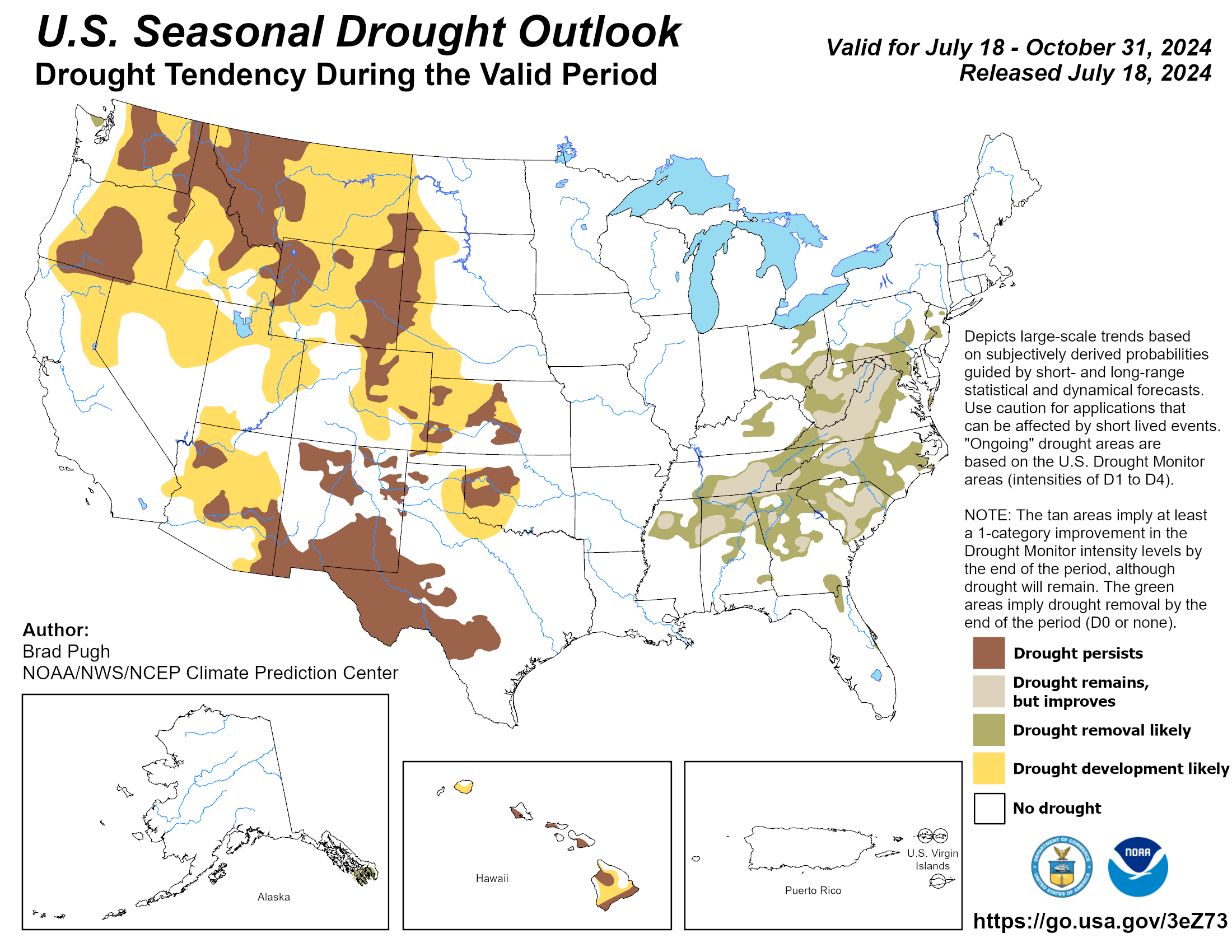
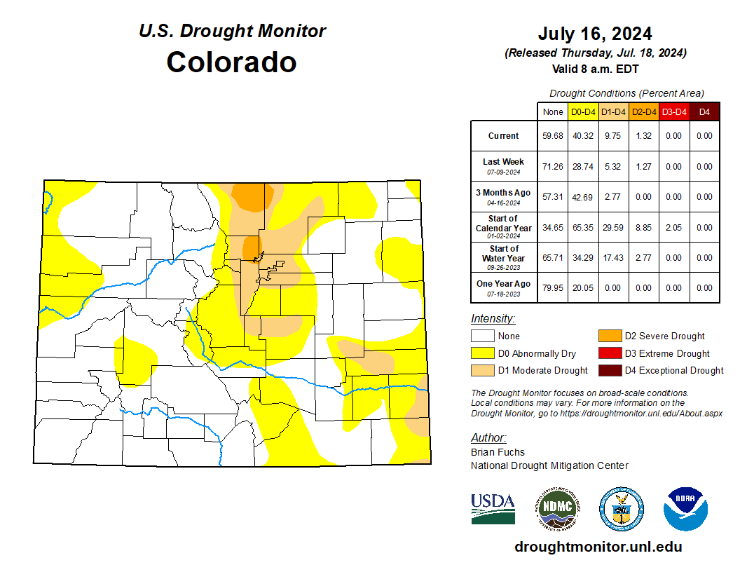
A few pockets of above-normal precipitation were recorded in northwest South Dakota and north central North Dakota as well as in areas of eastern Kansas at the end of the current period. Much of the rest of the region was dry or received minimal amounts of precipitation. Abnormally dry conditions were expanded in northwest and southeast Kansas as well as in eastern Colorado and western Nebraska. Moderate drought was introduced over eastern Colorado and expanded in northwest Nebraska and southwest South Dakota as well as in eastern portions of Wyoming. Moderate and severe drought expanded in central Colorado as the foothills remained dry. After several weeks of wet weather, some drying out is taking place in portions of the region, which is welcomed in some circumstances…
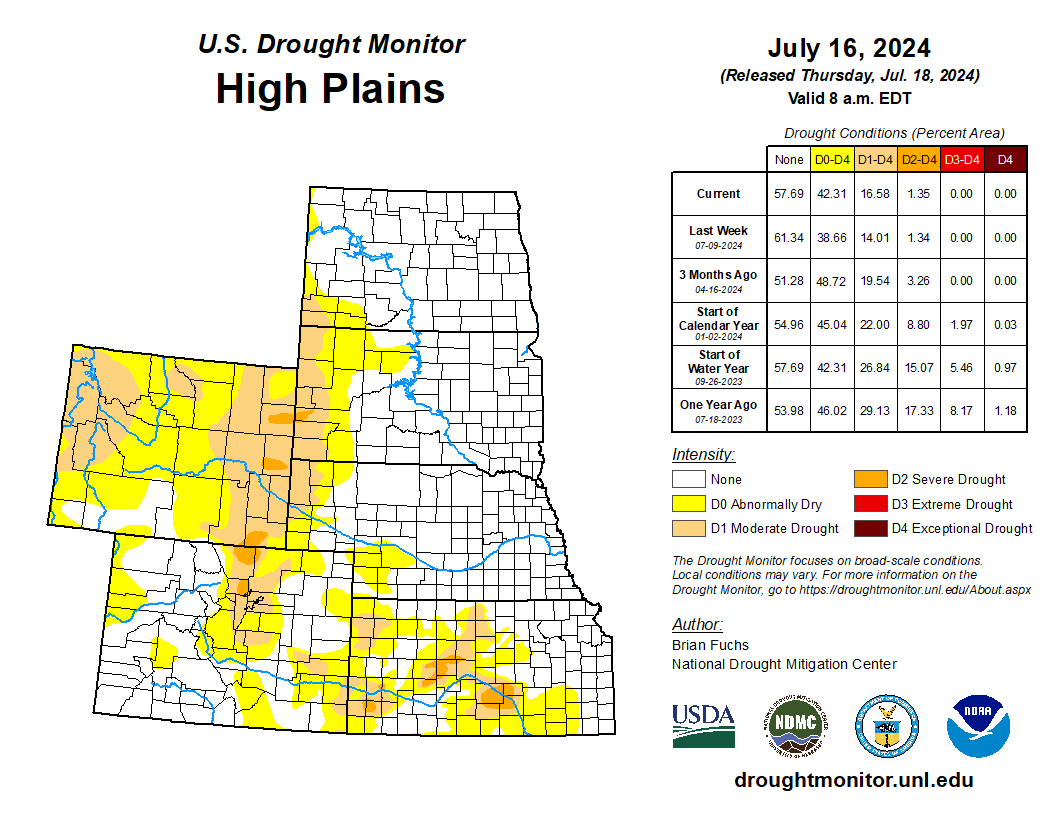
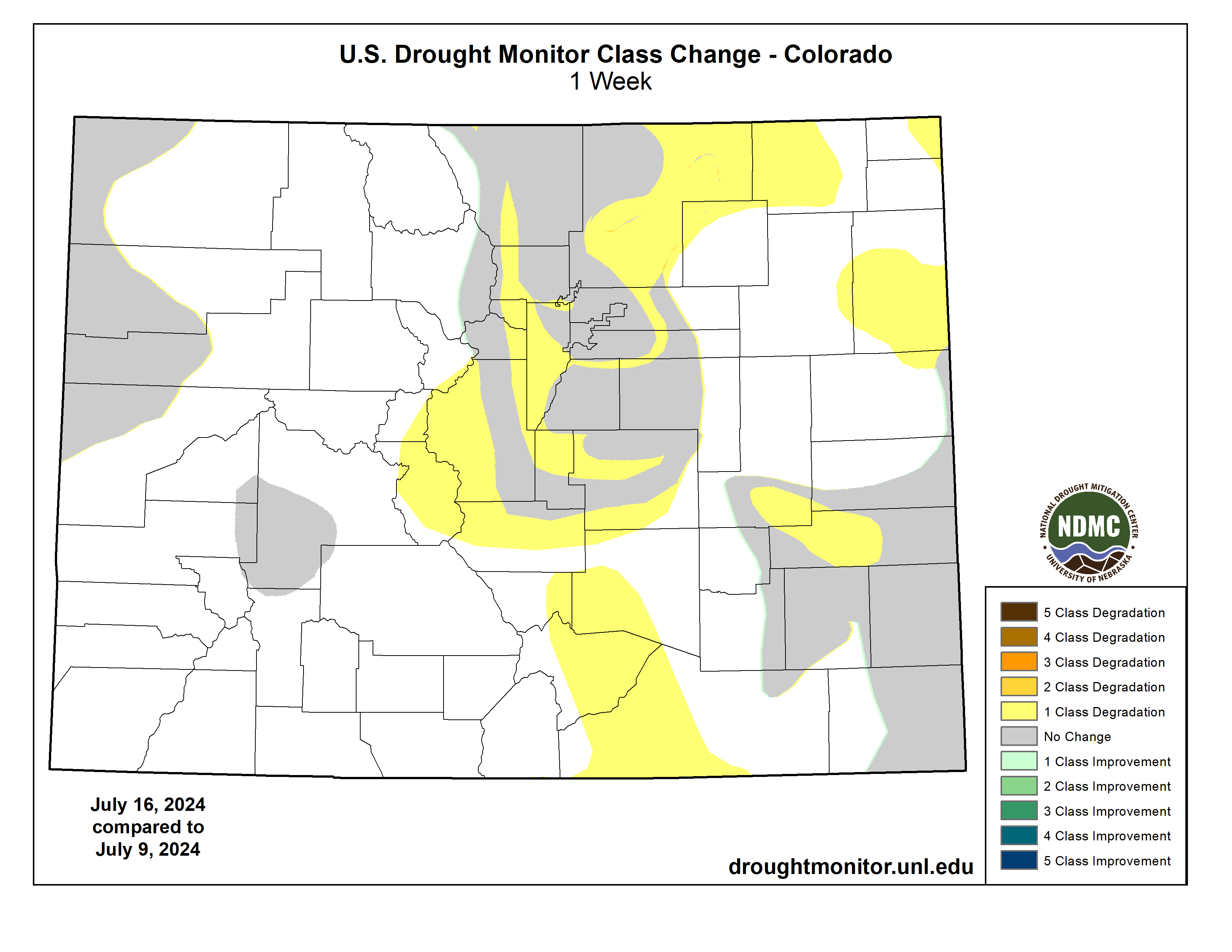
Colorado Drought Monitor one week change map ending July 16, 2024.
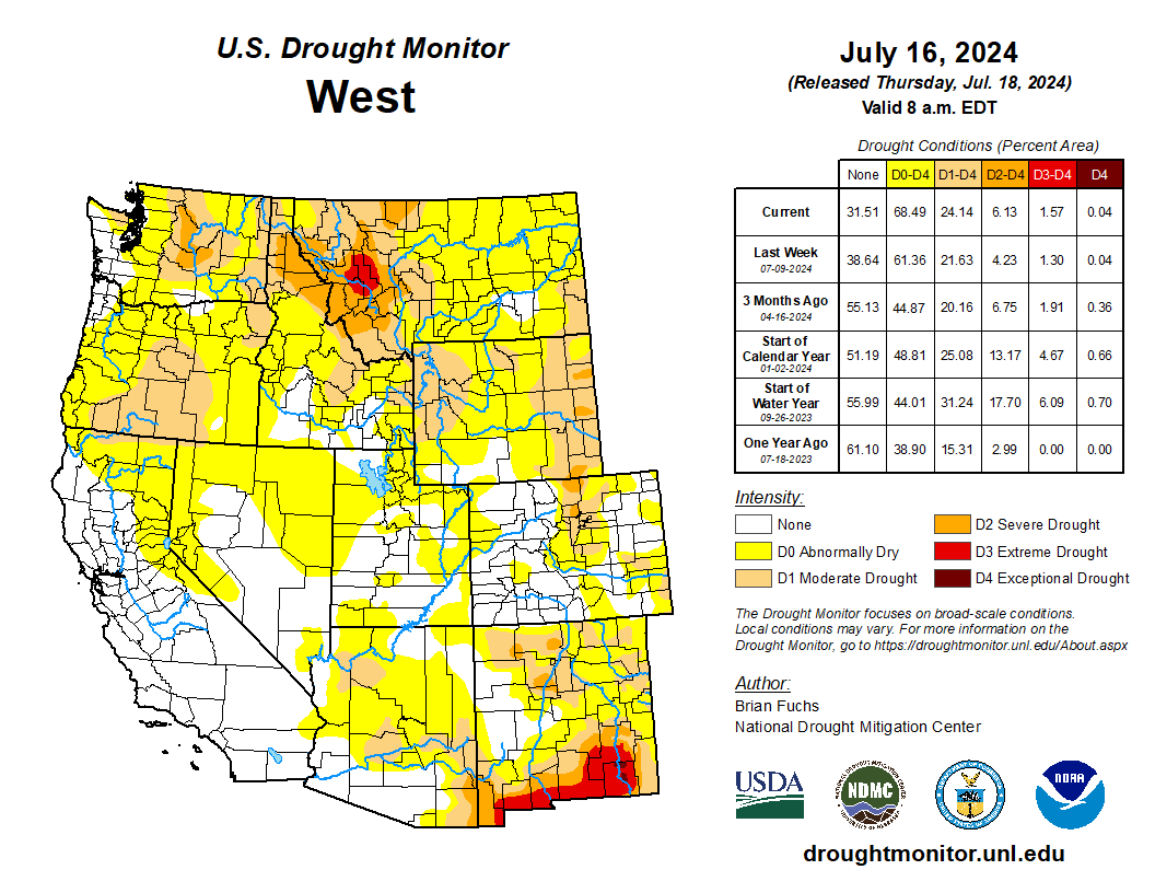
Warmer-than-normal temperatures dominated the region, with only portions of western Colorado and New Mexico below normal for the week with departures of up to 3 degrees below normal in New Mexico. Portions of central Washington and Oregon into northern California had temperatures 9-12 degrees above normal. Isolated rains in New Mexico and Arizona as well as portions of central California were the only precipitation events of significance in the region. In response to the recent heat and dryness, a large swath of abnormally dry conditions was expanded this week from northern Nevada and southern Idaho into northern Utah. Abnormally dry conditions were also expanded in northwest California, western Nevada, southern Colorado and southwest Utah. Moderate drought was expanded over more of central Oregon with more abnormally dry areas added in the west. Moderate drought was expanded in western Wyoming, and Montana had severe drought expand broadly in the west while a new pocket of extreme drought was introduced…
It was a mostly dry week over the region with much of the area experiencing temperatures that were 2-3 degrees below normal. With short-term dryness returning to portions of north Texas and southern Oklahoma, abnormally dry conditions were expanded this week. Throughout the rest of the region, no other significant changes were made this week, with status quo common across the region…
Looking Ahead
Over the next 5-7 days, an active pattern appears to be developing from the Southwest, Plains, and into the Southeast and eastern seaboard. The most significant precipitation is anticipated over New Mexico, southern Colorado, northeast Texas, and from Louisiana through Virginia. Dry conditions are anticipated over much of the West and Midwest during this period. Cooler-than-normal temperatures are anticipated over much of the Plains, South and into the Southeast, with some departures from normal approaching 9-11 degrees below normal in portions of Nebraska, Kansas and into Colorado and New Mexico. Warmer-than-normal temperatures will dominate the West with departures of 11-13 degrees above normal over the Great Basin and into the northern Rocky Mountains. Near-normal temperatures are anticipated over other areas.
The 6-10 day outlooks show that the greatest chances of below-normal temperatures will be over the southern Plains into portions of the South, Southwest and southern Midwest. The greatest probability of experiencing above-normal temperatures during this time will be over the West and the Florida peninsula and portions of the Northeast. The highest probability of above-normal precipitation will be over Texas with the area from the Southwest into the Mid-Atlantic also expected to have above-normal chances of above-normal precipitation. The area with the greatest chances of below-normal precipitation will be over the northern Rocky Mountains into the northern High Plains.
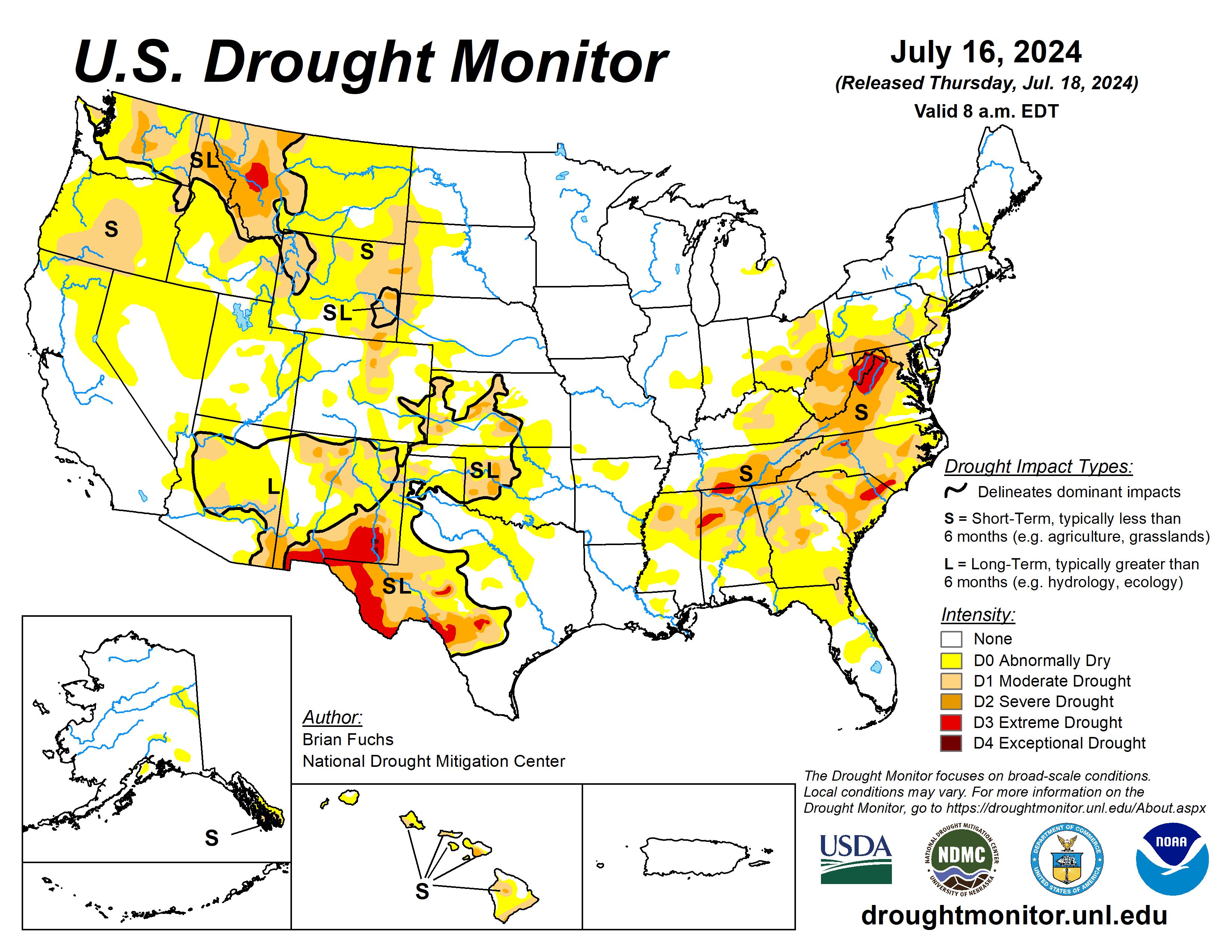
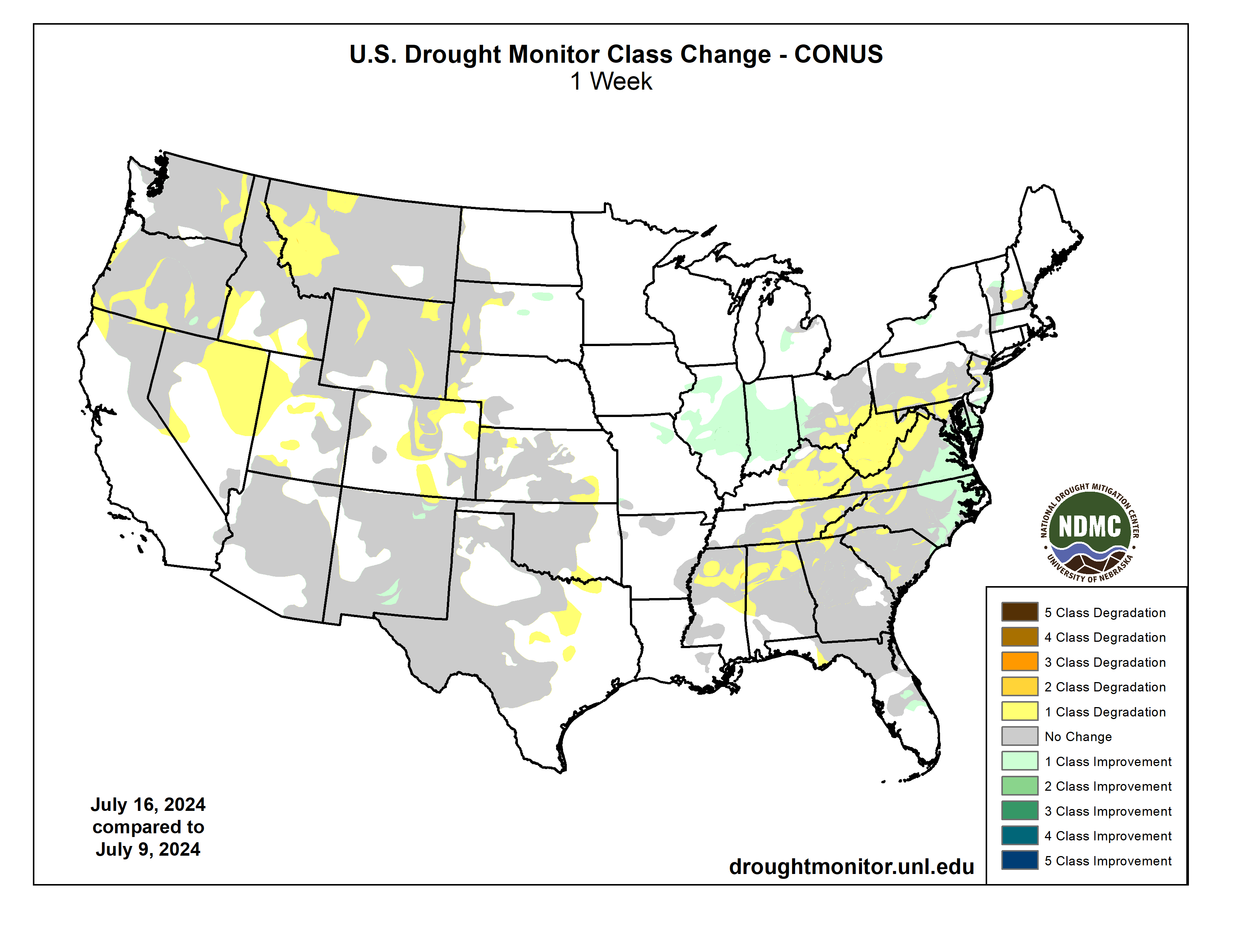
US Drought Monitor one week change map ending July 16, 2024.
American beaver, he was happily sitting back and munching on something. and munching, and munching. By Steve from washington, dc, usa – American Beaver, CC BY-SA 2.0, https://commons.wikimedia.org/w/index.php?curid=3963858
From email from the Beaver Institute (Matt Moseley):
BOULDER, Colo – As drought, climate change and wildfires become more challenging around the country, the intriguing beaver has become a hot topic these days.
BeaverCON is the premier global gathering for knowledge-sharing and celebration of beavers. The Beaver Institute will host the third biennial global gathering on October 19-24 at the University of Colorado Boulder. It will feature presentations, science, field trips, panels, discussion, art and storytelling about the castor canadensis.
“Beavers are more important than ever in water management and creating habitat,” said Adam Burnett, executive director of the Beaver Institute. “This conference is an opportunity for multiple organizations, disciplines, and experiences to converge and learn how to create a future of ecological balance with beavers. We are thrilled with the speakers and energy around this unique and special conference.”
Highlights of BeaverCON:
Saturday, October 19: Cameron Peak Wildfire Field Trip with Dr. Emily Fairfax.
Sunday, October 20: Urban Beaver Field Trip
Monday, October 21: Opening Ceremony with Tribal Recognition, activating of Artist Commission; featured presenters include Dr. Emily Fairfax on wildfires, USDA FSA Administrator Zach Ducheneaux on beavers and farmers, Dr. Ellen Wohl on beavers in Colorado, California’s Natural Resources Secretary Wade Crowfoot on beaver reintroduction, Brock & Kate Lundquist on the Bring Back the Beaver Campaign, and Jim Vaile & Alicia Yellow Owl on Blackfeet Nation’s beaver management plan.
Tuesday, October 22: Multiple speakers on beaver-related restoration, coexistence, relational conservation, partnering with Tribal Nations, youth leadership, subsistence living, relocation, and policy. Leading voices in the field Molly Alves, Mark Beardsley, Dr. Roisin Campbell-Murphy, Janine Castro, Derek Gow, Dr. Chris Jordan, Dr. Jordan Kennedy, Sarah Marshall, Torrey Ritter, Gerhard Schwab, Dr. Colin Thorne, and Alexa Whipple, will present and participate in panels. A Beaver Storytelling Circle will be held at the Dairy Arts Center in the evening.
Wednesday, October 23: A sprawling “State of the Beaver Union” session, Low-Tech Process-Based Restoration (LTPBR) technical sessions, film screenings, and presentations on permafrost, rewilding, youth leadership, policy, and more.
Thursday, October 24: Wetland Field Trip and a beaver coexistence workshop with Mike Callahan (Beaver Solutions, Beaver Institute)
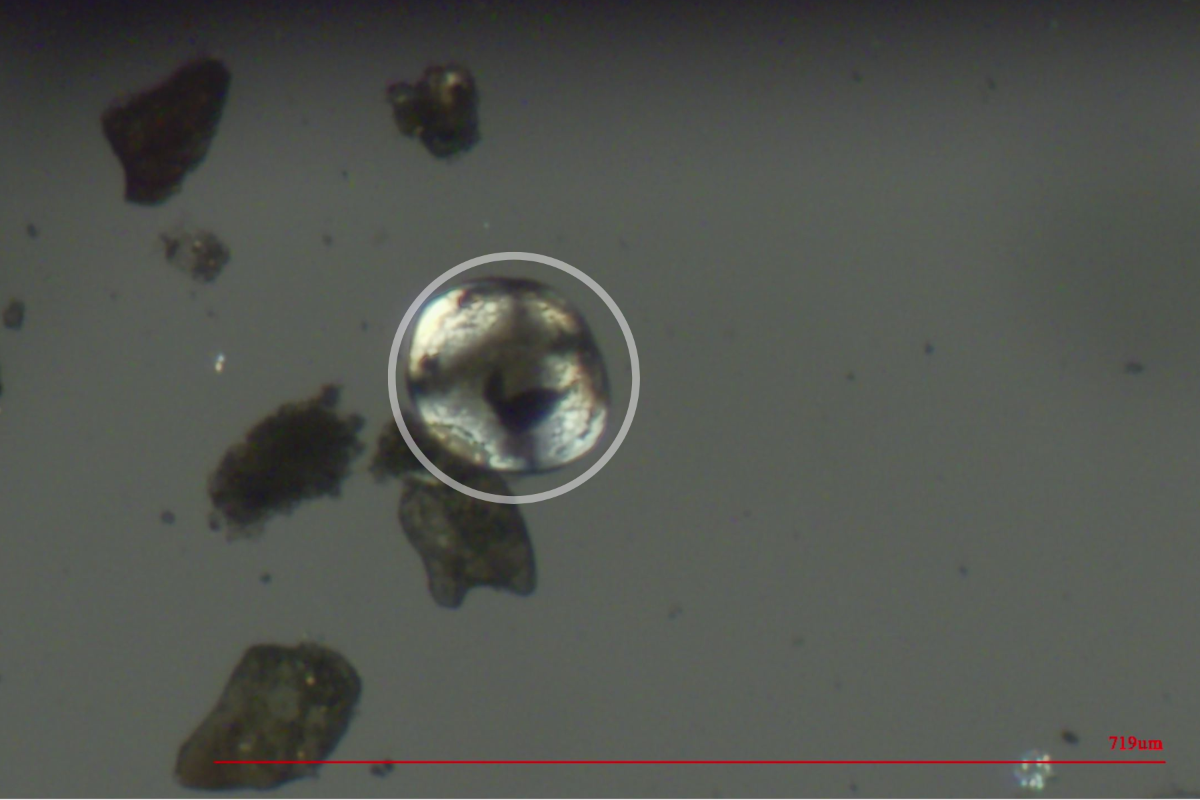
Photo of a zebra mussel veliger discovered by CPW in the Colorado River near Grand Junction after routine testing in early July. A veliger is the mussel’s free-floating (planktonic) larval stage that can only be seen under a microscope. Photo Credit: CPW
Colorado Parks and Wildlife (CPW) announces the discovery of zebra mussel veligers in the Colorado River and Government Highline Canal after routine testing in early July.
On July 1, staff from CPW’s Aquatic Nuisance Species (ANS) team collected a plankton sample from the Government Highline Canal near Clifton. This sample was evaluated at the ANS Lab in Denver where a suspected single zebra mussel veliger was found. The Sample was then sent to CPW’s Aquatic Animal Health Lab (AAHL) for further analysis. On July 9, the lab notified Robert Walters, Invasive Species Program Manager, that the sample was positive for zebra mussel DNA.
The Government Highline Canal, in Palisade. The Government Highline Canal near Grand Junction. The Grand Valley Water Users Association, which operates the canal, has been experimenting with a program that pays water users to fallow fields and reduce their consumptive use of water. Photo: Brent Gardner-Smith/Aspen Journalism
On July 8, CPW ANS staff collected plankton samples from two locations in the Colorado River upstream of the Grand Valley Water Users Canal diversion. On July 10 ANS technicians identified single suspect zebra mussel veligers in both samples. The samples were sent to the AAHL for confirmation. On July 11, the lab confirmed the samples were positive for zebra mussel DNA.
With single detections in both waters, these locations are now considered “suspect” for the presence of zebra mussels. In response to this detection, CPW has initiated their Invasive Species Rapid Response Plan and increased sampling is underway to determine if the classification should be changed to “positive,” a designation given when two or more subsequent sampling events detect mussel veligers in a water body.
A veliger is the free-floating (planktonic) larval stage of the mussel. At this stage of their life cycle, zebra mussels can only be seen under a microscope. No adult zebra mussels have been found at this time at either location.
“This challenging discovery has ecological and economic impacts not only on the Grand Valley but potential statewide impacts as well. CPW is committed to working with all of our partners as we work to better understand the extent of this discovery and the next steps in protecting the natural resources and infrastructure,” said CPW Director Jeff Davis.
Zebra mussels pose an extreme risk of ecological impacts to Colorado. The establishment of zebra mussels in the Colorado River is likely to negatively impact native fish populations due to their filter-feeding strategies that strip essential prey items, such as plankton, from the water. Slower-moving sections of the Colorado River, such as pools, eddies, and backwaters, are especially prone to invasion.
Zebra mussels also pose a risk to infrastructure that pulls water from the Colorado River. Female zebra mussels can produce up to 1,000,000 eggs in a spawning season. As they mature, the mussels bond to surfaces with byssal threads making them extremely difficult to remove. This rapid reproduction coupled with their attachment by byssal threads can lead to clogged water infrastructures creating long-term maintenance issues.
“We are disappointed in the situation we find ourselves in,” said Ed Warner, Area Manager, BOR Western Colorado Area Office. “We know how much effort CPW has put into keeping the Colorado River clear of zebra mussels. This is an extremely difficult scenario for all who rely on the Upper Colorado River system. We look forward to partnering with CPW, our stakeholders, and all involved to do what we can to address the situation.”
“This news is devastating,” said Tina Bergonzini, Grand Valley Water Users Association General Manager “Having our canal and the Colorado River test positive increases the threat of this invasive species and could impact everyone in the Grand Valley. From irrigation to drinking water, the ramifications cannot be underestimated or overstated. Our efforts, alongside our partners at CPW and the BOR, will be increased to protect our infrastructure, the livelihoods of so many, and water security for us all.”
CPW staff will continue working closely with our partners at the Bureau of Reclamation and Grand Valley Water Users Association on the next steps. Signs alerting the public of the river status will be posted at river access points starting in the De Beque Canyon to the Loma Boat Ramp.
“Detecting mussels in the Colorado River highlights how critical it is for boaters, paddlers, anglers, and any person recreating in Colorado’s waters to do their part in preventing the spread,” said Robert Walters, Invasive Species Program Manager.
CPW strongly encourages anyone boating, floating, paddling, or fishing in the Colorado River to clean, drain, and dry their vessels and equipment, including motorized boats, rafts, paddle boards, kayaks, and fishing gear after exiting the river.
CPW is evaluating options for the future management of Highline Lake based on this new information. Updates regarding access, fishing regulations, and water management will be provided once those decisions have been made.
Questions from the media for the Bureau of Reclamation can be directed to BOR Public Affairs Specialist Justyn Liff at 970-248-0625 or jliff@usbr.gov.
Questions from the media for the Grand Valley Water Users Association can be directed to GVWAU General Manager Tina Bergonzini at 970-242-5065 or tbergonzini@gvwua.com.
🚨 This is big news—we’ve discovered zebra mussel larvae in the Colorado River and Government Highline Canal near Grand Junction. No adult zebra mussels have been found at this time. pic.twitter.com/HIPoau5PQd
— Colorado Parks and Wildlife (@COParksWildlife) July 16, 2024
SPANISH TRANSLATION:
CPW anuncia el descubrimiento de mejillones cebra en el río Colorado y el canal Highline del Gobierno
GRAND JUNCTION, Colorado. – El Departamento de Parques y Vida Silvestre de Colorado (CPW, por sus siglas en inglés) anuncia el descubrimiento de veligers de mejillón cebra en el río Colorado y el canal Government Highline después de hacer pruebas de rutina al principio de julio.
El 1 de julio, el personal del equipo de Especies Acuáticas Molestas (ANS) de CPW recolectó una muestra de plancton del Canal Highline del Gobierno, cerca de Clifton. Esta muestra fue evaluada en el Laboratorio ANS en Denver, donde se encontró un presunto veliger de mejillón cebra. Luego, la muestra se envió al Laboratorio de Salud de Animales Acuáticos (AAHL) de CPW para más análisis. El 9 de julio, el laboratorio notificó a Robert Walters, Gerente del Programa de Especies Invasoras, que la muestra era positiva de ADN de mejillón cebra.
El 8 de julio, el personal de CPW ANS recolectó muestras de plancton de dos lugares en el río Colorado aguas arriba del desvío del Canal de Usuarios de Agua de Grand Valley. El 10 de julio, un técnico de ANS identificó a un solo sospechoso de mejillón cebra en ambas muestras. Las muestras se enviaron a la AAHL para su confirmación. El 11 de julio, el laboratorio confirmó que las muestras eran positivas de ADN de mejillón cebra.
Con detecciones únicas en ambas aguas, estos lugares ahora se consideran “sospechosos” de la presencia de mejillones cebra. En respuesta a esta detección, CPW ha iniciado su Plan de Respuesta Rápida de Especies Invasoras y se está llevando a cabo un aumento de muestreo para determinar si la clasificación debe cambiarse a “positiva”, una designación que se da cuando dos o más eventos de muestreo posteriores detectan mejillones veligers en agua.
Un veliger es la etapa larvaria flotante (planctónica) del mejillón. En esta etapa de su ciclo de vida, los mejillones cebra solo se pueden ver bajo un microscopio. No se han encontrado mejillones cebra adultos en este momento en ninguno de los dos lugares.
“Este desafiante descubrimiento tiene impactos ecológicos y económicos no solo en el Gran Valle, sino también posiblemente en todo el estado. CPW está comprometido a trabajar con todos nuestros socios para comprender mejor el alcance de este descubrimiento y los próximos pasos para proteger los recursos naturales y la infraestructura”, dijo el director de CPW, Jeff Davis.
Los mejillones cebra representan un riesgo extremo de impactos ecológicos para Colorado. Es probable que el establecimiento de mejillones cebra en el río Colorado tenga un impacto negativo en las poblaciones de peces nativos debido a sus estrategias de alimentación por filtración que despojan del agua a las presas esenciales, como el plancton. Las secciones más lentas del río Colorado, como pozas, remolinos y remansos, son especialmente propensas a la invasión.
Los mejillones cebra también representan un riesgo para la infraestructura que extrae agua del río Colorado. Las hembras de mejillón cebra pueden producir hasta 1,000,000 de huevos en una temporada de desove. A medida que maduran, los mejillones se adhieren a las superficies con hilos bisales, lo que los hace extremadamente difíciles de eliminar. Esta rápida reproducción, junto con su fijación por roscas bisales, puede provocar la obstrucción de las infraestructuras de agua, lo que crea problemas de mantenimiento a largo plazo.
“Estamos decepcionados con la situación en la que nos encontramos”, dijo Ed Warner, Gerente de Área de la Oficina del Área Occidental de Colorado de BOR. “Sabemos cuánto esfuerzo ha puesto CPW para mantener el río Colorado libre de mejillones cebra. Este es un escenario extremadamente difícil para todos los que dependen del sistema del río Colorado. Esperamos asociarnos con CPW, nuestras partes interesadas y todos los involucrados para hacer lo que podamos para abordar la situación”.
“Esta noticia es devastadora”, dijo Tina Bergonzini, Gerente General de la Asociación de Usuarios de Agua de Grand Valley, “El hecho de que nuestro canal y el río Colorado den positivo aumenta la amenaza de esta especie invasora y podría afectar a todos en Grand Valley. Desde el riego hasta el agua potable, las ramificaciones no pueden subestimarse ni exagerarse. Nuestros esfuerzos, junto con nuestros socios en CPW y BOR, se incrementarán para proteger nuestra infraestructura, los medios de vida de tantas personas y la seguridad hídrica para todos nosotros”.
El personal de CPW continuará trabajando en estrecha colaboración con nuestros socios en la Oficina de Recuperación y la Asociación de Usuarios de Agua de Grand Valley en los próximos pasos. Se colocarán letreros que alerten al público sobre el estado del río en los puntos de acceso al río, comenzando en el cañón De Beque hasta la rampa para botes de Loma.
“La detección de mejillones en el río Colorado pone de manifiesto lo importante que es para los navegantes, remeros, pescadores y cualquier persona que se recree en las aguas de Colorado hacer su parte para prevenir la propagación”, dijo Robert Walters.
CPW recomienda encarecidamente a cualquier persona que navegue, flote, reme o pese en el río Colorado que limpie, drene y seque sus embarcaciones y equipos, incluidos botes motorizados, balsas, tablas de remo, kayaks y equipos de pesca después de salir del río.
CPW está evaluando opciones para la futura administración del lago Highline en función de esta nueva información. Las actualizaciones sobre el acceso, las regulaciones de pesca y la gestión del agua se proporcionarán una vez que se hayan tomado esas decisiones.
Las preguntas de los medios de comunicación para la Oficina de Reclamación pueden dirigirse al especialista en asuntos públicos de BOR, Justyn Liff, al 970-248-0625 o jliff@usbr.gov.
Las preguntas de los medios de comunicación para la Asociación de Usuarios de Agua de Grand Valley pueden dirigirse a la Gerente General de GVWAU, Tina Bergonzini, al 970-242-5065 o tbergonzini@gvwua.com.
Click the link to read the article on the Sibley’s Rivers website (George Sibley):
July 17, 2024
In the last post, I suggested that the Colorado River Compact with its ‘temporary equitable division’ into two basins could now be considered irrelevant (or worse, obstructive) because we have finally effectively accomplished, over the past century, the goal that brought the seven-state Compact commission together in 1922, but which they were unable to achieve then: a seven-way division of the use of the river’s waters.
They wanted a legally constituted seven-way division that would override the appropriation doctrine at the interstate level, to avoid a seven-state horserace for water in which California was already lapping the field, but in 1922 they lacked, for that goal, both a sufficient knowledge of the river’s flows and reasonable expectations for their own growth. Finally they settled on the two-basin division that was, from the start, problematic (Arizona refused to even ratify it), but which sufficed to persuade Congress that the states were enough in agreement so that Congress could go ahead with funding the big mainstem structures the Bureau of Reclamation was champing at the bit to build (perhaps the real goal of the Compact).
But now, after a century of Colorado River development, we ought to be able to say, with resignation if not confidence, that, yes, we have accomplished an eight-way division of use of the river’s waters (seven states plus Mexico). We can say this because all of the waters of the river have been put to use; what each state has to use now is almost certainly all the water it will ever have to use – at best.
Is it an ‘equitable’ division? The Compact intended for each basin to have the use of half of the river’s waters; what has evolved over the century is roughly two-thirds of the river being used by the Lower Basin, one third by the Upper. But a huge majority of the 35-40 million people served by the river live in the Lower Basin; the majority of the best land irrigable by the river is there. Speaking as an Upper Basin inhabitant, I would rather see the water go where the people are, than the people coming to where the water is (although too much of that is happening anyway).
Map credit: AGU
But to my point: the seven-way (plus Mexico) division of the use of the waters that the Compact commissioners wanted has been achieved – like it or not. (Water for the 30 First People tribes is shoehorned into the state allotments.) So can we not finally jettison the two-basin division that has really proven to be nothing but divisive? As indicated by the current situation, with each basin producing a plan for the future that is unacceptable to the other basin?
We seem to have two options for the post-2026 operation and management of the river systems and structures at this point: one, add another set of ‘Law of the River’ modifications, corrections, crutches and bandaids to the beat-up Compact. Or two, start to do what we keep telling ourselves we need to be doing today: ‘thinking outside the box’ – the Compact being the box we’re in. Nested in a larger box, the appropriation doctrine as the ultimate answer, no matter what the question.
So with the seven states currently deadlocked in the two-basin box, we might take the moment to at least haul ourselves up onto the edge of the box to look around – and we might find a start in looking at the basic nature and function of our river, underneath all the physical, legal and economic structures we’ve laid over it to control and contain its basic nature. There is also some interesting science happening around the river I want to get into….
The basic function of every stream is to collect and carry off water from precipitation that the precipitation ‘catchment basin’ could not ‘catch’ and put to work in some way nurturing other life, soaking into the root zone of the plant life or accumulating in surface pools and lakes. When it comes too fast (as when a snowpack is melting), or the slope is too steep or rocky, the ‘catchment basin’ becomes a ‘watershed,’ shedding water. This is not to say that a living stream is just a ‘drainage ditch’; the water itself gives intimations of trying to stay with the land, slowing itself with picking up everything from sand and gravel to whole trees; and when the slope gentles enough, it drops what it is carrying in its own path and forces itself into looping meanders and wetlands that maximize contact with the land and opportunities to stay there.
A stream becomes a ‘gaining’ or ‘losing’ stream, depending on what is happening in the watershed it is moving through: precipitation causes direct runoff from the land, and also raises the water table, the level of saturation in whatever geological structures underlie the watershed. Both of those can add water to the stream, making it a ‘gaining’ stream. If there is no precipitation, or only enough to wet the root zone for whatever plant life is trying to hold the watershed together, and if the stream is carrying a flow that is higher than the water table in the stream’s riparian zone, then the stream will give some of its water to its riparian zone in what hydrologists call a ‘hyporheic exchange,’ making it a ‘losing’ stream. (Personally, I think of it as a ‘giving stream.’)
You can probably see where this is going for a river in an arid region like most of the Colorado River Basin. Humid-region rivers like the Mississippi and its eastern tributaries tend to be ‘gaining streams’ all the way to the oceans, due to precipitation throughout the basin, but an arid-region river is more likely to be a ‘losing (giving) stream’ once it leaves its relatively wet headwaters.
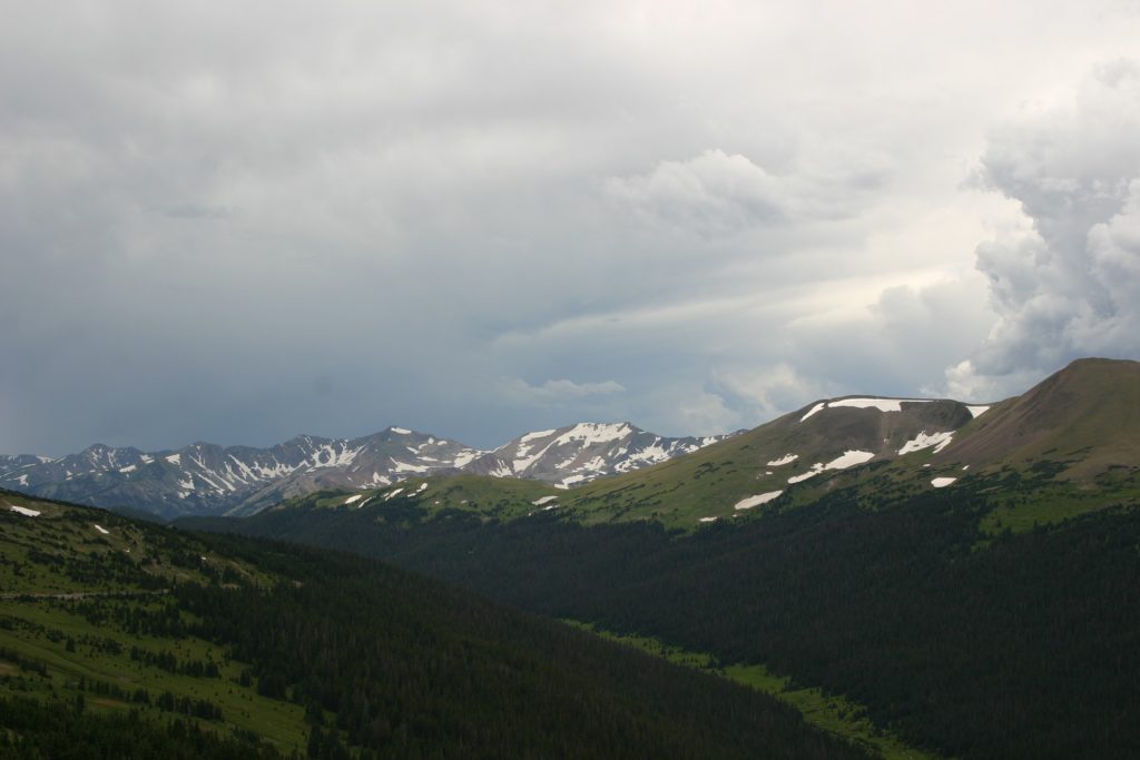
This Trail Ridge Road view of the Colorado Front Range shows how the upslope conditions are created. Photo credit: Texas A&M University
A state-of-the-science study by the Western Water Assessment (based at the University of Colorado), compiling work from many river scientists, reported that 85-90 percent of the Colorado River’s total water supply is runoff from the mountain headwaters of the Colorado River. The mountains force air upward into cooler atmospheric levels, where any moisture in the air condenses and falls as precipitation, mostly above 8,000 feet in elevation. There would be no Colorado River were it not for the mountain ranges rising to 14,000 feet in the Southern Rockies – which constitute less that 15 percent of the Basin’s 250,000 square miles. The river’s desert reaches receive very little dependable precipitation – a lot of which comes in violent summer storms powerful enough to break through the ‘heat shield’ that creates the virga – the afternoon would-be storms when rain is seen trailing out of clouds, but being vaporized before reaching ground by the rising desert heat.
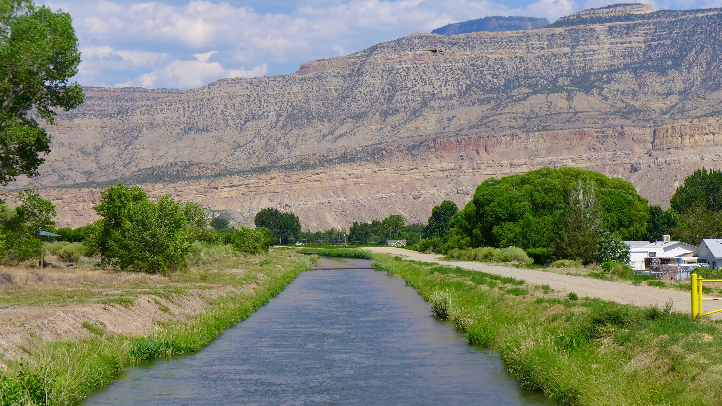
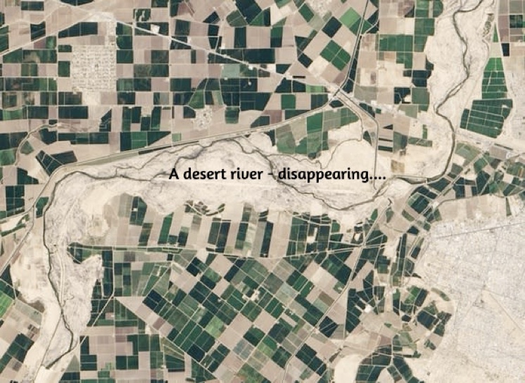
The Colorado River, despite its mountain origins, is a desert river. Below the 7,000-foot elevation the river’s tributary streams flow onto (and deeply into) the high deserts of the Colorado Plateau, then out of those canyons and into the subtropical Sonora and Mojave Deserts. Desert rivers, as a rule, are gaining streams only in their headwaters highlands; once in the deserts, they are losing (giving) streams that begin to disappear, through evaporation, plant transpiration, and ‘giving’ to low water tables – and now, of course, to humans diverting the river to irrigate rich but dry desert lands, or to water great desert cities: human practices that go back 6,000 years to the ‘Fertile Crescent’ of the Tigris and Euphrates Rivers and the floodplains of the Nile.
The Colorado River, despite its mountain origins, is a desert river. Below the 7,000-foot elevation the river’s tributary streams flow onto (and deeply into) the high deserts of the Colorado Plateau, then out of those canyons and into the subtropical Sonora and Mojave Deserts. Desert rivers, as a rule, are gaining streams only in their headwaters highlands; once in the deserts, they are losing (giving) streams that begin to disappear, through evaporation, plant transpiration, and ‘giving’ to low water tables – and now, of course, to humans diverting the river to irrigate rich but dry desert lands, or to water great desert cities: human practices that go back 6,000 years to the ‘Fertile Crescent’ of the Tigris and Euphrates Rivers and the floodplains of the Nile.
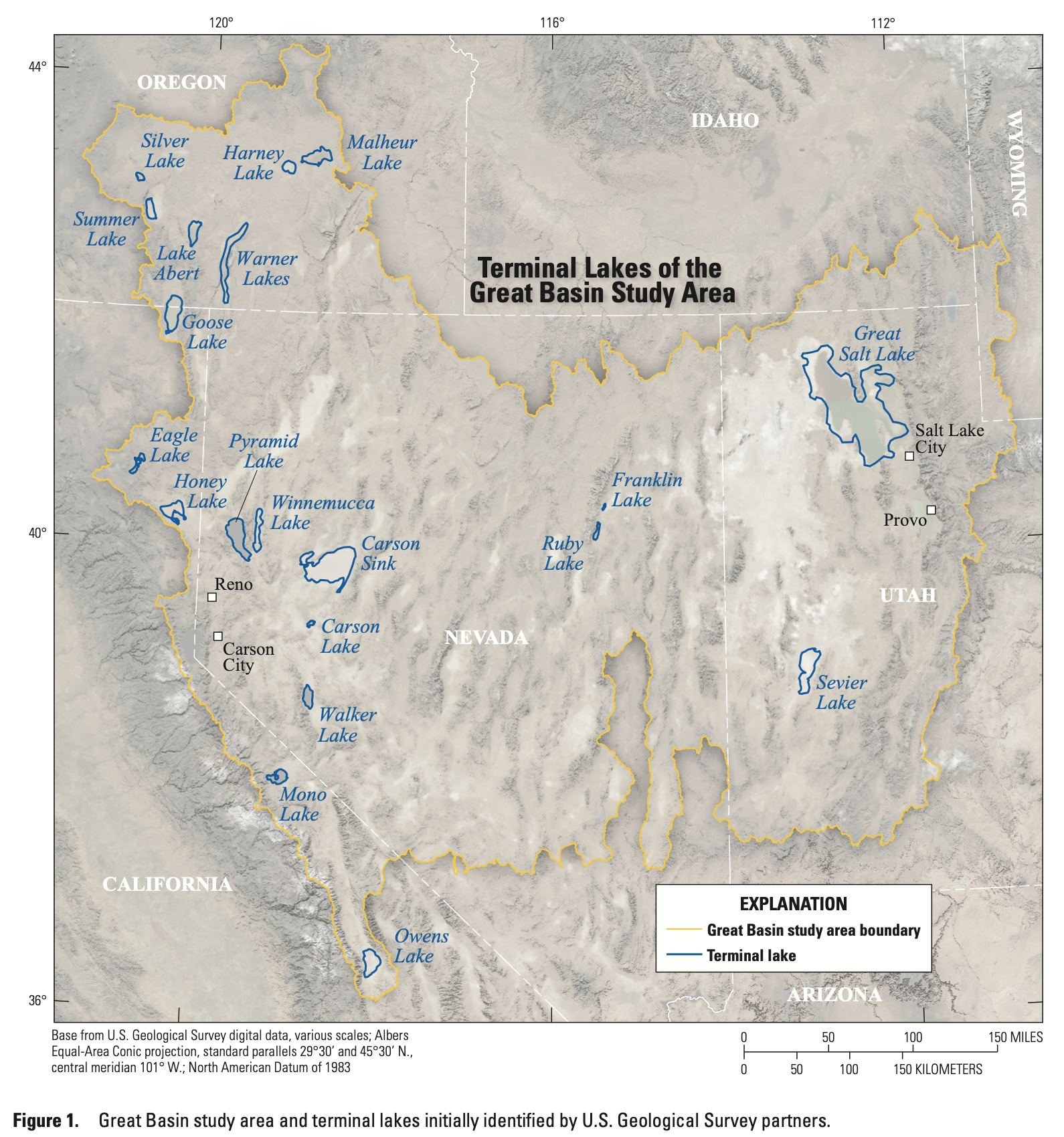
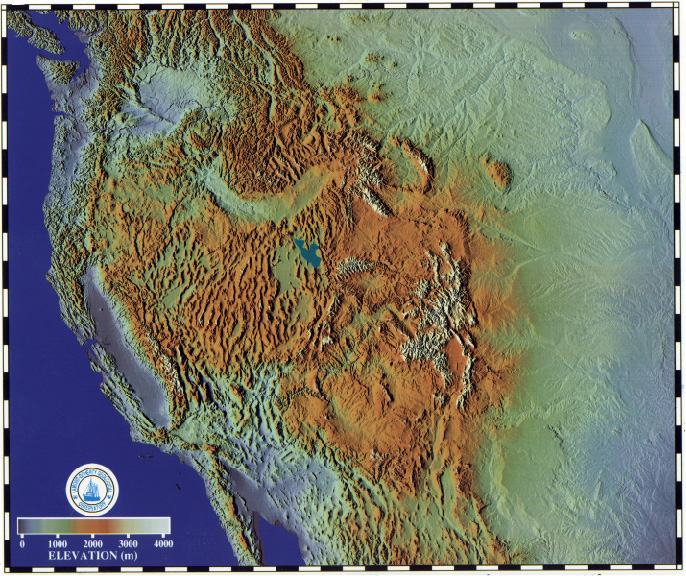
The Colorado River, as it ran before we went to work on it, still carried enough water so there would be some left after its passage through the deserts, to ‘waste’ into the Gulf of California – most of in a 2-3 month flood as the snow melted, then dropping to a trickle in the delta that probably went intermittent in drier periods. But the Great Basin north of the Colorado River region has good current examples of what happens more or less naturally with desert rivers.
Credit: USGS
Forty streams and rivers flow into the Great Basin from the Sierras, the Wasatch, the Colorado and Columbia Plateaus, and the smaller Nevada ranges within its basin-and-range landscape, and most of those streams just disappear there. Some of them are substantial like the Truckee and Humboldt Rivers as they emerge from the mountains, and flow into salty fluctuating lakes similar to but much smaller than the Great Salt Lake (also in the Great Basin). But most of those streams disappear in shallow silty playas that are dry most of the year, or they just dribble off into the riparian scrub growth they nurture in passing.
Evaporation and plant transpiration from those ‘dying’ Great Basin desert rivers is probably responsible for some of the precipitation that falls on the Southern Rockies and creates the Colorado River. As the dried-out westerlies pass over the Sierras where they’ve dumped their load of Pacific moisture – a lot of it on the Sierras’ east slopes (Tahoe Lake regularly gets 8-20 feet of snow), the dried air warms up as it flows down the mountains and begins picking up vapor evaporated from the 40 Great Basin streams and rivers, carrying it on to the Rockies where it is again condensed to precipitation.
Colorado River water is thus at the end of a line of freshwater transformations beginning with water vapor from the Pacific Ocean, condensed to rain over California’s coastal mountains, running off as liquid water to the Central Valley, then to vapor again under the hot sun, picked by the westerlies, then condensed to serious rain or snow over the high Sierras, then back to water running off the Sierras, then evaporated again in the Great Basin and again picked up by the westerlies, then condensed again to snow as it is cooled over the Southern Rockies, then melted as runoff and groundwater for the Colorado River.
The freshwater dance: less than three percent of the planet’s water is in the freshwater cycle at any time, but all land-based life depends on that fraction, mostly in its liquid state. One notices, however, that the sun and wind that create it over the ocean and move it onto land work hard to return it to its vaporous state – and what we are doing to our atmosphere is making it easier for the vaporizing forces, and more difficult to keep enough liquid water for all life everywhere.
When it comes to contemplating the management and operation of a desert river, it’s useful to begin by trying to ignore all of the artificial boundaries drawn over the river basin, especially the state boundaries which (except for where the river divides California from Arizona) bear absolutely no resemblance to or reflection of any real geography. Dividing unsettled lands into large ‘territories,’ bounded by straight lines useful only in oceanic navigation, is an imperial ploy used to create weak political and economic states with a developed dependence on the powers that drew the lines – in our case, setting up resource supply territories for the ever-expanding industrial juggernaut ‘back east.’
Western US
If you can forget the state lines and look at nature’s usually blurrier or fuzzier lines – you don’t need to be hydrologist to see that a desert river divides naturally into two regions: a water-production region in the mountains and other uplands that receive most of the river-creating precipitation, and a water-consumption region, the deserts where the river’s water gradually disappears into atmospheric vapor, groundwater, or riparian life – now including extensive human activities taking some of the water a long way from the natural river channel.
Obviously the two regions require different management strategies, in a time of water-stress. In the Colorado River’s ‘water-consumption’ region, with humans now the largest consuming entity, the management challenge is in the broad range of activities that can be called ‘conservation’: implementing systemic changes like requiring low-flow fixtures in all construction or remodeling; determining the best balance of water uses and providing the carrots and sticks to work toward those balances; doing what can be done to capture whatever precipitation does fall rather than treating it as ‘storm runoff’; where possible ‘hiding’ stored water away from the sun through recharging underground aquifers; developing internal and inter-community water reuse and sharing systems for the metropolitan sprawls – et cetera.
Rendering of Phoenix’s proposed Cave Creek direct potable reuse project. Source: City of Phoenix
A lot of work is already being done in these ventures – mostly initiated by the cities themselves, or by large irrigation entities – sometimes working together with the cities. Such measures are expensive – some of them very expensive, like reuse systems requiring substantial disruptive replumbing, but they do ‘increase the water supply’ to the extent that water not needed in one place can fill a shortage somewhere else.
But an entirely different set of management challenges await up in the ‘water-production’ region – the 15 percent of the basin that produces 85-90 percent of its water – and not a lot is being done about those challenges, so far as I can tell, at least not in a conscious and deliberate way. Most of the water-production region is public land, and most of it is administered by the U.S. Forest Service which has a lot of other challenges on its plate.
But there is a factoid from the aforementioned Western Water Assessment study of Colorado River science that intrigues: they say that as much as 170 million ace-feet of precipitation falls on the Colorado River Basin, the majority of it in the mountain headwaters tributaries – yet only about 10 percent of that shows up in the river. What happens to the rest of it?