#Drought news July 25, 2024: The heaviest rainfall amounts fell across much of E. #Colorado, reporting rainfall totals up to 400% of normal

Click on a thumbnail graphic to view a gallery of drought data from the US Drought Monitor website.

Click the link to go to the US Drought Monitor website. Here’s an excerpt:

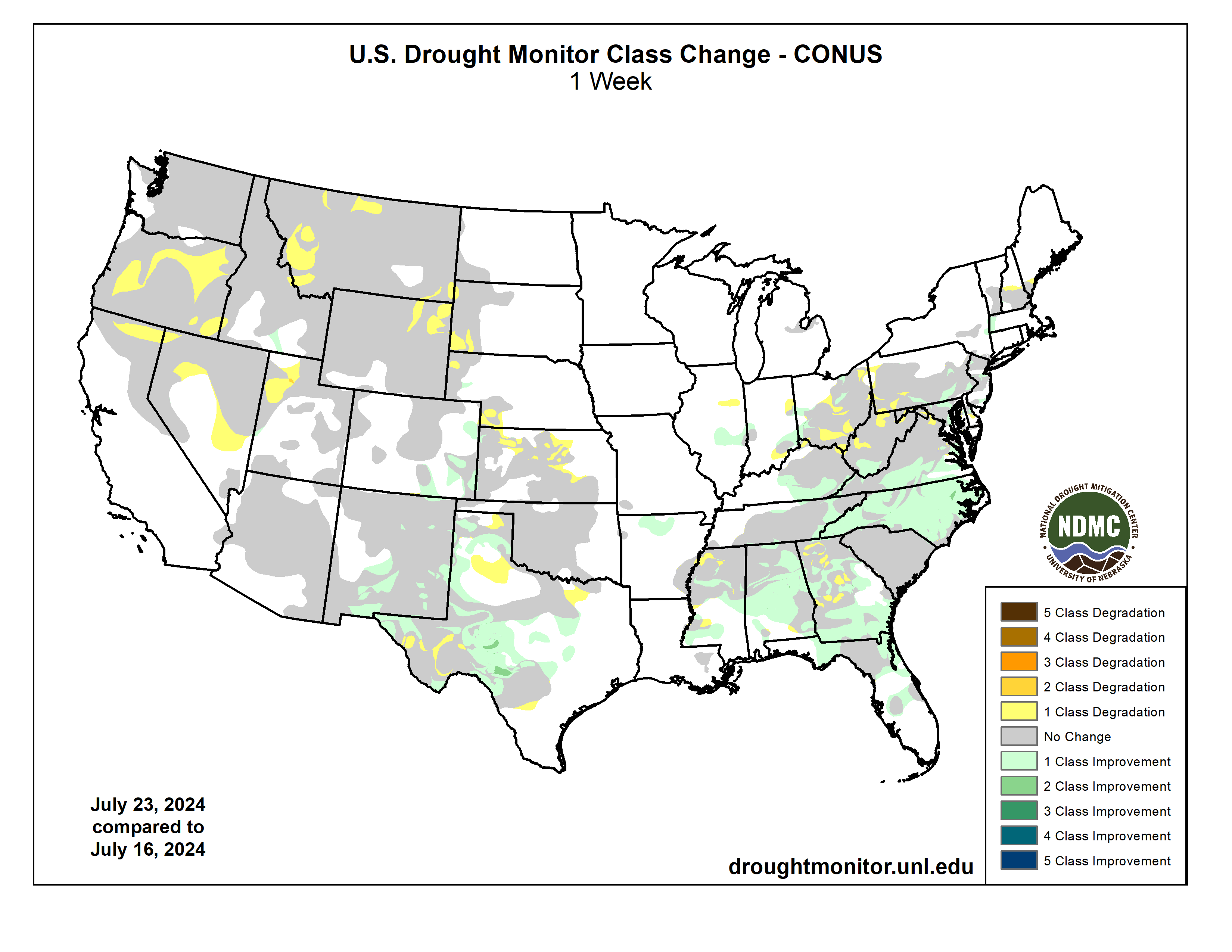
This Week’s Drought Summary

Over the past week, a major heatwave brought warmer-than-normal temperatures to much of the West, with departures ranging between 3 to 12 degrees F above normal across much of the region. Near-normal to cooler-than-normal temperatures were observed from the central Rockies to the Great Lakes, with departures ranging between 3 to 9 degrees F below normal. Precipitation varied across the contiguous U.S. this week. Monsoonal moisture brought heavy precipitation and flash flooding to parts of the Southwest, while a lingering frontal boundary brought daily thunderstorms, heavy rainfall and flash flooding across much of the Southeast and Mid-Atlantic. The most widespread improvements were made in the Southeast, as well as eastern portions of the Southwest and across much of western Texas, where above-normal precipitation amounts were observed this past week. Conversely, dry conditions resulted in degradations across much of Hawaii and the Pacific Northwest, as well as southern portions of the Northeast and in parts of the central Plains, and other parts of the West. Drought and abnormal dryness also expanded or intensified in the Ohio Valley, western High Plains, and in New England. In Hawaii, dry conditions coupled with warmer temperatures resulted in the expansion and intensification of drought across the state this week…
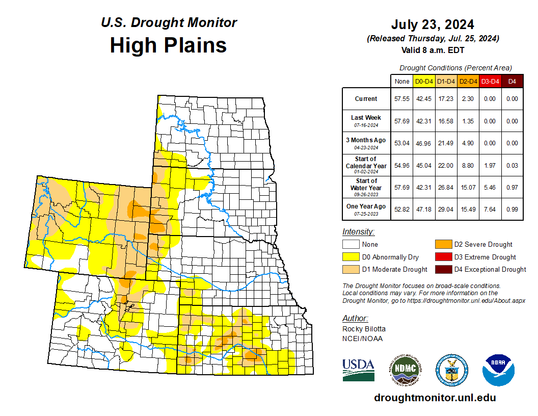
High Plains

Precipitation fell across much of the region this week, which was enough to prevent large areas of degradation but not enough to warrant large improvements. The heaviest rainfall amounts fell across much of eastern Colorado, reporting rainfall totals up to 400% of normal, resulting in the improvements of abnormal dryness and the removal of moderate drought from the region. Heavy precipitation amounts were also reported in central Nebraska and central South Dakota but were already free of drought and abnormal dryness this week. Precipitation was below-normal across the western portions of the region, resulting in the expansion and intensification of drought. Severe drought was added western South Dakota and Nebraska, and expanded in eastern Wyoming. Moderate drought also introduced in southwest Nebraska this week, while abnormal dryness was expanded in the area. Much of the region remains free of drought and abnormal dryness this week…
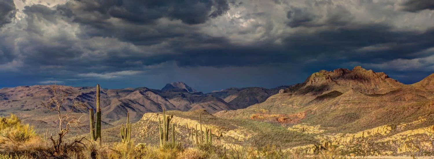
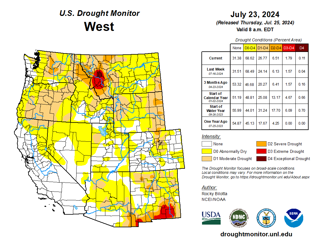
Colorado Drought Monitor one week change map ending July 23, 2024.

West

Average temperatures were well above normal across much of the West this week. Temperatures ranged between 3 to 9 degrees F above normal across much of the region, while northern portions of the region observed temperatures up to 12 degrees F above normal this week. Precipitation fell across much of the region but amounts were mostly below-normal for the region. The heaviest precipitation amounts were measured over parts of New Mexico. Above-normal precipitation (up to 6 inches), along with cooler temperatures, resulted in the removal of exceptional drought from southeast New Mexico and improvements to extreme drought, severe drought, moderate drought and abnormal dryness across eastern and southern portions of the state. Conversely, warmer-temperatures and below-normal precipitation resulted in the introduction of exceptional drought in western Montana, as well as the expansion of drought in other parts of Montana, across much of Oregon into northern California, while moderate drought was introduced in northwest Utah. The expansion of abnormal dryness occurred in parts of Nevada, which missed out on some of the beneficial rains resulting in the expansion of moderate drought in the area. Conditions remained dry in the interior parts of Washington, resulting in expansion of moderate drought and abnormal dryness based on short-term SPI/SPEI data, as well as low soil moisture and streamflow…

South

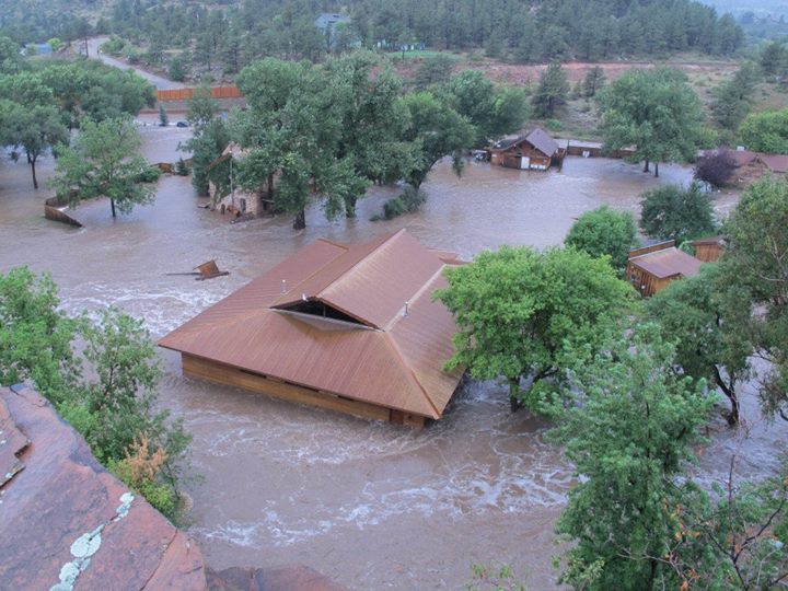
Dry conditions continued across much of the northern portions of the South this week, while heavy precipitation fell across much of central Texas and in parts of northern Arkansas, with areas reporting rainfall totals greater than 600% of normal. Abnormal dryness was removed from northern Arkansas, while moderate to extreme drought were improved across much of central Texas. Improvements were also made to parts of northern and eastern Tennessee where spotty showers brought much needed relief, returning areas back to their 30-day precipitation normals. Conversely, conditions continued to deteriorate in parts of northern Kansas and parts of western Texas, where precipitation totals were 5% to 25% of normal for the past month. Moderate to severe drought were expanded into central Kansas, while extreme drought was expanded and exceptional drought was introduced into the Trans-Pecos region of Texas this week. Temperatures were below-normal across much of the South, while departures of 1 to 6 degrees F above normal were observed across parts of western Texas. The expansion and intensification of drought categories were based on short-term SPI/SPEI, reservoir levels, streamflow and soil moisture data…

Looking Ahead

During the next five days (July 23–27, 2024), dangerous heat is expected to continue through the midweek across much of the West, with high temperatures reaching the 90s and 100s and ranging between 5-15 degrees above normal. The strong ridge, extending from the Southwest U.S. into west-central Canada, which produced hazardous heat from the West into the northern High Plains, should begin to weaken and begin to push eastward ahead of a Pacific upper low tracking into western Canada and trailing trough that will settle near the West Coast. Monsoonal conditions will promote daily episodes of showers and storms over the Four Corners states and into the Great Basin under and near upper ridging over that part of the country. Meanwhile, one or more wavy fronts will be on the leading side of Great Lakes into southern Plains mean troughing aloft, leading to multiple days of rain and thunderstorms with areas of heavy rainfall from the southern Plains into the Mid-Atlantic and parts of New England. The Great Lakes and Northeast should eventually trend drier late week as the northern part of the trough moves eastward. Consensus still shows the Atlantic upper ridge building into the Southeast for a time, peaking in strength around Wednesday-Thursday.

The Climate Prediction Center’s 6-10 day outlook (valid July 28–August 1, 2024) favors above-normal precipitation along much of the eastern contiguous U.S. and Alaska, as well as parts of Northwest, with below-normal precipitation across most of the interior West and in parts of New England. Increased probabilities for above-normal temperatures are forecast for much of the contiguous U.S., while below-normal temperatures are likely across the state of Alaska and in southern parts of California and Texas.

US Drought Monitor one week change map ending July 23, 2024.

Bureau of Reclamation to host Ruedi Reservoir water operations public meeting #FryingPanRiver

Sunrise at Ruedi Reservoir October 20, 2015. Photo via USBR.

From email from Reclamation (Anna Perea):

July 24, 2024

The Bureau of Reclamation has scheduled the annual public meeting to discuss the Ruedi Reservoir Water Operations for the 2024 water year. The meeting will be held on Wednesday August 7, 2024, from 6:00 p.m. – 8:00 p.m. at the following location:

Roaring Fork Conservancy River Center
22800 Two Rivers Road
Basalt, CO 81621

Topics will include: 

  • Reservoir operations update (Reclamation)
  • Colorado River 15-Mile Reach endangered fish update (U.S. Fish and Wildlife)
  • Fryingpan River projects (Roaring Fork Conservancy)
  • Updates on Ruedi water leases (Colorado Water Conservation Board)Ā 
  • Overview of East Slope Fryingpan-Arkansas Project (Reclamation)Ā Ā 
  • Public question and answer sessionĀ 

For more information, please contact Tim Miller, Hydrologist, Eastern Colorado Area Office, by phone or e-mail: (970) 461-5494, or tmiller@usbr.gov.

Media inquiries or general questions about Reclamation should be directed to Anna Perea, Public Affairs Specialist, at 970-290-1185 or aperea@usbr.gov. If you are deaf, hard of hearing or have a speech disability, please dial 7-1-1 to access telecommunications relay services.

Biden-Harris Administration Announces Nearly $66M for #Conservation Work with States, Tribes, Private Landowners as Part of Investing in America Agenda — NRCS

Photo credit: NRCS

Click the link to read the release on the NRCS website:

June 11, 2024

USDA also signs agreement with Western Governors to strengthen shared efforts to protect communities and resources

During a meeting of the Western Governors Association today, Deputy Secretary of Agriculture Xochitl Torres Small announced that USDA is investing nearly $66 million for projects to reduce wildfire risk, protect water quality and improve forest health across the nation as part of President Biden’s Investing in America agenda.

Deputy Secretary Torres Small also signed a Memorandum of Understanding (MOU) with the Western Governors’ Association, reestablishing the framework for cooperatively responding to the many challenges faced across western landscapes. The MOU, signed on behalf of the USDA alongside Governors Brad Little of Idaho, Joe Lombardo of Nevada, Michelle Lujan Grisham of New Mexico, Doug Burgum of North Dakota, and Mark Gordon of Wyoming, amplifies the scale of shared stewardship work between participating states and the USDA. It also fosters better integration of forest and rangeland health and wildfire risk reduction projects across different land ownerships.

ā€œPeople across rural America face growing wildfire threats to their homes, business, infrastructure, and resources,ā€ said Deputy Secretary Torres Small. ā€œThrough the investments announced today, President Biden is investing in state and local governments, Tribal partners, and private landowners to ensure our landscapes are healthy, our infrastructure is strong, and our communities stay safe.ā€

Of the total investment announced, $12 million is being provided through the USDA Forest Service’s Good Neighbor Authority,  allowing the agency to collaborate with state forestry agencies, Tribes and counties to mitigate wildfire risk and enhance forest, rangeland and watershed health. This funding will support 22 projects across 13 states, thanks to funding from President Biden’s Bipartisan Infrastructure Law. Nearly $9 million of the total funding will be allocated to support projects in several states that are part of the Western Governors Association member states, including Arizona, California, Idaho, Montana, Oregon, Utah, Washington and Wyoming.

The Department is also investing nearly $55 million of the total funding to reduce wildfire risk, and improve water quality and forest health through the Joint Chiefs’ Landscape Restoration Partnership. This collaborative effort between USDA’s Natural Resources Conservation Service (NRCS) and Forest Service aims to work with private, state, and Tribal landowners to conserve forests and agricultural lands alongside federally managed lands while safeguarding communities. The $55 million investment will support 41 projects — including 10 new projects — across 11 states. 

This program advances President Biden’s Justice40 Initiative, which sets a goal that 40% of the overall benefits of certain federal climate, clean energy, and other investments flow to disadvantaged communities that are marginalized by underinvestment and overburdened by pollution.

The NRCS and Forest Service are also now accepting proposals for Joint Chiefs’ Landscape Restoration Partnership projects for fiscal year 2025 projects. Applications are due on September 13, 2024.  

ā€œThese projects are indicative of a growing movement of cooperation around natural resource issues for the betterment of us all,ā€ said Forest Service Chief Randy Moore. ā€œA keystone of the Joint Chiefs’ projects is the people and the understanding that the healthier our forests, the healthier our nation.ā€ 

ā€œThe Joint Chiefs’ Landscape Restoration Partnership enables NRCS and the Forest Service to collaborate with agricultural producers and forest landowners to invest in conservation and restoration at a big enough scale to make a difference in their communities,ā€ said NRCS Chief Terry Cosby. “Working with federal, state and local agencies at this scale, helps reduce wildfire threats, protect water quality and supply, improve wildlife habitat for at-risk species, and ultimately combat climate change.ā€ 

Today’s announcements also build on Agriculture Secretary Tom Vilsack’s announcement last week of $18 million for 23 new Tribal Forest Protection Act projects.

Background

Joint Chiefs’ Restoration Partnership

Since 2014, USDA has invested more than $423 million in 134 projects in 42 states as well as Guam and Puerto Rico through the Joint Chiefs’ Landscape Restoration Partnership. This program focuses on areas where national forests and grasslands intersect with privately-owned lands.

Good Neighbor Authority

Established by Congress in 2014, Good Neighbor Authority provides the Forest Service a straightforward way to enter into management agreements with states, Tribes and counties. The Good Neighbor Authority pools federal, state, Tribal, and county resources to complete more forest, rangeland, and watershed restoration work on national forests and grasslands. President Biden’s Bipartisan Infrastructure Law authorizes $160 million over five years for states and Tribes to implement restoration projects on federally managed lands through the Good Neighbor Authority and the Tribal Forest Protection Act
 

USDA touches the lives of all Americans each day in so many positive ways. In the Biden-Harris administration, USDA is transforming America’s food system with a greater focus on more resilient local and regional food production, fairer markets for all producers, ensuring access to safe, healthy and nutritious food in all communities, building new markets and streams of income for farmers and producers using climate smart food and forestry practices, making historic investments in infrastructure and clean energy capabilities in rural America and committing to equity across the department by removing systemic barriers and building a workforce more representative of America. To learn more, visit usda.gov

The timing of rainfall could help predict floods: New CIRES-led study measures the time between storms to better understand soil moisture — Western Water Assessment

Photo credit: CIRES

Click the link to read the release on the CIRES website (Ben Livneh, Nels Bjarke, Parthakumar A. Modi, Alex Furman, Darren Ficklin, Justin M Pflug, and Kris Karnauskas):

June 25, 2024

With record rainfall projected to continue into the future, many worry extreme flooding will follow suit. But a new CIRES-led study published today in Science of the Total Environment found an increase in precipitation alone won’t necessarily increase disastrous flooding — instead, flood risk depends on how many days have passed between storms.

Credit: CIRES

In the study, CIRES Fellow and Western Water Assessment director Ben Livneh and his colleagues, including CIRES Fellow Kris Karnauskas, looked for a new way to understand soil moisture and how it impacts flooding. The research team knew soil moisture is important when understanding floods, but measuring soils effectively is challenging. 

So they found a proxy for soil moisture: precipitation intermittency, the length of a dry spell between precipitation events. Simply put: after a prolonged time since the last rain, it takes a larger storm to generate flooding; with fewer days between storms, a wider range of conditions can lead to flooding.

ā€œWe can actually understand changes in flood risk based on the number of days since the last rain event,ā€ Livneh said. ā€œWe wanted to make it straightforward because soil water is hard to predict.ā€

The research focused on semi-arid and arid regions and looked at rain as a form of precipitation rather than snow. To create a value for precipitation intermittency, researchers looked at historical observations of 108 watersheds around the U.S. from 1950-2022. Through analysis of these observations, the goal was to understand whether wet or dry soils preceded heavy rain events — and how that influenced floods.

Soil moisture is notoriously difficult to estimate or simulate, results can vary from one person’s backyard to their front yard, and understanding how soil moisture influences flood events is even harder. Nels Bjarke, a Western Water Assessment postdoctoral researcher, ran the analysis for the study. 

ā€œWe don’t have comprehensive observations of soil moisture that are continuous over space or continuous through time,ā€ said Bjarke. ā€œTherefore, it can be difficult to apply some sort of predictive framework for flooding using just soil moisture because the data are sparse.ā€ 

Yet, precipitation is widely measured, so the team tested precipitation as a proxy for soil moisture by looking at the timing of rain, rather than the amount. 

Through analysis, the team created a timescale as a meaningful value for precipitation intermittency. They categorized intermittency into segments of five days. Ten days or less indicated low intermittency, when a high range of storms could produce floods. Drier periods with 20 days or more between storms defined high intermittency, and only serious storms could produce floods. Overall, flood probabilities are 30 percent lower following long periods of dry spells. 

Planet Bluegrass during the September 2013 flood. The Wildflower Pavilion is the building at center. (Courtesy of town of Lyons)

The 2013 floods in Boulder are a real-life example of how precipitation intermittency is applied to flood projections. Seven days of heavy rain nearly doubled the previous record for rainfall. The event displaced hundreds and caused $2 billion in property damage, according to NOAA.

Forecasters and emergency managers could use the paper’s findings to anticipate very real flooding risks. Since wide-ranging observations of precipitation exist, forecasters can take the findings of this paper and use intermittency to help predict the likelihood of a flood.

ā€œAs we enter the era of big data, we can benefit from simple proxies like the dry-spell length as a way to more intuitively understand extreme events,ā€ said Livneh.

Authors of the paper ā€œCan precipitation intermittency predict floodingā€ in Science of the Total Environment are: Ben Livneh, Nels Bjarke, Parthakumar A. Modi, Alex Furman, Darren Ficklin, Justin M Pflug, and Kris Karnauskas (CIRES Fellow). 

Extreme heat is breaking global records: Why this isn’t ā€˜just summer,’ and what #ClimateChange has to do withĀ it — The Conservation #ActOnClimate

Visitors walk past a sign reading ā€˜Stop: Extreme Heat Danger’ in Death Valley National Park during a heat wave on July 7, 2024. Etienne Laurent/AFP via Getty Images

Mathew Barlow, UMass Lowell and Jeffrey Basara, UMass Lowell

A month into summer 2024, the vast majority of the U.S. population had already experienced at least one extreme heat wave, and millions of people were under heat alerts, with forecasts warning of more ahead.

Death Valley hit 125 degrees Fahrenheit (51.7 Celsius) or higher for nine consecutive days in early July. Las Vegas broke its all-time heat record at 120 F (48.9 C). Days of 100-degree heat dried out the California landscapes, fueling wildfires there and in the Northwest. Oregon reported several suspected heat deaths.

Globally, the planet had its hottest day in at least eight decades of recordkeeping on July 21 – and then broke the record again on July 22, according to the European Union’s Copernicus Climate Change Service.

The extreme heat is part of a longer trend: Each of the past 13 months has been the hottest on record for that month globally, including the hottest June, the EU service reported in early July. It also found that the average temperature for the previous 12 months had been at least 1.5 C (2.7 F) warmer than the 1850-1900 pre-industrial average.

A chart shows yearly averages and the trend line going out 10 more years before it crosses 1.5 C for the 30-year average.
Global temperatures showing the trend line averaged over 30 years. Copernicus Climate Change and Atmosphere Monitoring Services

The 1.5 C warming threshold can be confusing, so let’s take a closer look at what that means. In the Paris climate agreement, countries worldwide agreed to work to keep global warming under 1.5 C, however that refers to the temperature change averaged over a 30-year period. A 30-year average is used to limit the influence of natural year-to-year fluctuations.

So far, the Earth has only crossed that threshold for a single year. However, it is still extremely concerning. We study weather patterns involving heat. The world appears to be on track to cross the 30-year average threshold of 1.5 C within 10 years.

Heat is becoming a global problem

Several countries have experienced record heat across the Americas, Africa, Europe and Asia in 2024. In Mexico and Central America, weeks of persistent heat starting in spring 2024 combined with prolonged drought led to severe water shortages and dozens of deaths.

Extreme heat turned into tragedy in Saudi Arabia, as over 1,000 people on the Hajj, a Muslim pilgrimage to Mecca, collapsed and died. Temperatures reached 125 F (51.8 C) at the Grand Mosque in Mecca on June 17.

A large number of people in traditional clothing covering them from their necks to their wrists and ankles walk on wide pathway, some carrying umbrellas for shade.
Muslim pilgrims spent hours in extreme temperatures and humidity during the Hajj in June 2024 in Saudi Arabia. Over 1,000 people died in the heat. AP Photo/Rafiq Maqbool

Hospitals in Karachi, Pakistan, were overwhelmed amid weeks of high heat, frequent power outages, and water shortages in some areas. Neighboring India faced temperatures around 120 F (48.9 C) for several days in April and May that affected millions of people, many of them without air conditioning.

Japan issued heatstroke alerts in Tokyo and more than half of its prefectures as temperatures rose to record highs in early July.

Large parts of Europe were suffering through a long-running heat wave as the 2024 Summer Olympics prepared to open in Paris in late July.

The climate connection: This isn’t ā€˜just summer’

Although heat waves are a natural part of the climate, the severity and extent of the heat waves so far in 2024 are not ā€œjust summer.ā€

A scientific assessment of the fierce heat wave in the eastern U.S. in June 2024 estimates that heat so severe and long-lasting was two to four times more likely to occur today because of human-caused climate change than it would have been without it. This conclusion is consistent with the rapid increase over the past several decades in the number of U.S. heat waves and their occurrence outside the peak of summer.

These record heat waves are happening in a climate that’s globally more than 2.2 F (1.2 C) warmer – when looking at the 30-year average – than it was before the industrial revolution, when humans began releasing large amounts of greenhouse gas emissions that warm the climate.

Two global maps show much faster warming per decade over the past 30 years than in the past 120 years.
Global surface temperatures have risen faster per decade in the past 30 years than over the past 120. NOAA NCEI

While a temperature difference of a degree or two when you walk into a different room might not even be noticeable, even fractions of a degree make a large difference in the global climate.

At the peak of the last ice age, some 20,000 years ago, when the Northeast U.S. was under thousands of feet of ice, the globally averaged temperature was only about 11 F (6 C) cooler than now. So, it is not surprising that 2.2 F (1.2 C) of warming so far is already rapidly changing the climate.

If you thought this was hot

While this summer is likely be one of the hottest on record, it is important to realize that it may also be one of the coldest summers of the future.

For populations that are especially vulnerable to heat, including young children, older adults and outdoor workers, the risks are even higher. People in lower-income neighborhoods where air conditioning may be unaffordable and renters who often don’t have the same protections for cooling as heating will face increasingly dangerous conditions.

Extreme heat can also affect economies. It can buckle railroad tracks and cause wires to sag, leading to transit delays and disruptions. It can also overload electric systems with high demand and lead to blackouts just when people have the greatest need for cooling.

The good news: There are solutions

Yes, the future in a warming world is daunting. However, while countries aren’t on pace to meet their Paris Agreement goals, they have made progress.

In the U.S., the 2022 Inflation Reduction Act has the potential to reduce U.S. greenhouse gas emissions by nearly half by 2035.

Switching from air conditioners to heat pumps and network geothermal systems can not only reduce fossil fuel emissions but also provide cooling at a lower cost. The cost of renewable energy continues to plummet, and many countries are increasing policy support and incentives.

A chart shows the number of heat waves is likely to be four times higher in a world 2.7 F (1.5 C) warmer and nearly five times higher in a world 6.3 F (3.5 C) warmer. Both scenarios are possible as global emissions rise.
Actions to reduce warming can limit a wide range of hazards and create numerous near-term benefits and opportunities. National Climate Assessment 2023

There is much that humanity can do to limit future warming if countries, companies and people everywhere act with urgency. Rapidly reducing fossil fuel emissions can help avoid a warmer future with even worse heat waves and droughts, while also providing other benefits, including improving public health, creating jobs and reducing risks to ecosystems.

This is an update to an article originally published on June 26, 2024.

Mathew Barlow, Professor of Climate Science, UMass Lowell and Jeffrey Basara, Professor of Meteorology, UMass Lowell

This article is republished from The Conversation under a Creative Commons license. Read the original article.